Historical Airphoto Processing Unlock your Airphoto ... · working with 10 or 10,000 images, our...
2
Unlock your Airphoto Archives Valuable archived information remains untapped, but when digitally scanned and properly geo- referenced, this information can brought to life. Reveal hidden patterns, gain a deeper understanding and make better decisions with HAP. From Terabytes to Terrain The automation and streamlined workflow in HAP lets you focus on quality while it processes your archive. Plus, with multiple HAP licenses you can distribute QA across your team to take on even the biggest projects. HAP Can Handle It Prepare historical data and set up workflows to create perfectly aligned ortho- mosaics for use in GIS and geo-image applications. Start realizing the value of your vast archives of historical airphoto imagery today and turn hundreds of thousands of archived images into GIS ready digital mosaics. © PCI Geomatics Inc. All rights reserved. www.pcigeomatics.com/HAP Historical Airphoto Processing Bigger workflows and larger projects multiply the complexity of your work, but they don’t need to bring increased difficulty and you shouldn’t have to sacrifice quality as a result. PCI Geomatics’ custom, production workflow for historical airphotos connects and automated many of your project tasks and completes these complex jobs efficiently and accurately. Make Yesterday’s Imagery Work For You Today Historical aerial photography archives contain valuable information that remains untapped. Digitally scanned and properly geo-referenced historical aerial imagery can bring this information to life, making it possible to analyze/visualize the historical information in modern GIS systems. These historical images can reveal hidden patterns, provide a deeper understanding of changes over time thus leading to better decision making. Automated Processing “Our previous workflow was very manually intensive. In a 12 month duration, we were able to produce 4,000 individual orthos. Using the new Production Workflow from PCI, we can produce 300 orthos per week, or over 15,000 per year (4 X improvement, with significant reduction in the need for operator intervention).” Using over 30 years of remote sensing knowledge, the HAP production workflow streamlines historic airphoto processing to produce extraordinary results. HAP is easily configured to meet your unique operational needs, letting you focus on business instead of pushing buttons. Historical image from London, Ontario - 1955 The University of Western Ontario houses over 58,000 paper airphotos in its archives
Transcript of Historical Airphoto Processing Unlock your Airphoto ... · working with 10 or 10,000 images, our...
Unlock your Airphoto ArchivesValuable archived information remains untapped, but when digitally scanned and properly geo-referenced, this information can brought to life. Reveal hidden patterns, gain a deeper understanding and make better decisions with HAP.
From Terabytes to TerrainThe automation and streamlined workflow in HAP lets you focus on quality while it processes your archive. Plus, with multiple HAP licenses you can distribute QA across your team to take on even the biggest projects.
HAP Can Handle ItPrepare historical data and set up workflows to create perfectly aligned ortho-mosaics for use in GIS and geo-image applications. Start realizing the value of your vast archives of historical airphoto imagery today and turn hundreds of thousands of archived images into GIS ready digital mosaics.
© PCI Geomatics Inc. All rights reserved. www.pcigeomatics.com/HAP
Historical Airphoto ProcessingBigger workflows and larger projects multiply the complexity of your work, but they don’t need to bring increased difficulty and you shouldn’t have to sacrifice quality as a result. PCI Geomatics’ custom, production workflow for historical airphotos connects and automated many of your project tasks and completes these complex jobs efficiently and accurately.
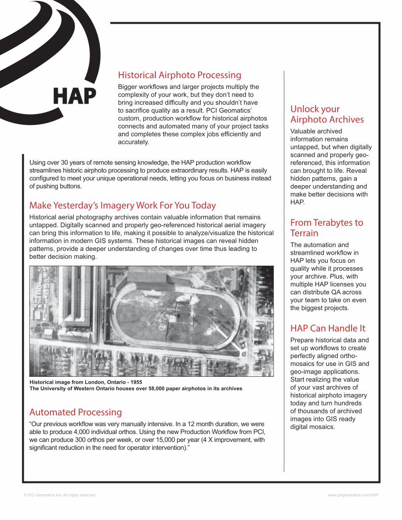
Make Yesterday’s Imagery Work For You TodayHistorical aerial photography archives contain valuable information that remains untapped. Digitally scanned and properly geo-referenced historical aerial imagery can bring this information to life, making it possible to analyze/visualize the historical information in modern GIS systems. These historical images can reveal hidden patterns, provide a deeper understanding of changes over time thus leading to better decision making.
Automated Processing“Our previous workflow was very manually intensive. In a 12 month duration, we were able to produce 4,000 individual orthos. Using the new Production Workflow from PCI, we can produce 300 orthos per week, or over 15,000 per year (4 X improvement, with significant reduction in the need for operator intervention).”
Using over 30 years of remote sensing knowledge, the HAP production workflow streamlines historic airphoto processing to produce extraordinary results. HAP is easily configured to meet your unique operational needs, letting you focus on business instead of pushing buttons.
Historical image from London, Ontario - 1955 The University of Western Ontario houses over 58,000 paper airphotos in its archives
© PCI Geomatics Inc. All rights reserved. www.pcigeomatics.com/HAP
PCI Geomatics Headquarters 90 Allstate Parkway, Suite 501Markham, Ontario L3R 6H3
Phone: (905) 764-0614Fax: (905) 764-9604Email: [email protected]: www.pcigeomatics.com
Features• Automated fiducial mark collection
• Automated GCP / TP collection
• Large volume block bundle adjustment
• Automated mosaicking and colour balancing
• Quality assurance tools to inspect colour balancing, GCP/TP quality, and seamlines
• 3-5 x faster than manual workflows
• High-accuracy, and reliable results
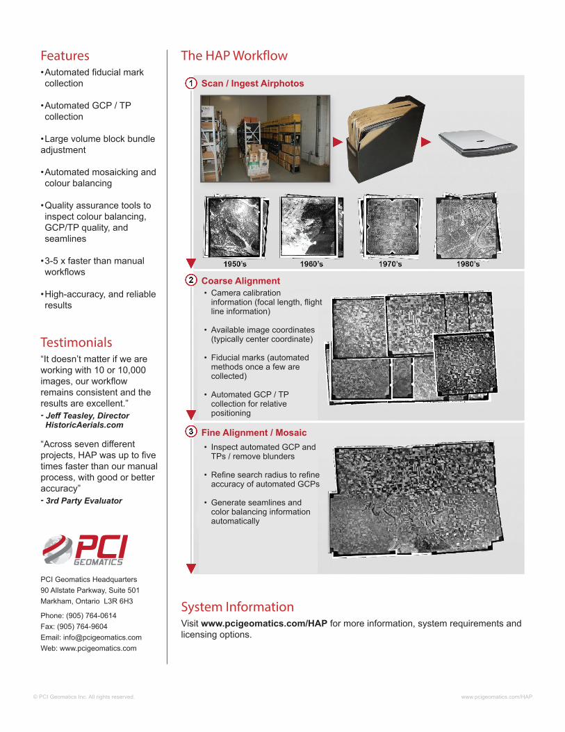
• Camera calibration information (focal length, flight line information)
• Available image coordinates (typically center coordinate)
• Fiducial marks (automated methods once a few are collected)
• Automated GCP / TP collection for relative positioning
• Inspect automated GCP and TPs / remove blunders
• Refine search radius to refine
accuracy of automated GCPs
• Generate seamlines and color balancing information automatically
Coarse Alignment
Fine Alignment / Mosaic
Scan / Ingest Airphotos
Testimonials“It doesn’t matter if we are working with 10 or 10,000 images, our workflow remains consistent and the results are excellent.”- Jeff Teasley, Director HistoricAerials.com
“Across seven different projects, HAP was up to five times faster than our manual process, with good or better accuracy”- 3rd Party Evaluator
System InformationVisit www.pcigeomatics.com/HAP for more information, system requirements and licensing options.
The HAP Workflow