Historic Resources Survey Report Boyle Heights …preservation.lacity.org/sites/default/files/Boyle...
51
Historic Resources Survey Report Boyle Heights Community Plan Area Prepared for: City of Los Angeles Department of City Planning Office of Historic Resources Prepared by: Architectural Resources Group, Inc. Pasadena, CA December 30, 2014
-
Upload
nguyenkhanh -
Category
Documents
-
view
224 -
download
1
Transcript of Historic Resources Survey Report Boyle Heights …preservation.lacity.org/sites/default/files/Boyle...

Historic Resources Survey Report
Boyle Heights Community Plan Area
Prepared for: City of Los Angeles Department of City Planning Office of Historic Resources Prepared by:
Architectural Resources Group, Inc. Pasadena, CA December 30, 2014

Table of Contents Project Overview 1
SurveyLA Methodology Summary 1
Project Team 3
Survey Area 3 Designated Resources 17 Community Plan Area Survey Methodology 19
Summary of Findings 21
Summary of Property Types 21
Summary of Contexts and Themes 24
Selected Bibliography 48
Appendices
Appendix A: Individual Resources Appendix B: Non-Parcel Resources Appendix C: Historic Districts and Planning Districts
SurveyLA
Boyle Heights Community Plan Area 1
Project Overview This Historic Resources Survey Report (Survey Report) has been completed on behalf of the City of Los Angeles Department of City Planning’s Office of Historic Resources (OHR) for the SurveyLA historic resources survey of the Boyle Heights Community Plan Area (CPA). This project was undertaken from December 2013 to December 2014 by Architectural Resources Group (ARG).
Boyle Heights was one of several areas previously evaluated during the pilot survey phase of SurveyLA. However, the CPA was re-surveyed to account for the subsequent refinement of survey methodology as well as the development of additional contexts and themes that are pertinent to the developmental history of Boyle Heights. Findings from the pilot survey, as well as input from the Boyle Heights Historical Society and members of the community, were consulted by ARG while conducting the present survey. This Survey Report provides a summary of the work completed, including a description of the Survey Area; an overview of the field methodology; a summary of relevant contexts, themes and property types; and complete lists of all recorded resources. This Survey Report is intended
to be used in conjunction with the SurveyLA Field Results Master Report (Master Report), which provides a detailed discussion of SurveyLA methodology and explains the terms used in
this report and associated appendices . The Master Report, Survey Report, and Appendices are available on the Survey Findings page at SurveyLA.org. Additionally, survey data for this CPA is
searchable at HistoricPlacesLA.org.
SurveyLA Methodology Summary
Below is a brief summary of SurveyLA methodology. Refer to the Master Report discussed above for more information. Field Survey Methods
Properties surveyed for SurveyLA are evaluated for eligibility for listing in the National Register of Historic Places, California Register of Historical Resources and for local
designation as Los Angeles Historic-Cultural Monuments (HCM) or Historic Preservation Overlay Zones (HPOZ), commonly known as historic districts.
Field surveyors cover the entire area within the boundaries of a CPA. However, only resources that have been identified as significant within the contexts developed for
SurveyLA are recorded.

SurveyLA
Boyle Heights Community Plan Area 2
Consultants making resource evaluations meet the Secretary of the Interior’s Professional Qualifications Standards in Architectural History, History, or a related field.
Surveys focus on identifying significant resources dating from about 1850 to 1980.
All surveys are completed from the public right-of-way (from vehicles or on foot as
needed).
Digital photographs are taken of all evaluated resources.
Field surveys do not include:
Individual resources and historic districts (including HPOZs) that are already
designated (listed in the National, California or local registers).
Community Redevelopment Agency of Los Angeles (CRA/LA) surveys conducted within the last five years.
Potential HPOZ areas which have been surveyed within the last five years and
are in the process of being designated.
SurveyLA Resource Types
SurveyLA identifies individual resources, non-parcel resources, historic districts, and district contributors and non-contributors. Each of these is described below. Appendices A, B, and C of
this Survey Report are organized by resource type.
Individual Resources are generally resources located within a single assessor parcel, such as a residence or duplex. However, a parcel may include more than one individual
resource, if each appears to be significant.
Non-Parcel Resources are not associated with Assessor Parcel Numbers (APNs) and generally do not have addresses. Examples may include street trees, street l ights, landscaped medians, bridges, and signs.
Historic Districts are areas that are related geographically and by theme. Historic districts may include single or multiple parcels depending on the resource. Examples of
resources that may be recorded as historic districts include residential neighborhoods, garden apartments, commercial areas, large estates, school and hospital campuses, and
industrial complexes.
District Contributors and Non-Contributors are buildings, structures, objects, sites and other features located within historic districts (such as residences, schools, and parks). Generally, non-contributing resources are those that are extensively altered, are built outside the period of significance, or do not relate to historic contexts and themes defined for the district.

SurveyLA
Boyle Heights Community Plan Area 3
Planning Districts are areas that are related geographically and by theme, but do not meet eligibility standards for designation. This is generally because the majority of the contributing features have been altered, resulting in a cumulative impact on the overall integrity of the area and making it ineligible as a Historic District. The Planning District determination, therefore, is used as a tool to inform new Community Plans being
developed by the Department of City Planning. These areas have consistent planning concepts, such as height, massing, setbacks, and street trees, which may be considered
in the local planning process.
Project Team The Boyle Heights CPA survey team included the following personnel from ARG: Charles E. Chase, Principal; Katie Horak, Senior Associate and Architectural Historian and Preservation
Planner; and Andrew Goodrich, Architectural Historian and Preservation Planner. Additional assistance was provided by interns Christina Park and Sandra Shannon. Katie Horak served as project manager. Concurrent with ARG’s survey of the Boyle Heights CPA, the additional Los Angeles CPAs of Venice, Westwood, and Wilshire were also surveyed by a team including ARG and the firm Historic Resources Group (HRG). HRG conducted the survey of the Venice and Westwood CPAs, while ARG conducted the surveys of the Boyle Heights and Wilshire CPAs. Personnel from HRG also participated in some aspects of this project.
Survey Area Description of the Survey Area The boundaries of the identified Survey Area correspond with those of the Boyle Heights CPA. Located immediately to the east of Downtown and the Los Angeles River, the Survey Area
flanks the eastern edge of the City of Los Angeles. The area is moderate in size in comparison to other Los Angeles CPAs and irregular in shape. Its boundaries are approximately defined by
Interstate 10 (San Bernardino Freeway) and Marengo Street on the north, the Union Pacific and Santa Fe Railroad tracks on the south, Indiana Street on the east, and the Los Angeles River on the west. The southern and eastern boundaries of the Survey Area are coterminous with the city limits of Los Angeles; the City of Vernon is located to the south of the Survey Area, and the unincorporated communities of East Los Angeles and City Terrace are located to the east. The CPAs of Northeast Los Angeles and Central City North are located to the north and west of the Survey Area, respectively.

SurveyLA
Boyle Heights Community Plan Area 4
Survey Area Map

SurveyLA
Boyle Heights Community Plan Area 5
Within the Survey Area are 17,145 parcels, 11,076 of which were evaluated by the SurveyLA
team. In accordance with SurveyLA methodology, buildings constructed after 1980 and resources designated under local, state, and/or federal programs were not surveyed.1 Also
excluded from SurveyLA were roughly 2,800 parcels that were evaluated in 2007-2008 as part of the Community Redevelopment Agency of Los Angeles’ (CRA/LA) historic resource survey of
the Adelante Eastside Redevelopment Project Area.2 The CRA/LA survey focused exclusively on industrial parcels and commercial corridors in Boyle Heights and the adjacent community of El
Sereno, which is located in the Northeast Los Angeles CPA. Commercial corridors in the Boyle Heights CPA that were evaluated as part of the CRA/LA survey include Marengo Street, Cesar E. Chavez Avenue, 1st Street, 4th Street, Whittier Boulevard, and Olympic Boulevard. Boyle Heights was one of several areas previously evaluated during the pilot survey phase of SurveyLA. The pilot surveys enabled the SurveyLA team to test and refine the project’s methodology, software and hardware, and public participation strategies before surveys were conducted across the entire city. ARG, with assistance from Christopher A. Joseph and Associates (CAJA) and input from the Boyle Heights Historical Society, completed the Boyle
Heights pilot survey between December 2008 and December 2009. The CPA is being re-surveyed to account for the refinement of survey methodology as well as the development of additional contexts and themes that are pertinent to the developmental history of Boyle Heights. Findings from the pilot survey were consulted while conducting the present survey. The Boyle Heights CPA is composed of 3,807 acres in the eastern section of Los Angeles. Much of the area is flat, but there is some topographical variation throughout the CPA, especially near its western boundary as the terrain rises eastward from the banks of the Los Angeles River. The northeast corner of the CPA is also hilly and features moderate changes in elevation. Historically, a distinction was drawn between the “flats” adjacent to the river and the “bluffs”
located to the east; these bluffs inspired the name Boyle “Heights.”
As one of the most densely-populated and urbanized communities in Los Angeles, Boyle Heights contains few natural features. The Los Angeles River, which defines the CPA’s western
border, was a free-flowing waterway when Boyle Heights was initially developed but was encased in concrete in the 1930s as part of a flood control project undertaken by the U.S. Army
Corps of Engineers. The river, which serves as the CPA’s western border, forges a discernible geographic division between the Survey Area and Downtown Los Angeles.
Human-made features largely define the Survey Area. Several freight and passenger rail lines traverse the area’s south and west perimeters. A large freight railroad yard, officially called the
Los Angeles Transfer Facility and colloquially known as Piggyback Yard, occupies a 130-acre site
1 For the location of designated resources within the Boyle Heights CPA, refer to the Designated Resources map on
page 18 or go to HistoricPlacesLA.org 2 Both the survey report and findings for the Adelante Eastside Redevelopment Project Area survey are available
online at http://www.preservation.lacity.org/surveyla-field-survey-findings-and-reports.
SurveyLA
Boyle Heights Community Plan Area 6
adjacent to the river at the northwest corner of the CPA. A light rail line (Metro Gold Line) runs
east-west through the CPA along First Street and includes a combination of at-grade and subterranean sections. Multiple freeways bisect the area, including Interstate 10 (San
Bernardino Freeway), Interstate 5 (Golden State Freeway), State Route 60 (Pomona Freeway), and US Route 101 (Santa Ana Freeway); all of the freeways converge at a single point, the East
Los Angeles Interchange, which is located in the western section of the CPA. These freeways and their associated ramps, overpasses, underpasses, and interchanges forge sharp physical
divisions within the CPA, thus dividing the area into multiple sections. The Survey Area is composed of a variety of land uses and associated property types. A majority of the area is zoned for residential use; however, industrial zones are located along the CPA’s south and west perimeters. Commercial and institutional properties are generally concentrated along the area’s primary east-west vehicular corridors. Various open spaces and public facilities are interspersed throughout the residential sections of the CPA. Streets within the Survey Area generally conform to a grid pattern that is oriented at a 28-
degree angle off the cardinal directions; the grid divides the area into a regular series of blocks that are largely uniform in size and pedestrian in scale. The skewed orientation of the street grid, which is shared by most other neighborhoods adjacent to Downtown, can be traced back to the Laws of the Indies, which were used by the Spanish founders of Los Angeles to dictate the orientation and development of the pueblo and its environs. A small number of streets near the northeast corner of the Survey Area break from the grid and instead conform to the area’s hilly topography; similarly, most streets in the westernmost section of the Survey Area diverge from the grid and instead approximate the course of the Los Angeles River and the bluffs that flank its eastern banks. The internal circulation network of Wyvernwood, a sprawling multi-family development near the southwest corner of the Survey Area, consists of curvilinear
streets that follow the contours of the land.
The major east-west arteries within the Survey Area are (from north to south): Marengo Street, César E. Chavez (formerly Brooklyn) Avenue, First Street, Fourth Street, Whittier Boulevard,
Eighth Street, and Olympic Boulevard. The major north-south arteries within the Survey Area are (from east to west): Indiana Street, Lorena Street, Euclid Avenue, Evergreen Avenue, Soto
Street, State Street, Boyle Avenue, and Mission Road.

SurveyLA
Boyle Heights Community Plan Area 7

SurveyLA
Boyle Heights Community Plan Area 8
Development History
Boyle Heights is among the oldest communities in Los Angeles and was developed as one of the
city’s first residential suburbs. Located on the flats and bluffs directly east of the Los Angeles River, the Boyle Heights area, like much of Los Angeles, was inhabited solely by the Tongva
people until mid-eighteenth century. When California was colonized by the Spanish, the area occupied the easternmost section of the Los Angeles pueblo lands, which were incorporated in
1781 under Governor Felipe de Neve and extended eastward to present-day Indiana Street.3 This peripheral area was originally named El Paredón Blanco, or “white bluff,” a reference to its rolling hills and commanding westward views of both the river and pueblo. El Paredón Blanco was first settled in the 1830s by members of the pioneering López family, which had been deeded much of the area east of the Los Angeles River upon California’s transference from Spanish to Mexican rule in 1821. Aside from a modest adobe residence (not extant) and various auxiliary structures that were erected to support agricultural uses, El Paredón Blanco retained a pastoral character and remained almost entirely undeveloped in the
early and mid-nineteenth century. Rather, the vast expanses of open land comprising the area were occupied by farmsteads, which were used to support a variety of small-scale agricultural operations including the cultivation of vineyards and the production of wine.4 Portions of El Paredón Blanco were sold over time to various investors and developers. Notably, in 1858, 22 acres of the flats and bluffs were sold to Andrew Aloysius Boyle, an entrepreneurial Irishman who had recently relocated to Southern California from San Francisco and operated a shoe store in Downtown Los Angeles. Boyle purchased an additional 20 acres the following year. On his newly-acquired land, Boyle constructed a brick residence, portions of which were extant until the mid-1990s; raised a stock of cattle and horses; and planted vineyards and
orchards of oranges, walnuts, lemons, peaches, and figs.5 Boyle is credited as being “the first [white] American that came to live on the east side of the Los Angeles River,” but his acquisition
of property in the area did not culminate in any substantive changes to the area’s physical landscape.6 Despite its proximity to the center of Los Angeles, Boyle’s land remained pastoral
and was generally perceived as unfit for development at the time, due to its geographic isolation from the rest of the city via the Los Angeles River.
Development activity in the area first occurred in the 1870s, when construction of the Southern Pacific Railroad forged a link between Los Angeles and San Francisco and spurred the first of
several real estate booms across Southern California. Among those eager to capitalize on the 3 City of Los Angeles, Four Square Leagues: Los Angeles Two Hundred Years Later, n.d., 12.
4 Mary E. Mooney, “Side-Lights on Old Los Angeles,” The Quarterly, Publications of the Historical Society of
Southern California and of the Pioneers of Los Angeles 5 (1900-1902): 43-48. 5 Michael E. Engh, “Everyone’s ‘Uncle Bil ly:’ Will iam H. Workman, Los Angeles Pioneer,” Los Angeles Corral 229 (Fall
2002): 5. 6 Ninth Ward Improvement Associati on, Beautiful Highlands of Los Angeles: Comprising Boyle Heights, Brooklyn
Heights, Euclid Heights, n.d.

SurveyLA
Boyle Heights Community Plan Area 9
railroad’s economic potential was William Henry Workman, the son-in-law of Andrew Boyle
who had inherited Boyle’s acreage upon his death in 1871. Workman, who was a member of the Los Angeles City Council (then known as the Los Angeles Common Council) at the time, later
served as the mayor and treasurer of Los Angeles, and played an instrumental role in the development of the city’s first high school and a citywide network of parks. In 1875, Workman,
along with financiers Isaias Hellman and John Lazzarevitch, subdivided his inheritance into residential lots and named the subdivision “Boyle Heights” in honor of his late father-in-law.7 In
addition to platting a system of streets and parcels, Workman constructed a water main and a horse-drawn streetcar line across the river to better connect Boyle Heights with the city’s core and make the peripheral area a feasible place to settle. Boyle Heights was not the only subdivision in the Survey Area to be recorded at the height of the 1870s real estate boom. George Cummings, a forty-niner-turned cattle rancher and farmer who had married into the López family, subdivided the Mount Pleasant tract near the present-day intersection of First Street and Boyle Avenue in 1875. In 1876, a group of investors led by attorney and developer A.H. Judson formed the Brooklyn Land and Building Company and
subdivided 105 acres located on the eastern bank of the river, adjacent to the horse-drawn streetcar route that had been put in place by Workman. Judson’s subdivision, named Brooklyn Heights, was oriented around Brooklyn (now César E. Chavez) Avenue, an east-west route that would later emerge as one of the area’s preeminent commercial corridors.8 At the center of Brooklyn Heights was a four-acre, teardrop-shaped parcel that was donated to the city in 1877 and later developed as Prospect Park. Judson and his associates are purported to have borrowed place names from New York, such as “Brooklyn” and “Prospect Park,” to attract East Coasters who were interested in relocating to Los Angeles.9 At first, Brooklyn Heights developed as an autonomous suburb and was portrayed as “the sister suburb of Boyle Heights ;” however, over time the name Brooklyn Heights fell into obscurity and the area came to be regarded as a
part of the larger Boyle Heights area.10 Subdivisions dating from this initial wave of growth were largely concentrated along the western edge of Boyle Heights, in the areas nearest Downtown.
However, like most new communities that arose at this time, development came to a halt when
the local economy abruptly collapsed and the real estate boom bottomed out. Hardly any development had taken place in Boyle Heights prior to the economic downturn. New
development was limited to a smattering of houses in Mount Pleasant, including a two-story Italianate residence on Pleasant Avenue that has since been demolished (formerly HCM #97) and an Italianate mansion constructed for lumber baron William Hayes Perry, also on Pleasant
Avenue, that was moved to Heritage Square Museum in 1975 (HCM #98). Evergreen Cemetery,
7 Ibid.
8 Nathan Masters, “Prospect Park and L.A.’s Forgotten Borough, Brooklyn Heights,” KCET, 6 June 2013.
9 David Margolick, “Brooklyn Expatriates i n Los Angeles Mourn Fading Reminders of the Past,” New York Times, 3
April 1994. 10
Japanese American National Museum, Images of America: Los Angeles’s Boyle Heights (Charleston: Arcadia Publishing, 2005), 10.

SurveyLA
Boyle Heights Community Plan Area 10
the first privately-operated memorial park in Los Angeles, had been developed in 1877 on a 70-
acre site in the easternmost section of Boyle Heights, in what was then an area far-removed from the rest of the city. Notably, Evergreen, unlike almost every other cemetery in Los Angeles
at the time, was not off-limits to racial and ethnic minorities, though the facility was segregated and some ethnic groups, including Chinese Americans, were relegated to a small “potter’s field”
adjacent to the main grounds.11 Overall, however, Boyle Heights and its environs remained very sparsely developed, in spite of the area’s multitude of new subdivisions and various
improvements that had been undertaken by developers and investors in the mid-1870s. It was not until a second real estate boom in the 1880s that Boyle Heights began to shed its pastoral roots and truly evolve into a residential suburb. The completion of a transcontinental rail line to Southern California in 1885 and a subsequent fare “war” between the Southern Pacific and Santa Fe Railroads brought scores of newcomers to Los Angeles, which in turn produced a surge of land speculation and development activity across the region.12 Boyle Heights, which had already been platted and partially improved by Workman and others, was marketed at this time as an upscale residential district that boasted good views, a convenient
location near the central city, and its own public transit line. At the height of the 1880s land boom, many affluent and prominent Angeleno families flocked to the area and constructed large houses atop the westward-facing bluffs. To ensure that his community attracted the most upstanding groups of settlers, Workman donated “choice lots of ground” within Boyle Heights to various religious institutions for church construction.13 By the late 1880s, the area was beginning to take shape as a “predominantly upper-class Protestant neighborhood.”14 As Boyle Heights began to come of age, the city embarked upon the development of several municipal parks to serve the residents of the new community. In 1890, at the height of Boyle Heights’ early period of development, a 21-acre site at what was then the heart of the nascent
community was donated to the City of Los Angeles by Elizabeth H. Hollenbeck and William H. Workman for use as a public park. Opened to the public in 1892, the new facility was named in
honor of Hollenbeck’s late husband, John Edward Hollenbeck, an entrepreneur who had invested heavily in the early development of Boyle Heights and was among the community’s
earliest and most distinguished settlers.15 With its picturesque setting and lushly-landscaped grounds, the park quickly emerged as a focal point of the community. Prospect Park, a four-acre
site in nearby Brooklyn Heights that had been donated to the city in the 1870s for use as a city park, was improved and opened to the public in 1891.
11
Hadley Meares, “Evergreen Cemetery: Snapshots of a Forever-Changing Boyle Heights,” KCET, 30 Aug. 2013. 12
George L. Henderson, California and the Fictions of Capital (New York: Oxford University Press, 1999), 154. 13
Come to Boyle Heights,” The Boyle Heights Sun, 9 June 1906. 14
Mary S. Pardo, Mexican American Women Activists: Identity and Resistance in Two Los Angeles Communities (Philadelphia: Temple University Press, 1998), 25. 15
Harris Newmark, Sixty Years in Southern California (Cambridge: The Riverside Press, 1916), 598.

SurveyLA
Boyle Heights Community Plan Area 11
Boyle Heights was home to some of the city’s most affluent and prominent households and was
promoted as an upper-class enclave in its formative years. Yet even early in its history, the area was never exclusively the domain of the civic elite. Families of more modest means, also
attracted to the suburban ideal that was being promoted by area boosters, constructed smaller dwellings near the horse-drawn streetcar line that crossed the river at Aliso Street (near
present-day César E. Chavez Avenue) and proceeded to run down Pleasant Avenue and First Street.16 An 1888 Los Angeles Times article speaks to the area’s socioeconomic diversity by
describing its housing stock as being “of the cottage order to a great extent, but some of these cottages cost as much money, from the costly manner in which they are built and decorated, as the two-story houses” that had been constructed nearby by more affluent households.17 Subsequent advances in inter-urban transportation accelerated the pace of development in the area, touching off a wave of rapid residential growth that ultimately transformed the sparsely-populated district into a more urbanized streetcar suburb. In 1889, the horse-drawn streetcar line that served Boyle Heights was replaced by a cable rail line that was operated by the Los Angeles Cable Railway and ran down First Street; the cable car line, in turn, was replaced by a
more modern and efficient electric streetcar line in the 1890s.18 An additional electric streetcar line was constructed on Brooklyn Avenue in 1899 to accommodate an increase in ridership, and by the early twentieth century streetcars traversed almost every major thoroughfare in the area.19 The availability of direct and reliable transit connections between Boyle Heights and the central city opened up once-inaccessible tracts of land and facilitated suburban growth. Scores of Angeleno households who desired a more suburban lifestyle moved to Boyle Heights, and developers acquired and subdivided large tracts of undeveloped land to be developed with single-family houses to accommodate the rapid influx of newcomers. Middle and working-class households accounted for much of this growth, as the availability of affordable public transit
permitted even those of the most modest means to seek a more suburban lifestyle while remaining within a reasonable commuting distance to their places of employment, most of
which were located in and around Downtown. Between 1880 and 1900, Boyle Heights’ population had increased from 300 or 400 families to 10,670 people; the population continued
to steadily increase until the 1920s, at which point Boyle Heights had largely been built out.20
The rapid residential growth that occurred within the area between the 1890s and 1920s was accompanied by the development of various commercial and institutional uses, which arose to serve the day-to-day needs of the area’s growing population. Conforming to a pattern typical of
streetcar suburbs, the majority of commercial development occurred along what were then the
16
Sanborn Fire Insurance Maps, 1888. 17
“Casas Grandes, and Pretty New Cottages on All Sides,” Los Angeles Times, 2 June 1888. 18
“National Register of Historic Places Nomination Form: Boyle Hotel -Cummings Block,” 7 June 2013, § 8, 3. 19
Nathan Masters, “Prospect Park and L.A.’s Forgotten Borough, Brooklyn Heights,” KCET, 6 June 2013. 20
Wendy Ell iot-Scheinberg, “Boyle Heights: Jewish Ambiance in a Multi -Cultural Neighborhood,” dissertation, Claremont Graduate School, 2001, 62.

SurveyLA
Boyle Heights Community Plan Area 12
community’s two principal streetcar routes, First Street and Brooklyn Avenue; among the
earliest commercial properties to be developed in the area was the four-story Boyle Hotel (HCM #891), which was financed by George Cummings and strategically sited adjacent to the
streetcar line and Cummings’ Mount Pleasant tract. Further east on First Street, a commercial strip arose between Boyle Avenue and Chicago Street and became the city’s “first commercial
district east of Downtown Los Angeles.”21 Various public and private institutions including schools, churches, parks, hospitals, convalescent homes, and orphanages were developed
across Boyle Heights around the turn of the twentieth century and into the 1920s. By the 1920s, Boyle Heights, once on the fringes of the city, had matured into a bustling streetcar suburb. As Boyle Heights became more densely developed, a concerted effort was made to better connect the community to the Central City area. Boyle Heights benefited tremendously from the Viaduct Bond Act of 1923, which set into motion an ambitious and far-reaching bridge building program across the city. Notably, the sale of bonds financed the construction of a series of monumental concrete viaducts that spanned both the Los Angeles River and the rail
lines that ran adjacent to the riverbed; seven of these viaducts, at Macy (now Chavez), First, Fourth, Sixth, Seventh, Ninth (now Olympic), and Washington Streets, were routed into Boyle Heights and were completed between 1925 and 1931.22 These bridges replaced several existing wood and metal truss bridges, which were susceptible to flood damage and lacked the capacity to accommodate traffic that had been generated by the area’s rapid growth.23 Boyle Heights is often associated with residential and commercial development; however, its strategic location alongside two major railroad arteries also ushered in a wave of industrial development in the early twentieth century, most of which was concentrated in the “flats” that spanned the area’s southern and western perimeters and occupied land adjacent to the
railroad lines. Industrial development was diverse and included freight houses and freight yards developed by the railroads in addition to warehouses, manufacturing facilities, and salvage
yards.24 Construction-related industries – including lumber yards and brick factories – set up shop to support the area’s rapid residential growth. Sears, Roebuck and Company constructed a
massive Art Deco-style mail order fulfillment center and retail store complex (HCM #788) on an eight-acre industrial parcel near the southwestern corner of the present-day CPA in 1927; while
the mail order facility has since closed, the retail store remains in operation, and the building continues to stand as one of the most iconic landmarks in Boyle Heights.25 Sears’ presence in particular helped catalyze the development of additional industries in the 1930s on nearby
parcels that were subdivided but had not yet been developed. 21
Harris Newmark, Sixty Years in Southern California (Cambridge: The Riverside Press, 1916), 598. 22
Los Angeles Conservancy, “Spanning History: The Bridges of the Los Angeles River,” 2008. 23
All seven viaducts are designated Historic-Cultural Monuments and thus were not re-evaluated as part of
SurveyLA. The Macy/Chavez viaduct was designated in August 1979; the others were designated in January 2008. 24
Community Redevelopment Agency of the City of Los Angeles, “Intensive Historic Resources Survey: Adelante Eastside Redevelopment Project Area, Los Angeles, California,” prepared by PCR Services Corporation, July 2008. 25
Ibid.

SurveyLA
Boyle Heights Community Plan Area 13
By the 1930s, almost every large tract of land in the Boyle Heights area had been developed; an
exception was a 72-acre parcel near the southwest corner of the community that belonged to the estate of D. Herbert Hostetter, proprietor of a company that manufactured a popular
nostrum known as Dr. Hostetter’s Stomach Bitters.26 Between 1938 and 1941, Hostetter’s estate embarked upon the construction of an expansive multi-family housing development
based upon planning principles espoused by Ebenezer Howard’s Garden City movement, including the separation of pedestrian and vehicular traffic; superblock configuration, with
internal and autonomous circulation networks; and a site plan that was oriented around an expansive common open space. Known as Wyvernwood, the sprawling development was the first garden apartment complex in Los Angeles, and its prototype was widely replicated by both public and private housing developers throughout the 1940s and ‘50s. 27 Wyvernwood was geared toward middle and lower-income earners who were employed Downtown and at industrial centers located nearby.28 Los Angeles, like most of the nation’s major cities, experienced an acute housing crisis during the Great Depression that was characterized by overcrowding and the proliferation of
deteriorated and substandard dwelling units. These conditions could be found across the city but were especially pronounced in Boyle Heights, due to the community’s relatively high proportion of working-class residents and ample supply of lower-cost housing. Of particular note was the area immediately east of the Los Angeles River known as the “flats,” which had deteriorated into one of Los Angeles’ most notorious slum districts by the late 1930s.29 Seeking to curtail unfavorable housing conditions such as those in Boyle Heights, the Franklin D. Roosevelt administration signed into law the landmark Housing Act of 1937, which enabled local governments to form housing agencies and construct low-income public housing projects. The City of Los Angeles was among the first cities in the nation to take advantage of the federal
law, establishing the Housing Authority of the City of Los Angeles (HACLA) in 1938. HACLA embarked upon an ambitious slum clearance and public housing program in the early 1940s,
which brought about significant changes to the physical landscape of the area. A total of ten public housing developments were proposed throughout the city as part of this program, three
of which were to be located in Boyle Heights . HACLA’s efforts culminated in the acquisition and demolition of buildings in the deteriorated “flats” that were deemed substandard; in their place
the agency constructed two large public housing developments, Aliso Village and Pico Gardens, that together constituted “the largest group of public housing west of the Mississippi.” 30 A third public housing development, Estrada Courts, was developed at Eighth Street and Grande Vista
Avenue on a site that was also deemed a slum. All three of the developments were completed
26
Ibid. 27
Los Angeles Conservancy, “Wyvernwood Garden Apartments,” accessed Dec. 2013. 28
Since Wyvernwood has been determined eligible for l isting on the National Register of Historic Places an d is l isted in the California Register of Historical Resources, it was not evaluated as part of SurveyLA. 29
“City Housing Authority to Open Project Today,” Los Angeles Times, 2 Aug. 1942. 30
Hector Becerra, “Building Confidence in a New Project,” Los Angeles Times, 23 Aug. 1988.

SurveyLA
Boyle Heights Community Plan Area 14
in 1942 and replaced densely-developed residential neighborhoods with sprawling garden
apartment complexes that placed an emphasis on residents’ access to open space. Aliso Village and Estrada Courts also stood out as some of the first public housing projects in the nation to
be racially integrated.31
Multiculturalism played a pivotal role in defining Boyle Heights’ early history. Prior to World War II, Boyle Heights was considered to be the most ethnically heterogeneous community in
Los Angeles, “a place often described as one of the largest and earliest showcases for multicultural harmony” in the city.32 Restrictive covenants and deed restrictions prohibited non-whites from owning or occupying property in many Los Angeles communities; however, these discriminatory housing tactics were never implemented on a widespread basis in Boyle Heights, making it one of the few places in the city where ethnic and religious minorities and new immigrants could settle. Mexican Americans had continuously lived in the Boyle Heights area since the nineteenth century, but in the early twentieth century they were joined by sizable numbers of Japanese Americans, many of whom had relocated to Los Angeles after the San Francisco Earthquake of 1906, and Russian and Eastern European Jews seeking refuge from
World War I.33 The Molokan, a minority sect of Russian Christians who immigrated to Los Angeles between 1904 and ‘08 in order to avoid religious persecution and military conscription, settled in the “flats” where Aliso Village and Pico Gardens were later constructed.34 This area of Boyle Heights represented the largest concentration of Molokans in the United States until the 1940s, when the primary Molokan church was relocated to the eastern edge of Boyle Heights and members of the Molokan community migrated eastward, eventually re-settling in unincorporated East Los Angeles.35 The diverse composition of Boyle Heights’ population was articulated in an assessment of the area that was completed by the Home Owners Loan Corporation (HOLC) in 1939. In addition to
the aforementioned ethnic and cultural groups that had created enclaves in Boyle Heights, the assessment indicates that there were also smaller concentrations of Polish, Armenian, Greek,
Slavic, Italian, and African American populations located throughout the community. The assessment, which was conducted in an era when racial diversity was not viewed favorably,
describes Boyle Heights as being “a ‘melting pot’ area…literally honeycombed with diverse and subversive racial elements” on virtually every block.36
While no one ethnic group comprised a majority of Boyle Heights’ population in the first half of the twentieth century, Boyle Heights became well-known as the epicenter of Los Angeles’
31
Dana Cuff, The Provisional City: Los Angeles Stories of Architecture and Urbanism (Cambridge: MIT Press, 2002), 161; Los Angeles Conservancy, “Estrada Courts,” accessed Dec. 2014. 32
Teresa Watanabe, “Boyle Heights Celebrates its Ethnic Diversity,” Los Angeles Times, 22 Feb. 2010. 33
Watanabe (2010). 34
Ricardo Romo, East Los Angeles: History of a Barrio (Austin: University of Texas Press, 1983), 65-67. 35
Peter Moruzzi, “Historic Resource Assessment Report, 623-629 S. Lorena Street,” prepared for Global Premier Development, Inc., Nov. 2007. 36
Ibid.

SurveyLA
Boyle Heights Community Plan Area 15
Jewish community during this time and boasted one of the largest Jewish populations in the
western United States.37 Most restrictive covenants that applied to ethnic and racial minorities also discriminated against those of Jewish lineage, which steered Jewish immigrants toward the
relatively-unrestricted housing market of Boyle Heights. Generally, the Jewish population settled in the northern section of Boyle Heights, near the Brooklyn Avenue corridor; Brooklyn
Avenue abounded with Jewish-owned businesses and institutions, and the intersection of Brooklyn Avenue and Soto Street emerged as the heart of Jewish Los Angeles. Synagogues,
meeting halls, and cultural institutions that served the Jewish population also arose in the vicinity. Over time, as demographics have changed and the Jewish community moved to other parts of the city, most of these businesses and institutions have evolved to meet the needs of changes in population; however, resources such as the Breed Street Shul (HCM #359) remain extant and offer tangible connections to this chapter in the area’s rich cultural history. The construction of an expansive freeway network throughout Southern California after World War II drastically altered the configuration and physical character of Boyle Heights. In spite of vehement opposition that was voiced by residents and community leaders, five freeways and
the multi-level East Los Angeles Interchange were routed through Boyle Heights between 1948 and 1965. Entire blocks were razed to make way for the Interstate 10 (San Bernardino), Interstate 5 (Golden State), US Route 101 (Santa Ana), and State Route 60 (Pomona) freeways, which together consumed some fifteen percent of the total land area within Boyle Heights and culminated in the displacement of thousands of households.38 The largely at- and above-grade corridors truncated once-through streets and carved the once-cohesive community into multiple sections that became physically disjointed and lacked connectivity and flow. The construction of the Golden State Freeway yielded an especially profound impact on the built environment of Boyle Heights by severing the western end of Hollenbeck Park and reducing the park’s net acreage, and by obstructing its once-commanding westward views of the downtown
skyline.
Changes in the postwar landscape of Boyle Heights were not limited to the built environment; the area experienced significant demographic and cultural shifts during this time as well. These
shifts can be attributed to a myriad of factors including the internment of California’s Japanese American population during World War II as well as the easing of race restrictive covenants in
the 1950s, which allowed upwardly-mobile Jewish households to move to more affluent neighborhoods in other parts of the city including the San Fernando Valley and the Westside; this in turn led to the exodus of Boyle Heights’s Japanese and Jewish populations.39 Other
ethnic and religious groups with roots in the area had moved away from Boyle Heights by this time as well. However, for the most part the community’s Latino population remained, largely
due to language barriers, income inequality, fewer job opportunities, and a real estate market
37
Ibid, 64-65. 38
Will iam Deverell and Greg Hise, eds. A Companion to Los Angeles (Hoboken: Wiley-Blackwell, 2010), 136. 39
Ryan White, “Boyle Heights Bears the Scars and Promise of L.A.,” The California Endowment Health Journalism Fellowships Blog, accessed Jan. 2014.

SurveyLA
Boyle Heights Community Plan Area 16
that continued to discriminate against certain racial and ethnic minorities. Economic changes
and civil unrest that afflicted Mexico and Central America ushered in new waves of immigration to Los Angeles and particularly Boyle Heights beginning in the 1970s.40 The area subsequently
evolved into a predominantly Latino community and a destination for new immigrants arriving from Mexico and, to a lesser extent, Central America; the population of Boyle Heights today is
94 percent Latino and 52 percent foreign-born.41
Boyle Heights’ demographic and cultural transformation in the second half of the twentieth century is manifest in the area’s built environment. The Mexican American All Wars Memorial, an obelisk that honors Mexican American soldiers who served in the U.S. Armed Forces, was erected in 1947 at the intersection of Brooklyn Avenue, Indiana Street, and Lorena Street, an area that came to be known to those within the community as “Cinco Puntos.”42 Businesses and institutions that historically catered to the area’s Japanese and Jewish populations were repurposed to serve a largely-Latino clientele. New cultural institutions arose and became significant in their own right, including Mariachi Plaza (1993), a gathering place for local mariachi musicians. Boyle Heights emerged as a focal point for Chicano activism in the 1960s
and ‘70s and contains a rich and expressive collection of murals painted by a variety of local Chicano artists.43 In 1994, Brooklyn Avenue was renamed César E. Chavez Avenue in honor of the iconic Mexican American labor leader and civil rights activist.44 While the area is no longer the heterogeneous “melting pot” that it was prior to World War II, it remains a community replete with cultural attributes. Additional changes to Boyle Heights’ built environment have occurred in recent years. Due to their ongoing deterioration and issues related to gang violence and crime, the Aliso Village and Pico Gardens public housing projects, both of which had been prominent elements of Boyle Heights’ urban fabric since the 1940s, were demolished and replaced with new residential
complexes. Pico Gardens retains its name and its historical use as public housing, but Aliso Village was reconstructed as a mixed-income development called Pueblo del Sol that reflects
contemporary trends in the design and operation of subsidized housing. In the early 2000s, the Metropolitan Transportation Authority (Metro) extended the Gold Line light rail corridor
eastward through the CPA via First Street which includes four stops in Boyle Heights. The Gold Line Extension has provided residents with more direct access to the central city and adjacent
communities, and has also helped to reinvigorate the local economy.
40
Japanese American National Museum, “Boyle Heights: The Power of Place,” accessed Jan. 2014. 41
“Mapping L.A.,” Los Angeles Times. 42
“Speaker John A. Perez Presents Restored Memorial for Latino Veterans,” press release, 1 Mar. 2013. 43
Angel Lizarraga, “Boyle Heights Streets a Canvas: But Historic Murals are Neglected,” accessed Jan. 2014. 44
Mary Anne Perez, “Sign of the Times: Cesar Chavez Avenue,” Los Angeles Times, 3 Apr. 1994.

SurveyLA
Boyle Heights Community Plan Area 17
Designated Resources The following map depicts designated resources within the Boyle Heights CPA at the time of the survey. These include properties listed in the National Register of Historic Places (NR) and/or
the California Register of Historical Resources (CR), as well as locally-designated Los Angeles Historic-Cultural Monuments (HCM). Currently, there are no locally-designated Historic
Preservation Overlay Zones (HPOZ) located within the CPA.
For up-to-date, detailed information about designated resources visit the online database at historicplacesla.org or zimas.lacity.org.

SurveyLA
Boyle Heights Community Plan Area 18

SurveyLA
Boyle Heights Community Plan Area 19
Community Plan Area Survey Methodology The survey of the Boyle Heights CPA was conducted using the methodology established by the OHR for SurveyLA which includes the citywide Historic Context Statement and customized
mobile Field Guide Survey System (FiGSS).45 Concurrent with the survey of the Boyle Heights CPA, three additional CPAs were also surveyed, including one in central Los Angeles (Wilshire)
and two in west Los Angeles (Venice and Westwood).
The field work was conducted in two phases: reconnaissance and documentation. The reconnaissance phase was conducted by the project managers and key staff of all four CPA
surveys, all of whom meet the Secretary of the Interior’s Professional Qualifications Standards. The reconnaissance team for the Boyle Heights CPA included Katie Horak and Andrew Goodrich of Architectural Resources Group, and Kari Fowler and Christine Lazzaretto of Historic Resources Group. This phase involved a detailed and methodical review of each neighborhood, street, and individual property within the Survey Area. It was during this phase that decisions were made about which properties and districts should be documented, and how those properties should be evaluated. During this initial reconnaissance phase, surveyors reviewed pre-loaded data submitted by community members to MyHistoricLA, identified concentrations of resources that might later be recorded as eligible historic districts and planning districts, and
developed lists of pre-field research tasks that would help inform the field survey. By making these decisions up front and as a team, this methodology ensures a more thoughtful approach to resource identification and evaluation, creates greater consensus among the field survey teams, and produces more consistent survey results across CPAs. This approach also substantially streamlines the next phase of field survey, enabling the field teams to document large numbers of properties quickly and efficiently. During the reconnaissance phase, ARG created Geographic Information System (GIS) maps of each neighborhood; these maps were printed for use in the field. A blank map showing only street names, address numbers, and parcel lines was used by surveyors in the field for notes and comments about resources identified during the reconnaissance phase. Another map featured parcels shaded by decade of building construction, which helped to illustrate
chronological development patterns and concentrations of resources.
Once the reconnaissance phase was completed, the documentation phase began. During this phase, field work was conducted by teams of two. Properties that were identified during the
previous phase, along with those that had significant associative qualities identified in pre-loaded data in FiGSS, were recorded and evaluated for potential historic, cultural, or architectural significance. Documentation included a digital photograph, recordation of historic features and subsequent alterations, and the reason for a property’s potential historic
45
For more information about the SurveyLA methodology, see the SurveyLA Field Results Master Report.

SurveyLA
Boyle Heights Community Plan Area 20
significance. It was also during this phase that contexts and themes were applied and
evaluation status codes were assigned.
Surveyed properties included residential, commercial, institutional, and industrial buildings and important landscape and infrastructure features such as bridges and designed landscapes. All
field work was conducted from the public right-of-way. Following the completion of field work, all survey data was reviewed in detail by a qualified survey professional to ensure accuracy and
consistency throughout the data set. Survey teams conducted research on individual properties and neighborhoods throughout the field survey process. When specific information was needed in order to complete an evaluation, additional research was conducted. Sources included building permits, historical newspapers and periodicals, Sanborn maps, tract maps, and city directories. The survey team also referenced input from the Boyle Heights Historical Society and utilized their Boyle Heights History Blog, an online local history resource. Other sources that were consulted include the collections of the Los Angeles Public Library; Online Archive of California; University of Southern
California (USC); University of California, Los Angeles (UCLA); and the Library of Congress archives. This research helped with the identification of historic tract names and boundaries, names of tract subdividers, dates of subdivision, and original building uses and footprints.

SurveyLA
Boyle Heights Community Plan Area 21
Summary of Findings
The following discussion of Property Types, Contexts, and Themes relates to the resources identified and recorded as eligible for designation.
Summary of Property Types With regard to land use, Boyle Heights is diverse and includes a variety of residential,
commercial, institutional, and industrial properties. However, nearly all of Boyle Heights’ industrially-zoned parcels and most of its major commercial corridors fall within the Community Redevelopment Agency (CRA/LA)’s Adelante Eastside Redevelopment Project Area, which was surveyed by the agency in 2007-2008 and was not re-evaluated as part of SurveyLA. Since most industrial and commercial parcels had already been evaluated, a vast majority of the properties identified in SurveyLA were residential or institutional in use; in rare cases, a property located within the CRA/LA project area was evaluated and documented as part of SurveyLA, particularly if it had been identified as significant by members of the community through the MyHistoricLA public outreach program.
Following is a summary of those property types within the CPA that were documented and evaluated as significant. Residential Properties Boyle Heights largely consists of residential neighborhoods, which are primarily composed of single-family residences but also feature a handful of multi-family property types. Most of these neighborhoods were developed between the 1880s and 1920s alongside the construction of streetcar lines. Given the area’s abundance of residential neighborhoods, residential properties account for a majority of resources identified in the survey; eligible residential property types include both individual resources and concentrations of resources (historic and planning
districts).
Many of the residential properties that were identified as individually eligible resources are single-family residences that date to the late nineteenth and early twentieth centuries and
reflect the area’s earliest settlement patterns. Generally, these houses are located in established neighborhoods where most other buildings have been substantially altered, thus making intact examples of early residences relatively uncommon. Many of the single-family houses that were identified as individually eligible were also evaluated as excellent examples of various Late Victorian and Arts and Crafts architectural styles. In addition, the survey identified
several single-family residences that are associated with historically significant individuals who resided in the community.

SurveyLA
Boyle Heights Community Plan Area 22
A number of multi-family residential properties were also identified as individually eligible
resources. Identified in the survey were three duplexes, twelve fourplexes, two apartment houses, three bungalow courts, and one unusual grouping of bungalows, which were all
constructed at various periods in Boyle Heights’ developmental history. Most of these multi -family resources were identified as excellent and/or rare examples of their respective property
type, though a few were also evaluated for their architectural merit.
In addition, five residential historic districts and one residential planning district were identified in the Survey Area. Four of the historic districts, which were subdivided in the late nineteenth century and developed through the 1920s, were identified as significant examples of streetcar suburbanization that reflect development patterns associated with early advances in mass transit; one of these districts also contains a notable concentration of intact late nineteenth and early twentieth century residential architecture. The fifth historic district was identified as an excellent and cohesive concentration of Spanish Colonial Revival residential architecture. The planning district is also a significant and early example of streetcar suburbanization; however, since the majority of residences within its boundaries have been substantially altered, it does
not appear to retain sufficient integrity for eligibility as a historic district, though it merits special consideration in the local planning process. The survey also identified one excellent example of a 1940s-era public housing complex owned and operated by the Housing Authority of the City of Los Angeles (HACLA). In addition to standing out as an excellent example of the garden apartment property type, the complex is the only extant example of public housing in Boyle Heights that dates to this early period. The property is also notable for possessing a concentration of more than 50 murals, many of which were painted by local artists in the 1970s and depict themes in Chicano history and culture.
Commercial Properties
Most commercial development in the Survey Area is concentrated along linear corridors that historically were served by electric streetcars. Since almost all of these corridors were included
in the CRA/LA’s 2007-2008 historic resources survey and were not re-evaluated, relatively few commercial properties in Boyle Heights were identified through SurveyLA. However, the survey
did identify a small number of commercial properties, most of which are located in residential districts or along secondary commercial corridors. Specifically, the survey identified four neighborhood markets and one walk-up food stand that exemplify their respective property
type; one 1930s service station and one 1940s repair garage that are significant examples of early automobile development; two intact streetcar commercial buildings that had not been
previously evaluated; and several long-term businesses that contribute to Boyle Heights’ cultural and commercial identity. No commercial districts were identified in the Survey Area.

SurveyLA
Boyle Heights Community Plan Area 23
Industrial Properties
Industrial development in Boyle Heights is largely confined to the area’s south and west
perimeters, which were also included in the CRA/LA’s historic resources survey and were not re-evaluated. One industrial property located outside of the previously-surveyed industrial
zones, a former powerhouse for the Los Angeles Railway, was identified as part of this survey.
Institutional Properties
The survey identified numerous institutional properties which, unlike commercial and industrial
development, are not clustered in discernible zones but instead are interspersed across the Survey Area. Public and private institutional properties represent the second most common
resource type identified in the Survey Area, surpassed only by residences. Eligible institutional property types were recorded both as individual resources and districts, depending on the number of significant resources present at a given site. Institutional resources that were identified in the Survey Area consist largely of religious and
educational facilities. Twenty-two churches and religious campuses were identified and were generally evaluated as rare examples of early institutional development in the area, for
longstanding associations with particular ethnic and cultural groups, and/or as excellent examples of architectural styles. The survey also identified eleven schools, most of which were
reconstructed after the 1933 Long Beach Earthquake and exemplify LAUSD campus planning and design principles of the period; a smaller number of schools, most of which were privately
operated, were evaluated for their contributions to the area’s rich ethnic and cultural history. Other institutional resources that were identified include three municipal parks and recreation centers; two cultural centers and meeting halls associated with the area’s Latino and Jewish communities; two former healthcare facilities, including a medical clinic and a sanitarium; one Department of Water and Power distributing station; one settlement house affiliated with the Catholic church; one parsonage that served an adjacent church; and one cemetery that dates to the late nineteenth century and is among the city’s oldest burial grounds.
Other Properties Finally, the survey identified several resources that are not located on legal parcels and thus cannot be categorized under any of the aforementioned property types. These resources include five air raid sirens associated with civil defense efforts during World War II and the Cold War; five notable examples of pedestrian infrastructure including tunnels, bridges, and stairways; a war memorial associated with the Latino community that was installed in the 1940s; an intact retaining wall that spans the length of a residential subdivision from 1904; and
a linear grouping of early utility poles that feature distinctive geometric details in their design.

SurveyLA
Boyle Heights Community Plan Area 24
Summary of Contexts and Themes
Many of the Contexts and Themes developed as part of the SurveyLA Citywide Historic Context Statement are represented in the Boyle Heights CPA. Following is a representative sampling of
some of the more common Context/Theme combinations that were used in the Survey Area, as well as several combinations that are either particularly representative or unique components
of the area’s developmental history. Each Context/Theme combination listed is illustrated with specific examples from the Survey Area.
Appendix A includes a complete list of all individual resources identified as meeting eligibility
standards and criteria for the National Register, California Register, and/or HCM/HPOZ. Appendix B includes a complete list of all non-parcel resources identified as meeting eligibility standards and criteria for the National Register, California Register, and/or HCM/HPOZ . Appendix C includes a complete list of historic districts identified as meeting eligibility standards and criteria for the National Register, California Register, and/or HCM/HPOZ. This appendix also
includes Planning Districts, which do not meet eligibility standards and criteria for listing but may warrant special consideration for local planning purposes.

SurveyLA
Boyle Heights Community Plan Area 25
Context: Residential Development and Suburbanization, 1850-1980
Theme: Early Residential Development, 1880-1930 Sub-Theme: Early Single Family Residential Development, 1880-1930
As one of the earliest residential suburbs within Los Angeles, Boyle Heights contains many of the
city’s oldest single-family residences. A majority of these early houses have been extensively altered, but several retain integrity and represent the area’s earliest settlement patterns. This Context/Theme combination was used to evaluate rare, intact examples of single-family
residences that were built between the 1880s and the first decade of the twentieth century; some of the houses identified are among the oldest residences remaining in Los Angeles.
Address: 1526 E. Bridge St. Address: 1417 E. Pleasant Ave.
Date: 1887 Date: 1882
Address: 2534 E. Pennsylvania Ave. Address: 2126 E. 2nd
St.
Date: 1895 Date: 1895

SurveyLA
Boyle Heights Community Plan Area 26
Address: 1536 E. Bridge St. Address: 1818 E. Pomeroy Ave.
Date: 1889 Date: 1890
Address: 2605 E. 3
rd St. Address: 2008 E. Pennsylvania Ave.
Date: 1890 Date: 1895
Address: 2533 E. Michigan Ave. Address: 629 S. Camulos St.
Date: 1895 Date: 1905

SurveyLA
Boyle Heights Community Plan Area 27
Context: Residential Development and Suburbanization, 1850-1980
Theme: Streetcar Suburbanization, 1888-1933 Sub-Theme: Suburban Planning and Development, 1888-1933
Geographically isolated from the rest of the city in its formative years, Boyle Heights benefited
enormously from advances in inter-urban transportation at the turn of the twentieth century, when multiple streetcar lines were constructed along almost all of the area’s major thoroughfares. Streetcar lines made it easy and affordable for commuters to travel between Boyle Heights and
major commercial and employment nodes located Downtown, which created a demand for new development in areas of the CPA that had once been largely inaccessible. This Context/Theme
combination was used to evaluate four historic districts, one planning district, and one tract feature that were developed as a direct result of their proximity to streetcar lines.
District: Mount Pleasant Residential Historic District District: 2
nd Street Residential Historic District
Period of Significance: 1882-1927 Period of Significance: 1883-1923
District: Boyle Avenue Residential Historic District District: St. Louis-Chicago Residential Historic District
Period of Significance: 1887-1926 Period of Significance: 1895-1926
SurveyLA
Boyle Heights Community Plan Area 28
Context: Residential Development and Suburbanization, 1850-1980
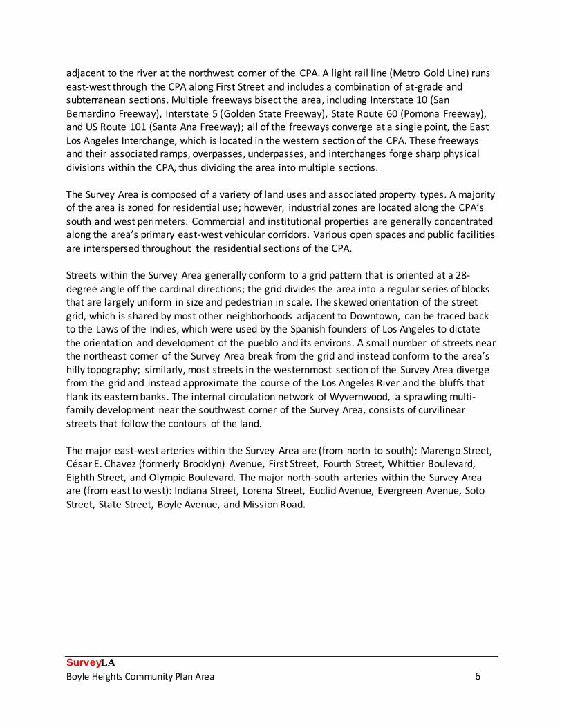
Sub-Context: Multi-Family Residential Development, 1910-1980 Theme: Multi-Family Residential, 1910-1980 Sub-Theme: Apartment Houses, 1910-1980
Single-family residences accounted for most of Boyle Heights’ early development, but by the early twentieth century a variety of more economical multi-family housing types were built as the area’s population became more solidly middle and working-class. Four-unit apartment houses,
known as fourplexes or four-flats, were among the most common multi-family buildings introduced to the Boyle Heights area. Typically composed of four individual units with elongated
plans, fourplexes were designed in a manner that allowed them to be mistaken at first glance for large single-family houses, thus assimilating seamlessly into predominantly low-density
neighborhoods. This Context/Theme combination was used to evaluate several fourplexes in Boyle Heights that are excellent and highly intact examples of the property type.
Address: 202 S. Boyle Ave. Address: 1928 E. Pennsylvania Ave.
Date: 1907 Date: 1924
Address: 919 S. Concord St. Address: 2909 E. Oregon St.
Date: 1917 Date: 1915

SurveyLA
Boyle Heights Community Plan Area 29
Context: Residential Development and Suburbanization, 1850-1980
Sub-Context: Multi-Family Residential Development, 1910-1980 Theme: Multi-Family Residential, 1910-1980 Sub-Theme: The Bungalow Court, 1910-1939
One of the most prominent multi-family housing types in Los Angeles between the 1910s and ‘30s was the bungalow court, a low-density development that consisted of multiple detached bungalows oriented around a central landscaped courtyard. Bungalow courts were an innovative
type of multi-family housing that took advantage of Southern California’s temperate climate and combined the privacy afforded an individual residence with shared outdoor space. Since Boyle
Heights was largely built out by the time that bungalow courts became popular, examples of the property type that remain intact are relatively rare within the CPA. This Context/Theme
combination was used to evaluate three bungalow courts that are highly representative of the property type and are among the very few remaining examples in the area that retain integrity.
Address: 2415-2417 E. Malabar St. Address: 620-624 N. San Benito St.
Date: 1924 Date: 1923
Address: 445-455 S. Mathews St.
Date: 1915

SurveyLA
Boyle Heights Community Plan Area 30
Context: Residential Development and Suburbanization, 1850-1980
Theme: Multi-Family Residential, 1910-1980 Sub-Theme: Garden Apartments, 1938-1960
Sub-Theme: Public and Defense Housing, 1939-1945
Prior to World War, the Housing Authority of the City of Los Angeles (HACLA) was established to eradicate slum-like conditions within the city and replace substandard residences with quality, low-cost public housing complexes. HACLA planned and constructed ten such complexes in
several of the City’s most impoverished neighborhoods using money that had been allocated under the Federal Housing Act of 1937. HACLA’s early public housing complexes opened in the
early 1940s and embodied design principles espoused by the Garden City movement including superblock site plans with internal circulation networks; the deliberate separation of vehicular
and pedestrian traffic; wide expanses of open space; and groups of low-density buildings oriented around a series of landscaped courtyards and common areas.
Estrada Courts, located in Boyle Heights, was among the original ten public housing complexes planned and constructed by HACLA. The complex was designed in 1942 by a team of esteemed architects including Robert Alexander, Winchton Risley, David Witmer, and Loyall Watson and landscape architect Hammond Sadler; an extension of the original complex was completed in 1954 and was designed by architect Paul Robinson Hunter and landscape architect Fred Barlow, Jr. As was true for almost all of HACLA’s early public housing complexes, Estrada Courts was used as shelter for defense workers and their families during World War II, but was re-converted back into subsidized public housing after the war had ended. An excellent example of both early public housing and a garden apartment complex, the property was evaluated under multiple
sub-themes within this Context/Theme combination. The property was also evaluated under the Public Art theme for the rich collection of murals that adorn many of its buildings.
District: Estrada Courts District: Estrada Courts
Architect: Alexander, Risley, Witmer, Watson & Hunter Architect: Alexander, Risley, Witmer, Watson & Hunter
Period of Significance: 1942-1954 Period of Significance: 1942-1954

SurveyLA
Boyle Heights Community Plan Area 31
Context: Commercial Development, 1850-1980
Theme: Markets, 1850-1980
Most of Boyle Heights’ commercial corridors were included in previous surveys and were not re -evaluated as part of SurveyLA. However, the CPA contains a number of neighborhood markets
that are located in residential neighborhoods, away from the previously-surveyed commercial corridors. This Context/Theme combination was used to identify four representative and intact examples of neighborhood markets, a commercial property type that was once common in most
of Los Angeles’ urbanized communities but has become increasingly rare. Constructed in an era that pre-dated the rise of the automobile and the popularization of one-stop supermarkets,
neighborhood markets were built to a pedestrian scale and typically occupy small, vernacular buildings sited on corner parcels within residential districts.
Address: 2700 E. Pomeroy St. Address: 3036 E. 5
th St.
Date: 1928 Date: 1924
Address: 1000 N. Clement St. Address: 2842 E. Wabash Ave.
Date: 1930 Date: 1929
SurveyLA
Boyle Heights Community Plan Area 32
Context: Commercial Development, 1850-1980
Theme: Commercial Identity, 1850-1980
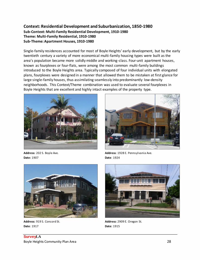
Located within Boyle Heights are several long-term businesses that, over time, have evolved into local commercial institutions that help define the area’s commercial identity. Most of these
businesses were founded by immigrants who had recently arrived in Boyle Heights from other parts of the world, and retain their association with the various ethnic and cultural groups that have resided in the community. This Context/Theme combination was applied to evaluate six local
businesses that have been in continuous operation for several decades and are well-known components of Boyle Heights’ commercial landscape. Five of the six properties identified are
associated with the CPA’s Latino population; the sixth (bottom right) is a rare remaining example of a business associated with the area’s historical Japanese American community.
Name: El Tepeyac Café Name: La Favorita Bakery
Address: 812 N. Evergreen Ave. Address: 2301 E. 4th
St.
Date: 1952 Date: 1971
Name: El Mercado de Los Angeles Name: Otomisan Restaurant
Address: 3425 E. 1st
St. Address: 2506 E. 1st
St.
Date: 1968 Date: 1956

SurveyLA
Boyle Heights Community Plan Area 33
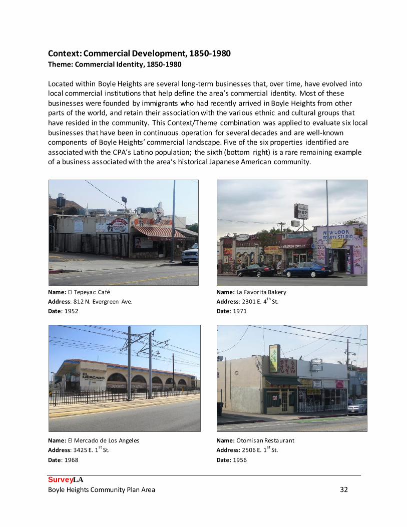
Context: Public and Private Institutional Development, 1850-1980
Sub-Context: Education, 1876-1980 Theme: Public Schools and the LAUSD, 1876-1980
Sub-Theme: Post-1933 Long Beach Earthquake, 1933-1945
Some of the earliest public schools in Los Angeles were located in Boyle Heights, but almost all of these early campuses were reconstructed after the 1933 Long Beach Earthquake. Thus, the CPA contains a relatively high concentration of schools that were constructed in the mid-1930s
and reflect the LAUSD’s efforts to bring its campuses into compliance with the Field Act, state legislation that was enacted in response to the Long Beach Earthquake and required that older
campuses be remodeled and/or reconstructed to new seismic safety standards. Nine LAUSD campuses that date to the post-earthquake era were evaluated under this Context/Theme
combination, several of which were designed by noted architects of the period.
Name: Breed Street Elementary School Name: Lorena Street Elementary School
Address: 2226 E. 3rd
St. Address: 1015 S. Lorena St.
Architect: Joseph Kaiser Architect: Paul Kingsbury
Date: 1936 Date: 1935
Name: Euclid Avenue Elementary School Name: Bridge Street Elementary School
Address: 806 S. Euclid Ave. Address: 605 N. Boyle Ave.
Architect: Elmer Grey Architect/Builder: R.E. Campbell
Date: 1937 Date: 1934-1935

SurveyLA
Boyle Heights Community Plan Area 34
Context: Public and Private Institutional Development, 1850-1980
Sub-Context: Education, 1876-1980 Theme: Education and Ethnic/Cultural Associations, 1876-1980
Often referred to as the “Ellis Island of Los Angeles,” Boyle Heights has long served as a point of
entry for new immigrants arriving in Los Angeles from other countries. This Context/Theme combination was used to evaluate a variety of public and private educational facilities that are associated with the ethnic and cultural groups that settled in Boyle Heights and reflect the
area’s diversity. Notable properties include the Forsythe Memorial School (top left), a boarding school where girls of Mexican descent were versed in American culture; the First Street School
(bottom left), site of an LAUSD-run assimilation facility where women were instructed in English language and “mastery of the American tradition;” Roosevelt High School (top right) , a focal
point of Los Angeles’ Chicano civil rights movement; and Rafu Chuo Gakuen (bottom right), which has continuously provided instruction in Japanese language and culture since the 1930s.
Name: Forsythe Memorial School Name: Theodore Roosevelt High School
Address: 506 N. Evergreen Ave. Address: 456 S. Mathews St.
Name: First Street Elementary School Name: Rafu Chuo Gakuen Japanese Language School
Address: 2820 E. 1st
St. Address: 204 N. Saratoga St.

SurveyLA
Boyle Heights Community Plan Area 35
Context: Public and Private Institutional Development, 1850-1980
Sub-Context: Religion and Spirituality, 1850-1980 Theme: Religious Property Types, 1850-1980
Early in its history, Boyle Heights was known for its abundance of churches, which were founded
by various Christian denominations to serve the area’s rapidly growing population. Often, these churches were designed by noted ecclesiastical architects of the period and, due to their size and grandeur, served as focal points of the neighborhoods in which they were located. Some of Boyle
Heights’ early churches have been demolished over time, but many remain intact and reflect early patterns of institutional development within the community. This Context/Theme
combination was used to evaluate five rare, intact examples of late nineteenth and early twentieth century church buildings in Boyle Heights. Some of the properties identified, including
the Boyle Heights Presbyterian Church (1895, top left) are among the oldest churches in the city.
Name: Boyle Heights Presbyterian Church Name: Boyle Heights Christian Church
Address: 126 N. Chicago St. Address: 213 S. Breed St. Date: 1895 Date: 1913
Name: Los Angeles Calvary Baptist Church Name: Euclid Heights Methodist Episcopal Church
Address: 206 S. St. Louis St. Address: 430 S. Euclid Ave.
Date: 1906 Date: 1910

SurveyLA
Boyle Heights Community Plan Area 36
Context: Public and Private Institutional Development, 1850-1980
Sub-Context: Religion and Spirituality, 1850-1980 Theme: Religion and Spirituality and Ethnic/Cultural Associations, 1850-1980
Churches historically functioned as places of congregation for the various ethnic and cultural
groups that settled in Boyle Heights, and reflect the community’s long history of diversity and multiculturalism. This Context/Theme combination was used to evaluate twelve churches associated with the variety of ethnic and cultural groups that have settled in Boyle Heights
throughout its history. Notable properties include a rare example of a former Jewish synagogue (top left); a church founded by evangelist Aimee Semple McPherson as part of her outreach to
the Mexican American community (top right); and churches that historically served Boyle Heights’ Japanese and Russian communities (bottom left and bottom right, respectively).
Name: Fairmount Street Shul Name: Mexican Mission Church/Templo el Buen Pastor
Address: 2833 E. Fairmount St. Address: 1524 E. Pleasant Ave.
Date: 1936 Date: 1930
Name: Los Angeles Japanese Baptist Church Name: Russian Baptist Church
Address: 2923 E. 2nd
St. Address: 2960 E. 8th
St.
Date: 1926 Date: 1949

SurveyLA
Boyle Heights Community Plan Area 37
Context: Public and Private Institutional Development, 1850-1980
Sub-Context: Social Clubs and Organizations, 1850-1980 Theme: Social Clubs and Ethnic/Cultural Associations, 1850-1980
Secular institutions accompanied churches as focal points of community life for Boyle Heights’
myriad ethnic and cultural groups. Over time, as several of these groups have moved elsewhere and the area’s population has become less ethnically heterogeneous, most of the secular institutions have been closed and/or converted into other uses, although the buildings in which
they were housed are still standing. Two properties that formally housed prominent ethnic and cultural organizations were evaluated under this Context/Theme combination, both of which
played a significant role in the cultural development of Boyle Heights.
Established in 1941, the Vladeck Center (pictured left), named for prominent Jewish labor organizer, journalist, and politician B. Charney Vladeck, functioned as the heart of secular Jewish
life in Los Angeles until it closed in 1960. Members of Los Angeles’ Jewish community congregated at the center to form labor organizations and teach the Yiddish language. Casa del Mexicano (pictured right), founded by the Mexican Consulate to provide support to Mexican Americans afflicted by the Great Depression, was a popular Mexican American cultural center and performance venue. The center operated in Boyle Heights between 1950 and 2012; it was recently acquired by the non-profit East Los Angeles Community Corporation (ELACC), which plans to eventually re-open the Casa del Mexicano as a cultural and community center.
Name: Vladeck Center Name: Casa del Mexicano
Address: 126 N. St. Louis St. Address: 2900 Cal le Pedro Infante
Period of Significance: 1941-1960 Period of Significance: 1950-2012
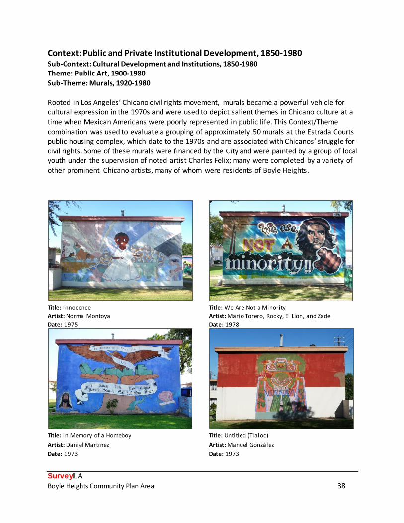
SurveyLA
Boyle Heights Community Plan Area 38
Context: Public and Private Institutional Development, 1850-1980
Sub-Context: Cultural Development and Institutions, 1850-1980 Theme: Public Art, 1900-1980
Sub-Theme: Murals, 1920-1980
Rooted in Los Angeles’ Chicano civil rights movement, murals became a powerful vehicle for cultural expression in the 1970s and were used to depict salient themes in Chicano culture at a time when Mexican Americans were poorly represented in public life. This Context/Theme
combination was used to evaluate a grouping of approximately 50 murals at the Estrada Courts public housing complex, which date to the 1970s and are associated with Chicanos’ struggle for
civil rights. Some of these murals were financed by the City and were painted by a group of local youth under the supervision of noted artist Charles Felix; many were completed by a variety of
other prominent Chicano artists, many of whom were residents of Boyle Heights.
Title: Innocence Title: We Are Not a Minority
Artist: Norma Montoya Artist: Mario Torero, Rocky, El Líon, and Zade
Date: 1975 Date: 1978
Title: In Memory of a Homeboy Title: Untitled (Tlaloc)
Artist: Daniel Martinez Artist: Manuel González
Date: 1973 Date: 1973

SurveyLA
Boyle Heights Community Plan Area 39
Context: Public and Private Institutional Development, 1850-1980
Sub-Context: Military Institutions and Activities, 1850-1980 Theme: Air Raid Sirens and Civil Defense, 1939-1960
During World War II, hundreds of air raid sirens were installed throughout Los Angeles for the
purpose of civil defense and were designed to provide audible warnings of impending air assaults. The system was shut off at the end of World War II, but was reactivated in the 1950s following the onset of the Cold War. Five examples of air raid sirens are located in Boyle Heights
and were evaluated under this Context/Theme combination. All four of the federal air raid siren models – rotating, birdhouse, flattened birdhouse, and wire spool – are represented in the CPA;
all of the air raid sirens identified are installed on freestanding support poles.
Name: Air Raid Siren No. 154 (Rotating) Name: Air Raid Siren No. 190 (Birdhouse)
Location: Pleasant Ave. and Summit Ave. Location: Orme Ave., south of Olympic Blvd.
Date: circa 1940 Date: circa 1940
Name: Air Raid Siren No. 174 (Flattened Birdhouse) Name: Air Raid Siren No. 64 (Wire Spool)
Location: Behind 2927 E. Whittier Blvd., in alley Location: Dundas Ave., north of Wabash Ave.
Date: circa 1940 Date: circa 1940

SurveyLA
Boyle Heights Community Plan Area 40
Context: Architecture and Engineering, 1850-1980
Theme: Late nineteenth and Early twentieth Century Architecture, 1865-1950 Sub-Theme: Queen Anne, 1885-1905
Some of the buildings that date to Boyle Heights’ earliest period of development were designed
in the eclectic and highly-embellished Queen Anne style. This Context/Theme combination was used to evaluate nine single-family residences and one institutional building that stand out as excellent examples of Queen Anne architecture. Common features include irregular plans and
asymmetrical massing; steeply-pitched roofs, often adorned by a tower; integral porches that sometimes wrap around the side elevations of the building; a variety of textured wall cladding
materials; and an abundance of applied ornament and decorative millwork. As some of the oldest houses in the area, most Queen Anne residences were also evaluated under the Early
Residential Development theme.
Address: 2113 E. 2
nd St. Address: 410 N. Chicago St.
Date: 1897 Date: 1885
Address: 3407 E. 4
th St. Address: 2616 E. 3
rd St.
Date: 1895 Date: 1893

SurveyLA
Boyle Heights Community Plan Area 41
Context: Architecture and Engineering, 1850-1980
Theme: Arts and Crafts Movement, 1895-1930 Sub-Theme: American Foursquare or Prairie Boxes, 1895-1914
Rooted in the Arts and Crafts movement, American Foursquare architecture emerged as a common choice for residential architecture around the turn of the twentieth century and
emphasized simplicity, affordability, and practicality. The style was especially popular among middle-class households seeking to make the most out of a modest lot. This Context/Theme
combination was used to evaluate six single-family houses and one parsonage building that are excellent examples of the style. Common features include box-like building forms, symmetrical
massing, hipped roofs with central dormers, and prominent front porches. One of the examples identified (bottom right) includes both Victorian- and Arts and Crafts-era details and represents a
more eclectic interpretation of the style. As some of the oldest properties in the area, most were also evaluated under the Early Residential Development theme.
Address: 2636 E. 2
nd St. Address: 2029 E. 4
th St.
Date: 1908 Date: 1902
Address: 460 S. Evergreen Ave. Address: 706 S. Chicago St.
Date: 1903 Date: 1906
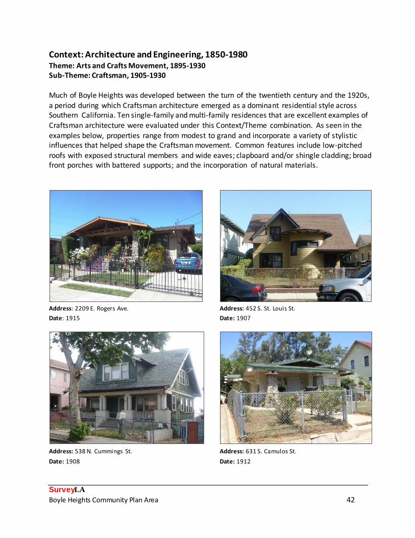
SurveyLA
Boyle Heights Community Plan Area 42
Context: Architecture and Engineering, 1850-1980
Theme: Arts and Crafts Movement, 1895-1930 Sub-Theme: Craftsman, 1905-1930
Much of Boyle Heights was developed between the turn of the twentieth century and the 1920s,
a period during which Craftsman architecture emerged as a dominant residential style across Southern California. Ten single-family and multi-family residences that are excellent examples of Craftsman architecture were evaluated under this Context/Theme combination. As seen in the
examples below, properties range from modest to grand and incorporate a variety of stylistic influences that helped shape the Craftsman movement. Common features include low-pitched
roofs with exposed structural members and wide eaves; clapboard and/or shingle cladding; broad front porches with battered supports; and the incorporation of natural materials.
Address: 2209 E. Rogers Ave. Address: 452 S. St. Louis St.
Date: 1915 Date: 1907
Address: 538 N. Cummings St. Address: 631 S. Camulos St.
Date: 1908 Date: 1912

SurveyLA
Boyle Heights Community Plan Area 43
Context: Architecture and Engineering, 1850-1980
Theme: American Colonial Revival, 1895-1960 Sub-Theme: Dutch Colonial Revival, 1895-1940
Drawing upon the architectural traditions of the nation’s early colonial settlements, Dutch Colonial
Revival residences were immensely popular in the Northeastern United States in the late nineteenth and early twentieth centuries, though examples can also be found in several of Los Angeles’ older residential communities including Boyle Heights. Two single-family residences that
stand out as intact, well-articulated examples of the Dutch Colonial Revival style were evaluated under this Context/Theme combination. Both houses exhibit character-defining features of the
style including simple building footprints, roughly symmetrical facades, gambrel roofs with wide eaves, wood clapboard and/or shingle cladding, and centrally-positioned front doors.
Address: 3543 E. 4
th St. Address: 2453 E. Folsom St.
Date: 1905 Date: 1906

SurveyLA
Boyle Heights Community Plan Area 44
Context: Architecture and Engineering, 1850-1980
Theme: Mediterranean and Indigenous Revival Architecture, 1887-1952 Sub-Theme: Romanesque Revival, 1910-1940
Sub-Theme: Spanish Colonial Revival, 1915-1942
Since the Period Revival architectural movement in Los Angeles reached its peak after most of Boyle Heights had already been developed, buildings of these styles are not as common in the CPA as in other parts of the city. Nonetheless, several buildings in the area were identified as
excellent examples of various Mediterranean-inspired Period Revival styles. Notable properties include two single-family houses and one church (bottom left) designed in the Spanish Colonial
Revival style, and one 1920s church (bottom right) designed in the Romanesque Revival style.
Address: 2820 E. Wabash Ave. Address: 605 N. Brittania St.
Date: 1929 Date: 1932
Name: Lorena Street Baptist Church Name: St. Mary’s Catholic Church
Address: 1100 S. Lorena St. Address: 407 S. Chicago St.
Date: 1920 Date: 1925

SurveyLA
Boyle Heights Community Plan Area 45
Context: Architecture and Engineering, 1850-1980
Sub-Context: L.A. Modernism, 1919-1980 Theme: Related Responses to Modernism, 1926-1970
Boyle Heights had been largely built out by the 1920s, but a handful of parcels either remained
undeveloped or were redeveloped in the 1930s and early ‘40s. Buildings that date to this later period of development were designed in various iterations of the Art Deco and Moderne styles that were popular at the time. This Context/Theme combination was used to evaluate eight
properties that are excellent examples of 1930s and ‘40s -era architectural styles. Included are an apartment house (top left) and church (top right, historically associated with White Memorial
Hospital), both excellent examples of the Art Deco style; a former medical clinic (bottom left) that is an excellent example of the PWA Moderne style and was designed by noted architect S.
Charles Lee; and a mixed-use streetcar commercial building (bottom right) that stands out as an excellent and very rare example of the Streamline Moderne style in Boyle Heights.
Description: Apartment House (Art Deco) Name: David Paulson Memorial Hall (Art Deco)
Address: 2100 E. City View Ave. Address: 1815 E. Bridge St.
Date: 1931 Date: 1932
Name: Mount Sinai Hospital Clinic (PWA Moderne) Name: Rafu TV (Streamline Moderne)
Address: 211 N. Breed St. Address: 911 S. Lorena St.
Date: 1940 Date: 1936

SurveyLA
Boyle Heights Community Plan Area 46
Context: Other Context, 1850-1980
Theme: Important Persons/Individuals, 1850-1980
Boyle Heights has been home to numerous individuals who have made significant contributions to local, state, and national history over time. This Context/Theme combination was us ed to
evaluate the former residences of significant individuals who resided in Boyle Heights: Edward R. Roybal (top left), a prominent Latino politician who represented Boyle Heights in the Los Angeles City Council and U.S. House of Representatives and helped break down racial barriers within
these institutions; Eugene A. Obregón (top right), a U.S. Marine of Mexican American descent who died in battle, was posthumously awarded the Congressional Medal of Honor, and is widely
regarded as a local war hero; and Kiu Sing Chan (bottom left), an advocate for Chinese American assimilation who was one of few very Chinese Americans to own property in Boyle Heights in an
era when discrimination against people of Chinese descent was common.
Name: Edward Roybal Residence Name: Eugene Obregón Residence
Address: 628 S. Evergreen Ave. Address: 624 S. Evergreen Ave.
Period of Significance: 1949-1962 Period of Significance: 1948-1950
Name: Kiu Sing Chan Residence
Address: 2309 E. 3rd
St.
Period of Significance: 1898-1923

SurveyLA
Boyle Heights Community Plan Area 47
Context: Other Context, 1850-1980
Theme: Design/Construction, 1850-1980
The survey identified several eclectic and unique properties that are significant for their design and/or construction, but do not fit within any particular historic context. This Context/Theme
combination was used to evaluate these types of properties. Included is a duplex and a single-family home (top left and top right, respectively), both of which are very eclectic interpretations of Arts and Crafts architecture; a turn of the century single-family house built entirely of brick
(bottom left), a rare residential building material in Los Angeles; and a grouping of bungalows (bottom right) that is notable for its street side (rather than courtyard) configuration and its
combination of residential and commercial uses, both of which are distinctive and atypical characteristics of the bungalow prototype.
Address: 3600 E. Percy St. Address: 3672 E. Percy St.
Date: 1924 Date: 1927
Address: 3051 E. 5th
St. Location: Spence St. and Sabina St.
Date: 1903 Date: 1916

SurveyLA
Boyle Heights Community Plan Area 48
Selected Bibliography Books and other published material:
Architectural Resources Group, with Steven Keylon. Garden Apartments of Los Angeles, Historic Context Statement. 2012.
Avila, Eric. Popular Culture in the Age of White Flight: Fear and Fantasy in Suburban Los Angeles. Berkeley: University of California Press, 2004.
City of Los Angeles. Four Square Leagues: Los Angeles Two Hundred Years Later. n.d. Creason, Glen. Los Angeles in Maps. New York: Rizzoli International Publications, Inc., 2010. Cuff, Dana. The Provisional City: Los Angeles Stories of Architecture and Urbanism . Cambridge:
MIT Press, 2002.
Deverell, William, and Greg Hise, eds. A Companion to Los Angeles. Hoboken: Wiley-Blackwell, 2010.
Elliot-Scheinberg, Wendy. “Boyle Heights: Jewish Ambiance in a Multi-Cultural Neighborhood.”
Dissertation, Claremont Graduate School, 2001.
Henderson, George L. California and the Fictions of Capital. New York: Oxford University Press, 1999.
Intensive Historic Resources Survey, Adelante Eastside Redevelopment Area, Los Angeles, California. Prepared by PCR Services Corporation for the Community Redevelopment
Agency of the City of Los Angeles, July 2008.
Japanese American National Museum. Images of America: Los Angeles’s Boyle Heights. Charleston: Arcadia Publishing, 2005.
Los Angeles Conservancy, “Spanning History: The Bridges of the Los Angeles River.” 2008. Mooney, Mary E. “Side-Lights on Old Los Angeles,” The Quarterly, Publications of the Historical
Society of Southern California and of the Pioneers of Los Angeles 5 (1900-1902): 43-48.
Newmark, Harris. Sixty Years in Southern California. Cambridge: The Riverside Press, 1916.
Ninth Ward Improvement Association. Beautiful Highlands of Los Angeles: Comprising Boyle
Heights, Brooklyn Heights, Euclid Heights. n.d.

SurveyLA
Boyle Heights Community Plan Area 49
Pardo, Mary S. Mexican American Women Activists: Identity and Resistance in Two Los Angeles
Communities. Philadelphia: Temple University Press, 1998.
Romo, Ricardo. East Los Angeles: History of a Barrio. Austin: University of Texas Press, 1983.
Sanchez, George J. Beyond Alliances: The Jewish Role in Reshaping the Racial Landscape of Southern California. West Lafayette: Purdue University Press, 2012.
Other repositories of maps, photographs, periodicals, and other materials:
Digital Sanborn Maps 1867-1970, Sanborn Fire Insurance Maps, accessed January 2014. http://sanborn.umi.com.ezproxy.lapl.org/.
"Home Owners Loan Corporation (HOLC) Maps." Testbed for the Redlining of California's
Exclusionary Space. University of North Carolina, accessed January 2014. http://salt.unc.edu/T-RACES/demo/demo.html.
Japanese American National Museum. “Boyle Heights: The Power of Place,” accessed January 2014. http://www.janm.org/exhibits/bh/exhibition/exhibition.htm.
Los Angeles County Department of Public Works. Tract Maps, accessed January 2014.
http://dpw.lacounty.gov/sur/surveyrecord/tractMain.cfm.
Los Angeles Public Library, California Index, accessed January 2014.
http://www.lapl.org/collections-resources/visual-collections/california-index.
Los Angeles Public Library Photographic Collection, Historic Photographs, accessed January 2014. http://photos.lapl.org/carlweb/jsp/photosearch_pageADV.jsp.
Los Angeles Times. “Mapping L.A,” accessed January 2014. http://projects.latimes.com/mapping-la/neighborhoods.
ProQuest Newsstand, Historical Los Angeles Times, accessed December 2013 – April 2014. http://search.proquest.com.ezproxy.lapl.org/.
Snow, Jenna, and Erika Trevis. National Register of Historic Places Nomination Form: Boyle Hotel-Cummings Block. 7 June 2013.