Historic Preservation Board March 20, 2019 Peebles Island ...
35
Historic Preservation Board March 20, 2019 Peebles Island State Park Commissioner’s Remarks • I am honored and humbled to have been asked by Governor Cuomo to lead the Office of Parks, Recreation and Historic Preservation. • I’m excited to be back working for the best and most robust park and Historic Preservation system in the country. It feels a lot like I’ve come home. • My first real job was as a lifeguard at Lake Welch in 1982, and I was lucky enough to serve as Deputy Commissioner under Commissioner Carol Ash. • I am fortunate to be following in the footsteps of Commissioner Rose Harvey. Under the Governor’s leadership, you and she have driven an extraordinary turnaround for New York State Parks and Historic Sites and the people who visit them. • I will be particularly focused on ensuring the best possible visitor experience for the millions of people coming to our parks and historic sites every year for outdoor recreation, exploration, education and relaxation with friends and family. • I will be clear – Historic Preservation and Interpretation plays a vital role in this mission. • Toward that goal, we will seek to: o Expand partnerships to leverage people, places and services as we expand visitor services and programming
Transcript of Historic Preservation Board March 20, 2019 Peebles Island ...

Historic Preservation Board March 20, 2019
Peebles Island State Park Commissioner’s Remarks
• I am honored and humbled to have been asked by Governor
Cuomo to lead the Office of Parks, Recreation and Historic Preservation.
• I’m excited to be back working for the best and most robust park and Historic Preservation system in the country. It feels a lot like I’ve come home.
• My first real job was as a lifeguard at Lake Welch in 1982, and I
was lucky enough to serve as Deputy Commissioner under Commissioner Carol Ash.
• I am fortunate to be following in the footsteps of Commissioner Rose Harvey. Under the Governor’s leadership, you and she have driven an extraordinary turnaround for New York State Parks and Historic Sites and the people who visit them.
• I will be particularly focused on ensuring the best possible visitor
experience for the millions of people coming to our parks and historic sites every year for outdoor recreation, exploration, education and relaxation with friends and family.
• I will be clear – Historic Preservation and Interpretation plays a vital role in this mission.
• Toward that goal, we will seek to: o Expand partnerships to leverage people, places and services
as we expand visitor services and programming

o Resource protection to preserve our historic and cultural assets and continue to be a national leader in community development through the historic preservation tax credit
§ The rehabilitation tax credit program has hit $5 billion in historic preservation investments under Governor Cuomo. We are planning a big celebration and you all will be the first to know where and when that will be. We are discussing as we speak.
§ The program has touched 56 of 62 counties and was
ranked Number 1 in the nation for the fourth straight year.
§ This is programming is extending the Parks brand to
hundreds of additional communities outside our current parks and historic sites system and generating jobs and tax revenues at the local, state and federal level.
§ I wish to thank the State Review Board for their critical
role in qualifying historic properties for the tax credit program. Thank you.
o Focus on access, diversity and inclusion to ensure our parks
and historic sites and facilities are welcoming to all people
o Innovation and sustainability to put the NY State Park system at the forefront of technology services and renewable, sustainable energy
o NY Parks 2020 and beyond—continue our legacy-making
capital initiative with projects designed to carry us into the 21st century and beyond

o I am extremely excited that Division for Historic Preservation is preparing to launch a statewide historic resource survey of the State Park system.
§ We intend to launch this project by early summer 2019
and will survey the park system’s building and historic landscape inventory to assist the agency with planning, compliance review, historic resource stewardship, and identifying resources for stewardship of these resources.
§ The project will be completed over the next three years and be coordinated with the Regional Directors and Park, Historic Site and park managers.
• I wish to thank The State Review Board, our immensely hardworking and dedicated staff, or fearless leader Daniel MacKay, Director Michael Lynch and Division Staff again for your passionate and committed service that has placed New York State at the forefront of Historic Preservation. We are a nationwide leader!
o Leading the Nation: Historic Rehabilitation Tax Credits as I
mentioned,
o Leading the Nation: Number of properties, resources, and districts on the State and National Registers
o Leading the Nation: Most diverse selection in the country
from LGBTQ sites in NYC to the newest project to address African American civil rights history in Upstate NY.
• I would also like to send a special shout-out to our Archaeology
Unit led by Nancy Herter for their oversight of the Revolutionary War-era burial plot in Lake George. You volunteered on site,

worked closely with all state agencies and local departments to ensure these remains were treated with the respect they deserved. New York State is so very grateful for that.
• Thank you for inviting me today and I am excited to build upon the great historic preservation successes.
SRB Presentations: ALDRICH AND RAY MANUFACTURING COMPANY BUILDING BUFFALO, ERIE COUNTY
Summary of Proposal
The building proposed for nomination is the Aldrich and Ray Manufacturing Building, located at
1491 Niagara Street, Buffalo, in a commercial and industrial corridor largely defined by
properties from the late nineteenth and early twentieth centuries.
The Aldrich and Ray Company was an important manufacturer of copper and brass products in
Buffalo during the late nineteenth and early twentieth centuries. The company was founded in
1879 by Schuyler Aldrich. In its early years, it operated at two different locations, at 14-20 Perry
and 74 Washington. In 1884 Isaac A. Aldrich entered the firm, and in 1886 George A. Ray was
admitted as a partner. The company moved to 1491 Niagara Street in 1888 and, shortly
thereafter, Aldrich and Ray built its first manufacturing facility on the current site. This is an
1889 Sanborn map showing that original. 4-story factory – You should also note the 2-story
police station, which is on the right side of the image. Less than a year later, in 1893, the
factory was destroyed by fire.
After the original factory was destroyed in 1893, the company purchased the adjacent site to the
north, the location of the police station, which had either been destroyed or seriously damaged in
the same fire. [and it’s very difficult to tell exactly what happened to the police station from
newspaper articles – some say destroyed, while others say seriously damaged]

This is from an 1894 atlas and, according to the nomination, this is inconsistent with the timeline
because it appears to show the site as it was before the fire. It shows the original 4-story factory
and the 2-story police station in 1894; however, we know that they burned in 1893. So, we agree
with the nomination author that this map must actually show the site in 1893 – it may have been
prepared before the fire and not updated before the atlas went to press. This rendering shows
that by 1900 Aldrich and Ray had constructed a U-shaped building more than twice the size of
the original. While no photos of the completed building have been found, this rendering
suggests that the newly expanded factory embodied a consistent, unified design and that the new
building may have incorporated a portion of the front wall of the former police station. If you
look at the left side of the first floor, under the sign that says “office,” you can see that the first
floor windows on the north side are different. The new building was three stories tall and
thirteen bays wide. Two wings, eleven and nineteen bays deep, extended back from the main
block on either side of a drive-through from Niagara Street. The rendering is supported by the
1900 Sanborn map, which shows the same configuration and also shows the offices in the
northwestern quadrant, while the rest of the building was laid out for manufacturing and storage
spaces. A fourth floor was added to the south wing in 1904. (again, there is no historic photo,
but maps confirm)
The Aldrich and Ray Company and its successor firm, the George A. Ray Manufacturing
Company, occupied the U-shaped building until 1953. You can see in this 1950 Sanborn that the
George A. Ray Company still occupied most, but not all of the building; and a series of Sanborns
indicate that the building remained entirely intact to its construction period. The same U-shaped
configuration remained as built until 1954, when a one-story gantry crane wing was added at the
southeast corner by a subsequent company, the Fedders-Quigan Company. The maps show that
until well into the mid twentieth century all of Aldrich and Ray and its successor company’s
functions were carried out in the U-shaped complex and the building retained its architectural
integrity as a typical late nineteenth century industrial factory.
In 1976, while under the ownership of the S.A. Day Company, the entire north half of the
building was destroyed by fire, leaving only the south wing of the former Aldrich and Ray
Company building and the 1954 addition added by a later company.

This image shows all four floors of the interior as they are today
SHPO Opinion
In our opinion, the fragment that remains, which is about half of the historic Aldrich and Ray
Factory, does not retain sufficient integrity to illustrate either a typical late nineteenth century
manufacturing complex or the operation of the Aldrich and Ray Company during the period of
significance. At no time during the Aldrich and Ray Company’s history or during the building’s
historic period of industrial use (1894-1954) did it ever resemble what exists today. What exists
today represents the building’s history only from 1976 - the date of the fire.
Now, how did we make that evaluation? Well, there are two parts to establishing eligibility:
First, a building must represent a significant theme. In this case, that theme is industry. We feel
that the draft nomination has more than enough information to support the claim that Aldrich and
Ray was a significant local industry. So it meets test one.
But, the second test is that a building must have enough integrity to illustrate that significant
theme – in this case, can the building illustrate the industrial history of the Aldrich and Ray
company? The National Register gives us seven measures for judging integrity [they are:
location, setting, design, materials, workmanship, feeling and association] and it requires that a
building must meet four of the seven measures to be eligible. Those four should be the ones that
are most important to illustrating the significant theme [in this case, industry], and two of them
must be feeling and association. When we establish the relevant integrity measures, we also look
at the relative rarity of the building type. If something is the only surviving example of its type,
for example, the only factory left in a small village where that industry was the major employer
for that village, then we are allowed to be a little more lenient when we look at its integrity.
However, if there are many examples of a certain type of resource, then we are required to be
stricter about the integrity required as we look at multiple examples. Unfortunately, late
nineteenth century industrial buildings with typical mill construction are not particularly rare in
Buffalo; thus, we are limited to a relatively strict reading of the integrity criteria for this resource.

The other very important consideration is period of significance: In order to meet the eligibility
criteria, a property must retain the character it had during the period of significance..
So, if we go through the seven integrity measures for this proposal, we can all agree that the
building retains integrity of location and setting. So that means we have two of the four we need.
The next three are related, and they are integrity of design, materials and workmanship.
Workmanship is more about craftsmanship or design innovation, and it isn’t really relevant to a
building like this one. But design and materials are. Design is the combination of elements that
create the form, plan, space, structure, and style of a building. If you look at the rendering, you
can see that the surviving wing has only half of its original design, half of the form, half of the
space, half of the plan, half of the structure, and, by extension, half of the materials as the
original. And if we look at functional integrity, which would be the spaces needed to represent
the history of a manufacturing building, crucial parts of the building in which manufacturing
functions occurred are gone, as is the office, which is arguably one of a business’s most
important spaces. The part of the building that remains is half of the factory that was designed,
constructed and used by Aldrich and Ray. We believe that it is essentially a fragment of the
original factory and that it does not retain integrity of design or materials.
So what about feeling and association? For the building to be eligible, it must retain integrity of
both feeling and association. Association is the direct link between the building and its historic
theme during the period of significance. Since the building did not achieve its current
appearance until 1976, long after Aldrich and Ray and its successor firm stopped using the
building, we believe that the building does not retain its significant association with the Aldrich
and Ray Manufacturing Company during the period of significance. Feeling is a much more
subjective measure, but it refers to the property’s expression of the historic sense of the period.
With only half of what existed remaining, without the company offices, without the drive
through and yard, we believe that the fragment lacks the feeling of the twentieth century factory
that operated on this site for 80 years.
So, what about the draft nomination itself?

The draft nomination argues for significance under criterion A in the area of “Industrial History.”
As I noted, the draft meets this test very well; we agree that it contains more than enough
information to support the claim that Aldrich and Ray was a significant local industry.
However, the nomination does not try to make the case that the surviving fragment is intact
enough to represent the history of the Aldrich and Ray Company. Instead, the nomination
presents the argument that the building fragment alone is significant because only the south wing
was constructed for the Aldrich and Ray Manufacturing Company. The draft states that the north
wing, the part of the building that was destroyed by fire in 1976, was not an important part of the
building because it was adapted from the earlier police station. We do not believe that this is a
valid argument.
The Sanborn maps confirm that after the 1893 fire, an expansive U-shaped factory was
constructed that housed all aspects of the company’s offices and manufacturing functions
throughout the rest of its existence. Whether or not the newly expanded U-shaped factory
incorporated a portion of the former police station is irrelevant. The Sanborn maps prove that the
entire building as developed (either adapted and/or constructed) after the fire is what was used by
the company and what represented the company’s history and development over the period of
significance. In addition, the north wing was the location of the company’s offices, a vital part
of its operation. We do not believe an argument can be made that supports the significance of the
surviving wing alone as an industrial building when it was clearly a part of a large, integrated
design scheme for a factory that incorporated all aspects of the manufacturing process.
Summary
The board’s task is to determine whether, in your judgment, the building is 1. Associated with a
significance theme and, if the answer is yes, 2. Does it retains enough integrity to the period of
significance to illustrate that theme using the seven integrity criteria?
CHURCH OF ST. GABRIEL THE ARCHANGEL Paul Smiths, Franklin County

This is a postcard of the Church of St. Gabriel the Archangel, located in the small resort
community of Paul Smiths, in Franklin County. Even though the image is in black and white,
you can see two important things about the building: first it had a multi-color paint scheme and
second it always considered a mission church; it never had a full time resident pastor. This was
typical for many, small summer churches on the Adirondacks, which served either summer
vacationers or year round communities with small populations or sometimes both.
Here is the church today. This small wood-frame church was built in 1896, on land donated by
famous Adirondack resort owner Paul Smith, and it was apparently built for the catholic workers
at Paul Smith’s Hotel who resided in the nearby community. There is no architect of record, and
we suspect that it was designed by a local builder. It’s actually a fairly simple building, but it’s
distinguished by rustic embellishment of all surfaces, both exterior and interior – On the exterior,
it has a sweeping eaves line with deep overhangs and every surface is covered by a decorative
pattern of wood shingle and clapboard; it also has wood trim with delicate sunburst and tassel
motifs. The interior relies on deeply varnished, narrow tongue and groove bearded board
arranged in a highly decorative manner. According to our consultant, these decorative, rustic
style churches were more typical of those built for summer guests and contrasted with larger,
more traditional brick and stone buildings built for regular parishes - I’m actually not sure I
believe her, especially because this was for a year round congregation!
However, it was a very small congregation – so small that it remained a mission for its entire history before becoming an oratory, which meant it could only be used on special occasions - and in 2012 the diocese finally closed it – Before the diocese closed it, it removed the stained glass windows – which were not original anyway, but left the church with only storm windows and boarded up openings. Because there was a clause in the original deed saying that if it was used for other than religious purposes, the original land owner could take it back, that is just what Paul Smith’s College did a few years ago. The college took it back for its own protection. St Gabriel’s in sig in architect for its intact “rustic “ design and in social history for its association with the small hamlet of Paul Smiths and the community that developed around it MCNAUGHT FAMILY FARM Bovina Center Vicinity, Delaware County This is a 1946 aerial view of the McNaught Family Farm and you can just make out our farm in
the center of the image. When the large McNaught Family arrived from Scotland in 1817 they
leased Lot 88- a 202 acre farm [part of the Hardenburgh patent] that can still be identified today
by most of a massive stone wall – show them. And that entire farm remained in the family until
1962, when Marshall McNaught died without any heirs. [in fact, the way the McNaught children
and grandchildren spread out, the family owned more than 1,000 acres throughout the valley].
However, after old Marshall’s cows were found wandering around alone one day and he was
discovered dead in the house, the farm was divided into more than 40 separate parcels and most
of it has been developed – and all we have left with integrity is 22 acres right in this triangle....
This house consists of multiple parts – the large, two-story section was built in 1865-70 during a
time of great prosperity. The smaller wing was either an earlier house on this site or an earlier
house moved to the site when the 1870 house was built – because they have one continuous
foundation but it has a much older frame. And the other wing behind it is also an older building
thought to have been moved to the site in a slightly later period
The outbuildings – most of which dated to the 1870s – burned in the 1980s and included a 20th
century milk house that sat on this foundation [which now holds a non-contributing shed], a
horse or carriage barn, a dairy barn [this is the ramp], and a mill [which could be significant in
archeology but the owner has already pulled the wheel out so it really needs professional
investigation], and there are pieces of stone fencing and boundary wall throughout the property –
[I’m not sure Alexis will let me count all of these]
One of the interesting things about this nomination is the information that the consultant turned
up about the Scottish immigrants – that they did not chose these remote farms at high elevations
because they reminded them of the Scottish highlands – if fact they were poor tenants in
Scotland and they were poor tenants in Delaware county – unable to afford the choicer land at
lower elevations
The other interesting thing is that even by the 1940s, you can that they were beginning to use
machinery – and the land closer to the house has begun to lose its small field patterns and stone
walls –[here is a machine shed – that has since been converted to a house and lost integrity; thus
excluded ] But the 22 acres parcel that survives reflects this last era of farming

So the McNaught Family Farm is significant under Criteria A and C in architecture, settlement,
social history and agriculture.
Alku & Alku Toinen 816 & 826 43rd Street, Brooklyn, Kings County [Facades] Alku (New Beginning) and Alku Toinen (Second Beginning), the buildings constructed by the Finnish Home Building Association in 1916 and 1917, respectively, are significant under Criterion A in the area of social history as the first purpose-built true cooperative apartment buildings to be constructed in New York State. Built by and for Finnish laborers, the buildings operated based on the Rochdale principles established in 1844. These principles, which include democratic control, a nonprofit structure, voluntary membership with individual economic participation, and concern for community, set the foundation for the operation of cooperatives internationally and remain at the core of the cooperative movement. [Finntown] New York City’s Finnish community grew in the late nineteenth century as a result of troubles in Finland, including crop failures, rural poverty, and political tensions created by the Russian Empire. New York’s largest Finntowns were located in Harlem in Manhattan, Sunset Park in Brooklyn, and in the Bronx. Finnish immigrants brought a deep familiarity with the cooperative movement with them. Finland’s cooperative movement was one of the strongest in the west and grew over the course of the twentieth century. By 1914, the majority of the Finnish population was involved in some form of cooperation. In America, Finns used cooperative organizations to help maintain their cultural identity, distribute Finnish products, and contribute to the community’s success. [Elevation drawing] In response to the housing crisis in New York City, the lack of housing that met their needs, and the discrimination they faced as new immigrants, a group of working-class Finnish builders established the Finnish Home Building Association to work cooperatively to build suitable and affordable housing for their community. Each family in the cooperative contributed funds and skills to the project and were together responsible for repaying loans to community members and a cooperative bank. [Alku] Alku was designed by Maxwell Cantor and Boris Dorfman and Alku Toinen was designed by Eric O. Holmgren. All three men were first or second generation Eastern European immigrants, were members of the Brooklyn Society of Architects and American Institute of Architects, and worked prolifically in Brooklyn. Both buildings feature simple, Neoclassical revival style facades that relied on cost-efficient details and a predominant use of brickwork, which lent itself to the skills of the Finnish builders involved in the project.

[Alku Toinen floor plan] The functionality, efficiency, and livability of the interior was of utmost importance. Each floor was divided into four units, which offered the luxury of larger, light-filled spaces and well-designed interior circulation with wide corridors. [Alku Toinen] Alku and Alku Toinen were lauded by national cooperative publications, gained state and local notice, and were immediately filled and appreciated by members of the Finnish community in Sunset Park. [Food & Markets] While Finns were familiar with cooperative ownership, the project was groundbreaking in New York State and was initially slowed by municipal authorities that found the idea of joint ownership strange. As most other previously existing cooperatives were food-based, the State Department of Agriculture regulated all cooperatives, including housing cooperatives, for decades. (only cooperative alongside 21 orgs in 1920 Food and Markets) [Contract] The buildings maintained a stable community which was committed to following community rules and bylaws based on cooperative principles. Each apartment owner had one vote in matters related to the operation of their building, attended regular ownership meetings, and was responsible for paying a small monthly maintenance fee. Apartment rates remained stable throughout the period of significance, not beginning to rise in response to market rates until after the period of significance. [Alku entry] [Alku hallway] (more decorative details in common spaces, simpler in apartments) [Alku Toinen entry] Following the model established by the Finnish Home Building Association’s ownership structure and building design philosophy, other groups of Finns established their own cooperatives. These spread rapidly within the Finnish enclaves of Sunset Park and the Bronx through ca. 1930. [Alku Toinen hallway] Ultimately, approximately 30 Finnish cooperatives were established in Brooklyn in existing and purpose-built apartment buildings. Many continued to operate after WWII, when the non-profit housing cooperative became the favored method of housing in New York City. [Interior] Alku and Alku Toinen were an immediate success, contributed to Finnish social and cultural cohesiveness, and demonstrate the accomplishments of immigrants working together toward a common goal.

[1970s photo] While the population of the apartments remained stable, the demographic of the cooperative ownership of the buildings was no longer predominantly Finnish by ca. 1955. While the cooperative’s documentation changed to English during this period, its founding rules and principles were retained. Both Alku and Alku Toinen remain under cooperative ownership and operation. Draft by Valerie Landriscina, coop resident, and Cecilia Feilla, assistant professor at Marymount Manhattan College Letters of Support from Amerikan Uutiset (National Newspaper for Finnish-Americans); the New York Metropolitan and Florida Chapters of the Finlandia Foundation; the Finland Center Foundation; the Sibelius Bredablick Lodge; Finnish American Lawyers Association; Richmond Hill Historical Society; NYC LPC East Harlem Historic District Harlem, New York Co. [East 116th Street] The East Harlem Historic District is significant under Criterion C in the area of architecture for its extensive intact groupings of late 19th century row houses and flats and late 19th and early 20th century tenement buildings, as well as religious and institutional buildings designed by notable architects. It is additionally significant under Criterion A in the areas of social and ethnic history for its association with the Jewish, Italian, and Puerto Rican working-class immigrant communities that occupied this neighborhood successively from the mid-nineteenth to the mid-twentieth centuries. While many other ethnic and cultural groups have been associated with the neighborhood, these three stand out of their length of stay, percentage of the population, and for having lent their names to the area. [Map] The name “East Harlem” has been used informally to cover a large area. While the history of immigrant communities played out throughout the whole of East Harlem, much of that history revolved around the commercial spine of East 116th Street from Park Avenue to the East River, along the residential spine of Pleasant Avenue, and on nearby blocks. The district’s period of significance – 1865 to 1966 – covers a century of the neighborhood’s historical and architectural evolution and its post-Civil War development as an immigrant community. [East 117th Street] The buildings of the historic district predominantly consist of rowhouses and flats dating from the 1870s and 1880s, and tenements dating from the 1880s and 1910s, along with a number of commercial, institutional, and religious structures serving immigrant communities. The row house is a distinctive element in the residential development of mid to late 19th century New York City; like row houses elsewhere in the city, the East Harlem examples create uniform streetscapes with a distinctly New York flavor.
[East 116th Street] As the city grew denser, four-story French flats – multiple dwellings with one apartment per floor – joined the row houses and were often designed in similar styles. The tenements in the district, including both old-law and new-law types, reflect the evolution of housing reform in late 19th and early 20th century New York City. [Tenements 1944] Like the tenements of the Lower East Side, with which they are roughly contemporary, the East Harlem tenements were the first home for waves of immigrants during the country’s period of vast immigration in the decades before and after 1900. Jewish settlement extended throughout the city and throughout Harlem, but only this section became known as Jewish Harlem. German Jews began settling in the area during the 1860s, and were later joined by Eastern European Jews. The number of Jewish families in East Harlem grew into the mid-1920s, when it comprised half of the neighborhood’s population. [Our Lady of Mt Carmel (1884) & St Pauls RC Church (1908)] Italian-American communities have existed in all five boroughs, but East Harlem became known as “Little Italy,” rivaling the area of Lower Manhattan also known by that name. Italians began moving to East Harlem during the late 1870s and remained a significant part of the neighborhood’s ethnic and cultural makeup into the 1960s. Religious life, community, and tradition was central to the Italian population. Our Lady of Mt Carmel served a varied Catholic population but became strongly associated with a culturally Italian annual feast and parade in honor of the Madonna which continued into the twentieth century. [Italian Savings Bank (1923) & Banca Commerciale Italiana (1930)] During the first quarter of the twentieth century, two banks were established on East 116th Street to cater to the Italian population. The construction of these buildings reflects East Harlem’s solidification both as a major Italian-American neighborhood and as a community that even conservative bankers found a good investment. These banks facilitated the transfer of funds back to Italy and offered the comfort of Italian-speaking staff with knowledge of the community’s needs. [Thomas Jefferson Play Center (1936)] Fiorello LaGuardia, who first served as a congressman from East Harlem, helped bring new public projects to the neighborhood, many funded with WPA money, during his tenure. These included the WPA Pool and Play Center designed by Aymar Embury II in Thomas Jefferson Park… [NYC Dept of Health (1937)] … the Modern Classic New York City Health Center, said to be the first city-built and owned health center in Manhattan and the first in a series of similar buildings planned for the City… [Benjamin Franklin HS (1942)] … and the Georgian Revival Benjamin Franklin High School, an experimental school modeled on East Harlem based Leonard Covello’s educational theories.

[Lucky Corner – 1943 Marcantonio, 2017] LaGuardia’s protégé, Vito Marcantonio, a progressive, fiery, and controversial figure, served as East Harlem’s congressman from 1934-50. LaGuardia established the intersection of East 116th Street and Lexington Avenue as his “lucky corner” for campaigning, and Marcantonio continued the use of this corner for speeches and events. [Midcentury East Harlem] Spanish Harlem, or El Barrio, is most closely associated with the Puerto Rican experience in New York City. The earliest Puerto Rican immigrants arrived in East Harlem during the 1920s, and the population grew substantially by the 1950s and continued to grow through the end of the twentieth century. [James Weldon Johnson School (1960-62)] The postwar years saw little construction in the district, all of which was related to the flourishing of Catholic institutions and growth of the community. Neo-Formalist NYC public school. [East 119th Street] While change has begun to come to the area, the district retains the buildings that so many communities have called home and continues in its role as a neighborhood of entry to new immigrant groups. Draft by Tony Robins Letters of Support from NYC LPC; Historic Districts Council; 2 property owners Letters of Objection from 59 property owners (639 total) VISITOR: Chris Cirillo, Landmark East Harlem Stanley H. Lowndes House 155 Bayview Avenue, Northport, Suffolk Co [façade from street / Lowndes] Built in 1895, the Stanley H. Lowndes House is locally significant under Criterion B in the areas of maritime history and commerce for its association with Stanley H. Lowndes, a prominent regional figure and renowned oyster baron. The house is additionally significant under Criterion C as a notable local example of Queen Anne architecture. The oyster industry was one of the most important economic generators of growth for the village of Northport and had a significant impact on its development. [Oyster cultivation] Born in Connecticut, Stanley Lowndes learned about the industry at an early age from his grandfather and father, who pioneered and developed oyster culturing in the region. As natural oyster supplies diminished, they discovered that oyster growth could be enhanced and controlled by placing hard, smooth surfaces in the water near existing oyster beds. They also became involved in “planting” oysters, the process of catching or cultivating oyster seed and then depositing it in a specific location.

[CT Map 1940s] These new processes, and the associated infrastructure, presented new legal problems. To ensure their investment, growers needed to maintain control over the water bottoms where they were culturing oysters. (In CT – bottoms land subdivided, ref map) Following in his family’s business, Lowndes developed significant cultured and seeded oyster bed and, when he encountered resistance due to state and municipal regulations, became involved in litigation. [Northport Harbor] As he pushed his operations further into Long Island Sound, Lowndes became embroiled in a legal case to claim rights as a non-resident to harvest oysters in waters claimed by the Town of Huntington. After nearly a decade of appeals, in 1894 the Supreme Court of the United States made a final judgement in the case. The court sided with Huntington, which claimed that its colonial patents, which included harbors, gave it the right to restrict underwater rights to its residents. [Historic house and dock] After this final decision, Lowndes relocated his primary home and the headquarters of the Lowndes Oyster Company to Northport to be able to take advantage of the excellent conditions for Oystering in Northport Harbor. From Northport, Lowndes continued to expand the company into one of the most successful oyster industry operations in the region during the period. [Outbuilding] The company operated several processing and shipping facilities, including one in the harbor next to Lowndes Home. [Current from dock] After he made the decision to move, Lowndes announced his entry into Northport’s business and social communities by commissioning local builder Darius B. Ruland to build an expansive Queen Anne home to overlook his oyster operations. The house reflects the style through its asymmetrical massing, horizontal and irregular silhouette, sweeping wraparound porch, waterfront rear-facing tower, and diverse use of materials. [Dining room / staircase] The house exemplifies the Queen Anne motif through the remarkable and intricate woodwork present throughout the building, which has been attributed to the carpentry expertise of its builder. [Parlor] [Tower bedroom] [Attic] [Angle shot]

Columbia Draft Letter of Support from Steven King, Northport Village Historian George Washington Hotel 23 Lexington Avenue, New York Co. [Current / Historic shot] The George Washington Hotel is significant under Criterion C for its Italian Renaissance Revival design and as an intact example of one of the final apartment hotels erected in New York City after the building boom of the 1920s and before the passage of the Multiple Dwelling Law of 1929 when apartment hotel construction came to a near-halt. The Hotel is also significant under Criterion A for its association with the history of housing and social history in New York City. [Plans] Completed in 1930, the George Washington Hotel was designed by Frank M. Andrews and John B. Peterkin for the Club Hotels Corporation. Designed to give a sense of social sophistication to its clientele, the architects utilized the Italian Renaissance Revival style and employed a monumental entrance, elaborate terra-cotta decorative details, and grand interior spaces finished with luxurious materials. [Storefront] Apartment hotels like the George Washington catered to the city’s growing population seeking moderately priced housing in convenient locations near businesses, shopping, and amusements. The success of the building type was a result of its relative affordability and the offering of the amenities of a hotel with the greater permanence more typical of apartments. [Windows / Terrace] The George Washington Hotel – “Born of a Great Need,” – as its brochure advertised – offered such a place for emerging young professionals of discriminating tastes just beginning their careers in the city. [Elevators] The hotel distinguished itself with its club-like setting, offering extensive amenities and comforts that had been previously reserved for upper class. In addition to the 630 modest-sized rooms, residents could take advantage of… [Historic gallery] …the entire second floor which was designated as communal space for residents and their guests. This included a large Italian Renaissance Revival gallery that overlooked Lexington Avenue… [Current gallery] …a Colonial Revival style lounge, a Georgian Revival style library, and smaller reception and bridge rooms. [ITC project took great care to preserve these important public spaces]

[Lounge] While the George Washington’s eclectic combination of exterior and interior spcaes referred to the opulent styles of the past, it offered amenities and accommodations that were distinctly modern. Approved Part 1 application Draft by Lindsay Peterson, Higgins, Quasebarth & Partners Letter of Support from NYC LPC St. Luke’s Hospital 30 Morningside Drive, New York Co. [Aerial / Engraving] St. Luke’s Hospital in Morningside Heights is significant under Criterion C in the area of architecture as an early and important work of American architect Ernest Flagg that reflects developments in the architectural design of hospitals. It is also significant under Criterion A in the area of medicine as a good example of an urban hospital demonstrating the evolving role of hospitals in providing medical care in New York City in the nineteenth and twentieth centuries. [Plan] Early hospitals, which often had a compact plan, had to contend with the spread of illness between patients. By the mid 19th century, pavilion plans, which prioritized through ventilation and typically featured low-slung pavilions separated by large areas of open space had come into favor. Flagg made advances in the pavilion plan, adapting it for the urban landscape; he positioned the pavilions close to each other but kept them isolated by fresh air cutoffs. [Muhlenberg / Minturn] The relatively tall pavilions stacked more floors than earlier pavilion hospitals, while maintaining standards of ventilation and protection against contagion; they were differentiated by function, representing the various treatment, scientific, administrative, housing, and other aspects of the increasingly complex modern hospital. [Plant / Scrymser] The hospital also represented a departure from the red brick Romanesque Revival style that had dominated institutional architecture in New York City in the later 19th century. The French Renaissance Revival style of the St. Luke’s Pavilions, derived from palatial seventeenth century Parisian models, gave the array of pavilions a unified design expression despite their complex differentiation in program and plan, and was a milestone in the introduction of Beaux-Arts style institutional architecture to New York. [Plant balconies] (Private Patients pavilion. Balconies facing out on Morningside Park)
[Evolution] The period of significance spans from the completion of the first Flagg-designed buildings in 1896 until the last historic addition, constructed in 1965. Flagg’s 12-building master plan for the new St. Luke’s campus continued to serve the hospital’s needs and was followed into the mid-twentieth century. Five pavilions and two smaller buildings were constructed during the initial campaign, and three more pavilions were built over the next 30 years. [Scrymser / Travers] The expansive, forward-looking plan reflected the increasingly central role of hospitals in providing comprehensive, scientifically sophisticated medical services to an urban population. It provided for the advantageous siting of patient wards and a chapel as well as the modern structures necessary for a hospital’s expanding functions. [Travers / Ambulance Stable] This included housing for nursing staff, laboratory and surgical facilities, administrative and physicians’ offices, and private patient and outpatient pavilions. [Expansion, ca. 1955 – Clark] Following World War II, the hospital desperately needed to add new capacity and facilities. Instead of following Flagg’s plan, they instead chose a new modern design focused on efficient, simple, modern facades and interiors. [Clark] The hospital was also able to abandon the pavilion plan as a result of the introduction of antibiotics, which eroded the link between the physical arrangement of spaces and the treatment of illness. After the introduction of air conditioning and ultraviolet light as a disinfectant, natural light and outdoor air was no longer perceived as necessary in a hospital environment. [Aerial of full complex] The additions constructed in the later twentieth century were not built with any consideration to Flagg’s plan, or to the style, sale, or materials of the Flagg buildings, but they do represent important later trends in health care planning as well as the substantial postwar expansion of the hospital. This period saw a sharp rise in hospital admissions, aided by the adoption of antibiotics and the creation of employer health insurance plans that made hospital care more affordable. The hospital constructed four large pavilions from 1954 to 1971, which accommodated the 1952 merger with another major Morningside Heights institution, Woman’s Hospital. [Muhlenberg entrance] (Administration building – primary entrance before late 20th century additions) [Chapel] (Chapel wing – inspired by 19th century French ecclesiastical architecture, large stained glass window by English artist Henry Holiday) [Minturn interior] (Reception room, Plant-Minturn connector)

[Hallway] (interiors reflect updates over time for hospital use) [St. Luke’s 1905] Approved Part 1 application Draft by Jonathan Tayor, Higgins, Quasebarth & Partners Letter of Support from NYC LPC

Sag Harbor Hills, Azurest, and Ninevah Beach Subdivisions (SANS) Historic District Sag Harbor, Suffolk Co. [Map & Amaza] The Sag Harbor Hills, Azurest, and Ninevah Beach Subdivisions Historic District, also known as SANS, is significant under Criterion A in the areas of community planning and development, social history, and ethnic history as a summer community created by and for people of color and their families. The district reflects the work of its founders to create the community and develop strategies for its success, the value of the social networks established by the African-American professionals who purchased land and built homes there, and the aspirations they held for their families. [St. David AME / 1916 Map] Eastville, a community of people of color, formed on the eastern side of Sag Harbor starting in the 1830s. During the late 19th and early 20th centuries, this year-round community centered around the St. David AME Zion Church welcomed summer vacationers of color. Eastville served as an anchor community for these families, attracting them to the area and ultimately helping to inspire the creation of the SANS subdivisions. [Map with subdivisions] SANS was developed shortly after World War II on sandy land east of Eastville as a summer resort for people of color who wished to enjoy leisure time along the Sag Harbor waterfront. Sisters Maude Terry and Amaza Lee Meredith spearheaded the creation of the Azurest subdivision in 1947. The planning and settling of Azurest paved the way for the planning and settlement of the Sag Harbor Hills, Sag Harbor Beach Club, and Ninevah Beach Subdivisions which were owned, platted, filed, and sold in phases by white developers. [Early small houses] Although the Sag Harbor Hills and Ninevah Beach subdivisions were not initially planned by or for African American homebuyers, the growing presence of people of color in Azurest, combined with racist assumptions of profitability, laid the groundwork for them to become de facto African-American communities. Middle- and upper-class African American professionals saw this as an opportunity for access to protected beaches, safety from the oppressive conditions of Jim Crow, and the economic ability to own a vacation home for their families. [Terry Cottage] Housing segregation, discriminatory urban planning and zoning and mortgage financing policies prohibited many people of color from building or buying housing, let alone developing and enjoying resort housing. Creative solutions were required to make SANS accessible even to middle-class African-Americans. Terry and Meredith established the Azurest Syndicate in 1950 during the second-phase of the Azurest subdivision to facilitate sales of lots, offer small mortgages to buyers, and act as a property owners association. (Terry Cottage, 1949, designed by Amaza Lee Meredith; architect Virginia State Univ. founder of art dept)

[Beach Ave Streetscape] In the Sag Harbor Hills and Ninevah Beach neighborhoods, families typically paid cash for the land and were able to obtain credit from local hardware stores or contractors for the materials for their homes. Some owners built progressively with the help of friends and neighbors, and some made arrangements with local contractors. Each of the three neighborhoods grew gradually over approximately a thirty-year period as new families became members of the seasonal community. [Ranches] As each owner was responsible for building his or her own home, the neighborhoods lack a cohesive design identity. However, as owners generally built in popular, modern styles, SANS does reflect a consistent mid-twentieth century modern aesthetic. (examples of ranch homes, which began to appear relatively early in neighborhood’s development) [Beach access] The SANS community is among a small number of surviving beach communities in the United States with African American roots. These communities allowed African-American families a welcoming environment to enjoy summertime amenities that they could not enjoy elsewhere due to racism and exclusion under Jim Crow laws. African American families learned about the opportunity to become a part of the tight-knit summer community in Sag Harbor through family connections and extensive social networks based on their educational and professional associations. [1959 beach photo] These neighborhoods became, and continue to exist as, havens for middle-class and upper-middle-class African-American families, populated by doctors and lawyers, artists and academics. (I hope you read through the appendix at the end of the nomination – SANS residents read like a “Who’s Who” and guests to the community range from Duke Ellington, Lena Horne, and Langston Hughes to Congressman Adam Powell, Lt Gov Basil Paterson and NYC Mayor David Dinkins) The SANS beaches were, and continue to be, a place of congregation for SANS residents and visitors and a setting for social connections as well as intellectual conversation and civil rights planning. [More interesting] While many of the homes in SANS are more typical examples of mid-twentieth century suburban design, some families hired architects, built homes based on plans for magazines, or were inspired by playful trends in mid-century residential design. [Small houses] (Later examples of smaller houses in the neighborhood) [Lincoln streetscape] As the subdivisions grew, the community’s summer traditions formalized. Many centered around women and children, who spent entire summers in SANS while fathers and husbands worked during the week. Residents fondly recall the fish fries, barbecues, and beach parties they experienced during their youths; parties were given on rotation, and it wasn’t

uncommon for families to cross subdivision lines to attend. Community-wide events, such as the annual kids parade and Labor Day weekend events, were and remain very popular. [A frames/1970s] Families in the neighborhood welcomed each other into their homes, looked after each other’s children, and shared parenting. Residents often refer to SANS as a “safe haven” where they felt comfortable, safe, and free from racial attack and embarrassment. The community continued to thrive into the second half of the twentieth century. As the neighborhoods matured, residents of SANS experienced and participated in new residential growth, landscape changes, and physical improvements. [Taft streetscape] The roads, which were private and laid out with each of the subdivision plans, were originally unpaved. Because of the dirt roads, homes in SANS lacked certain amenities that were available in comparable, contemporaneous subdivisions sold to white homebuyers elsewhere on Long Island. Although SANS homes had well water, unpaved roads meant the absence of hydrants, which in turn made insurance rates high. In 1977, the community self-funded its connection to municipal water. Around the same time, the roads were paved in all of the neighborhoods. In Azurest and Sag Harbor Hills, the roads are public and publicly maintained; Ninevah Beach self-funds road maintenance and maintains private control over its roads. [Beach family] These improvements during the late 1970s marked the beginning of change in the neighborhoods, which have gradually transitioned to have more year-round residents and have seen generational and larger cultural changes in recent decades. SANS remains one of the last thriving and primarily African American owned resort beach areas in the country and retains a strong summer community presence that includes descendants of the original families. Draft by Allison McGovern, VHB & Georgette Grier-Key with the contributions of many community members and supporters Letter of Support from Congressman Thomas Suozzi; former Congressman Charles Rangel; State Senator Kenneth P. LaValle; Assemblyman Fred W. Thiele; NACCP New York State Conference; Board of Trustees of the Village of Sag Harbor; Eastville Community Historical Society of Sag Harbor; Dr. Andrew Kahrl, a scholar whose research focuses on twentieth century African-American beaches and resorts; Renee Simons, the President of SANS Neighborhood Association; 7 property owners, 4 supporters (including one from the former president and CEO of the National Urban League) Letters of Objection from 5 property owners VISITOR: Georgette Grier-Key

WINGED FOOT GOLF CLUB, MAMARONECK, WESTCHESTER COUNTY (5)
Winged Foot Golf Club consists of two eighteen-hole golf courses designed by
renowned golf course architect Albert Warren Tillinghast, and a Jacobethan Revival-
style clubhouse, a commodious stone and brick masonry building with slate roof that
combines the visual allure of an English Tudor manor house with a crisp and efficient
plan, designed by noteworthy golf clubhouse architect Clifford C. Wendehack. The
undulating topography of the two golf courses constitute a designed landscape dating
from the “Golden Age” of golf-course architecture, a period which both Tillinghast
and Wendehack contributed significantly to. Although the two courses, referred to as
the East and West courses, evolved over time in response to changing technology and
the evolving nature of the game, both have undergone meticulous restoration under
the guidance of golf course architect Gil Hanse to restore them as closely as feasible
to the original Tillinghast design, using available archival resources and state-of-the-art
laser scanning and computer analysis. The two restored courses, which rank among
Tillinghast’s most memorable designs, along with the Wendehack-designed clubhouse,
today constitute a historic resource of considerable importance to the history of
golfing in the United States.
The Tillinghast-designed courses were completed and opened to members in 1923,
and clubhouse was completed in 1925. Winged Foot Golf Club’s debut on the
national scene occurred in 1929, when the United States Open Championship—
known familiarly as the U.S. Open—was awarded to Winged Foot’s West Course; this
date is identified as the terminal date for the period of significance, given the
tournament affirmed the preeminence of the collective design. The club was founded
in August 1921 by members of the New York Athletic Club, which shortly thereafter
purchased 280 acres of land in the Mamaroneck area of Westchester County. A.W.
Tillinghast, who in 1922 was just finishing overseeing the layout of two courses at

Baltusrol Golf Club in Springfield, New Jersey, and who was by then among the most
sought after golf course architects in America, was retained to design the new club’s
two courses. Wendehack, the nation’s leading architect of clubhouses, was
commissioned the same year to design the club’s new building, which was built in
planned phases. Although the courses had been modified over the ensuing years due
to the evolution of the game and other circumstances, they have both been
meticulously restored in recent years to reflect Tillinghast’s original design intent,
under the guidance of Gil Hanse. Winged Foot Golf Club remains an important
touchstone to American golf’s “Golden Age” and two of its foremost design
practitioners, Tillinghast and Wendehack. It is being nominated to the NRHP in
association with Criteria A and C, at the national significance level, in the areas of
Architecture, Landscape Architecture, and Recreation. The cited period of
significance focuses on the original mid-1920s work of Tillinghast and Wendehack
and Wing Foot’s West Courses association with the 1929 U.S. Open, a supreme
contemporary acknowledgment of the quality and importance of the design.
Letter of support Steven Otis, NYSA
JACOB & CAROLINE HAWKINS HOUSE, CAMPBELL HALL, ORANGE COUNTY (6)
The Jacob and Caroline Hawkins House is a substantially intact example of Greek
Revival-style rural domestic architecture located in the Campbell Hall area of Orange
County. Erected ca. 1839 for the Hawkins family, the dwelling is a timber-frame
construct consisting of a commodious two and one-half story main block and an
attached rear story-and-a-half kitchen ell with accessible-at-grade basement, these two
blocks having been erected above a stone foundation and rectangular plan with
perpendicular roof ridges. Although not a temple-front example of the style, the
house nevertheless features a robust Greek Revival-style decorative program, which

on the exterior consists of two formal entrances with corresponding pilasters and
entablatures; windows with fully articulated classical surrounds; a wraparound porch
sustained by fluted Grecian Doric pilasters; and deep friezes with corresponding
cornice returns on the gable ends. Inside, the main block retains its original side hall,
double-parlor floor plan and most all of its historic plaster, wood and marble finishes.
These include gray marble and wood mantelpieces, struck-plaster cornices and a
round ceiling medallion, paneled pilasters and other original woodwork, and an open-
stringer staircase with turned newel post and balusters characteristic of the mid-
nineteenth century period. Owned and maintained by the Orange County Historical
Society as a rental property, it remains a notable specimen of its type and period with
little in the way of alterations that hinder its interpretation as a period resource.
The house was erected for Jacob Mills Hawkins and his second wife, Caroline Decker
Hawkins, and it remained in the possession of family heirs until being sold in the mid-
1930s. Although in some regards conceived along conventional lines, it nevertheless
exhibits spatial and finish features which directly relate it to the Greek Revival, which
was then approaching the height of its popularity as a singular national architectural
style. The house remains remarkably pure to the original late 1830s building
campaign and its construction for the Hawkins family, given that no major historical
updating campaigns were undertaken after its completion. It is being nominated in
associated with NRHP Criterion C, in the area of Architecture, as a highly intact and
excellent representative example of the Greek Revival style as expressed in a rural
Orange County farmhouse.
CAMP HILL SCHOOL, POMONA, ROCKLAND COUNTY (15)
The former Camp Hill School, located in the Village of Pomona, Rockland County,
was dedicated in 1923 and served as the schoolhouse for Ramapo’s District No. 12

from the time of its completion until its discontinuation due to local school
centralization. The nominated building has, since the late 1970s, functioned as
Pomona’s village hall and as a public gathering place for residents, and it is presently
one of two historic educational buildings which have been sensitively repurposed
under the village’s auspices for contemporary use. Erected as a two-room
schoolhouse, it is a one-story building of load-bearing masonry construction with
cross-gabled roof, smooth stucco-finished walls, a slate shingle roof, and modest
detailing of a classically inspired nature. Large banks of windows admitted light to the
two classrooms from the east and west, and these remain, along with their original
multi-pane wood sash. The school was built to the designs of the New York City
architectural office of Ross & McNeil, with Ramapo resident Robert E. Chamberlain
serving as an associate architect. Although the former school was modified for
contemporary use in more recent times by the village, in the later 1970s and most
recently in 1990, it retains many aspects of its original school-period form and layout,
including its two upper level classrooms, basement auditorium, and the vertical
circulation that linked the two levels.
The Camp Hill School remains an important historic resource and one that shares
direct associations with the history of education in the Town of Ramapo. The
building functioned faithfully as an educational facility until the 1950s, at which time
the area’s district schools were centralized; it nevertheless continued to be used for
educational purposes into the early 1960s. After laying unused for a period, it was
renovated in the later 1970s to function as the municipal offices and as a gathering
place for residents of the Village of Pomona, which was formed in 1967 from lands
previously contained within the towns of Ramapo and Haverstraw. Although a
building of modest proportions and decorative treatments, its design nevertheless
embodies important design principles associated with standardized practices

developed in the early years of the twentieth century in New York State. It is being
nominated to the NRHP in association with Criterion A, in the area of Education,
given its direct association with the history of education in the Town of Ramapo, and
also under Criterion C, in the area of Architecture, as a typical and intact example of
an early twentieth century two-room schoolhouse.
PIG KNOLL SCHOOL, POMONA, ROCKLAND COUNTY (16)
The former Pig Knoll School, built as the Town of Ramapo’s District No. 11 School,
is a load-bearing stone educational building erected in 1915. Built to the designs of
architect Walter Robb Wilder, the building is characterized by its rustic Arts & Crafts
stonework and interpenetrating hipped and gable-roofed masses; the principal
elevation is a symmetrically composed and dominated by a large central window band
that corresponds with the former classroom within. The building’s period of usage as
a school was relatively short-lived, consisting of less than 15 continuous years, and
excepting a brief period mid-century when, by necessity, it was brought back into
active educational service. A second life for the building was assumed in the early
1950s, at which time it was deeded back to the residents of District No. 11 for use as
the West Pomona Community Center. After falling into disuse yet again, it was
eventually acquired by the village and it presently serves as the Village of Pomona
Cultural Center, which functions as a gallery and performance space. The building
today presents as a composite of these three distinctive periods of use, of which the
earliest school-house era is best represented by the exterior, it having survived in large
measure as designed by Wilder. Aspects of the existing floor plan also date to that
earliest period, although some features, such as the bathrooms, were introduced after
the building’s short-lived usage as an educational building. Those reflect the
building’s second significant period, beginning in 1952, when it began a new life as a
community center.

Walter Robb Wilder, the building’s architect, was a onetime draftsman in the
architectural office of McKim, Mead & White who worked closely with one of the
firm’s principal partners, Stanford White, and who later, with Harry Keith White, was
himself a principal in the office of Wilder & White. Wilder and his wife, Louise Beebe
Wilder, an accomplished and renowned gardener and author of numerous books on
the subject, resided in the Pomona area, and the couple took an avid interest in the
community and its school-aged children. The building’s rustic styling associates it
with the Arts & Crafts movement of the early twentieth century period; as such it
deviates from the Neoclassical and Renaissance-inspired work which Wilder became
familiar with while in the employ of McKim, Mead & White and the Neoclassical
work executed by Wilder & White for the State of Washington in Olympia. In 1952,
following centralization, the building was deeded back to the taxpayers of the district
and retrofitted to serve as the West Pomona Community Center. By the early 1980s,
when it was being used only sporadically, it became the residence of local architect R.
Todd Campbell, who sought to protect it from further vandalism and deterioration.
After falling into tax foreclosure, the building was acquired by the village and it has
since functioned as a cultural center. The Pig Knoll School is being nominated under
NRHP Criterion A, in the area of Education, for its salient association with the
history of education in the Town of Ramapo, and also in the area of Social History,
for its use, beginning in 1952, as a mixed-use civic space. It is additionally being
nominated in association with Criterion C, in the area of Architecture, as a distinctive
and unusual example of a one-room rural district school in the Arts & Crafts idiom
erected to the plans of Walter Robb Wilder.
V. Bartos—NR Presentation text--21 March 2018

Just to introduce myself, I am Virginia Bartos, NR rep for the Finger Lakes and
Onondaga County. I have two items for your consideration.
First is the former Waterloo High School, Waterloo, Seneca County
Slide 1: The Waterloo High School was built in 1928 and is being nominated under
Criterion A in the area of education for the role it played in promoting progressive
education largely through the efforts of its principal Charles R. Foley. A discussion
of progressive education is in the nomination. If I had to define it in 25 words or
less, it’s basically everything that we take for granted in education today: student-
centered experiential learning that included vocational classes, home economics,
arts, music, field trips, PTAs and elementary school kindergartens. (That’s 26
words, but who’s counting.) The building is also being nominated under Criterion
C in the area of architecture as an excellent example of early twentieth century
neoclassic architecture. It was designed by Rochester architect Carl Ade (1892-
1962), who specialized in school design. The lower image is Ade’s rendering for
the school that appeared in the newspaper.
Slide 2: His design for the building was that of a “temple of learning” emphasized
by its neoclassic design and detailing, which included pillars, urns, pilasters,
swags, pediments, Palladian windows and inspirational inscriptions. Early
twentieth century American neoclassic architecture had its roots in the City
Beautiful Movement, which sought to reinforce the principles of democracy in its
citizens through city planning and architecture. Following the upheaval of World
War I, neoclassicism was recognized as a reassuring symbol of stability, and
reflective of American democracy and the architecture of Thomas Jefferson.

Slide 3: This panel on the gymnasium wing has one of those inspirational quotes
and the date of construction in Roman numerals. Other quotations were over the
main entrance, primary auditorium door and north door to the gymnasium that is
now partly obscured by a portico and ADA compliant ramp.
Slide 4: Here’s better view of the gymnasium wing. Physical education was a
component of progressive education. In 1938, the high school hosted a PTA
meeting where Florence Kenfield, a physical education teacher, addressed the
parents on “the meaning and value of play.” This was part of a larger Finger Lakes
Parent Teacher Association conference with over 100 participants, all converging
in the Waterloo High School.
Slide 5: Undoubtedly, many of the sessions were held in the auditorium. The
auditorium wing at the south end of the building had a separate entrance facing
onto West Main Street, allowing this part of the building to be used for
community events and after-hours programs. The curved bay contained a smaller
meeting area. The limited decoration and windows in the west end of the wing
indicate the location of the stage.
Slide 6: Around 1962, the building became the junior high school, after a new high
school was constructed and eventually it became an elementary school. It was
continually used until recently which accounts for its good condition and retaining
much of its original interior fabric. You can see some modifications such as newer

windows and the drop ceilings, but the original ceilings are still extant. The
sponsor of the nomination is the school district and is in the process of selling the
building. The new owner plans to use federal (and state) rehabilitation tax credits
to convert the building to housing and the project already has its part 1 approval.
We have a letter of support for the listing from the village.
Questions? Concerns?

Whedon-Schumacher House, Syracuse, Onondaga County
Slide 1—The house was built in 1892 at the far east end of West Onondaga Street
which at that time was Syracuse’s “grand avenue” and is therefore being listed
under Criterion A in the area of social history. If you’re not familiar with the Grand
Avenues, let me just say that the house was originally part of the “lifestyles of the
rich and famous,” in this case Dr. George Whedon. He was a successful physician
but hit it right a couple of times with real estate deals, allowing him to move from
a house further west on the street to 366 West Onondaga Street when he had
this one built. It’s also being nominated in the area of commerce (also Criterion A)
as representing the early 20th century professionalization of the funeral industry
as it became the Schumacher Funeral Home in 1921. This is all explained in the
nomination document. The house is also being listed under Criterion C in
architecture for being designed by prominent Syracuse architect, Archimedes
Russell.
Slide 2—The upper left shows the large hall from the main entrance portico with
its decorated ceiling and terra cotta fireplace at the far end. To the right is the
tower room and the lower left is the dining room in the west tower. The image to
its right is a detail view of the painting between the windows and crown molding.
The house was designed in the Queen Anne style and the towers are common
characteristic of Russell’s work, most recently seen in the St. Anthony Convent
complex that was recently approved by this board.
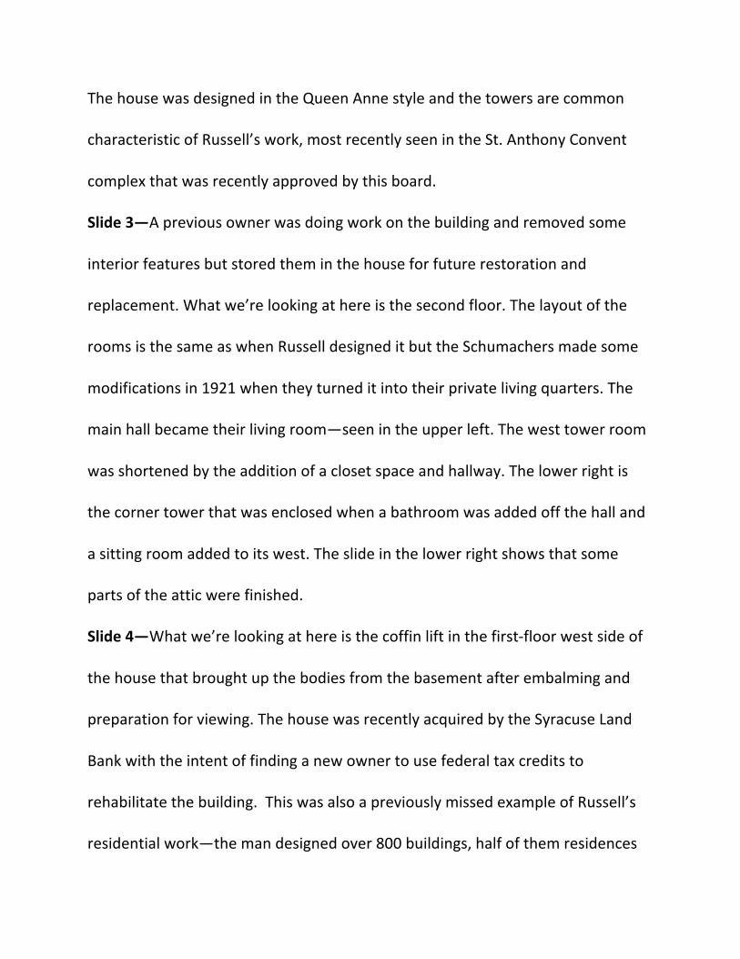
Slide 3—A previous owner was doing work on the building and removed some
interior features but stored them in the house for future restoration and
replacement. What we’re looking at here is the second floor. The layout of the
rooms is the same as when Russell designed it but the Schumachers made some
modifications in 1921 when they turned it into their private living quarters. The
main hall became their living room—seen in the upper left. The west tower room
was shortened by the addition of a closet space and hallway. The lower right is
the corner tower that was enclosed when a bathroom was added off the hall and
a sitting room added to its west. The slide in the lower right shows that some
parts of the attic were finished.
Slide 4—What we’re looking at here is the coffin lift in the first-floor west side of
the house that brought up the bodies from the basement after embalming and
preparation for viewing. The house was recently acquired by the Syracuse Land
Bank with the intent of finding a new owner to use federal tax credits to
rehabilitate the building. This was also a previously missed example of Russell’s
residential work—the man designed over 800 buildings, half of them residences

and this one was hidden between apartment buildings and other commercial
development, so kudos to the Land Bank for finding and acquiring it.
Questions? Comments?