HISTORIC MAIN STREET, HAHNDORF -THE · PDF file2.2 Sketch of building techniques ... The...
104
HISTORIC MAIN STREET, HAHNDORF -THE MANAGEMENT OF CHANGE- DAVID ALTMANN SCHOOL OF THE BUILT ENVIRONMENT UNIVERSITY OF SOUTH AUSTRALIA This submission is the "Individual Planning Study" component for:- THE GRADUATE DIPLOMA IN REGIONAL AND URBAN PLANNING. Submitted October, 1991.
Transcript of HISTORIC MAIN STREET, HAHNDORF -THE · PDF file2.2 Sketch of building techniques ... The...
HISTORIC MAIN STREET, HAHNDORF
-THE MANAGEMENT OF CHANGE-
DAVID ALTMANN
SCHOOL OF THE BUILT ENVIRONMENT
UNIVERSITY OF SOUTH AUSTRALIA
This submission is the "Individual Planning Study" component for:-
THE GRADUATE DIPLOMA IN REGIONAL AND URBAN PLANNING.
Submitted October, 1991.
FIGURES AND TABLES
1.1 Location of Hahndor.f
1.2 Study Area
2.1 Plan of the "U" shape village formation
2.2 Sketch of building techniques
2.3 Photo of Main Street streetscape, 1900
2.4 Population statistics and growth rate for Hahndorf
2.5 Cartoon, "Hahndorf in the future"
3.1 Plan of typical settlement in Prussia
3.2 Development application procedures for state Heritage Areas and State Heritage Items
3.3 List of historic buildings
3.4 Government gazette notice for state Heritage Area declaration
4.1 Photo of Pine Avenue, 1890
4.2 Newspaper article - "Hahndorf stobies go"
4.3 Land use survey
4.4 Development pattern survey
4.5 Plan of "Rodert's" property
4.6 Sketch of Wotzke House
4.7 Sketch of Betty Cleggett's sweet Shop
4.8 Sketch of Haebich Cottage
4.9 Sketch of the Old Mill building
4.10 Sketch of Hahndorf Academy
4.11 Photo of "Hills Earth Movers" property
1
3
5
5
6
7
8
9
14
15
17
21
21
24-25
26-27
23
28
28
29
29
29
30
4.12 Photo of imitation half-timbered walls 31
4.13 Photo of replica building - German construction 31
4.14 Newspaper article, "wall to wall shops" 33
4.15 Photo of bus-parking problem along Main street 35
5.1 Sketch of Thiele Cottage 40
5.2 Elevations of development proposals for 102 Main Street 42
5.3 Artists impression of rear extension to German Arms 44
5.4 Artists impression of additions to German Arms along Main Street 44
5.5 Photo of German Arms Hotel, 1990, prior to up-grading 45
5.6 Photo of German Arms Hotel, 1991, after up-grading 45
5.7 Artists impression of shop development at 40-42 Main street 4 7
5.8 Photo of 70 Main street, approx. 1925 51
5.9 Photo of 70 Main street, 1991 - "obliterated with signs" 51
5.10 Photo of an inappropriate advertising sign 52
5.11 Newspaper article, "Council crackdown on signs" 53
6.1 Sketches of suitable illustrations for Urban Design Guidelines 63-65
6.2 Newspaper article, "Heritage Branch lacks credibility" 68
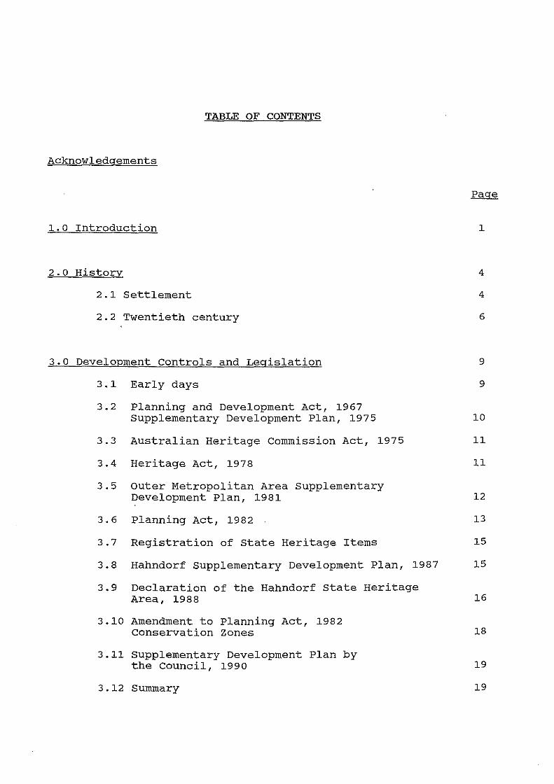
TABLE OF CONTENTS
Acknowledgements
1.0 Introduction
2.0 History
2.1 Settlement
2.2 Twentieth century
3.0 Development Controls and Legislation
3.1 Early days
3.2 Planning and Development Act, 1967 supplementary Development Plan, 1975
3.3 Australian Heritage Commission Act, 1975
3.4 Heritage Act, 1978
3.5 outer Metropolitan Area Supplementary Development Plan, 1981
1
4
4
6
9
9
10
11
11
12
3.6 Planning Act, 1982 13
3.7 Registration of State Heritage Items 15
3.8 Hahndorf supplementary Development Plan, 1987 15
3.9 Declaration of the Hahndorf State Heritage Area, 1988
3.10 Amendment to Planning Act, 1982 Conservation Zones
3.11 supplementary Development Plan by the Council, 1990
3.12 summary
16
18
19
19
I ,. I
4.0 Main Street In Context
4.1 street-trees
4.2 Development pattern and land use
4.3 Historic buildings
4.4 Infill development
4.5 Impact of tourism
4.6 Traffic
4.7 Planning policy
5.0 case studies
5.1 102 Main Street - Thiele Cottage
5.2 67-69 Main Street - German Arms Hotel
5.3 40-42 Main Street - Shop development
5.4 Enforcement and management
5.4.1 Prosecution
5.4.2 Civil Enforcement
5.4.3 Discussion
5.5 summary
6.0 Discussion and Recommendations
6.1 Planning policy
6.2 Urban design guidelines
6.2.1 conservation guidelines - Mintaro township
6.2.2 City of Adelaide
6.2.3 Maldon Planning Scheme
20
21
22
28
30
32
33
35
39
39
43
46
49
49
50
50
54
56
56
58
59
60
61
6.3 Resources 66
6.3.1 Role of the elected members and planning staff 66
6.3.2 Heritage advice I S.A Planning Commission 67
6.4 Enforcement 69
6.5 Education 71
6.6 Incentives 72
6.7 Traffic, parking and road verges 73
7.0 Summary 75
8.0 Bibliography 76
8.1 Books, reports and articles 76
8.2 Informal interviews 78
9.0 Appendices 78
1. Development Plan policies relevant to the Study Area
a. District wide Principles of Development Control, titled, "Heritage"
b. Historic Township (Main Street Heritage Area) zone (HT(1))
c. Historic Township (Residential Heritage Area) zone (HT(2))
d. Table MtB/11 and 12
2. Hahndorf historic township zones map
3. Interview questionnaire
4. Hahndorf bus-park proposals
ACKNOWLEDGEMENTS
This report has been prepared to complete the Graduate Diploma of Regional and Urban Planning (Individual Planning study) at the University of South Australia. The views and opinions are those of the author (unless otherwise indicated by references) and should not be treated as the views or opinions of the District Council of Mount Barlcer.
David Altmann. October, 1991
I would like to thank the following people who have contributed to the preparation of this study:-
The District council of Mount Barker
Bruce Harry - Hahndorf Heritage Adviser
Damien Mugavin - University of south Australia
Carol Wigg - Department of Environment and Planning
sue Smith - District council of Mount Barker
Peter Hine - Hahndorf Chamber of Commerce
Brian Fox - Hahndorf Residents Association
Phillip Tanner - Hahndorf Tourist Association
Reg Butler - local Hahndorf historian
Bob Chambers - District Council of Mount Barker
Petrina Altmann - my wife
1.0 INTRODUCTION
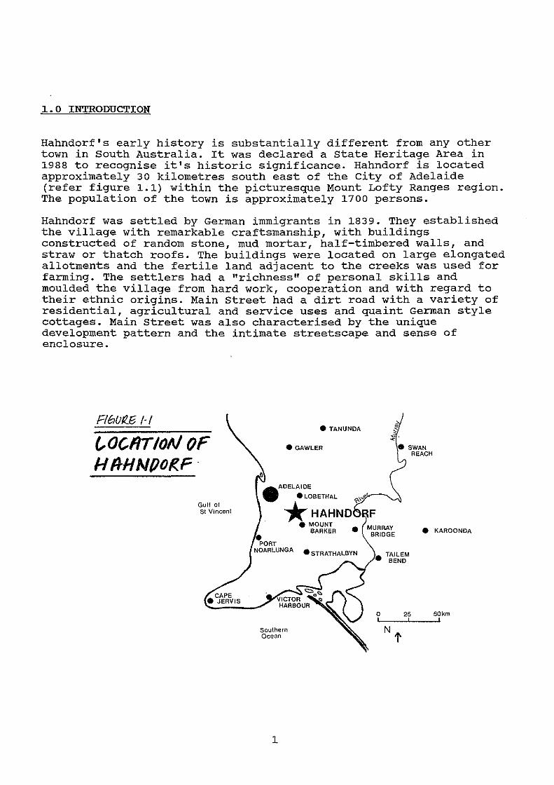
Hahndorf's early history is substantially different from any other town in South Australia. It was declared a state Heritage Area in 1988 to recognise it's historic significance. Hahndorf is located approximately 30 kilometres south east of the city of Adelaide (refer figure 1.1) within the picturesque Mount Lofty Ranges region. The population of the town is approximately 1700 persons.
Hahndorf was settled by German immigrants in 1839. They established the village with remarkable craftsmanship, with buildings constructed of random stone, mud mortar, half-timbered walls, and straw or thatch roofs. The buildings were located on large elongated allotments and the fertile land adjacent to the creeks was used for farming. The settlers had a "richness" of personal skills and moulded the village from hard work, cooperation and with regard to their ethnic origins. Main Street had a dirt road with a variety of residential, agricultural and service uses and quaint German style cottages. Main Street was also characterised by the unique development pattern and the intimate streetscape and sense of enclosure.
FlbUf(f3 /·I
~OCfiTIOAI OF H lfHNPOI?..F ·
Gulf of St Vincent
• TANUNOA
• GAWLER
•
ADELAIDE
• LOBETHAL ~,-..~
. *HAHND
Southern Ocean
1
e MOUNT BARKER • • KAROONDA
0 25 50km
Hahndorf's character is now tainted by traffic congestion, tourist activities, damaged and diseased street-trees, a range of incongruous commercial buildings and many signs and displays along the street frontage. Hahndorf has transformed from a quiet rural village to a tourist destination for millions of visitors.
The aim of the study is to analyse whether the planning and heritage legislation has adequately controlled and guided development within the historic Main Street area. Has the planning and heritage controls been able "to manage change" successfully?
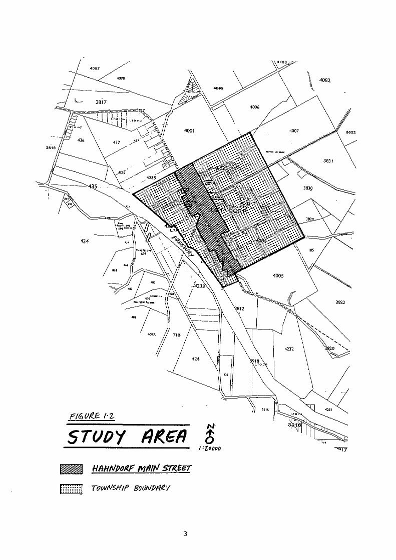
The study area, Main Street, is illustrated on figure 1.2.
Section 2 of the study outlines the history of Hahndorf's settlement with particular attention to the growth of the village to the present day. The planning and heritage legislation that has affected Hahndorf's growth is described in Section 3. The 1990 Supplementary Development Plan for Hahndorf and the declaration of the State Heritage Area in 1988, forms the focus of the discussion. A brief critic of each development control document is provided in respect to the suitability of the policies required to conserve the historical aspects of Main street.
Section 4 describes "Main street in Context", with regard to the present character of Main Street. The positive and negative aspects of Hahndorf's character are outlined. The description acknowledges a number of recent reports written on Hahndorf's heritage and history. A land use survey and development pattern survey from aerial photography was also carried out.
Case study development proposals are discussed in Section 5. The proposals were carefully chosen from the District Council of Mount Barker's register of planning approvals and are examples of a variety of recently approved commercial developments along Main Street. The processes involved with the assessment of the proposals and the politics and issues are discussed. Enforcement is also an important issue as "planning" can not be successful without the back-up and support of strong enforcement procedures.
Section 6 of the study is a synthesis of all of the issues affecting Main Street, with discussion of whether the planning and heritage controls "manage change" adequately. Conclusions are drawn from the analysis of recent reports, the case study development proposals, field research and personal interviews with traders, community members and professionals involved in the administration of controls within the study area. Recommendations are outlined to strengthen the existing "system" with regard to (1) planning policy, (2) urban design guidelines, (3) enforcement, (4) education, (5) incentives and (6) resources. The recommendations should be the basis for an overall strategy for the District council of Mount Barker and the State Heritage Branch to implement.
2
\ 4082
....
134
3822
'"
5T()OY Nr
6 1 'toooo
3
2.0 HISTORY
2.1 Settlement
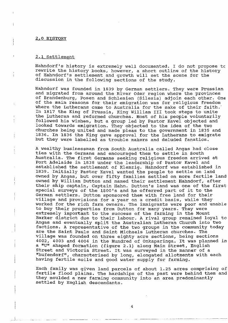
Hahndorf's history is extremely well documented. I do not propose tc rewrite the history books, however, a short outline of the history of Hahndorf's settlement and growth will set the scene for the discussion in the following sections of the study.
Hahndorf was founded in 1839 by German settlers. They were Prussian and migrated from around the River Oder region where the provinces of Brandenburg, Posen and Schlesien (Silesia) adjoin each other. One of the main reasons for their emigration was for religious freedom where the Lutherans came to Australia for the sake of their faith.· In 1817 the King of Prussia, King William III took steps to unite the ~utheran and reformed churches. Most of his people voluntarily followed his wishes, but a group led by Pastor Kavel objected and looked towards emigration. They objected to the idea of the two churches being united and made pleas to the government in 1835 and 1836. In 1836 the King gave approval for the Lutherans to emigrate but they were labelled as trouble makers and deluded fanatics.
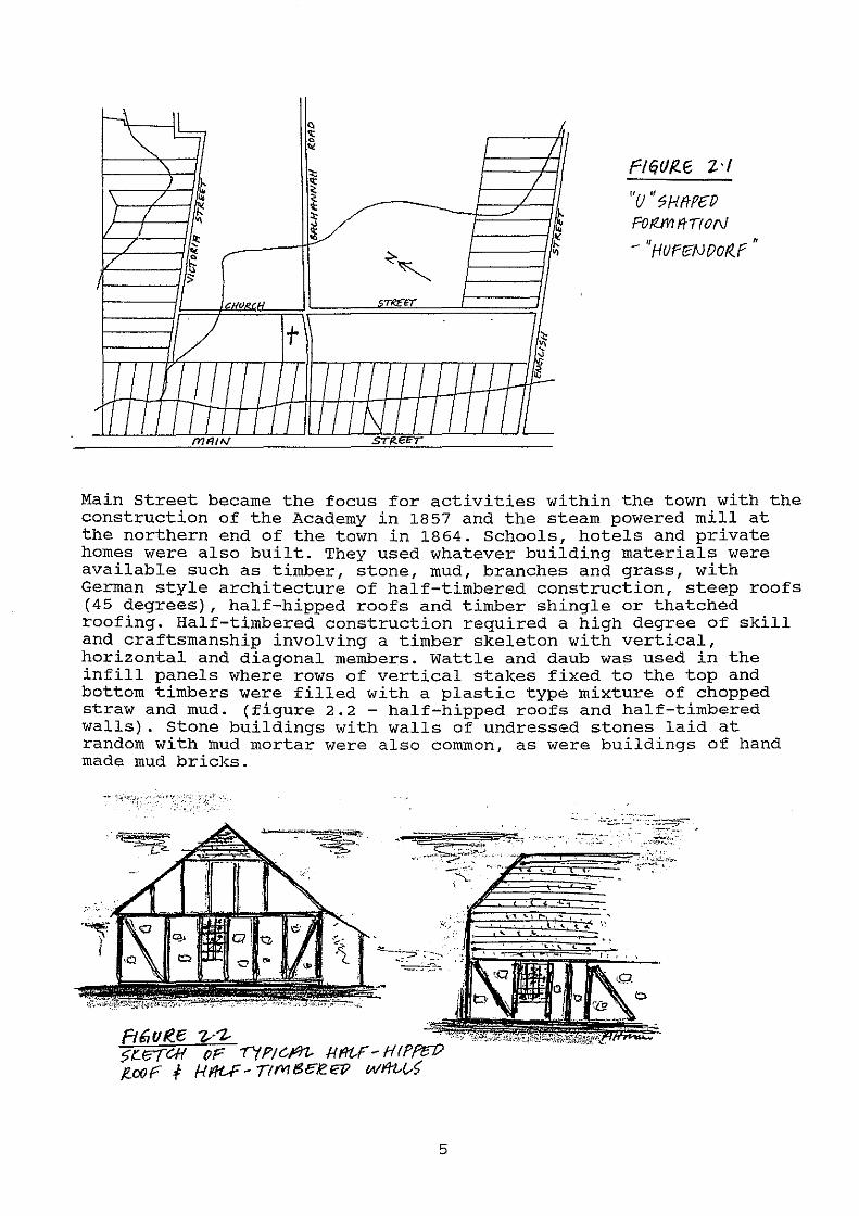
A wealthy businessman from South Australia called Angas had close ties with the Germans and encouraged them to settle in South Australia. The first Germans seeking religious freedom arrived at Port Adelaide in 1838 under the leadership of Pastor Kavel and established the settlement of Klemzig. Hahndorf was established in 1839. Initially Pastor Kavel wanted the people to settle on land owned by Angas, but over fifty families settled on more fertile land owned by William Dutton and named their settlement Hahndorf, after their ship captain, Captain Hahn. Dutton's land was one of the first special surveys of the 1800's and he offerred part of it to the German settlers. Dutton sponsored them with free land for their village and provisions for a year on a credit basis, while they worked for the rich farm owners. The immigrants were poor and unable to buy their properties from Dutton for many years. They were extremely important to the success of the farming in the Mount Barker district due to their labour. A rival group remained loyal to Angas and eventually split the Australian Lutheran Church into two factions. A representative of the two groups in the community today are the Saint Pauls and Saint Michaels Lutheran churches. The village was founded on three eighty acre sections, being sections 4002, 4003 and 4004 in the Hundred of Onkaparinga. It was planned in a "U" shaped formation (figure 2.1) along Main street, English Street and Victoria Street. It was surveyed in the manner of a "hufendorf", characterised by long, elongated allotments with each having fertile soils and good water supply for farming.
Each family was given land parcels of about 1.25 acres comprising of fertile flood plains. The hardships of the past were behind them and they moulded a new farming community into an area predominantly settled by English descendants.
4
h\
~ ~
" J \ / ~
L ( ~
"' 1/ I ~ / "' / ~ " ;;
'cii-RCH
/ t I lj I I
' IIIJ! I
mmw
" ~ "
1 :); ---~
~,
STIIEET
I I I I
I I \j I I
/ I
I /
~ ~
~ "'
~ '
I I ff !--.
I I I'--
r=trquJ<.r; z .,
"u '' '?Hf!PEP Fo !?.J'MtTI 0 rJ . " - HUFr?NOor<.f
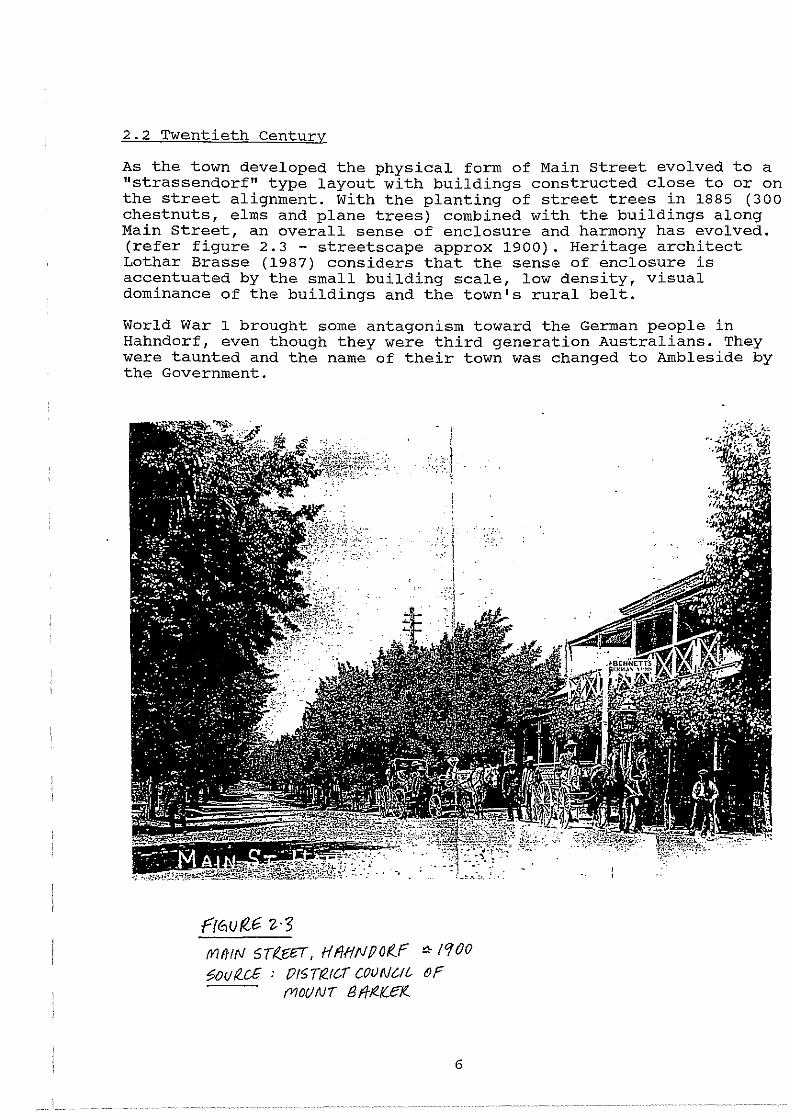
Main Street became the focus for activities within the town with the construction of the Academy in 1857 and the steam powered mill at the northern end of the town in 1864. Schools, hotels and private homes were also built. They used whatever building materials were available such as timber, stone, mud, branches and grass, with German style architecture of half-timbered construction, steep roofs (45 degrees), half-hipped roofs and timber shingle or thatched roofing. Half-timbered construction required a high degree of skill and craftsmanship involving a timber skeleton with vertical, horizontal and diagonal members. Wattle and daub was used in the infill panels where rows of vertical stakes fixed to the top and bottom timbers were filled with a plastic type mixture of chopped straw and mud. (figure 2.2 - half-hipped roofs and half-timbered walls). Stone buildings with walls of undressed stones laid at random with mud mortar were also common, as were buildings of hand made mud bricks.
:=:s~·~!~·-- -. ~~---.-:-. "'
-'--
5
2.2 Twentieth Century
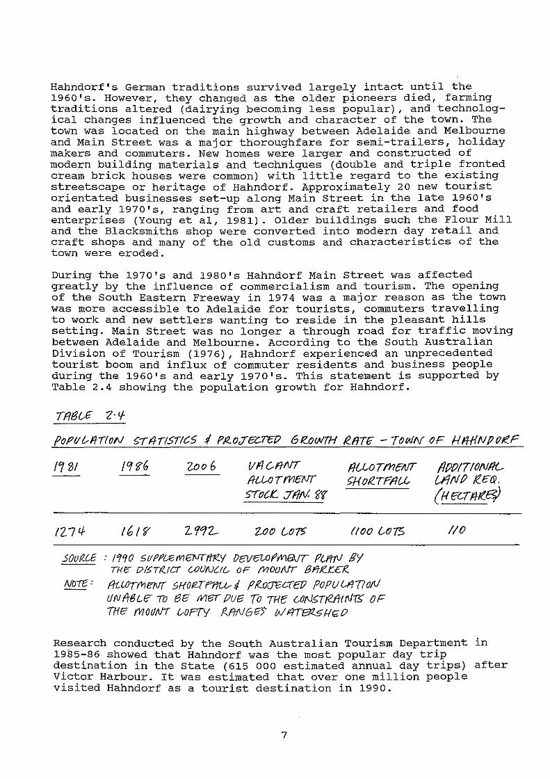
As the town developed the physical form of Main street evolved to a "strassendorf" type layout with buildings constructed close to or on the street alignment. With the planting of street trees in 1885 (300 chestnuts, elms and plane trees) combined with the buildings along Main Street, an overall sense of enclosure and harmony has evolved. (refer figure 2.3- streetscape approx 1900). Heritage architect Lothar Brasse (1987) considers that the sense of enclosure is accentuated by the small building scale, low density, visual dominance of the buildings and the town's rural belt.
World War 1 brought some antagonism toward the German people in Hahndorf, even though they were third generation Australians. They were taunted and the name of their town was changed to Ambleside by the Government.
r(fi.U f?.-6 Z· 3 fVlfflfl/ STf..6£T, HfiHtJPOf..r <!-/CfOO ~ouR_c£ : {)f5Tt2.1C..T COUNCil.- OF
fV/OUNT Bf/-~1(£1(..
6
Hahndorf's German traditions survived largely intact until the 1960's. However, they changed as the older pioneers died, farming traditions altered (dairying becoming less popular), and technological changes influenced the growth and character of the town. The town was located on the main highway between Adelaide and Melbourne and Main Street was a major thoroughfare for semi-trailers, holiday makers and commuters. New homes were larger and constructed of modern building materials and techniques (double and triple fronted cream brick houses were common) with little regard to the existing streetscape or heritage of Hahndorf. Approximately 20 new tourist orientated businesses set-up along Main street in the late 1960's and early 1970's, ranging from art and craft retailers and food enterprises (Young et al, 1981). Older buildings such the Flour Mill and the Blacksmiths shop were converted into modern day retail and craft shops and many of the old customs and characteristics of the town were eroded.
During the 1970's and 1980's Hahndorf Main Street was affected greatly by the influence of commercialism and tourism. The opening of the South Eastern Freeway in 1974 was a major reason as the town was more accessible to Adelaide for tourists, commuters travelling to work and new settlers wanting to reside in the pleasant hills setting. Main Street was no longer a through road for traffic moving between Adelaide and Melbourne. According to the south Australian Division of Tourism (1976), Hahndorf experienced an unprecedented tourist boom and influx of commuter residents and business people during the 1960's and early 1970's. This statement is supported by Table 2.4 showing the population growth for Hahndorf.
Tfi6G£ 2·</-
PoPI/t--fflforJ ~rii-II.Sr!C5 !/ PltoJ-ez:ra; 6rz_ow1H R.fJTfi' -TOWN oF HffHNP(JJe.F
/'1 '01 /CJi6 Zoo6 VflC-fJ-NT fJUOTI11Eifff f/PPIT!ON/l{_ /lU-0 T fl16NT ~HoR..TFIIU (fiNP /t.E~. sroc.t:.. :Tfltil. ~f {f/ECTfllt_~
tZ7tf 16 {'? 2'112- VJo C..o-r? (/00 {AJ75 //0
sootUE : I 19 0 511 Pf~ mevr"fi'RY 08!6UJ f' fi1ENT PU'IJV 8'1 Ti-<1'; I?I5Ttf..!C-T (...OUNC/6 OP MOUNT Bf'!Jet:£1?..
No-re = fitWTfl1eN( SHOfZTF11U--tl f'R..0(]"6CTE!l POPUrAT?oN UNft8LE TO r36 Met /JUE3 {o THe C.Of\].£TtefrtrliT.£ OF THI? friOIJtJT vOPTY /Zf/1\/Gri') W14113l..51-!~0
Research conducted by the South Australian Tourism Department in 1985-86 showed that Hahndorf was the most popular day trip destination in the state (615 000 estimated annual day trips) after Victor Harbour. It was estimated that over one million people visited Hahndorf as a tourist destination in 1990.
7
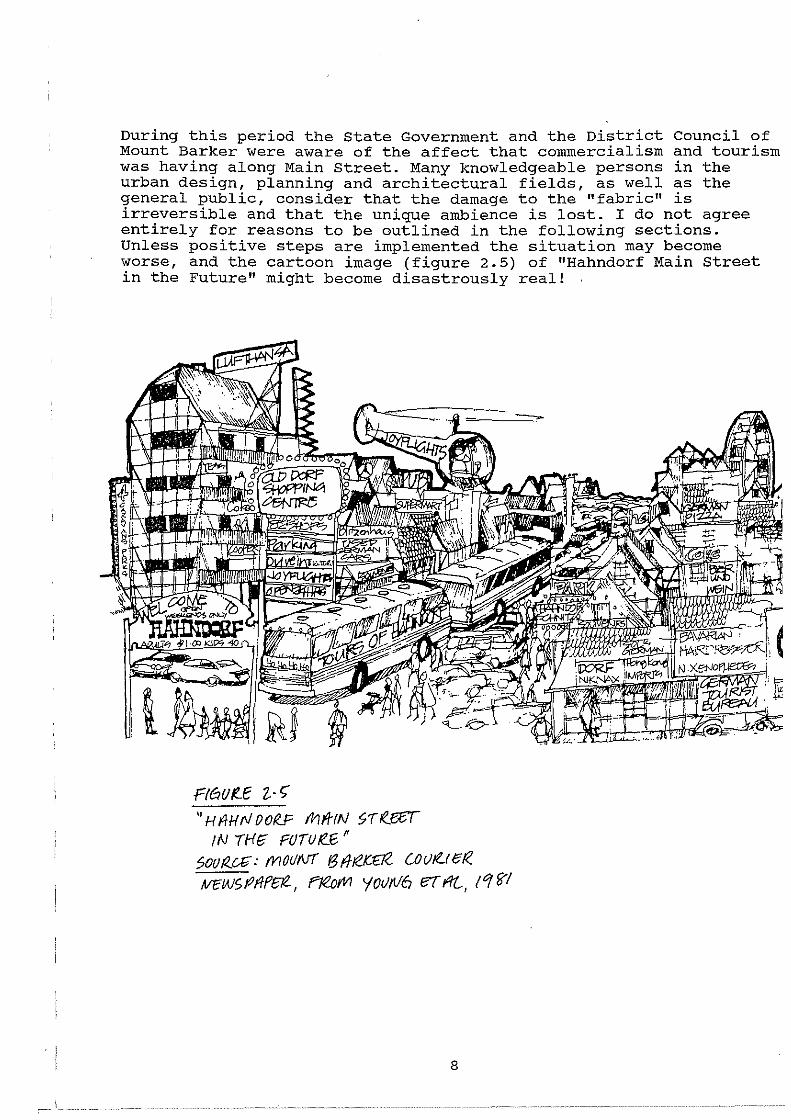
During this period the State Government and the District Council of Mount Barker were aware of the affect that commercialism and tourism was having along Main Street. Many knowledgeable persons in the urban design, planning and architectural fields, as well as the general public, consider that the damage to the "fabric" is irreversible and that the unique ambience is lost. I do not agree entirely for reasons to be outlined in the following sections. Unless positive steps are implemented the situation may become worse, and the cartoon image (figure 2.5) of "Hahndorf Main Street in the Future" might become disastrously real!
Ft&!Of!.E Z.· ~ '' H f/HrJ OOR..F fni/-rN ~TR...eel
IN /Hri FOTU/tf;" 5ovr<.ai: mouNT f3ffte.K£T<- coulf..rer<. !VEWSPilff:IZ, Fl&;rVI '(OU/116 eT IlL, !1 '61
8
3. 0 DEVELOPMENT CONTROLS AND LEGISLATION
This section will outline the evolution of planning controls and heritage legislation. In the early days of Hahndorf's growth development controls and building codes were non-existent. There are now a multitute of acts and regulations which govern building work and all forms of development in Hahndorf. The conclusion drawn from the following research is that the planning system has only recently caught up with the concept of heritage. The introduction of new planning and heritage legislation during the 1960's to the present day has coincided with a marked transformation of Main street's character.
Section 5 will highlight how the planning system is presently "managing change" by discussing case study development examples with recommendations to promote a better system in section 6.
3.1 Early Days
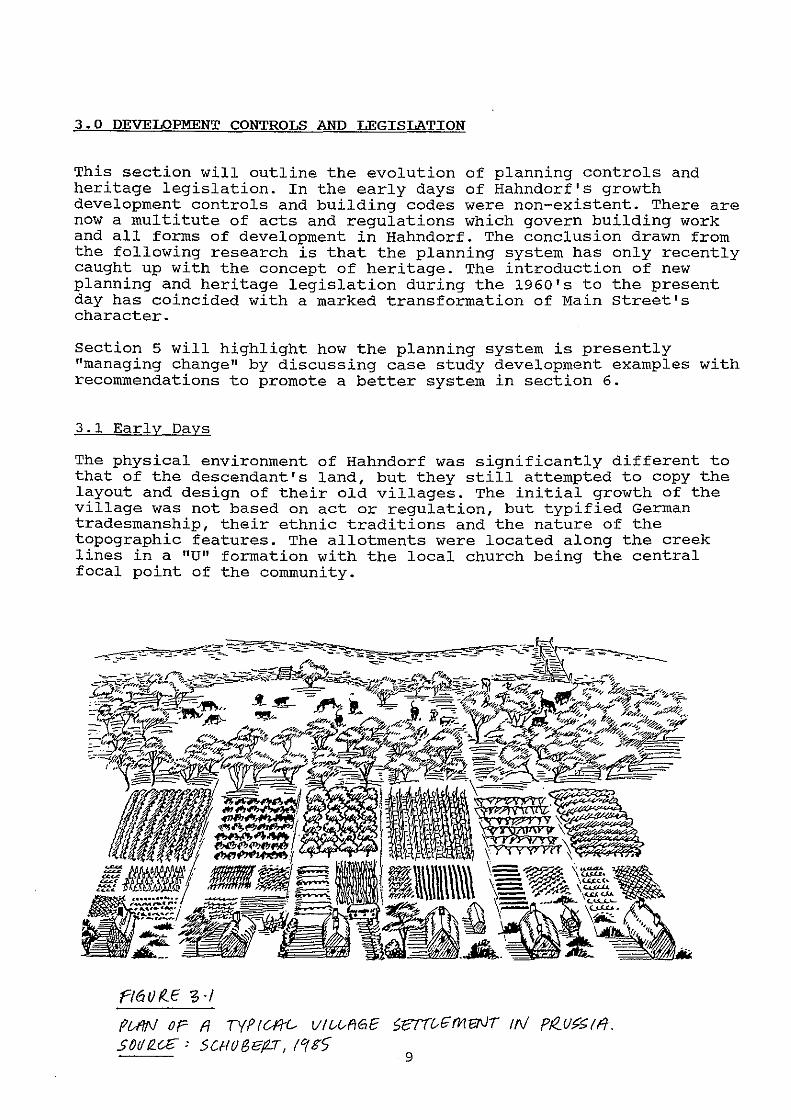
The physical environment of Hahndorf was significantly different to that of the descendant's land, but they still attempted to copy the layout and design of their old villages. The initial growth of the village was not based on act or regulation, but typified German tradesmanship, their ethnic traditions and the nature of the topographic features. The allotments were located along the creek lines in a "U" formation with the local church being the central focal point of the community.
f'/6UI?...E "3·1
fUW op fl TYPIU1i-- Vl&&f!GE S~d~~: SCHOBe~T, f1g)
9

Young et al (1981) argues that the unique subdivision pattern for Hahndorf was designed to give an equal portion of land to the settlers for agriculture and living. It is understood that Hermann Friedrich Kook devised the layout for Hahndorf for these reasons. The German settlers had obviously adapted to a new environment and the characteristics were quite different from neighbouring English communities like Mount Barker. They were presented with a new environment and moulded it to fit their traditional lifestyles.
In the early days the Hahndorf township was located within the District Council of Echunga and Onkaparinga which were both proclaimed in 1853. The main role of the Councils was to provide roads, sanitation, lighting and general community services such as libraries. Main Street was controlled by two local authorities and according to Butler (1985), they continually argued about its maintenance and management. In 1935, an Act of Parliament rearranged council boundaries and the Mount Barker Council became responsible for the Hahndorf township.
A Building Act was passed in 1881 and was the first South Australian legislation to provide specifically for the general control of building construction. It was based closely on the English Act (setout regulations for the rebuilding of London after the Great Fire in 1866) with regard to fire safety and health. This Act was eventually repealed and superceded by the Building Act, 1923.
Up until the 1970's development controls for Hahndorf were instigated under the Building Act as by-laws. During this period many buildings and land uses were established which are incongruous and out of character with the historic origins of Main Street. Examples of such include the Nitschke Earthmovers property (cream brick building with earthmoving equipment stored along the street frontage and behind), and large double and triple fronted dwellings constructed of cream brick with deep setbacks. The Building Act did not include any real urban design criteria as we now understand them. The Act was derived from the need to protect the safety and health of the public and issues such as siting, bulk, scale and visual appropriateness were not considered. The Act (1970-1976) was again amended "to regulate the construction, alteration and demolition of buildings; to establish standards to which buildings must conform; ...... " (Building Act 1970-1976). It was again a technical document without planning controls.
3.2 Planning and Development Act 1967 supplementary Development Plan 1975
In 1967 the Planning and Development Act was brought into force and the few planning controls which had crept into the Building Act (e.g. setbacks) were taken away and incorporated into the the Planning Act. The Hahndorf area was designated within the outer Metropolitan Area of the Act (one of 12 planning regions throughout the State), and only in 1975 were policies authorised to guide development within this area. This plan was virtually useless for the guidance of development in Hahndorf as the policies were for a regional area with Principles of Development Control and Objectives
10
that had no particular relevance to Hahndorf's character and heritage. As outlined by Whitelock (1976), "the purpose of the Outer Metropolitan controls were to provide a broad-brush framework for the region and that the relevant council should then prepare their own plan for a particular area or township." The Development Plan for example included statements such as:-
"Hahndorf should not expand to any great degree to (1) preserve its rural character, (2) to protect the watershed and (3) to allow allotments of approximately 1000 square metres to retain the open character."
Such policies were ambiguous, open to misinterpretation and subjective. During this period there were no statutory controls over demolition.
Regulations under Section 36 of the Planning and Development Act enabled councils to make regulations to control development, for example demolition or allotment standards. However, these were not utilised to a great extent as the regulation needed Ministerial approval and the time delay (two months) was a disincentive to council. In addition, with the District council of Mount Barker being a relatively small district council it did not have the expertise or resources to produce the regulations.
3.3 Australian Heritage Commission Act 1975
In 1975 the Commonwealth Government introduced the Heritage Commission Act and established the Australian Heritage Commission, to advise on the protection of the National Estate and to keep a Register of all places which are included in the National Estate.
The Commission's powers are limited to actions by Commonwealth Ministers and agencies and there are few powers associated with the National Estate Register. "It is toothless" (B. Hayes QC, 1990), and has had no influence over heritage or conservation issues in Hahndorf.
3.4 Heritage Act 1978
In 1978 the Heritage Act was brought into operation throughout the State due to concern at the number of historic buildings being demolished for redevelopment. Within the Heritage Act there are two matters of particular reference to Main Street Hahndorf, the establishment of a register known as the "Register of State Heritage Items" and the designation of "State Heritage Areas".
* under the Act the Minister must keep a Register of State Heritage Items and pursuant to Section 12 of the Act an Item may be registered where the Minister considers, "(a) that an Item that is not on the Register is part of the environmental, social or cultural heritage of the State; and (b) that the Item is of a significant aesthetic, architectural, historical, archaeological, technological or scientific interest."
11

* pursuant to Section 13 of the Act a State Heritage Area can be designated where the Minister considers, "(a) that an area of land is part of the environmental, social or cultural heritage of the state; and (b) that the area is of a significant aesthetic, architectural, historical, cultural, archaeological, technological or scientific interest."
* the Minister is advised by the south Australian Heritage Committee on any matter relating to the entry of an item in the Register and the designation of land as a state Heritage Area.
Not all land and buildings can be conserved, and there is a set standard for the assessment of appropriate items for the Register. The Minister for Environment and Planning may place an item on the Register if it is part of the environmental, social or cultural heritage of the State. The item is tested against 7 criteria. The Minister must also consider whether the item is of significant aesthetic, architectural, historical, cultural, archaeological, technological or scientific interest before it can be placed on the Register. Any person may apply to have an item registered and their application will be assessed by the Heritage conservation Branch of the Department of Environment and Planning, who will recommend to the Minister whether the item should be registered. The owners of the property have an extensive period to comment and the public are notified by a public notice in "The Advertiser" newspaper.
The Heritage Act is unique with regard to planning and building legislation as it binds the crown. The Act is fairly narrow in its definitions and requires the support or integration of other Acts to be workable (e.g. Planning Act, 1982), and it does not fulfill the need to protect local heritage adequately. The matter of local heritage is a contentious issue as there are many items of "local" significance which may not comply with the above mentioned criteria for registration. To alleviate this problem to some extent the State Government have introduced the concept of "Conservation Zones" where local authorities can zone areas and items of local heritage importance. The Heritage Act does not distinguish between local and state significance. The introduction of "Conservation Zones" will be discussed in section 3.10.
3.5 Outer Metropolitan Area Supplementary Development Plan 1981
The problem during the 1970's and 1980's was with catering for the influx of tourists and trying to conserve the historical and cultural aspects of the town. The 1975 outer Metropolitan Plan policies treated Hahndorf as just one of many pleasant Adelaide Hills townships. However, it was becoming increasingly obvious that Hahndorf had a special historical character resulting from its different cultural heritage and this was being replaced with a mixture of incongruous developments in terms of style, form and land use. The District Council of Mount Barker requested the state Planning Authority to prepare a Supplementary Development Plan in 1978 and this was authorised in 1981 as part of the Outer Metropolitan component of the Development Plan. The purpose of the amendment to the Development Plan was to:-
12
"indicate in general terms those measures necessary or desirable to ensure the conservation of the historic character of Hahndorf and its orderly development as a service centre and residential township." (Explanatory Statement 1981 S.D.P).
The research by Neill Wallman, Planning Consultant (Draft Hahndorf Structure Plan 1978), and the survey carried out by Young, Harmstorf et al for the Australian Heritage commission in 1981 were instrumental in providing the necessary background research for the S.D.P. The desired future character statement for Main Street (Area Principle l4.l.l) stated that:-
"The Main Street and its immediate surrounding form an area which should retain the essence of Hahndorf's historic character. This character arises from the "strassendorf" development pattern, the numerous 19th century buildings constructed in both East German and colonial Australian styles, the rhythm of individual buildings and adjoining spaces, the street-trees, intimate scale, and a ·sense of enclosure that gives the street an overall cohesion. A component of this character is the number of residences that still remain - in some instances combined with retailing and other commercial activities. Until now, very few incongruous structures or landscaped spaces have been introduced to lessen this character."
This principle can not be faulted. However, the development control policies were typical broad planning statements for policy areas and were still open to interpretation. It did give the planning authorities marginally better avenues to ensure that future development was sympathetic.
3.6 Planning Act 1982
In 1982 the new Planning Act indroduced a legal framework relating predominantly to Development Control. The power of the Heritage Act, 1978 was strengthened with the inception of the Planning Act.
Pursuant to Section 48 of the Act "development" must not be undertaken within a state Heritage Area or to an Item on the State Heritage Register without consent of the relevant planning authority. Section 4 (f) of the Act specifically defines as development:-
"the demolition, conversion, addition to, or alteration of an Item of the state Heritage or a State Heritage Area"
The Act requires the Council to forward to the Minister an application which affects an item of the state Heritage or a State Heritage Area. Council must not make a decision on an application until it receives a report from the Minister (State Heritage Branch of the Department of Environment and Planning), and "must have regard to" the comment and also seek the concurrence of the South Australian Planning commission. (refer figure 3.2 - application procedures for Heritage Areas and Items). The Council is not bound to make a decision in accordance with the advice of the state Heritage Branch.
13
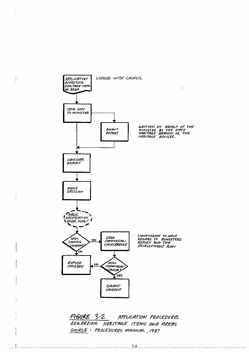
IJPPUCJIITtlX'I 1/FI'OlT/Nil> Ht:ll.ITfl6fF ITE7'1 ~AMII -
SeN/? C/Jf'Y TO MINISTeR.
t:aVStPeR f!£R>/2.r
l mm":< PECIS 10/"1
r...
/(.UFIISE CONSeNT
IAPtJIJP WITH
l 1/wttrr il£f'QRT
I
WI(JIT!;N ON 8/iii/1111.-F OF THe ll?tiVISTEf{ By THE ST<'/rc fft:fl/Tll!,t BtR.fltVCH OK. THE J-flfRIT1f6F 1//)VISEI!. ·
COmmt5S!/JN TO Hfi<IE f{E61'/tel) 711 miNISTf:R:S /I,E"f'O({T liND T"fffF PCVCWI'I'>reAtT ft-IIN
f<£611~.P!N6 H~tTMli"" 1Tct11s IINP Flt<"E7'15 Soui!.C-6 ' f'lt.OC.Ct?V/I?.B 1111'/NI/fH ... , 19 87
..... J4..
3.7 Registration of state Heritage Items
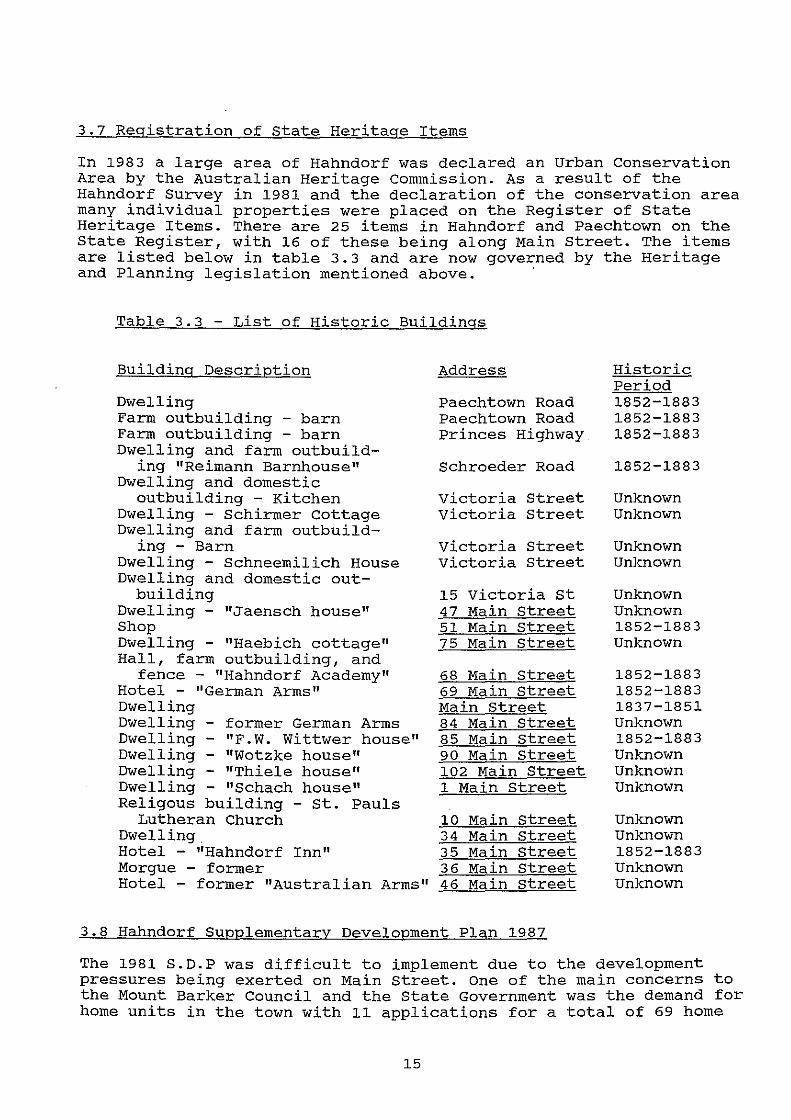
In 1983 a large area of Hahndorf was declared an Urban Conservation Area by the Australian Heritage commission. As a result of the Hahndorf Survey in 1981 and the declaration of the conservation area many individual properties were placed on the Register of state Heritage Items. There are 25 items in Hahndorf and Paechtown on the State Register, with 16 of these being along Main Street. The items are listed below in table 3.3 and are now governed by the Heritage and Planning legislation mentioned above. '
Table 3.3 - List of Historic Buildings
Building Description
Dwelling Farm outbuilding - barn Farm outbuilding - barn Dwelling and farm outbuild-
ing "Reimann Barnhouse" Dwelling and domestic
outbuilding - Kitchen Dwelling - Schirmer cottage Dwelling and farm outbuild
ing - Barn Dwelling - Schneemilich House Dwelling and domestic out-
building Dwelling - "Jaensch house" Shop Dwelling - "Haebich cottage" Hall, farm outbuilding, and
fence - "Hahndorf Academy" Hotel - "German Arms" Dwelling Dwelling - former German Arms Dwelling - "F.W. Wittwer house" Dwelling - "Wotzke house" Dwelling - "Thiele house" Dwelling - "Schach house" Religous building - st. Pauls
Lutheran Church Dwelling. Hotel - "Hahndorf Inn" Morgue - former Hotel - former "Australian Arms"
Address
Paechtown Road Paechtown Road Princes Highway
Schroeder Road
victoria Street Victoria Street
Victoria Street victoria Street
15 Victoria st 47 Main Street 51 Main Street 75 Main Street
68 Main Street 69 Main street Main street 84 Main Street 85 Main Street 90 Main Street 102 Main Street 1 Main Street
10 Main Street 34 Main Street 35 Main Street 36 Main Street 46 Main Street
3.8 Hahndorf Supplementary Development Plan 1987
Historic Period 1852-1883 1852-1883 1852-1883
1852-1883
Unknown Unknown
Unknown Unknown
Unknown Unknown 1852-1883 Unknown
1852-1883 1852-1883 1837-1851 Unknown 1852-1883 Unknown Unknown Unknown
Unknown Unknown 1852-1883 Unknown Unknown
The 1981 S.D.P was difficult to implement due to the development pressures being exerted on Main street. One of the main concerns to the Mount Barker Council and the State Government was the demand for home units in the town with 11 applications for a total of 69 home
15
units between 1984 and 1986 (statement of investigations - Hahndorf S.D.P by the Minister 1987). The previous S.D.P did not contain guidelines for units and it was the Department of Environment and Planning's opinion, that the mass construction of home units within Hanhdorf was not in keeping with the character of the town. The S.D.P policies also introduced "zones" and "prohibited development". This gave Council the right to refuse specified development such as industry and unit development that were incompatible with Main Street and the township as a whole. The S.D.P was authorised on an interim basis in 1987 to prevent a rush of 11 pan'ic" applications and was fully authorised on December 17, 1987.
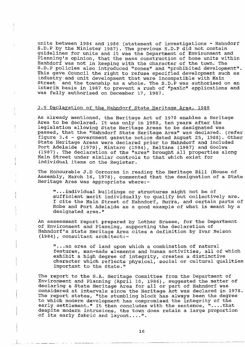
3.9 Declaration of the Hahndorf State Heritage Area, 1988
As already mentioned, the Heritage Act of 1978 enables a Heritage Area to be declared. It was only in 1988, ten years after the legislation allowing State Heritage Areas to be designated was passed, that the "Hahndorf State Heritage Area" was declared. (refer figure 3.4- government gazette notice dated August 25, 1988). Other State Heritage Areas were declared prior to Hahndorf and included Port Adelaide (1979), Mintaro (1984), Beltana (1987) and Goolwa (1987). The declaration of the "area" brought all properties along Main Street under similar controls to that which exist for individual items on the Register.
The Honourable J.D Corcoran in reading the Heritage Bill (House of Assembly, March 16, 1978), commented that the designation of a State Heritage Area was appropriate where:-
" •.. individual buildings or structures might not be of sufficient merit individually to qualify but collectively are. I cite the Main Street of Hahndorf, Burra, and certain parts of Robe and Port Adelaide as a good example of what is meant by a designated area."
An assessment report prepared by Lothar Brasse, for the Department of Environment and Planning, supporting the declaration of Hahndorf's state Heritage Area .cites a definition by Ivar Nelson (1984), consultant architect:-
" ... an area of land upon which a combination of natural features, man-made elements and human activities, all of which exhibit a high degree of integrity, creates a distinctive character which reflects physical, social or cultural qualities important to the State."
The report to the S.A. Heritage Committee from the Department of Environment and Planning (April 10, 1986), suggested the matter of declaring a State Heritage Area for all or part of Hahndorf was considered at intervals since the Heritage Act was declared in 1978. The report states, "the stumbling block has always been the degree to which modern development has compromised the integrity of the early settlement." It then concludes with the sentence, " .... that despite modern intrusions, the town does retain a large proportion of its early fabric and layout .... ".
16
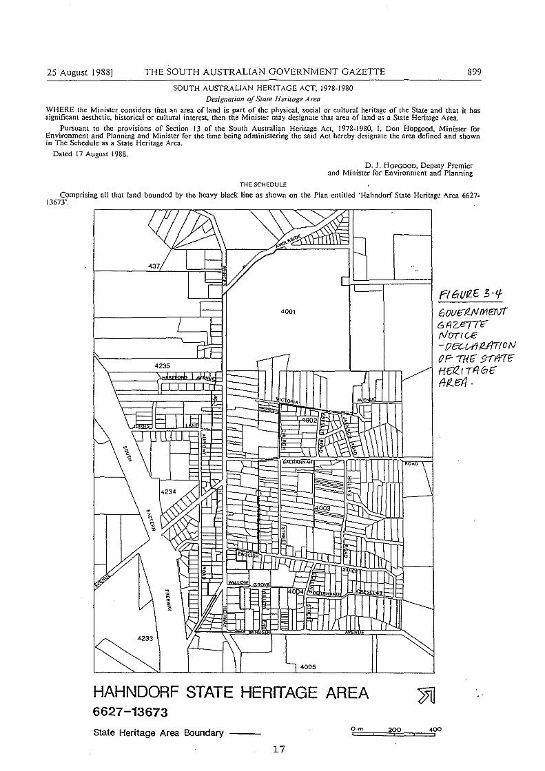
25 August 1988] THE SOUTH AUSTRALIAN GOVERNMENT GAZETTE
SOUTH AUSTRALIAN HERITAGE ACT, 1978-1980
Designation of State Heritage Area
899
WHERE the Minister considers that an area of land is part of the physical, social or cultural heritage of the State and that it has significant aesthetic, historical or cultural interest, then the Minister may designate that area of land as a State Heritage Area.
Pursuant to the provisions of Section 13 of the South Australian Heritage Act, l978wl980, I, Don Hopgood, Minister for Environment and Planning and Minister for the time being administering the said Act hereby designate the area defined and shown in The Schedule as a State Heritage Area.
Dated 17 August I 988.
THE SCHEDULE
D. J. HOPGOOD, Deputy Premier and Minister for Environment and Planning
Comprising all that land bounded by the heavy black line as shown on the Plan entitled 'Hahndorf State Heritage Area 6627-13673'.
4001
l-------~/:JI-1-1-
~
I~ 'I 4005
HAHNDORF STATE HERITAGE AREA 6627-13673
State Heritage Area Boundary Om
17
200
rt6uR.E 3-'f
6 out;fUo/ m81F( 6AZI?TTC rl/ CJT, c.e -oec.Vf!/2A7tON OF- 'TH£" s--rlf1F HfTZ.r TFIC?E" f}/!._d/,
400
I find it difficult to comprehend why the Government procrastinated for so many years, during which time the damage to the "fabric" along Main Street continued and is well documented. The report from the Heritage Committee seems to contradict itself, however, in theix defence the delay was due to the issue of whether the integrity of Main Street was too diminished to warrant State Heritage Area status. Some in the planning and heritage field and the Hahndorf community, consider the declaration was too late, however, much of the historic "fabric" still remains and the declaration should ensure that the wrongs of the past are not dupl'icated in the future.
3.10 Amendment to Planning Act, 1982 - Conservation Zones
As previously explained the provisions of the Planning Act 1982, were expanded in 1989, enabling local councils to have control of local heritage items and demolition. These controls were made possible by the designation of Conservation zones within the Development Plan for areas having a distinctive historical character or "sense of place." Conservation Zones do not possess the same legal backing as Heritage Areas under Section 48 of the Planning Act, 1982, but enables local councils to "zone" particular areas or individual sites within their Development Plan, with specific Objectives and Principles of Development Control to guide future building and prevent demolition. Consultation with the Minister (State Heritage Branch) and seeking the Planning Commissions concurrence is not required for development applications.
Kensington and Norwood Council are the only council to use this procedure at present and according to their senior Planning Officer, it is achieving desirable results. In 1990 an application was received for the demolition of one of Kensington and Norwood's oldest houses (dated from before 1853} with an ~arly vernacular style and to replace it with a two storey bluestone townhouse. The amendment to the Act via the Development Plan gave the Council a level of control which many councils have sought but have not previously had. The Council had to assess both the merits of the building being demolished and the suitability of the replacement building. Their Historic (Conservation) zones Supplementary Development Plan (S.D.P} 1990 gave them comprehensive and well researched policies and statements of character for varying areas to assess such applications against. The application was refused as the heritage building was of significant heritage value to the community and the replacement building was inappropriate with regard to the S.D.P in terms of scale, siting and materials.
To establish Conservation Zones a Supplementary Development Plan must be prepared by a council or the Minister and be authorised pursuant to Section 41 of the Planning Act. There are no detailed criteria for assessing the designation of Conservation Zones and the council is not bound to obtain the expert advice of the Heritage Branch when assessing development applications within such zones. However, time-delays are reduced in the decision-making process and the Council is provided with an avenue of conserving local heritage items.
18
3.11 Supplementary Development Plan by the Council, 1990
In 1990 the District Council of Mount Barker gained authorisation for it's Urban Areas Supplementary Development Plan which introduced amendments to the Development Plan for the townships in the district, including Hahndorf. The policies for Hahndorf Main Street and the township as a whole were based on a report prepared for the Council by Lothar Brasse (1988), titled, "Hahndorf- a blueprint for revival". The Principles of Development Control for Main Street Historic Township (l) and (2) Zones (refer appendix 1 for S.D.P. policies) were amended to include less ambiguous guidelines for signage, built form, siting and design. Even so, the S.D.P. failed in one major area, the policies were not supported by urban design guidelines giving the public and property developers a key visual guide to the meaning of the S.D.P. The S.D.P also married the boundaries of the State Heritage Area with the Zone boundaries, reducing the confusion between the different areas. (refer appendix 2 - Hahndorf Township Zone map 1990) .
3.12 SUMMARY
The above synopsis clearly highlights how young the planning system is within South Australia. The development control system for Hahndorf is still in its early days, but a number of conclusions can be drawn from the past to ensure that the planning and development for Hahndorf Main Street occurs in a rational and cohesive manner in the future. The Minister for Environment and Planning and the Mount Barker Council have jointly funded a state Heritage Adviser Scheme for Hahndorf to provide a "hands on" heritage adviser to inform and guide the public in interpreting the Development Plan and also to give consultation advice to the Council.
The introduction of new legislation to many untrained eyes can "weave a tangled web", but the thought and meaning of the controls has merit if implemented properly. The inception of the Heritage Advisory Scheme is one step in the right direction.
Section 4 of the report will describe Main street "in context" and the study will conclude with the discussion of key case studies to illustrate and assess whether the introduction of the planning and heritage legislation has had any beneficial impact on the character of Main Street.
19
4.0 MAIN STREET IN CONTEXT
To enable a proper assessment of the planning and heritage legislation which governs Main Street and the "management of change", it is important to have a clear understanding of what we are controlling and what we are striving to achieve. This section of the study will attempt to answer the above statement by outlining the components of Main Street's character that the planning and heritage legislation is trying to maintain and enhance.
There have been many reports written on Hahndorf's history, it's ambience and character, by authors such as Lothar Brasse (Hahndorf -a Blueprint for Revival, 1988), Young, Harmstorf et al (Hahndorf Survey Volume I and II, 1981), Wallman (Hahndorf Structure Plan, 1978), etc. etc., all of which talk of Hahndorf's Main street and its "unique old world character and charm". They each talk of the individual aspects that make-up the character of Main Street. The traders.and Hahndorf community also have views on what aspects of Main Street are worthy of conservation. Following an analysis of the above reports and discussions with traders and community representatives (refer appendix 3 - questionnaire) it was apparent that the listed items are fundamental components of Main Street's character:-
* street-trees * development pattern * historic buildings * sense of enclosure * variety of buildings and uses
All of these elements can be combined and be described as the "streetscape" (similar meaning to "townscape", see Dictionary of Human Geography, Goodall (1987) -" .... visual patterning of the town or city ...... a physical entity integrating street plan or layout, architectural style or building fabric, and land use and function ..... ") of Main Street. The spaces behind the buildings and their inter-relationships are also important.
A number of destructive elements detract from Main street and the dominant factors include;-
* traffic and parking * quality of infill developments * large number of tourists
The following discussion will outline the positive and negative aspects of Main Street, which will lead towards the discussion of case study development applications (Section 5) assessed by the planning authorities. Recommendations to protect and enhance these positive aspects and suggested management of the negative aspects will be outlined in Section 6.
20
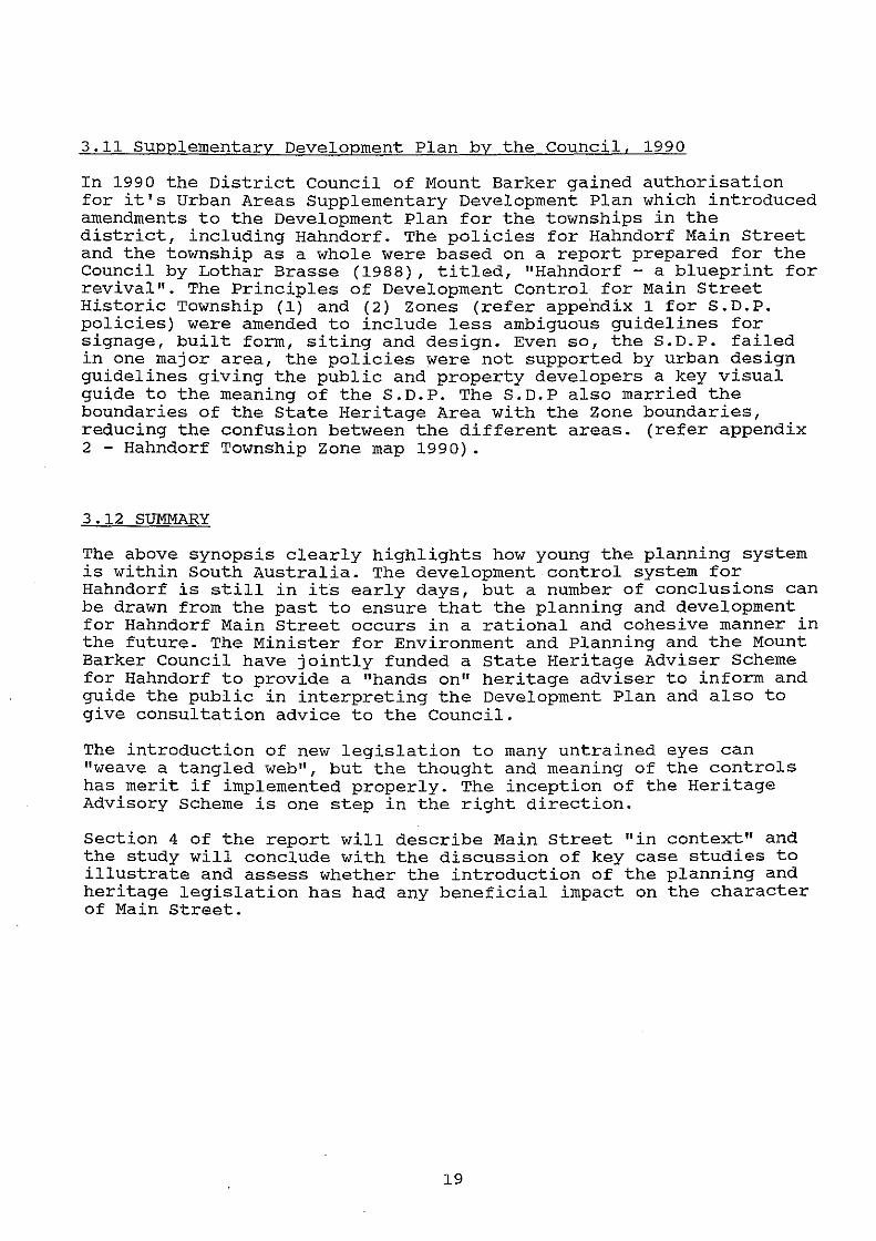
4.1 street-trees
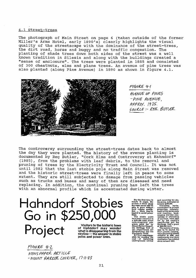
The photograph of Main Street on page 6 (taken outside of the former Miller's Arms Hotel, early 1890's) clearly highlights the visual quality of the streetscape with the dominance of the street-trees, the dirt road, horse and buggy and no traffic congestion. The planting of shade trees down both sides of the street was a well known tradition in Silesia and along with the buildings created a "sense of enclosure". The trees were planted in 1885 and consisted of 300 chestnuts, elms and plane trees. An avenue of pine trees was also planted (along Pine Avenue) in 1890 as shown in figure 4.1 .
.PIGUI?.£ If·(
f/-VENU~ OF fi/N£5 - PtNe fWcfl/ue, fi-P(J f!.O'j. ( 9 ~$'. ~ov!LU :- f.$. f3UT0r:R
The controversy surrounding the street-trees dates back to almost the day they were planted. The history of the avenue planting is documented by Reg Butler, "Cork Elms and controversy at Hahndorf" (1985), from the problems with leaf debris, to the removal and pruning of trees by the Electricity Trust and Council. It was not until 1982 that the last stobie pole along Main Street was removed and the historic street-trees were finally left in peace to some extent. They are still subjected to damage from passing vehicles such as trucks and buses and many of them are diseased and need replacing. In addition, the continual pruning has left the trees with an abnormal profile which is accentuated during winter.
Hahndorf Stobies Go in $250 1000 Project
rtflo 1?£ lf·l
rvcw r; mp e-tZ.. fi-ttT r u .. £
Visitors to the historic town of Hahndorf may wonder what is disappearing from the skyline- the answer is stobie poles and power lines.
-mouNT tii~IU3t- CO/JR-1~, t7·tt·'B'J
21
For tho flnlt ttmo In nearly 'l'O yean~, the avenue of tTOe!l along Ute main street wtU 00 ublo to grow without . their regular muUIB.· t!on ... When they're lopped to avoid power
'"""· The stoble poles ho.ve been removed 1n a $250,000 main street redevelopment pro-
ff!::~hJ::;~~r~~c'U: ~! ~~~~rfm~n1t ~~~ Envtroriment and the Electrlclty Tn.urt.
E.T.S.A. waare.!J'P(:nIJI.ble for meeting the cost · of lnstaJllng underground wiring
and removing the IJto. ble poles, et~Uffiated at around $100,000.
Trenching \\'Orks, connecUons to private properties, rolnstatementof the pavements and roadway, land-
:'tfo~ :;~t:;la~'~ of services, were paid
~t~bu~ :c[: Heritage Unit's grant of $60,000 eaclt.
The avenue of trees, now to be spared the four.yearly lopping, were planted by IIChool chlldren in 1886, and
~~~~~ri'b:~~~t: since around Ull3.
. i
Progress and modern technology can not be halted and certain transformations along Main Street are inevitable with the introduction of bitumen roads (1930's), line marking, modern services and the inception of modern building techniques. However, the retention of the beautiful deciduous trees and replacement of dying and damaged trees is vital for Main Street to retain its character and the streetscape.
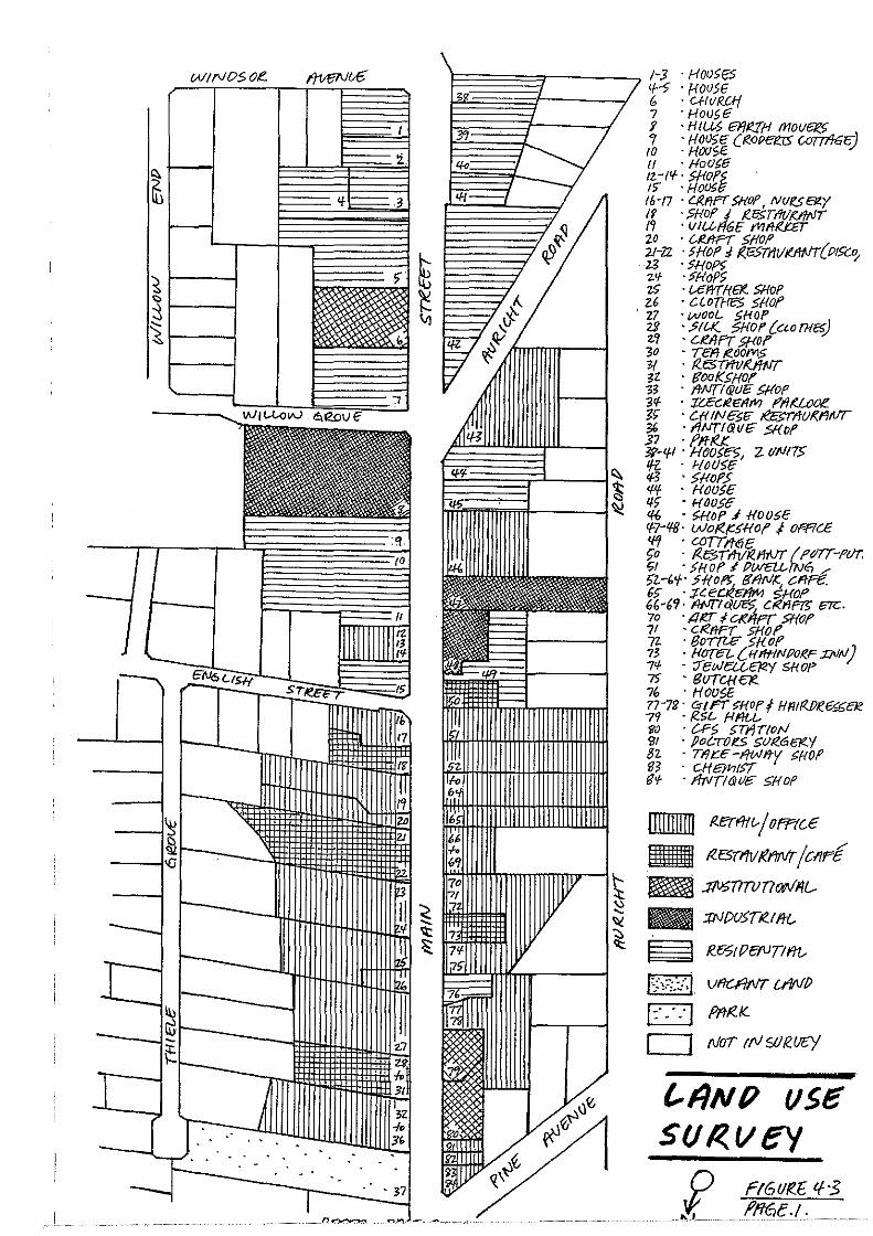
4.2 Development Pattern and Land Use
A land use survey and an analysis of the development pattern from aerial photography was conducted and the results are illustrated by figures 4.3 and 4.4. The survey shows the separate land uses for each allotment (including a description of the use) and the siting of each individual building along Main Street. An indication of the buildings listed on the State Heritage List are also highlighted on figure 4.4.
The survey maps also show the present allotment configuration which has been fragmented into smaller and more contemporary shaped allotments. The extent of the fragmentation is clearly illustrated by comparing figure 4.3 and 4.4 with figure 2.1 (1850's) on page 5. As mentioned in Section 2 the early subdivision layout was planned to give equal portions of land to each settler. Small modest buildings were constructed on the allotments and were later replaced by more substantial homes close to the street alignment. The abandoned buildings were used as outbuildings. The survey shows that over 72 percent of the buildings fronting Main Street are now used for commercial activities, 3 percent for industry, 17 percent for residential purposes and the remaining properties for institutional and public purposes. It is interesting to note that an overwhelming proportion of the shops along Main Street are occupied by antique/art and craft shops (22 percent) and food and drink/restaurant establishments (25 percent) .
The result of the survey raises an important issue, where over 70 percent of the uses are "commercial". Traditionally the cottages along Main Street were used as dwellings with a small proportion being used for shops and services to cater for the local community. Due to the large influx of tourists there is a "market" for additional shops. This issue will be discussed in Section 6.
One of the best remaining examples of the development pattern is Rodert•s Cottage at number 20 Main street. Figure 4.5 of Rodert's Cottage shows the elongated "hufendorf" allotment pattern with the "strassendorf" development pattern. The initial dwelling is sited towards the centre of the allotment. The barn and pig sty are located to the rear. The more recent dwelling was built at the front of the allotment of stone and iron.
An inspection of the buildings revealed them to be in very poor condition and in need of urgent conservation. The original dwelling and the barn are dilapidated and open to weathering by the elements and are continuing to deteriorate. It is a good example of the development pattern and moves should be made to preserve the property (possibly as a museum piece) for future generations to appreciate.
22
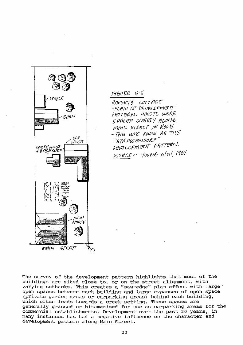
Pt6U /!.f tf -~ (!_of? 61Z. II? UJTT Fltf£. - PC-ff1V OF ~ (Jf;UJffVItrVT FR7Tta<.N. 1-fOVSES !NClZf 5 Pil-e£!? CU'hEl- '/ !!-tON 6 {V)f/1 rJ STR.eei ;tv' t<.ow5
-THIS wY'/5 K}JIJuJ ~ TH6" " 1'~T!iC.i%§ eN PO f!..P
fievfiVOftV1(3V{ Plt!Telf'J-5o!/ lf..ce :- 'foil N6 e-+a /, ft:/?]"/
The survey of the development pattern highlights that most of the buildings are sited close to, or on the street alignment, with varying setbacks. This creates a "saw-edge" plan effect with large· open spaces between each building and large expanses of open space (private garden areas or carparking areas) behind each building, which often leads towards a creek setting. These spaces are generally grassed or bitumenised for use as carparking areas for the commercial establishments. Development over the past 30 years, in many instances has had a negative influence on the character and development pattern along Main street.
23
W!NOSO£.
(/.()--
-~ <H--
.. 1 .
ffililll]J f<erf'ltt_..j Off(C£
~~~ ~E5TI'/1//ftl/1lr /CliFf
6 .JMIITtmr»/1'/L
- :PJ{)USTR.I Iii-
~ f(c-:7/P~TII'it
fim. Vf/C.FINT U'/(\//)
D m~</(_
0 Nor ttV$R.UC'/
t.IINP vse SfJ I<. I/ ey f rt6V!?.E tf- -3
. "·' .. fl_fl§f:.:! :
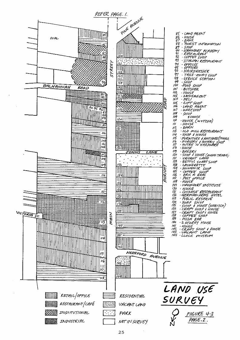
- /?.E.TfTI r...j OFP{c.£
- P.E5TfiUI(fWTjCI/F{
~ ;J:I\/f>Trn!T/ON!ff...
:JNPIJST/?.1 ffi-
. ~ . . . . .
~ ((ESIIJEf\/Tfffi.
H;:~E;;I Vflc.f!NT U'INP
EJ pfllj_
D NOT!f\1.9/K_IIC/
25
LIJtvP vse SUI< VtiY
i rrG.uK-C: lf-·3 PIJ6E.2..

.-(. --<-·------
OEVEZ..OP/YIEIVl Pf/TTEI<N f rrt!Jvt<£ 'f·<f N ?1'16t:. 1.
~o11 tZ.ce: · !l£R.f fl1-f'HOW6f<fl-f'h
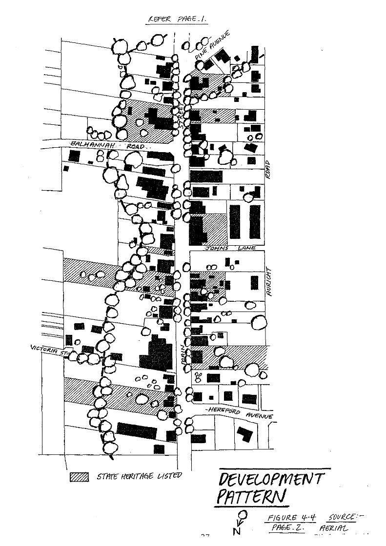
PtV~UJPMCNT ffiTTe-t<N ~ rlfJ VRJ:i i.f-·'{- )OiJI?..CC:-
N PM£. z.. _flli!-tff1:-
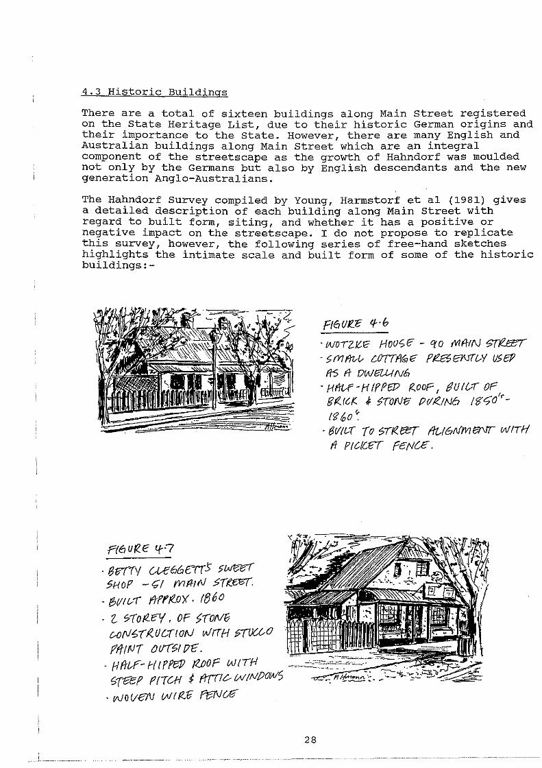
4.3 Historic Buildings
There are a total of sixteen buildings along Main street registered on the State Heritage List, due to their historic German origins and their importance to the state. However, there are many English and Australian buildings along Main street which are an integral component of the streetscape as the growth of Hahndorf was moulded not only by the Germans but also by English descendants and the new generation Anglo-Australians.
The Hahndorf Survey compiled by Young, Harmstorf et al (1981) gives a detailed description of each building along Main Street with regard to built form, siting, and whether it has a positive or negative impact on the streetscape. I do not propose to replicate this survey, however, the following series of free-hand sketches highlights the intimate scale and built form of some of the historic buildings:-
.Pf6 ur?.IE If·?
. en~v U-e66e:-rr.> >Wf:%( 5HOP - 0/ f'VIff!r\l 5Tt.mT.
. 8(!/f./( fJFff(.O)(. tf360
· 2. t71o!<.f1(, OF >-roNG c.-o(lf6(((UD(ION wiTH :;TIJ{£0
Ft6UR."E lf · b
· woTZ!tE' Hoot;!? - era rVlfttN ~ · >mfrtA-- C.07TI/19ff' PI!Ef3\Jfl-.Y IJ>eP
f/5 ft DWE3UI N6 ·Hft(;f-HfPPfP /2.,ooF, gutf.,TOF
g((rc,r.. .f >TONti Prii?JN6 te-<;o'r{)? 60 ~~
· 81/t&T To ~rr<ecr ffU611fmeNT wiTH If PtC(CtiT fE/'IC£ .
fffttvT tJII(~t !7E. ~~~~~~?~~ . Hflt-F-NtPPBP !Z.JJOF WITH ~1-r?'ef PfTW f f11'11? WtNfJOW) :'.;_0:.c=i-.:~~~
. w weN vm<Ji f15N a
28
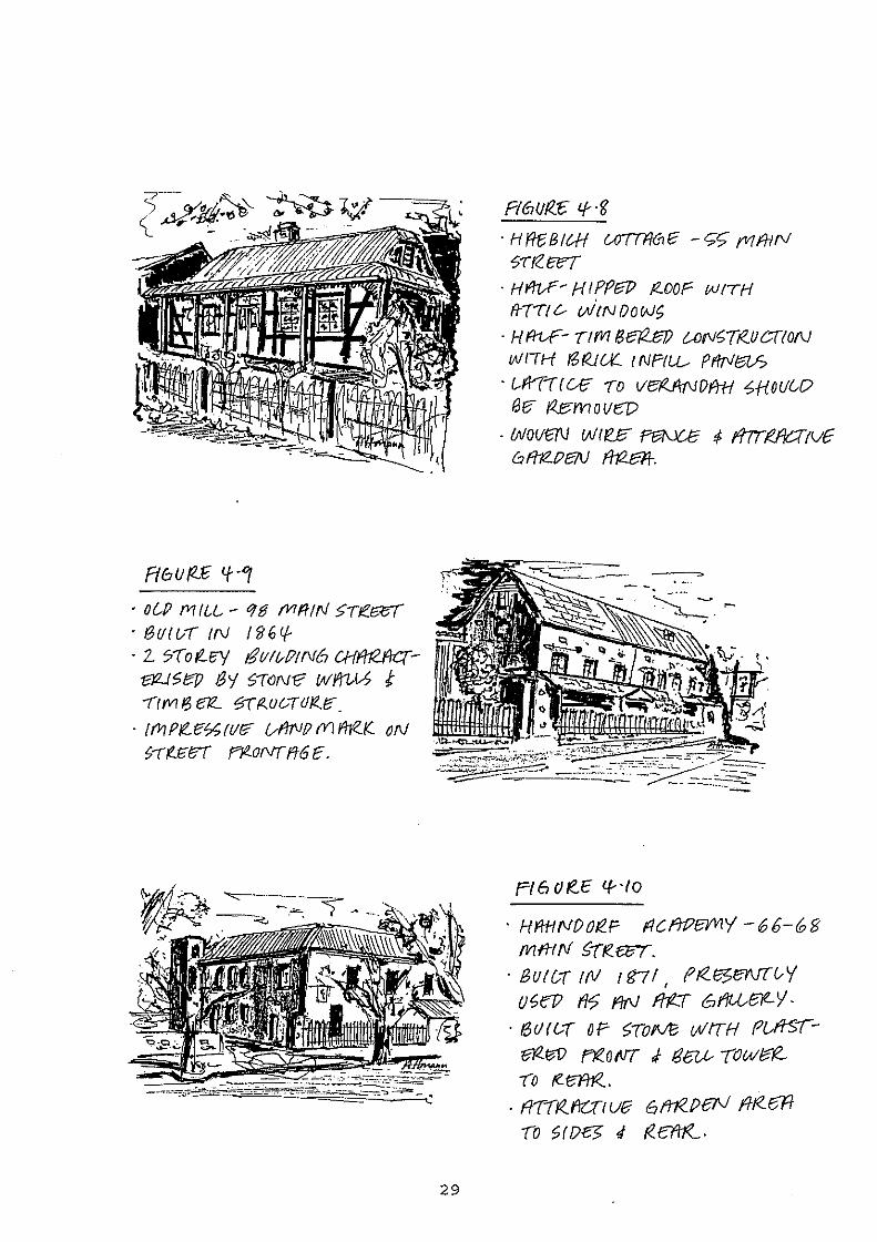
f(6U p_;F; tf ·'1
• o(.JJ fVI IU~- qg fVIff!N >n?.6/'ff · tauwr IN ;g6q.. · 2. '?(of..~ &f.llt-f?tN6 CHfftWC(-
1312-1 ~ r::p I3Y (,-r CJN<? wmt-5 t 71fVI6 erz.. ~~rzuc--rd!ZtJ".
· rr11 PI'Lt!'h rvf?' vlfTV!J (Y) !'he..{( oN t;-(f..t:;{:J'( f"JR..oNr ff6 E.
29
R6Ufl.:C: tf .g
· H (1£ B I &H WTTFM E - c;r; fVI fN f\f 5-r{(.tx(
· Hf1VF~ HIPPeP !2-00F (IJfTH ffTTf &- vitN Do fJJ{,
· Hfi-VP- TffVI f3e?2..et? UJf\/{,T~IJ(.,.{/ON WITH /3t<JU( 1 NP//..L- PflrJtah
. Uf'Tc(Uf TO VerZft(\l()f'rH ~H.OUC-0 13£? i'Ze:movw
· {}1/0VW Wle£3" PF3f\.JU: f 117TMCrtvE bf/1Z.f?f31) f/12.al-.
Fl 6 0 TC.E lf- ·to
· HJ!tHNOOIZ.F flC.fJt?eYV!Y -66-68 mmN s-r~e.wr.
· Bun-r tN tfs11 ff<.f%B\!T&Y '
U'Jel? f/'7 flfl} fff..T 61ti.-U31LY-
. f3UfL-r ~p <;ToM wrrH Pt..ffS'(@Z~ rr<.ofllT ; ear..- -row~ 70 f2._ eAr<..
· fiTI~fcnut? 6111<.PeN ffRe:ff -ro ~ro~ .J r<.ert!(..
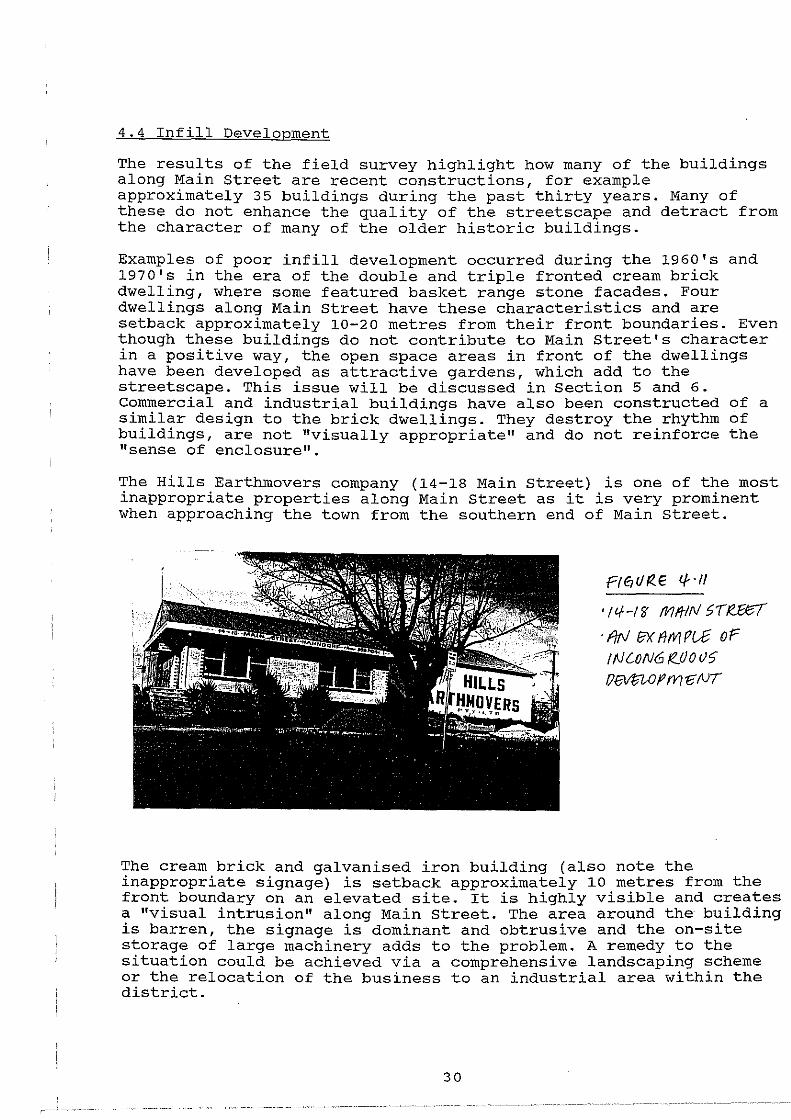
4.4 Infill Development
The results of the field survey highlight how many of the buildings along Main Street are recent constructions, for example approximately 35 buildings during the past thirty years. Many of these do not enhance the quality of the streetscape and detract from the character of many of the older historic buildings.
Examples of poor infill development occurred during the 1960's and 1970's in the era of the double and triple fronted cream brick dwelling, where some featured basket range stone facades. Four dwellings along Main Street have these characteristics and are setback approximately 10-20 metres from their front boundaries. Even though these buildings do not contribute to Main Street's character in a positive way, the open space areas in front of the dwellings have been developed as attractive gardens, which add to the streetscape. This issue will be discussed in Section 5 and 6. Commercial and industrial buildings have also been constructed of a similar design to the brick dwellings. They destroy the rhythm of buildings, are not "visually appropriate" and do not reinforce the ''sense of enclosure".
The Hills Earthmovers company (14-18 Main street) is one of the most inappropriate properties along Main Street as it is very prominent when approaching the town from the southern end of Main Street.
Pt0C/f<.E <HI
· fl!- -1 ff Mlflfll > r R.1X7 · f!rJ f?X 11111 Pi..£ oP !f\ILON61Z.OOU> {)~OPfVIff/V(
The cream brick and galvanised iron building (also note the inappropriate signage) is setback approximately 10 metres from the front boundary on an elevated site. It is highly visible and creates a "visual intrusion" along Main street. The area around the building is barren, the signage is dominant and obtrusive and the on-site storage of large machinery adds to the problem. A remedy to the situation could be achieved via a comprehensive landscaping scheme or the relocation of the business to an industrial area within the district.
30
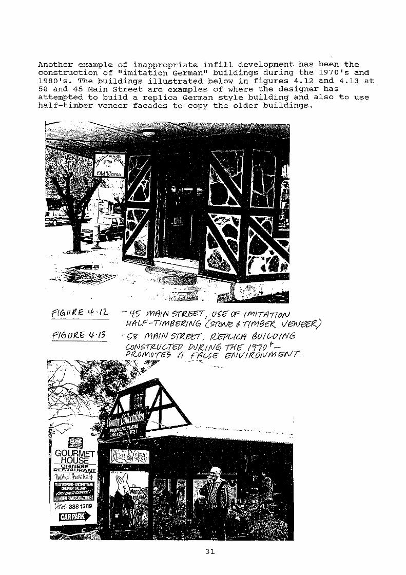
Another example of inappropriate infill development has been the construction of "imitation German" buildings during the 1970's and 1980's. The buildings illustrated below in figures 4.12 and 4.13 at 58 and 45 Main street are examples of where the designer has attempted to build a replica German style building and also to use half-timber veneer facades to copy the older buildings.
r/GUt:!.E '+ ·l'l- - <ffi fVIR!t.J S-rt<J%T, U~(FOP (fVIITfl/(0/\1 l-lf'rL-f-TtfV/861</NG {>ToNe~ Trn16El( VeveEJ<.)
P/6ufU~ lf-·13 -t;'d fVIfi1N 5Tr<£l::T, /l.EP&-tc.R SU!vO!N6 wN£TMC..TC!? Pill<-!fl/6 THE' 1'170 1-Pr<.OMO(f?; 4 Ff!f..--§E 6NV!f<.Ott!Mf'N(.
·····- -'>I.
·---·-·
' ...
31
To the untrained or unsuspecting eye such replica buildings can be mis-interpreted as original buildings and both confuse and diminish the genuine historical values and create a false theatrical environment.
4.5 Impact of Tourism
"The primary stimulus to the growth of the tourist activity in Hahndorf has been the town's historical background." (S.A. Division of Tourism, 1976).
It is an obvious conclusion that Hahndorf's historical background and its environment and surrounds are the stimuli for attracting the massive number of tourists. As outlined in Section 2, Hahndorf is attracting in excess of one million tourists per annum. With the number of tourists increasing each year Hahndorf Main Street and its environs must still retain some of its appeal and character. Even so, I consider that Hahndorf is at the cross-roads and that the next 5 years will be vitally important otherwise Hahndorf may be engulfed by commercialism and tourism. In 1976 the S.A. Division of Tourism published a document titled, "The Impact of Tourism on Hahndorf", and their results were based on a survey of local residents and traders. Even though the report was written in 1976 it drew a number of interesting conclusions:-
* the result of tourism could compromise the historical character and streetscape of Main street through incompatible building styles.
* facilities for tourists such as carparks and advertising signage could detract from the streetscape.
* the increased popularity of Main Street is resulting in the increase of property values and rents which is putting pressure on traders to remain competitive and viable. This can also lead to the possible reduction of visitors if they perceive there to be a poor "variety" of land-uses and shops.
* the tourist industry can be vulnerable to changes in consumer choice.
* the majority of the survey group were in favour of tourism in Hahndorf but were concerned that an increase in the tourist trade may create a conflict along Main Street and the residential areas.
Although the questionnaire survey conducted for this report was not as comprehensive as the 1976 report, it is interesting to compare the changes in results from the community:-
* there is a saturation of "art and craft" type shops and eating houses. Discussions with local real-estate agents revealed that the turn over of properties during the mid to late 1980's was very high and "only the fittest survive".
32
* the impact of the tourist is now very real and that the recent spate of new commercial developments (shops, offices and entertainment facilities) are compromising the traditional rural township mix of uses, and the historical structure of the town and Main Street.
* residents are becoming more and more sceptical about commercial development due to the traffic congestion, diminishing quality of the historic streetscape and the loss of privacy and amenity in the neighbouring residential streets. Main street is becoming popular for young people who attend night clubs and discos, which emanate noise to adjoining residential areas.
* traders and residents want more detailed and clear controls, "to provide hard and fast rules" of what is appropriate development.
* there appears to be apathy on behalf of some traders who will often, "develop their property and ask questions later", and also by the Council and state Government who should be educating the traders and residents about the heritage legislation in order to reduce the conflict between all parties.
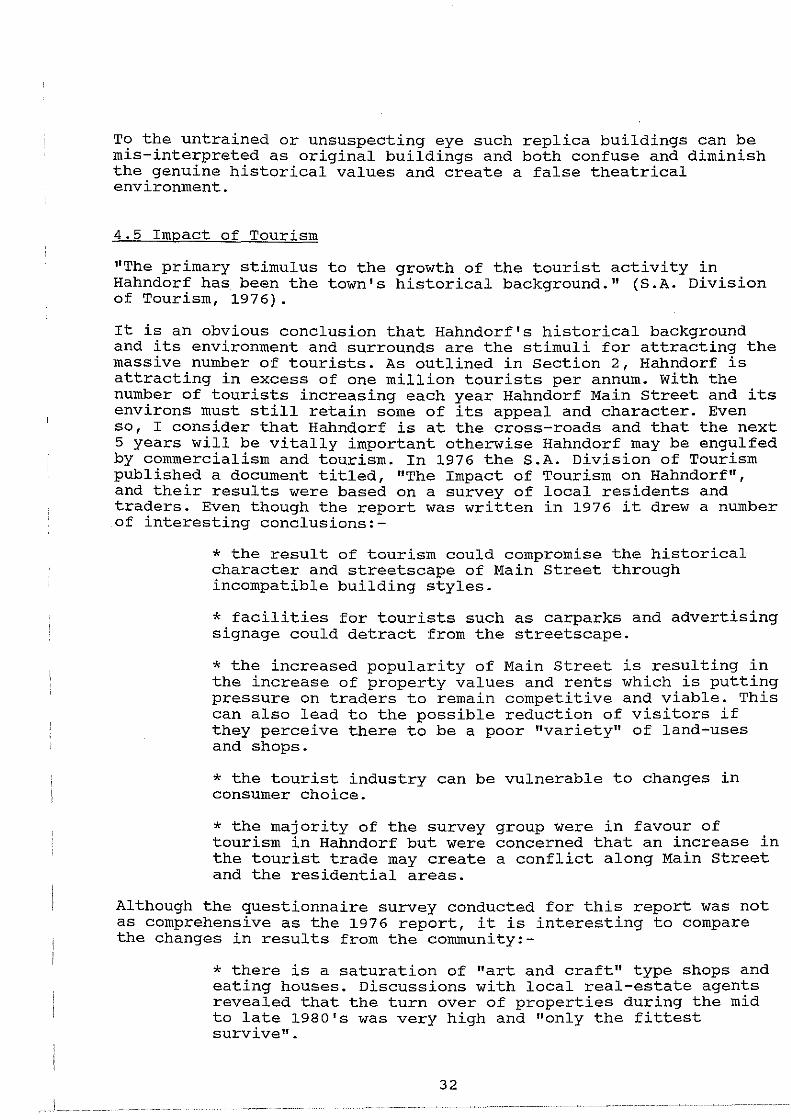
As Main Street becomes increasingly popular the traders perceive that there is a demand for further services and this has resulted in a number of recent developments and proposed developments for shops and food establishments. The article in figure 4.14 from the Mount Barker Courier Newspaper shows how the local community is reacting to the new developments along Main street which are being built to cater for the demand from the incoming tourists.
Hahndorf under threat by 'wall-to-wall' shops Halmdorf could cease to be viable as
a tourist attraction if its charm Is destroyed by "wall-to-waH" shops, trader Peter Hlne has warned.
Mr Hlne. who was threatened with legal action after his letter to the editor was published In last week's Courter, says controveruy over the German Arms Hotel redevelopment has obscured the real Issues.
A total of 102 residents and traders have signed a petition protesting Mr Hlne's statement that "aU main street landowners, tenants and residents arc dismayed and angry" at
4.6 Traffic
renovations to the heritage-listed hotel. They stated they were pleased with German
Arms owner Noel Duffield's efforts to "harmonise the authentic antiquity of the buUdlngs wHh the social needs Utey are expected to serve In this day and age."
"I would Uke the people who've become awnre or the problems In Hahndorf to think about it, devoid of this nonsense." Mr Hlne said.
"They should ask themselves: Do they want a vlllage where all the charm has been lost by the gradual development of multiple shops In front of exlstlng houses?"
ft6Ut2.B l}·lc(
f\ll3.tiJ ~ Pf'I'P6'P. f11<.TI CAAi Fl2..0 fVl. TH ~ fVl Or/rJI !SftrZ.ICGR. UJrJt:?...! e:l!. , Z-'6-lf·Cfo
The popularity of Main Street as a tourist destination is also putting a strain on the road system, carparking and bus parking facilities. Traffic congestion and safety issues are of a real concern. The majority of traffic entering Main street is from the northern or Adelaide direction and creates a "bottle-neck" with
33
limited on-street and off-street carparking. A report prepared for the Mount Barker Council by Shane Foley (1981), highlights the major issues that should be addressed by the Council in terms of providing clearly sign-posted carparking areas, having time restricted on-street parking, having additional off-street carparking and also providing for bus parking facilities. The report included a traffic count outside of the Hahndorf Academy with the following results:-
* July 1981, Saturday - 6602 vehicle movements July 1981, sunday - 7046 vehicle movements
* results were also recorded on a Saturday and Sunday during the May school holidays in 1981, with an approximate 10 percent higher rate of vehicle movements on both days.
The 1990 figures from the Highways Department show a marked increase in vehicle movements which can be attributed to the increase in visitation. The traffic count was conducted at the intersection of Pine Avenue and Main Street on March 26, 1990. The results were collated and a 24 hour estimated traffic flow was established:-
* 12300 vehicle movements on the north west arm of the intersection (Adelaide side) * 5600 vehicle movements on the south east arm of the intersection (Mount Barker side) * 3820 vehicle movements on Pine Avenue
Parking was also assessed by Foley with approximately 445 off-street parks provided (1981) and at the peak periods it was estimated that about 500 parks were needed. These carparks were under-utilised as up to 200 cars were counted along Main Street and the surrounding residential streets.
For new developments along Main street the developer must now provide on-site carparking facilities at the rate of one (1) carpark per 15 square metres for a shop and one (1) carpark per 25 square metres for offices. If the developer can not provide the required carparking the Council can apply a carparking levy of $2650 per carpark for any short-fall, which the Council spend on future carparking and traffic management in Hahndorf. This policy can create a number of isolated carparking areas which are under utilised by the public, however, it is also council policy to try and encourage shared or integrated areas to reduce the overall number of parking areas and access and egress points to Main Street.
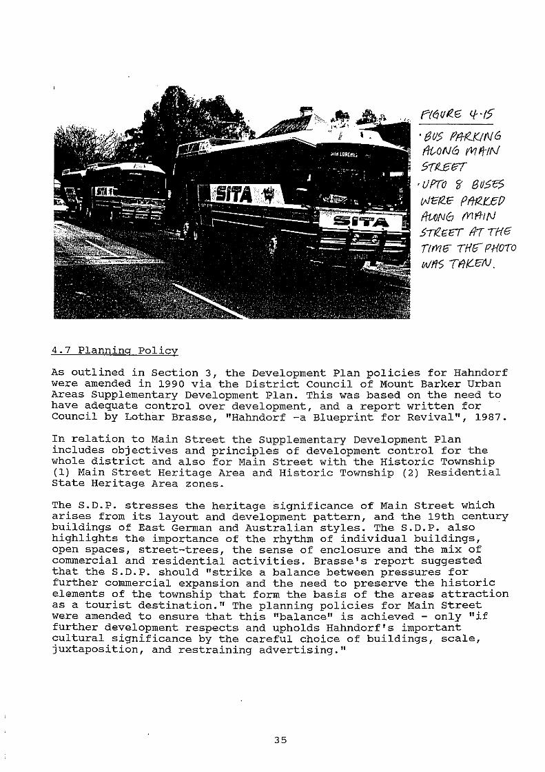
The Hahndorf Bus Park was established in 1990 by the Mount Barker Council to help alleviate some of the congestion along Main Street. The photograph (figure 4.15) below was taken on the Queen's Birthday Holiday 1991, where eight coaches where parked along Main Street. It was ironic as the Council had to fight a planning appeal to construct the bus park (local residents strongly opposed the proposal on the grounds of the loss of residential amenity), and many of the bus companies are not utilising it as they prefer to park along Main Street for the convenience of their passengers. The bus park was empty at the time the photograph was taken.
34
4.7 Planning Policy
P/61JI?.16 Cf ·IS
· t3 115 ffl-t<..K! N 6 f/i,ON6 M fi;!f\1
S7Ut37 • UPTO ~ 8rJS13? t;J 12i2.E' P fHZ.t::E· fl ~N0 fV114tN .5Tf!.G'l3T fl-7 T{-(G
Tfrvtfi' ·rHr PHOTO
Wft5 Tflf{.C:N.
As outlined in Section 3, the Development Plan policies for Hahndorf were amended in 1990 via the District Council of Mount Barker Urban Areas Supplementary Development Plan. This was based on the need to have adequate control over development, and a report written for Council by Lothar Brasse, "Hahndorf -a Blueprint for Revival", 1987.
In relation to Main Street the Supplementary Development Plan includes objectives and principles of development control for the whole district and also for Main Street with the Historic Township (1) Main Street Heritage Area and Historic Township (2) Residential State Heritage Area zones.
The S.D.P. stresses the heritage significance of Main Street which arises from its layout and development pattern, and the 19th century buildings of East German and Australian styles. The S.D.P. also highlights the importance of the rhythm of individual buildings, open spaces, street-trees, the sense of enclosure and the mix of commercial and residential activities. Brasse's report suggested that the S.D.P. should "strike a balance between pressures for further commercial expansion and the need to preserve the historic elements of the township that form the basis of the areas attraction as a tourist destination." The planning policies for Main Street were amended to ensure that this "balance" is achieved - only "if further development respects and upholds Hahndorf's important cultural significance by the careful choice of buildings, scale, juxtaposition, and restraining advertising."
35
The Objectives and Principles of Development Control for the Historic Township (1) Main Street zone are:-
Objective 1: The retention of the historic character of Main Street and its immediate surrounds.
Objective 2: To encourage a high standard of outdoor advertising which reflects the historical origins of Hahndorf and which does not detract from the heritage value of its historic areas.
(1) This zone should accommodate commercial, residential and community orientated development.
(2) Buildings of National, state, or local heritage significance including those listed in Table MtB/12 should be conserved, and where appropriate, restored. (Note: Table MtB/12 includes those items registered on the state Heritage List).
(3) Land division that would in any way detract from or fragment the existing "Strassendorf" allotment pattern and allotment sizes should not be undertaken.
(4) Development should be undertaken only if the scale of activity, vehicular and pedestrian traffic generation, access and associated utilities, maintains, or enhances the Silesian heritage and character of the zone.
(5) Buildings should be erected along, or adjacent to, the common building line of existing buildings to maintain the enclosures of the streetscape, and where possible spaces should be retained between them to allow landscaping and softening of the built form. Landscaping should utilise hedges, gardens and trees traditionally used in the township.
(6) Buildings and structures should harmonise in form, texture and colour, with the character of the zone.
(7) Shop and office development should be of a small scale with a roof pitch of between 35 degrees and 45 degrees that complies with the standards contained in Table MtB/11. (Note: these standards include, (1) ratio of building to open space along street frontage of 4:1, (2) minimum set-back from side boundary to be 1.2 metres and (3) maximum continuous street facade should not exceed 9 metres)
(8) Sufficient on-site car and where appropriate coach parking spaces to meet anticipated future demand be provided at the rear of buildings, designed so as not to damage significant vegetation, including single trees, or intrude upon creeks.
36
(9) Areas marked B and C on map MtB/19A should be retained for off-street bus parking facilities. (refer Appendix 4 for maps)
(10) Residential development should be retained wherever possible, either along, or in conjuction with, other compatible development.
(11) All outdoor advertising should:
(a) harmonise with and reflect the heritage character of Main Street; and
(b) be of scale which respects both the building to which it is attached or related and that of the built form of Main Street.
(12) Advertisements should wherever practicable use pictorial representation to maintain the character of the street and ready recognition by tourists.
(13) The total area of all advertisements should not exceed ten percent of the area of any facade of the building on which it is displayed.
(14) Advertisements should not be displayed on the roof or above the silhouette of any building.
(15) No advertisements should protrude beyond the footpath
(16) No advertisement should be illuminated unless:
(a) they are front lit in a manner that does not cause glare or light spill; or
(b) the lighting does not flash.
(17) Corporate signs, logos and symbols should only be displayed where their.size and location is compatible with the objectives for the zone.
(18) Advertisements advertising properties for sale, rent or lease should:
(a) be limited to a total area of three square metres;
(b) be limited to not more than two displays for any one real estate agent; and
(c) not be displayed at a height greater than 1.2 metres above the ground level immediately surrounding the advertisement.
(19) Bunting and flashing lights should not be used as attention drawing devices, except for short term activities such as festivals.
37
(20) Flags should be restricted to locations and building facades where their presence enhances the historic character of Main street.
(21) the following kinds of the Historic Township (Main (HT(1)):
Amusement Machine Centre Amusement Park Boarding House Builder's Yard Caravan Park Fuel Depot General Industry Horse Keeping Intensive Animal Keeping Junk Yard Light Industry Motor Sales Premises Multiple Dwelling
development are prohibited in Street Heritage Area) Zone
Prescribed Mining Operations Public service Depot Residential Flat Building Refuse Destructor Road Transport Terminal Row Dwelling Semi-detached Dwelling Service Industry Sevice Trade Premises Special Industry Two or more dwellings on any
allotment Warehouse
A small portion of Main Street at the southern entrance of the town is located within the Historic Township (Residential Heritage Area) Zone (HT(2)). The policies are tabled in Appendix 1 and relate to the preservation and enhancement of the low density residential character of the zone. New dwellings and outbuildings should only be constructed if their style, scale and density are in harmony with the existing historic buildings. Six "district" Principles of Development Control under the heading of "heritage" also apply to the conservation of local, State and National Estate items of heritage significance.
The general objectives of the supplementary Development Plan are sound, however, there are a number of deficiencies which have become apparent during the past eighteen months. The need for refinement will be outlined in Section 6. The Supplementary Development Plan reiterates and enforces the findings of the heritage studies written on Hahndorf and attempts to maintain and enhance the historic quality of Main Street. Since the inception of the state.Heritage Area in 1988 the officers of the State Heritage Branch have used their architectural and heritage expertise to advise the Council on the suitability of proposed developments along Main Street, and their advice has also hinged on the support of the Supplementary Development Plan policies. The philosophy of the State Heritage Branch has been to promote:-
"new infill development that is simple and contemporary in character, sympathetic to the siting, scale and form of the older buildings. The visual focus should be aimed at the older buildings and not the new."
The following section of the report will highlight a series a case study examples which have been assessed by the Council and the State Heritage Branch during this period. I will assess the success of the "planning system" in terms of achieving the above mentioned objectives and principles.
38
5.0 CASE STUDIES
The following case study examples relate to three recent development applications considered by the District Council of Mount Barker and also in relation to enforcement of planning and heritage matters. The purpose of the discussion is not to promote a negative picture of the planning system or the planning authorities, but rather to outline recommendations to strengthen and promote a more manageable system. '
The 1990 Supplementary Development Plan (S.D.P) came into effect due to the need for more detailed policies to assess development in a period of transformation and growth in Hahndorf. In 1988 Main Street, Church Street and Victoria Street areas were declared a State Heritage Area and the procedures for assessing development applications was brought under Section 48 of the Planning Act, 1982. The S.D.P sought to introduce policy guidelines to inform us of the important aspects of the historic town and to ensure that the historic character and fabric were recognised and preserved with new developments.
The case study examples were carefully chosen from the District Council of Mount Barker planning register of approvals which were all assessed under the 1990 S.D.P and are also located within the State Heritage Area. They include:-
* commercial development to the rear of a state Heritage listed building
* alterations and additions to a State Heritage listed building
* infill shop development on a property which in isolation has a negative impact on Main street
* management and enforcement of development (advertising signs)
Each example differs with regard to use, visual appropriateness, impact on Main street and the philosophies applied during their assessment.
5.1 Lot 20, 102 Main Street, Hahndorf- Thiele Cottage
An application was lodged with the District Council of Mount Barker on July 2, 1985, and included the conversion of the ground floor of Thiele Cottage into two shops and an office, and the construction of a new building to the rear comprising five offices and three shops. (refer figure 5.2- elevation of proposal). In addition, it was proposed that another shop be constructed between the new building and the cottage with a large bird aviary to the rear adjacent to the creek. Thiele Cottage is registered on the State Heritage List as it is a good example of original German architecture, utilising a half-timbered construction. This proposal is a good example of the
39
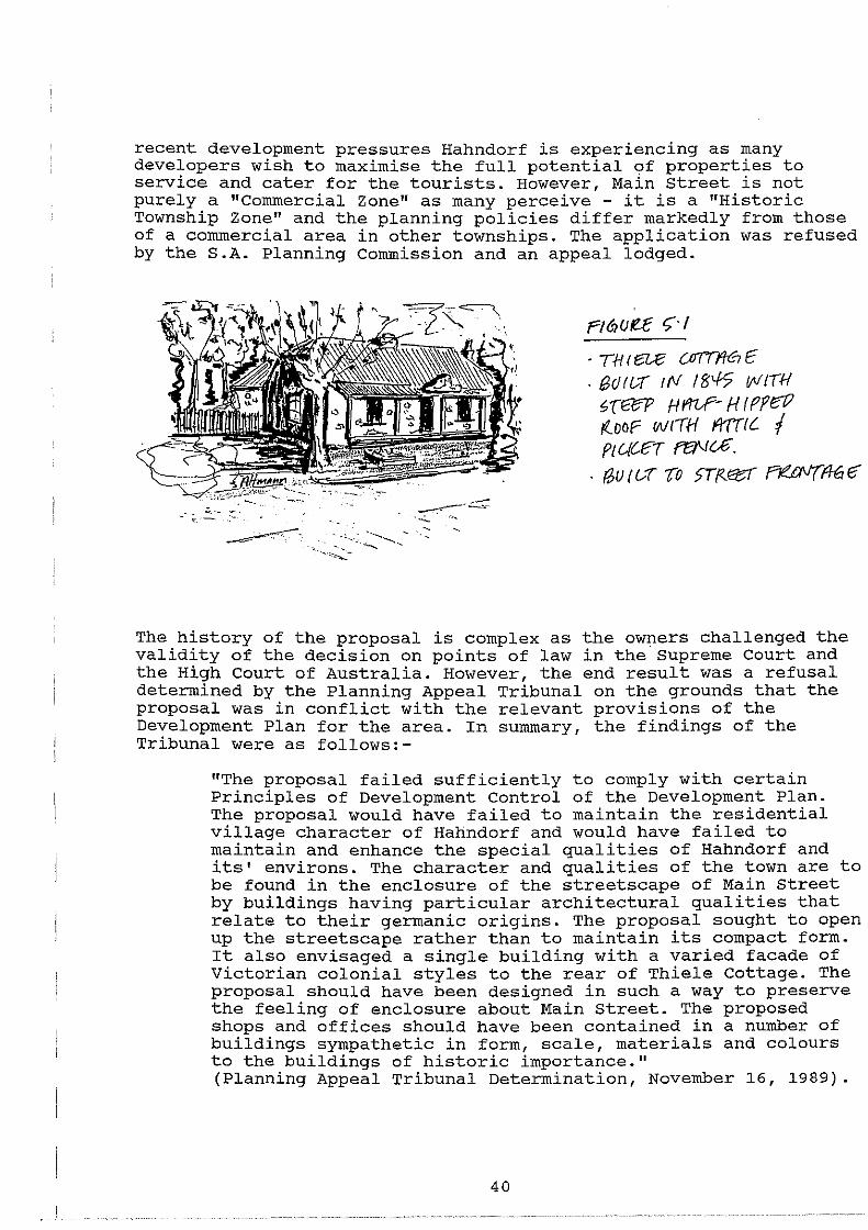
recent development pressures Hahndorf is experiencing as many developers wish to maximise the full potential of properties to service and cater for the tourists. However, Main street is not purely a "Commercial Zone" as many perceive - it is a "Historic Township Zone" and the planning policies differ markedly from those of a commercial area in other townships. The application was refused by the S.A. Planning Commission and an appeal lodged.
.. t:.·--
Fl ti!OI!..E t; · I
· TH I e:u:: {JT{{ff€1 E · (;5() I 1.--f" t {II 18'-!5 IJII IIH ~(t%P Hmf- HIPfa:' r<.ooP wrTH mete. I PtUC-E-r ffl\Jc£.
. f?,u r ur -ro 5Ttz!85f ne.uv(ff6 e-
The history of the proposal is complex as the owners challenged the validity of the decision on points of law in the supreme Court and the High Court of Australia. However, the end result was a refusal determined by the Planning Appeal Tribunal on the grounds that the proposal was in conflict with the relevant provisions of the Development Plan for the area. In summary, the findings of the Tribunal were as follows:-
"The proposal failed sufficiently to comply with certain Principles of Development Control of the Development Plan. The proposal would have failed to maintain the residential village character of Hahndorf and would have failed to maintain and enhance the special qualities of Hahndorf and its' environs. The character and qualities of the town are to be found in the enclosure of the streetscape of Main Street by buildings having particular architectural qualities that relate to their germanic origins. The proposal sought to open up the streetscape rather than to maintain its compact form. It also envisaged a single building with a varied facade of Victorian colonial styles to the rear of Thiele Cottage. The proposal should have been designed in such a way to preserve the feeling of enclosure about Main Street. The proposed shops and offices should have been contained in a number of buildings sympathetic in form, scale, materials and colours to the buildings of historic importance." (Planning Appeal Tribunal Determination, November 16, 1989).
40
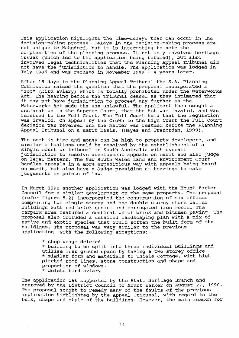
This application highlights the time-delays that can occur in the decision-making process. Delays in the decision-making process are not unique to Hahndorf, but it is interesting to note the complexities of the planning process. It not only involved heritage issues (which led to the application being refused) , but also involved legal technicalities that the Planning Appeal Tribunal did not have the jurisdiction to handle. The application was lodged in July 1985 and was refused in November 1989 - 4 years later.
After 15 days in the Planning Appeal Tribunal the S.A. Planning Commission raised the question that the proposal incorporated a "zoo" (bird aviary) which is totally prohibited under the Waterworks Act. The hearing before the Tribunal ceased as they intimated that it may not have jurisdiction to proceed any further as the Waterworks Act made the use unlawful. The applicant then sought a declaration in the Supreme court, that the Act was invalid, and was referred to the Full Court. The Full Court held that the regulation was invalid. On appeal by the Crown to the High Court the Full Court decision was reversed and the matter was resumed before the Planning Appeal Tribunal on a merit basis. (Hayes and Trenordan, 1990).
The cost in time and money can be high to property developers, and similar situations could be resolved by the establishment of a single court or tribunal in South Australia with overall jurisdiction to resolve development appeals on merit and also judge on legal matters. The New South Wales Land and Environment Court handles appeals in a more expeditious way with appeals being heard on merit, but also have a Judge presiding at hearings to make judgements on points of law.
In March 1990 another application was lodged with the Mount Barker Council for a similar development on the same property. The proposal (refer figure 5.2) incorporated the construction of six offices comprising two single storey and one double storey stone walled buildings with red brick quoins and corrugated iron roofs. The carpark area featured a combination of brick and bitumen paving. The proposal also included a detailed landscaping plan with a mix of native and exotic species that would soften the built form of the buildings. The proposal was very similar to the previous application, with the following exceptions:-
* shop usage deleted * building to be split into three individual buildings and utilise less ground space by having a two storey office * similar form and materials to Thiele Cottage, with high pitched roof lines, stone construction and shape and proportion of windows. * delete bird aviary
The application was supported by the state Heritage Branch and approved by the District Council of Mount Barker on August 27, 1990. The proposal sought to remedy many of the faults of the previous application highlighted by the Appeal Tribunal, with regard to the bulk, shape and style of the buildings. However, the main reason for
41
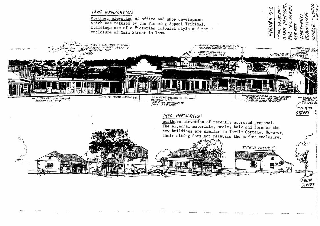
, ~ r.: /Cc= • .• · ·-
/1'15'? A-fPIA&ftT/ON northern elevation of office and shop development which was refused by the Planning Appeal Tribinal. Buildings are of a Victorian colonial style and the enclosure of Main Street is lost;.
-.. ! {·~"'~· . . .... p .· •tr- _· ~~~t.i .... ;,.iiM_ r.~ .·'=',..r6~ ....... _'0,., \i.,-... ..;........,
1 ,.,,,-.~ .. -7<.\I.C•. ~E' ..:.AN~'J"!t' T:..
r-~ ~ er ~ l?flai / """""I"" ~,.,. 9/CW/J .;,_--_.: . ...,.. ~ ,..____. -~~~-.,;CC~~: -',"l!4
·- ... ' . ~ 5 ! • j.r_~.-,
· F ?:J-JT."~J;:; ~1Ka/WT ~ L ~.v ~ ~" 10 .-u.. iff);.lFf.C,l.ff :Wfl..t.~ !Am.:e rlt<Ct& "!:C/<E:8tJ ro Ff.CI..ff :F \I~.J:UI
\{ ~-~A.tlF
!t{f(O ftff'v/1/ffTION
r-..1 \f-
~ \.!;
it
. ,...::, <;: ~ ~ ~I>
\ ' ':5, ~ \i\ ..... ._, ". 1\5 <::, ~ ~~ '-). \rt~~ ~ ~ "· ~t~~:;- ;t~ ~ .. ! <:::, ~ - ~ K '\\:~ ""' I D I:,£ ':;> • ~ ~~~ <:> ~ ~ It 'V\ ':" "' •
northern elevation of recently approved proposal. The external materials, scale, bulk and form of the ne1v buildings are similar to Theile Cottage. However, their siting does .not maintain the street enclosure.
5-rl6rr
the Planning Appeal Tribunal refusal was due to the loss of street enclosure. The elevations (figure 5.2) clearly illustrate how the development will draw people away from Main Street into an imitation heritage enclave, which would accentuate a loss of the street enclosure and the "strassendorf" development pattern. The approval for a large scale development away from the street frontage has set a worrying precedent for future development along Hahndorf's Main Street. It is also interesting to assess the proposal against the Principles of Development Control for the zone relating to the retention of the street enclosure and construction of buildings to match the existing building alignment. The s.D.P as a development guide does not specifically address the issue of buildings being constructed behind those fronting Main street. These areas are generally gardens (often leading to a creek setting), private yards or carparking areas and the preservation of these open areas needs assessment.
The development proposal (1990 application) has attempted to utilise a scale and form of building that is sympathetic to Main Street and the older buildings. However, the proposed buildings are to be situated behind Thiele Cottage in a linear form at right angles to the street. The retention of the street enclosure which has been important for guiding proposals by the State Heritage Branch, was not enforced in this instance. The use of the buildings for offices should not draw the public away from Main street, however, they could possibly be converted into shops at a later date. The form, bulk and scale of the individual new buildings complements that of Thiele Cottage - roof treatment and pitch and use of stone walls almost replicates the construction of Thiele Cottage. However, this is directly at variance to Heritage philosophy who wish to promote sympathetic contemporary architecture which does not dominate the older buildings visually.
I consider that the Heritage Branch may have been influenced to process this application expeditiously due to the complex history of the previous application and as it was amended in accord with the suggestions of the Planning Appeal Tribunal determination in 1989.
5.2 Lot 20, 67 69 Main street, Hahndorf - German Arms Hotel
The German Arms Hotel caters for meals, functions, accommodation and is one of Hahndorf's two Hotels.
With the tourism boom there is now an obvious demand to cater for more than local trade with clientele from interstate and Adelaide. The owners of the Hotel sought approval from the District Council of Mount Barker to refurbish the Hotel, including, (1) a new entry between the hotel and adjoining cottage, (2) the external facade of the hotel being restored to its "original" condition, (3) restaurant and storeroom additions to the rear of the building and (4) major changes to the internal layout of the two buildings. The artists impression of the additions (figure 5.3 and 5.4 - Council register of planning approvals) clearly highlight modern architecture with extensive glass facades to the rear and to the entry at the front. The height and form of the rear extension (figure 5.3) was
43
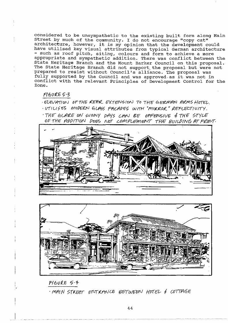
considered to be unsympathetic to the existing built form along Main Street by much of the community. I do not encourage "copy cat" architecture, however, it is my opinion that the development could have utilised key visual attributes from typical German architecture - such as roof pitch, siting, colours and form to achieve a more appropriate and sympathetic addition. There was conflict between the State Heritage Branch and the Mount Barker Council on this proposal. The State Heritage Branch did not support, the proposal but were not prepared to resist without Council's alliance. The proposal was fully supported by the Council and was approved.as it was not in conflict with the relevant Principles of Development Control for the Zone.
ft6Uri.E t;·3 · t;UVI"/"T!ON oFTHG ,e_1?111(__ I?Xier'J<?toN To TH~ tSr37ZIVII'ItJ 1/ief'IIS HOT-a-. · UT/l.A~f5l? fVIO{)f;{!.f\] 6iA'/<75 fflC-1/Pfft; WfTH •fV/1/FZ.K?..O,e. '' /?..fft.--a-T(UI1Y
· THfi"" C:7Gf/R.£ oN GUNNY PII-Y5 C-1'11V 61? oPFeTV6fl/G t THE 5TYL£ OF THC:: fl-f}!)fTI0(\1 fJofiS Nr.JT UJWif?U?W7taVT TM 8U/UJ!N6 fiT PI!!.NVT·
fi 6 u ~(:; <?. '1-
. fYlftttV 5Tf.JXT Pf\IT!'i!..f'f1\}U3 tB17T~ f(OTr3-- I (JJTTflt6E
44
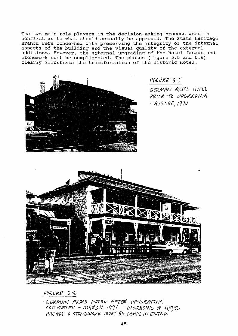
The two main role players in the decision-making process were in conflict as to what should actually be approved. The State Heritage Branch were concerned with preserving the integrity of the internal aspects of the building and the visual quality of the external additions. However, the external upgrading of the Hotel facade and stonework must be complimented. The photos (figure 5.5 and 5.6) clearly illustrate the transformation of the historic Hotel.
PIGUf2..E 5' ·<?
Ftt;;riR.e t;·> · 6 f:1(.JI1 f/7\1 fht_M? HOT 67..-
Przror<.. !o VP6tf.RPIN6 -fhj6V§1', !990
· 6r3'1Zfl1f/1'J fh(M5 HOT(W ITFT~ UP-61!.Fff?!fi/G; CiJfiiiPWTEP - fV1~GH, ro/'11. "Ufb!ZPfP!NG Of HOTD..r . " F'f!-Cfl:f)'G ~ >TON"GWOt2.([. f't<U~/ gr; L.OWlfUf(VIf;/\!7cP.
45
This example clearly shows how the changing social and economic structure of Hahndorf is affecting business decisions and the streetscape of Main street. No longer is Hahndorf a quiet rural town, it is now a tourist destination for millions of people. The increase in property values and demand for service facilities has a direct influence on the form of development. The redevelopment of the Hotel was inevitable due to the demand for high quality restaurant, drinking and entertainment facilities. The use of glass facades on a registered state Heritage item must be questioned. Young et al (1981) considers that, "the orientation of Hahndorf towards tourist activity will create an artificial townscape which compromises the basic historic integrity of Hahndorf. It overshadows the function of the town to service its' residents."
The redevelopment has its merits and faults. A long concern of the heritage and conservation movement is in relation to the inside of heritage buildings. The redevelopment included the substantial modification of the internal layout of the Hotel and the adjoining cottage, involving the removal of many internal walls. During my research and interviews with the public it was obvious that the intimate charm of the historic building had been affected and that the German Arms Hotel as a restaurant, hotel and entertainment venue no longer matched the Hahndorf Inn in terms of its intimate charm and character.
There are a number of policies within the Development Plan relating to the retention of the historic character of Main Street and the need to promote the restoration and conservation of historic buildings. However, the Development Plan does not specifically cater for the assessment of major alterations to the internal areas of heritage buildings. The Council presently rely on expert advice from the State Heritage Branch for applications to internally renovate, but there needs to be the legal backing of appropriate planning policies. In this case the Council did not rely on the initial advice of the State Heritage Branch.
Further redevelopment of existing heritage buildings is inevitable and the retention of their integrity must be a high priority. The Development Plan controls recognise this point, but further clarity and better guidelines are required to ensure that the planning authorities and the state Heritage Branch (as trustee of State Heritage) have a clear, concise and manageable guide to assess future proposals. It is also a matter of educating the public and developers of the value and importance of Main Street so that they can understand the need to preserve and enhance the historic fabric.
5.3 Lot 96, 40-42 Main Street, Hahndorf - Shop Development
This is an example of "infill" commercial development within the State Heritage Area on a property that has little significance for the character of Main Street. A 1960's triple-fronted cream brick dwelling is situated approximately 10 metres from the front boundary alignment, however, the quality of the new building will impact on the overall character of Main Street and adjoining heritage listed buildings.
46
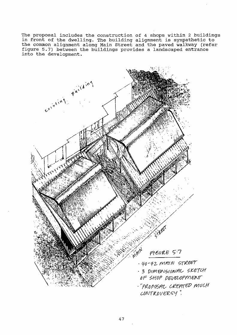
The proposal includes the construction of 4 shops within 2 buildings in front of the dwelling. The building alignment is sympathetic to the common alignment along Main Street and the paved walkway (refer figure 5.7) between the buildings provides a landscaped entrance into the development.
47
1, ... / '• .<..·. /
/ . ./
//
• l{-0 - if2- fVII'i1 N <;T!Zff:l
· 3 f)ti'VI f)'\/$tott!fi'V t;U"{CH
or >HOP Ofiii13UJPm£NT · ''fP.oPOSf/0- uiZ:ffffelJ fi1UGH ~NT i!..OV f:/2. <;'j ·:
The architect has attempted to design the shops in accordance with the Development Plan policies for the zone by (1) building to the street frontage to retain the street enclosure and (2) utilise a similar building bulk, compatible with that of an old 19th century building (encouraged via the Development Plan for Main Street Zone -Principle of Development control 6). However, shops have caused a great deal of controversy within the Hahndorf community as many consider it to be a blot on the streetscape or a "visual intrusion". The proposal complied with the Development Plan policies and was in accord with advice from the state Heritage Branch', to encourage buildings of a contemporary style, providing the aspects of bulk, siting, materials and size are complementary to the older buildings. The controversy was created as the building was perceived by the Hahndorf community as being "too contemporary".
Even though the cream brick dwelling did not have a positive impact on Main Street the garden area at the front and the deep setback added variety and open space to the streetscape. This example raises the question that other open spaces along Main street may be subject to future "infill" proposals of a similar type?
The use of rendered walls should be complimented and is supported by heritage architect Lothar Brasse (Hahndorf - A Blueprint for Revival, 1987). The buildings have sympathetic bulk, form, shape and siting to the heritage buildings, such as Thiele Cottage and Wotzke Cottage. The building has a contemporary style with large shop-front windows and the steel verandah is simple in form. The amended plans for the proposal show a high pitch roof that is compatible to the older buildings, but the rounded roof venting protrudes and detracts from the style of the building and prevents the use of simple roof pitch. The rendered brick-work is a contemporary way of treating a building facade and provides a colour and texture that is neutral in its impact amongst the historic architectural styles present in Main Street.
The application was supported by the Heritage Branch and approved on october 2, 1990.
The infill shop development has attempted to address the simple key aspects of built form and urban design in relation to the Development Plan policies for the Zone. However, a building of similar bulk with smaller window proportions (to complement the 19th century German and Victorian buildings) and deletion of the ridge venting would be a more suitable alternative.
The building introduces new geometry into the architectural styles along Main Street. It is really neutral in character as it does not copy the architectural style of the older buildings or use of building materials. It has been designed to complement and not detract from the character of Main street. The combination of a new style of building and the loss of an attractive garden area made the proposal a target for criticism.
48
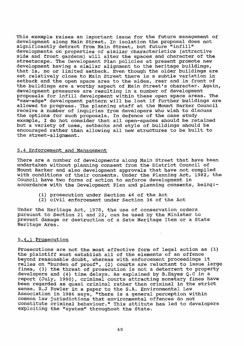
This example raises an important issue for the future management of development along Main street. In isolation the proposal does not significantly detract from Main Street, but future "infill" developments on properties of similar characteristics (attractive side and front gardens) will alter the spaces and character of the streetscape. The Development Plan policies at present promote new development having a similar alignment to the heritage buildings, that is, no or limited setback. Even though the older buildings are set relatively close to Main Street there is a subtle variation in setback and the open space area to the sides, rear and in front of the buildings are a worthy aspect of Main street's character. Again, development pressures are resulting in a number of development proposals for infill development within these open space areas. The "saw-edge" development pattern will be lost if further buildings are allowed to progress. The planning staff at the Mount Barker Council receive a number of inquiries from developers who wish to discuss the options for such proposals. In defence of the case study example, I do not consider that all open-spaces should be retained but a variety of uses, setbacks and style of buildings should be encouraged rather than allowing all new structures to be built to the street-alignment.
5.4 Enforcement and Management
There are a number of developments along Main Street that have been undertaken without planning consent from the District Council of Mount Barker and also development approvals that have not complied with conditions of their consents. Under the Planning Act, 1982, the Council have two forms of action to enforce development in accordance with the Development Plan and planning consents, being:-
(1) prosecution under Section 46 of the Act (2) civil enforcement under Section 36 of the Act
Under the Heritage Act, 1978, the use of conservation orders pursuant to section 21 and 22, can be used by the Minister to prevent damage or destruction of a Sate Heritage Item or a State Heritage Area.
5.4.1 Prosecution
Prosecutions are not the most effective form of legal action as (1) the plaintiff must establish all of the elements of an offence beyond reasonable doubt, whereas with enforcement proceedings it relies on "burden of proof", (2) courts are reluctant to issue large fines, (3) the threat of prosecution is not a deterrent to property developers and (4) time delays. As explained by B.Hayes Q.C in a report (July, 1990), criminal courts attracting monetary fines have been regarded as quasi criminal rather than criminal in the strict sense. R.J Fowler in a paper to the S.A. Environmental Law Association in 1986 says, "there is a general perception within common law jurisdictions that environmental offences do not constitute criminal behaviour." This attitute has led to developers exploiting the "system" throughout the state.
49
Proceedings must be initiated in the Magistrates Court within 12 months after the alleged offence (unless the Attorney-General gives special permission to undertake proceedings within a 5 year period) and the defendant can be found liable of up to $10000 in fines. However, an illegal change in use of land is a continuing offence, that is, the process of changing the use continues for every day that the new use continues. (District Council of Munno Parra vs Battersby - Botton, 1985) . The Court rarely impose the maximum fines.
5.4.2 Civil Enforcement
The concept of civil enforcement is relatively new in South Australia as it did not exist under the repealed Planning and Development Act. It is thought that these provisions were incorporated into the new 1982 Act, to overcome the above inadequacies with respect to prosecution.
Council or the S.A. Planning Commission may apply for a civil enforcement order where there has been a contravention of the Planning Act by filing a complaint with the District Court supported by an affidavit evidence relating to the alleged contravention or failure to comply with the Act. The affidavit is normally from a Planning Officer or another officer from the Council or Commission with knowledge of the complaint. If the Judge of the Court is satisfied that there is a case to answer, he will order that a summons be issued requiring the respondent to appear before the court to show why an order should not be made. If the respondent contests the matter a full hearing is conducted and if the court is satisfied of the contravention or the non-compliance, it may order the respondent to refrain from the act or course of action complained of, or "make-good" the contravention. (Planning Act, 1982). In addition, pursuant to section 36 (8) of the Planning Act, if the respondent fails to carry out the required work the council can carry out the work and recover the cost.
The Court may also issue interim orders or "injunctions" to make the respondent refrain from a certain act prior to a full hearing.
Enforcement may also be instigated under Section 666 (b) of the Local Government Act, 1934, for properties kept in an unsightly condition, but this provision has not been necessary along Main Street as the properties are generally kept in a tidy condition.
5.4.3 Discussion
A good example of illegal development along Main Street relates to signage where a large proportion of freestanding signs, sandwich board signs and fixed signs have been erected without planning authorisation. This issue has been an on-going "thorn in the side" for the Mount Barker Council and it is a major contributing factor to the degradation of the visual quality of Main Street. There are a multitute of colours, materials, sizes, shapes and fixtures which take away from the attractive and historic origins of the streetscape. (refer figures 5.9 and 5.10).
50
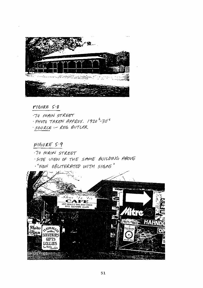
F't6UI'.E (-g
·7o flllfitrJ s-rR.~er ·PHoTo lfiK£N f!Pff2o;(. 192-fJ ~-30'~ · .?oo t<.u ,_ f!..c6 euru:rz
Pf6UtlE >·Cf ·?o M!f!rV SIR.e:GT · 51Pli vrew OF mE 9'ifr1E t3Ut&PtN6 fffJOvG
·''No()} 0/3t_,!1"firZ..fi-T6!? IJI/ITH 5/qf'/5"
51
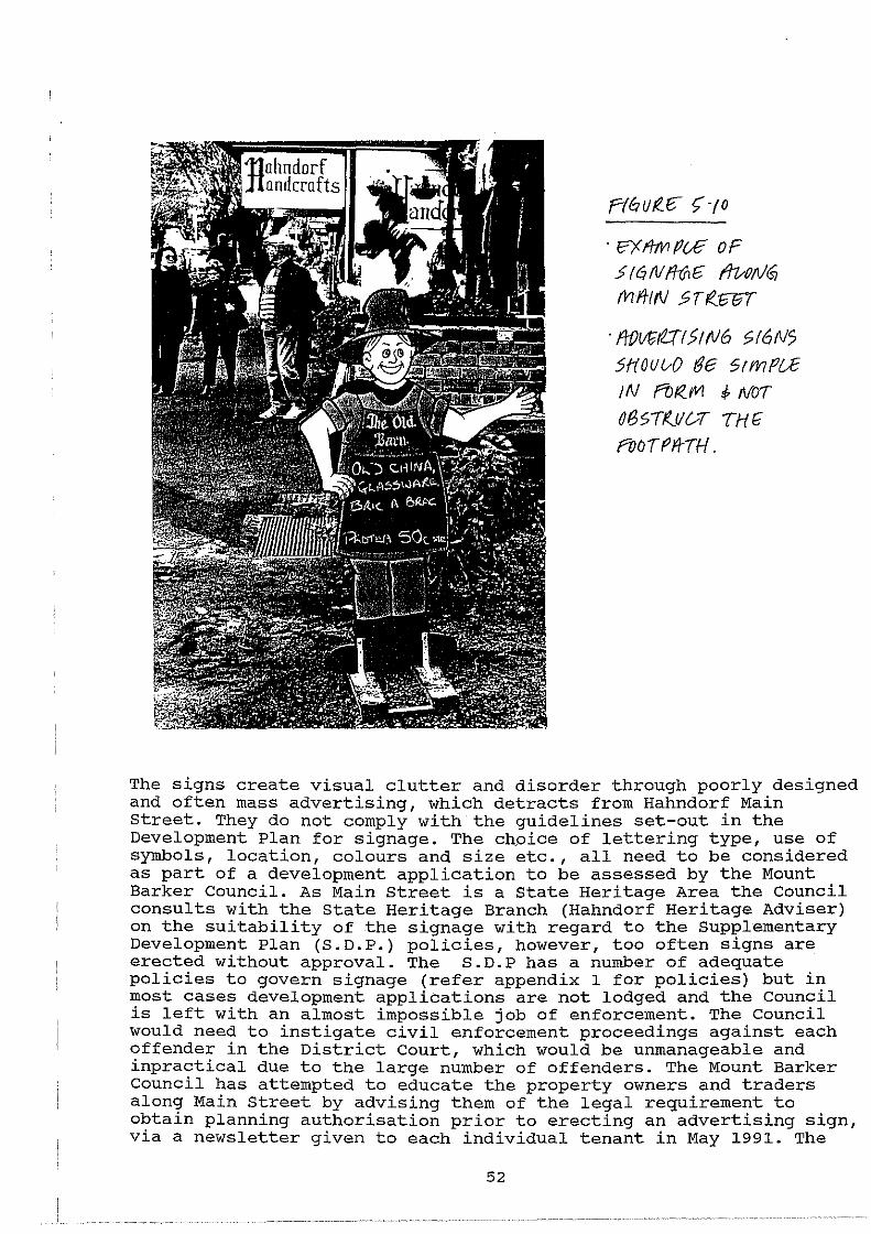
· !?X I/7VI Pc£ oF .5/ q N f/VI6 ihAJtt/GJ Mfi-IN ~Tri?J3FT
· ft0l!tit2:Tf5!N6 >16N5 5f(OUV0 rJe 5rmPU IN f'b I<. I'll i- NO!
Of35TIZ.U~I THf
rooUftrH.
The signs create visual clutter and disorder through poorly designed and often mass advertising, which detracts from Hahndorf Main Street. They do not comply with the guidelines set-out in the Development Plan for signage. The chpice of lettering type, use of symbols, location, colours and size etc., all need to be considered as part of a development application to be assessed by the Mount Barker Council. As Main Street is a State Heritage Area the Council consults with the State Heritage Branch {Hahndorf Heritage Adviser) on the suitability of the signage with regard to the Supplementary Development Plan (S.D.P.) policies, however, too often signs are erected without approval. The S.D.P has a number of adequate policies to govern signage (refer appendix 1 for policies) but in most cases development applications are not lodged and the Council is left with an almost impossible job of enforcement. The Council would need to instigate civil enforcement proceedings against each offender in the District Court, which would be unmanageable and inpractical due to the large number of offenders. The Mount Barker Council has attempted to educate the property owners and traders along Main Street by advising them of the legal requirement to obtain planning authorisation prior to erecting an advertising sign, via a newsletter given to each individual tenant in May 1991. The
52

article printed in the Mount Barker Courier Newspaper (figure 5.11) also highlights the attempts by the Council to remedy the signage problem along Main Street. It is apparent that the situation will not improve unless there is a concerted effort by the traders to comply with the provisions of the Planning Act and apply to council for signage in accordance with the design guidelines in the Supplementary Development Plan. There also needs to be an immediate amendment to the Planning Act to enable Councils to issue fines on a daily basis for breaches of the Act to enable prompt and efficient enforcement of the provisions under the Act.
Council crackdown on illegal Hahndorf signs Halmdorf traders beware - Mt Barker
councll is cracking down on lllegal signs covering bulldlngs or lltterlng sidewalks.
At a recent meeting councillors voted to confiscate sandwich boards and send legal noUc:es to known otrendern.
"D.Iegn.l slgnage htu! been a problem In Hnhndorf for many yearn but It's been on the Increase In the past 12 months," Mt Barker Planner Bob Chambers said.
''There Is this trend occurlng where people put the sign up first and get approval later."
A general letter explafnl.ng planning procedures for signs will be sent to all traders tn the town followed by a warning notice targeted at specific oflenders.
If the notices are Ignored a council otflc1a.J. will pay a personal vl:Jlt to the business. OnlY sandwich board signs will be conllscated when thla procedure falls.
Mr Chambers said tradera should be aware that since Hahndort: was declared a heritage site aU signs, regardless of shape, size or location, required planning approval from council.
"Councll 1a not saying lor one minute that slgnage does not have a place, but you have to be looking at the Importance of Hahndort'a heritage role as a major tourist desUno.tlon."
Sandwich boardll on footpaths were alooasatety risk because they blocked pedestrian trutUc.
Footpath!! are a council rellponslblllty and the councll Ia Jlable for any accident.
Mr Chambera Mid the eouncll had not received any complaints about injuries austalned from sandwich boards, but he d.ld know of compllllnta about 'lmpedJng traffic' and the 'Inappropriate ness" of such signs.
President of the Hahndorf Chamber of Commerce and'lburiBm, PeterHlne, said tmdem were not given a clear direction on slgnage by the councll.
He said there was 'a lot of uncertainty' and a lack of any real guidellnea on plannlng procedures and appropriate appUeaUons.
He disagreed with heritage guidelines which suggested all signa should conform to a stmllar, unobtrusive pattern.
"lndlvtdual bualneB!les have their own way of promoting their bualne88e8," :Mr H1ne said.
''A certatn amount of Iat1tude should be provided so we don't look oo much the Mme that It becomes uninteresting."
P(Gr!((£ r;·tf
· fHTEMPI f/1 /?PrJc.fli!N6 !H £: 00 tVtiYl u N tTY !VBIVS Pflfft.... r'f?Z.TtCfA~ PIZO /Vl ""rHf?" (VIOUN/
g~ wz UJ (j fi(_f 6t._ 1
Z.t.f·!.f·1t
Advertising is an integral part of trading along Main Street and there is a need to provide clear signage for the large number of shoppers and tourists. Cohesive policy and greater unity of signage is a must to create a better visual environment and to the remove the cluttering and "kit:sch" appearance from Main Street.
There are other examples of illegal development (unsympathetic painting of heritage listed buildings, building additions etc.) along Main Street. Is it a matter of ignorance on behalf of the developer or are they taking advantage of the cumbersome planning legislation which governs development in the State? The conclusions drawn from interviews with persons in the study area indicate that most of the owners/tenants are well aware of the process and need to obtain planning approval and the purpose of the State Heritage Area declaration, but will chose to "flaunt" the system as they perceive Council to be powerless. Perhaps it is time for the planning authorities to take a strong stance through education and also instigation of legal action against offenders? This will have the effect of ensuring that the community are aware of the purpose of the heritage and planning role within the State Heritage Area along Main Street and the powers to enforce and manage it.
53
The issue of enforcement will be discussed further in Section 6.
5. 5 Summary
The case study examples illustrate issues facing the Mount Barker District Council, the S.A. Planning commission, the Trustee of state Heritage (State Heritage Branch) and the general community of Hahndorf. The major issues arising from the case study discussion include:-
Thiele Cottage - 102 Main street - inconsistency of advice from the State Heritage Branch in relation to the two applications - inability of the Planning Appeal Tribunal to judge on points of law - concern regarding the construction of "replica" buildings which is at variance to State Heritage philosophy - lack of adequate Development Plan controls to clearly assess "infill" development proposals - time-delays associated with the decision-making process and the frustration involved to applicants due to the uncertainty of the assessment
German Arms Hotel - 67-69 Main Street - lack of suitable Development Plan policies to assess proposals involving internal refurbishment of buildings registered on the state Heritage list - conflict between decision-making authorities which does not promote confidence to the public in achieving rational development control - time-delays associated with major proposals due to varying interpretations of the development plan policies by different parties - need for Urban Design Guidelines to guide and promote clear, concise examples of suitable development
Shop development Cinfilll 40-42 Main Street - Development Plan does not specifically cater for the assessment of "infill" development proposals. The controls do not limit the development of shops which prevents the retention of the traditional mix of uses - the variety of open spaces along Main Street adds to the overall character and the "saw-edge" setback pattern adds variety to the streetscape - lack of design criteria to outline the appropriate choice of building materials, window proportions, style etc. - lack of incentives to encourage retention of private garden areas
Enforcement and management - lack of legal backing from the Planning Act and Regulations - the enormity of the problem along Main Street to enforce and prevent illegal development - resources, costs and time-delays involved in taking legal action
54
The Development Plan policies which govern the Main Street area and the philosophies of the role players are sound. The mechanics used to manage development must be assessed to ensure that the system is consistent, clear, unambiguous and rational. The planning profession and the State Heritage legislation are recent innovations, however, it is a very critical period for Main Street as it is experiencing a rapid transformation and growth. The next 5 years are crucial to the future of Main Street with the need for greater clarity and direction.
The 1990 Supplementary Development Plan has attempted to guide new development proposals. Ideally the declaration of the State Heritage Area in 1988 or the S.D.P. should have been accompanied by comprehensive urban design guidelines - the funding and resources have not been made available from the state Government for its preparation to date. The 1990 s.D.P. incorporates a number of objectives and principles of development control to provide the basis for managing development. Expert advice from the architects of the State Heritage Branch or the Hahndorf Heritage Adviser strengthens the present development control system. However, the case studies clearly highlight teething problems with regard to the planning system in general, ranging from the S.D.P. policies to the provisions of the Planning Act and the Planning Regulations.
Research is presently being undertaken by the Hahndorf Heritage Adviser, Mr. Bruce Harry, to assess the aspects of Hahndorf's heritage worth preserving and to recommend a conservation policy to be incorporated into the present Development Plan policies for Main Street and Victoria Street. The results will not be published until late 1991 and should culminate with the Mount Barker council seeking funds from the State Government to research and prepare Urban Design Guidelines for Main Street. It is now time to take positive steps to ensure that the development control procedures and the legalistic framework for managing change are modified to provide a better "system" for planning authorities to implement and for developers to understand. The final section of this study will outline several issues that need to be addressed with specific recommendations for implementation.
55
6.0 DISCUSSION AND RECOMMENDATIONS
The recommendations and issues discussed in this section have been drawn from the four case study examples and also from the field research. During the course or the study it became increasingly apparent that the evolution of planning and heritage legislation has only recently caught-up with the concept of heritage. At the same time, Hahndorf is experiencing a marked transformation with the demand for tourist and commercial activities along Main street. It is therefore essential that adequate controls are in place to ensure that the character and integrity are not further diminished, and to "manage change". The discussion of the following issues will assist in facilitating a more manageable and responsive system:-
* planning policy * urban design guidelines * enforcement * resources * education and inc.entives * traffic, parking and street verges
Many of the recommendations outlined can not be achieved overnight and can only be expected to be implemented over a number of years and are dependent on funding from the Government and the Council. Grants can be sought from the Commonwealth Government National Estate programme for areas and cultural places of heritage significance. The grants are administered by the Australian Heritage Commission and are limited to local government and co~unity bodies. owners of State Heritage items may apply for State Heritage funds for assistance to conserve a heritage item.
Implementation of the following recommendations will result in an improved system to guide and promote orderly and sympathetic development along Main street.
6.1 Planning Policy
Section 2 and 3 of the study gives a detailed background into the planning and heritage legislation which has governed Main street to date. The Mount Barker Council with its 1990 supplementary Development Plan upgraded the previous Development Plan policies brought into affect during the 1970's and 1980's, however the case study examples have highlighted a number of problems such as:
* the need for more concise Development Plan policies for (1) infill development, (2) alterations and additions to State Heritage listed buildings (internally and externally), (3) setbacks (to promote "variety" and to ensure that the "saw-edge" development pattern is retained) and (4) character (signage, building materials, form, shape etc.)
* need for urban design guidelines to back-up the Supplementary Development Plan with key visual diagrams.
56
The issues outlined for the German Arms proposal, the infill shop proposal, the office development and the enforcement dilema, highlight the need for more concise policies to ensure that property developers have a clear understanding at the planning stage. At present the general public do not clearly understand the purpose of the Development Plan policies and for this reason they are interpreted in different ways. In addition, the State Heritage Branch officers, the Council and its staff have also been criticised by the Hahndorf community and property developers for their varying interpretations of the planning policies.
The field survey in Section 4 demonstrates that over 70 percent of the properties along Main street are used for "commercial" purposes. It has reached the stage where further commercial uses will seriously compromise the integrity of Main street. The establishment of additional shops needs to be controlled to provide a mix of uses. Main Street has historically had a mix of uses and if the trend towards "total retail" continues, the remaining integrity and character will be destroyed.
The heritage character of Main Street derives from its setting, the environment and the nature of the buildings. The architectural styles, siting of buildings, allotment sizes, landscaping etc. all contribute to the character of the area. The existing Development Plan provides a number of broad based objectives and principles of development control with regard to Main street's character and Silesian origins, however, the policies should be refined to broaden the policy base and reflect and reinforce the major components of Main Street's character.
Recommendation
* That the present objectives and principles of development control for the Historic Township (l) and (2) Zones be refined to overcome the present shortcoming. In particular the following points should be considered:-
- revised list of "prohibited development" with clear definitions of what each use legally means. For example, there are a number of incompatible developments that are not listed which would invariably be assessed as a "consent" application. To reinforce the definition of each use the Supplementary Development Plan should include a "glossary of terms" to cover those definitions not adequately defined in the Planning Regulations under the Planning Act, 1982. The demolition of State Heritage listed buildings and land division creating additional allotments should be included on the list of prohibitions. (Note:demolition is prohibited by State Heritage legislation, but should be reinforced by adding controls to the Development Plan).
57
- prepare detailed historic character statements for the two principal heritage zones, outlining the features which contribute to Main street's character, such as the street-trees, the German and 19th century Victorian buildings, their intimate scale, the development pattern and the overall sense of enclosure and atmosphere which the above items contribute to.
- that further "infill" commercial development be prohibited on allotments that have a positive impact on the streetscape. Commercial development only be allowed on certain "ear-marked" allotments within a prescribed building envelope. This will help to maintain a mix of uses.
- planning policies be expanded to include details of the type of (1) building materials, (2) landscaping, (3) fencing, (4) architectural styles and (5) building form, that are encouraged. A statement of the philosophies used to guide development along Main Street should also be prepared. For example, "new infill development to be simple and contemporary in style, sympathetic to the siting, scale and form of the older buildings, with the visual focus being aimed at the older buildings and not the new." Suitable planning policy statements should also be prepared for additions and alterations to state Heritage listed buildings. These statements to include specific guidelines for the renovation and refurbishment of the interior of State Heritage listed buildings. (Note:- policies for internal renovation and refurbishment is a very complex area and would reqUire the preparation of a very large planning document.)
- review advertising sign policies with particular attention to sandwich board signs, size, and location. The feasibility of introducing leases for traders wishing to display signs on the footpath be investigated, providing it is limited to 1 sign only with restrictions being applied in accordance with the.Development Plan guidelines. A fee a $50 per year should be charged for the lease of a footpath area of approximately 1 square metre with the owner of the sign indemnifying Council against any public liability claim.
6.2 Urban Design Guidelines
The use of Urban Design Guidelines have been successful in a number of Council areas throughout Australia. The study does not include the drafting of Urban Design Guidelines for Main street but outlines how they have been used elsewhere in Australia, such as Mintaro, City of Adelaide and Malden. Urban Design Guidelines as a planning tool are uncommon in Australia but are able to link the desired future character statements and policy to illustrations of design principle.
A number of visual examples will be illustrated outlining how Urban Design Guidelines should be prepared for Main Street, Hahndorf.
58
Planning and development control systems are very complex with issues such as heritage, conservation, land management, subdivision design, provision of services, policy formulation, urban design and a multitute of others. Planners and other professional involved in the decision-making process require various "tools" to implement their objectives, such as the Development Plan or "rule book" and Regulations as "tools of the trade". Planning that is too draconian and prescriptive should not be encouraged as it could create an urban environment that lacks variety. However, the role of Urban Design Guidelines is not to "force-feed" a standard form of development, but to reinforce and clarify the meaning of the planning principles.
It is stated in an article by Francis Tibbalds (Australian Planner Journal, 1990) that statutory plans in the United Kingdom now always include sections about "Townscape and Landscape" or "The Built Environment" or "Architecture" and "Conservation". Tibbalds considers that statutory plans have "bland, generalised policies which are fairly weak as urban design controls or codes ... " It is acknowledged throughout the planning profession that good urban design must be legislated - the use of Urban Design Guidelines for Main Street is a positive way of promoting good urban design.
The use of Urban Design Guidelines will also help to reduce the "gap" between planners and architects who are often at loggerheads when discussing the appropriate design for a development. Clear Urban Design Guidelines to back-up the planning policies for Main Street should help to close the gap and promote better communication. Guidelines will reduce the ambiguity of the Development Plan and encourage planners, architects, elected members, property owners and developers to work towards a common goal. Some architects have the attitude that the Development Plan denies their right to design as they perceive best, however, in sensitive areas like Hahndorf it is imperative to have a clear, concise development control document in place to ensure that development does not compromise integrity and character.
6.2.1 Conservation Guidelines - Mintaro township
Mintaro is located approximatey 150 kilometres north east of Adelaide in the Clare District Council area. The township is well known as an early colonial rural town, its copper and slate mining, the "layout" and historic buildings. The town is characterised by large properties with scattered stone and slate 19th century buildings within an agricultural area of undeveloped land and trees.
The Mintaro Development Plan policies were updated in 1990 and incorporated Conservation Guidelines to strengthen them. The planning policies were based on investigations undertaken in 1984/85 as part of the 1987 Supplementary Development Plan, but were becoming too broad in their application and did not have the necessary detail to ensure the characteristics of Mintaro were retained. (Explanatory Statement, 1990 Supplementary Development Plan by the Minister). The policies and guidelines were designed to preserve the township and landscape qualities (such as the 19th century buildings, subdivision layout etc.) and to control tourism development within the town. The planning policies are linked to the
59
Conservation Guidelines and outline "actions" and "approaches" for items such as (1) wall materials, (2) roof gutters, (3) windows and doors,(4) verandahs, (5) outbuildings, (6) scale of buildings, (7) colour schemes and (8) signs and fences.
There are few similarities when comparing the characteristics of Hahndorf and Mintaro as the origins of the people, the landscape, building materials, development pattern and building design are all different. However, the planning processes for the two towns are administered under the same Act (Planning Act, 1982), and Mintaro is also a State Heritage Area. The format for the sketch diagrams in the following recommendations has been based on the Mintaro Supplementary Development Plan. Mintaro, in comparison to Hahndorf, has been relatively unaffected by commercialism and tourism. Even so, the Heritage Branch and the Clare Council were aware of the increasing tourist potential of the area with the attraction of the Clare Valley, Martindale Hall and Mintaro, and implemented amendments to the Development Plan policies and brought into affect Conservation Guidelines, prior to the loss of character and charm of the original Australian colonial town.
6.2.2 Urban Design Guidelines - city of Adelaide
The Corporation of the City of Adelaide produced a document titled, "The Urban Design Guidelines" as part of the 1986-1991 City of Adelaide Plan. The "guidelines" were prepared to accompany and illustrate the "General Principles and Statements of Desired Future Character". The "guidelines" include design principles dealing with alignment, amenity and heritage as well as illustrating specific case study development examples for certain sites.
The local case studies outline policies and include a list of desired uses with 3-dimensional illustrations of "suitable" development for each specific site. The use of case study examples are useful for important sites but there is a danger of creating "guidelines" that are too descriptive and promote a repetitive form of development. For example, within the "Festival Theatre Precinct" a case study for the Exhibition Centre on North Terrace is provided, with sketched options for the siting and construction of an exhibition centre. The policies for the precinct promote a building that complements the adjacent heritage buildings, such as the Constitutional Museum, the Railway Station and Parliament House. However, the drawings of the exhibition centre depicts the use of extensive glass facades and a modern building form which "clashes" with the older buildings. I doubt whether the City of Adelaide would encourage this type of construction (the building was constructed in 1988/1989, "in conflict" to. the design guidelines, but was approved by the Premiers Department under the Aser Act and not the City of Adelaide Development Control Act), and it raises an important issue of ensuring that case studies are drawn accurately at the drafting stage to prevent contradiction. Case studies should also be simplistic so as not to preclude better options.
60
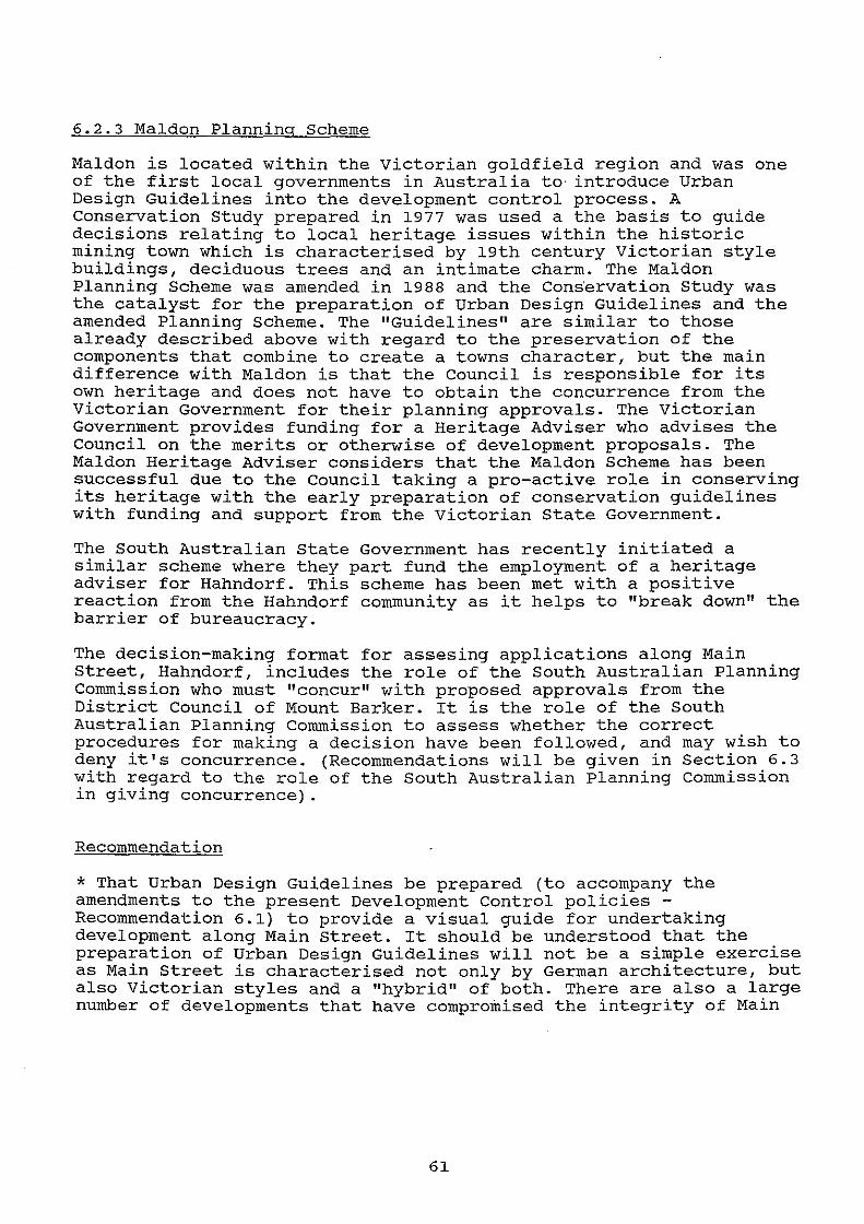
6.2.3 Maldon Planning Scheme
Maldon is located within the Victorian goldfield region and was one of the first local governments in Australia to· introduce Urban Design Guidelines into the development control process. A Conservation Study prepared in 1977 was used a the basis to guide decisions relating to local heritage issues within the historic mining town which is characterised by 19th century Victorian style buildings, deciduous trees and an intimate charm. The Maldon Planning Scheme was amended in 1988 and the Cons·ervation study was the catalyst for the preparation of Urban Design Guidelines and the amended Planning Scheme. The "Guidelines" are similar to those already described above with regard to the preservation of the components that combine to create a towns character, but the main difference with Maldon is that the Council is responsible for its own heritage and does not have to obtain the concurrence from the Victorian Government for their planning approvals. The Victorian Government provides funding for a Heritage Adviser who advises the Council on the merits or otherwise of development proposals. The Maldon Heritage Adviser considers that the Maldon Scheme has been successful due to the Council taking a pro-active role in conserving its heritage with the early preparation of conservation guidelines with funding and support from the Victorian State Government.
The south Australian state Government has recently initiated a similar scheme where they part fund the employment of a heritage adviser for Hahndorf. This scheme has been met with a positive reaction from the Hahndorf community as it helps to "break down" the barrier of bureaucracy.
The decision-making format for assesing applications along Main Street, Hahndorf, includes the role of the South Australian Planning Commission who must "concur" with proposed approvals from the District Council of Mount Barker. It is the role of the South Australian Planning Commission to assess whether the correct procedures for making a decision have been followed, and may wish to deny it's concurrence. (Recommendations will be given in Section 6.3 with regard to the role of the South Australian Planning Commission in giving concurrence) .
Recommendation
* That Urban Design Guidelines be prepared (to accompany the amendments to the present Development Control policies -Recommendation 6.1) to provide a visual guide for undertaking development along Main street. It should be understood that the preparation of Urban Design Guidelines will not be a simple exercise as Main Street is characterised not only by German architecture, but also Victorian styles and a "hybrid" of both. There are also a large number of developments that have compromised the integrity of Main
61
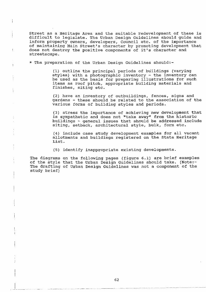
Street as a Heritage Area and the suitable redevelopment of these is difficult to legislate. The Urban Design Guidelines should guide and inform property owners, developers, council etc. of the importance of maintaining Main Street's character by promoting development that does not destroy the positive components of it's character and streetscape.
* The preparation of the Urban Design Guidelines should:-
(l) outline the principal periods of buildings (varying styles) with a photographic inventory - the inventory can be used as the basis for preparing illustrations for such items as roof pitch, appropriate building materials and finishes, siting etc.
(2) have an inventory of outbuildings, fences, signs and gardens - these should be related to the association of the various forms of building styles and periods.
(3) stress the importance of achieving new development that is sympathetic and does not "take away" from the historic buildings - general issues that should be addressed include siting, setback, architectural style, bulk, form etc.
(4) include case study development examples for all vacant allotments and buildings registered on the State Heritage List.
(5) identify inappropriate existing developments.
The diagrams on the following pages (figure 6.1) are brief examples of the style that the Urban Design Guidelines should take. (Note:The drafting of Urban Design Guidelines was not a component of the study brief)
62
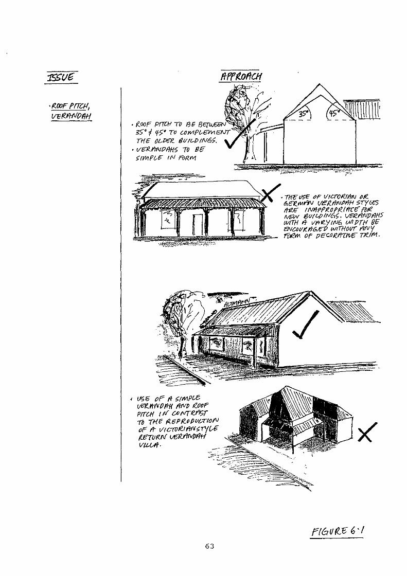
• (Zoor PITCI-1 TO 13~ Re!?.<£"GN·~
g§• f 'f>' TO U/J1,1Pl-EMIB\!T
THE O&Pff f!l/!l--P!N6>. • VE'R.I1Nl?f/HS TO Bf?"
>rmPtA> IN f'iJRIV/
' !IS 6 oP f1 >rMPl£ Ver!..MV () f11{ 11/VfJ teooP PilCH I tV c-;NTI(.J%T Til -a-a: r<. f:J P ~o P vcrro,v or fr vrcTTJ~tfiNH'(U tff{I/RN t£{(firvPt/H V/1-U'f-
63
Ffbl/f()~ 6 ·I
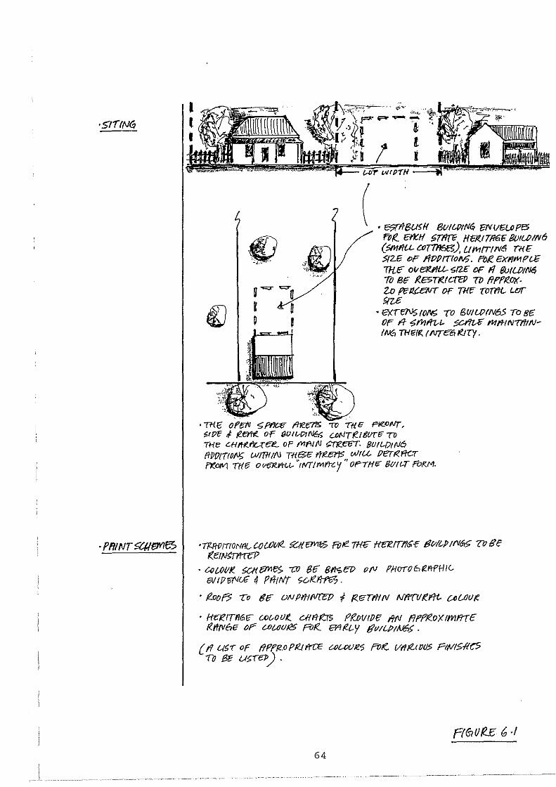
l l
•
u """"" -r 0 I
( • -SU<U BW'-P<"'i ON""-'f'6 FOR.. 1:/i:.H ~TflfE Ht;Jf.l71161i B/JIGP!tv6 (fimf/U. CJJTrn6B), UMrrtN6 TH1i S/Z/3 of' 11PPrrtoll6. fVR. £Xf!I'1PlE Trlf: ol/eJei'IU. Sf2£ DF f1 fMWI~ 7li Blf /?.ESTtefC("EJ/ Tf) f!PfR.OX· Z.0 Fe lt£eNT OF Tf{f: T017'ti- u:tr SIZ£
• er:rr::N5 (ON; TO BWWfN65 To 81: Of' fl .,;mf/1--1- ~ 1'11/'NN77'f!NIN6 TH!<Ifi. tNTc6/I?Jry.
' Ttl f: 0 f{;IV '5: f'f'lt:e ~ Tl{ (; Ffi!.OrJT, f,t/?tf ,f teertt!. Or (JOit.-1?/NGt; UJNTR.Itlff(f TO THe Cfl/t(r'/{_.(ef!._ OP (VIftl/1! ~EfiT. 801/-0!f\/6 fi-PIJ!TIO!J> WfR/If'J Tfl$/3" l'tteEr!S WIU l?eT~fi(..T /XOIVI Tl(lfi OC!tJI'1.vt~t.- "tfo/TIMYT<-y "OPTHt; 8(111.-T fVI<M.
·-rntotrtoNfl{.. cowl/£. ~em$ RJ/1!. m:e H'CP.ITI!~£-r: tJC//t.p trv&.;; V7 BE t:Et!J~
• CQ 1.01/te 5Ct1 /'7YII':S 7JI 8£: 811S E1J oN PHOTO 6 tel'lf'H I Clil/ I P ff'Jc£ tf fli-t Nf <;c.lt./tfti7 ·
'/Zaof5 To 8£: ONPifl(ll'({;[l f r<eTf/1/V Nfm!KI"ft. UUJ()K
• 1-ft;l?tTIIif>f: c.oc..o(}/!.. C>Hfl-fi!:E Pf.DvtPff 1/fJ f/Pff..ox 1mfi'TE t<.l'ltv6!i or C.0/..(J(}/i5 pot<_ &'lt<t..y tJv!(..PfAJ6>.
{ f1 u5-r of tlPf/2.0 Pt<.t l'rCf3 UJ(..Of)!e5 fVI( 1/1//!..1 Ill/? Fltllf5fle5 To Be U>lel>) .
64
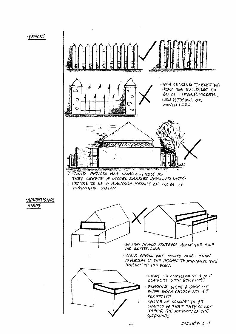
/ • waN ffi\IC.t N E1 To EXI~Tf Nli'> tl~ITI'!<nt t'S\J I t,.p ( 101£ \o Be- of' T1Ml3ae. PIGICCT5, UiW H ED6 lNG, 0 te. WOI/6N "-!IR.10.
I() ffli(l> V'Nf'I'Cl...I';PT"fli3U t1S -m.ey C-/UmTIF t'l Vf~l/fft.- 8/'TteR!CK. ~EPIJC.ttVI$ VI~· f'el1Ja'5 To BIF ft I'YII"/fffi1VM H676HT oF f-2 M y-o fYitrtNTfll N 1/1~1 oN.
•IJO >16N ~HOI/W PFZoTR,V()f" f/BOI£ Wf" f(OOF 0 te. <1> VTTeiZ LAN£
• S(f!!NS Sf{OIJ[A) (lfor OCLAIP'( mOte.£ THI'/N (0 PU!.c.EM' OF THE FriC:I"J(J£ 7iJ fV/IfVIMIU TH€ ltv/ I' ffc:T oP Tf/13 $f6N.
• .(,f6f<!S To C.OfVIP/...13/'V/V'ff $ fiAJT c.-crnpere- wt7H BuJt.-OtN6?>
• RA'r~Hif116 $161"1) f BY'tCK. UT NeoN 516N~ SHOUt-{) /{/V/ 6£ f'£/(,rV!tTre]J
• CHOICC oF C.OUH/te£ TO 8fi Wt!JI"TW >o {ffft T /HE'/ (}O fl}()l lfi1Pfilf<. /HE I/MtN!7'f oF T.f!E >or<.MUNP5.
6.3 Resources
There are three principal agents in the decision-making process for development applications, being:-
* The District Council of Mount Barker (the elected members guided by their professional planning staff)
* The Minister for Environment and Planning (as Trustee of State Heritage by the State Heritage Branch andjor Heritage Adviser).
* The South Australian Planning Commission
(refer figure 3.2 for procedures for assessing development applications under Section 48 of the Planning Act, l982.)
6.3.l. Role of the elected members and planning staff
The Mount Barker Council under the Planning Act must make decisions that are not "at variance" to the objectives and principles of development control for all development applications. Such decisions are being made at a political level as the Hahndorf community is "close knit" and actively lobby the elected members. Planners see themselves as being technical experts, planning within a set framework, and stand away from political conflict basing their decisions on rational assessment having regard to the Development Plan policies and planning practice. Planning in its "purest" sense is not political, however, it operates within a political environment with many decisions being made by elected members who may be influenced by political motives.
Planners have a special role to play in heritage and conservation issues and it is a role that comes from their broad knowledge of urban systems and policy, their position within local government and their co-ordination abilities. Planners also have the role of policy formulation in the form of writing Supplementary Development Plans. The recommendations outlined in Section 6.l should be prepared by the planning staff of the District Council of Mount Barker in conjunction with the State Heritage Branch and the Hahndorf Heritage Adviser. Kaufman (l980), describes the above roles of a planner as being "substantive specialists" and "strategic planners". It is vitally important that the Council staff are continually educated with regard to heritage and conservation issues to ensure that the management of Main Street can be achieved at the local government level.
Within the set framework for making decisions planners must adapt to political pressure and try and resolve issues in line with Development Plan policy. Developers will challenge the validity of the Development Plan and try and obtain approval for applications that are in conflict with the Development Plan. John Forester in an article titled, "Planning in the Face of Conflict", l987, suggests that planners must play the role of "negotiator" and "mediator" to resolve land use conflicts. These roles sound contradictory, but a planner will have clear views of what is appropriate development and can "frame" hisjher approach to resolve the conflict. A mediating
66
role is required when there is conflict between two parties, for example, a property developer and the Hahndorf Heritage Adviser, where the planner should try and "defuse" the situation without compromising the position of the Heritage Adviser or the Council. Negotiation is required where the applicant may have a strong case for obtaining planning approval for a proposed inappropiate development and by negotiating or offering 11 trade-offs" the proposal can often be amended and improved. For example, the Development Plan does not specifically prevent the construction of shops infront of existing dwellings, where these open spaces provide attractive garden areas and a variety of setbacks, and negotiating with a developer could preserve these areas prior to obtaining the legal support of up-graded planning policies. Negotiating may be useful in some cases, but in a State Heritage Area and with dealing with a State Heritage item, compromise is not always possible.
Councillors are faced with a multitude of tasks and issues on local government. It is no longer a matter of budgetting for "roads, rates and rubbish", the issue of planning and heritage is high on every District Council of Mount Barker agenda. The role of councillor can be made easier through education from (1) their staff, (2) seminars and (3) planning and heritage journals and newsletters.
Councillors are often criticised for spending little time on applications and issues of controversy, where Knox (1982), quotes an experienced United Kingdom planner:-
" ..... you get a councillor saying something .... and everyone looks around and grins. They will spend half an hour discussing the extension to the back of a house and then an application worth a million pounds goes straight through!"
A good relationship between councillors and planners is vital, as councillors rely on the planner for consistent recommendations in a field that is becoming increasingly complex and sophisticated. The planner is quoted by Knox (1982) as being "on tap" for advice, but not always "on top".
The relationship between planners and elected members could be strengthened with less ambiguous planning policy and the preparation of Urban Design Guidelines. This would help to promote a common goal and reduce the confusion and complexity of lengthy planning reports, plans and submissions for development. The future of Main Street is not only contingent on legislation but also the committment of the decision-makers, and their willingness to take advice.
6.3.2 Heritage advice I south Australian Planning Commission
Pursuant to Section 48 of the Planning Act the Council must refer a development application to the Minister for Environment and Planning (State Heritage Branch or Heritage Adviser - within State Heritage Area or items listed on state Heritage list) for comment and must "have regard" to the Minister's advice. The Council must also seek the concurrence of the south Australian Planning commission prior to
67

I '.
granting consent to a development application. Since the declaration of the State Heritage Area in 1988 there have been 4 different heritage architects giving the Council advice on behalf of the Minister. The criteria they use for giving consultation advice revolves around their interpretation of the Development Plan policies, professional knowledge of heritage issues and with regard to the historic character of Main street. The Heritage Branch has also adopted the Australian ICOMOS Charter for the Conservation of Places of Cultural Significance (The Burra Charter) as the standard for conservation practice in respect of State Heritage items. However, the Heritage Branch have been criticised by sections of the local community as the philosophy of each adviser has appeared to differ with regard to promotion of building materials, landscaping etc. The ideologies of the advisers are sound, but with frequent staff changes and the scope for varying interpretions of the Development Plan, has created scepticism and mistrust within the community. The Development Plan should not promote one common solution, but should have a set framework with guidelines for each adviser to work within.
Hahndorf Heritage Sir - Without tho o.ppllcn.Uon or tunds b;Y the Heritage Department to support Its alms, thla Department can only be effective with either the active co-operation of Ute buslneMM and re:sldent!l of Hnhndorl or by wielding Its legi:Jlatlve sUck.
Fbr this co.cperatlon Jtneeds to provide credible decisions compatible with a historic town of essentially Prusslan (not Bavarian) origin and with the present atmosphere of Hnhndort.
The Heritage Department has apparently been unable to provide written guldellnelJ as to Its atms or objectives ln Hahndorl. The only consistent theme seems to be inconsistency.
D1l!erent Department advisors, perhapa lacking in-depth knowledge of the town, have gtven different, often conOictlng, advice which has ramlflcatlon3ln whether development plans are approved or refused. This hns been a flno.nclal lmposltlon on property owners.
Without guidelines, plan!! may have to be redrawn several Urnes, etten for minor a.ltemtton.s.
Heritage Departments aim would seem, ln many situations, to favor new buUdlnga or additions that do not conform to the traditional Hahndorf style.
Most resident!:! and businesses In the main street would prefer sympathetic changes complemenUng the older buildings.
It thls apparent aim Is In fact coiTect, the South Australian Heritage Department would appear to have objectives conntcting with the alms or 11lmUar bodles In moot other countries of the world.
We were optimistic when part ofHahndorf wa:s declared a Heritage 'Ibwn.
Sadly, over the last couple of year11, there has been the •street lights fiasco' {now resolved) and approvals for rows of shops (completely out of context with the town).
Some owners have been prevented from making very minor changes, while In other cases the gutting of the Internal structure of historic buildings has been approved,
The Heritage Department has lost Its credibility.
H.GALLASCH Hahndort
. Ltff(6(. {O 1H.E (3i{) t/0 r<.
· fVI 0 If AlT & f/12./:_~ COURt t£ {lt15WS P!TP.e. 17·11·1 0
Development applications within a State Heritage Area or items registered on the state Heritage List are "vetted" by the South Australian Planning Commission who must concur with the decision of the Mount Barker Council. The need to obtain "concurrence" creates time-delays in the decision-making process as the Planning Commission take approximately 2-4 weeks to "rubber stamp" planning proposals. The time-frame for assessing applications within the State Heritage Area averages approximately 6-8 weeks, while similar proposals within the Mount Barker township (no concurrence required) averages around 3 weeks. (Source: District Council of Mount Barker records). To reduce the time-delays it would be appropriate to remove the role of the Planning Commission, providing the Council decision is in accordance with the recommendation of the Hahndorf Heritage Adviser (on behalf of the Minister for Environment and Planning) and Planning Officer.
68
The Mount Barker Council has also been criticised by sections of the community for failing to heed the advice of the State Heritage Branch, as the Council are only required to "have regard" to their advice. In this instance the role of the S.A. Planning Commission is important, to ensure that the Council make rational decisions based on planning policy and not for political motives.
With the employment of the Heritage Adviser for Hahndorf the inter-relationship between the council and the State Heritage Branch has improved, as the Heritage Adviser is working' in close relationship with the council staff and elected members and many of the "barriers" are being broken. The outcome of the decisions for the case studies in section 5, would be quite different in my opinion, if assessed by the Council at present. The philosophies and ideologies of the Heritage Adviser seem to have the support of the Council.
Recommendation
* That elected members be included with staff in training sessions to enable greater appreciation of planning and heritage issues.
* That the role players in the decision-making process liase on a regular basis to discuss heritage and planning issues to ensure that they are working towards a "common goal".
* That the State Government provide funding for the preparation of Urban Design Guidelines and for the continual funding of a Heritage Adviser scheme with the capacity to increase his/her hours.
* That the time-frame for assessing development applications be reduced for applications that are "deemed to comply" by the Heritage Adviser and Planning Officer. Such applications should be determined by the District Council of Mount Barker and not require the concurrence of the South Australian Planning Commission. (amendments to Section 48 of the Planning Act are required to facilitate this).
- Option 1 :- "deemed to comply"
- Option 2 :- Council propose to approve application without the support of Heritage Adviser or Planning Officer.
6.4 Enforcement
- no concurrence required
- concurrence required from the S.A. Planning commission prior to granting consent
As discussed in the previous section, the provisions of the Planning Act (Section 36 and 46) are inadequate to act as a deterrent towards illegal development.
69
With regard to management and enforcement along Main Street it is a matter of whether it is the intent of the Council or south Australian Planning Commission to "punish" the offender' or "remedy" the problem. Planning legislation should not be used to punish in every respect as the aim of the Planning Act, the Regulations and the Development Plan is to promote and facilitate appropriate development - civil enforcement can ensure that these requirements are upheld. It can also act as a deterrent to those who wish to breach the Act, as developers will be aware of the Council powers to take legal action. However, civil enforcement does not deter those who wish to "test" or blatantly breach the Act, and such persons should be prosecuted for their actions as well as being subjected to civil enforcement proceedings to remedy the breach. The provisions of the New South Wales Land and Environment Court provides penalties of upto $20000 (double South Australia). The existing fine structure in south Australia (breach to be proven beyond all reasonable doubt) does not act as a large enough deterrent and the time-delays and litigation are frustrating and very expensive for Councils to initiate. The result of prosecution proceedings can often lead to minimal fines in the vicinity of $100 - $1000 which is more of an embarrassment to property developers than punishment.
The New South Wales civil enforcement procedures offers the right to any person (under Section 123 and 124 of the Act) to instigate proceedings in the District Court for breaches of the planning legislation. This should be encouraged in South Australia as many councils do not have the expertise or resources available to enforce all breaches within their respective areas. This also enables the public to become involved in environmental and built form issues and can reduce their frustrations by not having to rely on the government authorities. A similar situation exists in Victoria through the Administrative Appeals Tribunal. The 2020 Strategy (1991) reinforces these points and also suggests that a better fines system (delegated to local government with no court involvement) be set-up and that defendants should be found to be in contempt of court if they do not comply with a court order.
Recommendation
* That the Planning Act, 1982, and the regulations under the Planning Act be amended to facilitate the following:-
- the penalty for prosecution be increased from a maximum of $10000 to $250000.
- a fines system be introduced to allow local government to issue fines (by serving a notice) with no court involvement - maximum of $100 fine on a daily basis for the continuation of a breach.
- any person be given the right to instigate civil enforcement proceedings or prosecution proceedings under section 36 and 46 of the Planning Act. (Note:- this system has been successful in New South Wales and has not led to a glut of legal hearings) .
70
- offenders to be found in contempt of court for the failure to comply with an order from the Court.
- a Judge to preside at hearings of the Planning Appeal Tribunal for the judgement of controversial appeals to enable "points of law" to be resolved expeditiously within the one court.
6.5 Education
Heritage conservation and planning terminology has a language of its own. An understanding of this terminology and the purpose of the planning system can lead to better communication and the achievement of desired goals.
The property owners were advised of the declaration of the State Heritage Area in 1988 and new property owners are advised of the State Heritage Area via their land agent on "form 18's". The Supplementary Development Plans are also put on exhibition for a two month period and public hearings and forums are conducted by the Mount Barker Council for community members to attend. Most property owners are aware of their property being located in a State Heritage Area but are not entirely sure of its significance and the processes required for obtaining approval to build, erect signs etc.
Many of the problems associated with enforcement would be alleviated with the better education of property owners. Most of the owners do not fully understand the planning system and its purpose. Since the inception of the state Heritage Area the public have become increasingly frustrated with what they perceive to be "over-control". Education is fundamental in promoting a better planning system, and will also reduce the naivity and frustrations of the community.
Recommendation
* That the state Heritage Branch and the District Council of Mount Barker prepare a planning and heritage brochure (to be kept on display at the council office), outlining the purpose of the Planning and Heritage Acts and processes required to obtain approval for development. The information brochure should be distributed to every property owner and Main Street tenant and should have the following format:-
- Historic significance of Hahndorf
- Purpose of the Planning Act, Heritage Act and the Development Plan
- The Development Plan policies and Zones (in summary form only)
71
- Process for obtaining planning authorisation for development applications:-
-what constitutes development? -how to lodge an application? -details, plans, fees and other requirements needed to assess a development application -time-frame for assessment
example of the quality and format of plans that are required for assessment (for example:- scaled site plan and elevations etc.)
- professional advice available from the Hahndorf Heritage Adviser and Council planning staff
- sources of funding, low interest loans and other incentives.
* That the District Council of Mount Barker fund a heritage seminar in Hahndorf to educate the tenants and property owners on the importance of legislative controls and the need for community support in achieving the desired goals. Promote communication between the community, council staff and the Heritage Adviser. (repeat every other year)
* That the District Council of Mount Barker promote other information services available to the public, such as Department of Environment and Planning publications and technical services.
6.6 Incentives
The issue of providing incentives is a topic that is always high on the publics agenda when discussing heritage conservation. This issue will not be discussed at length as it is a controversial topic worthy of further investigation. However, it was a very strong opinion of the Hahndorf traders that owners of State Heritage listed buildings should have some recognition and incentive for their continual maintenance. They can apply for State Heritage funding but many are unaware of the procedures and availability of funds.
Incentives are also useful in providing developers with a "carrot" to achieve a level of development consistent with the objectives and principles of development control for Main street. For example, the Development Plan policies restrict the proportion of land that can be developed for State Heritage listed properties - the incentive of reduced rates and taxes may offer some form of compensation.
Recommendation
* That the State Government continue to offer low interest loans for restoration and conservation work that has obtained a valid planning approval from the Mount Barker council, for buildings registered on the State Heritage list.
72
... ·······------- ---- ---············ ··························· ···················--
* The Mount Barker Council offer rate rebates for properties registered on the State Heritage list.
* The recommendation outlined in Section 6.4 be adopted to reduce time-delays in the decision-making process, which will also offer an incentive for applicants to apply for proposals that "deem to comply".
* That provision be made in the Planning Regulations for Councils to "waive" fees for proposals that comply with the objectives and policies of the State Heritage Area and Development Plan.
6.7 Traffic, parking and road verges
With approximatey 1 million tourists visiting Hahndorf every year it is inevitable that car and bus parking would create congestion and traffic problems along Main street and surrounding residential streets. Permeability, as described by Bentley et al (1986), is related to the ease of access for vehicles in a particular locality. Although this issue is not directly related to the legislative "management of change" along Main Street the resultant congestion has a direct influence on its character and amenity.
With the opening of the South Eastern Freeway in 1974 it was considered that there would be a decrease in traffic flows along Main Street. Hahndorf is now so popular that over 5000 vehicles pass the Pine Avenue intersection on any given day. During peak periods car and bus parking facilities are unable to cater with the demand and vehicles "spill-out" onto adjoining residential areas to the northern end of Main Street, English Street, Auricht Road, Balhannah Road and Hereford Drive. Bus parking creates congestion, loss of vehicle sight distances, damage to the street-trees and constitutes a safety hazard. To resolve these problems the Mount Barker Council has constructed a 7 bus parking area with access from Pine Avenue and Auricht Road and intends to construct a second bus park at the northern entrance to Main street. The supplementary Development Plan promotes a number of policies and proposals with regard to traffic management and these policies should be the basis for the future upgrading of Main Street's traffic problems.
The road verges are an important component of the streetscape. At present with the variety of advertising signs, planter tubs, untidy road verges, a number of dying street-trees and mobile stalls, it is providing an unattractive, cluttered and non-traditional appearance for those entering the town from Mount Barker and Adelaide.
Recommendation
* That the District Council of Mount Barker continue to implement their traffic management strategy for Main street as follows:-
73
- encourage the co-ordination of car and coach parking facilities on suitable land behind Main Street frontages, in conformity with appropriate design guidelines.
- reconstruct Main Street as funds become available, having regard to pedestrian and vehicular traffic flow, car and coach parking requirements and street landscapes.
* That upon completion of the second bus parking area at the northern entrance to Main Street, all bus parking be banned along Main Street and be continually policed.
* That the District Council of Mount Barker establish a tree-replanting scheme to replace the dying and damaged street-trees over a twenty year period.
* The District Council of Mount Barker in association with the Hahndorf Heritage Adviser formulate a clear and manageable policy to govern the placement of signs and other street furniture. To be policed.
* The District Council of Mount Barker prepare a strategy for the attractive maintenance of the road verge and footpath along Main Street, with the removal of all inappropriate advertising signs, mobile stalls, flower tubs and other paraphernalia.
74

7.0 SUMMARY
The results of the study indicate that the planning and heritage legislation and controls of the past have been unable to adequately cope with the development pressures exerted on Main Street. The planning system is only now starting to come to terms with the concept of heritage and conservation.
The study highlights that the integrity and character of Main Street has been significantly damaged, particularly during the period from the 1960's to the present day. During this period the planning and heritage controls have been unable to successfully control the influx of tourist and commercial development. Comprehensive controls were required to prevent the incongruous development along Main street. The Development Plans of the 1970's and 1980's were ambiguous and totally inadequate as planning documents. While the authorities grappled with the concept of heritage and planning guidelines, many inappropriate buildings and land uses.were established along Main Street- "the horse bolted".
One of the most important issues arising from the study is the need to achieve a mix of uses along Main street. The case studies show that the planning controls have no legal power to prevent commercial activities, unless the building style, siting etc., is inappropriate. If further shops are constructed the integrity and character of Main Street will be totally destroyed. The Planning Act should recognise that special planning documents are appropriate for areas of State significance, to limit commercial uses and promote a mix of uses. Planning controls are prepared to ensure that new buildings are designed with regard to siting, carparking, architectural styles etc., but, market forces should not be allowed to dictate the types of uses that are suitable for a State Heritage Area. Unless innovative steps are taken, Main Street will become a "sea" of shops within 5 years.
Urban design criteria and amended planning policies are still important to promote appropriate "physical" development. However, polished planning controls are worthless unless the planning authority can enforce the policies. Better enforcement procedures and a fines system need to be established in parallel with the other recommendations to prevent developers from continually abusing the cumbersome enforcement provisions.
To conserve the essential "authentic" character of Main Street and Hahndorf as a whole the community and the District Council of Mount Barker must work towards the common goals espoused by the State Heritage Branch and the Development Plan. If there is on-going conflict it will severely limit the successfulness of achieving a manageable planning system. With the wealth of knowledge that is available to the authorities it is an appropriate time to implement a positive and concise approach to "manage change" along Main Street Hahndorf.
75
8.0 BIBLIOGRAPHY
8.1 Books, Reports and Articles
AUSTRALIAN BUREAU OF STATI.STICS - demographic statistics.
BENTLEY, I., et al, Responsive Environments, the Architectural Press, London, 1986.
BOTTON, J., Enforcement of Procedures Available to Councils in south Australia Concerning Unlawful Land Uses, paper delivered to a seminar, August, 1988.
BRASSE, L., Hahndorf- a Blueprint for Revival, a report prepared for the District Council of Mount Barker as part of the 1990 Urban Areas Supplementary Development Plan, 1987.
BURCHELL AND STERNLIEB, Planning Theory in the 80's, article by Kaufman on the role of a planner, 1980
BUTLER, R., Cork Elms and Controversy at Hahndorf, Investigator Press, Pty Ltd, 1985.
CORPORATION OF THE CITY OF ADELAIDE, 1986-1991 City of Adelaide Plan, 1986.
CORPORATION OF THE CITY OF KENSINGTON AND NORWOOD - Historic (Conservation) Zones.
DEPARTMENT OF ENVIRONMENT AND PLANNING, report to the Manager, State Heritage Branch, on the proposed Hahndorf state Heritage Area -background report prepared by L. Brasse, April, 1986.
DEPARTMENT OF ENVIRONMENT AND PLANNING, advisory circular to the Minister for Environment and Planning relating to Heritage Lists and Historic (Conservation) Zones, 1989.
DEPARTMENT OF ENVIRONMENT AND PLANNING, Procedures Manual - South Australian Planning System, 1987.
DEPARTMENT OF ENVIRONMENT AND PLANNING, pamphlet titled, Conserving South Australia's Heritage, no date.
DEPARTMENT OF ENVIRONMENT AND PLANNING, Heritage Conservation Practice Notes, 1.1, 1.2, 1.3 and 1.10, 1990.
DEPARTMENT OF INDUSTRY, TECHNOLOGY AND COMMERCE, Combined Jurisdiction for Development Appeals in the states and Territories, report prepared by B. Hayes QC and c. Trenorden, Australian Government Publishing Service, Canberra, 1990.
76
DISTRICT COUNCIL OF MOUNT BARKER, Urban Areas Supplementary Development Plan - Statement of Investigations, 1990.
DISTRICT COUNCIL OF MOUNT BARKER - public register of planning and building approvals.
FOLEY, s., Hahndorf Parking and Traffic Management study, prepared for the District Council of Mount Barker, 1981.
GOODALL, Dictionary of Human Geography, Penguin,' 1987.
HARMSTORF, I and CIGLER, M., The Germans in Australia, Australasian Press Pty Ltd, Victoria, 1985.
HAYES, B., paper titled, Criminal and civil Enforcement Provisions for Environmental Legislation in the States and Territories, July, 1985.
JACOBS LEWIS VINES ARCHITECTS, Maldon Conservation Study, Ministry for Planning and Environment (Victoria), 1977, republished, 1987.
JOURNAL OF THE AMERICAN PLANNING ASSOCIATION, Planning in the Face of Conflict, article by J. Forester, Summer 1987.
JOURNAL OF THE ROYAL AUSTRALIAN PLANNING INSTITUTE, Design and Evaluation of Urban Design Codes, June, 1990.
KNOX, P., Urban Social Geography, chapter 8- Politics, Planning and Society, Longman Inc., New York, 1982.
LeMESSURIER ARCHITECTS, Hahndorf Conservation Policy - Draft, prepared by Mr. Bruce Harry, Hahndorf Heritage Adviser, for the District Council of Mount Barker, June, 1991.
MINISTER FOR ENVIRONMENT AND PLANNING, Mintaro State Heritage Area Supplementary Development Plan, 1987
MOUNT BARKER COURIER NEWSPAPER.
PLANNING APPEAL TRIBUNAL, determination for the appeal between Tsanakas and the District Council of Mount Barker and the S.A. Planning Commission, Nos. 559 and 560 of 1986, determination delivered, November, 1989.
PLANNING REVIEW, 2020 Vision - Ideas for Metropolitan Adelaide, Department of Environment and Planning, 1991.
SCHUBERT, D., Kavel's People- from Prussia to South Australia, Lutheran Publishing House, Adelaide, 1985.
SOUTH AUSTRALIAN DIVISION OF TOURISM, The Impact of Tourism on Hahndorf, Adelaide, 1976.
SOUTH AUSTRALIAN PLANNING ACT, 1982.
77
SOUTH AUSTRALIAN HERITAGE ACT, 1978.
SOUTH AUSTRALIAN INSTITUTE OF TECHNOLOGY, planning law lecture notes, B. Hayes QC, 1990.
SCHMIDT, B., Mountain upon the Plain, published by the District council of Mount Barker, 1983.
WALLMAN, N., Draft Hahndorf Structure Plan, District Council of Mount Barker, 1978.
WHITELOCK, D., Hahndorf- past present and future, papers given at a University of Adelaide seminar, October, 1976.
WHIMPRESS, J., Echunga - 1839-1939, Lutheran Publishing House, Adelaide, 1975.
YOUNG, G. et al, Hahndorf Volume I and II, a survey carried out for the Australian Heritage Commission, Techsearch Inc., Australia, 1981.
seminar on Local Heritage, conducted by the state Heritage Branch, March 18, 1991.
8.2 Informal Interviews
The information gathered from the following people during the course of the study has been incorporated into the text of the report.
Carol Wigg - State Heritage Branch, Department of Environment and Planning.
Bruce Harry - Hahndorf Heritage Adviser.
Reg Butler - local historian.
Brian Fox - Hahndorf Residents Association.
Peter Hine - Hahndorf Chamber of commerce.
Phillip Tanner - Hahndorf Tourist Association.
Matt Robertson - Senior Planner, city of Kensington and Norwood.
Ian Coleman - Heritage Adviser for the Maldon Shire Council.
District Council of Mount Barker staff.
Montrose Realty, Hahndorf.
78
9.0 APPENDICES
1. Development Plan policies relevant to the study Area.
a. District wide Principles of Development Control, titled, "Heritage".
b. Historic Township (Main Street Heritage Area) Zone (HT (1)).
c. Historic Township (Residential Heritage Area) Zone (HT ( 2) ) .
d. Table MtB/11 and 12.
2. Hahndorf Historic Township Zones Map.
3. Interview Questionnaire.
4. Hahndorf Bus Park Proposals.
79
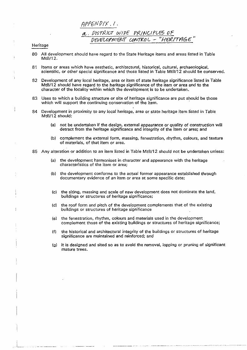
Heritage
APfJGN!JIY. I.
ot-. /)15!1</a WIPE Pf<.!NOn£:5 OF flEVfiUJfMg.J{ UJfVT1?.£J L. - ''H~/TriG E"
80 All development should have regard to the State Heritage items and areas listed in Table MtB/12.
81 Items or areas which have aesthetic, architectural, historical, cultural, archaeological, scientific, or other special significance and those listed in Table MtB/12 should be conserved.
82 Development of any local heritage, area or item of state heritage significance listed in Table MtB/1 2 should have regard to the heritage significance of the item or area and to the character of the locality within which the development is to be undertaken.
83 Uses to which a building structure or site of heritage significance are put should be those which will support the continuing conservation of the item. ·
84 Development in proximity to any local heritage, area or state heritage item listed in Table MtB/12 should:
(a) not be undertaken if the design, external appearance or quality of construction will detract from the heritage significance and integrity of the item or area; and
(b) complement the external form, massing, fenestration, rhythm, colours, and texture of materials, of that item or area.
85 Any alteration or addition to an item listed in Table MtB/12 should not be undertaken unless:
(a) the development harmonises in character and appearance with the heritage characteristics of the item or area;
(b) the development conforms to the actual former appearance established through documentary evidence of an item or area at some specific date;
(c) the siting, massing and scale of new development does not dominate the land, buildings or structures of heritage significance;
(d) the roof form and pitch of the development complements that of the existing buildings or structures of heritage significance
(e) the fenestration, rhythm, colours and materials used in the development complement those of the existing buildings or structures of heritage significance;
(f) the historical and architectural integrity of the buildings or structures of heritage significance are maintained and reinforced; and
(g) it is designed and sited so as to avoid the removal, lopping or pruning of significant mature trees.
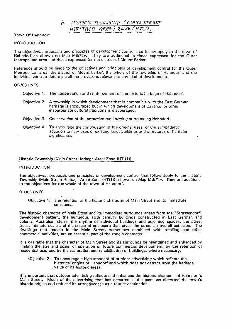
b. 1-{15(01?../G ToWN'?HIP fVll'l-tf\1 STR.6rr f..I62..1Tf/6E: fltea4 z_oN~ (t-tr(t)
Town Of Hahndorf
INTRODUCTION
The objectives, proposals and principles of development control that follow apply to the town of Hahndorf as shown on Map MtB/19. They are additional to those expressed for the Outer Metropolitan area and those expressed for the district of Mount Barker.
Reference should be made to the objectives and principles of development control for the Outer Metropolitan area, the district of Mount Barker, the whole of the township of Hahndorf and the individual zone to determine all the provisions relevant to any kind of development.
OBJECTIVES
Objective 1: The conservation and reinforcement of the historic heritage of Hahndorf.
Objective 2: A township in which development that is compatible with the East German heritage is encouraged but in which development of Bavarian or other inappropriate cultural traditions is discouraged.
Objective 3: Conservation of the attractive rural setting surrounding Hahndorf.
Objective 4: To encourage the continuation of the original uses, or the sympathetic adaption to new uses of existing land, buildings and structures of heritage significance.
Historic Township (Main Street Heritage Area) Zone (HT (1))
INTRODUCTION
The objectives, proposals and principles of development control that follow apply to the Historic Township (Main Street Heritage Area) Zone (HT(l )), shown on Map MtB/19. They are additional to the objectives for the whole of the town of Hahndorf.
OBJECTIVES
Objective 1: The retention of the historic character of Main Street and its immediate surrounds.
The historic character of Main Steet and its immediate surrounds arises from the "Strassendorf" development pattern, the numerous 19th century buildings constructed in East German and colonial Australian styles, the rhythm of individual buildings and adjoining spaces, the street trees, intimate scale and the sense of enclosure that gives the street an overall cohesion. The dwellings that remain in the Main Street, sometimes combined with retailing and other commercial activities, are an essential part of the zone's character. ·
It is desirable that the character of Main Street and its surrounds be maintained and enhanced by limiting the size and scale, of operation of future commercial development, by the retention of residential use, and by the restoration and rehabilitation of buildings, where necessary.
Objective 2: To encourage a high standard of outdoor advertising which reflects the historical origins of Hahndorf and which does not detract from the heritage
. value of its historic areas.
It is important that outdoor advertising reflects and enhances the historic character of Hahndorf's Main Street. Much of the advertising that has occurred in the past has distorted the town's historic origins and reduced its attractiveness as a tourist destination.
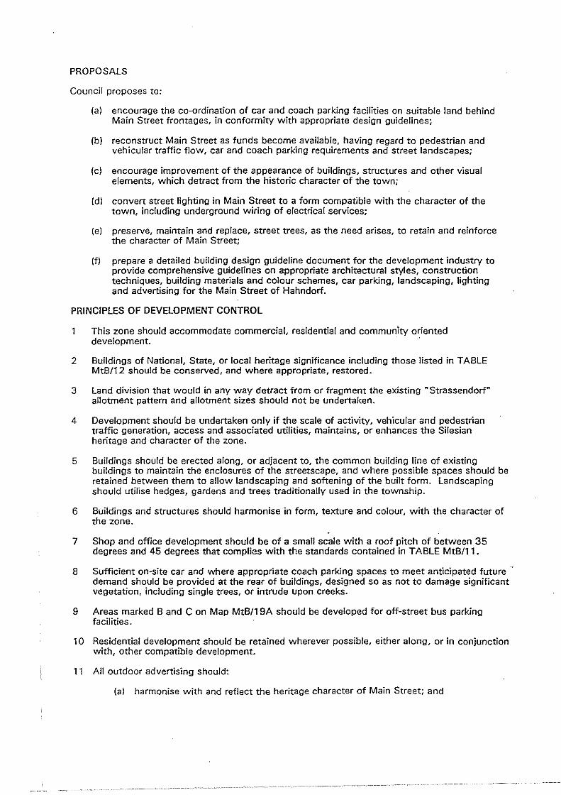
PROPOSALS
Council proposes to:
(a) encourage the co-ordination of car and coach parking facilities on suitable land behind Main Street frontages, in conformity with appropriate design guidelines;
(b) reconstruct Main Street as funds become available, having regard to pedestrian and vehicular traffic flow, car and coach parking requirements and street landscapes;
(c) encourage improvement of the appearance of buildings, structures and other visual elements, which detract from the historic character of the town;
(d) convert street lighting in Main Street to a form compatible with the character of the town, including underground wiring of electrical services;
(e) preserve, maintain and replace, street trees, as the need arises, to retain and reinforce the character of Main Street;
(f) prepare a detailed building design guideline document for the development industry to provide comprehensive guidelines on appropriate architectural styles, construction techniques, building materials and colour schemes, car parking, landscaping, lighting and advertising for the Main Street of Hahndorf.
PRINCIPLES OF DEVELOPMENT CONTROL
1 This zone should accommodate commercial, residential and community oriented development. ·
2 Buildings of National, State, or local heritage significance including those listed in TABLE MtB/12 should be conserved, and where appropriate, restored.
3 land division that would in any way detract from or fragment the existing "Strassendorf" allotment pattern and allotment sizes should not be undertaken.
4 Development should be undertaken only if the scale of activity, vehicular and pedestrian traffic generation, access and associated utilities, maintains, or enhances the Silesian heritage and character of the zone.
5 Buildings should be erected along, or adjacent to, the common building line of existing buildings to maintain the enclosures of the streetscape, and where possible spaces should be retained between them to allow landscaping and softening of the built form. landscaping should utilise hedges, gardens and trees traditionally used in the township.
6 Buildings and structures should harmonise in form, texture and colour, with the character of the zone.
7 Shop and office development should be of a small scale with a roof pitch of between 35 degrees and 45 degrees that complies with the standards contained in TABLE MtB/11.
8 Sufficient on-site car and where appropriate coach parking spaces to meet anticipated future demand should be provided at the rear of buildings, designed so as not to damage significant vegetation, including single trees, or intrude upon creeks.
9 Areas marked 8 and C on Map MtB/19A should be developed for off-street bus parking facilities.
10 Residential development should be retained wherever possible, either along, or in conjunction with, other compatible development.
11 All outdoor advertising should:
(a) harmonise with and reflect the heritage character of Main Street; and
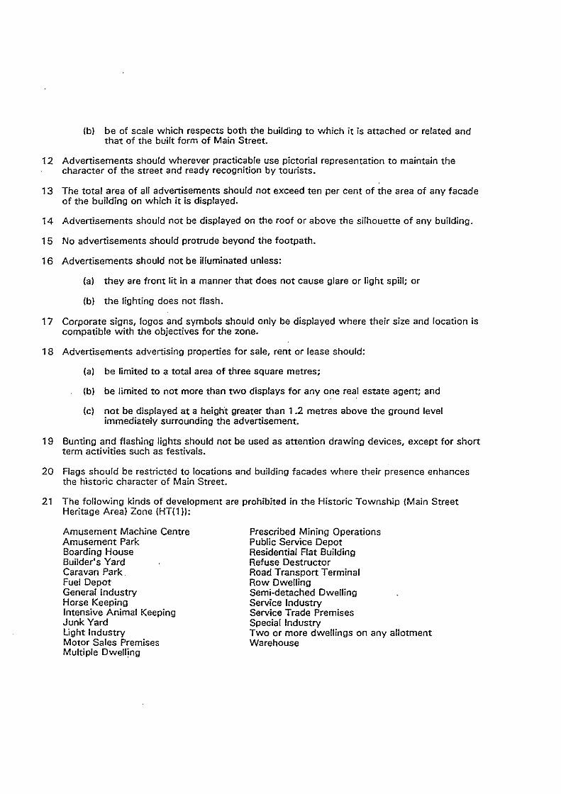
(b) be of scale which respects both the building to which it is attached or related and that of the built form of Main Street.
12 Advertisements should wherever practicable use pictorial representation to maintain the character of the street and ready recognition by tourists.
13 The total area of all advertisements should not exceed ten per cent of the area of any facade of the building on which it is displayed.
14 Advertisements should not be displayed on the roof or above the silhouette of any building.
15 No advertisements should protrude beyond the footpath.
16 Advertisements should not be illuminated unless:
{a) they are front lit in a manner that does not cause glare or light spill; or
{b) the lighting does not flash.
17 Corporate signs, logos and symbols should only be displayed where their size and location is compatible with the objectives for the zone.
18 Advertisements advertising properties for sale, rent or lease should:
{a) be limited to a total area of three square metres;
(b) be limited to not more than two displays for any one real estate agent; and
(c) not be displayed at a height greater than 1 .2 metres above the ground level immediately surrounding the advertisement.
19 Bunting and flashing lights should not be used as attention drawing devices, except for short term activities such as festivals.
20 Flags should be restricted to locations and building facades where their presence enhances the historic character of Main Street.
21 The following kinds of development are prohibited in the Historic Township (Main Street Heritage Area) Zone (HT(1 )):
Amusement Machine Centre Amusement Park Boarding House Builder's Yard Caravan Park Fuel Depot General Industry Horse Keeping Intensive Animal Keeping Junk Yard Light Industry Motor Sales Premises Multiple Dwelling
Prescribed Mining Operations Public Service Depot Residential Flat Building Refuse Destructor Road Transport Terminal Row Dwelling Semi-detached Dwelling Service Industry Service Trade Premises Special Industry Two or more dwellings on any allotment Warehouse
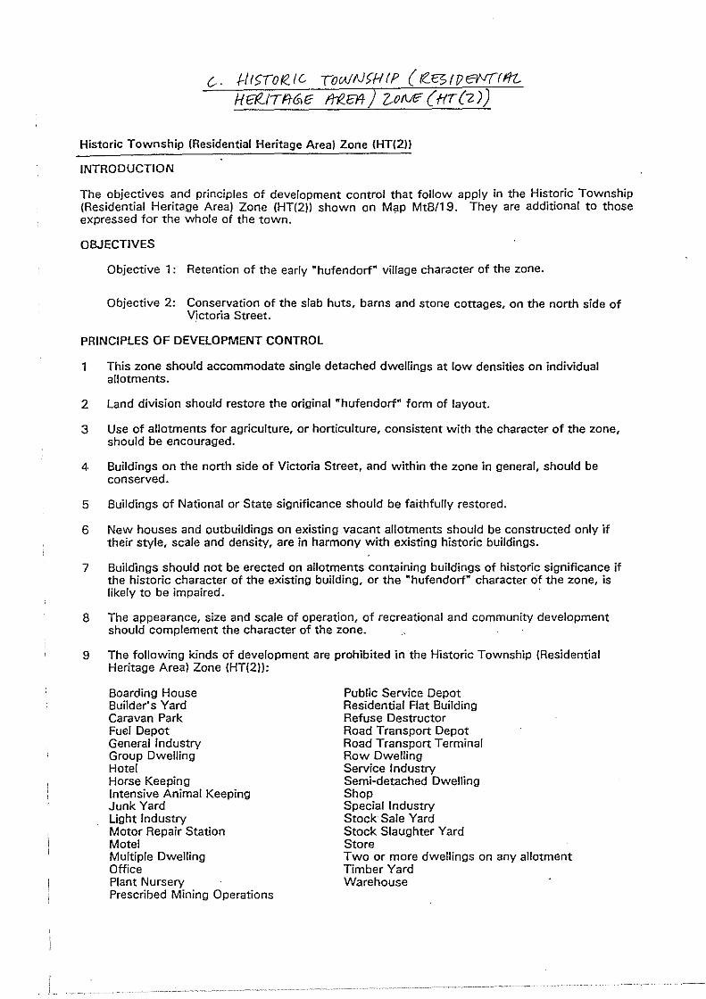
i -------~
c.-. f.-/l<;(o/ZIG To!AIN)Hff ( rZ.C>fT)evflflt_ He!...ITFtrS!E lrf!E14) Z-of\E(HT(2))
Historic Township (Residential Heritage Areal Zone (HT(2))
INTRODUCTION
The objectives and principles of development control that follow apply in the Historic Township (Residential Heritage Area) Zone (HT(2ll shown on Map MtB/19. They are additional to those expressed for the whole of the town. ·
OBJECTIVES
Objective 1: Retention of the early "hufendorf" village character of the zone.
Objective 2: Conservation of the slab huts, barns and stone cottages, on the north side of Victoria Street.
PRINCIPLES OF DEVELOPMENT CONTROL
1 This zone should accommodate single detached dwellings at low densities on individual allotments.
2 Land division should restore the original "hufendorf" form of layout.
3 Use of allotments for agriculture, or horticulture, consistent with the character of the zone, should be encouraged.
4 Buildings on the north side of Victoria Street, and within the zone in general, should be conserved.
5 Buildings of National or State significance should be faithfully restored.
6 New houses and outbuildings on existing vacant allotments should be constructed only if their style, scale and density, are in harmony with existing historic buildings.
7 Buildings should not be erected on allotments containing buildings of historic significance if the historic character of the existing building, or the "hufendorf" character cit the zone, is likely to be impaired.
8 The appearance, size and scale of operation, of recreational and community development should complement the character of the zone.
9 The following kinds of development are prohibited in the Historic Township (Residential Heritage Areal Zone (HT(2)):
Boarding House Builder's Yard Caravan Park Fuel Depot General Industry Group Dwelling Hotel Horse Keeping Intensive Animal Keeping Junk Yard Light Industry Motor Repair Station Motel Multiple Dwelling Office Plant Nursery Prescribed Mining Operations
Public Service Depot Residential Flat Building Refuse Destructor Road Transport Depot Road Transport Terminal Row Dwelling Service Industry Semi-detached Dwelling Shop Special Industry Stock Sale Yard Stock Slaughter Yard Store Two or more dwellings on any allotment Timber Yard Warehouse
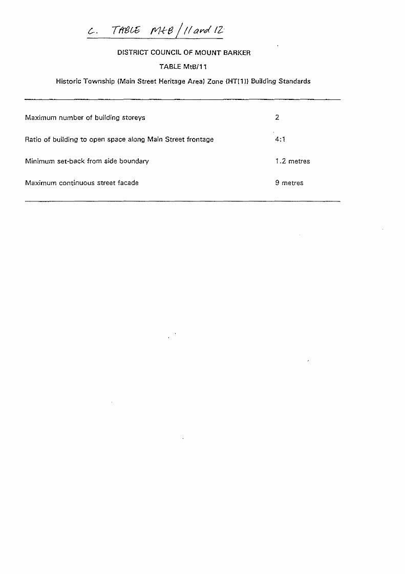
DISTRICT COUNCIL OF MOUNT BARKER
TABLE MtB/11
Historic Township (Main Street Heritage Area) Zone (HT(1)) Building Standards
Maximum number of building storeys 2
Ratio of building to open space along Main Street frontage 4:1
Minimum set-back from side boundary 1.2 metres
Maximum continuous street facade 9 metres
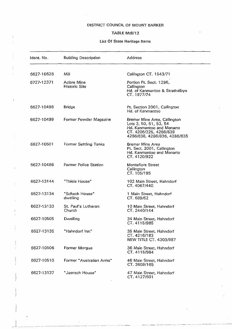
DISTRICT COUNCIL OF MOUNT BARKER
TABLE MtB/12
List Of State Heritage Items
!dent. No. Building Description Address
6627-10628 Mill Callington CT. 1543/71
6727-12371 Aclare Mine Portion Pt. Sect. 1296, Historic Site Callington
Hd. of Kanmantoo & Strathalbyn CT. 1977/74
6627-10498 Bridge Pt. Section 2001, Callington Hd. of Kanmantoo
6627-10499 Former Powder Magazine Bremer Mine Area, Callington Lots 3, 50, 51, 53, 54 Hd. Kanmantoo and Monarto CT. 4206/225, 4286/839 4286/838, 4286/836, 4286/835
6627-10501 Former Settling Tanks Bremer Mine Area Pt. Sect. 2001 , Callington Hd. Kanmantoo and Monarto CT. 4120/922
6627-10486 Former Police Station Montefiore Street Callington CT. 105/195
6627-13144 "Thiele House" 102 Main Street, Hahndorf CT. 4067/440
6627-13134 "Schach House" 1 Main Street, Hahndorf dwelling CT. 699/62
6627-13133 St. Paul's Lutheran 10 Main Street, Hahndorf Church CT. 2440/144
6627-10505 Dwelling 34 Main Street, Hahndorf CT. 4115/985
6627-13135 "Hahndorf Inn" 35 Main Street, Hahndorf CT. 4216/183 NEW TITLE CT. 4303/987
6627-10506 Former Morgue 36 Main Street, Hahndorf CT. 4115/984
6627-10510 Former "Australian Arms" 46 Main Street, Hahndorf CT. 3609/165
6627-13137 "Jaensch House" 47 Main Street, Hahndorf CT. 4127/601
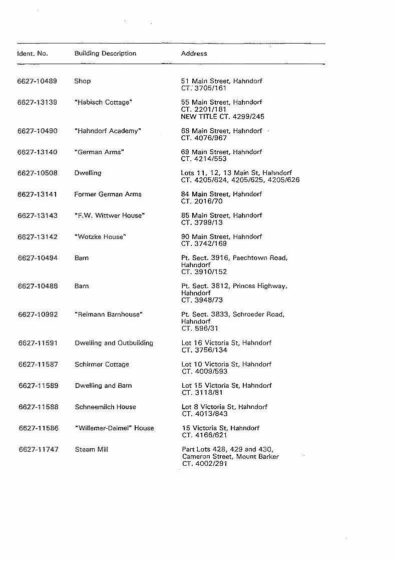
ldent. No. Building Description Address
6627-10489 Shop 51 Main Street, Hahndorf CT: 3705/161
6627-13139 • Habisch Cottage" 55 Main Street, Hahndorf CT. 2201/181 NEW TITLE CT. 4299/245
6627-10490 "Hahndorf Academy" 68 Main Street, Hahndorf CT. 4076/967
6627-13140 "German Arms" 69 Main Street, Hahndorf CT. 4214/553
6627-10508 Dwelling Lots 11, 12, 13 Main St, Hahndorf CT. 4205/624, 4205/625, 4205/626
6627-13141 Former German Arms 84 Main Street, Hahndorf CT. 2016/70
6627-13143 "F.W. Wittwer House" 85 Main Street, Hahndorf CT. 3799/13
6627-13142 "Wotzke House" 90 Main Street, Hahndorf CT. 3742/169
6627-10494 Barn Pt. Sect. 3916, Paechtown Road, Hahndorf CT. 3910/152
6627-10488 Barn Pt. Sect. 3812, Princes Highway, Hahndorf CT. 3948/73
6627-10992 "Reimann Barnhouse" Pt. Sect. 3833, Schroeder Road, Hahndorf CT. 596/31
6627-11591 Dwelling and Outbuilding Lot 16 Victoria St, Hahndorf CT. 3756/134
6627-11587 Schirmer Cottage Lot 10 Victoria St, Hahndorf CT. 4009/593
6627-11589 Dwelling and Barn Lot 15 Victoria St, Hahndorf CT. 3118/81
6627-11588 Schneemilch House Lot 8 Victoria St, Hahndorf CT. 4013/843
6627-11586 "Willemer-Deimel" House 15 Victoria St, Hahndorf CT. 4166/621
6627-11747 Steam Mill Part Lots 428, 429 and 430, Cameron Street, Mount Barker CT. 4002/291
!dent. No. Building Description Address
6627-10512 Post Office Lot 10 Corner Gawler and Hutchinson Streets, Mount Barker CT. 3884/45 NEW TITLE CT. 4220/164
6627-10651 Old Corner Shop Lot 299, Corner Gawler and Mclaren Streets, Mount Barker CT. 4068/666
6627-10511 Police Station & Stables Part Lots 102, 1 03 and 1 04, Gawler Street, Mount Barker CT. 2152/20,2152/21
6627-11723 Courthouse Lot 296, Hutchinson Street, Mount Barker CT. 2152/20
6627-10497 Mill Sect. 3810, Mount Barker Road, Mount Barker CT. 1543/71
6627-10820 Mill 2 Junction Street, Nairne CT. 1506/136 NEW TITLE CT. 4256/392, 4256/393
6627-10509 "District" Hotel Main Street, Nairne NEW TITLE CT. 4262/448
6627-10496 Dwelling Pt. Sect. 3915, Paechtown Road, Paechtown CT. 4047/442 Hd. Kuitpo
6627-12598 Educational Building Prospect Hill and Outbuilding CT. 1865176 Hd. Kuitpo
NEW TITLE CT. 4221/528, 4221/529,4221/530,4221/531 Pt. Sect. 963, 335, 356, 355, 333 Hd. of Kuitpo.
6627-10460 Echunga Goldfields Rubbish Dump Road, Echunga Jupiter Creek Diggings CT. 4197/757
6627-10459 Echunga Goldfield Chapel Diggings Road, near Mylar Hill Diggings Sect. 393, Hd. of Kuitpo
6627-11744 Dwelling 28 Morphett Street, Mount Barker CT. 4199/540
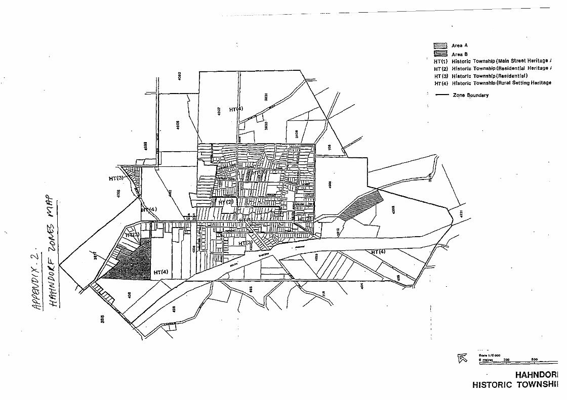
~ ~
~ (:S
N lL '><- "" ...._ <:::.
~ <::. '< ~ ~
~ ~ -;;; ~
!
~ VgJI \;;
• ~
8 ~
_I--HJTIIIIIIIU!nn7771 I I I ~1::::~11
~·
b:::::::~:::i Area A
~ AreaB HT(1) Historic Township (Main Street Heritage J HT {2) Historic Township (Residential Heritaga J
HT (3) Historic Townshlp(Residentfal) HT(4) Historic TownshiP (Rural Setting Heritage
- Zqne ~~undary
~ ~1;l5000
0 .,..\ret :IDe tiOO
HAHNDORI HISTORIC TOWNSHII
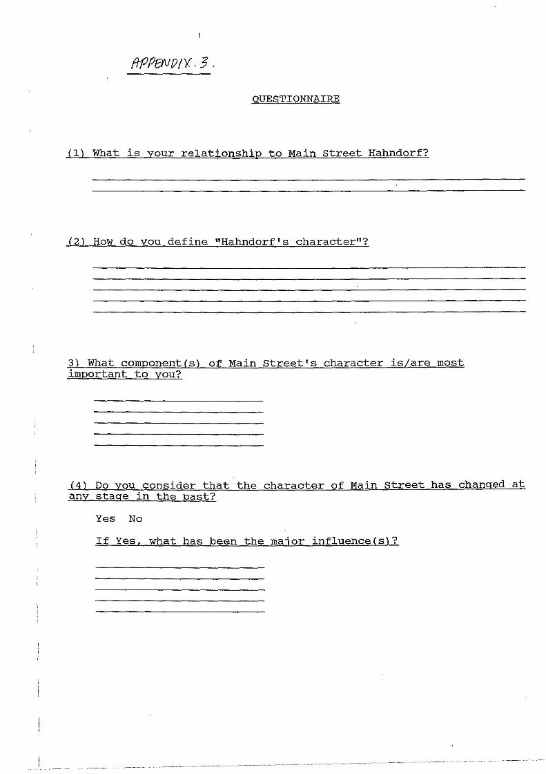
QUESTIONNAIRE
(ll What is your relationship to Main Street Hahndorf?
(2) How do you define "Hahndorf's character"?
3) What component(sl of Main street's character is/are most important to you?
(4) Do you consider that the character of Main Street has changed at any stage in the past?
Yes No
If Yes, what has been the major influence(s)?
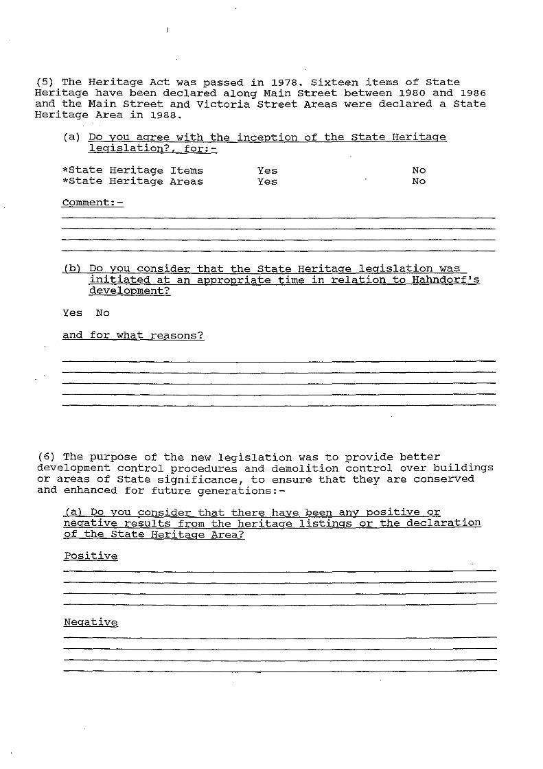
(5) The Heritage Act was passed in 1978. Sixteen items of State Heritage have been declared along Main Street between 1980 and 1986 and the Main Street and Victoria Street Areas were declared a State Heritage Area in 1988.
(a) Do you agree with the inception of the state Heritage legislation?, for:-
*State Heritage Items *State Heritage Areas
Comment:-
Yes Yes
No No
(b) Do you consider that the State Heritage legislation was initiated at an appropriate time in relation to Hahndorf's development?
Yes No
and for what reasons?
(6) The purpose of the new legislation was to provide better development control procedures and demolition control over buildings or areas of State significance, to ensure that they are conserved and enhanced for future generations:-
(a) Do you consider that there have been any positive or negative results from the heritage listings or the declaration of the State Heritage Area?
Positive
Negative
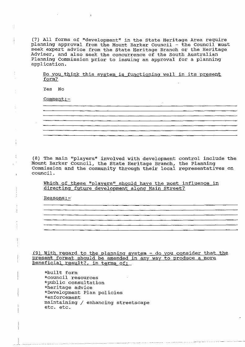
(7) All forms of "development" in the state Heritage Area require planning approval from the Mount Barker Council - the Council must seek expert advice from the state Heritage Branch or the Heritage Adviser, and also seek the concurrence of the South Australian Planning Commission prior to issuing an approval for a planning application.
Do you think this system is functioning well in its present form?
Yes No
Comment:
(8) The main "players" involved with development control include the Mount Barker Council, the State Heritage Branch, the Planning Commission and the community through their local representatives on council.
Which of these "players" should have the most influence in directing future development along Main Street?
Reasons:
(9) With regard to the planning system - do you consider that the present format should be amended in any way to produce a more beneficial result?, in terms of:
*built form *council resources *public consultation *heritage advice *Development Plan policies *enforcement maintaining I enhancing streetscape etc. etc.

Comment:-
(10) Do you think the general public are aware of the planning system and the development control process for the Heritage Area and its purpose?
Property owners Shop tenants Residents
Comment:-
Yes Yes Yes
No No No
(11) How do you percieve the future of Main Street with regard to its character, development and legislative controls?
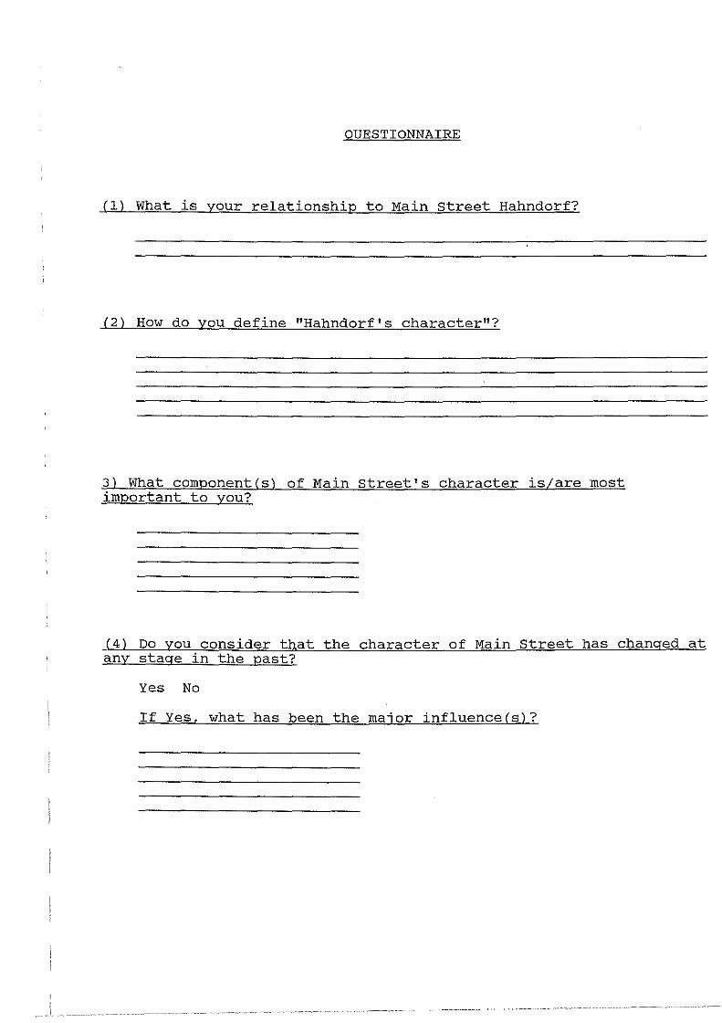
I I
I
QUESTIONNAIRE
(l) What is your relationship to Main street Hahndorf?
(2) How do you define "Hahndorf's character"?
3) What component(s) of Main street's character is/are most important to you?
(4) Do you consider that the character of Main Street has changed at any stage in the past?
Yes No
If Yes, what has been the major influence(s)?
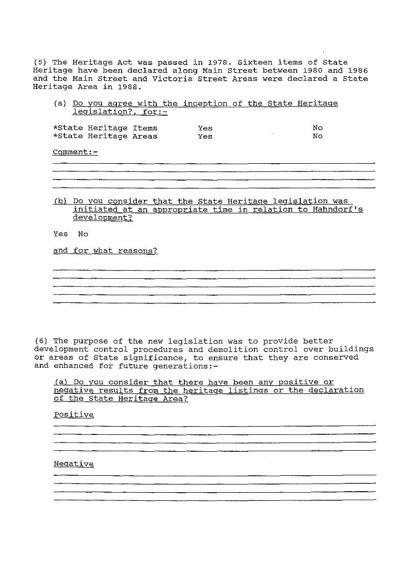
(5) The Heritage Act was passed in 1978. Sixteen items of State Heritage have been declared along Main Street between 1980 and 1986 and the Main Street and Victoria Street Areas were declared a State Heritage Area in 1988.
(a) Do you agree with the inception of the State Heritage legislation?, for:-
*State Heritage Items *State Heritage Areas
Comment:-
Yes Yes
No No
(b) Do you consider that the state Heritage legislation was initiated at an appropriate time in relation to Hahndorf's development?
Yes No
and for what reasons?
(6) The purpose of the new legislation was to provide better development control procedures and demolition control over buildings or areas of State significance, to ensure that they are conserved and enhanced for future generations:-
(a) Do you consider that there have been any positive or negative results from the heritage listings or the declaration of the state Heritage Area?
Positive
Negative
(7) All forms of "development" in the state Heritage Area require planning approval from the Mount Barker Council - the Council must seek expert advice from the state Heritage Branch or the Heritage Adviser, and also seek the concurrence of the south Australian Planning Commission prior to issuing an approval for a planning application.
Do you think this system is functioning well in its present form?
Yes No
Comment:-
(8) The main "players" involved with development control include the Mount Barker Council, the State Heritage Branch, the Planning Commission and the community through their local representatives on council.
Which of these "players" should have the most influence in directing future development along Main Street?
Reasons:-
(9) With regard to the planning system present format should be amended in any beneficial result?, in terms of:
*built form *council resources *public consultation *heritage advice *Development Plan policies *enforcement maintaining I enhancing streetscape etc. etc.
do you consider that the way to produce a more
Comment:-
(lOl Do you think the general public are aware of the planning system and the development control process for the Heritage Area and its purpose?
Property owners Shop tenants Residents
Comment:-
Yes Yes Yes
No No No
(lll How do you Perceive the future of Main Street with regard to its character, development and legislative controls?