
HIRISE AND CTX DIGITAL TERRAIN MODELS AND TERRAIN ...
16
ESA - official use Prepared by UCL (Si-Ting Xiong, Yu Tao, Jan-Peter Muller, A.R.D. Putri) Date of Issue 14/01/2021 esac European Space Astronomy Centre (ESAC) European Space Agency (ESA) Camino Bajo del Castillo s/n Urb. Villafranca del Castillo 28692 Villanueva de la Canada - Madrid SPAIN HIRISE AND CTX DIGITAL TERRAIN MODELS AND TERRAIN-CORRECTED IMAGES OF MARS: PRODUCT USER GUIDE (PUG)
Transcript of HIRISE AND CTX DIGITAL TERRAIN MODELS AND TERRAIN ...

ESA - official use
Prepared by UCL (Si-Ting Xiong, Yu Tao, Jan-Peter Muller, A.R.D. Putri) Date of Issue 14/01/2021
esac European Space Astronomy Centre (ESAC)
European Space Agency (ESA) Camino Bajo del Castillo s/n
Urb. Villafranca del Castillo 28692 Villanueva de la Canada - Madrid
SPAIN
HIRISE AND CTX DIGITAL TERRAIN MODELS AND TERRAIN-CORRECTED IMAGES OF MARS: PRODUCT USER GUIDE (PUG)
ESA UNCLASSIFIED - For Official Use
Reason for change Issue Revision Date
Initial version 1 0 14/01/2021
Issue 1 Revision 0
Reason for change Date Pages Paragraph(s)
Initial version 14/01/2021 All All

ESA UNCLASSIFIED - For Official Use
Table of contents: 1. Introduction ............................................................................................................................................................................... 4 1.1 Instrument and datasets ........................................................................................................................................................... 4 1.2 Abbreviations and Acronyms ................................................................................................................................................. 4 1.3 Reference and Applicable Documents .................................................................................................................................... 5 2. scientific objectives .................................................................................................................................................................. 7 2.1 Acknowledgements ................................................................................................................................................................. 7 3. Data Product Generation ........................................................................................................................................................... 8 4. Archive Format and Content .................................................................................................................................................. 10 4.1 Product type .......................................................................................................................................................................... 10 4.2 Naming convention ............................................................................................................................................................... 10 4.3 Format type ........................................................................................................................................................................... 10 4.4 DTM/ORI specification ........................................................................................................................................................ 11 4.5 Product Example and Usage ................................................................................................................................................. 11 5. Known Issues .......................................................................................................................................................................... 14 6. Software .................................................................................................................................................................................. 16

ESA UNCLASSIFIED - For Official Use
1. INTRODUCTION
Within the EU FP-7 iMars project (http://www.i-mars.eu), UCL developed a fully automated multi-resolution DTM processing chain for NASA MRO CTX and HiRISE stereo processing, called CASP-GO (Tao et al., PSS, 2018), based on the open source NASA AMES Stereo Pipeline, ASP (Beyer et al., ESS, 2018). CASP-GO employs tie-point based multi-resolution image co-registration (Tao & Muller, Icarus, 2016), and Gotcha sub-pixel refinement and densification (Shin and Muller, PR, 2012). The CASP-GO pipeline is being used to produce planet-wide CTX and HiRISE DTMs that guarantee global geo-referencing compliance with respect to HRSC, and thence to the MOLA global height reference system, providing refined stereo matching completeness and accuracy. The CASP-GO software and products with the highest quality levels are being made open-source to the planetary science community through NASA Ames Github software (in 2021/12) and the products through the ESAC GSF (2020). The browse products are viewable through the iMars WebGIS system (http://www.i-mars.eu/webgis) which is described in Walter et al. (2018). Eventually it is planned that users will be able to download all Mars products through this site. 1.1 Instrument and datasets The MRO HiRISE instrument operates in visible wavelengths, the same as human vision, but with a telescopic lens that produces panchromatic images containing individual, basketball-size (30 to 60 cm, or 1 to 2 feet wide) pixel elements, allowing surface features 4 to 8 feet across to be resolved (https://mars.nasa.gov/mro/mission/instruments/hirise/). The HiRISE images have a swath-width of 6 km and a length of up to 60 km. Stereo-pair images are released at a site within University of Arizona (https://www.uahirise.org), and the CASP-GO system can take these stereo-pair images as input to produce HiRISE DTMs, which will be coregistered with CTX images and hence HRSC images. The HiRISE, CTX and HRSC images released over this site are cropped into a coverage over a terraced crater in Elysium Planitia. The following triplet shows the three ORIs overlaying on the three DTMs. The HSRC product shown is from DLR.
Figure 1. A triplet of HiRISE, CTX and HRSC images. 1.2 Abbreviations and Acronyms ALSC Adaptive Least Square Correlation
ESA UNCLASSIFIED - For Official Use
ASP Ames Stereo Pipeline CASP-GO Co-registration ASP Gotcha Optimised CTX Context Camera DTM Digital Terrain Model EU FP-7 European Union’s Seventh Framework Programme ESA European Space Agency ESAC European Space Astronomy Centre GIS Geographic Information System GSF Guest Storage Facility (ESA-ESAC-PSA) HiRISE High Resolution Imaging Science Experiment HRSC High Resolution Stereo Colour imaging ISIS Integrated Software for Imagers and Spectrometers PSA Planetary Science Archive PVL Parameter Value Language (used by ISGS) MOLA Mars Orbiter Laser Altimeter MRO Mars Reconnaissance Orbiter ORI OrthoRectified Images PUG Product User Guide UCL University College London webGIS web based Geographic Information System 1.3 Reference and Applicable Documents
Beyer, Ross A., Oleg Alexandrov, and Scott McMichael. 2018. The Ames Stereo Pipeline: NASA's open source software for deriving and processing terrain data. Earth and Space Science, 5. DOI: 10.1029/2018EA000409.
Gwinner, K.; Jaumann, R.; Hauber, E.; Hoffmann, H.; Heipke, C.; Oberst, J.; Neukum, G.; Ansan, V.; Bostelmann, J.; Dumke, A.; Elgner, S.; Erkeling, G.; Fueten, F.; Hiesinger, H.; Hoekzema, N. M.; Kersten, E.; Loizeau, D.; Matz, K.-D.; McGuire, P. C.; Mertens, V.; Michael, G.; Pasewaldt, A.; Pinet, P.; Preusker, F.; Reiss, D.; Roatsch, T.; Schmidt, R.; Scholten, F.; Spiegel, M.; Stesky, R.; Tirsch, D.; van Gasselt, S.; Walter, S.; Wahlisch, M.; Willner, K. The High Resolution Stereo Camera (HRSC) of Mars Express and its approach to science analysis and mapping for Mars and its satellites. Planetary and Space Science 2016, 126, 93–138.
Gwinner, K.; Scholten, F.; Preusker, F.; Elgner, S.; Roatsch, T.; Spiegel, M.; Schmidt, R.; Oberst, J.; Jaumann, R.; Heipke, C. Topography of Mars from global mapping by HRSC high-resolution digital terrain models and orthoimages: Characteristics and performance. Earth and Planetary Letters 2010, 294, 506–519.
Shin, D. and Muller, J.P., 2012. Progressively Weighted Affine Adaptive Correlation Matching for Quasi-Dense 3D Reconstruction. Pattern Recognition, 45(10), pp.3795-3809. DOI: 10.1016/j.patcog.2012.03.023
Smith, D.E., Sjogren, W.L., Tyler, G.L., Balmino, G., Lemoine, F.G., and Konopliv,A.S., 1999. The gravity field of Mars—Results from Mars Global Surveyor. Science, 286, p. 94–97. DOI: 10.1126/science.286.5437.94
Tao, Y., Muller, J.P., Sidiropoulos, P., Xiong, S.T., Putri, A.R.D., Walter, S.H.G., Veitch-Michaelis, J. and Yershov, V., 2018. Massive stereo-based DTM production for Mars on cloud computers. Planetary and Space Science, vol. 154, pp.30-58. DOI: 10.1016/j.pss.2018.02.012

ESA UNCLASSIFIED - For Official Use
Tao, Y., Muller, J.P. and Poole, W.D., 2016. Automated localisation of Mars rovers using co-registered HiRISE-CTX-HRSC orthorectified images and wide baseline Navcam orthorectified mosaics. Icarus, vol. 280, pp. 139-157. DOI: 10.1016/j.icarus.2016.06.017
Walter, S. H. G.; Muller, J. P.; Sidiropoulos, P.; Tao, Y.; Gwinner, K.; Putri, A. R. D.; Kim, J. R.; Steikert, R.; vanGasselt, S.; Michael, G. G.; Watson, G.; Schreiner, B. P., 2018. The Web-based Interactive Mars Analysis and Research System for the iMars project. Earth and Space Science, 5, 308-323, DOI: 10.1029/2018EA000389
ESA UNCLASSIFIED - For Official Use
2. SCIENTIFIC OBJECTIVES
During the past 5 decades, many areas on Mars have been imaged with serendipitous stereo, mainly to improve the potential for scientific studies. The rapid progress in planetary surface reconnaissance instrumentation, especially in relation to 3D imaging of the surface, has allowed change detection analysis. For example, by combining the surface images with penetrating radar observations, like SHARAD data, dielectric constant can be estimated. During the investigation of subsurface features in the Cerberus Plain, an interesting terraced crater is found to be significant considering the likely correspondent subsurface layers observed in SHARAD data collected nearby. The co-registered CTX and HiRISE DTMs+ORIs are used to measure the dielectric constant in this area. It is common knowledge in the planetary scientific community that research greatly benefits from the availability of high-resolution 3D models of Mars. Within the EU FP-7 iMars (http://www.i-mars.eu) project, we focused on developing tools and producing value-added datasets to maximize the exploitation of the available planetary datasets of the Martian surface. This includes the generation of high quality co-registered DTMs and corresponding terrain-corrected ORIs, using data from different NASA and ESA instruments. 2.1 Acknowledgements Users are requested to acknowledge the dataset by mentioning it in any relevant figure captions and within the acknowledgements within their publications to cite both the DOI of the dataset (10.5270/esa-lqefjdl) and the paper describing the processing, assessment, and final product generation: Xiong, S.; Tao, Y.; Persaud, D. M.; Campbell, J. D.; Diana Putri, A. R.; Muller, J.-P. Subsurface Reflectors Detected by SHARAD Reveal Stratigraphy and Buried Channels over Central Elysium Planitia, Mars. Earth and Space Science 2020, 7, e2019EA000968.doi: 10.1029/2019EA000968 Accessible at: https://www.cosmos.esa.int/web/psa/ucl-mssl_mars-cep_ctx-hirise_v1.0 The CASP-GO methods together with HiRISE and CTX examples are described in: Tao, Y., Muller, J.P., Sidiropoulos, P., Xiong, S.T., Putri, A.R.D., Walter, S.H.G., Veitch-Michaelis, J. and Yershov, V., 2018. Massive stereo-based DTM production for Mars on cloud computers. Planetary and Space Science, 154, pp.30-58. DOI: 10.1016/j.pss.2018.02.012 The first author of this publication and datasets acknowledges Chinese Scholar Council and University College London for providing a scholarship from the Dean of MAPS prize. The research leading to these results has received funding from the European Union’s Seventh Framework Programme (FP7/2007-2013) under iMars grant agreement No. 607379 as well as partial funding from the STFC “MSSL Consolidated Grant” ST/K000977/1 and UKSA Aurora programme (2018-2021) under grant no. ST/S001891/1.
ESA UNCLASSIFIED - For Official Use
3. DATA PRODUCT GENERATION
The CASP-GO pipeline is based on the NASA Ames Stereo Pipeline (ASP) with enhancements from in house software developed previously. CASP-GO takes formatted “left” and “right” MRO HiRISE images (which can be downloaded at the site of University of Arizona, https://www.uahirise.org) and a reference HRSC or CTX ORI as inputs. It uses a combination of the ASP functions and the 6th generation of an adaptive least squares correlation and region growing matcher called Gotcha (Shin & Muller, 2012), which provides accurate and robust sub-pixel conjugate points. CASP-GO generates raster products such as ORIs and DTMs that are co-registered to HRSC. The complete CASP-GO workflow for HiRISE DTM production has the following 12 steps: (1) USGS-ISIS pre-processing steps which include the standard USGS-ISIS functions for HiRISE CCD radiometric de-calibration, stitching, SPICE kernel initialisation, and a de-jittering process; (2) This is followed by a sequence of USGS-ISIS de-stripping and Kuwahara denoise filters (https://isis.astrogeology.usgs.gov/Application/presentation/Tabbed/kuwahara/kuwahara.html (3) ASP “left” and “right” image pre-processing (image normalisation, Laplacian of Gaussian filtering, and stereo map projection); (4) ASP disparity map initialisation (use absolute difference to build a rough disparity map); (5) UCL fast Maximum Likelihood matching and building of a “float” initial disparity map; (6) ASP Bayes Expectation Maximisation weighted affine adaptive sub-pixel cross-correlation; (7) UCL refined outlier rejection gap erosion scheme to remove and eliminate mis-matched and unreliable disparity values; (8) UCL ALSC based sub-pixel refinement; (9) UCL Gotcha (ALSC with region growing) based refinement and densification method to refine the disparity value and match un-matched or mis-matched area; (10) UCL co-kriging grid-point interpolation to generate ORI and DTM as well as height uncertainties for each DTM point; (11) UCL ORI co-registration/geocoding with reference to HRSC orthoimage and DTM adjustment; (12) UCL B-Spline fitting to remove vertical residuals or jittering between HiRISE DTM and the reference DTMs. Each of these function extensions/modifications (labelled as the UCL pipeline) have been discussed in more detail in (Tao et al., PSS, 2018). In this work, the HRSC DTM + ORI product are processed by DLR using their bespoke and proprietary VICAR system (Gwinner et al., 201, 2016). The level-4 DLR HRSC product on a sinusoidal map projection can be found in the level4 product archive on the ESA-PSA.

ESA UNCLASSIFIED - For Official Use
Figure 2. Flow diagram of the UCL-ASP CASP-GO processing chain for HiRISE DTM processing.

ESA UNCLASSIFIED - For Official Use
4. ARCHIVE FORMAT AND CONTENT
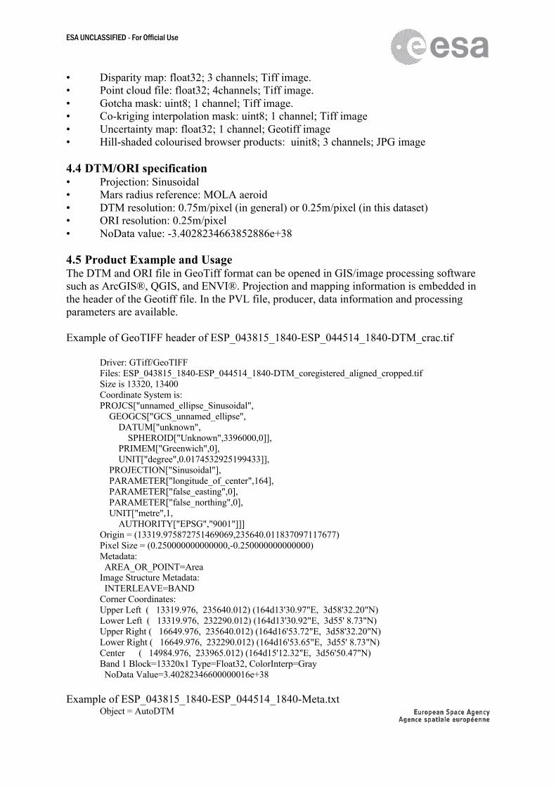
4.1 Product type A complete set of iMars 3D product for one pair of stereo HiRISE images contains the following types of products: • DTM (Mars areoid) • ORI • Metadata file The following are also produced but are not included in this first release • Uncertainty map • Point cloud file • Gotcha mask • Co-kriging interpolation mask • Hill-shaded colourised browser products 4.2 Naming convention When each product is processed the following set of files is contained in a directory with a naming convention of LEFT_HiRISE_IMAGE_ID-RIGHT_HiRISE_IMAGE_ID. The naming convention for the different types of products listed above is as follows: • DTM (areoid): LEFT_HiRISE_IMAGE_ID-RIGHT_HiRISE_IMAGE_ID-DTM_UCL.tif • ORI: LEFT_HiRISE_IMAGE_ID-RIGHT_HiRISE_IMAGE_ID-ORI_UCL.tif • Metadata file: LEFT_HiRISE_IMAGE_ID-RIGHT_HiRISE_IMAGE_ID-Meta.txt The following additional product layers are not distributed at present: • Uncertainty map: LEFT_HiRISE_IMAGE_ID-RIGHT_HiRISE_IMAGE_ID-F.tif • Point cloud file: LEFT_HiRISE_IMAGE_ID-RIGHT_HiRISE_IMAGE_ID-PC.tif • Gotcha mask: LEFT_HiRISE_IMAGE_ID-RIGHT_HiRISE_IMAGE_ID-GM.tif • Co-kriging mask: LEFT_HiRISE_IMAGE_ID-RIGHT_HiRISE_IMAGE_ID-CM.tif • Uncertainty map: LEFT_HiRISE_IMAGE_ID-RIGHT_HiRISE_IMAGE_ID-uncertainty.tif • browser products: LEFT_HiRISE_IMAGE_ID-RIGHT_HiRISE_IMAGE_ID-browse.tif Since the datasets released at this site is cropped to over the terraced crater, and the HiRISE and CTX images are coregistered and aligned to DLR HRSC images, we named them with suffix of “_crac” standing for “_coregistered_aligned_cropped.tif”. Therefore, the four files are named as follows. HiRISE DTM: ESP_043815_1840-ESP_044514_1840-DTM_crac.tif HiRISE ORI: ESP_043815_1840-ESP_044514_1840-ORI_crac.tif CTX DTM: F22_044514_1831_XN_03N195W-G02_018853_1837_XN_03N195W-DTM_crac.tif CTX ORI: F22_044514_1831_XN_03N195W-G02_018853_1837_XN_03N195W-ORI_crac.tif 4.3 Format type • DTM: float32; 1 channel; Geotiff image. • ORI: float32; 1 channel; Geotiff image. • Metadata file: ASCII file in PVL format The following additional product layers are not distributed at present:
ESA UNCLASSIFIED - For Official Use
• Disparity map: float32; 3 channels; Tiff image. • Point cloud file: float32; 4channels; Tiff image. • Gotcha mask: uint8; 1 channel; Tiff image. • Co-kriging interpolation mask: uint8; 1 channel; Tiff image • Uncertainty map: float32; 1 channel; Geotiff image • Hill-shaded colourised browser products: uinit8; 3 channels; JPG image 4.4 DTM/ORI specification • Projection: Sinusoidal • Mars radius reference: MOLA aeroid • DTM resolution: 0.75m/pixel (in general) or 0.25m/pixel (in this dataset) • ORI resolution: 0.25m/pixel • NoData value: -3.4028234663852886e+38 4.5 Product Example and Usage The DTM and ORI file in GeoTiff format can be opened in GIS/image processing software such as ArcGIS®, QGIS, and ENVI®. Projection and mapping information is embedded in the header of the Geotiff file. In the PVL file, producer, data information and processing parameters are available. Example of GeoTIFF header of ESP_043815_1840-ESP_044514_1840-DTM_crac.tif
Driver: GTiff/GeoTIFF Files: ESP_043815_1840-ESP_044514_1840-DTM_coregistered_aligned_cropped.tif Size is 13320, 13400 Coordinate System is: PROJCS["unnamed_ellipse_Sinusoidal", GEOGCS["GCS_unnamed_ellipse", DATUM["unknown", SPHEROID["Unknown",3396000,0]], PRIMEM["Greenwich",0], UNIT["degree",0.0174532925199433]], PROJECTION["Sinusoidal"], PARAMETER["longitude_of_center",164], PARAMETER["false_easting",0], PARAMETER["false_northing",0], UNIT["metre",1, AUTHORITY["EPSG","9001"]]] Origin = (13319.975872751469069,235640.011837097117677) Pixel Size = (0.250000000000000,-0.250000000000000) Metadata: AREA_OR_POINT=Area Image Structure Metadata: INTERLEAVE=BAND Corner Coordinates: Upper Left ( 13319.976, 235640.012) (164d13'30.97"E, 3d58'32.20"N) Lower Left ( 13319.976, 232290.012) (164d13'30.92"E, 3d55' 8.73"N) Upper Right ( 16649.976, 235640.012) (164d16'53.72"E, 3d58'32.20"N) Lower Right ( 16649.976, 232290.012) (164d16'53.65"E, 3d55' 8.73"N) Center ( 14984.976, 233965.012) (164d15'12.32"E, 3d56'50.47"N) Band 1 Block=13320x1 Type=Float32, ColorInterp=Gray NoData Value=3.40282346600000016e+38
Example of ESP_043815_1840-ESP_044514_1840-Meta.txt
Object = AutoDTM

ESA UNCLASSIFIED - For Official Use
Object = ProductInfo Object = Processing SoftwareName = CASP-GO SoftwareVersion = 2.0 OperatingSystem = "RHEL v7.2" ProcessingStartTime = 2020-06-10T06:30 ProcessingEndTime = 2020-06-10T07:29 ProcessingOrganisation = UCL/MSSL ProcessingResource = "Imaging Group Blades" ContactPerson = "Yu Tao" ContactEmail = "yu.tao{at}ucl.ac.uk" End_Object Object = Data ID = ESP_043815_1840_RED-ESP_044514_1840_RED Format = GeoTiff Band = 1 BitDepth = 32f DTMResolution = 0.25 ORIResolution = 0.25 Unit = Metre NodataValue = 3.40282346600000016e+38 Projection = Sinusoidal End_Object End_Object Object = Algorithm Group = ASP Name = "Ames Stereo Pipeline Function Parameters" InitialCorrKernel = 25 RefinementCorrKernel = 35 RefinementIteration = 1 End_Group Group = sGotcha Name = "Adaptive Least Squares Correlation and Region growing Parameters" ALSCIteration = 8 MaxEigenValue = 80 ALSCKernel = 11 GrowNeighbour = 8 End_Group Group = ML Name = "Fast Maximum Likelihood Matching Parameters" MLKernel = 25 MLIter = 3 End_Group Group = ORS Name = "Outlier Rejection Schemes Parameters" MaxDiff = 1.5 PercentDiff = 60 DiffKernel = 21 PatchThreshold = 7.5 PercentReject = 25 Erode = 1 End_Group Group = coKriging Name = "Co-Kriging Interpolation Parameters"

ESA UNCLASSIFIED - For Official Use
NeighbourLimit = 21 DistLimit = 500 SpatialResRatio = 1 End_Group Group = MSA-SIFT Name = "Mutual Shape Adapted Scale Invariant Feature Transform Co-registion Parameters" nOctave = 8 EdgeThreshold = 10 MatchCoeff = 0.6 nLayer = 3 End_Group End_Object End_Object End

ESA UNCLASSIFIED - For Official Use
5. KNOWN ISSUES
There are likely to be artefacts present in the CASP-GO DTMs released. There are known artefacts present in HiRISE DTMs which mirror some of the artefacts shown below for CTX. Examples are shown below of what we have previously encountered with CTX and HiRISE DTMs of Mars. Efforts have been made to try to reduce these artefacts, but we advise users to look at the individual colourised_by_height hillshaded relief maps to check whether their Region of Interest is affected before using the DTM for any quantitative purposes. The methods that have been developed for correction of artefacts are not ready for dissemination. https://www.uahirise.org/dtm/about.php show artefacts caused by the SOCET® software.
Table 1: Known Issues in CASP-GO Products
Issue Explanation Illustration Square artefact The square artefact is caused by
converting the DTMs from spherical reference (DT) to DA reference (areoid) using a MOLA DT-DA difference map (the dem_geoid function in ASP). The size of each square’s edge is exactly the same as the MOLA pixel size (463m/pixel). Reducing the effect of this artefact is possible by using an upscaled MOLA DTM, however, this takes a long time to compute and requires a large amount of disk space.
Tiling artefact The tiling artefact is produced sometimes as a result of matching the stereo images with smaller tiles that have insufficient overlapping area or bad agreement of the matching results of different tiles.
Contouring Contouring artefact is produced
when the matching window is not small enough over steep slopes.

ESA UNCLASSIFIED - For Official Use
Jitter artefact Currently there is no jitter detection and automated correction method for HiRISE images. Dejittering is possible manually via USGS ISIS suites. We have developed an automated dejittering system for HRSC but have not yet applied this to HiRISE.

ESA UNCLASSIFIED - For Official Use
6. SOFTWARE
CASP-GO will be released in 2021/2 via NASA Ames Github as part of a NASA project https://github.com/NeoGeographyToolkit


