Hills Park Recreation District Functional Plan
69
DRAFT PFP ‐ 4/13/15 Page 1 of 69 Tualatin Hills Park & Recreation District Parks Functional Plan Board of Directors Joe Blowers, Director John Griffiths, President Jerry Jones Jr., Secretary Pro‐Tempore Larry Pelatt, Director Bob Scott, Secretary THPRD Management Oversight Doug Menke, General Manager Keith Hobson, Director of Business & Facilities Jim McElhinny, Director of Park & Recreation Services THPRD Project Team Bruce Barbarasch, Superintendent of Natural Resources & Trails Management Tim Bonnin, Senior Park Planner Scott Brucker, Superintendent of Sports Jon Campbell, Superintendent of Maintenance Steve Gulgren, Superintendent of Planning and Development Brad Hauschild, Urban Planner Mike Janin, Superintendent of Security Operations Aisha Panas, Director of Planning Nicole Paulsen, Planning & Development Coordinator Seth Reeser, Operations Analysis Manager Keith Watson, Park Maintenance Supervisor Plan Reviewers THPRD Advisory Committees (Parks, Natural Resources, Recreation, Sports, Trails) City of Hillsboro Park Planning Staff Consultants John Barnholt, GreenPlay, LLC Dave Peterson and Carter Marshall, Design Concepts Landscape Architecture
Transcript of Hills Park Recreation District Functional Plan
DRAFT PFP ‐ 4/13/15
Page 1 of 69
Tualatin Hills Park & Recreation District
Parks Functional Plan
Board of Directors
Joe Blowers, Director
John Griffiths, President
Jerry Jones Jr., Secretary Pro‐Tempore
Larry Pelatt, Director
Bob Scott, Secretary
THPRD Management Oversight
Doug Menke, General Manager
Keith Hobson, Director of Business & Facilities
Jim McElhinny, Director of Park & Recreation Services
THPRD Project Team
Bruce Barbarasch, Superintendent of Natural Resources & Trails Management
Tim Bonnin, Senior Park Planner
Scott Brucker, Superintendent of Sports
Jon Campbell, Superintendent of Maintenance
Steve Gulgren, Superintendent of Planning and Development
Brad Hauschild, Urban Planner
Mike Janin, Superintendent of Security Operations
Aisha Panas, Director of Planning
Nicole Paulsen, Planning & Development Coordinator
Seth Reeser, Operations Analysis Manager
Keith Watson, Park Maintenance Supervisor
Plan Reviewers
THPRD Advisory Committees (Parks, Natural Resources, Recreation, Sports, Trails)
City of Hillsboro Park Planning Staff
Consultants
John Barnholt, GreenPlay, LLC
Dave Peterson and Carter Marshall, Design Concepts Landscape Architecture

DRAFT PFP ‐ 4/13/15
Page 2 of 69
Table of Contents
1. Executive Summary 3
2. Introduction 8
3. Existing Conditions / Where We Are 10
4. Future Conditions / Where We Want To Be 21
5. Achieving Success / How We Get There 36
6. Success Monitoring / How Are We Doing? 58
7. Appendix 60

DRAFT PFP ‐ 4/13/15
Page 3 of 69
1. Executive Summary The purpose of the Parks Functional Plan (PFP) is to help implement a number of goals from the Tualatin Hills Park & Recreation District’s (THPRD) 2013 Strategic Plan. These goals set forth THPRD’s approach to providing, developing, and maintaining park sites for its patrons. This PFP helps to implement these goals and outlines how THPRD: Acquires land for new parks Prioritizes park development Designs, constructs and maintains parks
As part of this plan’s development, a new methodology and approach for the provision of
parks is being utilized. This approach, a “composite‐values methodology”, is an outcome of
the 2013 Comprehensive Plan Update and takes into account a park’s individual
components, its comforts and conveniences, its aesthetics and ambience, and its walkability
from adjacent neighborhoods. This new approach will help THPRD:
Improve overall neighborhood level of service (LOS) to the residents it serves Improve walkable access to parks and park components Establish site suitable criteria for how land is acquired for parks Establish prioritization criteria for park development
1.1 Existing Conditions / Where We Are
With the 2013 Comprehensive Plan Update, a number of needs were identified related to
park development, including the provision of positive activities for youth and implementing
planned park and trail projects. Additionally, an October 2012 community survey identified
a number of important future facilities and amenities, including pathways and trails, play
and picnic areas and dog parks. These needs were reinforced through a park development
and maintenance survey undertaken in the fall of 2014.
Established in the 2013 Comprehensive Plan Update, park components are those features
that draw people to parks, such as play areas, natural areas and ball fields. Comfort and
convenience amenities are those features that enhance overall park experience, such as
restrooms, benches and drinking fountains. Each park site was scored to rate its
components, comfort, convenience and ambient qualities based on the following point
scale. Score sheets for each park can be found in the Appendix.
0, or Not Provided 1, or Below Expectations
2, or Meets Expectations 3, or Exceeds Expectations
Park LOS is considered in one of two ways: neighborhood or community. Neighborhood LOS
addresses walkable access and the number and quality of unique components within a park

DRAFT PFP ‐ 4/13/15
Page 4 of 69
site. Community LOS addresses the neighborhood factors plus the quantity of each unique
component. As part of the 2013 Comprehensive Plan Update, an analysis established an
average value for neighborhood LOS and community LOS, which represents the district’s
desired LOS for parks as follows:
Neighborhood LOS = 75
Community LOS = 168
This plan acknowledges that not every park in THPRD’s service area will achieve this
expectation due to limitations such as site size, topography, or other considerations. This
plan identifies strategies for dealing with these types of situations. For purposes of this PFP,
community LOS expectations have already been achieved district‐wide and improving
individual park community LOS scores is not a priority.
A number of maps have been created, highlighting the district neighborhood LOS coverage,
and are included in this plan.
1.2 Future Conditions / Where We Want to Be
Development of new park sites starts with land acquisition and identifying suitable sites
that consider park needs such as developable area for meeting neighborhood or community
needs, having adequate street frontage, being easily accessible from adjacent
neighborhoods and similar considerations.
In order to achieve neighborhood LOS expectations, a park should consist of five
components, include comfort and convenience amenities, and be within a 10‐minute walk
time from the neighborhood it serves. For community LOS, a park site should include an
additional three to five components, multiples of unique components, and be within a 10‐
minute drive time of the community it serves.
The plan recommends the district allocate its resources for: 1) land acquisition for parks, 2)
new park development and 3) preservation and enhancement of existing parks. These
recommendations were established, in part, through the park development and
maintenance survey conducted in fall 2014 and after discussion with the district’s advisory
committees.
The PFP also identifies a number of criteria that will be used to prioritize park enhancement
and development. These include, but are not limited to: available infrastructure, community
support, potential for various types of recreation, and site access and visibility. As projects

DRAFT PFP ‐ 4/13/15
Page 5 of 69
arise, they will be scored and placed in “high,” “medium,” or “low” priority categories. This
criteria is also used for determining site suitability for land acquisition of new park sites.
The district’s priorities for land acquisition, development of new parks and enhancement of
existing parks are discussed in greater detail in Section 4 of this plan, and are summarized in
the tables below:
Land Acquisition Priorities for New Park Sites
High Medium Low
South Cooper Mountain Bonny Slope West North Bethany
Allen/Scholls Ferry Highway 217/ Canyon/Walker Highway 217/US‐26/THPRD Boundary/Barnes Cedar Mill Town Center area
Murray/Barrows/ Scholls Ferry Greenway/Hall/125th 175th/Rigert 209th/Farmington/ 204th/Murphy Oleson/Peyton/THPRD Boundary/Scholls Ferry
Priorities for New Development of Future Park Sites
High Medium Low
NE Neighborhood Park Wenzel / Wall property* Wilson Property
Altishin Property Biles Property Cobb Property East Community Park Lehman Property Mitchell Property Mt. Williams Property Sterling Savings Property SW Community Park Site* Teufel Property
* These properties will be evaluated for possible future use as the site of a community recreation
center. If not chosen as the preferred site, one or both could be converted to a park use.

DRAFT PFP ‐ 4/13/15
Page 6 of 69
Priorities for Enhancement of Existing Park Sites
High Medium Low
Bethany Lake Park Garden Home Park John Marty Park McMillan Park Somerset Meadows Park Willow Park
Bronson Creek Park Butternut Park Carolwood Park Center Street Park Cooper Park Fifth Street Park Florence Pointe Park Foege Park Forest Hills Park Griffith Park Harman SC & Park Hart Meadows Park Hazeldale Park Holland Park Kaiser Woods Park Melilah Park Mitchell Park Raleigh SC & Park Reservoir Park Ridgecrest Park Ridgewood Park Rock Creek Park Wanda L. Peck Memorial Park Waterhouse Park West Slope Park West Sylvan Park Wildhorse Park Wildwood Park
Fanno Farmhouse Park Little Peoples Park Raleigh Scholls Park Valley Park Valley West Park Veterans Memorial Park
1.3 Achieving Success / How We Get There
A number of guidelines have been established for land acquisition, park design and
maintenance operations. The plan also reinforces processes already in place, such as public
involvement, park naming, encroachments, and property disposition. A number of funding
sources are also identified in order to highlight options available to the district for funding
park development and enhancement projects, such as capital funds, system development
charges (SDCs), grants, partnerships, and general obligation bonds. Not all funding sources
can be used for all types of park improvements. For example, SDCs may not be used to fund
the renovation or replacement of components or amenities, as they must be spent only on
land acquisitions or improvements that add capacity to the park system.

DRAFT PFP ‐ 4/13/15
Page 7 of 69
In order to ensure a high level of service for its users, THPRD has established guidelines for typical park features, comforts and conveniences, which are intended to ensure high quality and minimal long‐term maintenance costs. This plan identifies a number of park design elements to be considered, including but not limited to: site furnishings, play areas, accessibility, signage, landscaping, irrigation, and sustainability. Guidelines for maintenance operations are also outlined in this plan and include but are not limited to: zone management, frequency of operations, and typical services (such as mowing, trash removal and emergency response).
1.4 Success Monitoring / How Are We Doing?
The PFP identifies a number of traditional performance measures for park and recreation,
which are typically monitored annually and include, but are not limited to, acres of new
park land acquired, number of projects completed, and number of master plans developed.
With an emphasis on improving walkable access to parks and improving district‐wide
neighborhood LOS, the district will also monitor items such as ensuring one‐half (1/2) mile
walkable access free of barriers to parks, creating well‐designed parks that promote healthy
lifestyles, and operating and maintaining parks sustainably.
The district will use a variety of methods to monitor its successes, or shortfalls, in
achieving its expectations. Monitoring of expectations will occur on an annual basis,
through site visits and annual inspection reports, or a multiple year basis, such as
tracking projects identified in the budget and comprehensive park inventories,
depending on outcomes being monitored.

DRAFT PFP - 4/13/15
Page 8 of 69
2. Introduction
The purpose of the Parks Functional Plan (PFP) is to implement THPRD’s 2013 Strategic
Plan. This plan outlines how THPRD will:
Acquire land for new parks Prioritize park development Design, construct and maintain parks
The following goals identified in the 2013 Strategic Plan relate to providing, developing,
and maintaining park lands for its patrons as follows:
Goal 1 – “Provide quality neighborhood and community parks that are readily
accessible to residents throughout the District’s service area.”
Goal 3 – “Operate and maintain parks in an efficient, safe, cost‐effective manner,
while maintaining high standards.”
Goal 8 – “Incorporate principles of environmental and financial sustainability into
the design, operation, improvement, maintenance, and funding of Park District
programs and facilities.”
An outcome of THPRD’s Comprehensive Plan Update process and the 2013 Strategic
Plan was a call for a review of the standards and guidelines used to ensure residents are
provided with quality park lands. This review included how THPRD acquires land for
parks; how it develops or enhances park sites; and how it maintains and operates park
sites.
The previous plan, the 2006 Comprehensive Plan, recommended prescriptive standards
for park lands, such as minimum sizes and locational criteria. The 2013 Comprehensive
Plan Update recommends a new methodology and approach for the provision of parks.
This new approach, a “composite‐values methodology,” takes into account a park’s
individual components, such as a play area, ball field or community garden; the quality
of these components; its comforts and conveniences, such as benches, restrooms and
landscaping; its overall design; and walkability to the park.
Using this new approach, THPRD has developed this PFP to identify key areas for park
land acquisition and park site development that takes into account suitability and
quality of park facilities. While park size is important, in that it determines total number

DRAFT PFP - 4/13/15
Page 9 of 69
of components that can be developed within a park site, it does not determine the
quality of overall design.
Finally, this plan will help the district:
1. Maintain overall neighborhood level of service (LOS) to the residents it serves.
2. Improve walkable access to parks and park components.
3. Establish criteria for how land is acquired for parks.
4. Establish prioritization criteria for new park development and enhancement of
existing parks.

DRAFT PFP - 4/13/15
Page 10 of 69
3. Existing Conditions / Where We Are
THPRD first adopted a comprehensive plan in 1997. In 2006, that plan was updated and
identified a number of goals for parks; established standards for parks, land acquisition
and maintenance; and provided strategies for achieving success. The 2006
Comprehensive Plan was updated in 2013 refining district goals and rethinking
strategies on goal implementation. This section of the PFP takes a look at where the
district sits today and its progression since the 2006 update.
3.1 2006 Comprehensive Plan
3.1.1 Existing Conditions
In 2006, THPRD owned and operated about 200 parks and recreation facilities,
encompassing about 1,400 acres. This included parks, natural areas and special use
facilities. Table 3A shows the breakdown for the parks categories:
Table 3A – Breakdown by Park Category, 2006.
Category Total Number Total Acres Average Acres per
Park
Neighborhood Parks 66 193 2.9
Community Parks 11 225 24.5
Special Use Parks 6 309 51.5
3.1.2 Identified Needs
Neighborhood Parks. In 2006 it was estimated that over the next twenty years THPRD
would need to obtain and develop between 60 and 100 acres of new neighborhood
parks within its existing service area. At an average size of 3.5 to 5 acres per park, this
would be equivalent to approximately 17 to 30 parks. Within new service areas, such as
the North Bethany area, additional park land, estimated to total 12 acres, would be
needed (equivalent to about three parks).
Community and Special Use Parks. In 2006 it was estimated that over the next twenty
years THPRD would need to obtain and develop 90 acres of new community and special
use parks within its existing service area. At an average size of 20 acres per park, this
would be equivalent to approximately four parks. In the North Bethany area, another 24
acres would be needed, equivalent to one community park.

DRAFT PFP - 4/13/15
Page 11 of 69
3.1.3 Standards and Expectations
As part of the 2006 Comprehensive Plan Update the district reformulated its
classification system of parks and recreational facilities. These classifications were
based on primary intended use. However, many facilities serve multiple purposes. For
example, some neighborhood parks include significant natural areas or features, and
some large linear parks include play areas or other neighborhood park features.
This new classification system represented a significant change in comparison to the
district’s previous system, which included only five primary classes – neighborhood
parks, community parks, regional parks, mini‐parks and a combined green
space/greenway/natural area category. As a result, more detailed descriptions of facility
classes and associated amenities were added to the 2006 Comprehensive Plan. Table 3B
shows the standards established for neighborhood, community, and special use parks.
Table 3B – THPRD Park Category Descriptions.
Category Description Recommended Size Range
Neighborhood Park
A park that meets the recreation needs of a surrounding residential neighborhood, including informal play areas, green space, and opportunities for informal recreation.
Includes mini‐parks. Examples include Forest Hills Park and Hideaway Park.
2 ‐ 5 acres
Community Park
Large parks that provide active and passive recreational opportunities for all district residents. Accommodates large group activities, including facilities for organized recreation activities and programs. Examples include Cedar Hills Park
and Commonwealth Lake Park.
10 ‐ 25 acres
Special Use Park
Includes urban plazas and large special use areas or facilities dedicated to a specific purpose that do not fit into other categories and/or multiple needs. Urban plazas also
included and support community interaction, highlight cultural or historic resources, enhance the pedestrian
experience, and take advantage of occasional small urban spaces not otherwise suitable for park development.
Examples include the Jenkins Estate, Tualatin Hills Nature Park, and Fanno Farmhouse.
Varies depending on intended use
3.1.4 Accomplishments
In 2013, THPRD owned and operated about 250 parks and recreation facilities,
encompassing approximately 2,700 acres. This is an increase of 47 sites and over 1,300
acres, which included parks, green spaces, natural areas, sport fields and
DRAFT PFP - 4/13/15
Page 12 of 69
facilities/centers. The district also serves approximately 230,000 residents, which is an
increase of approximately 20,000 people since 2006.
As it relates to parks, the following summarizes the district’s accomplishments between
2006 and 2013 (based on the park inventory and analysis completed as part of the 2013
Comprehensive Plan Update):
Added 12 neighborhood park sites totaling 45 acres.
Added 6 community park sites totaling 96 acres.
Added 3 special use park sites totaling 337 acres.
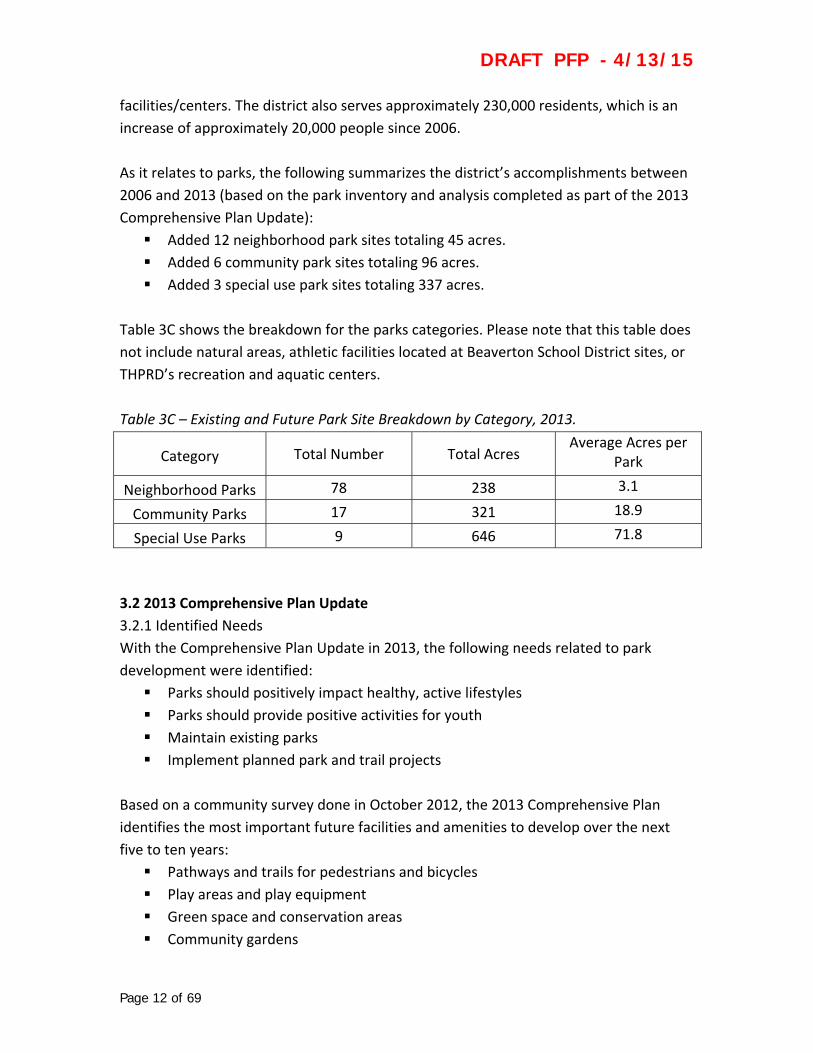
Table 3C shows the breakdown for the parks categories. Please note that this table does
not include natural areas, athletic facilities located at Beaverton School District sites, or
THPRD’s recreation and aquatic centers.
Table 3C – Existing and Future Park Site Breakdown by Category, 2013.
Category Total Number Total Acres Average Acres per
Park
Neighborhood Parks 78 238 3.1
Community Parks 17 321 18.9
Special Use Parks 9 646 71.8
3.2 2013 Comprehensive Plan Update
3.2.1 Identified Needs
With the Comprehensive Plan Update in 2013, the following needs related to park
development were identified:
Parks should positively impact healthy, active lifestyles
Parks should provide positive activities for youth
Maintain existing parks
Implement planned park and trail projects
Based on a community survey done in October 2012, the 2013 Comprehensive Plan
identifies the most important future facilities and amenities to develop over the next
five to ten years:
Pathways and trails for pedestrians and bicycles
Play areas and play equipment
Green space and conservation areas
Community gardens

DRAFT PFP - 4/13/15
Page 13 of 69
Picnic areas and shelters
Dog parks
These findings from the 2013 Comprehensive Plan Update were also supported based
on findings from a fall 2014 survey of park users throughout the district. This included:
Top five reasons to visit parks:
exercise (79%)
nature / wildlife (56%)
play area / play equipment (48%)
dog park / dog walking (26%)
picnicking (24%)
Top five amenities or comforts desired in parks:
restrooms (68%)
drinking fountain (52%)
seating (47%)
parking (43%)
landscaping (38%)
Top five maintenance activities for parks:
timely repair of damaged park features (78%)
litter & debris removal (71%)
prompt graffiti removal (35%)
regularly mowed and irrigated grassy areas (31%)
water conservation practices (31%)
Top five prioritization considerations for developing parks:
number of overall residents served (47%)
cost of development (43%)
available funding sources (39%)
within a 10‐minute walk time from residence (37%)
community support (36%)
Full survey results can be found in Appendix 7.4.
3.2.2 Standards and Expectations
Park classifications of neighborhood, community and special use remained unchanged
with the 2013 Comprehensive Plan Update. However, some parks were reclassified to
DRAFT PFP - 4/13/15
Page 14 of 69
better meet their current function (e.g., John Marty Park was reclassified from a linear
park to a neighborhood park).
As part of the 2013 Comprehensive Plan Update, all THPRD parks and facilities were
inventoried, analyzed and scored based on their individual and cumulative components,
amenities and attributes. This analysis resulted in the establishment of a scoring process
to determine a desired level of service on a neighborhood and community scale. More
details on this analysis are provided below.
3.3 LOS Scoring Criteria
3.3.1 Scoring Criteria
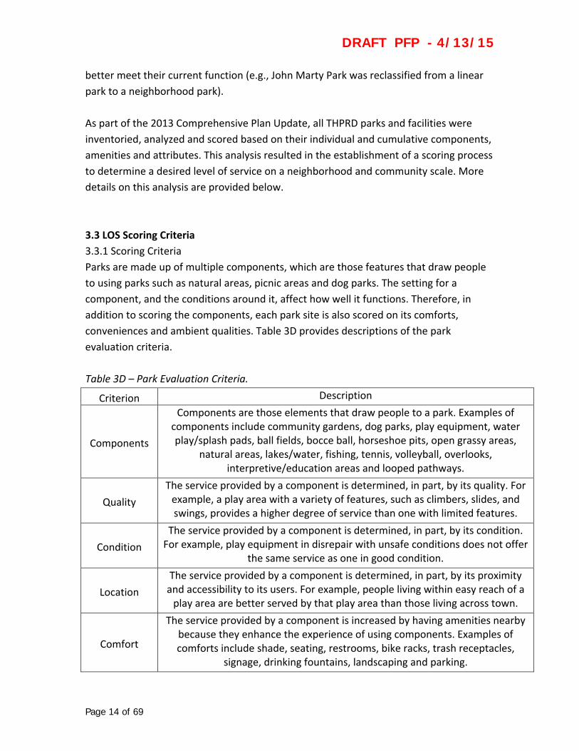
Parks are made up of multiple components, which are those features that draw people
to using parks such as natural areas, picnic areas and dog parks. The setting for a
component, and the conditions around it, affect how well it functions. Therefore, in
addition to scoring the components, each park site is also scored on its comforts,
conveniences and ambient qualities. Table 3D provides descriptions of the park
evaluation criteria.
Table 3D – Park Evaluation Criteria.
Criterion Description
Components
Components are those elements that draw people to a park. Examples of components include community gardens, dog parks, play equipment, water play/splash pads, ball fields, bocce ball, horseshoe pits, open grassy areas,
natural areas, lakes/water, fishing, tennis, volleyball, overlooks, interpretive/education areas and looped pathways.
Quality
The service provided by a component is determined, in part, by its quality. For example, a play area with a variety of features, such as climbers, slides, and swings, provides a higher degree of service than one with limited features.
Condition
The service provided by a component is determined, in part, by its condition. For example, play equipment in disrepair with unsafe conditions does not offer
the same service as one in good condition.
Location
The service provided by a component is determined, in part, by its proximity and accessibility to its users. For example, people living within easy reach of a play area are better served by that play area than those living across town.
Comfort
The service provided by a component is increased by having amenities nearby because they enhance the experience of using components. Examples of comforts include shade, seating, restrooms, bike racks, trash receptacles,
signage, drinking fountains, landscaping and parking.

DRAFT PFP - 4/13/15
Page 15 of 69
Convenience The service provided by components is increased by having easy access to and
availability of comfort amenities.
Ambience
The service provided by a component is enhanced where there is a sense of safety and security, as well as pleasant surroundings, attractive views and a
sense of place.
Components are scored using the following three‐tier rating system to establish a base
score (Table 3E).
Table 3E – Park Rating Classification.
Symbol Description Value
B Below expectations 1
M Meets expectations 2
E Exceeds expectations 3
Taking into consideration the above criteria, as well as proximity to trails, multipliers are
then added to the base score. These individual component scores are then combined to
establish an overall score for specific park sites. This analytical scoring technique, known
as Composite‐Values Methodology (CVM), is used to establish level of service provided
by parks throughout the district.
More detailed information on the scoring criteria and analysis process can be found in
the 2013 Comprehensive Plan Update and in Appendix 7.2.
3.3.2 What the Scoring Means
Based on the 2013 Comprehensive Plan Update inventory and scoring of park sites, level
of service (LOS) values have been identified for district needs at both a neighborhood
and community level. Table 3F highlights these LOS considerations.
Table 3F – Park Level‐of‐Service (LOS) Considerations.
Category LOS Consideration
Neighborhood
In general, addresses access to parks and recreation facilities, and is primarily based on the number of unique components and quality of
those components
Community Addresses the two neighborhood factors, but also considers the
quantity of each component

DRAFT PFP - 4/13/15
Page 16 of 69
To establish an overall LOS for a park, each park component is given a value (as
identified in Table 3E above), which is then used to calculate a cumulative score (taking
into account the multipliers described in Table 3D above) for each park site in the
inventory (these scores are presented in Appendix 7.1). The outcome of this analysis,
highlighted in the 2013 Comprehensive Plan Update, established an average value for
neighborhood LOS and community LOS, and represents the desired LOS expectation for
district parks as follows:
Neighborhood LOS = 75
Community LOS = 168
For purposes of the analysis, a one‐mile “buffer” was placed on all components to
evaluate a park’s neighborhood LOS. This represents a distance from which convenient
access to the park can be achieved by normal means (such as driving, bicycling, or
walking). An additional one‐half mile buffer was used, which represents a distance that
a resident can reasonably walk in ten minutes. As a result, scores are doubled within the
one‐half mile buffer to reflect the added value of walkable proximity, since most healthy
individuals can reach a location on their own by walking.
A three‐mile buffer was placed on all components to evaluate a park’s community LOS,
because it is assumed that users are willing to travel farther (approximately ten minute
drive times) to reach the types of components providing a community‐oriented service.
Scoring for a park’s community LOS also takes into consideration the total number of
the same component, not just the type of component (i.e., four tennis courts or two
multi‐purpose sports fields).
The intent is to achieve a neighborhood LOS score of 75 over the entire THPRD service
area and to ensure district residents have access to those components typically found in
a park. Whether this is achieved at an individual park site or at multiple park sites within
their neighborhood, the key to success is the provision of easily accessible park and
recreation opportunities throughout the district.
A more detailed description on how the park LOS evaluation and scoring process works
can be found in the 2013 Comprehensive Plan Update and Appendix 7.2 of this PFP.
3.4 Inventory of Park Sites
3.4.1 Cumulative Scoring
The tables in Appendix 7.1 illustrate the scoring results from the 2013 Comprehensive
Plan Update. Those scores are intended to serve as a baseline and help the district

DRAFT PFP - 4/13/15
Page 17 of 69
prioritize how existing parks can be improved and how new parks can be developed.
However, it is important to note that not all parks will be able to meet the
neighborhood LOS threshold due to site constraints or other development restrictions.
The district currently has three sites (HMT Recreation Complex, PCC Rock Creek
Recreational Facility, and Cedar Hills Park) meeting the community LOS threshold of
168. The majority of the district’s community and special use parks range between 90
and 155 and have the potential for increased LOS. Since not all parks can meet the
community LOS threshold, these scores are not being considered in this plan because
the district’s emphasis is on improving neighborhood LOS and walkable access for the
residents these sites serve.
3.4.2 Mapping
The following figures highlight the district’s neighborhood LOS as it currently stands.
These maps serve as the baseline and will be used to measure the district’s progress in
meeting its expectations.

Page
Figur
18 of 69
re 3A – 2014 System Mapp.
DRAFTT PFP - 4/13/15
5

Page
Figur
19 of 69
re 3B – Walkkable Access to All Recreation.
DRAFTT PFP - 4/13/15
5

Page
Figur
20 of 69
re 3C – Gaps in Walkablee Access to A
All Recreatio
DRAFT
on (Neighbor
T PFP -
rhood LOS).
4/13/15
5
DRAFT PFP - 4/13/15
Page 21 of 69
4. Future Conditions / Where We Want To Be
In order to achieve the level of service (LOS) expectations outlined in the previous
section, the district has identified the following guidelines related to development of
new parks and redevelopment or enhancement of existing parks. The district has also
established criteria to help in prioritizing where and how district resources are allocated
in addressing district park needs.
4.1 Minimum Expectations for New Parks
4.1.1 Land Acquisition
Minimum expectations for land acquisition generally relate to acquiring sites that are
suitable for development as a park and include the following:
Developable area of one acre or more if serving a neighborhood function
Developable area of eight acres or more if serving a community function
Relatively flat
Balanced mix of wooded / natural areas and open areas
Walkable access from surrounding neighborhoods
Where appropriate, consider recommendations and standards identified in the
Athletic Facilities Functional Plan stating where ball fields and sport courts are
needed or desired
Where appropriate, consider recommendations and standards identified in the
Natural Resources Functional Plan when natural areas are present
Where appropriate, consider recommendations and standards identified in the
Trails Functional Plan where trails occur or are planned to occur
Once land is acquired, notice is given to staff that new land has been brought into the
district and maintenance operations can begin (at a minimal level) until the site can be
prioritized, master planned and developed.
4.1.2 Neighborhood Park
In order to achieve a (LOS) score of 75, a park fulfilling neighborhood needs will
generally consist of the following:
Five components, i.e., play areas, sport courts, woodlands and dog parks
Comfort and convenience amenities, i.e., benches, restrooms and parking
Be within a ten minute walk from the neighborhood it serves
Walkable access that is not impeded by barriers, such as arterials, highways and
rail lines
Be within one‐half mile of a regional or community trail
DRAFT PFP - 4/13/15
Page 22 of 69
4.1.3 Community Park
In order to achieve a LOS score of 168, a park fulfilling community needs will generally
consist of all the things listed above plus:
An additional three to five components
Multiples of a single component, such as four tennis courts or two ball fields
Be within a ten minute drive time from the community it serves
Parks acquired through developer SDC credit projects or other partnerships are
expected to adhere to the same expectations outlined above.
4.2 Maintaining and Enhancing the Level of Service for Existing Parks
Based on the park inventory and scoring identified in the previous section, the district
can evaluate those park sites not meeting minimum expectations identified above. All
parks scoring low in LOS will be evaluated to determine what will be needed to improve
their overall LOS. Based on these evaluations, it can be determined what elements or
features are lacking in a specific park site and/or what opportunities exist to improve or
enhance that park. Upon completion of this evaluation process, existing parks can be
enhanced based on the park development prioritization criteria described below.
For example, a park having a low LOS score as a result of aging play equipment and lack
of a restroom, seating, and a drinking fountain could be enhanced by replacing the play
equipment and adding a restroom facility, benches, picnic tables and a drinking
fountain. The addition of enclosures around portable toilets where none currently exist
or the addition of shade trees around play and picnic areas is also another way to
improve overall LOS at low scoring parks.
Capital funds are typically prioritized for use in replacing existing components, while
other funding, such as grants and bond funds, can be spent on a wider array of
improvements and enhancements. The use of SDCs can only be used for capacity
improvements, and may not be used to renovate or replace existing components or
amenities.
Other examples of improving LOS include:
Overcoming barriers, such as arterials and rail lines, by purchasing land or
developing parks on both sides of the barrier in order to eliminate the barrier
DRAFT PFP - 4/13/15
Page 23 of 69
Re‐purposing underutilized components, such as basketball courts or tennis
courts, into something new, such as skate spots or street soccer/futsal courts
Modernize or “freshen up” well‐used areas, such as installing permanent ADA
accessible picnic tables and benches where they do not currently exist, to
improve park ambience
It should be noted that not every park will be able to meet the neighborhood LOS
threshold due to site size and/or site constraints, such as wetlands, topography or utility
encumbrances. In these situations, it will be important to utilize nearby park sites to
ensure neighborhood LOS thresholds are being met and district residents have walkable
access to a variety of park components. Ultimately, the end result is to meet the
desired neighborhood LOS threshold district‐wide, whether it is achieved by a single
park or multiple parks. The following map, Figure 4A, helps illustrate this concept.

Page
Figur
24 of 69
re 4A – 2014 Walkable AAccess to Standard Comp
DRAFT
ponents.
T PFP - 4/13/15
5

DRAFT PFP - 4/13/15
Page 25 of 69
Where multiple park sites are used, it is important that those parks provide a variety of
park components rather than all the same ones. If three parks are needed to meet the
LOS threshold of a neighborhood, each park should contain a unique component that
the others do not have. For example, while all three could include play equipment,
looped pathways and turf areas, the first could include a dog park, the second a
basketball court and the third a picnic pavilion.
4.3 Prioritization Criteria
The prioritization criteria was established, in part, through a community‐wide survey on
park development and maintenance, as well as input from THPRD’s citizen‐based
advisory committees and staff. These priorities will be implemented by the district’s
board of directors through the annual budgeting process. Priorities will largely be set
based on the funds that are available and applicable for each category (i.e. capital
funding to be used for replacement projects in existing parks). Based on this outreach
process, the following section provides information on how the district should allocate
resources related to park improvements throughout the district:
Buy More Land for Parks
Develop New Parks
Enhance Existing Parks
The fall 2014 survey indicated that respondents believed the district should allocate its
resources in the following order: 1) enhance existing parks, 2) develop new parks, and 3)
buy more land for parks. It should be noted, however, that while purchase of land for
new parks rated as the third priority for respondents, there may be extenuating
circumstances when land acquisition should take precedence to park development or
enhancement. Land acquisition is often driven by market conditions, a property owner’s
willingness to sell, partnerships and other factors. The district will continue to actively
pursue land for parks and recreation facilities in those areas where no service currently
exist (including current and future service areas). In areas currently served, the district
will be most interested in acquiring land adjacent to existing parks where LOS could be
increased as a result of a larger park site.
Priority consideration for land acquisition is the district’s future growth areas. It will be
important for the district to pursue land in those areas where service will eventually be
provided. However, while these areas may rank high in land acquisition priority, they
may in turn rank low in park development because they are located outside of the
district’s current service boundary. This would include areas such as North Bethany,

DRAFT PFP - 4/13/15
Page 26 of 69
South Cooper Mountain, and Bonny Slope West. Areas within the district’s current
service area having no service will also be a priority for land acquisition, but these areas
are often already developed, and sites large enough for parks are often difficult to find.
As part of the district’s process to update the Capital Improvement Program list and as
an element of the annual SDC budgeting process, the district’s board of directors will be
asked to prioritize the acquisition of land. As acquisition efforts progress, it may be
necessary to recalibrate the district’s priorities. For example, if many of the future park
and trail locations identified in community plans for the new urban areas have not been
secured, the board may find that acquiring land in those areas should take top priority.
Conversely, if many of the desired sites in those areas have been secured, the board
may wish to prioritize a 10‐15 year supply of land needs in the larger service area. As
noted above, these priorities can be adjusted and set by the board each year.
Table 4A represents sixteen (16) prioritization criteria that will be used to determine
how the district will use its resources for park development, whether it is enhancement
of existing parks or development of new parks. In order to better prioritize park projects
throughout the district, each criterion is weighted based on district policies and desired
outcomes. As projects arise, they will be scored and placed in “high”, “medium,” or
“low” priority areas. Projects scoring 36 or higher will be considered high priority.
Projects scoring 31 to 35 will be considered medium priority. Projects scoring 30 or less
will be considered low priority.
Table 4A – Park Development Prioritization Criteria Matrix.
Criteria Point Scale (3 = High / 1 = Low)
3 2 1
Available Funding (includes grant
eligibility)
Within 2 Years 2 to 5 Years More than 5 Years
Available Utilities & Infrastructure
On‐Site
Adjacent to Site (within right‐of‐way) or funded future
project
Not Adjacent or Available
Citizen‐Initiated Project Support
Generally Supported by Residents
Adjacent to Park
Generally Supported by the Community
At‐Large
Neutral or Generally Not Supported
Developable Acres More than 5 2 to 5 Less than 2
Land Use / Zoning Compatibility
Permitted Use & Compatible
Special / Conditional Use & Compatible
Not Allowed &/or Not Compatible

DRAFT PFP - 4/13/15
Page 27 of 69
Located in Environmental Justice* or Community
Development Block Grant Designated
Area
Within a Significantly Above
Average Area
Within an Above Average Area
Within an Average or Below Average
Area
Located in Existing THPRD Boundary
In‐District n/a Out‐of‐District
Number of Residents Served**
More than 1,000 500 to 1,000 Less than 500
Potential for Active / Programmed Recreation
More than 75% 30% to 75% Less than 30%
Potential for Informal / Leisure
Recreation
More than 75% 30% to 75% Less than 30%
Potential for Scenic / Natural Area Recreation
More than 75% 30% to 75% Less than 30%
Property Ownership District Owned
Non‐District Owned Having a Formal Agreement for Long‐Term Use
Non‐District Owned Having No Formal Agreement for Long‐Term Use
Proximity to Regional or
Community Trail
Within ½‐Mile ½‐Mile to 1‐Mile Over 1‐Mile
Site Access & Visibility
Street Frontage & Neighborhood Connection
Street Frontage Neighborhood Connection
Site Developability Minor Site Work Moderate Site Work Major Site Work
Staff Judgment
Does it make sense to develop a new park or enhance an existing park in this location?
Does this project fill a specific need or service? How long has this area had an unmet need?
How long has the district owned the property?
*based on information produced by Metro
**located within ½‐mile of project area (walkable access standard)

DRAFT PFP - 4/13/15
Page 28 of 69
In general, priority in meeting neighborhood park needs will be as follows:
Continue to ensure all residents are within one mile of a neighborhood park or
neighborhood park components of another district facility
Develop, improve and provide amenities within existing neighborhood park sites
that have been acquired but not yet developed
In general, priority in meeting community park needs will be as follows:
Continue to ensure all residents are within three miles of a community park or
special use facility that helps serve a community park
Develop, improve and provide amenities within existing community park sites
that have been acquired but not yet developed
4.4 Priority Areas
4.4.1 Land Acquisition for Park Sites
Generally speaking, areas of the district that currently have no service, as illustrated in
Figure 4B, will typically rank high in priority for land acquisition. Areas having some
service, but not to the district’s LOS expectation, will generally rank medium in priority,
while areas meeting current LOS expectations will generally rank low in priority. Areas
called out on the map indicate locations where THPRD is either likely to pursue land
acquisitions (North Bethany, Bonny Slope West, South Cooper Mountain) or unlikely to
pursue land acquisitions, often because the areas are already developed (e.g. the Nike
and Tektronix campuses, Red Tail Golf Course).

Page
Figur
29 of 69
re 4B – Gaps in Walkablee Access to AAll Recreatio
DRAFT
on, No Servic
T PFP -
ce Areas.
4/13/15
5
DRAFT PFP - 4/13/15
Page 30 of 69
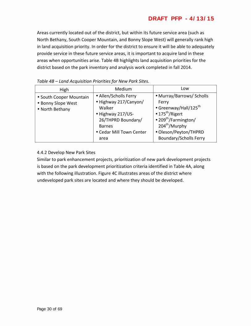
Areas currently located out of the district, but within its future service area (such as
North Bethany, South Cooper Mountain, and Bonny Slope West) will generally rank high
in land acquisition priority. In order for the district to ensure it will be able to adequately
provide service in these future service areas, it is important to acquire land in these
areas when opportunities arise. Table 4B highlights land acquisition priorities for the
district based on the park inventory and analysis work completed in fall 2014.
Table 4B – Land Acquisition Priorities for New Park Sites.
High Medium Low
South Cooper Mountain Bonny Slope West North Bethany
Allen/Scholls Ferry Highway 217/Canyon/ Walker Highway 217/US‐26/THPRD Boundary/ Barnes Cedar Mill Town Center area
Murray/Barrows/ Scholls Ferry Greenway/Hall/125th 175th/Rigert 209th/Farmington/ 204th/Murphy Oleson/Peyton/THPRD Boundary/Scholls Ferry
4.4.2 Develop New Park Sites
Similar to park enhancement projects, prioritization of new park development projects
is based on the park development prioritization criteria identified in Table 4A, along
with the following illustration. Figure 4C illustrates areas of the district where
undeveloped park sites are located and where they should be developed.

Page
Figur
31 of 69
re 4C – Gaps in Walkablee Access for AAll Recreatio
DRAFT
on, Future Pa
T PFP -
ark Priorities
4/13/15
s.
5
DRAFT PFP - 4/13/15
Page 32 of 69
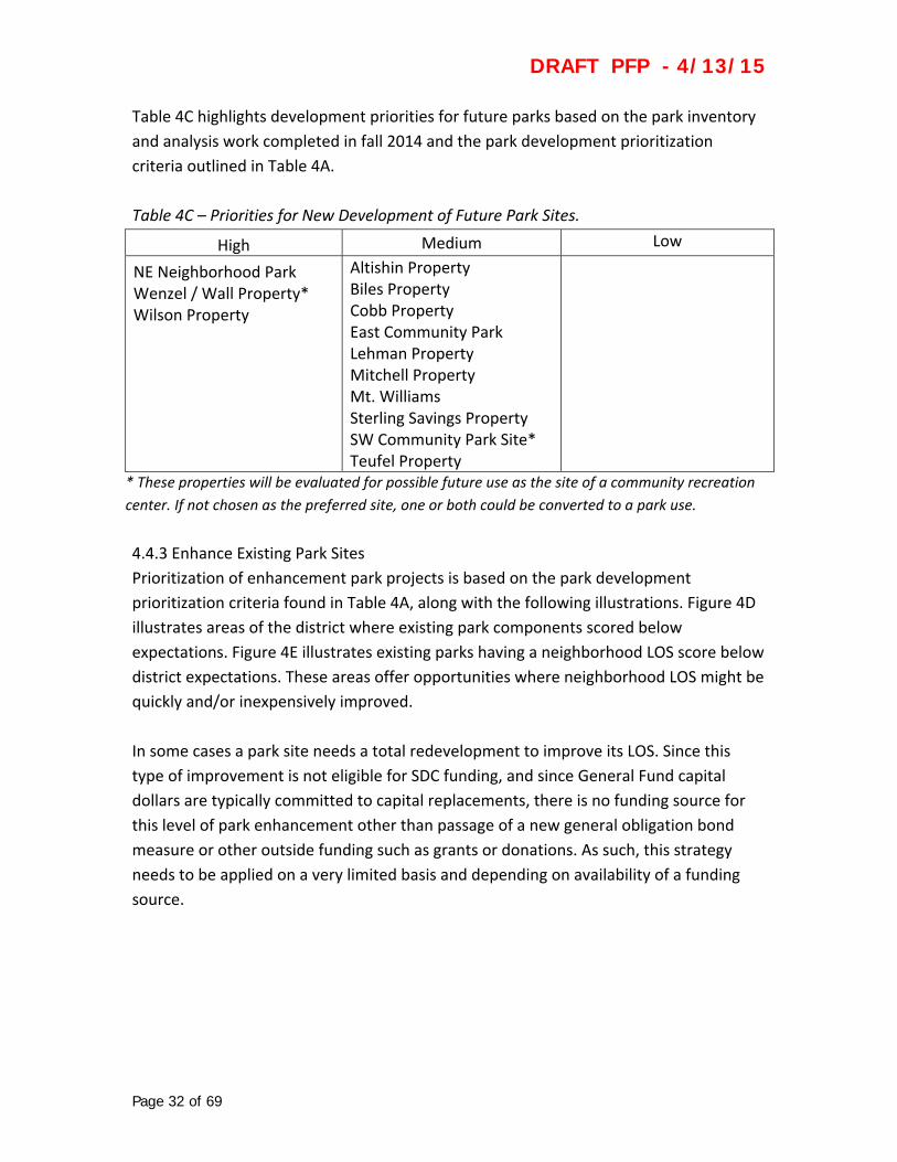
Table 4C highlights development priorities for future parks based on the park inventory
and analysis work completed in fall 2014 and the park development prioritization
criteria outlined in Table 4A.
Table 4C – Priorities for New Development of Future Park Sites.
High Medium Low
NE Neighborhood Park Wenzel / Wall Property* Wilson Property
Altishin Property Biles Property Cobb Property East Community Park Lehman Property Mitchell Property Mt. Williams Sterling Savings Property SW Community Park Site* Teufel Property
* These properties will be evaluated for possible future use as the site of a community recreation
center. If not chosen as the preferred site, one or both could be converted to a park use.
4.4.3 Enhance Existing Park Sites
Prioritization of enhancement park projects is based on the park development
prioritization criteria found in Table 4A, along with the following illustrations. Figure 4D
illustrates areas of the district where existing park components scored below
expectations. Figure 4E illustrates existing parks having a neighborhood LOS score below
district expectations. These areas offer opportunities where neighborhood LOS might be
quickly and/or inexpensively improved.
In some cases a park site needs a total redevelopment to improve its LOS. Since this
type of improvement is not eligible for SDC funding, and since General Fund capital
dollars are typically committed to capital replacements, there is no funding source for
this level of park enhancement other than passage of a new general obligation bond
measure or other outside funding such as grants or donations. As such, this strategy
needs to be applied on a very limited basis and depending on availability of a funding
source.

Page
Figur
Priori
33 of 69
re 4D – Gaps
ities.
s in Walkablee Access for All Recreatio
DRAFT
on, Low Scor
T PFP -
ring Park Co
4/13/15
omponent
5

Page
Figur
Priori
34 of 69
re 4E – Gaps
ities.
in Walkablee Access for AAll Recreatio
DRAFT
on, Low Scor
T PFP -
ring Neighbo
4/13/15
orhood Park
5

DRAFT PFP - 4/13/15
Page 35 of 69
Table 4D highlights enhancement priorities for existing parks based on the park
inventory and analysis work completed in fall 2014 and the park development
prioritization criteria outlined in Table 4A.
Table 4D – Priorities for Enhancement of Existing Park Sites.
High Medium Low
Bethany Lake Park Garden Home Park John Marty Park McMillan Park Somerset Meadows Park Willow Park
Bronson Creek Park Butternut Park Carolwood Park Center Street Park Cooper Park Fifth Street Park Florence Pointe Park Foege Park Forest Hills Park Griffith Park Harman SC & Park Hart Meadows Park Hazeldale Park Holland Park Kaiser Woods Park Melilah Park Mitchell Park Raleigh SC & Park Reservoir Park Ridgecrest Park Ridgewood Park Rock Creek Park Wanda L. Peck Memorial Park Waterhouse Park West Slope Park West Sylvan Park Wildhorse Park Wildwood Park
Fanno Farmhouse Park Little Peoples Park Raleigh Scholls Park Valley Park Valley West Park Veterans Memorial Park
Page
5. A
To fa
expec
estab
deve
sourc
fundi
5.1 St
5.1.1
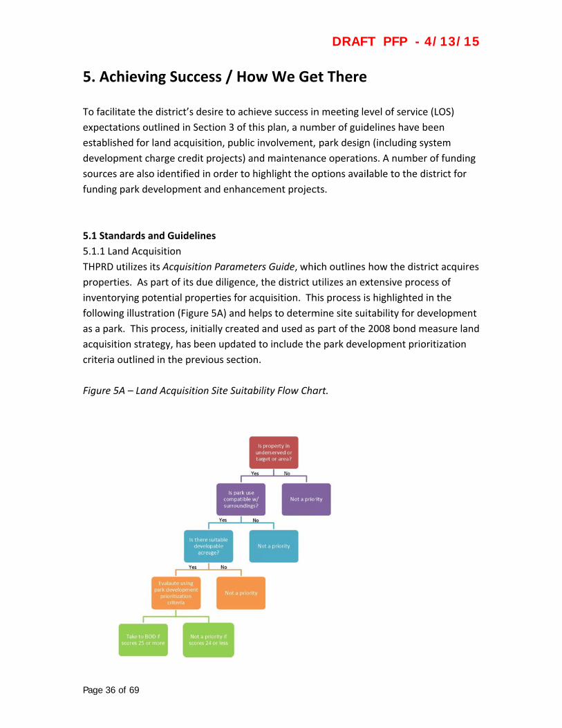
THPR
prope
inven
follow
as a p
acqui
criter
Figur
36 of 69
Achievin
cilitate the d
ctations out
blished for la
lopment cha
ces are also i
ing park dev
tandards an
Land Acquis
RD utilizes its
erties. As pa
ntorying pote
wing illustrat
park. This pr
isition strate
ria outlined
re 5A – Land
g Succes
district’s des
lined in Sect
and acquisiti
arge credit p
identified in
velopment an
nd Guideline
sition
s Acquisition
art of its due
ential prope
tion (Figure
rocess, initia
egy, has bee
in the previo
Acquisition
ss / How
sire to achiev
tion 3 of this
on, public in
projects) and
order to hig
nd enhancem
es
n Parameters
e diligence, t
erties for acq
5A) and hel
ally created a
n updated to
ous section.
Site Suitabil
w We Ge
ve success in
s plan, a num
nvolvement,
d maintenan
ghlight the o
ment projec
s Guide, whi
the district u
quisition. Th
ps to determ
and used as
o include th
lity Flow Cha
DRAFT
et There
n meeting le
mber of guid
park design
nce operation
options avail
cts.
ich outlines
utilizes an ex
his process is
mine site suit
part of the
e park deve
art.
T PFP -
evel of servic
delines have
n (including s
ns. A numbe
lable to the d
how the dist
xtensive pro
s highlighted
tability for d
2008 bond m
lopment pri
4/13/15
ce (LOS)
been
system
er of funding
district for
trict acquire
cess of
d in the
developmen
measure lan
oritization
5
g
es
t
d
DRAFT PFP - 4/13/15
Page 37 of 69
In addition to the flow chart, a number of questions are also asked when determining
acquisition and prioritization of potential park sites. These include the following:
Does it make sense to develop this site as a park? Does this site fill a specific need or service? Is this a unique opportunity? Can the site fulfill its intended purpose? What are potential costs for future park development (utilities & infrastructure,
site developability, etc.)? Does it serve a multipurpose opportunity for a park, natural area and/or athletic
facility, or is it just a park? Is it a key piece to expand an existing park?
As opportunities arise, properties will be scored and placed in “high”, “medium,” or
“low” suitability park sites.
5.1.2 Public Involvement
5.1.2.a Land Acquisition
Due to the confidential nature of land acquisition, public involvement does not occur
during site‐specific transactions. However, district residents are asked to participate in
broader planning efforts to help determine where new parks are needed. This process
follows the district’s Community Outreach Procedures, Policy 4.01.01.
5.1.2.b New Park Development
A master planning process is required of any new park development. This process
includes an extensive public involvement process, ensuring residents have opportunities
to provide feedback on design options and programming needs of a new park. This
process follows the district’s Community Outreach Procedures, Policy 4.01.01.
5.1.2.c Existing Park Enhancement
Unlike new park development, a master planning process is not always required when
changes are proposed to an existing park. Only in cases where major renovation of the
park or reprogramming of a park use is proposed would a master planning process be
utilized. This process would be the same as the process used for new park development.
When smaller changes to an existing park are proposed, such as installing permanent
picnic tables or fencing near a play area, a master planning process is not utilized.
Instead, informational materials and/or meetings are used to let the public know of
pending changes to the park. These are typically projects where minimal options are
available to solicit widespread public feedback.

DRAFT PFP - 4/13/15
Page 38 of 69
In either scenario, the district’s Community Outreach Procedures, Policy 4.01.01 is
followed.
5.1.2.d Encroachments
Whether identified through a master planning process or through routine maintenance
operations, encroachments will be handled per the district’s Encroachments on District
Property, Policy 4.02.01. If an encroachment is identified through a master planning
process for a new park project, the district will seek to have the encroachment
addressed prior to completion of the park improvements in order to ensure clearly
delineated park boundaries.
5.1.2.e Park Naming, Sponsorship and Memorials
Naming of park sites and other district facilities shall follow the district’s Naming of
District Property, Policy 5.01.01. In the case of sponsorships for athletic facilities or
special events located in park sites, the district’s Private Sponsorships, Policy 4.01.02
shall be adhered to.
In many instances the district is approached about the placement of memorial benches,
trees, boulders and other items to be located in parks. Whenever possible, these
features should be included as part of a master planning effort for development of new
parks and enhancement of existing parks. In all cases, such memorials shall follow the
district’s Memorials and Tributes, Policy 4.01.04.
5.1.2.f Property Disposition
There may be instances when the district acquires land for new park development or
existing park enhancement and it becomes necessary to sell a portion of such property
or enter into an exchange of property with another party when the result of such action
provides a greater benefit to the district.
For example, the district may purchase a residence on an oversized lot adjacent to an
existing park in order to improve access to that park. The district may decide to partition
or perform a lot line adjustment in order to sell the portion of the property with the
house and use any proceeds from the sale for improvements to the park, or to
reimburse the district’s land acquisition fund.
Another example may be that the district owns property and enters into an agreement
with an adjacent property owner to swap a portion of the property that provides a
mutual benefit to both parties. Likely reasons for such an agreement would be improved
DRAFT PFP - 4/13/15
Page 39 of 69
development suitability for park improvements (i.e., flatter topography or less
environmentally sensitive areas) in exchange for street frontage or visibility. The result
of the land swap does not generally change the overall park size or location from what it
was before the land swap occurred.
5.1.3 Park Design
In order to ensure a high level of service for its users, THPRD has established guidelines
for typical park features, comforts and conveniences. The following guidelines are
intended to ensure high quality and minimal long‐term maintenance costs for district
residents. District standards, including preferred vendors, products, model numbers and
other specific information, are not included as part of the PFP because these standards
are ever‐evolving. However, this information is available upon request from the
Planning & Development Department.
5.1.3.a Site Furnishings
Site furnishings are fundamental to any park and include, but are not limited to, seating,
picnic areas, restrooms and kiosks. Typical materials used for site furnishings include
recycled plastic lumber, re‐purposed wood, and metal. Other materials may be
considered on a project‐specific basis. The following design guidelines must be
considered anytime site furnishings are to be located in a park site.
Seating
o May include benches, seat walls, boulders or other features designed for
park users to sit
o Typically located near play areas, viewing areas / overlooks, plazas, park
entries, sport courts, ball fields, along pathways and other high use park
components
o Should provide space for strollers and wheelchairs, located outside of
adjacent pathways, whenever possible
o Seat walls shall include “skate stops” as appropriate
Picnic tables
o May include permanent or temporary/movable tables
o Typically located near play areas, pathways and other similar park
components
o Should provide space for strollers and wheelchairs, locate outside of adjacent
pathways, whenever possible

DRAFT PFP - 4/13/15
Page 40 of 69
Trash receptacles
o Typically located near picnic areas, play areas, park entries and other similar
park components, but not directly adjacent to picnic tables and sitting areas
o Should be located for ease of maintenance service and access
Bike racks
o Typically located near play areas, plazas, park entries and other similar park
components as appropriate
o Should be located in a manner that does not impede park users using
pathways, plazas, park entries or other high use pedestrian areas
Drinking fountains
o Typically located near picnic areas, play areas, sport courts, ball fields and
other similar park components
o New drinking foundations must include pet bowl and jug filler options
o Should consider use of dual basins in high use areas
o Should be located for ease of maintenance service and access
Bollards
o May include permanent, removable, collapsible or other site elements, such
as boulders or logs
o Typically located near park entries where pathways connect to transition
ramps at sidewalks, parking areas, drive aisles or streets
o Where maintenance access is needed, removable or collapsible bollards shall
be used at park entries and pathways as appropriate
o Decorative bollards may be used in locations where a higher level of design
detail is desired, such as at main park entries or plazas
o Consider use of reflective tape where bollards are located in pathways that
are located in high use areas or that function as trails
Doggie bag dispensers
o Typically located near primary park entries, dog park entries and other
similar park components as appropriate
o Should be located near trash receptacles and may be mounted on a sign
post, fence or other surface as appropriate

DRAFT PFP - 4/13/15
Page 41 of 69
Picnic shelters
o Typically located near parking areas, play areas and other similar park
components as appropriate
o Should be large enough to accommodate six (6) permanent picnic tables,
include two (2) ADA picnic tables
o May include security lighting and power source (outlets), and should consider
the use of solar power when provided
o Placement of trash receptacles and barbecue grills should be adjacent to the
picnic shelter but not directly underneath it’s roof
o May serve as an artistic element customized to the site
o Should be located for ease of maintenance service and access, and with clear
sight lines from park entries for security
Restrooms
o May be permanent or temporary (portable) based on park classification, use
and/or programming, such as community gardens, sports or picnic shelters
o Typically located near park entries, picnic areas, sport courts, sport fields and
other similar park components
o Permanent restrooms should include security measures to prevent after
hours use if located at a non‐staffed district site
o Permanent restrooms should include a family restroom facility in addition to
male/female facilities
o Temporary restrooms may include a permanent enclosure
o Enclosures may serve as an artistic element to the site
o Should be located for ease of maintenance service and access, and with clear
sight lines from park entries for security
Kiosks
o Typically located at parks that also serve as a trailhead or at community or
special use parks having high use as a result of programming and/or activities
Artwork
o Should be considered in the overall design of the park site, as appropriate,
and can be incorporated as part of the site furnishings (benches, kiosk,
portable toilet enclosure, etc.); as park components (play equipment, picnic
shelter, etc.); as stand‐alone elements (bridge, sculpture, mural, etc.); or as
educational features (interpretive elements, environmental features, etc.)

DRAFT PFP - 4/13/15
Page 42 of 69
5.1.3.b Play Areas
Play areas are an important component to any park site and the following items must be
considered whenever play areas are included.
Play equipment
o Typically located having clear sight lines from park entries, picnic areas and
other high use components
o Typically includes play elements for all ages and abilities (including swings),
although may be separated depending on size of play area
o Typically includes play elements of varying styles and skill levels
o Should be located for ease of maintenance service and access
Safety surfacing
o Typically includes rubberized surfacing or engineered wood fiber (EWF)
o Typically will be contained by curbing or other edging material
o Shall comply with all national and industry safety standards
Accessibility
o Play areas and equipment should be all inclusive, to the greatest extent
possible, providing play elements for all age and abilities, including mobility,
visual, audio and cognitive features
o Where EWF is used, transition ramp shall be provided to permit access from
pathways to the play area
Drainage
o Shall provide a subsurface drainage system under safety surfacing and shall
daylight away from play area as appropriate
o Ensure positive surface drainage away from play equipment and other
surface play elements
Spatial relationship to other park components
o Typically located having clear sight lines from park entries, picnic areas and
other high use components
o Avoid locating adjacent to ball fields, sports courts or other active/
programmed uses as appropriate to reduce user conflicts (refer to the
Athletic Facilities Functional Plan for additional information)
o Avoid locating in stands of large, mature trees where tree litter and debris
may be cause for safety and/or maintenance concerns

DRAFT PFP - 4/13/15
Page 43 of 69
Nature play
o Typically located in parks having greater areas of natural features, such as
woodlands, steep slopes and water courses
o Typically include boulders, logs or other natural elements and use of such
elements should be considered when site conditions are appropriate
o Should use materials found on site or nearby sites to utilize unique features
of the site
o Can be mixed with typical play areas or developed as stand‐alone park
components refer to the Natural Resources Functional Plan for additional
information
5.1.3.c Accessibility
All parks, their components and the comforts and conveniences within them shall be
designed to be fully accessible for park users of all ages and abilities to the greatest
extent possible. While it is understood that not every portion of a park site may be ADA
accessible, every effort should be made to ensure all intended experiences of that park
site are made available to all park users. Accessibility is a critical piece for any district
park site or facilities and the following items must be considered.
Mobility
o Transitions shall be provided at all park entries where ADA access is provided
or will be provided
o Adequate space shall be provided adjacent to benches, picnic tables and
other seating areas for mobility devices
o Provide railings and landings or pullouts whenever steep slopes occur on
pathways for long or extended stretches
Visibility
o Where transition ramps occur at park entries or other locations within a
park, black tactile warning strips shall be used to create a high level of
contrast
o Where transition ramps occur within street right‐of‐ways, yellow tactile
warning strips shall be used unless otherwise required by the agency with
jurisdiction
o Park component elements and site furnishings should take into consideration
use of color schemes that promote easy visibility and/or contrast from
adjacent park features

DRAFT PFP - 4/13/15
Page 44 of 69
5.1.3.d Pathways
Pathways are intended to provide opportunities for access and exercise internally within
a park site and therefore the following items must be considered. Additional
information can be found in the Trails Functional Plan and the Natural Resources
Functional Plan related to pathways.
Hard surface
o Typically are asphalt or concrete
o Typically are five (5) feet wide, but wider widths should be considered in high
use areas
o Concrete is typically used in areas near parking areas, park entries, plazas,
picnic shelters and other high use areas of a park
o Asphalt is typically used for main and looped pathways within a park or
connections to park components from a main pathway
o Use of pervious pavement should be considered
Soft surface
o Typically are crushed rock, bark chips or bare earth
o Typically are three (3) feet wide, but wider widths should be considered in
high use areas
o Crushed rock shall include a binding agent when located in high use areas to
provide greater stabilization
o Should consider use of edging material, especially with crushed rock, to keep
material contained for ease of maintenance
o Use of bark chips should be avoided where wet site conditions are commonly
found
5.1.3.e Signage
All signage proposed at park sites shall adhere to the district’s approved Signage Master
Plan. The following list represents signage most commonly found at park sites
throughout the district.
Identification
o Typically includes the A1 sign type at neighborhood park sites; A2 sign type at
community and special use parks; and A3 sign type at all park sites
o A1 and A2 signs are located at the main park entry, are perpendicular to the
street and may be located in a landscape bed
o A3 signs are located at secondary park entries; include a R1 sign and doggie
bag dispenser; are offset at least two (2) feet from the edge of the entry
pathway and/or sidewalk; and may be located in a landscape bed
DRAFT PFP - 4/13/15
Page 45 of 69
Regulatory
o Typically includes the R1 sign type at all park sites, although other regulatory
signs may be applicable, such as for sport courts, ball fields or dog parks, if
such park components are present
o R1 signs are typically located at all park entries and can be combined with A3
signs and doggie bag dispensers as appropriate
o All other regulatory sign types are located at the appropriate park
component(s) within the park
Informational
o Typically includes interpretive signage, although other signage may be
applicable
o Interpretive signs are typically used when unique site features or educational
characteristics exist and must adhere to the district’s interpretive signage
program as administered by its natural resources department
5.1.3.f Lighting
Due to the district’s regular operating hours from dawn to dusk at its neighborhood
parks, lighting is generally not provided. However, there are instances when lighting is
necessary and the following items must be considered on those occasions when lighting
is used.
Pathways
o Typically are pedestrian‐scaled, pole‐mounted lamps or ornamental bollards
o Other lighting styles may be considered depending on the intent of their use
Parking areas
o Typically are limited to use in off‐street parking areas
Security
o May be included with picnic shelters and permanent restrooms as
determined by the district’s superintendent of security operations
5.1.3.g Parking
Like lighting, parking is typically not provided at neighborhood parks. However, there
may be instances when parking is needed; therefore the following items need to be
considered when parking is provided.
On‐street
DRAFT PFP - 4/13/15
Page 46 of 69
o Typically the most common type of parking available
o Need to consider relationship between park components and street frontage
(i.e. routes from street to community garden or picnic shelter)
Off‐street
o Typically provided as required by park programming needs or as designated
in the Athletic Facilities Functional Plan
o Should be located to minimize conflicts with nearby park components
Bicycle parking
o Typically located at main park entries, play areas, plazas and other high use
park components
o Should be located in a manner that does not impede park user pedestrian
movements
o Should consider bike access to a park from streets, parking areas and/or trails
o Refer to 5.1.3.a site furnishings for details about bike racks
Half‐street improvements
o Typically required when no sidewalk or curb exists along a park’s street
frontage and shall be designed to meet all regulatory requirements
o When required, improvements should be incorporated into the overall park
design and provide for on‐street parking as appropriate
o Such improvements should be considerate of adjacent properties and street
frontages
5.1.3.h Fencing
Although fencing is not normally used at neighborhood parks, there are instances when
it becomes necessary to delineate property or natural area boundaries or for safety and
security purposes. Whenever fencing is used in a park site, the following fencing types
should be considered.
General considerations
o The district does not install fencing for property owners; in those instances
where it is required, the district shall place such fencing on the property
owner side of the property line and is not responsible for such fencing after
installation
o Fencing should be located within a mow strip as deemed necessary by the
maintenance department regardless of fencing type
DRAFT PFP - 4/13/15
Page 47 of 69
Split‐rail
o Typically used for site boundaries, natural areas and safety and is the
district’s preferred fencing type in most situations where delineation
between activities or uses is needed
o When used for site boundaries, should be placed on district side of the
property line for ease of maintenance
o Generally three (3) to four (4) feet tall having two (2) rails; fences having
three (3) rails are considered “heavy duty”
o Should be considered along pathways having steep downhill slopes
o Should be considered along street frontages where play areas are located
within 100 feet of a street
o Should be located within a bark mulch mow strip as appropriate
Chain‐link
o Typically used for site boundaries, natural areas and safety
o Generally three (3) to six (6) feet tall depending on situation
o Should be considered along street frontages, parking areas, pathways and
other high use areas where sport courts and ball fields are located; refer to
the Athletic Facilities Functional Plan for more details
o May be galvanized or vinyl‐coated depending on location; where vinyl‐
coating is needed, it should be black
o Consider use of privacy slats as appropriate
Wood plank
o When required. may be used for site boundaries
o Generally four (4) to six (6) feet tall
o Should consider “good‐neighbor” fencing when located along park
accessways or as otherwise appropriate
Field fencing
o Typically used for natural areas
o Generally two (2) to five (5) feet tall
o Should be considered along natural areas where access by park users is not
desired, such as mitigation or restoration areas
o Generally used on a temporary basis

DRAFT PFP - 4/13/15
Page 48 of 69
Ornamental / decorative
o Ornamental or decorative fencing may be considered in those instances
where a higher level of design is desired, such as plazas or main park entries
5.1.3.i Landscaping
The following items must be considered for landscaping occurring within district park
sites. Use of native and drought tolerant species should be considered whenever
possible, especially in locations where irrigation is not provided.
Locations
o Typically located at park entries, plazas, sitting areas and other appropriate
areas, often being an integral part of the park design
o Shall include native and drought tolerant plant species as appropriate, but
should consider ornamental plant species where irrigation is available
o Site entries typically include low‐growing shrubs, groundcovers and
perennials, and may include small ornamental trees as appropriate
o Activity areas typically include low‐growing shrubs, groundcovers and small
to medium sized ornamental or shade trees, and may include perennials in
regularly maintained areas having irrigation
o General site landscape typically includes medium to large shade trees in
groupings/massing or as stand‐alone specimen trees
o Existing landscaping and trees should be protected and incorporated into
park site development / enhancement / redevelopment whenever possible
Ornamental grasses
o Generally require minimal maintenance once established and are typically
used at park entries, plazas and other high use park areas
Groundcovers
o Typically used in areas where turf grass is not appropriate, such as on steep
slopes, and in planter beds where low foot traffic is anticipated
o Can consider use of ornamental plant species in high visibility areas, such as
main park entries, plazas and other similar areas, and when irrigation is
available
Shrubs
o Should consider ornamental plant species in areas where more visible to park
users, such as park entries, sitting areas and play areas, and where irrigation
is available

DRAFT PFP - 4/13/15
Page 49 of 69
o Should consider native plant species along park boundaries, natural areas
and other locations where buffers are needed
Trees
o Avoid the use of trees having excessive litter and debris in areas of high park
use, such as play areas, picnic areas, sport courts and ball fields
o Need to consider mature tree sizes when siting trees to ensure compatibility
with nearby park components
o Avoid placement of trees within ten (10) feet of pathways and sidewalks;
where trees are needed within ten (10) feet (e.g., street trees or plazas);
where applicable, follow the City of Beaverton Street Tree Standards
Low maintenance guidelines
o Avoid the use of plant species that produce excessive litter and debris, such
as fruit, pods or cones
o Avoid the use of plant species susceptible to wood rot or limb breakage
(“weak wooded”) in areas of high park use, such as play areas or picnic areas,
or near parking areas
o Avoid siting plant species that overhang pathways, sitting areas, play areas,
sport courts and other similar park components
o Trees located in open turf areas must have a “mow ring” around its trunk at
the time of planting
5.1.3.j Irrigation
Irrigation is generally used to help plants get established after their initial planting or
when turf areas are maintained for programmed activities, such as soccer. The district
monitors efficiency trends and irrigation systems and must consider the efficient use of
water in their design and operation. In the event that water supply is decreased, the
district will re‐evaluate its irrigation approach accordingly. Whenever irrigation is used
at a park site, the following items must be taken in account.
Shrub beds
o Shall be irrigated when water source is available
Turf areas
o Shall be irrigated when water source is available unless determined
otherwise by the maintenance department (based on intended programmed
use of the turf area)
DRAFT PFP - 4/13/15
Page 50 of 69
System components
o Typically includes, but is not limited to, controllers, wiring, valve boxes,
valves, piping and sprinkler heads
5.1.3.k Storm Water Management
Dealing with storm water runoff on‐site at district park sites and facilities has become
common practice and incorporated into overall park design. As such, the following items
need to be considered for storm water management at park sites.
Pervious surfaces
o Typically considered for use of pathways, plazas, parking areas and other
hard surfaced areas where feasible and includes the use of asphalt, concrete
or pavers depending on intended use
o Asphalt should be considered for lower use pathways or low‐use/ smaller
sized parking areas
o Concrete should be considered for higher use pathways, plazas, picnic areas
or moderate‐use parking areas
o Pavers should be considered for plazas, picnic areas or parking stalls where
drive aisles will be an impervious material
Bioswales / filtration strips
o Typically considered for use adjacent to plazas, parking areas, pathways,
sports courts and other hard surfaced areas
o Shall be planted in accordance to the guidelines set forth by Clean Water
Services Design and Construction Standards
Detention / retention ponds
o When such areas are desired or required, they shall be incorporated into an
overall park’s design and development, and shall be planted in accordance to
the guidelines set forth by Clean Water Services Design and Construction
Standards
Wetland mitigation / enhancement
o When such areas are desired or required, they shall be incorporated into an
overall park’s design and development, and shall be planted in accordance to
the guidelines set forth by regulatory agencies

DRAFT PFP - 4/13/15
Page 51 of 69
Vegetated corridor mitigation / enhancement
o When such areas are desired or required, they shall be incorporated into an
overall park’s design and development, and shall be planted in accordance to
the guidelines set forth by Clean Water Services Design and Construction
Standards
Low impact design alternatives
o It is the intent of the district to preserve natural areas, to the greatest extent
possible, as part of an overall park’s design and development and to
minimize development impacts to such areas as much as possible
o Typically includes the incorporation of smaller, integrated treatment
techniques scattered throughout the site rather than a large, single
treatment solution when space allows
o Refer to guidelines established by Clean Water Services
5.1.3.l Crime Prevention Through Environmental Design (CPTED)
Along with the desire of creating well‐designed parks to provide quality recreation and
green space opportunities for its residents, the district is also intent on ensuring the
safety and security of its parks and facilities. To help make this possible, the following
fundamental CPTED principles should be considered.
Access
o Establishment of clearly defined park entries and routes for park users to
easily pass through a park site
o Establishment of clearly defined park boundaries to differentiate between
public and private spaces
Visibility
o Maintain open sight lines throughout a park site in order to promote natural
surveillance and the “see and be seen” concept
5.1.3.m Sustainability
As the district strives to create, operate and maintain more sustainable parks and
facilities, the following principles should be applied whenever possible.
Materials found on site
o Shall incorporate the use of materials of the park site into the overall
development of the park as appropriate

DRAFT PFP - 4/13/15
Page 52 of 69
o Typically includes stone, wood or other natural site features for the use of
nature play areas, seating areas, artwork, landscape features, interpretive
elements or other such feature
Native / local materials
o Shall incorporate building and landscape materials and products
manufactured and distributed in the pacific northwest to the greatest extent
possible
Leadership in energy and environmental design (LEED)
o Encouraged to be incorporated into an overall park development as
appropriate
o For parks, this typically applies to buildings, such as permanent restrooms,
and lighting, such as all exterior and the control of spillover lighting onto
adjacent properties
Sustainable sites initiative
o Encouraged to be incorporated into an overall park development
Water conservation
o Irrigation systems should be efficiently designed to maximize water usage
with minimal water loss
o Irrigation systems should be taken off‐line once plant establishment has
occurred or when turf areas are no longer programmed for sports and other
activities
o Use of native and drought tolerant plants are highly encouraged
5.1.4 System Development Charges (SDC) Credit Projects
5.1.4.a Credits for Minimum Standards
Developer SDC credit projects are partnerships between a developer and the district to
develop park sites in lieu of having the developer pay SDC fees. This partnership is
described in more detail in section 5.2.3 below.
The district shall only provide credit for the minimum standards at which the district
would develop a park site. For example, when concrete is used for a loop pathway in
lieu of using asphalt, credit shall only be granted for the cost of using asphalt. Additional
costs associated with the use of concrete shall be borne by the developer of the project.
DRAFT PFP - 4/13/15
Page 53 of 69
Similarly, where a four (4) foot tall chain‐link fence is used where a split‐rail fence could
be used instead, credit shall be given for the cost of the split‐rail fence rather than the
chain‐link fence.
5.1.5 Maintenance Operations
Maintenance operations at district park sites fall into one of three categories: park
maintenance, athletic facilities maintenance, or natural resources maintenance.
Park maintenance provides for safe and open access opportunities for people to
recreate, play and enjoy the outdoors
Athletic facilities maintenance provides for safe and open access opportunities
for people to compete and play on sport fields and courts
Natural resources maintenance is intended to lessen human impacts and allow
natural processes to continue, while providing safe access for people where
appropriate
Please refer to the Athletics Facilities Functional Plan for additional information relating
to athletic facilities maintenance and the Natural Resources Functional Plan for
additional information relating to natural resources maintenance. Park maintenance
operations are identified as follows:
5.1.5.a General Considerations
Park maintenance is performed in a zone management structure with eight park
zones and two trail zones. Zone maps and weekly site schedules are updated
and available at www.thprd.org
Park maintenance and operation standards and guidelines are taken from
THPRD’s Maintenance Standards Manual and should be referenced for the most
current maintenance and operations practices
5.1.5.b Frequency of Operations
Frequency of park maintenance is determined by service levels established for
park sites, as shown below in Table 5A
Routine park maintenance operations are seasonally dependent, but are
typically consistent for approximately eight (8) to nine (9) months out of the year
Park maintenance operations during the winter months are typically project
based, but also include winterization and spring preparation of assets and
landscapes
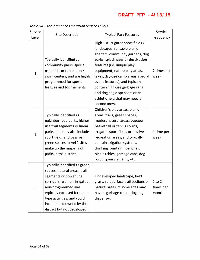
DRAFT PFP - 4/13/15
Page 54 of 69
Table 5A – Maintenance Operation Service Levels.
Service
Level Site Description Typical Park Features
Service
Frequency
1
Typically identified as
community parks, special
use parks or recreation /
swim centers, and are highly
programmed for sports
leagues and tournaments.
High‐use irrigated sport fields /
landscapes, rentable picnic
shelters, community gardens, dog
parks, splash pads or destination
features (i.e. unique play
equipment, nature play areas,
lakes, day‐use camp areas, special
event features), and typically
contain high‐use garbage cans
and dog bag dispensers or an
athletic field that may need a
second mow.
2 times per
week
2
Typically identified as
neighborhood parks, higher
use trail segments or linear
parks, and may also include
sport fields and passive
green spaces. Level 2 sites
make up the majority of
parks in the district.
Children’s play areas, picnic
areas, trails, green spaces,
modest natural areas, outdoor
basketball or tennis courts,
irrigated sport fields or passive
recreation areas, and typically
contain irrigation systems,
drinking fountains, benches,
picnic tables, garbage cans, dog
bag dispensers, signs, etc.
1 time per
week
3
Typically identified as green
spaces, natural areas, trail
segments or power line
corridors; are non‐irrigated,
non‐programmed and
typically not used for park‐
type activities; and could
include land owned by the
district but not developed.
Undeveloped landscape, field
grass, soft surface trail sections or
natural areas, & some sites may
have a garbage can or dog bag
dispenser.
1 to 2
times per
month

DRAFT PFP - 4/13/15
Page 55 of 69
5.1.5.c Typical Park Maintenance Duties
Park maintenance strives to keep their field staff on a regular maintenance routine for
efficiency purposes, yet emergency response is unavoidable. Examples of both are as
follows:
Routine park maintenance duties:
o Trash removal
o Dog bag dispenser stocking
o High production mowing
o General landscape practices
o Safety inspections and reports
o Irrigation system maintenance
o Pesticide application
Emergency response maintenance duties:
o Vandalism repair
o Graffiti removal
o Safety response
o Hazard tree / storm response
o Snow / ice removal
5.1.5.d Support Services
Park maintenance provides a level of support for other district functions, such as
identified below.
Special events
Community events
Picnic shelter rentals
5.2 Funding
5.2.1 Capital Improvement Program (CIP)
The district’s capital improvement program (CIP) is a combination of deferred
maintenance capital projects and SDC development projects (new parks or existing park
enhancements). Additionally, the list takes into account the project priorities outlined in
Section 4.4 List of Priority Areas of this PFP. Projects in the CIP are then funded through
the district’s budgeting process with either general funds or SDC funds. Grants,
partnerships, donations and volunteers may also be solicited to help fund projects
identified in the CIP in an effort to maximize district resources.
DRAFT PFP - 4/13/15
Page 56 of 69
As stated above, the two primary funding streams available to deliver projects on the
CIP are:
5.2.1.a Property Taxes / General Fund
The district’s primary funding source is property tax revenues. These revenues go into
the district’s general fund and are then allocated for capital projects and maintenance
operations on an annual basis. These funds are typically prioritized toward capital
replacements.
5.2.1.b. System Development Charges / SDC Fund
The district’s secondary source of funding for park improvements comes from its system
development charges (SDC) fund. Since 1997 the district has collected fees on new
residential and commercial development occurring within its service area. These fees
can only be used for new park development or improvements to existing parks to
expand capacity necessitated by new development. SDC funds cannot be used for
capital replacement or maintenance purposes.
5.2.2 Developer SDC Credit Projects
In lieu of paying SDC fees at the time of development, developers may enter into a
memorandum of understanding (MOU) to construct park improvements in the amount
of estimated SDC fees that would normally be charged. The MOU outlines specific park
improvements to be constructed for which credit will be issued. The MOU also includes
language to ensure that such park improvements meet district design standards and
guidelines.
5.2.3 Grants
Multiple grant opportunities exist for funding of park improvements, in part or wholly.
Grant sources include private foundations, such as the United State Tennis Association,
and public agencies, such as the Oregon Parks and Recreation Department. Grants can
be used to acquire land, fund an entire park development and/or just a portion of a
park, such as play equipment, picnic shelter, or sports court. Grants can also be used for
new park development or enhancement of existing parks and facilities. The district will
typically use SDC funds as a local match in order to leverage grant funds.
5.2.4 Donation / Volunteer / Partnership
In certain instances, park improvements are donated to the district or provided to the
district. This could include land, materials, products, and/or labor for the construction or
installation of park improvements. In most instances, this occurs in conjunction with
DRAFT PFP - 4/13/15
Page 57 of 69
improvement projects of other public agencies, such as Beaverton School District,
Tualatin Valley Water District, or the City of Beaverton. In some instances, park
improvements can come from private development or community groups seeking
improvements of park facilities of their neighborhoods.
5.2.5 Future Bond Funding
The district may pursue the issuance of bonds if approved by voters during a general or
special election. Bond funds can be used for a variety of projects based on how the bond
is crafted, including land acquisition, new park development, redevelopment of existing
parks, capital replacements or a combination of these items. Bond funds can be short‐
term or long‐term, and can be used for specific projects or many different projects.
DRAFT PFP - 4/13/15
Page 58 of 69
6. Success Monitoring / How Are We Doing?
6.1 Performance Measures
Traditional performance measures for park and recreation, typically monitored annually,
include things such as:
Acres of new park land acquired
Number of park master plans completed
Number of new park sites developed
Number of existing park sites enhanced
Number of capital replacement projects completed
While the district will monitor these items, they cannot be stand‐alone measurements
as many factors can influence targeted outcomes. Budget constraints, shifts in priorities,
environmental considerations and other such factors can impact the length of time to
complete projects or acquire land.
With an emphasis on improving walkable access to parks and improving district‐wide
neighborhood LOS scores, the district will also monitor the following items:
Ensure one‐half (½) mile walkable access, free of pedestrian barriers, to
neighborhood parks or park components and amenities at other district facilities
Create well‐designed parks that promote healthy active lifestyles and promote
positive activities for youth
Operate and maintain parks sustainably and efficiently with high standards
6.2 Monitoring Procedures
The district will use a variety of methods to monitor its successes, or shortfalls, in
achieving its expectations. Monitoring of expectations will occur on an annual basis or a
multi‐year basis depending on outcomes being monitored.
6.2.1 Short Term Monitoring
One of the easiest ways for the district to gauge whether it is increasing its
neighborhood LOS is through its annual maintenance inspection process. Each year all
district assets at its parks and facilities are evaluated and placed into the deferred
maintenance database. This database is used to help prioritize capital replacement
projects during the budgeting process. As replacement projects occur, often updating
park components and amenities, these items can be tracked against the park inventory

DRAFT PFP - 4/13/15
Page 59 of 69
database completed in the fall of 2014 and LOS scores can be adjusted to reflect these
improvements.
Park inventory scoring analysis can also be performed, independently or as part of the
maintenance inspection process, to determine increases or decreases in neighborhood
LOS by evaluating current conditions to the 2014 park inventory information.
Park user surveys are another way the district can monitor whether or not LOS
expectations are being met or if walkable access is improving. Although these types of
surveys are not scientific or statistically accurate, they do provide a method of getting
immediate feedback from the people in the parks.
6.2.2 Long Term Monitoring
Because projects such as master plans, new park development, and existing park
redevelopment often take more than one year to complete, it is more effective to
monitor for success on a two‐to‐three year basis. Tracking projects identified in the
district’s annual budget is one of the easiest ways to track progress, comparing projects
completed on time versus those that get delayed or eliminated.
Comprehensive park inventory and analysis work can be performed every five years to
update neighborhood and community LOS scores for the district’s park sites, as well as
to update the maps showing results of the inventory. This type of comprehensive
analysis confirms short term monitoring results and establishes new baselines for
moving forward.

DRAFT PFP - 4/13/15
Page 60 of 69
7. Appendix
7.1 Park Inventory and Level of Service (LOS) Scoring
The following tables summarize scoring for both neighborhood and community LOS at
the district’s park sites. Scores are based on the park inventory and analysis work
completed in fall 2014. More detailed information on individual park sites can be found
in the Inventory Atlas later in this appendix.
Table 7A – LOS for Neighborhood Park Sites.
Site Name Neighborhood Score Community Score
A.M. Kennedy Park 72.0 72.0
Arnold Park 22.0 22.0
Autumn Ridge Park 36.0 38.4
Barrows Park 54.0 54.0
Barsotti Park 61.2 61.2
Bethany Creek Falls Park Tbd Tbd
Bonny Slope Park 26.4 26.4
Bronson Creek Park 16.5 16.5
Buckskin Park 13.2 13.2
Burnsridge Park 13.2 13.2
Burntwood Park 17.6 17.6
Butternut Park 18.0 18.0
Carolwood Park 26.4 28.8
Cedar Mill Park 58.5 70.2
Center Street Park 33.0 41.8
Channing Heights Park 26.4 31.2
Cooper Park 16.8 16.8
Eichler Park 28.8 28.8
Fifth Street Park 6.0 6.0
Fir Grove Park 19.2 19.2
Florence Pointe Park 7.7 7.7
Foege Park 22.0 22.0
Foothills Park 26.4 26.4
Forest Hills Park 21.6 31.2
Garden Home Park 43.2 52.8
George W. Otten Park 28.8 28.8
Griffith Park 28.8 67.2
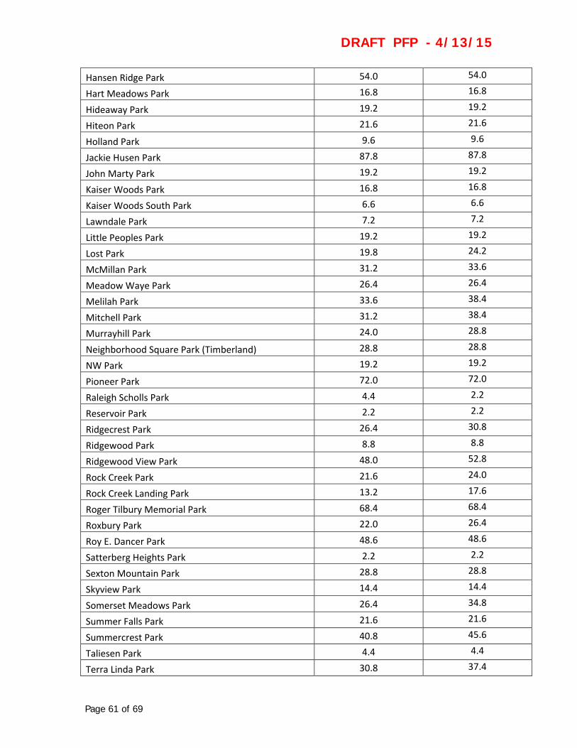
DRAFT PFP - 4/13/15
Page 61 of 69
Hansen Ridge Park 54.0 54.0
Hart Meadows Park 16.8 16.8
Hideaway Park 19.2 19.2
Hiteon Park 21.6 21.6
Holland Park 9.6 9.6
Jackie Husen Park 87.8 87.8
John Marty Park 19.2 19.2
Kaiser Woods Park 16.8 16.8
Kaiser Woods South Park 6.6 6.6
Lawndale Park 7.2 7.2
Little Peoples Park 19.2 19.2
Lost Park 19.8 24.2
McMillan Park 31.2 33.6
Meadow Waye Park 26.4 26.4
Melilah Park 33.6 38.4
Mitchell Park 31.2 38.4
Murrayhill Park 24.0 28.8
Neighborhood Square Park (Timberland) 28.8 28.8
NW Park 19.2 19.2
Pioneer Park 72.0 72.0
Raleigh Scholls Park 4.4 2.2
Reservoir Park 2.2 2.2
Ridgecrest Park 26.4 30.8
Ridgewood Park 8.8 8.8
Ridgewood View Park 48.0 52.8
Rock Creek Park 21.6 24.0
Rock Creek Landing Park 13.2 17.6
Roger Tilbury Memorial Park 68.4 68.4
Roxbury Park 22.0 26.4
Roy E. Dancer Park 48.6 48.6
Satterberg Heights Park 2.2 2.2
Sexton Mountain Park 28.8 28.8
Skyview Park 14.4 14.4
Somerset Meadows Park 26.4 34.8
Summer Falls Park 21.6 21.6
Summercrest Park 40.8 45.6
Taliesen Park 4.4 4.4
Terra Linda Park 30.8 37.4

DRAFT PFP - 4/13/15
Page 62 of 69
The Bluffs Park 26.4 26.4
Thornbrook Park 15.4 15.4
Valley Park 3.3 3.3
Valley West Park 3.3 3.3
Vista Brook Park 82.8 90.0
Wanda L. Peck Memorial Park 21.6 21.6
Waterhouse Park 40.8 40.8
West Slope Park 14.4 14.4
West Sylvan Park 13.2 17.6
Wildhorse Park 11.0 11.0
Wildwood Park 14.4 14.4
Willow Park 5.5 5.5
Wonderland Park 16.8 16.8
Table 7B – LOS for Community and Special Use Park Sites.
Site Name Neighborhood Score Community Score
Community Parks
Bethany Lake Park 36.0 36.0
Camille Park 82.8 104.4
Cedar Hills Park 181.4* 208.6*
Commonwealth Lake Park 90.0 90.0
Evelyn M. Schiffler Memorial Park 115.2 133.2
Greenway Park 110.4 115.2
Harman Park & Swim Center 21.6 24.0
Hazeldale Park 60.0 64.8
Paul & Verna Winkelman Park 93.6 115.2
Raleigh Park & Swim Center 36.4 59.8
Somerset West Park & Swim Center 111.6* 111.6*
SW Quadrant Community Park 129.6* 154.8*
Special Use Parks
Cooper Mountain Nature Park 90.0 90.0
Fanno Farmhouse 25.2 25.2
H.M. Terpenning Recreation Complex 200.4 298.8
Jenkins Estate 85.8 113.0
John Quincy Adams Young House 17.6 17.6
PCC Rock Creek Recreational Facility 148.2 273.0

DRAFT PFP - 4/13/15
Page 63 of 69
Progress Lake Park 30.8 37.4
Tualatin Hills Nature Park 101.4 109.2
Veterans Memorial Park 21.6 21.6
*based on funded anticipated improvements
Table 7C – LOS for Undeveloped Park Sites.
Site Name Neighborhood Score Community Score
Altishin Property 4.4 4.4
Biles Property 4.4 4.4
Lehman Property 4.4 4.4
NE Neighborhood Park 8.8 8.8
Mitchell Property 4.4 4.4
Sterling Savings Property 4.4 4.4
Wilson Property 4.4 4.4
Cobb Property 4.4 4.4
East Community Park 4.4 4.4
Mt. Williams Park 8.8 8.8
SW Community Park Site 8.8 8.8
Teufel Property 13.2 13.2
Wenzel / Wall Properties 4.4 4.4
DRAFT PFP - 4/13/15
Page 64 of 69
7.2 Addendum to 2013 Comprehensive Plan Update – Inventory Update, Walkability
Assessment and Prioritization
This addendum to the 2013 Comprehensive Plan Update summarizes the inventory of
park sites that was completed during the fall of 2014. Based on the full inventory of
district park sites, a walkability analysis was conducted to identify pedestrian barriers
(such as freeways, arterial streets, rail lines and waterways). This analysis shows which
areas of the district are underserved because pedestrian barriers make it difficult for
district residents to access parks. The addendum also makes recommendations on how
to overcome these barriers and improve neighborhood LOS.

DRAFT PFP - 4/13/15
Page 65 of 69
7.3 Inventory Approval Atlas, October 2014
The inventory atlas identifies the components and the comfort and convenience
amenities found at each of the district’s park sites. The atlas also contains scoring
information and comments or feedback for an entire park site, as well as the individual
components and amenities found in that park.
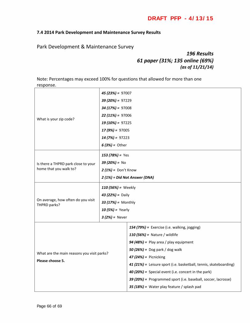
DRAFT PFP - 4/13/15
Page 66 of 69
7.4 2014 Park Development and Maintenance Survey Results
Park Development & Maintenance Survey 196 Results
61 paper (31%; 135 online (69%) (as of 11/21/14)
Note: Percentages may exceed 100% for questions that allowed for more than one response.
What is your zip code?
45 (23%) = 97007
39 (20%) = 97229
34 (17%) = 97008
22 (11%) = 97006
19 (10%) = 97225
17 (9%) = 97005
14 (7%) = 97223
6 (3%) = Other
Is there a THPRD park close to your home that you walk to?
153 (78%) = Yes
39 (20%) = No
2 (1%) = Don’t Know
2 (1%) = Did Not Answer (DNA)
On average, how often do you visit THPRD parks?
110 (56%) = Weekly
43 (22%) = Daily
33 (17%) = Monthly
10 (5%) = Yearly
3 (2%) = Never
What are the main reasons you visit parks?
Please choose 5.
154 (79%) = Exercise (i.e. walking, jogging)
110 (56%) = Nature / wildlife
94 (48%) = Play area / play equipment
50 (26%) = Dog park / dog walk
47 (24%) = Picnicking
41 (21%) = Leisure sport (i.e. basketball, tennis, skateboarding)
40 (20%) = Special event (i.e. concert in the park)
39 (20%) = Programmed sport (i.e. baseball, soccer, lacrosse)
35 (18%) = Water play feature / splash pad

DRAFT PFP - 4/13/15
Page 67 of 69
18 (9%) = Other
13 (7%) = Specialty activity (i.e. disc golf, horseshoes, bocce)
7 (4%) = DNA
4 (2%) = Community garden
What amenities or comforts do you prefer at the parks you visit?
Please choose 4.
134 (68%) = Restroom facility / portable toilet
102 (52%) = Drinking fountain
92 (47%) = Seating
84 (43%) = Parking
75 (38%) = Landscaping (i.e. shrub/flower beds & trees)
56 (29%) = Containers for recycling
46 (23%) = Picnic shelter
29 (15%) = Other
27 (14%) = Bike racks
10 (5%) = DNA
9 (5%) = Artwork
Of the following items, what are the most important to you?
Please choose 3.
152 (78%) = Timely repair of damaged park features (i.e. benches, drinking fountains, play equipment)
140 (71%) = Litter & debris removal
68 (35%) = Prompt graffiti removal
61 (31%) = Regularly mowed & irrigated grassy areas
61 (31%) = Water conservation practices (i.e. reduced irrigation in less used grassy areas)
32 (16%) = Tree / shrub pruning & removal of brush to improve sight lines within a park
16 (8%) = Weed‐free landscape beds & common areas
15 (8%) = Other
11 (6%) = DNA
Rank the following.
How would you prioritize the following efforts to provide quality parks?
1 being the highest priority; 3 being the lowest priority.
Develop vacant park lands
1.5 = Average Rating
82 (42%) = 1; 78 (40%) = 2; 20 (10%) = 3
Update existing park sites
1.7 = Average Rating
65 (33%) = 1; 68 (35%) = 2; 47 (24%) = 3

DRAFT PFP - 4/13/15
Page 68 of 69
Buy more land for parks
2.2 = Average Rating
37 (19%) = 1; 32 (16%) = 2; 110 (56%) = 3
6 (3%) = Comments
14 (7%) = DNA
What factors would you consider when prioritizing the development of parks?
Please choose 3.
93 (47%) = Number of overall residents served
84 (43%) = Cost of development
76 (39%) = Available funding source(s)
72 (37%) = Within a 10‐minute walk time from your home
69 (36%) = Community support
57 (29%) = Proximity to younger residents (under 21) or older residents (over 62)
52 (27%) = Located in THPRD’s current boundary
15 (8%) = Other
14 (7%) = DNA
Are there other activities or elements that you would like THPRD to plan for that are currently not found in its parks?
95 (48%) = Responses
101 (52%) = DNA
What is your favorite park to visit? Why?
(Does not need to be a THPRD park)
140 (71%) = Responses
56 (29%) = DNA

Page
7.5 P
The f
impro
comp
69 of 69
ark User Re
following hig
ovements to
ponents, com
quest Flow
ghlights the p
o parks. Requ
mforts and c
Chart
process whe
uests can be
onvenience
enever reque
e related to m
s.
DRAFT
ests are mad
maintenanc
T PFP -
de from park
e operations
4/13/15
k users for
s and/or par
5
rk


![Welcome [] · Welcome Across North Dakota, ... Indian Hills State Recreation Area 38 Nature Areas ... Congress to highlight America’s natural](https://static.fdocuments.in/doc/165x107/5b62c1cc7f8b9a45488e1475/welcome-welcome-across-north-dakota-indian-hills-state-recreation-area.jpg)


![Welcome [library.nd.gov]library.nd.gov/statedocs/ParksRec/statetrailguide20101013.pdfOct 13, 2010 · Indian Hills State Recreation Area 36 Sully Creek State Recreation Area 38 Nature](https://static.fdocuments.in/doc/165x107/5fca39c52e6d5b456d11a1a2/welcome-oct-13-2010-indian-hills-state-recreation-area-36-sully-creek-state.jpg)