Hiking Virginia, Maryland, West Virginia, and North Carolina - … · 2019-06-18 · waterfalls is...
3
Transcript of Hiking Virginia, Maryland, West Virginia, and North Carolina - … · 2019-06-18 · waterfalls is...
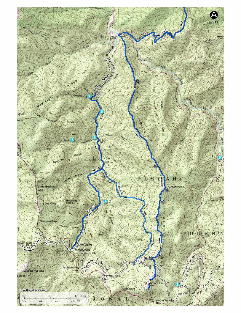
Middle Prong Wilderness - Pisgah National Forest, NC
Length Difficulty Streams Views Solitude Camping
18.8 mls
Hiking Time:Elev. Gain:
Parking:
14 hours spread out over 2 days of backpacking4,181 ftParking on NC215. 35.37357, -82.93617
By Trail Contributor: Zach Robbins
Although adjacent to the overpopulated Shining Rock Wilderness, the Middle Prong Wilderness is wild and desolate incomparison. Crowds are drawn to the larger eastern neighbor for a number of reasons including closer proximity toAsheville, numerous trailheads off U.S. 276 and the Blue Ridge Parkway, and the attraction of many 6,000+ foot peakswith expansive views. The Middle Prong Wilderness has many of the same features, without any of the crowds. This hikeis the grand loop of the entire wilderness, following the long, rugged Fork Ridge to high elevations and big views beforediving down into the remote headwaters of the Middle Prong of the West Fork Pigeon River. The western Great Balsam
Mountains form a horseshoe around the Middle Prong watershed. Hidden within this watershed are many beautiful waterfalls that are difficult toreach.
The hike, at nearly 19 miles, is deal for a weekend backpacking trip. After a punishing climb up Fork Ridge there are a variety of campsites along theMountains-to-Sea Trail (MST) below Mt. Hardy. Some offer grand views with little protection, most are beneath the tree canopy. The second day canbe improvised. You can take day hikes east to Mt. Hardy or Mt. Hardy Falls before continuing west on the MST down into the Middle Prongwatershed. Once by the river there are multiple campsites if you wish to stay a second night. This is an ideal option if you choose to bushwhack toone or more waterfalls that are located on many of the creeks that form Middle Prong. For backpackers the Middle Prong Wilderness is a fantasticweekend getaway to a place that is more wild and tough than most of the hike options in the region.
Waterfalls in the wilderness – Middle Prong Wilderness is full of hidden waterfalls that are mostly difficult and dangerous to reach. The waterfallsin this region are listed on the pdf map and turn off points are listed below for when you need to leave the trail and start bushwhacking. Even if youare experienced at off-trail navigation and canyoneering, many of these waterfalls are still tough to reach. The best resource for finding thesewaterfalls is Kevin Adams’ newest 3rd edition of North Carolina Waterfalls.
Day One
Mile 0.0 – The Green Mountain Trail [113] (no blaze) begins on the east side of the NC 215 bridge over Middle Prong opposite of the parking pull outs beside West Fork Pigeon River. There is no trail sign nor obvious cleared pathway. It is hidden amongst trees approximately 15 feet before the bridge. When you see a dip through a slight opening walk through the branches and you should see a small, eroded trail climbing to the left. Once you walk away from the road the trail should become more obvious as it is the only clear path through tunnels of rhododendron. The Green Mountain Trail is considered one of the most difficult hikes in the region. You’ll climb relentlessly for 4 miles from 3,000 feet to 5,900 feet along Fork Ridge to the summit of Green Knob. There is no water on this trail and the campsites located in the first few miles are far from ideal and should be considered a last resort. Allocate 4+ hours for this section with a full backpack. There are no blazes and the trail itself is narrow and overgrown, but it follows the ridge crest and is easy to follow. Mile 1.5 – Southeastern view of West Fork Pigeon River watershed from a rock outcrop.Mile 2.4 – There are three small campsite areas beside the trail for the next 0.3 miles but none of these have water access.Mile 3.7 – Western view of Middle Prong of West Fork Pigeon River watershed from a small rock outcrop.Mile 4.2 – The canopy opens up as you pass the summit of Green Knob (5,880 feet). On the right is a protected campsite. On the left is a beautiful grassy area with open views east and south of some of the tallest peaks in the Great Balsam Mountains. The deep West Fork Pigeon River watershed below divides the Shining Rock Wilderness and the Middle Prong Wilderness. The double-humped Sam Knob stands tall above the river valley. The smaller peak on the right is Little Sam Knob. You should easily pick out the many waterfalls of Flat Laurel Creek between the two mountains as it falls hundreds of feet out of sight. Behind Sam Knob to the left is half of the flat, bald summit of Black Balsam Knob. The tiny bump is Tennent Mountain, and the ridge dips to the left to Ivestor Gap before climbing to Grassy Cove Top. To the right of Little Sam Knob is the pointy Silvermine Bald and immediately right the tall cliffs of Devil’s Courthouse. The big mountain on the far right behind the humps of Fork Ridge is Mt. Hardy. Mile 4.6 – Wooded campsites below Green Knob.Mile 5.4 – Excellent campsites on each side of the trail with a big view southeast of Devil’s Courthouse and the surrounding peaks.Mile 5.8 – Sheltered campsite on the west side of the trail.Mile 6.0 – T-junction with side trail on the right to campsites.Mile 6.1 – Green Mountain Trail turns left at a T-junction with a heavily used unofficial connector to the Mountains-to-Sea Trail, with a view straight ahead of Mt. Hardy. Turn right following the connector trail west to check out more campsites.Mile 6.2 – The connector trail passes through an open field with incredible views of Mt. Hardy immediately south and to the west Rough Butt Bald, Reinhart Knob, and Richland Balsam, the tallest peak in the Great Balsam Mountains at 6,410 feet. The western Great Balsam Mountains form a horseshoe around the Middle Prong watershed to the northwest. Throughout this field are multiple campsites with wide open vistas. If it is going to be a calm night this is an ideal place to set up camp for the night. If wind or rain is a threat, then you can retreat a few hundred feet east near the Green Mountain Trail junction to utilize the campsites under the trees. Either way, you need to collect water. Continue west on the connector trail as it descends steeply down the open hillside.Mile 6.6 – T-junction with the Mountains-to-Sea Trail [440] (no blaze). You can head in either direction on the MST to access water, in this case the GPS track heads left/east towards the origin of Buckeye Creek. We suggest turning right/west instead, where the MST crosses Buckeye Creek downstream. Mile 6.8 – Water access via Buckeye Creek on the right side of the trail. Fill up and turn around heading back to the campsites.Mile 7.3 – Night one at the grassy campsites near the Green Mountain Trail junction.
Day Two
Mile 7.4 – Optional Mt. Hardy ~2 mile summit hike – Follow the connector trail east to the T-junction with the Green Mountain Trail andcontinue south on the Green Mountain Trail (This optional hike is primarily for peakbaggers since it will count for the South Beyond 6000Challenge. The views are not worth the trip.)
(A second option for a slightly longer day hike would be to continue east past Mt. Hardy for ~1.5 miles to the overlook for Mt. Hardy Falls.This waterfall is nearly 100 feet high but is on a very small creek. You should consider this after a good rainfall.)
Mile 7.5 – The Green Mountain Trail ends at a T-junction with the Mountains-to-Sea Trail [440] (no blaze). Turn left/east on the MST. Thereare campsites on the right side of the trail junction where the MST continues west.

www.hikingupward.com
Mile 7.55 – Before a large fallen tree a side trail on the right leads to Mt. Hardy. At first this trail wanders through the spruce-fir forest thenemerges briefly through weed-strewn meadows on the east side of Mt. Hardy. Towards the end of these meadows the trail makes a hard rightheading southwest. Once you enter the forest the trail is much easier to follow as it switchbacks up the mountain.Mile 8.1 – East view on the left side of the trail.Mile 8.2 – Wooded summit of Mt. Hardy (6,120 feet). Turn around and head back down the summit trail to the MST.Mile 9.0 – From the campsites head west on the connector trail to join the MST.Mile 9.3 – Turn right at the MST T-junction heading west.Mile 9.5 – Wishbone junction with the Buckeye Gap Trail [126] (no blaze) on the right. (You can turn right here on the Buckeye Gap Trail toshorten the hike by a few miles. The Buckeye Gap Trail follows the slopes south high above Buckeye Creek before plowing west down theridge to meet the Haywood Gap Trail.) Continue left on MST and you’ll soon cross two branches of Buckeye Creek.Mile 10.5 – T-junction with a Blue Ridge Parkway Access Trail at Buckeye Gap. Turn right through the campsite to continue following the MSTwest.Mile 12.2 – Y-junction with the Haywood Gap Trail [142] (no blaze). The MST turns left towards Haywood Gap and the Blue Ridge Parkway.Turn right on the Haywood Gap Trail to begin a moderate descent through hardwood forest. The trail is surrounded by ferns and stingingnettles.Mile 12.9 – Cross Possum Hollow Stream between small waterfalls as it flows into Haywood Gap Stream. The trail now closely followsHaywood Gap Stream.Mile 13.5 – Rock hop or wet crossing of Middle Prong of West Fork Pigeon River. Shortly upstream the confluence of Buckeye Creek andHaywood Gap Stream creates Middle Prong. (If you are hiking to Buckeye Falls, you need to leave the trail here and creek-walk upstream tothe confluence, turn left on Buckeye Creek, then continue to creek-walk upstream to the base of the falls.)Mile 14.5 – Shortly after rock hopping Grassy Ridge Branch you’ll continue straight through a cross intersection with the Buckeye Gap Trail onyour right. The trail on the left leads to a large, excellent campsite perched above Middle Prong.Mile 15.2 – Rock hop or wet crossing Middle Prong below a 15-foot waterfall with an inviting swimming hole. This waterfall has no officialname.Mile 15.5 – Y-junction with overgrown forest road on the left. This forest road leads to campsites at Big Beartrap Branch and bushwhackaccess for the lowest drop of Big Beartrap Falls.Mile 16.0 –At a slight turn left the right side of the trail has tall dirt banks. (This is the location to bushwhack down to Middle Prong Falls,which is audible from the trail but impossible to see. Refer to Kevin Adams' book if you are interested in seeing this waterfall. It is beautifulbut very difficult and very dangerous to reach.)Mile 16.6 – The trail passes over the top of a low-flow waterfall on Berry Branch then passes above the lowest drop of Little Beartrap Falls. (Atough bushwhack is required to see the upper drops of Little Beartrap Falls and is not encouraged. Scrambling down to the base of this bowl tosee the lowest drops of the waterfall on Berry Branch and Little Beartrap Falls is not worth the effort.)Mile 16.8 – Haywood Gap Trail ends at FSR 97. Turn right to follow FSR 97 back to NC 215.Mile 17.2 – At a left turn an overgrown forest road on the right heads down towards Middle Prong. This is a possible creek-walk access forMiddle Prong Falls, but would be unadvisable in above average water flow.Mile 18.4 – Gate on FSR 97. On the other side of this gate are multiple parking areas and large campsites.Mile 18.5 – Shallow concrete ford of Right Hand Prong of West Fork Pigeon River.Mile 18.8 – FSR 97 ends at NC 215 and the parking areas for this hike.