
HIGH SPEED TWO PHASE ONE INFORMATION … · Street and would include a taxi rank, taxi drop-off...
17
1 HIGH SPEED TWO PHASE ONE INFORMATION PAPER H1: BIRMINGHAM CURZON STREET STATION Version 1.4 Last updated 23 rd February 2017 This paper outlines the proposals for Curzon Street Station. It will be of particular interest to those potentially affected by the Government’s proposals for high speed rail. This paper was prepared in relation to the promotion of the Bill for Phase One of the scheme which is now enacted. Although the contents were maintained and updated as considered appropriate during the passage of the Bill (including shortly prior to the enactment of the Bill in February 2017) the contents are now historic and are no longer maintained. If you have any queries about this paper or about how it might apply to you, please contact the HS2 Helpdesk in the first instance. The Helpdesk can be reached at: High Speed Two (HS2) Limited Two Snowhill, Snow Hill Queensway Birmingham, B4 6GA by email: [email protected] or by phone: 08081 434 434 (lines are open 24 hours)
Transcript of HIGH SPEED TWO PHASE ONE INFORMATION … · Street and would include a taxi rank, taxi drop-off...
1
HIGH SPEED TWO PHASE ONE INFORMATION PAPER H1: BIRMINGHAM CURZON STREET STATION
Version 1.4 Last updated 23rd February 2017
This paper outlines the proposals for Curzon Street Station.
It will be of particular interest to those potentially affected by the Government’s proposals for high speed rail.
This paper was prepared in relation to the promotion of the Bill for Phase One of the scheme which is now enacted. Although the contents were maintained and updated as considered appropriate during the passage of the Bill (including shortly prior to the enactment of the Bill in February 2017) the contents are now historic and are no longer maintained.
If you have any queries about this paper or about how it might apply to you, please contact the HS2 Helpdesk in the first instance.
The Helpdesk can be reached at:
High Speed Two (HS2) Limited Two Snowhill, Snow Hill Queensway
Birmingham, B4 6GA
by email: [email protected]
or by phone: 08081 434 434 (lines are open 24 hours)
2
H1: BIRMINGHAM CURZON STREET STATION
1. Introduction
High Speed Two (HS2) is the Government’s proposal for a new, high speed north-south railway. The proposal is being taken forward in two phases: Phase One will connect London with Birmingham and the West Midlands and Phase Two will extend the route to Manchester, Leeds and beyond.
HS2 Ltd is the non-departmental public body responsible for developing and promoting these proposals. The company works to a Development Agreement made with the Secretary of State for Transport.
In November 2013, HS2 Ltd deposited a hybrid Bill1 with Parliament to seek powers for the construction and operation of Phase One of HS2 (sometimes referred to as ‘the Proposed Scheme’). The Bill is the culmination of nearly six years of work, including an Environmental Impact Assessment (EIA), the results of which were reported in an Environmental Statement (ES) submitted alongside the Bill. The Secretary of State has also published draft Environmental Minimum Requirements (EMRs), which set out the environmental and sustainability commitments that will be observed in the construction of the Proposed Scheme.
The Bill is being promoted through Parliament by the Secretary of State for Transport (the ‘Promoter’). The Secretary of State will also appoint a body responsible for delivering the Proposed Scheme under the powers granted by the Bill.
This body is known as the 'nominated undertaker'. There may well be more than one nominated undertaker – for example, HS2 Ltd could become the nominated undertaker for the main railway works, while Network Rail could become the nominated undertaker for works to an existing station such as Euston. But whoever they are, all nominated undertakers will be bound by the obligations contained in the Bill and the policies established in the EMRs.
These information papers have been produced to explain the commitments made in the Bill and the EMRs and how they will be applied to the design and construction of the Proposed Scheme. They also provide information about the Proposed Scheme itself, the powers contained in the Bill and how particular decisions about the project have been reached. This paper outlines the proposals for Curzon Street Station.
1 The High Speed Rail (London – West Midlands) Bill, hereafter ‘the Bill’.
3
2. Overview
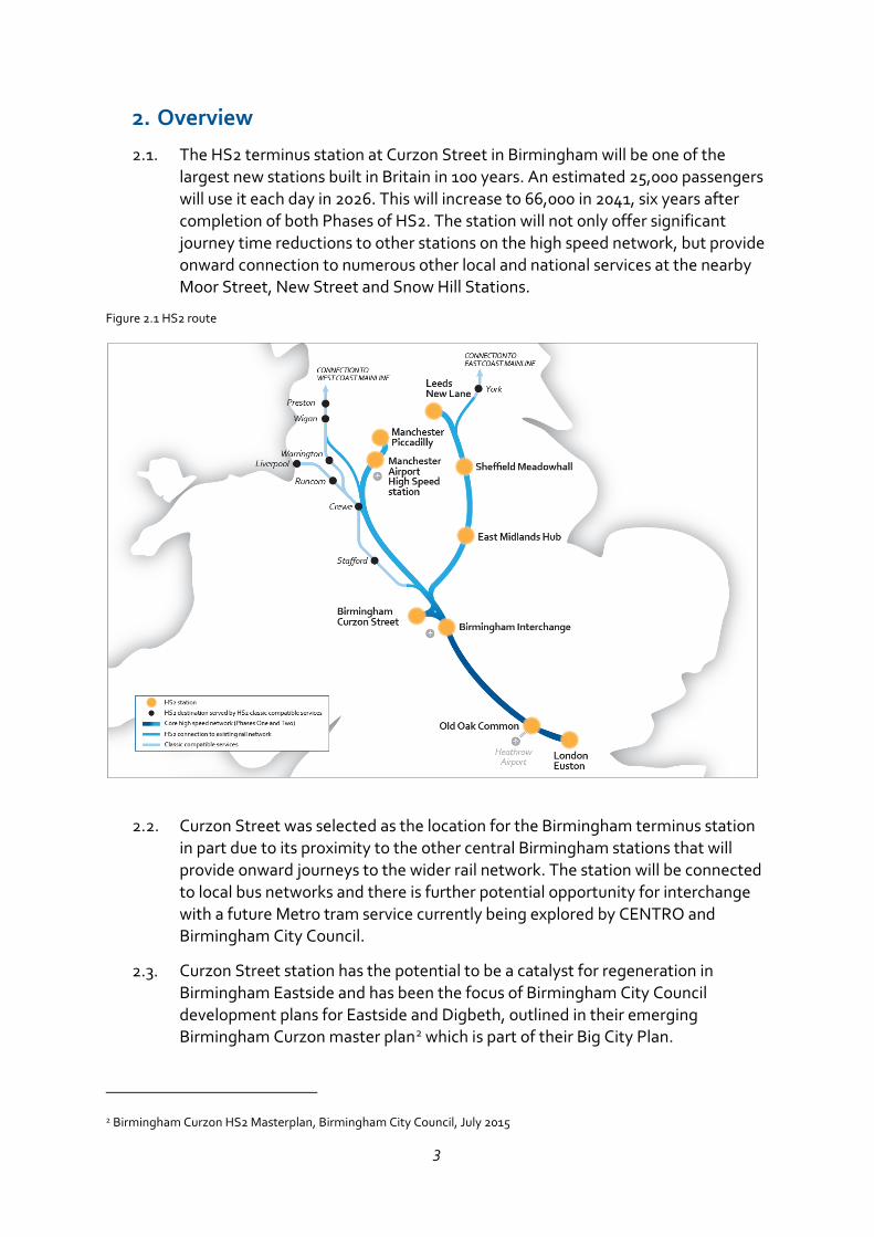
The HS2 terminus station at Curzon Street in Birmingham will be one of the largest new stations built in Britain in 100 years. An estimated 25,000 passengers will use it each day in 2026. This will increase to 66,000 in 2041, six years after completion of both Phases of HS2. The station will not only offer significant journey time reductions to other stations on the high speed network, but provide onward connection to numerous other local and national services at the nearby Moor Street, New Street and Snow Hill Stations.
Figure 2.1 HS2 route
Curzon Street was selected as the location for the Birmingham terminus station in part due to its proximity to the other central Birmingham stations that will provide onward journeys to the wider rail network. The station will be connected to local bus networks and there is further potential opportunity for interchange with a future Metro tram service currently being explored by CENTRO and Birmingham City Council.
Curzon Street station has the potential to be a catalyst for regeneration in Birmingham Eastside and has been the focus of Birmingham City Council development plans for Eastside and Digbeth, outlined in their emerging Birmingham Curzon master plan2 which is part of their Big City Plan.
2 Birmingham Curzon HS2 Masterplan, Birmingham City Council, July 2015

4
3. Why Curzon Street?
Eight options were considered for a terminus station in central Birmingham, including upgrades and expansions of Moor Street, Snow Hill and New Street stations or development of a completely new station. Extending New Street would offer the best solution for passengers, but unfortunately it is not feasible. Even if the cost could be justified, an additional new station would be required somewhere else in the city, and existing trains services would be severely disrupted during construction.
Extension of Snow Hill would also present fundamental problems as the shallow tunnels at either end would need to be rebuilt. Because of its orientation, Moor Street is not compatible with the route via the Water Orton corridor. It was concluded that a new station would be needed as all the other options had significant engineering, capacity and/or land use constraints.
Of the options for a new terminus station for the Water Orton corridor route, the two best locations were Warwick Wharf and Fazeley Street (now known as Curzon St). Either would deliver broadly the same passenger benefits, but Warwick Wharf would bisect the Warwick Bar Conservation Area and the local street pattern, would affect a number of listed buildings and would create greater local severance. It would also be marginally more expensive to build. Fazeley Street was therefore selected.
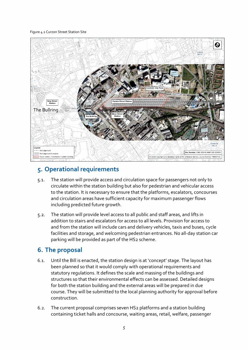
4. The site
It is proposed that the station and associated infrastructure be built on land between the West Coast Main Line and the recently completed Eastside City Park. The site is next to Moor Street Station and approximately 400m north east of New Street Station. The whole site including the ‘fan’ of tracks to the platforms is around 900m long, of which the station building would occupy approximately 550m. It is currently mostly used for open space, temporary parking or is vacant.
Between Moor Street Queensway to the west and New Canal Street in the middle of the site, the ground level falls approximately 17m but further east it is flat. There are two vacant public houses on the site - the Grade 2 listed but derelict Fox and Grapes and the locally listed Eagle and Tun. There are a number of heritage assets located in the vicinity including the Grade 1 listed former Curzon Street station building immediately to the north. At the eastern end of the construction site HS2 will cross the Digbeth Branch Canal.
5
Figure 4.1 Curzon Street Station Site
5. Operational requirements
The station will provide access and circulation space for passengers not only to circulate within the station building but also for pedestrian and vehicular access to the station. It is necessary to ensure that the platforms, escalators, concourses and circulation areas have sufficient capacity for maximum passenger flows including predicted future growth.
The station will provide level access to all public and staff areas, and lifts in addition to stairs and escalators for access to all levels. Provision for access to and from the station will include cars and delivery vehicles, taxis and buses, cycle facilities and storage, and welcoming pedestrian entrances. No all-day station car parking will be provided as part of the HS2 scheme.
6. The proposal
Until the Bill is enacted, the station design is at ‘concept’ stage. The layout has been planned so that it would comply with operational requirements and statutory regulations. It defines the scale and massing of the buildings and structures so that their environmental effects can be assessed. Detailed designs for both the station building and the external areas will be prepared in due course. They will be submitted to the local planning authority for approval before construction.
The current proposal comprises seven HS2 platforms and a station building containing ticket halls and concourse, waiting areas, retail, welfare, passenger
The Bullring
6
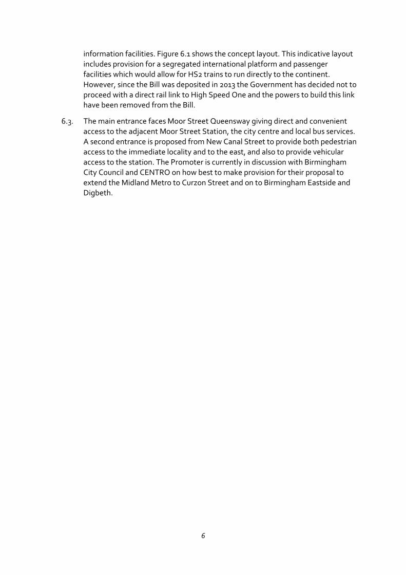
information facilities. Figure 6.1 shows the concept layout. This indicative layout includes provision for a segregated international platform and passenger facilities which would allow for HS2 trains to run directly to the continent. However, since the Bill was deposited in 2013 the Government has decided not to proceed with a direct rail link to High Speed One and the powers to build this link have been removed from the Bill.
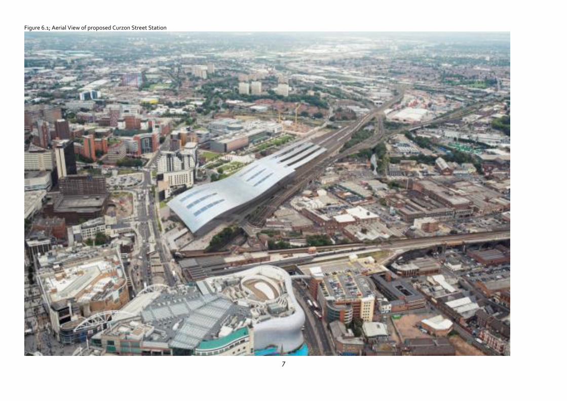
The main entrance faces Moor Street Queensway giving direct and convenient access to the adjacent Moor Street Station, the city centre and local bus services. A second entrance is proposed from New Canal Street to provide both pedestrian access to the immediate locality and to the east, and also to provide vehicular access to the station. The Promoter is currently in discussion with Birmingham City Council and CENTRO on how best to make provision for their proposal to extend the Midland Metro to Curzon Street and on to Birmingham Eastside and Digbeth.
7
Figure 6.1; Aerial View of proposed Curzon Street Station
8
Figure 6.2 Site Layout
9
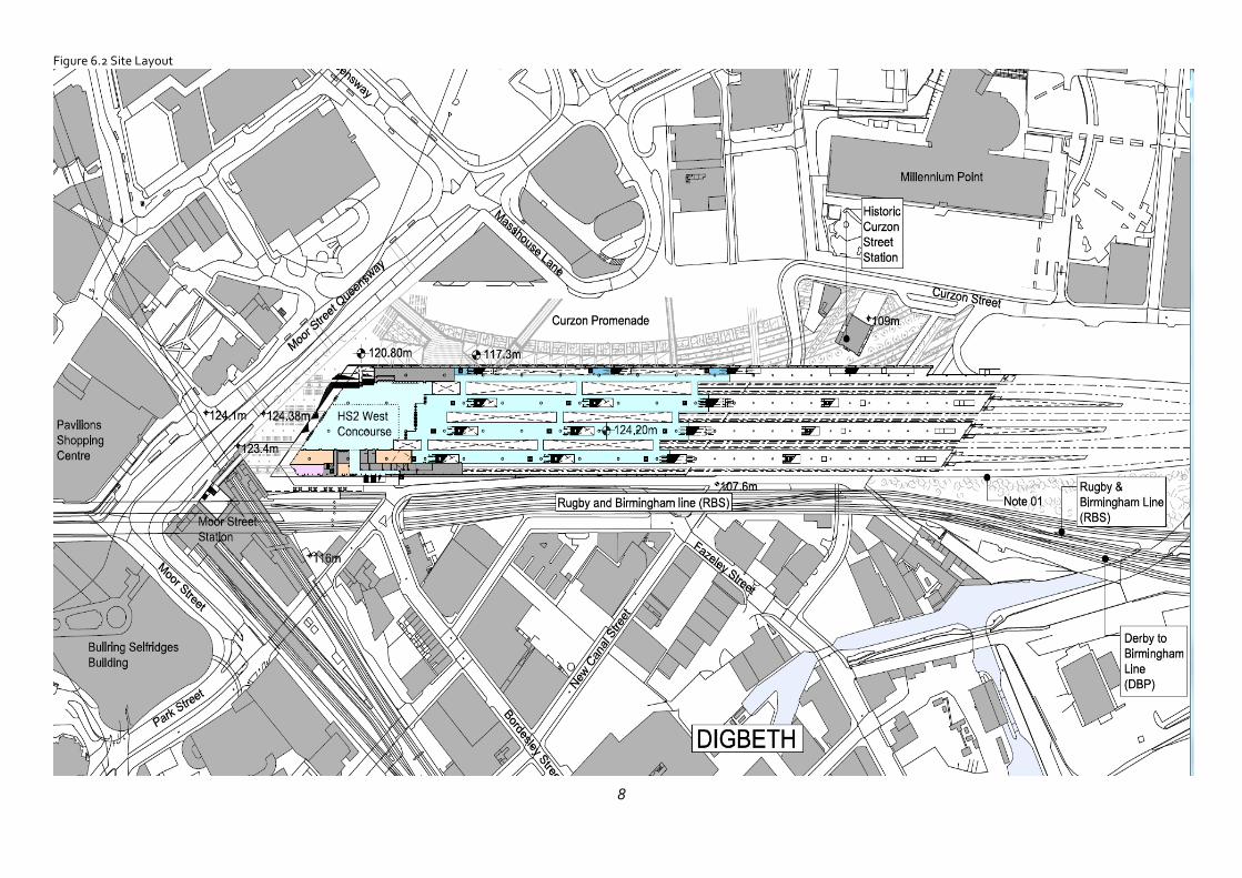
From the east, the HS2 line crosses two railway lines and the A4520 Ring Road on a viaduct crossing New Canal Street 8-9m above ground level, but due to the slope of the land, at the Moor Street Queensway end the platforms are approximately 7m below street level. A street level upper concourse above the platforms is proposed at this end and there will also be a lower concourse underneath the platforms at New Canal Street level so that passengers can enter at ground level at both ends of the station.
Vehicular access to the station will be via Curzon Street and New Canal Street and would include a taxi rank, taxi drop-off points, provision for ‘kiss and ride’ drop-off and short term car parking. At this stage it is assumed that a future Metro tram route would include stops at both entrances to the station, though this is still to be determined.
Figure 6.3: Illustrative station layout
Main concourse (Moor Street Queensway) level
Platform level
Lower concourse (New Canal Street) level
10
7. Station design principles
The station design will provide:
a gateway to Birmingham;
enhanced connectivity to the wider rail network and other modes of transport; and
a potential catalyst to regeneration in Eastside, Digbeth and the wider city region.
In assurances to Birmingham City Council and CENTRO, the Promoter has agreed the general design principles for Curzon Street station covering the following issues:
• Simple and clear
• Safe and secure
• Inclusive and accessible
• Welcoming and user friendly
• Functional and operable
• Maintainable and flexible
• Sustainable
• Value for money
• Permeable and integrated
• Buildable
• Quality of design and materials
• Integration with local transport networks
• Internal layout
• Optimising active frontages
The principles also include requirements specific to Curzon Street station in relation to optimising station entrances and exits, minimising construction impacts, and to future regeneration, redevelopment and public realm.
11
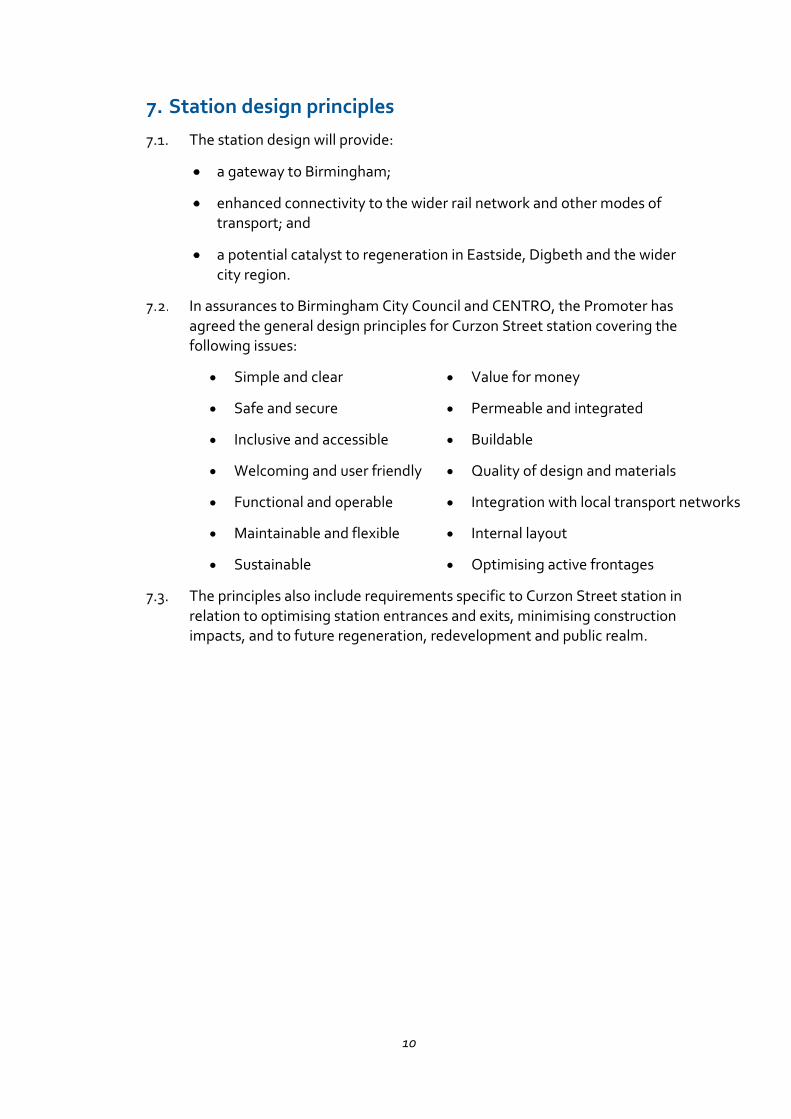
Figure 7.1: Illustrative View from Upper Concourse
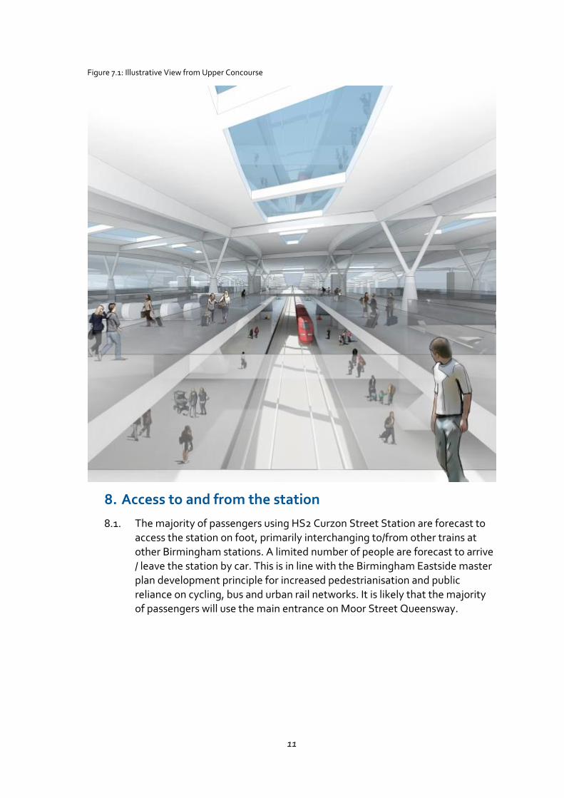
8. Access to and from the station
The majority of passengers using HS2 Curzon Street Station are forecast to access the station on foot, primarily interchanging to/from other trains at other Birmingham stations. A limited number of people are forecast to arrive / leave the station by car. This is in line with the Birmingham Eastside master plan development principle for increased pedestrianisation and public reliance on cycling, bus and urban rail networks. It is likely that the majority of passengers will use the main entrance on Moor Street Queensway.
12
Figure 8.1: Artist’s impression of the north side of Curzon Street Station
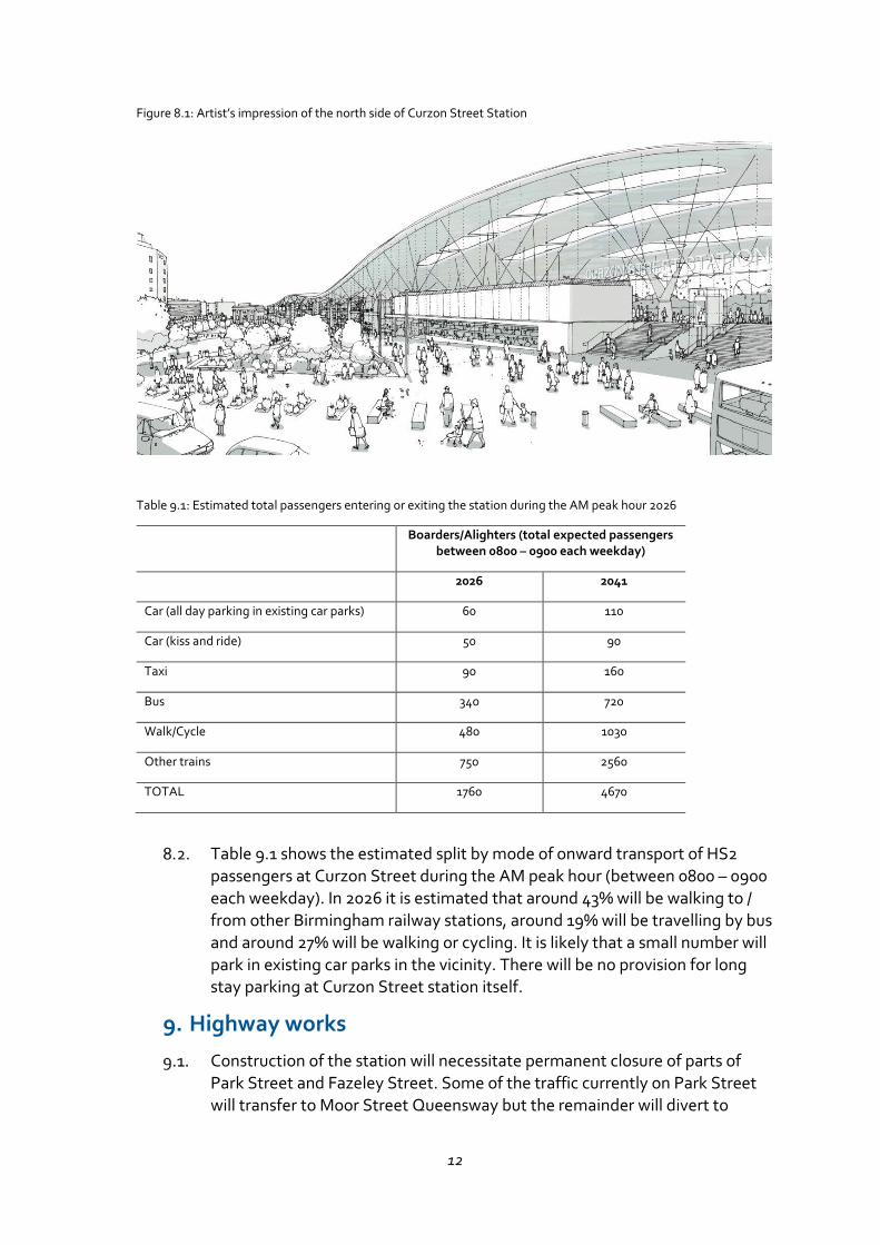
Table 9.1: Estimated total passengers entering or exiting the station during the AM peak hour 2026
Boarders/Alighters (total expected passengers between 0800 – 0900 each weekday)
2026 2041
Car (all day parking in existing car parks) 60 110
Car (kiss and ride) 50 90
Taxi 90 160
Bus 340 720
Walk/Cycle 480 1030
Other trains 750 2560
TOTAL 1760 4670
Table 9.1 shows the estimated split by mode of onward transport of HS2 passengers at Curzon Street during the AM peak hour (between 0800 – 0900 each weekday). In 2026 it is estimated that around 43% will be walking to / from other Birmingham railway stations, around 19% will be travelling by bus and around 27% will be walking or cycling. It is likely that a small number will park in existing car parks in the vicinity. There will be no provision for long stay parking at Curzon Street station itself.
9. Highway works
Construction of the station will necessitate permanent closure of parts of Park Street and Fazeley Street. Some of the traffic currently on Park Street will transfer to Moor Street Queensway but the remainder will divert to
13
Curzon Street and the ring road. As the ring road junctions at Curzon Circle and Garrison Circus are currently operating at or near capacity at peak times, improvements to these junctions are included in the Proposed Scheme.
Other transport infrastructure improvements currently envisaged include:
Diversion and widening of Curzon Street around the Woodman public house.
New access roads to the east and south of the station.
Provision of pedestrian bridge link over the Digbeth viaduct.
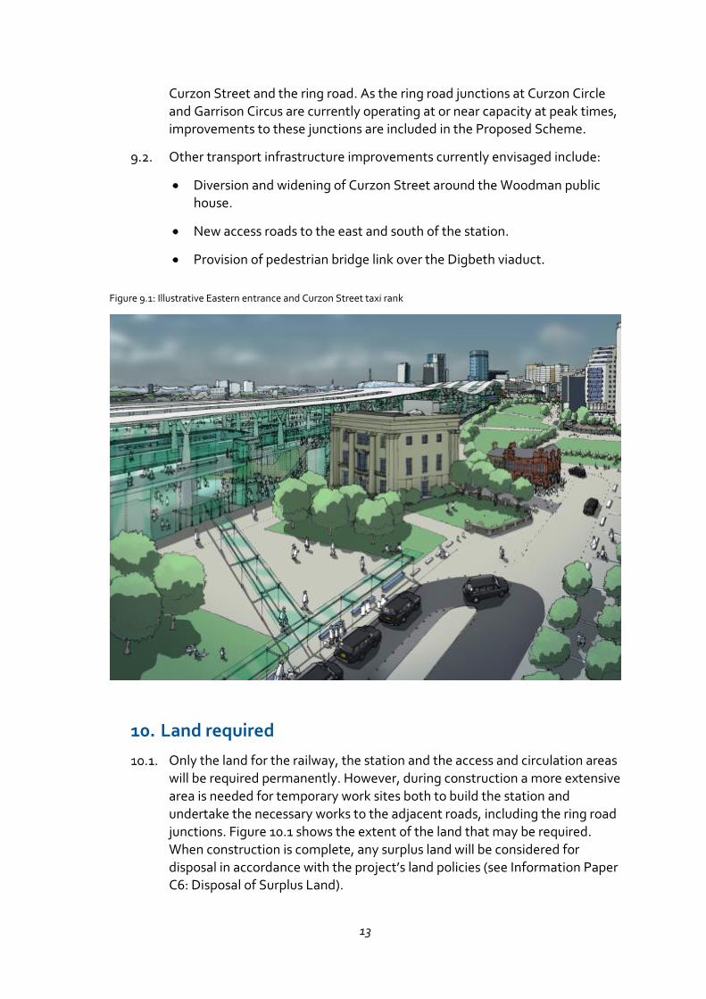
Figure 9.1: Illustrative Eastern entrance and Curzon Street taxi rank
10. Land required
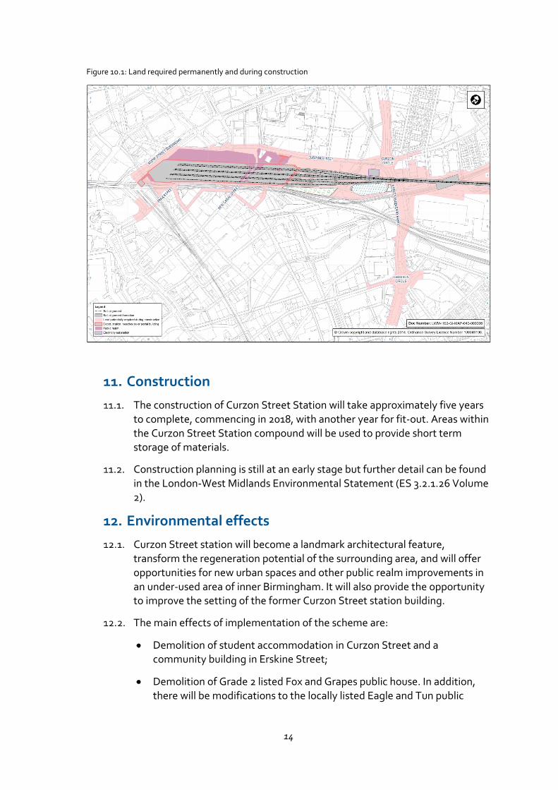
Only the land for the railway, the station and the access and circulation areas will be required permanently. However, during construction a more extensive area is needed for temporary work sites both to build the station and undertake the necessary works to the adjacent roads, including the ring road junctions. Figure 10.1 shows the extent of the land that may be required. When construction is complete, any surplus land will be considered for disposal in accordance with the project’s land policies (see Information Paper C6: Disposal of Surplus Land).
14
Figure 10.1: Land required permanently and during construction
11. Construction
The construction of Curzon Street Station will take approximately five years to complete, commencing in 2018, with another year for fit-out. Areas within the Curzon Street Station compound will be used to provide short term storage of materials.
Construction planning is still at an early stage but further detail can be found in the London-West Midlands Environmental Statement (ES 3.2.1.26 Volume 2).
12. Environmental effects
Curzon Street station will become a landmark architectural feature, transform the regeneration potential of the surrounding area, and will offer opportunities for new urban spaces and other public realm improvements in an under-used area of inner Birmingham. It will also provide the opportunity to improve the setting of the former Curzon Street station building.
The main effects of implementation of the scheme are:
Demolition of student accommodation in Curzon Street and a community building in Erskine Street;
Demolition of Grade 2 listed Fox and Grapes public house. In addition, there will be modifications to the locally listed Eagle and Tun public
15
house on New Canal Street to integrate the building within the proposed Curzon Street station structure;
Loss of open space in Park Street and Eastside City parks;
Loss of mediaeval remains in Freeman Street and other archaeological deposits elsewhere on the site.
During construction, noise, atmospheric emissions and other adverse environmental effects will be controlled in accordance with the ‘Environmental Minimum Requirements’ including the Code of Construction Practice (CoCP), which will include a range of mitigation measures to reduce impacts as far as reasonably practicable. It also makes provision for the preparation of local environmental management plans (LEMPs) to include local environmental and community protection measures. Contractors are required to manage noise, dust, air pollution, odour and exhaust emissions during construction works.
Details of the proposed environmental regime can be found in the HS2 Environmental Statement in Volume 2, CFA4 Report, the Draft Code of Construction Practice and the Environmental Memorandum. The environmental protection regime is described in Information Paper E1: Control of Environmental Impacts. Amongst other things, specific mitigation measures include:
Protection of the former Curzon Street station building and the Woodman public house during construction and enhancement of their settings;
Pedestrian link bridge over the Digbeth railway viaduct to Moor Street station; and
Protection the Digbeth Branch Canal during construction and improving public access on completion.
Details of the proposed environmental mitigation regime can be found in the HS2 Environmental Statement in Volume 2, CFA4 Report, the Draft Code of Construction Practice and the Environmental Memorandum.
13. Regeneration opportunities
As part of its Big City Plan for regeneration and expansion of Birmingham City Centre, in February 2014 Birmingham City Council produced a draft masterplan for the ‘Birmingham Curzon’ area around the station comprising 140ha of the Eastside and Digbeth quarters and the eastern fringe of the City Centre Core. With minor revisions the plan was adopted by the Council’s Cabinet in July 2015. The masterplan is a long term vision to provide around 36,000 additional new jobs and over 4,000 new homes by the middle of the century.
16
The master plan includes a creative quarter centred on Digbeth, retail and business development around the station and a research, technology and education hub focussed on Aston University and the planned Birmingham City University campus. Birmingham City Council is in the process of setting up an urban regeneration company to take the regeneration forward.
The regenerative effect of Curzon Street station would extend far wider than the immediate area. The overall Big City Plan ambition for central Birmingham is “a 20 year vision for Birmingham’s City Centre supporting transformational change to create a world class city centre delivering sustainable growth, improved connectivity, authentic character, environmental quality, new residential communities and a diversified economic base”. It covers an area of 800 hectares and includes a spatial strategy for growing the City Core by over 25%. The whole of the city centre will benefit from the enhanced connectivity to London, Manchester, Leeds and the other conurbations and to international airports provided by HS2.
14. Undertakings and Assurances
During the hybrid Bill process the Promoter has provided a number of undertakings and assurances, including assurances to Birmingham City Council and CENTRO. The Register of Undertakings and Assurances is published online. As the Bill passes through the House of Lords prior to Royal Assent, the Promoter may provide further undertakings and assurances if it is appropriate to do so. The Register will therefore be updated periodically. The latest version of the Register is available at:
https://www.gov.uk/government/publications/high-speed-rail-london-west-midlands-billregister-of-undertakings-and-assurances.
In relation to the Curzon Street Station, the assurances to Birmingham City Council / CENTRO include the design principles summarised in Section 7 and assurances on the following issues:
• A design panel will be set up by Birmingham City Council, CENTRO and the Promoter to review the station proposals prior to the Promoter seeking formal approval of the design details.
• Integration of the station with the local transport network having regard to the principles of efficient, convenient and accessible transport interchange described in the Birmingham Curzon Masterplan for Growth and the West Midlands Connectivity Package.
• Appropriate location of railway infrastructure to avoid conflict with regeneration opportunities and to maximise the potential of development land having regard to the Birmingham Curzon Masterplan for Growth.
• the provision of public realm surrounding the station, having due regard to the principles and proposals of the Birmingham Curzon
17
Masterplan for Growth which seeks to create new squares and spaces that maximise connectivity to Digbeth, Eastside and the City Core.
• Seeking to optimise active frontages along elevations.
• Enhancing the setting of the Grade I listed former Curzon Street Station building, the adjoining Woodman Public House and the Eastside City Park.
• HS2 is also to participate in a joint working group to be established by CENTRO to develop the design of a high-quality and high-capacity interchange between the HS2 Curzon Street station and the Midland Metro Birmingham Eastside Extension (BEE).
15. More information
More detail on the Bill and related documents can be found at: www.gov.uk/HS2