High resolution aeromagnetic survey of Lake Superior
6
Eos, Vol. 72, No. 8, February 19, 1991 VOLUME 72, NUMBER 8 FEBRUARY 19, 1991 PAGES 81-96 High Resolution Aeromagnetic Survey of Lake Superior PAGES 81, 85-86 D. J. Teskey, M. D. Thomas, R. A. Gibb, S. D. Dods, R. P. Kucks, V. W. Chandler, K. Fadaie, and J. D. Phillips A 57,000 line kilometer, high-resolution aeromagnetic survey was flown in 1987 as a contribution to the Great Lakes International Multidisciplinary Program on Crustal Evolu- tion (GLIMPCE). Existing aeromagnetic data from the United States and Canada were combined with the new data to produce a composite map and gridded data base of the Lake Superior region (Figure 1). Analysis of the new data permits more accurate definition of faults and contacts within the Midcontinent Rift system (MCR). The aeromagnetic map provides important information supplemental to the seismic pro- files acquired under the GLIMPCE program in 1986, allowing lateral extension of the seismic interpretation. In particular, model- ing of the data provides an independent as- sessment of a reflection seismic model de- rived along line A (Figure 2). The profile and gridded digital data are available to geosci- entists through the Geophysical Data Centre of the Geological Survey of Canada (GSC), while the gridded data are available from the USGS-EROS Data Center. GLIMPCE was established in 1985 to study the nature and genesis of the crust in the Great Lakes region. Program participants include the GSC, the U.S. Geological Survey (USGS), provincial and state surveys, and Canadian and American universities. In the D. J. Teskey, M. D. Thomas, R. A. Gibb, S. D. Dods, and K. Fadaie, Geological Survey of Canada, 1 Observatory Crescent, Ottawa, Ontario, K1A 0Y3; R. P. Kucks, U. S. Geological Survey, P.O. Box 25046, DFC MS 964, Denver, CO 80225-0046; V. W. Chandler, Minnesota Geological Survey, 2642 Uni- versity Ave., St. Paul, MN 55114-1057; and J. D. Phillips, U. S. Geological Survey, MS 927, Reston, VA 22097. Geological Survey of Canada Contribu- tion 18390; U.S. Geological Survey Contribution R90-0548. Lake Superior area, a major objective of the program is to develop thermal, tectonic, and petrogenetic models for the evolution of the MCR and to evaluate these in the broader context of the tectonic evolution of the North American continent. Pre-1982 geological and geophysical knowledge of the MCR in the Lake Superior region has been summarized by Wold and Hinze [1982]. The Lake Superior region pro- vides a unique window on this Proterozoic rift system, exposing igneous rock of the Keweenawan Supergroup that disappears under Paleozoic cover to the southwest. Geology The geology of the MCR in the Lake Su- perior region has been extensively reviewed and discussed by Halls [1978], Davidson [1982], Morey and Green [1982], Klasner et al [1982], and Van Schmus and Hinze [1985]. A generalized geological map of the region adapted from Cannon and Davidson [1982] is shown in Figure 2. In this region, Middle Proterozoic (—1.1 b.y.) Keweenawan sedimentary and volcanic rocks of the MCR are flanked by Archean rocks of the Superior Province and by overlying Early Proterozoic sedimentary rocks which formed a continen- tal margin prism. The Superior Province is characterized by east-northeast trending, al- ternating belts of metasedimentary gneiss and granite-greenstone. South of Lake Supe- rior the Early Proterozoic prism is in contact with magmatic terranes of the 1.9-1.8 b.y. Penokean orogen along the east-west trend- ing Niagara suture zone. Southwest of Lake Superior the MCR cuts across the western extension of the suture, where relationships are obscured by Phanerozoic cover. Gravity and magnetic signatures continue south- ward, however, and the gravity and magnetic pattern shows, in fact, that the MCR and Lake Superior basin are part of the same sys- tem. (See introduction to Wold and Hinze [1982] for discussion.) Development of the MCR in the Lake Su- perior region is attributed to extensive volca- nism and subsidence at approximately 1.1 b.y. [Palmer and Davis, 1987; Davis and Sutcliffe, 1985; Davis and Paces, 1990]. The MCR is a series of segmented grabens or—as suggested by Behrendt et al. [1988]— a series of juxtaposed half-grabens contain- ing weakly deformed and metamorphosed sequences of sedimentary and volcanic rocks more than 30 km thick [Cannon et al., 1989]. In the west and central part of the lake, the Keweenaw fault (Figure 3) appears to form a southern bounding-fault. The northern bounding-fault in the central por- tion, the Isle Royale fault, continues to the west, as indicated on this new aeromagnetic map. GLIMPCE Reflection Seismic Studies Five deep-penetration multichannel re- flection seismic profiles were obtained in 1986; their locations are shown in Figure 2. Cannon et al. [1989] present a discussion of the seismic program and resultant interpreta- tion. The processed seismic sections indi- cate that thick sequences of volcanic and sedimentary strata were deposited in grabens and broadening basins, respectively. The strata were subsequently subjected to uplift, accompanied by reverse faulting along origi- nal graben-bounding normal faults, possibly caused by a regional compressive event [Cannon et al., 1989]. Basins change in asymmetry from north lower to south lower between lines C and A, whereas line F ap- pears to be approximately symmetrical. It is assumed that the three corresponding blocks are separated along two relatively narrow accommodation zones: one west of Isle Roy- ale [Cannon et al., 1989] is inferred by a break in the gravity pattern; and the second, east of the Keweenaw Peninsula in the posi- tion of the Thiel fault [Hinze et al., 1966, 1982], is evident on the aeromagnetic map (Figure 1). An interpreted crustal cross-sec- tion for seismic line A [Cannon et al., 1989] across the central portion of the lake is shown in Figure 3. Gravity Data and Pre-1987 Aeromagnetic Data Magnetic and gravity surveys have a sig- nificant role in the geologic interpretation of the MCR in the Lake Superior basin, particu- This page may be freely copied. Eos, TRANSACTIONS, AMERICAN GEOPHYSICAL UNION
Transcript of High resolution aeromagnetic survey of Lake Superior

Eos, Vol. 72, No. 8, February 19, 1991
VOLUME 72, NUMBER 8
FEBRUARY 19, 1991
PAGES 81-96
High Resolution Aeromagnetic Survey of Lake Superior PAGES 81, 85-86
D. J. Teskey, M. D. Thomas, R. A. Gibb, S. D. Dods, R. P. Kucks, V. W. Chandler, K. Fadaie, and J. D. Phillips
A 57,000 line kilometer, high-resolution aeromagnetic survey was flown in 1987 as a contribution to the Great Lakes International Multidisciplinary Program on Crustal Evolution (GLIMPCE). Existing aeromagnetic data from the United States and Canada were combined with the new data to produce a composite map and gridded data base of the Lake Superior region (Figure 1).
Analysis of the new data permits more accurate definition of faults and contacts within the Midcontinent Rift system (MCR). The aeromagnetic map provides important information supplemental to the seismic profiles acquired under the GLIMPCE program in 1986, allowing lateral extension of the seismic interpretation. In particular, modeling of the data provides an independent assessment of a reflection seismic model derived along line A (Figure 2) . The profile and gridded digital data are available to geosci-entists through the Geophysical Data Centre of the Geological Survey of Canada (GSC), while the gridded data are available from the USGS-EROS Data Center.
GLIMPCE was established in 1985 to study the nature and genesis of the crust in the Great Lakes region. Program participants include the GSC, the U.S. Geological Survey (USGS), provincial and state surveys, and Canadian and American universities. In the
D. J. Teskey, M. D. Thomas, R. A. Gibb, S. D. Dods, and K. Fadaie, Geological Survey of Canada, 1 Observatory Crescent, Ottawa, Ontario, K1A 0Y3; R. P. Kucks, U. S. Geological Survey, P.O. Box 25046, DFC MS 964, Denver, CO 80225-0046; V. W. Chandler, Minnesota Geological Survey, 2642 University Ave., St. Paul, MN 55114-1057; and J. D. Phillips, U. S. Geological Survey, MS 927, Reston, VA 22097. Geological Survey of Canada Contribution 18390; U.S. Geological Survey Contribution R90-0548.
Lake Superior area, a major objective of the program is to develop thermal, tectonic, and petrogenetic models for the evolution of the MCR and to evaluate these in the broader context of the tectonic evolution of the North American continent.
Pre-1982 geological and geophysical knowledge of the MCR in the Lake Superior region has been summarized by Wold and Hinze [1982]. The Lake Superior region provides a unique window on this Proterozoic rift system, exposing igneous rock of the Keweenawan Supergroup that disappears under Paleozoic cover to the southwest.
Geology The geology of the MCR in the Lake Su
perior region has been extensively reviewed and discussed by Halls [1978], Davidson [1982], Morey and Green [1982], Klasner et al [1982], and Van Schmus and Hinze [1985]. A generalized geological map of the region adapted from Cannon and Davidson [1982] is shown in Figure 2. In this region, Middle Proterozoic (—1.1 b.y.) Keweenawan sedimentary and volcanic rocks of the MCR are flanked by Archean rocks of the Superior Province and by overlying Early Proterozoic sedimentary rocks which formed a continental margin prism. The Superior Province is characterized by east-northeast trending, alternating belts of metasedimentary gneiss and granite-greenstone. South of Lake Superior the Early Proterozoic prism is in contact with magmatic terranes of the 1.9-1.8 b.y. Penokean orogen along the east-west trending Niagara suture zone. Southwest of Lake Superior the MCR cuts across the western extension of the suture, where relationships are obscured by Phanerozoic cover. Gravity and magnetic signatures continue southward, however, and the gravity and magnetic pattern shows, in fact, that the MCR and
Lake Superior basin are part of the same system. (See introduction to Wold and Hinze [1982] for discussion.)
Development of the MCR in the Lake Superior region is attributed to extensive volca-nism and subsidence at approximately 1.1 b.y. [Palmer and Davis, 1987; Davis and Sutcliffe, 1985; Davis and Paces, 1990]. The MCR is a series of segmented grabens or—as suggested by Behrendt et al. [1988]— a series of juxtaposed half-grabens containing weakly deformed and metamorphosed sequences of sedimentary and volcanic rocks more than 30 km thick [Cannon et al., 1989]. In the west and central part of the lake, the Keweenaw fault (Figure 3) appears to form a southern bounding-fault. The northern bounding-fault in the central portion, the Isle Royale fault, continues to the west, as indicated on this new aeromagnetic map.
GLIMPCE Reflection Seismic Studies Five deep-penetration multichannel re
flection seismic profiles were obtained in 1986; their locations are shown in Figure 2. Cannon et al. [1989] present a discussion of the seismic program and resultant interpretation. The processed seismic sections indicate that thick sequences of volcanic and sedimentary strata were deposited in grabens and broadening basins, respectively. The strata were subsequently subjected to uplift, accompanied by reverse faulting along original graben-bounding normal faults, possibly caused by a regional compressive event [Cannon et al., 1989]. Basins change in asymmetry from north lower to south lower between lines C and A, whereas line F appears to be approximately symmetrical. It is assumed that the three corresponding blocks are separated along two relatively narrow accommodation zones: one west of Isle Roy-ale [Cannon et al., 1989] is inferred by a break in the gravity pattern; and the second, east of the Keweenaw Peninsula in the position of the Thiel fault [Hinze et al., 1966, 1982], is evident on the aeromagnetic map (Figure 1). An interpreted crustal cross-section for seismic line A [Cannon et al., 1989] across the central portion of the lake is shown in Figure 3.
Gravity Data and Pre-1987 Aeromagnetic Data
Magnetic and gravity surveys have a significant role in the geologic interpretation of the MCR in the Lake Superior basin, particu-
This page may be freely copied.
E o s , T R A N S A C T I O N S , A M E R I C A N G E O P H Y S I C A L U N I O N
Eos, Vol. 72, No. 8, February 19, 1991
5 0 ° t ~ —
4 9 ° f
48 £
N
1 #
4 7 ° V
4 6 °
9 3 c
92 c
) 0 C 8 8 ° W 8 6 c
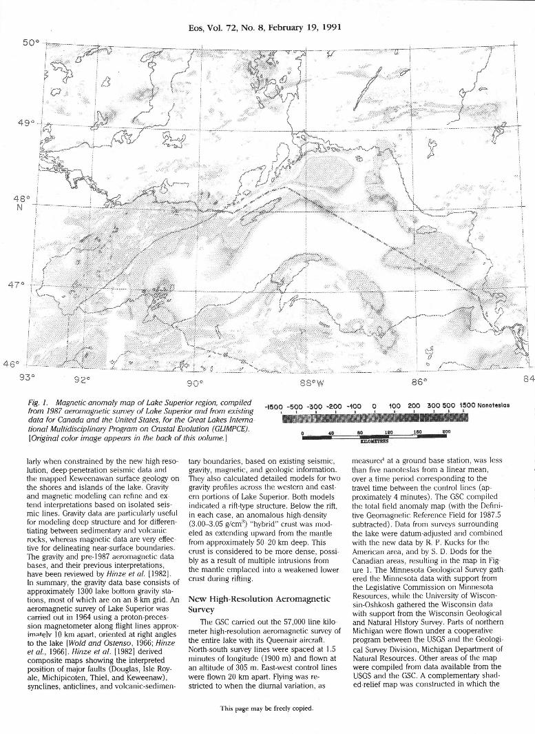
ttg. 7. Magnetic-anomaly map of Lake Superior region, compiled H 5 0 0 - 5 0 0 -300 -200 -100 0 100 200 300 500 1500 Nanoteslas from 1987 aeromagnetic survey of Lake Superior and from existing • i • • i i _ L _ ^ t _ L _ data for Canada and the United States, for the Great Lakes International Multidisciplinary Program on Crustal Evolution (GLIMPCE). ^ 8 0 m
[Original color image appears in the back of this volume.} wmmmmmn I H M M
larly when constrained by the new high-resolution, deep-penetration seismic data and the mapped Keweenawan surface geology on the shores and islands of the lake. Gravity and magnetic modeling can refine and extend interpretations based on isolated seismic lines. Gravity data are particularly useful for modeling deep structure and for differentiating between sedimentary and volcanic rocks, whereas magnetic data are very effective for delineating near-surface boundaries. The gravity and pre-1987 aeromagnetic data bases, and their previous interpretations, have been reviewed by Hinze et al. [1982]. In summary, the gravity data base consists of approximately 1300 lake bottom gravity stations, most of which are on an 8-km grid. An aeromagnetic survey of Lake Superior was carried out in 1964 using a proton-precession magnetometer along flight lines approximated 10 km apart, oriented at right angles to the lake [Wold and Ostenso, 1966; Hinze et al., 1966]. Hinze et al. [1982] derived composite maps showing the interpreted position of major faults (Douglas, Isle Roy-ale, Michipicoten, Thiel, and Keweenaw), synclines, anticlines, and volcanic-sedimen
tary boundaries, based on existing seismic, gravity, magnetic, and geologic information. They also calculated detailed models for two gravity profiles across the western and eastern portions of Lake Superior. Both models indicated a rift-type structure. Below the rift, in each case, an anomalous high-density (3.00-3.05 g/cm 3 ) "hybrid" crust was modeled as extending upward from the mantle from approximately 50-20 km deep. This crust is considered to be more dense, possibly as a result of multiple intrusions from the mantle emplaced into a weakened lower crust during rifting.
New High-Resolution Aeromagnetic Survey
The GSC carried out the 57,000 line kilometer high-resolution aeromagnetic survey of the entire lake with its Queenair aircraft. North-south survey lines were spaced at 1.5 minutes of longitude (1900 m) and flown at an altitude of 305 m. East-west control lines were flown 20 km apart. Flying was restricted to when the diurnal variation, as
measurer1 at a ground base station, was less than five nanoteslas from a linear mean, over a time period corresponding to the travel time between the control lines (approximately 4 minutes). The GSC compiled the total field anomaly map (with the Definitive Geomagnetic Reference Field for 1987.5 subtracted). Data from surveys surrounding the lake were datum-adjusted and combined with the new data by R. P. Kucks for the American area, and by S. D. Dods for the Canadian areas, resulting in the map in Figure 1. The Minnesota Geological Survey gath ered the Minnesota data with support from the Legislative Commission on Minnesota Resources, while the University of Wiscon-sin-Oshkosh gathered the Wisconsin data with support from the Wisconsin Geological and Natural History Survey. Parts of northern Michigan were flown under a cooperative program between the USGS and the Geological Survey Division, Michigan Department of Natural Resources. Other areas of the map were compiled from data available from the USGS and the GSC. A complementary shad-ed-relief map was constructed in which the
This page may be freely copied.


Eos, Vol. 72, No. 8, February 19, 1991
92° 9 0 ° 8 8 ° 8 6 ° 8 4 °
0 200km
W 7 7 1 1 1 1 1 : i: 111: i:
KEWEENAWAN
Upper-Sedimentary rocks
M i d d l e - M a f i c volcanics/ gabbro
L o w e r - M a f i c volcanics
vvvv Lower-Sib ley Group ~5T7r
0 o 0
o o ,
SUPERIOR MARGIN 2 . 1 - 1 . 8 5 b.y. Continental margin prism
SUPERIOR PROVINCE 2 .70 - 2 . 6 5 b.y. Post-orogenic granites
Ca 2.7 b.y.
Metosedimentary gneiss belt
3 . 0 - 2 . 7 b.y. Granite - Greenstone belt
Fig. 2. Geological sketch map of the Lake Superior region, showing seismic lines A, B, C, F and G and aeromagnetic profile 126 (D) (Adapted from Cannon and Davidson, 1982).
I LINE G 3000
LINE A, MIGRATED
Fig. 3. Interpreted cross-section for seismic line A (modified from Cannon et al., 1989), with BS denoting Bayfield Group; OG, Oronto Group; JS, Jacobsville Sandstone; PLV, Portage Lake Volcanics; AG, Archean Gneiss; and M, approximate location of Moho. Vertical scale is in seconds of two-way travel time (T(s)).
aeromagnetic data, treated as topography, are illuminated from the north by an artificial light source, thus accentuating some of the finer details not visible on the map. The gridded data are available from the USGS-EROS data centre and the GSC Geophysical Data Center. The new survey, with a line spacing approximately one-fifth that of the 1964 survey and an order of magnitude better in magnetometer sensitivity, was flown at a lower altitude, providing considerably
more detail. This increase in detail is particularly evident along the northwest shore between Duluth and Isle Royale and in the northeast between the Slate Islands and Ma-mainse Point.
Structural Significance of New Aeromagnetic Map
Hinze et al. [1982] used a variety of geophysical information to define first-order
structural elements in the Lake Superior basin, such as the faults in Figure 4a, which shows the zero contour of the first vertical-derivative magnetic map. The zero contour often coincides with positions of crustal boundaries, particularly where the latter are steeply dipping. The new magnetic data suggest modifications, in varying degree, of some of these faults' positions.
The magnetic signature of the Isle Royale fault is a spectacular feature on the new map (Figure 1). It appears as a steep gradient which forms the northern flank of a strong positive magnetic anomaly (HI , Figure 4a) extending between line C and Michi-picoten Island. This anomaly correlates with mainly mafic volcanic rocks on Isle Royale and Michipicoten Island. In places the fault signature incorporates a flanking narrow negative anomaly to the north that separates the positive anomaly from areas of positive anomaly north of the Isle Royale fault. Two areas in particular, one a broad magnetic high (H2) and the other a more restricted high (H3) south of the Coldwell Complex (Figure 4a), give the impression of former unity with the southern high.
The signature indicates that the Isle Royale fault continues southwestward from Isle Royale for at least 60 km. This differs from the position illustrated by Hinze et al. [1982], in which the fault swings abruptly south-southwest from the island, before curving gradually southwest to link eventually with the Douglas fault near the Bayfield Peninsula. The current aeromagnetic data and existing seismic data [Mudrey, 1990] do not appear to support a connection between the Douglas and Isle Royale fault. The new aeromagnetic map suggests that, in the eastern part of Lake Superior, the Isle Royale fault merges with the southeastern part of the Michipicoten Island fault. No continuous or discontinuous magnetic feature corresponding to the northwest part of the latter fault is observed.
The fault is remarkably straight for about 140 km near Isle Royale, but northeast of the island it begins to trace a series of connected arcs, both north and south facing, as far as Michipicoten Island. This tortuous fault trace strongly suggests that segments may be thrust-like, an idea that is reinforced by the scalloping along parts of the northern flank of the positive anomaly HI , which indicates low-angle thrusting. This suggests that some of the straighter portions may be high-angle faults and that the overall structure, particularly northeast of Isle Royale, is complex. Since the original investigations in the area, several researchers have suggested post-rifting compression as an explanation [Cannon et al., 1989]; this could be a cause of the inferred thrusting, which apparently occurs where the basin thickens dramatically southward. Alternatively, the pattern of arcs may be explained by linking/overlapping of a series of half-grabens of similar polarity [Rosendahl, 1987] as suggested by Behrendt et al. [1988]. By comparison with Rosendahl's [1987] model, the central part of the arcs can be equated to major normal bound-
This page may be freely copied.

Eos, Vol. 72, No. 8, February 19, 1991
0 km 50 0 km 100 I j I 1
Fig. 4a. Zero contour of vertical gradient map of Lake Superior; shaded areas indicate positive values, and blank areas indicate negative values. In shaded area, HI, H2, H3, hi, and h2 represent positive anomalies discussed in text. Dotted lines are major faults as interpreted by Hinze et al. [1982] from earlier survey; solid line is interpreted trace of Isle Royale fault; inset shows detail of Superior Shoal region. SS, Superior Shoal; TF, Thiel fault. Lines 1 and 2 are positions of bathymetric and magnetic profiles shown in plan in Figure 4b.
ary faults of an original half-graben, while the extremities of the arcs represent loci of horizontal shearing. Given post-rifting compression [Cannon et al., 1989], arcs separating HI and H2, and HI and H3 could represent thrusting on preexisting normal faults; and the straight segments of the Isle Royale fault along the island itself, and those to the immediate west of the Thiel fault, could represent strike-slip faults. If the initial normal
PROFILE 1 N W SE
Fig. 4b. Bathymetric and magnetic profiles on interpolated lines 1 and 2 (Figure 4a) showing inverse relationship.
faults had. steep dips, in all likelihood these would be retained as reactivated normal faults became reverse faults. The apparently low angle of thrusting suggested by the fault trace is incompatible with this picture. If the Isle Royale fault is indeed a low angle thrust it must have developed by the creation of new shear surfaces unrelated to rift-forming discontinuities, although the latter may have in some way controlled the locus of thrusting. Available seismic lines do not indicate low-angle thrusting across the Isle Royale fault (W. F. Cannon, personal communication, 1990), so an alternative explanation for the nature of the fault trace may be necessary.
The Thiel fault, which is also expressed in gravity and crustal refraction seismic data [Hinze, 1982] is broadly expressed on the new aeromagnetic map. The fault is subpar-allel to a northeast trending segment of the Isle Royale fault near Superior Shoals (inset, Figure 4a). North of Superior Shoals, a prom inent, broad magnetic low is parallel to the Thiel fault, but is offset some 10-15 km to the west. It extends from the vicinity of the Coldwell alkali complex to Superior Shoals and apparently continues south of the Isle Royale fault where the amplitude of HI is diminished. A possible basement ridge underlying a thinned section of volcanic rocks, suggested in seismic reflection data along line G [Cannon et al., 1989], may cause the low.
Two small positive anomalies—hi and h2—superimposed on the negative anomaly near Superior Shoals (inset, Figure 4a, and Figure 4b) correlate with bathymetric troughs, leading us to believe that the underlying rocks are volcanic and have a strong component of reversed magnetization. A trough in such material would generate a positive magnetic signature. The broad mag
netic low in this region which coincides in large part with the elevated Superior Shoals would be compatible with such a layer. Indeed, normally magnetized samples have been recovered from the Superior shoals (H. C. Halls, personal communication, 1990), but the existence of a dominant negative anomaly reinforces the idea that reversely magnetized rock must be present. More study is clearly required to understand the true nature of these complex patterns.
Modeling of Aeromagnetic Profile Quantitative modeling of the aeromag
netic data provides an independent assessment of seismic reflection models. Since seismic line A (Figure 2) is situated in an area relatively close to the Thiel fault where the magnetic patterns are disturbed, an actual flight-line profile (line 126 shown as D in Figure 2)—slightly to the west in a region where the patterns are more continuous— was chosen to compare with a calculated magnetic profile based on the seismic model (Figure 3) , thereby providing an independent assessment of the model.
Previous studies summarized by Halls and Pesonen (1982) have identified two predominant components of remanent magnetization in the Keweenawan basic volcanics: a reversed component with inclination -60° and declination 120°, and a normal component with inclination 45° and declination 290°. The Koenigsberger ratio of remanent to induced is less than 5 and generally between 1 and 3. Halls [1972] indicated that the contact between older reversely magnetized flows and the younger normal flows is probably stratigraphic, and that the magnetic anomalies over the lake are predominantly due to the normal magnetization. Positive magnetic anomalies correlate well with normally magnetized volcanics on the Keweenaw Peninsula, Isle Royale, Michipicoten Island, and the northwest shore. Negative anomalies correlate with reversely magnetized lower parts of the Osier Volcanics; they also correlate with reversely magnetized parts of the North Shore Volcanic Group, the plutonic rocks of the Duluth Complex, and the Powder Mill Group in Michigan.
Source geometries for the magnetic model of line D (Figure 5) were selected to correspond as closely as possible to the seismic model. Magnetization directions were set to a vector sum of the induced (D=0°, 1=75°) and normal (D=290°, 1=45°) magnetization, assuming a Koenigsberger ratio of 3. Because of expected variability, the magnetization of the various units was allowed to change to provide the best least-squares fit. The magnetization directions in the basin (units 2-7) were also rotated to account for post-depositional tilting. The required rotation could also be due to other effects such as departure from two-dimensionality and thus cannot be considered definitive. It was necessary to model the deeper units 9, 10, and 11 with a strong reversed component (D=120°, I=-60°), which was added to the induced to obtain the total magnetization.
This page may be freely copied.

Eos, Vol. 72, No. 8, February 19, 1991
MEASURED DATA MODEL DATA
M(A/M) I D 1 0 3862 50 300 2 0 3256 50 305 3 0 2765 49 305 4 0 4143 60 285 5 0 2997 49 305 6 0 5569 49 305 7 0 3805 60 285 8 0 3000 90 -4 9 0 1688 -45 120
10 0 8808 -45 120 11 0 8491 -45 120 12 0 4258 50 300 13 0 2227 90 -4
Fig. 5. Model derived from aeromagnetic data for north-south flight line 126 (D in Figure 2). I, inclination; D, declination; M(AIM), magnetization in amperes/metre.
The geometry of the magnetic model is essentially compatible with that of the seismic reflection model, but reversed magnetization is required in the lowermost portions, suggesting the presence of volcanic rocks possibly equivalent to the reversed lower Osier Volcanics and Powder Mill Group. The magnetization required to fit the observed profile for unit 9 is low, indicating that the component of reversed magnetization is weak or non-existent for the unit.
It is important to note that all of the units shown on the seismic interpretation (Figure 3) have magnetic counterparts, although the upper two layers in the magnetic model (that is, 2 and 5, 3 and 6, 4 and 7) could be combined without seriously affecting the results. The fit of the model over the central profile is not significantly affected by increasing the depth of the model's lower surface; the major effect is a lowering of the amplitude of the reversed component in units 10 and 11. The depth of the upper surface of the strictly volcanic section of the basin (PLV in Figure 2) , equivalent to the top of the Portage Lake Volcanics, is also greater than expected from the seismic results; however, this may be due to a decreased average magnetization in the overlying volcanic-sedimentary unit because of increasing intra-volcanic sedimentary rocks.
The magnetic and seismic models may differ in part because of the different locations, particularly with respect to unit 1. They may also differ because the geology is not consistent along the strike, so the assumption of two-dimensional geometry in modeling the anomalies may not be valid. The aeromagnetic map indicates a marked asymmetry of magnetic units about the profile line, particularly in the southern portion; for this reason, a more detailed three-dimensional study is in progress to refine the model.
The magnetic model must be viewed simply as confirming the main features of the seismic model and allowing its lateral extension. The thickness of layers is highly dependent on the magnetization values chosen; the Koenigsberger ratio is also arbitrarily selected and has a significant effect on the model's details. Until further controls are obtained, the model can be visualized as being drawn on an elastic membrane which can be distorted vertically while retaining the basic geometry. Further constraints may be provided by seismic refraction studies now in progress [GLIMPCE Seismic Refraction Working Group, 1989] and gravity modeling.
References Behrendt, J. C , A. G. Green, W. F. Cannon, D. R.
Hutchinson, M. W. Lee, B. Milkereit, W. F. Ag-ina, and C. Spencer, Crustal structure of the Mid-
continent Rift system: Results from GLIMPCE deep seismic reflection profiles, Geology, 16, 81, 1988.
Cannon, W. F., and D. M. Davidson, Bedrock geologic map of the Lake Superior region, in Geology and Tectonics of the Lake Superior Basin, Mem. 156, edited by R. J. Wold and W. J. Hinze, pp. 5-14, Geological Society of America, Boulder, Colo., 1982.
Cannon, W. F., A. G. Green, D. R. Hutchinson, M. Lee, B. Milkereit, J. C. Behrendt, H. C. Halls, J. C. Green, A. B. Dickas, G. Morey, R. Sutcliffe, and C. Spencer, The North American Midconti-nent Rift beneath Lake Superior from GLIMPCE seismic reflection profiling, Tectonics, 8, 305, 1989.
Davidson, D., Jr., Geological evidence relating to interpretation of the Lake Superior basin structure, in Geology and Tectonics of the Lake Superior Basin, Mem. 156, edited by R. J. Wold and W. J. Hinze, pp. 5-14, Geological Society of America, Boulder, Colo., 1982.
Davis, D. W., and R. H. Sutcliffe, U-Pb ages from the Nipigon plate and northern Lake Superior, Geol. Soc. Am. Bull., 96, 1572, 1985.
Davis, D. W., and Paces, J. B., Time resolution of geologic events on the Keweenaw peninsula and implication for development of the Midcontinent Rift system, Earth Planet. Sci. Lett., 97, 54, 1990.
GLIMPCE Seismic Refraction Working Group, GLIMPCE seismic experiments, Eos Trans. AGU, 70, 38, 1989.
Halls, H. C , Magnetic studies in northern Lake Superior, Can. J. Earth Sci., 9, 1349, 1972.
Halls, H. C , The late Precambrian central North America rift system, in Tectonics and Geophysics of Continental Rifts, Nato Advanced Study Institute, Series C, 37, edited by E. R. Neumann and I. Ramberg, pp. 111-123, D. Reidel, Boston, Mass., 1978.
Halls, H. C , and Pesonen, L. J., Paleomagnetism of Keweenawan rocks, in Geology and Tectonics of the Lake Superior Basin, Mem. 156, edited by R. J. Wold and W. J. Hinze, pp. 173-201, Geological Society of America, Boulder, Colo., 1982.
Hinze, W. J., N. W. O'Hara, J. W. Trow, and J. B. Secor, Aeromagnetic studies of eastern Lake Superior, in The Earth Beneath the Continents, Geophys. Monogr. Ser., vol. 10, edited by J. S.
Steinhart and T. J. Smith, pp. 95-110, AGU, Washington, D.C., 1966.
Hinze, W. J., R. J. Wold, and N. W. O'Hara, 1982, Gravity and magnetic anomaly studies of Lake Superior, in Geology and Tectonics of the Lake Superior Basin, Mem. 156, edited by R. J. Wold and W. J. Hinze, pp. 203-221, Geological Society of America, Boulder, Colo., 1982.
Klasner, J. S., W. F. Cannon, and W. R. Van Sch-mus, The pre-Keweenawan tectonic history of southern Canadian Shield and its influence on formation of the Midcontinent Rift, in Geology and Tectonics of the Lake Superior Basin, Mem. 156, edited by R. J. Wold and W. J. Hinze, pp. 27-46, Geological Society of America, Boulder, Colo., 1982.
Morey, G. B., and J. C. Green, Status of the Keweenawan as a stratigraphic unit in the Lake Superior region, in Geology and Tectonics of the Lake Superior Basin, Mem. 156, edited by R. J. Wold and W. J. Hinze, pp. 15-25, Geological Society of America, Boulder, Colo., 1982.
Mudrey, M. G., Jr., A. B. Dickas, L. D. McGinnis, and W. F. Cannon, Tectonic ramifications of GNI/Argonne Lake Superior seismic data (abstract), Proc. Inst. Lake Superior Geol. Annu. Meet. 1989, 73, 1990.
Palmer, H. C , and D. W. Davis, Paleomagnetism and U-Pb geochronology of volcanic rocks from Michipicoten Island, Lake Superior, Canada: Poise calibration of the Keweenawan polar wan der path, Precambrian Research, 37, 157, 1987.
Rosendahl, B. R., Architecture of continental rifts with special reference to East Africa, Ann. Rev. Earth Planet. Sci., 15, 445, 1987.
Van Schmus, W. R., and W. J. Hinze, The Midcontinent Rift system, Ann. Rev. Earth Planet. Sci, 13, 345, 1985.
Wold, R. J., and W. J. Hinze (Eds.), Geology and Tectonics of the Lake Superior Basin, Mem. 156, Geological Society of America, Boulder, Colo., 1982.
Wold, R. J., and N. A. Ostenso, Aeromagnetic, gravity and subbottom profiling studies in western Lake Superior, in The Earth Beneath the Continents, Geophys. Monogr. Ser., vol. 10, edited by J. S. Steinhart and T. J. Smith, pp. 66-94, AGU, Washington, D.C., 1966.
This page may be freely copied.