High-Impact Reservoirs - Schlumberger · PDF fileMenlo Park, California, USA Jesús...
16
14 Oilfield Review High-Impact Reservoirs To the surprise of many in the E&P industry, the impact of an extraterrestrial mass may bring about conditions conducive to the formation of petroleum reservoirs. Conversely, these Earth-shattering events can also disrupt hydrocarbon accumulations. Roger Barton True Oil LLC Casper, Wyoming, USA Ken Bird US Geological Survey Menlo Park, California, USA Jesús García Hernández PEMEX Villahermosa, Tabasco, Mexico José M. Grajales-Nishimura Gustavo Murillo-Muñetón Mexican Petroleum Institute Mexico City, Mexico Ben Herber Paul Weimer University of Colorado Boulder, Colorado, USA Christian Koeberl University of Vienna Vienna, Austria Martin Neumaier Oliver Schenk Aachen, Germany Jack Stark Continental Resources, Inc. Enid, Oklahoma, USA Geologic processes and events shape the Earth and determine the location and quality of petro- leum reservoirs. Many geologic processes, including erosion, mountain building, sediment deposition, continent breakup and ocean spreading, occur over tens of millions of years. These gradual pro- cesses are often punctuated by distinct events— earthquakes, landslides and volcanic eruptions— that are instantaneous on a geologic time scale. Another type of sudden event, and one that is seldom mentioned in petroleum geology discus- sions, is asteroid impact. Although relatively rare, a collision between the Earth and a large extrater- restrial object dramatically alters surface and sub- surface rock properties and can have lasting effects over large areas. Equipped with a better understanding of the consequences of an asteroid strike, explorationists can exploit the isolated basins and fractured rock left in the aftermath. This article describes the processes that accompany impact and the roles they play in creating or destroying petroleum source rocks, reservoirs and traps. Case studies from the USA provide evidence of current oil and gas produc- tion from ancient impact structures. An example from Mexico shows how a massive impact con- tributed to the formation of some prolific reser- voirs. In a case from Alaska, USA, inclusion of impact effects increased the reliability of the basin and petroleum system model. Sustaining Impact For billions of years the Earth has been bom- barded by comets, asteroids and meteoroids. Comets are composed of ice, dust and rock and have diameters up to 20 km [12 mi]. In our solar system they typically have long elliptical orbits about the Sun and rarely impact the Earth or other terrestrial planets. Asteroids can be larger, up to 900 km [560 mi] in diameter, and are formed of rocky matter. Most asteroids orbit the Sun in the asteroid belt, which lies between Mars and Jupiter, but some—the so-called Earth- crossing asteroids—come closer to the Earth. > Frequency of impact. Impact frequency is inversely proportional to impactor size. [Adapted from Short N: “The Remote Sensing Tutorial, Section 18: Basic Science II: Impact Cratering,” http://rst.gsfc.nasa.gov/ (accessed December 10, 2009).] Impact interval Every year Impactor diameter, m 4 20 90 2,000 9,000 Once a century Every 10,000 years Every 100 million years Every million years 400 Oilfield Review Winter 2009/2010: 21, no. 4. Copyright © 2010 Schlumberger. For help in preparation of this article, thanks to Judson Ahern, University of Oklahoma, Norman; John Dribus, New Orleans; Gretchen Gillis, Sugar Land, Texas, USA; Alan Hildebrand, University of Calgary, Alberta, Canada; Kenneth J. Kerrihard, Continental Resources, Enid, Oklahoma; Jorge Lopez de Cardenas and Jesus Mendoza Ruiz, Mexico City; Jodie Lowry, Oklahoma City, Oklahoma; Josephine Ndinyah, Cambridge, Massachusetts, USA; Ken Peters, Mill Valley, California; and Matt Varhaug, Houston. 1. Lowman PD Jr: “Extraterrestrial Impact Craters,” in Johnson KS and Campbell JA (eds): Ames Structure in Northwest Oklahoma and Similar Features: Origin and Petroleum Production (1995 Symposium). Norman, Oklahoma, USA: Oklahoma Geological Survey, Circular 100 (1997): 55–81. Buthman DB: “Global Hydrocarbon Potential of Impact Structures,” in Johnson KS and Campbell JA (eds): Ames Structure in Northwest Oklahoma and Similar Features: Origin and Petroleum Production (1995 Symposium). Norman, Oklahoma: Oklahoma Geological Survey, Circular 100 (1997): 83–99. 2. “Hazards, Impacts in Our Future?” American Museum of Natural History, Arthur Ross Hall of Meteorites, http://www.amnh.org/exhibitions/permanent/meteorites/ impacts/hazards.php (accessed September 7, 2009).
-
Upload
truongduong -
Category
Documents
-
view
213 -
download
0
Transcript of High-Impact Reservoirs - Schlumberger · PDF fileMenlo Park, California, USA Jesús...

14 Oilfield Review
High-Impact Reservoirs
To the surprise of many in the E&P industry, the impact of an extraterrestrial mass
may bring about conditions conducive to the formation of petroleum reservoirs.
Conversely, these Earth-shattering events can also disrupt hydrocarbon accumulations.
Roger BartonTrue Oil LLCCasper, Wyoming, USA
Ken BirdUS Geological SurveyMenlo Park, California, USA
Jesús García HernándezPEMEXVillahermosa, Tabasco, Mexico
José M. Grajales-Nishimura Gustavo Murillo-MuñetónMexican Petroleum InstituteMexico City, Mexico
Ben HerberPaul Weimer University of ColoradoBoulder, Colorado, USA
Christian KoeberlUniversity of ViennaVienna, Austria
Martin NeumaierOliver SchenkAachen, Germany
Jack StarkContinental Resources, Inc.Enid, Oklahoma, USA
Geologic processes and events shape the Earth and determine the location and quality of petro-leum reservoirs. Many geologic processes, including erosion, mountain building, sediment deposition, continent breakup and ocean spreading, occur over tens of millions of years. These gradual pro-cesses are often punctuated by distinct events—earthquakes, landslides and volcanic eruptions— that are instantaneous on a geologic time scale.
Another type of sudden event, and one that is seldom mentioned in petroleum geology discus-sions, is asteroid impact. Although relatively rare, a collision between the Earth and a large extrater-restrial object dramatically alters surface and sub-surface rock properties and can have lasting effects over large areas. Equipped with a better understanding of the consequences of an asteroid strike, explorationists can exploit the isolated basins and fractured rock left in the aftermath.
This article describes the processes that accompany impact and the roles they play in creating or destroying petroleum source rocks,
reservoirs and traps. Case studies from the USA provide evidence of current oil and gas produc-tion from ancient impact structures. An example from Mexico shows how a massive impact con-tributed to the formation of some prolific reser-voirs. In a case from Alaska, USA, inclusion of impact effects increased the reliability of the basin and petroleum system model.
Sustaining ImpactFor billions of years the Earth has been bom-barded by comets, asteroids and meteoroids. Comets are composed of ice, dust and rock and have diameters up to 20 km [12 mi]. In our solar system they typically have long elliptical orbits about the Sun and rarely impact the Earth or other terrestrial planets. Asteroids can be larger, up to 900 km [560 mi] in diameter, and are formed of rocky matter. Most asteroids orbit the Sun in the asteroid belt, which lies between Mars and Jupiter, but some—the so-called Earth-crossing asteroids—come closer to the Earth.
> Frequency of impact. Impact frequency is inversely proportional to impactor size. [Adapted from Short N: “The Remote Sensing Tutorial, Section 18: Basic Science II: Impact Cratering,” http://rst.gsfc.nasa.gov/ (accessed December 10, 2009).]
Oilfield ReviewAutumn 09Impact Fig. NEW 1ORAUT09-Impact Fig. NEW 1
Impa
ct in
terv
al
Every year
Impactor diameter, m
4 20 90 2,000 9,000
Once acentury
Every10,000
years
Every 100million years
Everymillion
years
400
Oilfield Review Winter 2009/2010: 21, no. 4.Copyright © 2010 Schlumberger.For help in preparation of this article, thanks to Judson Ahern, University of Oklahoma, Norman; John Dribus, New Orleans; Gretchen Gillis, Sugar Land, Texas, USA; Alan Hildebrand, University of Calgary, Alberta, Canada; Kenneth J. Kerrihard, Continental Resources, Enid, Oklahoma; Jorge Lopez de Cardenas and Jesus Mendoza Ruiz, Mexico City; Jodie Lowry, Oklahoma City, Oklahoma; Josephine Ndinyah, Cambridge, Massachusetts, USA; Ken Peters, Mill Valley, California; and Matt Varhaug, Houston.1. Lowman PD Jr: “Extraterrestrial Impact Craters,” in
Johnson KS and Campbell JA (eds): Ames Structure in Northwest Oklahoma and Similar Features: Origin and Petroleum Production (1995 Symposium). Norman, Oklahoma, USA: Oklahoma Geological Survey, Circular 100 (1997): 55–81.
Buthman DB: “Global Hydrocarbon Potential of Impact Structures,” in Johnson KS and Campbell JA (eds): Ames Structure in Northwest Oklahoma and Similar Features: Origin and Petroleum Production (1995 Symposium). Norman, Oklahoma: Oklahoma Geological Survey, Circular 100 (1997): 83–99.
2. “Hazards, Impacts in Our Future?” American Museum of Natural History, Arthur Ross Hall of Meteorites, http://www.amnh.org/exhibitions/permanent/meteorites/impacts/hazards.php (accessed September 7, 2009).
28237schD4R1.indd 14 3/22/10 1:39 PM
Winter 2009/2010 15
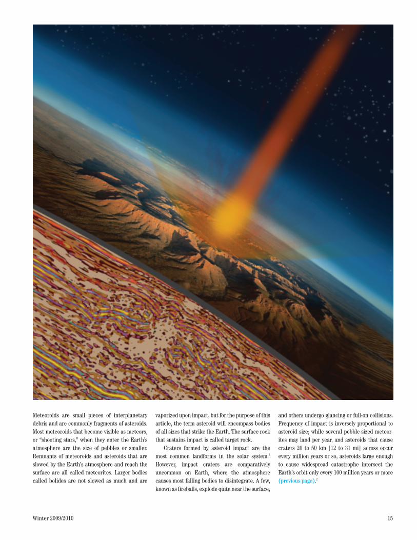
Meteoroids are small pieces of interplanetary debris and are commonly fragments of asteroids. Most meteoroids that become visible as meteors, or “shooting stars,” when they enter the Earth’s atmosphere are the size of pebbles or smaller. Remnants of meteoroids and asteroids that are slowed by the Earth’s atmosphere and reach the surface are all called meteorites. Larger bodies called bolides are not slowed as much and are
vaporized upon impact, but for the purpose of this article, the term asteroid will encompass bodies of all sizes that strike the Earth. The surface rock that sustains impact is called target rock.
Craters formed by asteroid impact are the most common landforms in the solar system.1 However, impact craters are comparatively uncommon on Earth, where the atmosphere causes most falling bodies to disintegrate. A few, known as fireballs, explode quite near the surface,
and others undergo glancing or full-on collisions. Frequency of impact is inversely proportional to asteroid size; while several pebble-sized meteor-ites may land per year, and asteroids that cause craters 20 to 50 km [12 to 31 mi] across occur every million years or so, asteroids large enough to cause widespread catastrophe intersect the Earth’s orbit only every 100 million years or more (previous page).2
Oilfield ReviewAutumn 09Impact Fig. OpenerORAUT09-Impact Fig. Opener
28237schD4R1.indd 15 1/9/10 5:19 AM
16 Oilfield Review
When craters are formed by impact events, they disappear relatively quickly with the rework-ing of the Earth’s crust—buried beneath sedi-ments, pulled under at subduction zones, folded into mountain ranges or eroded. Eroded, buried or otherwise modified impact craters are called impact structures.
An asteroid can hit the Earth with a velocity between 10 and 70 km/s [up to 250,000 km/h, or 160,000 mi/h], releasing large amounts of kinetic energy.3 Crater formation is a rapid process that can be divided into three stages: contact and compression, excavation, and postimpact crater modification. Structural alterations and phase
changes in the target rocks occur during the first stage, and the morphology of the crater is deter-mined in the later stages.
Upon contact, the projectile pushes target material out of its path, compressing and acceler-ating it. The target resists penetration and decel-erates the projectile. Following contact, the projectile stops almost immediately, traveling a distance approximating one or two times its diameter into the target rock. The kinetic energy is converted into heat and shock waves that pen-etrate both the impacting body and the target rock. A large asteroid can produce shock pres-sures in excess of 100 GPa [14.5 million psi] and
temperatures greater than 3,000°C [5,400°F] in the impact volume, causing fracturing, shock metamorphism, mineral phase changes, melting and vaporization.4 Duration of the contact and compression stage depends on the projectile’s size, composition and velocity; for all but the largest impacts, this stage lasts only up to a few seconds.
During the excavation stage, which lasts a few seconds to minutes, a hemispherical shock wave propagates into the target, generating high pres-sure in the material. The expanding shock wave causes irreversible changes in the shocked volume. After the shock wave passes, the high pressure is released by a rarefaction, or pressure-release wave. This pressure wave leads to cre-ation of a mass flow that opens the crater. The material excavated by the impact is ejected from the crater and can be thrown great distances. The larger the impactor, the more likely it will be completely vaporized and ejected as well. Solid, liquid and vaporized debris are thrust back up along paths that form a cone-shaped “ejecta cur-tain.” Ejected material follows ballistic trajecto-ries upward and back down to Earth. Some debris may travel beyond the atmosphere and then reenter it thousands of kilometers away.
Ejecta size ranges from vapor and dust to giant blocks. Molten rock and vaporized matter that condenses during flight can form round, sand-sized particles called spherules. Such spherules, often glassy, can land thousands of kilometers from the impact site and form distinc-tive layers in the sedimentary record.5 In the Chicxulub, Mexico, impact of 65 million years ago, ejecta distribution reached global propor-tions, with some spherules traveling as far as New Zealand.6 Spherule layers often outlast the crater itself and may be the only evidence of an ancient impact, as is the case for some 3.5 billion-year-old impact deposits in South America and Australia. The thickness of the spherule layer typically decreases with distance from the impact site.
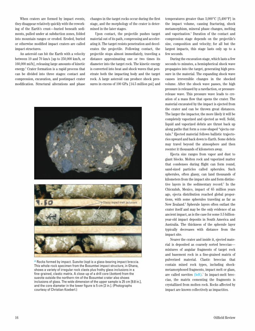
Nearer the crater and inside it, ejected mate-rial is deposited as coarsely sorted breccias—mixtures of angular fragments of target rock and basement rock in a fine-grained matrix of pulverized material. Clastic breccias that contain mixed rock types, including shock- metamorphosed fragments, impact melt or glass, are called suevites (left).7 In impact-melt brec-cias, the matrix cementing the fragments is crystallized from molten rock. Rocks affected by impact are known collectively as impactites.
> Rocks formed by impact. Suevite (top) is a glass-bearing impact breccia. This whole-rock specimen from the Bosumtwi impact structure, in Ghana, shows a variety of irregular rock clasts plus frothy glass inclusions in a fine-grained, clastic matrix. A close-up of a drill core (bottom) from the suevite outside the northern rim of the Bosumtwi crater also shows inclusions of glass. The wide dimension of the upper sample is 25 cm [9.8 in.], and the core diameter in the lower figure is 5 cm [2 in.]. (Photographs courtesy of Christian Koeberl.)
Glassy impact-melt inclusions
Oilfield ReviewAutumn 09Impact Fig. 2ORAUT09-Impact Fig. 2
Glassy impact-melt inclusions
Oilfield ReviewAutumn 09Impact Fig. 2ORAUT09-Impact Fig. 2
28237schD4R1.indd 16 1/9/10 5:19 AM

Winter 2009/2010 17
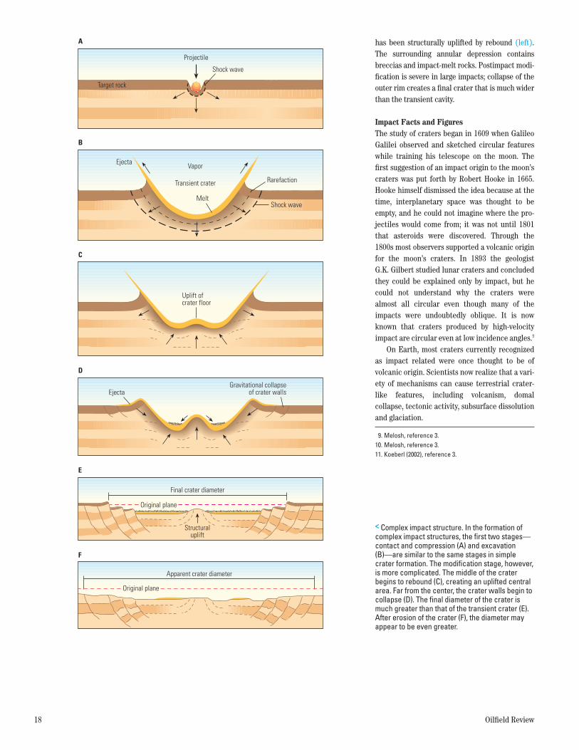
Excavation produces a bowl-shaped “tran-sient” crater. During postimpact modification, the transient crater collapses because of gravity. The morphology of the resulting crater depends on target rock type and impactor size.8 Simple structures retain their bowl shape and uplifted rim. On Earth simple impact structures are usu-ally small, with diameters up to 2 km [1.2 mi] in sedimentary rock and up to 4 km [2.4 mi] in crystalline rock. An example of a well-preserved simple structure in sedimentary rock is the Barringer crater, located in Arizona, USA (right). Beneath the apparent floor of the crater lies a layer of brecciated target material, which over-lies the fractured but autochthonous target rocks of the crater’s true floor. Analysis of shocked min-erals from the crater floor indicates that pres-sures reached approximately 25 GPa [3.6 million psi]. The walls of the final, collapsed, crater are shorter than in the original, transient, crater. Such postimpact modifications produce a final diameter slightly greater than that of the tran-sient cavity.
Craters larger than a few kilometers in diame-ter usually have complex morphologies character-ized by an uplifted central area. The central uplift may be a peak or, in the largest craters, a ring. The central high consists of shocked target rock that
> Simple impact structure. During contact and compression (A) the asteroid hits the Earth’s surface and pushes target material downward. In the excavation stage (B), the transient crater forms. Following impact, the crater walls have collapsed slightly, and ejecta have fallen back into the crater (C). The Barringer crater, in Arizona (D), is an example of a simple impact crater. It has a diameter of 1.2 km [0.7 mi] and was formed 50,000 years ago. (Photograph courtesy of the Lunar and Planetary Institute.)
Oilfield ReviewAutumn 09Impact Fig. 3ORAUT09-Impact Fig. 3
D
Shock wave
A
Projectile
Target rock
Transient crater
Vapor
Melt
Ejecta
Rarefaction
Shock wave
B
C
Overturned flap
Original plane
Dyke with impact melt
Shockedtarget rock
Melt
Mixedbreccia
Sediments
Fracture
Air-fall breccia
3. For general references on the following discussion: Melosh HJ: Impact Cratering: A Geologic Process.
New York: Oxford University Press, 1989. Koeberl C: “Impact Cratering: The Mineralogical and
Geochemical Evidence,” in Johnson KS and Campbell JA (eds): Ames Structure in Northwest Oklahoma and Similar Features: Origin and Petroleum Production (1995 Symposium). Norman, Oklahoma: Oklahoma Geological Survey, Circular 100 (1997): 30–54.
Koeberl C: “Mineralogical and Geochemical Aspects of Impact Craters,” Mineralogical Magazine 66, no. 5 (October 2002): 745–768.
4. Koeberl (2002), reference 3.5. Simonson BM and Glass BP: “Spherule Layers—Records
of Ancient Impact,” Annual Review of Earth and Planetary Sciences 32 (May 2004): 329–361.
6. Smit J: “The Global Stratigraphy of the Cretaceous-Tertiary Boundary Impact Ejecta,” Annual Review of Earth and Planetary Sciences 27 (May 1999): 75–113.
7. Koeberl (2002), reference 3. Koeberl C, Milkereit B, Overpeck JT, Scholz CA,
Amoako PYO, Boamah D, Danuor S, Karp T, Kueck J, Hecky RD, King JW and Peck JA: “An International and Multidisciplinary Drilling Project into a Young Complex Impact Structure: The 2004 ICDP Bosumtwi Crater Drilling Project—An Overview,” Meteoritics & Planetary Science 42, no. 4/5 (2007): 483–511.
8. Grieve RAF: “Terrestrial Impact Structures: Basic Characteristics and Economic Significance with Emphasis on Hydrocarbon Production,” in Johnson KS and Campbell JA (eds): Ames Structure in Northwest Oklahoma and Similar Features: Origin and Petroleum Production (1995 Symposium). Norman, Oklahoma: Oklahoma Geological Survey, Circular 100 (1997): 3–16.
28237schD4R1.indd 17 3/22/10 1:40 PM
18 Oilfield Review
has been structurally uplifted by rebound (left). The surrounding annular depression contains breccias and impact-melt rocks. Postimpact modi-fication is severe in large impacts; collapse of the outer rim creates a final crater that is much wider than the transient cavity.
Impact Facts and FiguresThe study of craters began in 1609 when Galileo Galilei observed and sketched circular features while training his telescope on the moon. The first suggestion of an impact origin to the moon’s craters was put forth by Robert Hooke in 1665. Hooke himself dismissed the idea because at the time, interplanetary space was thought to be empty, and he could not imagine where the pro-jectiles would come from; it was not until 1801 that asteroids were discovered. Through the 1800s most observers supported a volcanic origin for the moon’s craters. In 1893 the geologist G.K. Gilbert studied lunar craters and concluded they could be explained only by impact, but he could not understand why the craters were almost all circular even though many of the impacts were undoubtedly oblique. It is now known that craters produced by high-velocity impact are circular even at low incidence angles.9
On Earth, most craters currently recognized as impact related were once thought to be of volcanic origin. Scientists now realize that a vari-ety of mechanisms can cause terrestrial crater-like features, including volcanism, domal collapse, tectonic activity, subsurface dissolution and glaciation.
, Complex impact structure. In the formation of complex impact structures, the first two stages—contact and compression (A) and excavation (B)—are similar to the same stages in simple crater formation. The modification stage, however, is more complicated. The middle of the crater begins to rebound (C), creating an uplifted central area. Far from the center, the crater walls begin to collapse (D). The final diameter of the crater is much greater than that of the transient crater (E). After erosion of the crater (F), the diameter may appear to be even greater.
Oilfield ReviewAutumn 09Impact Fig. 4ORAUT09-Impact Fig. 4
Shock wave
A
Projectile
Target rock
Transient crater
Vapor
Melt
Ejecta
Rarefaction
Shock wave
B
C
Uplift ofcrater floor
EjectaGravitational collapse
of crater walls
D
E
Original plane
Structuraluplift
Final crater diameter
F
Apparent crater diameter
Original plane
9. Melosh, reference 3.10. Melosh, reference 3.11. Koeberl (2002), reference 3.
28237schD4R1.indd 18 1/9/10 5:19 AM

Winter 2009/2010 19
The first proposal linking asteroid impact to a terrestrial crater was made in 1906, when D.M. Barringer argued that the simple crater in Arizona now named for him was produced by the high-speed impact of a large meteorite.10 Fragments of meteoritic iron—a nickel-iron alloy containing rare metals in concentrations unlike those in any terrestrial rock—had been discov-ered on the rim of the crater. Barringer was con-vinced that a large meteorite was buried below the crater floor, and he started a mining company to drill holes in search of the iron mass. His claim was a contentious one, in part because he was never able to uncover the meteorite, which had vaporized upon contact. His opponents argued into the 1950s that the crater was caused by vol-canism or collapse. The discovery of pulverized deposits and ultrahigh-pressure mineral phases helped convince geologists and astronomers that the Barringer crater and many others are scars of asteroid impact.
Because in most cases the asteroid is destroyed upon impact, remnants that prove impact origin are hard to find. Erosion and burial further complicate the situation. Therefore, sci-entists have developed diagnostic criteria for identifying and confirming impact structures on Earth. In the absence of the extraterrestrial projectile or geochemical evidence thereof, the following characteristics are deemed most impor-tant for confirming asteroid impact: evidence of shock metamorphism, crater morphology and geophysical anomalies. Of these three, only diag-nostic shock-metamorphic effects can provide unambiguous evidence of impact origin.
The impact shock wave causes compression of target rocks at pressures far exceeding the Hugoniot elastic limit (HEL)—the maximum stress a material will reach without permanent distortion.11 The HEL for most minerals and rocks is 5 to 10 GPa [725,000 to 1,450,000 psi]. The only natural process on Earth known to produce shock pressures exceeding these levels is asteroid impact; static pressures involved in deep meta-morphism may approach 5 GPa, and volcanic activity does not exceed pressures of 1 GPa [145,000 psi].
At impact pressures, two types of shock meta-morphism can occur: phase changes and struc-tural changes (above right). In a phase change, a mineral transforms from one phase to another. For example, quartz undergoes solid-state phase transitions, forming coesite and then stishovite at even higher pressures. The stishovite poly-morph of quartz has never been found in nature
except in impact structures. Another phase change that can occur at impact pressures is from graphite to diamond. High-pressure phase changes typically involve closer packing of the mineral’s constituent molecules, resulting in a high-density version of the mineral. These changes can be detected by optical and scanning electron microscopy, X-ray diffraction and nuclear magnetic resonance measurements.
Structural changes can occur on macroscopic and microscopic scales. A macroscopic indicator of impact shock is the occurrence of shatter cones. These structures, which are cones with regular thin grooves that radiate from the apex, develop better in some lithologies than in others. They form at pressures from 2 to 30 GPa [290,000 to 4,400,000 psi] and range in size from milli-meters to meters (below).
> Pressures and temperatures of impact-related mineral changes. Conditions that cause ordinary subsurface metamorphism are shaded in blue. High-velocity impact, typically generating pressures greater than 5 GPa, causes phase transformations—such as the change from quartz polymorph coesite to stishovite—and shock metamorphism, which is characterized by planar deformation features, diaplectic glass, shock melting and vaporization.
Tem
pera
ture
, °C
Pressure, GPa
1,000
2,000
3,000
00.1 0.5 1 5 10 50 100
Shattercones
Planardeformation
features
Diaplecticglass
Melting
Vaporization
Quar
tzCo
esite
Grap
hite
Diam
ond
Coes
iteSt
isho
vite
EclogiteGranuliteAmphiboliteGreenschistGlaucophaneSchistZeolite
HornfelsSanidinite
Zircon decomposesQuartz melts
Sphene melts
Oilfield ReviewAutumn 09Impact Fig. 5ORAUT09-Impact Fig. 5
> Shatter cone in limestone. This shatter cone was retrieved from the Steinheim crater, in Germany. The crater was formed about 15 million years ago and is still visible on the Earth’s surface. (Photograph courtesy of Christian Koeberl.)
4 cm
Oilfield ReviewAutumn 09Impact Fig. 6ORAUT09-Impact Fig. 6
28237schD4R1.indd 19 3/22/10 1:40 PM

20 Oilfield Review
Structures at the microscopic scale typically occur at higher pressures. At pressures between 5 and 45 GPa [725,000 to 6,500,000 psi] some mineral grains develop microstructures called planar deformation features (PDFs).12 These fea-tures are sets of closely spaced parallel lamellae (left). Individual grains may contain multiple groups of PDFs at different angles. Analysis of the orientations helps quantify the stress levels attained during impact.
At pressures greater than about 30 GPa, some mineral crystals transform into an amorphous structure called diaplectic glass. This glass forms without melting. Such a solid-state transforma-tion can preserve the grain shape and some of the grain’s original defects, distinguishing the product from melt glass.
At pressures above 50 GPa [7.3 million psi], silica and other mineral grains melt, and above 60 GPa [8.7 million psi] rocks undergo bulk melt-ing and form impact melts. If they cool quickly, these molten materials form impact glass, and if they cool slowly, they become fine-grained impact-melt rocks. With time, shock-generated glass recrystallizes, or devitrifies, explaining why no glass remains in older impact structures.
As of 2010, more than 175 impact structures that exhibit shock-metamorphic effects have been identified on the Earth (next page, top).13 These circular features range in diameter from 15 m [49 ft] at the Haviland crater, in Kansas, USA, to 300 km [190 mi] at the Vredefort crater, in the Witwatersrand basin of South Africa. More than 30 of these structures have some form of potentially economic deposits, including oil and gas, precious metals and diamonds.14
Three types of resources can result from impact:•Progenetic deposits originate before impact;
examples are the uranium deposits of the Carswell structure, in Saskatchewan, Canada, which were lifted up during crater formation, and the gold and uranium deposits of the Witwatersrand basin, which were buried and preserved in the Vredefort crater.
•Syngenetic deposits originate during orbecause of impact; examples are diamonds found in impact melts in several craters in Germany, Ukraine and Russia, and copper-nickel and platinum-group elements in sul-fides, such as those in the prolific mines of the Sudbury structure, in Ontario, Canada.
•Epigenetic deposits result from postimpactprocesses; examples include hydrocarbons and hydrothermal deposits. The remainder of this article focuses on hydrocarbon resources.
> Grain deformation. At impact pressures, some mineral grains develop planar deformation features (PDFs), which are closely spaced parallel lamellae that penetrate the whole grain. A shocked quartz grain assemblage from the Woodleigh impact structure, in Australia (top), displays multiple orientations of PDFs (from Reimold et al, reference 12). A single shocked quartz grain from an impact structure near Manson, Iowa, USA, exhibits two main PDF orientations (middle). The colors result from interference with the microscope’s light, caused by the grain thickness. An unshocked quartz grain (bottom) shows some features that inexperienced observers might confuse with PDFs. The lines are traces of subplanar fluid-inclusion trails that are the result of alteration caused by low-grade tectonic deformation. They are not straight, planar or closely spaced. (Photographs courtesy of Christian Koeberl.)
50 µm
50 µm
300 µm
Oilfield ReviewAutumn 09Impact Fig. 7ORAUT09-Impact Fig. 7
50 µm
50 µm
300 µm
Oilfield ReviewAutumn 09Impact Fig. 7ORAUT09-Impact Fig. 7
50 µm
50 µm
300 µm
Oilfield ReviewAutumn 09Impact Fig. 7ORAUT09-Impact Fig. 7
28237schD4R1.indd 20 1/9/10 5:19 AM
Winter 2009/2010 21
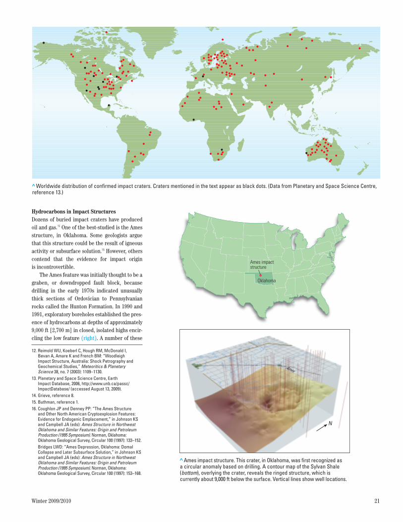
Hydrocarbons in Impact Structures Dozens of buried impact craters have produced oil and gas.15 One of the best-studied is the Ames structure, in Oklahoma. Some geologists argue that this structure could be the result of igneous activity or subsurface solution.16 However, others contend that the evidence for impact origin is incontrovertible.
The Ames feature was initially thought to be a graben, or downdropped fault block, because drilling in the early 1970s indicated unusually thick sections of Ordovician to Pennsylvanian rocks called the Hunton Formation. In 1990 and 1991, exploratory boreholes established the pres-ence of hydrocarbons at depths of approximately 9,000 ft [2,700 m] in closed, isolated highs encir-cling the low feature (right). A number of these
12. Reimold WU, Koeberl C, Hough RM, McDonald I, Bevan A, Amare K and French BM: “Woodleigh Impact Structure, Australia: Shock Petrography and Geochemical Studies,” Meteoritics & Planetary Science 38, no. 7 (2003): 1109–1130.
13. Planetary and Space Science Centre, Earth Impact Database, 2006, http://www.unb.ca/passc/ImpactDatabase/ (accessed August 13, 2009).
14. Grieve, reference 8. 15. Buthman, reference 1.16. Coughlon JP and Denney PP: “The Ames Structure
and Other North American Cryptoexplosion Features: Evidence for Endogenic Emplacement,” in Johnson KS and Campbell JA (eds): Ames Structure in Northwest Oklahoma and Similar Features: Origin and Petroleum Production (1995 Symposium). Norman, Oklahoma: Oklahoma Geological Survey, Circular 100 (1997): 133–152.
Bridges LWD: “Ames Depression, Oklahoma: Domal Collapse and Later Subsurface Solution,” in Johnson KS and Campbell JA (eds): Ames Structure in Northwest Oklahoma and Similar Features: Origin and Petroleum Production (1995 Symposium). Norman, Oklahoma: Oklahoma Geological Survey, Circular 100 (1997): 153–168.
>Worldwide distribution of confirmed impact craters. Craters mentioned in the text appear as black dots. (Data from Planetary and Space Science Centre, reference 13.)
Oilfield ReviewAutumn 09Impact Fig. 8ORAUT09-Impact Fig. 8
> Ames impact structure. This crater, in Oklahoma, was first recognized as a circular anomaly based on drilling. A contour map of the Sylvan Shale (bottom), overlying the crater, reveals the ringed structure, which is currently about 9,000 ft below the surface. Vertical lines show well locations.
Oilfield ReviewAutumn 09Impact Fig. 9ORAUT09-Impact Fig. 9
Ames impactstructure
Oklahoma
N
Ames
28237schD4R1.indd 21 1/9/10 5:19 AM

22 Oilfield Review
early wells produced oil and gas from the Arbuckle dolomite, a formation that does not usu-ally have significant porosity or permeability in this region.
Late in 1991 a well targeting a small feature in the central depression penetrated an unusu-ally thick shale section before finding oil in what drillers called a glassy formation, at 8,800 ft [2,680 m].17 The borehole then encountered more than 320 ft [98 m] of what turned out to be oil- bearing brecciated Precambrian granodiorite base-ment (left). The well became a prolific producer. Subsequent drilling, however, had mixed results.
By 1992, geologists put together the apparent ring-like distribution of productive Arbuckle wells, the extra thickness of shale and the clues of glass and brecciated basement rock to propose an impact origin for the Ames structure.18 To test the impact hypothesis, scientists from several organizations conducted petrographic, mineral-ogic and geochemical studies of drill cuttings and core samples from Ames boreholes. Additional investigations tested whether gravity and mag-netic fields in the vicinity of the structure are consistent with an impact origin (below left).19 In the hope of understanding the distribution of reservoir-quality rock, Continental Resources commissioned 2D and 3D seismic surveys over the structure.20
Microscopic scrutiny of cuttings and core samples revealed mineralogic changes to quartz that could be explained only by forces one to two orders of magnitude greater and 10 orders of magnitude shorter in duration than anything cre-ated internally in the Earth, such as volcanism and seismicity. The shock-impact features and the presence of rare impact glass confirmed the impact origin of the Ames crater.21
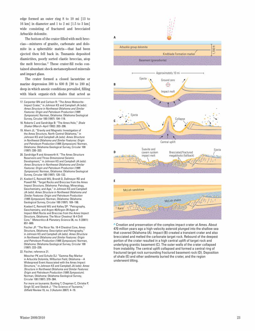
The scenario for the creation of the Ames structure can be described in steps (next page). Approximately 470 million years ago, 1,700 ft [520 m] of platform carbonates in a shallow sea overlaid granitic Precambrian basement rock. A 1,000-ft [300-m] diameter asteroid traveling at 20 mi/s [32 km/s] created a bowl-shaped depres-sion, excavating target rock to a depth of 2,000 ft [600 m] and compressing and fracturing the basement rock. Pressures exceeded 50 GPa.
The basement rock at the center of the crater subsequently rebounded. Around this central high, raised basement and carbonate rock formed a ring 3 mi [5 km] in diameter, 1 mi [1.6 km] thick and 1,600 ft [490 m] higher than the crater floor. Postimpact collapse of the crater’s inner
> Core sample from the Ames structure. Some of the Ames oil production comes from brecciated granodiorite basement rock. This sample contains large holes and vugs amid fragments of granite.
Large granitefragments
Large vugs that storeoil and enable flow
Small and very finefragments of graniteSmall and very finefragments of granite
Oilfield ReviewAutumn 09Impact Fig. 10ORAUT09-Impact Fig. 10
> Gravity signature of the Ames crater. Bouguer gravity anomalies indicate lateral subsurface density variations. In sedimentary rocks impact craters that have diameters similar to that of the Ames structure typically produce a negative gravity anomaly. A negative anomaly signifies material of low density. (Image courtesy of Judson Ahern.)
Oilfield ReviewAutumn 09Impact Fig. 11ORAUT09-Impact Fig. 11
Distance north, km
Distance east, km
–1.0
–2.0
18
14
12
10
6
4
2
0
mGal
0
68
24
8
16
20
1012
1416
1820
–0.6
–1.0
–1.4
–1.8
–2.2
mGa
l
Bouguer Gravity
28237schD4R1.indd 22 1/9/10 5:19 AM
Winter 2009/2010 23
17. Carpenter BN and Carlson R: “The Ames Meteorite-Impact Crater,” in Johnson KS and Campbell JA (eds): Ames Structure in Northwest Oklahoma and Similar Features: Origin and Petroleum Production (1995 Symposium). Norman, Oklahoma: Oklahoma Geological Survey, Circular 100 (1997): 104–119.
18. Roberts C and Sandridge B: “The Ames Hole,” Shale Shaker (March–April 1992): 203–206.
19. Ahern JL: “Gravity and Magnetic Investigation of the Ames Structure, North-Central Oklahoma,” in Johnson KS and Campbell JA (eds): Ames Structure in Northwest Oklahoma and Similar Features: Origin and Petroleum Production (1995 Symposium). Norman, Oklahoma: Oklahoma Geological Survey, Circular 100 (1997): 330–333.
20. Sandridge R and Ainsworth K: “The Ames Structure Reservoirs and Three-Dimensional Seismic Development,” in Johnson KS and Campbell JA (eds): Ames Structure in Northwest Oklahoma and Similar Features: Origin and Petroleum Production (1995 Symposium). Norman, Oklahoma: Oklahoma Geological Survey, Circular 100 (1997): 120–132.
21. Koeberl C, Reimold WU, Brandt D, Dallmeyer RD and Powell RA: “Target Rocks and Breccias from the Ames Impact Structure, Oklahoma: Petrology, Mineralogy, Geochemistry, and Age,” in Johnson KS and Campbell JA (eds): Ames Structure in Northwest Oklahoma and Similar Features: Origin and Petroleum Production (1995 Symposium). Norman, Oklahoma: Oklahoma Geological Survey, Circular 100 (1997): 169–198.
Koeberl C, Reimold WU and Kelley SP: “Petrography, Geochemistry, and Argon-40/Argon-39 Ages of Impact-Melt Rocks and Breccias from the Ames Impact Structure, Oklahoma: The Nicor Chestnut 18-4 Drill Core,” Meteoritics & Planetary Science 36, no. 5 (2001): 651–669.
Fischer JF: “The Nicor No. 18-4 Chestnut Core, Ames Structure, Oklahoma: Description and Petrography,” in Johnson KS and Campbell JA (eds): Ames Structure in Northwest Oklahoma and Similar Features: Origin and Petroleum Production (1995 Symposium). Norman, Oklahoma: Oklahoma Geological Survey, Circular 100 (1997): 223–239.
22. Fischer, reference 21. Mescher PK and Schultz DJ: “Gamma-Ray Marker
in Arbuckle Dolomite, Wilburton Field, Oklahoma—A Widespread Event Associated with the Ames Impact Structure,” in Johnson KS and Campbell JA (eds): Ames Structure in Northwest Oklahoma and Similar Features: Origin and Petroleum Production (1995 Symposium). Norman, Oklahoma: Oklahoma Geological Survey, Circular 100 (1997): 379–384.
For more on tsunamis: Bunting T, Chapman C, Christie P, Singh SC and Sledzik J: “The Science of Tsunamis,” Oilfield Review 19, no. 3 (Autumn 2007): 4–19.
edge formed an outer ring 8 to 10 mi [13 to 16 km] in diameter and 1 to 2 mi [1.5 to 3 km] wide consisting of fractured and brecciated Arbuckle dolomite.
The bottom of the crater filled with melt brec-cias—mixtures of granite, carbonate and dolo-mite in a spherulitic matrix—that had been ejected then fell back in. Tsunamis deposited diamictites, poorly sorted clastic breccias, atop the melt breccias.22 These crater-fill rocks con-tained abundant shock-metamorphosed minerals and impact glass.
The crater formed a closed lacustrine or marine depression 300 to 600 ft [90 to 180 m] deep in which anoxic conditions prevailed, filling with black organic-rich shales that acted as
> Creation and preservation of the complex impact crater at Ames. About 470 million years ago a high-velocity asteroid plunged into the shallow sea that covered Oklahoma (A). Impact (B) created a transient crater and also brecciated and melted the carbonate target rock. Rebound of the deepest portion of the crater resulted in a high central uplift of target rock and underlying granitic basement (C). The outer walls of the crater collapsed from instability. The central uplift collapsed and formed a central ring of fractured target rock surrounding fractured basement rock (D). Deposition of shale (E) and other sediments buried the crater, and the region underwent tilting.
Oilfield ReviewAutumn 09Impact Fig. 12ORAUT09-Impact Fig. 12
Approximately 10 mi
Ground zero
Impact melt
Ejecta
B
EjectaCollapse
Central uplift
C
Suevite andcavern systemimpact melt
EjectaBrecciated/fracturedmegablocks (fallback)
D
McLish shales
E
Karst
McLish sandstone
Basement (granodiorite)
1,70
0 ft
Kindblade Formation marker
Arbuckle group dolomite
A
28237schD4R1.indd 23 1/9/10 5:19 AM

24 Oilfield Review
hydrocarbon source rock and reservoir seal.23 The impact structure was buried under 10,000 ft [3,000 m] of sediments, ensuring its preserva-tion. Analysis of the burial history and of source rock and petroleum geochemistry indicates most of the hydrocarbons were generated in the Triassic, at approximately 225 million years ago (Ma).24 The hydrocarbons migrated into three types of reservoir rocks: Arbuckle dolomite with intercrystalline porosity, Arbuckle dolomite with leached porosity, and granite breccias (left).
Ultimate recoverable reserves are estimated at 25 million bbl oil [4 million m3] and 100 Bcf gas [2.8 billion m3]. As of 2009, the Ames impact structure has produced 17 million bbl [2.7 mil-lion m3] of oil and 80 Bcf [2.3 billion m3] of gas.25
Red Wing Creek Field The Red Wing Creek structure, in western North Dakota, USA, is one of several producing impact structures in the Williston basin.26 Early in its exploration history, the feature was a seismic anomaly that fit no known pattern.27 Shell drilled two wells in the area in the 1960s; both pene-trated unusually thick Mississippian and Pennsylvanian sections but were dry. In 1972 True Oil LLC drilled a well about 1 mi [1.6 km] away and discovered a 2,700-ft [820-m] gross oil column in highly fractured and brecciated car-bonates of the Mission Canyon Formation. Net pay of 1,600 ft [490 m] was in extreme contrast to the 20- to 40-ft [6- to 12-m] pay sections in the surrounding area.28 Subsequent wells helped delineate the field.
Data from seismic surveys and well logs dem-onstrated the existence of a circular central uplift as much as 1 mi across and comprising Mississippian carbonates, evaporites and interca-lated siliciclastics at about 3,300 ft [1,000 m] above their normal stratigraphic position for the region (left). Surrounding the uplift is a depres-sion more than 1 mi wide. An uplifted ring 5 mi [8 km] across encloses the complex structure, which is buried under almost 7,000 ft [2,100 m] of sediments.
The discovery of shatter-cone fragments in drill cuttings was the first indication that the oil was trapped in a complex meteorite impact struc-ture.29 More recent work confirmed there were PDFs in quartz grains in cuttings from one of the True Oil wells.30 Analysis of the PDF orientations indicates shock pressures reached 12 to 20 GPa [1.7 million to 2.9 million psi]. Estimates from stratigraphy place the age of the structure at 220 to 200 Ma.
> Ames petroleum system cross section. Organic-rich shales that filled the Ames crater became the source rock for reservoirs that formed in the fractured and brecciated granites and dolomites beneath the crater floor. Petroleum migrated into upthrown blocks in the central ring and the outer rim. Additional shales acted as seals. The section of Devonian and younger layers overlying the structure is about 7,000 ft thick (not shown to scale).
Oilfield ReviewAutumn 09Impact Fig. 13ORAUT09-Impact Fig. 13
Source rock Seal rockOil
Oil Migration into Reservoir Rock
> Impact crater oil trap in North Dakota. The Red Wing Creek field produces from a 2,700-ft section of fractured carbonate breccia in the crater’s central uplift (blue). This complex impact crater is about 6 mi [10 km] wide, but the productive zone is concentrated in a 1-mi2 [2.6-km2] area in the center.
Red Wing Creekstructure
NorthDakota
km
mi
1
1
0
0
NW SE
Cretaceous
JurassicTriassic
Devonian
Silurian
Mississippian
Pennsylvanian-Permian
Oilfield ReviewAutumn 09Impact Fig. 14ORAUT09-Impact Fig. 14
28237schD4R1.indd 24 1/9/10 5:19 AM

Winter 2009/2010 25
Matrix permeability of the Mission Canyon Formation is low—from 1 to 7 mD—throughout the Williston basin. However, in the Red Wing Creek field, impact-induced porosity and perme-ability enable relatively high flow rates. Productive wells are concentrated in a 1-mi2 [2.6-km2] area on the central uplift. The earlier Shell wells penetrated the structure on the flank of the uplift and in the annular crater.
Interpretation of a 3D seismic dataset and selected attributes, such as dip azimuth, coher-ency and curvature, allows for detailed mapping of the faults and deformed strata (right).31
To date, this field has produced 16.6 million bbl [2.6 million m3] of oil and 25 Bcf [700 million m3] of gas from 26 wells—22 are still producing. It is estimated that the brecciated central uplift contains 130 million bbl [21 million m3] of oil, of which 70 million bbl [11 million m3] are recover-able. Natural gas reserves are estimated at 100 Bcf. True Oil geologists and researchers at the University of Colorado in Boulder, USA, are using seismic data to develop a geologic model for use in reservoir simulation.
Big ImpactThe impact that has drawn the most attention in the past 25 years is the collision of the Chicxulub impactor with what is now the Mexican Yucatán Peninsula. Though a great deal of controversy surrounds the date, size and environmental rami-fications of this impact, the observations point to a truly cataclysmic event.
Interest in this structure dates to before the 1950s, when detection of a circular gravity low led Petróleos Mexicanos (PEMEX) to conduct a drilling program.32 Throughout the 1970s several
wells were drilled, some to 3,000 m or more, but none encountered hydrocarbons, nor were the results made public at the time.
In the late 1970s, scientists investigating sed-iments deposited at the end of the Cretaceous period and before the beginning of the Tertiary, called the K-T boundary, found extremely large concentrations of iridium [Ir] and other plati-num-group elements in a thin layer of clay that marks this boundary in Italy.33 Based on extrater-restrial ratios of the platinum-group elements, they proposed that the high-concentration layer
was deposited there and at several other locales around the globe 65 million years ago following an impact somewhere on Earth of an asteroid 10 km [6 mi] in diameter, which also caused mass extinction of the dinosaurs and other life forms.34 Subsequently, other workers discovered grains of shocked quartz and other shocked minerals, stishovite and impact diamonds in K-T boundary deposits elsewhere in the world, corroborating the notion of an immense impact with widely dis-persed ejecta.35
23. Castaño JR, Clement JH, Kuykendall MD and Sharpton VL: “Source-Rock Potential of Impact Craters,” in Johnson KS and Campbell JA (eds): Ames Structure in Northwest Oklahoma and Similar Features: Origin and Petroleum Production (1995 Symposium). Norman, Oklahoma: Oklahoma Geological Survey, Circular 100 (1997): 100–103.
24. Curtiss DK and Wavrek DA: “The Oil Creek-Arbuckle (!) Petroleum System, Major County, Oklahoma,” in Johnson KS and Campbell JA (eds): Ames Structure in Northwest Oklahoma and Similar Features: Origin and Petroleum Production (1995 Symposium). Norman, Oklahoma: Oklahoma Geological Survey, Circular 100 (1997): 240–258.
For more on petroleum system modeling: Al-Hajeri MM, Al Saeed M, Derks J, Fuchs T, Hantschel T, Kauerauf A, Neumaier M, Schenk O, Swientek O, Tessen N, Welte D, Wygrala B, Kornpihl D and Peters K: “Basin and Petroleum System Modeling,” Oilfield Review 21, no. 2 (Summer 2009): 14–29.
25. Vardi N: “The Last American Wildcatter,” Forbes (February 2, 2009), http://www.forbes.com/forbes/2009/0202/066.html (accessed September 7, 2009).
26. Sawatzky HB: “Astroblemes in Williston Basin,” AAPG Bulletin 59, no. 4 (April 1975): 694–710.
27. Gerhard LC, Anderson SB, Lefever JA and Carlson CG: “Geological Development, Origin, and Energy Mineral Resources of Williston Basin, North Dakota,” AAPG Bulletin 66, no. 8 (August 1982): 989–1020.
28. Gerhard LC, Anderson SB and Fischer DW: “Petroleum Geology of the Williston Basin,” in Leighton MW, Kolata DR, Oltz DT and Eidel JJ (eds): Interior Cratonic Basins. Tulsa: The American Association of Petroleum Geologists, AAPG Memoir 51 (1990): 507–559.
29. Grieve, reference 8.30. Koeberl C, Reimold WU and Brandt D: “Red Wing
Creek Structure, North Dakota: Petrographical and Geochemical Studies, and Confirmation of Impact Origin,” Meteoritics & Planetary Science 31 (1996): 335–342.
31. Huang C, Herber B, Barton R, Weimer P, Jiang S and Hammon S: “3-D Interpretation of a Meteorite Impact Field, Red Wing Creek Field, Williston Basin, Western North Dakota,” presented at the AAPG Annual Convention and Exhibition, Denver, June 7–10, 2009, http://www.searchanddiscovery.net/abstracts/html/2009/annual/abstracts/huang.htm (accessed October 12, 2009).
Friedman B: “Red Wing Data Has Big Impact,” AAPG Explorer (April 2009), http://www.aapg.org/explorer/2009/04apr/redwing0409.cfm (accessed September 6, 2009).
> Red Wing Creek impact structure seismic data. Interpretation of 3D seismic data reveals the subsurface signature of the Red Wing Creek crater. Depth of the Mission Canyon Formation is color coded, from red (shallow) to blue and purple (deep). Extracted 2D sections from the 3D survey form the background.
Oilfield ReviewAutumn 09Impact Fig. 15ORAUT09-Impact Fig. 15
32. Cornejo-Toledo A and Hernandez-Osuna A: “Las anomalias gravimetricas en la cuenca salina del istmo, planicie costera de Tabasco, Campeche y Peninsula de Yucatan,” Boletín de la Asociación Mexicana de Geólogos Petroleros 2 (1950): 453–460, as cited in Stoffler D: “Chicxulub Scientific Drilling Project (CSDP),” http://www.museum.hu-berlin.de/min/forsch/csdp.html (accessed October 9, 2009).
33. In the Earth’s crust, Ir concentration averages 0.001 ppm; in meteorites, the average is at least 500 times greater, or 0.5 ppm.
34. Alvarez LW, Alvarez W, Asaro F and Michel HV: “Extraterrestrial Cause for the Cretaceous-Tertiary Extinction,” Science 208, no. 4448 (June 6, 1980): 1095–1108.
35. Bohor B, Foord EE, Modreski PJ and Triplehorn DM: ”Mineralogic Evidence for an Impact Event at the Cretaceous-Tertiary Boundary,” Science 224, no. 4651 (May 25, 1984): 867–869.
McHone JF, Nieman RA, Lewis CF and Yates AM: “Stishovite at the Cretaceous-Tertiary Boundary, Raton, New Mexico,” Science 243, no. 4895 (March 3, 1989): 1182–1184.
Carlisle DB and Braman DR: “Nanometre-Size Diamonds in the Cretaceous/Tertiary Boundary Clay of Alberta,” Nature 352, no. 6337 (August 22, 1991): 708–709.
28237schD4R1.indd 25 1/9/10 5:19 AM
26 Oilfield Review
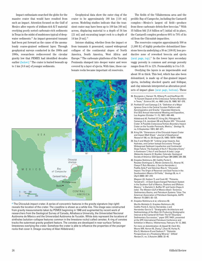
Impact enthusiasts searched the globe for the massive crater that would have resulted from such an impact. Attention focused on the Gulf of Mexico after reports of iridium-rich K-T material overlying poorly sorted carbonate-rich sediments in Texas in the midst of mudstones typical of deep-water sediments.36 An impact-generated tsunami had been put forward as the cause of the anoma-lously coarse-grained sediment layer. Through geophysical surveys conducted in the 1980s and 1990s, researchers rediscovered the circular gravity low that PEMEX had identified decades earlier (below).37 The crater is buried beneath up to 1 km [0.6 mi] of younger sediments.
Geophysical data show the outer ring of the crater to be approximately 180 km [110 mi] across. Modeling studies indicate that the tran-sient crater may have been up to 100 km [60 mi] across, displacing material to a depth of 34 km [21 mi] and excavating target rock to a depth of 14 km [9 mi].38
Intense shaking, whether from the impact or from tsunamis it generated, caused widespread collapse of the continental slopes of North America, South America, West Africa and Europe.39 The carbonate platforms of the Yucatán Peninsula slumped into deeper water and were covered by a layer of ejecta. With time, these car-bonate rocks became important oil reservoirs.
The fields of the Villahermosa area and the prolific Bay of Campeche, including the Cantarell complex—Mexico’s largest oil field—produce from these carbonate debris-flow breccias.40 With 35 billion bbl [5.6 billion m3] initial oil in place, the Cantarell complex produces 60% to 70% of its oil from the Chicxulub impactites.
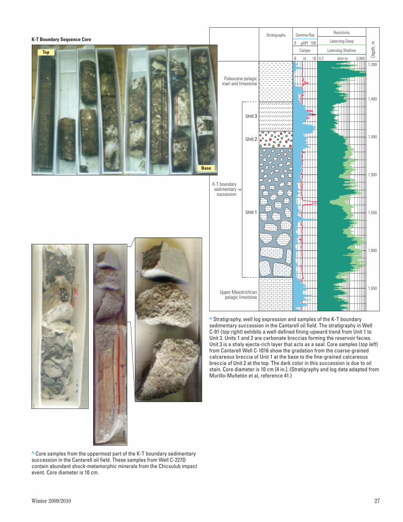
The reservoirs comprise approximately 300 m [1,000 ft] of highly productive dolomitized lime-stone breccia underlying a 30-m [100-ft] less pro-ductive zone of reworked breccia and ejecta (next page, top).41 In the lower layer secondary vuggy porosity is common and average porosity ranges from 8% to 12%. Permeability is 3 to 5 D.
Overlying the layers is an impermeable seal about 30 m thick. This bed, which has also been dolomitized, is made up of fine-grained impact ejecta, including shocked quartz and feldspar, and clay minerals interpreted as alteration prod-ucts of impact glass (next page, bottom). These
36. Bourgeois J, Hansen TA, Wiberg PL and Kauffman EG: “A Tsunami Deposit at the Cretaceous-Tertiary Boundary in Texas,” Science 241, no. 4865 (July 29, 1988): 567–570.
37. Penfield GT and Camargo Z A: “Definition of a Major Igneous Zone in the Central Yucatan Platform with Aeromagnetics and Gravity,” Expanded Abstracts, 51st SEG Annual International Meeting and Exposition, Los Angeles (October 11–15, 1981): 448–449.
Hildebrand AF, Penfield GT, Kring DA, Pilkington M, Camargo Z A, Jacobsen SB and Boyton WV: “Chicxulub Crater: A Possible Cretaceous/Tertiary Boundary Impact Crater on the Yucatán Peninsula, Mexico,” Geology 19, no. 9 (September 1991): 867–871.
38. Kring DA: “Dimensions of the Chicxulub Impact Crater and Impact Melt Sheet,” Journal of Geophysical Research 100, no. E8 (August 25, 1995): 16979–16986.
39. Day S and Maslin M: “Linking Large Impacts, Gas Hydrates, and Carbon Isotope Excursions Through Widespread Sediment Liquefaction and Continental Slope Failure: The Example of the K-T Boundary Event,” in Kenkmann T, Horz F and Deutsch A (eds): Large Meteorite Impacts III. Boulder, Colorado: Geological Society of America: GSA Special Paper 384 (2005): 239–258.
40. Grajales-Nishimura JM, Cedillo-Pardo E, Rosales-Domínguez C, Morán-Zenteno DJ, Alvarez W, Claeys P, Ruíz-Morales J, García-Hernández J, Padilla-Avila P and Sánchez-Ríos A: “Chicxulub Impact: The Origin of Reservoir and Seal Facies in the Southeastern Mexico Oil Fields,” Geology 28, no. 4 (April 2000): 307–310.
Magoon LB, Hudson TL and Cook HE: “Pimienta-Tamabra(!)—A Giant Supercharged Petroleum System in the Southern Gulf of Mexico, Onshore and Offshore Mexico,” in Bartolini C, Buffler RT and Cantú-Chapa A (eds): The Western Gulf of Mexico Basin: Tectonics, Sedimentary Basins, and Petroleum Systems. Tulsa: The American Association of Petroleum Geologists, AAPG Memoir 75 (2001): 83–125.
41. Grajales-Nishimura et al, reference 40. Murillo-Muñetón G, Grajales-Nishimura JM,
Cedillo-Pardo E, García-Hernández J and Hernández-García S: “Stratigraphic Architecture and Sedimentology of the Main Oil-Producing Stratigraphic Interval at the Cantarell Oil Field: The K/T Boundary Sedimentary Succession,” paper SPE 74431, presented at the SPE International Petroleum Conference and Exhibition in Mexico, Villahermosa, February 10–12, 2002.
For more on dolomitization: Al-Awadi M, Clark WJ, Moore WR, Herron M, Zhang T, Zhao W, Hurley N, Kho D, Montaron B and Sadooni F: “Dolomite: Perspectives on a Perplexing Mineral,” Oilfield Review 21, no. 3 (Autumn 2009): 32–45.
> The Chicxulub impact crater. A series of concentric features in the gravity signature (top right) reveals the location of the crater. The coastline is shown as a white line. This image was constructed from gravity measurements taken by PEMEX beginning in 1948 and augmented by recent work of researchers from the Geological Survey of Canada, Athabasca University, the Universidad Nacional Autónoma de México and the Universidad Autónoma de Yucatán. White dots represent the locations of sinkholes (solution-collapse features common in the limestone rocks) called cenotes. A ring of cenotes tracks the outermost gravity gradient feature. The cenotes are developed in near-surface Tertiary limestones overlying the crater. Somehow the crater is able to influence the properties of the younger rocks that cover it. (Image courtesy of Alan Hildebrand.)
Oilfield ReviewAutumn 09Impact Fig. 16ORAUT09-Impact Fig. 16
300
km0 300
mi0
Bochil
C E N T R A L A M E R I C A
U S A
Villahermosa
Chicxulubstructure
M E X I C O Bayof Campeche
Cantarell field
22°
21°
20°
90° 89°
28237schD4R1.indd 26 1/27/10 2:14 PM
Winter 2009/2010 27
> Core samples from the uppermost part of the K-T boundary sedimentary succession in the Cantarell oil field. These samples from Well C-227D contain abundant shock-metamorphic minerals from the Chicxulub impact event. Core diameter is 10 cm.
Oilfield ReviewAutumn 09Impact Fig. 18ORAUT09-Impact Fig. 18
> Stratigraphy, well log expression and samples of the K-T boundary sedimentary succession in the Cantarell oil field. The stratigraphy in Well C-91 (top right) exhibits a well-defined fining-upward trend from Unit 1 to Unit 3. Units 1 and 2 are carbonate breccias forming the reservoir facies. Unit 3 is a shaly ejecta-rich layer that acts as a seal. Core samples (top left) from Cantarell Well C-1016 show the gradation from the coarse-grained calcareous breccia of Unit 1 at the base to the fine-grained calcareous breccia of Unit 2 at the top. The dark color in this succession is due to oil stain. Core diameter is 10 cm [4 in.]. (Stratigraphy and log data adapted from Murillo-Muñetón et al, reference 41.)
1,350
1,400
1,450
1,500
1,550
1,600
1,650
Unit 3
Unit 2
Unit 1
Paleocene pelagicmarl and limestone
K-T boundarysedimentary
succession
Upper Maastrichtianpelagic limestone
Dept
h, m0 100gAPI
6 16in.
Caliper
Stratigraphy Gamma Ray Resistivity
0.2 3,000ohm.m
Laterolog Shallow
Laterolog Deep
Base
Top
Oilfield ReviewAutumn 09Impact Fig. 17ORAUT09-Impact Fig. 17
K-T Boundary Sequence Core
28237schD4R1.indd 27 1/27/10 2:15 PM
28 Oilfield Review
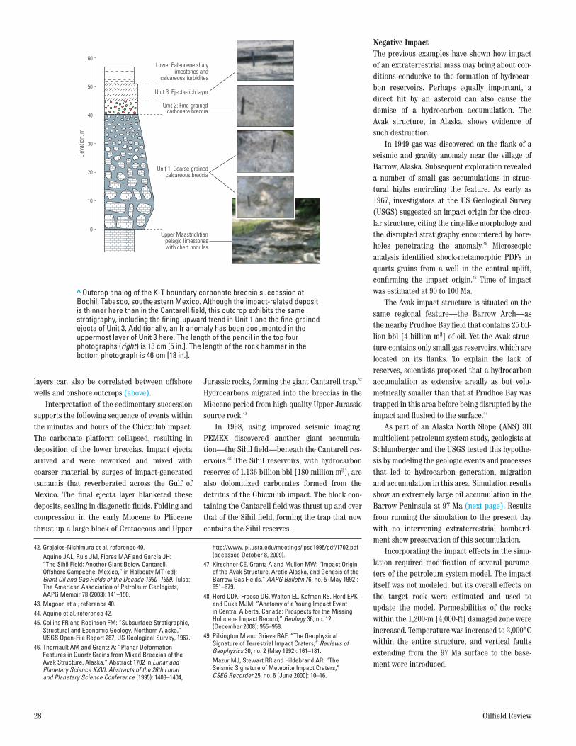
layers can also be correlated between offshore wells and onshore outcrops (above).
Interpretation of the sedimentary succession supports the following sequence of events within the minutes and hours of the Chicxulub impact: The carbonate platform collapsed, resulting in deposition of the lower breccias. Impact ejecta arrived and were reworked and mixed with coarser material by surges of impact-generated tsunamis that reverberated across the Gulf of Mexico. The final ejecta layer blanketed these deposits, sealing in diagenetic fluids. Folding and compression in the early Miocene to Pliocene thrust up a large block of Cretaceous and Upper
Jurassic rocks, forming the giant Cantarell trap.42 Hydrocarbons migrated into the breccias in the Miocene period from high-quality Upper Jurassic source rock.43
In 1998, using improved seismic imaging, PEMEX discovered another giant accumula-tion—the Sihil field—beneath the Cantarell res-ervoirs.44 The Sihil reservoirs, with hydrocarbon reserves of 1.136 billion bbl [180 million m3], are also dolomitized carbonates formed from the detritus of the Chicxulub impact. The block con-taining the Cantarell field was thrust up and over that of the Sihil field, forming the trap that now contains the Sihil reserves.
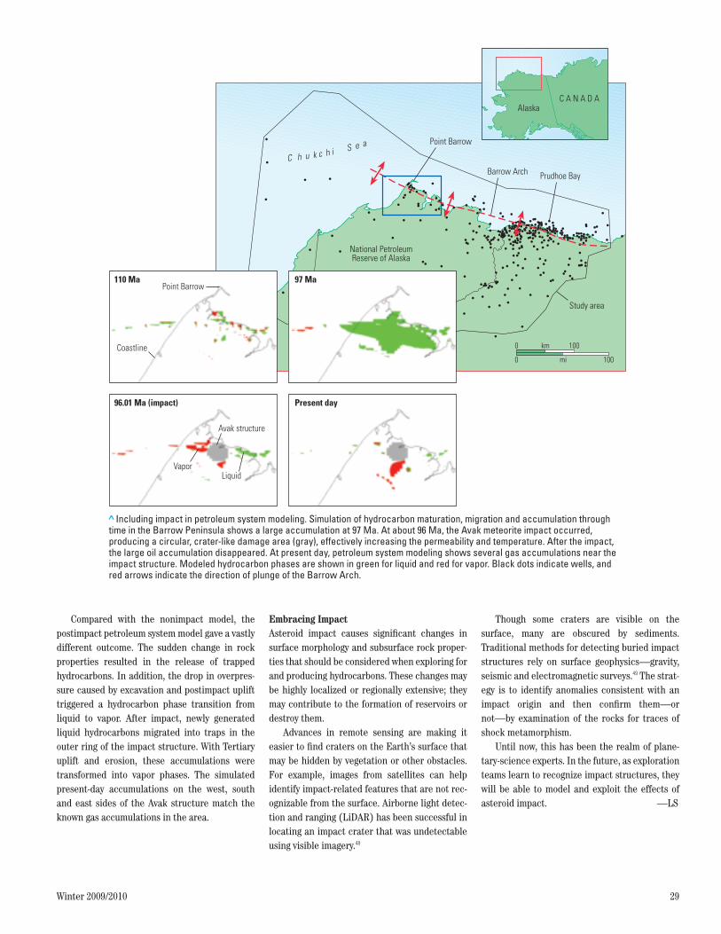
Negative ImpactThe previous examples have shown how impact of an extraterrestrial mass may bring about con-ditions conducive to the formation of hydrocar-bon reservoirs. Perhaps equally important, a direct hit by an asteroid can also cause the demise of a hydrocarbon accumulation. The Avak structure, in Alaska, shows evidence of such destruction.
In 1949 gas was discovered on the flank of a seismic and gravity anomaly near the village of Barrow, Alaska. Subsequent exploration revealed a number of small gas accumulations in struc-tural highs encircling the feature. As early as 1967, investigators at the US Geological Survey (USGS) suggested an impact origin for the circu-lar structure, citing the ring-like morphology and the disrupted stratigraphy encountered by bore-holes penetrating the anomaly.45 Microscopic analysis identified shock-metamorphic PDFs in quartz grains from a well in the central uplift, confirming the impact origin.46 Time of impact was estimated at 90 to 100 Ma.
The Avak impact structure is situated on the same regional feature—the Barrow Arch—as the nearby Prudhoe Bay field that contains 25 bil-lion bbl [4 billion m3] of oil. Yet the Avak struc-ture contains only small gas reservoirs, which are located on its flanks. To explain the lack of reserves, scientists proposed that a hydrocarbon accumulation as extensive areally as but volu-metrically smaller than that at Prudhoe Bay was trapped in this area before being disrupted by the impact and flushed to the surface.47
As part of an Alaska North Slope (ANS) 3D multiclient petroleum system study, geologists at Schlumberger and the USGS tested this hypothe-sis by modeling the geologic events and processes that led to hydrocarbon generation, migration and accumulation in this area. Simulation results show an extremely large oil accumulation in the Barrow Peninsula at 97 Ma (next page). Results from running the simulation to the present day with no intervening extra terrestrial bombard-ment show preservation of this accumulation.
Incorporating the impact effects in the simu-lation required modification of several parame-ters of the petroleum system model. The impact itself was not modeled, but its overall effects on the target rock were estimated and used to update the model. Permeabilities of the rocks within the 1,200-m [4,000-ft] damaged zone were increased. Temperature was increased to 3,000°C within the entire structure, and vertical faults extending from the 97 Ma surface to the base-ment were introduced.
> Outcrop analog of the K-T boundary carbonate breccia succession at Bochil, Tabasco, southeastern Mexico. Although the impact-related deposit is thinner here than in the Cantarell field, this outcrop exhibits the same stratigraphy, including the fining-upward trend in Unit 1 and the fine-grained ejecta of Unit 3. Additionally, an Ir anomaly has been documented in the uppermost layer of Unit 3 here. The length of the pencil in the top four photographs (right) is 13 cm [5 in.]. The length of the rock hammer in the bottom photograph is 46 cm [18 in.].
Oilfield ReviewAutumn 09Impact Fig. NEW 19ORAUT09-Impact Fig. NEW 19
Lower Paleocene shalylimestones and
calcareous turbidites
Unit 3: Ejecta-rich layer
Unit 2: Fine-grainedcarbonate breccia
Unit 1: Coarse-grainedcalcareous breccia
Upper Maastrichtianpelagic limestoneswith chert nodules
20
10
0
30
40
50
60
Elev
atio
n, m
42. Grajales-Nishimura et al, reference 40. Aquino JAL, Ruis JM, Flores MAF and García JH:
“The Sihil Field: Another Giant Below Cantarell, Offshore Campeche, Mexico,” in Halbouty MT (ed): Giant Oil and Gas Fields of the Decade 1990–1999. Tulsa: The American Association of Petroleum Geologists, AAPG Memoir 78 (2003): 141–150.
43. Magoon et al, reference 40.44. Aquino et al, reference 42.45. Collins FR and Robinson FM: “Subsurface Stratigraphic,
Structural and Economic Geology, Northern Alaska,” USGS Open-File Report 287, US Geological Survey, 1967.
46. Therriault AM and Grantz A: “Planar Deformation Features in Quartz Grains from Mixed Breccias of the Avak Structure, Alaska,” Abstract 1702 in Lunar and Planetary Science XXVI, Abstracts of the 26th Lunar and Planetary Science Conference (1995): 1403–1404,
http://www.lpi.usra.edu/meetings/lpsc1995/pdf/1702.pdf (accessed October 8, 2009).
47. Kirschner CE, Grantz A and Mullen MW: “Impact Origin of the Avak Structure, Arctic Alaska, and Genesis of the Barrow Gas Fields,” AAPG Bulletin 76, no. 5 (May 1992): 651–679.
48. Herd CDK, Froese DG, Walton EL, Kofman RS, Herd EPK and Duke MJM: “Anatomy of a Young Impact Event in Central Alberta, Canada: Prospects for the Missing Holocene Impact Record,” Geology 36, no. 12 (December 2008): 955–958.
49. Pilkington M and Grieve RAF: “The Geophysical Signature of Terrestrial Impact Craters,” Reviews of Geophysics 30, no. 2 (May 1992): 161–181.
Mazur MJ, Stewart RR and Hildebrand AR: “The Seismic Signature of Meteorite Impact Craters,” CSEG Recorder 25, no. 6 (June 2000): 10–16.
28237schD4R1.indd 28 3/22/10 1:40 PM
Winter 2009/2010 29
Compared with the nonimpact model, the postimpact petroleum system model gave a vastly different outcome. The sudden change in rock properties resulted in the release of trapped hydrocarbons. In addition, the drop in overpres-sure caused by excavation and postimpact uplift triggered a hydrocarbon phase transition from liquid to vapor. After impact, newly generated liquid hydrocarbons migrated into traps in the outer ring of the impact structure. With Tertiary uplift and erosion, these accumulations were transformed into vapor phases. The simulated present-day accumulations on the west, south and east sides of the Avak structure match the known gas accumulations in the area.
Embracing ImpactAsteroid impact causes significant changes in surface morphology and subsurface rock proper-ties that should be considered when exploring for and producing hydrocarbons. These changes may be highly localized or regionally extensive; they may contribute to the formation of reservoirs or destroy them.
Advances in remote sensing are making it easier to find craters on the Earth’s surface that may be hidden by vegetation or other obstacles. For example, images from satellites can help identify impact-related features that are not rec-ognizable from the surface. Airborne light detec-tion and ranging (LiDAR) has been successful in locating an impact crater that was undetectable using visible imagery.48
Though some craters are visible on the surface, many are obscured by sediments. Traditional methods for detecting buried impact structures rely on surface geophysics—gravity, seismic and electromagnetic surveys.49 The strat-egy is to identify anomalies consistent with an impact origin and then confirm them—or not—by examination of the rocks for traces of shock metamorphism.
Until now, this has been the realm of plane-tary-science experts. In the future, as exploration teams learn to recognize impact structures, they will be able to model and exploit the effects of asteroid impact. —LS
> Including impact in petroleum system modeling. Simulation of hydrocarbon maturation, migration and accumulation through time in the Barrow Peninsula shows a large accumulation at 97 Ma. At about 96 Ma, the Avak meteorite impact occurred, producing a circular, crater-like damage area (gray), effectively increasing the permeability and temperature. After the impact, the large oil accumulation disappeared. At present day, petroleum system modeling shows several gas accumulations near the impact structure. Modeled hydrocarbon phases are shown in green for liquid and red for vapor. Black dots indicate wells, and red arrows indicate the direction of plunge of the Barrow Arch.
Oilfield ReviewAutumn 09Impact Fig. 20ORAUT09-Impact Fig. 20
Point Barrow
Prudhoe BayBarrow Arch
National PetroleumReserve of Alaska
Study area
km 100
mi 100
0
0
C h u k c h i S e a
Brooks RangeFoothills
AlaskaC A N A D A
Point Barrow110 Ma 97 Ma
96.01 Ma (impact) Present day
Coastline
Avak structure
LiquidVapor
28237schD4R1.indd 29 1/27/10 2:19 PM