
High Fidelity Imagery & Infinite Analytics
17
1 © 2014 Skybox Imaging, Inc. Your World on Demand High Fidelity Imagery & Infinite Analy4cs John Clark Product Manager, Imagery & Data 14 December 2013 © 2014 Skybox Imaging, Inc.
-
Upload
cimmyt-int -
Category
Education
-
view
952 -
download
0
Transcript of High Fidelity Imagery & Infinite Analytics
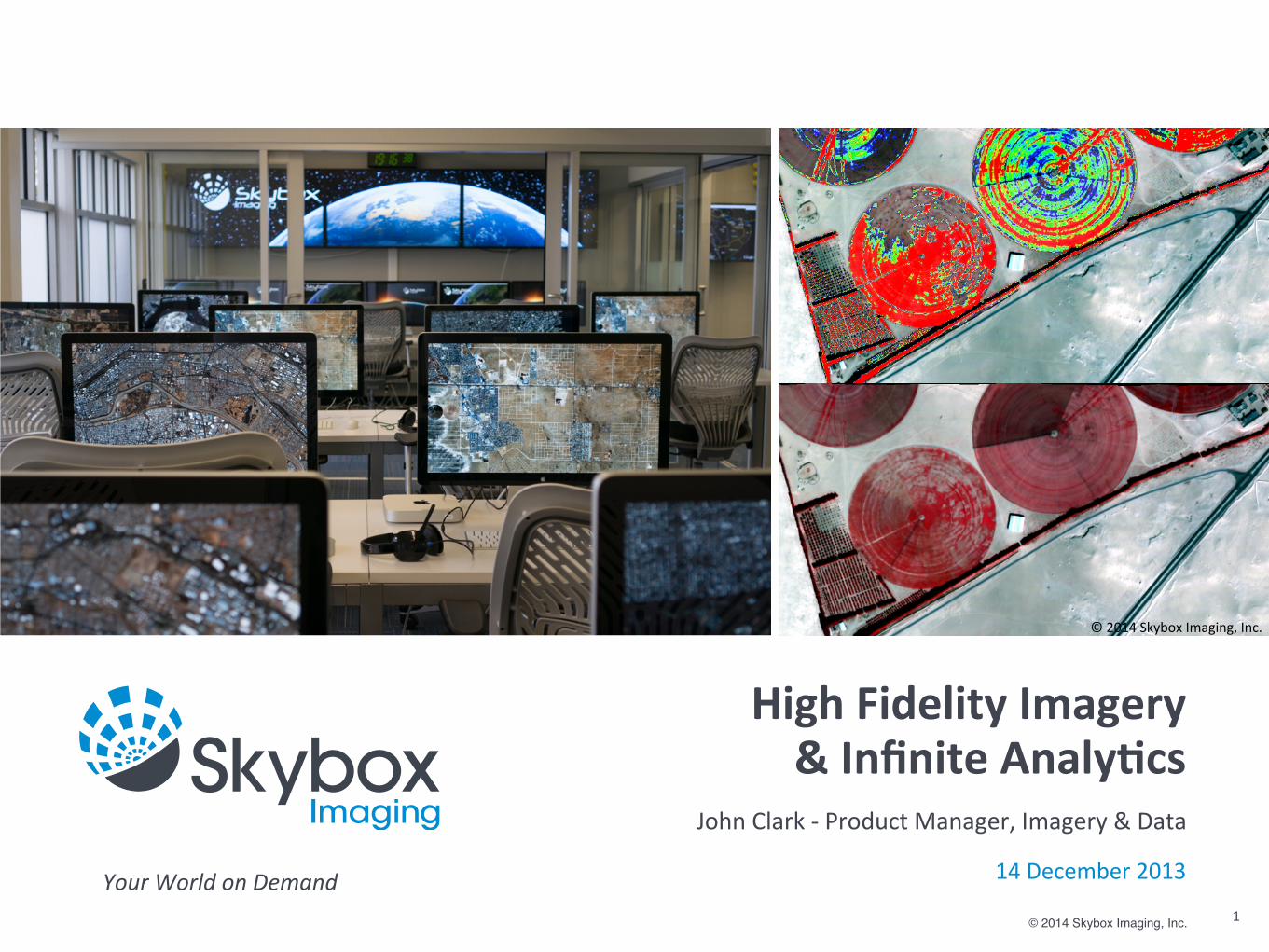
1© 2014 Skybox Imaging, Inc.
Your World on Demand
High Fidelity Imagery& Infinite Analy4cs
John Clark -‐ Product Manager, Imagery & Data
14 December 2013
© 2014 Skybox Imaging, Inc.

© 2014 Skybox Imaging, Inc.
The Skybox Vision
2
Deliver unprecedented insight into daily global ac4vity

© 2014 Skybox Imaging, Inc.
The Skybox Vision
Deliver unprecedented insight into daily global ac4vity
3
AgricultureHum
anitarianInsurance
Oil & GasNatural DisasterFinancialCarbon M
onitoringMariGm
e
Skybox is an informa4on and analy4cs company enabling applicaGons with a web-‐scale data plaCorm and a constellaGon of sub-‐meter imaging satellites.

Skybox Imaging Proprietary & Confidential
The Company -‐ by the numbers
44 2009 2010
2011
2012
$91MKhosla Ventures
Bessemer Ventures Canaan Ventures
Norwest Venture Partners
25
53
84
<4Months to launch of SkySat-‐2
2009 IncorporaGon
100+Number of space missions supported by the team
SkyboxTeam
2013115
24# Satellites in planned constellaGon
1# Satellites currently on orbit

© 2014 Skybox Imaging, Inc.
Complete System Approach
5
© 2013 Skybox Imaging, Inc.

© 2014 Skybox Imaging, Inc.
Technology that enables new applicaGons
Space System
24+ satellites70cm resoluGon4-‐5x per day
1.5B km2 annually6
Ground System
Hadoop Big Data pla[ormMul4 Sensor processing
Analy4cs via custom algorithmsFlexible integraGon
Custom Algorithm
Image Quality
(ResoluG
on)
1m resoluGon threshold
Timeliness -‐ Revisit /day
1m0.5m
0.25m
ExquisiteSystems
Skybox

© 2014 Skybox Imaging, Inc.
Skybox Product Lines
7
Access
Analy4c Services
Imagery & Video
Timely and Accessible sub-‐meter imagery and high definiGon video
Data mining for unprecedented insight into daily global acGvity
Access the Skybox constellaGon with direct tasking and downlink via the SkyNode

© 2014 Skybox Imaging, Inc.
Access Products
8
SkyNode
© 2014 Skybox Imaging, Inc.
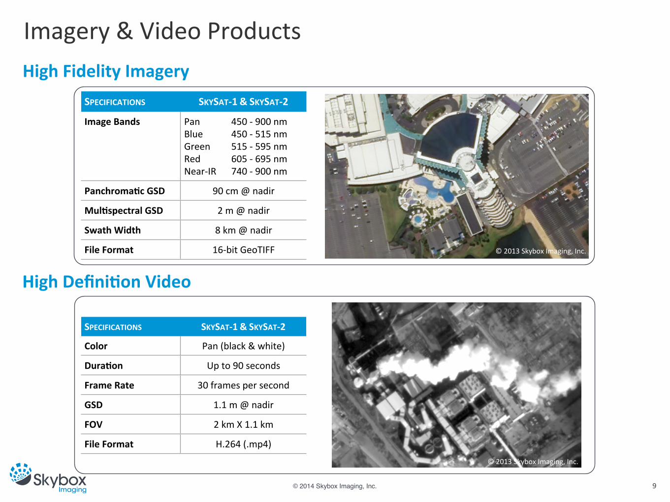
Imagery & Video Products
9
SPECIFICATIONS SKYSAT-‐1 & SKYSAT-‐2
Color Pan (black & white)
Dura4on Up to 90 seconds
Frame Rate 30 frames per second
GSD 1.1 m @ nadir
FOV 2 km X 1.1 km
File Format H.264 (.mp4)
SPECIFICATIONS SKYSAT-‐1 & SKYSAT-‐2
Image Bands Pan 450 -‐ 900 nmBlue 450 -‐ 515 nmGreen 515 -‐ 595 nmRed 605 -‐ 695 nmNear-‐IR 740 -‐ 900 nm
Panchroma4c GSD 90 cm @ nadir
Mul4spectral GSD 2 m @ nadir
Swath Width 8 km @ nadir
File Format 16-‐bit GeoTIFF
High Fidelity Imagery
High Defini4on Video
© 2013 Skybox Imaging, Inc.
© 2013 Skybox Imaging, Inc.

© 2014 Skybox Imaging, Inc.
SkySat-‐1 Imagery
10
SkySat-‐1 First Imagery. Perth, Australia -‐ December 4, 2013

© 2014 Skybox Imaging, Inc. 11
SkySat-‐1 Imagery
SkySat-‐1 First Imagery. Perth, Australia -‐ December 4, 2013

© 2014 Skybox Imaging, Inc. 12
SkySat-‐1 Imagery
SkySat-‐1 First Imagery. Abu Dhabi, UAE -‐ December 7, 2013
© 2013 Skybox Imaging, Inc. All Rights Reserved

© 2014 Skybox Imaging, Inc.
The Skybox Pla[orm Vision
13
???
© 2014 Skybox Imaging, Inc.
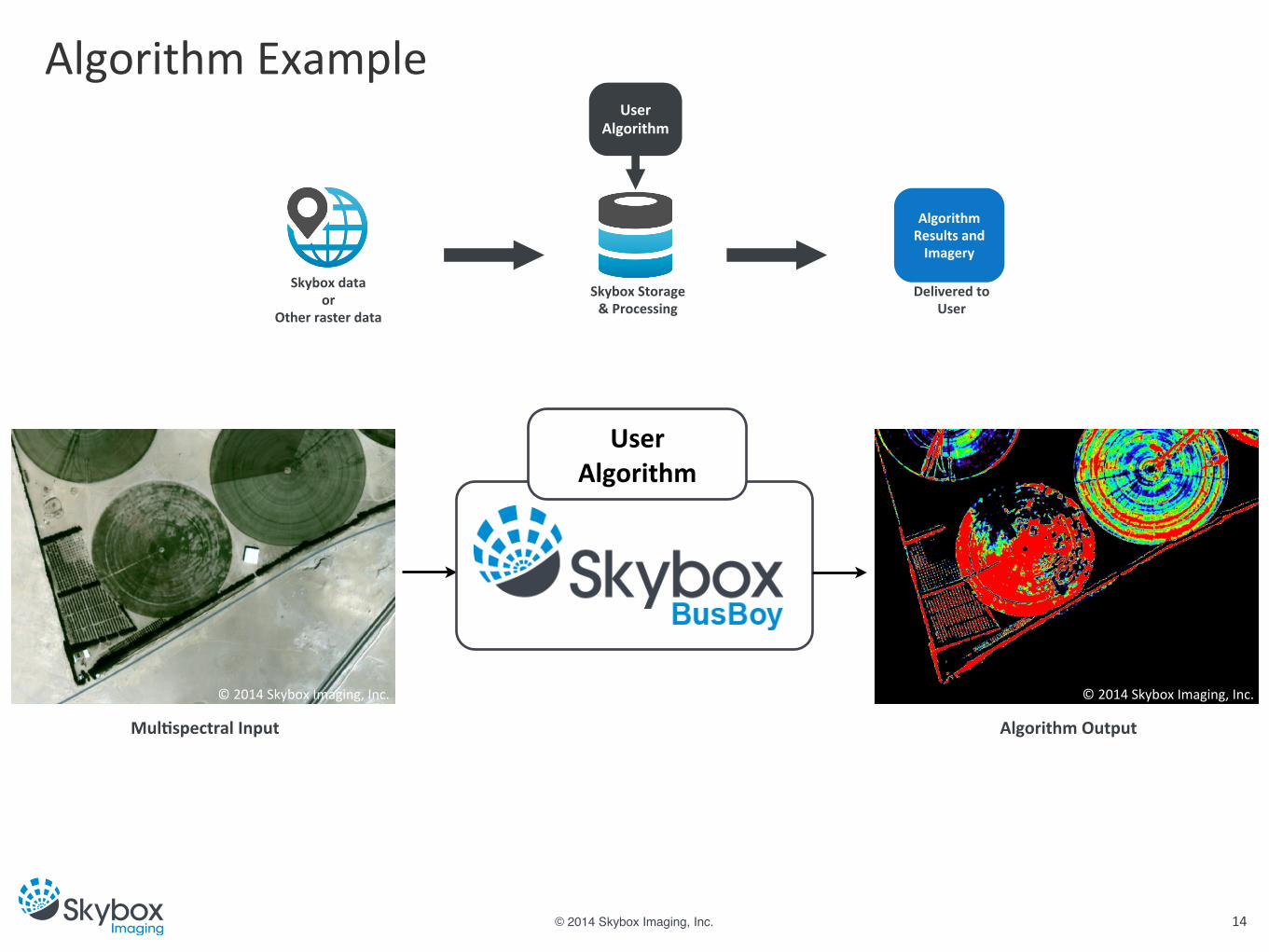
Algorithm Example
14
Skybox dataor
Other raster data
Skybox Storage& Processing
Algorithm Results and Imagery
Delivered toUser
UserAlgorithm
Mul4spectral Input
UserAlgorithm
Algorithm Output
© 2014 Skybox Imaging, Inc. © 2014 Skybox Imaging, Inc.

© 2014 Skybox Imaging, Inc.
Partnership
15
Analysis
SensorLayer
DataLayerData/Storage/&/ProcessingAlgorithms
DeliveryLayer
???Sensors
Delivery
Download Skybox SaaS Application API to Partner Applications
Skybox Algorithms Customer Algorithms Partner Algorithms
Skybox Data Customer Data Partner Data
Expert Analysis Human-in-the-Loop
© 2014 Skybox Imaging, Inc.
Partnership
Partnership is key to the Skybox strategy• Understand the customer & market• Path to customer & tools used by customer
Designed for flexibility• System integraGon• Flexible licensing• Scalable architecture
Crawl, Walk, Run• Define a business model• Start with a pilot• Scale to producGon
16