
HI-RES RAPID REFRESH (HRRR) Initial Implementation … · HI-RES RAPID REFRESH (HRRR) Initial...
34
HI-RES RAPID REFRESH (HRRR) Initial Implementation V1.0.1 EMC Change Configuration Board August 6, 2014 Presented by: Geoff Manikin EMC Collaborators: Curtis Alexander, Stan Benjamin, Steve Weygandt, David Dowell, Eric James, Ming Hu, Tanya Smirnova, John Brown, Joe Olson, and the rest of the ESRL/GSD crew Geoff DiMego EMC Jianbing Yang, Becky Cosgrove, Justin Cooke, Carissa Klemmer, Boi Vuong, Chris Magee NCO Jim Taft, John Michalakes, Jim Abeles IBM 1
Transcript of HI-RES RAPID REFRESH (HRRR) Initial Implementation … · HI-RES RAPID REFRESH (HRRR) Initial...

HI-RES RAPID REFRESH (HRRR) Initial Implementation V1.0.1
EMC Change Configuration Board
August 6, 2014
Presented by: Geoff Manikin EMC
Collaborators: Curtis Alexander, Stan Benjamin, Steve Weygandt, David Dowell, Eric James, Ming Hu, Tanya Smirnova, John Brown, Joe Olson, and
the rest of the ESRL/GSD crew
Geoff DiMego EMC
Jianbing Yang, Becky Cosgrove, Justin Cooke, Carissa Klemmer, Boi Vuong, Chris Magee NCO
Jim Taft, John Michalakes, Jim Abeles IBM 1

2
Charter Overview
– This project is an NWS and NCEP Annual Operating Plan (AOP) milestone for Q4 FY2014
– Implementation scheduled for 23 September 2014
– Hi-Res Rapid Refresh description • Used by SPC, AWC, WPC, FAA, NWS offices and others for
details short-range forecasts, especially convective evolution
• 24 cycles/day – each run out to 15 hours
• No cycling

Rapid Refresh and HRRR
NOAA hourly updated models
3
13km Rapid
Refresh (RAP)
(mesoscale)
V2 in ops: 2/25/14
3km HRRR
(storm-scale)
High-Resolution
Rapid Refresh
Scheduled NCEP
Implementation Sept 2014
RAP
HRRR

We have the RAP – why do need the HRRR?
• Increased resolution of basic fields like temperatures/winds/visibility, etc to resolve mesoscale features
• Explicitly resolves convection, allowing for storm-scale structure; shows skill at predicting storms with strong rotation, bow echoes, etc.
• Provides hourly updates at high resolution
• Will provide high-resolution 1st guesses to RTMA/URMA
4

High Impact Prediction Needs:
Higher Resolution Models
20 km RUC 2002
(3x resolution)
13 km RUC/RAP 2005/2012
(4.6x resolution)
3 km HRRR 2014
(20x resolution)
40 km RUC 1998
(1.5x resolution)

13-km 6hr forecast HRRR 6hr forecast
07 June 2012 5 PM EDT Reality
Observations Used High Impact Prediction Needs:
Higher Resolution Models
3-km HRRR
Explicit
Convection 6 hr forecast
Aircraft must
Navigate Around
Thunderstorms
13-km RAP
Parameterized
Convection 6 hr forecast
No Storm Structure
No Estimate
of Permeability
Accurate Storm
Structure
Accurate Estimate of
Permeability

7

8
Hurricane Arthur

9

Why run the HRRR at NCEP?
• GSD version has a significant time lag – often completes over 2 hours after the synoptic start time; NCEP version F00 available 44 minutes past the start time, with final products available 83 minutes after start time
• GSD must often truncate or even cancel cycles
• GSD runs subject to jet outages
• GSD can put more time into model development instead of maintaining HRRR data feed and web site with graphics
• Generate bufr and gempak data
• Get data into AWIPS
10

HRRR (and RAP) Future Milestones HRRR Milestones HRRR Availability
HRRR 12 hr fcst availability
Includes all missed/incomplete runs
Jet (HRRR primary) Zeus (HRRR backup) Union

HRRR Basic Overview
• Runs every hour (24/day) • Uses previous hour’s post-digital filter RAP analysis interpolated from 13 km to
3 km to initiate pre-forecast period • Uses previous hour’s RAP forecast for boundary conditions (01/13z HRRR uses 2-hr
old RAP due to 00/12z RAP having later start time)
• Runs a 1-hr spin-up forecast, using temperature tendencies obtained from processing radar data every 15 minutes to help properly initialize ongoing precipitation
• Runs a 3 km GSI after spin-up forecast to assimilate new data and a separate GSI to assimilate hydrometeor obs
• Model forecast is integrated out to 15 hours • Full post-processing is done for every forecast hour; subset of fields is post-
processed every 15 minutes • Bufr output and gempak data generated for each forecast hour; gempak files
also generated for the smaller sub-hourly data sets
12

3-km
Interp
HRRR Initialization from RAPv2
GSI
Hybrid
GSI HM
Anx
Digital
Filter
18 hr fcst
GSI
Hybrid
GSI HM
Anx
Digital
Filter
18 hr fcst
GSI
Hybrid
GSI HM
Anx
Digital
Filter
18 hr fcst
3 km
HRRR
13z 14z 15z 13 km RAP
Refl Obs
1 hr pre-fcst
GSI HM
Anx
GSI
3D-VAR
15 hr fcst
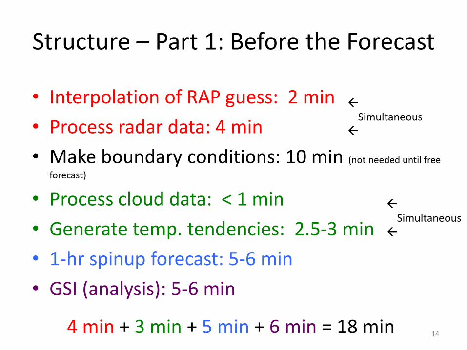
Structure – Part 1: Before the Forecast
• Interpolation of RAP guess: 2 min
• Process radar data: 4 min
• Make boundary conditions: 10 min (not needed until free
forecast)
• Process cloud data: < 1 min
• Generate temp. tendencies: 2.5-3 min
• 1-hr spinup forecast: 5-6 min
• GSI (analysis): 5-6 min
14
Simultaneous
Simultaneous
4 min + 3 min + 5 min + 6 min = 18 min

RESOURCES – allocated ~80 nodes
• Interpolation of RAP guess: 6 nodes
• Process radar data: 4 min: 4 nodes
• Make boundary conditions: 6 nodes
• Process cloud data: 1 node
• Generate temp. tendencies: 1 node
• 1-hr spinup forecast: 75 nodes
• GSI (analysis): 30 nodes
15
Simultaneous
Simultaneous
- 3 minute overlap between the spinup forecast and the boundary processing

HRRR Pre-Forecast Hour
-45
-30
-15
0
-60 -45 -30 -15 0
Model Pre-Forecast Time (min)
Temperature Tendency (i.e. Latent Heating) = f(Observed Reflectivity)
LH specified from reflectivity observations applied in four 15-min periods
NO digital filtering at 3-km
Reflectivity observations used to specify latent heating in previous 15-min period as follows:
• Positive heating rate where obs reflectivity ≥ 28 dBZ over depth ≥ 200 mb (avoids bright banding)
• Zero heating rate where obs reflectivity ≤ 0 dBZ
• Model microphysics heating rate preserved elsewhere
LH (i, j,k) =1000
p
æ
èç
ö
ø÷
Rd /cp(Lv + L f )( f [Ze ])
t *cp
LH = Latent Heating Rate (K/s) p = Pressure Lv = Latent heat of vaporization Lf = Latent heat of fusion Rd = Dry gas constant cp = Specific heat of dry air at constant p f[Ze] = Reflectivity factor converted to rain/snow condensate t = Time period of condensate formation (600s i.e. 10 min)

Why use almost 20 minutes to run a 1-hr spin-up?
17

HRRR 2013 3-km GSI HM Analysis
Obs
23z
30 May
2012
0-hr anx
3-km
radar DA
2013
HRRR
0-hr anx
No 3-km
radar DA
2012
HRRR

HRRR 2013 3-km GSI Data Assim
Optimal
Bias = 1.0
With 3-km DA
Without 3-km DA
With 3-km DA
Without 3-km DA
Statistical Retrospective Comparison
30 May - 04 June 2012 (55 matched runs)
3-km grid ≥ 35 dBZ
Eastern US
Improved 0-4 hr convection

Structure – Part 2: Forecast and Products
• 15-hr model forecast: ~39-40 min
• Simultaneous hourly post-processing + smartinit: ~7 min each
• Simultaneous hourly wrfbufr: 1-2 min each
• Simultaneous subhourly post-processing: 2 min each
• Sounding post (bufr): 2 min
• Gempak: runs alongside post manager
20

• 15-hr model forecast: 70 nodes
• Simultaneous hourly post-processing: 2 nodes each
• Simultaneous hourly wrfbufr: 1 node each
• Simultaneous sub-hourly post-processing: 2 nodes each
• Sounding post (bufr): 1 node (shared)
• Gempak: 1 node (shared)
21
RESOURCES – allocated ~80 nodes
- Maximum overlap is 3 hourly post jobs, 2 subhourly post jobs, the gempak job, and 1 wrfbufr job for a system total of 82 nodes - Efforts to further speed up forecast job were unsuccessful

POLICY for “LATE” RUNS
• NCEP HRRR completes in ~63 minutes (forecast job is finished by ~57 minutes)
• By the 66 minute mark, the next hour’s 1-hr spin-up forecast needs all of the nodes
• When the current hour’s spin-up forecast is ready to begin, if the previous hour’s free forecast has not yet reached F14, the current hour’s cycle will be canceled
• This scenario has been rare during testing, occurring only when there are significant system glitches
22

Validation with ESRL HRRR (Zeus)
NCEP HRRR ESRL HRRR (Zeus)

DEPENDENCIES
UPSTREAM: RAP, RAP obs processing, RAP “early” 00/12z obs processing DOWNSTREAM: RTMA (eventually), HRRRE-TL (eventually)
Implementation requires following enhancements: 1. Implementation of corrected g2tmpl library
24 TIN: Issued 1 August 2014

DEVELOPMENT TESTING
- CONUS HRRR run at GSD for 4+ years - Built at EMC Jan-May 2014 - Using 2013 version except for bug fix to address cold bias over
snow pack - Issue with discontinuity involving terrain at boundaries resolved
in early July - Only other crashes were caused by configuration settings
suggested by IBM – were able to speed up forecast by 3 minutes, but occasional crashes occurred
- NCO parallel running stably since early July – only changes since have been to post-processing
- 30-day evaluation to begin 8/11
25

Organization Recommended Optional (nice to have)
NCEP Centers EMC, NCO
NCEP Service
Centers
WPC, SPC, AWC OPC, NHC
NWS Region /
WFO
ER, CR, SR, WR
Other NWS or
NOAA
components
External
Customers /
Collaborators
FAA
PROPOSED EVALUATION TEAM
26
GSD has set up web site to provide graphics from NCEP parallel run

PRODUCTS
27
For each forecast hour (16), generate - 3 km file with data on pressure levels 350 MB (each file) - 3 km file with data on native levels 545 MB - 3 km file with mostly 2-D (surface) data 82 MB - 2.5 km NDFD file for AWIPS 96 MB - bufr sounding file 22 MB gempak file 210 MB
16.4 GB per cycle / 400 GB per day gempak files add 3.3 MB per cycle/ 80 GB per day
For every 15 minutes, generate - 3 km file with very limited 2-D (surface) data 22 MB - Time labels are in minutes - Cat 15/30/45/60 past hour into a single file 75 MB - gempak file 71.2 MB
1.05 GB per cycle / 25.2 GB per day gempak adds 1.14 GB/cycle / 27.4 GB per day

Disk Usage Current
Production
Expected New
Production
Actual New
Production
IBM Disk - 1.6 TB/day -
IBM Tape - TDB -
NCEP FTP Server - 425 GB/day -
NWS FTP Server - Same? -
Initial Analysis of Product Volume
28

29
Observed radar reflectivity – 2100 UTC 20 May 2013

30

31
3-member HRRR ensemble Max 1h updraft helicity

Preview of NCEP RAPv3/HRRRv2
Improved 2-m 12 hr temperature forecasts with reduction of warm bias
Eastern US Time Series
BIAS (Forecast – Obs) RMSE
--/-- Developmental ESRL RAPs with DA and model changes (candidates for final RAPv3)
-- Primary ESRL RAP with initial RAPv3 code
-- Operational NCEP RAPv2
Optimal Bias = 0.0
W
arm

Preview of NCEP RAPv3/HRRRv2
Improved 2-m 12 hr dewpoint forecasts with reduction of dry bias
Eastern US Time Series
BIAS (Forecast – Obs) RMSE
Dry
--/-- Developmental ESRL RAPs with DA and model changes (candidates for final RAPv3)
-- Primary ESRL RAP with initial RAPv3 code
-- Operational NCEP RAPv2
Optimal Bias = 0.0

34
Issues/Risks
Issues: no margin for error with 30-day evaluation period
Risks: any clock reset or CWD will push this to Q1FY15
Mitigation: lots of praying
Finances
Scheduling G Project Information and Highlights
Lead: Geoff DiMego,/Geoff Manikin EMC and Chris Magee, NCO
Scope:
1. Initial version of 3 km Hi-Res Rapid Refresh
2. Similar to RAP but allows explicit convection
3. Initialized from previous hour’s RAP analysis interpolated to 3 km.
Radar data assimilated every 15 minutes to allow a one-hour
“spinup” forecast, followed by a final 3 km GSI.
4. Output generated every 15 minutes of forecast
Expected Benefits:
1. Hourly hi-resolution forecasts of convective evolution and structure
along with various parameters relevant to severe storm, aviation,
and winter weather forecasting
Associated Costs:
Funding Sources:
Management Attention Required Potential Management Attention Needed On Target G v1.0 09/14//07
G
Y R
Hi-Resolution Rapid Refresh v1.0.0 Project Status as of 8/6/14
Milestone (NCEP) Date Status
EMC testing complete 6/30/2014 COMPLETED
Final code submitted to NCO 7/7/2014 COMPLETED
Technical Information Notice Issued 8/1/2014 COMPLETED
EMC CCB Approval 8/6/2014
Parallel testing begun in NCO 7/16/2014 COMPLETED
IT testing begins 8/11/2014
IT testing ends 8/18/2014
Real-time evaluation begins 8/11/2014
Real-time evaluation ends 9/10/2014
Management Briefing 9/18/2014
Implementation 9/23/2014
Y
Y