HI-LAND VIEWS - Bruce Trail · 2017-12-06 · HI-LAND VIEWS Winter 2017/2018 Editor: Carl Tafel...
20
HI-LAND VIEWS Winter 2017/2018 Editor: Carl Tafel Winter. Already? What Happened to Summer? Although this is ostensibly a winter edition, most of the articles in this newsletter are from past seasons. And, unlike the previous newsletter which was filled with events that the Dufferin Club sponsored or participated in, this edition contains mainly articles. It is not that we weren't involved in any events – we did have booths at the Alliston Potato Festival and Shelburne Fair, and, as you shall read, had a very successful Bruce Trail Day. But, unlike me, who is on the Bruce Trail almost every day and has not hiked outside of the Dufferin section in two years, our members tend to get restless, and set their sights on more exotic locales; not just on other sections of the Trail, but in different provinces and countries. In this edition, our Club President dons his historian's hat, our members take up a pen to write about their hiking exploits so that we can live vicariously through their adventures, and well known author Nicola Ross (the only non Dufferin member) writes about, of all things, hiking in Dufferin. But Ms Ross takes a broader view, writing about Dufferin County, which includes not only the tremendous trails in the Caledon section north of Highway 9, but also (gasp) trails outside of the Bruce trail network. So, during these long, cold winter nights, why not curl up by the fire with the Dufferin newsletter, and dream about far away places and warmer days ahead?
Transcript of HI-LAND VIEWS - Bruce Trail · 2017-12-06 · HI-LAND VIEWS Winter 2017/2018 Editor: Carl Tafel...

HI-LAND VIEWS
Winter 2017/2018
Editor: Carl Tafel
Winter. Already? What Happened to Summer?Although this is ostensibly a winter edition, most of the articles in this newsletter are from past seasons. And, unlike the previous newsletter which was filled with events that the Dufferin Club sponsored or participated in, this edition contains mainly articles. It is not that we weren't involved in any events – we did have booths at the Alliston Potato Festival and Shelburne Fair, and, as you shall read, had a very successful Bruce Trail Day. But, unlike me, who is on the Bruce Trail almost every day and has not hiked outside of the Dufferin section in two years, ourmembers tend to get restless, and set their sights on more exotic locales; not just on other sections of the Trail, but in different provinces and countries.
In this edition, our Club President dons his historian's hat, our members take up a pen to write about their hiking exploits so that we can live vicariously through their adventures, and well known author Nicola Ross (the only non Dufferin member) writes about, of all things, hiking in Dufferin. But Ms Ross takes a broader view, writing about Dufferin County, which includes not only the tremendous trails in the Caledon section north of Highway 9, but also (gasp) trails outside of the Bruce trail network.
So, during these long, cold winter nights, why not curl up by the fire with the Dufferin newsletter, and dream about far away places and warmer days ahead?
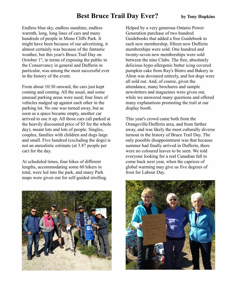
Best Bruce Trail Day Ever? by Tony Hopkins
Endless blue sky, endless sunshine, endless warmth, long, long lines of cars and many hundreds of people in Mono Cliffs Park. It might have been because of our advertising, it almost certainly was because of the fantastic weather, but this year's Bruce Trail Day on October 1st, in terms of exposing the public to the Conservancy in general and Dufferin in particular, was among the most successful ever in the history of the event.
From about 10:30 onward, the cars just kept coming and coming. All the usual, and some unusual parking areas were used; four lines of vehicles nudged up against each other in the parking lot. No one was turned away, but as soon as a space became empty, another car arrived to use it up. All those cars (all parked at the heavily discounted price of $5 for the whole day), meant lots and lots of people. Singles, couples, families with children and dogs large and small. Five hundred (excluding the dogs) is not an unrealistic estimate (at 3.87 people per car) for the day.
At scheduled times, four hikes of different lengths, accommodating some 60 hikers in total, were led into the park, and many Park maps were given out for self-guided strolling.
Helped by a very generous Ontario Power Generation purchase of two hundred Guidebooks that added a free Guidebook to each new membership, fifteen new Dufferin memberships were sold. One hundred and twenty-seven new memberships were sold between the nine Clubs. The free, absolutely delicious hypo-allergenic butter icing covered pumpkin cake from Ray's Bistro and Bakery in Alton was devoured entirely, and hot dogs were all sold out. And, of course, given the attendance, many brochures and sample newsletters and magazines were given out, while we answered many questions and offered many explanations promoting the trail at our display booth.
This year's crowd came both from the Orangeville/Dufferin area, and from farther away, and was likely the most culturally diverse turnout in the history of Bruce Trail Day. The only possible disappointment was that because summer had finally arrived in Dufferin, there were no coloured leaves to be seen. We told everyone looking for a real Canadian fall to come back next year, when the caprices of global warming may give us five degrees of frost for Labour Day.

Dufferin Light and Power by Jim Preyde
As the Bruce Trail winds its way through the Dufferin Hi-Land section it visits some of theEscarpment's most beautiful natural vistas; rolling hills, forests and babbling, bubbling brooks. Coyotes, skunks, foxes, snakes and porcupines are never too far away from you, nor is humanity's touch on the landscape.
In the forests near the Pine River Fishing Area west of Kilgorie (km. 35.5) hikers are met by the ruins of the old Dufferin Light and Power Company looming in the woods. Built in 1910 by Thompson Huxtable, the power mill supplied Orangeville, Shelburne and Horning's Mills with the villages’ first electricity. The mill lasted only a few years, for in 1916 Ontario’s Hydro Electric Power Commission reached the area with its lines earlier than originally estimated and the villages contracted their power supply from the new Commission. The HEPC purchased the distribution system, but not the generating plant. The inner workings of the Company’s generators were sold piecemeal to try to recoup some of their debt, leaving this hulking ghost of another era on the banks ofthe Pine River.
Dufferin Hi-Land Bruce Trail Club is always indebted to our landowners who allow us to hike on their properties. With their generosity and goodwill our hiking experiences are greatly enriched. Magnificent views, tranquil forests and rushing streams are often on private property. As the world seems less willing to share with others, our landowners are a shining example of a more considerate and generous attitude.
Your support is truly appreciated and Dufferin Hi-Land Bruce Trail Club wishes you the best of the holiday season.
Carl Alexander Landowner Relations
The new twenty car parking lot on the BTC owned Reginald Brett property is finished, and it's spectacular (for a parking lot). It's worth driving to the SE corner of 30 Sideroad and 1st Line in Mulmur just to check it out. And while you're there, you might want to go for a bit of a hike in the northern reaches of the Dufferin section, which are beautiful.

Hike Director Report by Les Babbage
The summer/fall hike season was a mix of good news and bad. A wet summer which deterred hikers from coming out to hike was offset by summer-like weather in September and October, contributing to the success of Iroquoia and Peninsula End-to-End and Changing Light series. Bruce Trail Day saw record numbers of individuals and families joining our hikes at Mono Cliffs.
Upcoming, we have a full schedule of winter hikes on both Tuesdays and weekends, including the ever popular Winter Badge series, the infamous Walk Off the Turkey hike and our annual New Year’s Day celebration and recovery from New Year’s Eve festivities. Our hike leaders are also offering a large selection of one off hikes featuring Bruce Trail highlights from the Iroquoia section to Beaver Valley with, of course, many close to home Dufferin Hi-Land hikes.
Looking ahead to early spring, our intrepid power hikers will be getting tuned up on the hills of Hockley in the annual Quadzilla series. We also look forward to sampling a revamped Dufferin Hi-Land Side Trail series. The seven hikes of the original series have been condensed to four hikes - a little longer, but still very doable for most hikers.
One innovation you will find in this edition of the weekend hike schedule is GPS coordinates for all meeting place/parking locations, where available. So dust off that GPS or Google Maps app and come join us on the trail!
hikerles @gmail.com
L7E 2X7 [email protected]
Announcing a New Hike Series
What happens when hike leaders put their poles together and talk hiking? They come up with a new hike series. First it was “Let’s hike all the side trails”, then it was “How can we do it in less hikes?”
There are two hikes in Mono Cliffs Park offering many significant geological and biological resources including cliffs, outliers, caves, kettle lakes and more. On the first hike, you will walk along Jacob's Ladder, a natural cleft in the rock where rare ferns cling to the cool dark rock. On the second hike, you will climb to a lookout where on a clear day you can see the CN Tower beyond the beauty of the mixed forests below and then picnic at McCarston’s Lake, a kettle lake left behind by retreating glaciers. Splitrock Narrows is an added feature of the second hike. You will see rocky outliers, steep cliffs, long views, a glacial spillway, and an impressive crevice system along the Niagara Escarpment brow.
The third hike is in the Boyne Valley including the Primrose loop and Murphy’s Pinnacle, but adding on a jaunt to Kilgorie. The fourth hike is in Rock Hill and Walker's Woods/Oliver Creek, with an additional hike to the Mulmur Lookout.
These hikes are on the schedule for April 15, 22, 29 and May 6. They start at 1pm and go for 2.5 to 3.5 hours with distances from 10 km to 15 km. They will appeal to seasoned hikers wanting the new badge, new hikers looking for challenges, families, teens, school groups, amateur geologists, camera buffs…and you!
[email protected] 519-217-5414.

Beyond the Bruce Trail in Dufferin County by Nicola Ross
Dufferin County reminds me of that geeky kid in high school who turns out to be the brightest, nicest and most attractive and interesting person at your class reunion several decades later. I’ve lived in Caledon, next door to Dufferin County, for most of my life, but it wasn’t until I wrote my third hiking guide, Dufferin Hikes: Loops & Lattes, that I came to really appreciate my neighbour with the deep-down attachment that one can have for a landscape.
Similarly, there is nothing geeky about the hiking on offer in Dufferin County. Bruce Trail hikers know this, but they may not be familiar with the rich options beyond Canada’s oldest and longest marked footpath. For a change, try out the sandy rolling trails in the main tract of the Dufferin County Forest near Mansfield, or loop around – and over – Island Lake on an amazing array of boardwalks. Give the long, flat and immaculately maintained Upper Grand Trailway a go and then drop into Grand Valley for a latte or lunch afterwards. Each of Dufferin’s larger towns (Grand Valley, Orangeville and Shelburne) offers walks that follow trails through wetlands and by streams before leading you right into the town centre past elegant heritage homes, coffee shops and ice cream parlours.
Ranging in length from 2 to 21 kilometres, the 32 routes described in Dufferin Hikes: Loops & Lattes are all convenient loops so each one starts and ends at the same spot. They can be completed in under an hour to the better part of a day, and in addition to providing detailed directions and informative maps, Dufferin Hikes suggests places to have lunch or coffeeafterwards. And in this regard, Dufferin County has plenty to offer those interested in a little après-hike.
In a book I wrote about Dufferin County in 2003, William Thorsell, who has a home in Mulmur and is a former editor-in-chief of The Globe and Mail, wrote: “Dufferin County has a wildness to it that marks a distinct change from Toronto’s sphere of influence. You see and feel the difference immediately north of Highway 9, where the landscape is written more boldly, the weather is more beautifully violent, the hills rise more powerfully and the evidence of pioneer settlement is more clear. You can still get lost in Dufferin County, and be intimidated by the land and sky. Nature balances humanity more evenly there, and commands and keeps our attention.”
While I appreciated Thorsell’s words back then, I didn’t understand them in my heart and soul. After tramping along so many wonderful trails, I do now.
If you have walked some of the trails in Dufferin County, you know what I mean. If not, then a treat awaits you. Either way, I hope to see you out there on some of the best hiking routes Southern Ontario has to offer.
The winner of numerous writing honours, including a National Magazine Award, Nicola is the author seven books, including the popular Loops & Lattes Hiking Guides (Caledon, Halton & Dufferin), Caledon and Dufferin County. Nicola is a regular contributor to and columnist with In the Hills magazine. Her articles have been published in The Walrus, The Globe and Mail,Explore magazine, Bruce Trail magazine, Mountain Life, Avenue, Ontario Nature, Alternatives Journal, and more.
She is an avid hiker and cyclist who pursues her love of writing, travel and sport on a full-time basis.
For more information about Dufferin Hikes: Loops & Lattes, visit her website at www.nicolaross.ca and/or her blog, Dusty Travels at www.blog.nicolaross.ca.

Crown of the Continent by Susan Bate
“Highway 93 has been closed this morning and there’s no way to get you to the hike start”, our guides tell us. It wasn’t what we wanted to hear. After months of training on the Bruce Trail carrying our +30lb backpacks, we wanted to know why we weren’t going to hike the Rockwall in Kootenay National Park, one of the Rocky Mountains' premiere destination hikes.
The wet spring in British Colombia followed by a searing heatwave with weeks of temperatures in the thirties set lodgepole pine forests ablaze throughout the whole province. Both my brothers live in the Kootenays and they made it clear that we were at the mercy of the direction of the wind. At night, the fires would simmer down then start up again mid- morning, the smoke drifting low through the valleys between the mountain ranges.
On Wednesday August 2, the smoke funnelled down between two new fires south of us, one in Verdant Creek, the other near Skookumchuck, and they were growing at an alarming rate. The smoke was dense enough to warrant closing the highway and that was our morning dilemma the day we’d hoped to start our twelve day hike and paddle called Crown of the Continent.
Carol-Ann and I were new to this kind of adventure. Never having carried our own gear and camped in the wild, we were sitting back, relaxed and waiting for the powers to be to reopen the highway. They were going to open it, weren’t they? At nine o’clock the verdict came down; the highway would remain closed as it turned out for the following five days (the duration of our hike).
Exit hike A and enter plan B. Our guide Pate offers us another choice; he doesn’t look apologetic at all, in fact, he’s looking relieved, maybe elated. Pate is an accredited back country guide and although everyone, yes everyone else, has backed out of this trip, Carol-Ann and I are sitting at the kitchen table with two young strong guides the age of our kids. Pate explains, “We’ve been wanting to develop an off trail back country bushwhacking itinerary and wondered if you ladies are up for some willy nilly exploring along the Continental Divide in the southern Rockies, just south of Assiniboine Park.
The Continental or Great Divide is a drainage divide that separates the watersheds of the Pacific Ocean from those of the Atlantic Ocean. The allure, of course, is we’ll be by ourselves in the wilderness, a mountain range away from drifting smoke, free to choose our own campsites and hiking route. We ladies exchange a glance and secretly think this is the best thing that’s ever happened to us: two hikers with two guides. Count us in, we chime!
Backpacks packed, awash in girlish grins, we all load in the truck and rock along the gravelly road to the trailhead called Marvel Pass. Marvel Pass. Even the words sound wonderful. This will be the only trail we follow for the remainder of the week. We start through the forest, winding our way uphill, pausing for water, a photograph, some trail mix and continue across barren rock strewn with the glory of summer flowers. All this beauty at eye level is matched with the beauty of surrounding mountains and, above tree level, we can see remnants of snow. We head up the pass and come out at Logger’s Lake or Marvel Lake or as we like to call it, Bug Haven.
It’s so quiet here. The quiet of no cars, no airplanes and no cell phones pinging. We jump in the lake and quickly jump back out. It feels great to be here. We pitch our three man tent (or as we call it, our two woman tent) in the meadow. It’s a great design with an entrance on either side. We blow up the thermarests, plunk down our sleeping bags and divide the tent like two feuding sisters with our matchy matchy backpacks down the centre where we’ll play a game of Yahtzee before bed each night.
Our guides, Pate and Daniel, are over yonder setting water to boil on top of a big rock. It’s snack time, rice crackers smeared with red pepper hummus and we are excited! Dinner is underway. Water is being filtered. It is a preview of the shape of days to come. Choose a site, locate a bear hang, unpack the kitchen, apples followed by a one plate meal and some exotic “shake it till it thickens” dessert.
We hit the sack early and when the call of nature wakes me up, I lie there trying to talk myself out of getting out of my cozy sleeping bag. I know it’s a losing argument. I sit up and hear a sound I’ll never forget. Big. Heavy. Panting. At a canter. And the sound of heavy paws? hooves? touching down, moving forward. How long I held my breath I’ll never know, but I sure was glad I hadn’t been outside my tent when it traipsed by. In the morning, our guides seemed nonplussed by my story. Accordingly to them it could have been any number of animals. My mind was made up, however, and I just know it was Sasquatch.
The following morning the smoke was moving over the mountain range to our west. Our luck would take us in the opposite direction along the top of a ridge where we could see small lakes with ice floes still in them, pristine cascading waterfalls and lush Currie Pass. Each morning our senses were excited by clear blue skies, varied terrain, mountain water and some of the craziest hiking we’d ever done.
….continued on next pages

Pate and Dan carried topographical maps as well as downloaded maps on their phones. They used an app called www.peakfinder.com to identify the surrounding mountains. It was great fun looking at it even when we had no idea, in fact, where we were. As a safety precaution they also carried a sat-nav so that if we needed to exit in a hurry, the folks back at Nipika Lodge could pick us up on the nearest fire service road (even if it was a full day’s hike out).
That said, the topographical lines on these maps could not identify the terrain, and so it happened that afternoon we found ourselves picking our way over a large glacial moraine of chunky rocks and slippery scree. It was a long day before we reached our evening campsite, Garden of Eden. Set amongst a delta of streams riddled with stepping stones, Carol-Ann pitched the tent pretty much in the stream. The white noise of the river drowned out any chance of hearing large animals romping by in the night and we both slept soundly with visions of pudding and cookies dancing in our heads.
Day 3 and we’re already getting used to airing our tarp, folding the tent and packing up real fast, always leaving a bit of space to add the day’s meals to our weight. Pate points up and away to some far off space between two mountain ranges. “We’re going to sidestep across the forest hill for a few hours and aim for that space, hopefully we’ve picked the right pass today”. That’s how it went. Look, point, hike sideways, straight up, straight down, jump across streams, take more pictures of wildflowers and valleys. By lunchtime we were in sight of the pass and stopped for a break. We are eating in BC but over the pass is Alberta. The Continental Divide divides the headwaters between the two provinces. Up, up and over we go, collecting rock specimens on the way down and cheerfully adding a little more weight to our backs.
We camp near an old Skyline campsite on a gorgeous little lake with breathless reflections of itself. The day is peaceful; the hiking is strenuous but we are not tired. Bumpy Meadows is a beautiful rest spot for the night and we learn even more about laundry, toilet habits and creating the perfect pillow. The night sky is really dark here before the moon comes up and I wish I had the nerve to fall asleep under the stars.
My backpack isn’t getting any lighter, but it seems just fine to me anyway. My feet, on the other hand, are wrapped in blister cushions. As long as I keep them in check I am happy. The weather has been hot, plus 30c all week. Hiking on an incline and climbing over jagged rock moraine and fallen trees is causing some slipping friction inside my boots. Who cares? Who has time to complain when all around is such immense beauty and precious company.
There is more to climb and more to descend as we cross into BC and back into Alberta again at Rendezvous Point. This Continental Divide is exhilarating because the views into the valleys show where we’ve been and where we are going.
Today the walking is slowed by the many photo moments of turquoise lakes and pretty little flowers like Indian paintbrush, star arnica and fireweed. This is what happy looks like. Dan takes the lead and we are moving up over a craggy landscape en route to the Ptarmigan Plateau. It’s barren and beautiful and without a trace of other people. Again, it is quite late in the day when we reach our final campsite, Lunar Landing. That night the moon is full and blood red from the fires. It hangs just over the rock above our tent. I can see it now while I’m writing this down, a real hush over the world comes over me too.
Pate and Dan are up early to go for a run and take some film photos. They are unrelentingly cheerful. So are we. “Can you be ready to go in 45 minutes?” asks Pate. We haven’t got a clue, we haven’t seen a clock in days and we don’t even know what day it is.
Today we are hiking out. We hike out by way of several steep descents and challenging ascents. We traverse giant rock ski slopes, march through thick unmarked forests, over and around fallen logs. Hours and hours later we find ourselves on a deserted forest service road. Deserted except for a truck. We toss our packs into the back, scarf back the end of our food rations and climb in.
We’re heading for part two of our adventure: 110km of canoeing and river camping from Vermilion Crossing to Canal Flats. Now if you ask Carol-Ann her favourite part of the entire trip, she won’t even mention the mountains; she’ll tell you it’s when she tipped out of the inflatable canoe into the chilly Kootenay River. But that’s a story for another time.

Once again, thanks to Theatre Orangeville's Community Give Back Program, the Dufferin Club had the chance to see a great play at a discounted price and raise money for the club at the same time.
On October 19th, thirty-eight Dufferin members and family and friends attended a preview performance of the world premiere of the play Sugar Road by Kristen da Silva. Not that it matters now, but in Sugar Road a woman who met her one true, but temporary love at a Country and Western festival, gets a chance to (happily?) re-unite with him at the same festival 10 years later.
What does matter, of course, is that 38 tickets sold x $25 = $950 to support Club activities.

The ‘Peninsula Camino’ by Margery Cruise
In September 2017, four women participated in a seven day trek through the Peninsula Section of the Bruce Trail, hiking a total of 140 km of the 166.4 km in this section and averaging 18 km per day. We managed to see all the features on the main trail but avoided 33 km of road walking.
The sights started with the Wiarton Willie statue in Wiarton, then a view from Malcolm Bluffs of Colpoy’s Bay. The highlights on the first day were the spiral staircase and a visit with friends staying at the marina. This was followed by a trek across Sydney Bluff and then Jones Bluff which provided views of Sydney Bay. Lion’s Head provided an opportunity to hike the Friendship Trail which is ‘twinned’ with the Cotswold Way in England. Also, an opportunity for shopping!
The Dyer’s Bay and Cape Chin section was rugged with lots of fantastic views, as well as side trails to potholes and Devil’s Monument. We experienced culture shock on the last day as we entered the Grotto area of Cyprus Lake National Park and encountered several people enjoying the water. I must add that a highlight for us was each opportunity to soak our feet in the cool waters of Georgian Bay!
Marlene Wiens, Helen Bailey, Margery Cruise and Jan Higenbottam at the Cairn in Tobermory.
In Wiarton we stayed at Wright House B&B so we started each day with a good breakfast and carried water, lunch and snacks. Our reward at the end of the day was a shower and dinner out in beautiful Wiarton. In Tobermory we rented an Air BnB where we enjoyed cooking meals for each other.
What is next for this intrepid team of women?
Mono Hiking Challenge and Mulmur Passport Hikes' Statistics
To celebrate Canada's 150th birthday, the municipalities of Mono and Mulmur held hiking contests that finished at the end of October that incorporated many of the trails in the Dufferin Hi-Land section.
Mulmur handed out over eighty badges to people who completed all five hikes. Mono had a more ambitious program, with over 2000 hikes completed, totalling over 9,400 kilometres hiked.
Trail Director's Report by Carl Tafel
It is always gratifying to receive compliments on Dufferin's trails and their condition. Usually I receive them in person, but I'd like to share a few comments that were mailed in. As always, I am grateful for the contributions of the many volunteers who help with maintenance.
"I would like to thank all of the trail volunteers I met along my way, great job of maintaining the trail." J. P., Woodstock "We were absolutely in love with the section - you all have done a fantastic job setting up little viewpoints over vistas, making sure benches are right where you'd hope/expect to see one, etc, but you've done it whilst not making the trail feel over-manicured or stripped of some of its natural features." C.L., Mississauga “The trail is very well marked and maintained. Hats off to the trail captains and your club for all the work you do for all to enjoy." A. S., Kitchener


Winter 2017/18 Weekend Hike Schedule
All km trail references are to Edition 29 of the Bruce Trail Maps and Trail Guide.Visit http://dufferinbrucetrailclub.org/events/category/general-hikes/ for changes and additional hikes.
Hike Rating Criteria: Pace: Leisurely - 3 km/hr or less; Medium – 3 to 4 km/hr; Brisk – 4 to 5 km/hr; Fast - 5+ km/hr Terrain: Easy - Mostly flat and usually good footing; Moderate - Some hills and/or some poor footing;
Strenuous - Hilly with steep climbs and some poor footing Saturday, December 2, 9:00 am – 1:30 pm: Caledon HillsCaledon Hills Section, Map 18. Pace: Medium; Terrain: Moderate; Distance: approx 11.2 km. Meet at 7th Line Bruce Trail parking lot on 7th Line, just off Airport Rd, approx 2 km north of Hwy 9 (km 42.2; GPS: N43.960477 , W79.979773 ). We will hike to km 47.8, where the trail crosses Airport Rd, and back. Bring water and snacks. Well-behaved dogs welcome. Leader: Helen Bailey [email protected] or 289-231-4566
Sunday, December 3, 9:00 am – 2:00 pm: Toronto End-to-End Hike #4 of 4Toronto Section, Maps 11 and 12. Pace: Medium; Terrain: Moderate; Distance: 12.4 km. Car shuttle hike. Meet at the entrance to Hilton Falls Conservation Area on Campbellville Rd (near km 0.0; N43.505705 ,W79.961589 ). From Regional Rd 25 north of Hwy 401, drive about 5 km east on Regional Rd 9/Campbellville Rd. We will park cars as needed at the Hilton Falls CA parking lot, shuttle back to km 12.1, then hike back through the Speyside Resource Management Area and along the escarpment cliffs to Hilton Falls. Bring lunch, water, snacks. Well-behaved dogs are welcome. Leader: Les Babbage 416-763-8854 or [email protected]
Sunday, December 3, 1:00 – 4:00 pm: Mono Cliffs Provincial ParkDufferin Hi-Land Section, Map 19. Loop hike. Pace: Leisurely; Terrain: Easy to Moderate; Distance: 6 km. Meet at the Mono Cliffs Provincial Park parking on 3rd Line EHS, Mono (GPS: N44.046603 , W80.061953 ) . From Airport Road take Dufferin Road 8 west to 3rd Line EHS, then north to parking. We will explore the many trails in the park. Leader: David Francis 905-936-4446 or cell phone on day of hike 416-579-5432
Saturday, December 9, 9:30 am-3:00 pm: Humber Valley Heritage TrailHumber Valley Heritage Trail, Map 17. Car shuttle. Pace: Medium; Terrain: Easy; Distance: 12 km. Meet on Humber Station Road at the intersection of the Caledon Trailway and the northern terminus of the Humber Valley Heritage Trail, about 3 km north of Old Church Road. We will carpool to the HVHTA parking lot along the Emil Kolb Parkway. This is a beautiful trail where you will see a variety of terrain and signs of wildlife. Bring water and lunch plus appropriate footwear and clothing for the weather. Well-behaved dogs are welcome. Leader: Bob Slack, 519-215-7696 or [email protected]
Saturday, December 16, 9:30 am – 1:00 pm: Mono Cliffs LoopsDufferin Hi-Land Section, Map 19. Loop hike. Pace: Medium; Terrain: Easy; Distance: approx. 10 km. Meet at Mono Community Centre hiker parking area on County Rd 8/Mono Centre Rd (GPS: N44.026195 , W80.071516 ) . From Hwy 10 north of Orangeville, follow signs for Mono Cliffs Provincial Park. When you reach the 50 km/hr zone as you enter Mono Centre, look for the driveway to the parking lot on your left. We will hike the many side trails in Mono Cliffs. Route and distance will bedetermined by weather/trail conditions. Dress for the weather. Snowshoes or icers may be needed. Bring water and snacks. Well-behaved dogs welcome. Leader: Les Babbage 416-763-8854 or [email protected]
Saturday, December 23, 9:00 am – 12:00 pm: Boyne Valley LoopDufferin Hi-Land Section, Map 20. Loop hike. Pace: Medium; Terrain: Moderate; Distance: approx. 8.4 km. Meet at roadside parking on County Rd 19 (Prince of Wales Rd), 2 km north of the intersection of Hwys 10 and 89 where the Primrose Sidetrail crosses the road (GPS: N44.268777 , W80.156810 ). Please dress for conditions and bring equipment as appropriate. Well-mannered dogs welcome. Leader: Helen Bailey [email protected] or 289-231-4566

Saturday December 30, 9:30 am – 1:30 pm: Dufferin Hi-Land “Annual Walk off the Turkey Hike”Dufferin Hi-Land Section, Boyne Valley, Map 20. Pace: Medium; Terrain: Moderate to Strenuous Distance: 16 km with an 8 km short option. Meet on County Rd 19 (Prince of Wales Rd), 2 km north of Hwy 89, where the Primrose Side Trail crosses the road (GPS: N44.268777 , W80.156810 ). We will walk to km 23.9 and back; the shorter hike will hike the Main Trail to km 19.9 and return by way of the Boyne Valley Sidetrail. Bring water, lunch. Dress appropriately, snowshoes may be necessary. Call if in doubt. Well-behaved dogs welcome. “Turkey Sandwiches not welcome!” Pub stop to follow. Leaders: Bryan and Carol Foley 519-942-6488 or [email protected]
Monday, January 1, 1:00-4:00 pm: Dufferin Hi-Land Annual New Year’s Day HikeDufferin Hi-Land, Map 19; Loop hike. Pace: Medium; Terrain: Easy to Moderate; Distance: 8-10 km. Work off the excesses of the night before and get a jump start on those resolutions with a casual walk through Mono Cliffs Provincial Park. All ages and levels are welcome. Well-mannered dogs also welcome. Meet at the Mono Community Centre parking lot (GPS: N44.026195 , W80.071516 ) . Take Mono Centre Road east from Hwy 10 and look for the Community Centre on your right as you approach the stop sign in Mono Centre. Bring snacks, water, icers and snowshoes if required. Snacks for post hike celebration welcome. Leader: Les Babbage, 416-763-8854 or [email protected]
Thursday, January 11, 9:30 am – 2:00 pm Exploring Boyne Valley Provincial ParkDufferin Hi-Land, Map 20. Loop hike. Pace: Medium; Terrain: Moderate; Distance: approx 8 -10 km. Meet at roadside parking on Dufferin Rd 19, north of Primrose, where the Primrose Loop Sidetrail heads east to Murphy’s Pinnacle (GPS: N44.268777 , W80.156810 ). We will start out on the Primrose Loop Sidetrail and continue to explore the Boyne Valley west of Dufferin Rd 19. Bring snowshoes, water, lunch. Dress for the weather. Leader: Bryan Foley, [email protected] or 519-942-6488
Saturday, January 13, 10:00 am - 2:00 pm: Dufferin Hi-Land Winter Badge, Hike #1 of 4Dufferin Hi-Land, Map 20. Snowshoe loop hike. Pace: Medium; Terrain: Moderate to Strenuous; Distance: 8 km. Meet at the intersection of 8 Sideroad, Mulmur and 2nd Line EHS (km 23.9; GPS: N44.139206 , W80.100577 ). Take Hwy 89 east from Hwy 10 for 2.5 km. Turn left on 1st Line EHS and go north for 4.5 km to 8 Sideroad. Turn right and park at the intersection with 2nd Line. We will hike south to km 19.9 and return via the Boyne Valley Sidetrail and Main Trail. Option to turn back at km 19.9 for a 6.6 km distance. Bring snowshoes/icers, water, snacks, lunch. Pub stop to follow. Leaders: Les Babbage, 416-763-8854 or [email protected] and Helen Bailey, 905-936-1119 or [email protected]
Saturday, January 20, 9:30 am – 2:00 pm: Exploring Mono Cliffs Provincial ParkDufferin Hi-Land, Map 19. Loop hike Pace: Medium; Terrain: Moderate; Distance: 10-12 km. Meet at 5 Sideroad and 2nd Line EHS (top of the Walter Tovell Sidetrail; GPS: N44.064042 , W80.081273). Bring snowshoes, lunch, water. Dress for the weather. Leaders: Bryan and Carol Foley, [email protected] or 519-942-6488
Sunday, January 21, 11:00 am – 3:00 pm: Hockley Valley. Pre-registration requiredCaledon Hills Section, Map 18. Loop hike. Pace: Leisurely; Terrain: Moderate; Distance: 8 km. Meet at parking area at Hockley Road Side Trail on north side of Hockley Road (Dufferin Rd 7) between 3rd Line EHS and 2nd Line EHS (GPS Coordinates: 43.972857/-80.056330). No dropout. We will snowshoe 3-4 hours looping through the forest. Please pre-register with hike leader by text or email in case hike needs to be changed or cancelled due to inclement weather. Pub stop to follow. Bring icers in case snow is shallow. Leader: Cynthia Archer, [email protected] or 416 573 4236 (text)

Saturday, January 27, 6:15 – 9:00 pm: Moonlight Hike, Dufferin Hi-Land Winter Badge, Hike #2 of 4Dufferin Hi-Land, Map 20. Loop hike. Pace: Medium; Terrain: Moderate; Distance: 8 km. Meet at 6:15 pm to sign in, put on snowshoes, etc. HIKE STARTS PROMPTLY AT 6:30 PM. Meet at 2ND Line EHS and 8 Sideroad just north of km 23.9 (GPS: N44.139206 , W80.100577 ) where trail heads into woods. Be careful of ditches when parking!! From Orangeville, continue north on Hwy 10 through lights at Primrose (Hwy 89). Turn right at 5 Sideroad, left at 1st Line EHS, then right on 8 Sideroad. Follow around the bend to meeting place. Bring snowshoes, water, snacks, headlamps. Dress for the weather!! Leaders: Bryan and Carol Foley, [email protected] or 519-942-6488
Thursday, February 1 to Sunday, February 4: Killbear Provincial Park – Group 1Sunday, February 4 to Tuesday, February 6: Killbear Provincial Park – Group 2Snowshoeing and cross-country skiing in Killbear Provincial Park. Contact Frieda Baldwin at [email protected] for info and registration.
Sunday February 4, 1:00-4:00 pm: Holland Landing to NewmarketNewmarket; Linear Car shuttle hike. Pace: Medium; Terrain: Easy; Distance: 6 km. Meet at Seniors Meeting Place, Newmarket, opposite Go Station. Bring lunch snacks and water. Leader: David Francis 905-936-4446, or 416-579-5432 on day of hike.
Saturday, February 10, 10:00 am-2:00 pm: Dufferin Hi-Land Winter Badge, Hike #3 of 4Dufferin Hi-Land, Map 21. Snowshoe loop hike. Pace: Medium; Terrain: Moderate to Strenuous; Distance: 8 km. Meet on Prince of Wales Rd near km 46.2 where the main trail turns east off of the road (GPS: N44.216390 , W80.168172 ) . Take Hwy 124 north from Shelburne for 15 km and turn right on Dufferin Road 21. Head east for 4 km and then right on Prince of Wales Rd. The meeting place is 1 km. ahead. This hike will take us to Black Bank and back. Pub stop to follow. Hike Leaders: Les Babbage, 416-763-8854 or [email protected] Helen Bailey, 905-936-1119 or [email protected]
Saturday February 24, 6:15 – 9:00 pm: Moonlight Hike, Dufferin Hi-Land Winter Badge, Hike #4 of 4Dufferin Hi-Land, Map 19. Loop Hike. Pace: Medium; Terrain: Moderate; Distance: approx 8-10 km.Meet at 6:15 pm at end of 1st Line EHS, south of 25 Sideroad (km 7.9) to sign in, put on snowshoes, etc. HIKE STARTS PROMPTLY AT 6:30 PM. From Orangeville, continue north on Hwy 10, turn right on 25 Sideroad (just north of Shell Gas Stn), then right on 1st Line EHS and continue to end. Please turn and park on east side of 1st Line. Becareful of ditches when parking!! Bring snowshoes, water, snacks, headlamps. Dress for the weather!! Leaders: Bryan and Carol Foley [email protected] or 519-942-6488
Saturday March 3, 9:00 am – 3:00 pm: Dundas Valley Winter Waterfall Hike. Iroquoia Section, Map 8. Car shuttle. Pace: Medium; Terrain: Moderate with some slippery and steep sections; Distance: 9 to 13 km depending on weather/trail conditions. Drop out possible after the first 9 km. Meet at the upper end of the Old Ancaster Inn north side parking lot. From Hwy 403 going west up the escarpment past Hamilton, take Exit 64 following Mohawk/Rousseau road north. Turn right on Wilson St, continuing for 0.75 km to the next traffic light. Turn left on Montgomery Dr, then another left on Old Dundas Road. The parking lot is on the right (north) side of the road, about 75 m past the Old Ancaster Inn. We'll car pool to Tiffany Falls Side Trail (km 45.2) and hike back, taking in Canterbury, Sherman, and Tiffany Falls in their full winter glory. We'll then car pool to the north end of the valley where we'll walk around Webster's Falls, and hike down the side trail from Tews Falls to Sydenham Rd. Bring icers, hiking poles, and snowshoes in the event of heavy snowfall. RSVP to leader via email or phone. Pub stop to follow. Conservation Area parking fees apply at these locations. Leader: Gilles Gagnon, 289-237-5663 or [email protected]
Sunday, March 4, 1:00-3:30 pm: Beeton ForestBeeton, Loop hike. Pace: Leisurely to Moderate; Terrain: Easy; Distance: 6 km. From Hwy 9, go north on 10th Sideroad for 8.3 km to the junction with 7th Line or from Beeton, go south on 10th Sideroad to 7th Line. Leader: David Francis at 905-936-4446 or cell phone on day of hike 416-579-5432

Saturday, March 10, 9:30 am – 12:30 pm: Humber Valley Humber Valley Heritage Trail. Car shuttle/snowshoe hike. Pace: Leisurely to Medium; Terrain: Dependent on conditions, slippery sections likely; Distance: 6 km, shorter if conditions or weather are adverse. Meet at HVHTA parking lot on the west side of Emil Kolb Parkway, 2 km west of Highway 50 and 2 km south of Castlederg Road. We will shuttle to the bridge over the Humber River on Castlederg Road. Icers mandatory in case of icy conditions, snowshoes if deep snow. Bring proper clothing and footwear for conditions, plus water. Leader: Bob Slack 519-215-7696 or [email protected]
Saturday, March 17, 9:00 am – 2:00 pm: Scotsdale Farm – St Patrick’s Day HikeToronto Section, Map 13. Loop hike. Pace: Medium; Terrain: Moderate; Distance: 12.5 km.Meet at Scotsdale Farm off of Trafalgar Road, just north of 27 Sideroad (GPS: N43.687772 , W79.990300 ) . We will follow the Bennett Heritage Side Trail, Main Trail and Great Esker Side Trail looping back to the parking lot. This hike offers shenanigans, leprechauns and general St Patrick’s day tomfoolery, lots of hills, forests and very pretty vistas! Bring lunch, snacks and water. Wear green, snowshoes/icers/waterproof foot wear according to the weather. Well-mannered dogs welcome. Pub stop to follow; be prepared for Green Beer! Leaders: Pat Foley, 416-578 3772 or [email protected] and Tristan Goguen, [email protected]
Saturday, March 24th, 9:00 am – 2:00 pm: Crawford Lake Iroquoia Section, Map 11. Loop hike. Pace: Medium; Terrain: Moderate; Distance: approx 11.1 km. Meet at Calcium Pits roadside parking on Twiss Rd (km 103.8; GPS: N43.447743 , W79.953436) which is the first road west of Guelph Line between Conservation Road and Derry Road. We will hike a loop on the Main Trail and Crawford Lake Side Trail, including the village and visitor centre. Bring lunch and snacks. Snowshoes, icers or hiking boots depending on the weather. Well-mannered dogs welcome. Possible pub stop at the end. Leaders: Pat Foley, 416-578 3772 or [email protected] and Tristan Goguen, [email protected]
Sunday, April 1, 10:00am – 12:00pm: Happy ValleyHappy Valley, south of Pottageville. Loop hike. Pace: Leisurely to Moderate; Terrain: Easy; Distance: 6 km. Meet at 7th Concession, south of Pottageville. Leader: David Francis at 905-936-4446 or cell phone on day of hike 416-579-5432
April 7, 14, 21 and 28 (4 hikes), 8:30am-3:00pm: Quadzilla Series, 4,500 M of climb over 96 KCaledon Section, Map 18. Loop hike. Pace: Brisk; Terrain: Strenuous; Distance: 24 km. While we cover only 24 km at a moderate pace each day, this STRENUOUS terrain series covers many steep grades found along the Hockley Valley trails. The series is designed for experienced hikers wanting a head start to their season. Depart from parking lot on 5th Line EHS just south of Hockley Road, west of Airport Road (GPS: N43.993572 , W80.014057 ) . No dropouts. No badge, just satisfaction! Leader: Tristan Goguen [email protected] or 416-250-5600, x205 (24/7)
Dufferin Hi-Land Side Trails Badge SeriesThis new series is a modification of the Dufferin Hi-Land Side-to-Side Series. Hikes are combined to offer fewer hikes (4 instead of 7) which are longer and still cover all of the side trails in the section. Join in on the challenge!Sunday, April 15, 1:00 pm-3:00 pm: Dufferin Hi-Land Side Trails Series, Hike #1 of 4Dufferin Hi-Land Section, Mono Cliffs, Map 19. Pace: Medium; Terrain: Moderate/Strenuous; Distance: 8.7 km. Meet at the Mono Cliffs parking lot on 3rd Line (GPS: N44.046603 , W80.061953 ) . From Hwy 10 north of Orangeville, drive east on Mono Centre Road (Dufferin Rd 8) to 3rd Line EHS and north to parking lot. We will hike Carriage, South Outlier Loop, Walter Tovell and Laidlaw Side Trails. Bring water and snacks. Leaders: Helen Bailey [email protected] or 289-231-4566; Margery Cruise, [email protected] or 519-217-5414

Sunday, April 22, 1:00 pm-3:30 pm: Dufferin Hi-Land Side Trails Series, Hike #2 of 4Dufferin Hi-Land Section, Mono Cliffs, Map 19. Pace: Medium; Terrain: Moderate/Strenuous; Distance: 8.8 km. Meet at 2nd Line EHS parking lot at Split Rock Narrows, north of Mono Cliffs Park (GPS: N44.074962 , W80.083756 ) . From Hwy 10 north of Orangeville, drive east on 25 Sideroad to 2nd Line EHS, then about 1.5 km north to parking lot. We will hike Split Rock, Narrows and Ralph Tremills Side Trails. Then we will car shuttle to hike Walter Tovell, Lookout, McCarston’s Lake and Carriage Side Trails. Bring water and snacks. Leaders: Helen Bailey [email protected] or 289-231-4566; Margery Cruise, [email protected] or 519-217-5414
Sunday, April 29 1:00 pm-5:00 pm: Dufferin Hi-Land Side Trails Series, Hike #3 of 4Dufferin Hi-Land, Primrose, Map 20. Pace: Medium; Terrain: Moderate/Strenuous; Distance: 15.6 km. Meet at roadside parking (next to bridge over Boyne River) on the east side of Dufferin Rd 19, north of Hwy 89 (GPS: N44.100049 , W80.137339 ) . From Hwy 10 north of Orangeville to Primrose, continue north on Dufferin Rd 19/Prince of Wales Road to roadside parking. We will hike Primrose Loop, Prince of Wales, Murphy’s Pinnacle, and Boyne Valley Side Trails. Then we will car shuttle to Kilgorie to hike the Kilgorie and Bell Lookout Side Trails. Bring water and snacks. Leaders: Helen Bailey [email protected] or 289-231-4566; Margery Cruise, [email protected] or 519-217-5414
Sunday, May 6, 1:00pm-4:30 pm: Dufferin Hi-Land Side Trails Series, Hike #4 of 4Dufferin Hi-Land, Rock Hill Park, Map 20. Pace: Medium; Terrain: Moderate/Strenuous; Distance: 12.7 km. Meet at the parking lot (km 29.4) on 1st Line E just south of Dufferin Rd 17/10 Sideroad (GPS: N44.148246 , W80.118529 ) . From Hwy 10 north of Orangeville to Primrose, east on 89 to 1st Line E and north past 8 Sideroad to parking lot. We will hike Rock Hill Park, David Hahn, Enchanted Forest, Moss Haven and Oliver Creek Side Trails. Then we will car shuttle to 8 Sideroad to hike out and back to Boyne Creek and Mulmur Lookout Side Trails. Leaders: Helen Bailey [email protected] or 289-231-4566; Margery Cruise, [email protected] or 519-217-5414
Save the Dates: Dufferin Hi-Land Two Day End-to-End: May 12 and 13. Details and registration information will be posted on the DHBTC website.
Advertising is accepted and ads are included in both the print and digital versions of the newsletter.Terms: Cheque with order payable to Dufferin Bruce Trail Club, sent to Box 698, Alliston, Ont. L9R 1V9 or contact [email protected]
Type Rate
Bus. Card $20.00
¼ Page $40.00
½ Page $60.00
Full Page $120.00
Tuesday Hikes Winter-Spring 2018 Les Babbage 416 763-8854 or [email protected] Glenys Williams 519 925-5406Note: All km references are to the 29th edition of the Bruce Trail GuideFor all hikes bring water and a snack and, in winter, snowshoes and/or icers. Dress for the weather!
Tuesday, January 2, 2018, 9:30 am–12:00 pmDufferin Hi-Land, approx 4-6 km. Pace leisurely, terrain moderate. We will hike the Kilgorie loop and loop off Prince of Wales Rd, depending on weather. We will meet at the west end of Superburger parking lot at Hwy 10 and 89. Map 20
Tuesday, January 9, 2018, 9:30 am-12:00 pmDufferin Hi-Land, approx 6 km. Pace leisurely, terrain easy-moderate. We will hike loops in Mono Cliffs Provincial Park. Meet at 25 Sideroad and 2nd Line East, Mono at north end of Walter Tovell trail. Map 19
Tuesday, January 16, 2018, 9:30 am-12:00 pmCaledon Section, approx 6 km. Pace leisurely, terrain moderate/strenuous. We will hike the Tom East trailMeet at the parking lot on Hockley Road, 250 metres east of the trail. Map 18
Tuesday, January 23, 2018, 9:30 am-12:00 pm Dufferin Hi-Land, approx 6 km. Pace leisurely, terrain moderate. We will hike from 2nd Line, just north of 8 Sideroad to Moss Haven Side Trail and back. Meet at the west end of Superburger, Hwy 10 and 89. Map 20

Tuesday, January 30, 2018, 9:30 am-12:00 pmDufferin Hi-Land, 5.2 km, Pace leisurely, terrain moderate/strenuous. We will hike from 8 Sideroad and 2nd line EHS, km 23.9, south to Centre Road, km 18.7. Meet at Superburger, Hwy 10 and 89, Map 20.
Tuesday, February 6, 2018, 9:30 am-12:00 pmCaledon Section, approx 6 km. Pace leisurely, terrain moderate. We will hike from Dunby Rd south and around Snell loop. Meet at Dunby Rd (km 66.8), just east of 2nd Line. Map 18
Tuesday, February 13, 2018, 9:30 am-12:00 pmDufferin Hi-Land, 4.3 km. Pace leisurely, terrain strenuous. Black Bank Challenge. We will hike from Centre Road, km 47.4 to Dufferin Rd 21, km 49.7, and back. Meet at Superburger, Hwy 10 and 89. Map 21
Tuesday, February 20, 2018, 9:00 am-12:00 pmCaledon Section, 6 km. Pace leisurely, terrain easy/moderate. We will hike in the Forks of the Credit Provincial Park. Meet at parking lot beside Winners in Orangeville at 9:00 am or at Forks of the Credit Road near Dominion St at 9:30 am. Map 15
Tuesday, February 27, 2018, 9:00 am-12.00 pm Blue Mountains Section, 5-7 km. Pace leisurely, terrain easy/moderate. We will hike a loop through the Nottawasaga Conservation Area. Meet at the west end of Superburger, Hwy 10 and 89, at 9:00 am or Nottawasaga Bluffs parking area, Side Road 15/16 (km 20.4) at 9:30 am. Map 22
Tuesday March 6, 2018, 9:30 am-12:00 pmEarl Rowe Provincial Park, approx 6 km. Pace leisurely, terrain easy/moderate. Meet at parking lot behind the park office on 7th Concession, 1 km north of Hwy 89 (west end of Alliston).
Tuesday, March 13, 2018, 9:30 am-12:00 pmDufferin Hi-Land, 6 km. Pace leisurely, terrain moderate/strenuous. We will hike a loop from Centre Rd (km 18.7) south to Boyne Valley Side trail and back via 1st Line East. Meet at Superburger, Hwy 10 and 89. Map 20
Tuesday, March 20, 2018, 9:30 am-12:00 pmCaledon Section, approx 6.5 km. Pace leisurely, terrain moderate/strenuous. We will hike from km 44.3 on 5 Sideroad, east of Airport Rd, north to Hockley Heights Side Trail and on to 5th Line parking. Meet at 5th Line and Hockley Road, 1.5 km west of Airport Road. Map 18.
Tuesday, March 27, 2018, 9:30 am-12:00 pmBeaver Valley Section, 9 km. Pace leisurely, terrain moderate. We will hike from Eugenia Falls to Hogg’s Falls. Meet at Superburger, Hwy 10 and 89. Map 26
Tuesday, April 3, 2018, 9:00 am-12:00 pmBlue Mountains Section, approx 7 km. Pace leisurely, terrain easy/moderate. We will hike from km 6.2 through the Noisy River Nature Reserve. Meet at Superburger, Hwy 10 and 89, at 9:00 am or at Lavender Cemetery at 9:30 am on the Mulmur/Nottawasaga Townline, 500 metres east of Lavender. Map 21
Tuesday, April 10, 2018, 9:30 am-12:00 pmCaledon Section, approx 5 km. Pace leisurely, terrain moderate/strenuous. We will car pool to parking on 3rd Line East and hike the Glen Cross and Isabel East Side Trails. Meet at the parking lot on Hockley Road 250 metres east of the trail. Map 18
Tuesday, April, 17, 2018, 9:45 am-2:00 pmToronto Section, 9 km. Pace leisurely, terrain easy/moderate. We will hike through Terra Cotta Conservation Area. Meet at parking lot beside Winners in Orangeville at 9.00 am or at km 47.8 on Boston Mills Rd, just west of Mississauga Rd at 9:30 am. We will car pool to km 38.9 and hike back. Map 14. BRING LUNCH
Tuesday, April 24, 2018, 9:00 am-2:00 pmCaledon Section 11 km. Pace leisurely, terrain easy. We will hike the Oak Ridges Trail (formerly Palgrave Side Trail) from Coolihans Sideroad to Palgrave Conservation Area. Meet at Palgrave Forest parking lot on Hwy 50, north end of Palgrave. Map 17. BRING LUNCH

Dufferin Hi-Land Club members Brian Cornfield and Tony Riggs are pictured here after completing the Peninsula section of the Bruce Trail on November 5th. Brian writes: “Dufferin Hi-Land hikers Les Babbage, Rick McCoy, Tristan Goguen and Pat Foley also participated in this PeninsulaSection series of hikes, but were not available for this last scheduled hike and would make it up at a later date, with Les Babbage and Rick McCoy finishing in the snow on Nov. 19-20.”
This marks the completion of hiking the Bruce Trail End To End for Brian, and the third time for Tony. Brian completed his End To End in two seasons, which is remarkable considering he is busy as the Club's Land Steward Director and a big help with trail maintenance.
A surprise 70th birthday party for Hike Leader Les Babbage was held at the Mill Creek Pub in Orangeville on August 30th. Superbly organized by Nancy Morgan, and beautifully emceed by Bryan Foley, the event drew not only friends and family, but much of the crème-de-la-crème of Dufferin Hi-Land hiking society. Below is a picture taken at the event.
Everest by Craig Gutowski
Having just turned 65, I observed how retirement, old age pension, and graying hair begins to affect one's view of the future. We begin to think in terms of a gradual decline. It occurred to me that the perfect antidote to that decline would be an inclination for an incline.
An advert in an old travel magazine I stumbled upon offered guided treks to Everest Base Camp. That sounded cool, so I showed it to my 65 year old buddy and in a moment of silent double dare we decided to pursue it. After talking at length to the tour operator, we mutually agreed to a rigorous training regimen for the two months remaining before a March departure. My buddy put together a spreadsheet with the daily distances and elevation increases of the 15 day trek. From that, we were able to create training simulations using our respective locales. He used repetitive climbings of Muswell Hill in London, one of the steepest hills in the London Town.
On the other hand, I have the good fortune of residing on the Bruce Trail near the steep hills of the Boyne and Pine river valleys. Out came the trail map with careful counting of the ten metre contour lines, looking for the maximum elevations' differences. We couldn't simulate the thin air of 18,000 foot elevation, but we could simulate 6 hour climbs with 2,000 plus feet of elevation. My stress test was to climb up and down the icy unplowed Centre Road hill seven times in succession.
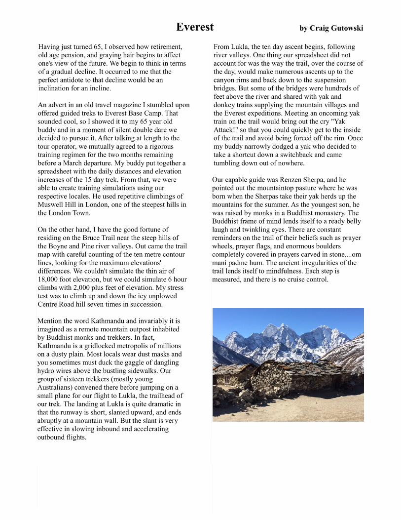
Mention the word Kathmandu and invariably it is imagined as a remote mountain outpost inhabited by Buddhist monks and trekkers. In fact, Kathmandu is a gridlocked metropolis of millions on a dusty plain. Most locals wear dust masks and you sometimes must duck the gaggle of dangling hydro wires above the bustling sidewalks. Our group of sixteen trekkers (mostly young Australians) convened there before jumping on a small plane for our flight to Lukla, the trailhead of our trek. The landing at Lukla is quite dramatic in that the runway is short, slanted upward, and ends abruptly at a mountain wall. But the slant is very effective in slowing inbound and accelerating outbound flights.
From Lukla, the ten day ascent begins, following river valleys. One thing our spreadsheet did not account for was the way the trail, over the course of the day, would make numerous ascents up to the canyon rims and back down to the suspension bridges. But some of the bridges were hundreds of feet above the river and shared with yak and donkey trains supplying the mountain villages and the Everest expeditions. Meeting an oncoming yak train on the trail would bring out the cry "Yak Attack!" so that you could quickly get to the inside of the trail and avoid being forced off the rim. Once my buddy narrowly dodged a yak who decided to take a shortcut down a switchback and came tumbling down out of nowhere.
Our capable guide was Renzen Sherpa, and he pointed out the mountaintop pasture where he was born when the Sherpas take their yak herds up the mountains for the summer. As the youngest son, he was raised by monks in a Buddhist monastery. The Buddhist frame of mind lends itself to a ready belly laugh and twinkling eyes. There are constant reminders on the trail of their beliefs such as prayer wheels, prayer flags, and enormous boulders completely covered in prayers carved in stone....om mani padme hum. The ancient irregularities of the trail lends itself to mindfulness. Each step is measured, and there is no cruise control.

Over the course of the ascent, two days are acclimation days. That means climb high and sleep low. We would do rigorous climbs of a least 2000 feet of elevation and then come back down to sleep at the same camp as the night before. Altitude sickness is not uncommon, and each day we would see a few helicopters streaking down the canyon evacuating afflicted trekkers. The affliction plays no favourites and can strike the most young and fit. Many trekkers experience mild symptoms of headache, dizziness, and difficult sleep. Our guides carried a portable oxygen tent in the event of a life threatening case.
Accommodation at the lower altitudes was in permanent camps of two person tents and a modest dining hall. At the upper altitudes we slept in guest houses with cell like bedrooms above and a dining hall below. In either case, the yak dung stove provided heat only for the supper hour. After that, most trekkers would soon head to their sleeping bags with overnight temperatures in the minus 20 degree range.
Base Camp was very satisfying, but in fact was a pile of stones littered with prayer flags and a piece of stone with "Base Camp 2017" chalked on it. Actually, it said 2016 with the 16 crossed out and 17 chalked in. But what the heck, we made it! The actual base camp for those preparing to summit Everest was across the gully, and quarantined from visitors, their infections and distractions.
In retrospect, I realized that for the duration of the fifteen day trek, the only wheels I saw were prayer wheels...not one car, bike, or even a cart. The whole region with dozens of villages is accessible only by the ancient trails (or the occasional helicopter) with crude irregular steps that can only be navigated by foot or hoof. The enormous loads of goods carried by the Sherpa porters was a sight to behold. One was carrying a full size fridge, and he left us in his dust!
Besides wheels, the other thing in complete absence in that whole remote region of Nepal is any visible sign of central authority. The entire region gives no taxes to the central government, and expects zero services or authority in return. There are no police in the entire region, only extremely effective tribal councils. Hopefully they can continue this tradition and resist the encroachment of development from China to the north, and India to the south.

Dufferin Hi-Land Board of Directors
President Jim Preyde [email protected]
Past President/ Land Securement and Landowner Relations Carl Alexander [email protected]
Vice President Brenda Carling [email protected]
Secretary/Social MediaSusan Bate [email protected]
Treasurer Peter Blackmere [email protected]
BTC Director Sue Simons [email protected]
Trail Director/NewsletterCarl Tafel [email protected]
Hike Director Les Babbage [email protected]
Published by
Dufferin Hi-Land Bruce Trail Club
P.O.Box 698
Alliston, Ontario, L9R 1V9
www.dufferinbrucetrailclub.org
www.facebook.com/DufferinHiLandBruceTrailClub
photo credits: Les Babbage (17), Susan Bate (8), Brian Cornfield (17), Margery Cruise (9), Craig Gutowski (18,19), Tony Hopkins (2), Jim Preyde (3) Carl Tafel (1,5,12,14,16)
uncredited articles: Margery Cruise (3), Tony Hopkins (8)
print distribution: Marianne Dzuba
Land Stewardship Director Brian Cornfield [email protected]
Membership Director Inge Eckerich [email protected]
Social Events Director Barb Sonzogni [email protected]
Directors
James Griffin [email protected]
Carol Foley Hike Event Coordinator [email protected]
Tony Hopkins [email protected]
Pauline Lloyd [email protected]
Glenys Williams [email protected]
Archivist Bryan Foley [email protected] Tom Thayer [email protected]
Are you reading this newsletter in beautiful, living colour? If not, please consider receiving it digitally. You'll not only save the Club postage costs, but you'll save trees.