Helping the U.S. Army Understand Complex Social ... · U.S. Army Corps of Engineers staff and ......
27
Presented at Bridging Divides: Spaces of Scholarship and Practice in Environmental Communication The Conference on Communication and Environment, Boulder, Colorado, June 11-14, 2015 https://theieca.org/coce2015 Helping the U.S. Army Understand Complex Social- Ecological Systems Heather Ward, PhD Geographer, U.S. Army Engineer Research and Development Center, Geospatial Research Lab [email protected] Abstract Imagine a U.S. Army commander newly assigned an area of responsibility (AOR) in a global hotspot. Chaos reigns, either because of inter or intra-state conflict, natural disaster and response, or fledgling peace-building efforts. How does he or she obtain command situational awareness quickly in order to take actions confidently and responsibly to accomplish the mission? What framework works best to analyze the plethora of information and intelligence available in a way that captures all of the human and environmental systems in their complexity and that can be employed up and down levels of generality and command? Military doctrine and past experience are the first places commanders look for guidance, but beyond weather and terrain environmental systems thinking is relatively new to the military. U.S. Army Corps of Engineers staff and others evaluate some overseas development projects for soundness and consider the welfare of humans and endangered species on U.S. installations, but avoiding environmental degradation and protecting natural resources during active operations are exceptions rather than the rule. Consensus is growing within the U.S. Armed Services that nearly-linear military analytic processes, such as PMESII-PT (Political, Military, Economic, Social, Infrastructure, Information, Physical Environment, and Time) and ASCOPE (Area, Structures, Capabilities, Organizations, People, and Events) fail to capture interactions within complex social-ecological systems (SES), such as water’s role in regional security and stability (Canna, 2013; Ducote, 2010; Flynn et al, 2010; Shove, 2014; U.S. Army FM 34-130, 1994) and calls are growing to incorporate social science methods into military operations across the board from human terrain teams at brigade levels to theater country studies and security cooperation plans. Full spectrum operations and counterinsurgency (COIN) in particular demand processes that are iterative and multidisciplinary. SES analysis is challenging because the boundaries of many ecological systems and services span geographic regions and
Transcript of Helping the U.S. Army Understand Complex Social ... · U.S. Army Corps of Engineers staff and ......
Presented at Bridging Divides: Spaces of Scholarship and Practice in Environmental Communication
The Conference on Communication and Environment, Boulder, Colorado, June 11-14, 2015
https://theieca.org/coce2015
Helping the U.S. Army Understand Complex Social-
Ecological Systems
Heather Ward, PhD
Geographer, U.S. Army Engineer Research and Development Center, Geospatial Research Lab
Abstract
Imagine a U.S. Army commander newly assigned an area of responsibility (AOR) in a global hotspot.
Chaos reigns, either because of inter or intra-state conflict, natural disaster and response, or
fledgling peace-building efforts. How does he or she obtain command situational awareness
quickly in order to take actions confidently and responsibly to accomplish the mission? What
framework works best to analyze the plethora of information and intelligence available in a way
that captures all of the human and environmental systems in their complexity and that can be
employed up and down levels of generality and command? Military doctrine and past experience
are the first places commanders look for guidance, but beyond weather and terrain environmental
systems thinking is relatively new to the military. U.S. Army Corps of Engineers staff and others
evaluate some overseas development projects for soundness and consider the welfare of humans
and endangered species on U.S. installations, but avoiding environmental degradation and
protecting natural resources during active operations are exceptions rather than the rule.
Consensus is growing within the U.S. Armed Services that nearly-linear military analytic processes,
such as PMESII-PT (Political, Military, Economic, Social, Infrastructure, Information, Physical
Environment, and Time) and ASCOPE (Area, Structures, Capabilities, Organizations, People, and
Events) fail to capture interactions within complex social-ecological systems (SES), such as water’s
role in regional security and stability (Canna, 2013; Ducote, 2010; Flynn et al, 2010; Shove, 2014; U.S.
Army FM 34-130, 1994) and calls are growing to incorporate social science methods into military
operations across the board from human terrain teams at brigade levels to theater country studies
and security cooperation plans. Full spectrum operations and counterinsurgency (COIN) in
particular demand processes that are iterative and multidisciplinary. SES analysis is challenging
because the boundaries of many ecological systems and services span geographic regions and

Page 2 of 27
Presented at Bridging Divides: Spaces of Scholarship and Practice in Environmental Communication
The Conference on Communication and Environment, Boulder, Colorado, June 11-14, 2015
https://theieca.org/coce2015
Combatant Commands (COCOM). Course of Action (COA) development and Commander’s Critical
Information Requirements (CCIR) suffer as a result. Moreover, environmental security assets are
scattered across DOD and federal agencies and largely unknown to commanders.
Through document research and participant observation, this paper first discusses broad military
interest in environmental security and evolving requirements, followed by a general introduction of
social sciences relevant to understanding complex social-ecological systems (SES) and the role of
natural resources in conflict. Finally, we consider evolving military environmental communication
techniques and several SES of current interest. Our goal is to narrow the divide between military
and social science communities of practice, begin to integrate environmental systems thinking into
U.S. Army planning and decision-making processes, and bring methods from geography, political
ecology, and sustainability science to bear on complex military problems and dynamic situations.
Evolving Military Requirements
Imagine a U.S. Army commander newly assigned an area of responsibility (AOR) in a global hotspot.
Chaos reigns, either because of inter or intra-state conflict, natural disaster and response or
fledgling peace-building efforts. How does he or she obtain command situational awareness
quickly in order to take actions confidently and responsibly to accomplish the mission? What
framework works best to analyze the plethora of information and intelligence available in a way
that captures all of the human and environmental systems in their complexity and that can be
employed up and down levels of generality and command, and tailored for each phase of conflict
(see Table 1: Environment—Crisis—Military Nexus)? Military doctrine and past experience are the
first places commanders look for guidance.
Field Manual (FM) 7-015 The Army Universal Task List (AUTL) organizes military tasks beneath seven
warfighting functions – Movement and Maneuver (ART 1), Intelligence (ART 2), Fires (ART 3),
Sustainment (ART 4), Mission Command (ART 5), Force Protection (ART 6), and Full Spectrum
Operations (ART 7). A comprehensive review of tasks yielded only a few indirectly related to
understanding social-ecological systems or hazardous terrain, found most often in the intelligence,
movement and maneuver, and force protection warfighting functions. These findings reflect
military standard operations, which leaves oversight of pre-conflict development and post-conflict
reconstruction efforts to the U.S. Agency for International Development (USAID) and non-
governmental organizations. Considering the role of the environment during all conflict phases

Page 3 of 27
Presented at Bridging Divides: Spaces of Scholarship and Practice in Environmental Communication
The Conference on Communication and Environment, Boulder, Colorado, June 11-14, 2015
https://theieca.org/coce2015
might spare soldier and civilian lives and health by limiting infrastructure damage and the release
of toxins and facilitate reconstruction, thereby saving taxpayer dollars.
FM 34-130 Intelligence Preparation of the Battlefield (IPB) remains the baseline document outlining
the Army’s process for describing battle space. FM 34-130 serves as a guide for commanders and
staff at all levels; the process outlined drives intelligence collection efforts and commanders’
decision-making for combat and contingency situations, recently referred to as ‘full spectrum’
operations (FM 7-0). Chapter six in FM 34-130 suggests general considerations for conducting IPB
in various ‘operations other than war,’ recommending shifts in focus and degree of detail as
needed.
Human and environmental complexity increases with the amount of territory in the AOR, command
level, and number of participating host nations and federal agencies. Joint operations—Army, Navy,
Air Force, Marines, Coast Guard—combine command and service IPBs, systems analysis, and
geospatial information into a Joint Intelligence Preparation of the Operational Environment (JIPOE)
(Joint Publication 2-01.3, Figure I-2). Chapter IV outlines considerations for missions and situations
that require a ‘more tailored JIPOE approach’, such as “Increased Emphasis on Sociocultural Factors,”
Increased Need for Collaboration and Information Sharing,” “Actual or Threatened Use of Weapons
of Mass Destruction,” or “Theater Missiles.” It is important to note, however, that this guidance is
mostly in the form of numbered lists.
Additional Army field manuals and publications further interpret the process, hoping to address
additional special situations and information requirements. Few attempts are made to model
systems or networks or dynamic processes and human-ecological interactions are absent.
FM 3-24.2 Tactics in Counterinsurgency, for example, acknowledges the greater complexity inherent
in guerrilla warfare and overlapping “system of systems.” Chapter one introduces a mnemonic tool
to help commanders and staff analyze, map, and overlay ‘civil considerations’ – Areas, Structures,
Capabilities, Organizations, People, and Events (ASCOPE) (Table 1-1). Chapter four describes and
‘operating environment’ in terms of eight variables: Political, Military, Economic, Social, Information,
Infrastructure, Physical environment, and Time (PMESII-PT). Counterinsurgency doctrine also
expands on the military’s ‘line of effort’ concept. Seven counterinsurgency ‘lines of effort’ –
Establish Civil Security, Support Host Nation Security Forces, Support to Governance, Establish Civil
Control, Restore Essential Services, Support to Economic and Infrastructure Development, and

Page 4 of 27
Presented at Bridging Divides: Spaces of Scholarship and Practice in Environmental Communication
The Conference on Communication and Environment, Boulder, Colorado, June 11-14, 2015
https://theieca.org/coce2015
Conduct Information Engagement – prompt social cause-and-effect thinking along a timeline from
‘starting conditions’ to ‘end state’ (Figure 3-1). The IPB process in Appendix A of the regulation
includes another table of social considerations, including population demographics, health, history,
leadership and prominent personalities, ethnicity and culture, religion, government, and politics.
Not surprisingly, FM 3-07 Stability Operations also builds on the human and social aspects of
military operations, details objectives within stability lines of effort, and introduces another acronym
– SWEAT-MSO (Sewage, Water, Electricity, Academics, Trash, Medical, Safety, and Other
considerations) (Figure 4-2). Chapter four introduces planning and operation design concepts that
further reach for the human dimension and hint of dynamic processes, such as ‘decisive points.’
Examples of decisive points include, “obtaining political support from key tribal leaders” or
“quantifiably reducing crime” (FM 3-07, 4-12).
The U.S. Army Commander’s Appreciation and Campaign Design (CACD) (TRADOC Pam 525-5-500)
is a recent and still-developing cognitive model for commanders who must tackle complex
operational problems. The Army Capabilities Integration Center created the pamphlet following a
series of strategic seminars and wargames. The presumption is that commanders charged with
designing and executing military campaigns will not be able to completely understand problems
before acting and must adopt iterative decision-making processes. The guidance divides problems
according to complexity, recognizes the greater frequency of irregular and civil wars, introduces the
notions of complex adaptive systems and trend analysis, and recognizes the importance of
information circulation across echelons and up and down levels of command. Problem-framing
guidance in the document suggests that commanders ask broad, open-ended questions to reveal
initial conditions, domestic and international context, systems, critical constituents, strategic trends,
and gaps in knowledge. Commanders should recognize cultural narratives and employ
anthropological, historical, and discourse analysis methods to understand the complex adaptive
systems operating alongside and within the conflict.
Joint Publication 5-0, Joint Operation Planning, outlines the corresponding operational approach
which suggests that commanders assign social objectives, such as ‘qualified and trained civil service’
or ‘literacy rate improved’ to each line of effort. The goal is to achieve safe and stable regions and
conflict-free end states (Fig III-8), but these documents provide only examples of the process, not
specific objectives or templates for every possible military contingency. Moreover, differences in
geographic focus, responsibilities, planning cycles, incentives, timelines and resources between the

Page 5 of 27
Presented at Bridging Divides: Spaces of Scholarship and Practice in Environmental Communication
The Conference on Communication and Environment, Boulder, Colorado, June 11-14, 2015
https://theieca.org/coce2015
Department of Defense, Department of State, and the US Agency for International Development
make social objectives, stability operations, and desired end states even more difficult to achieve
(3D Planning Guide 2012, 42-43).
Many commanders, especially those steeped in experiences from wars in Iraq and Afghanistan, now
demand better guidance, tools, and graphics to understand complex coupled human-environmental
systems and 2nd and 3rd order effects of operational decisions across time. The ‘lines of effort’
discourse in military publications reflects this failing by insisting on a stable end state. They
complain that PMESII-PT ‘rigor’ and utility decline once analysts move beyond the preeminent
Army categories of weather and terrain, making no mention, for example, of critical ecosystems and
the human services they provide, such as Iraq’s marshes or Helmand River hydrology. Analysis of
the operational environment at all levels is too linear and goal-oriented lacking commander and
staff templates that consider dynamic systems, reveal feedback loops, and render a more holistic
and genuine ‘sense of place’.
• Major General Michael Flynn argues that military intelligence analysts need to collect and
share more ‘population-centric’ or ‘white’ information about local populations, governance,
and economic development. He recommends that analysts organize along geographic
rather than functional or country-specific lines and move between field elements as
information integrators and brokers (Flynn, Pottinger, Batchelor 2010).
• The Chief of Staff of the Army’s Strategic Studies Group recently recommended five
umbrella concepts to consider alongside intelligence preparation of the battlespace to
better understand megacities. According to the authors, the Army should endeavor to view
cities as systems, holistically and as living organisms, by grouping data and intelligence by
‘scale’, ‘density’, ‘connectedness’, ‘flow’, and ‘context’ (Bailey et al. 2014).
• Ducote’s (2010) monograph for the School of Advanced Military Studies further challenges
PMESII-PT to describe and understand complex, asymmetric environments. He prefers
iterative inquiry to uncover the structures, functions, processes, politics, and ethics in
operating in combat, stability, or relief operations. Ducote points out that PMESII-PT may
be useful to describe observable variables, but neglects to capture relationships well and the
true nature of systems not at all.

Page 6 of 27
Presented at Bridging Divides: Spaces of Scholarship and Practice in Environmental Communication
The Conference on Communication and Environment, Boulder, Colorado, June 11-14, 2015
https://theieca.org/coce2015
All of the above critiques by senior military officers express dissatisfaction with current doctrine and
practice, advocating for systems approaches, meta-questioning, and enhanced human geography.
“Conflict, in all its forms, remains a fundamentally human endeavor…Success depends as much on
understanding the social and political fabric of the surroundings as it does on the ability to
physically dominate them. In an environment defined by the intermingling of friends, enemies, and
neutral parties, understanding social and cultural networks becomes just as important as the
weapons we employ.” General Ray Odierno (Canna 2013)
The Department of Defense also believes that sociocultural tradecraft should be improved, arguing
in 2013 and 2009 white papers (Flynn 2013, Defense Science Board Report 2009) that
understanding human dynamics is an essential aspect of success across the full spectrum of military
and national security operations. The MINERVA Initiative, HSCB Modeling Program, and the
Strategic Multilayer Assessment Program (including the Megacities Reconnaissance Surveillance,
and Intelligence (M-RSI) project) are Sociocultural Analysis (SCA) techniques under development by
the Secretary of Defense for Intelligence, Defense Intelligence Agency, ERDC, and others (Canna
2013, Ehlschlaeger 2014). Social science research methods applied in Afghanistan by Human
Terrain Teams (HTT) improved estimates of village populations, facilitated economic development,
and clarified drivers of conflict in brigade areas of operation (Shove 2014).
Social-ecological information and intelligence requirements outlined by the Department of the
Army are very broad (Relevant Military Environmental Requirements available on request from the
author). We cannot expect commanders or staff to ask the right questions, write detailed
environmental requirements, or pull critical data and analyses from multiple intelligence and
analytic sources. We need to anticipate their specific needs and place environmental security
mental maps, resources and decision tools at their fingertips. COCOM requirements inform USACE
ERDC’s and Army Geospatial Center science and technology Command, Control, Communications,
and Intelligence (C3I) and Force Protection Level One lines of effort. Broad ‘thrust areas’ include
human geography, geospatial intelligence, and geo-enabled computing. Environmental security
products make sense across Army S&T activities (Social, Military, and Environmental Interactions,
Terrain and Environmental Modeling, and Sensor and Data Integration).

Page 7 of 27
Presented at Bridging Divides: Spaces of Scholarship and Practice in Environmental Communication
The Conference on Communication and Environment, Boulder, Colorado, June 11-14, 2015
https://theieca.org/coce2015
Traditional Social Science Contributions: Geography, Ecology, Systems
How can social science methodologies be applied more efficiently and at various levels of
generality remotely to clarify military problems and reveal dynamic working systems? Fundamental
concepts from the fields of geography, political ecology, and environmental security perhaps best
begin to explain connections between the natural environment, conflict, and peace-building.
The geographic ‘sense of place’ possesses physical, social, and unconscious dimensions. Place is at
once a fixed location with material objects, interactions with the environment, and social processes,
together interpreted by human experience and imagination with accompanying feelings of
attachment or detachment. Place is a bounded, oft-contested geographic entity or invisible social
interactions or some combination of both (Johnston 2000, 731). Geographers employ
interdisciplinary methods to get at ever-changing notions of place and the people that live there
(Johnston et al. 2000, 719 and 870).
The National Council for Geographic Education adopted two educational tools that researchers also
use to collect data for country and regional studies. Questions inherent in the Five Themes of
Geography (1984) (UWEC Fig 1) and The Eighteen National Geography Standards (Boehm and
Peterson 1994) overlap and capture physical and human characteristics of place, movement and
connections among places, causes and meanings, human-environmental interactions and systems,
and global interdependence. Both educational frameworks are designed to be iterative and
additional geographic mental models—urban gravity, center place, identity formation, hybridity, and
resistance theories—fit within their bounds.
Political ecology is a wide-ranging interdisciplinary field investigating political and economic
principles controlling relations between human beings and with their environment. Characterized
by systems thinking, the field envisions environments and societies in terms of relationships,
interactions, and transactions. Political ecology adopts a more critical view compared to other
scholarly disciplines. Biersack and Greenberg, for example, are interested in “alternative
socionatural orders…that enable us to envision instances of ecological viability as well as more
lasting and just ways of being-in-place and ‘being-in-networks with a diversity of humans and
other living beings…” (2006 3). ‘Ecosystem services’ and ‘adaptive management’ are additional
concepts from ecology useful to any study of place.

Page 8 of 27
Presented at Bridging Divides: Spaces of Scholarship and Practice in Environmental Communication
The Conference on Communication and Environment, Boulder, Colorado, June 11-14, 2015
https://theieca.org/coce2015
• Functioning ecosystems provide freshwater, fuel wood, fisheries, fertility, forest products and
fodder – the foundations of human well being and most economic activity. The direct and
indirect benefits that humans derive from natural processes are called ‘ecosystem ‘services’
(Molnar 2000, TEEB 2010, DEFRA 2005). Trying to value nature’s services is difficult,
sometimes controversial, and a deep well for scholars. Most service assessments have been
regional and carried out in rural environments (O’Farrell et al. 2012). The first global survey
reported that more than 60 percent of ecosystem services evaluated were in decline with
future human access to freshwater one of the greatest concerns (Millennium Ecosystem
Assessment 2005).
• ‘Adaptive management’ is the general term for a flexible, iterative process of monitoring and
decision-making that can be adjusted in the face of uncertain feedbacks and as outcomes
are better understood. The concept grew out of a more holistic approach to conservation
known as ecosystem management which integrates ecological, economic, and social
principles to manage biological systems for long-term sustainability (Meffe et al. 1997, 360;
Adaptive Management Working Group)
In geography, ‘human ecology’ explores relationships between people and their physical and social
environments minus political ecology critiques. Usually, the concept of a system is used relatively
loosely to stress the interdependence of phenomena and variables, although some physical
geographers do use more formal and mathematical systems methods, multiple criteria regression
analysis techniques and others (Johnston 2000, 353). Systems studies address four main issues
according to Johnston (818): 1) Is the system open or closed? 2) Can the system be divided into
sub-systems or clusters of interdependent elements? 3) Do the links involve flows, causal or ‘black
box’ relationships? And, 4) is feedback in the system?
Environmental security literature is very diverse both topically and analytically. The most prominent
debate in the field remains unresolved and revolves around whether natural resource scarcity or
abundance is more closely related to conflict (Floyd and Matthew 2013, 2). Greed and grievance
debates between Toronto and Swiss-based groups of scholars are challenged by scholars arguing
that resource pressures generate both innovation and conflict and that risk of conflict may be
diminished by effective state governance and the equitable distribution of abundant resources.
Qualitative studies used to track processes and causal mechanisms have led to larger-N
quantitative studies with additional predictive power, depending on scale. Generalization of
Page 9 of 27
Presented at Bridging Divides: Spaces of Scholarship and Practice in Environmental Communication
The Conference on Communication and Environment, Boulder, Colorado, June 11-14, 2015
https://theieca.org/coce2015
findings remains difficult and the most comprehensive recent summaries on the subject might be
Floyd and Matthew (2013), Bernauer et al (2012) and Mildner et al (2011), as well as the United
Nations Environment Programme’s From Conflict to Peacebuilding: The Role of Natural Resources
and the Environment (2009).
Military consideration of the role of natural resources in conflict is in its infancy and problem-
solving rarely more than two-dimensional. ‘Water security,’ for example, represents to the military
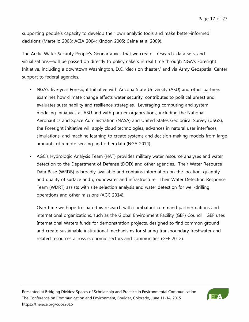
access to clean, plentiful drinking water or water as terrain, i.e. an obstacle. A more complete
portrayal of water security’s many important dimensions might include water quantity, quality,
accessibility (Who controls the resource?), availability (discharge rates or seasonality of flow),
boundary issues, and institutional competence (See Water Smart Card). Insights from research
about environmental change, degradation, scarcity have made their way into the highest levels of
military thinking and security policymaking. Several overlapping approaches exist (Brown 2005):
1. Demand-Induced Scarcity (Toronto Group, Homer-Dixon)
The “Toronto Group” refers to a team of researchers and institutions across four continents that
participated in research projects led by Thomas Homer-Dixon then at the University of Toronto.
Homer-Dixon (1994 1999) used case studies to investigate the connections between resource
scarcities (water, cropland, and pasture) and violent conflict. Homer-Dixon defined environmental
security as a neo-Malthusian trifecta of sorts between supply-induced scarcity (environmental
degradation or depletion), increased resource demand (population growth or per capita
consumption) and inequitable distribution between social groups. The Toronto Group of
researchers found that scarcities never act alone to cause conflict, instead interacting with other
contextual factors at multiple levels and scales (Deligiannis 2013).
• ‘Resource capture’ occurs when resource degradation or depletion interacts with population
growth, prompting powerful groups to shift access in their favor.
• ‘Ecological marginalization’ occurs when skewed distribution of resources combines with
population growth and increased demand to cause migration to ecologically fragile areas.
High population densities combined with lack of knowledge, good governance, or capital
result in deforestation, desertification or other severe degradation, creating a downward
spiral in resource supply.

Page 10 of 27
Presented at Bridging Divides: Spaces of Scholarship and Practice in Environmental Communication
The Conference on Communication and Environment, Boulder, Colorado, June 11-14, 2015
https://theieca.org/coce2015
Through case studies in Kenya, the Philippines and elsewhere, Kahl (2006) went on to link resource
scarcity to political corruption and the breakdown of a state’s functional capacity. State failure
conflicts occur when population growth, environmental degradation, and resource inequality
weaken governments’ legitimacy, capacity and cohesion, expanding rebellion and intergroup
violence. State exploitation conflicts, in contrast, occur when political leaders capitalize on the
opportunities arising from population pressures, natural resource scarcities, and accompanying
social grievances, instigating violence to serve parochial interests.
2. Supply-Induced Scarcity (Bern-Zurich Group, Baechler)
The “Bern-Zurich Group” includes Gunther Baechler and scholars from the Swiss Peace Foundation
and the Centre for Security Studies and Conflict Research. Bern-Zurich researchers focus on the
mechanisms creating scarcity in the first place, especially the structural inequities in local and global
economic relationships that prompt excess appropriation and exclusion of some groups. Baechler’s
(1998) independent variable is environmental degradation—a consequence of human
environmental distribution and transformation that precedes scarcity. Environmental conflict is
linked to social transitions from subsistence to market economies, arguing that violence is most
likely to occur in remote regions where environmental stresses meet greed, political tensions, and
inequitable distribution. Conflict occurs when communities resist the environmental damage and
expropriation of resources accompanying development projects.
3. Abundance, Corruption, and State Capacity (International Peace Research Institute in Oslo (PRIO).
Empirical evidence suggests that some countries suffer, not from scarcity, but from a “resource
curse,” possessing high concentrations of ‘lootable’ resources. World Bank studies suggest that
conflict risk increases dramatically for countries heavily dependent on the export of primary
commodities for income (Collier et al 2003). Conflict occurs when different groups compete for
control of abundant, easy to transport, or hard to trace resources, such as timber, oil, diamonds,
other minerals, or rare earth metals. Collier (2007, 3) argues that countries “at the bottom that are
falling behind, and often falling apart” are prone to conflict by mutually reinforcing conditions –
past, chronic violence, an abundance of lootable natural resources, unstable and violent
neighboring countries, and corrupt, incompetent governments.

Page 11 of 27
Presented at Bridging Divides: Spaces of Scholarship and Practice in Environmental Communication
The Conference on Communication and Environment, Boulder, Colorado, June 11-14, 2015
https://theieca.org/coce2015
Governance and institutions matter, sometimes able to resolve nonviolent conflicts over resources
before they escalate or vice versa. Giordano, Giordano, and Wolf (2005) found that the risk of
international conflict increases where institutions are absent, ill-defined, of cannot keep up with the
pace of environmental degradation or change. Bennett and colleagues (2001) and Walton and
Barnett (2008) found that corruption and slow resolution processes could trigger conflict. In the
case of Sudan (Manger 2005), the government exploited local tribal disputes around the ownership
of land and water to undermine the insurgency, making natural resources seem more important in
the conflict than perhaps is merited.
4. Network Threats
Environmental degradation is only one of many ‘network threats’ in a world that also includes
climate change, international terrorism, globalization, and so on. Individual decisions based on
immediate ecological, economic, or social problems constitute a network and ultimately a global
security problem. Mitigating network threats is especially difficult because effects are dispersed
and shared incentive structures to modify behavior nonexistent.
Le Billon (2001) understands ‘resources’ as products of environment and geography, but
‘dependence’ and its potential for conflict are shaped more powerfully by commodity chains,
markets and globalization. Not all countries blessed with lootable resources descend into armed
conflict; violence results from historical patterns of social relations within and between countries,
requiring further study by more appropriate scholars of anthropology and international relations.
Climate change acts as a catalyst or multiplier, increasing conflict potential by aggravating other
factors, such as demographics, land degradation, water complexities (quantity, quality, access), or
fishery shifts. Burke et al (2009) reported strong empirical connections between civil war and
temperature in Africa, concluding that global warming impacts will outweigh benefits from
economic growth and democratic progress in the region. Climate change is a factor in violent
conflicts because it renders societies vulnerable, negatively affecting individual livelihoods and
collective well-being—human insecurity leading to more conventional security problems (Barrett
and Adger 2007).
5. Quantitative Large-n Studies

Page 12 of 27
Presented at Bridging Divides: Spaces of Scholarship and Practice in Environmental Communication
The Conference on Communication and Environment, Boulder, Colorado, June 11-14, 2015
https://theieca.org/coce2015
Contradictory findings emerge from large-N quantitative research on environmental change and
violent conflict (Bernauer 2011). Hsaing et al (2011) directly associate the El Nino/Southern
Oscillation—the dominant interannual mode of modern climate—with new civil conflicts arising
throughout the tropics. Buhaug (2010) applies complementary measures of armed conflict and
several different models to conclude that African civil wars are better explained by structural and
contextual conditions—ethnopolitical exclusion, poor national economies, and the collapse of the
Cold War system—rather than climate variability. Hauge and Ellingsen (2001) and Gleick (1993)
suggest that water scarcity may lead to armed conflict, but Theissen (2008) at the International
Peace Research Institute found that poverty and dysfunctional institutions were better predictors of
conflict. Transboundary waters may be associated with low-level conflicts rather than all out ‘water
wars’ (Gleditsch and Hegre 2000, Brochmann and Hensel 2009, Dinar 2009). In some cases, states
resolve diplomatic tensions by cooperating over shared water resources (Yoffe et al 2003, Wolf
2002). See Bernauer et al 2011 for a more complete list of quantitative environmental change and
conflict studies.
Clearly, human changes to the environment, usually detrimental ones, contribute to social changes,
such as resource capture and inequity, migration, economic decline, and protests and riots. The
resulting scarcity, greed, and grievances may lead to conflict, but rarely are cause and effects linear.
Many other factors are in play; variables are difficult to differentiate, especially over time, and
pathways to conflict complicated. Additional case studies are needed to tease out preexisting
social and political indicators of conflict, weigh their importance as drivers, and refine models. The
spatial resolution of environmental data is often inappropriate for the research question or problem.
Regional perspectives are needed to lower the level of analysis in quantitative analyses.
Evolving Communication Techniques
The primary goal for the Geospatial Research Laboratory’s (GRL) environmental security research
and human geography research within the Engineer Research and Development Center (ERDC)
broadly is to introduce systems thinking into the Military Decision Making Process (MDMP) (See
Diagram 1). Understanding human-environmental interactions and cause and effect relationships
will improve intelligence preparation of the operating area (IPOE), command situational awareness,
security and stability operations, humanitarian and disaster response, and of course conflict
outcomes. GRL collaborates with other ERDC labs, the National Geospatial Intelligence Agency
Page 13 of 27
Presented at Bridging Divides: Spaces of Scholarship and Practice in Environmental Communication
The Conference on Communication and Environment, Boulder, Colorado, June 11-14, 2015
https://theieca.org/coce2015
(NGA), and multiple federal agencies to create comprehensive and compelling visualizations of
social-ecological systems.
• NGA advocates an open-sourced, publicly-accessible, interagency ‘geonarrative’ approach
that allows users to create a needs-based narrative. Envision a Web dashboard populated
with interactive geographic information system (GIS) maps, ‘friendly’ visualizations,
photographs, and analyses plus embedded, authoritative source databases for savvier users.
Geonarratives are models for immersive, digital, geospatial storytelling, visually capturing
aspects of the water-food-energy-climate nexus. By revealing “unasked questions,”
interdependencies, and uncertainties, geonarratives represent more than the sum of their
parts, explaining complex social-ecological systems (SES) to the whole-of-government
(analysts, policymakers, aid workers, and military commanders). (Thomas and Cook 2005;
Segel and Heer 2010)
• GRL’s Rapid Integrated Strategic Assessment for Water Security (RISA-4H20) research
envisions on-hand, interoperable anticipatory framework to rapidly analyze the plethora of
information and intelligence available in a way that captures human and hydrological
systems in their complexity and that can be employed up and down levels of generality and
command. Following proof of concept with watersheds, the RISA framework will be applied
to other social-environmental systems. The primary transition target for the Rapid
Integrated Strategic Assessment (RISA) for Water Security project is the Army Geospatial
Center’s (AGC) Water Resources Program—the primary Department of Defense military
water resource analysis and detection group.
ERDC, AGC, and NGA began collaborating to develop geonarrative and table-top exercises for the
Niger River at the request of U.S. Special Operations Command Africa (SOCAFRICA). They
requested similar work on the Nile because of rising tensions between Egypt and Ethiopia over
dam construction and water rights. Charged with enhancing partner nation capacity, promoting
regional security and stability, dissuading conflict, and protecting U.S. and coalition interests,
Combined Joint Task Force – Horn of Africa (CJTF-HOA), also will find geonarrative, RISA-4H2O and
similar products useful. EUCOM requested a geonarrative revealing Russian interests. PACOM
asked that similar ‘systems thinking’ work be completed for the Brahmaputra watershed where
climate change and glacial retreat cause regional flooding and threaten drinking water supplies for
the Indian subcontinent. SOCOM Joint Intelligence Center (JIC) planners request water security

Page 14 of 27
Presented at Bridging Divides: Spaces of Scholarship and Practice in Environmental Communication
The Conference on Communication and Environment, Boulder, Colorado, June 11-14, 2015
https://theieca.org/coce2015
assessments and visualizations that address conflict related to water infrastructure, transboundary
water tensions, relationships between water, cultural practices, and disease vectors, water and food
insecurity, and so on. ERDC and AGC provide geospatial products routinely to the Defense
Intelligence Agency’s Defense Resources and Infrastructure Office (DIA/DRIO), and USACE’s
Transatlantic Division (TAD).
Geonarratives and other knowledge management tools aim to inform, encourage collaboration, and
persuade through (1) interaction with geospatial information and (2) the selectively transparent,
participatory exposure of its components, including its data, algorithms, visualizations, models, and
discursive, analytic, and decision processes. Transparency serves up communally robust, timely,
query-able knowledge that informs and provokes future decisions, analysis, and research. A
geonarrative does not provide “the answer.” Rather, through data visualization it allows for
rigorous exploration of issues to discover the “unasked questions,” fostering deeper analysis and
discussions to reduce unanticipated second and third order consequences in Phase Zero (Shape)
and Phase Four (Stability) actions. Both methods resemble multimedia, interactive atlases in their
current configurations, but possess the potential to generate scenarios to assist with course of
action development and decision-making, allowing analysts and decision-makers to dynamically
interact with diverse data sets in a real-time modeling and simulation environment.
Analysts seek easily navigable and compelling entry points into complex social-ecological systems,
concepts that will help planners and commanders recognize complicated interactions without
paralyzing subsequent decision-making. A watershed approach usually results in a rich sense of
place within a geonarrative, capturing at once environmental processes, ecosystem services,
resulting social structures, and likely conflicts (over resources, borders, space, and so on).
Watersheds and other ‘transboundary’ concepts link the carrying capacity of the environment with
economies and societies, forcing the user to acknowledge multiple scales—local, regional and
global (GEF 2012). Remote sensing and other geospatial data and visualizations are at hand.
Watershed boundaries are science-based and relatively objective. In many communities,
environmental management occurs at the watershed scale; regulations and best practices are
familiar and consensus more easily achieved.
Prioritizing knowledge management and geonarrative topics based on decision-maker needs can
be problematic. Many ask general questions without levying specific requirements, leaving the
analyst to anticipate current and future needs and justify full time effort (FTE). Determining the
Page 15 of 27
Presented at Bridging Divides: Spaces of Scholarship and Practice in Environmental Communication
The Conference on Communication and Environment, Boulder, Colorado, June 11-14, 2015
https://theieca.org/coce2015
appropriate audience(s) and level of generality is challenging, as are classification levels,
interoperability needs, and technology choices. Bottom line: communicating military and
intelligence analysis resembles communicating science. Data and information must be ‘translated’
into a geonarrative or knowledge management taxonomy that better ‘leads’ the user toward an
understanding of complex human-environmental relationships and unanticipated consequences.
‘Ecosystem Services’ or ‘Hazards,’ for example, represent more intuitive and enlightening choices for
geonarrative frameworks than ‘Oceanic Algae’ or ‘Bathymetry.’ Another option might be to choose
‘bins’ or ‘categories’ at a level of generality high enough to capture a wide range of date and
analyses no matter the region or topic, such as ‘Drivers,’ ‘Pressures,’ State’ or ‘Impacts’ (Sekovski
2012).
Social-Ecological Systems of Current Interest
Urban social-ecological system are of special interest to military planners and U.S. Army probably
will be called on to conduct operations in and around coastal megacities, but military
understanding of complex social-ecological systems is in its infancy. Urban operational
considerations used to be ‘avenues of approach,’ ‘mobility corridors,’ and ‘hazards’. FM 3-06 Urban
Operations and FM 2-91.4 Intelligence Support to Urban Operations now characterize urban areas
as “dynamic entities” dividing the complex environment into terrain, society, and infrastructure, but
this remains still too simplistic. Figure 2-1 in FM 3-06 labels ‘infrastructure’ at the intersection
between overlapping circles that represent ‘terrain’ and ‘society,’ forgetting that human
infrastructure depends upon even more fundamental ecosystems and their ‘services.’ Urban pattern
and model discussions in both manuals hint at systems science, using terms such as ‘core’ and
‘periphery’, ‘hub’, ‘satellite’, ‘cycle of effects’, and ‘network’. Section 2.32 titled Industrial Area
addresses human and environmental health most directly, warning of accidental and deliberate
release of toxic industrial chemicals and materials (TICs and TIMS) with a table of common TICs and
their industrial or commercial use. Common challenges for large cities include the sheer scale of
population, resource demands, and infrastructure needs, high rates of land-cover loss and
migration, and dynamic exposures to global trade, crime, and market fluctuations. In addition to
magnified effects on fragile ecosystems and geomorphology from universal urban and industrial
processes, megacities in the coastal zone face additional natural hazards aggravated by regional
climatic shifts, such as cyclones, tsunamis, flooding, drought, heat waves, sea level rise and erosion,
and shifting ocean currents and fisheries.

Page 16 of 27
Presented at Bridging Divides: Spaces of Scholarship and Practice in Environmental Communication
The Conference on Communication and Environment, Boulder, Colorado, June 11-14, 2015
https://theieca.org/coce2015
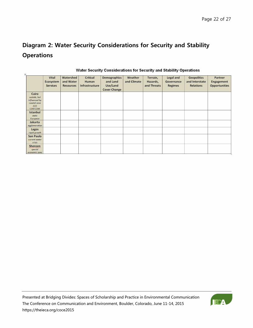
The Army gets around rudimentary and rigid models of systems by allowing for 'special
considerations'. The draft "Water Security Considerations for Security and Stability
Operations“ aims to expand on a Army’s doctrinal definition of urban 'infrastructure' and include
ecosystem services (See Diagram 2). The ‘bins’ or geonarrative chapter titles represent one way to
represent the environment, change across time, and mitigation opportunities for each city... in a
way that looks familiar to commanders and planners completing intelligence preparation of the
operating environment (JIPOE) using acronyms such as PMESII-PT, METT-TC, or ASCOPE. So far,
this taxonomy seems to be capturing most data inputs and revealing information gaps. This paper
examines data-rich, well-studied coastal megacities to identify unique environmental vulnerabilities
and resiliencies as well as partner engagement opportunities to enhance security and stability
operations. This examination suggests information requirements and special considerations for
less-accessible, data-poor megacities that planning staff and commanders can use to evaluate
courses of action, protect soldiers and civilians, and sustain the environment in their area of
operation. We further suggest that the military broaden its doctrinal definition of infrastructure in
the urban environment to include foundational ecosystem services.
The rate of change in the Arctic is dramatic and that pace is not lost on environmental and security
analysts within the Washington, D.C. beltway. With some urgency, we are developing sub-arctic
and arctic environmental security geonarrative schemas that encapsulate physical and human
geography watershed complexities. The goal is to build balanced, accessible geonarrative template
incorporating the critical reflections of ‘people in place’ with ‘boots on the ground’ along the lines
of Howard Zinn’s A People’s History of the United States. Participatory work of this kind using an
international team was done for Russia’s Lake Imandra watershed in the Kola Peninsula. This
approach brought a significant amount of ecological, social, economic, and health information to
bear on sustainable resource management in the region, while further developing information
requirements, science infrastructure, and technological solutions toward extracting meaningful
insights from large databases (Zinn 2003; Voinov et al 2004). To overcome beltway and scientific
biases in conceptual frameworks, we plan participatory action research (PAR) that will include
design suggestions and real-world perspectives from local and regional authorities inside and
outside of government. Non-indigenous populations, in particular, are treated as an aggregate,
although they are no less canaries-in-the-coalmine; indeed acknowledging their challenges, voices,
and interests are critical to advance public engagement, climate change planning, and mitigation.
PAR values the process as much as the product, taking into account stakeholder perspectives and
Page 17 of 27
Presented at Bridging Divides: Spaces of Scholarship and Practice in Environmental Communication
The Conference on Communication and Environment, Boulder, Colorado, June 11-14, 2015
https://theieca.org/coce2015
supporting people’s capacity to develop their own analytic tools and make better-informed
decisions (Martello 2008; ACIA 2004; Kindon 2005; Caine et al 2009).
The Arctic Water Security People’s Geonarratives that we create—research, data sets, and
visualizations—will be passed on directly to policymakers in real time through NGA’s Foresight
Initiative, including a downtown Washington, D.C. ‘decision theater,’ and via Army Geospatial Center
support to federal agencies.
• NGA’s five-year Foresight Initiative with Arizona State University (ASU) and other partners
examines how climate change affects water security, contributes to political unrest and
evaluates sustainability and resilience strategies. Leveraging computing and system
modeling initiatives at ASU and with partner organizations, including the National
Aeronautics and Space Administration (NASA) and United States Geological Survey (USGS),
the Foresight Initiative will apply cloud technologies, advances in natural user interfaces,
simulations, and machine learning to create systems and decision-making models from large
amounts of remote sensing and other data (NGA 2014).
• AGC’s Hydrologic Analysis Team (HAT) provides military water resource analyses and water
detection to the Department of Defense (DOD) and other agencies. Their Water Resource
Data Base (WRDB) is broadly-available and contains information on the location, quantity,
and quality of surface and groundwater and infrastructure. Their Water Detection Response
Team (WDRT) assists with site selection analysis and water detection for well-drilling
operations and other missions (AGC 2014).
Over time we hope to share this research with combatant command partner nations and
international organizations, such as the Global Environment Facility (GEF) Council. GEF uses
International Waters funds for demonstration projects, designed to find common ground
and create sustainable institutional mechanisms for sharing transboundary freshwater and
related resources across economic sectors and communities (GEF 2012).
Page 18 of 27
Presented at Bridging Divides: Spaces of Scholarship and Practice in Environmental Communication
The Conference on Communication and Environment, Boulder, Colorado, June 11-14, 2015
https://theieca.org/coce2015
Water Smart Card

Page 19 of 27
Presented at Bridging Divides: Spaces of Scholarship and Practice in Environmental Communication
The Conference on Communication and Environment, Boulder, Colorado, June 11-14, 2015
https://theieca.org/coce2015
Table 1: Environment—Crisis—Military Nexus
Full-Spectrum Conflict Phases
(JP 5-0)
Environmental Factors to Consider
(JP 5-0; Theater Campaign Handbook)
ERDC/AGC Support (JP 2-01.3; FM 3-07)
Pre-Conflict – 0 – Prepare and Prevent I – Crisis Defined Foundation Work – prepared well ahead and updated regularly.
PMESII Framework (political, military, economic, social, information, and infrastructure) Geographic Features Hazards Population Demographics Political and Socioeconomics WMD capabilities Environmental Conditions and Changes, Pre-existing toxins, pollution, TIMs (toxic industrial materials) …. Knowledge Gap: ecosystems services and natural resources inventory
Early Warning and Vulnerability Analyses
• IPOE (intel preparation of operating environment)
• Identify Ecosystem Services and Inventory Resources
• Regional and Country Studies • Features and Network
Mapping • Steady-state Engagement • Conflict Prevention Planning • Humanitarian Disaster
Response • Decision Tools and Table-top
Exercises Challenge: How to make analyses and products relevant and accessible across tactical – strategic continuum?
Conflict Operations II – Seize the Intiative III – Dominate Prioritize and Protect
Preconflict information plus… Population Essential and Mission-Critical Infrastructure and Ecosystem Services Emerging Hazards (released toxins, disease vectors,…)
Risk Assessments and Decision Support
• Sabotage and Environmental Warfare Target Early Warning
• Area of Responsibility/Battle Space Mapping
• Hazardous Terrain Maps – ‘No go’ Areas
• Dynamic Systems Analysis (envir/social/econ/political)
Post Conflict
IV – Stabilize
Critical Ecosystems and Human Environmental Services Economic and Infrastructure
Environmental Design and Development Projects for Stability Operations
Page 20 of 27
Presented at Bridging Divides: Spaces of Scholarship and Practice in Environmental Communication
The Conference on Communication and Environment, Boulder, Colorado, June 11-14, 2015
https://theieca.org/coce2015
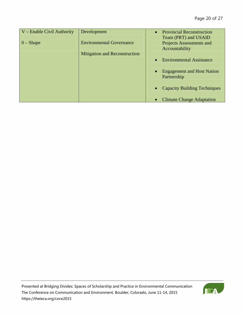
V – Enable Civil Authority 0 – Shape
Development Environmental Governance Mitigation and Reconstruction
• Provincial Reconstruction Team (PRT) and USAID Projects Assessments and Accountability
• Environmental Assistance
• Engagement and Host Nation
Partnership
• Capacity Building Techniques
• Climate Change Adaptation

Page 21 of 27
Presented at Bridging Divides: Spaces of Scholarship and Practice in Environmental Communication
The Conference on Communication and Environment, Boulder, Colorado, June 11-14, 2015
https://theieca.org/coce2015
Diagram 1: Military Decision Making Process
FM 101-5, 5-2
Page 22 of 27
Presented at Bridging Divides: Spaces of Scholarship and Practice in Environmental Communication
The Conference on Communication and Environment, Boulder, Colorado, June 11-14, 2015
https://theieca.org/coce2015
Diagram 2: Water Security Considerations for Security and Stability
Operations
Page 23 of 27
Presented at Bridging Divides: Spaces of Scholarship and Practice in Environmental Communication
The Conference on Communication and Environment, Boulder, Colorado, June 11-14, 2015
https://theieca.org/coce2015
References
“3D Planning Guide: Diplomacy, Development, Defense,” July 31, 2012.
Adaptive Management Working Group. Adaptive Management: The U.S. Department of the Interior
Technical Guide, n.d. http://www.doi.gov/initiatives/AdaptiveManagement/TechGuide.pdf.
Army Geospatial Center. 2014. “Water Resource Assessments and Appraisals (WRA/WAA).”
www.agc.army.mil/Media/FactSheets/FactSheetArticleView/tabid/11913/Article/480934/water-
resource-assessment-and-appraisals-wrawaa.aspx.
Baechler, Gunther. “Why Environmental Transformation Causes Violence: A Synthesis.”
Environmental Change and Security Project Report 4 24 (Spring 1998).
Bailey, Michael, Dixon, Robert, Harris, Marc, Hendrex, Daniel, Melin, Nicholas, and Russo, Richard. “A
Proposed Framework for Appreciating Megacities: A US Army Perspective.” Small Wars Journal,
April 21, 2014.
Barnett, Jon, and W. Neil Adger. “Climate Change, Human Security and Violent Conflict.” Political
Geography 26 (2007): 639–55.
Biersack, Aletta, and James Greenberg. Reimagining Political Ecology. Duke University Press, 2006.
Boehm, R.C., and Peterson, J.F. “An Elaboration of the Fundamental Themes in Geography.” Social
Education 58, no. 4 (May 1994): 211–18.
Brochmann, M, and P R Hensel. “Peaceful Management of International River Claims.” International
Negotiation 14 (2009): 393–418.
Brown, Oli. “The Environment and Our Security: How Our Understanding of the Links Has Changed.”
International Conference on Environment, Peace and Dialogue among Civilizations, May 2005.
Buhaug, Halvard. “Climate Not to Blame for African Civil Wars.” Proceedings of the National
Academy of Sciences 107 (n.d.): 16477–82.
Page 24 of 27
Presented at Bridging Divides: Spaces of Scholarship and Practice in Environmental Communication
The Conference on Communication and Environment, Boulder, Colorado, June 11-14, 2015
https://theieca.org/coce2015
Burke, MB, S Satyanath, JA Dykema, and DB Lobell. “Warming Increases the Risk of Civil War in
Africa.” Proceedings of the National Academy of Sciences, 2009.
Caine, Ken, Colleen Davison, and Emma Steward. 2009. “Preliminary field-work: methodological
reflections from northern Canadian research.” Qualitative Research. 9 (4): 489-513.
Canna, Sarah. Operational Relevance of Behavioral and Social Science to DoD Missions, March 2013.
Collier, Paul. The Bottom Billion: Why the Poorest Countries Are Failing and What Can Be Done
About It. Oxford, UK: Oxford University Press, 2007.
Collier, Paul, Lani Elliot, Havard Hegre, Anke Hoeffler, Marta Reynal-Querol, and Nicholas Sambanis.
Breaking the Conflict Trap. Civil War and Development Policies. Oxford, UK: World Bank and
Oxford Press, 2003.
Defense Science Board. Understanding Human Dynamics, March 2009.
Deligiannis, Tom. “The Evolution of Environment-Conflict Research: Toward a Livelihood Framework.”
Global Environmental Politics 12, no. 1 (February 2012): 78–100.
Dinar, S. “Scarcity and Cooperation along International Rivers.” Global Environmental Politics 9 (n.d.):
109–35.
Ducote, Brian. Challenging the Application of PMESII-PT in a Complex Environment. SAMS
Monograph. School of Advanced Military Studies, April 2010.
Ehlschlaeger Charles, ed. “Understanding Megacities with the Reconnaissance, Surveillance, and
Intelligence Paradigm: Topical Strategic Multi-Layer Assessment (SMA) and U.S. Army Engineer
Research Development Center (ERDC) Multi-Agency/Multi-Disciplinary White Papers in Support of
National Security Challenges,” April 2014.
Floyd, Rita, and Richard Matthew. Environmental Security: Approaches and Issues. London:
Routledge, 2013.
Flynn, Michael, Matt Pottinger, and Paul Batchelor. “Fixing Intel: A Blueprint for Making Intelligence
Relevant in Afghanistan.” Center for a New American Security, January 2010.
Page 25 of 27
Presented at Bridging Divides: Spaces of Scholarship and Practice in Environmental Communication
The Conference on Communication and Environment, Boulder, Colorado, June 11-14, 2015
https://theieca.org/coce2015
GEF. “Community to Cabinet: Two Decades of GEF Action to Secure Transboundary Basins and
Aquifers.” GEF ID 4219. www.iwlearn.net
Giordano, Mark F., Meredhit Giordano, and Aaron T. Wolf. “International Resource Conflict and
Mitigation.” Journal of Peace Research 42, no. 1 (January 2005): 47–65.
Gleditsch, Nils Petter, P Wallensteen, M Eriksson, M Sollenberg, and H Strand. “Armed Conflict
1946-2001: A New Dataset.” Journal of Peace Research 39 (2002): 615–37.
Gleick, P H. “Water and Conflict: Fresh Water Resources and International Security.” International
Security 18 (1993): 79–112.
Hauge, Wenche, and Tanja Ellingson. “Beyond Environmental Scarcity: Causal Pathways to Conflict.”
Journal of Peace Research 35, no. 3, Special Issue on Environmental Conflict (May 1998): 299–317.
Homer-Dixon, Thomas F. Environment, Scarcity, and Violence. Princeton University Press, 1999.
———. “Environmental Scarcities and Violent Conflict - Evidence from Cases.” International Security
19 (1994): 5–40.
Hsaing, S, K Meng, and M Cane. “Civil Conflicts Are Associated with the Global Climate.” Nature 476
(n.d.): 438–41.
Johnston, R J, Derek Gregory, Geraldine Pratt, and Michael Watts. The Dictionary of Human
Geography. 4th ed. Blackwell Publishing, 2000.
Kahl, C. States, Scarcity, and Civil Strife in the Developing World. Princeton: Princeton University
Press, n.d.
Kindon, Sara. 2005. “Participatory Action Research.” In Qualitative Research Methods in Human
Geography, 2nd ed., 207–20. Victoria, Australia: Oxford University Press.
Le Billon, Philippe. “The Political Ecology of War: Natural Resources and Armed Conflict.” Political
Geography 20, no. 5 (November 26, 2012): 561–84.
Page 26 of 27
Presented at Bridging Divides: Spaces of Scholarship and Practice in Environmental Communication
The Conference on Communication and Environment, Boulder, Colorado, June 11-14, 2015
https://theieca.org/coce2015
Manger, Leif. “Understanding Resource Management in the Western Sudan: A Critical Look at New
Institutional Economics.” In Beyond Territory and Scarcity: Exploring Conflicts over Natural Resource
Scarcities, 135–48. Uppsala: Nordic Africa Institute, 2005.
Martello, Marybeth. 2008. “Arctic Indigenous Peoples as Representations and Representatives of
Climate Change.” Social Studies of Science 38 (3): 351–76.
Matthew, Richard. “Regional Dynamics of Environment and Security in Post-Conflict States.”
Procedia Social and Behavioral Sciences 14 (2011): 28–30.
Meffe, Gary, and C. Ronald Carroll. Principles of Conservation Biology, 2nd Ed. Sunderland,
Massachusetts: Sinauer Associates, Inc., 1997.
Mildner, Stormy-Annika, Gitta Lauster, and Wiebke Wodni. “Scarcity and Abundance Revisited: A
Literature Review on Natural Resources and Conflict.” International Journal of Conflict and Violence
5, no. 1 (2011): 155–72.
Molnar, Jennifer ed. The Atlas of Global Conservation Conservation: Changes, Challenges, and
Opportunites to Make a Difference. Berkeley: University of California Press, 2010.
National Geospatial Intelligence Agency. 2014. “NGA, Arizona State University to Study Climate
Change, Anticipatory Analytics with $20 Million Research Grant”, June 18.
O’Farrell, Patrick, Pippin Anderson, David Maitre, and Patricia Holmes. “Insights and Opportunities
Offered by a Rapid Ecosystem Service Assessment in Promoting a Conservation Agenda in an
Urban Biodiversity Hotspot.” Ecology and Society 17, no. 3 (2012): 27.
Segel, E. and J. Heer. 2010. “Narrative Visualization: Telling Stories with Data,” IEEE Transactions on
Visualization and Computer Graphics 16(6):1139-1148.
Sekovski, Ivan, Alice Newton, William Dennison. “Megacities in the coastal zone: Using a driver-
pressure-state-impact-response framework to address complex environmental problems.” Estuarine,
Coastal and Shelf Science. 96 (2012): 48-59.
TEEB - The Economics of Ecosystems and Biodiversity. TEEB Manual for Cities: Ecosystem Services in
Urban Management, www.TEEBweb.org.
Page 27 of 27
Presented at Bridging Divides: Spaces of Scholarship and Practice in Environmental Communication
The Conference on Communication and Environment, Boulder, Colorado, June 11-14, 2015
https://theieca.org/coce2015
Thomas, J. J. and K. A. Cook, eds. 2005. Illuminating the Path: The Research and Development
Agenda for Visual Analytics. National Visualization and Analysis Center.
Bernauer, Thomas, Tobias Bohmelt, and Koubi Vally. “Environmental Changes and Violent Conflict.”
Environmental Research Letters 7 (2012): 1–8.
UNDP. “From Conflict to Peacebuilding: The Role of Natural Resources and the Environment.”
United Nations Environment Programme, 2009. http://www.unep.org/pdf/pcdmb_policy_01.pdf.
Voinov, Alexey, Lars Bromley, and Elizabeth Kirk. 2004. “Understanding Human and Ecosystem
Dynamics in the Kola Arctic: A Participatory Integrated Study.” Arctic 57 (4): 375–88.
Walton, Grant, and Jon Barnett. “The Ambiguities of ‘Environmental’ Conflict: Insights from the
Tolukuma Gold Mine, Papua New Guinea.” Society and Natural Resources 21 (2008): 1–16.
Wolf, Aaron T. Conflict Prevention and Resolution in Water Systems. Cheltenham: Edward Elgar, n.d.
Yoffe, S, Aaron T. Wolf, and Mark F. Giordano. “Conflict and Cooperation over International
Freshwater Resources: Indicators of Basins at Risk.” Journal of the American Water Resources
Association 39 (n.d.): 1109–26.
Zinn, Howard. 2005. A People’s History of the United States. Harper Perennial Modern Classics.