HELD UNDER SECTIONS 34 AND 51 OF THE PLANNING … · AUGUST 22, 2014 – 10:00 A.M. CLAR ... ON L9P...
74
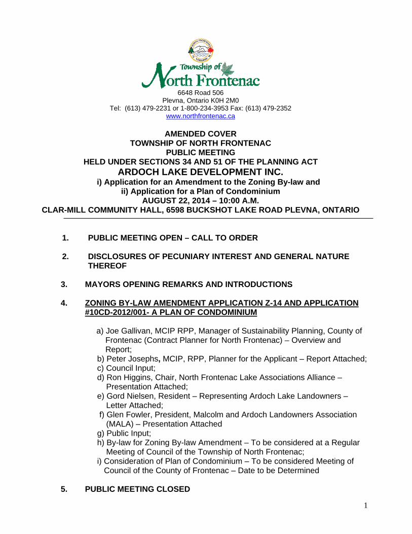
1 6648 Road 506 Plevna, Ontario K0H 2M0 Tel: (613) 479-2231 or 1-800-234-3953 Fax: (613) 479-2352 www.northfrontenac.ca AMENDED COVER TOWNSHIP OF NORTH FRONTENAC PUBLIC MEETING HELD UNDER SECTIONS 34 AND 51 OF THE PLANNING ACT ARDOCH LAKE DEVELOPMENT INC. i) Application for an Amendment to the Zoning By-law and ii) Application for a Plan of Condominium AUGUST 22, 2014 – 10:00 A.M. CLAR-MILL COMMUNITY HALL, 6598 BUCKSHOT LAKE ROAD PLEVNA, ONTARIO 1. PUBLIC MEETING OPEN – CALL TO ORDER 2. DISCLOSURES OF PECUNIARY INTEREST AND GENERAL NATURE THEREOF 3. MAYORS OPENING REMARKS AND INTRODUCTIONS 4. ZONING BY-LAW AMENDMENT APPLICATION Z-14 AND APPLICATION #10CD-2012/001- A PLAN OF CONDOMINIUM a) Joe Gallivan, MCIP RPP, Manager of Sustainability Planning, County of Frontenac (Contract Planner for North Frontenac) – Overview and Report; b) Peter Josephs, MCIP, RPP, Planner for the Applicant – Report Attached; c) Council Input; d) Ron Higgins, Chair, North Frontenac Lake Associations Alliance – Presentation Attached; e) Gord Nielsen, Resident – Representing Ardoch Lake Landowners – Letter Attached; f) Glen Fowler, President, Malcolm and Ardoch Landowners Association (MALA) – Presentation Attached g) Public Input; h) By-law for Zoning By-law Amendment – To be considered at a Regular Meeting of Council of the Township of North Frontenac; i) Consideration of Plan of Condominium – To be considered Meeting of Council of the County of Frontenac – Date to be Determined 5. PUBLIC MEETING CLOSED
Transcript of HELD UNDER SECTIONS 34 AND 51 OF THE PLANNING … · AUGUST 22, 2014 – 10:00 A.M. CLAR ... ON L9P...
1
6648 Road 506
Plevna, Ontario K0H 2M0 Tel: (613) 479-2231 or 1-800-234-3953 Fax: (613) 479-2352
www.northfrontenac.ca
AMENDED COVER TOWNSHIP OF NORTH FRONTENAC
PUBLIC MEETING HELD UNDER SECTIONS 34 AND 51 OF THE PLANNING ACT
ARDOCH LAKE DEVELOPMENT INC. i) Application for an Amendment to the Zoning By-law and
ii) Application for a Plan of Condominium AUGUST 22, 2014 – 10:00 A.M.
CLAR-MILL COMMUNITY HALL, 6598 BUCKSHOT LAKE ROAD PLEVNA, ONTARIO
1. PUBLIC MEETING OPEN – CALL TO ORDER
2. DISCLOSURES OF PECUNIARY INTEREST AND GENERAL NATURE
THEREOF
3. MAYORS OPENING REMARKS AND INTRODUCTIONS 4. ZONING BY-LAW AMENDMENT APPLICATION Z-14 AND APPLICATION
#10CD-2012/001- A PLAN OF CONDOMINIUM
a) Joe Gallivan, MCIP RPP, Manager of Sustainability Planning, County of Frontenac (Contract Planner for North Frontenac) – Overview and Report;
b) Peter Josephs, MCIP, RPP, Planner for the Applicant – Report Attached; c) Council Input; d) Ron Higgins, Chair, North Frontenac Lake Associations Alliance – Presentation Attached; e) Gord Nielsen, Resident – Representing Ardoch Lake Landowners – Letter Attached; f) Glen Fowler, President, Malcolm and Ardoch Landowners Association (MALA) – Presentation Attached g) Public Input; h) By-law for Zoning By-law Amendment – To be considered at a Regular Meeting of Council of the Township of North Frontenac; i) Consideration of Plan of Condominium – To be considered Meeting of Council of the County of Frontenac – Date to be Determined
5. PUBLIC MEETING CLOSED

2
Note: Additional Reports on this Planning Proposal can be found at http://goo.gl/OX91f3 or by contacting: Joe Gallivan Jenny Duhamel Manager of Sustainability Planning Clerk/Planning Manager County of Frontenac Township of North Frontenac 2069 Battersea Road 6648 Road 506 RR # 1, Glenburnie ON K0H 1S0 Plevna, Ontario, K0H 2M0 Phone: (613) 548-9400 Ext. 350 Phone: 1-800-234-3953 or 613-479-2231 Ext. 225 Fax: (613) 548-8460 Fax (613) 479-2352 Email: [email protected] Email: [email protected]

Jenny Duhamel
From: Sent: To: Subject:
To Jenny Duhamel,
C and W Scott <[email protected]> July-25-14 12:45 PM Jenny Duhamel Ardoch
Please accept this letter as a request to amend the zoning application for the Ardoch Condominium application to reflect the change from 45 lots to 34 as per revised plan dated June, 2014. These lots will all be strictly seasonal
dwellings without exception .
Best regards,
Colin Scott.
Ardoch Lake Developments.
1

6648 Road 506 P.O. Box 97, Plevna, Ontario KOH 2MO
Tel: (613) 479-2231or1-800-234-3953 Fax: (613)479-2352 www.northfrontenac.ca
January 16, 2012
Ardoch Developments Inc. c/o Colin Scott 46 Quaker Village Drive Uxbridge, ON L9P 1 A2
Dear Mr/ Scott:
RE: Zoning By-law Amendment Application #Zl-12 Ardoch Lake Developments Inc.
COPY
Please be advised your Zoning By-law Amendment application has been deemed complete by Tunnock Consulting. I am enclosing a copy of this Notice for your information.
I am also enclosing receipts for the Zoning By-law Amendment fees and the Condominium Approval fees for your records.
I have spoken to KFL&A Public Health and they advise they cannot complete a site inspection and repo11 until the spring when the weather is milder and the ground thawed. For this reason, we will not be able to hold the required Public until the spring. I will inform you of the date of this meeting once arranged.
If you require anything further from me at this time, please do not hesitate to get in touch with me.
Yours truly, . n ~v--~
y Duhamel, Clerk/Planning Manager Enclosures

01 / 03/2012 15:33 17054750030 TUNNOCK CONSULTING
Tunnock Consulting Ltd.
JAN 0 3 2012 .~ ..
To: Agencies Twp, Gf Ntirth Front91iiiQ
Per .,,,YUIUr:··~, •• , ••• " u11uu·•'"'"'"1t\llf'J., .. ,..,......,,
From: Tunnock Con~ultiog Ltd Tunnock Commlring Ltd. File P-1 523
Re:
CC:
Zoning By-Jaw Amendment - Notice of Complete Application
Town~hip ofNorth Frontenac
~~:.r. .
#of Pages (not Including cover page:
~i~ 'ontenac, Fax (613) 548-8460
of North Frontenac, Fax (613) 479-2352 nc District School Board, Fax (613) 544-6804
3
PAGE 01
... .,..~in and Lakeshore District School Board, Fax (613) 258-5067 S . .. ~. ... . .• iiseil de· District des ecoles publiques de langue fran~aise no. 59, Fax (613) 747-~810 Secretaire, Conseil scolaire de district catholique du Centre-Est de !'Ontario, Fax.(613) 746-3081 Secretary-Treasurer, Mississippi Valley Conservation Authority, Fax (613) 259-3468 Secretary, Hydro 01Je Networks, Fax (905) 946-6242 . Secretary, Union Gas Limited Fax (519) 436-5218 Executive Vice-President, Law and Development, Ontario Power Gener.ation; Fax ( 416) 592· 1466 Ministry ofMunici:pal Affairs arid Housing (Kingsto.n), Fax (613) 548-6822 Executive Director, Algonquins of Ontario Consultation Office, Fax: (613) 735-6307
Tunnock Consulting Ltd. Phone: (705) 475-0040 Fax: (705) 475-0030 1-800-924-0128 247 Hearst Street, Nortld~ay, ON PlB 8Z2
. .. .. -. ~ •,.: . ... : . . . . .... ·. . . . . . ..... - -.: .. • . . ·.
www.runnockconsulting.ca
Servi.ces en fran~ai~
. ... -·; , ., ... . ··· --f ··- ··· .··• ... ........ ... ... ··· ·) · ·~..,·-.·~, ...... . _ ......... -,.. ... --~-. · ·-:·-:'•;9'"'· -- -·-:----· ·.: ·. ·~ ·""- :~-- -:··:·-·
.DEDIC~4TED TO li.\T~\TOl·':-!T/01\T . .-L.\!D.EXCELLE1\TCE . .

01/03/ 2012 15:33 17054750030 TUNNOCK CONSULTING
Township of North Frontenac
NOTICE OF A COMPLETE APPLICATION Zoning by-law Amendment
PAGE 02
TAKE NOTICE that the Council of the Corporation of the Township of North Frontenac has re.ceived an application under Section 34 of the Planning Act to amend the Zoning By-law of the Township of: North Frontenac. The application has been deemed to be complete (see affirmation notice).
PURPOSE AND EFFECT: The ~oning by-law amendment is required is concurrent with an application to the County of Frontenac for a Plan of Condominium. The effect is to re-zone lands from the Waterfront Residential (RW) Zone and the L,imited Service Rural (LSR) Zone to the Waterfront Residential (RW) Zone and the Environmental Protection (EP) Zone in order to permit a 4S-unit residential plan of vacant land condominium. The lands arc legally described as Part of Lots 22, and 23, Concessions I and 2, in the Geographic Township of Clarendon, Township of North Frontenac, County of Frontenac, and are located along the southern shoreline of Ardoch Lake. The subject land has a lot area of 93.2 ha (230.2 ac) and has frontage of 1,884 m ± (6181 ft ±). (see Key Map)
TAKE NOTICE that the municipality will be holding a. public meeting under the Planning Act to consider this application. Any Person may make written or verbal presentation either in support of or in opposition to the proposed zoning by-law amendment. If a person or public body does not make oral submissions at the public meeting or make written submissions to the Township of North Frontenac before the proposed zoning by-law amendment is adopted, the person or public body is not entitled to appeal the decision of the Council of the Township of North Frontenac to the Ontario Municipal Board. tf a person or public body does not make oral submissions to the Township of North Frontenac before the proposed zoning by-law amendment is adopted, the person or publie body may not be added as a party to the hearing of an appeal before the Ontario Municipal Board unless, in the opinion of the Board .• there are reasonable grounds to add the person or public body as a party.
ADDITIONAL INFORMATION related to the proposed Zoning By-law amendment is available during regular office hours at the municipal offices.
Dated at the Township of North Frontenac this 4•h Day of .January, 2012.
Jenny Duhamel Clerk/Planning Manager Township ofNorth Frontenac 6648 Road 506, Box 97 Plevna, Ontario KOH 2MO Phone: (613) 479-2231 or I (800) 234-3953 Fax: (613) 479-2352 Email: [email protected]

01/03/2012 15:33 17054750030
---~ '··-.., - ~ '·, ' ,,. -,,
Existing Residential Waterfront (RW) Zone
TUNNOCK CONSULTING
Key Map
Area to be Re-Zoned Environmental Protection (EP)
Zone
T __ ~SR __ ._
PAGE 03

01/ 03/ 2012 15:33 17054750030 TUNNOCK CONSULTING
CORPORATION OF THE TOWNSHIP OF North Frontenac
PAGE 04
Roll # 1042-060-020-02600-0000 1042-060-020-02800-0000 1042-070-020-29900-0000 1042-070-020-30000-0000 1042-070-020-30100-0000
File# P-1523
o Official Plan Amendment An application for a x Zoning By-law Amendment submitted on December 2, 2011 ,
o Subdivision
by 548846 Ontario Ltd. (Mme of applicant)
was received on January 3, 2012. This application was reviewed and deemed
to be complete pursuant to the requirements of the
Planning Act on January 4, 2012.
Glenn Tunnock. MPA, RPP Januaiy 4. 2012 (Authorized Officer) (Date)
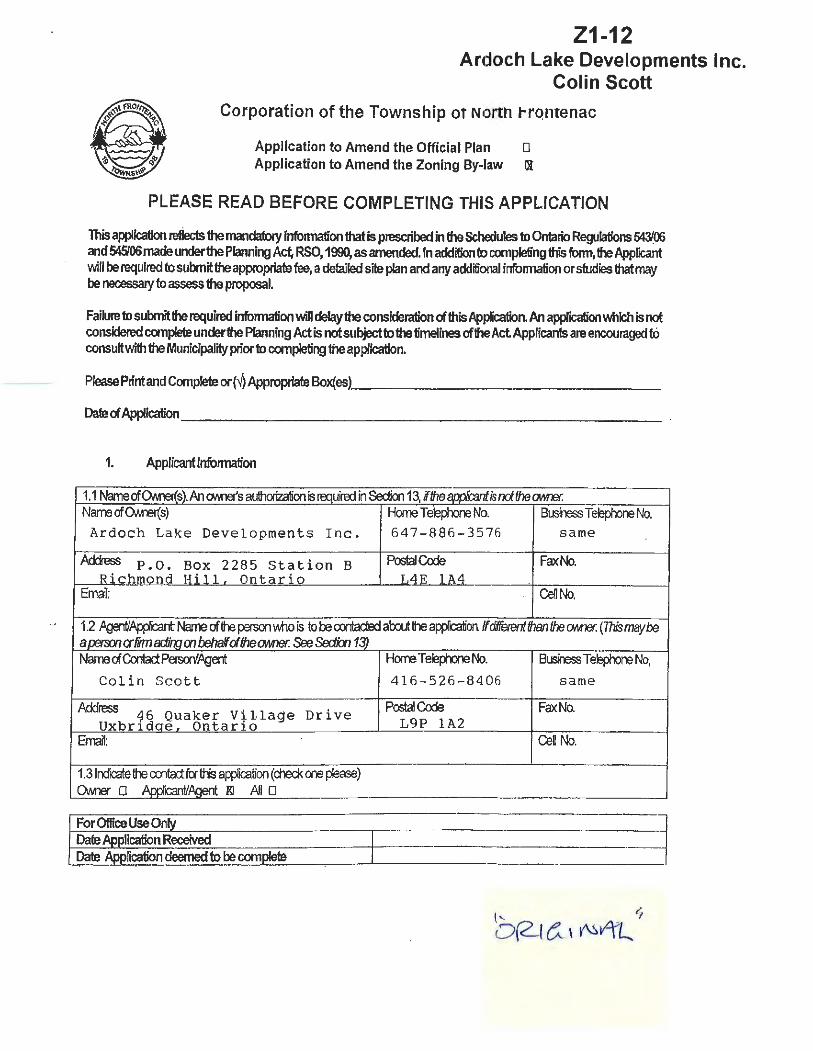
Z1-12 Ardoch Lake Developments Inc.
Colin Scott
Corporation of the Township ot Nortn trontenac
Application to Amend the Official Plan D Application to Amend the Zoning By-law Ol
PLEASE READ BEFORE COMPLETING THIS APPLICATION
This application reflects the mandatory infomlation that is prescribed in the Schedules to Ontario Regulations 5@'.06 and 545'06 made under the Planning Act, RSO, 1990, as amended. In addition to completing this fonn, the Applicant will be required to submit the appropriate fee, a detailed site plan and any additional infonnation or studies that may be necessary to assess the proposal.
Failure to submit the required infonnation will delay the consideration of this Application. An application which is not considered complete under the Planning Act is not subject to the timelines of the Act Applicants are encouraged tO consult with the Munlcipality prior to completing the application.
Please Print and Completeor(../)Appropriate Box{es) ______________ _
Date of Application _ ______________________ _
1. Applicantlnfonnation
1.1 Name of OM'ler{s). An ONra's authorization is reauire:f in Section 13, if the aoolbant is nd the OM1er. · Name of CMrer(s) Howe Telepmne No. Business Tek:lp00ne No.
Ardoch Lake Developments Inc. 647-886-3576 same
Address P.O. Box 2285 Station B PostalQxfe Fax No. Richmond Hi 11. Ontario L4E 1A4
Email: Cell No.
1.2 ~App/Cant Name of the person Vvtlo is to be ooitadEd ab::lutthe appl"K:alion /f dtfferentfhanlhe OArer. (This maybe a rem:n er firm woo m behalf <ifhe OM1er. See SedkJn 13) Name of Contact Persoo'Agent Home Teeph:lre No. B~Te~No.
Colin Scott 416-526-8406 same -
Ack:lress 16 Quaker Vi1tage Drive PostaJQxfe Fax No.
Uxbr1dae. Ontario L9P 1A2 Email: CeU No.
1.3 lrdicate the ~fcfthi.s application (check CX1e please) OM1er 0 Andblnt/~ Kl All 0
I ForOftic:elJseOnly

2. location of the subject land ( C-Omplete applicable boxes in 21)
2.1 Munldpal Address (malirtJ address) I Poslal COOe 5026 B Ardoch Road
Conres5ion Numl::e-(s) LctNumren~) See Attac hed See Attache d
Registered Plan No. Lct(s;vBlod<(s)
Refererce Plan No. Part Number(s) Parcel Number(s) Fooner TCMn5hip Clarendon
Asses.5mert Rdl No. 2.2 Ne thereany~enls cnBStJidive oovenanls affedirg tre suqect land? o No ~ Yes If~. desoite lhe easement a-oovenant m:1 its effect. (Refer to Planning Report) Right-of-way over "Road A" in favour Of Lot 16, Cone. 1 , Geographic Township of Palmerston, now Township of North Front~
3. Namesard OOdresses of any m~. hokJe<s of dlarges orctrerenarnl:rarras of tt-e suqect lards (altrll
sei:erate ~ ~~uired). -----..,.----------Haro ld P.erry, Ardoch , Ontario, Ge neral Delivery KOM lCO (and Mona Perry)
4. Description of the property and set'Vicing information ( C-Omp/ete each section using metric unifs on,y).
4.1 Dimaisions Lct LctArea varies 9 3 .2 ha
4.2 ~ (COOck awrcpdate box and ::tale road name): D ProvirdalHghNay(#) _________ __________ _ Kl Munapalrocd,manaira:lyearround Private road intersects Ardoch Rd . o Munopa/ road, seaoc.oall'f mantained ________________ _
o CourtyRoo:JOO~~~~~~~~--.,.~--o-~-.-~~~-,-~-~ PrivateRoo:J ' Access to new l ot s will be priva te roa d o Rg~ofvvay __________ ___________ ~
D W~Po::ess~----------------------4.3 If water access only, describe the location of parking and docking facilities to be used
and the distance from the subject lands. Indicate whether parking is public or private.
N/A
4. 4 Wafel Suwl'f (Check ap{XO(Jiate box fix type cl $Nk:e prr:fX)Sed): o Putiidy OMled ard q:erate:J ~ watErsystem O Privatey cwied ard oi:erated pi~ wcJ.er system ( cx::mmunal) Kl Dri!ed 'l.eU 0 Sard f))int O lake a-oth:rv-.rater t:cdy O Otrerrreans (deasestate)
2
nae.

4.5 Sewage~ (Ched< 8(:fXCpfiaJe box fr:Ftype d sel\IX:e prcposed): o Pul:f~ OM'B:1 and q:aatoo sanitary se.vage system
XJ Plivatefl/ OM'B:1 and q:aatoo hfrvklual sepx;system* o Plivatey OM'B:1 and op:ratoo cxxnmunal seµic s~* 0 Privf 0 Hokflrg tank D Olrer~state) _______________ ~---~ 0 Sewage cfiSfXJSC31 seM:e not pqxised
* If eitrer of these nems ctecked, pease see Sedion 4.8.
4.6 arer Savices (Check if fhe servte js avalable): ~ Eledridty 0 Sdlool tussrg 0 GaJbage cxfucfun
4.7 stcxm Dainage (lncfcate fhe proposed stcxm drainage system): o Stoon seJ..e'S
IX Ditcres IX SWa~ o Oh:!r(OOaseSate) _____ _______________ _
4.8 W-ere deveqxnert\~B i:ro:Juce more than 48:XJ ~of effluerta day,~ ere reqtired to sutmfa seMrg oµions rerxxt and a h~cal report: cr Titleanddatedsavidrgoµionsreport: ___ R_u_r_a_l_S_e_r_v_1_·c_i_n_g...__S_t_u_d_y ___ _ IX Title and date cl~~k'.al rE!{XXt ___ R_u_r_a_l_S_e_r_v_i_c_i n_g""--S_t_u_d_.Y.__ __ _
Nov. 2007 with
5. Planning Information 5.1 OfticislPlan(rurrert) Land Usedesgnatioo(s)ofsutjedlard 11 Lake Deye J opment
"Rural Areas"
update Apr . 2011
Area" and
5.2 ProvX:leanexpanationofhcmaJ:lPicatbnoonfamsto1heOffrialPlan: ________ _ Refer to Planning Report (Peter A. Josephs, Oct, 2011)
5.3 If an Offdal Plan Amendment is beirg requested, Wll 1he change? (Ched< cif 8{PO{Xiate boxes}: o Replareoroolete an existirg ~icy (ies}. If yes, ristaU pdicysecronsaffeded __ N""""'/_A ___ _
O Charge a lard use desgnafion on a p-op:rty (ies). If yes, W1at is 1he ~land use desgnation or desgnatioos? _____________________ ~
o Alta-1he boundary of salEment area Q.e. tO'Ml, vill~e. hamEt). If yes, name tie setfument area ard p'O'lde sketch of area affe::ted. Nameof sa!lementarea _____ ___ _:__ ___ _
(Nde: if ap{ik:ants are requesting a charr;;e to apdcy, they are requied to pro'IOO/he ~fextdthe {Xib;(es). If apptants ~ requeSi?g a charr;;e to a Lard Use Schedule, they are requied loprwkfe a map cx-!rhedule shdW1g the prr:posednewlandusedesignafbnfr:FtheatrededJXq:Jedy(ies).) 5.4 Reason Wily official plan amerdrrent is beirg req~ed: ___ N ...... /-'-A"----------
5.5 BdslirgZonrgonsuqedlands_RW · Zone and LSR Zone (see Planning Report} 5.6 Zonirg requesied RW Zone and EP. Zone (see Planning Report) 5.7 Reasonwhyrezoning .isbeingrequested: To permit 45-unit (lot) residential
plan of vacant land condominium
3

6. Description of subject land 6.1 Frootageonsfreetsoo(m} N/A 6.2 Lot D::pll (m}_ v_a_r_i _e_s __ ___,,,.._ _ _
F~onwatersre(m} 1,884 m approx.
6.3 LotArea 9 3 • 2 ha m2
7. SeWementArea Boundary 7.1 Doas 1his a~icafun ~to cilarge the lxx.umy of a se!IX;mait area (e.g. t0M1, village or hamlet}
O Yes ~No If Yes, provide description:--- -----------
8. Employment Area 8.1 VVill this apifu3tial reimve lard ti-an a desgnated em~oyment area? ( Olock.aprtqJtiafe oox)
o Converts an a-part of a commercial, irduslrial a- in5ttutional buik:li~ to a resideolial use. D Converts a l:roM1rekl site to a resk:lential use o ,Appication is fcr resklenfial use on lard desgnation fcr a canmerdal, irous1rial or in.sfitutional use Xl Does rd remove any employment lard
9. Existing Use(s)of Property 9.1 State all existirg use{s) of the puparty (Check apprq)(iafe box( es)):
o Resklential 0 Comrredal 0 lrdustria! 0 Institutional o Agricultural XI Vacant O Mixed Use: (Pleases/ale) _________________ _
NI Other: (Pleasestate) old camp sites, cabin List all existing buildings and structures (including accessory buildings and structures) on the property by completing the following Table: (If more than 5 buildings or stnictures, please use separate page to provide description):
Item Building or Building or Building or Buildfng or Building or Structure# 1 Structure#2 Structure# 3 Sfructure#4 Structure#5
Existirg type cr~ !Cf ea:::l1 tuit1ing ard N/A stn..dure Heght(m) II
Setbock fil::xn fiwt bt fine(m)
II
Sett:a::k fil::xn rear 11 II
lre(ml Setbcd< fil::xn sOO l::t rn~sde(m) II
Setbcd< fil::xn sOO l::t fine -olheir sde (m)
II
-&furl fian shoreline (m) " ~~m)cr fxxrarea(m II
year BW:fin;i or II
sfn.dure oonsbu::la:J
9.2 How many existing parking spaces are provided on the subject land? none spaces.
4

9.3 Statetheexislirg use of lard oo al:x.Jttirg ~:
North: Ardoch Lake South: private - bush · East: r u r a l /bush ( pr iv ate ) West: __,r,_u_r_a-1 /-r.o-b-u-s-=-h-..( _p_r_,.i_v_a__,.t-e-.),..--
10. Proposed use of property 10.1 State proposed use(s) of the property (Check appropriate box(es)):
IX Residential D Commercial o Industrial o Institutional o Agricultural D Vara-it o Mixed Use: (Please state} O Other: (Pleasestate) Refer ::to Planning Report
10.2 List all proposed buildings and structures to be constructed on the property by completing the following Table: (If more than 5 buildings or structures, please use separate page to provide descri1Jfion) (Typical zone standard for each l ot)
Item Building or Building or Building or Building or Building or Structure# 1 Structure# 2 Structure# 3 Structure# 4 Structure# 5
Bdstirg ty]l3 Cf Seasonal detached d1 elling use of each or
ruildirg am Single de tached dwe ling
strudue He~ht(m) 10 m Setback from front lotHne(m) 30 m
Setback from rear 7.5 lotfine(m) m
Setback mxn soo lot line ore side 3 .0 m (m) Setbad< furn side lot fine -olher side 3. o· m (m) Setbad< furn
30 m shorelre(m) -Dimensbns (m) a-floorarea(m2) To be de ,ermined
Year Buildrg cr slrudure To be de ,er mined ronstruded Propos00 date <:i
To be det ermined conStrudioo
10.3 Indicate the number of additional parking spaces to be provided? 2 per dwel l i ?$~aces .
5

10.4 Are there any uses or features on the suqect lard orW!hin flJJ m of the suqect ~. uness o!l"lelWse ~·
11. 11.1
11.2
11 .3 11.4
12. 12.1
Item
Com eTu~ · Use or feature On the subject Land Within 500 m of subject land, unless
othelWise specified. (inricate iximateclstance
ment to b set bac
History of the Subject land. Has 1he suqect land~ been re suqect of a-i a~ication for appoval of a µevPu.s offcial pan orzonirg am:!rdrrent? o Yes ~No o Uri<roMI lfyes,plf:Nkietheootcisanddedsbnoffhep1eW.Js app(x::afion.
If this application is a re-submission of a previous application, describe how it has been changed from the original application. Providethedale'lvilenthesuqectlardwasacquiredbytherurentOMlef. JULY 31 , 2 006 ~the lergth of time that the existirg uses ofthes~ land have a:rfuled (Prrdmayberequro:J.) Year since rurent uses have continued: u n kn own
Simultaneous Applications lsfusuqed land orany land'lvithin 120m of the suqedlardsuqectof anyclher pannirg apPicalions at!tiis tine? IX Yes o No If yes, indbatethe type ardfie numberO.e. cmsent, ~. mincfvariance, site pan oonbol). Pease cx:mplete foloorg TaCle:
Plan of Condominium (application to County) l\r.prrcation # 1 (type): Application#2 (tyi:e): My fandv.ifhin 120 m ofttie
suqect lard:
FdeNumrer Unknown Name of aJ:PDval atAhcxity County of \A)l~~~a~iiA. Frontenac Land affected by applicaticfl
Same lands
6

Purµ:se Residential (Refer to Pl am ing Report) Plan Of Condominium
Stab.Js Submitted to County at same time as M'r\Tii TIN
Effect on ~i..ested Zoning is req1 ired amerdment for proposed • 5-lot residential p an of condominiu1 ~.
13. Authorization 13.1 If the applicant is not the owner of the land that is the subject of this application, the written
authorization of the owner that the applicant is authorized to make the application must be included with this form or the authorization set out below must be completed.
A. · ·D.
13.2 If the applicant is not the owner of the land that i~ the subject of this application, complete the authorization of the owner concerning personal information set out below.
AUTHORIZATION OF OWNER FOR AGENT TO MAKE THE APPLICATION
1 ,Arrl~ w~ f}.uda~..{.; Mv. I am the owner of the land that is the subject of this application and for the purposes of the Freedom of Information and Protection of Privacy Act, I authorize C4 l•"'- lt& 1:± as my agent for this application, to provide any of my personal information that will b~ us,ed in tf)is · · or CQllec~d during the p cessing of the application. {) ft rJ-.otL IJ.-[u ......D 1 tAL-.
u_. lo I Y~r:-.:.·----~~~~--~---Date Sif;tf 1ature of Owl'l - ~ . o.
7
13.3 Consent of the Owner
Comp!ete the consent of the owner concerning personal information below.
14. Additional Studies or Information
Additional studies or information may be required by the Municipality to support the application. The application may not be considered a complete application unless these studies have been completed. Applicants are advised to pre-consult with the Municipality to determine what additional studies or information is required. List of Additional Studies or information required by the Municipality: 0 0 0 0 0 0
(NOTE: LIST TO BE PROVIDED BY MUNICIPALITY)
15. Declaration
NOTE: ALL APPLICANTS SHALL ENSURE THAT A 'COMPLETE APPLICATION' UNDER THE PLANNING ACT HAS BEEN MADE BEFORE COMPLETING THIS DECLARATION
1. I hereby declare that this application is consistent with the policy statements issued under subsection 3(1) of the Planning Act.
2. I hereby declare that this application conforms or does not conflict with any provincial plan or plans. .
3. I hereby declare that the information contained in this application and on the attached plan and any associated information submitted with this application are, to the best of my knowledge, a true and complete representation of the purpose and intent of this application.
8

16. Site Plan
A site p'an shall be submitted with this application that provides the following information. D The boundaries and dimensions of the subject land; D The location size and type of all existing and proposed buildings and structures on
the subject land, indicating their distance from the front lot line, the rear lot line, each side yard lot line and the shoreline of any water body, where applicable;
o The approximate location of all natural and artificial features such as railways, roads, water body, drainage ditches, wetlands, wooded areas, wells and septic tanks, all easements, flood plain, organic (muck) soils or leda clay;
(Note: these features must be shown for both the subject land and on any adjacent lands where these features may affect the application.) D The current uses of land that is adjacent to the subject land. D The location, width and name of any roads within or abutting the subject land
indicating whether it is an unopened road allowance, a public road, a private road or a right-of-way
O If access to the subject land will be by water only, the location of the parking and docking facilities to be used.
D North arrow and scale D Other (as indicated by Municipality) - - - --- --------
9
LEGAL DESCRIPTION
Part of PIN 36188·0451 being PT LT 22·23 CON 1 CLARENDON; PT LT 22·23 CON 2 CLARENDON; PT LT 21 ·22 CON NORTHEAST RANGE CLARENDON; PT ROAL BTN CON NORTHEAST RANGE AND CON SOUTHWEST RANGE CLARENDON CLOSED BY FR367996; PT LT 21 CON SOUTHWEST RANGE CLARENDON PTS 1-13,13R18450 srr FR754055; NORTH FRONTENANC

Peter A. Josephs
From: Sent: To: Cc: Subject:
C and W Scott [[email protected]] November 28, 2011 4:39 PM Peter Josephs 'Peter Josephs' FW: Ardoch Lake Roll #s and Property Descriptions
From: Wendy Lewis [mailto:[email protected]] Sent: November-28-11 4:30 PM To: 'C and W Scott' Subject: Ardoch Lake Roll #s and Property Descriptions
Colin:
Below are the Roll #s and Property Descriptions on the five tax bills I receive for Ardoch Lake:
1. 10-42-070-020-30000-0000 - Prop Desc: 5026 B Ardoch Rd, Con 1 Pt Lot 23 2. 10-42-060-020-02600-0000 - Prop Desc: Clarendon NE & SW Range Con 1 Pt Lot 21 RP 13R18450 3. 10-42-070-020-29900-0000 - Prop Desc: Clarendon Con 2 Pt Lot 23 RP 13R18450 Pt. Part 2 Green 4. 10-42-070-020-30100-0000 - Prop Desc: Clarendon Con 1 Pt Lot 23 RP 13R18450 Pt. Parts 2 and 3 5. 10-42-060-020-02800-0000 - Prop Desc: 5026 B Ardoch Rd Clarendon Con 1 Pt Lot 22 Con 1 Pt Lot 21 RP
13R18450
Let me know if you need anything else .
Wendy

Ardoch Lake Proposed Rezoning:::,;
c ,.
•
t ... . - - .
.. .. . • • . .. ~
?
• • • . • . • . . • • .
~ . ~
• ~· .··
Kezoneto KW
Rezone to EP
Re1vised Application July 31., 2014
Ardoch Lake Subdivision Page 1
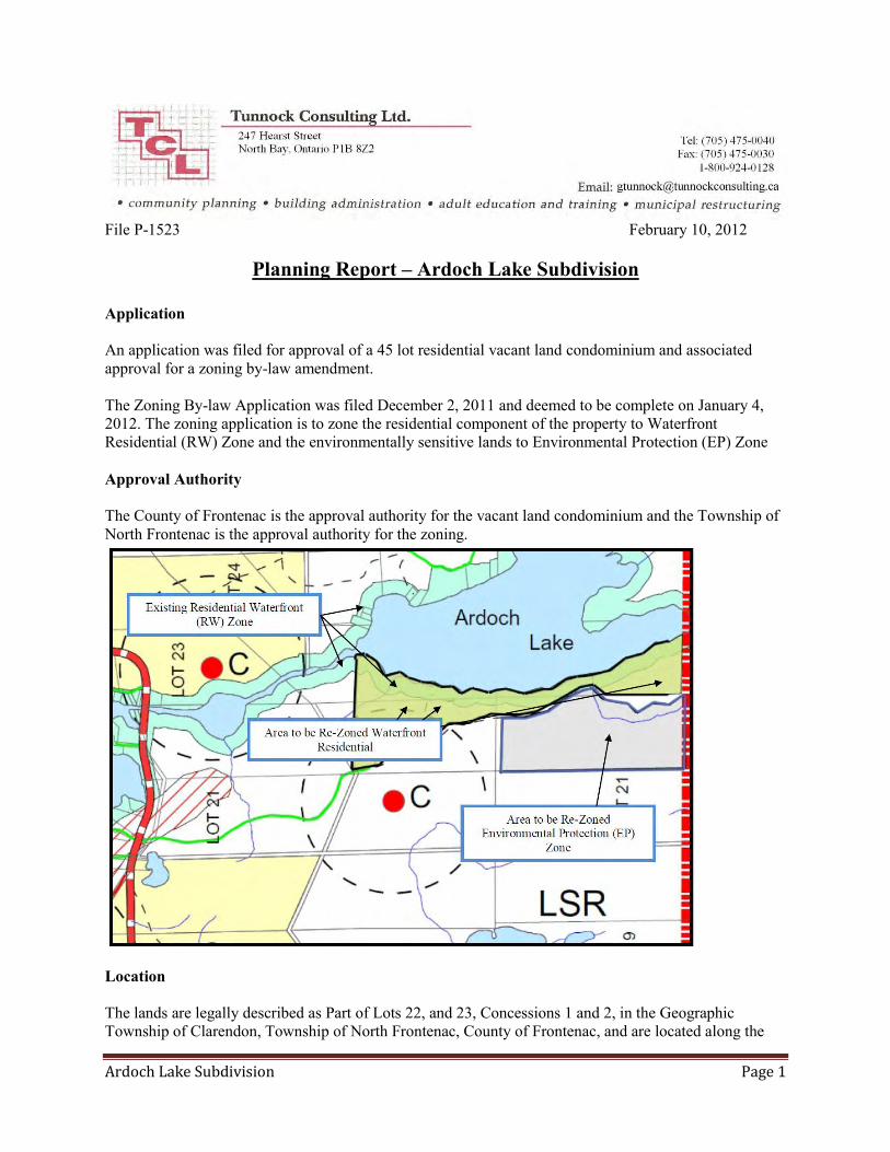
File P-1523 February 10, 2012
Planning Report – Ardoch Lake Subdivision
Application An application was filed for approval of a 45 lot residential vacant land condominium and associated approval for a zoning by-law amendment. The Zoning By-law Application was filed December 2, 2011 and deemed to be complete on January 4, 2012. The zoning application is to zone the residential component of the property to Waterfront Residential (RW) Zone and the environmentally sensitive lands to Environmental Protection (EP) Zone Approval Authority The County of Frontenac is the approval authority for the vacant land condominium and the Township of North Frontenac is the approval authority for the zoning.
Location The lands are legally described as Part of Lots 22, and 23, Concessions 1 and 2, in the Geographic Township of Clarendon, Township of North Frontenac, County of Frontenac, and are located along the

Ardoch Lake Subdivision Page 2
southern shoreline of Ardoch Lake. The total land area of the holding is 93.162 ha [230 ac.] of which 49.38 ha [122.03 ac.] is proposed for the residential area. The total shoreline frontage on Ardoch Lake is 1,884 m [6,181 ft.]. Property Description The site is generally described as undulating or hilly with rock outcrops and covered with old field meadow, mixed deciduous and coniferous tree species and flooded swamp. Drainage on the eastern part collects in a marsh area and discharges into Ardoch Lake between proposed Lots 10 and 11. A small water course is located in the western part of the site and drains into Ardoch Lake across Block A. Background The applicant first approached the municipality in early 2007 with an interest in the development of a subdivision. In the interim period, the consultant team for the applicant has prepared a variety of studies and consulted with agencies that have a role in the approvals process. Supporting Studies A series of studies were conducted in support of the application:
Stage 1 to 3 Archaeological Assessment of Part Lots 22 and 23, Concession 1 and 2, Former
Geographic Township of Clarendon, Currently Township of North Frontenac, County of
Frontenac, Northeastern Archaeological Associates, Port Hope, March 5, 2009 Rural Servicing Stud, Proposed Ardoch Lake Subdivision, Part Lots 22 and 23, Concession 1 and
2, Township of North Frontenac, County of Frontenac, Jagger Hims Limited, Environmental Consulting Engineers, Newmarket, November 2007
Rural Servicing Study- Addendum to Report, Genivar, Newmarket, April 12, 2011 Phosphorus Budget Assessment, Genivar, Newmarket, January 10, 2011 Environmental Impact Study, Ardoch Lake Subdivision Part Lots 22 and 23, Concession 1 and 2,
Former Geographic Township of Clarendon, Township of North Frontenac, Niblett Environmental Associates Inc., Lindsay, August 12, 2011
Planning Report, Applications for Residential Plan of Vacant Land Condominium and Zoning
By-law Amendment, Peter A. Josephs & Associates, Planning Consultants, Peterborough, October 2011
The studies have been filed with the approval authorities. The County of Frontenac typically requests a peer review. This Planning Report addresses the applications in the context of the Official Plan, Zoning By-law and Provincial Policy Statement. Official Plan The Official Plan designates the south shoreline of Ardoch Lake as Lake Development Area to a depth of approximately 125 m while lands to the interior of this land use designation are designated Rural Area. The intent of the Plan was to subject shoreline development to the package of shoreline management policies for waterfront related development. More specifically, Section 4.10.2 states that the Lake Development Policies apply to lands within 300 m of water bodies; hence it is our opinion that Sections 3.19 and 4.10 of the Plan should apply to Lots 1-40 and 43-45, Only Lots 41 and 42 lie completely outside of the Lake Development Area designation, albeit the access road servicing the
Ardoch Lake Subdivision Page 3
development provides common access to all of the interior lots. An Official Plan amendment is not required for the proposed development by virtue of Section 3.16.2 which states that land development shall generally take place for waterfront residential development…and may be used for large lot development in the Rural Area. Section 4.10.2A also anticipates residential development along shoreline areas and makes provision for development by plan of subdivision where specific criteria are met. The first criterion is the requirement for an Environmental Impact Study. Environmental Impact Study
A study was conducted by Niblett Environmental Associates Inc., who has consulted with the Conservation Authority. The current study is an update from the 2008 study. Genivar also conducted a study with respect to an assessment of phosphorus loading on Ardoch Lake. The study concludes that there are no provincially significant wetlands, woodlands, valley lands or areas of natural and scientific interest; however there is fish habitat and significant wildlife habitat on or adjacent to the site. A biophysical inventory was conducted based on field visits in 2006-2007. Ten (10) vegetation communities were identified including a wet cedar swamp which is located on the shoreline in front of Block ‘A’; also 43 bird species, herpetozoa, several mammals and a variety of fish species. The water quality was assessed through a sample and reliance on existing records available through the Mississippi Valley CA. The Lakeshore Capacity model was used to predict phosphorus loading and based on the addition of 46 additional cottages, the TP (total phosphorus) would increase by 2.9 µg/L to approximately 10 µg/L (from 7 µg/L) as a worst case scenario; however the impact would be mitigated given the prescribed 30 m minimum setback for sewage disposal systems. The resulting change to TP would be ½ of the Provincial Water Quality Objective of 20 µg/L for warm water lakes (see Genivar study below). The study indicates that:
No rare species of vegetation were identified The area is known to provide habitat for three rare bird species, although no nesting sites were
found on the subject lands for these species (least bittern, red-shouldered hawk and bald eagle) No rare herpetozoa were discovered No rare mammal species were identified The contiguity of the woodland area has been disturbed through past land use activities. New
development will reduce the forested area to accommodate building envelopes and road improvements; however, the impact of the disruption will be minimized with the shoreline setbacks
Vegetation community 1 which encompasses an unevaluated wetland and a Great Blue Heron Colony should be protected from any development to conserve the integrity of the habitat areas. Construction should be avoided between March 15 and June 30 which would have the effect of disrupting the rearing of young
The subdivision will not have any direct impact on fish habitat The study makes a series of recommendations:
1. Maintain 30 m setbacks from Ardoch Lake, from the creek that outlets from the wetland and from the boundary of the wetland in vegetation community 1.
2. Stake the setbacks on the property. 3. Require a sediment and erosion plan for construction and post-construction 4. Install a silt and snow fence along the limit of the developable area and building envelopes and
remain in place until site construction is completed and the soils revegetated. Regular monitoring

Ardoch Lake Subdivision Page 4
of the silt fence is needed to ensure that it maintains its stability and functionality. If stability or functionality is compromised the fencing must be repaired.
5. Tree cutting should occur outside of the peak breeding season (May 1 – July 31) to prevent removal of active nests.
6. Leave shoreline riparian zone in its natural state. 7. All stockpiles to be located a minimum of 15 m back from the 30 m setback and be stabilized. 8. No blasting, road construction or rock truck/heavy equipment activity or other loud construction
activities should occur during the Great Blue Heron breeding season (March 15-June 30). 9. Clearing within the 30 m setback on the lake or cutting of brush, herbaceous plants or trees
should occur prior to registration of the lots. 10. Tree clearing to be kept to a minimum on the shoreline and backshore lots.
Fish Habitat
11. To protect fish habitat, the following mitigative measures should be employed: No removal of trees, boulders and other naturally occurring objects from the water. These
features provide cover for the fish and their pry and must be left alone to maintain productive capacity of fish habitat.
Only floating, pipe or cantilever docks may be installed so as not to disturb substrates and natural shoreline processes (i.e. sediment transport, water movement)
The docks are to be constructed in the later summer to fall timing window to avoid potential impacts on sensitive life stages of fish.
No in-water structures (stumps, logs and boulders) should be removed for dock construction or any other in-water work.
Treatment of lumber to be used for docks should take place before the structure is in place and well away from the water’s edge.
No removal of aquatic vegetation should take place. These plants are essential for the production of fish food, providing shelter, spawning habitat and water filtration. Aquatic vegetation is not abundant in Ardoch Lake and therefore all vegetation needs to be protected.
12. Stormwater management plans should ensure that all road runoff does not reach the lake untreated.
13. A recommendation is made for a three buffer system along the lake shore wherein the first two buffers of 15 m each are left essentially in their natural state with minimum cutting and restricted land uses and an addition 6 m beyond the 30 m is an area where turf grass or woody vegetation should be permitted or encouraged.
The detailed phosphorus assessment (triggered by an initial peer review) by Genivar was undertaken using the Dillon-Rigler Model (established in the 1970’s) and the draft of the Lakeshore Capacity Handbook (MOE/MMAH). The calculations indicate that the use of conventional sewage disposal systems would increase the TP loading on Ardoch Lake to 45µg/L which is considered to be Eutrophic by the MVCA. Consequently, phosphorus treatment is required. Genivar recommends that phosphorus treatment be required, the impact of which would be to reduce the phosphorus loading from 9 mg/L to 2 mg/L such that the overall loading on the lake would be reduced from a predicted 45 µg/L to 18.3 µg/L which is considered to be acceptable for a warm water lake since this would be within the Provincial Water Quality Objective of 20 µg/L. The report recommends:
The use of sewage disposal systems that incorporate a phosphorus treatment component That such systems be designed by a qualified engineer That the homeowner enters into a maintenance agreement with a qualified service provider to
ensure continued functionality of the phosphorus treatment system. (The metal based flocculent

Ardoch Lake Subdivision Page 5
required for the phosphorus treatment system is replaced in similar fashion to salt in a water softener.)
Comment The report appears to follow the prescription of the requirements for an Environmental Impact Assessment report set out in Section 4.12.2 F. of the Official Plan. The recommendations arising from the report should be incorporated into the approval documents such as the conditions of draft approval, and zoning. The EIS warrants a review by the MVCA with particular regard to threatened and endangered species since the report does not make specific mention of either category contrary to the requirements of Section 4.12.2 D of the Official Plan. The report sets out a higher standard for shoreline conservation measures than set out in the Official Plan and the Zoning By-law. No provision appears to be made for activity areas with the exception of a right-of-way or foot path and boat docks. The recommendations also talk to conserving more of the natural vegetation cover than the first 30 m inland from the shoreline. Figure 1 to the report illustrates the concept of the 30 m buffer zone and the retained vegetation areas. Essentially the approach is to confine development to a building and servicing envelope with a narrow access to the lake of 1-3 m. We note that the consultant has identified regionally rare plants but they would be protected because they will be located outside of the building envelopes. Out assumption is that the locations of such plants are outside of the building envelopes and servicing envelopes identified on Figure 7 in Genivar’s Rural Servicing Study Report. However, this should be verified. Any development will have an impact on the phosphorus loading of an abutting water body. Every effort should be made to minimize the increase in TP since the effect is to eutrophy the lake. Section 2.2.1 of the PPS states that “Planning authorities shall protect, improve or restore the quality and quantity of water.” Protection at a very minimum would require a package of measures including strict adherence to setbacks for the sewage disposal systems, retention of the shoreline vegetation, use of phosphorus treatment, maintenance agreements including contractual arrangements for regular pump-outs. Archaeological Resources
Ontario Regulation 544/06 (Schedule 1, clauses 23 and 24) and Section 3.4 of the Official Plan require consideration of archaeological resources in the evaluation of a development such as a subdivision. A stage 1-3 study was conducted of the subject lands and included site visits (2008) by a licensed archaeologist. No registered archaeological sites are located on the property. A pioneer home was established on the property in the late 19th- early 20th century which was demolished in the 1950s or 1960s, the presence of which was confirmed through test excavations. Some 61 artifacts were discovered during the excavation investigations that related to the occupation of the property since the construction of the original dwelling. No evidence of prehistoric occupation was discovered. The summary and recommendations of the report indicate that there are no significant archaeological findings; however in view of the requirements of the Ontario Heritage Act, the following requirement must apply: “If deeply buried archaeological remains are encountered during construction, the proponent must stop work immediately and contact the Archaeology Unit of the Ministry of Culture at 416 314-7146. If human remains are encountered, the proponent must stop work and contact the Registrar of Cemeteries

Ardoch Lake Subdivision Page 6
Regulations Section of the Ministry of Consumer and Business Services at 416 326-8404, as well as the Archaeology Unit of the Ministry of Culture.”
Comment We are satisfied that the requirements of the policy and regulatory documents have been met since the study was undertaken by a licensed archaeologist. However, the above noted clause must be incorporated as a condition of draft approval and must be conveyed to any prospective purchaser of property on the subject lands. Site Servicing
Ontario Regulation 544/06 (Schedule 1, clause 20) and Section 3.18 of the Official Plan require an evaluation of the servicing requirements of the development for water and sewage disposal. It is also a requirement of the Provincial Policy Statement (1.6.4.4) that site conditions be suitable for the long-term provision of individual on-site services and that under clause 1.6.4.1 (e) that provision be made for the treatment of hauled sewage (i.e. off-site septage disposal). The Rural Servicing Study (Jagger Hims) assessed the impacts of development using an earlier version of the draft condominium, later adjusted through a supplementary report prepared by Genivar. The original report used 46 lots as the basis for the evaluation as opposed to the 45 lots in the revised lotting pattern. The report evaluated the hydrology characteristics of the property through the use of test pits, the drilling and pump-testing of six wells. Well water testing was conducted in compliance with the D-5-5 MOE Guideline. The report concludes that the water supply is adequate for the size of the proposed development and that there is no groundwater interference. There were no health related parameters of concern with respect to water quality but exceedences of 3 of the aesthetic standards were identified. The consultant recommended UV treatment as a safety measure. The report indicates that conventional sewage disposal systems could be installed either for in-ground disposal systems or partially raised beds depending on location. As indicated above the supplementary study advised of the need for engineered disposal systems using phosphorus treatment technology. The proposed subdivision can be serviced with individual on-site water and sewage disposal systems subject to a number of recommendations made in the report and summarized as follows:
Preparing a master grading plan Design of individual sewage disposal systems (per the revised recommendation) Locating wells up-gradient of sewage disposal systems Installing water treatment systems to address water hardness and manganese and dissolved
organic carbon Installing UV treatment as a safety measure Construction of specified wells with grout annular seals to a minimum 15 m depth Drilling and constructing wells in compliance with Ontario Regulation 903 Cautioning that multiple wells on an individual property may be required to ensure access to a
suitable water bearing zone and that supplemental storage may be a requirement for low yields Laboratory testing should be done to confirm water quality

Ardoch Lake Subdivision Page 7
The supplementary study indicates that the development can meet the prescriptive provincial standard for nitrate loading. Comment The studies indicate that the lot can be adequately serviced with individual on-site water and sewage systems subject to meeting certain design, construction and treatment standards/criteria. The report does not include a statement on servicing options and a one-page confirmation letter indicating that individual systems are the only appropriate service is required. The design and construction standards must be built in as conditions of draft approval. The report(s) do not address the requirement for pump-outs. The applicant must submit information that there is sufficient off-site capacity. Individual property owners will be obliged to make arrangements for pump-out services. Waste Disposal Site
During the process of early consultation, a discussion was held with respect to the waste disposal site shown on Schedule II to the Official Plan. We note from the Proponent’s consultant Planner’s report (Appendix 2) that Genivar attempted to identify the location of the landfill site without success. The engineer concluded that in the absence of a confirmed landfill area and/or detectable groundwater impacts related to landfill materials, no further hydrogeological investigations or assessments are required. Comment We are satisfied with the investigation conducted on this matter.
Subdivision Design
The subdivision design is based on a conventional linear arrangement with 33 lots have direct frontage on Ardoch Lake and the balance of the 11lots being classed as backshore. The undevelopable portion of the lands would be classed as an environmental protection area. All of the proposed lots meet the minimum lot frontage and lot area requirements. While lot depths vary from as little as 56 m, lot depths are adequate to meet the prescribed 30 m shoreline setback and a rear yard (road-side) setback while leaving sufficient land for a dwelling. The characteristics of the land base are a limiting factor in subdivision design. The desire for a cluster design is not feasible for any of the area east of proposed Lot 17 because of the narrowness of the developable land in that area. The west half of the subdivision provides more opportunity for a potential cluster design. With respect to the policies of the current Official Plan, the design complies with the policies. There are three blocks which provide access to Ardoch Lake. However, Block ‘A’, the most westerly block cannot be practicably used as an access given the wetland characteristics of the shoreline. Block ‘B’ provides a centralized access point to the development while Block ‘D’ provides access at the east end of the subdivision. Common docking or boat launching facilities are not proposed. We would not recommend the use of these open space blocks for other than passive recreational use as this would avoid undue boat traffic on the lake other than property owners in the condominium.

Ardoch Lake Subdivision Page 8
The plan accommodates a 30 m shoreline setback and a setback for the creek on Block ‘F’ at the east end; however, a similar provision is not made for Block A. The creek enters the lake at the east property line. With a 30 m setback, this will severely limit the development on proposed Lot 30. It may be feasible to reduce the setback from this creek, but not without a specific recommendation from MVCA. Since this may affect the lot design, the matter should be addressed before the condominium plan and the subdivision are finalized. Access to the lots is dependent on a private road, hence the application for a vacant land condominium. While the condominium corporation will be responsible for the maintenance of the roads, the municipality has responsibility for determining the design standards for construction and maintenance. We also note that the proponent and the condominium corporation will also be required to maintain access to the land owners to the east of the subdivision. The proponent proposes to maintain the alignment of the existing private road through the subject lands and to provide for a 20 m ROW width for the main road. The secondary roads (Road B and C) to provide access to Lots 24 – 33 and 1-4, respectively would have a 14 m ROW width. There is insufficient information provided in the reports to ascertain whether a 14 m ROW will suffice to build a road that can be used for access by property owners as well as emergency vehicles and delivery trucks. The proponent should verify that the location and width of Roads B and C will suffice for access purposes (i.e. width, clearance height, slope) and that the turnarounds have the appropriate radius (i.e. 13.87 m). The scale of the development also warrants an assessment of the standard of the Ardoch Road leading into the subdivision. The Township should be satisfied that this road is of an acceptable condition to provide safe access; alternatively, the Township could request an upgrading of this part of the road. Depending on the final design, all of the existing subsidiary roads and trails should be eliminated and the ROWs allowed to regenerate into vegetated areas or incorporated into the layout of the building envelopes on each lot. The number of lots proposed in the subdivision is at an unprecedented scale for North Frontenac. Our preference would be for a performance-driven approach whereby the subdivision is developed in three phases. Phase would be for proposed Lots 17-33 (subject to our comments about the setback from the creek as it affects Lot 30. Once the first phase is 80 % occupied, Phase 2 could be approved (Lots 6-16). Finally the balance of the lots could be development when 80% of Phase 2 is built out. Phase three would consist of Lots 1-5. The key advantage of a phased development would be to ensure an orderly take-up and build-out of lots to coincide with market demand and to premature construction of roads, notably Road C. The Township would also be able to monitor development and ascertain whether changes to the design standards for wells, sewage disposal systems etc would be required. The Municipality could also monitor the impact on water quality. Zoning By-law An amendment to the zoning by-law is required for the following purposes:
To zone all of the residential lands including Open Space Blocks ‘A’, ‘B’ and ‘D’ in a Waterfront Residential (RW) Zone. It should be noted that part of the shoreline is currently zoned RW, but from a legal standpoint, could not be interpreted to apply to all of the lands proposed for residential development, hence the need to rezone. A holding symbol could be placed on the 2nd and 3rd phase depending on the need to control the rate of development as described above.
Depending on the required setback for development adjacent to Lot 30, a site specific variation may be required for the setback from the creek discharging through Block ‘A’.
To place all of the lands in Blocks ‘C’, ‘E’ and ‘F’ in an Environmental Protection (EP) Zone designed to conserve the ecological values of the natural heritage features of this area.

Ardoch Lake Subdivision Page 9
To exempt the provisions of Section 4.20 (b) (i) for the waste disposal site in view of the engineer’s findings that there appears to be no influence from and landfill site on the proposed development.
To specify that certain sections of the zoning by-law shall not apply or must be modified as a measure to conserve the shoreline area in its natural state including: - 4.1.1 (h) permitting a reduction in the shoreline setback for an accessory use; - 4.1.1 (k) permitting a reduction for a gazebo or viewing stand - 4.22.2 by increasing the natural vegetation buffer from 25 m to 30 m - 4.22.1 by reducing the shoreline activity area from 25% to 3 m
The recommendation for the third zone of 6 m in the EIS report could be instituted through a condition of condominium approval. Provincial Policy Statement We are of the opinion that the proposed applications are consistent with the Provincial Policy Statement. However, as indicated, there is a need to impose controls to ensure that the impact on the water quality of Ardoch Lake is minimized if Section 2.2.1 of the PPS regarding water quality is to be achieved. The conditions of draft approval must require the use of phosphorus treatment in the installation of sewage disposal systems. Recommendations Based on the above Planning Report we would recommend the following:
1. That MVCA provide written comments to the Municipality regarding the final version of the EIS and in particular comments with respect to endangered and threatened species.
2. That MVCA be asked for an opinion on the required setback for the creek discharging into Ardoch Lake through Block ‘A’.
3. That the applicant be asked to clarify the intent of the statement regarding regionally significant plants.
4. That the applicant provides a letter regarding statement on servicing options. 5. That the applicant be requested to investigate and report on the availability of off-site
septage disposal. 6. That the Municipality assesses the adequacy of the width of Roads B and C and the
associated radii of the turnarounds. 7. That a draft zoning by-law be prepared. 8. That a public meeting be held to jointly consider the applications for subdivision and zoning
and that the meeting be coordinated with the County of Frontenac. 9. That draft conditions of approval related to matters governed by the Township of North
Frontenac be prepared. 10. That the applicant be requested to consider phasing of the subdivision and report back to
the Municipality. We would be pleased to prepare the draft zoning by-law amendment and the conditions of draft approval.
Ardoch Lake Subdivision Page 10
Respectfully submitted,
Glenn Tunnock, MPA, RPP

PETER A. JOSEPHS & ASSOCIATES PLANNING CONSULTANTS
June 12, 2014
Mr. Peter Young, MCIP, RPP Community Planner County of Frontenac 2069 Battersea Road Glenburnie, Ontario KOH 1SO
Re: Ardoch Lake Developments Inc.
JUN 1 5 2014
Twp. of North Frontenac Per ...................... .......... .
©@WJ~j
Application for Draft Plan of Vacant Land Condominium (Amended) (County File No. 10CD-2012/001) Application for Zoning By-law Amendment (Amended) Part of Lots 22 and 23, Concession 1 Part of Lots 22 and 23, Concession 2 Township of North Frontenac, County of Frontenac
Dear Mr. Young:
On behalf of Mr. Colin Scott for Ardoch Lake Developments Inc., I am submitting a revised draft plan of vacant land condominium to the County of Frontenac for review and approval. This is an amended copy of the original application, which was dated December 2, 2011 (i.e., this is not a new application, but is an amended version of the original application).
The following changes have been made to the draft plan of vacant land condominium:
1. The total number of residential lots has been reduced from 45 to 34. The number of shoreline lots is the same (28), although there have been revisions made to some of the lots, as described below.
2. Lots 34 to 40 on the original plan have been merged into one large lot (now numbered Lot 34).
3. Lots 41 to 45 on the original plan have been retained, but are now renumbered as Lots 29 to 33.
4. Lots 7; 8 and 9 on the original plan have been merged into two shoreline lots, identified as Lots 7 and 8, and the other lots have been renumbered accordingly. This change is based on a recommendation from Genivar in order to accommodate an acceptable lot servicing layout for revised Lots 7 and 8.
5. Block "D" has been removed, and will become part of Lot 1 (see #6 below).
4 DALEVIEW AVENUE, PETERBOROUGH, ONTARIO K9J 1 LS TEL: (705) 748-2 l 09 FAX: (705) 748-25 19 E- MAIL: [email protected]
PAGE 2
6. Lots 1 to 5 on the original plan have been merged into one large lot, identified as Lot 1. Lot 1 now includes the shoreline open space block that was originally identified as Block "D" (now identified as Lot "1A"). Lot 1 and 1A on the draft plan will be identified as one "unit" in the plan of condominium.
7. The south boundary of Lot 1 has been squared off so that it does not follow an irregular boundary based on the wetland influence area.
8. Road "C" has been removed. Lot 1 will have access from a private driveway from Road "A."
9. The width of Road "B'' ("right-of-way" width) has been increased from 14 metres to 20 metres. It is understood that this revision was recommended by the Township
10. The table of lot numbers, areas and frontages has been updated to reflect all of the above revisions.
The outer boundaries of the overall draft plan have not changed.
The residential lots in the draft plan will be for seasonal dwellings.
I have attached a revised copy of "Table A" from the County's Condominium Application, showing the original information and the amended information.
I have also attached a second archaeological clearance letter from the Ministry of Tourism, Culture and Sport dated January 22, 2014, for further clearance of the site.
A separate letter will be submitted to the Township of North Frontenac pertaining to the applicable amendments to the original rezoning application dated December 2, 2011 .
Please contact me if you would like to discuss any of the above.
Yours truly,
PETER A. JOSEPHS & ASSOCIATES Planning Consultants
cc: - Colin Scott . - Jenny Duhamel, Township of North Frontenac /

Ministry of Tourism, Culture and Sport
Culture Programs Unit Programs and Services Branch Culture Division 401 Bay Street, Suite 1700 Toronto ON M7A OA7 Tel. : (519) 675·6898 Email: [email protected]
Jan 22, 2014
Lawrence Jackson (P025)
Ministere du Tourisme, de la Culture et du Sport
Unite des programmes culturels Direction des programmes et des services Division de culture 401, rue Bay, bureau 1700 Toronto ON M7A OA7 Tel.: (519) 675-6898 Email: [email protected]
Northeastern Archaeological Associates Ltd. - Port Hope
Page 1of2
f;>ontario
RE: Review and Entry into the Ontario Public Register of Archaeological Reports: Archaeological Assessment Report Entitled, "REVISED 2: Stage 1 to 3 Archaeological Assessment of Part Lots 22 and 23, Concession 1 and 2, Former Geographic Township of Clarendon, Township of North Frontenac, County of Frontenac", Dated Mar 8, 2012, Filed with MTCS Toronto Office on Jun 19, 2013, MTCS Project Information Form Number P025-148-2008-STG3,P025-243-2012,P025-148-2008, MTCS File Number 10$8136
Dear Mr. Jackson:
This office has reviewed the above-mentioned report, which has been submitted to this ministry as a condition of licensing in accordance with Part VI of the Ontario Heritage Act, R.S.O. 1990, c 0.18. This review has been carried out in order to determine whether the licensed professional consultant archaeologist has met the terms and conditions of their licence, that the licensee assessed the property and documented archaeological resources using a process that accords with the 1993 Archaeological Assessment Technical Guidelines set by the ministry, and that the archaeological fieldwork and report recommendations are consistent with the conservation, protection and preservation of the cultural heritage of Ontario.
This report was subjected to a review that focused specifically on concerns for archaeological resources and/or sites in relation to the outcomes and recommendations of the report. This focused review does not alter or affect your obligation as the licensee to ensure that all reports submitted meet the Ministry technical guidelines and terms and conditions of licence.
The report documents the Stage 1-3 archaeological assessment of the subject property as depicted in Map 10. 3 of the above titled report and recommends the following:
One archaeological site was discovered during the assessment but it is considered sufficiently documented warranting no further concern. It is, therefore, recommended that no further archaeological assessment of the subject property is required.
Based on the information contained in the report, the ministry is satisfied that the fieldwork and reporting for the archaeological assessment are consistent with the ministry's 1993 Archaeological Assessment Technical Guidelines and the Terms and Conditions for Archaeological Licences. This report has been entered into the Ontario Public Register of Archaeological Reports. Please note that the ministry makes no representation or w arranty as to the completeness , accuracy or quality of reports in the register.
Should you require any further information regard ing this matter, please feel free to contact me.
Sincerely,

Page 2 of 2
Shari Prowse Archaeology Review Officer
cc. Archaeology Licensing Officer
"In no way will the ministry be liable for any harm, damages, costs, expenses, losses, claims or actions that may result: (a) if the Report(s) or its
recommendations are discovered to be inaccurate. incomplete, misleading or fraudulent; or (b) from the issuance of this letter. Further measures
may need to be taken in the event that additional artifacts or archaeological sites are identified or the Report(s) is otherwise found to be inaccurate,
incomplete, misleading or fraudulent.

' . .
........,_,,.. COUN'TY of
ronte11ac ' • '("'nlii__.,_. .. ___ ...
APP LI CATION FOR
o Plan of Subdivision
lXJ Condominium Description
AMENDED ~PPLICATION _ JUNE 12, 2014
Pa~• I vf9

FOR OFFICE USE ONLY:
Date Application Received: -----------
Date Application Deemed Complete:
File Nurnber ----------
Apphcahon Fee:--------- Receipt :
Print in black or blue ink, complete or (0) appropriate box( es)
1 . APPLICATION INFORMATION
1.1 Name of Owner(s). An owner's authorization is required in Section 11.1 , ii the applicant is not the owner. Name of Owner(s) Home Telephone No. Business Tol•pho11e No
Ard och Lake Developmen ts Inc. Address
P.O . Box 2285 Station B Richmond Hill , Ontario
6 47 - 886 -3 576 same
Postal Code Fa• No.
L 4E 1A4 1.2 Aoenl/Appllcan1 - Name of the person who is to be contacted about the application, ii different than the owner.
(This may be a person or firm acting on behalf of the owner.) Name ol Con1ae1 Person
Co lin Scott
Address
46 Quaker Villag~ Drive Uxbridge , Ontario
1.3 Planner /Planning Consultant
Na111e of Planner
Peter A. Josephs
Address
4 Oalcview Avenue, Peterborough, Ont .
Home Telep/lone No.
4 16 - 526-8406
Postal Code
L9P 1A 2
Pos1a1 Code
K9J l LS
6uS1ncss Tolephone No
same
Fa• No.
8us1r1ess T olcpnonu No
705-748-2 109
Fax No.
705-748-251 9 email
1.4 Ontario Land Surveyor Nama of Surveyor
pa j os eph s@n ex i c_.,u Busme~s Tel~p1·10111:: No. 1' l:
Hopki ns, Cormie r ~ Chitty Surveying Consultants 613-38 4 -9266
A<ldress Pos lal Code Fax No.
634 - 636 Norris Court , Kingston, Ontario K7P 2R9 613-384 -35 13 emaiJ
2. DESCRIPTION OF THE SU BJ ECT L AND • COMPLETE APPLICABLE BOXES IN SECTION 2 . 1
2.1 Local Mumcipahty I Town$1up Geographic Village/Town Concession No Lol(s)
See Attached Sec Attached North Fronte na c Clarendon Regislered Plan No. Lot(s) Eltock(s)
Name ol SireeVRoad Slreel No. Reference Plan No. Porl(s)
Ardoch Road 50 268 2. 2 Are there any easements or restrictive covenants affecting the subject land?
i"I No O{ Yes If yes, describe each easement or covenant and its ellect.
Refer to Pl a nning Report
Right-of-way ove r "Road A" in favour o f Lot 16, Conces s i o n 1, Geographic Town ship of Pa lmerston, n ow Township of North Frontenac, County of Frontenac.
3. PROPOSED ANO CURRENT L AND Use 3.1 Complete Table A on Proposed Land Use SEE ATTACHED
Table A · Proposed Land Use REVI SED TABLE FOR JUNE 12, 20 1-1 AMENDED APPLICATION
Number of Lots and/or Area (ha) of Density (Units/Dwellings Blocks on Ora fl Plan l and shown per ha.) on Draft Plan
(I.e. 11/13} on Draft (J .e.1 1/20.3 Plan
(i.e.20.3ha)
2 unit 1 1•
' ,;

Olher (specify lhe use)
Commercial
lnduslfial
Park or Open Space
lnslilutional (specify)
Roads
Number or Units or Dwellings on
Draft Plan (I.e. 11)
Number or Lots and/or Blocks on Draft Plan
(i.e. 11/13)
3
Area (ha) of Land shown
on Draft Plan
(i.e.20.3ha)
54 9 3 .2
NIA NIA
NIA
(1) Complete only if for approval of condominium de>1;r.1•1, '"
3 2 What is the cunent use of the subject land? (I.e. vacant, residential, commercial & agriculture)
Old seasona l camp sites, cabin, bush, wetland.
3.3 How is the subject land currently designated in any applicable official plan? {I.e . rural, agricultural)
LaKe Development Area and Rural Areas
3.4 Has there been an industrial or commercial use, or an orchard on the subject land Of adjacent land? Mining? {I.e. fuel storag< repair garage)
IX No o Yes if Yes, specify the uses.
3.5 Has the grading of the subject land been changed by adding earth or other material?
3.6 Has a gas station been located on the subject land or adjacent land at any time? Has there been petroleum or other fuel stored on the subject land or adjacent land?
3.7 Is there reason to believe the subject land may have been contaminated by former u ses on the site or adiacent sites?
Yes 0
Yes
0 D
Yes
0
No Unkn" ' '' 119 r.
·' No Uniin~;. ,.
~ 0 :1
No Unkn<J;, 11
131 ,_.
3.8 Whal information did you use to determine the answers to the above questions? (I. e. land owners, municipal o fficials andio1 technical studios)
KnowL~age Of current owner.
3.9 If Yes, to (3.4), (3.5), (3.6) or (3.7), a previous use inventory showing all former u ses of the subject and or, if appropriate, of the adjacent land, is needed. Is the previous use inventory auached?
Ltut Dm~ Raistd: Dtctwbtr 8. 1009
Yes
0 N o
CJ
Page J o( 9

4 ADDITIONAL INFORMATION FOR CONDOMINIUM APPLICATIONS ONLY
4 .1 Has a site plan for the proposed condominium been approved?
4 .2 Has a site plan agreement been entered into?
4.3 Has a building permit for the proposed condominium been issued?
4.4 Is the proposed condominium under conslruclion?
4.5 If construction is completed, indicate the date of completion. -----------
4 .6 Is this a conversion or a building containing rental residential units? If Yes, indicate the number of units to be converted, units. (If the building to be
converted includes one or more rental residential units, this application musl be submilted to lhe local municipality, not the County or Frontenac, as required by the Rental Housing Protection Act.)
5 CONSULTATION WITH LOCAL MUNICIPALITY
Yes No
0 ~ 0 ~ D ~ fJ f5a 0 rx iJ ot
5.1 Has lhe draft plan of subdivision or condominium descriplion lhal is subject of this appl ication been presented lo the Towrosl·1; , Council? IXYesO No (early consultation meetings with Council and
Township Planner) 5.2 Have you confirmed with the municipality that the proposed development meets all of the requirements of the applicable ofrit "''
plans?
IXYeso No (If an official plan amendment Is needed, It should be submitted prior to or concurrently with this application.)
6. STATUS OF OTHER APPLICATIONS UNDER THE PLANNING ACT
6.1 Has the subject land ever been the subject or a previous application for approval of a plan or subdivision under Seclion 51 oi the Act for a consent under Section 53 of the Acl, for a minor variance, for approval or a site plan or for an amendment to an official plan, a zoning by-law or a Minister's zoning order?
0 Yes XI No O Unknown
If Yes and if Known, indicate the application file number and the status of the application.
6.2 Is the subjecl land also the subject of a proposed official plan or plan amendment that has been submitted for approval? ll YesfXNo 0 Unknown If Yes and if Known , indicate the application file number, the data of applfcation and status of the application.
6.3 Is the subject land also the subject of an application for consent, approval of a site plan. minor variance, zoning by-law or zoning order amendment? !XYes O No O Unknown
If Yes and if Known, indicate the type or application, the file number, the date of application and the status of the applicat1'" '
Application for zoning by-law amendment submitted to Township at same time as condominium application.
6.4 If the subject land covered by a Minister's zoning order, what is the Ontario Regulation Number? N/ A
6.5 Are the waler, sewage or road works associated with the proposed development subject to the provisions of the Environmental Assessment Act? o Yes Ci No
If Yes, will the notice of public meeting for this application be modified lo stale that the public meeting will address the requirements of both the Planning Act and the Environmental Assessment Act? Cl Yes IXNo
6.G Is the subject land within an area or land designated under any provincial plan or plans? 0 Yes ~No [} Unknown
If YES, does the plan conform to or not conflict with the applicable provincial plan or plans?
Lt1JI Dnle Re•·i.Jed: December 8, 2009

-
7 .0 P ROVINCIAL POLICY -7.1 Brieny explain how this p lan is consistent with the Provincial Policy Statement issued under subsection 3 (1) of the Plannin\1 \. •
Refer t o Planning Report by Peter A. Josephs & Associates,
dated Octob er 20 11 . Plann ing rep ort addresses PPS.
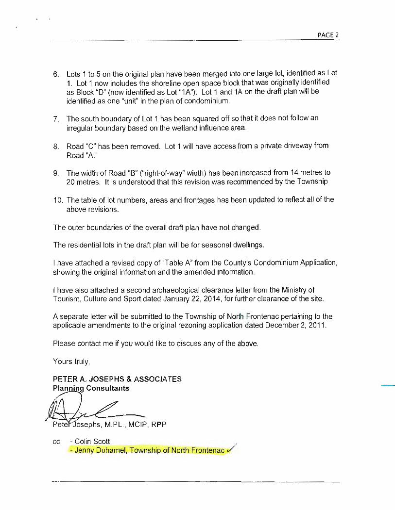
7.2 Table B below lists the features or development circumstances of interest to the Province. Complete Table B and be advise.I
of the potential information requirements in noted section.
TABLE B - S ig n ificant F eatures Checklist
{1) If a feature, Is It on site or within SOOm OR If a fea ture,
Feature or Development Circumstances (2) II a development specify clrcums1ance. does It distances in Potenllal Information Needs apply? metres
Yes(_) No(_)
Non-farm developmenl near designated Demonstrate suHiclent need within 20•)0" urban areas or rura l setuement area x projections and thal proposed devalopme111 w1il r .'
hinder efficienl expansion of urban or r·u~.
--metres setUemenl areas
Class 1 lnduslly' Assess development for resldenlial end olh·~
x metres sensitive uses within 70m --Class 2 induslly' x Assess development lor residential an<l Cl!"•:'
--metres sensitive uses within 300m
Class 3 Industry' x Assess development for resident<al and 1')(11•."
metres sensitive uses within 1 OOOrn -- --Land Fm Site Site is show n i n Offic i a l Address possible leachate, odOur. vermin illl ..
I
Plan b1t not co ri.f.i.t:lfl'eta>~ ofher impacts lrom limil of licensed-fill area !
Sewage Treatment Plant Assess the need for a feasibility study fo, I
x metres residential and other sensitive land uses -- -·-Wasle Stabilizalion pond Assess the need for a feasibility Study le,,• !
x -- metres residential and other sensilive land uses
Active railway Jone x --metres Evaluate impacts wilh1n tOOm '
ControJJed access highways or freeways Evaluale impacts within 100m ' ' including designated future ones x --metres -I Operating mine sile Will development hinder continuation or explli\:)1v 1 I
x --metres of operations? I ., Non-operating mine site within 1 OOOm Have potential impacts been address? Has lh~ I
' x -- metres mine been rehabilitated so there will be no adv("'' effects?
I
Airports where noise exposure forecast Demonstrate lcasib1llty ol development above l·! (NEF) or noise eXpOsure projection (N EP) x NEF for sensitive land uses .. Above the J is 28 or greater --metres NEFINEP, development or sensitive rand use' "
I not permitled :
Electric translormer station x --metres Determine possible impacts within 200m I
High volJage eledtic transmission line x --metres Consult the appropriate elecmc pcmer service
Transportation and Infrastructure corridors x Will the corridor be protected? ' metres ..
Prime agricultural land x Demonslrate need for use other than agnclllh.,.;,
--metres and in dicate how fmpacls are lo be mitigaled -.
Agricultural opera tions x Development to comply w1lh the Minimum 0.Sld• .,_,, ;
--metres Separa lion Formulae . Mineral aggregate resource areas x Win developmenl hinder access to the resourc'-' ' "
metres the establishment ol new resource opara lions·
Mineral aggregate operations x Will developmenl hinder continuation or ex1ract1011·,. -j metres I
.. (1) If a feature, Is it on site or within SOOmOR If a featur e,
Feature or Developmonl Circumstances (2) If a development specify circumstance, d istances in Polenlial Information Needs
I does it apply? mot res !
Yes(_) No{_) I .. 1
Mineral and pettoleum resource areas x Will development hinder access to tho resourec u1 I metres Iha establishment or new resource operat1oos?
Elds~ng pits and quarries x W iU development hinder continued operatJ011 ur I metres expansioo?
J Significant weliands south and east o f the Development is nol permitted I Canadian (Cdn.) Shield x --metres
Significant weUands In the Cdn. Shield x metres Demon strate no negative Impacts l -- J
laJI Dtirt Rel'IJtd: Dtttmbtr I. J()IJ') Pui;cJ of9
Featuro or Development Circumstances
(3) If a l eature, ls It on site or within 600m OR
(4) ii a development circumstance, does it apply?
res NO
II a feature, specify
distances In metres
Potential Information Needs
~,.....-,::--..,.--.--.,..,..-~.,---,-----11-------i-----i------I~-------------·· . ~h!/!Jl~~~!S°a\\~?~rg~rtn"Jlf~8~cies R"' F"' r t- r "'T <: R "'~ 'r-i=- metres OeveJopment is not perniilled
1----=---------'-------l:.Al~"""--l<.!.lj._......l...W-C~,l.l.j.U....._ __ --1------------~- ·
Significant fish habitat, woodlands south and east or the Canadian Shield, valley lands, areas of natural and scientific interest, wild~le habitat
Demonstrate no negative impacts
Re fe r to EIS Repcrt. __ metres
1-------------l-----~----~-----1---------------- -Sensitive groundwater recharge areas, headwaters and aquifers
Significant bu~t lleritage resources and cultural heritage landscapes
x
Refer to Archaeol ogical Assessmt~nt r epor
Demonsltate that groundwater recharge ,,,._. •·· headwateTS and aquifers will be protected
Development shouk:t conserve s19flificant l •.ii herilage resources and cultural hen!, 1 · landscapes
1---------------11-------i-----i------I~-------------- -Significant archaeological resources Refer t~ Archa eo ogical
Assessm nt repor
Assess development proposed in areas of rrh 111 •
and high potential for sign1hcant archaeotv ;1 " resources These sources are to be studieo ,, 1
preserved. or where appropriate. remoVt J. catalogued and analysed prior to development
1---------------11-----~-----i------li----------------Great Lakes • SI. Lawrence River System and Large Inland Lakes: • wilhin defined portions or dynamic beach and 1: 100 year llood level along connecling channels • on lands subjecl to flooding and erosion
Erosion hazards
Floodplains
x
x
On shoreline of ~rdoch
Lake. D ~el~ings ~i ll be well abDve lake ~evel.
Development Is not permilled
Developmenl may be permitted; demonslral" ti . " hazards can be safely addressed
Determine feasibilily within lhe 1 :100 year eru'"'" limils or ravines, river valleys and streams
Where one·zone flood p1a111 management .s .j •
effect, development is nol permitted w~th111 II · floodplain
Where two-zone nood plain management •S ·'' effecl, development is not permitted with11 1 Uu·: noodway
Where a Special Policy Area (SPA) is in cited development must conform with official pion policies lor the SPA 1
l-~-----------1-------l'--~----11---~~-1---~----------- ·· Hatardous sites4 Oemonstrale that hazards can be addressed
1-~----~~~~---1-~~-~+--~U~n~k~n~o~~~n:..:_ __ ~+-~---~~-~------, RehabiUtated mine sites
x Application lor approval from Ministry of NorU••· · Oevelopment and Mines should be 1110~··· I
COOC1KrenUy '
1-~--~-~--~~--1---~---1~-----11-----t-------~------·-
Contaminated sites Refer t p Rura l !:iervicing Study a nd Plann i hg Repor1
Assess an lnvenlory or pt'evious uses 1n area;; ,: possible soil contamination
1-~---~-------'----~--''-------''------L-----------~-~--
1. Class' Industry - small scale, sel l-conlained plant, no outside storage, low JXObabllity or lugilive emissions and daytime operations only. 2. Class 2 lnduslry - medium scale processing and manulacluring with outdoor storage, periodic oulput or emissions, shill operations and daytin•e
!ruck traffic. 3. Class 3 Industry - Indicate ii within 1 OOOm • processing and manulacturing with lrequent and inlense olf-site Impacts and a high probab1hty of
fugitive emissions. 4. Hazardous slles - property or lands that could be unsale lor developmenl or alteration due to naluralfy ocOJtring hazard. These hazards ma /
include unstable soils (sens!Uve marine clays (Leda). organic solls) or unstable bedrock (Karst topogtaphy).
l.rut Datt R.e.-iJt.d: Dtccntb<r 6, 1009 l'•g• 6 ot 9
7.3 ·For applications that include permanent housing (i.e. not seasonal) complete Table C ·Housing Affordability. For each t)'P" ... : housing and unit size, complete the rest of the row. If lots are to be sold as vacant lots, indicate the lot frontage. lnforma1tu1 •
should be based on the best information available at the time of application. ff additional space is needed. attach on a separate page.
Table C ·Housing Affordability
For example: Semi-detached - 10 units; 1000 sq. 1115.5 metres, $119,900
Housing Type #of Units Unit Size (sq. ft.) and/or Lot Frontage Estimated Selling Price/Reu l -·
Semi-Detached -·
..
link/Sem-Detached --
-
Row or Townhouse --
~-- -
Apartment Block ...
- . Other Types or Multiples (Mobile home)
- --
7.4 Is there any other information which may relate to the Affordability o f the proposed housing, or the type of housing needs served by the proposal?
U Yes 0 No If Yes, explain in Section. 9 .1 or attach on a separate page.
8. SERVICING
8.1 Indicate in a) and b) the proposed servicing type for the subject land. Select the appropriate servicing type from Table D. Attach and provide the title of the servicing information/reports as indicated in Table D.
a) Indicate the proposed sewage d isposal system Individual septic systems
b) Indicate the proposed water supply system Individual wells
c) Name of servicing information/reports Rur a 1 Servici ng Study
Table D - Sewage Disposal and Water Supply
Sewage Disposal 1) Publicly owned and operated piped sanitary sewage system
2) Privately owned and operated communal septic system
3) Individual septic system(s)
4) Other
Water Supply 1) Publicly owned and operated piped water system
2) Public or privately o.wned and o(Jerated communal well(s)
3) Individual well(s)
lasl Dnrt Rt.rbtd: December 8. 1009
.. .
Municipality should confirm that capacity will be available to service the develoµ1 n.,·1 at the time of lot creation or re-zoning
..
Communal systems HYOROGEOLOGICAL REPORT for the development of more than !: :1 l ots/units: SERVICING OPTIONS REPORT'. HYDROGEOLOGICAL REPORT'. and indica1:r,
whether a public body is willing to own and operate the system '
Communal systems for the development of 5 or less lo ts/units and generating Jes than 4500 litres per day effluent as a result of the development buin completed: HYDROGEOLOGICAL REPORT'
The development of fewer than 5 lots or units on privately owned and opewti: communal septic system and generating more than 4500 litres of effluent per d<i} ,, a result of the development being completed : SERVICING OPTIONS REPORT; a1 . HYDROGEOLOGICAL REPORT.'
Individual septic systems for the development of more than 5 lots/units: SERVICll I OPTIONS REPORT' and HYDROGEOLOGICAL REPORT'
Individual septic systems for the development of 5 or less lots/units and gener<1i:111 less than 4500 litres per day effluent: HYDROGEOLOGICAL REPORT'
The development of fewer than 5 lots or unit on a privately owned and oper:110, Individual septic system and gener~tino more than 4500 litros of emuent per day :1", result of the development being completed: SERVICING OPTIONS REPORT ; anr HYDROGEOLOGICAL REPORF
To be described by applicant ...
Municipality should confirm that capacity will be available to service developme1:1 "' the lime of lot creation or re-zoning
-Communal well systems for the development of more than 5 lots/units: SERVICIM; OPTIONS REPORT' , HYDROGEOLOGICAL REPORT' and indication whether a public tJ(,d, is willing to own and operate the system'
Communal well systems for non-residential d evelopment where wate r will he used for human consumption : HYDROGEOLOGICAL REPORT'
Individual wells for the development of more than 5 lots/units: SERVICING OPTIONS REPORT', and HYOROGEOLOGICAL REPORT'
~ ..
Pnge 7 of 9
Individual wells for non-residential development where water will be used fo; · human consumption: HYOROGEOLOGICAL REPORT'
4) Communal surface water
Approval of a •water taking permit" under section 34 of the Ontario Water Resou• ~·:• Act Is necessary for this type of servicing
5) Individual surface SERVICING OPTIONS REPORT water
6) Other (ie. lake) To be described by applicant
Notes: 1. Confirmation that the municipality concurs with the SERVICING OPTIONS REPORT will facilitate the review of the proposal. 2. Before undertaking a HYOROGEOLOGICAL REPORT, consult the Subdivision Approval Authority about the type of
HYOROGEOLOGICAL ASSESSMENT that is expected given the nature and location of the proposal. 3. Where communal services are proposed (water and/or sewage), these services must be owned by the municipality. 4. A Certificate of Approval from the local Public Health Unit or MOEE submitted with this application will facilitate the review.
8.2 Indicate in a) and b) the proposed type of storm drainage and access to the subject land. Select the appropriate type fron1 Table E. Attach and provide the servicing information as indicated in Table E.
a) Indicate the proposed storm drainage system Ditches or swa les
b) Indicate the proposed road access Private road from Ardoch Road c) Is water access proposed?
O Yes 1(,1 No
If Yes, attach a description of the parking and docking facilities to be used and the appropriate distance of these facilities from the subject land and the nearest public road 0 Attached
d) Is the preliminary stormwater management report attached? It is anti ci pated t I
0 Yes M No If nol attached as a separate report. in what report can It be found? stormwa ter /gradin g
Table E · Storm Drainage, Road Access and Water Access con di ti on of a r i:I f l .
Service Type a,Pcflrova l.
Potential Information/Re o s
Storm Drainage 1) Sewers A preliminary stormwater management report is recommended and should be prepared concurrent with any hydrogeologlcal reports for submission with lhe appllcaUon. A
2) Ditcl'les or Swales storm water management plan will be needed prior to final approval of a plan or subdivi>1u1 • or as a requirement of site plan approval.
3) Olher ·-·-
Road Access 1) Provincial highway Application for an access permit should be made prior lo submllling this application. A" access permit is required from MTO before any development can occur.
2) Municipal or other public road maintained all year
Detailed road alignment and access will be confirmed when the development applicalio1. ''' mado.
3) Municipal road maintained Subdivision or condominium development is not usually permiUed on seasonally seasonally maintained roads.
4} Righi of way/Pr/vale road Access by right of ways on p<ivate roads are not usually permiUed. except as part of condominium.
VValer Access lnformaUon from the owner of the parking anddocl<ing facilities 10 be used regarding lht capacity of the facilities lo accommodate the proposal and the approximate distance of these facilities from lhe subject land and the nearest public road . ----9. OTHER INFORMATION
9.1
9.2
Is there any other information that may be useful to the County of Frontenac in reviewing this development proposal (e.g. efforts made to resolve outstanding objections or concerns)? If so, explain below or attach a separate page.
Refer to Planning Report and other technica l reports. Does the subject land contain any areas of archaeological potential?
--··
-
D Yes ~No D Unknown Refer to Arc haeological Assessment and P lanning R.:q .. .
9.3 Does the plan permit development on land that contains known archaeological resources or areas of archaeological potential?
DYes NNo Refer to Planning Report for zoning recommenda tions. If Yes, (a) an Archaeological Assessment prepared by a person who holds a licence that is effective with respect to the subje~1
land, issued under Part VI (Conservation or Resources of Archaeological Value) of the Ontario Heritage Act; and
(b) a conservation plan for any archaeological resources identified in the assessment.
Lrut D{lf~ Rtvi.ud: December 8. 1009 Page 8 uf9

10. AFFIDAVIT OR SWORN DECLARATION
1, [v!)v. Sutt of the HL.µ\j <..~~!.it1 o( U"Jlit;ri~ the f2iiU\.\ Dl Dur~t>.vh ..
make oath and say (or solemnly declare) that the infonnation contained In this application is true and that the mforn •. u.1
contained in the documents that accompany this application is true .
1 1 . (\Ul"HORl7.A'T~ONS
1 ·1.1 If the applicant is not the owner of the land that is the subject of this application, the writlen authorization of the owner th. 11 ii••· apRlicanl is authorized lo make the application must be included with this form or the authorization set out below mu~t 1 .. · completed.
Authorization of Owner for Agent to Make th e Application
I, Arkd.. Lt,tv D.u.>W>(P°"?,.,(, 11ic.. am the owner of the land that is the subject of this application for approval 01,
plan of subdivision (or condominium description) and I authorize (., I.YI, 5e&ft to make l/ 11~ application on my behalf. ArJ&.L ~ ~UJ.¢
12<-r: -$ ,D .
11 . 2 If the applicant is not the owner of the land lhat is the subject of this application, complete the authorization of the o;.r~" concerning personal information set out below.
Authorizatio n of Owner for Agent to Provide Personal In format ion
I, A~ Gk.. ~ukp~J 'I"tl.. · am the owner of the land that Is the subject of this application for approval <•I ; . plan of subdivision (or condominium description) and for the purposes of the Freedom o f In form ation and Protect ion o l Pri vacy Act, I authorize , as my agent for this application, to provide any of 11 1~ personal information that will be included in this application or collected during the th application.
ArJo.L.. [JJ.~ t~<...
Date
12. CONSENT OF THE OWNER
12.1 Complete the consent of the owner concerning personal information set out below.
Consent of the Owner to the Use and Disclosure of Personal In formation
1./A.rM la.'4 ~J.t>f l'N:..lJ 1"1.l.- am the owner of the land that is the subject of this application for approval oi ~ plan of subdivision (or condominium description) and for the purposes or the Freedom or Information and Protection of Privacy Act, I authorize and consent to the use by or the disclosure to any person or public body of any persw .al information that is collected under the authority of the Planning Act for the purpose of processing this applicatio1 1
~l\..:lt 1~(,..
~L1D1 J Date I A-S.0.
Pag• Y uf9

AGREEMENT TO INDEMNIFY
The Owner/Applicant agrees to reimburse and indemnify the County of Frontenac (hereinafter referred to as the ·county .. 1 •1
all fees and expenses incurred by the County to process the application for plan of subdivision or condominium, as the l <1: •
may be, including any fees and expenses attributable to proceedings before the Ontario Municipal Board or any court or oa • ·! administrative tribunal if necessary to defend the County's decision to support the application.
Without limiting the foregoing, such fees and expenses shall include the fees and expenses of consultants, plan11e1·; engineers, lawyers and such other professional and technical advisors as the County, may, in its absolute discretion ac1111\· reasonably, consider necessary or advisable to more properly process and support the application.
Attached to this application is a cheque payable to the County in the amount of$ ~ ooo · i>., of the application fee.
1 representing pay1•1v1
The Owner/Applicant further agrees to provide the County, upon request, a deposit against which the County may, from ' " ' "·' to time charge against the deposit any fees and expenses incurred by the County in order to process the application. If ;u· I 1
lees and expenses exceed the deposit, the Owner/Applicant shall pay the difference forthwi th upon being billed by the Co•u : , with interest al the rate of 1.25% per month (15% per annum) on accounts overdue more than 30 days.
The Owner/Applicant further agrees that, upon request by the County from lime to time, the Owner/Applicant shall make sud' additional deposits as the County considers necessary, and until such request has been complied with, the County will llave no continuing obligation to process the application or attend or be represented at the Ontario Municipal Board or any court •K
other administrative proceeding in connection with the applicalio~. f{rJoJ.,_
Q {._, 1 ]J?l \ 1?~r : Date I uot"t P,. .S. o .
The County will assign a File Number for complete applications and this number should be used In all communications with th<l Count1 ,,1 Frontenac.
Applicant's Checklist:
Forward to:
l...11.sr Dflle Rtlilstd: Dutmbtr 8. 2009
Have you remembered lo attach:
1. 15 copies of the completed application form? (Ensure you have a copy for yourself)
2 . 15 copies of the draft plan of subdivision or condominium (consistent with Section 51(17} of the Planning Act) with key maps, folded to aw x 14" size?
3. 2 copy of the draft plan reduced to 8Y," X 11" size?
4. 1 computer disk containing a digitized copy of the proposed draft plan in imprint DXF format?
5. 5 copies of the information/reports as indicated in the application form?
6. 1 copy ot the registered transfer/deed for the subjecl lands?
7. The required fee, either as a certified cheque or money order, payable to the County of Frontenac?
COUNTY OF FRONTENAC Attention: Susan M. Beckel. Deputy Clerk 2069 Battersea Road R.R.#1 Glenburnie, Ontario KOH 1SO
Yes
tJ
u
c
[J
I]
[J
Pnge JO cf 9

LEGAL DESCRIPTION
Part of PIN 36188-0451 being PT LT 22-23 CON 1 CLARENDON; PT LT 22-23 CON 2 CLARENDON; PT LT 21-22 CON NORTHEAST RANGE CLARENDON; PT ROAL BTN CON NORTHEAST RANGE AND CON SOUTHWEST RANGE CLARENDON CLOSED BY FA367996; PT LT 21 CON SOUTHWEST RANGE CLARENDON PTS 1 - 13, 13A18450 SIT FR754055; NORTH FRONTENANC

FOR OFFICE USE ONLY:
Date Application Received: ----------
Date Application Deemed Complete:
File Number:----- -----
Application Fee:-- ------- Receipt :
Print in black or blue ink, complete or (0 ) appropriate box(es)
1. APPLICATION INFORMATION
1.1 Name of Owner(s). An owner's authorization is required in Section 11.1, if the applicant is not the owner. NameofOwner(s) Home Telephone No. Business Telephone No
Address Postal Code Fax No.
emait
1.2 AgentJApplicant - Name of the person who is to be contacted about the application, if different than the owner.
(This may be a person or firm acting on behalf of the owner.)
Name of Conlacl Person
Address
1.3 Planner /Planning Consultant
Name of Planner
Address
1.4 Ontario Land Surveyor
Name of Surveyor
Address
Home Telephone No.
Postal Code
Poslal Code
Poslal Code
Business Telephone No
Fax No.
Business Telephone No.
Fax No.
Business Telephone No.
Fax No.
2. DESCRIPTION OF THE SUBJECT L AND • COMPLETE APPLICABLE BOXES IN SECTION 2. 1
2.1 Local Municipalily I Township Geographic VillagefTown Concession No. Lot(s)
Registered Plan No. Lo~s) Block(s)
Name of StreeVRoad Street No. Reference Plan No. Pa~s)
2.2 Are there any easements or restrictive covenants affecting the subject land? D No D Yes If yes, describe each easement or covenant and its effect.
3. PROPOSED ANO CURRENT LANO U SE
3.1 Complete Table A on Proposed land Use Table A - Pro posed Land Use
REVISED TABLE "A" FOR JUNE 12, 2014 AMENDED
n.nr Tf"J\.rflTl'U.f
Number of Units Number of Lots and/or Area (ha) of C>ensity (Units/Dwellings Number of Proposed Land Use or Dwellings on Blocks on Draft Plan L and shown per ha.) on Draft Plan Parking Spa~e"
on Dra ft Draft Plan (i.e. 11/13) (i.e.11/20.3ha) (i.e. 11) Plan
(i.e.20.3ha) ·-
Residential Detached 11 -
Semi-Detached 1·
Multiple Atlached ..
Apartment
Seasonal 34 34 49.12 2/unit . .
Mobile Home . -
Uu1 Date Rr'l'irtt/: D~ce111bu8. JOfJ9 Pagel of9

' . Number of Units Number of Lois and/or Area (ha) of Density (Units/ Dwellings Number o per ha.) on Draft Plan Parking Spa Proposed Land Use or Dwellings on Blocks on Draft Plan Land shown
Oran Plan (i.e. 11/13) on Drart (l.e.11/20.3ha) (I.e. 11) Plan
(i.e.20.3ha)
C< s
Other (speci fy the use)
Commercial
Industrial
Park 0< Open Space NIA
" "HI F.7 NIA NIA - ·
Institutional (specify) -
Roads NIA 2 s 17 NIA NIA
Other (specify the use) --·
Totals 34 41 93.16
3.2
(1) Complete only 1f for approval of condominium descri;>I· ' 1
Whal is the current use of the subject lend? (I.e. vacant, resident ial , commercial & agriculture)
3.3 How is the subject land currently designated in any applicable official plan? (I.e. rural, agricultural)
3.4 Has there been an industrial or commercial use, or an orchard on the subject land or adjacent land? Mining? (i.e. fuel storage. repair garage)
D No D Yes If Yes, specify the uses.
3.5 Has the grading of the subject land been changed by adding earth or other material?
3.6 Has a gas station been located on the subject land or adjacent land at any time? Has there been petroleum or other fuel stored on the subject land or adjacent land?
3. 7 Is thare reason lo believe the subject land may have been contaminated by former uses on lhe site or adjacent sites?
Yes 0
es D 0
Yes
:::J
No Unk1 1u:.11
0
No Unknr1\";! 1
D 0
No Unknm·_.,-,
0 f !
3.8 Whal information did you use to determine the answers to the above questions? (i.e. land owners, mun icipal officials and/01 technical studies)
3.9 If Yes, to (3.4), (3.5), (3.6) or (3.7), a previous use inventory showing all former uses of the subject and or, if appropriate, of the adjacent land, is needed. Is the previous use inventory attached?
la.st Datt. Rt.viJt.d: Dtet1t1btr 8. 1009
Yes
0 No 0
/'age J ofY
PROPOSED LAND USE ,.,.....
~~" ~ ..._ ,., T ...
=· ·= '·"" '"'" ~tt ~~:· ~ .. ~~ =· ..,, """ •1.•s ::~ =· - l:Z.11 ..,, ~ ~ ... ~ t .'17 =· H.l l .....
~i l~~~ ~= ::~ I.Mt :: ~~ ::~ =" ~n~ :l': :~ ::= =~•,'::'a ~-· ~!= :IB ~, ::::
UIT ll
~~fi ~n~ ~~~ ~,,.
"* !:fill? ~Tl· LDn:
~n: :!:: :!. :·= l.M'7 ::: :n ::~~ =" ~~! ~ :;: :::n
lt.D.W.'1 Cf(WSf'C
"""' ..,.,.., M>-Tllllll ,.,., .,, ~~
"'' ...... .,
PROPOSED LAND USE '1v!W1•<"'> ... . '!'• - ·-.... ~ ... ...,
)·-..... ..... ..,. "'" ~ ... .. ., = ~~ ~~ ru: ~.~ 1.ltJ , ..,
)-.... ..... 1:: ......... 15UO
l;ffi - i:l1J '°'·'· - ~ l~:i --f=~~~ ~ ....
t f.2.Jt ~a.,.. .. !lila D} 11.ll.S l:r1n1~itr;t-) (a..c11 r1 t':P.IH I
·~~ .l4 UMll MID ~llll~llll!:l.D.E4'm
"""""""' ~"=l:•'=n~=.,~~~~~~
Afli!l:jMAf!K tJ fl F\' 21' 500m -.- ..-n"'31TIW'flllL
AfN()iNAflX I? n EV 214.QQm W.L~...._tl lillllflWMIL
BQlGiMAPK Q OfY 25;),Sl!Jm M'LNa-NllllfT IW -llllE.
MJPJM&P!C a+ f!F\I 7ss4nm --~m•n•-~
~M&RK '! ..... 2~2MfR"m
Ardoch Lake WATER LEVEL 253.92m
OCTOBER 25, Z006
r-"'•• Hr_., ... .. -... -· .. ....... ~ .. ,_ .... ~;~~~
"!·-·-· ~.=.,..-:?:..=.;~~ =-~~ .. Ml: U.llO'lt ,,~f{!_,., _ .. . ... .... , .
- -~ ....
OWIJf!§ ALJ"WOE17,IJJOO
=~'":& .• 111~= .. ~:c..;::-~= -~IU<M "W llll~"""...-IWl•~~-
~--;;_~!!'!..1.~_4
l
., 8L~ 'E'•
... ... +
.,L -0 ... r ., 2 2
:i'-~~~r1:.;h9{17)
!~~: =::::~: 12 ~~~~':.".:-•na (•) AllJN.1,,i; 0-.~~"-ldribl, ~....s_,eo11 UM,
(l) N~ H ""'" ht A1~lM11111plM (II}..,.. .. 7 II ~. IMhtLd Woll•
r! ::~: .. !11 ..... ....... ... '"" h) lhelc.P:il """""- M:il'*ll• - lbw ~~' ,.,.. '""-""' .. ,_
DRAFT PL AN OF VACANT LAND CONDOMINIUM
PART of LOT 22 &: 2.3, CONCESSION 1 and PART of LOT 22 ti: 2J, CONCESSION 2
FORliiEll CE~APHIC ~ ~ ct.AArnDCN CUR:R:ENll Y TO'UISHF OF ~CAlH FRCfflDh\C
COUPITY CF Fll:ctnrn...c IUU: 1 ~1!(1» . ~
! @!WRS Al Uri INl\O!Ml$ )

Planning Report To: Mayor and Members of Council
From:Joe Gallivan Manager of Sustainability Planning
Peter Young Community Planner County of Frontenac
Re: Applications for Plan of Vacant Land Condominium and Zoning By-law Amendment - Ardoch Lake File No. I OCD-2012/00 I and Z-12
Recommendation: Receive Public Comments
Date Prepared: Date of Public Meeting:
Proposal
August 18, 2014 August 21 , 2014
Planning applications have been submitted proposing a 34 lot (unit) vacant land condominium on Ardoch Lake. The County of Frontenac is the approval authority for the vacant land condominium and the Township of North Frontenac is the approval authority for the zoning amendment. This application is a revision of the original plan that was submitted in 20 I I that included 45 lots.
Background The subject land is located on the south side of Ardoch Lake, southeast of the hamlet of Ardoch, with access via Ardoch Road. The lands are legally described as Part of Lot 22 and 23, Concessions I and 2, geographic Township of Clarendon, Township of North Frontenac. The surrounding area generally is rural and wooded, with cottages and camps located on the north side of the lake. The subject property is approximately 93 hectares (230 acres). The property can be described as somewhat hilly, with rock outcrops, some meadows, extensive tree cover, and a large swamp located at the eastern end of the lands. The property also has shoreline frontage on Ardoch Lake of 1,884 metres ( 1.2 miles).
Map I provides aerial imagery of the location of the property with an overlay of the proposed lots and blocks of land to be created.
The applicant has applied for a vacant land condominium and associated implementing rezoning. An application was first submitted and deemed complete on January 4, 2012 for 45 units,

however after detailed review by commenting agencies, a revised application was submitted proposing 34 units.
A plan of vacant land condominium is very similar to a plan of subdivision, except that the roads and most other facilities are privately owned, rather than being owned and operated by the Township. Unlike most private road development by consent, there is a strong legal mechanism to repair commonly owned property such as these roads or private parkland, including mandatory condominium dues and a mandatory reserve fund .
The applicant has submitted a number of studies and plans in support of the development. Studies, study addendums, and agency correspondence have been posted online by Frontenac County planning staff at the following link:
http://goo.gl/OX9 I f3
The studies and plans include:
• A draft plan of vacant land showing the layout of the proposed development and what parts of the development will be shared ("common elements")
• Planning report • Stormwater management brief • Phosphorous budget assessment • Rural servicing study • Servicing options statement • Archaeological assessment • Environmental impact study
Agencies involved in the review include: Mississippi Valley Conservation Authority; Ministry of Environment; Ministry of Culture; Malroz Engineering (hydrogeological peer review for Frontenac County); and KFL&A Public Health.
Provincial Policy Statement (2014) The 2014 Provincial Policy Statement (PPS) provides direction on matters of Provincial interest related to land use planning and development. It promotes efficient land use and development patterns that support strong, liveable and healthy communities, protect the environment and public health and safety, and facilitate economic growth. Although the application was submitted prior to the 2014 PPS, decisions of Council must be consistent with the PPS in place at the time of the decision.
Some of the key areas under review for PPS consistency include:
• Section 1.1.5 - Rural Lands: The 2014 PPS further clarified land use policies in rural areas, and specified that permitted uses include resource-based recreational uses (including recreational dwellings).
• Section 2.1 - Natural Heritage: The PPS states that, "natural features and areas shall be protected for the long term" (2.1.1 ), and further that any new development needs to recognize, " ... linkages between and among natural heritage features and areas, surface water features, and ground water features" (2.1.2).

• Section 2.2 - Water: this section of the PPS requires planning authorities to protect, improve, and/or restore that quality and quantity of water and includes a list of measures to be considered - many of which are contained in the policies of the Towns hip Official Plan.
Further review of the proposal will determine whether it is consistent with the Provincial Policy Statement.
Official Plan The lands affected are designated as Lake Development Area (along the shoreline and approximately 120 metres in depth from the lake) and Rural in the Official Plan. Portions are also affected by Mineral Aggregate Resources and Waste Disposal Facility influence areas (see further comments in the Zoning Section). The 'Lake Development Area' section of the Official Plan recognizes the importance of protecting the water quality and waterfront character of a lake or river and contains a list of shoreline management policies for new waterfront development.
The total lake capacity of Ardoch Lake for development has been raised as an issue. Section 3. 16.2 0. of the Official Plan states that "Consents may not be granted for the creation of a new lot on a water body where the lake has reached its development capacity and no residual capacity exists for that water body." The Mississippi Valley Conservation Authority and the Ministry of the Environment both raised the possibility of the Township/County allocating development capacity among other lake owners.
The develo.per has proposed to install above-average septic systems designed to remove most phosphorous content.
Zoning The property is zoned as Waterfront Residential (RW), Rural and Limited Service Rural (LSR), and Mineral Extraction Zone (small portion of entrance) in the Township's zoning by-law. Some portions of the lands are affected by Waste Management Facility and Mineral Extraction influence zones. The applicant has provided information that the Waste Management Facility map facility is likely in a different area over one kilometre to the west. The Mineral Extraction zone also does not affect the development as it is located near Ardoch Road over one kilometre from the proposed residential lots.
The proposed zoning by-law amendment would rezone waterfront lots and lots close to the water from LSR to RW, and rezone lands within the wetland and buffers from LSR to Environmental Protection (EP).
Typically if a vacant land condominium or subdivision application is granted draft approval, the final passing of the zoning by-law will not take place until the layout is finalized after detailed engineering studies, and the passing of the zoning by-law would be a condition of draft approval.
Comments A number of agency comments have been received. A summary of the agency comments can be found below.
Agency Comments Summary Status Malroz Issues raised included well yields, high variability in well No remaining issues Engineering quantity across the property, and not enough da:ta to
(County justify conclusions, After further testing and information Hydrogeological provided by the applicant's consultant, Malroz had no Peer Reviewer) remaining objections and recommended the following
condition of approval:
• As part of the condominium development agreement, owners be notified of the potential for low yielding wells and the requirement that a hydrogeologist approve the potable water supply well at each lot prior to issuance of a building permit
KFL&A Public Support development with conditions including: No remaining issues Health • Septic systems to be located in areas shown on
servicing plan
• Sewage systems at least 30 metres from high water mark
• Sewage systems partially or fully raised with imported soils
• Some sewage systems may require effluent pumps with high water level alarms
• Site specific changes on Lots 7 and Lot 21 to be resolved before final approval
• Wells should be located up gradient of sewage systems
• Well drillers must be aware of site servicing plans and locations for sewage systems
Ministry of One archaeological site was discovered during the No remaining issues Tourism, assessment but it is considered sufficiently documented Culture, and warranting no further concerns, No further Sport archeological assessment is required. Mississippi Valley MVC provided a number of issues with the plan MVC issues remain Conservation including water quality, fisheries, boating, the impact of outstanding. Major Authority (MVC) phosphorous and whether development capacity should issues in their
be allocated to one landowner, slope stability on lots 2- response to the July 6, and the need to evaluate whether the wetland is 20 14 revised plan provincially significant. include phosphorous
budget, slope stability and the evaluation of the wetland
Ministry of the MOE reviewed the phosphorous budget assessment Generally it appears Environment submitted with the application and provided a number of that the phosphorous (MOE) comments related to the methodology of the study. The budget meets MOE
applicant later reduced the number of lots and standards, although submitted a revised study for review. The MOE there has been reviewed the documents and recommended that: discussion on capacity
allocation and I. The development plans be revised to show the calculating the
proposed lot changes phosphorous budget 2. The zoning by-law for the backlots specified that using permanent
septic systems must be placed 300 metres back residential standards. from the lake
3. The shoreline lots should have a 30 metres setback for structures and sewage systems and the lands should be protected during and after construction

4. The revised development density of 35 lots will use up the residual development capacity remaining on Ardoch Lake. The County and Township need to consider whether they want to allocate the remaining capacity solely to this development proposal.
School Boards, No comment/objection or no response No remaining issues. Hydro One, Algonquins of Ontario, Bell Canada, Canada Post
Public comments to date have also raised a number of issues including:
• The impact of the development on the heron colony, and whether appropriate setbacks have been included on the plan
• The lack of a formal evaluation of the wetland • The impact of the development and boating on fish habitat and other wildlife • The need for the lake capacity model to classify potential development as full time
residential rather than seasonal • The potential impact of additional phosphorous levels on lake quality and whether there
would be an impact on Malcolm Lake (just to the west of Ardoch Lake, both lakes are corrected)
• The issue of allocating remaining development capacity to a single landowner and reducing severance and/or building potential for landowners
• The social impact of the proposal in terms of a high population on a small lake • The density of the lot fabric in terms of frontages
The applicant will have an opportunity to address these comments and comments from the public meeting, and they will be further reviewed by the Township/County planning staff as part of a comprehensive staff report.
Pre-consultation The applicant pre-consulted with Township and County staff, and with Township Council prior to submitting the applications.
Conclusion As of the writing of this report, further review of agency and public comments is necessary before a comprehensive planning report is prepared.
It is recommended that Township Council: I. Receive public comments at the public meeting 2. Direct staff to prepare a comprehensive report on the plan of vacant land
condominium application and zoning by-law amendment application

Sincerely,
_ft5pare by: V'f'eter Young, MCIP, RPP
Community Planner County of Frontenac
epared by: Joe Gallivan, MCIP, RPP Manager of Sustainability Planning County of Frontenac

Data Source: OGDE, MPAC & The County of Frontenac. Created: Aug 18th, 2014 Reference: Produced by the County of Frontenac with data supplied under license by members of the Ontario Geospatial Data Exchange. The County of Frontenac disclaims all responsibility for errors, omissions or inaccuracies in this publication.
MAP 1: PROPOSED ARDOCH LAKE VACANT LAND CONDOMINIUM
34
1
Block E
Block D
33 Block C32
30
31
29
2
28
45
8
26
7
3
6
18
9
15
2416
14
12
2221
11
Road A
2717
2523
19
13
20
1A
Block B10
Road BBlock A
A r d o c h L a k e
Schonauer Rd
±
0 200 400100Metres
A r d o c hL a k e
OVERVIEW MAP

PETER A. JOSEPHS & ASSOCIATES PLANNING CONSULTANTS
July 23, 2014
Mr. Peter Young, MCIP, RPP Community Planner County of Frontenac 2069 Battersea Road Glenburnie, Ontario KOH 1SO
Re: Ardoch Lake Developments Inc. Application for Draft Plan of Vacant Land Condominium (Amended) (County File No. 1 OCD-20121001) Application for Zoning By-law Amendment (Amended) Part of Lots 22 and 23, Concession 1 Part of Lots 22 and 23, Concession 2 Township of North Frontenac, County of Frontenac
Dear Mr. Young:
A revised application for the draft plan of vacant land condominium was submitted to the County of Frontenac in June 2014. My covering letter dated June 12, 2014 provided a detailed list of revisions to the draft plan.
Revisions were made to the plan based on previous communications with the County and the Township, and to implement recommendations from the project hydrogeologist to address peer review comments pertaining to servicing of the residential lots. A conceptual lot servicing plan was prepared by Genivar in response to peer review comments, and the revised draft plan of condominium (June 2014) was based on that layout.
The following is a summary of other key issues which have been identified in the review to date:
Lake Capacity Assessment
Genivar prepared a Lake Capacity Assessment - Phosphorous Reduction report dated April 1, 2013 (previously provided to the County), which contained an analysis of the effect of using phosphorous reduction technologies as part of the sewage treatment and disposal systems for each residential lot. This report concluded that should the phosphorous reduction technologies be implemented at the proposed development, and properly maintained through service agreements with the manufacturer, the proposed development would have an acceptable effect on Ardoch Lake.
4 DALEVIEW AVENUE, PETERBOROUGH, ONTARIO K9J l LS TEL: (705) 748-2109 FAX: (705) 748-2519 E- MAIL: [email protected]

PAGE 2
It is my understanding that the Lake Capacity Assessment is based on seasonal use of the dwellings in the plan of condominium. This form of residential dwelling was identified in the revised subdivision/condominium application which was part of the June 12, 2014 submission. Mr. Colin Scott has advised me that the proposal is for seasonal dwellings.
Environmental Impact Study and Compliance with Section 2.1 of 2014 Provincial Policy Statement (Natural Heritage)
The County requested an update on the status of the Environmental Impact Study (EIS).
Niblett Environmental Associates Inc. has provided a letter dated July 14, 2014 (attached), which summarizes the status of communication with the Mississippi Valley Conservation Authority. Mr. Ellingwood of Niblett refers to two letters to the MVCA. The most recent letter, dated March 18, 2013, is attached for reference purposes.
Mr. Ellingwood reviewed the revised draft plan of condominium prior to its submission to the County in June 2014. In his letter dated July 14, 2014, Mr. Ellingwood confirms that the revisions to the draft plan of condominium have not changed the recommendations, impact assessment, or conclusions in the EIS and subsequent response letters.
Mr. Ellingwood has also provided a professional opinion in his letter dated July 14, 2014 that the EIS conclusions and recommendations are in compliance with the new 2014 Provincial Policy Statement.
Planning Review- 2014 Provincial Policy Statement
The Planning Report by Peter A. Josephs & Associates dated October 2011 for the original planning applications to the County and Township included a detailed review of the applicable provisions of the 2005 Provincial Policy Statement (PPS). The 2011 planning report concluded that the proposed residential development was consistent with the provisions of the 2005 PPS.
The new 2014 PPS was issued by the Province under Section 3 of the Planning Act and came into effect on April 30, 2014. Section 4.1 of the new PPS, under the provisions for "Implementation and Interpretation," indicates that this Provincial Policy Statement applies to all decisions in respect of the exercise of any authority that affects a planning matter made on or after April 30, 2014. Such decisions "shall be consistent with" the 2014 PPS.
Based on the interpretation of the 2014 PPS, it is understood that, notwithstanding that the original applications for the draft plan of vacant land condominium and the zoning by-

PAGE 3
law amendment were made in 2011, the provisions of the 2014 PPS must be considered since the approval authorities have not yet made decisions with respect to these applications.
Based on my review of the 2014 PPS, it is my opinion as a professional planner that the proposed draft plan of vacant land condominium (as revised) is consistent with the 2014 PPS. The following is a summary of the applicable provisions of the 2014 PPS.
Please note that the opinion with respect to the draft plan of vacant land condominium will also apply to the related zoning by-law amendment, which will be amended accordingly to reflect the revised draft plan of condominium application.
Section 1.1 of the PPS - Managing and Directing Land Use to Achieve Efficient and Resilient Development and Land Use Patters:
• The revised provisions of the 2014 PPS do not change the general analysis of the 2011 Planning Report. A new Section 1.1.4 is included in the 2014 PPS, pertaining to Rural Areas in Municipalities. Section 1.1 .4 provides that growth and development may be directed to rural lands in accordance with Section 1.1.5.
• Section 1.1.5 indicates that on rural lands located in municipalities, permitted uses are:
(a) the management or use of resources; (b) resource based recreational uses (including recreational dwellings); (c) limited residential development; (d) home occupations and home industries; (e) cemeteries; and (f) other rural land uses.
It is noted that the 2014 PPS does not define the term "recreational dwelling." However, it is interpreted that the proposed residential development is by design located in close proximity to a resource (the lake), and is functionally linked to the shoreline resource. The technical studies for this development recognize the environmental capacity of the lake. The proposed residential development is deemed to be permitted as a "resource based recreational use."
The term "limited residential development" is also not defined in the PPS, but it is noted in the 2011 planning report that in the 2003 Township Official Plan, the site is designated as "Lake Development Area" and "Rural Areas." As such, the proposed residential development was deemed to conform to the permitted residential uses of the Official Plan at this location. An amendment to the Official Plan is not required.

PAGE4
Section 1.6 of the PPS - Infrastructure and Public Service Utilities
• The revised provisions of the 2014 PPS do not change the general analysis as outlined in the 2011 Planning Report. Under Section 1.6.6, "Sewage, Water and Stormwater," Section 1.6.6.4 indicates that individual on-site sewage services and individual on-site water services may be used provided that the site conditions are suitable for the long term provision of such services with no negative impacts. As noted earlier in this report, revisions have been made to the original draft plan of condominium to facilitate acceptable servicing of the lots with private water and sewage systems.
• Kingston, Frontenac and Lennox & Addington Public Health provided a letter to the County dated December 4, 2013, advising that KFL & A Public Health is prepared to approve the development subject to certain site development conditions.
Section 2.1 of the PPS - Natural Heritage:
• As noted above, the letter from Niblett Environmental Associates Inc. dated July 14, 2014, confirms that the revised plan is consistent with Section 2.1 of the PPS.
Section 2.2 of the PPS - Water:
• The Lake Capacity Assessment by Genivar addresses environmental lake capacity.
Section 2.3 of the PPS - Agriculture:
• The revised provisions of the 2014 PPS do not change the general analysis as outlined in the 2011 Planning Report.
Section 2.5 of the PPS - Mineral Aggregate Resources:
• The revised provisions of the 2014 PPS do not change the general analysis as outlined in the 2011 Planning Report.
Section 2.6 of the PPS - Cultural Heritage and Archaeology:
• The supporting information that was submitted with the June 12, 2014 revised draft plan of condominium included a second archaeological clearance letter from the Ministry of Tourism, Culture and Sport, dated January 22, 2014.

PAGE 5
Section 3.1 of the PPS - Natural Hazards:
• The revised provisions of the 2014 PPS do not change the general analysis as outlined in the 2011 Planning Report. It is noted that the access road that leads to the development site from Ardoch Road should be constructed to a standard that is acceptable to the Municipality and which ensures safe access.
Section 3.2 of the PPS - Human-Made Hazards:
• The revised provisions of the 2014 PPS do not change the general analysis as outlined in the 2011 Planning Report.
As noted above, it is my opinion that the proposed draft plan of vacant land condominium (as revised) is consistent with the 2014 PPS.
Please contact me if you would like to discuss any of the above.
Yours truly,
&ephs, M.PL., MCIP, RPP
cc: - Colin Scott - Jenny Duhamel, Township of North Frontenac
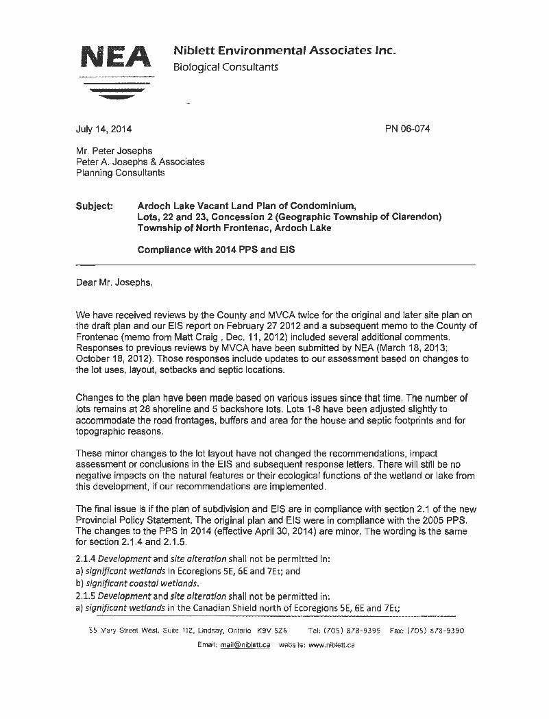
NEA Niblett Environmental Associates Inc. Biological Consultants
July 14, 2014
Mr. Peter Josephs Peter A. Josephs & Associates Planning Consultants
Subject: Ardoch Lake Vacant Land Plan of Condominium,
PN 06-074
Lots, 22 and 23, Concession 2 (Geographic Township of Clarendon) Township of North Frontenac, Ardoch Lake
Compliance with 2014 PPS and EIS
Dear Mr. Josephs,
We have received reviews by the County and MVCA twice for the original and later site plan on the draft plan and our EIS report on February 27 2012 and a subsequent memo to the County of Frontenac (memo from Matt Craig , Dec. 11, 2012) included several additional comments. Responses to previous reviews by MVCA have been submitted by NEA (March 18, 2013; October 18, 2012). Those responses include updates to our assessment based on changes to the lot uses, layout, setbacks and septic locations.
Changes to the plan have been made based on various issues since that time. The number of lots remains at 28 shoreline and 5 backshore lots. Lots 1-8 have been adjusted slightly to accommodate the road frontages, buffers and area for the house and septic footprints and for topographic reasons.
These minor changes to the lot layout have not changed the recommendations, impact assessment or conclusions in the EIS and subsequent response letters. There will still be no negative impacts on the natural features or their ecological functions of the wetland or lake from this development, if our recommendations are implemented.
The final issue is if the plan of subdivision and EIS are in compliance with section 2.1 of the new Provincial Policy Statement. The original plan and EIS were in compliance with the 2005 PPS. The changes to the PPS in 2014 (effective April 30, 2014) are minor. The wording is the same for section 2.1.4 and 2.1.5.
2.1.4 Development and site alteration shall not be permitted in: a) significant wetlands in Ecoregions SE, GE and 7E1; and b) significant coastal wetlands. 2.1.S Development and site alteration shall not be permitted in: a) significant wetlands in the Canadian Shield north of Ecoregions SE, GE and 7Ei;
55 Mary Street West. Suite 112, Lindsay, Ontario K9V SZ& Tel: (705) 878-9399 Fax: (705) 878-9390
Email: [email protected] website: www.nlblett.ca

Ardoch Lake plan of condominium Comments regarding new plan
b) significant woodlands in Ecoregions 6E and 7E (excluding islands in Lake Huron and the St. Marys River)1; c) significant valley/ands in Ecoregions 6E and 7E (excluding islands in Lake Huron and the St. Marys River)l; d) significant wildlife habitat; e) significant areas of natural and scientific interest; and f) coastal wetlands in Ecoregions SE, 6E and 7E1 that are not subject to policy 2.1.4(b) unless it has been demonstrated that there will be no negative impacts on the natural features or their ecological functions.
The main change in section 2.1 was to take the habitat of threatened or endangered species and change the requirement to the province. The section reads:
2.1. 7 Development and site alteration shall not be permitted in habitat of endangered species and threatened species, except in accordance with provincial and federal requirements.
The final section ofthe new PPS dealing with EIS requirements has not changed since 2005. It reads:
2.1.8 Development and site alteration shall not be permitted on adjacent lands to the natural heritage features and areas identified in policies 2.1.4, 2.1.5, and 2.1.6 unless the ecological function of the adjacent lands has been evaluated and it has been demonstrated that there will be no negative impacts on the natural features or on their ecological functions.
Based on our review of the latest site plan, the EIS conclusions and recommendations are in compliance with the new 2014 Provincial Policy Statement.
If more information on the above responses is required, please contact me.
Sincerely,
,,.. .
/·.-' ~
Chris Ellingwood,
President and Sr. Terrestrial and wetland biologist
Niblett Environmental Associates Inc. 2

NEA Niblett Environmental Associates Inc. Biological Consultants
MAH 9 1013 March 18, 2013 PN 06-074
Mississippi Valley Conservation 4175 Highway 511 RR#2 Lanark, ON KOG 1KO
Attention: Matt Craig, Manager of Planning and Regulatory Services
Subject: Ardoch Lake Vacant Land Plan of Condominium, Lots, 22 and 23, Concession 2 (Geographic Township of Clarendon) Township of North Frontenac, Ardoch Lake
Response to 2nc1 round of comments on EIS
Dear Mr. Craig,
We received your comments on the draft plan and our EIS report on February 27 2012 and have responded. A subsequent memo to the County of Frontenac (memo from Matt Craig, Dec. 11, 2012) included several additional comments.
This response has been prepared to address those additional comments.
1. The impact on fisheries and boating capacity is very difficult to determine as there is no existing data on the level of fishing or boat use of this lake. The site plan does not include communal docks/launches as part of the development but individual lot owners can install a dock within the zoning permitted. Lake capacity based on phosphorus is a separate issue from the recreational uses. Even though the number of lots on the lake does result in additional potential users that may fish or do recreational boating.
2. Lot development- It was recommended in the EIS that access from the building envelope to the shoreline be limited. Options for views of the lake and paths were made in the EIS. Clearing of understory and groundcover should be limited to the width of a trail or path to the shoreline.
3. No boat ramps, boathouses or launches are proposed for individual lots. The installation of a dock on individual lots is acceptable provided it meets the Township zoning.
4. Wetlands-The MNR has been contacted by NEA regarding the heron colony and the wetland. They have not been forwarded a copy of the EIS. The Township typically is the agency that would request MNR to review a file and pass on the report to them for comment.
55 Mary Street West, Suite 112, Lindsay, Ontario K9V 5Z6 Tel: (705) 878-9399 Fax: (705) 878-9390
Email: [email protected] website: www.niblett.ca

Ardoch Lake plan of condominium Response to MVCA comments
If more information on the above responses is required, please contact me.
Sincerely,
Chris Ellingwood
President and Sr. Terrestrial and wetland biologist
Niblett Environmental Associates Inc. 2
Ardoch Lake plan of condominium Response to MVCA comments
Attachment 1
Minutes of meeting with Matt Craig (MVCA) on July 17, 2012.
I met with Matt Craig and Diane on site last week(Tuesday 17th July).
There were several issues and areas of concern from their review letter, they wanted to see in person.
1. Great-blue heron colony- questions regarding 300 m MNR construction buffer and if that was applicable in this case
a. Sensitivity of colony to disturbance and what kinds of disturbance, timing, noise level, access to wetland by residents and disturbance from closest houses
2. Upgrades to culvert crossing on outlet from heron wetland to lake- ensure crossing doesn't impact on water levels in wetland
3. Lots 1-5 a. Steepness of slope (greater than 3:1 ?) or stability issues (is geotech needed) b. Location of house and septic on slope
c. Tree clearing required for view of lake and construction access d. Road to these lots-erosion and grade
e. Access to shore, docks or viewing areas 4. Lots 6-10
a. Are contours reflecting actual ground conditions b. Lots 8 and 9 have 10 m cliff on site. Are septic and house above that cliff? No shown on
contours. c. Can septic be on road side of house to increase distance between septic and lake d. View corridors and tree limbing on each lot. e. No cutting of shoreline trees. f. Are residents allowed under condo to trim or remove trees or construct gazebos or
docks on shore 5. Lots 11-29
a. Can septic be behind house (road side) to increase distance between septic and lake. b. Would reduce clearing of forest on lake side of each lot.
6. Park Block b Uses proposed on lot- residents access, boat dock design, boat ramp at this point only,
7. Park block A- uses proposed 8. Other comments-
a. introduction of invasive aquatic organisms to lake (mitigation measures) or boat wash rules
b. Increased pressure on fisheries from increased angling on lake-can we do some literature review of current use and projected use and impact on lakes fishery Including ice fishing
Niblett Environmental Associates Inc. 3

Ardoch Lake plan of condominium Response to MVCA comments
c. Are all back lots being removed d. Treat wetland as PSW even if not evaluated and provide mitigation measures. e. No boat ramps or private ramps/launches on individual lots f. Control on these issues by condo board g. No three zone buffer, just 30 m natural setback from lake h. No boathouses permitted i. There is 25% limit on shoreline veg removal as per Township bylaw
Niblett Environmental Associates Inc. 4

From: Ron Higgins [mailto:[email protected]] Sent: August‐15‐14 7:02 AM To: Jenny Duhamel Subject: RE: Notice of Application and Public Meeting‐ Ardoch Lake Developments Jenny here is our brief overview for the Public Meeting. ALCD Public Meeting August 22, 2014 NFLAA Delegation The North Frontenac Lake Associations Alliance (NFLAA) delegation will be speaking at the Ardoch Lake Developments Inc. for a Plan of Condominium Public meeting and will cover the following
1. Our alliance membership, mission and mandate.
2. Our position on developments in general including the setting of precedents.
3. Our position and concerns related to the proposed Condominium.
a. We support government agencies official reports related to water quality, fish and
wildlife.
b. Our major concern is lake capacity in relation to what Ardoch Lake can sustain and how
that impacts all landowners of Ardoch Lake.
c. Other concerns related to the Application for a Plan of Condominium.
Thanks Jenny for allowing us this opportunity to be heard.
Chair, NFLAA North Frontenac Lake Associations Alliance
1
ARDOCH LAKE DEVELOPMENT CONCERNS (July 29, 2014)
We, the signatories of this document, are Ardoch Lake landowners and as such have a very keen interest in the overall health and environment of Ardoch Lake now and in the future. We have several concerns and questions to bring forward before the August 5, 2014 deadline. The Environmental Impact Study(EIS) report prepared by Niblett Environmental Associates(NEA) discusses the buffer zone for Great Blue Heron Colony. Under section 6.0 of the Provincial Policy Statement(PPS) the colony would be defined as a "Natural Heritage Feature" that would require "Significant Protection." This protection is explained in the “Management Guidelines For The Protection Of Heronries In Ontario” (Management Guidelines) handbook by the Ministry of Natural Resources (Bowman and Siderius, April 1984). The “Management Guidelines For The Protection Of Heronries In Ontario” is itself referenced in the EIS also on page 39. Concerning the buffer zones Management Guidelines the EIS states:
“The MNR management guidelines describe a two zone buffer, a 1 km heavy development buffer zone and a 300 m minimum buffer zone. Entry or activity within the 300 m buffer should be prohibited during the sensitive breeding season. The heavy development buffer zone states that activities having a high disturbance factor, such as road construction, logging, forest site-preparation, pipeline construction, blasting and dredging should be prohibited during the nesting season. “
These statements may be factual but are certainly very incomplete as only those paragraphs or sentences favouring the developer have been included. The EIS states that this applies until June 30th but the Management Guidelines specifically state in section 3.4 that the breeding season runs until 01 August. The EIS then ignores the minimum buffer zone completely and simply refers to a 30m setback. In fact the Management Guidelines, in section 3.4.2.1, clearly state that the minimum buffer zone should be 300m, and in section 3.4.2.3 continues about what should never be allowed in the minimum buffer zone:
Activities that would necessitate the removal or disturbance of trees or ground vegetation in the minimum buffer zone and in the colony proper should be prohibited at all times. The vegetation should remain intact to serve as a deterrent to man and predators (see Section 3.6.3). Trees in the buffer zone are also needed as nesting sites, should the colony increase in size, and to shield existing nests from the elements.
The emphasis on “prohibited at all times” has not been added here, yet it is in the Management Guidelines. That means that there should be a completely undisturbed 300m setback from the heronry. During the breeding season there should be no access to this minimum buffer zone at all except for annual census purposes or other individually approved ministry management activities. In the non-breeding seasons access is limited to activities such as habitat management, hiking, camping, and hunting.

2
That would mean the whole east half of the proposed development cannot be developed! How can NEA make an assumption that there will be no negative impacts on the colony when Herons and their colonies are highly sensitive to and do not tolerate disturbances and human activity, especially in isolated colonies like this one? It is to our understanding that the Ministry Of Natural Resources(MNR) has not been notified of this Colony yet. If not, why not? We believe that this should have been done by the developer as part of their responsibilities. Should the County not notify the MNR about this before the public meeting? Has the wetland that the Heronry is in been evaluated yet? Under section 6.3.1 of the PPS, Significant Wetlands, it states that "for a wetland that is unevaluated but has characteristics or contains components that are typical of a significant wetland the planning authority should ensure that a wetland evaluation is undertaken." Has a Gap Analysis, as described in the Significant Wildlife Habitat Technical Guide, been evaluated on the Physiographic Units around the development area to gauge the Significance of the Heronry and the Wetlands on the property to the Provincially Significant Wetland(PSW) located 2 kilometers to the north? Land owners on the lake have also heard Whip-poor-wills on the subject property. These birds are Species At Risk(SAR). Plus there are 13 other bird species included with Significant Status(Area Sensitive). Should the OMNR be informed of the SAR and what is being done to protect the other 13 species with Significant Status? How are the fisheries going to be protected? Under section 2.1.1 of the PPS it states that "Natural features and areas shall be protected for the long term." Under section 2.1.2 it states "The diversity and connectivity of natural features in an area, and the long term ecological function and biodiversity of natural heritage systems, should be maintained, restored or, where possible improved." Under section 2.1.6 it explains that "no development shall be permitted on adjacent lands to the natural heritage features unless there will be no negative impacts on the natural features or their ecological functions." In the Lakeshore Capacity Assessment Handbook(LCAH) it defines shoreline development to include "any activity which through the creation of additional lots or units or through changes in land or water use, has the potential to adversely affect water quality and aquatic habitat." Boating is an activity that will definitely have an impact on the fisheries and shoreline erosion. We have to assume there will be an additional 35 boats with this development. About 1/3 of the shoreline of this development is a shallow shoal that extends out about 1/3 of the way across the lake. On this shoal is where the walleye and bass spawn and is the nursery habitat. Owners on half of the new lots will have to cross this shoal with their boats to get to deeper waters. Over time this will erode shorelines and the silt will destroy spawning beds which in time will destroy the fisheries of Ardoch Lake. NEA's report coincides with this by stating "Motorized boats and personal watercraft have the potential to impact fish habitat, in particular they could negatively impact the nursery habitat in the small bays." The MVCA also states "no status of the current fishery was indicated, and there was no discussion on potential impacts and the

3
sustainability of the local fishery from the increase in development. No angling quality change calculations were addressed.' Why have potential negative impacts to fish habitat not been addressed yet? In the Lake Capacity Assessment Handbook ( LCAH) it states "other factors that influence the development capacity of inland lakes are factors such as crowding, the number and type of boats." With the potential of 35 more boats on the lake, have these factors been considered when the lake capacity was evaluated? How will the new phosphorus from the proposed Condominium affect Malcolm Lake? In the Lakeshore Capacity Assessment Handbook it states that "The Lakeshore Capacity Model assumes that all the phosphorus leaving one lake will be transported downstream to the next lake." The handbook also states: “it is consistent with watershed management in that it considers upstream sources and downstream receptors when assessing the development capacity of a lake.” When reviewing the Lake Capacity Assessment there was no mention about the affects of the increase of phosphorus to Malcolm Lake. Why? For the Lake Capacity Assessment, why has the capacity model not been calculated using Full Time Residential. North Frontenac Township has incorporated this in their new Official Plan. It states "Determining the highest and best use of land at full build-out of the site. Shoreline residential development proposed for seasonal occupancy will be evaluated as permanent residential." Having incorporated this into their new Official Plan the Township is ensuring planning practices for responsible and long-term environmental considerations. Even though this development is under the 2003 Official Plan there is nothing governing the Township from using this on the Lake Capacity Assessment for Ardoch Lake. In reality with more cottages being built as actual houses, and cottages being turned into full-time residential this would make the most sense for the long-term protection of water quality on Ardoch and Malcolm Lakes. In the Phosphorus Assessment for Ardoch Lake conducted by Geniver they said there was three(3) undeveloped properties on the lake when if fact there are actually five(5). Future plans of the owners of those five properties could suffer because of this inaccuracy. This assessment should be redone using the correct figures. Many cottage and landowners have owned property on Ardoch Lake for many years, some since the land was acquired from the crown. We have paid taxes on our properties for many years. Our taxes have helped maintain Township roads, buildings and employee wages. The landowners with large enough shoreline for division hope the Municipal Planners and Council will give them full consideration when dealing with this matter. The Lakeshore Capacity Assessment Handbook states in the section "Modeling, setting capacity limits and allocating development capacity”:
In reviewing new developments, municipal planning authorities are encouraged to: • Allocate lakeshore development capacity among landowners and developers within the catchment area of a lake."
It is patently unfair to other landowners that the remaining capacity of Ardoch Lake be used up by a single developer owning only a portion of the lakeshore. To further
4
emphasize this point in the Ministry of Environment letter dated September 11, 2012 Victor Castro states in point 4:
The revised development density of 35 lots will use up the residual development capacity
remaining on Ardoch Lake. The County and Township need to consider whether they want to
allocate the remaining capacity solely to this development proposal.
In a letter dated December 11, 2012 from the Mississippi Valley Conservation Authority to Peter Young, Frontenac County it states:
For generations Ardoch Lake has been a lake for canoeing and fishing not only for the landowners but for the many that travel up the creek from Malcolm Lake. The current cottage owners understand the Negative Impacts that large horsepower boats, water skiing, tubing and sea-dooing will have on the habitat features of the lake, including shoreline erosion and the fisheries, and have refrained from such activities. How are the planning departments and approval authorities going to guarantee that the habitat features, aesthetic qualities, scenic features of waterfront areas and human safety will not be jeopardized with such a large development on a small lake? The Mississippi Valley Conservation Authority has identified several concerns as well including: slope hazards, lake capacity, septic siting, and wetland evaluation. Finally, we know that the south side of Ardoch Lake will be developed. We do not have a problem with that. However, the development should be done in a manner which will ensure that the overall environment of Ardoch Lake is maintained now and for future generations. Fish, birds, and wildlife should continue to be seen by our grandchildren. Current landowners should not be shut out of subdividing lots in the future. Tax revenue should increase, not due to a short-term increase in lots, but because Ardoch Lake and all of North Frontenac is a place that people want to invest in and spend time in because of it’s natural beauty and access to wonderful outdoor activities. We would also ask at this time to be designated as a delegate for a presentation at the public meeting for the Ardoch Lake Vacant Land Condominium. Sincerely, Ken Schonauer (c/o Brian Schonauer e-mail [email protected]) Wade Schonauer ([email protected]) John Schonauer ([email protected]) Ruth and John Cooper ([email protected])

5
Barbara Lindegger ([email protected]) Monica Lindegger (c/o Barbara Lindegger) Ruth Lindegger (c/o Barbara Lindegger) Geof Green ([email protected]) Shawn Langille ([email protected]) (Ardoch Lake Landowners)

From: ken kirk [mailto:[email protected]] Sent: August‐07‐14 9:29 AM To: Jenny Duhamel Cc: Joe Gallivan; Glen Fowler; Carolyn Waclawik; dbmartin xplornet.ca; [email protected]; Ron Higgins Subject: RE: Notice of Application and Public Meeting ‐ Ardoch Lake Developments
Good morning Jenny: As requested the following is the brief overview of our MALA discussion for inclusion in the Agenda: "Malcolm & Ardoch Landowners Association (MALA) will address the three major concerns/issues below contained in their Annual General Meeting Motion dated June 14, 2014 that was provided to both the Township and County: 1. Lake Capacity 2. Environmental ‐ Fisheries 3. Water Quality" If you require further information please do not hesitate to contact us. We look forward to the opportunity to make our presentation at the Public Meeting. Thanks Ken Kirk on behalf of the MALA Executive.
From: Glen Fowler [mailto:[email protected]] Sent: July‐07‐14 7:08 AM To: [email protected]; Jenny Duhamel; Cheryl Robson; Joe Gallivan; bud clayton Subject: Ardoch Lake Condominium Development 07 July 2014 County of Frontenac – Planning Department Township of North Frontenac Council Re: Ardoch Lake Condominium Development Plan North Frontenac Township Please consider the following when deliberating over the proposed condo development for Ardoch Lake by ALCD. The Malcolm & Ardoch Landowners Association (MALA) held its annual general meeting on the 14th of June 2014. The association passed the following motion concerning the condo development. This motion was supported by the membership and embodies the serious concerns we have with the development proposal. Our membership is made up of cottage owners, land owners and full time residents of the two lakes. Please consider the following motion from our membership: MALA members through this Motion request that the Township of North Frontenac and the County of Frontenac in its deliberations, planning, decisions and approvals regarding the proposed development by ALCD on Ardoch Lake give full and complete consideration to the following concerns: 1. Lake Capacity: The total lake development capacity for Ardoch Lake should not be allocated to one entity, in this case ALCD, to the exclusion of existing landowners with adequate property frontage who may wish to sever their properties. The lake planning capacity which was calculated on “seasonal residence” needs to be recalculated to account for the future reality of “full time residence”. 2. Environmental – Fisheries: MALA believes that appropriate fisheries studies should be conducted prior to development to establish a baseline for fish management to measure and protect future Ardoch Lake fish stocks. 3. Water Quality: MALA is concerned about the impact the proposed development will have on the water quality of Ardoch Lake and therefore the impact that will subsequently affect the shallower Malcolm Lake due to water flow. MALA membership asks that the Township of North Frontenac give serious consideration to the above concerns. Glen Fowler President Malcolm & Ardoch Landowners Association