Heart of Vermont Bikeways
24
heart of vermont bikeways nine loops of the lake champlain bikeways network
-
Upload
vuongtuong -
Category
Documents
-
view
219 -
download
0
Transcript of Heart of Vermont Bikeways

heart of vermont bikeways nine loops of the lake champlain bikeways network

table of contents
• heart of vermont 1
• lake champlain bikeways network map 2
• safety guidelines 3
• land of milk and honey 4
• halfway to heaven 6
• town and country 8
• mills to mansions 10
• gap to gap 12
• moosalamoo wandering 14
• america's first victory 16
• rebel's retreat 18
• otter creek wandering 20
Cover image/Addison County Chamber of Commerce, Nancy Malcolm

heart of vermont
1
The bicycle loops described within this guide take you through some of the best cycling country in Vermont. From the quiet beauty of the Green Mountains to the shores of Lake Champlain, Addison, Rutland and Windsor counties are an area of great scenic beauty. Wildflowers growing in profusion in springtime turn the roadsides into a garden. Summer days are bright and blue and the golds and reds of autumn make the fall season spectacular. The landscape of the area is primarily agricultural, characterized by working farms and apple orchards. You will find views of the Adirondacks across the lake to the west, and the Green Mountains to the east. Pristine brooks and rivers provide refreshing stops along the way. For each of the nine individual loops, this guide briefly describes the historic and cultural sites you will see.
Green Mountains near Brandon Gap/Bruce Brown

Wh
iteh
all
Bu
rlin
gto
n
Cham
bly
St-Jea
n-sur-Riche
lieu
Tic
on
de
ro
ga
St. A
lba
ns
Pla
ttsb
urg
h
The W
illiam H
. Mine
r Sto
ry (35
.3)
Ca
na
da
Un
ited
Sta
tes
1,3
55
tota
l
ne
two
rk
mile
s3
8 in
terp
re
tive
the
me
loo
ps
no
rth
ern
ad
iro
nd
ack
co
ast b
ike
wa
ys
ad
iro
nd
ack
co
ast b
ike
wa
ys
fra
nk
lin c
ou
nty
ro
ute
s
ch
am
pla
in is
lan
ds b
ike
wa
ys
loc
al m
otio
n r
ou
tes
he
art o
f ve
rm
on
t bik
ew
ays

safety guidelines
Motorists and bicyclists share scenic roads. Use caution on narrow, winding or unpaved roadway. Follow traffic laws and ride safely. Bicycles are vehicles by law and have the right to use public roads. You are responsible for operating your bicycle under all conditions.
when cycling, please follow these guidelines: Source: Mad about Cycling
1. WEAR A HELMET and cycling gloves.2. Ride with the flow of traffic.3. When using travel lanes, follow motor vehicle laws. Obey all traffic signs and signals. Do not cut corners.4. Use clear hand signals when making turns or stopping.5. Ride in a straight line at least 3 feet from parked cars or curbs.6. If you must ride at night, use lights and reflectors.7. Ride defensively! Be aware of motorists’ actions.8. Be aware of train tracks and other road conditions.9. Ride single file. 10. Carry items in panniers or a handle-bar pack.
3Cyclists touring the Champlain Bikeway/Gary Randorf
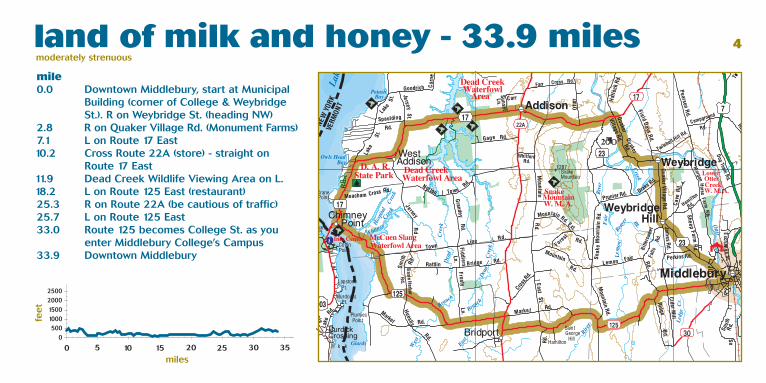
land of milk and honey - 33.9 miles moderately strenuous 4
mile 0.0 Downtown Middlebury, start at Municipal Building (corner of College & Weybridge St.). R on Weybridge St. (heading NW)2.8 R on Quaker Village Rd. (Monument Farms) 7.1 L on Route 17 East 10.2 Cross Route 22A (store) - straight on Route 17 East 11.9 Dead Creek Wildlife Viewing Area on L. 18.2 L on Route 125 East (restaurant)25.3 R on Route 22A (be cautious of traffic)25.7 L on Route 125 East33.0 Route 125 becomes College St. as you enter Middlebury College’s Campus33.9 Downtown Middlebury

route description From Middlebury’s 200-year-old “College on the Hill” through the fertile valley floor to the Lake Champlain shoreline, this tour offers the bicyclist some of the best of the region’s scenic, natural, and historical attractions. Farms dominate the landscape, as they have for more than two hundred years. Dairying prevails today, but in the 1800s pastures were filled with tens of thousands of wrinkly Merino sheep.
This route is mostly paved with an alternate dirt road route in West Addison on Jersey Street. Your trip begins on fairly flat roads following Otter Creek. In Addison, West Addison and Bridport, the roads become gently rolling hills with some long flat stretches. Be cautious when traveling on Routes 17 and 125 as these roads see significant automobile traffic.
5Monument Farms Dairy/Addison County Chamber of Commerce, Nancy Malcolm

halfway to heaven - 17.9 miles moderately strenuous mile 0.0 Bristol Town Green - start by heading east out of town on Main St. 1.5 R on Lincoln Rd.4.9 L on Quaker St. (store)5.8 L on Downingsville Rd.9.4 Downingsville Rd. becomes Jerusalem Rd. 11.5 L on Route 17 West (store) 12.9 Bristol Memorial Park - stop and wander through the gorge 14.6 L on Route 116 South (restaurant, inn) 16.3 Merge R onto Main St. (heading back into town of Bristol) 17.9 Bristol Town Green
6

route description Halfway to Heaven begins and ends in the Town of Bristol, commonly referred to as “The Gateway to the Green Mountains.” This loop takes you from Bristol along Route 116/17 to the Lincoln Road, where you will travel uphill alongside the New Haven River. After passing through the center of Lincoln, the incline will increase somewhat but then level off. At this point you’ll be leaving paved roads to a dirt road with a variety of uphill, downhill and flat sections. Upon reaching Jerusalem, you’ll be back again on paved roads, which bring you down a steep hill until you once again reach Route 116/17, bringing you to a level road as you return to Bristol center. Halfway to Heaven showcases a vibrant downtown, historic buildings, beautiful rivers and mountain views, and a landscape that was dramatically changed in places because of a large flood.
7Bristol, the “Gateway to the Green Mountains”/Jim Cunningham

town and country - 31.3 miles moderately strenuous 8
mile 0.0 Vergennes Town Green - head N on Main St.0.2 R at traffic light on Monkton Rd.9.8 R on Bristol Rd. (general store on L) 12.9 R on Hardscrabble Rd. (1.4 mi. of gravel rd.) 17.7 R on Monkton Rd. 18.8 Monkton Rd. turns into North St. 19.1 Alternate gravel route: R on Plank Rd. 19.8 R on Main/West St. (at lights in Bristol)23.9 R on North St. 26.1 L on Plank Rd. 30.1 R on Route 7 (be cautious crossing!) 30.4 L on Church St.31.0 R on Green St. (at yellow blinking light)31.2 R on Main St.31.3 Vergennes Town Green

route description This loop leads from Vergennes, Vermont’s oldest and smallest city, through villages and rich farmland, to Bristol, the “Gateway to the Green Mountains,” and back again. Vergennes and Bristol both have charming, historic downtowns with inviting shops and restaurants. Eat Good Food in Vergennes is popular with bicyclists, and the Bristol Bakery on Main Street and seasonal Village Cremee Stand on the outskirts of Bristol should not be missed.
This route runs along mainly paved roads with dirt sections of Hardscrabble Road and Plank Road. Cyclists should be in good shape to tackle this fairly hilly loop, but note that there are places in Vergennes, Monkton and Bristol to get off your bicycle and rest, eat and drink along the way.
9Otter Creek Falls in Vergennes/Liz Fitzsimmons

mills to mansions - 40.9 miles easy
10
mile 0.0 Middlebury Green - head east on Merchants Row. Straight on Court Square. 0.1 R on Court St. (Route 7 South)0.8 R on Creek Road4.4 R on Shard Villa Rd. (swimming hole on R)7.6 L on West Salisbury Rd. (cautious on Rte. 7) 10.6 West Salisbury Rd. turns into Maple St. and curves right, back to Route 7 12.0 L on Route 7 South 13.2 L on Fern Lake Rd. (store) 15.6 Straight on Lake Dunmore Rd. 16.7 Lake Dunmore Rd. turns into North St. 17.9 R on Forest Dale Rd./Route 73 (store)20.1 Forest Dale Rd. turns into Marble St.20.4 R on Park St.20.7 Brandon. Straight on Center St/Route 7. 22.3 L on Arnold District Rd.25.0 Arnold Dist. Rd. turns into Swinington Hill Rd.25.7 L on Leicester-Whiting Rd.29.7 R on North Main St./Route 30 North40.9 Middlebury Town Green

route description Vermont's rural landscape disguises an industrial history that is at least as important as its agricultural history. Take a closer look at the industrial heritage that made regional centers of downtown Middlebury and Brandon. Churning at the heart of downtown Middlebury is the Otter Creek Falls, first harnessed by early settlers to power sawmills and gristmills. It was marble--locally quarried, shaped and polished by waterpower--that became one of Middlebury's primary industries. Brandon's development took a different track with the coming of the Burlington-Rutland Railroad. Brandon became a center for the manufacture of railroad cars. Outside Brandon, Forest Dale grew out of the iron industry, where blast furnaces smelted locally mined ore. The economic prosperity that flowed from these industries was reflected in the homes of prominent citizens. You will have the chance to see these beautiful homes on this relatively flat, paved ride.
11
Stone Cotton Factory before the 1891 fire in Middlebury/Henry Sheldon Museum

gap to gap - 62.8 milesstrenuous
12
mile 0.0 Shaw’s Supermarket, R on Washington St. 1.2 L on Quarry Rd.3.3 R on Route 116 South6.8 L on Route 125 West - E. Middlebury 8.0 E. Middlebury Gorge and swimming hole 10.8 Town of Ripton (store) 13.7 Breadloaf Campus of Middlebury College 16.3 Top of Middlebury Gap 19.3 Texas Falls Scenic Area on left22.3 R on Route 100 South - Town of Hancock 26.6 Town of Rochester (store, bike shop, cafe)27.4 L on Route 73 West - begin climbing Gap 36.6 Top of Brandon Gap41.6 R on Route 53 to Lake Dunmore (store)47.3 Branbury State Park at Lake Dunmore 49.6 R on Upper Plains Rd. (store)52.7 L on Beaver Pond Rd.53.3 R on Lower Plains Rd.55.1 L on Route 125 West55.9 R on Route 116 North (store)59.4 L on Quarry Rd.62.8 Shaw’s Supermarket parking lot

route description This beautiful loop is challenging given the two climbs over the Middlebury and Brandon gaps. Each gap is over 2000 ft in elevation, but the rewards of vistas beyond description and the scenic Route 100 Corridor slicing through the heart of the Green Mountains make the effort worthwhile for the physically fit. Gap to Gap brings the cyclist through quaint and picturesque towns that offer restaurants, lodging, a few shops and great country stores. Be on the lookout for these services in East Middlebury, Hancock, and Rochester. Be forewarned that the backside of the Middlebury Gap is steeper than the front. The clockwise rotation of this loop allows the easier side of both gaps to be climbed. This loop begins at the Shaw’s Supermarket parking lot in Middlebury. Exit the lot and head east (right out of the lot).
13
Bread Loaf in Spring/Addison County Chamber of Commerce

Dale
moosalamoo meander - 42.3 miles strenuous 14
mile 0.0 Shaw’s Supermarket, R on Washington St. 1.2 L on Quarry Rd.3.3 R on Route 116 South6.8 L on Route 125 West - E. Middlebury 7.6 R on Lower Plains Rd.9.4 L on Beaver Pond Rd. 10.0 R on Upper Plains Rd. 11.9 L on Lake Dunmore Rd. (store) 14.2 Branbury State Park (camping) 19.9 L on Forest Dale Rd. (Brandon Gap) 21.6 L on Town Hill Rd.22.2 L over bridge, becomes Carlisle Hill Rd.23.8 Carlisle Hill becomes Goshen-Ripton Rd.30.7 L on Route 12531.7 Town of Ripton (store)34.4 E. Middlebury Gorge and swimming hole35.4 R on Route 116 north (store)38.9 L on Quarry Rd.41.0 Bear L on Seminary St. Extension42.1 Bear L on Washington St. (at stop sign)42.3 Shaw’s Supermarket
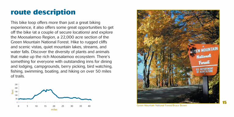
route description This bike loop offers more than just a great biking experience, it also offers some great opportunities to get off the bike (at a couple of secure locations) and explore the Moosalamoo Region, a 22,000 acre section of the Green Mountain National Forest. Hike to rugged cliffs and scenic vistas, quiet mountain lakes, streams, and water falls. Discover the diversity of plants and animals that make up the rich Moosalamoo ecosystem. There’s something for everyone with outstanding inns for dining and lodging, campgrounds, berry picking, bird watching, fishing, swimming, boating, and hiking on over 50 miles of trails.
15Green Mountain National Forest/Bruce Brown

america's first victory - 18.8 miles moderately strenuous
16
mile 0.0 Shoreham Town Center - start heading west (R out of driveway) on Main Street from the Shoreham Inn0.2 L on Route 74 West 3.5 Shoreham Bicycle Rest Stop on right –stop, relax and enjoy the view while learning about America’s First Victory4.5 L on Route 73 East5.8 Norton’s Gallery (restroom)9.9 Alternate ride out and back to Mount Independence (R on Mt. Independence Road–10 mile round trip) 10.2 Cross Route 22A, straight on Main Street 10.6 L on North Orwell Road - Welcome to Orwell! (store) 15.8 L on Richville Road 18.0 Cross Route 22A, straight on Cemetery Hill 18.3 R on School Street 18.7 R on Main Street 18.8 Shoreham Inn

route description
This bicycle loop of gently rolling hills brings you through apple orchards, farmland and the quaint town centers of Shoreham and Orwell. You will find mostly paved roads along this route with stores for provisions in both towns, an inn in Shoreham, and an interesting art gallery (Norton’s on Route 73) with a clean public restroom. Heading out of Shoreham, this loop offers incredible long views of Lake Champlain and historically significant sites in early American history. Make sure you stop to rest at Hands Cove Park, the bicycle rest stop just after the intersection of Route 74 and Smith Street. Finally, make the trip out and back to Mt. Independence–it’s worth it!
17Hands Cove Park Bicycle Rest Stop/Janine Hetherington
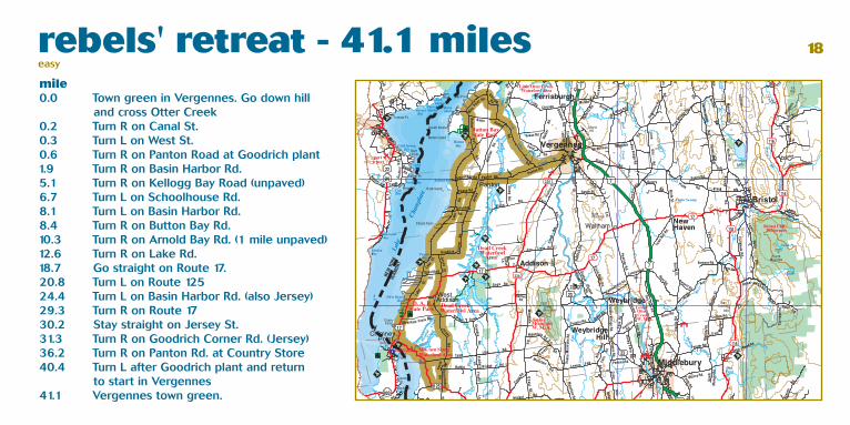
rebels' retreat - 41.1 mileseasy
18
mile 0.0 Town green in Vergennes. Go down hill and cross Otter Creek0.2 Turn R on Canal St. 0.3 Turn L on West St. 0.6 Turn R on Panton Road at Goodrich plant 1.9 Turn R on Basin Harbor Rd.5.1 Turn R on Kellogg Bay Road (unpaved)6.7 Turn L on Schoolhouse Rd.8.1 Turn L on Basin Harbor Rd.8.4 Turn R on Button Bay Rd. 10.3 Turn R on Arnold Bay Rd. (1 mile unpaved) 12.6 Turn R on Lake Rd. 18.7 Go straight on Route 17.20.8 Turn L on Route 12524.4 Turn L on Basin Harbor Rd. (also Jersey)29.3 Turn R on Route 1730.2 Stay straight on Jersey St. 31.3 Turn R on Goodrich Corner Rd. (Jersey) 36.2 Turn R on Panton Rd. at Country Store40.4 Turn L after Goodrich plant and return to start in Vergennes41.1 Vergennes town green.

route description
Rebel’s Retreat is a spectacular route traveling through flat to slightly rolling farmland on Vermont’s “west coast” alongside of Lake Champlain. Although there are no or minimal shoulders, traffic volume is low with the exception of Panton Road and Route 17. The loop begins and ends in downtown Vergennes where food, lodging, and parking are available. Take in unspoiled lake views while meandering the area where the rebellious American Troops retreated after the Revolutionary Battle of Valcour. To avoid capture, the troops, led by Benedict Arnold, escaped to what is now Arnold’s Bay, and retreated by foot to Ticonderoga. Delve into the recent discovery of Benedict Arnold’s scuttled gunboat at the Lake Champlain Maritime Museum or investigate the region’s rich history at Chimney Point State Historic Site. Also enjoy a visit to Button Bay or D.A.R. State Parks along Lake Champlain’s scenic shoreline. While in Vergennes, visit MacDonough Park at the Otter Creek Basin, site of Commodore Thomas MacDonough’s 1813-1814 shipyard.
19
Addison County farmland/Addison County Chamber of Commerce

otter creek wandering - 27.5 miles easy
20
mile 0.0 Vergennes town green 0.7 Turn L on Hopkins Rd. (0.7 miles unpaved) 2.9 Turn L on East Rd. (3.0 miles unpaved) 6.7 Turn L on Route 17 7.5 Turn R on Route 23 12.1 Center of Weybridge - bear L on Route 23 15.0 Turn L and L again at yield sign to enter Middlebury 15.4 Turn L on Seymour St. to the left of the big white church 15.6 Turn L at Greg’s Market 15.7 Bear R after bridge underpass 16.3 Cross Pulp Mill Bridge and bear R on Morgan Horse Farm Rd. 19.8 Cross New Haven River 23.1 Cross Route 17 27.5 Vergennes town green

route description
Connecting the historic towns of Middlebury and Vergennes, Otter Creek Wandering meanders through scenic farmlands along the Otter Creek, Vermont’s longest river. Although there are no or minimal shoulders, traffic volume is low through most sections. Terrain varies from flat to rolling, and hills exist in some areas. A majority of the route follows paved roads, with the exception of a 5.9 mile stretch along Hopkins and East Roads to Route 17. The loop begins in downtown Vergennes, where food, lodging, and parking are available.
Presently dominated by dairying, Addison County has a long agricultural tradition of crop-farming, sheep-raising, and horse-breeding. Weybridge is the home of Vermont’s largest agricultural fair, Field Days, held the first full week in August. Be sure to visit the Sheldon Museum in downtown Middlebury, or the Morgan Horse Farm in Weybridge, to experience Addison County’s unique flavor.
21
Downtown Vergennes/Addison County Chamber of Commerce, Nancy Malcolm

acknowledgements The development of this guide took place thanks to the hard work of many volunteers. Lake Champlain Bikeways would like to thank: Jim Arnold, Kevin Behm, Lou Bresee, Bruce Brown, Liz Fitzsimmons, Elsa Gilbertson, Barbara Harding, Dennis Hysko, Ron Morgan, and Brandy Saxton. We would also like to thank the Addison County Chamber of Commerce, the Addison County Regional Planning Commission, The Addison Independent, Northern Cartographic and the Vermont Department of Forests, Parks and Recreation for their support, guidance, and input.
We would like to acknowledge funding from the Federal Highway Administration's National Scenic Byway Program, through the All-American Road, Lakes to Locks Passage, for the design template of this guide.
general information
lake champlain bikeways missionTo promote bicycling throughout the Lake Champlain regions of New York, Vermont and Québec for the purposes of increasing opportunities for bicycle recreation and transportation, improving the quality of life, enhancing the economic vitality, advocating for sustainable communities, encouraging healthy lifestyles and raising public awareness and appreciation of inherent scenic, historic, cultural, natural, and recreational resources throughout the area.
lake champlain bikeways clearinghouseContact us to order a variety of LCB publications, as well as other regional bicycling information:Lake Champlain Bikeways, c/o Local Motion Trailside CenterOne Steele Street #103Burlington, VT 05401802.652.BIKE (2453)[email protected], www.champlainbikeways.org
emergency info To reach Police, Fire & Rescue dial 911. If using a cell phone, please be aware of your location.
Brandon Area Chamber of Commerce
www.brandon.org
Disclaimer: Users assume all risks, inherent and not inherent, in the use of materials recommending routes of the Lake Champlain Bikeways network and all affiliated organizations, and individuals disclaim any and all liability on their part for damages or injuries to persons or property should they occur. Routes are chosen, designated and/or signed because: they are popular, or are preferred, or provide continuous routes to destinations, or are lightly traveled, or are scenic, or have more room for cars and bikes, or possess a combination of these attributes.