HB2 Overview - Nelson County · HB2 Screening Process-Key Take Away9 • Only projects that meet a...
72
HB2 Overview June 18, 2015 HB2 Team
Transcript of HB2 Overview - Nelson County · HB2 Screening Process-Key Take Away9 • Only projects that meet a...

HB2 Overview
June 18, 2015HB2 Team

Life Cycle of a Candidate Project
How it’s planned.
2
How it’s scored. How it’s funded.

3
• VTrans is the long-range, statewide multimodal policy plan -Vision and Goals for transportation in the Commonwealth
• VTrans2040 serves two functions and produces two independent, but connected documents:• VTrans2040- 25 year vision document
• VTrans2040- Multimodal Transportation Plan (VMTP) includes Multimodal Needs Assessment
How it’s plannedVTrans2040

How it’s plannedVTrans2040
4
• Needs Assessment:• VMTP will identify future needs for all modes travel
across the Commonwealth – not project specific
• Policy and recommendations of the plan will focus on:
• Corridors of Statewide Significance
• Identified regional networks
• Local designated growth areas
• Safety
5
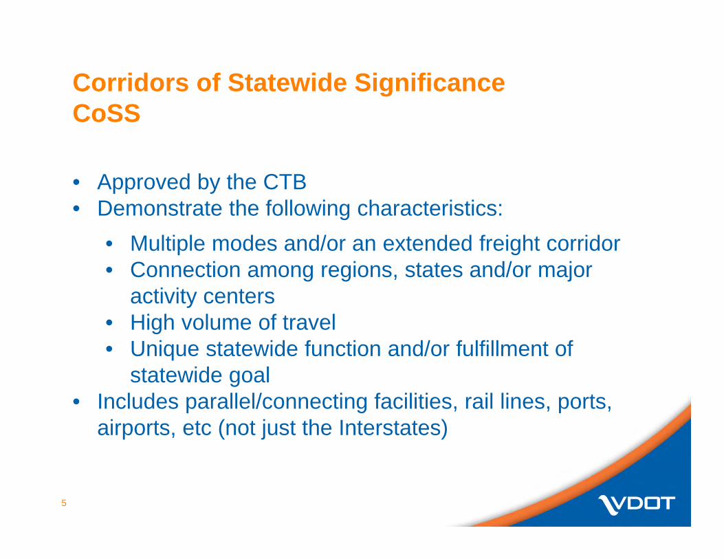
Corridors of Statewide SignificanceCoSS
• Approved by the CTB• Demonstrate the following characteristics:
• Multiple modes and/or an extended freight corridor• Connection among regions, states and/or major
activity centers• High volume of travel• Unique statewide function and/or fulfillment of
statewide goal• Includes parallel/connecting facilities, rail lines, ports,
airports, etc (not just the Interstates)

6
Virginia CoSS
Detailed mapping resources to be provided to all field staff
7
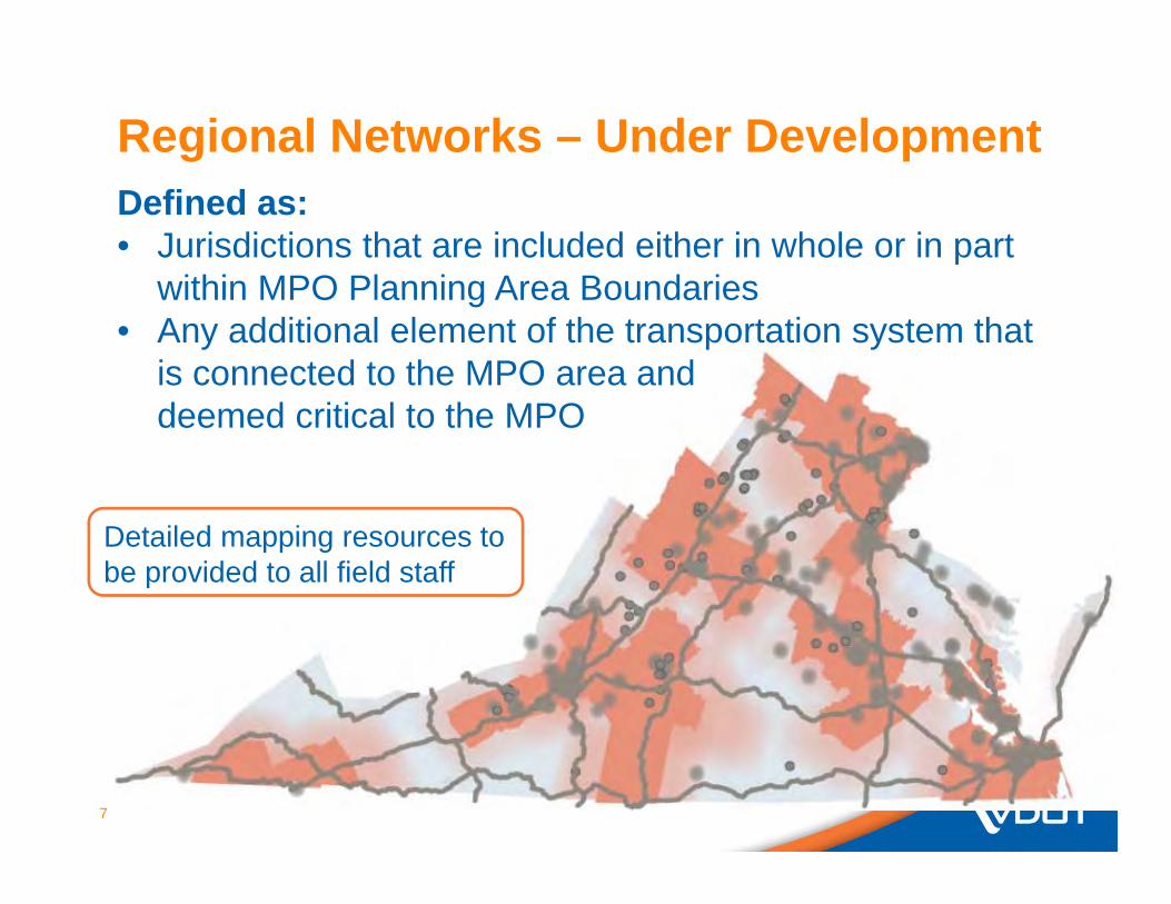
Regional Networks – Under DevelopmentDefined as: • Jurisdictions that are included either in whole or in part
within MPO Planning Area Boundaries• Any additional element of the transportation system that
is connected to the MPO area and deemed critical to the MPO
Detailed mapping resources to be provided to all field staff

8
Urban Development AreasUDAs
• Areas voluntarily designated by local governments as prime areas for future economic growth pursuant to 15.2-2223.1
• Must reflect transportation-efficient land use principles including• Mixed-use land use• Interconnected streets• Moderately compact growth

HB2 Screening Process- Key Take Away
9
• Only projects that meet a need identified in VTrans2040 will be prioritized
• Projects must be located within one of the following areas:• Corridors of Statewide Significance• Regional Networks• Improvements to promote urban development
areas• Or addresses an identified safety need
• Projects that do not meet the screening criteria will not be scored or prioritized under HB2

How HB2 is funded
• HB1887 removes the 40-30-30 formula put in place in by the 1986 Special Session legislation
• New construction formula established, effective FY 2021: State of Good Repair – 45% High-Priority Projects Program (Statewide) * – 27.5% District Grant Programs* – 27.5%
10
*To be programmed according to HB 2 in FY17

How HB2 is funded
• In the interim (FY17-20):• Funds not programmed to projects are to be
distributed 50/50 to:• High-Priority Projects Program (Statewide)• District Grant Programs
11

Funds Available for HB 2(in millions - Subject to Revision)
12

13
HB2 Overview

14
Schedule: May to October 2015
• Process must be used to develop FY17-22 Six-Year Improvement Program; Program will be considered by the Board in June 2016
Upcoming Events:June 17th – CTB adopted the HB2 processJuly 2015 – VTRANS2040 VMTP identification of transportation draft needsJune/July – Training for VDOT staffJuly/Aug. – Training Entities (e.g. Localities, MPOs, PDCs)
• Process overview• Online application system
July 1st – VDOT to begin working with EntitiesAug 1st – Entities begin inputting applicationsSept 30th – On-line applications deadline

HB2 Project Types
15
• Eligible project types include:• Highway improvements
Widening projects
Operational improvements
Access management
• Transit and rail capacity expansion projects
• Transportation demand management
Van Pools
Park & Ride facilities
Telecommuting
• Passenger Rail

HB2 Project Types
16
• Project types excluded:• Asset Management
• Structurally deficient bridges
• Reconstructive paving
• Routine maintenance
• Transit and Rail State of Good Repair projects

17
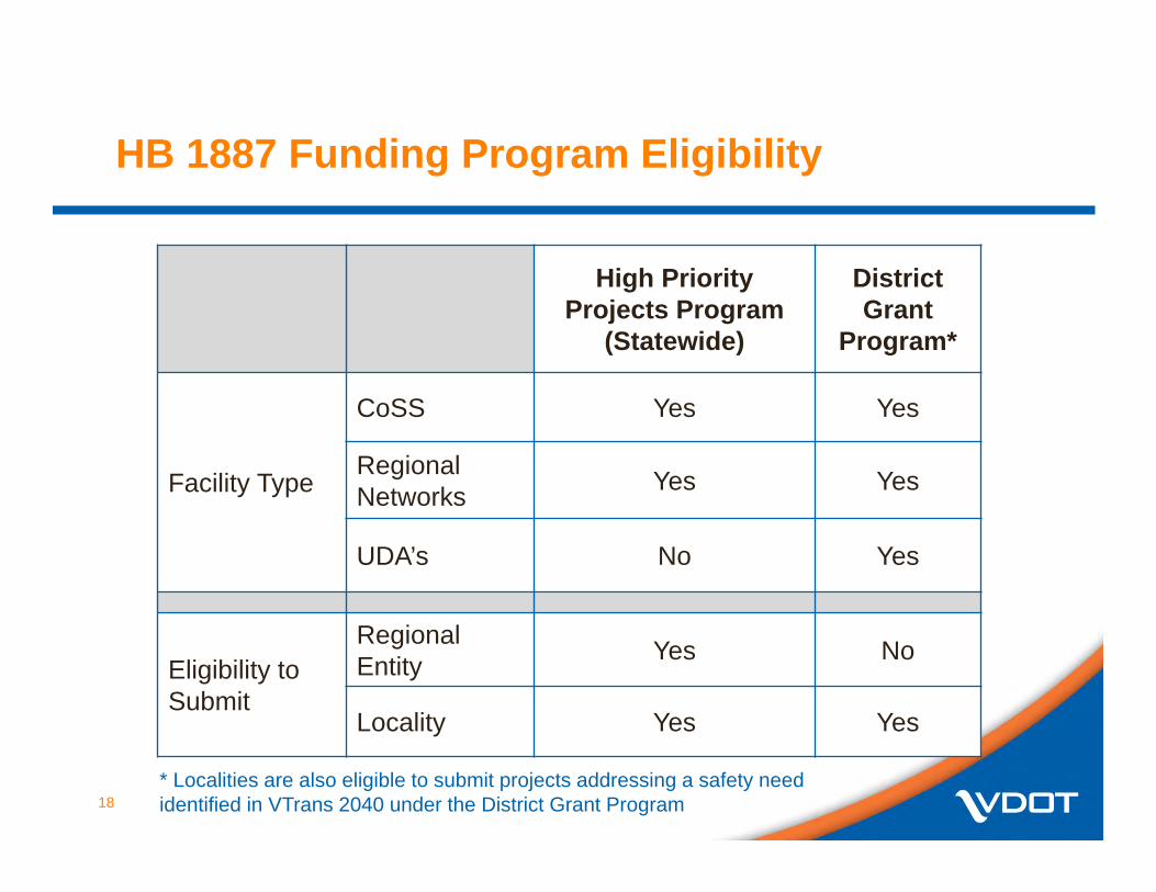
Applicant Eligibility
Project System
Regional Entity (MPOs, PDCs)
Locality* (Counties, Cities, Towns)
Public Transit Agencies
Corridor of Statewide Significance
YesYes, with a resolution of support from relevant
regional entity
Yes, with resolution of support from
relevant regional entity
Regional Network Yes Yes
Yes, with resolution of support from
relevant entity
Urban Development Area
No Yes No
* Localities are also eligible to submit projects addressing a safety need identified in VTrans 2040 under the District Grant Program
18
HB 1887 Funding Program Eligibility
High Priority Projects Program
(Statewide)
District Grant
Program*
Facility Type
CoSS Yes Yes
Regional Networks Yes Yes
UDA’s No Yes
Eligibility to Submit
RegionalEntity Yes No
Locality Yes Yes
* Localities are also eligible to submit projects addressing a safety need identified in VTrans 2040 under the District Grant Program

19
HB2 Measure/Scoring

HB2 Scoring - Screening Process
20
REMEMBER:
• Only projects that meet a need identified in VTrans 2040 will be prioritized, and projects need to be on at least one of the following:• Corridors of Statewide Significance• Regional Networks• Improvements to promote urban development
areas• Address a safety need from VTrans needs
assessment

21
HB2 Scoring – Factor Areas
• The prioritization process is objective, quantifiable and considers at least the following factors relative to cost:
• Congestion mitigation • Economic development • Accessibility • Safety • Environmental Quality
• For Area Types A and B a transportation and land use factor will be used

22
HB2 Scoring – Evaluating Benefits Relative to Cost
• House Bill 2 requires that benefits produced by a project be analyzed on a basis of relative costs
• Results to be provided to CTB based on:• Benefits relative to total costs
• Benefits relative to HB2 costs

23
HB2 Scoring – Weighting – CTB Approved June 17, 2015 • House Bill 2 requires that the CTB weight the factors
differently in different parts of the Commonwealth
Factor Congestion Mitigation
EconomicDevelopment Accessibility Safety Environmental
QualityLand Use
Category A 45% 5% 15% 5% 10% 20%
Category B 15% 20% 25% 20% 10% 10%Category C 15% 25% 25% 25% 10%Category D 10% 35% 15% 30% 10%

HB2 Scoring – Factors
24
For more details see:www.VirginiaHB2.org

Factor AreasGoals that guided measure development
• Safety – reduce the number and rate of fatalities and severe injuries
• Congestion – reduce person hours of delay and increase person throughput
• Accessibility – increase access to jobs and travel options• Economic Development – support economic development,
improve goods movement and improve travel time reliability• Environmental Quality – improve air quality and avoid
impacts to the natural environment• Land Use – support transportation efficient land development
patterns
25

26
Applicant Responsibilities(with State support)

27
Applicant Roles and ResponsibilitiesScope/ Schedule/ Estimates
Local/Regional applicants will be required to provide the following information when submitting a project under HB2 Point of contact Who will administer project? Project priority (if submitting more than one) Detailed project description/scope Project sketch (optional but strongly encouraged) Project status, cost estimate and duration by phase Measure information related to Accessibility, Economic
Development, Environment, and Land Use (area types A & B) Amount of HB2 funding requested Description of any non-HB2 funding committed to project Applicable supporting documents (resolutions, plans, studies,
etc)

28
Applicant Roles and ResponsibilitiesScope/ Schedule/ Estimates
HB2 project applications must include the following information:• Scope - The scope should define the limits of the project, its physical
and operational characteristics, and physical and/or operational footprint.
• Cost Estimate - Cost estimate should be as realistic as possible –considering known information and should account for possible risk and contingencies.
• Schedule – Anticipated schedule should be realistic and reflect complexity of project and identify phase durations (PE, RW, CN)
VDOT and DRPT will assist applicants in the development of project scopes, cost estimates, and schedules

29
Current Situation (example)
HB2 Process
Project Idea with
“High Level Cost Est.
Consideration by CTB
Project Enters SYIP
Define Scope
and Cost Est.
Project Design R/W CN
Project Idea with
“High Level Cost
Est.
Define Scope and
Cost Estimate
HB2 Scoring
Consideration by CTB
Project Enters SYIP
Project Design R/W CN
SYIPThen/Now

30
HB2 Cost Estimates
• PCES Workbook is the preferred tool for developing cost estimates for road improvements
• If quantities are known, TRANSPORT can be used for cost estimation
• Accurate cost estimates critical because:• Cost impacts the project score• Cost estimate increases could force project to be
rescored• VDOT/DRPT will assist applicants with the
development of cost estimates

31
Project Readiness
• Projects that conceptual in nature and not well defined may need additional planning/pre-scoping level work before project can be submitted and scored under HB2
• In these cases, VDOT/DRPT may recommend to applicant the need for additional study prior to HB2 submittal

HB 2 Process Timeline for implementation
32

HB2 Schedule
33
• Overall Schedule• June/July – Training and outreach to applicants
• HB2 process – early July• HB2 web application – late July
• July 1st to September 30th
• Project coordination (now to August 30th)• Communication and coordination with applicants
(RAs/REs/PIMs/DPMs/DRPT)• Project definition/scope• Project documentation
• August 1st to September 30th – Application submission• October 1st to December 31st – Screening and Scoring• January – June 2016 – CTB considers results in developing
SYIP

34
Additional Resources
• Presentations to the CTB• www.ctb.virginia.gov
• HB2 Implementation Guide and Appendices• http://virginiahb2.com/docs/HB2PolicyGuide_
MeasuresAppendices_05182015.pdf
• HB2 Website• http://virginiahb2.org

VDOT Recommended HB2 Applications for Nelson County
1) Route 151/6/638 HSIP Project (Existing Project) Existing HSIP Project withrevenue shortfall and identified VTRANS Safety Hotspot. Located on a RegionalNetwork (US 151) and in an area of high Economic Development.
Intersection Improvement Safety Project submittal to secure shortfall
2015 Long Range Transportation Plan Prioritization: Rank #5, Project ID: 28 2013 Route 151 Corridor Study Identified Intersection Recommendation #14 VTRANS Top 100 PSI Intersections (Fatalities & Serious Injuries), Lynchburg District #27
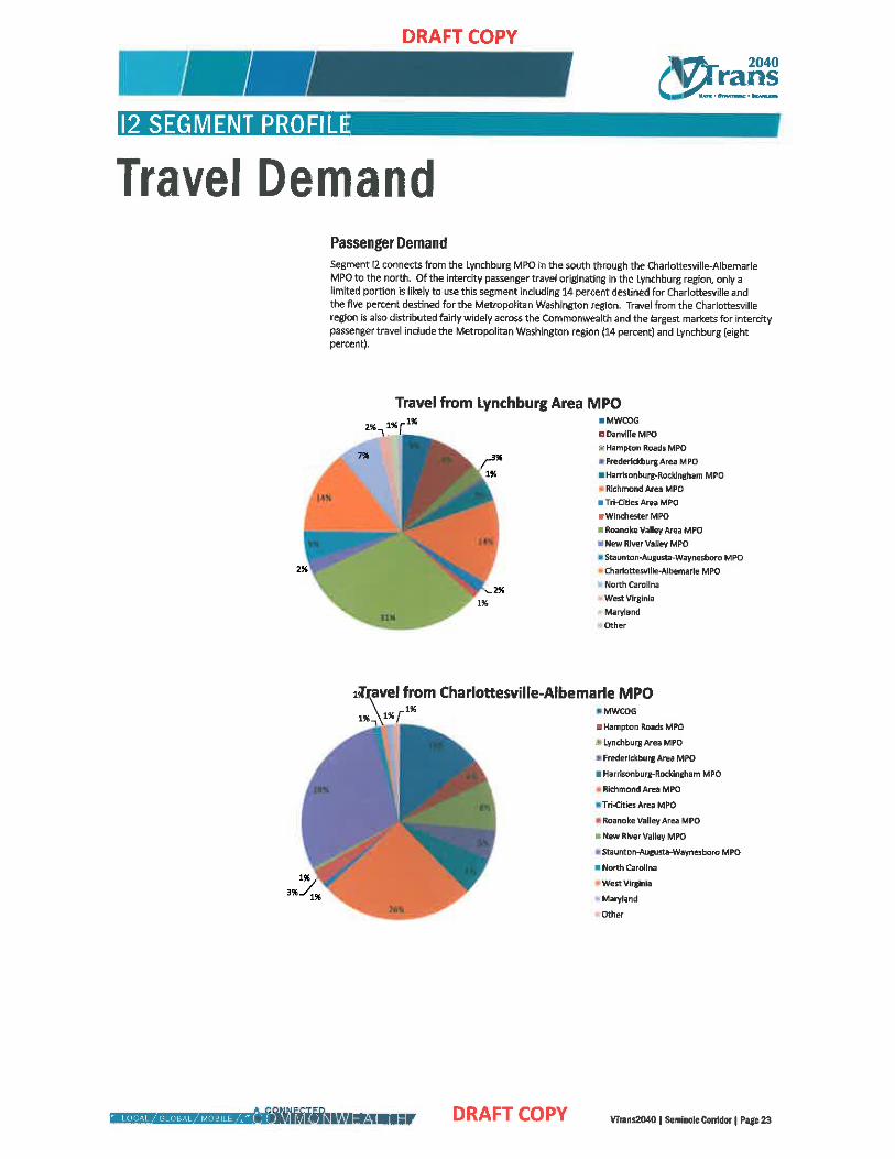
2) Route 29 / 655 Intersection Improvement Identified VTRANS Safety Hotspot on aCorridor of Statewide Significance (Seminole Corridor, Segment I2-US Route 29)
1) Right turn lane and taper to be constructed on Route 29 Southbound at the intersectionof Route 655
2) The existing right turn lane and taper on Route 29 Northbound at the intersection ofRoute 655 to be extended / widened
2015 Long Range Transportation Plan Prioritization: Rank #2, Project ID: 10 VTRANS Top 100 PSI Intersections (Fatalities & Serious Injuries), Lynchburg District #3
3) Route 151 / 664 Turn Lane Identified Safety Improvement in Route 151 Study and located on a Regional Network (US 151) and in an area of high Economic Development.
1) Offset Right turn lane and taper to be constructed on Route 151 Southbound at theintersection of Route 664
2013 Route 151 Corridor Study Identified Intersection Recommendation #1


Project Prioritization Matrix Results
RANK ID ROUTE CONSTRUC-
JURISDICTION FROM: TO: TYPICAL AVER-TION DISTRICT SECTION AGE
1 31 64 Lynchburg Nelson Augusta CL Albemarle CL 6 6.45 2 10 29/655 Lynchburg Nelson Amherst CL 56 4 594 3 42 29/BU$29 lynchburg Nelson 56 29S BUS 4 5 58 4 24 151/635 Lynchburg Nelson GS 784 2 5.56 5 28 151/6/638 Lynchburg Nelson 6N Albemarle CL 2 5.42 6 30 250 Lynchburg Nelson Augusta CL 6 3 5.41 7 29 151 Lynchburg Nelson 6N Albemarle CL 2 5.19 8 43 29 BUS Lynchburg Nelson 29S BUS 29N BUS 2 'i16 9 25 151 Lynchburg Nelson 6S 784 2 510 10 23 151 Lynchburg Nelson 751 6 2 4.75 11 32 29/775 Lynchburg Nelson 29N BUS 623 2 4.66 12 26 151/6 Lynchburg Nelson 65 784 2 464 13 22 151/613 Lynchburg Nelson 751 6 2 4.52 14 35 6/634 Lynchburg Nelson 151 29 2 4.29 15 27 635 Lynchburg Nelson 6/151 633 2 408 16 7 151/56 Lynchburg Nelson 151 y 56 2 3.52 16 8 151 Lynchburg Nelson 151 y 56 2 3.52 18 16 60/622 Lynchburg Nelson AmherstCl 622 2 3.38 19 20 151/627 Lynchburg Nelson 707 751 2 3.29 19 9 56 Lynchburg Nelson 151 29 2 3.29 21 21 613 Lynchburg Nelson 6125 612 N 2 319 22 12 739 Lynchburg Nelson 657 29 2 310 22 41 56/647 Lynchburg Nelson 639 722 2 3.10 24 11 665 Lynchburg Nelson 29 655 2 3.00 24 39 639 Lynchburg Nelson 56 719 2 3.00 26 13 657 Lynchburg Nelson 721 739 2 2.99 27 15 626 Lynchburg Nelson 60 606 2 2.90 27 17 656 Lynchburg Nelson 60 622 2 2.90 27 38 639 Lynchburg Nelson 719 643 2 290 30 5 666 lynchburg Nelson 679 56 2 2.81 30 6 681 Lynchburg Nelson 666 679 2 2.81 32 1 666 Lynchburg Nelson 827 679 2 2.71 33 2 676 Lynchburg Nelson 778 151 2 2.65
6
cmcgarry
Highlight
cmcgarry
Highlight


Project Description Project ID: 28
location: VA 151 at VA 6 at VA 638
Description: Deficiencies with low priority, Continue to monitor for
potential improvements
Estimated 2020 Cost: $50,000
Prioritization Results Final Score: 5.42 (High)
Overall Rank: 5 of 44
Intersection Projects Rank: 4 of 12
2010-13 Fatal+ Severe Injuries Crashes per Mile: 8
Major Environmental Impacts: N/ A
Project Location Map
Overview of Performance Measure Data
cmcgarry
Highlight
cmcgarry
Highlight

toss j
Project Description Project 10: 10
Location: US 29 at VA 655
Description: Short-term improve signage; Mid-term lengthen turn
lanes. (Local Priority)
Estimated 2020 Cost: Short-term I Mid-term: $750,000
Prioritization Results Final Score: 5.94 (High)
Overall Rank: 2 of 44
Intersection Projects Rank: 1 of 12
2010-13 Fatal+ Severe Injuries Crashes per Mile: 22
Major Environmental Impacts: N/ A
Project Location Map
Overview of Performance Measure Data
cmcgarry
Highlight
cmcgarry
Highlight

Route 151 Corridor Study HNTB 3.5 Safety Assessments
The Existing Conditions safety assessment, presented In Section 2.4, focused on identifying crash
patterns at the 15 study intersections along the study corridor, general patterns for the corridor, and
identifying potential mitigation measures. Information gathered from public comments received at the
first public meeting was also considered in the process. The safety assessment considered Crash
Modification Factors (CMFs) to quantify an expected reduction in crashes if various measures were
implemented. The primary source for CMF was the AASHTO Highway Safety Manual {HSM)1, while the
VDOT Highway Safety Improvement Program (HSIP) CRFs were used as a supplement reference where
the HSM did not have listed factors. The HSM was also used to develop additional countermeasures or
recommendations to improve safety. The operations of any Improvements that recommended new
turn lanes or a roundabout was tested and presented in Section 3.4.
int::!r<,ection Recom ril<?ndr.tions
Full details by intersection are presented in Appendix D, and include a crash type diagram, crash
summary, including time of day, field observations, as well as detailed recommendations. Corridor-wide
recommendations to address general deficiencies are also provided. Key recommendations, listed by
intersections and the corridor, are as follows:
1. Route 664 (Beech Grove Road I Glenthorne Loop) at Route 151
• Adjust the signage along northbound Route 151.
• Add a southbound right turn bay; offset the turn bay by 6 feet to aid drivers on the eastbound
approach to differentiating of southbound through movement versus right turning vehicles.
2. Route 627 (Spruce Creek Lane and Glenthorne Loop) at Route 151
• Realign Route 627 to reduce skew (by 25 degrees) and improve sight distance.
• Add intersection-ahead signage with flashers on the northbound approach.
• Regrade the embankment in the southwest quadrant.
3. Route 634 (Adial Road)/Nellysford area at Route 151
• Add sidewalks for pedestrians.
• As new development or re-development occurs, improve access management and inter-parcel
connectivity.
4. Route 613 (Rodes Farm Drive and Lodebar Estate) at Route 151
• Reduce the crest of hill and regrade the embankments to improve sight distance.
• Review commercial signage to ensure signage is not within the VDOT right-of-way.
1 AASHTO, Highway Safety Manual, 1•1 Edition, 2010.
July 2013
33
cmcgarry
Highlight

Route 151 Corridor Study HNTB 14. Route 6 (Afton Mountain Road) and Route 638 North (Avon Road) at Route 151
• Construct left turn lanes for the northbound and southbound approaches. Note that an HSIP
grant for the turn bays was recently approved, designs will be prepared and the preliminary
start date of construction is March 2016.
• Reconfigure the eastbound right turn lane to reduce skew by 20 percent.
• Improve signage.
• Consider rumble strips on the approaches of Routes 6 and 638 to the intersection.
• Regrade the approaches of Routes 6 and 638 to the intersection.
15. U.S. Route 250 (Rockfish Gap Turnpike) at Route 151
• Extend the westbound left turn lane.
• Offset the eastbound right turn bay by 12 feet to improve the visibility of eastbound through
vehicles.
• Consider street lighting at the intersection.
• Consider a roundabout or signalization with a northbound right turn lane. If this improvement
would not be constructed, consider a northbound right turn lane with an acceleration lane on
u.s. 250.
Gl!neral Recommendation~
In additional to the location-specific recommendations, general recommendations were developed for
the corridor, which include:
• Perform speed studies to set speed limits appropriate for traffic patterns and land uses along
the corridor.
• Improve access management for existing parcels by looking for opportunities to consolidate
existing driveways and inter-parcel connectivity. Ensure new developments comply with VDOT
access management guidelines.
• Develop a comprehensive plan for the Village of Nellysford. For the transportation components,
key elements to be considered include parallel road(s) to Route 151, inter-parcel connectivity
and pedestrian/bicyclist accommodations.
• Reconstruct Route 151 to correct geometric deficiencies (horizontal, vertical and/or sight
distance) and to provide paved shoulders to accommodate pedestrians and cyclists. This project
can be phased by segment.
• Reduce sign clutter. VDOT should improve wayfinding and other roadway signage as projects
are implemented along the corridor. Nelson County will review and update its zoning ordinance
relative to commercial sign age within and adjacent to the VDOT right-of-way.
• As state funding becomes available, replace deficient guardrail or install new guardrail at the
identified locations.
• Nelson County police should continue its active program in enforcing the speed limit and truck
size regulations for the corridor. Nelson County should continue to work with VDOT on
geometric safety issues.
July 2013
35
cmcgarry
Highlight