Hazards Data Distribution System (HDDS) - nps.gov · 201108 Hurricane Irene Data Sources Geospatial...
24
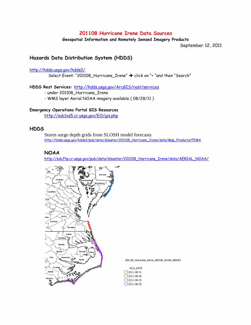
201108 Hurricane Irene Data Sources Geospatial Information and Remotely Sensed Imagery Products September 12, 2011 Hazards Data Distribution System (HDDS) http://hdds.usgs.gov/hdds2/ Select Event: “201108_Hurricane_Irene” click on “+ “and then “Search” HDDS Rest Services: http://hdds.usgs.gov/ArcGIS/rest/services - under 201108_Hurricane_Irene - WMS layer Aerial NOAA imagery available ( 08/28/11 ) Emergency Operations Portal GIS Resources http://edclxs5.cr.usgs.gov/EO/gis.php HDDS Storm surge depth grids from SLOSH model forecasts http://hdds.usgs.gov/hdds2/pub/data/disaster/201108_Hurricane_Irene/data/Map_Products/FEMA NOAA http://edcftp.cr.usgs.gov/pub/data/disaster/201108_Hurricane_Irene/data/AERIAL_NOAA/
Transcript of Hazards Data Distribution System (HDDS) - nps.gov · 201108 Hurricane Irene Data Sources Geospatial...
201108 Hurricane Irene Data Sources Geospatial Information and Remotely Sensed Imagery Products
September 12, 2011
Hazards Data Distribution System (HDDS)
http://hdds.usgs.gov/hdds2/
Select Event: “201108_Hurricane_Irene” click on “+ “and then “Search”
HDDS Rest Services: http://hdds.usgs.gov/ArcGIS/rest/services
- under 201108_Hurricane_Irene
- WMS layer Aerial NOAA imagery available ( 08/28/11 )
Emergency Operations Portal GIS Resources
http://edclxs5.cr.usgs.gov/EO/gis.php
HDDS Storm surge depth grids from SLOSH model forecasts http://hdds.usgs.gov/hdds2/pub/data/disaster/201108_Hurricane_Irene/data/Map_Products/FEMA
NOAA http://edcftp.cr.usgs.gov/pub/data/disaster/201108_Hurricane_Irene/data/AERIAL_NOAA/
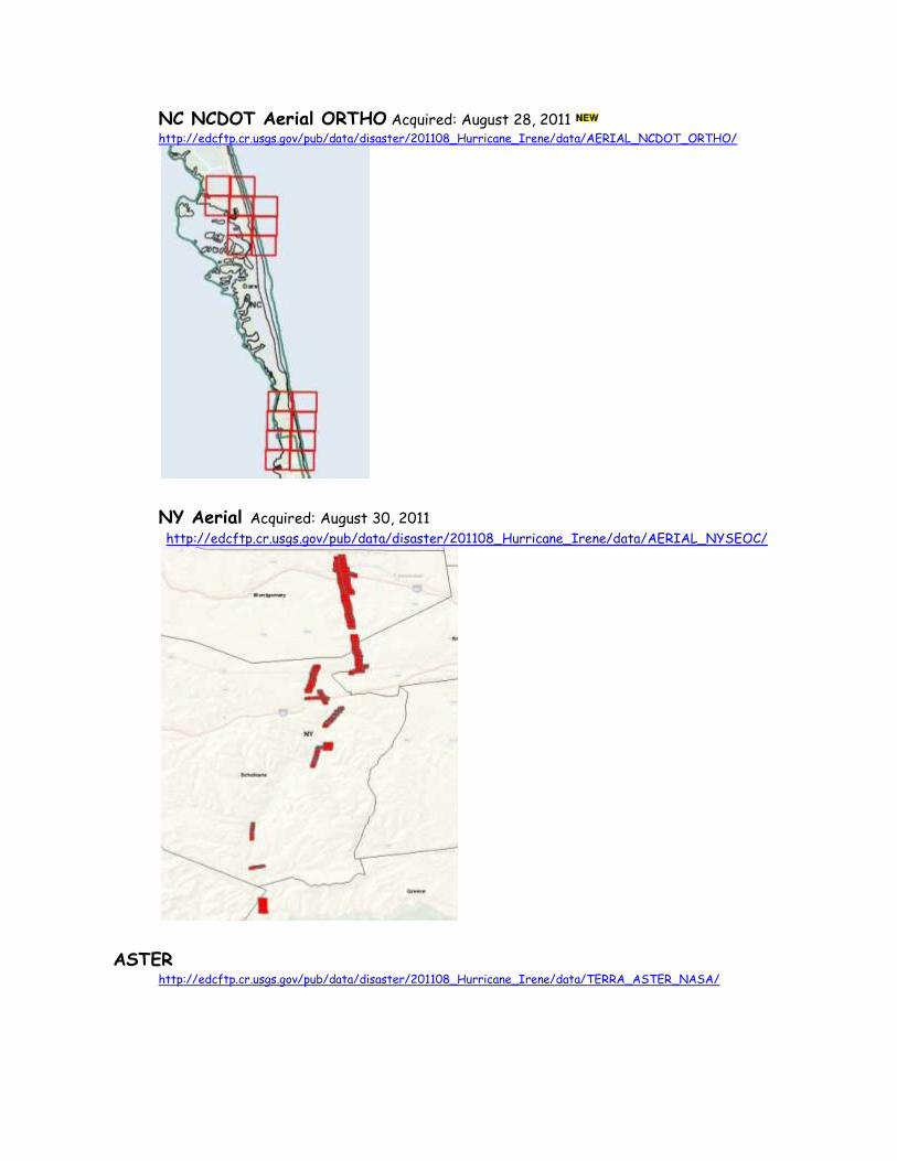
NC NCDOT Aerial ORTHO Acquired: August 28, 2011 http://edcftp.cr.usgs.gov/pub/data/disaster/201108_Hurricane_Irene/data/AERIAL_NCDOT_ORTHO/
NY Aerial Acquired: August 30, 2011 http://edcftp.cr.usgs.gov/pub/data/disaster/201108_Hurricane_Irene/data/AERIAL_NYSEOC/
ASTER http://edcftp.cr.usgs.gov/pub/data/disaster/201108_Hurricane_Irene/data/TERRA_ASTER_NASA/
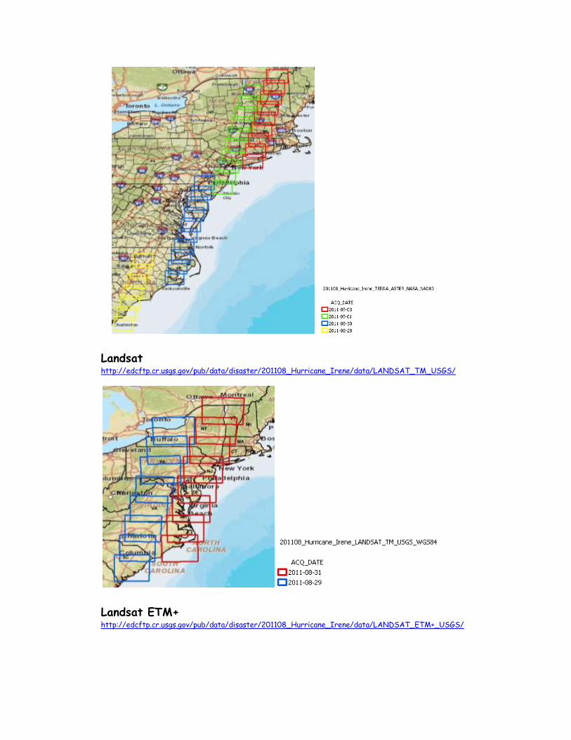
Landsat http://edcftp.cr.usgs.gov/pub/data/disaster/201108_Hurricane_Irene/data/LANDSAT_TM_USGS/
Landsat ETM+ http://edcftp.cr.usgs.gov/pub/data/disaster/201108_Hurricane_Irene/data/LANDSAT_ETM+_USGS/
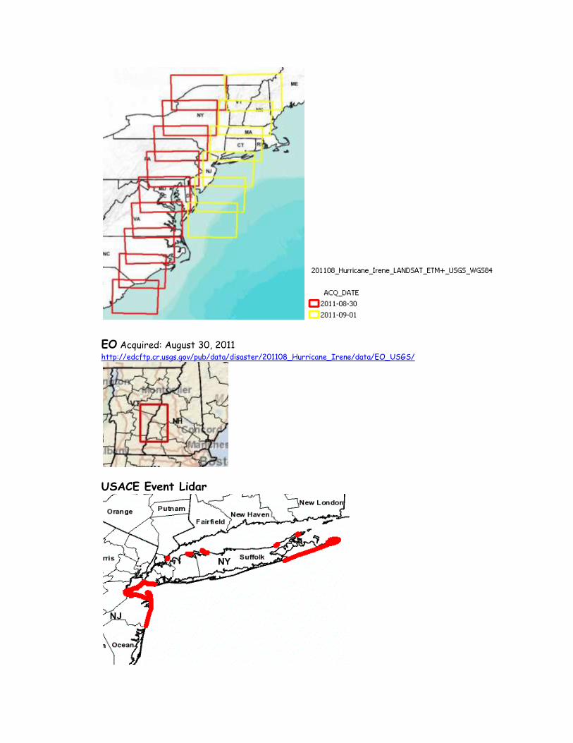
EO Acquired: August 30, 2011 http://edcftp.cr.usgs.gov/pub/data/disaster/201108_Hurricane_Irene/data/EO_USGS/
USACE Event Lidar
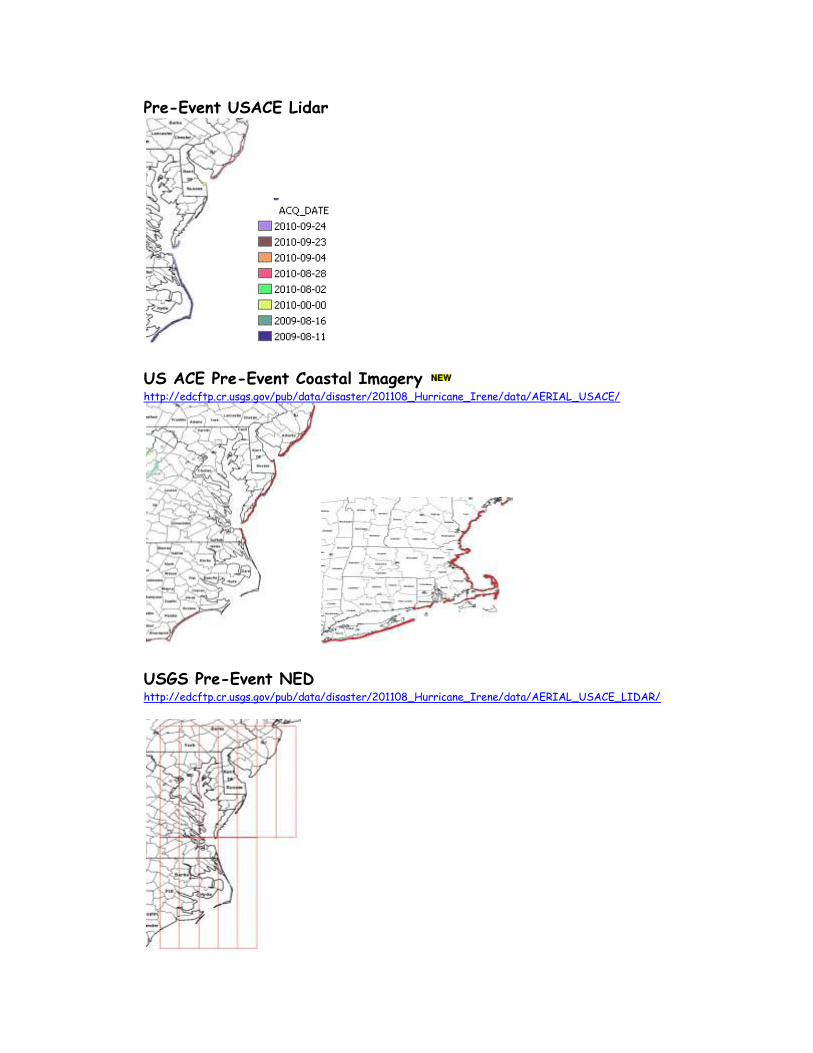
Pre-Event USACE Lidar
US ACE Pre-Event Coastal Imagery http://edcftp.cr.usgs.gov/pub/data/disaster/201108_Hurricane_Irene/data/AERIAL_USACE/
USGS Pre-Event NED http://edcftp.cr.usgs.gov/pub/data/disaster/201108_Hurricane_Irene/data/AERIAL_USACE_LIDAR/
Virginia Pre-Event from HDDS
BL_VA_2002_virginia_va_2ft/
BL_VA_200512_coastal_va_0x5000m/
BL_VA_200906_virginia_naip_va_1m/
Pre-Event NAIP Imagery from HDDS BL_CT_201008_connecticut_naip_ct_1m/
BL_DC_201004_washington_dc_16cm/
BL_DE_200906_delaware_naip_de_1m/
BL_MA_201007_massachusetts_naip_ma_1m/
BL_MD_200906_maryland_naip_md_1m/
BL_NC_201006_north_carolina_naip_nc_1m/
BL_NJ_201007_new_jersey_naip_nj_1m/
BL_NY_200905_new_york_naip_ny_1m/
BL_PA_201005_pennsylvania_naip_pa_1m/
BL_RI_201007_rhode_island_naip_ri_1m/
HDDS Restricted
Self Register for HDDS Restricted. http://hdds.usgs.gov/hdds2
If you have not registered on either EarthExplorer or HDDS, click the register
button in the top right corner of the screen and go thru the registration process.
Once registered, you will have access to EarthExplorer and HDDS download
capabilities. To sign up for the event access - go to http://hdds.usgs.gov/hdds2 go to the login button in the upper right corner of the screen enter your usercode and password Click on fill out an access request form select 201108_hurricane_irene (do not select 201108_hurricane_irene_charter) fill in the comment box and submit
Questions on HDDS Contact: Rynn Lamb [email protected] or Brenda Jones [email protected]
(Note: you cannot click on URL and access imagery / data. However if you copy the url and
paste in into your browser, you can access the data (after you are logged in).
RADARSSAT and TerraSARX derived Flood polygons http://hdds.usgs.gov/hdds2/disaster_restricted/201108_Hurricane_Irene/data/Map_Products
FEMA surge sensors and RSWG meeting notes
http://hdds.usgs.gov/hdds2/disaster_restricted/201108_Hurricane_Irene/docs_misc/
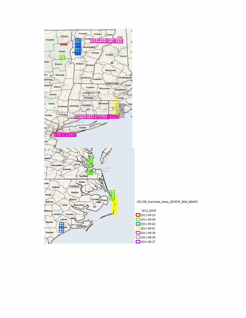
GEOEYE Acquired: August 29, 2011 http://hdds.usgs.gov/hdds2/disaster_restricted/201108_Hurricane_Irene/data/GEOEYE_NGA
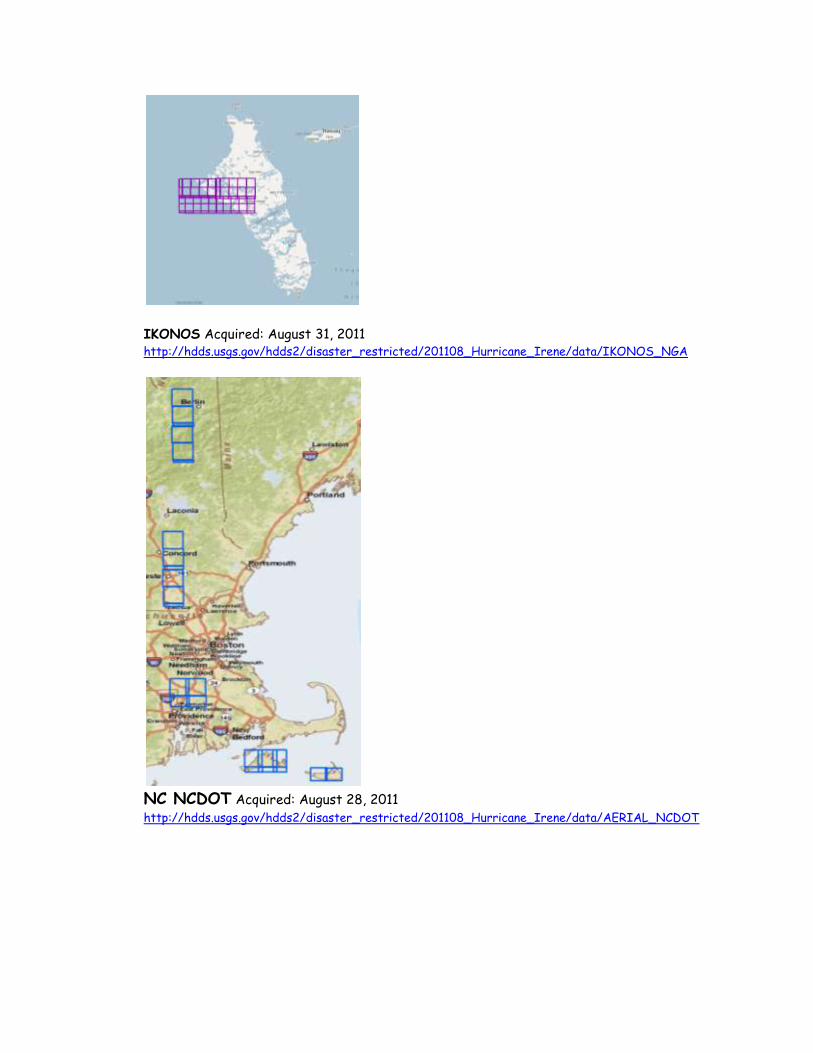
IKONOS Acquired: August 31, 2011 http://hdds.usgs.gov/hdds2/disaster_restricted/201108_Hurricane_Irene/data/IKONOS_NGA
NC NCDOT Acquired: August 28, 2011 http://hdds.usgs.gov/hdds2/disaster_restricted/201108_Hurricane_Irene/data/AERIAL_NCDOT
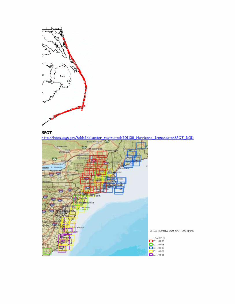
SPOT http://hdds.usgs.gov/hdds2/disaster_restricted/201108_Hurricane_Irene/data/SPOT_DOD
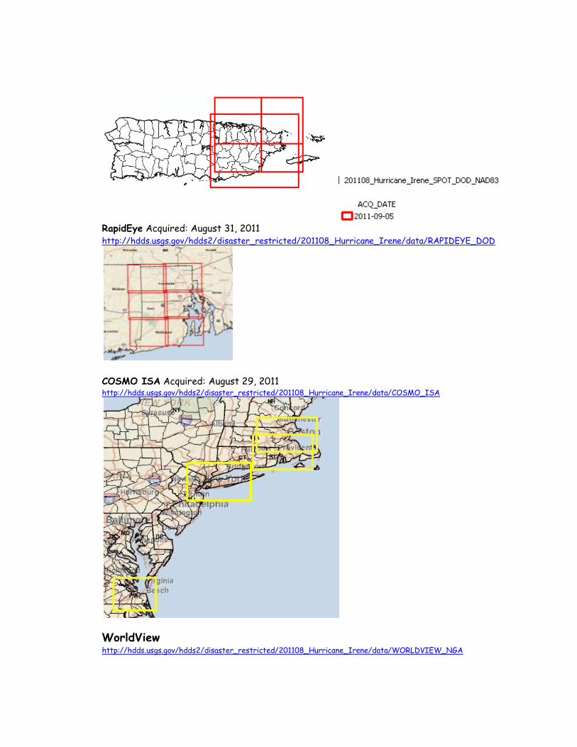
RapidEye Acquired: August 31, 2011 http://hdds.usgs.gov/hdds2/disaster_restricted/201108_Hurricane_Irene/data/RAPIDEYE_DOD
COSMO ISA Acquired: August 29, 2011 http://hdds.usgs.gov/hdds2/disaster_restricted/201108_Hurricane_Irene/data/COSMO_ISA
WorldView http://hdds.usgs.gov/hdds2/disaster_restricted/201108_Hurricane_Irene/data/WORLDVIEW_NGA
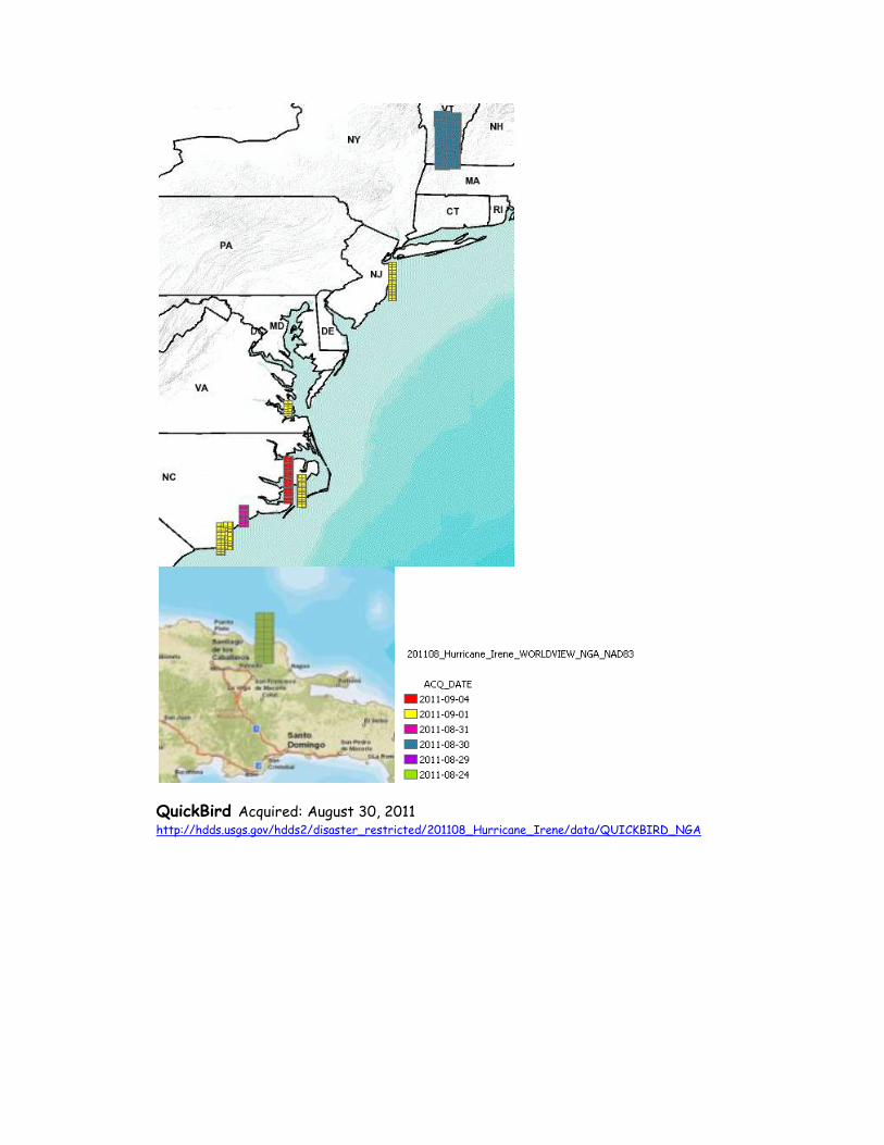
QuickBird Acquired: August 30, 2011 http://hdds.usgs.gov/hdds2/disaster_restricted/201108_Hurricane_Irene/data/QUICKBIRD_NGA
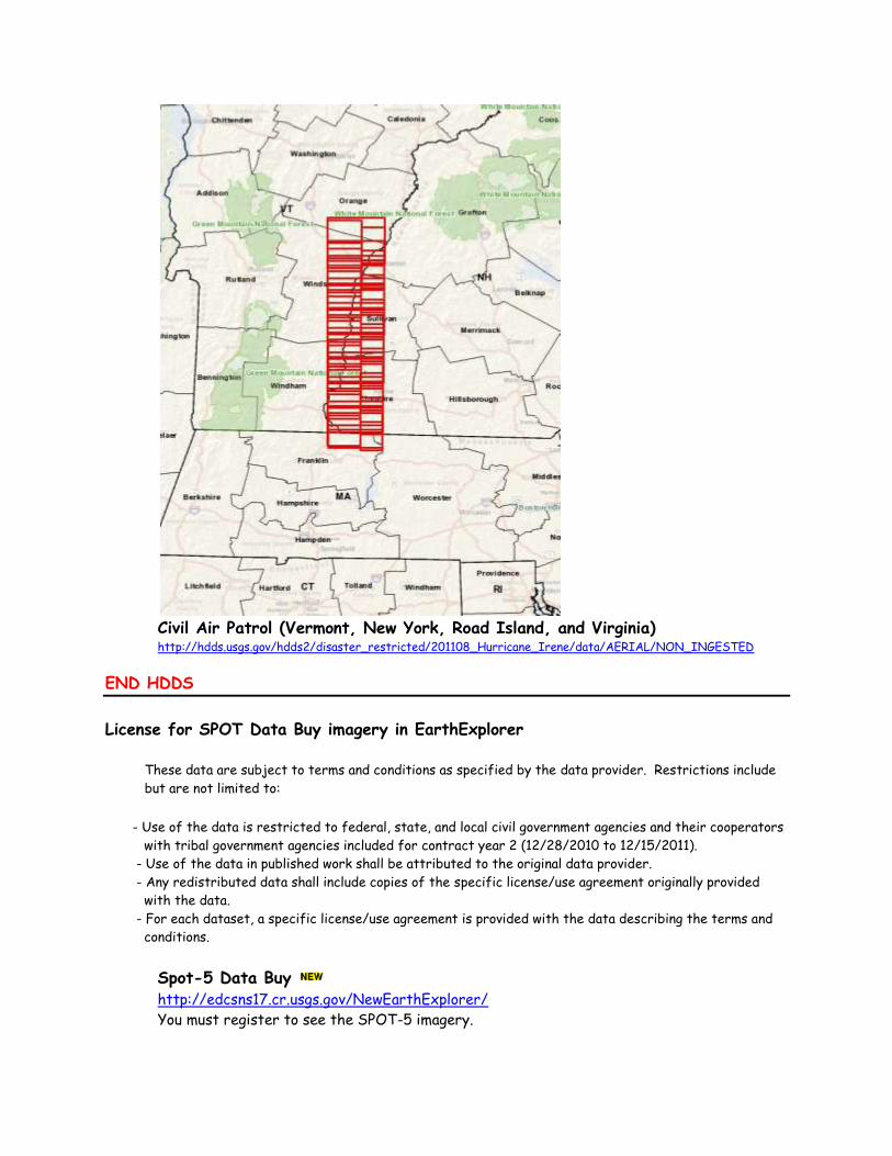
Civil Air Patrol (Vermont, New York, Road Island, and Virginia) http://hdds.usgs.gov/hdds2/disaster_restricted/201108_Hurricane_Irene/data/AERIAL/NON_INGESTED
END HDDS
License for SPOT Data Buy imagery in EarthExplorer
These data are subject to terms and conditions as specified by the data provider. Restrictions include
but are not limited to:
- Use of the data is restricted to federal, state, and local civil government agencies and their cooperators
with tribal government agencies included for contract year 2 (12/28/2010 to 12/15/2011).
- Use of the data in published work shall be attributed to the original data provider.
- Any redistributed data shall include copies of the specific license/use agreement originally provided
with the data.
- For each dataset, a specific license/use agreement is provided with the data describing the terms and
conditions.
Spot-5 Data Buy http://edcsns17.cr.usgs.gov/NewEarthExplorer/
You must register to see the SPOT-5 imagery.
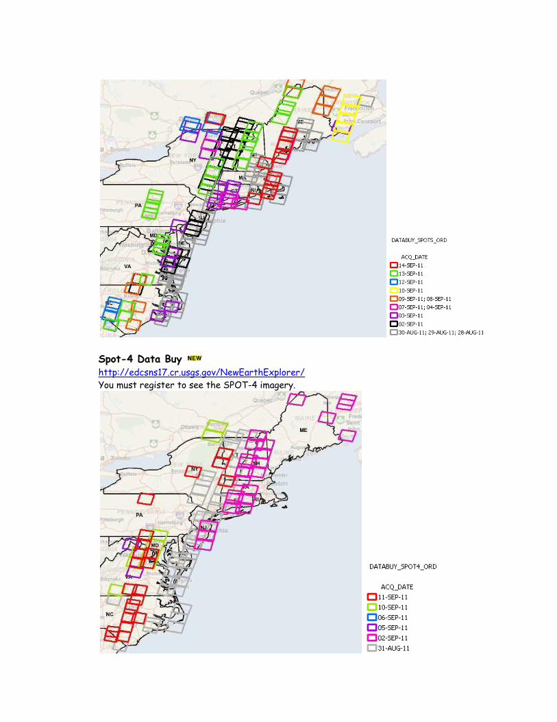
Spot-4 Data Buy http://edcsns17.cr.usgs.gov/NewEarthExplorer/
You must register to see the SPOT-4 imagery.
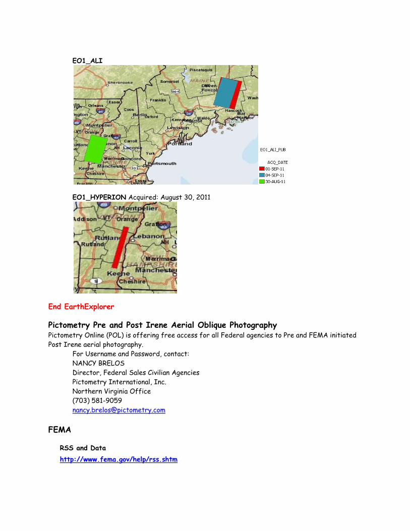
EO1_ALI
EO1_HYPERION Acquired: August 30, 2011
End EarthExplorer
Pictometry Pre and Post Irene Aerial Oblique Photography Pictometry Online (POL) is offering free access for all Federal agencies to Pre and FEMA initiated
Post Irene aerial photography.
For Username and Password, contact:
NANCY BRELOS
Director, Federal Sales Civilian Agencies
Pictometry International, Inc.
Northern Virginia Office
(703) 581-9059
FEMA
RSS and Data
http://www.fema.gov/help/rss.shtm
FEMA_GIS FEMA_GIS public group has been established on www.arcgis.com and several public web services
have been registered on the site:
DRC’s
Declared Counties
Regions/Offices
Hurricane Evacuation Routes
Planned:
Historic Designations
NASA
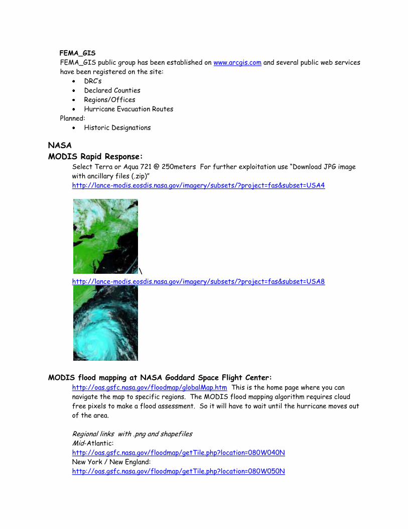
MODIS Rapid Response: Select Terra or Aqua 721 @ 250meters For further exploitation use “Download JPG image
with ancillary files (.zip)”
http://lance-modis.eosdis.nasa.gov/imagery/subsets/?project=fas&subset=USA4
\ http://lance-modis.eosdis.nasa.gov/imagery/subsets/?project=fas&subset=USA8
MODIS flood mapping at NASA Goddard Space Flight Center:
http://oas.gsfc.nasa.gov/floodmap/globalMap.htm This is the home page where you can
navigate the map to specific regions. The MODIS flood mapping algorithm requires cloud
free pixels to make a flood assessment. So it will have to wait until the hurricane moves out
of the area.
Regional links with .png and shapefiles Mid-Atlantic:
http://oas.gsfc.nasa.gov/floodmap/getTile.php?location=080W040N
New York / New England:
http://oas.gsfc.nasa.gov/floodmap/getTile.php?location=080W050N
Two very preliminary MODIS-based maps of the Irene flooding for the northeastern US are online at http://floodobservatory.colorado.edu/RapidResponse/2011UnionvilleNYRR.html and http://floodobservatory.colorado.edu/RapidResponse/2011CTValleyRR.html
Darthmouth Flood Observatory NASA-MODIS Rapid Response Record of 2011Hurricane/Tropical Storm Irene http://floodobservatory.colorado.edu/RapidResponse/2011IreneRR.html
NASA TRMM rainfall products http://trmm.gsfc.nasa.gov/
NGA Volumes 1 - 7 of the New York/New Jersey Area Urban Search and Rescue 1k Atlas are now
available on the eFTP. ( http://www.floodmaps.net/eftp/download.php ) File names:
717266845_NY_NJ_1k_USAR_Atlas_Vol_1.pdf
768655395_NY_NJ_1k_USAR_Atlas_Vol_2.pdf
864675903_NY_NJ_1k_USAR_Atlas_Vol_3.pdf
774285888_NY_NJ_1k_USAR_Atlas_Vol_4.pdf
827624511_NY_NJ_1k_USAR_Atlas_Vol_5.pdf
323489379_NY_NJ_1k_USAR_Atlas_Vol_6.pdf
242080688_NY_NJ_1k_USAR_Atlas_Vol_7.pdf
Files are also available on SMTS:
NY_NJ 1k USAR Atlas Vol 1.pdf
NY_NJ 1k USAR Atlas Vol 2.pdf
NY_NJ 1k USAR Atlas Vol 3.pdf
NY_NJ 1k USAR Atlas Vol 4.pdf
NY_NJ 1k USAR Atlas Vol 5.pdf
NY_NJ 1k USAR Atlas Vol 6.pdf
NY_NJ 1k USAR Atlas Vol 7.pdf
USGS
USGS: Coastal Change Hazards: Hurricanes and Extreme Storms http://coastal.er.usgs.gov/hurricanes/irene/coastal-change/updated-assessment.php
USGS Storm surge Sensor Deployment WEB viewer http://water.usgs.gov/osw/floods/2011_HIrene/index.html
Click on the map and you will go directly to the viewer.
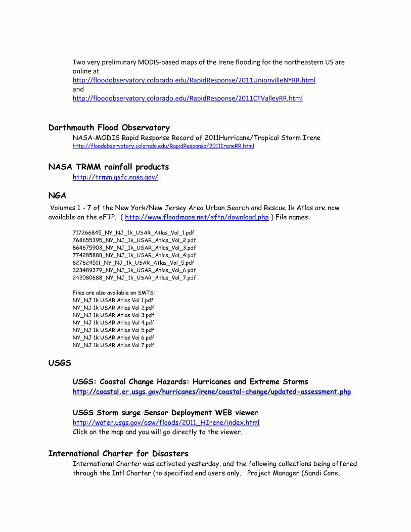
International Charter for Disasters International Charter was activated yesterday, and the following collections being offered
through the Intl Charter (to specified end users only. Project Manager (Sandi Cone,
[email protected] ). Potential International Charter collects: RSAT1 - Aug 28 RSAT2 - Aug 28, 29 ESA Envisat - 27 and 30 Aug (Chesapeake Bay, NC, SC)
DLR TerraSAR-X, DMCii, KARI and DMI
Naval Research Lab http://www.nrlmry.navy.mil/TC.html
SSMI, TMI, AMSRE, WINDSAT, AMSUB, GAC, GEO, MODIS, OLS
Tropical Cyclone Web Page http://www.nrlmry.navy.mil/tc_pages/tc_home.html
GOES Tropics http://www.nrlmry.navy.mil/tropics-bin/tropics.cgi
NOAA Current River Forecasts: (Mid-Atlantic) http://www.erh.noaa.gov/marfc/
NWS Eastern Region HQ: http://www.erh.noaa.gov/
Digital Coast: (lidar data) http://csc-s-maps-q.csc.noaa.gov/dataviewer/viewer.html
Measured Surge: http://tidesandcurrents.noaa.gov/quicklook/data/IRENE.html
Irene: http://www.noaawatch.gov/2011/tc_at09.php
National Hurricane Center: http://www.nhc.noaa.gov/
NHC GIS Data and Products http://www.nhc.noaa.gov/gis/
Weather: http://weather.gov
Latest Storm Surge Predictive Files http://www.weather.gov/mdl/psurge/download.php
Storm Surge Probabilities http://www.nhc.noaa.gov/psurgegraphics_at4.shtml?gm
Google Map Viewer: http://www.nhc.noaa.gov/psurgegraphics_at1.shtml?gm
Wind Field for North Carolina The first part of the Irene data can be found in the following link;
ftp://ftp.aoml.noaa.gov/hrd/pub/annane/irene/NC
ftp://ftp.aoml.noaa.gov/hrd/pub/annane/irene/new_NC
ftp://ftp.aoml.noaa.gov/hrd/pub/annane/irene/new_NY
ftp://ftp.aoml.noaa.gov/hrd/pub/annane/irene/new_census_data
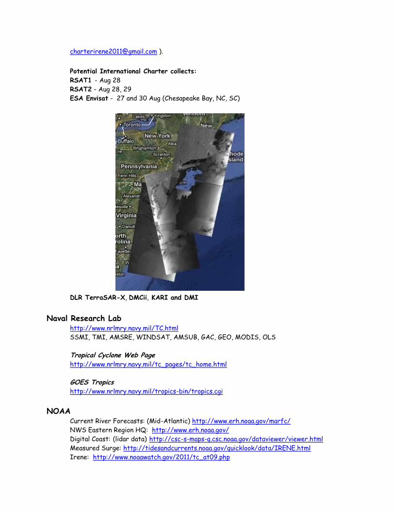
Hurricane IRENE Response Imagery Viewer:
Single tiles and zip files: http://ngs.woc.noaa.gov/storms/irene/
TMS tiles. http://ngs.woc.noaa.gov/storms/irene/mobile/
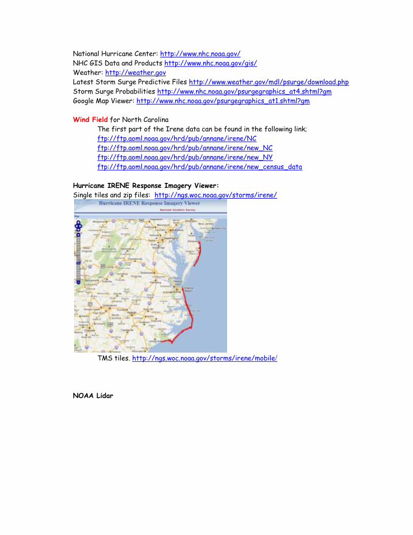
NOAA Lidar
These tiles can be accessed from the following FTP site:
ftp://ftpnos.woc.noaa.gov/outgoing/white
To access a tile, replace the X's in the following link with a tile name, and then place the link in a web
browser and click enter:
ftp://ftpnos.woc.noaa.gov/outgoing/white/20110828_XXXXXXXXXXXXXXX_las.zip
For example, place tile 305000e3837500n in as follows:
ftp://ftpnos.woc.noaa.gov/outgoing/white/20110828_305000e3837500n_las.zip
It should be note that e for easting and n for northing must be lowercase.
As the precise ephemeris becomes available, the data will be reprocessed and make it available.
Hurricanes @ USA.gov Links to state information
http://www.usa.gov/Topics/Weather/Hurricane.shtml
Google.org 2011 Hurricane Season http://crisislanding.appspot.com/
CrisisCommons http://wiki.crisiscommons.org/wiki/Hurricane_Irene
http://wiki.crisiscommons.org/wiki/Hurricane_Irene_Data_Profile
Geolocated Flood Damage & Coordination Information for VT http://vtirene.crowdmap.com/
ESRI
ESRI Public Information Disaster Map http://www.esri.com/services/disaster-response/hurricanes/latest-news-map.html
ArcGIS Hurricane Irene Viewer http://www.arcgis.com/home/webmap/viewer.html?webmap=4a9b65e79ea045ffbd1b6087674ee78b
Hurricane Irene Disaster Response
http://www.arcgis.com/home/group.html?owner=disaster_response&title=Hurricane%20Irene%20Disaster%20Res
ponse
GIS Support Resources (Live weather feeds, data, etc.) http://www.esri.com/services/disaster-response/hurricanes/resources.html
USDA Pre-Event Imagery USDA NAIP WMS: By State
NAIP ArcGIS Map Service by State : http://gis.apfo.usda.gov/ArcGIS/rest/services/
Pre-Event 1-meter NAIP Imagery from 2011 available for: SC
Pre-Event 1-meter NAIP Imagery from 2010 available for: CF, NJ, RI, VA
Pre-Event 1-meter NAIP Imagery from 2009 available for: DE, MD, NY
OR: In ArcMap: Add ArcGIS Server “Use GIS Services” “internet Server URL:
http://gis.apfo.usda.gov/arcgis/services
USDA NAIP Imagery on Geospatial Data Gateway: By County
http://datagateway.nrcs.usda.gov/
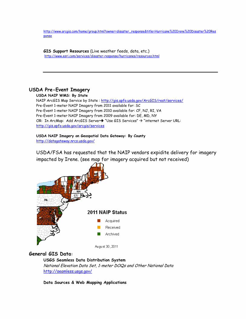
USDA/FSA has requested that the NAIP vendors expidite delivery for imagery
impacted by Irene. (see map for imagery acquired but not received)
General GIS Data:
USGS Seamless Data Distribution System
National Elevation Data Set, 1-meter DOQs and Other National Data http://seamless.usgs.gov/
Data Sources & Web Mapping Applications
http://sierrafire.cr.usgs.gov/fire_gis_webpage.htm
OGC compliant WMS Servers
http://www.skylab-mobilesystems.com/en/wms_serverlist.html
State GIS Sites: Connecticut http://mapserver.lib.uconn.edu/data/index.htme
Maine http://www.maine.gov/megis/
Maryland http://dnrweb.dnr.state.md.us/gis/data/data.asp
MEMA OSPREY http://www.mema.state.md.us/MEMA/MAP.html
Massachusetts http://www.mass.gov/mgis/
New Hampshire http://www.granit.unh.edu/
New Jersey https://njgin.state.nj.us/NJ_NJGINExplorer/index.jsp
New York http://www.nysgis.state.ny.us/ http://www.nysgis.state.ny.us/index.cfm
North Carolina http://www.nconemap.net/ 2010 Orthoimagery Rest Services:
http://imagery.nconemap.com/ArcGIS/rest/services/2010_Orthoimagery/ImageServer
NC OneMap Post-Hurricane Irene Imagery Viewer
http://data.nconemap.com/geoportal/hurricane_irene/index.html
Rhode Island http://www.edc.uri.edu/rigis/
Vermont www.vcgi.org This site is Up! VT State Climatologist: http://www.uvm.edu/~vtstclim/?Page=Irene_flooding_2011.html
Virginia http://www.virginiaplaces.org/boundaries/gisdata.html
Virginia ArcGIS Service:
Most Recent Imagery (2009/2007/2006) web service available without authentication. We are
also in the process of building a web service for the 2011 imagery we have for the NGA1
(Virginia Beach – Hampton Urban Area), which will be available in the same location.
The ArcGIS Server URL is http://gismaps.virginia.gov/arcgis2/services
The web services you would want are in the MostRecentImagery folder.
Vermont Vermont CAP Photography http://www.uvm.edu/~joneildu/irene/Imagery/30Aug11/CAP_StillImages_30Aug11.zip
Vermont Transportation Status
ftp://vtransmap.aot.state.vt.us/Maps/VTrans_data_Irene/Damage_Status_Maps/
Vermont Road Closures
http://511.vermont.gov/main.jsf
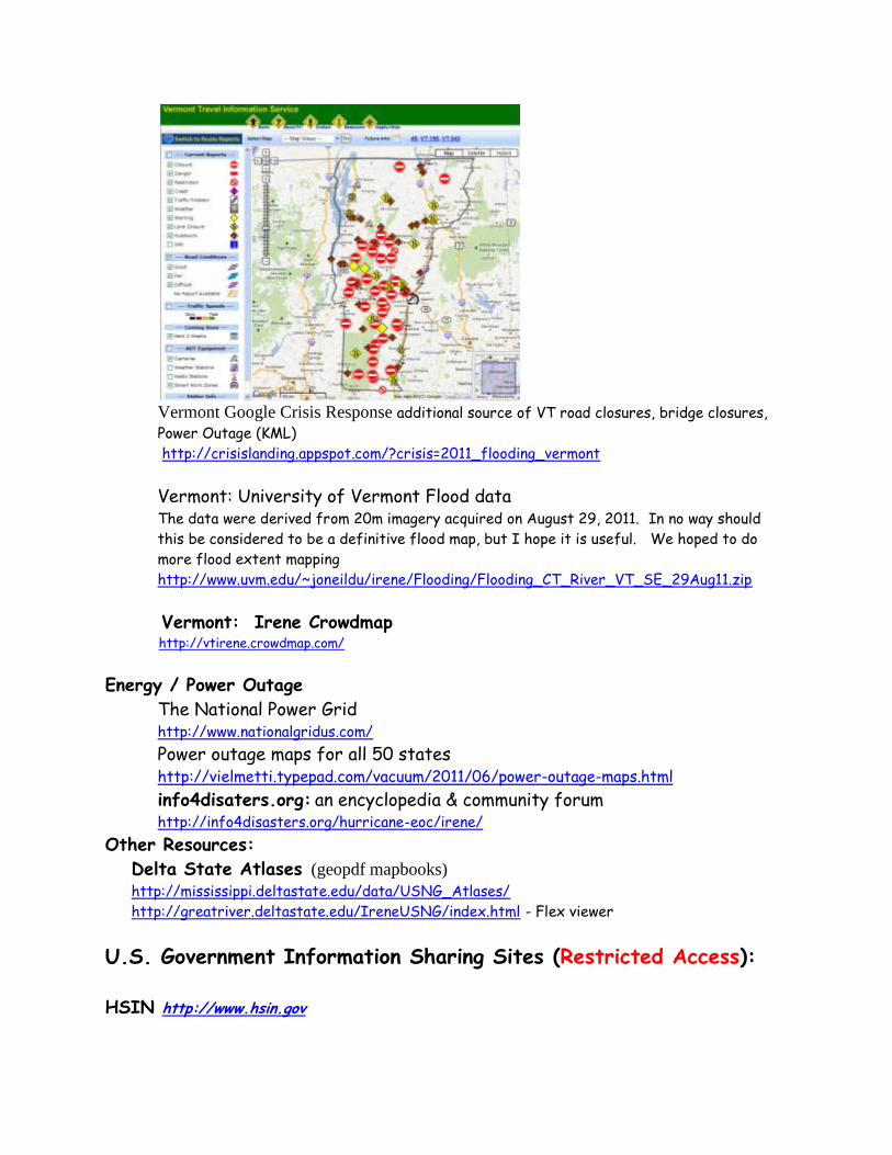
Vermont Google Crisis Response additional source of VT road closures, bridge closures,
Power Outage (KML) http://crisislanding.appspot.com/?crisis=2011_flooding_vermont
Vermont: University of Vermont Flood data The data were derived from 20m imagery acquired on August 29, 2011. In no way should
this be considered to be a definitive flood map, but I hope it is useful. We hoped to do
more flood extent mapping
http://www.uvm.edu/~joneildu/irene/Flooding/Flooding_CT_River_VT_SE_29Aug11.zip
Vermont: Irene Crowdmap http://vtirene.crowdmap.com/
Energy / Power Outage
The National Power Grid http://www.nationalgridus.com/
Power outage maps for all 50 states http://vielmetti.typepad.com/vacuum/2011/06/power-outage-maps.html
info4disaters.org: an encyclopedia & community forum http://info4disasters.org/hurricane-eoc/irene/
Other Resources:
Delta State Atlases (geopdf mapbooks) http://mississippi.deltastate.edu/data/USNG_Atlases/
http://greatriver.deltastate.edu/IreneUSNG/index.html - Flex viewer
U.S. Government Information Sharing Sites (Restricted Access):
HSIN http://www.hsin.gov
Emergency Management: Hurricane Irene https://government.hsin.gov/sites/EmergencyManagement/SysSupport.aspx Federal Operations: Hurricane Irene https://government.hsin.gov/sites/FedOperations/DocMgmt.aspx
IRSCC https://government.hsin.gov/sites/EmergencyManagement/IRSCC/default.aspx
IRSCC GeoSpace https://government.hsin.gov/sites/EmergencyManagement/IRSCC/SitAware.aspx
To request access to the IRSCC Portal, please contact the IRSCC Executive Secretariat
Intelink-U Damage, Debris, and Flooding Shapefiles
Maps: Power and Cellular Outages
https://www.intelink.gov/wiki/Hurricane_Irene_2011
Maps Under DMIGS; IRSCC reports
https://www.intelink.gov/inteldocs/browse.php?fFolderId=263031
NGA Source Americas/Hurricane-Tropical Storm Situational Report (Imagery Tasking) https://www.intelink.gov/wiki/NGA_Source_Americas/Hurricane-Tropical_Storm_Situational_Report
Civil Air Patrol
https://missions.cap.af.mil/wmirs
Products and Resources from Federal/State/Local/Private: 8/25/2011 FEMA
IMAT White Team Geospatial Unit
Location: VA EOC (Richmond)
POC: Eric Soucie ([email protected])
Region X Support to Region III
Location: MEMA (Reisterstown, MD)
POC: John Edwards ([email protected])
HIFLD Working Group
HSIP Gold/Freedom (Presidentially Declared Disaster)
www.hifldwg.org
POC: Jason Barnett ([email protected])

DHS
Critical Infrastructure/Key Resources (CIKR) Maps
Joe Ricks ([email protected]) (Richmond PSA)
Mark Milicich ([email protected]) (Norfolk PSA)
Matt Wombacher ([email protected]) (National Capital Region PSA)
Sean Mcaraw ( [email protected]) (National Capital Region PSA)
Ray Hanna ([email protected]) (Maryland PSA)
Ken Greeson ([email protected]) (Delaware PSA)
Folks here is a resource list as compiled from our RISG GIS Pre Event Call. We will try to
update this list after each call. Big thanks to Jason Barnett for compiling this list from his
notes.
Virginia
Virginia Dept. of Emergency Management (VDEM):
POC: [email protected]
Storm Surge Road Maps (CAT 1-4) by county
Currently Identifying Hazards data: Wind, Rain, Storm Surge then will assess risk.
County of Fairfax
POC: Mike Liddle ([email protected])
Dam Inundation Maps
County of Henrico
POC: Juston Manville ([email protected])
Web Mapping Application (Web Services available?)
Maryland
POC: Mick Brierly ([email protected])
MEMA OSPREY http://www.mema.state.md.us/MEMA/MAP.html
Pushing hurricane specific data to our publicly facing OSPREY application on MEMA website.
City of Laurel
Laurel Flex Application
POC: Sandi Cone ([email protected])
Send comments, additions, and corrections to:
Glenn Bethel, USDA Remote Sensing Advisor
[email protected] (202)720-1280
http://edcftp.cr.usgs.gov/pub/data/disaster/201108_Hurricane_Irene/docs_misc/Data_Sources/