Hazardous Materials/Wastes Technical Report · Hazardous Materials/Wastes Technical Report ... PCB...
73
DRAFT Hazardous Materials/Wastes Technical Report Merced to Fresno Section Project EIR/EIS August 2011 Sacramento Stockton Downtown Modesto Downtown Merced San Francisco Transbay Terminal Fresno Kings/Tulare Regional Station (Potential Station) Gilroy San Jose Diridon Redwood City or Palo Alto Millbrae-SFO Bakersfield Palmdale Sylmar Ontario Airport Burbank Norwalk Riverside Murrieta Escondido University City San Diego Industry Los Angeles Anaheim Project Environmental Impact Report / Environmental Impact Statement
Transcript of Hazardous Materials/Wastes Technical Report · Hazardous Materials/Wastes Technical Report ... PCB...

DRAFTHazardous
Materials/Wastes Technical Report
Merced to Fresno Section Project EIR/EIS
August 2011
Sacramento
Stockton
Downtown Modesto
Downtown Merced
San Francisco Transbay Terminal
Fresno
Kings/Tulare Regional Station(Potential Station)
Gilroy
San Jose Diridon Redwood City
or Palo Alto
Millbrae-SFO
Bakersfield
Palmdale
Sylmar
Ontario Airport Burbank
Norwalk Riverside
Murrieta
Escondido
University City
San Diego
IndustryLos Angeles
Anaheim
Project Environmental Impact Report /Environmental Impact Statement

CALIFORNIA HIGH-SPEED TRAIN PROJECT EIR/EIS
DRAFT TECHNICAL REPORT
Merced to Fresno Section Hazardous Materials/Wastes
Prepared by:
AECOM CH2M HILL
Parus Consulting, Inc.
August 2011

California High-Speed Rail Authority and Federal Railroad Administration. 2011. Merced to Fresno Section Hazardous Materials/Wastes Technical Report, California High-Speed Train Draft Project EIR/EIS. Sacramento, CA, and Washington, DC. Prepared by AECOM, CH2M HILL, and Parus Consulting. August 2011.

CALIFORNIA HIGH-SPEED TRAIN PROJECT EIR/EIS HAZARDOUS MATERIALS/WASTES MERCED TO FRESNO SECTION TECHNICAL REPORT
Page iii
Table of Contents List of Abbreviated Terms .............................................................................................. v 1.0 Introduction..................................................................................................... 1-1
1.1 Purpose and Methods ................................................................................ 1-3 1.1.1 Purpose ........................................................................................ 1-3 1.1.2 Limitations and Exceptions ............................................................. 1-3
2.0 Project Description .......................................................................................... 2-1 2.1 No Project Alternative ................................................................................ 2-1 2.2 High-Speed Train Alternatives ..................................................................... 2-1
2.2.1 UPRR/SR 99 Alternative .................................................................. 2-1 2.2.2 BNSF Alternative ............................................................................ 2-5 2.2.3 Hybrid Alternative .......................................................................... 2-7 2.2.4 Heavy Maintenance Facility Alternatives ........................................... 2-8
3.0 Laws, Regulations, and Orders ........................................................................ 3-1 3.1 Federal ..................................................................................................... 3-1 3.2 State ........................................................................................................ 3-2 3.3 Local Jurisdiction Plans and Policies ............................................................. 3-2
3.3.1 Certified Unified Program Agencies .................................................. 3-2 3.3.2 Merced County .............................................................................. 3-3 3.3.3 City of Merced ............................................................................... 3-3 3.3.4 Madera County .............................................................................. 3-3 3.3.5 City of Chowchilla .......................................................................... 3-4 3.3.6 City of Madera ............................................................................... 3-4 3.3.7 Fresno County ............................................................................... 3-4 3.3.8 City of Fresno ................................................................................ 3-4
4.0 Records Review and Site Reconnaissance Study Area and Methodology ....... 4-1 4.1 Study Area ................................................................................................ 4-1 4.2 Materials under Consideration ..................................................................... 4-1
4.2.1 Petroleum Hydrocarbons ................................................................ 4-1 4.2.2 Asbestos ....................................................................................... 4-1 4.2.3 Lead ............................................................................................. 4-2 4.2.4 Equipment Containing Polychlorinated Biphenyls .............................. 4-2 4.2.5 Common Roadway, Railway, and Utility Corridor Contaminants .......... 4-2 4.2.6 Contaminants Associated with Agricultural Operations ....................... 4-2
4.3 Study Methodology .................................................................................... 4-2 4.3.1 Defining Sites of Environmental Concern .......................................... 4-3 4.3.2 Records Review ............................................................................. 4-9 4.3.3 Historical Topographic Maps and Aerial Photographs ......................... 4-9 4.3.4 Site Reconnaissance ..................................................................... 4-10
5.0 Results of Analysis ........................................................................................... 5-1 5.1 General Site Conditions .............................................................................. 5-1
5.1.1 Geology, Hydrogeology, Topography, Surface Water, Groundwater .... 5-2 5.1.2 Proximity to Schools ....................................................................... 5-3
5.2 Potential Environmental Concerns ............................................................... 5-4 5.2.1 UPRR/SR 99 Alternative .................................................................. 5-4 5.2.2 BNSF Alternative ........................................................................... 5-11 5.2.3 Hybrid Alternative ......................................................................... 5-12 5.2.4 Heavy Maintenance Facility ............................................................ 5-12
6.0 Environmental Consequences ......................................................................... 6-1 6.1 Evaluation of Impacts ................................................................................ 6-1
6.1.1 Methods for Evaluating Effects under NEPA ...................................... 6-1 6.1.2 CEQA Significance Criteria .............................................................. 6-2
6.2 No Project Alternative ................................................................................ 6-2 6.3 High-Speed Train Alternatives ..................................................................... 6-2

CALIFORNIA HIGH-SPEED TRAIN PROJECT EIR/EIS HAZARDOUS MATERIALS/WASTES MERCED TO FRESNO SECTION TECHNICAL REPORT
Page iv
6.3.1 Construction Period Impacts ........................................................... 6-3 6.3.2 Project Impacts ............................................................................. 6-8
6.4 Mitigation Measures .................................................................................. 6-10 6.5 NEPA Impacts Summary ........................................................................... 6-10 6.6 CEQA Significance Conclusions .................................................................. 6-10
7.0 Additional Considerations ................................................................................ 7-1 7.1 Opinion .................................................................................................... 7-1 7.2 Data Gaps ................................................................................................. 7-1 7.3 Conclusions and Deviations ........................................................................ 7-1
7.3.1 Conclusions ................................................................................... 7-1 7.3.2 Deviations ..................................................................................... 7-1
8.0 References ....................................................................................................... 8-1 8.1 Literature Reviewed ................................................................................... 8-1 8.2 Persons and Agencies Consulted ................................................................. 8-3
9.0 Preparer Qualifications and Professional Statement ...................................... 9-1 9.1 Preparer Qualifications ............................................................................... 9-1 9.2 Professional Statement .............................................................................. 9-1
Appendices
A EDR Environmental Atlas Report and EDR Environmental Corridor Report
B EDR Topographic Map Series
C Historical Aerial Photography
Tables
4-1 USGS Topographic Maps Reviewed ......................................................................... 4-9 5-1 Schools Within 0.25 Mile of Construction Footprint ................................................... 5-3 5-2 PECs Common to the UPRR/SR 99 Alternative, the BNSF Alternative, and the
Hybrid Alternative ................................................................................................. 5-4 5-3 PECs Unique to the UPRR/SR 99 Alternative ............................................................ 5-9 5-4 Historical and Conceivable PECs Unique to the BNSF Alternative ............................... 5-11 5-5 Summary of Contamination, Remedial Actions, and Status of the Castle Airport
Superfund Site Issues within the Castle Commerce Center HMF Study Area .............. 5-14 5-6 Historical, Conceivable, and Current PECs in the Castle Commerce Center HMF Site
Study Area .......................................................................................................... 5-15 6-1 PEC Sites Potentially Affected by UPRR/SR 99 Alternative and Nearby Schools ............ 6-5 6-2 PEC Sites Potentially Affected by BNSF Alternative and Nearby Schools ...................... 6-6 6-3 PEC Sites Potentially Affected by the Hybrid Alternative and Nearby Schools .............. 6-7 6-4 Summary of Potentially Significant Utility Impacts and Mitigation Measures ............... 6-11
Figures
1-1 California HST System ........................................................................................... 1-2 2-1 Merced to Fresno Section HST Alternatives ............................................................. 2-2 2-2a and b Ave 24 Wye and Chowchilla Design Options .................................................... 2-4 4-1 Potential Environmental Concerns in the Merced Project Vicinity ................................ 4-5 4-2 Potential Environmental Concerns in the Chowchilla Project Vicinity ........................... 4-6 4-3 Potential Environmental Concerns in the Madera Project Vicinity ................................ 4-7 4-4 Potential Environmental Concerns in the Fresno Project Vicinity ................................. 4-8

CALIFORNIA HIGH-SPEED TRAIN PROJECT EIR/EIS HAZARDOUS MATERIALS/WASTES MERCED TO FRESNO SECTION TECHNICAL REPORT
Page v
List of Abbreviated Terms ACM asbestos-containing material
AST aboveground storage tank
ASTM American Society for Testing and Materials International
Authority California High-Speed Rail Authority
B84 Building 84
Bay Area San Francisco Bay Area
Bay Area to Central Valley Program EIR/EIS
Bay Area to Central Valley High-Speed Train (HST) Final Program Environmental Impact Report/Environmental Impact Statement (EIR/EIS)
BMP best management practice
BTEX benzene, toluene, ethylbenzene, and xylene
AFB Air Force Base
CalEPA California Environmental Protection Agency
Caltrans California Department of Transportation
CEQA California Environmental Quality Act
CERCLA Comprehensive Environmental Response, Compensation, and Liability Act
CFR Code of Federal Regulations
Cortese List California Government Code Section 65962.5 hazardous waste and substances sites list
CUPA Certified Unified Program Agency
DA-4 Discharge Area 4
DTSC California Department of Toxic Substances Control
EDR Environmental Data Resources, Inc.
EIR Environmental Impact Report
EIS Environmental Impact Statement
EPA U.S. Environmental Protection Agency
FRA Federal Railroad Administration
HMF heavy maintenance facility
HST high-speed train
LUST leaking underground storage tank

CALIFORNIA HIGH-SPEED TRAIN PROJECT EIR/EIS HAZARDOUS MATERIALS/WASTES MERCED TO FRESNO SECTION TECHNICAL REPORT
Page vi
mph miles per hour
MTBE methyl tertiary butyl ether
NAPP National Aerial Photography Program
NEPA National Environmental Policy Act
NPL National Priorities List
Parus Parus Consulting, Inc.
PCB polychlorinated biphenyl
PEC Potential Environmental Concern
PG&E Pacific Gas & Electric
Proposition 65 Safe Drinking Water and Toxic Enforcement Act
RCRA Resource Conservation and Recovery Act
RTP regional transportation plan
RWQCB Regional Water Quality Control Board
SLIC Spills, Leaks, Investigations and Cleanup Program
SPCC Spill Prevention, Control, and Countermeasures
SR State Route
Statewide Program EIR/EIS
Final Program Environmental Impact Report/Environmental Impact Statement (EIR/EIS) for the Proposed California High-Speed Train (HST) System
SVOC semivolatile organic compound
SWRCB State Water Resources Control Board
TCE trichloroethylene
USC United States Code
USGS U.S. Geological Survey
UST underground storage tank
VOC volatile organic compound

CALIFORNIA HIGH-SPEED TRAIN PROJECT EIR/EIS HAZARDOUS MATERIALS/WASTES MERCED TO FRESNO SECTION TECHNICAL REPORT
Page 1-1
1.0 Introduction The California HST System, as shown in Figure 1-1, is planned to provide intercity, high-speed service on more than 800 miles of guideway throughout California, connecting the major population centers of Sacramento, the San Francisco Bay Area, the Central Valley, Los Angeles, the Inland Empire, Orange County, and San Diego. The HST System is envisioned as a state-of-the-art, electrically powered, high-speed, steel-wheel-on-steel-rail technology, which will include contemporary safety, signaling, and automated train-control systems. The trains will be capable of operating at speeds of up to 220 miles per hour (mph) over a fully grade-separated, dedicated guideway alignment.
Two phases of the California HST System are planned. Phase 1 will connect San Francisco to Los Angeles via the Pacheco Pass and the Central Valley. An expected express trip time between San Francisco and Los Angeles is mandated to be 2 hours and 40 minutes or less. Phase 2 will connect the Central Valley to the state’s capital, Sacramento, and will extend the system from Los Angeles to San Diego.
The California HST System will be planned, designed, constructed, and operated under the direction of the California High-Speed Rail Authority (Authority), a state governing board formed in 1996. The Authority’s statutory mandate is to develop a high-speed rail system that is coordinated with the state’s existing transportation network, which includes intercity rail and bus lines, regional commuter rail lines, urban rail and bus transit lines, highways, and airports.
The Merced to Fresno HST Section is a critical Phase 1 link connecting the Bay Area HST sections to the Fresno to Bakersfield, Bakersfield to Palmdale, and Palmdale to Los Angeles HST sections. The Merced to Fresno Section HST alternatives originated in two program documents. The Final Program Environmental Impact Report/Environmental Impact Statement (EIR/EIS) for the Proposed California High-Speed Train (HST) System (Statewide Program EIR/EIS) (Authority and Federal Railroad Administration [FRA] 2005) evaluates the ability of an HST System to meet the existing and future capacity demands on California’s intercity transportation network. The Bay Area to Central Valley High-Speed Train (HST) Final Program Environmental Impact Report/Environmental Impact Statement (EIR/EIS) (Bay Area to Central Valley Program EIR/EIS) (Authority and FRA 2008) identifies a preferred alignment for the San Francisco Bay Area (Bay Area) to the Central Valley sections of the HST System.
For each of the environmental resources evaluated for this project, analysts defined the study areas to be surveyed for existing conditions and to be analyzed for impacts. These study areas are defined with the following basic parameters:
The potential area of disturbance or construction footprint, encompassing the required right-of-way, as described in Section 2, Project Description, and areas required for construction including staging areas and temporary construction easements. The construction footprint is common to all resource areas.
A resource-specific buffer for evaluation of indirect impacts. The buffer varies by resource area.
This technical report describes the affected environment associated with hazardous materials and wastes, the impacts related to hazardous materials and wastes that might result from implementation of the Merced to Fresno Section of the HST project, and the mitigation measures that would reduce these impacts. This report has been designed to meet the requirements for subsequent analysis set forth in the Statewide Program EIR/EIS prepared for the project.
Section 1 of this report describes the report’s purpose, limitations, and exceptions. Section 2 provides a project description. Section 3 includes the federal, state, and local laws, regulations, and orders that pertain to hazardous materials and wastes in the study area. Section 4 defines the study area, identifies the hazardous materials and wastes covered in this report, and details the study methods.
Definition of HST System The system that includes the HST guideways, structures, stations, traction powered substations, and maintenance facilities and train vehicles able to travel 220 mph.

CALIFORNIA HIGH-SPEED TRAIN PROJECT EIR/EIS HAZARDOUS MATERIALS/WASTES MERCED TO FRESNO SECTION TECHNICAL REPORT
Page 1-2
Figure 1-1 California HST System

CALIFORNIA HIGH-SPEED TRAIN PROJECT EIR/EIS HAZARDOUS MATERIALS/WASTES MERCED TO FRESNO SECTION TECHNICAL REPORT
Page 1-3
Section 5 provides the results of the analysis and Section 6 discusses the environmental effects on hazardous materials/wastes as a result of the HST project. Section 8 lists the references cited in this report. Section 9 describes the qualifications of the preparers and provides a statement of qualifications.
For the purposes of this report, Potential Environmental Concerns (PECs) are defined consistent with the American Society for Testing and Materials International (ASTM) Standard E 1528-06 (ASTM 2006) and the Initial Site Assessment Guidance Document (California Department of Transportation [Caltrans] 2006). Sites have been identified as PECs where there is:
[The] possible presence of any hazardous substances or petroleum products on a property under conditions that indicate the possibility of an existing release, a past release, or a threat of a release of any hazardous substances or petroleum products into structures on the property or into the ground, ground water, or surface water of the property (ASTM 2006).
This assessment relied upon a review of government records and historical data, and site reconnaissance to identify PECs within the area potentially affected by the project.
1.1 Purpose and Methods
1.1.1 Purpose
The goal of this technical report is to assess potential project-level hazards and hazardous materials impacts as defined by the significance criteria of the California Environmental Quality Act (CEQA) Guidelines, Appendix G, Section VII, Hazards and Hazardous Materials. This evaluation is not intended to be used as a due diligence assessment for property transfer. Detailed hazardous materials assessments of individual parcels potentially subject to property transfer or acquisition would occur after completion of the National Environmental Policy Act (NEPA) and CEQA environmental review process, as part of final design and project implementation.
1.1.2 Limitations and Exceptions
The analysts reviewed only readily available previous environmental studies and historical sources for the study area. Therefore, the results of this study do not constitute a complete and comprehensive compilation of all available information for the study area. Observations of the study area were conducted from public rights-of-way because of the size of the study area, the current uses of the study area, and the limited access to privately owned parcels. Sanborn Fire Insurance Maps were not reviewed.
This report is based on the application of scientific principles and the use of professional judgment to ascertain facts, with resultant subjective interpretations. Professional judgments expressed herein are based on the facts currently available within the limits of the existing data, scope of work, budget, and schedule. The information provided in this report is not to be construed as legal advice.

CALIFORNIA HIGH-SPEED TRAIN PROJECT EIR/EIS HAZARDOUS MATERIALS/WASTES MERCED TO FRESNO SECTION TECHNICAL REPORT
Page 2-1
2.0 Project Description The purpose of the Merced to Fresno Section of the HST project is to implement the California HST System between Merced and Fresno, providing the public with electric-powered high-speed rail service that provides predictable and consistent travel times between major urban centers and connectivity to airports, mass transit systems, and the highway network in the south San Joaquin Valley, and to connect the northern and southern portions of the HST System. The approximately 65-mile-long corridor between Merced and Fresno is an essential part of the statewide HST System. The Merced to Fresno Section is the location where the HST would intersect and connect with the Bay Area and Sacramento branches of the HST System; it would provide a potential location for the heavy maintenance facility (HMF) where the HSTs would be assembled and maintained, as well as a test track for the trains; it would also provide Merced and Fresno access to a new transportation mode and would contribute to increased mobility throughout California.
2.1 No Project Alternative
The No Project Alternative refers to the projected growth planned for the region through the 2035 time horizon without the HST project and serves as a basis of comparison for environmental analysis of the HST build alternatives. The No Project Alternative includes planned improvements to the highway, aviation, conventional passenger rail, and freight rail systems in the Merced to Fresno project area. There are many environmental impacts that would result under the No Project Alternative.
2.2 High-Speed Train Alternatives
As shown in Figure 2-1, there are three HST alignment alternatives proposed for the Merced to Fresno Section of the HST System: the UPRR/SR 99 Alternative, which would primarily parallel the UPRR railway; the BNSF Alternative, which would parallel the BNSF railway for a portion of the distance between Merced and Fresno; and the Hybrid Alternative, which combines features of the UPRR/SR 99 and BNSF alternatives. In addition, there is an HST station proposed for both the City of Merced and the City of Fresno, there is a wye connection (see text box on page 2-3) west to the Bay Area, and there are five potential sites for a proposed HMF.
2.2.1 UPRR/SR 99 Alternative
This section describes the UPRR/SR 99 Alternative, including the Chowchilla design options, wyes, and HST stations.
2.2.1.1 North-South Alignment
The north-south alignment of the UPRR/SR 99 Alternative would begin at the HST station in Downtown Merced, located on the west side of the UPRR right-of-way. South of the station and leaving Downtown Merced, the alternative would be at-grade and cross under SR 99. Approaching the City of Chowchilla, the UPRR/SR 99 Alternative has two design options: the East Chowchilla design option, which would pass Chowchilla on the east side of town, and the West Chowchilla design option, which would pass Chowchilla 3 to 4 miles west of the city before turning back to rejoin the UPRR/SR 99 transportation corridor. These design options would take the following routes:
East Chowchilla design option: This design option would transition from the west side of the UPRR/SR 99 corridor to an elevated structure as it crosses the UPRR railway and N Chowchilla Boulevard just north of Avenue 27, continuing on an elevated structure away from the UPRR corridor along the west side of and parallel to SR 99 to cross Berenda Slough. Toward the south side of Chowchilla, this design option would cross over SR 99 north of the SR 99/SR 152 interchange near

CALIFORNIA HIGH-SPEED TRAIN PROJECT EIR/EIS HAZARDOUS MATERIALS/WASTES MERCED TO FRESNO SECTION TECHNICAL REPORT
Page 2-2
Figure 2-1 Merced to Fresno Section
HST Alternatives

CALIFORNIA HIGH-SPEED TRAIN PROJECT EIR/EIS HAZARDOUS MATERIALS/WASTES MERCED TO FRESNO SECTION TECHNICAL REPORT
Page 2-3
Avenue 23½ south of Chowchilla. Continuing south on the east side of SR 99 and the UPRR corridor, this design option would remain elevated for 7.1 miles through the communities of Fairmead and Berenda until reaching the Dry Creek Crossing. The East Chowchilla design option connects to the HST sections to the west via either the Ave 24 or Ave 21 wyes (described below).
West Chowchilla design option: This design option would travel due south from Sandy Mush Road north of Chowchilla, following the west side of Road 11¾. The alignment would turn southeast toward the UPRR/SR 99 corridor south of Chowchilla. The West Chowchilla design option would cross over the UPRR and SR 99 east of the Fairmead city limits to again parallel the UPRR/SR 99 corridor. The West Chowchilla design option would result in a net decrease of approximately 13 miles of track for the HST System compared to the East Chowchilla design option and would remain outside the limits of the City of Chowchilla. The West Chowchilla design option connects to the HST sections to the west via the Ave 24 Wye, but not the Ave 21 Wye.
The UPRR/SR 99 Alternative would continue toward Madera along the east side of the UPRR south of Dry Creek and remain on an elevated profile for 8.9 miles through Madera. After crossing over Cottonwood Creek and Avenue 12, the HST alignment would transition to an at-grade profile and continue to be at-grade until north of the San Joaquin River. After the alternative crosses the San Joaquin River, it would rise over the UPRR railway on an elevated guideway, supported by straddle bents, before crossing over the existing Herndon Avenue and again descending into an at-grade profile and continuing west of and parallel to the UPRR right-of-way. After elevating to cross the UPRR railway on the southern bank of the San Joaquin River, south of Herndon Avenue, the alternative would transition from an elevated to an at-grade profile. Traveling south from Golden State Boulevard at-grade, the alternative would cross under the reconstructed Ashlan Avenue and Clinton Avenue overhead structures. Advancing south from Clinton Avenue between Clinton Avenue and Belmont Avenue, the HST guideway would run at-grade adjacent to the western boundary of the UPRR right-of-way and then enter the HST station in Downtown Fresno. The HST guideway would descend in a retained-cut to pass under the San Joaquin Valley Railroad spur line and SR 180, transition back to at-grade before Stanislaus Street, and continue to be at-grade into the station. As part of a station design option, Tulare Street would become either an overpass or undercrossing at the station.
2.2.1.2 Wye Design Options
The following text describes the wye connection from the San Jose to Merced Section to the Merced to Fresno Section. There are two variations of the Ave 24 Wye for the UPRR/SR 99 Alternative because of the West Chowchilla design option. The Ave 21 Wye does not connect to the West Chowchilla design option and therefore does not have a variation.
Ave 24 Wye
The Ave 24 Wye design option would travel along the south side of eastbound Avenue 24 toward the UPRR/SR 99 Alternative and would begin diverging onto two sets of tracks west of Road 11 and west of the City of Chowchilla. Under the East Chowchilla design option, the northbound set of tracks would travel northeast across Road 12, joining the UPRR/SR 99 north-south alignment on the west side of the UPRR right-of-way just north of Sandy Mush Road. Under the West Chowchilla design option, the northbound set of tracks would travel northeast across Road 12 and would join the UPRR/SR 99 north-south alignment just south of Avenue 26. The southbound HST guideway would continue east along Avenue 24, turning south near SR 233 southeast of Chowchilla, crossing SR 99 and the UPRR railway to connect to the UPRR/SR 99 Alternative north-south alignment on the east
What is a “Wye”? The word “wye” refers to the “Y”-like formation that is created where train tracks branch off the mainline to continue in different directions. The transition to a wye requires splitting two tracks into four tracks that cross over one another before the wye “legs” can diverge in opposite directions to allow bidirectional travel. For the Merced to Fresno Section of the HST System, the two tracks traveling east-west from the San Jose to Merced Section must become four tracks—a set of two tracks branching to the north and a set of two tracks branching to the south.

CALIFORNIA HIGH-SPEED TRAIN PROJECT EIR/EIS HAZARDOUS MATERIALS/WASTES MERCED TO FRESNO SECTION TECHNICAL REPORT
Page 2-4
side of the UPRR near Avenue 21½. Under the West Chowchilla design option, the southbound tracks would turn south near Road 16 south of Chowchilla, crossing SR 99 and the UPRR to connect to the UPRR/SR 99 north-south alignment on the east side of the UPRR adjacent to the city limits of Fairmead.
Figure 2-2a shows the wye alignment for the East Chowchilla design option and Figure 2-2b shows the alignment for the West Chowchilla design option. Together, the figures illustrate the difference in the wye triangle formation for each design option connection. The north-south alignment of the West Chowchilla design option between Merced and Fresno diverges along Avenue 24 onto Road 12, on the north branch of the wye, allowing the HST alternative to avoid traveling through Chowchilla and to avoid constraining the city within the wye triangle.
Ave 21 Wye
The Ave 21 Wye would travel along the north side of Avenue 21. Just west of Road 16, the HST tracks would diverge north and south to connect to the UPRR/SR 99 Alternative, with the north leg of the wye joining the north-south alignment at Avenue 23½ and the south leg at Avenue 19½.
2.2.1.3 HST Stations
The Downtown Merced and Downtown Fresno station areas would each occupy several blocks, to include station plazas, drop-offs, a multimodal transit center, and parking structures. The areas would include the station platform and associated building and access structure, as well as lengths of platform tracks to accommodate local and express service at the stations. As currently proposed, both the Downtown Merced and Downtown Fresno stations would be at-grade, including all trackway and platforms, passenger services and concessions, and back-of-house functions.
Downtown Merced Station
The Downtown Merced Station would be between Martin Luther King Jr. Way to the northwest and G Street to the southeast. The station would be accessible from both sides of the UPRR, but the primary station house would front 16th Street. The major access points from SR 99 include V Street, R Street, Martin Luther King Jr. Way, and G Street. Primary access to the parking facility would be from West 15th Street and West 14th Street, just one block east of SR 99. The closest access to the parking facility from the SR 99 freeway would be R Street, which has a full interchange with the freeway. The site proposal includes a parking structure that would have the potential for up to 6 levels with a capacity of approximately 2,250 cars and an approximate height of 50 feet.
Downtown Fresno Station Alternatives
There are two station alternatives under consideration in Fresno: the Mariposa Street Station Alternative and the Kern Street Station Alternative.
Figure 2-2a and b Ave 24 Wye and Chowchilla Design
Options

CALIFORNIA HIGH-SPEED TRAIN PROJECT EIR/EIS HAZARDOUS MATERIALS/WASTES MERCED TO FRESNO SECTION TECHNICAL REPORT
Page 2-5
Mariposa Street Station Alternative The Mariposa Street Station Alternative is located in Downtown Fresno, less than 0.5 mile east of SR 99. The station would be centered on Mariposa Street and bordered by Fresno Street on the north, Tulare Street on the south, H Street on the east, and G Street on the west. The station building would be approximately 75,000 square feet, with a maximum height of approximately 60 feet. The two-level station would be at-grade, with passenger access provided both east and west of the HST guideway and the UPRR tracks, which would run parallel with one another adjacent to the station. Entrances would be located at both G and H Streets. The eastern entrance would be at the intersection of H Street and Mariposa Street, with platform access provided via the pedestrian overcrossing. The main western entrance would be located at G Street and Mariposa Street.
The majority of station facilities would be located east of the UPRR tracks. The station and associated facilities would occupy approximately 18.5 acres, including 13 acres dedicated to the station, bus transit center, surface parking lots, and kiss-and-ride accommodations. A new intermodal facility would be included in the station footprint on the parcel bordered by Fresno Street to the north, Mariposa Street to the south, Broadway Street to the east, and H Street to the west. The site proposal includes the potential for up to three parking structures occupying a total of 5.5 acres. Two of the three potential parking structures would each sit on 2 acres, and each would have a capacity of approximately 1,500 cars. The third parking structure would have a slightly smaller footprint (1.5 acres), with 5 levels and a capacity of approximately 1,100 cars. Surface parking lots would provide approximately 300 additional parking spaces.
Kern Street Station Alternative The Kern Street Station Alternative for the HST station would also be in Downtown Fresno and would be centered on Kern Street between Tulare Street and Inyo Street. This station would include the same components and acreage as the Mariposa Street Station Alternative, but the station would not encroach on the historic Southern Pacific Railroad depot just north of Tulare Street and would not require relocation of existing Greyhound facilities. Two of the 3 potential parking structures would each sit on 2 acres and each would have a capacity of approximately 1,500 cars. The third structure would have a slightly smaller footprint (1.5 acres) and a capacity of approximately 1,100 cars. Like the Mariposa Street Station Alternative, the majority of station facilities under the Kern Street Station Alternative would be east of the HST tracks.
2.2.2 BNSF Alternative
This section describes the BNSF Alternative, including the Le Grand design options and wyes. It does not include a discussion of the HST stations, because the station descriptions are identical for each of the three HST alignment alternatives.
2.2.2.1 North-South Alignment
The north-south alignment of the BNSF Alternative would begin at the proposed Downtown Merced Station. This alternative would remain at-grade through Merced and would cross under SR 99 at the south end of the city. Just south of the interchange at SR 99 and E Childs Avenue, the BNSF Alternative would cross over SR 99 and UPRR as it begins to curve to the east, crossing over the E Mission Avenue interchange. It would then travel east to the vicinity of Le Grand, where it would turn south and travel adjacent to the BNSF tracks.
To minimize impacts on the natural environment and the community of Le Grand, the project design includes four design options:
Mission Ave design option: This design option would turn east to travel along the north side of Mission Avenue at Le Grand and then would elevate through Le Grand adjacent to and along the west side of the BNSF corridor.

CALIFORNIA HIGH-SPEED TRAIN PROJECT EIR/EIS HAZARDOUS MATERIALS/WASTES MERCED TO FRESNO SECTION TECHNICAL REPORT
Page 2-6
Mission Ave East of Le Grand design option: This design option would vary from the Mission Ave design option by traveling approximately 1 mile farther east before turning southeast to cross Santa Fe Avenue and the BNSF tracks south of Mission Avenue. The HST alignment would parallel the BNSF for a half-mile to the east, avoiding the urban limits of Le Grand. This design option would cross Santa Fe Avenue and the BNSF railroad again approximately one-half mile north of Marguerite Road and would continue adjacent to the west side of the BNSF corridor.
Mariposa Way design option: This design option would travel 1 mile farther than the Mission Ave design option before crossing SR 99 near Vassar Road and turning east toward Le Grand along the south side of Mariposa Way. East of Simonson Road, the HST alignment would turn to the southeast. Just prior to Savana Road in Le Grand, the HST alignment would transition from at-grade to elevated to pass through Le Grand on a 1.7-mile-long guideway adjacent to and along the west side of the BNSF corridor.
Mariposa Way East of Le Grand design option: This design option would vary from the Mariposa Way design option by traveling approximately 1 mile farther east before turning southeast to cross Santa Fe Avenue and the BNSF tracks less than one-half mile south of Mariposa Way. The HST alignment would parallel the BNSF to the east of the railway for a half-mile, avoiding the urban limits of Le Grand. This design option would cross Santa Fe Avenue and the BNSF again approximately a half-mile north of Marguerite Road and would continue adjacent to the west side of the BNSF corridor.
Continuing southeast along the west side of BNSF, the BNSF Alternative would begin to curve just before Plainsburg Road through a predominantly rural and agricultural area. One mile south of Le Grand, the HST alignment would cross Deadman and Dutchman creeks. The alignment would deviate from the BNSF corridor just southeast of S White Rock Road, where it would remain at-grade for another 7 miles, except at the bridge crossings, and would continue on the west side of the BNSF corridor through the community of Sharon. The HST alignment would continue at-grade through the community of Kismet until crossing at Dry Creek. The BNSF Alternative would then continue at-grade through agricultural areas along the west side of the BNSF corridor through the community of Madera Acres north of the City of Madera. South of Avenue 15 east of Madera, the alignment would transition toward the UPRR corridor, following the east side of the UPRR corridor near Avenue 9 south of Madera, then continuing along nearly the same route as the UPRR/SR 99 Alternative over the San Joaquin River to enter the community of Herndon. After crossing the San Joaquin River, the alignment would be the same as for the UPRR/SR 99 Alternative.
2.2.2.2 Wye Design Options
The Ave 24 Wye and the Ave 21 Wye would be the same as described for the UPRR/SR 99 Alternative (East Chowchilla design option), except as noted below.
Ave 24 Wye
As with the UPRR/SR 99 Alternative, the Ave 24 Wye would follow along the south side of Avenue 24 and would begin diverging into two sets of tracks (i.e., four tracks) beginning west of Road 17. Two tracks would travel north near Road 20½, where they would join the north-south alignment of the BNSF Alternative on the west side of the BNSF corridor near Avenue 26½. The two southbound tracks would join the BNSF Alternative on the west side of the BNSF corridor south of Avenue 21.
Ave 21 Wye
As with the UPRR/SR 99 Alternative, the Ave 21 Wye would travel along the north side of Avenue 21. Two tracks would diverge, turning north and south to connect to the north-south alignment of the BNSF Alternative just west of Road 21. The north leg of the wye would join the north-south alignment just south of Avenue 24 and the south leg would join the north-south alignment just east of Frontage Road/Road 26 north of the community of Madera Acres.

CALIFORNIA HIGH-SPEED TRAIN PROJECT EIR/EIS HAZARDOUS MATERIALS/WASTES MERCED TO FRESNO SECTION TECHNICAL REPORT
Page 2-7
2.2.3 Hybrid Alternative
This section describes the Hybrid Alternative, which generally follows the alignment of the UPRR/SR 99 Alternative in the north and the BNSF Alternative in the south. It does not include a discussion of the HST stations because the station descriptions are identical for each of the three HST alternatives.
2.2.3.1 North-South Alignment
From north to south, generally, the Hybrid Alternative would follow the UPRR/SR 99 alignment with either the West Chowchilla design option with the Ave 24 Wye or the East Chowchilla design option with the Ave 21 Wye. Approaching the Chowchilla city limits, the Hybrid Alternative would follow one of two options:
In conjunction with the Ave 24 Wye, the HST alignment would veer due south from Sandy Mush Road along a curve and would continue at-grade for 4 miles parallel to and on the west side of Road 11¾. The Hybrid Alternative would then curve to a corridor on the south side of Avenue 24 and would travel parallel for the next 4.3 miles. Along this curve, the southbound HST track would become an elevated structure for approximately 9,000 feet to cross over the Ave 24 Wye connection tracks and Ash Slough, while the northbound HST track would remain at-grade. Continuing east on the south side of Avenue 24, the HST alignment would become identical to the Ave 24 Wye connection for the BNSF Alternative and would follow the alignment of the BNSF Alternative until Madera.
In conjunction with the Ave 21 Wye connection, the HST alignment would transition from the west side of UPRR and SR 99 to an elevated structure as it crosses the UPRR and N Chowchilla Boulevard just north of Avenue 27, continuing on an elevated structure along the west side of and parallel to SR 99 away from the UPRR corridor while it crosses Berenda Slough. Toward the south side of Chowchilla, the alignment (with the Ave 21 Wye) would cross over SR 99 north of the SR 99/SR 152 interchange near Avenue 23½ south of Chowchilla. It would continue to follow along the east side of SR 99 until reaching Avenue 21, where it would curve east and run parallel to Avenue 21, briefly. The alignment would then follow a path similar to the Ave 21 Wye connection for the BNSF Alternative, but with a tighter 220-mph curve. The alternative would then follow the BNSF Alternative alignment until Madera.
Through Madera and until reaching the San Joaquin River, the Hybrid Alternative is the same as the BNSF Alternative. Once crossing the San Joaquin River, the alignment of the Hybrid Alternative becomes the same as for the UPRR/SR 99 Alternative.
2.2.3.2 Wye Design Options
The wye connections for the Hybrid Alternative follow Avenue 24 and Avenue 21, similar to those of the UPRR/SR 99 and BNSF alternatives.
Ave 24 Wye
The Ave 24 Wye is the same as the combination of the UPRR/SR 99 Alternative with the West Chowchilla design option, and the Ave 24 Wye for the BNSF Alternative.
Ave 21 Wye
The Ave 21 Wye is similar to the combination of the UPRR/SR 99 Alternative with the Ave 21 Wye on the northbound leg and the BNSF Alternative with the Ave 21 Wye on the southbound leg. However, the south leg under the Hybrid Alternative would follow a tighter, 220-mph curve than the BNSF Alternative, which follows a 250-mph curve.

CALIFORNIA HIGH-SPEED TRAIN PROJECT EIR/EIS HAZARDOUS MATERIALS/WASTES MERCED TO FRESNO SECTION TECHNICAL REPORT
Page 2-8
2.2.4 Heavy Maintenance Facility Alternatives
The Authority is studying five HMF sites (see Figure 2-1) within the Merced to Fresno Section, one of which may be selected.
Castle Commerce Center HMF site – A 370-acre site located 6 miles northwest of Merced, at the former Castle Air Force Base in northern unincorporated Merced County. It is adjacent to and on the east side of the BNSF mainline, 1.75 miles south of the UPRR mainline, off of Santa Fe Drive and Shuttle Road, 2.75 miles from the existing SR 99 interchange. The Castle Commerce Center HMF would be accessible by all HST alternatives.
Harris-DeJager HMF site – A 401-acre site located north of Chowchilla adjacent to and on the west side of the UPRR corridor, along S Vista Road and near the SR 99 interchange under construction. The Harris-DeJager HMF would be accessible by the UPRR/SR 99 and Hybrid alternatives if coming from the Ave 21 Wye and the UPRR/SR 99 Alternative with the East Chowchilla design option and the Ave 24 Wye.
Fagundes HMF site – A 231-acre site, located 3 miles southwest of Chowchilla on the north side of SR 152, between Road 11 and Road 12. This HMF would be accessible by all HST alternatives with the Ave 24 Wye.
Gordon-Shaw HMF site – A 364-acre site adjacent to and on the east side of the UPRR corridor, extending from north of Berenda Boulevard to Avenue 19. The Gordon-Shaw HMF would be accessible from the UPRR/SR 99 Alternative.
Kojima Development HMF site – A 392-acre site on the west side of the BNSF corridor east of Chowchilla, located along Santa Fe Drive and Robertson Boulevard (Avenue 26). The Kojima Development HMF would be accessible by the BNSF Alternative with the Ave 21 Wye.

CALIFORNIA HIGH-SPEED TRAIN PROJECT EIR/EIS HAZARDOUS MATERIALS/WASTES MERCED TO FRESNO SECTION TECHNICAL REPORT
Page 3-1
3.0 Laws, Regulations, and Orders This section includes the federal, state, and local laws, regulations, and orders that pertain to hazardous materials and wastes in the study area.
3.1 Federal
NEPA [42 U.S.C. Section 4321 et seq.]
NEPA requires the consideration of potential environmental impacts, including potential hazardous wastes and materials impacts, in the evaluation of any proposed federal agency action. NEPA also obligates federal agencies to consider the environmental consequences and costs of their projects and programs as part of the planning process. General NEPA procedures are set forth in the Council on Environmental Quality regulations (23 CFR 771).
Resource Conservation and Recovery Act (RCRA) [42 USC Section 6901 et seq.]
RCRA regulates the identification, generation, transportation, storage, treatment, and disposal of solid and hazardous materials and hazardous wastes.
Comprehensive Environmental Response, Compensation, and Liability Act (CERCLA) [42 USC Section 9601 et seq.]
CERCLA regulates former and newly discovered uncontrolled waste disposal and spill sites. The code also established the National Priorities List (NPL) of contaminated sites, and the Superfund cleanup program.
Clean Air Act
The Clean Air Act protects the general public from exposure to airborne contaminants that are known to be hazardous to human health. Under the Clean Air Act, EPA established National Emissions Standards for Hazardous Air Pollutants, which are emissions standards for air pollutants, including asbestos.
Clean Water Act
The Clean Water Act regulates discharges and spills of pollutants, including hazardous materials, to surface waters and groundwater.
Safe Drinking Water Act [42 USC Section 300(f) et seq.]
The Safe Drinking Water Act regulates discharges of pollutants to underground aquifers.
Toxic Substances Control Act [15 USC Section 2601 et seq.]
The Toxic Substances Control Act regulates the manufacturing, inventory, and disposition of industrial chemicals, including hazardous materials.
Federal Insecticide, Fungicide and Rodenticide Act [7 USC Section 136 and 40 CFR Parts 152 to 171]
The Federal Insecticide, Fungicide and Rodenticide Act regulates of the manufacturing, distribution, sale, and use of pesticides.
Hazardous Materials Transportation Act [49 USC Section 1801-1819 and 49 CFR Parts 101, 106, 107, and 171–180]
The Hazardous Materials Transportation Act regulates the transport of hazardous materials by motor vehicles, marine vessels, and aircraft.

CALIFORNIA HIGH-SPEED TRAIN PROJECT EIR/EIS HAZARDOUS MATERIALS/WASTES MERCED TO FRESNO SECTION TECHNICAL REPORT
Page 3-2
Emergency Planning and Community Right to Know Act [40 CFR Parts 350 to 372]
The Emergency Planning and Community Right to Know Act regulates facilities that use hazardous materials in quantities that require reporting to emergency response officials.
Federal Compliance with Pollution Control [Executive Order 12088]
Executive Order 12088 requires federal agencies to take necessary actions to prevent, control, and abate environmental pollution from federal facilities and activities that federal agencies control.
3.2 State
CEQA [Public Resource Code Section 21000 et seq.] and CEQA Guidelines [California Code of Regulations Section 15000 et seq.]
CEQA requires state and local agencies to identify the significant environmental impacts of their actions, including potential significant impacts associated with hazardous wastes and materials, and to avoid or mitigate those impacts when feasible.
Porter-Cologne Water Quality Act [California Water Code Section 13000 et seq.]
The Porter-Cologne Water Quality Act regulates water quality through the State Water Resources Control Board (SWRCB) and Regional Water Quality Control Boards (RWQCBs), including oversight of discharges, water quality monitoring, and contamination abatement.
Hazardous Materials Release Response Plans and Inventory Law [California Health and Safety Code Section 25500 et seq.]
This section of the California Health and Safety Code requires facilities using hazardous materials to prepare hazardous materials business plans.
Hazardous Waste Control Act [California Health and Safety Code Section 25100 et seq.]
Similar to RCRA on the federal level, this act regulates the identification, generation, transportation, storage, and disposal of materials the state of California has deemed hazardous.
Safe Drinking Water and Toxic Enforcement Act [Proposition 65]
The Safe Drinking Water and Toxic Enforcement Act, which is similar to the Safe Drinking Water Act and the Clean Water Act on the federal level, regulates the discharge of contaminants to groundwater.
California Government Code Section 65962.5
This regulation requires the California Department of Toxic Substances Control (DTSC) to compile and maintain lists of potentially contaminated sites located throughout the state of California. (This section includes the hazardous waste and substances sites [Cortese List.])
3.3 Local Jurisdiction Plans and Policies
3.3.1 Certified Unified Program Agencies
The Unified Program (California Environmental Protection Agency [CalEPA] 2009) consolidates, coordinates, and makes consistent the administrative requirements, permits, inspections, and enforcement activities of six environmental and emergency response programs. CalEPA and other state agencies set the standards for their programs while local governments implement the standards. These local implementing agencies are called Certified Unified Program Agencies (CUPAs). For each county, the CUPA regulates/oversees the following:

CALIFORNIA HIGH-SPEED TRAIN PROJECT EIR/EIS HAZARDOUS MATERIALS/WASTES MERCED TO FRESNO SECTION TECHNICAL REPORT
Page 3-3
• Hazardous materials business plans. • California accidental release prevention plans or federal risk management plans. • The operation of aboveground storage tank (ASTs) and underground storage tanks (USTs). • Universal waste and hazardous waste generators/handlers. • Onsite hazardous waste treatment. • Inspections, permitting, and enforcement. • Proposition 65 reporting. • Emergency response.
3.3.2 Merced County
As the CUPA for Merced County, the Department of Health, Environmental Health Division maintains a list of known hazardous waste sites within the county. Chapter 1, Section B, Subsection 5, Part 5.C. Hazardous and Non-Hazardous Waste of the Merced County Year 2000 General Plan (Merced County 1990) includes Figure VI-12: Merced County Hazardous Waste/
3.3.3 City of Merced
Contaminated Sites, which lists 54 sites that require remediation.
Policies S-7.1 and S-7.2 of the Merced Vision 2015 General Plan (City of Merced 1997; Chapter 11, Safety; Goal Area 7: Hazardous Materials) are designed to prevent injuries and environmental contamination caused by hazardous material releases and require that properties be remediated before redevelopment.
The City of Merced Emergency Operations Plan Guidance Document (City of Merced 2003) states: “The area is highly exposed to hazardous materials transported over major interstate highways, state routes, and railways.” Furthermore, the guidance document indicates that there is a hazard associated with the transport of “a vast assortment of petroleum products, agricultural pesticides and industrial chemicals [that] are moved within and through” Merced on a daily basis (City of Merced 2003). The following elements and information in the emergency operations plan apply to this analysis:
• Chapter 8.20, Appendix C-4 describes disaster control.
• Appendix E-12, Map 11, Acutely Hazardous Materials Facilities, provides a general map of such facilities.
• Appendix E-14, Map 13, Liquid Petroleum Pipelines, notes several 6- and 12-inch pipeline alignments Kinder Morgan owns.
3.3.4 Madera County
For Madera County, the CUPA is the Department of Environmental Health (Madera County 2010). The Madera County Sheriff’s Department, Office of Emergency Services, is responsible for emergency response and planning. Madera County and the Madera County Sheriff’s Department prepared the Madera County Local Hazard Mitigation Plan (Madera County and Madera County Sheriff’s Department 2010), which includes a hazard analysis, vulnerability analysis, capabilities assessment, and mitigation strategy. The plan applies to all areas of the county except the City of Chowchilla and the Picayune Rancheria.
According to the Madera County Local Hazard Mitigation Plan, Madera County can expect a minor hazardous materials incident every 1 to 5 years because of an accident on local roadways, and every 1 to 3 years because of a railroad accident. In addition, numerous stationary sources in the county have a potential for hazardous substance releases. Madera County is committed to continually monitoring the manufacture, storage, and transport of hazardous materials. The county works with environmental health and public safety agencies to identify effective mitigation actions and requirements that will help reduce the risk of incidents including the spread of released hazardous materials (Madera County 2010).

CALIFORNIA HIGH-SPEED TRAIN PROJECT EIR/EIS HAZARDOUS MATERIALS/WASTES MERCED TO FRESNO SECTION TECHNICAL REPORT
Page 3-4
3.3.5 City of Chowchilla
The Local Hazard Mitigation Plan (City of Chowchilla 2010) includes a hazard analysis, vulnerability analysis, capabilities assessment, and mitigation strategy. According to the plan, the city is vulnerable to spills of hazardous materials and wastes from mobile sources because the city limits straddle SR 99 and the Southern Pacific Railroad. The document states that there are numerous stationary facilities that could result in a hazardous incident within the city, including active businesses, city-owned facilities, and utilities. Because EPA does not list any active businesses or other facilities within the city limits as generators of large quantities of hazardous waste, the plan considers the potential for hazardous waste incidents to be minor. To minimize potential hazards from utilities, the city has committed to monitor PG&E comprehensive inspection and monitoring programs to oversee the safety of natural gas pipelines in the city. The city also works with other agencies to conduct similar assessments of petroleum and fiber optic lines in the city (City of Chowchilla 2010).
3.3.6 City of Madera
The Madera Municipal Code (City of Madera 2010) has no specific hazardous material regulations other than household hazardous waste recycling policies. The hazard management element of the city’s comprehensive general plan (City of Madera 1992) does not provide detailed hazardous materials regulations or emergency plans pertinent to the project.
3.3.7 Fresno County
For Fresno County, the CUPA is the Department of Public Health, Division of Environmental Health (Fresno County 2009a). The Fresno County Office of Emergency Services handles emergency response and planning (Fresno County 2009b).
The Health and Safety Element of the Fresno County General Plan (Fresno County 2000) contains the Fresno County Operational Area Master Emergency Services Plan. Section F, Hazardous Materials, includes policies to regulate the use of hazardous materials and promote recycling.
Policies HS-F.1 through HS-F.3, HS-F.5 through HS-F.8, and OS-G.12 in the Fresno County General Plan direct the county to verify that hazardous materials use and waste management activities are performed in compliance with applicable laws and regulations, and address the need to avoid inappropriate siting of sensitive land uses (Fresno County 2000). Specifically, Policy HS-F.3 is intended to make sure that the capability for emergency response to hazardous materials incidents is maintained, including city−county mutual aid agreements. This policy provides for local fire protection and other emergency response agencies to provide adequate county-wide response to accidents or spills. Policies HS-F.2 and HS-F.8 encourage reductions in hazardous waste generation, which reduces the amount of hazardous materials used and stored, the demand on county hazardous waste facilities, and the potential for soil or groundwater contamination because of spills or leaks. The transport of hazardous materials and wastes on local roadways continues to be subject to applicable federal and state regulations.
3.3.8 City of Fresno
The City of Fresno Municipal Code regulates discharges of hazardous waste to the city water system (Chapter 6 Municipal Service and Utilities, Article 3 Sewage and Water Disposal). In addition, it issues permits to solid waste handling and recycling facilities (Chapter 10, Regulations regarding Public Nuisance and Real Property Conduct and Use; Article 4, Solid Waste and Recycling Facilities). Chapter 12 prescribes CEQA compliance procedures (Article 5, Environmental Quality) and regulates abandoned service stations and the conversion of service stations to other uses (Article 3, General Conditions Applicable to Zoning).
Through the city fire code, the City of Fresno Fire Department issues operational permits for facilities that use compressed gases, explosives, flammable and combustible liquids, hazardous materials, and liquefied

CALIFORNIA HIGH-SPEED TRAIN PROJECT EIR/EIS HAZARDOUS MATERIALS/WASTES MERCED TO FRESNO SECTION TECHNICAL REPORT
Page 3-5
petroleum gas. The City of Fresno Fire Department, which has an Emergency Planning and Preparation System, responds to hazardous material incidents.


CALIFORNIA HIGH-SPEED TRAIN PROJECT EIR/EIS HAZARDOUS MATERIALS/WASTES MERCED TO FRESNO SECTION TECHNICAL REPORT
Page 4-1
4.0 Records Review and Site Reconnaissance Study Area and Methodology
4.1 Study Area
The study area is the construction footprint, which encompasses the construction footprint for tracks, stations, HMFs, and other infrastructure improvements (such as redesign of overpasses), plus a 150-foot buffer around the construction footprint to account for hazardous material and waste issues located on adjacent properties. To be consistent with standard practices for searching the ASTM database, the database search included a 0.5-mile buffer area on either side of the alternative centerline. Within this broader area, analysts attempted to identify potential large or regionally important PEC sites (such as CERCLA NPL sites) where contamination could extend well beyond the mapped address and into the study area. The database search did not identify any such sites. To evaluate potential impacts on schools in a manner consistent with the CEQA significance criteria, the study area for school locations was increased to 0.25 mile on both sides of the construction footprint.
4.2 Materials under Consideration
For the purposes of this assessment, hazardous material is defined as any material that, because of quantity, concentration, or physical or chemical characteristics, poses a significant present or potential hazard to human health and safety, or to the environment, if released. Hazardous materials include, but are not limited to, hazardous substances, hazardous wastes, and any material that a handler or the administering regulatory agency has a reasonable basis for believing would be injurious to the health and safety of persons or harmful to the environment if released into the workplace or the environment (California Health and Safety Code, Section 25501 [o]). Several properties may cause a substance to be considered hazardous, including toxicity, ignitibility, corrosivity, or reactivity. Although often treated separately from hazardous materials, petroleum products (including crude oil and refined products such as fuels and lubricants), and natural gas are considered in this analysis because they may also pose a potential hazard to human health and safety if released into the environment. Hazards related to high-voltage power lines, radon, and mold are outside of the scope of ASTM Standard E 1528-06 (ASTM 2006), and are not considered in this assessment.
4.2.1 Petroleum Hydrocarbons
Petroleum products including crude oil and refined products (e.g., fuels, solvents, lubricants, and natural gas), are excluded from the definition of a “hazardous substance” in CERCLA. These materials may pose a hazard to human health and safety or to the environment if released into the workplace or the environment. Release could occur through spills during construction and operation, or through the disturbance of contaminated soil or groundwater.
4.2.2 Asbestos
Asbestos is a mineral fiber that was commonly used prior to the 1980s in a variety of building construction materials for insulation and as a fire-retardant. Because of its fiber strength and heat-resistant properties, asbestos has also been used for a wide range of manufactured goods, such as friction products (e.g., automobile clutch, brake, and transmission parts), heat-resistant fabrics, packaging, gaskets, and coatings. When repair, remodeling, or demolition activities damage or disturb asbestos-containing material (ACM), microscopic fibers become airborne and can be inhaled into the lungs (U.S. Environmental Protection Agency [EPA] 2009b). Naturally occurring asbestos includes fibrous minerals found in certain types of rock formations. Natural weathering or human disturbance can break naturally occurring asbestos down to microscopic fibers that are suspended easily in air. When airborne asbestos is inhaled, these thin fibers irritate tissues and resist the body’s natural defenses. Asbestos causes cancer of the lung and the lining of internal organs, as well as asbestosis and other diseases that
CALIFORNIA HIGH-SPEED TRAIN PROJECT EIR/EIS HAZARDOUS MATERIALS/WASTES MERCED TO FRESNO SECTION TECHNICAL REPORT
Page 4-2
inhibit lung function (EPA 2009a). Asbestos exposure could occur during building demolition or ground disturbing activities.
4.2.3 Lead
For projects involving demolition of older structures, testing might be required to determine the presence of lead-based paint. Historically, lead was used as a pigment and drying agent in oil-based paint. The Lead-Based Paint Poisoning Prevention Act prohibited the use of lead-based paint after 1971. Many structures built prior to this time might still contain lead-based paint. Additionally, weathering and routine maintenance of paint on buildings may have contaminated nearby soils with lead.
Leaded gasoline was used as a vehicle fuel in the United States from the 1920s until the late 1980s. Although lead is no longer used in gasoline formulations, lead emitted from vehicles is a recognized source of contamination in soils along roadways (i.e., aerially deposited lead). Surface and near-surface soils along heavily used roadways have the potential to contain elevated concentrations of lead (EPA 2010a).
4.2.4 Equipment Containing Polychlorinated Biphenyls
Polychlorinated biphenyls (PCBs) belong to a broad family of manufactured organic chemicals known as chlorinated hydrocarbons. Domestically, PCBs were manufactured from 1929 until their production was banned in 1979 (EPA 2010b). They have a range of toxicity and vary in consistency from thin, light-colored liquids to yellow or black waxy solids. Because of their non-flammability, chemical stability, high boiling point, and electrical insulating properties, PCBs were used in hundreds of industrial and commercial applications. Although no longer commercially produced in the United States, PCBs may be present in equipment produced before the 1979 PCB ban. Equipment that might contain PCBs includes transformers, capacitors, and other electrical equipment; oil used in motors and hydraulic systems; and thermal insulation material (e.g., fiberglass, felt, foam, and cork) (EPA 2010b).
4.2.5 Common Roadway, Railway, and Utility Corridor Contaminants
Yellow paint, tape, and other materials used on roadways for pavement marking prior to 1997 may exceed the hazardous waste criteria for lead under Title 22, California Code of Regulations. Such wastes require disposal in a Class I disposal facility authorized to accept this type of wastes. Contaminants common in rail corridors and utility corridors include wood preservatives (e.g., creosote and arsenic), heavy metals in ballast rock, and herbicide residues. Although the HST train alignments would avoid the UPRR and BNSF tracks, these materials may occur in the area of potential disturbance.
4.2.6 Contaminants Associated with Agricultural Operations
Historically, numerous agricultural enterprises have stored, handled, and applied pesticides and herbicides on row crops or orchards within the study area. Pesticide residues may persist in study area soils. However, routine application of these materials would not generally accumulate to levels sufficient to cause concern. Areas that may be of concern include pesticide-handling areas that lack concrete pads, berms, or cribs to contain spills or leaks during handling and storage, and rinse water from washout facilities for pesticide-application equipment that has not been properly collected and treated before discharge.
4.3 Study Methodology
This report was prepared by using the methodologies specified by ASTM Standard E 1528-06, CREATE: Railroad Property Special Waste Procedures (FRA 2006). The assessment was accomplished by conducting a screening-level assessment of PECs based on database searches of government records and historical records reviews, regulatory agency files reviews, and site reconnaissance.

CALIFORNIA HIGH-SPEED TRAIN PROJECT EIR/EIS HAZARDOUS MATERIALS/WASTES MERCED TO FRESNO SECTION TECHNICAL REPORT
Page 4-3
This methodology used was not intended to be a parcel-level due diligence assessment for the purpose of property acquisition or transfer. Although this methodology incorporated some of the investigation methods, it was not intended to represent or satisfy the requirements of a Phase I Environmental Site Assessment, as defined by ASTM Standard E 1527-05 (ASTM 2005), nor was it intended to satisfy the requirements of an All Appropriate Inquiry, as defined in Title 40 Code of Federal Regulations (CFR) Part 312. This methodology did not include interviews with property owners, field sampling, or analysis or investigation of individual buildings or structures. A detailed hazardous materials assessment of individual parcels that are potentially subject to property transfer or acquisition would occur after completion of the NEPA/CEQA environmental review process, during the final design and project implementation.
4.3.1 Defining Sites of Environmental Concern
4.3.1.1 Insignificant (De Minimis) Environmental Concerns
Within the affected environment, conditions that are not believed to present a substantive risk of potential harm to public health or the environment and that generally would not be the subject of an enforcement action if brought to the attention of appropriate governmental agencies are de minimis environmental concerns (ASTM 2005). These environmental conditions are considered a de minimis risk to public health and the environment for several reasons. These reasons include the following: (1) the facilities are small-scale and the small volume of hazardous materials/petroleum products used are not normally considered high risk; (2) city, state, and federal laws control the use, storage, and disposal of hazardous materials by these businesses; (3) these businesses are required to have hazardous materials management plans and Material Data Safety Sheets on file with the CUPA; and (4) the CUPA must perform annual hazardous materials inspections and fire inspections of businesses in the study area. The following list summarizes minor (i.e., de minimis) environmental conditions prevalent in the study area:
Properties containing improperly disposed refuse, aggregations of tires, abandoned automobiles, or abandoned agricultural equipment.
Small industrial facilities demonstrating poor housekeeping practices.
Small quantity generators of hazardous wastes the CUPA regulates (e.g., automobile service facilities collecting waste engine oil, small agricultural operations using minor amounts of pesticides and fertilizers, and medical wastes from health care providers).
Smaller hazardous materials spills/accidental releases that are cleaned up immediately, such as most of the incident reports in the Caltrans Hazardous Materials Incident Report System database and the California Office of Emergency Services California Hazardous Materials Incident Report System database.
Clandestine drug laboratories, which often contain toxic and explosive materials, and are typically treated like accidental spills and cleaned up immediately.
4.3.1.2 Potential Environmental Concerns
PEC sites were identified through records review and site reconnaissance, as described in Section 4. Through this process, three general types of sites were identified within the study area: Historical PECs, Conceivable PECs, and Current PECs, described below.
Historical PECs are those sites the lead agency has designated as closed cases or with a “No Further Action” status. Therefore, it was determined unlikely that these Historical PECs would require further remedial actions. It should be noted, however, that such sites might still have contaminants present, but below state action levels. Leaking underground storage tank (LUST) and DTSC EnviroStor sites that the Central Valley RWQCB or local agencies closed prior to April 1, 2008, would not necessarily have been closed based on a risk assessment that considered volatile organic compounds (VOCs) and the vapor intrusion pathway (EPA 2002). Assembly Bill 422 requires such a risk assessment. In addition, sites with

CALIFORNIA HIGH-SPEED TRAIN PROJECT EIR/EIS HAZARDOUS MATERIALS/WASTES MERCED TO FRESNO SECTION TECHNICAL REPORT
Page 4-4
closed case/No Further Action status might be under deed restrictions or other institutional controls that might hinder subsequent development.
Conceivable PECs were identified as sites where there is a significant amount of petroleum product or hazardous material storage or use (and, thus, a potential for future release), although no known violations or accidental releases have occurred. Examples of Conceivable PECs include dry cleaning operations (which typically use tetrachloroethylene, a persistent contaminant of groundwater with high toxicity); metal finishing operations that use many hazardous chemicals (including hexavalent chromium); large quantity generators of hazardous waste regulated under RCRA; and other industrial operations that produce chemicals and have notified EPA of their business operations under Section 7 of the Federal Insecticide, Fungicide and Rodenticide Act. Sites where petroleum products are used or stored were also considered to be Conceivable PECs because they have a potential for soil and groundwater contamination and would likely require additional study. The numerous gas stations located within the study area may have buried tanks or other leaking facilities, which can remain undetected for extended periods. Therefore, gas stations within the study area that are not known to have contamination are still considered Conceivable PECs.
In addition, large industrial facilities may require further site assessments to determine if hazardous materials contamination is present. Therefore, these sites are considered Conceivable PECs. At one such site, leaking pipes and poor maintenance practices were observed during site reconnaissance. Field review also identified an industrial food processing facility in Madera that may present an environmental concern. At that location, surface water associated with a leaking lagoon and discharge pipes seeping into the UPRR corridor was observed to have a surface sheen.
Current PECs are sites that are in punitive/regulatory phases prior to remediation, active remediation phases, or post-remedial monitoring phases. The current case status was identified through queries of the SWRCB GeoTracker database, queries of the DTSC EnviroStor database, and CUPA document searches. Common chemicals of concern include petroleum hydrocarbons, gasoline additives, and organic solvents. Current PEC sites can be further categorized according to the level of risk they are believed to present. Higher risk sites might be substantially contaminated and might create liability or additional project costs for the Authority. Higher-risk sites typically involve contaminants that are difficult to remediate (e.g., perchloroethylene), have larger volumes of contaminants, or have long histories of industrial or commercial use. A site might also be considered higher risk if limited information is available about the site, which creates greater uncertainty about the extent of contamination and the costs of remediation. Sites are a medium risk if (1) the nature of potential contamination is better known based on existing investigation data; (2) the contaminants are not as toxic or difficult to treat; or (3) remediation approaches are straightforward or already occurring.
Sites identified as PECs are depicted on Figures 4-1 through 4-4 for the Merced, Chowchilla, Madera, and Fresno vicinities, respectively. The following sections and tables provide information about the PECs within the study area.

CALIFORNIA HIGH-SPEED TRAIN PROJECT EIR/EIS HAZARDOUS MATERIALS/WASTES MERCED TO FRESNO SECTION TECHNICAL REPORT
Page 4-5
Figure 4-1 Potential Environmental Concerns
in the Merced Project Vicinity

CALIFORNIA HIGH-SPEED TRAIN PROJECT EIR/EIS HAZARDOUS MATERIALS/WASTES MERCED TO FRESNO SECTION TECHNICAL REPORT
Page 4-6
Figure 4-2 Potential Environmental Concerns in
the Chowchilla Project Vicinity

CALIFORNIA HIGH-SPEED TRAIN PROJECT EIR/EIS HAZARDOUS MATERIALS/WASTES MERCED TO FRESNO SECTION TECHNICAL REPORT
Page 4-7
Figure 4-3 Potential Environmental Concerns in the
Madera Project Vicinity

CALIFORNIA HIGH-SPEED TRAIN PROJECT EIR/EIS HAZARDOUS MATERIALS/WASTES MERCED TO FRESNO SECTION TECHNICAL REPORT
Page 4-8
Figure 4-4 Potential Environmental Concerns in
the Fresno Project Vicinity

CALIFORNIA HIGH-SPEED TRAIN PROJECT EIR/EIS HAZARDOUS MATERIALS/WASTES MERCED TO FRESNO SECTION TECHNICAL REPORT
Page 4-9
4.3.2 Records Review
Environmental Data Resources, Inc., (EDR) performed comprehensive queries of government databases on November 2, 2009; December 7, 2009; April 29, 2010; and July 26, 2010. These custom EDR reports (called “corridor studies” and “environmental atlases”) defined the databases reviewed and identified all sites within the search radii specified by ASTM standards. Appendix A includes the complete EDR reports. The computerized geocoding technology used in the database search is based on available census data and is only accurate within approximately 300 feet. Section 5 discusses the results of the EDR reports.
4.3.3 Historical Topographic Maps and Aerial Photographs
EDR assembled a custom set of historical topographic maps covering the study area on November 13 and December 10, 2009, and updated on May 5 and July 26, 2010. (Appendix B contains the map excerpts.) The set included U.S. Geological Survey (USGS) 7.5-minute quadrangle maps dated from 1917 to 1987, as listed in Table 4-1. Historical and current topographic maps of the study area were analyzed to identify topography and infer surface and groundwater flow direction; identify current and historical land use; and ascertain current and historical structures, utilities, and roads.
Table 4-1 USGS Topographic Maps Reviewed
7.5-Minute Topographic Quadrangle Map Version Dates
Berenda 1918, 1961, 1981, 1987
Bullard-Fresno North 1923
El Nido 1960, 1987
Fresno North 1965, 1972, 1981
Fresno South 1963, 1972, 1981
Gregg 1922, 1947, 1965
Herndon 1923, 1964, 1965, 1978
Kismet 1920, 1961, 1981, 1987
Le Grand 1961, 1981
Lingard 1918, 1948
Madera 1922, 1946, 1947, 1963, 1981
Merced 1917, 1948, 1961, 1962, 1976, 1987
Plainsburg 1919, 1947, 1960
Planada 1918, 1948, 1961
In conjunction with the maps analyzed, historical aerial photographs were reviewed. Parus Consulting Inc., (Parus) obtained two sets of historical aerial photographs (dated 1987 and 1998) from the USGS National Aerial Photography Program (NAPP) (Parus, 2009). Photographs reviewed included the following: NAPP 1987, Fresno to Merced, Flight Numbers/Frames 463-20, 462-272, 462-132, 472-98, 461-54, 472-101, 461-51, 472-127, 462-102, 462-103, 472-128, 472-130, 462-100, 462-16, 461-18, 460-148, 4601-51, 459-26, 459-76, 459-113, 460-14, 460-15, and 460-150; and NAPP 3c 1998, Fresno to

CALIFORNIA HIGH-SPEED TRAIN PROJECT EIR/EIS HAZARDOUS MATERIALS/WASTES MERCED TO FRESNO SECTION TECHNICAL REPORT
Page 4-10
Merced, Flight Numbers 10545, 10547, 10548, 10560, 10561, and 10566. (Appendix C contains copies of the historical aerial photographs.) Recent (2008) 1-foot resolution aerial photography from DigitalGlobe was also analyzed. Historical aerial photographs of the study area were analyzed to identify the following: current and historical land use; current or historical structures, utilities, and roads; current or historical drum storage, ASTs, or garbage dumps; landfills, pits, ponds, or lagoons; or suspicious ground disturbance, clearing, or soil change.
4.3.4 Site Reconnaissance
Registered Environmental Assessor G. O. Graening (DTSC License Number 08060) performed site reconnaissance of the study area on November 3, 6, 9, 11, 12, 23, and 25, 2009; December 4 and 18, 2009; and April 23, May 5 and 6, and August 9, 2010. Most accessible portions of the study area were observed by a pedestrian survey; inaccessible portions of the study area and adjoining properties were observed by a combination of a binocular survey and a windshield (automobile) survey. The interiors of buildings were not visited.
ASTM Standard 1527-05 states: “The objective of the site reconnaissance is to obtain information indicating the likelihood of identifying recognized environmental conditions in connection with the property.” The site reconnaissance involved evaluating the study area and adjoining properties for potential use, storage, disposal, or accidental release of hazardous substances. The site reconnaissance included identifying the following: the presence of tank and drum storage; the presence of equipment that contains PCBs (e.g., transformers or electrical equipment); evidence of soil or pavement staining or stressed vegetation; ponds, pits, lagoons, or sumps; suspicious odors; fills and depressions; or any other condition indicative of potential contamination. The site reconnaissance did not consider the presence of ACM, radon, lead-based paint, mold, or structural defects.

CALIFORNIA HIGH-SPEED TRAIN PROJECT EIR/EIS HAZARDOUS MATERIALS/WASTES MERCED TO FRESNO SECTION TECHNICAL REPORT
Page 5-1
5.0 Results of Analysis 5.1 General Site Conditions
Since the installation of the rail and road corridors in the early 20th century, the study area has been completely transformed from its natural state (e.g., perennial grasslands, oak woodlands, tule swamps, and small rural towns) into major centers of agri-business, industry, and urbanization. Hazardous materials have been used in the study area for at least 100 years.
The Central Pacific Railroad constructed the Southern Pacific line through the San Joaquin Valley to reach southern California in the 1870s. This railroad line revolutionized the transportation network, passenger travel, and the ability of farmers and ranchers to sell their goods to distant markets. During the late 1800s, the San Joaquin Valley became the center of California’s wheat belt. The San Joaquin Valley continues to be an agricultural region of world importance.
The United States’ involvement in World War II required large expanses of land in California for airbases, training centers, and firing ranges, as well as transportation and housing centers, to supply the Pacific Theater of Operations. Castle Air Force Base (AFB), in Atwater, was established in 1941 and remained active until its closure in 1995. The completion of SR 99 as a four-lane expressway between Sacramento and Los Angeles in the 1950s resulted in rapid regional growth, including new residential, commercial, and industrial complexes along this corridor.
Historical topographic maps (EDR 2009b; 2010c) and aerial photographs (Parus 2009) chronicle the increasing development of the study area from open space, rangelands, and small farmlands in the beginning of the 20th century to more-intensive land uses. These land uses included the consolidation of farms into large industrial agricultural facilities, the expansion of urban centers, and the industrialization of the UPRR and SR 99 and SR 152 corridors. Few of the topographic maps detailed any specific industrial land uses. Numerous oil wells are indicated in the vicinity of the BNSF Alternative on the Merced 7.5-minute quadrangle. Sewage disposal ponds are indicated on the Planada 7.5-minute quadrangle at a location west of Plainsburg Road and south of Gerard Avenue. A disposal site labeled “Le Grand sewage disposal” appears near Deadman Creek on the Le Grand 7.5-minute quadrangle. Recent aerial photographs revealed certain features that were not evident on topographic maps or were not visible during field reconnaissance. Waste treatment lagoons were visible on aerial photographs at several food processing facility locations. Private airstrips associated with crop dusting were visible on certain aerial photographs.
The site reconnaissance identified several properties that contained active remediation/treatment units, as discussed subsequently. These remediation/treatment units typically consisted of a fenced enclosure containing groundwater wells and pumps, filters, and storage tanks, as well as electrical subpanels. Such facilities typically draw soil gas or groundwater into a treatment system, then return treated groundwater to the subsurface and/or vent treated gases to the atmosphere.
The study area includes several urban areas and associated public utilities. In particular, there are several subterranean utilities in the UPRR, including a Pacific Gas & Electric (PG&E) natural gas pipeline, a Kinder Morgan petroleum pipeline, and telecommunications cables. The current utility infrastructure is well documented. However, because of the extensive development history in the study area, particularly along the UPRR, there is a potential that historical utilities are not well documented and could present a hazard.
No PCB-containing equipment (electric or hydraulic) was observed in a spot check of equipment in accessible areas during the site reconnaissance, and no containers had labeling indicating PCBs. Numerous pole-mounted transformers were observed in the study area. These transformers appeared to be modern and were not leaking. No unusual staining or other evidence of contamination (such as stressed vegetation) were observed within the study area.
CALIFORNIA HIGH-SPEED TRAIN PROJECT EIR/EIS HAZARDOUS MATERIALS/WASTES MERCED TO FRESNO SECTION TECHNICAL REPORT
Page 5-2
The environmental assessor observed numerous ponds and lagoons during the study area reconnaissance. In urban areas, the ponds consisted primarily of stormwater retention basins or detention basins, which were assumed to be part of regional stormwater and flood control management. Several lagoons were associated with food processing facilities. Other than the lagoons associated with an industrial food processing facility in Madera (refer to discussion of PECs in Section 5.2), none of the ponds or lagoons had obvious visual or olfactory signs of contamination. Some commercial and industrial facilities appeared to lack grease/oil separators or other stormwater treatment systems. In urban areas, municipal storm sewer systems were present, as evidenced by the many culverts, drop inlets, and manhole covers.
Privately contracted “roll-off” dumpsters were common in commercial zones. Numerous properties within the study area contain improperly disposed refuse and aggregations of tires and abandoned automobiles or agricultural equipment.
5.1.1 Geology, Hydrogeology, Topography, Surface Water, Groundwater
The study area is located in a broad alluvial basin (the San Joaquin Valley) that separates the rugged, mountainous terrain of the Sierra Nevada Mountains to the east and the moderately rugged mountains of the Coast Range to the west. The topography is relatively flat. Elevations in the study area range from approximately 170 feet to 300 feet above sea level, generally sloping to the west or northwest.
The valley is a structural trough created about 65 million years ago by collision of the Pacific and North American tectonic plates. The Quaternary-aged sediment within the basin is composed of fluvial, alluvial, and terrace deposits consisting of clay, silt, sand, gravel, and cobbles. These sediments are generally finer-grained near the center of the valley and coarser-grained along its flanks (Authority and FRA 2004). Most of the San Joaquin Valley floor is underlain by several thousand feet of Tertiary or older sediments, which were deposited on a basement complex of granitic and metamorphic rocks. Bedrock is about 6 miles below ground surface.
The study area is located in the San Joaquin River Basin, which drains to the Sacramento–San Joaquin Delta. The major tributaries, the Fresno, Merced, Tuolumne, and Stanislaus rivers, originate in the Sierra Nevada Mountains and flow in a westerly direction before discharging to the San Joaquin River. Impoundments, channelization, and water diversions regulate and affect stream flows.
Relatively uniform, unconfined aquifers and associated water tables are expected in the study area. In the San Joaquin Valley, the largest groundwater basin is the San Joaquin Valley Groundwater Basin. This groundwater basin is composed of the Delta Mendota Subbasin, the Merced Subbasin, the Chowchilla Subbasin, and the Madera Subbasin (Authority and FRA 2008). Groundwater in these subbasins is routinely withdrawn for domestic and agricultural purposes and is subject to long-term fluctuations in water levels because of overdraft and recharge conditions. Groundwater levels in the San Joaquin Valley Groundwater Basin fluctuate according to seasonal precipitation levels, withdrawal rates, and surface water appropriations and recharge rates. Recharge occurs naturally via precipitation and snowmelt infiltration or artificially via operations such as direct water injection. Most regions of the San Joaquin Valley do not have high infiltration capacity because clay or hardpan layers in the surface soils or subsurface materials limit infiltration. However, recharge areas do exist along active stream channels that contain substantial amounts of sands and gravels.
Groundwater flow in the San Joaquin Valley Groundwater Basin is primarily to the southwest (California Department of Water Resources 2004). The depth to groundwater in the various subbasins ranges from a few inches to more than 500 feet (152 meters). Most of the study area in Merced County has a high groundwater table, with groundwater within 10 feet of the ground surface (Merced County 1990). In the Chowchilla area, depth to groundwater varies from 10 to 190 feet (3 to 58 meters) (Bureau of Reclamation 2008). At the Castle Commerce Center, the depth to groundwater is 70 to 80 feet below ground surface (Jacobs Engineering 2009).

CALIFORNIA HIGH-SPEED TRAIN PROJECT EIR/EIS HAZARDOUS MATERIALS/WASTES MERCED TO FRESNO SECTION TECHNICAL REPORT
Page 5-3
5.1.2 Proximity to Schools
School locations are important to consider because children are particularly sensitive to hazardous materials exposure, and additional protective regulations apply to projects that could use or disturb potentially hazardous products near or at schools. The California Public Resources Code requires that projects that might be reasonably expected to emit or handle hazardous materials and are located within 0.25 mile of a school site consult with the school district regarding potential hazards. Schools within 0.25 mile of the study area include nursery schools, elementary schools, high schools, religious schools, adult/continuing education centers, and professional schools (refer to Table 5-1). Private daycare facilities are not typically included in risk analyses or regulations, but daycare facilities should also be considered as sensitive receptors.
Of the schools listed in Table 5-1, Merced Union High School District’s Adult Center is located within the construction footprint of the proposed Castle Commerce Center HMF site and Joe Stefani Elementary School is in the footprint of the track that would connect the HMF at Castle Commerce Center and the Downtown Merced Station. The remaining schools are outside of the construction footprint.
Table 5-1 Schools Within 0.25 Mile of Construction Footprint
School Address
Charles Wright Elementary 900 E 20th Street, Merced, CA 95340
Community Day 1180 E Street, Merced, CA 95341
Don Stowell Elementary/Galen Clark Preschool 251 E 11th Street, Merced, CA 95341
Franklin Elementary/Franklin Preschool 2736 Franklin Road, Merced, CA 95348
Joe Stefani Elementary School 2768 Ranchero Lane, Merced, CA 95348
Yosemite (Continuation)/Independence (Alternative)/Sequoia High 1900 G Street, Merced, CA 95340
Golden Valley High 2121 E Childs Avenue, Merced, CA 95341
Merced Adult 50 E 20th Street, Merced, CA 95340
Merced Union High School District’s Adult Center 2120 Spacecraft Drive, Atwater, CA 95301
Merced Scholars Charter 808 W 16th Street, Merced, CA 95340
Le Grand Elementary 808 W 16th Street, Merced, CA 95340
Madera Community College Center 30277 Avenue 12, Madera, CA 93638
St. Joachim Elementary 310 N I Street, Madera, CA 93637
Faith Tabernacle Christian Academy 745 N H Street, Madera, CA 93637
George Washington Elementary 509 E South Street, Madera, CA 93638
Sierra Vista Elementary 917 E Olive Avenue, Madera, CA 93638
Rio Vista Middle School 6240 W Palo Alto Avenue, Fresno, CA 93722
River Bluff Elementary 6150 Palo Alto Avenue, Fresno, CA 93722
Saroyan Elementary 5650 W Escalon Avenue, Fresno, CA 93722
Addams Elementary 2117 W McKinley Avenue, Fresno, CA 93728
Lincoln Elementary 651 B Street, Fresno, CA 93706
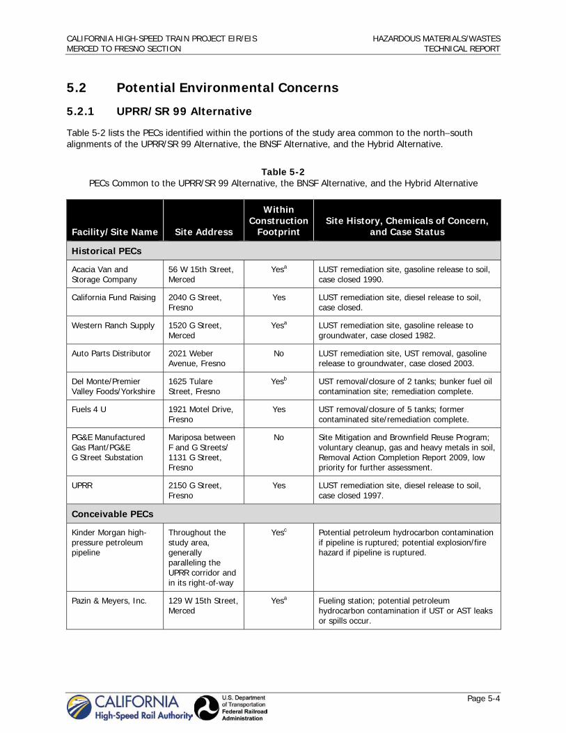
CALIFORNIA HIGH-SPEED TRAIN PROJECT EIR/EIS HAZARDOUS MATERIALS/WASTES MERCED TO FRESNO SECTION TECHNICAL REPORT
Page 5-4
5.2 Potential Environmental Concerns
5.2.1 UPRR/SR 99 Alternative
Table 5-2 lists the PECs identified within the portions of the study area common to the northsouth alignments of the UPRR/SR 99 Alternative, the BNSF Alternative, and the Hybrid Alternative.
Table 5-2 PECs Common to the UPRR/SR 99 Alternative, the BNSF Alternative, and the Hybrid Alternative
Facility/Site Name Site Address
Within Construction
Footprint Site History, Chemicals of Concern,
and Case Status
Historical PECs
Acacia Van and Storage Company
56 W 15th Street, Merced
Yesa LUST remediation site, gasoline release to soil, case closed 1990.
California Fund Raising 2040 G Street, Fresno
Yes LUST remediation site, diesel release to soil, case closed.
Western Ranch Supply 1520 G Street, Merced
Yesa LUST remediation site, gasoline release to groundwater, case closed 1982.
Auto Parts Distributor 2021 Weber Avenue, Fresno
No LUST remediation site, UST removal, gasoline release to groundwater, case closed 2003.
Del Monte/Premier Valley Foods/Yorkshire
1625 Tulare Street, Fresno
Yesb UST removal/closure of 2 tanks; bunker fuel oil contamination site; remediation complete.
Fuels 4 U 1921 Motel Drive, Fresno
Yes UST removal/closure of 5 tanks; former contaminated site/remediation complete.
PG&E Manufactured Gas Plant/ PG&E G Street Substation
Mariposa between F and G Streets/ 1131 G Street, Fresno
No Site Mitigation and Brownfield Reuse Program; voluntary cleanup, gas and heavy metals in soil, Removal Action Completion Report 2009, low priority for further assessment.
UPRR 2150 G Street, Fresno
Yes LUST remediation site, diesel release to soil, case closed 1997.
Conceivable PECs
Kinder Morgan high-pressure petroleum pipeline
Throughout the study area, generally paralleling the UPRR corridor and in its right-of-way
Yesc Potential petroleum hydrocarbon contamination if pipeline is ruptured; potential explosion/fire hazard if pipeline is ruptured.
Pazin & Meyers, Inc. 129 W 15th Street, Merced
Yesa Fueling station; potential petroleum hydrocarbon contamination if UST or AST leaks or spills occur.

CALIFORNIA HIGH-SPEED TRAIN PROJECT EIR/EIS HAZARDOUS MATERIALS/WASTES MERCED TO FRESNO SECTION TECHNICAL REPORT
Page 5-5
Facility/Site Name Site Address
Within Construction
Footprint Site History, Chemicals of Concern,
and Case Status
Allied Waste Service/ former Browning Ferris Industries
5501 Golden State Boulevard, Fresno
Yes The Central Valley RWQCB inspected in 1987 and reported petroleum hydrocarbon contamination in a lagoon and sump on the property. The case is open. Currently used for equipment maintenance yard/fueling station; potential petroleum hydrocarbon contamination if UST or AST leaks or spills occur.
T-Mobile 5525 N Golden State Boulevard, Fresno
Yes Cellular and telephone equipment; fuel AST; potential petroleum hydrocarbon or heavy metals contamination.
K & H Bros./Menderin Tanks/Mid Valley Equipment and Sales
6101 N Golden State Boulevard, Fresno
Yes High levels of lead detected in 1987. In 2003, a notice of violation was served for unpermitted storage of drums and soil stockpiles, some of which had significant concentrations of petroleum products and heavy metals. Remedial work plan approved in 2005. County rendered a No Further Action decision in 2007.
Whirlwind Car Wash/ Chevron
225 N H Street, Fresno
No Fueling station; potential petroleum hydrocarbon contamination if UST or AST leaks or spills occur.
Bendrosian Truck Service
1454 G Street, Fresno
Yes Vehicle maintenance and storage/fueling station; potential petroleum hydrocarbon contamination.
Calaveras Materials 410 N Thorne Avenue, Fresno
No Portland cement product production; hazardous materials storage, use, and disposal could result in contamination through accidental release or improper disposal.
Fresno County Police Officers Association Training Facility (firing range)
7633 N Weber Avenue, Fresno
No Potential contamination of soil with lead and polycyclic aromatic hydrocarbon compounds. Potential hazard from unexploded ordnance.
Industrial Plating Company/Valley Metal Finishing
733 G Street, Fresno
No Hazardous materials storage, use, and disposal could result in contamination through accidental release or improper disposal.
Lamoure’s Cleaners 1304 G Street, Fresno
Yes Potential organic solvent contamination if solvents improperly disposed, if UST or AST leaks or spills occur.
Producers Dairy Milk Distribution
N H Street and N Harrison Street, Fresno
No Food processing facility; various hazardous materials stored and used. Industrial facilities often require remedial actions after plant closure.
Integrated Grain and Milling
315 N H Street, Fresno
Yes Food processing facility; various hazardous materials stored and used. Industrial facilities often require remedial actions after plant closure.
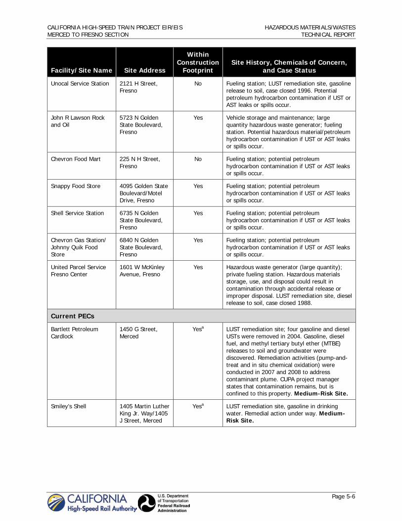
CALIFORNIA HIGH-SPEED TRAIN PROJECT EIR/EIS HAZARDOUS MATERIALS/WASTES MERCED TO FRESNO SECTION TECHNICAL REPORT
Page 5-6
Facility/Site Name Site Address
Within Construction
Footprint Site History, Chemicals of Concern,
and Case Status
Unocal Service Station 2121 H Street, Fresno
No Fueling station; LUST remediation site, gasoline release to soil, case closed 1996. Potential petroleum hydrocarbon contamination if UST or AST leaks or spills occur.
John R Lawson Rock and Oil
5723 N Golden State Boulevard, Fresno
Yes Vehicle storage and maintenance; large quantity hazardous waste generator; fueling station. Potential hazardous material/petroleum hydrocarbon contamination if UST or AST leaks or spills occur.
Chevron Food Mart 225 N H Street, Fresno
No Fueling station; potential petroleum hydrocarbon contamination if UST or AST leaks or spills occur.
Snappy Food Store 4095 Golden State Boulevard/Motel Drive, Fresno
Yes Fueling station; potential petroleum hydrocarbon contamination if UST or AST leaks or spills occur.
Shell Service Station 6735 N Golden State Boulevard, Fresno
Yes Fueling station; potential petroleum hydrocarbon contamination if UST or AST leaks or spills occur.
Chevron Gas Station/ Johnny Quik Food Store
6840 N Golden State Boulevard, Fresno
Yes Fueling station; potential petroleum hydrocarbon contamination if UST or AST leaks or spills occur.
United Parcel Service Fresno Center
1601 W McKinley Avenue, Fresno
Yes Hazardous waste generator (large quantity); private fueling station. Hazardous materials storage, use, and disposal could result in contamination through accidental release or improper disposal. LUST remediation site, diesel release to soil, case closed 1988.
Current PECs
Bartlett Petroleum Cardlock
1450 G Street, Merced
Yesa LUST remediation site; four gasoline and diesel USTs were removed in 2004. Gasoline, diesel fuel, and methyl tertiary butyl ether (MTBE) releases to soil and groundwater were discovered. Remediation activities (pump-and-treat and in situ chemical oxidation) were conducted in 2007 and 2008 to address contaminant plume. CUPA project manager states that contamination remains, but is confined to this property. Medium-Risk Site.
Smiley’s Shell 1405 Martin Luther King Jr. Way/1405 J Street, Merced
Yesa LUST remediation site, gasoline in drinking water. Remedial action under way. Medium-Risk Site.

CALIFORNIA HIGH-SPEED TRAIN PROJECT EIR/EIS HAZARDOUS MATERIALS/WASTES MERCED TO FRESNO SECTION TECHNICAL REPORT
Page 5-7
Facility/Site Name Site Address
Within Construction
Footprint Site History, Chemicals of Concern,
and Case Status
Seiberts Oil Company 2837 N Parkway Drive, Fresno
No LUST remediation site; tank removals in 1998 discovered gasoline and diesel contamination of soil. Excavated soils classified as hazardous waste and sent to Kettleman landfill. Supplemental site investigation for contaminated soils completed in 2009; soils contaminated with petroleum hydrocarbons still exist, and may eventually contaminate groundwater. Medium-Risk Site.
Caltrans Maintenance Yard
1385 N West Avenue, Fresno
Yes LUST remediation site; site operated as vehicle maintenance yard since 1960. In 1990, soil contamination by petroleum hydrocarbons discovered from leaking USTs during UST removals. Preliminary soil investigation in 1991. The Central Valley RWQCB issued warning letter in 2008 regarding UST release and threat of groundwater contamination. High-Risk Site.
Klein’s Truck Stop/ E-Z Trip (Herndon Enterprises)
6725 Golden State Boulevard, Fresno
Yes Open LUST site with remediation underway. Open Spills, Leaks, Investigations and Cleanup Program (SLIC) site. UST removals in 1998 discovered releases of gasoline and diesel to soil and groundwater. Site assessment in 2002 detected significant quantities of gasoline; benzene, toluene, ethylbenzene, and xylene (BTEX); lead, and MTBE in soil and groundwater; a threat exists to surrounding water supply wells. Foreclosure, transfer of property; remedial work plan submitted in 2003. Work plans for borings to determine the lateral and vertical impacts of the petroleum hydrocarbons were submitted in 2009. High-Risk Site.
UPRR Fresno Yard 3135 N Weber Street, Fresno
Yes Site has over 50 years of intense industrial use. A leaking UST was reported in 1990; status unknown. In 1995, a vault was discovered that had leaked Bunker C fuel; contaminated soil was removed. In 1999, a train spilled over 1,000 gallons of diesel; contaminated soil was removed. In 2008, a rail car leaked 10% hydrochloric acid; remediation was performed. High-Risk Site.
Unocal Bulk Plant No. 221
101 N Roosevelt Avenue, Fresno
No LUST remediation site; former bulk petroleum hydrocarbons distribution plant. USTs and other site improvements removed in 1995. Some soils contaminated with gasoline and diesel were removed in 1995; others were left in place. A 1998 site assessment reported significant soil contamination with petroleum hydrocarbons. In 2005, a work plan for additional soil and groundwater assessment was created. High-Risk Site.

CALIFORNIA HIGH-SPEED TRAIN PROJECT EIR/EIS HAZARDOUS MATERIALS/WASTES MERCED TO FRESNO SECTION TECHNICAL REPORT
Page 5-8
Facility/Site Name Site Address
Within Construction
Footprint Site History, Chemicals of Concern,
and Case Status
VOPAK USA, Inc./ Univar USA
1152 G Street, Fresno
Yesb Open SLIC site; site used to store and distribute industrial chemicals and to store perchloroethylene from 1965 to 1986. Vapor extraction conducted between 1998 and 2004. Groundwater is 90 feet below ground surface and gradient is to north-northeast. Currently quarterly monitoring conducted at the site and soil vapor extraction being conducted downgradient of the site. Indoor air assessment performed at neighboring properties in 2006. High-Risk Site.
Abandoned Service Station
655 G Street, Fresno
Yes Site operated as a service station from 1940s to 1970s. City of Fresno excavated USTs in 1988; gasoline and BTEX contamination of soil discovered. A site assessment in 2005 confirmed that significant soil, and possibly groundwater, contamination existed; a soil vapor extraction system was recommended. LUST remediation site with ongoing remediation activities (as of 2007). Potential gasoline contaminants affecting groundwater. Medium-Risk Site.
a These sites are within the potential footprint of the Downtown Merced Station (between W. 16th Street, W. 14th Street, Canal Street, and G Street). b These sites are within the potential footprint of both Downtown Fresno station alternatives (between Fresno Street, Tulare Street, H Street, and G Street for the Mariposa Street Station Alternative; and between Tulare Street, Inyo Street, H Street, and G Street for the Kern Street Station Alternative). c This utility is located in the construction footprint in several locations, but is not entirely within the UPRR/SR 99 construction footprint
The Merced and the Fresno HST station study areas are located in heavily industrialized areas with long histories of industrial and commercial land uses. Various historical cases of contamination have been reported at properties within these study areas. It is likely that construction activities within these study areas might encounter buried tanks, soil contamination, or groundwater contamination that has not been reported. Furthermore, the Fresno HST study area has one contaminated site that is considered high risk: the VOPAK USA, Inc./Univar USA facility at 1152 G Street, Fresno. This site was used to store and distribute industrial chemicals and to store perchloroethylene from 1965 to 1986. Although remedial activities were performed between 1998 and 2004, contaminated groundwater still exists and has spread to neighboring properties. In 2006, an indoor air assessment was performed at neighboring properties to determine if VOCs were migrating. Therefore, this area is likely to require additional planning and specific construction techniques.
Table 5-3 lists PECs identified within the portions of the UPRR/SR 99 Alternative study area that are not shared with the BNSF Alternative study area.

CALIFORNIA HIGH-SPEED TRAIN PROJECT EIR/EIS HAZARDOUS MATERIALS/WASTES MERCED TO FRESNO SECTION TECHNICAL REPORT
Page 5-9
Table 5-3 PECs Unique to the UPRR/SR 99 Alternative
Facility/Site Name Site Address
Within Construction
Footprint Site History, Chemicals of Concern,
Case Status, etc.
Historical PECs
Lockwood Seed Company
26777 Chowchilla Boulevard, Chowchilla
No Site contains pesticides and other wastes associated with pesticide production. Site screening conducted in 1988.
Madera Automatic Transmission
905 S. Gateway Drive/ 909 S Gateway Drive, Madera
No LUST remediation site; waste oil release to soil, case closed 1997.
Madera Intermodal Transport
123 E Street, Madera
Yes LUST remediation site; #4 fuel oil release to soil, also asbestos removal, case closed 1998.
Pacific Bell 221 S E Street, Madera
Yes LUST remediation site, diesel release to soil, case closed 1989.
Valee Foodstore BJ Liquors/BJ’s Gas and Liquor
225 Gateway Drive, Madera
No LUST remediation site, gasoline release to soil, case closed 1996.
Conceivable PECs
3-Boys Auto Wrecking/ Pick-a-Part
19494 Road 22, Madera
No Automotive maintenance and services; private fueling station. Potential hazardous materials/ petroleum hydrocarbon contamination if UST or AST leaks or spills occur.
Arco AM/PM 101 Gateway Drive, Madera
No Fueling station; potential petroleum hydrocarbon contamination if UST or AST leaks or spills occur.
Chevron/Mexicali Market
1130 N Country Club, Madera
Yes Fueling station; potential petroleum hydrocarbon contamination if UST or AST leaks or spills occur.
EJ Gallo Winery 31754 Avenue 9, Madera
Yes Food processing facility; various hazardous materials stored and used. Industrial facilities often require remedial actions after plant closure.
JW Myers, Inc./ Chevron Lubricants
546 E. Olive Avenue, Madera
Yes Fueling station; potential petroleum hydrocarbon contamination if UST or AST leaks or spills occur.
Industrial food processing facility (name unknown)
17710 Road 24, Madera
Yes Food processing facility; various hazardous materials stored and used. Industrial facilities often require remedial actions after plant closure.
PG&E Madera Service Center
309 S Gateway Drive, Madera
No Equipment maintenance and storage, hazardous waste generator, fueling station. Potential hazardous materials/petroleum hydrocarbon contamination if UST or AST leaks or spills occur.

CALIFORNIA HIGH-SPEED TRAIN PROJECT EIR/EIS HAZARDOUS MATERIALS/WASTES MERCED TO FRESNO SECTION TECHNICAL REPORT
Page 5-10
Facility/Site Name Site Address
Within Construction
Footprint Site History, Chemicals of Concern,
Case Status, etc.
Madera Transportation 305 N E Street, Madera
Yes LUST remediation site; a 1996 UST removal discovered significant soil contamination with gasoline and BTEX. Cleanup and Abatement Order issued in 2007 for failure of responsible parties to begin remediation. Site assessment determined that only shallow soil contamination was present, under pavement; no further assessment or remediation was recommended.
Chowchilla Chevron 240 E Robertson Boulevard, Chowchilla
Yes Fueling station; potential petroleum hydrocarbon contamination if UST or AST leaks or spills occur.
Current PECs
Former Madera Gas Co. (manufactured gas plant)/ PG&E Pole Yard
9th Street, Clinton Avenue, E Street, and D Street, Madera
No Manufactured gas plant operated from 1913 to 1931, then dismantled in 1935. In 1931, purchased by PG&E and used as a storage yard. In 1986, investigation of former gas plant revealed contamination of soil and ground water with heavy metals, polycyclic aromatic compounds, and other VOCs. PG&E entered into a voluntary cleanup agreement and remediation of soils is pending. High-Risk Site.
Belco (“Bilco”) Oil 529 S Gateway Avenue, Madera
No LUST remediation site; gasoline release to soil and groundwater; petroleum hydrocarbon and MTBE groundwater plume has spread to offsite locations. Soil vapor extraction pilot test performed in 2008. High-Risk Site.
Madera Produce 701 S Gateway Avenue, Madera
No Open, inactive LUST remediation site; diesel release to soil. Food processing facility; various hazardous materials stored and used. Industrial facilities often require remedial actions after plant closure. Medium-Risk Site.
5.2.1.1 Ave 24 Wye
The EDR database search identified one Historical PEC in the study area for the UPRR/SR 99 Alternative with the Ave 24 Wye: J R Simplot Co. (24148 Robertson Boulevard, Chowchilla), which was remediated in 1965.
5.2.1.2 Ave 21 Wye
The EDR database search identified one Historical PEC: an empty building (20550 Golden State Boulevard, Madera). The search also identified two Conceivable PECs: (1) an unnamed agricultural operation (Road 18, Chowchilla), and (2) an unnamed food processing plant (20984 Road 18, Chowchilla). No Current PECs were detected within the study area for the UPRR/SR 99 Alternative with the Ave 21 Wye.

CALIFORNIA HIGH-SPEED TRAIN PROJECT EIR/EIS HAZARDOUS MATERIALS/WASTES MERCED TO FRESNO SECTION TECHNICAL REPORT
Page 5-11
5.2.2 BNSF Alternative
Table 5-4 lists Historical and Conceivable PECs unique to the BNSF Alternative study area; no Current PECs were identified. Considerably fewer PECs occur within the BNSF Alternative study area than within the UPRR/SR 99 Alternative study area.
Table 5-4 Historical and Conceivable PECs Unique to the BNSF Alternative
Facility/ Site Name Site Address
Within Construction
Footprint Site History, Chemicals of Concern,
Case Status, etc.
Historical PECs
Circle K Ranch Road 27 at the Santa Fe Railroad Track, Madera
Yes LUST remediation site; diesel release to soil, case closed 1990.
Steel Structures, Inc 28777 Avenue 15½, Madera
Yes DTSC discovery and site screening in 1988.
Tenneco Madera Almond
20875 Avenue 24, Chowchilla
No SLIC site; petroleum fuel and pesticide/herbicide release; case closed 1965.
Le Grand Maintenance Yard
4051 Santa Fe Avenue, Le Grand
Yesa LUST remediation site; diesel release to soil, case closed 1999.
Conceivable PECs
Almaden Cellars Winery (formerly Paul Masson Vineyards, Vintners International Co. Inc., Canandaigua Wine Co. Inc., Constellation Wines US Inc.)
22004 Road 24, Madera
Yes Food processing facility; various hazardous materials stored and used. Industrial facilities often require remedial actions after plant closure.
D & S Market/Gas Station/ Thurman’s Service/Valadez Recycling Center #2
3850 S Santa Fe Avenue, Le Grand
Yesa Fueling station; petroleum hydrocarbon contamination could occur if UST/ AST leaks. LUST remediation site; gasoline release to soil, case closed 1996.
Le Grand Disposal Site 3100 S Santa Fe Avenue, Le Grand
Yesa Historical landfill/burn dump site, uncontrolled site where residents would dump trash; all salvageable materials were removed, and clean fill was brought in as cover for remaining waste. DTSC/CalRecycle performs quarterly monitoring. Site is currently used as an orchard.
a In study area for the Mariposa Way and Mission Ave design options.
5.2.2.1 Ave 24 Wye
The J R Simplot Co. Historical PEC is within the study area for all HST alternatives with the Ave 24 Wye.

CALIFORNIA HIGH-SPEED TRAIN PROJECT EIR/EIS HAZARDOUS MATERIALS/WASTES MERCED TO FRESNO SECTION TECHNICAL REPORT
Page 5-12
5.2.2.2 Ave 21 Wye
The BNSF Alternative with the Ave 21 Wye is located primarily on agricultural land. The study area includes the two Conceivable PECs in the UPRR/SR 99 with the Ave 21 Wye study area, and Lagorio Farming Inc. (23593 Avenue 20½, Madera), which use reportable quantities of hazardous materials/petroleum products. No Current PECs were identified.
5.2.3 Hybrid Alternative
The PECs within the study area for the Hybrid Alternative include the sites listed in Table 5-2 and the Steel Structures, Inc. Historical PEC in Madera.
5.2.3.1 Ave 24 Wye
The J R Simplot Co. Historical PEC is within the same study area for all HST alternatives with the Ave 24 Wye.
5.2.3.2 Ave 21 Wye
The Hybrid Alternative with the Ave 21 Wye study area includes the same three Conceivable PEC sites as those in the BNSF Alternative with the Ave 21 Wye study area: an unnamed agricultural operation, an unnamed food processing plant, and Lagorio Farming, Inc.
5.2.4 Heavy Maintenance Facility
5.2.4.1 Castle Commerce Center HMF Site
The former Castle AFB (N Buhach Road and Santa Fe Drive, Atwater) is a Superfund site. Castle AFB operated on the Castle Commerce Center HMF site from 1941 to 1995 (Jacobs Engineering 2009). Numerous activities/facilities at Castle AFB generated soil and groundwater contaminants during all or a portion of active base operations. Contamination was first identified in 1978, when trichloroethylene (TCE) was detected in groundwater samples from several onbase production wells. Institutional and engineering controls are in place in certain areas. Current remedial actions include two large groundwater pump-and-treat systems, four smaller point-source pump-and-treat systems, one operating soil vapor extraction system, and two permanent landfill caps. This site is a high-risk Current PEC. The following are potential source areas and related contaminants at the former Castle AFB that are identified in the 5-year review report (Jacobs Engineering 2009):
Engine maintenance shops – Buildings used for degreasing and repair of aircraft engines. Expected contaminants include VOCs (primarily TCE and its degradation products), aromatic VOCs (e.g., BTEX), other petroleum compounds, and metals.
Washracks and discharge areas – Washracks, typically associated with aircraft hangars and mainten-ance areas, were used for cleaning the outer surfaces of aircraft and other equipment. Discharge areas were locations where liquid wastes were released onto the ground surface. Expected contaminants include TCE, its degradation products, and metals.
Landfills and disposal pits – These areas were used for the disposal of domestic, construction, and industrial wastes (solid and liquid). Expected contaminants include VOCs, BTEX, semivolatile organic compounds (SVOCs), chlorofluorohydrocarbons, and metals.
Storage tanks and tank farms – Expected contaminants in these areas are petroleum hydrocarbons included in jet fuel, gasoline, diesel fuel, heating oil, motor oil, and hydraulic fluid.
Utility pipelines – Fuel, domestic waste, industrial-waste (sewer), and storm-drain pipelines. Expected contaminants are VOCs and petroleum hydrocarbons.

CALIFORNIA HIGH-SPEED TRAIN PROJECT EIR/EIS HAZARDOUS MATERIALS/WASTES MERCED TO FRESNO SECTION TECHNICAL REPORT
Page 5-13
Hazardous waste storage sites and solid waste management units – Hazardous waste storage sites included bermed, concrete-lined, and open areas used for the temporary storage of drummed (typical) wastes. Solid waste management units included silver recovery units, washrack tanks, grease traps, and oil/water separators. Expected contaminants are VOCs, SVOCs, BTEX, other petroleum hydrocarbons, paint, pesticides, and metals.
Surface release and fire training areas – These areas could have had accidental spills during base operations and purposeful releases of flammable liquids to the ground surface for fire training exercises. Expected contaminants include fuels, BTEX, and VOCs.
Miscellaneous – Small sites, such as stains on concrete flightlines, not included in any of the other categories. Expected contaminants for flightline stains were polycyclic aromatic hydrocarbons and metals.
Site characterization investigations began in 1981 under the Department of Defense Installation Restoration Program after solvents were discovered in the water supply. Those investigations and the extensive site characterization programs that followed have resulted in the installation of several hundred soil and soil vapor borings and more than 350 monitoring wells within and adjacent to the former Castle AFB. TCE was the principal contaminant in groundwater. It was estimated that at least 6,600 pounds of TCE was released to groundwater and that approximately 98% of this total was contained within the Main Base Plume Region (Jacobs Engineering 2009).
Several groundwater and vadose zone treatment or removal actions have been undertaken at the former Castle AFB to address groundwater, soil, or soil gas contamination at the four groundwater contamination plumes and the 233 soil (vadose) contamination sites. Groundwater removal actions were implemented at Discharge Area 4 (DA-4) and Wallace Road in 1991 and at Building 84 (B84) in 1993. Excavation and disposal, consolidation and capping, and soil vapor extraction removal actions have been initiated and completed at numerous vadose zone sites. Two groundwater remediation systems were installed to address the TCE in the Main Base Plume: Operable Unit 1 went online in 1994 and Operable Unit 2 went online in 1996 (Jacobs Engineering 2009).
Only two groundwater plumes (Main Base Plume and Castle Vista Plume) remain out of compliance. They have ongoing remedial actions, primarily for TCE. The selected remedy is pump-and-treat systems for plume capture and reduction to maximum contaminant levels. Institutional controls are in place to restrict the use of groundwater exceeding these levels (Jacobs Engineering 2009).
For some soil contamination sites (e.g., landfills, where complete removal was impractical), consolidation and capping have left hazardous substances, pollutants, or contaminants on site above levels that allow for unlimited use and unrestricted exposure. Long-term cap maintenance, monitoring, and institutional controls are in effect at these sites (Jacobs Engineering 2009).
The study area for the Castle Commerce Center HMF encompasses at least 24 specific soil contamination sites within the Castle Airport Superfund Site (Jacobs Engineering 2009). Table 5-5 summarizes the type of contamination, remedial actions, and current case status. The most recent final report for the Castle Airport Superfund Site (Jacobs Engineering 2009), states that, “all CERCLA decisions and documentation have been completed, all remedial actions are in place or completed, operating properly and successfully, determinations were made for the groundwater and Landfill 4 remedial actions, all property was found suitable for transfer and all property has been transferred.”

CALIFORNIA HIGH-SPEED TRAIN PROJECT EIR/EIS HAZARDOUS MATERIALS/WASTES MERCED TO FRESNO SECTION TECHNICAL REPORT
Page 5-14
Table 5-5 Summary of Contamination, Remedial Actions, and Status of the Castle Airport Superfund Site Issues
within the Castle Commerce Center HMF Study Area
Site Description/Issue Remedial Action/Status
B871 Building; petroleum hydrocarbon contamination
Excavation and disposal removal action completed; No Further Action status.
B909 Building; petroleum hydrocarbon contamination
Remedial actions and case status unknown.
B917 Building; petroleum hydrocarbon contamination
Remedial actions and case status unknown.
B950 and B951 Building; petroleum hydrocarbon contamination
Remedial actions and case status unknown.
DA-1/TCC-1 Disposal area; petroleum hydrocarbon contamination
Remedial actions and case status unknown.
DA-3 Disposal area; removal action in 2000 Excavation and disposal removal action completed; No Further Action status.
DA-6 Disposal area; petroleum hydrocarbon contamination
Remedial actions and case status unknown.
DA-7 Disposal area; petroleum hydrocarbon contamination
Remedial actions and case status unknown.
DP-1 Disposal pit Excavation and disposal removal action completed; No Further Action status.
DP-2 Disposal pit No action was required; No Further Action status.
DP-3 Disposal pit Excavation and disposal removal action completed; No Further Action status.
DP-4A/4B Disposal pit No action was required; No Further Action status.
ETC-2 Removal action in 2000 Excavation and disposal removal action completed; No Further Action status.
LF-1 Landfill, removal action 1998 to 2000; Landfill 1 Plume monitoring terminated in 2001
Excavation and disposal removal action completed; No Further Action status.
LF-2 Landfill, removal action 1997 to 1999 Excavation and disposal removal action completed; No Further Action status.
LG-1 Unknown No action was required; No Further Action status.
PCB-6 Polychlorinated biphenyls No action was required; No Further Action status.
PFFA Petroleum fuel farm area; petroleum hydrocarbon contamination
Remedial actions and case status unknown.
SA-B2 Storage area No action was required; No Further Action status.
SS-8 Sanitary sewer; petroleum hydrocarbon contamination
Remedial actions and case status unknown.
SWMU 4.15 Solid waste management unit No action was required; No Further Action status.

CALIFORNIA HIGH-SPEED TRAIN PROJECT EIR/EIS HAZARDOUS MATERIALS/WASTES MERCED TO FRESNO SECTION TECHNICAL REPORT
Page 5-15
In addition to these soil contamination sites, the groundwater below the Castle Commerce Center HMF study area is contaminated with TCE and other solvents, and petroleum hydrocarbons. Groundwater remediation systems are in place. Apparently, the Landfill 1 Plume region has been remediated to primary remediation goal levels for TCE, but the Main Base Plume and the Castle Vista Plume have not.
There are also several PEC sites in the study area between the proposed Merced HST station site and the proposed Castle Commerce Center HMF site. Table 5-6 identifies the sites in this portion of the study area.
Table 5-6 Historical, Conceivable, and Current PECs in the Castle Commerce Center HMF Site Study Area
Facility/Site Name Site Address
Within Construction
Footprint Site History, Chemicals of Concern,
and Case Status
Historical PECs
Adai LTD/Quick Lube 1440 V Street, Merced
No Waste oil release to soil; case closed 1993.
Brendella Boats, Inc. 2556 W 16th Street, Merced
No Unspecified pesticide enforcement action.
Abandoned Chevron Station
2060 W 16th Street, Merced
No LUST remediation site; case closed 1996.
City Auto Body 1200 16th Street, Merced
No LUST remediation site; gasoline release to soil; case closed 1988.
Dave Cook Front End Shop
704 W 16th Street, Merced
Noa LUST remediation site; diesel release to soil; case closed 1996.
McGarry Motors/ Starlightz Development
530 W 16th Street, Merced
Yesa LUST remediation site; gasoline release to soil; case closed 2007.
Pacific Bell 1202 W 15th Street, Merced
No LUST remediation site; gasoline release to soil; case closed 1994.
Southern Pacific Transportation Co.
692 W 16th Street, Merced
Noa SLIC site; case closed 1993.
Former Standard Oil/Tune-up Masters
608 W 16th Street, Merced
Noa Waste oil release to soil; case closed 1996.
Tenetti-William Property 855 15th Street, Merced
Yes LUST remediation site; gasoline release to groundwater; case closed 1999.
Texaco Bulk Plant 867 W 15th Street, Merced
Yes LUST remediation site; gasoline release to groundwater; case closed 1996.
Conceivable PECs
Armour Oil Company/ Gas N Save
963 W 16th Street, Merced
No Fueling station; potential petroleum hydrocarbon contamination if UST or AST leaks or spills occur. LUST remediation completed in 2010.
COSTCO Wholesale #142
14445 R Street, Merced
No Fueling station; potential petroleum hydrocarbon contamination if UST or AST leaks or spills occur.

CALIFORNIA HIGH-SPEED TRAIN PROJECT EIR/EIS HAZARDOUS MATERIALS/WASTES MERCED TO FRESNO SECTION TECHNICAL REPORT
Page 5-16
Facility/Site Name Site Address
Within Construction
Footprint Site History, Chemicals of Concern,
and Case Status
United Rentals/Smiley’s Gas & Food Mart/Shell Service Station
1480 W 16th Street, Merced
No Fueling station; potential petroleum hydrocarbon contamination if UST or AST leaks or spills occur.
Current PECs
Pacific Pride Cardlock Station
1455 R Street, Merced
No LUST remediation site; gasoline contamination of groundwater, remediation phase. Medium-Risk Site.
PG&E Manufactured Gas Plant/Service Center
560 W 15th Street, Merced
Yesa Operated between 1913 and 1931. Under a voluntary cleanup agreement. Polycyclic aromatic hydrocarbons in upper 3 feet of soil in 1992. Groundwater contaminated with perchloroethylene. Service Center had USTs (removed 1988). Annual groundwater monitoring re-instated by the Central Valley RWQCB in 2003. High-Risk Site.
R St. Texaco/R St. Exxon 1415 R Street, Merced
No Active remediation by the Central Valley RWQCB for release of gas into aquifer. Medium-Risk Site
Smith Van & Storage Company, Inc.
1120 W 15th Street, Merced
No Open LUST site with a preliminary site assessment underway. Potential contaminants include petroleum hydrocarbons in groundwater. Medium-Risk Site.
Former Unocal Bulk Plant #0420/ Aromalene Oil Company Bulk Plant
1590 W 16th Street, Merced
No LUST remediation site; CUPA-required site investigation in 1986 in response to loss of 800 gallons of heating oil from UST. Petroleum product contamination of soil and groundwater confirmed. The site’s tank system included three oil ASTs, two 20,000-gallon diesel and gasoline USTs, three 12,000-gallon USTs containing gasoline and heating oil, and one 8,000-gallon UST containing Stoddard solvent. A 1990 site investigation concluded that petroleum hydrocarbons and solvent plume likely extended beyond property boundaries. Monitoring in 2004 indicated significant levels of petroleum hydrocarbons and benzene, ethylbenzene, toluene, and xylenes solvents in groundwater. In 2008, a corrective action plan was approved for soil vapor extraction; remediation goals were established for petroleum hydrocarbons and VOCs. In 2009, 3,000 cubic yards of petroleum product-contaminated soil were excavated. High-Risk Site.
a These sites are north of the Downtown Merced Station, but may still pose a hazard within the construction footprint of the station due to potential contaminant migration.

CALIFORNIA HIGH-SPEED TRAIN PROJECT EIR/EIS HAZARDOUS MATERIALS/WASTES MERCED TO FRESNO SECTION TECHNICAL REPORT
Page 5-17
5.2.4.2 Harris-DeJager HMF Site
The Harris-DeJager HMF study area is currently used primarily for agricultural crop production. The study area also includes the SR 99 highway corridor; irrigation canals and pump stations; and a few rural residences and equipment barns. No PECs were identified in this study area.
5.2.4.3 Fagundes HMF Site
No PECs were identified within the Fagundes HMF study area.
5.2.4.4 Gordon-Shaw HMF Site
The Gordon-Shaw HMF study area is currently devoid of industrial development (except for the UPRR corridor) and is used for agricultural crop production. No PECs were identified in this study area.
5.2.4.5 Kojima Development HMF Site
The Kojima Development study area is currently devoid of industrial development, except for the BNSF corridor. No PECs were identified in this study area.


CALIFORNIA HIGH-SPEED TRAIN PROJECT EIR/EIS HAZARDOUS MATERIALS/WASTES MERCED TO FRESNO SECTION TECHNICAL REPORT
Page 6-1
6.0 Environmental Consequences This section describes the environmental consequences of hazards and hazardous materials for the proposed project. It describes the methods used to assess the impacts of the project and lists the thresholds used to conclude whether an impact would be significant.
Consistent with the Statewide Program EIR/EIS mitigation strategies prepared for the California HST Project, this analysis assumed the commitment to use design practices to minimize impacts and to use best management practices (BMPs) and mitigation strategies to substantially lessen or avoid impacts associated with hazardous materials. Program-level mitigation strategies provided in the Statewide Program EIR/EIS include the following:
Investigate soils for contamination and prepare environmental site assessments when necessary.
Survey for lead-based paint and ACM prior to demolition of buildings for project construction.
Acquire necessary permits if ground dewatering.
Perform Phase II Environmental Site Assessments (e.g., hydrogeologic investigations) to identify specific mitigation measures when indicated by project-level environmental site assessments. Perform Phase II Environmental Site Assessments in conformance with ASTM Standard E 1903-01 (ASTM 2002).
Prepare a site management program/contingency plan prior to construction to address known and potential hazardous material issues, including the following:
Measures to address management of contaminated soil and groundwater.
A site-specific health and safety plan that includes measures to protect construction workers and the general public if unknown contamination or buried hazards are encountered.
Identify more detailed mitigation or alternate methods more applicable to the proposed alignment, based on a site-specific analysis, where appropriate.
6.1 Evaluation of Impacts
6.1.1 Methods for Evaluating Effects under NEPA
Pursuant to NEPA regulations (40 CFR 1500-1508), project effects are evaluated based on the criteria of context and intensity. Context means the affected environment in which a proposed project occurs. Intensity refers to the severity of the effect, which is examined in terms of the type, quality, and sensitivity of the resource involved, location and extent of the effect, duration of the effect (short- or long-term), and other consideration of context. Beneficial effects are identified and described. When there is no measurable effect, impact is found not to occur. Intensity of adverse effects is summarized as the degree or magnitude of a potential adverse effect where the adverse effect is thus determined to be negligible, moderate, or substantial. It is possible that a significant adverse effect may still exist when on balance the impact is negligible or even beneficial. For hazardous materials and wastes, the terms are defined as follows:
A negligible impact is defined as an increased risk to the public or environment related to hazardous materials or substances that is slightly greater, but very close to the existing conditions. A moderate impact is defined as a localized increased risk to the public or environment related to hazardous materials or substances. Substantial effects are defined as increased risk to the public or environment related to hazardous materials or substances on a regional scale.

CALIFORNIA HIGH-SPEED TRAIN PROJECT EIR/EIS HAZARDOUS MATERIALS/WASTES MERCED TO FRESNO SECTION TECHNICAL REPORT
Page 6-2
6.1.2 CEQA Significance Criteria
Current conditions, including the hazardous material and waste sites identified in the available databases, provide the baseline against which the HST alternatives have been compared. Consistent with Appendix G of the CEQA Guidelines, a project is considered to have a significant impact on the environment if it results in one or more of the following conditions:
Creates a significant hazard to the public or the environment through the routine transport, use, or disposal of hazardous materials.
Creates a significant hazard to the public or the environment through reasonably foreseeable upset and accident conditions involving the release of hazardous materials into the environment.
Is located on a site that is included on a list of hazardous materials sites compiled pursuant to California Government Code Section 65962.5 (the Cortese List) and, as a result, would create a significant hazard to the public or the environment.
Emits hazardous air emissions or handles extremely hazardous substances or mixtures containing extremely hazardous substances within 0.25 mile of a school and would pose a health or safety hazard to students or employees.
6.2 No Project Alternative
Under the No Project Alternative, the existing transportation system would continue to operate, and the population in the study area would continue to grow. In addition, the changes and improvements to highway, airport, and conventional rail systems described in adopted regional transportation plans would be implemented. Furthermore, industrial, residential, and associated infrastructure development projects are planned (e.g., quarries, shopping centers, and wastewater conveyance upgrades). The planned improvements would require types and quantities of hazardous materials for construction and operation comparable with similar past and present transportation improvement projects. These future improvements would generate a comparable mix and quantity of wastes proportional to the magnitude of the improvements. Because many of the identified PEC sites are associated with major highway and railway corridors in the project vicinity, the sites could result in impacts on future improvements in those same corridors under the No Project Alternative.
It is reasonable to assume that, by 2035, some of the existing PEC sites would be investigated further and, if necessary, remediated under appropriate regulatory agency oversight. However, it is likely that investigation and remediation of all potentially hazardous materials in the study area, including contaminated soil or groundwater, would not occur, and the potential for impacts on transportation improvements would continue. Upsets and accidents related to hazardous materials and wastes could occur with continued operation of commercial and industrial facilities or during transportation of these goods. Such upsets and accidents might create PEC sites that could affect future improvements under the No Project Alternative.
In the study area, there are existing schools in proximity to these transportation systems. These schools could be subjected to potential risks from the routine transportation and handling of hazardous materials and wastes and the construction and operation of future transportation system improvements under the No Project Alternative. Existing and future transportation systems (e.g., as highways and conventional railway) would experience more traffic and congestion under the No Project Alternative. A higher level of traffic and congestion could increase the risk of accidents or incidents that might release hazardous materials or hazardous wastes to the environment.
6.3 High-Speed Train Alternatives
This section evaluates potential direct and indirect impacts that would result from construction and operation of each HST alternative. Construction of the HST would temporarily use and dispose of

CALIFORNIA HIGH-SPEED TRAIN PROJECT EIR/EIS HAZARDOUS MATERIALS/WASTES MERCED TO FRESNO SECTION TECHNICAL REPORT
Page 6-3
hazardous materials and waste associated with construction, and there is potential for disturbance of contaminants at PEC sites that are within the construction footprint. BMPs and regulations designed to limit the potential for hazards associated with an accidental spill of hazardous materials would reduce the potential for negative environmental impacts. Permanent use of hazardous materials (such as those from routine use and disposal of hazardous materials and waste for HST System operation and maintenance at an HMF) would be governed by regulations that prescribe the proper use and disposal of such materials.
6.3.1 Construction Period Impacts
6.3.1.1 Common Hazardous Materials and Wastes Impacts
The construction of any of the three HST alternatives would involve transporting, using, and disposing of construction-related hazardous materials and wastes. Potentially, such construction could result in accidents or upsets related to hazardous materials and waste, affect PEC sites, and result in temporary hazards to schools.
Temporary Transport, Use, Storage, and Disposal of Hazardous Materials and Wastes
Construction of any of the three HST alternatives and HMFs would temporarily increase the regional transportation, use, storage, and disposal of hazardous materials and petroleum products (e.g., diesel fuel, lubricants, paint and solvents, and cement products containing strong basic or acidic chemicals). These materials are commonly used at construction sites. Hazardous waste generated during construction might consist of welding materials, fuel and lubricant containers, paint and solvent containers, and cement products containing strong basic or acidic chemicals. Hazardous waste might also be generated during demolition (including ACM and lead-based paint).
Upsets and accidents associated with the temporary transport, storage, use, and disposal of hazardous materials and wastes could occur during construction. Spills or releases could result that might create hazards to persons and the environment, and, therefore, the routine transport, use, storage, and disposal of hazardous materials and wastes would result in a moderate impact under NEPA and a potentially significant impact under CEQA.
Standard accident and hazardous materials recovery training and procedures are enforced by the state and followed by private state-licensed, certified, and bonded transportation companies and contractors. Further, pursuant to 40 CFR 112, a spill prevention, containment, and countermeasures plan (SPCC) or, for smaller quantities, a spill prevention and response plan, that identifies BMPs for spill and release prevention and provides procedures and responsibilities for rapidly, effectively, and safely cleaning up and disposing of any spills or releases would be established for the project. As required under state and federal law, plans for notification and evacuation of site workers and local residents in the event of a hazardous materials release would be in place throughout construction.
The project would conform with permit and spill prevention plans prepared under SWRCB Construction General Permit (2009-0009 DWQ; SWRCB 2009) to avoid spills and releases of hazardous materials and wastes. Inspections would be conducted to verify consistent implementation of (1) general construction permit conditions and BMPs to avoid and minimize the potential for spills and releases and (2) the immediate cleanup and response thereto. BMPs include, for example, the designation of special storage areas and labeling, containment berms, coverage from rain, and concrete washout areas. Compliance with various federal, state, and local regulations minimizes the risk of a spill or accidental release of hazardous materials, and the impact of such a release would be largely negligible under NEPA and less than significant under CEQA.
Inadvertent Disturbance of Hazardous Materials or Wastes
Trenching and other ground-disturbing project construction activities could disturb undocumented soil or groundwater contamination (e.g., at Conceivable PEC sites). Adverse impacts could result if construction activities inadvertently dispersed contaminated material into the environment. For example, dewatering
CALIFORNIA HIGH-SPEED TRAIN PROJECT EIR/EIS HAZARDOUS MATERIALS/WASTES MERCED TO FRESNO SECTION TECHNICAL REPORT
Page 6-4
activities during construction could cause contaminated groundwater to migrate farther in the ground-water table or cause the release of contaminated groundwater to streams. Additionally, inadvertent disturbance of ACM could result in airborne asbestos fibers. Potential hazards to human health include ignition of flammable liquids or vapors, inhalation of toxic vapors in confined spaces such as trenches, and skin contact with contaminated soil or water. The disturbance of undocumented contamination would be a moderate impact under NEPA and a significant impact under CEQA because of the possibility for resulting hazards to the environment and human health.
A construction site management plan/contingency plan would be prepared that prescribes activities for workers to follow in areas with suspected presence of undocumented soil or groundwater contamination based on visual observation or smell. In such instances, construction activities would cease until it is determined, in coordination with regulatory agencies, that work can proceed without the risk of injury to persons or the environment.
Demolition of buildings and roadways containing asbestos and lead-based materials would require specialized procedures and equipment and appropriately certified personnel. Buildings and roadways intended for demolition that were constructed before 1980 would be surveyed for asbestos, and those constructed before 1971 would be surveyed for lead. A demolition plan would be prepared for any location with positive results for asbestos or lead. The plan would specify how to appropriately contain, remove, and dispose of the asbestos and lead-containing material while meeting all pertinent requirements and following appropriate BMPs to protect human health and the environment.
With the implementation of these standard precautions, the potential effects of inadvertent disturbance to hazardous materials or wastes would be negligible under NEPA and less than significant under CEQA.
Construction on or in near PEC Sites
As described for impacts associated with the inadvertent encounter of contaminated sites, there are various established procedures to reduce the potential that construction at PEC sites would result in impacts on human health or the environment. There are no known Cortese List sites within the study area; as a result, there would be no related hazard to the public or to the environment. Construction at known PEC sites requires prior coordination with regulatory agencies. Many of the PECs are located in urban areas where the guideway would be elevated. In these areas, construction would avoid effects on most known contaminated sites by constructing the supporting columns outside of the PEC sites.
Where effects on PEC sites cannot be avoided, preconstruction activities would address the requirements for constructing at PEC sites in coordination with regulatory agencies. Depending on proposed project activities, such as the need for subsurface ground disturbance, and the known extent and type of contamination, requirements for constructing at contaminated sites could include further evaluation of the level of contamination and associated potential risks to human health (including risks to children in nearby schools) and the environment, as well as site remediation. The potential effects from construction on contaminated sites would be negligible under NEPA and less than significant under CEQA.
UPRR/SR 99 Alternative
Table 6-1 lists the number of Historical, Conceivable, and Current PEC sites (high-risk and medium-risk) within the UPRR/SR 99 Alternative study area. The East Chowchilla design option with the Ave 21 Wye would potentially encounter more Conceivable PEC sites among the design options for this alternative.

CALIFORNIA HIGH-SPEED TRAIN PROJECT EIR/EIS HAZARDOUS MATERIALS/WASTES MERCED TO FRESNO SECTION TECHNICAL REPORT
Page 6-5
Table 6-1 PEC Sites Potentially Affected by UPRR/SR 99 Alternative and Nearby Schools
UPRR/SR 99 Alternative and Design Options
Number of PEC Sites Number
of Schools Historical Conceivable
Current High-Risk
Current Medium-Risk
Impacts by Project Combination
UPRR/SR 99 with West Chowchilla design option and Ave 24 Wye
10 24 6 2 10
UPRR/SR 99 with East Chowchilla design option and Ave 24 Wye
10 25 6 2 10
UPRR/SR 99 with East Chowchilla design option and Ave 21 Wye
10 27 6 2 10
Downtown Merced Station
Merced Station 2 1 0 2 4
Downtown Fresno Station Alternatives
Mariposa Street Station Alternative
2 2 1 1 1
Kern Street Station Alternative 2 2 1 1 1
Total UPRR/SR 99 Alternative Range of Impacts
14 27 to 30 7 5 15
The UPRR/SR 99 Alternative could require construction near the footprint of the former PG&E Manufactured Gas Plant site, a high-risk Current PEC site located in Merced. The site has soil and groundwater contamination that is being addressed under a voluntary cleanup agreement (DTSC 2007). The Downtown Fresno Station could affect the VOPAK USA, Inc./Univar site, which has active vapor extraction and groundwater monitoring to address VOC contamination (Fresno County Division of Environmental Health 2009). The remaining Current PECs associated with the UPRR/SR 99 Alternative study area are primarily petroleum LUST sites, most with investigation or remediation underway.
BNSF Alternative
Table 6-2 lists the number Historical, Conceivable, and Current PEC sites within the BNSF Alternative study area. The nature of the impacts for the BNSF Alternative would be similar to those previously discussed for the UPRR/SR 99 Alternative. The former PG&E Manufactured Gas Plant site in Merced and the VOPAK USA Inc./Univar site discussed under the UPRR/SR 99 Alternative are also within the BNSF Alternative study area. However, the overall level of construction impact associated with the BNSF Alternative is anticipated to be less than that associated with the UPRR/SR 99 Alternative because the portion of the alignment unique to the BNSF Alternative is less industrialized. This alternative would avoid the documented PEC sites in Madera that would be encountered under the UPRR/SR 99 Alternative.

CALIFORNIA HIGH-SPEED TRAIN PROJECT EIR/EIS HAZARDOUS MATERIALS/WASTES MERCED TO FRESNO SECTION TECHNICAL REPORT
Page 6-6
Table 6-2 PEC Sites Potentially Affected by BNSF Alternative and Nearby Schools
BNSF Alternative and Design Options
Number of PEC Sites
Number ofSchools Historical Conceivable
Current High-Risk
Current Medium-Risk
Impacts by Project Combination
BNSF north–south alignment with Ave 24 Wye
8 17 4 1 7
BNSF north–south alignment with Ave 21 Wye
7 20 4 1 7
Le Grand Design Options
Mission Ave 1 2 0 0 1
Mission Ave East of Le Grand 0 0 0 0 0
Mariposa Way 1 2 0 0 1
Mariposa Way East of Le Grand 0 0 0 0 0
Downtown Merced Station
Merced Station 2 1 0 2 4
Downtown Fresno Station Alternatives
Mariposa Street Station Alternative 2 2 1 1 1
Kern Street Station Alternative 2 2 1 1 1
Impact of Components Combined
BNSF Alternative, Ave 24 Wye 12 to 13 20 to 21 5 4 12 to 13
BNSF Alternative, Ave 21 Wye 11 to 12 23 to 25 5 4 12 to 13
Total BNSF Alternative Range of Impacts
11 to 13 20 to 25 5 4 12 to 13
Hybrid Alternative
Table 6-3 lists the number of Historical, Conceivable, and Current PEC sites within the Hybrid Alternative study area. The Hybrid Alternative could encounter fewer PEC sites than either the UPRR/SR 99 Alternative or BNSF Alternative.
The nature of the impacts under the Hybrid Alternative would be similar to those previously discussed for the UPRR/SR 99 and BNSF alternatives. The former PG&E Manufactured Gas Plant site in Merced and the VOPAK USA Inc./Univar site discussed under the UPRR/SR 99 Alternative are also within the Hybrid Alternative study area. Like the BNSF Alternative, the Hybrid Alternative would avoid the documented PEC sites in Madera than the UPRR/SR 99 Alternative would encounter.

CALIFORNIA HIGH-SPEED TRAIN PROJECT EIR/EIS HAZARDOUS MATERIALS/WASTES MERCED TO FRESNO SECTION TECHNICAL REPORT
Page 6-7
Table 6-3 PEC Sites Potentially Affected by the Hybrid Alternative and Nearby Schools
Hybrid Alternative and Design Options
Number of PEC Sites
Number of Schools Historical Conceivable
Current High-Risk
Current Medium-Risk
North-South Alignment with Ave 24 Wye
7 16 4 1 7
North-South Alignment with Ave 21 Wye
7 20 4 1 9
Downtown Merced Station
Merced Station 2 1 0 2 4
Downtown Fresno Station Alternatives
Mariposa Street Station Alternative
2 2 1 1 1
Kern Street Station Alternative 2 2 1 1 1
Total Hybrid Alternative Range of Impacts
11 19 to 23 5 4 12 to 14
Heavy Maintenance Facility Alternatives
Only the Castle Commerce Center HMF site has reported contamination. The study area for the Castle Commerce Center HMF includes more than 20 specific soil contamination sites and general contamination of groundwater by trichloroethylene and other organic solvents from activities at the former Castle AFB. Groundwater remediation systems are in place, but the Main Base Plume and the Castle Vista Plume have not yet been remediated to their primary remediation goal levels. Construction of the Castle Commerce Center HMF would require approval from regulatory agencies and coordination regarding the various remediation efforts currently under way.
There are several additional sites of known contamination along the tracks that would connect the Castle Commerce Center HMF to the Merced Station. The primary contaminants of concern at the PECs in this portion of the study area (including at one high-risk site under active remediation) are petroleum hydrocarbons and gasoline additives. At the PG&E Merced Manufactured Gas Plant, additional contaminates include heavy metals and PAH contamination of shallow soils.
Temporary Hazardous Material and Waste Activities near Schools
During construction, demolition, and excavation activities, the project would potentially emit hazardous air emissions or handle extremely hazardous wastes above threshold quantities. As shown in Tables 6-1 through 6-3, 12 to 15 schools are located in the vicinity of potential project construction activity, depending on the HST alternative and design options selected. Four schools are in the vicinity of the Castle Commercial Center HMF site and guideway. There are no schools in the study areas of the other four HMF sites. Airborne release of hazardous materials (e.g., gases or asbestos particles) or the accidental release of significant volumes of hazardous materials could pose a health or safety hazard to people at the school.
Prior to construction, schools within the construction footprint would be relocated; this would eliminate any further impact on these schools. As discussed above, the project would comply with federal and state regulations that are generally anticipated to reduce the potential for the release of large quantities of

CALIFORNIA HIGH-SPEED TRAIN PROJECT EIR/EIS HAZARDOUS MATERIALS/WASTES MERCED TO FRESNO SECTION TECHNICAL REPORT
Page 6-8
hazardous materials and wastes into the environment to an acceptable level. However, these standard procedures would not obviate the potential for the accidental release of an extremely hazardous substance (as defined in Section 21151.4 of the California Public Resources Code) in a quantity equal to or greater than the state threshold quantity specified in subdivision (j) of Section 25532 of the Health and Safety Code within 0.25 mile of a school. Because of the potential for the accidental release of extremely hazardous materials, the effect of HST construction related to routine transport and handling of hazardous or acutely hazardous materials within 0.25 mile of an existing or proposed school would be moderate under NEPA, and the impacts would be significant under CEQA.
6.3.2 Project Impacts
6.3.2.1 Common Hazardous Materials and Wastes Impacts
Operation and maintenance of any of the HST alternatives would involve the transport, use, storage, and disposal of small quantities of hazardous materials or wastes associated with the routine maintenance of HST stations and other facilities. The HST System would be dedicated to passenger transport and would not be used for the transport of freight or hazardous substances. Therefore, no impact from the HST would result from transporting hazardous materials or hazardous waste.
Transport, Use, Storage, and Disposal of Hazardous Materials and Wastes
HST stations and HMFs would store, use, manage, and dispose of hazardous materials and generate hazardous waste. Compared with operation of the HSTs and HST stations, operation of an HMF would involve a larger quantity of materials and wastes for maintenance and repair of HST vehicles. However, the quantities of materials used and wastes generated would be small compared to other transportation services (such as conventional passenger automobile or air travel, which use petroleum-based fuel as the primary means of power) and commercial or industrial production facilities.
The project would be required to maintain conformance with a general construction permit and spill prevention plan to avoid and minimize the potential for spills and releases, and to establish immediate cleanup and response procedures. BMPs would include, for example, the designation of special storage areas and labeling, containment berms, coverage from precipitation, and concrete washout areas. The project would also prepare and implement hazardous materials management plans, such as the following, to avoid occurrences and minimize the effects of hazardous materials spills and releases:
California hazardous materials business plan (pursuant to California Health and Safety Code Section 25500) that specifies requirements for material inventory management, inspections, training, recordkeeping, and reporting.
SPCC Plan(pursuant to 40 CFR 112) or, for smaller quantities, a spill prevention and response plan, that identifies BMPs for spill and release prevention and provides procedures and responsibilities for rapidly, effectively, and safely cleaning up and disposing of any spills or releases.
Conformance with these established policies would reduce the potential for improper handling of materials and wastes that could result in routine and accidental releases. Effects would be negligible under NEPA and less than significant under CEQA.
UPRR/SR 99, BNSF, and Hybrid Alternatives and HST Stations
Operation of the HST System under the UPRR/SR 99, BNSF, and Hybrid alternatives would require only minor amounts of hazardous materials and petroleum. Examples include the periodic use of herbicides in the right-of-way to control weeds and the use of grease to lubricate switching equipment. During operation, the HST stations would require various amounts of hazardous materials and petroleum products, such as landscape maintenance chemicals and janitorial supplies.
All existing transportation routes that potentially conflict with the proposed HST alternatives would be relocated to avoid such conflicts, including use of grade separations. The project would construct an HST

CALIFORNIA HIGH-SPEED TRAIN PROJECT EIR/EIS HAZARDOUS MATERIALS/WASTES MERCED TO FRESNO SECTION TECHNICAL REPORT
Page 6-9
guideway that would be separate from regular passenger and freight railways. The guideway and railways would be physically separated by distance and, potentially, physical barriers (where FRA standards require physical barriers). These separations and design characteristics would keep an HST derailment on the guideway (refer to Section 3.11, Safety and Security) and would eliminate the potential for collisions with transporters of hazardous materials that could result in a release to the environment.
Heavy Maintenance Facility
Operation of the proposed HMF (regardless of the site) would involve the use, storage, or disposal of hazardous materials and petroleum products associated with the maintenance of HST equipment. Hazardous materials, hazardous wastes, and storage equipment could include storage tanks for fuel, lubricants, and solvents, waste oil, and waste solvents; washracks; paint/coatings and associated solvents; and compressed gases and solder for welding. The project would be required to register with the State of California as a hazardous waste generator and implement the requirements for storage, labeling, contingency planning, training, shipping, reporting, and disposal (pursuant to Title 22 California Code of Regulations Section 66260).
Hazardous Materials and Wastes near Schools
Use of hazardous materials and generation of hazardous wastes would be mostly limited to small amounts associated with routine maintenance of the HST stations and other facilities. Larger amounts would be associated with maintenance and repair of HSTs at the HMF. Although all of these hazardous materials would be within the state threshold quantities and no hazardous air emissions would result from the project, accidental spills or upsets of hazardous materials could affect nearby schools. This impact is less than significant under CEQA.
UPRR/SR 99, BNSF, and Hybrid Alternatives
The HSTs would operate on electric power; therefore, they would not have the emissions associated with the use of diesel fuel, natural gas, or other fuels. No acutely hazardous materials would be required to operate the HSTs under the UPRR/SR 99, BNSF, or Hybrid alternatives. Operation of the HST System would reduce future congestion related to passenger vehicles. Reduced congestion could decrease the risk of vehicle accidents, which would reduce the potential for hazardous material releases caused by an accident. Reduced accident potential could also result in a beneficial effect for children in nearby schools.
Heavy Maintenance Facility
The emission of hazardous materials or the handling of acutely hazardous materials at an HMF near sensitive receptors (e.g., schools) could adversely affect human health or safety. One school is adjacent to the proposed HMF site at Castle Commerce Center. No schools are close to the other four proposed HMF sites. The unregulated emission of hazardous materials or the handling of acutely hazardous materials at an HMF near sensitive receptors such as schools could adversely affect human health or safety.
The HST project would comply with all applicable federal and state regulations pertaining to hazardous materials and wastes, and the schools within the construction footprint (one on the HMF site and another within the footprint of the connector tracks) would be relocated during property acquisition. The two remaining schools are in the vicinity of the connector track and more than 0.25 mile from the HMF. Impacts on these school sites would be as described above for the alignment alternatives. Additionally, as discussed above for construction, the project would include the preparation and implementation of hazardous materials management plans pursuant to California Health and Safety Code Section 25500 and 40 CFR 112. As a registered hazardous waste generator, the HMF would also implement storage, labeling, contingency planning, training, shipping, reporting, and disposal requirements (pursuant to Title 22 California Code of Regulations Section 66260) designed to reduce the potential for an adverse effect on the environment. With the relocation of the school on the Castle Commerce Center HMF site and the implementation of hazardous materials management plans, the impact of the HMFs on schools would be negligible under NEPA and less than significant under CEQA.

CALIFORNIA HIGH-SPEED TRAIN PROJECT EIR/EIS HAZARDOUS MATERIALS/WASTES MERCED TO FRESNO SECTION TECHNICAL REPORT
Page 6-10
6.4 Mitigation Measures
The Authority and FRA have considered avoidance and minimization measures consistent with the commitments in the Statewide Program EIR/EIS (Authority and FRA 2005) and the Bay Area to Central Valley Program EIR/EIS (Authority and FRA 2008). Materials and wastes would be handled, transported, and disposed of in accordance with applicable state and federal regulations, such as RCRA, CERCLA, the Hazardous Materials Release Response Plans and Inventory Law, and the Hazardous Waste Control Act. During project design and construction, the HST project would implement measures to reduce impacts resulting from the use of hazardous materials, generation of hazardous waste, and potential disturbance of hazardous waste sites.
To mitigate for potential impacts on schools within 0.25 mile of the project footprint, the following mitigation measure could be implemented:
HWM-MM#1: Limit use of extremely hazardous materials near schools. . The contractor shall not handle an extremely hazardous substance (as defined in California Public Resources Code Section 21151.4) or a mixture containing extremely hazardous substances in a quantity equal to or greater than the state threshold quantity specified pursuant to subdivision (j) of Section 25532 of the Health and Safety Code within 0.25 mile of a school.
6.5 NEPA Impacts Summary
The predicted growth in human population and urbanization would result in increased hazardous materials use and waste generation under the No Project Alternative for construction and operation of future infrastructure and development projects. These future improvements would use hazardous materials and generate hazardous wastes proportional to the magnitude of the improvements. Because many of the PEC sites identified in Section 3.10.4.B, Specific Sites of Concern, are associated with the major highway and railway corridors in the project vicinity, they could conflict with future infrastructure and development projects.
Construction of the Merced to Fresno Section of the HST System would result in increased hazardous materials use and waste generation, including ACM and lead-based materials. The potential for accidental spills and releases would be negligible with implementation of regulatory requirements and the limited use of extremely hazardous materials near schools.
Construction could inadvertently disturb sites with previously undocumented contamination or could affect known sites with contaminated soil and groundwater. To the extent feasible, project design would avoid known sites (e.g., by elevating the guideway). Construction at contaminated sites would be contingent on coordination with regulatory agencies; therefore, potential effects are considered to be negligible.
Operation of the Merced to Fresno Section of the HST System would result in increased use of hazardous materials and waste generation. The potential for accidental spills and releases would be reduced to negligible with implementation of regulatory requirements.
6.6 CEQA Significance Conclusions
Table 6-4 provides a summary of impacts, associated mitigation measures, and the level of significance after mitigation.

CALIFORNIA HIGH-SPEED TRAIN PROJECT EIR/EIS HAZARDOUS MATERIALS/WASTES MERCED TO FRESNO SECTION TECHNICAL REPORT
Page 6-11
Table 6-4 Summary of Potentially Significant Utility Impacts and Mitigation Measures
Impact
Level of Significance
before Mitigation Mitigation Measure
Level of Significance
after Mitigation
Construction Period Impacts
HMW#1. Handling of Extremely Hazardous Materials within 0.25 Mile of a School. The UPRR/SR 99 Alternative would impact 15 schools; the BNSF Alternative would impact 12 to 13 schools; and the Hybrid Alternative would impact 12 to 14 schools.
Significant HMW-MM#1: No use of extremely hazardous substances or a mixture thereof in a quantity equal to or greater than the state threshold quantity (Health and Safety Code Section 25532) within 0.25 mile of a school.
Less than significant
Project Impacts
None


CALIFORNIA HIGH-SPEED TRAIN PROJECT EIR/EIS HAZARDOUS MATERIALS/WASTES MERCED TO FRESNO SECTION TECHNICAL REPORT
Page 7-1
7.0 Additional Considerations 7.1 Opinion
Petroleum products and hazardous materials have been used in the study area for at least 100 years. It is the opinion of the registered environmental assessor that, according to the ASTM Standard E 1528-06 (ASTM 2006), numerous PECs are present within the study area. Common chemicals of concern include petroleum hydrocarbons, gasoline additives, and organic solvents. Further investigations of some individual parcels within the study area are recommended in the future, and would be identified during project finalization. However, it is the professional opinion of the registered environmental assessor that none of the PECs identified in this assessment would preclude the implementation of the proposed project or interfere with the adoption of the Draft Project EIR/EIS.
7.2 Data Gaps
Although the assessment obtained enough information to achieve the goals and intent of ASTM Standard E 1528-06, the following data gaps exist:
Unmapped (i.e., “orphan”) sites in EDR reports that lack accurate site addresses.
Missing or undocumented historical cases of hazardous waste disposal.
The inability to access some private property. (In those cases, surveyors relied on binocular surveys and analysis of recent aerial photographs.)
A significant lack of high-resolution imagery in available historical aerial photographs and lack of industrial land use notation in USGS topographic maps.
7.3 Conclusions and Deviations
7.3.1 Conclusions
The PECs identified in this report, which indicate the industrial nature of the study area, present several potential adverse effects. The presence of known or undetected chemical contamination of soils or groundwater would pose potential safety and health hazards for construction personnel involved in excavation or other ground-disturbance activities (and, possibly, a hazard to the surrounding public). Before reuse or redevelopment might proceed, PECs within the impact area of the alignments might require significant additional time and cost to remediate.
Further investigations of some individual parcels within the study area are recommended and would be identified during project finalization. However, the HST project is highly industrial in character. Remedial goals for future industrial land uses are typically less stringent than for other land uses that might subject sensitive receptors (e.g., a nursing home) to long-term exposure to hazardous materials and hazardous wastes. As a result, the fact that a property is contaminated might not exclude it from use in an HST alignment.
It is the professional opinion of the registered environmental assessor that none of the PECs identified in this assessment would preclude the implementation of the proposed action. Implementation of proposed mitigation measures could reduce impacts from hazards and hazardous materials to a less-than-significant level.
7.3.2 Deviations
This methodology is not intended to be a parcel-level, due diligence assessment for the purpose of property acquisition or transfer. Although this methodology incorporates some of those investigation

CALIFORNIA HIGH-SPEED TRAIN PROJECT EIR/EIS HAZARDOUS MATERIALS/WASTES MERCED TO FRESNO SECTION TECHNICAL REPORT
Page 7-2
methods, it is not intended to represent or satisfy the requirements of a Phase I Environmental Site Assessment, as defined by ASTM Standard E 1527-05 (ASTM 2005), nor is it intended to satisfy the requirements of an All Appropriate Inquiry, as defined in Title 40 CFR Part 312. This methodology does not include interviews with property owners, field sampling and analysis, or investigation of individual buildings or structures.

CALIFORNIA HIGH-SPEED TRAIN PROJECT EIR/EIS HAZARDOUS MATERIALS/WASTES MERCED TO FRESNO SECTION TECHNICAL REPORT
Page 8-1
8.0 References 8.1 Literature Reviewed
American Society for Testing and Materials International (ASTM). 2002. Designation E 1903-97(2002) Standard Guide for Environmental Site Assessments: Phase II Environmental Site Assessment Process. (E 1903-01)
American Society for Testing and Materials International (ASTM). 2005. Designation E 1527-05 Standard Practice for Environmental Site Assessments: Phase I Environmental Site Assessment Process. West Conshohocken, Pennsylvania.
American Society for Testing and Materials International (ASTM). 2006. Designation E 1528-06 Standard Practice for Limited Environmental Due Diligence: Transaction Screen Process. West Conshohocken, Pennsylvania.
Bureau of Reclamation. 2008. Draft Environmental Assessment: Annexation of Subordinate Lands in Chowchilla Water District EA-07-44, Mid Pacific Region, South Central California Area Office, Fresno, California. May 2008.
California Department of Toxic Substances Control (DTSC). 2007. Envirostor: PG&E MANUFACTURED GAS PLANT SQ-VO-MER (24490020). Available at: http://www.envirostor.dtsc.ca.gov/public/profile_report.asp?global_id=24490020. Accessed November 4, 2010.
California Department of Transportation (Caltrans). 2009. Route 99 Corridor Business Plan. September 2009.
California Department of Water Resources. 2004. California’s Groundwater Bulletin 118 for the Merced, Chowchilla, and Madera Subbasins.
California Environmental Protection Agency (CalEPA). 2009. Unified Program Home. http://www.calepa.ca.gov/CUPA/. October 1, 2009. Accessed January 19, 2010.
California High-Speed Rail Authority (Authority) and Federal Railroad Administration (FRA). 2004. Sacramento to Bakersfield Region Geology and Soils Technical Evaluation. Sacramento, California and Washington, D.C. January 2004.
California High-Speed Rail Authority (Authority) and Federal Railroad Administration (FRA). 2005. Final Program Environmental Impact Report/Environmental Impact Statement (EIR/EIS) for the Proposed California High-Speed Train System. Sacramento, California and Washington, D.C. August 2005.
California High-Speed Rail Authority (Authority) and Federal Railroad Administration (FRA). 2008. Bay Area to Central Valley High-Speed Train (HST) Program Environmental Impact Report/ Environmental Impact Statement (EIR/EIS). Sacramento, California and Washington, D.C. May 2008.
City of Chowchilla. 2005. Municipal Code. http://www.ci.chowchilla.ca.us/admin/muni_code.htm. Accessed January 19, 2010.
City of Chowchilla. 2010. Local Hazard Mitigation Plan. Available at http://www.ci.chowchilla.ca.us/dept.%20forms/Public%20Services/CLHMP%20Viewing%20Draft%2010.08.10.pdf. Chowchilla, CA.
CALIFORNIA HIGH-SPEED TRAIN PROJECT EIR/EIS HAZARDOUS MATERIALS/WASTES MERCED TO FRESNO SECTION TECHNICAL REPORT
Page 8-2
City of Madera. 1992. Comprehensive General Plan & Environmental Impact Report for the City of Madera, California. Prepared for Madera City Council, City Planning Commission, and Community Development Department. Prepared by Grunwald & Associates, Sacramento, California.
City of Merced. 1997. Merced Vision 2015 General Plan.
City of Merced. 2003. City of Merced Emergency Operations Plan Guidance Document.
Council of Fresno County Governments. 2007. Regional Transportation Plan. Available at www.fresnocog.org/.../Planning/2007RTP/Fresno%20COG%202007%20RTP.pdf. Accessed July 2010. Fresno, CA.
Environmental Data Resources, Inc. 2009a. EDR DataMap Environmental Atlas: High-Speed Train Merced to Fresno. Milford, CT. November 2, 2009.
Environmental Data Resources, inc. 2009b. The EDR Historical Topographic Map Report: High-Speed Train Merced to Fresno. Milford, CT. November 13, 2009.
Environmental Data Resources, Inc. 2010a. EDR DataMap Environmental Atlas: High-Speed Train Merced to Fresno, Part 2. Milford, CT. April 29, 2010.
Environmental Data Resources, Inc. 2010b. EDR DataMap Environmental Atlas: High-Speed Train Merced to Fresno. Milford, CT. July 26, 2010.
Environmental Data Resources, Inc. 2010c. The EDR Historical Topographic Map Report: High-Speed Train Merced to Fresno, Part 2. Milford, CT. May 5, 2010.
Federal Railroad Administration (FRA). 2006. CREATE: Railroad Property Special Waste Procedures. Prepared by Federal Highway Administration and Federal Railroad Administration.
Fresno County. 2000. Fresno County General Plan.
Fresno County. 2009a. Certified Unified Program Agency (CUPA). http://www.co.fresno.ca.us/DivisionPage.aspx?id=2974. Accessed January 19, 2010.
Fresno County. 2009b. Office of Emergency Services (OES). http://www.co.fresno.ca.us/DivisionPage.aspx?id=1568. Accessed January 19, 2010.
Jacobs Engineering. 2009. Final Five-Year Review Report: Third Five-Year Review Report for Castle Airport, Atwater, Merced County, California. United States Air Force 4P A-E Contract. Prepared for AFCEE. 407 pp.
Madera County and Madera County Sheriff’s Department. 2010. Madera County Local Hazard Mitigation Plan: Public Draft Plan, August 2010. Available at http://www.madera-county.com/sheriff/oes/pdf/MC_HMP_Public_Draft_081710lg.pdf. Madera, CA.
Madera County. 1995. Madera County General Plan Policy Document.
Madera County. 2010. Department of Environmental Health. http://www.madera-county.com/envhealth/#cupa. January 15, 2010. Accessed January 19, 2010.
Merced County. 1990. Merced County Year 2000 General Plan, including revisions resulting from the Phase II Policy Update.
Parus Consulting, Inc. (Parus). 2009. Aerial Photography Package. University of California, Santa Barbara.

CALIFORNIA HIGH-SPEED TRAIN PROJECT EIR/EIS HAZARDOUS MATERIALS/WASTES MERCED TO FRESNO SECTION TECHNICAL REPORT
Page 8-3
State Water Resources Control Board (SWRCB). 2009. National Pollutant Discharge Elimination System (NPDES) General Permit for Storm Water Discharges Associated with Construction and Land Disturbance Activities. Order No. 2009-009-DWQ, NPDES No. CAS 000002. Available at http://www.swrcb.ca.gov/water_issues/programs/stormwater/constpermits.shtml. Division of Water Quality, Sacramento, CA. September 2, 2009.
U.S. Environmental Protection Agency (EPA). 2002. OSWER Draft Guidance for Evaluating the Vapor Intrusion to Indoor Air Pathway from Groundwater and Soils (Subsurface Vapor Intrusion Guidance). EPA530-D-02-004. Office of Solid Waste and Emergency Response. 178 pp. http://www.epa.gov/epawaste/hazard/correctiveaction/eis/vapor.htm.
U. S. Environmental Protection Agency (EPA). 2009a. Pollution Prevention and Toxics: Asbestos (web portal). http://www.epa.gov/asbestos/. Accessed December 17, 2009.
U.S. Environmental Protection Agency (EPA). 2009b. Lead: Renovation, Repair and Painting. http://www.epa.gov/lead/pubs/renovation.htm. Accessed December 17, 2009.
U.S. Environmental Protection Agency (EPA). 2010a. Lead in Air. Air Pollutants Information Portal. Office of Air and Radiation, EPA. http://epa.gov/air/lead/basic.html. Accessed July 22, 2010.
U.S. Environmental Protection Agency (EPA). 2010b. Basic Information Polychlorinated Biphenyl (PCB). http://www.epa.gov/epawaste/hazard/tsd/pcbs/pubs/about.htm. Accessed June 2, 2010.
8.2 Persons and Agencies Consulted
Fresno County Division of Environmental Health
Bains, Mike, Fresno County Division of Environmental Health CUPA staff. Telephone interview by G.O. Graening, Parus Consulting, June 16, 2010, and September, 2010. Regarding public records request/file review.
Steven Rhodes, Fresno County Division of Environmental Health Supervising Environmental Health Specialist. Personal interview by G.O. Graening, Parus Consulting, September 18, 2010. Discussed file review and details of open cases/remediation status.
Madera County Department of Environmental Health
Rolan, Ann, Madera County Department of Environmental Health CUPA Program Manager. Telephone interview on 21 June 2010, 5 and 8 Aug 2010, emails in August 2010, and personal interview on September 18, 2010, by G.O. Graening, Parus Consulting. Regarding public records request, file review, and details of open cases/remediation status.
Merced County Environmental Health
Harvey, Marcia, Merced County Environmental Health. Telephone and email correspondence by G.O. Graening, Parus Consulting, August 2-18, 2010. Regarding public records request/file review.
Lowe, Steven, R.E.H.S., Merced County Environmental Health Supervisor. Personal interview by G.O. Graening, Parus Consulting, September 18, 2010. Discussed file review and details of open cases/remediation status.
Wrighton, Paul, Merced County Environmental Health. Telephone interview by G.O. Graening, Parus Consulting, May 19, 2010. Regarding CUPA file review and additional site information.

CALIFORNIA HIGH-SPEED TRAIN PROJECT EIR/EIS HAZARDOUS MATERIALS/WASTES MERCED TO FRESNO SECTION TECHNICAL REPORT
Page 8-4
California Department of Toxic Substances Control
CalRecycle, Clovis Field Office, secretary. File review by G.O. Graening, Parus Consulting, September 18, 2010.
Central Valley Regional Water Quality Control Board
Gross, Warren, Engineering Geologist, Central Valley Regional Water Quality Control Board, Underground Storage Tank Unit. Telephone and email correspondence by G.O. Graening, Parus Consulting, August and September, 2010.
Hannel, Jeff, Central Valley Regional Water Quality Control Board, Landfill Division. Telephone interview, email correspondence by G.O. Graening, Parus Consulting, September, 2010. Regarding CUPA file review and additional site information.
Martinez, Elizabeth, Central Valley Regional Water Quality Control Board, Landfill Division. Telephone and email correspondence by G.O. Graening, Parus Consulting, September, 2010. Regarding public records request/file review.

CALIFORNIA HIGH-SPEED TRAIN PROJECT EIR/EIS HAZARDOUS MATERIALS/WASTES MERCED TO FRESNO SECTION TECHNICAL REPORT
Page 9-1
9.0 Preparer Qualifications and Professional Statement
9.1 Preparer Qualifications
Personnel from the Parus office in Roseville, California, prepared this Hazardous Materials/Wastes Technical Report. Collectively, these people possess extensive experience in conducting hazardous materials and hazardous wastes studies, Phase I Environmental Site Assessments, and due diligence assessments. The following are professional qualifications for the preparers of this report.
Tom Lagerquist, Project Manager
Tom Lagerquist has more than 22 years of experience as an environmental consultant and project manager. He has a bachelor’s degree in geography and specializes in CEQA and NEPA project management and regulatory compliance for large-scale infrastructure and natural resources projects.
G.O. Graening, Technical Lead
Dr. G. O. Graening is a Registered Environmental Assessor I (DTSC License Number 08060). Dr. Graening has a Ph.D. degree in biological sciences and a Master of Science degree in engineering. Dr. Graening has more than 13 years of experience in environmental research and site assessment, including preparation of program-level Phase I Environmental Site Assessments, limited Phase II Environmental Site Assessment investigations, and environmental impact assessments for NEPA and CEQA compliance. Dr. Graening has completed the 40-hour Occupational Safety and Health Administration’s Hazardous Waste Operations and Emergency Response certification (with 8-hour annual refresher courses).
Jessica (Carson) Babcock, Technical Staff
Jessica Babcock has a bachelor’s degree in Environmental Studies and has 5 years of experience with hazardous materials assessments. She began her career in the hazardous materials field and has expanded her experience to include various elements of the built environment. Ms. Babcock has completed the 40-hour Occupational Safety and Health Administration’s Hazardous Waste Operations and Emergency Response certification.
Nick Eide, GIS and Field Support
Nick Eide performs supporting tasks in biological surveys, data collection, and analysis. Mr. Eide specializes in geospatial data collection, analysis, data entry, mapping, and statistics.
9.2 Professional Statement
I declare that, to the best of my professional knowledge, I meet the definition of ‘Environmental Professional’ as defined in §312.10 of 40 CFR. I have the specific qualifications based on education, training, and experience to assess a property of the nature, history, and setting of the subject property.
G. O. Graening, Ph.D., REA I #08060