Hazard Warnings - Michigan Technological University€¦ · How has warning integration (merging of...
16
Hazard Warnings Hazard Warnings GE 4150 Natural Hazards GE 4150 Natural Hazards September 17, 2007 September 17, 2007
Transcript of Hazard Warnings - Michigan Technological University€¦ · How has warning integration (merging of...

Hazard WarningsHazard Warnings
GE 4150 Natural HazardsGE 4150 Natural HazardsSeptember 17, 2007September 17, 2007


http://www.sdr.gov/NDIS_rev_Oct27.pdf

Sorensen, J.H. (2000) Hazard warning systems: Review of 20 years of progress. Natural Hazards Review, May, 119-125.
1. How has prediction and forecasting improved?(technology; major improvements: hurricanes, nuclear accidents; minor improvements: volcanoes, flood, earthquake)
2. How has warning integration (merging of monitoring/detection, social factors, to issue alerts/information) improved?
(conversion to EAS; planning; study of “myths”; effectiveness)
3. How has warning dissemination improved? 3. How has warning dissemination improved? (clearer chain of command, technological advances, public awareness)
4. What do we know about responses to warnings?(hazard organizations need a clear role; physical public response known but
not psychological)
Recommendations: -create a national warning strategy;-improve existing warning systems;-improve and equalize understanding for range of hazards

Sorensen, J.H. (2000) Hazard warning systems: Review of 20 years of progress. Natural Hazards Review, May, 119-125.
�� Modeling warning dissemination and response:Modeling warning dissemination and response:�� Officials slow in reaching decisionsOfficials slow in reaching decisions�� Most of the population at risk can be notified within 3 Most of the population at risk can be notified within 3
hourshoursNew warning systems can achieve very rapid warningNew warning systems can achieve very rapid warning�� New warning systems can achieve very rapid warningNew warning systems can achieve very rapid warning
�� The time people spend in responding to a warning The time people spend in responding to a warning depends on the perceived urgency of the threatdepends on the perceived urgency of the threat
�� The time required to evacuate a population is The time required to evacuate a population is unrelated to the size of the populationunrelated to the size of the population

Examples of warning failures:
March 27, 1994: A tornado killed 20 worshipers at a Palm Sunday service at the UMC Goshen Church in northern Alabama. A warning had been issued 12 minutes before the tornado struck the church. Though it was broadcast over the electronic media, the warning was not received by anyone in or near the church. The region was also not covered by NOAA Weather Radio.
February 22-23, 1998: Unusually strong tornadoes occurred in east and central Florida during the late night and early morning, killing 42. The NWS issued 14 tornado warnings, which received wide distribution by the electronic media and NOAA Weather Radio. The warnings were not widely received as people were asleep and did not own tone-alert NOAA Weather Radios.
May 31, 1998: A tornado killed six in Spencer, South Dakota. A warning was issued, but the sirens failed to sound because the storm had knocked out the power. Again, the area was outside reception of NOAA Weather Radio.

Emergency Alert System (EAS)
• Digital, replaced Emergency Broadcast System in 1994. Activated (local, state, national) hundreds of times each year
• At national level, only the president can issue an EAS. A special officer accompanies the president at all times, to contact FEMA, which then activates the EAS. Once the president uses it, FEMA can use it to distribute information.
• State and local officials can request EAS activation for emergencies
-FCC: coordinates all EAS activities related to industry-station inspection-review of all national, state and local EAS plans
-FEMA: coordinates all EAS activities related to government
-NWS: prepares and issues warnings for extreme weather events

Glossary
Affected people� ������������� �������������������������� �������������
���� ����������������� ����������������������������������������������������������������������������������������������������������total affected��������������������� ����������������������������������������������������������������� ���������������������������������������������������������
Dead� �������������������������������������������� ������������������
Estimated Damage� ���������������������������������������������������
���������� ������ ������������������������������� ������������������ �����������������������������������!������������"����������������������������������������#������������������������ ���������� �������������������������� ���������������������������������������������� �����������������������������������������������������������������
Homeless� ������������� ���������������������������������������������������������total affected���
Injured� �������������� �����������������$�������������������������������� ������������������������������������������������������������total affected��
Miscellaneous accident� %������������������������������������������ �����
������������������&�������������������������������� ����������'�������������������������������������������Explosions��Collapses��Fires������������������������������������������� ���������(���&����������������
Total affected� ����������������������injured���affected ���������homeless ������
����������������������������������� ����

Warnings 1993 1994 1995 1996 1997 1998 1999 2000 2001 2002 2003 2004Tornado Est. Est. Est. Est. Est. Est.
Lead Time (mins) 6 7 10 10 10 11 12 12 13 13 14 15Accuracy (%) 43 45 60 59 59 66 70 70 70 70 72 74
Severe ThunderstormsLead Time (mins) 16 17 17 18 18 18 19 20 21 22 23 24
Accuracy (%) 70 72 75 82 82 84 84 85 86 87 88 89
Flash FloodLead Time (mins) 22 18 26 39 45 52 41 46 48 50 55 58
Accuracy (%) 71 47 60 79 82 85 82 86 86 87 88 89No Lead Time (%) 70 64 64 41 37 35 27 26 24 23 22 20
Temperature
Measures of performance of the National Weather Service warningsMeasures of performance of the National Weather Service warnings
TemperatureCorrect forecast (%) 82 82 84 85 86 86 87 87 88 88 89 89
Accuracy of Forecast Onset ofFreezing Temp (%)
65 65 72 74 76 77 78 80 82 82 83 84
Snow AmountForecasting Heavy Snow (%) 37 39 42 44 45 50 55 60 65 70 70 72
PrecipitationLead time (days) for 1” forecast
vs 1-day accuracy in 19712.1 2.2 2.3 2.3 2.3 2.3 2.3 2.4 2.4 2.5 2.5 2.6
HurricanesAccuracy of landfall (miles) w/
24 hr lead time111 191 81 90 44 * 84 81 81 78 78 75

Effective warning messages should:
• Be brief (typically less than two minutes and preferably less than one minute) • Present discrete ideas in a bulletized fashion • Use nontechnical language • Use appropriate text/graphics geared for the affected hazard community and general population • Provide official basis for the hazardous event message (e.g., NWS Doppler Radar indicates tornado, police report of chemical accident, etc.) • Provide most important information first, including any standardized • Provide most important information first, including any standardized headlines • Describe the areas affected and time (e.g., “pathcasting” for moving events such as weather systems, volcanic debris or element dispersal, etc.) • Provide level of uncertainty or probability of occurrence • Provide a brief call-to-action statement for appropriate public response (e.g., safety instructions for protection of life and property, any evacuation instructions, shelter or other care facilities, etc.) • Describe where more detailed follow-up information can be found

USGS - Level of Concern Color Code for Volcanoes
Green Volcano is in its normal "dormant" state (normal seismicity and fumarolic activity is occurring).
Yellow Volcano is restless. Seismic activity is elevated. Potential for eruptive activity is increased. A plume of gas and steam may rise several thousand feet above the volcano which may contain minor amounts of ash.
Orange Small ash eruption expected or confirmed. Plume(s) not likely to rise above 25,000 feet above sea level. Seismic disturbance recorded on local seismic stations, but not recorded at more distant locations.
Red Large ash eruptions expected or confirmed. Plume likely to rise above 25,000 feet above sea level. Strong seismic signal recorded on all local and commonly on more distant stations.
http://volcanoes.usgs.gov/Products/Warn/warn.html

LaharsLahars
• Uses acoustic-flow monitor stations installed downstream from a volcano
• Each stations has a seismometer, analyzing ground vibrations and a microprocessor that analyzes the signal
•A radio at the station sends and receives http://volcanoes.usgs.gov/About/What/Monitor/Hydrologic/LaharDetect.html
•A radio at the station sends and receives information from a base station
•A battery and solar panel powers the system
•An emergency message is sent any time the vibrations exceed a given threshold for longer than 40 seconds.
•Used at Mount Rainier, Washington
•Project coordinating USGS and Pierce County
http://volcanoes.usgs.gov/About/Highlights/RainierPilot/Pilot_highlight.html
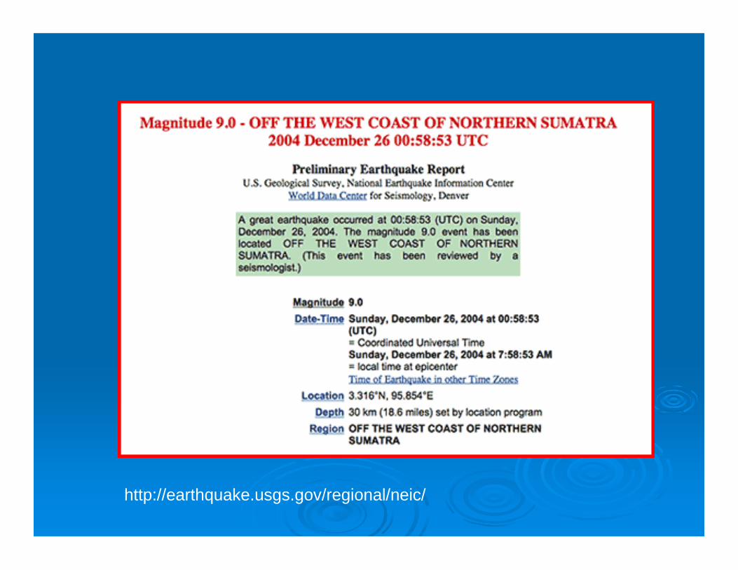
http://earthquake.usgs.gov/regional/neic/

HURRICANE GORDON ADVISORY NUMBER 28NWS TPC/NATIONAL HURRICANE CENTER MIAMI FL AL072006500 PM AST SUN SEP 17 2006
...GORDON FINALLY MOVING NORTH-NORTHEASTWARD...
AT 500 PM AST...2100Z...THE CENTER OF HURRICANE GORDON WAS LOCATEDNEAR LATITUDE 34.6 NORTH...LONGITUDE 52.4 WEST OR ABOUT 1430 MILES...2300 KM...WEST OF THE AZORES.
GORDON IS MOVING TOWARD THE NORTH-NORTHEAST NEAR 14 MPH...22 KM/HR...AND A NORTH-NORTHEAST TO NORTHEAST MOTION WITH AN INCREASE INFORWARD SPEED IS EXPECTED DURING THE NEXT 24 HOURS.
MAXIMUM SUSTAINED WINDS ARE NEAR 80 MPH...130 KM/HR...WITH HIGHERGUSTS. GORDON REMAINS A CATEGORY ONE HURRICANE ON THE SAFFIR-SIMPSON HURRICANE SCALE. LITTLE CHANGE IN STRENGTH IS FORECASTDURING THE NEXT 24 HOURS.DURING THE NEXT 24 HOURS.
HURRICANE FORCE WINDS EXTEND OUTWARD UP TO 25 MILES...35 KM…FROMTHE CENTER...AND TROPICAL STORM FORCE WINDS EXTEND OUTWARD UP TO 115MILES...185 KM.
ESTIMATED MINIMUM CENTRAL PRESSURE IS 983 MB...29.03 INCHES.
REPEATING THE 500 PM AST POSITION...34.6 N...52.4 W. MOVEMENTTOWARD...NORTH-NORTHEAST NEAR 14 MPH. MAXIMUM SUSTAINED WINDS…80MPH. MINIMUM CENTRAL PRESSURE...983 MB.
THE NEXT ADVISORY WILL BE ISSUED BY THE NATIONAL HURRICANE CENTER AT1100 PM AST.
FORECASTER MAINELLI/AVILA

National Warnings - http://www.weather.gov/view/nationalwarnings.php
Tsunami - http://www.prh.noaa.gov/ptwc/
Flash Floods - http://www.fema.gov/news/newsrelease.fema?id=15433
Tornado - http://www.houstoncounty.org/Emergency_Management/SirenWarningSystem.htm
Debris Flow - http://www.wrh.noaa.gov/lox/debris_flow.php#warning

For WednesdayFor Wednesday
�� Review websites prior to WednesdayReview websites prior to Wednesday�� http://www.uaf.edu/news/featured/07/augustine/http://www.uaf.edu/news/featured/07/augustine/�� http://www.avo.alaska.edu/activity/avoreport.phphttp://www.avo.alaska.edu/activity/avoreport.php
?view=update?view=update (weekly update, info release, (weekly update, info release, ?view=update?view=update (weekly update, info release, (weekly update, info release, status report)status report)
�� Come up with questions for Dr. Webley, how Come up with questions for Dr. Webley, how they disseminate disaster information, aircraft they disseminate disaster information, aircraft hazards, monitoring of remote volcanoes, etc. hazards, monitoring of remote volcanoes, etc.