HAZARD, RISK, VULNERABILITY AND CAPACITY …baksa.gov.in/pdf/ddmp_chapter2.pdf8 CHAPTER -2 HAZARD,...
22
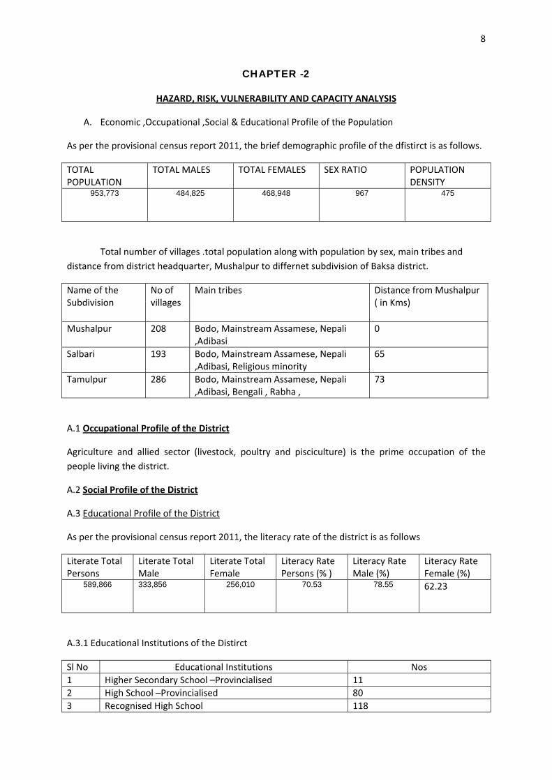
8 CHAPTER -2 HAZARD, RISK, VULNERABILITY AND CAPACITY ANALYSIS A. Economic ,Occupational ,Social & Educational Profile of the Population As per the provisional census report 2011, the brief demographic profile of the dfistirct is as follows. TOTAL POPULATION TOTAL MALES TOTAL FEMALES SEX RATIO POPULATION DENSITY 953,773 484,825 468,948 967 475 Total number of villages .total population along with population by sex, main tribes and distance from district headquarter, Mushalpur to differnet subdivision of Baksa district. Name of the Subdivision No of villages Main tribes Distance from Mushalpur ( in Kms) Mushalpur 208 Bodo, Mainstream Assamese, Nepali ,Adibasi 0 Salbari 193 Bodo, Mainstream Assamese, Nepali ,Adibasi, Religious minority 65 Tamulpur 286 Bodo, Mainstream Assamese, Nepali ,Adibasi, Bengali , Rabha , 73 A.1 Occupational Profile of the District Agriculture and allied sector (livestock, poultry and pisciculture) is the prime occupation of the people living the district. A.2 Social Profile of the District A.3 Educational Profile of the District As per the provisional census report 2011, the literacy rate of the district is as follows Literate Total Persons Literate Total Male Literate Total Female Literacy Rate Persons (% ) Literacy Rate Male (%) Literacy Rate Female (%) 589,866 333,856 256,010 70.53 78.55 62.23 A.3.1 Educational Institutions of the Distirct Sl No Educational Institutions Nos 1 Higher Secondary School –Provincialised 11 2 High School –Provincialised 80 3 Recognised High School 118
Transcript of HAZARD, RISK, VULNERABILITY AND CAPACITY …baksa.gov.in/pdf/ddmp_chapter2.pdf8 CHAPTER -2 HAZARD,...
8
CHAPTER -2
HAZARD, RISK, VULNERABILITY AND CAPACITY ANALYSIS
A. Economic ,Occupational ,Social & Educational Profile of the Population
As per the provisional census report 2011, the brief demographic profile of the dfistirct is as follows.
TOTAL POPULATION
TOTAL MALES TOTAL FEMALES SEX RATIO POPULATION DENSITY
953,773
484,825
468,948
967
475
Total number of villages .total population along with population by sex, main tribes and distance from district headquarter, Mushalpur to differnet subdivision of Baksa district.
Name of the Subdivision
No of villages
Main tribes Distance from Mushalpur ( in Kms)
Mushalpur 208 Bodo, Mainstream Assamese, Nepali ,Adibasi
0
Salbari 193 Bodo, Mainstream Assamese, Nepali ,Adibasi, Religious minority
65
Tamulpur 286 Bodo, Mainstream Assamese, Nepali ,Adibasi, Bengali , Rabha ,
73
A.1 Occupational Profile of the District
Agriculture and allied sector (livestock, poultry and pisciculture) is the prime occupation of the people living the district.
A.2 Social Profile of the District
A.3 Educational Profile of the District
As per the provisional census report 2011, the literacy rate of the district is as follows
Literate Total Persons
Literate Total Male
Literate Total Female
Literacy Rate Persons (% )
Literacy Rate Male (%)
Literacy Rate Female (%)
589,866 333,856 256,010 70.53 78.55
62.23
A.3.1 Educational Institutions of the Distirct
Sl No Educational Institutions Nos 1 Higher Secondary School –Provincialised 11 2 High School –Provincialised 80 3 Recognised High School 118
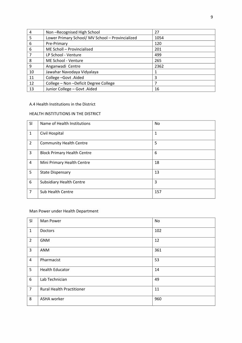
9
4 Non –Recognised High School 27 5 Lower Primary School/ MV School – Provincialized 1054 6 Pre‐Primary 120 6 ME Scholl – Provincialised 201 7 LP School ‐ Venture 499 8 ME School ‐ Venture 265 9 Anganwadi Centre 2362 10 Jawahar Navodaya Vidyalaya 1 11 College –Govt .Aided 3 12 College – Non –Deficit Degree College 7 13 Junior College – Govt .Aided 16
A.4 Health Institutions in the District
HEALTH INSTITUTIONS IN THE DISTRICT
Sl Name of Health Institutions No
1 Civil Hospital 1
2 Community Health Centre 5
3 Block Primary Health Centre 6
4 Mini Primary Health Centre 18
5 State Dispensary 13
6 Subsidiary Health Centre 3
7 Sub Health Centre 157
Man Power under Health Department
Sl Man Power No
1 Doctors 102
2 GNM 12
3 ANM 361
4 Pharmacist 53
5 Health Educator 14
6 Lab Technician 49
7 Rural Health Practitioner 11
8 ASHA worker 960
10
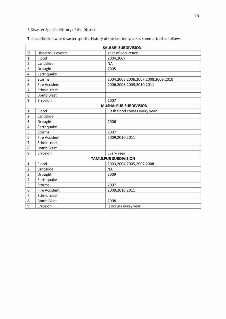
B.Disaster Specific History of the District
The subdivision wise disaster specific history of the last ten years is summarized as follows
SALBARI SUBDIVISION Sl Disastrous events Year of occurence 1 Flood 2004,2007 2 Landslide NA 3 Drought 2005 4 Earthquake 5 Storms 2004,2005,2006,2007,2008,2009,2010 6 Fire Accident 2006,2008,2009,2010,2011 7 Ethnic clash 8 Bomb Blast 9 Errosion 2007 MUSHALPUR SUBDIVISION 1 Flood Flash flood comes every year 2 Landslide 3 Drought 2006 4 Earthquake 5 Storms 2007 6 Fire Accident 2009,2010,2011 7 Ethnic clash 8 Bomb Blast 9 Errosion Every year
TAMULPUR SUBDIVISION 1 Flood 2003,2004,2005,2007,2008 2 Landslide NA 3 Drought 2009 4 Earthquake 5 Storms 2007 6 Fire Accident 2009,2010,2011 7 Ethnic clash 8 Bomb Blast 2008 9 Errosion It occurs every year
11
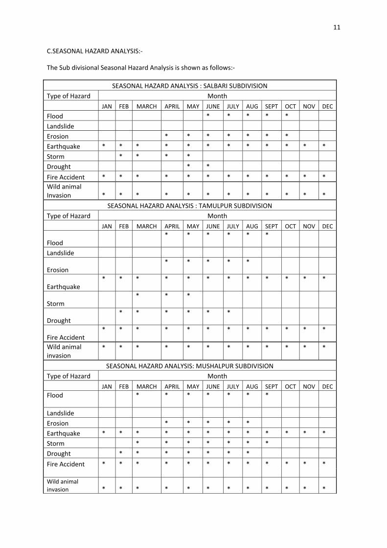
C.SEASONAL HAZARD ANALYSIS:‐
The Sub divisional Seasonal Hazard Analysis is shown as follows:‐
SEASONAL HAZARD ANALYSIS : SALBARI SUBDIVISION Type of Hazard Month JAN FEB MARCH APRIL MAY JUNE JULY AUG SEPT OCT NOV DEC
Flood * * * * * Landslide Erosion * * * * * * * Earthquake * * * * * * * * * * * * Storm * * * * Drought * *
Fire Accident * * * * * * * * * * * * Wild animal Invasion * * * * * * * * * * * *
SEASONAL HAZARD ANALYSIS : TAMULPUR SUBDIVISION Type of Hazard Month JAN FEB MARCH APRIL MAY JUNE JULY AUG SEPT OCT NOV DEC
Flood * * * * * *
Landslide
Erosion * * * * *
Earthquake * * * * * * * * * * * *
Storm * * *
Drought * * * * * *
Fire Accident * * * * * * * * * * * *
Wild animal invasion
* * * * * * * * * * * *
SEASONAL HAZARD ANALYSIS: MUSHALPUR SUBDIVISION Type of Hazard Month JAN FEB MARCH APRIL MAY JUNE JULY AUG SEPT OCT NOV DEC Flood * * * * * * *
Landslide Erosion * * * * * Earthquake * * * * * * * * * * * * Storm * * * * * * * Drought * * * * * * *
Fire Accident * * * * * * * * * * * * Wild animal invasion * * * * * * * * * * * *
12
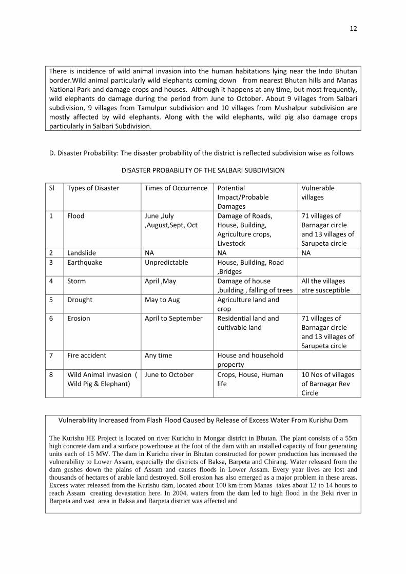
There is incidence of wild animal invasion into the human habitations lying near the Indo Bhutan border.Wild animal particularly wild elephants coming down from nearest Bhutan hills and Manas National Park and damage crops and houses. Although it happens at any time, but most frequently, wild elephants do damage during the period from June to October. About 9 villages from Salbari subdivision, 9 villages from Tamulpur subdivision and 10 villages from Mushalpur subdivision are mostly affected by wild elephants. Along with the wild elephants, wild pig also damage crops particularly in Salbari Subdivision.
D. Disaster Probability: The disaster probability of the district is reflected subdivision wise as follows
DISASTER PROBABILITY OF THE SALBARI SUBDIVISION
Sl Types of Disaster Times of Occurrence Potential Impact/Probable Damages
Vulnerable villages
1 Flood
June ,July ,August,Sept, Oct
Damage of Roads, House, Building, Agriculture crops, Livestock
71 villages of Barnagar circle and 13 villages of Sarupeta circle
2 Landslide NA NA NA 3 Earthquake
Unpredictable House, Building, Road
,Bridges
4 Storm
April ,May Damage of house ,building , falling of trees
All the villages atre susceptible
5 Drought
May to Aug Agriculture land and crop
6 Erosion
April to September Residential land and cultivable land
71 villages of Barnagar circle and 13 villages of Sarupeta circle
7 Fire accident
Any time House and household property
8 Wild Animal Invasion ( Wild Pig & Elephant)
June to October Crops, House, Human life
10 Nos of villages of Barnagar Rev Circle
Vulnerability Increased from Flash Flood Caused by Release of Excess Water From Kurishu Dam
The Kurishu HE Project is located on river Kurichu in Mongar district in Bhutan. The plant consists of a 55m high concrete dam and a surface powerhouse at the foot of the dam with an installed capacity of four generating units each of 15 MW. The dam in Kurichu river in Bhutan constructed for power production has increased the vulnerability to Lower Assam, especially the districts of Baksa, Barpeta and Chirang. Water released from the dam gushes down the plains of Assam and causes floods in Lower Assam. Every year lives are lost and thousands of hectares of arable land destroyed. Soil erosion has also emerged as a major problem in these areas. Excess water released from the Kurishu dam, located about 100 km from Manas takes about 12 to 14 hours to reach Assam creating devastation here. In 2004, waters from the dam led to high flood in the Beki river in Barpeta and vast area in Baksa and Barpeta district was affected and
13
losses ran to over Rs 180 crore. Again in 2007, the Narayanguri embankment was breached by the Beki river as water gushed into the river from Bhutan. This has destroyed 57,452 hectre of agriculture land and about 50000 hectre of agricultural land were rendered uncultivable due to heavy siltation in both Baksa and Barpeta distirct. The devastating flood inundated 758 villages of Barpeta and 111 villages of Baksa district and about 88,807 families were affected in both the distirct. Moreover this flash flood made homeless to 6415 families in Barpeta and 3034 families in Baksa district. The total human life loss was 31 in Barpeta district.(Report: Pratidin ,12th July 2011, P4).
Rivers in districts of Barpeta, Baksa and Dhubri districts of Assam were suddenly in spate on May 26 to May 28, 2009 due to release of water from the Kurishu dam in Bhutan following torrential rains. It triggered flash floods that claimed five lives in Dhubri district and one in Barpeta district besides inundating hundreds of villages
DISASTER PROBABILITY OF THE TAMULPUR SUBDIVISION
Sl Types of Disaster Times of Occurrence
Potential Impact/Probable Damages
Vulnerable villages
1 Flood
June to October House ,Crops , Livestock 8 Nos of villages under Goreswar Rev.circle : List enclosed at Annexure
2 Landslide NA NA NA 3 Earthquake
Unpredictable House, Building, Road
,Bridges,
4 Storm
March to May Residential house ,Public building , Crops ,
70 villages of Goreswar Revenue Circle
5 Drought
Feb to July Crops , Drinking water facilities
6 Erosion
April to Aug Agriculture land , Residential land
7 Fire accident
Any time House and household property
8 Wild Animal Invasion ( Elephant)
June to October Crops, House,Human life 9 Nos of villages of Tamulpur Rev Circle
DISASTER PROBABILITY OF THE MUSHALPUR SUBDIVISION
Sl Types of Disaster Times of Occurrence
Potential Impact/Probable Damages
Vulnerable villages
1 Flood
March to Sept Damage of crops,road, bridges
28 Nos of villages under Barama Rev Circle
2 Landslide NA NA NA 3 Earthquake
Unpredictable House, Building,Road ,Bridges,
14
4 Storm
March to Sept Buildings,Houses, Crops, Vegetation etc.
5 Drought
April to August Crops & Vegetation
All villages of Barama revenue circle
6 Erosion
March to Oct Houses ,Crops, Vegetation
12 Nos of villages under Barama Rev.Circle
7 Fire accident
Any time House and household property
8 Wild Animal Invasion ( Wild Elephant)
Unpredictable Crops, House,Human life
10 Nos of villages under Baganpara Rev Circle
VULNERABILITY OF INFRASTRUCTURE IDENTIFIED BY GOVT.DEPARTMENTS
I. Public Work Department (PWD)
Sl Type of Disaster
Time of Occurence
Vulnerable Road & Building
Vulnerable Areas/Reveneu circle/ Name of villages
Probable impact
Hudukhara Naosali to Ulubari Road
Jalah Reveneu Circle
Kalpani Sub‐way Road
Barnagar Revenue Circle
1 Erosion June to September
Safakamar Kahitema
Barnagar Revenue Circle
Surface damage
Subankhata to Nikashi Road
Chaulkara,Subankhata village under Baganpara revenue circle
Kadamtola Paglabazar Road
Barikadonga, Tupalia,Uttarpar ,Gerua under Baganpara reveneu circle
Baganpara Thalkuchi Road
Tupalia,Thalkuchi,Madaltana under Baganpara reveneu circle
2 Flood June to September
Thakursupa to Golbil Road
Thakursupa, Jartaluk, Goramara, Golbil, Uzirkhat under Baganpara reveneu circle
Scouring of Road surface,Formation of Breach, washed away of culverts, Roads & RCC Bridges
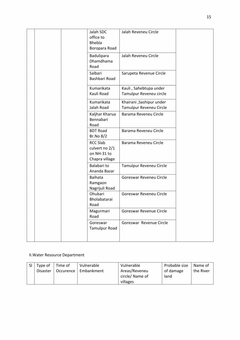
15
Jalah SDC office to Bhebla Boropara Road
Jalah Reveneu Circle
Badulipara Dhamdhama Road
Jalah Reveneu Circle
Salbari Bashbari Road
Sarupeta Revenue Circle
Kumarikata Kauli Road
Kauli , Sahebtupa under Tamulpur Reveneu circle
Kumarikata Jalah Road
Khairani ,Sashipur under Tamulpur Reveneu Circle
Kaljhar Kharua Bennabari Road
Barama Reveneu Circle
BDT Road Br.No 8/2
Barama Reveneu Circle
RCC Slab culvert no 2/1 on NH‐31 to Chapra village
Barama Reveneu Circle
Balabari to Ananda Bazar
Tamulpur Reveneu Circle
Baihata Ramgaon Nagrijuli Road
Goreswar Reveneu Circle
Ohubari Bholabatarai Road
Goreswar Reveneu Circle
Magurmari Road
Goreswar Revenue Circle
Goreswar Tamulpur Road
Goreswar Revenue Circle
II.Water Resource Department
Sl Type of Disaster
Time of Occurence
Vulnerable Embankment
Vulnerable Areas/Reveneu circle/ Name of villages
Probable size of damage land
Name of the River
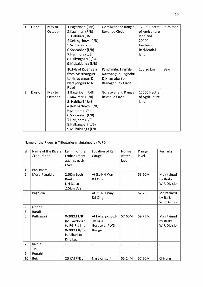
16
1.Bagaribari (R/B) 2.Kawimari (R/B) 3. Habibari ( R/B) 4.Kelengchowk(R/B)5.Salmara (L/B) 6.Sonmohari(L/B) 7.Harijhora (L/B) 8.Hallongbari (L/B) 9.Mukaldanga (L/B)
Goreswar and Rangia Revenue Circle
12000 Hectre of Agriculture land and 20000 Hectres of Residential land
Puthimari
1 Flood May to October
10.F/E of River Beki from Masthanguri to Narayanguri & Narayanguri to N.T Road
Panchmile, Tinimile, Narayanguri,Raghobil & Khagrabari of Barnagar Rev Circle
150 Sq Km Beki
2 Erosion May to October
1.Bagaribari (R/B) 2.Kawimari (R/B) 3. Habibari ( R/B) 4.Kelengchowk(R/B)5.Salmara (L/B) 6.Sonmohari(L/B) 7.Harijhora (L/B) 8.Hallongbari (L/B) 9.Mukaldanga (L/B
Goreswar and Rangia Revenue Circle
12000 Hectre of Agriculture land
Name of the Rivers & Tributaries maintained by WRD
Sl Name of the Rivers /Tributaries
Length of the Embankment against each river
Location of Rain Gauge
Normal water level
Danger level
Remarks
1 Pahumara ‐ ‐ ‐ ‐ ‐ 2 Mora‐Pagaldia 2.5Km Both
Bank ( From NH‐31 to 2.5Km D/S)
At 31‐NH Way Rd Xing
53.50M Maintained by Baska W.R.Division
3 Pagaldia At 31‐NH Way Rd Xing
52.75 Maintained by Baska W.R.Division
4 Noona ‐ ‐ ‐ ‐ ‐ 5 Baralia ‐ ‐ ‐ ‐ ‐ 6 Puthimari 0‐20KM L/B
(Mukaldonga to RG Rly line) 0‐20KM R/B ( Habibari to Dholkuchi)
At kellengchowk ,Rangia Goreswar PWD Bridge
57.60M 59.77M Maintained by Baska W.R.Division
7 Kaldia ‐ ‐ ‐ ‐ ‐ 8 Tihu ‐ ‐ ‐ ‐ ‐ 9 Rupahi ‐ ‐ ‐ ‐ ‐ 10 Beki 25 KM F/E of Narayanguri 55.24M 57.20M Chirang
17
River Beki from Masthanguri to Narayanguri & Narayanguri to N.T Road
W.R.Division
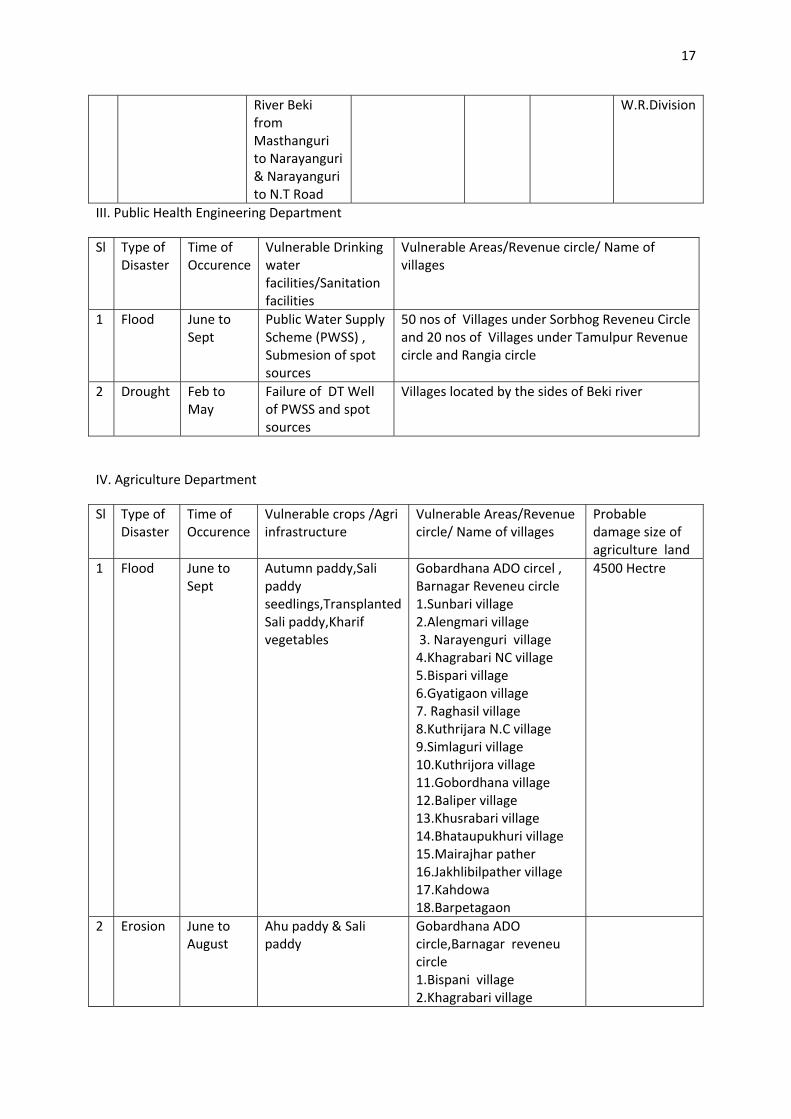
III. Public Health Engineering Department
Sl Type of Disaster
Time of Occurence
Vulnerable Drinking water facilities/Sanitation facilities
Vulnerable Areas/Revenue circle/ Name of villages
1 Flood June to Sept
Public Water Supply Scheme (PWSS) , Submesion of spot sources
50 nos of Villages under Sorbhog Reveneu Circle and 20 nos of Villages under Tamulpur Revenue circle and Rangia circle
2 Drought Feb to May
Failure of DT Well of PWSS and spot sources
Villages located by the sides of Beki river
IV. Agriculture Department
Sl Type of Disaster
Time of Occurence
Vulnerable crops /Agri infrastructure
Vulnerable Areas/Revenue circle/ Name of villages
Probable damage size of agriculture land
1 Flood June to Sept
Autumn paddy,Sali paddy seedlings,Transplanted Sali paddy,Kharif vegetables
Gobardhana ADO circel , Barnagar Reveneu circle 1.Sunbari village 2.Alengmari village 3. Narayenguri village 4.Khagrabari NC village 5.Bispari village 6.Gyatigaon village 7. Raghasil village 8.Kuthrijara N.C village 9.Simlaguri village 10.Kuthrijora village 11.Gobordhana village 12.Baliper village 13.Khusrabari village 14.Bhataupukhuri village 15.Mairajhar pather 16.Jakhlibilpather village 17.Kahdowa 18.Barpetagaon
4500 Hectre
2 Erosion June to August
Ahu paddy & Sali paddy
Gobardhana ADO circle,Barnagar reveneu circle 1.Bispani village 2.Khagrabari village
18
3.Simulbari village 4.Gobordhana village 5.Sunbari village
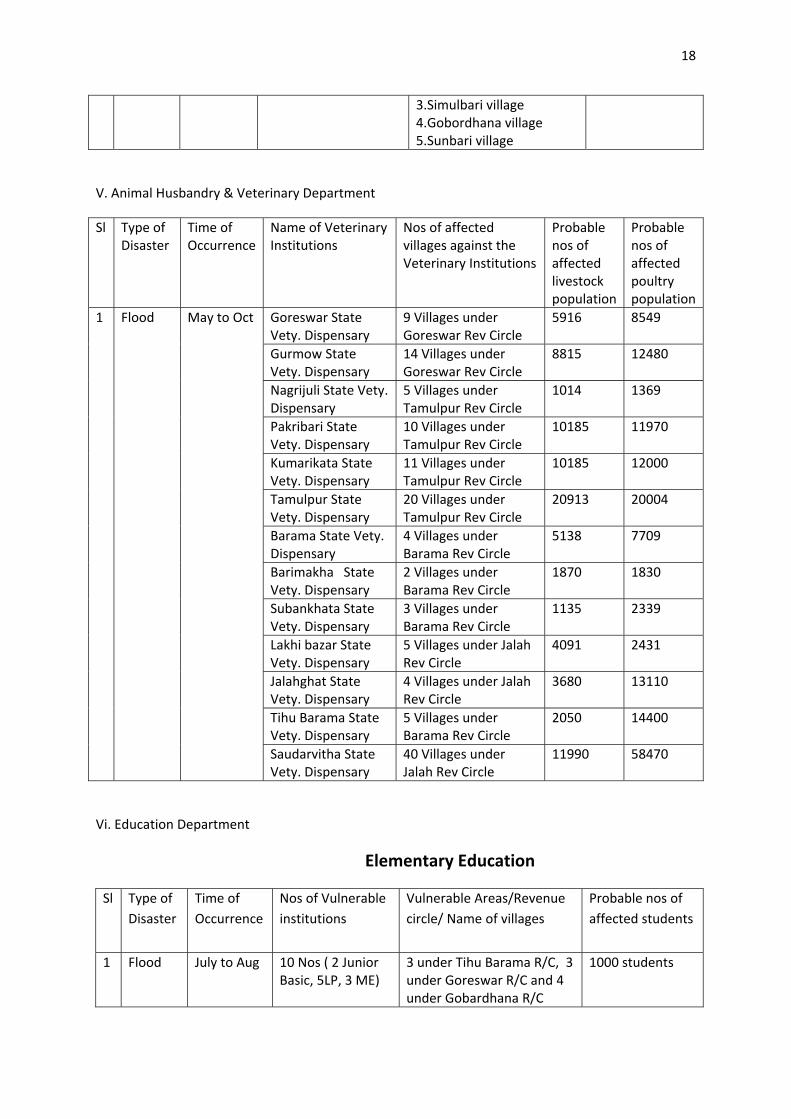
V. Animal Husbandry & Veterinary Department
Sl Type of Disaster
Time of Occurrence
Name of Veterinary Institutions
Nos of affected villages against the Veterinary Institutions
Probable nos of affected livestock population
Probable nos of affected poultry population
Goreswar State Vety. Dispensary
9 Villages under Goreswar Rev Circle
5916 8549
Gurmow State Vety. Dispensary
14 Villages under Goreswar Rev Circle
8815 12480
Nagrijuli State Vety. Dispensary
5 Villages under Tamulpur Rev Circle
1014 1369
Pakribari State Vety. Dispensary
10 Villages under Tamulpur Rev Circle
10185 11970
Kumarikata State Vety. Dispensary
11 Villages under Tamulpur Rev Circle
10185 12000
Tamulpur State Vety. Dispensary
20 Villages under Tamulpur Rev Circle
20913 20004
Barama State Vety. Dispensary
4 Villages under Barama Rev Circle
5138 7709
Barimakha State Vety. Dispensary
2 Villages under Barama Rev Circle
1870 1830
Subankhata State Vety. Dispensary
3 Villages under Barama Rev Circle
1135 2339
Lakhi bazar State Vety. Dispensary
5 Villages under Jalah Rev Circle
4091 2431
Jalahghat State Vety. Dispensary
4 Villages under Jalah Rev Circle
3680 13110
Tihu Barama State Vety. Dispensary
5 Villages under Barama Rev Circle
2050 14400
1 Flood May to Oct
Saudarvitha State Vety. Dispensary
40 Villages under Jalah Rev Circle
11990 58470
Vi. Education Department
Elementary Education
Sl Type of Disaster
Time of Occurrence
Nos of Vulnerable institutions
Vulnerable Areas/Revenue circle/ Name of villages
Probable nos of affected students
1 Flood July to Aug 10 Nos ( 2 Junior Basic, 5LP, 3 ME)
3 under Tihu Barama R/C, 3 under Goreswar R/C and 4 under Gobardhana R/C
1000 students
19
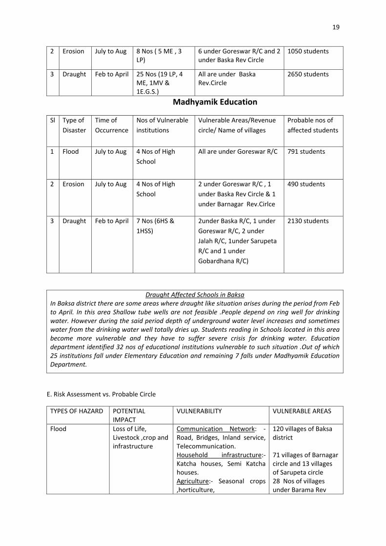
2 Erosion July to Aug 8 Nos ( 5 ME , 3 LP)
6 under Goreswar R/C and 2 under Baska Rev Circle
1050 students
3 Draught Feb to April 25 Nos (19 LP, 4 ME, 1MV & 1E.G.S.)
All are under Baska Rev.Circle
2650 students
Madhyamik Education
Sl Type of Disaster
Time of Occurrence
Nos of Vulnerable institutions
Vulnerable Areas/Revenue circle/ Name of villages
Probable nos of affected students
1 Flood July to Aug 4 Nos of High School
All are under Goreswar R/C 791 students
2 Erosion July to Aug 4 Nos of High School
2 under Goreswar R/C , 1 under Baska Rev Circle & 1 under Barnagar Rev.Cirlce
490 students
3 Draught Feb to April 7 Nos (6HS & 1HSS)
2under Baska R/C, 1 under Goreswar R/C, 2 under Jalah R/C, 1under Sarupeta R/C and 1 under Gobardhana R/C)
2130 students
Draught Affected Schools in Baksa In Baksa district there are some areas where draught like situation arises during the period from Feb to April. In this area Shallow tube wells are not feasible .People depend on ring well for drinking water. However during the said period depth of underground water level increases and sometimes water from the drinking water well totally dries up. Students reading in Schools located in this area become more vulnerable and they have to suffer severe crisis for drinking water. Education department identified 32 nos of educational institutions vulnerable to such situation .Out of which 25 institutions fall under Elementary Education and remaining 7 falls under Madhyamik Education Department.
E. Risk Assessment vs. Probable Circle
TYPES OF HAZARD POTENTIAL IMPACT
VULNERABILITY VULNERABLE AREAS
Flood
Loss of Life, Livestock ,crop and infrastructure
Communication Network: ‐ Road, Bridges, Inland service, Telecommunication. Household infrastructure:‐Katcha houses, Semi Katcha houses. Agriculture:‐ Seasonal crops ,horticulture,
120 villages of Baksa district 71 villages of Barnagar circle and 13 villages of Sarupeta circle 28 Nos of villages under Barama Rev
20
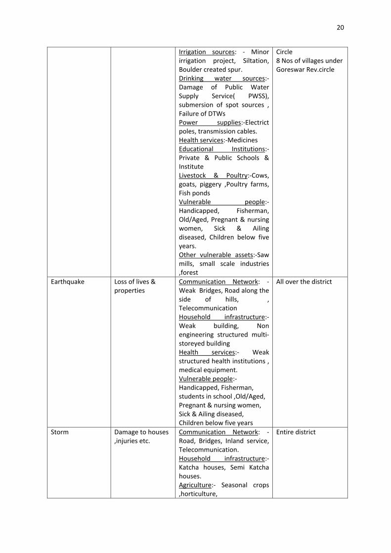
Irrigation sources: ‐ Minor irrigation project, Siltation, Boulder created spur. Drinking water sources:‐ Damage of Public Water Supply Service( PWSS), submersion of spot sources , Failure of DTWs Power supplies:‐Electrict poles, transmission cables. Health services:‐Medicines Educational Institutions:‐ Private & Public Schools & Institute Livestock & Poultry:‐Cows, goats, piggery ,Poultry farms, Fish ponds Vulnerable people:‐Handicapped, Fisherman, Old/Aged, Pregnant & nursing women, Sick & Ailing diseased, Children below five years. Other vulnerable assets:‐Saw mills, small scale industries ,forest
Circle 8 Nos of villages under Goreswar Rev.circle
Earthquake
Loss of lives & properties
Communication Network: ‐ Weak Bridges, Road along the side of hills, , Telecommunication Household infrastructure:‐ Weak building, Non engineering structured multi‐storeyed building Health services:‐ Weak structured health institutions , medical equipment. Vulnerable people:‐Handicapped, Fisherman, students in school ,Old/Aged, Pregnant & nursing women, Sick & Ailing diseased, Children below five years
All over the district
Storm
Damage to houses ,injuries etc.
Communication Network: ‐ Road, Bridges, Inland service, Telecommunication. Household infrastructure:‐Katcha houses, Semi Katcha houses. Agriculture:‐ Seasonal crops ,horticulture,
Entire district
21
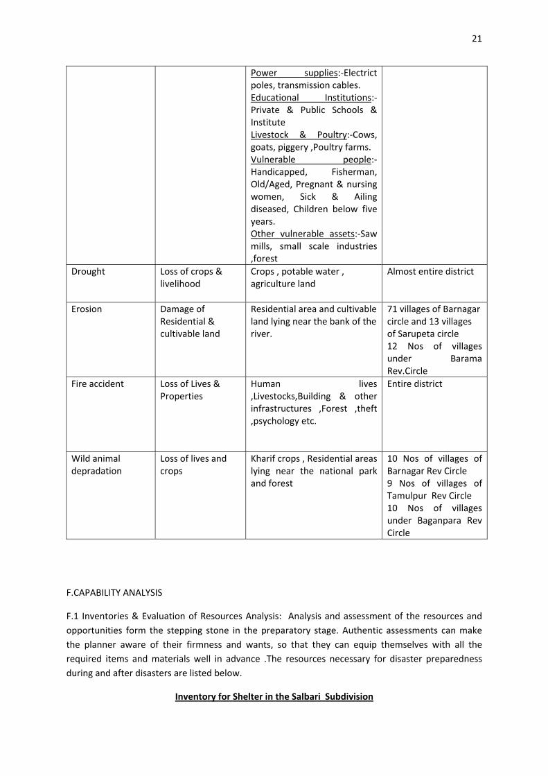
Power supplies:‐Electrict poles, transmission cables. Educational Institutions:‐ Private & Public Schools & Institute Livestock & Poultry:‐Cows, goats, piggery ,Poultry farms. Vulnerable people:‐Handicapped, Fisherman, Old/Aged, Pregnant & nursing women, Sick & Ailing diseased, Children below five years. Other vulnerable assets:‐Saw mills, small scale industries ,forest
Drought
Loss of crops & livelihood
Crops , potable water , agriculture land
Almost entire district
Erosion
Damage of Residential & cultivable land
Residential area and cultivable land lying near the bank of the river.
71 villages of Barnagar circle and 13 villages of Sarupeta circle 12 Nos of villages under Barama Rev.Circle
Fire accident
Loss of Lives & Properties
Human lives ,Livestocks,Building & other infrastructures ,Forest ,theft ,psychology etc.
Entire district
Wild animal depradation
Loss of lives and crops
Kharif crops , Residential areas lying near the national park and forest
10 Nos of villages of Barnagar Rev Circle 9 Nos of villages of Tamulpur Rev Circle 10 Nos of villages under Baganpara Rev Circle
F.CAPABILITY ANALYSIS
F.1 Inventories & Evaluation of Resources Analysis: Analysis and assessment of the resources and opportunities form the stepping stone in the preparatory stage. Authentic assessments can make the planner aware of their firmness and wants, so that they can equip themselves with all the required items and materials well in advance .The resources necessary for disaster preparedness during and after disasters are listed below.
Inventory for Shelter in the Salbari Subdivision
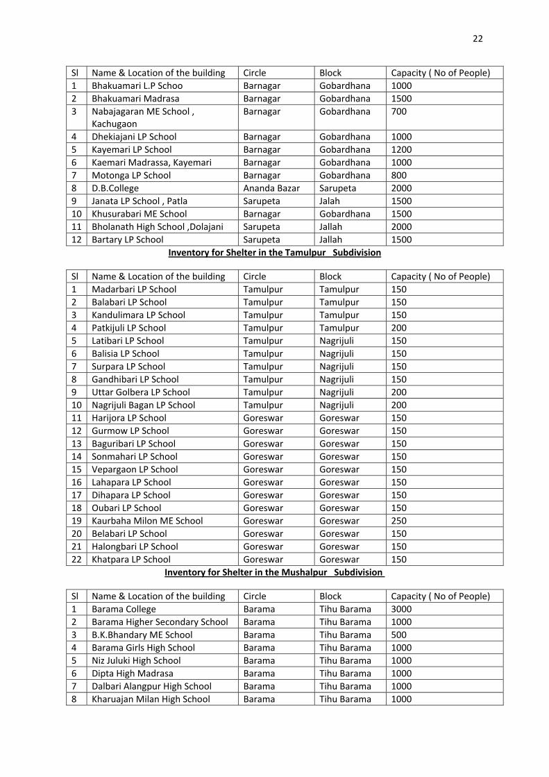
22
Sl Name & Location of the building Circle Block Capacity ( No of People) 1 Bhakuamari L.P Schoo Barnagar Gobardhana 1000 2 Bhakuamari Madrasa Barnagar Gobardhana 1500 3 Nabajagaran ME School ,
Kachugaon Barnagar Gobardhana 700
4 Dhekiajani LP School Barnagar Gobardhana 1000 5 Kayemari LP School Barnagar Gobardhana 1200 6 Kaemari Madrassa, Kayemari Barnagar Gobardhana 1000 7 Motonga LP School Barnagar Gobardhana 800 8 D.B.College Ananda Bazar Sarupeta 2000 9 Janata LP School , Patla Sarupeta Jalah 1500 10 Khusurabari ME School Barnagar Gobardhana 1500 11 Bholanath High School ,Dolajani Sarupeta Jallah 2000 12 Bartary LP School Sarupeta Jallah 1500
Inventory for Shelter in the Tamulpur Subdivision
Sl Name & Location of the building Circle Block Capacity ( No of People) 1 Madarbari LP School Tamulpur Tamulpur 150 2 Balabari LP School Tamulpur Tamulpur 150 3 Kandulimara LP School Tamulpur Tamulpur 150 4 Patkijuli LP School Tamulpur Tamulpur 200 5 Latibari LP School Tamulpur Nagrijuli 150 6 Balisia LP School Tamulpur Nagrijuli 150 7 Surpara LP School Tamulpur Nagrijuli 150 8 Gandhibari LP School Tamulpur Nagrijuli 150 9 Uttar Golbera LP School Tamulpur Nagrijuli 200 10 Nagrijuli Bagan LP School Tamulpur Nagrijuli 200 11 Harijora LP School Goreswar Goreswar 150 12 Gurmow LP School Goreswar Goreswar 150 13 Baguribari LP School Goreswar Goreswar 150 14 Sonmahari LP School Goreswar Goreswar 150 15 Vepargaon LP School Goreswar Goreswar 150 16 Lahapara LP School Goreswar Goreswar 150 17 Dihapara LP School Goreswar Goreswar 150 18 Oubari LP School Goreswar Goreswar 150 19 Kaurbaha Milon ME School Goreswar Goreswar 250 20 Belabari LP School Goreswar Goreswar 150 21 Halongbari LP School Goreswar Goreswar 150 22 Khatpara LP School Goreswar Goreswar 150
Inventory for Shelter in the Mushalpur Subdivision
Sl Name & Location of the building Circle Block Capacity ( No of People) 1 Barama College Barama Tihu Barama 3000 2 Barama Higher Secondary School Barama Tihu Barama 1000 3 B.K.Bhandary ME School Barama Tihu Barama 500 4 Barama Girls High School Barama Tihu Barama 1000 5 Niz Juluki High School Barama Tihu Barama 1000 6 Dipta High Madrasa Barama Tihu Barama 1000 7 Dalbari Alangpur High School Barama Tihu Barama 1000 8 Kharuajan Milan High School Barama Tihu Barama 1000
23
9 Kadamtala High School Barama Tihu Barama 2000 10 Barimakha High School Barama Tihu Barama 2500 11 Bengali ME & High School Barama Tihu Barama 2500 12 Debachara High School Barama Tihu Barama 2000 13 Thamna High School Baska Baska 350
Inventory for Storage of food in Salbari Subdivision
Sl Name & Location of the building Circle Block Capacity (In quintals) 1 Jallah Dev.Block Building ( 3
Building) Jallah
Jallah 50 Matric Tonnes
2
Gobardhana Development Block Bulding
Gobardhana Gobardhana 10 Matric Tonnes
Inventory for Storage of food in Tamulpur Subdivision
Sl Name & Location of the building Circle Block Capacity (In quintals) 1 Goreswar Rev.Circle Goreswar
Goreswar 100 Qtls
2
Suklai Irrigation Deptt. Goreswar Goreswar 200 Qtls
Inventory for Storage of food in Mushalpur Subdivision
Sl Name & Location of the building Circle Block Capacity (In quintals)
1 Barama High School Barama
Tihu Barama 2000 Qtls
2
Barama Girls High School Barama Tihu Barama 1500 Qtls
3 Dipta High Madrassa Barama Tihu Barama 2000Qtls 4 Barimakha High School Barama Tihu Barama 2000 Qtls
List of Police Station & Outpost location
Sl Designation Name of Office Location of Office Name of Officer Land line contact No Mobile No
1 SP SP Office Katligaon Bir Bikram Gogoi 03624234681, 03624234680
9435196880
2 Addtl.SP SP Office Katligaon Sri Hiranya Barman 03624234681, 03624234681
9957308090/9435183822
3 Dy.SP SP Office Katligaon Sri Nitya Ranjan Chutia
03624234681, 03624234682
9435564282/9859992366
4 SDPO SDPO Office Tamulpur Sayed Abdus Shamad Hussain
Not available 9435514472/7896694500/9613303172
5 SDPO SDPO Office Salbari Sri D.K.Mahanta Not available 9435354002
6 CI (Circle Inspector)
Barama Insp.Tileswar Saikia Not available 9854055366
7 Addi.CI SDPO Office Tamulpur Insp.Rukmo Buragohain
Not available 9864065123
8 O.C S.I Police Station Tamulpur Girindra Nath Deka Not available 9435125840
9 O.C S.I Police Station Goreswar Prasanta Bezbarua Not available 8011374955
24
10 O.C S.I Police Station Barama Mantu Talukdar Not available 9435016402
11 O.C S.I Police Station Barbari Sayadur Rahman Not available 9864671230
12 O.C S.I Police Station Mushalpur Tapan Kalita Not available 9854025909
13 O.C S.I Police Station Simla L.P.Kachari Not available 9854233367
14 O.C S.I Police Station Gobardhana Abu Bakkar Siddique Not available 7896359442
15 O.C S.I Police Station Salbari Dilip Medhi Not available 9401025182
16 IC ASI Police Outpost Doomni Dukho Ram Boro Not available 9613147667
17 IC ASI Police Outpost Baganpara Naren Borah Not available 9859402531
18 IC SI Police Outpost Darrangamela Ganesh Barman Not available 9854977686
19 IC SI Police Outpost Nagrijuli Moser Ali Ahmed Not available 9435190310
20 IC SI Police Outpost Kumarikata Upendra Nath Not available 9435441844
21 IC SI Police Outpost Gandhibari Tulshi Bora Not available 9864751717
22 IC SI Police Outpost Ananda Bazar H.Talukdar Not available 9954752956
23 IC SI Police Outpost Suaghpur Mojibur Rahman Not available 9854039880
24 IC SI Police Outpost Nikashi Ananta Ram Barman Not available 9859513227
25 IC ASI Police Outpost Aithabari Iman Ali Not available 9435860843
26 IC ASI Patrol Post Bansbari Mridul Bhagabati Not available 9954950906
27 IC ASI Patrol Post Kaurbaha Anil Mazumdar Not available 9859034605
28 IC SI Patrol Post Labdanguri Naren Das Not available 9864322029
29 IC SI Patrol Post Jalah Khetra Konwar Not available 9435406763
30 SI ( UB) Police Reserve Barbari Kumud Sarma Not available 9435280303
31 Motor Transport Officer
Police Reserve Barbari Munin Dutta Not available 9435664418
32 Police Control Room
SP Office Katligaon Satyan Das Not available 03624292948/03624234570
List of Fire Services
Sl Name and Address of the Office
Name & Designation of the Officer
Contact no Land Line
Contact No Mobile
Nos of Fire Tender
Other rescue equipments
Bhaban Kalita , Subofficer
03624234686
9854318838 1 Fire Station ,Mushalpur
Upen Baishya,Subofficer
03624234686
9854488374
2 ( Mini)
A.Life Jacket‐2 No B.Lifeboy‐ 2No Fire C.Extinguisher – 3 No ( 5Kg size) D.Rope ‐2No( 40 meter each)
25
2 Fire Station , Tihu
Jonardan Das, Subofficer
03624281244 9957710179 2 ( Mini‐1, Large‐1)
Lifejacket‐25, Lifeboy – 15, Fire Extng – 10(5Kg each), Ladder ‐2 No, Rope‐ 3 No
3 Fire Station , Nalbari
Lakheswar Goswami, Station Officer
03624220222 9706128251 4 (Mini‐2,Large‐2)
Lifejacket‐4, Lifeboy – 10, Fire Extng‐3 (25 Kg each), Fire Extng – 50(5Kg each), Ladder ‐4 No, Rope‐ 5 No
4 Fire Station, Pathsala
Prafulla Mali, Station Officer
03666266456 9435312276 2 ( Large‐1, Mini – 1)
Lifejacket‐6, Lifeboy – 6, Fire Extng‐1 (25 Kg each), Fire Extng – 3(5Kg each), Ladder ‐2 No, Rope‐ 3 No
5 Fire Station , Rangyia
Sailen Kakoti,Station Officer
03621240517 9864217137 2 ( Large‐1,Mini‐1)
Lifejacket‐10, Lifeboy – 10, Fire Extng‐10 (25 Kg each), Fire Extng – 20(5Kg each), Ladder ‐2 No, Rope‐ 10 No
6 Fire Station ,Baihata Chariali
0361286477 Lifejacket‐10, Lifeboy – 10, Fire Extng‐ (25 Kg each), Fire Extng – (5Kg each), Ladder ‐3 No, Rope‐ No
7 Fire Station,Barpeta Road
Sarat Saud ( Station Officer), Babul Ch Das ( Sub Officer)
03666260899 9707725587, 9954245686
3 ( All large)
Lifejacket‐11, Lifeboy – 11, Fire Extng‐ 4(10 Kg each), Fire Extng –8 (4.5Kg each), Fire Extng –25 (25Kg each Ladder ‐3 No, Rope‐ 1 No, Fire proxivit suit‐1
26
F.2 Communication & Media
F.2.1 Surface Communication: ‐ The subdivision wise surface communication is shown as follows
SURFACE COMMUNICATION WITH MOTORABLE ROAD IN THE SALBARI SUBDIVISION
Sl From To Means Distance (KM) 1 Bhabanipur Salbari Tata Sumo,Cruiser ,
Tempo 18
2 Saudarvita Gobardhana DO 18 3 Basbari Barpeta Road DO 21
4 Rupahi Jallah DO 35 5 Salbari Basbari DO 8 6 Khusbai Barpeta DO 12
SURFACE COMMUNICATION WITH MOTORABLE ROAD IN THE TAMULPUR SUBDIVISION
Sl From To Means Distance (KM) 1 Tamulpur Rangia Bus,Sumo, Winger
,Tampo 22KM
2 Goreswar Rangia Tata Sumo, Bus,Cruiser ,Tampo
25KM
3 Goreswar Bangalipara Tata Sumo, Bus,Cruiser ,Tampo
30KM
4 Goreswar Baihata Chariali Tata Sumo, Bus,Cruiser ,Tampo
20KM
5 Tamulpur Sandrup Janker ( Bhutan)
Bus ,Tata sumo ,Cruiser
28KM
SURFACE COMMUNICATION WITH MOTORABLE ROAD IN THE MUSHALPUR SUBDIVISION
Sl From To Means Distance (KM) 1 Kadamtala Mushalpur Tempo, Cruiser
,Winger ,Bus ,Tata sumo
19KM
2 Barama Kadamtala Tempo, Cruiser ,Winger ,Bus ,Tata sumo
5KM
3 Mushalpur Jalah Two wheeler , Private car
9KM
4 Mushalpur Nikashi Bus , Cruiser ,Tempo ,Tata Sumo
8KM
5 Mushalpur Barbari Private vehicle 7KM 6 Mushalpur Tamulpur
Subdivision Tempo, Cruiser ,Winger ,Bus ,Tata sumo
60KM
7 Mushalpur Salbari Subdivision Tempo, Cruiser ,Winger ,Bus ,Tata sumo
60KM
27
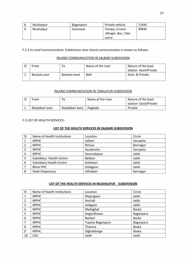
8 Mushalpur Baganpara Private vehicle 11KM 9 Mushalpur Goreswar Tempo, Cruiser
,Winger ,Bus ,Tata sumo
90KM
F.2.1 In‐Land Communication: Subdivision wise inland communication is shown as follows:
INLAND COMMUNICATION IN SALBARI SUBDIVISION
Sl From To Name of the river Nature of the boat station‐ Govt/Private
1 Barpeta east Barpeta west Beki
Govt. & Private
INLAND COMMUNICATION IN TAMULPUR SUBDIVISION
Sl From To Name of the river Nature of the boat station‐ Govt/Private
1 Madalbari east Madalbari west Pagladia Private
F.3 LIST OF HEALTH SERVICES:‐
LIST OF THE HEALTH SERVICES IN SALBARI SUBDIVISION
Sl Name of Health Institutions Location Circle 1 MPHC Salbari Sarupeta 2 MPHC Nimua Barnagar 3 MPHC Saudarvita Sarupeta 4 MPHC Swarnabazar Jalah 5 Subsidiary Health Centre Betbari Jalah 6 Subsidiary Health Centre Koklabari Jalah 7 Block PHC Golagaon Jalah 8 State Dispensary Athiabari Barnagar
LIST OF THE HEALTH SERVICES IN MUSHALPUR SUBDIVISION
Sl Name of Health Institutions Location Circle 1 MPHC Majorgaon Jalah 2 MPHC Anchali Jalah 3 MPHC Jolagaon Jalah 4 MPHC Medaghat Baska 5 MPHC Angardhowa Baganpara 6 MPHC Barbari Baska 7 MPHC Tupalia Baganpara Baganpara 8 MPHC Thamna Baska 9 MPHC Dighaldonga Baska 10 CHC Jalah Jalah
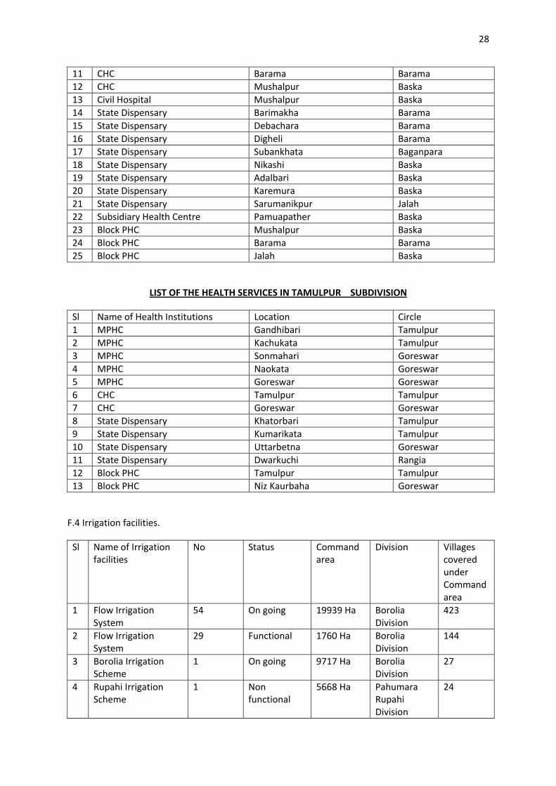
28
11 CHC Barama Barama 12 CHC Mushalpur Baska 13 Civil Hospital Mushalpur Baska 14 State Dispensary Barimakha Barama 15 State Dispensary Debachara Barama 16 State Dispensary Digheli Barama 17 State Dispensary Subankhata Baganpara 18 State Dispensary Nikashi Baska 19 State Dispensary Adalbari Baska 20 State Dispensary Karemura Baska 21 State Dispensary Sarumanikpur Jalah 22 Subsidiary Health Centre Pamuapather Baska 23 Block PHC Mushalpur Baska 24 Block PHC Barama Barama 25 Block PHC Jalah Baska
LIST OF THE HEALTH SERVICES IN TAMULPUR SUBDIVISION
Sl Name of Health Institutions Location Circle 1 MPHC Gandhibari Tamulpur 2 MPHC Kachukata Tamulpur 3 MPHC Sonmahari Goreswar 4 MPHC Naokata Goreswar 5 MPHC Goreswar Goreswar 6 CHC Tamulpur Tamulpur 7 CHC Goreswar Goreswar 8 State Dispensary Khatorbari Tamulpur 9 State Dispensary Kumarikata Tamulpur 10 State Dispensary Uttarbetna Goreswar 11 State Dispensary Dwarkuchi Rangia 12 Block PHC Tamulpur Tamulpur 13 Block PHC Niz Kaurbaha Goreswar
F.4 Irrigation facilities.
Sl Name of Irrigation facilities
No Status Command area
Division Villages covered under Command area
1 Flow Irrigation System
54 On going 19939 Ha Borolia Division
423
2 Flow Irrigation System
29 Functional 1760 Ha Borolia Division
144
3 Borolia Irrigation Scheme
1 On going 9717 Ha Borolia Division
27
4 Rupahi Irrigation Scheme
1 Non functional
5668 Ha Pahumara Rupahi Division
24

29