Haydon Park Investigation Study September 2021
51
Haydon Park Investigation Study Planting trees in stormwater basins NSW Department of Planning, Industry and Environment September 2021
Transcript of Haydon Park Investigation Study September 2021

Haydon Park Investigation Study Planting trees in stormwater basins
NSW Department of Planning, Industry and EnvironmentSeptember 2021

Acknowledgement of CountryNSW Department of Planning, Industry and Environment acknowledges the Traditional Custodians of the land and pays respect to all Elders past, present and future.
Published by NSW Department of Planning, Industry and Environment
dpie.nsw.gov.au
Title: Haydon Park investigation study: Planting trees in stormwater basins
This document is part of the Rosemeadow Demonstration Project completed in collaboration with Campbelltown City Council. Research, analysis, project planning, design and graphics to prepare this study were undertaken by Realm Studios in partnership with E2DesignLab and Cred Consulting in July 2020. Additional water balance modelling work was undertaken by Spiire in November 2020.
Copyright notice
© State of New South Wales through Department of Planning, Industry and Environment 2021. You may copy, distribute, display, download and otherwise freely deal with this publication for any purpose, provided that you attribute the Department of Planning, Industry and Environment as the owner. However, you must obtain permission if you wish to charge others for access to the publication (other than at cost); include the publication in advertising or a product for sale; modify the publication; or republish the publication on a website. You may freely link to the publication on a departmental website.
ISBN: 978-1-76058-479-5
Disclaimer
The information contained in this publication is based on knowledge and understanding at the time of writing (September 2021) and may not be accurate, current or complete. The State of New South Wales (including the NSW Department of Planning, Industry and Environment), the author and the publisher take no responsibility, and will accept no liability, for the accuracy, currency, reliability or correctness of any information included in the document (including material provided by third parties). Readers should make their own inquiries and rely on their own advice when making decisions related to material contained in this publication.
Illustration: Credit Nikita Ridgeway


Part 1:Haydon Park investigation study 04Executive summary 06
Introduction 14Background 14Purpose and aims of study 16Audience 16How this study will be used 16Why we need this study 17
Methodology 18Scope of this study 18Approach 19
Assessment criteria 20Overview 20Stormwater infrastructure assessment criteria 20State and local government policy direction 22Additional performance requirements 24Final assessment criteria 25
Haydon Park: existing site condition 26Landform, vegetation and use 27Urban Heat Index and Heat Vulnerability Index 28Catchment, hydraulics and stormwater information 29

Scenario testing 30Scenario overview 30Scenario development 30Scenario 1 34Scenario 2 38Scenario 3 42
Comparative assessment 46Results: assessment table 46Water management 48Key findings 49Next steps 49
Part 2:Practical guidance
50Introduction 52
Quality tree canopy planting toolkit 53Tree palette 53Groundcover palette 53
Care and maintenance 58Maintenance 58Erosion and soils 60Weeds 61
Considerations for infrastructure 62Stormwater infrastructure suited to tree planting 62Trees in retarding basins 63Trees in channels 68Where to plant trees 70
Case studies 72Detention basins 72Channels 73Precedents 75


Part 1: Haydon Park investigation study

Executive summary
Background
Addressing the urban heat island effect in Western Sydney
The urban heat island effect in the Western Sydney district is a major challenge that affects the health and well-being of the community. One approach to mitigating the urban heat island effect involves increasing ‘urban’ tree canopy cover in urban areas.
Recognising this, the NSW Government, through the 5 Million Trees for Greater Sydney Program (5MT), aims to plant trees in both the public and private realm to expand urban tree canopy towards 40%, across 33 local government areas (LGAs) within the Greater Sydney metropolitan area. The 5 Million Trees Program is aligned to and supports the NSW Premier’s Priority, Greening our city – Increase the tree canopy and green cover across Greater Sydney by planting 1 million trees by 2022. Objectives include:
• assisting in the amelioration of climate extremes by providing shade and cooling of urban areas through tree planting
• creating a healthier, more liveable and greener Greater Sydney.
Rosemeadow Demonstration Project
Rosemeadow is a suburb within Campbelltown City Council and was selected as a demonstration project for the 5MT Program. It has a tree canopy coverage measurement of 5.63%, one of the lowest in the Greater Sydney region (Greater Sydney Region Urban Vegetation Cover 2016).
The intent of the demonstration project was to showcase the methodology, learnings and outcomes to create a useful framework to inform future urban tree canopy projects across Greater Sydney. The Rosemeadow Demonstration Project explored ways to achieve the 40% canopy target through tree planting on public land (including streets, schools and open spaces), as well as in open spaces that have a dual purpose as stormwater overland flow infrastructure.
Haydon Park Investigation Study
The purpose of this hypothetical case study is to theoretically test the impact of tree planting in open space that has a dual purpose as a stormwater detention basin. The study has used Haydon Park, Rosemeadow as a case study to demonstrate the impacts of tree planting through the development of scenarios.
The study demonstrates how increasing tree canopy cover in these types of open spaces can result in improved water quality, reduced flooding risk, increased urban cooling, improved stormwater management and improved recreation opportunities. Assessment criteria were developed to gauge the impact of proposed changes against the existing condition of Haydon Park. Further detailed site-specific technical studies would be required to facilitate the delivery of projects looking to use these approaches.
NSW Department of Planning, Industry and Environment06

‘Campbelltown City Council supports the NSW Department of Planning, Industry and Environment’s study undertaken at Haydon Park, Rosemeadow to incorporate tree canopy into open space that also functions as stormwater infrastructure. Haydon Park is a dual-purpose open space and stormwater asset of council. The park’s stormwater function to date has impacted on the opportunity to integrate tree planting to provide quality open space, amenity shade and urban cooling. This study provides example scenarios on how
stormwater assets and tree planting can coexist to provide benefits to the community and the environment. By embracing the key principles of this report, dual-purpose open space and stormwater areas in Campbelltown can become treed areas that aid in cooling, provide habitat, improve recreation opportunities and make better use of captured water to irrigate planting areas.’
- Ian Andrews, Executive Manager Open Space, Campbelltown City Council
Developing assessment criteria
Assessment criteria were developed to reflect existing state and local government policies and were also informed by the technical engineering requirements for stormwater infrastructure to ensure the main functional components were being upheld.
The engineering requirements of flood-retarding basins and drainage channel easements can be broken down into three primary considerations:
1. Hydraulics: stormwater infrastructure needed to support the required flow characteristics and capacity that they were designed for.
2. Structural integrity: the integrity of some infrastructure components is critical to protect public safety and property.
3. Maintenance: infrastructure must be maintainable in a feasible and safe way.
The review of state and local government studies, strategies and reports identified three additional performance requirements that should be considered when assessing stormwater infrastructure.
1. Urban cooling: shade reduces surface temperatures and lowers the air temperature via evapotranspiration.
2. Water quality: utilise sediment and erosion control measures to improve water quality across the catchment.
3. Biodiversity: increase in vegetation restores, enhances and creates new habitats for flora and fauna species.
Haydon Park Investigation Study – September 2021 07

Scenarios for incorporating tree canopy in stormwater infrastructure
The study developed three different approaches (scenarios) to incorporating tree canopy cover in the open space at Haydon Park. The performance of the scenarios was assessed using the assessment criteria. The scenarios were then compared with the performance of the existing condition in Haydon Park to demonstrate the outcomes of increasing tree canopy coverage.
Each of the scenarios considered:
• increasing tree canopy to provide urban cooling• configuration of a diversion channel to increase the capacity
of the detention basin • suitable clearance around outlet structure to prevent
blockage• alternatives for utilising the water captured, and • a balanced approach to increased biodiversity and recreation
opportunities. All scenarios were designed to have no negative impacts on flood conditions within the catchment. Additional water storage would be provided through different configurations of diversion channels. Riparian zones were created to improve water quality. Any impact on hydraulics would be offset by the increase in capacity provided by the diversion channel.
The scenarios varied in the level of intervention that was required and are illustrated in the following diagrams.
SCE
NA
RIO1
1. Maintains maximum amount of playing field.
2. Tree planting shades embankment and water in diversion channel.
3. Water retained on site for passive irrigation and ground water recharge.
4. Increased appeal of space for recreation use
NSW Department of Planning, Industry and Environment08
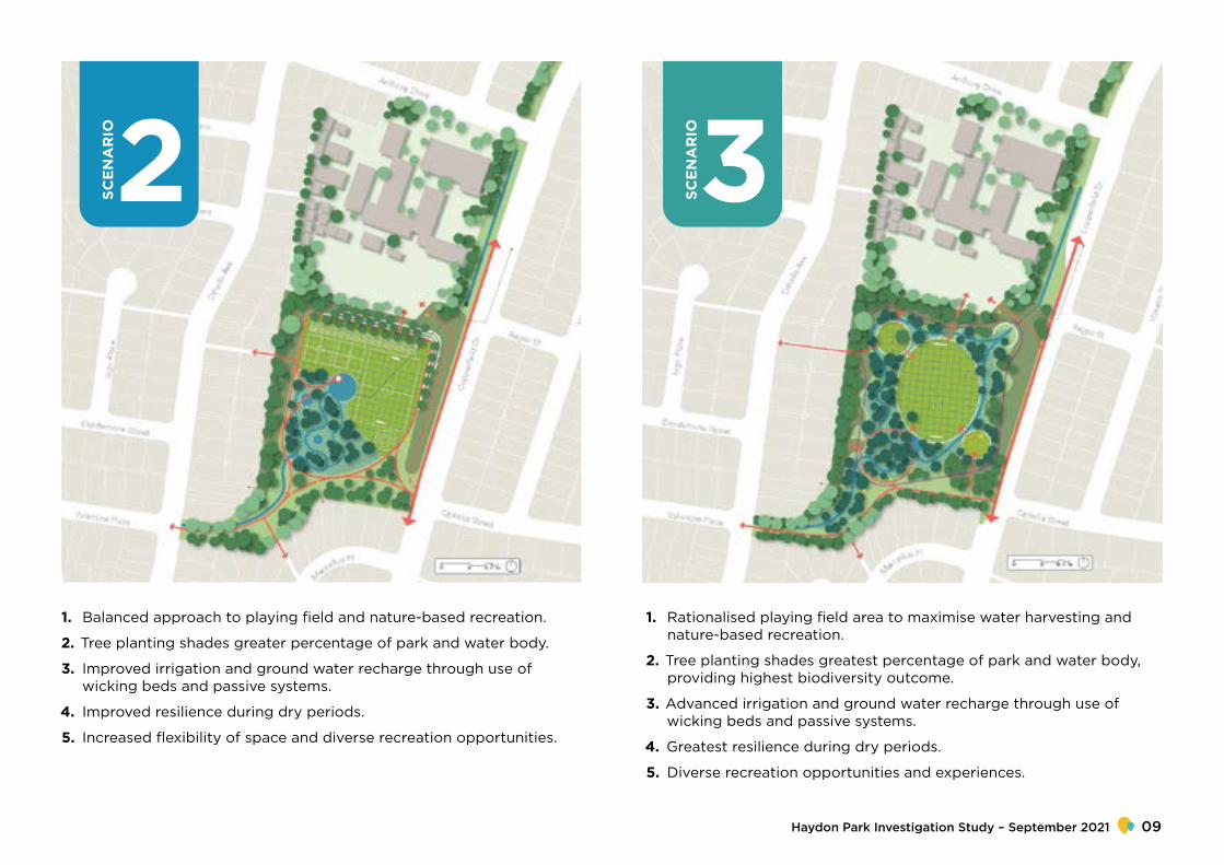
SCE
NA
RIO2
1. Balanced approach to playing field and nature-based recreation.
2. Tree planting shades greater percentage of park and water body.
3. Improved irrigation and ground water recharge through use of wicking beds and passive systems.
4. Improved resilience during dry periods.
5. Increased flexibility of space and diverse recreation opportunities.
SCE
NA
RIO3
1. Rationalised playing field area to maximise water harvesting and nature-based recreation.
2. Tree planting shades greatest percentage of park and water body, providing highest biodiversity outcome.
3. Advanced irrigation and ground water recharge through use of wicking beds and passive systems.
4. Greatest resilience during dry periods.
5. Diverse recreation opportunities and experiences.
Haydon Park Investigation Study – September 2021 09

The scenarios demonstrate how the inclusion of trees improved the performance of the stormwater infrastructure and delivered higher quality open space. Each scenario performed better than the existing condition, as outlined in the comparative assessment shown in Table 1.
Table 1: Comparison against assessment criteria
Urban cooling
Water quality
Biodiversity
Hydraulics
Structural
Maintenance
EXISTING
No impact on urban heat island effect, exposed turf temperature is high. Existing tree canopy cover of 3.8%
Limited impact on improving water quality as there is no opportunity for aeration or filtration of water as it passes through basin
Stormwater infrastructure does not support biodiversity
Meets existing capacity and conveyance requirements. No demonstrated ability to increase capacity
Ongoing structural investigation is required due to substantial variation in moisture content of soil
Low requirements: Basic maintenance schedule consists of mowing grass and removal of rubbish and debris.
NSW Department of Planning, Industry and Environment10

SCE
NA
RIO1
Provides urban cooling due to moderate increase in tree canopy cover to 13.8%
No less than 150 additional trees
Increased vegetation leads to greater aeration and filtration of water
Moderate increase in canopy supports improved biodiversity
Floodwater storage capacity increased by 2,080 m3
Soil moisture at ideal levels approximately 40% to 60% of the time.
Very poor soil moisture for the detention basin banks but the best soil moisture for the channel.
Improved structural integrity of embankment through tree planting in correct locations and redistribution of water volume.
Low requirements: maintenance schedule of mowing grass required and clearance of debris required as normal
SCE
NA
RIO2
Provides substantial urban cooling due to large increase in tree canopy cover to 14.5%.
No less than 150 additional trees
Increased vegetation leads to greater aeration and filtration of water. Retention and reuse of water on site improves ability for downstream systems to improve water quality.
Substantial increase in canopy, understory and water retention. Supports significant increase in biodiversity
Flood water storage capacity increased by 3,352 m3
Soil moisture at ideal levels approximately 50% to 60% of the time
The best soil moisture for the base of the reserve/oval
Improved structural integrity of embankment and channel through tree planting in correct locations, reduced velocity of water and redistributed water volume
Low requirements: maintenance schedule of mowing grass required, improvements to turf quality reduces maintenance for sports field. Clearance of debris required as normal
SCE
NA
RIO3
Provides substantial urban cooling due to large increase in tree canopy cover to 19.5% and increased soil moisture content.
No less than 200 additional trees
Increased vegetation leads to greater aeration and filtration of water. Retention and reuse of water on site improves ability for down-stream systems to improve water quality.
Substantial increase in canopy, understory supports significant increase in biodiversity
Flood water storage capacity increased by 5,960 m3
Soil moisture at ideal levels approximately 50% to 60% of the time.
The best combined soil moisture for both channel and based of the reserve/oval.
Improved structural integrity of embankment and channel through tree planting in correct locations and reduced velocity of water
Low requirements: maintenance schedule of mowing grass required, improvements to turf quality reduces maintenance for sports field. Clearance of debris required as normal
Urb
an c
oo
ling
Wat
er q
ualit
yB
iod
iver
sity
Hyd
raul
ics
Stru
ctur
alM
aint
enan
ce
Haydon Park Investigation Study – September 2021 11

Surface area
BA
NK
OVA
L
18,990m2
7,890m2
Irrigation volume Irrigation depth
Exi
stin
g
7.8ML 990mm
12.2ML 640mm
BA
NK
CH
AN
NE
L
OVA
L
8,200m2
5,600m2
13,330m2
7.7ML 940mm
3.1ML 550mm
13.4ML 1,010mmScen
ario
1
Surface area Irrigation volume Irrigation depth
BA
NK
CH
AN
NE
L
OVA
L
9,660m2
8,050m2
10,750m2
9.1ML 940mm
4.8ML 590mm
7.6ML 710mmScen
ario
2
7.7ML 940mm
8.2ML 630mm
4.7ML 710mmScen
ario
3
BA
NK
CH
AN
NE
L
OVA
L
8,200m2
12,870m2
6,660m2
Water modelling completed for the existing condition and each of the scenarios demonstrates improved water management across the scenarios.
Table 2: Water usage comparison
NSW Department of Planning, Industry and Environment12

When compared with the existing condition, the three scenarios demonstrated:
• integrating trees provided higher performance across all the assessment criteria requirements
• higher quality open space outcomes were achieved through provision of more diverse recreation opportunities
• an ability to assist in achieving the Premier’s Priority of increased urban tree canopy
• improved soil conditions that would better support vegetation growth and biodiversity
• improved water quality through processing, management and reuse
• increased resilience of planting during dry periods.
Key findings
The three scenarios show that alternate approaches can increase performance of stormwater infrastructure and provide additional benefits that reflect local and state government policy objectives.
There are significant achievements that can be made by applying updated approaches to dual-purpose open space and stormwater management across the Western Sydney district.
Haydon Park Investigation Study – September 2021 13

Introduction
BackgroundThe challenges involving the urban heat island effect in the Western Sydney district are significant. One approach to mitigate these challenges involves increasing tree canopy cover in urban areas. This approach also has a myriad of other benefits to the community.
Recognising this, the NSW Government, through the 5 Million Trees for Greater Sydney Program (5MT), aims to plant trees in both the public and private realm, to expand urban tree canopy to 40%, across 33 local government areas (LGAs) within the Greater Sydney metropolitan area. The 5 Million Trees Program is aligned to and supports the NSW Premier’s Priority, Greening our city – Increase the tree canopy and green cover across Greater Sydney by planting 1 million trees by 2022. Objectives for the Premier’s Priority include:
• assisting in the amelioration of climate extremes by providing shade and cooling of urban areas through tree planting
• creating a healthier, more liveable and greener Greater Sydney.
NSW Department of Planning, Industry and Environment14

Rosemeadow Demonstration Project
Rosemeadow is a suburb within Campbelltown City Council and was selected as a demonstration project for the 5MT Program. It has a tree canopy coverage measurement of 5.63%, one of the lowest in the Greater Sydney region (Greater Sydney Region Urban Vegetation Cover 2016). The intent of the demonstration project is to showcase the methodology, learnings and outcomes to create a useful framework to inform future urban tree canopy projects across Greater Sydney.
The Rosemeadow Demonstration Project explores ways to achieve the 40% canopy target through tree planting on public land (including streets, schools and open spaces), as well as in open spaces that have a dual purpose as stormwater overland flow infrastructure.
The supporting design documents for the Rosemeadow Demonstration Project are divided into three main areas:
1. Haydon Park Investigation Study
2. Street Tree Design Manual
3. Copperfield Drive Concept Design
The work to complete the documents was undertaken by Realm Studios in partnership with E2DesignLab.
The Haydon Park Investigation Study is a hypothetical case study designed to test the theoretical impact of tree planting in open space that has a dual purpose as a stormwater detention basin. Additional work was undertaken for the Haydon Park Investigation
Study by Spiire, who were engaged to add technical insight to the proposed scenarios. This included providing water balancing calculations and demonstrating whether the proposed scenarios support tree growth.
Stormwater infrastructure in open space
A number of open spaces across Western Sydney have a dual-purpose stormwater function.
Increasing tree canopy cover in open spaces that have a dual-purpose stormwater function responds to objectives such as improved water quality, reduced flooding risk, increased urban cooling, improved stormwater management and improved recreation opportunities. Effective management of stormwater is a critical function of the dual-purpose network, so the impacts of increasing tree canopy cover on this function requires consideration.
Benefits of tree planting in open space
Trees planted in open space increase:
• shade and temperature management through canopy cover
• control of stormwater runoff• stormwater harvesting and reuse
opportunities• landscape amenity through visual
significance of vegetation• habitat and food supply for fauna• management and control of weed species• overall health, structural condition and
growing environment for vegetation.
‘Campbelltown City Council supports the NSW Department of Planning, Industry and Environment’s study undertaken at Haydon Park, Rosemeadow to incorporate tree canopy into open space that also functions as stormwater infrastructure. Haydon Park is a dual-purpose open space and stormwater asset of council. The park’s stormwater function to date has impacted on the opportunity to integrate tree planting to provide quality open space, amenity shade and urban cooling. This study provides example scenarios on how stormwater assets and tree planting can coexist to provide benefits to the community and the environment. By embracing the key principles of this report, dual-purpose open space and stormwater areas in Campbelltown can become treed areas that aid in cooling, provide habitat, improve recreation opportunities and make better use of captured water to irrigate planting areas.’
- Ian Andrews, Executive Manager Open Space, Campbelltown City Council
Haydon Park Investigation Study – September 2021 15

Purpose and aims of study The broader purpose of the study is to demonstrate that tree planting in open space with a dual purpose improves the performance of stormwater management and provides wider benefits to habitat and community through improved biodiversity and recreation outcomes.
The aims of the Haydon Park Investigation Study (the study) is to devise and test ways to:
1. Increase the tree canopy to reduce the impacts of the urban heat island effect
2. Increase the capacity of stormwater systems for future loading/pressure
3. Support advances in understanding the utilisation of natural systems as infrastructure
4. Increase the ability of stormwater infrastructure to support improved environmental outcomes
5. Enable stormwater infrastructure to provide increased public amenity and recreation opportunities
It also aims to establish criteria that can be used to measure and assess the benefits that can be delivered through the addition of planting trees and vegetation, and to provide practical guidance for implementation.
Audience The audience for the study is professionals and stakeholders who are involved in the planning, delivery and maintenance of open spaces that have a dual purpose as stormwater infrastructure. This includes:
• Planners involved in green infrastructure, climate adaptation and development
• Urban designers/landscape architects involved in the improvement of open space
• Civil and stormwater engineers involved in infrastructure improvement works, including flood management and water quality improvement
• Arborists involved in enhancing, replacing or introducing trees in stormwater infrastructure
• Maintenance and operations staff involved in maintaining the performance of open space for recreation and stormwater infrastructure
• Community members who want improved open space outcomes.
How this study will be usedThe study provides insights into the benefits that can be achieved through incorporating tree planting into the design of open spaces used for stormwater infrastructure such as overland flow paths and detention basins. It sets out assessment criteria that can be applied by industry and government agencies to identify the benefits that can be delivered in different situations.
The study is structured in two parts. Part 1 provides an overview of the investigation study. Part 2 provides practical information and guidance to assist practitioners in successfully implementing tree planting in dual-purpose open space.
NSW Department of Planning, Industry and Environment16

Why we need this studyHistorical practices in stormwater management have seen most dual-purpose open spaces managed as open turf spaces. These spaces are not widely useable and provide limited environmental benefits or urban cooling, often resulting in:
• exacerbation of downstream flooding, by transferring flows downstream• direct transfer of polluted urban stormwater to downstream waterways,
containing suspended sediments, oil, litter and nutrients• damage to receiving waterways associated with more intense and frequent
erosive flows that damage the ecological values of receiving waterways• loss of social, cultural and environmental benefits provided by natural
waterwaysTrees are being incorporated into stormwater management practice, based on the understanding that trees assist flood mitigation through:• Interception of rainfall – leaves intercept and evaporate rainfall, slowing the
rate and volume of water that flows into drainage systems and reducing the risk of overflow
• Infiltration of stormwater into soils – sub-surface roots penetrate deep into the soil, drying it out and increasing its permeability, allowing the groundwater supply to recharge. Tree roots have been shown to improve infiltration by 153% compared with unplanted controls
• Stabilisation of soils – tree roots act as a net to hold soil in place and stop it washing into stormwater systems. This reduces erosion and the amount of soil and debris in the stormwater system
• Interception of stormwater runoff – trees can act as a drag on flood waters, holding back water and slowing the flow during heavy rainfall, reducing impacts downstream.
This technical case study provides much-needed insight into different approaches to incorporating trees in dual-purpose stormwater infrastructure that consider functional stormwater requirements in the overall performance of dual-purpose open spaces.
17Haydon Park Investigation Study – September 2021

MethodologyScope of this studyThis study focuses on a 4.57-ha stormwater catchment within Rosemeadow, the confluence of which is at Haydon Park.
Specifically, the study focuses on how to improve urban cooling by increasing tree canopy cover in the stormwater infrastructure while maintaining the park’s dual function as a detention basin to retain irregular flood water events. This includes assessing the performance of three scenarios that increase tree canopy cover in the stormwater infrastructure against the existing performance of Haydon Park using a series of performance criteria.
NSW Department of Planning, Industry and Environment18

Approach
Part 1: Investigation study
Part 1 of the study assesses three scenarios for increasing tree canopy cover in dual-purpose open spaces using Haydon Park as a theoretical case study.
The steps taken to achieve this are:
1. Review of state and local government strategies and technical reports to identify strategic objectives and performance requirements for stormwater infrastructure
2. Review stormwater infrastructure technical requirements to identify the primary engineering requirements for stormwater systems that have potential to support tree planting programs.
3. Establish an assessment criteria (that reflect the requirements identified in step 1 and 2) to assess the outcomes and benefits of proposed changes.
4. Review of the study site to understand the existing vegetation and soil quality, to establish a baseline performance level for the stormwater infrastructure, and to understand the existing recreation uses.
5. Develop three scenarios that reflect increasing levels of intervention and investigate the potential for benefits to be achieved.
6. Undertake a comparative analysis of the existing detention basin and the three scenarios to identify and compare the benefits and performance of each scenario against the assessment criteria
7. Identify the key findings of the study and provide recommendations for best-practice approaches to incorporating tree planting in stormwater infrastructure.
Part 2: Practical guidance
Part 2 provides practical information and guidance to assist practitioners in successfully implementing tree planting in dual purpose open spaces.
It can be used in a wide range of plans and processes, for state and local government, as well as industry, as outlined below.
State government
Coordinating increased performance across planning and design, including:
• green plans• district and regional plans• place infrastructure compacts• growth infrastructure compacts• integrated transport plans• collaboration areas.
Local government
Embedding green infrastructure in local council planning, including:
• local strategic planning statements• local environmental plan (LEP) and
development control plan (DCP) amendments
• open space strategies
Industry
Using guidance documents to support delivery in projects, including:
• master planning• implementation plans• urban design frameworks• spatial frameworks.
Haydon Park Investigation Study – September 2021 19

Assessment criteria
OverviewAssessment criteria were developed as a consistent way to compare the existing performance of Haydon Park with three proposed scenarios. The assessment criteria are intended to be broadly applied to provide a high-level assessment of any project that incorporates additional tree canopy in stormwater corridors.
The assessment criteria are derived from government policy directions, technical reports, environmental considerations and stormwater infrastructure performance requirements.
Stormwater infrastructure assessment criteria
A crucial aspect of the assessment criteria is understanding the technical requirements for stormwater infrastructure to ensure the main functional requirements were being upheld.
There are typically two kinds of stormwater systems that have potential for tree planting programs.
These are either:
1. flood-retarding basins (also known as detention basins)
2. drainage channel easementsThese stormwater systems have specific technical requirements that need to be upheld.
Flood-retarding basins
Flood-retarding basins are designed to temporarily hold water during major storm events, to reduce the downstream flooding impacts. Their primary function is to provide storage to hold flood water and control the release of the water through a designed outlet. Such basins are constructed to reduce the cost of downstream channel upgrades, to reduce downstream flooding impacts or to meet requirements restricting urban catchment outflow peaks.
Drainage channel easements
Drainage channel easements are open channels that convey stormwater from one location to another. They are linear systems that are frequently spatially constrained.
Stormwater infrastructure technical requirements
The engineering requirements of flood-retarding basins and drainage channel easements can be broken down into three primary considerations:
1. Hydraulics: stormwater systems need to support the flow characteristics and capacity that they were designed for.
2. Structural integrity: There are some critical elements whose sustained integrity is essential to protect public safety and property. For example, during extreme storm events, trees planted on embankments can topple out of the embankment, taking a root ball and part of the embankment with them, potentially causing the embankment to fail.
3. Maintenance: Systems must be maintainable in a feasible and safe way.
NSW Department of Planning, Industry and Environment20

Table 3: Stormwater infrastructure technical requirements
Functional requirement
Hydraulics
Structuralintegrity
Maintenance
Flood-detention basins
• Ability to store required volume of water
• Ability to release water at a controlled rate
• Reliable containment of water volume• Does not add to risk during flood event• Functions as intended
• Requires only minor ongoing maintenance
• Facilitates scheduled periodic inspections (such as geotechnical)
• Maintenance tasks are easily carried out
Drainage channel easements
• Conveyance capacity• Efficient conveyance of water• Surface conducive to movement
of water
• Batters that provide reliable containment of water
• Erosion
• Surface treatments that prevent erosion of channel
• Blockage (downstream)• Weeds and vegetation
Haydon Park Investigation Study – September 2021 21

State and local government policy directionA review of existing state and local government policies was undertaken to identify broader policy objectives that need to be considered in assessing stormwater infrastructure corridors.
NSW Government Premier’s Priorities
The Hon Gladys Berejiklian, Premier of NSW, June 2019
The Premier has set priorities that aim to tackle tough community challenges, lift the quality of life for all citizens and put people at the heart of creating a better environment.
Greening our city – Increase the tree canopy and green cover across Greater Sydney by planting 1 million trees by 2022.
Greener public spaces – Increase the proportion of homes in urban areas within 10 minutes’ walk of quality green, open and public space by 10 per cent by 2023.
Greater Sydney Region Plan (GSRP)
Greater Sydney Commission, 2018
The vision for A Metropolis of Three Cities sets out how residents will live within 30 minutes of jobs, education and health facilities, services and great places. The GSRP focuses on supporting a growing community through land use and transport to boost liveability, productivity and sustainability. It includes the following objective:
Urban tree canopy is valued for its economic, social and environmental benefits.
• The waterways are protected and healthier• Biodiversity is protected, urban bushland
and remnant vegetation is enhanced• Urban tree canopy cover is increased• Public open space is accessible, protected
and enhanced• The Green Grid links parks, open spaces,
bushland and walking and cycling paths• Heatwaves and extreme heat are managed
Western City District Plan
Greater Sydney Commission, 2018
The Western City District Plan sets out the 20-year vision for the Western Parkland City, which draws on the strength of the new Western Sydney Airport and the first stage of a North–South Rail Link. The Western Parkland City will capitalise on the established centres including Campbelltown. It includes the following planning priorities:
• Planning Priority W15: Increasing urban tree canopy cover and delivering Green Grid connections
– Objective 30: Urban tree canopy cover is increased.
– Objective 32: The Green Grid links parks, open spaces, bushland and walking and cycling paths.
• Planning Priority W18: Delivering high-quality open space
– Objective 31: Public open space is accessible, protected and enhanced.
NSW Department of Planning, Industry and Environment22
Reimagining Campbelltown CBD – Sydney’s Southern Gateway
Campbelltown City Council, 2018
Reimagining Campbelltown sets out a vision for a sustainable Campbelltown CBD, responding to the future pressures of climate change and population growth.
The proposals in Reimagining Campbelltown have direct relevance to Rosemeadow and the contents of this study and include:
• Re-purposing of existing infrastructure, particularly of drainage infrastructure, to provide broader benefits
• Creation of a network of blue and green infrastructure through improvement of open spaces
• Improved biodiversity across the urban area• Reduction in urban heat island effect• Improved amenity of open spaces for play
and leisure
‘Blue and Green Infrastructure [is] an integrated network [that] will assist in transforming the urban structure through improved and increased natural areas of open space...significantly reduce the temperature of local spaces and the effects of heat island by providing increased shade and canopy cover, while also bringing the “bush” back into the centre.’ – Reimagining Campbelltown CBD – Sydney’s Southern Gateway, Campbelltown City Council, 2018
Flood risk management in NSW
The Floodplain Development Manual and the Flood-prone Land Policy informs local government in managing flood risk in their communities, as it pertains to land development. The manual and policy are targeted at a strategic management level.
1.1: Flood-prone Land Policy for New South Wales recognises that ‘flood-prone land is a valuable resource that should not be sterilised by unnecessarily precluding its development’.
1.1.1: The Floodplain Development Manual policy objective is ‘to reduce the impact of flooding and flood liability on individual owners and occupiers of flood-prone property, and to reduce private and public losses resulting from floods, utilising ecologically positive methods wherever possible’.
The manual includes information on the preparation of flood studies, floodplain risk management studies and plans, as well guidance regarding flood planning levels and areas.
Policy implications
The review of these state and local government studies, strategies and reports identified three additional performance requirements that should be considered when assessing stormwater infrastructure.
1. Urban cooling
2. Water quality
3. Biodiversity
Haydon Park Investigation Study – September 2021 23

Additional performance requirements
Urban cooling
The population of Western Sydney is growing rapidly, and the area is particularly vulnerable to the effects of urban heat island. In extreme events, temperatures can rise 10°C higher than the eastern suburbs, resulting in unsustainable energy spikes and higher mortality rates (Sydney Water Corporation, 2017).
This problem is likely to be further exacerbated by climate change. Temperatures in metro Sydney are expected to increase by 0.3°C to 1°C by 2039 and as much as 2.5°C by 2070 (Office of Environment and Heritage, 2014)
Trees reduce the urban heat island effect by two main mechanisms:
1. Trees providing shade can reduce surface temperatures by as much as 40°C (D. Armson, 2012)
2. Trees lower the air temperature around them by between 1°C and 8°C via evapotranspiration (N.J. Georgi, 2006)
Planting trees requires water; irrigation is required during establishment and often long-term for a tree to flourish. Furthermore, a tree’s ability to impact the heat island effect relies on the availability of soil moisture to ensure a high leaf area index to provide shade and to ensure high rates of evapotranspiration (both decrease with a decrease in soil moisture).
Water quality
Growth within urban areas places pressure on waterways due to increased stormwater run-off and pollution.
Lands surrounding rivers and waterways are important as they can support diverse vegetation, assist in maintaining bank stability, improve ecology and waterway health, and improve amenity and economic productivity. Opportunities to deliver these improvements include:
• Rehabilitation of existing waterways and over-land flow paths to increase water quality and maximise the benefits to the community
• Utilise sediment and erosion control measures to assist in maintaining water quality and catchment health
Increased vegetation leads to greater aeration and filtration of water. Retention and reuse of water on site improves ability for down-stream systems to improve water quality. The water system should be considered as a whole, as what occurs upstream will ultimately affect downstream.
Land within the Campbelltown LGA falls within the catchments of two principal Sydney waterways, the Georges River and the Nepean River. These waterways and their associated bushland contribute to the unique natural character of Campbelltown, support a diverse variety of flora and fauna and provide for community amenity and recreational opportunities.
The majority of Campbelltown’s urban waterways flow into the Georges River, either directly to the river itself, or via the Bow Bowing Bunbury Curran Creek system
Unfortunately, modification of these natural systems coupled with increased impacts from urbanisation, including storm water run-off, pollution and sewage overflows, has led to deterioration of the water quality. (Campbelltown City Council, Local Strategic Planning Statement 2020)
NSW Department of Planning, Industry and Environment24
Biodiversity
Intensification of the urban environment increases the challenge of protecting and maintaining biodiversity. Maintaining, enhancing and/or establishing biodiversity corridors, which enable existing plant and animal communities to survive in their natural habitat, is a key to ensuring the protection of biodiversity.
A substantial increase in canopy and understory vegetation means significant increases in biodiversity can be achieved. Restoring and enhancing new habitats for flora and fauna species is a vital step in promoting biodiversity in catchments and waterways.
The Campbelltown LGA is in one of the most species-diverse regions in NSW, the Sydney Basin Bioregion. The bioregion includes two distinctive geological formations, the Cumberland Plain and the Woronora Plateau, and sustains a number of key areas of conservation significance, including:
• The Upper Georges River Corridor• Dharawal National Park• The O’Hares Creek CatchmentThese areas are significant natural assets that will be strengthened by protecting, maintaining and increasing the connectivity of open space throughout the LGA. (Campbelltown City Council, Local Strategic Planning Statement 2020)
Final assessment criteriaBased on the review of technical and policy driven performance requirements, the following set of assessment criteria were identified.
Table 4: Assessment criteriaGovernment objectives
Urban coolingTree canopy in stormwater infrastructure provides urban cooling.
Water qualityLower levels of pollutants and sediment in waterways.
Reduced impact of flood events on urban environments.
BiodiversityUtilisation of ecologically positive methods, biodiversity is protected and enhanced.
Technical requirements
HydraulicsAbility to store required volume of water, ability to release water at a controlled rate, controlled movement of water.
StructuralReliable containment of water volume, does not add to risk during flood event, functions as intended.
MaintenanceRequires only minor ongoing maintenance, facilitates scheduled periodic inspections (such as geotechnical), maintenance tasks are easily carried out.
Haydon Park Investigation Study – September 2021 25

Haydon Park: existing site conditionAnalysis of the existing condition of Haydon Park was conducted to understand how the site currently functions. This included assessing the existing landform and vegetation, urban heat island impacts, and capacity of detention basin.
Figure 1: Haydon Park context plan
NSW Department of Planning, Industry and Environment26

OT
HE
LLO
AV
EN
UE
CO
PPER
FIEL
D D
RIV
E
Extent of detained water
Tree canopy
Access points
Outlet
Embankment
Earth bund
Landform, vegetation and useHaydon Park is a 32,000m2 open space with 3.8% tree canopy and minimal other vegetation. The park has a sports field in typically poor condition due to inundation events that allow water to pool on the surface, resulting in compaction of the topsoil.
The park is used as a thoroughfare and as supporting space for the public school; however, the current stormwater management of the park inhibits sustained or increased use.
The north and west edges of the park have large embankments cut into the existing landform, while along Copperfield Drive there is a constructed earth bund that encloses the park to form the detention basin. This earth bund is over topped in a 1% Annual Exceedance Probability (AEP) event. The red arrows on figure 2 show the park is accessed from the school and the surrounding streets, providing a thoroughfare and cross-block connection from Copperfield Drive to Othello Avenue.
Figure 2: Haydon Park existing condition
Haydon Park Investigation Study – September 2021 27

Urban Heat Index and Heat Vulnerability Index
Figure 3: Urban Heat Index mapping Figure 4: Heat Vulnerability Index mapping
Much of the Rosemeadow suburb is identified as having the highest classification (9-12) on the Urban Heat Index. This highlights the suburb is severely impacted by urban heating and would benefit from interventions that increase shading and promote cooling.
The suburb also has the highest classifications (4-5) on the Heat Vulnerability Index. These two indices show that the liveability of the area is heavily impacted by temperature and that measures need to be put in place to promote urban cooling so as to increase the liveability of the neighbourhood.
NSW Department of Planning, Industry and Environment28

OTHELLO STREET JUNCTION PIT
CATCHMENT PIPES
MAJOR FLOW OUT
600
675
1350
1350
MINOR FLOW OUT
HAYDON PARK
Figure 5: Haydon Park catchment hydraulics plan
Catchment, hydraulics and stormwater informationHaydon Park stormwater detention basin sits downstream of a 47.5-ha residential stormwater catchment. It is fed by the convergence of three pipes (675mm and 2x 1,350mm diameter) at a junction pit on Othello Avenue. During a major flow event, water enters the detention basin on the surface and discharges via an outlet at the north-east corner of the basin. Stormwater depths in the basin reach between 1m to 2m in the area around the outlet.
When stormwater in the catchment converges at the Othello Street junction pit:
• Minor flow events (below 20% Annual Exceedance Probability (AEP)) enter a 600mm diameter pipe that runs under Haydon Park.
• Major flow events (above the 20% AEP) over-flow at the Othello Street junction pit and enter Haydon Park on the surface as overland flow (refer figure 6).
Figure 6: Othello Street junction pit
Haydon Park Investigation Study – September 2021 29

Scenario testing
Scenario overviewThree scenarios were developed to test the impact of planting trees in stormwater infrastructure at Haydon Park. The scenarios were assessed using the performance criteria established by the study. The scenarios included three different levels of intervention (ranging from minimal to complex) to provide a spectrum of possible responses, and to provide several points of comparison with the existing condition of the park.
Scenario development The three scenarios were designed to demonstrate how increased planting and tree canopy coverage encourage the retention of water on site and improve soil quality.
Each of the scenarios considered how to
• increase tree canopy to provide urban cooling
• configure a diversion channel to increase the capacity of the detention basin
• allow suitable clearance around outlet structure to prevent blockage
• demonstrate alternatives for utilising the water captured
• generate a balanced approach to open grassed area and increased vegetation to improve biodiversity and recreation opportunities.
The park has a dual role as open space that supports recreation activity and stormwater infrastructure. This has been factored into the scenarios to gauge the degree of improvement in recreation opportunities that can be provided.
All scenarios have been designed to have no negative impacts on flood conditions within the catchment or within the retarding basin. Additional water storage
is provided through the creation of new riparian zones that increase the capacity of the retarding basin to hold flood waters and benefit downstream flood levels (that is, lower flood levels). Any impact to the hydraulics by the increased roughness within the basin are easily offset by the increase of the basin’s capacity.
Each of the scenarios uses different configurations of a diversion channel to increase the capacity of the detention basin, demonstrate alternatives for utilising the water captured, and generate increased tree canopy.
Figure 7 demonstrates how the inclusion of a diversion channel increases the capacity of the detention basin to hold flood waters and improves its ability to respond to both low flow and high flow events. A 20m wide riparian diversion channel is excavated 800mm into the floor of the basin. This provides an additional volume within the basin, increasing flood water storage to help mitigate flooding downstream and it compensates for any minor losses in flood storage caused by the tree biomass roughage.
The existing capacity of the 600mm below ground pipe is 0.69 m3/s. The proposed surface pilot channel (1m base, 2m top width, 0.5m depth) provides a capacity of 0.82 m3/s as shown in the inset on figure 7.
NSW Department of Planning, Industry and Environment30

Approx 1:3 slope Batter to natural
1% Cross fall
Geotextile
0.8m
Approx 1:3 slope Batter to natural
1% Cross fall
EPHEMERAL WETLAND ZONE (NOMINAL 10M WIDTH)
EPHEMERAL WETLAND ZONE (NOMINAL 10M WIDTH)
PILOT CHANNEL
DRY PLAINS OPEN FOREST PLANTING
DRY PLAINS GRASS AND TREES
2m
1m
0.5m
0.3m
Geotextile
Rock d50 = 150mm
Rock d50 = 300mm, backfilled with soil and planted
Topsoil
Subsoil
2
1
3
4
5
1
2
3
4
5
Channel transverse sectionThe existing surface level is lowered by 800mm to create an ephemeral wetland zone and central pilot channel. This also gives the basin additional flood water storage to make up for the additional tree biomass roughage.
Figure 7: Diversion channel cross-section
Haydon Park Investigation Study – September 2021 31

5%fall0% fall1% fall
PIPES INCOMING TO JUNCTION PIT DIVERSION CHANNEL PILOT CHANNEL ROCK CHUTE
AND WEIR
x2 1350mm pipesSurcharge flows
Flows from daylighted 675mm pipe flows675mm pipe
Geotextile
Rock d50 = 25mm
Topsoil
Subsoil
Concrete weir with stepping stones
0.6m
0.3m
1
1
2
2
3
3
4
4
5
5
Channel longitudinal section
Figure 8: Channel weir – short section (n.t.s.)
Figure 9: Low flow channel longitudinal section (n.t.s.)
NSW Department of Planning, Industry and Environment32

0% fall 1% fall5% fall
DIVERSION CHANNEL
PILOT CHANNEL
ROCK CHUTE AND WEIR
3M CLEAR ZONE AROUND EXISTING BASIN OUTLET
Surface flows connected to
existing basin outlet
Existing flood basin
embankment
5m
1:10
Concrete plinth weir
Well graded angular rock d50 = 150mm
Well graded angular rock d50 = 150mm, back filled with soil and planted
1
1
2
2
2
3
3
Figure 10: Concrete weir & rock chute – plan (n.t.s.)
Haydon Park Investigation Study – September 2021 33

RL 137.80 NSL 138.60
Reconfigured inlet pit structure
Tree planting 3m clear of embankment toe
Surface flows connected to existing basin outlet. Tree planting 3m clear around basin outlet.
Weir crest IL 137.55
Weir crest IL 137.95
Bay
1
Bay
2
Existing trees
Grassy open woodland
Riparian woodland
Grassland
Sports pitch
Earth embankment
Ephemeral wetland
Ephemeral creek
Concrete weir
Existing sewer pipe and pits
Existing stormwater pipe and pits
Share path
Pedestrian footpath
Maintenance access
Scenario 1
1SCENARIO
Figure 11: Scenario 1 Site Plan
NSW Department of Planning, Industry and Environment34

2m1m
0.5m
0.3m
0.3m
Pilot channel
Channel weir
0.6mWeir shown beyond
Urban cooling
Water quality
Biodiversity
Hydraulics
Structural
Maintenance
1 to 3 - low to high
Assessment criteriaAdditional flood water storage = 20m x 0.8m x 130m = 2,080m3
Figure 12: Scenario 1 Section
Haydon Park Investigation Study – September 2021 35

Surface area
BA
NK
CH
AN
NE
L
OVA
L
8,200m2
5,600m2
13,330m2
Irrigation volume Irrigation depth
7.7ML 940mm
3.1ML 550mm
13.4ML 1,010mm
The purpose of scenario 1 was to maintain the maximum amount of open space and playing field. Trees would be planted around the outside of the space along the diversion channel and on the cut embankment. The circulation path will sit outside the diversion channel and connect around the sports field.
The channel would passively irrigate new planting areas, and the increased canopy would shade the landscape. This would help regulate the water temperature and assist in establishing ecosystems.
This scenario relies on regular rain fall events as it does not include any additional storage capacity.
Table 5: Scenario 1 water usage
NSW Department of Planning, Industry and Environment36
Oval
Channel
Bank 0 50 100m¯
Outcome
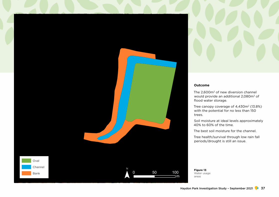
The 2,600m2 of new diversion channel would provide an additional 2,080m3 of flood water storage.
Tree canopy coverage of 4,430m2 (13.8%) with the potential for no less than 150 trees.
Soil moisture at ideal levels approximately 40% to 60% of the time.
The best soil moisture for the channel.
Tree health/survival through low rain fall periods/drought is still an issue.
Figure 13: Water usage areas
Haydon Park Investigation Study – September 2021 37

Bay 1
Bay 2
Embankment reinforced with concrete bleaches to support small tree planting
Inlet and outlet connection with finishing point for wicking system. Connection to existing 675mm low flow pipe.
Surface flows connected to existing basin outlet. Tree planting 3m clear around basin outlet.
Tree planting 3m clear of embankment toe
Reconfigured inlet pit structure
Existing trees
Grassy open woodland
Riparian woodland
Grassland
Sports pitch with wicking bed
Earth embankment
Ephemeral wetland
Ephemeral creek
Concrete weir
Sediment Pond
Existing sewer pipe and pits
Existing stormwater pipe and pits
Share path
Pedestrian footpath
Maintenance access
Scenario 2
2SCENARIO
Figure 14: Scenario 2 site plan
NSW Department of Planning, Industry and Environment38

Wicking
Additional flood water storage = 4190m x 0.8m = 3,352m3 0.5m
0.3m
Sandy loam top soil
Flow distribution cells 50mm
Wicking layer
100mm slotted
PVC pipe
Capillary rise
2m1m
0.5m
0.3m
Pilot channel
Urban cooling
Water quality
Biodiversity
Hydraulics
Structural
Maintenance
1 to 3 - low to high
Assessment criteria
Figure 15: Scenario 2 section
Haydon Park Investigation Study – September 2021 39

Surface area Irrigation volume Irrigation depth
BA
NK
CH
AN
NE
L
OVA
L
9,660m2
8,050m2
10,750m2
9.1ML 940mm
4.8ML 590mm
7.6ML 710mm
Scenario 2 would focus on balancing open space/playing field uses with greater tree canopy than scenario 1. The broad channel would allow for increased tree planting within the channel creating better shading of the water and increased urban cooling. It would also result in increased habitat provision and improved water quality.
Scenario 2 includes the installation of a wicking bed to passively irrigate the sports pitch, which would result in improved surface for a longer period of the year. There is also a retention basin that would increase irrigation during dry periods.
The reconfiguration of the playing field would allow for increased diversity of recreation with more extensive pathways and better access opportunities.
Terraced seating inter-planted with trees around the perimeter of the sports pitch would offer space for large school groups to gather and spectators to watch sport in the shade of the trees. This would also improve the structural integrity of the embankment.
Table 6: Scenario 2 water usage
NSW Department of Planning, Industry and Environment40

Oval
Channel
Bank 0 50 100m¯
Outcome
The 4,109m2 of new diversion channel would provide an additional 3,352m3 of flood water storage.
Tree canopy coverage of 4,624m2 (14.5%) with the potential for no less than 150 trees.
Soil moisture at ideal levels approximately 50% to 60% of the time.
The best soil moisture for the base of the reserve/oval.
Figure 16: Water usage areas
Haydon Park Investigation Study – September 2021 41

Bay 1
Bay 2
Bay 2
Trees place on non-structural section of embankment
Surface flows connected to existing basin outlet. Tree planting 3m clear around basin outlet.
Tree planting 3m clear of embankment toe
Inlet and outlet connection with finishing point for wicking system. Connection to existing 675mm low flow pipe.
Reconfigured inlet pit structure
Existing trees
Grassy open woodland
Riparian woodland
Grassland
Recreation lawn with wicking bed
Earth embankment
Ephemeral wetland
Ephemeral creek
Concrete weir
Existing sewer pipe and pits
Existing stormwater pipe and pits
Share path
Pedestrian footpath
Maintenance access
Scenario 3
3SCENARIO
Figure 17: Scenario 3 site plan
NSW Department of Planning, Industry and Environment42
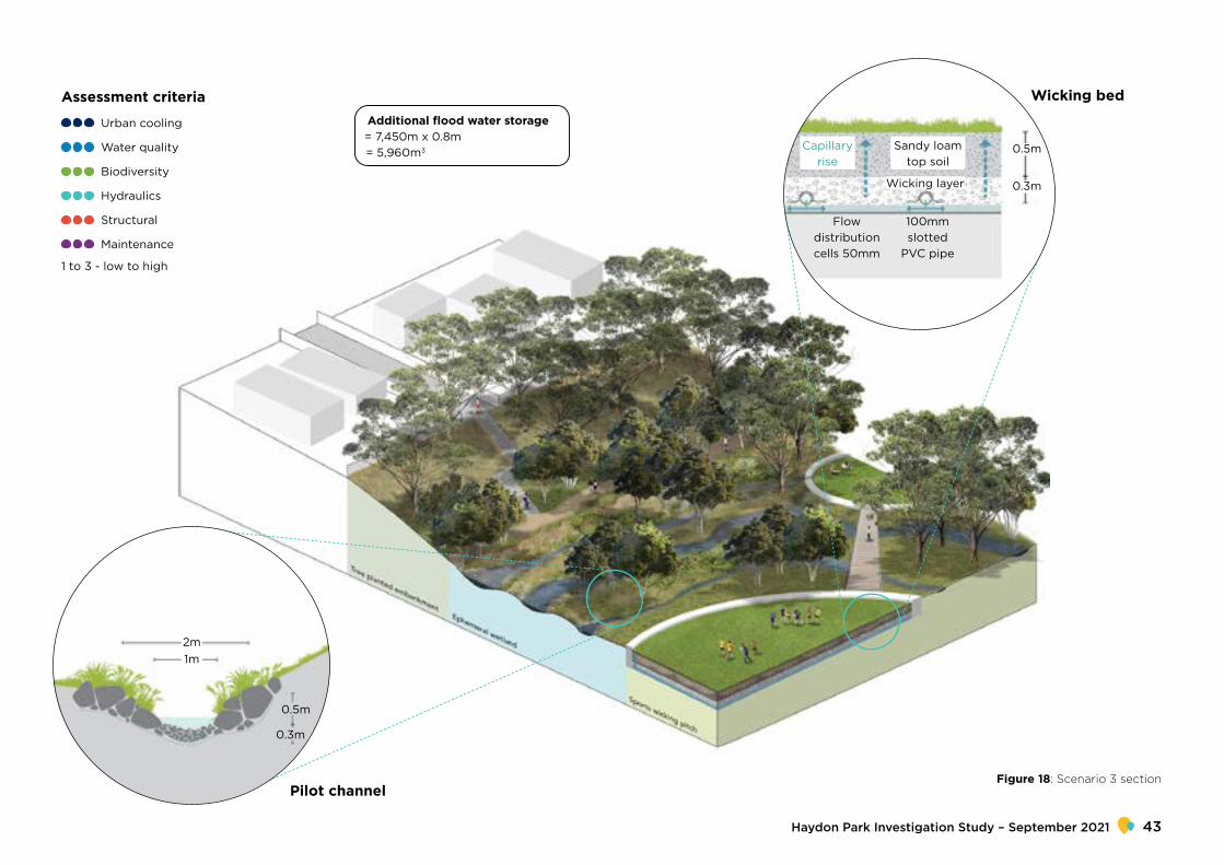
Additional flood water storage = 7,450m x 0.8m = 5,960m3
Wicking bed
0.5m
0.3m
Sandy loam top soil
Flow distribution cells 50mm
Wicking layer
100mm slotted
PVC pipe
Capillary rise
2m1m
0.5m
0.3m
Pilot channel
Urban cooling
Water quality
Biodiversity
Hydraulics
Structural
Maintenance
1 to 3 - low to high
Assessment criteria
Figure 18: Scenario 3 section
Haydon Park Investigation Study – September 2021 43

Surface area Irrigation volume Irrigation depth
7.7ML 940mm
8.2ML 630mm
4.7ML 710mm
BA
NK
CH
AN
NE
L
OVA
L
8,200m2
12,870m2
6,660m2
Scenario 3 would maximise flood water harvesting and tree canopy cover while rationalising the open space/playing field requirements. The large channel area would deliver extensive tree planting resulting in better shading of the water and increased cooling. It would also result in increased habitat provision and improved water quality.
This configuration would be the most effective for the installation of a wicking bed to passively irrigate the sports pitch, offering an improved surface for a longer period of the year. There is also a retention basin that would increase irrigation during dry periods.
The reconfiguration of the playing field would allow for increased diversity of recreation. Walking and bike tracks would weave through the forest and boardwalks and would create safe exit during times of flood. Forest installations throughout the park would create pause points, nature play spaces and areas to meet and picnic in the cool shade of a tree.
Table 7: Scenario 3 water usage
NSW Department of Planning, Industry and Environment44

Oval
Channel
Bank 0 50 100m¯
Outcome
The 7,450m2 of new diversion channel will provide an additional 5,960m3 of flood water storage.
Tree canopy coverage of 6,208m2 (19.5%) with the potential for no less than 200 trees.
Soil moisture at ideal levels approximately 50% to 60% of the time.
The best combined soil moisture for both channel and based of the reserve/oval.
Figure 19: Water usage areas
Haydon Park Investigation Study – September 2021 45

Comparative assessmentResults: assessment tableThe existing condition of the Haydon Park does not provide the same degree of benefits demonstrated by the three scenarios. All three scenarios achieve significant improvements in the performance of the park against all the criteria.
Assessment against performance criteria
When each of the scenarios were assessed against the criteria, they all had results better than the existing condition. The results of the performance assessment are summarised in table 8.
Table 8: Comparison against assessment criteria
Urban cooling
Water quality
Biodiversity
Hydraulics
Structural
Maintenance
EXISTING
No impact on urban heat island effect, exposed turf temperature is high. Existing tree canopy cover of 3.8%
Limited impact on improving water quality as there is no opportunity for aeration or filtration of water as it passes through basin
Stormwater infrastructure does not support biodiversity
Meets existing capacity and conveyance requirements. No demonstrated ability to increase capacity
Ongoing structural investigation is required due to substantial variation in moisture content of soil
Low requirements: Basic maintenance schedule consists of mowing grass and removal of rubbish and debris.
NSW Department of Planning, Industry and Environment46

SCE
NA
RIO1
Provides urban cooling due to moderate increase in tree canopy cover to 13.8%
No less than 150 additional trees
Increased vegetation leads to greater aeration and filtration of water
Moderate increase in canopy supports improved biodiversity
Floodwater storage capacity increased by 2,080 m3
Soil moisture at ideal levels approximately 40% to 60% of the time.
Very poor soil moisture for the detention basin banks but the best soil moisture for the channel.
Improved structural integrity of embankment through tree planting in correct locations and redistribution of water volume.
Low requirements: maintenance schedule of mowing grass required and clearance of debris required as normal
SCE
NA
RIO2
Provides substantial urban cooling due to large increase in tree canopy cover to 14.5%.
No less than 150 additional trees
Increased vegetation leads to greater aeration and filtration of water. Retention and reuse of water on site improves ability for downstream systems to improve water quality.
Substantial increase in canopy, understory and water retention. Supports significant increase in biodiversity
Flood water storage capacity increased by 3,352 m3
Soil moisture at ideal levels approximately 50% to 60% of the time
The best soil moisture for the base of the reserve/oval
Improved structural integrity of embankment and channel through tree planting in correct locations, reduced velocity of water and redistributed water volume
Low requirements: maintenance schedule of mowing grass required, improvements to turf quality reduces maintenance for sports field. Clearance of debris required as normal
SCE
NA
RIO3
Provides substantial urban cooling due to large increase in tree canopy cover to 19.5% and increased soil moisture content.
No less than 200 additional trees
Increased vegetation leads to greater aeration and filtration of water. Retention and reuse of water on site improves ability for down-stream systems to improve water quality.
Substantial increase in canopy, understory supports significant increase in biodiversity
Flood water storage capacity increased by 5,960 m3
Soil moisture at ideal levels approximately 50% to 60% of the time.
The best combined soil moisture for both channel and based of the reserve/oval.
Improved structural integrity of embankment and channel through tree planting in correct locations and reduced velocity of water
Low requirements: maintenance schedule of mowing grass required, improvements to turf quality reduces maintenance for sports field. Clearance of debris required as normal
Urb
an c
oo
ling
Wat
er q
ualit
yB
iod
iver
sity
Hyd
raul
ics
Stru
ctur
alM
aint
enan
ce
Haydon Park Investigation Study – September 2021 47

Surface area
BA
NK
OVA
L
18,990m2
7,890m2
Irrigation volume Irrigation depth
Exi
stin
g
7.8ML 990mm
12.2ML 640mm
BA
NK
CH
AN
NE
L
OVA
L
8,200m2
5,600m2
13,330m2
7.7ML 940mm
3.1ML 550mm
13.4ML 1,010mmScen
ario
1
Surface area Irrigation volume Irrigation depth
BA
NK
CH
AN
NE
L
OVA
L
9,660m2
8,050m2
10,750m2
9.1ML 940mm
4.8ML 590mm
7.6ML 710mmScen
ario
27.7ML 940mm
8.2ML 630mm
4.7ML 710mmScen
ario
3
BA
NK
CH
AN
NE
L
OVA
L
8,200m2
12,870m2
6,660m2
Water managementA key component of each proposed scenario is daylighting the existing 675mm inlet pipe and creating a diversion channel which is 800mm below the existing surface of the park. As a result, the water modelling has been completed using a combination of three distinct areas:
1. Bank diversion 2. Channel 3. Oval
Table 9 compares the water usage requirements of the three areas for each scenario. The water requirements for each area changes as the size of that area is altered. The depth of irrigation achieved is adjusted as the water available for infiltration per square metre is increased or reduced. This demonstrates how changing the size of each area redistributes the water requirements for the park to improve irrigation depths and prevent waterlogging in unwanted areas.
Table 9: Water usage comparison
NSW Department of Planning, Industry and Environment48

Key findings The existing condition of the park does not meet multiple assessment criteria, highlighting the shortfalls in meeting the ongoing needs of the community. While it meets an acceptable standard for stormwater infrastructure performance, it performs poorly when assessed against urban cooling, water quality and biodiversity. The existing condition does not provide for increased stormwater capacity and would not support increased growth as urbanisation typically results in increased impermeable surfaces that cause changes to small and frequent flow hydrology in the area.
The three scenarios integrate trees within the park and indicate far higher performance across all the criteria requirements (including stormwater infrastructure performance requirements) than the existing condition that does not integrate trees. They also provide higher quality open space outcomes and assist in achieving the Premier’s Priority of increased urban tree canopy.
All scenarios modelled in this case study have been shown to improve soil conditions that support vegetation and processing of water for improved quality. Methods for monitoring and testing to follow up on the success of projects would further support and help develop the findings of the study. The results from monitoring would provide the most benefit if comparable across projects.
Of the three Integrated Water Management solutions that have been put forward for Haydon Park, (passive irrigation, turf wicking bed and stormwater harvesting), passive irrigation is the simplest and most cost-effective solution to provide optimum soil moisture and use of water. Wicking beds and stormwater harvesting are significantly more expensive and require additional maintenance; however, they can provide a far more reliable supply of water during dry periods.
Next stepsThe study has found that the existing approach to stormwater management at Haydon Park, Rosemeadow has a limited function and will not provide a sustainable future use.
The three scenarios show that it is possible for alternate methods to be delivered that will increase performance of stormwater infrastructure and provide additional benefits that respond to local and state government policy objectives.
It is recommended that a cost-benefit analysis or a multi-criteria-analysis be conducted to determine which of the three scenarios will provide the best value solution for Haydon Park. One such assessment is a triple bottom line assessment, which quantifies the costs and benefits for the social, economic and ecological aspects of a project.
While this study is hypothetical, the findings demonstrated there are significant achievements that can be made by applying these updated approaches to dual-purpose open space. These finding indicate this approach should be investigated for application on similar sites across the Western Sydney district. Further detailed site specific technical studies would be required to facilitate the delivery of projects looking to use these approaches.
Haydon Park Investigation Study – September 2021 49