Hawkeye Systems - · PDF file2 Hawkeye Systems The Hawkeye range of road survey equipment...
16
Hawkeye Systems SCALEABLE SURVEY SOLUTIONS
-
Upload
hoangduong -
Category
Documents
-
view
214 -
download
0
Transcript of Hawkeye Systems - · PDF file2 Hawkeye Systems The Hawkeye range of road survey equipment...
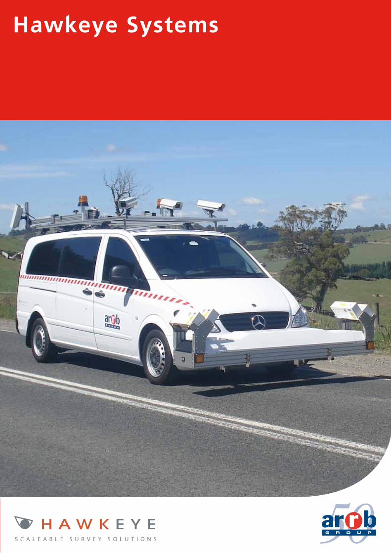
Hawkeye Systems
S C A L E A B L E S U R V E Y S O L U T I O N S

2 www.arrb.com.au
Hawkeye Systems
The Hawkeye range of road survey equipment is a result of ARRB’s extensive research into pavement and asset management.
ARRB Group has been manufacturing innovative road, traffic and transport solutions for over 25 years. During this time we have gained a world-wide reputation for the delivery of quality products designed specifically for many different road related applications.
ARRB’s main areas of product development are:
• Profiling systems for pavement monitoring purposes
• Digital imaging systems for both road and asset management applications
• Road geometry and mapping systems
• Network Survey Vehicles
• Weigh-in-Motion systems
• Accelerated pavement testing systems
• Software and data analysis tools
Hawkeye continues this tradition. Our advanced research and development program ensures we give our clients the best products, utilising the latest research and technologies.
Collecting accurate, time stamped data is assured in Hawkeye through the use of our innovative development, Heartbeat. The Heartbeat module ensures that all data is accurately linked to a primary key. The Heartbeat module also allows for the integration of current and future data acquisition modules, making upgrading your system a simple exercise.
All systems are manufactured in compliance with ISO 9001:2008 quality systems and are backed by ARRB’s experienced customer support team and 50 years of road and transport research.

Building on 50 years of road and transport research3
S C A L E A B L E S U R V E Y S O L U T I O N S
1000 Series - Portable survey solutionsThe 1000 Series provides a selection of portable products designed to offer affordable, portable solutions for road profiling and video data collection. The economic benefits of the 1000 Series and the fit for purpose specifications, make it an ideal solution for both video and road profiling applications. Most importantly, the 1000 Series is fully compatible with other Hawkeye products, enabling full data integration across the entire range.
2000 Series - Professional survey solutionsThe 2000 Series is a professional and highly specialised range of survey products designed to meet the most demanding survey applications. The modular design of the system enables complete scaleability for future growth and can be installed in a wide variety of vehicles due to its limited requirement for computer hardware. Once your requirements are established, simply customise the Hawkeye 2000 to meet your needs.
Contents PageHawkeye 1000 Digital Laser Profiler 4
Hawkeye 1000 Digital Imaging System 6
Hawkeye 1000 DUO System 8
Hawkeye 2000 Network Survey Vehicles 10
Hawkeye 2000 Digital Laser Profiler 12
Hawkeye 2000 Transverse Profile & Rutting 14
Hawkeye 2000 Asset View DIS 16
Hawkeye 2000 Pavement View DIS 18
Hawkeye 2000 GIPSI-Trac Road Mapping 20
Hakweye 2000 Acquisition Software 22
Hawkeye Processing Toolkit 24
Hawkeye Data Viewer Software 26
Hawkeye Software Comparison 27

4 www.arrb.com.au
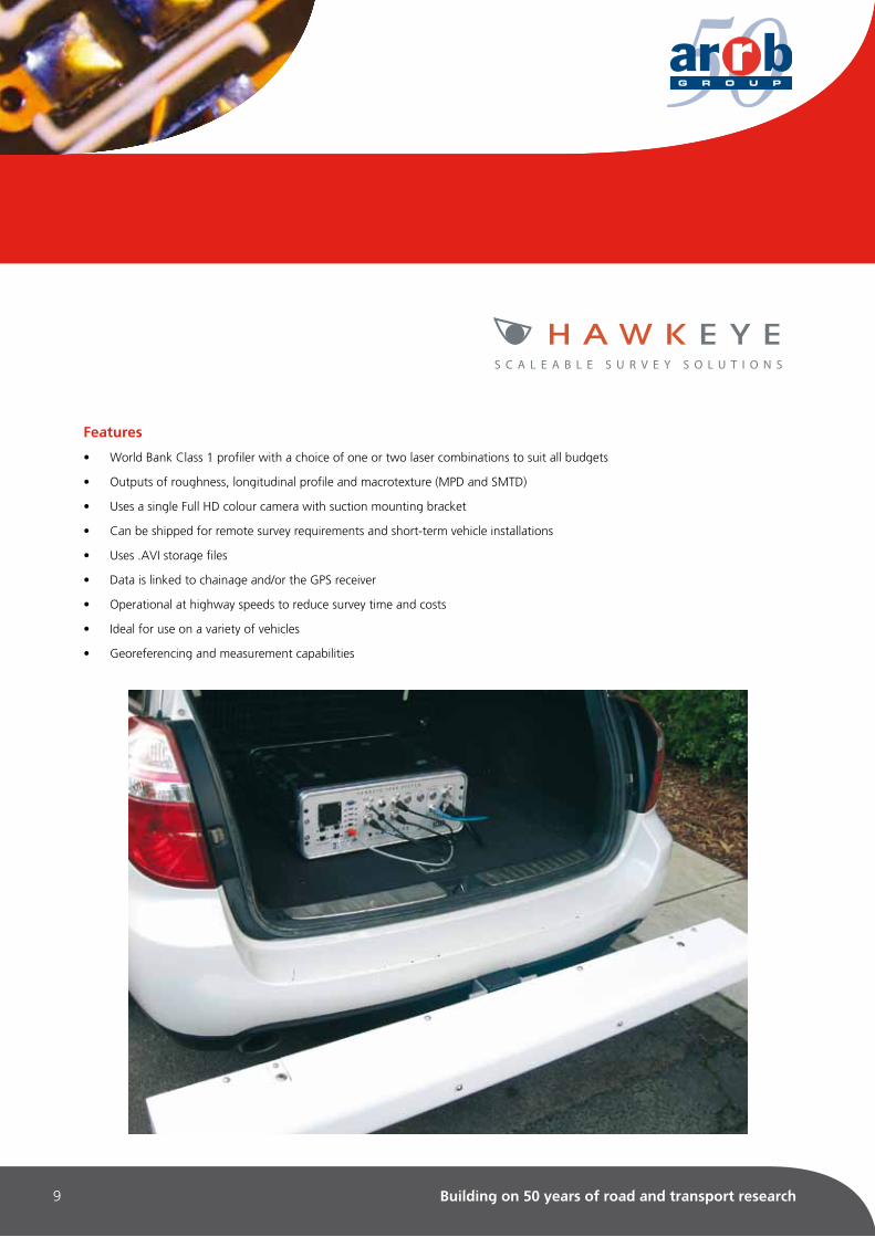
Hawkeye 1000 Digital Laser Profiler
The Hawkeye 1000 Digital Laser Profiler (DLP) is an affordable, portable system that measures longitudinal profile, macrotexture (MPD and SMTD) and roughness (IRI).
A World Bank Class 1 profiler, the Hawkeye 1000 DLP measures road profile in one or two wheel-paths using accelerometers and up to two precision laser sensors to compensate for vehicle body movement.
The DLP is completely portable using a detachable sensor beam and comes complete with a tow-bar mounting kit, making it perfect for less frequent survey demands.
An accurate Distance Measuring Instrument (DMI) and the Heartbeat module are used to precisely link the data to distance/chainage.
Used in conjunction with the Hawkeye Processing Toolkit, you have the ability to produce tables, graphs, reports and exports from your collected data.
Applications
• Pavement condition assessment
• Accurate quality assessments
• Quality control
• Contract validation
Available outputs
• Roughness (IRI, NAASRA)
• Longitudinal profile
• Macrotexture (MPD and SMTD)
• Distance
Compliance with international standards
• ASTM E950
• AASHTO PP37
• ASTM E1845
• ISO 13473
Low
Medium
High

Building on 50 years of road and transport research5
S C A L E A B L E S U R V E Y S O L U T I O N S
Features
• World Bank Class 1 profiler with a choice of one, two or three laser combinations to suit all budgets
• Can be easily shipped for remote survey requirements and short-term vehicle installations
• Easily installed on a vehicle without special tools or personnel
• Lightweight aluminium beam with external weatherproof housing
• Data is linked to chainage and/or the optional GPS receiver
• Operational at highway speeds to reduce survey time and costs
• Results are independent of vehicle type

6 www.arrb.com.au
Hawkeye 1000 Digital Imaging System
The Hawkeye 1000 Digital Imaging System (DIS) is a portable imaging unit for visually capturing and locating road and roadside features.
The single, full high definition (HD), colour camera can be mounted on a windscreen or vehicle dashboard.
The DIS is completely portable, using a suction mounted camera and transportable carry case, allowing for the system to be easily transferred between vehicles without the need for special tools or personnel.
An accurate Distance Measuring Instrument (DMI) and the Heartbeat module are used to precisely link the data to distance/chainage.
Used in conjunction with the Hawkeye Processing Toolkit software, the acquired images can be reviewed quickly and efficiently with the ability to locate assets, assess their condition and export the individual images to asset management systems.
Applications
• Visual identification of roadside features and assets
• Right of way assessment
• Asset location for GIS applications
• Road safety assessment
Available outputs
• Digital imagery
• GPS location / distance
• Shapefiles

Building on 50 years of road and transport research7
S C A L E A B L E S U R V E Y S O L U T I O N S
Features
• Uses a single full HD colour camera with suction mounting bracket
• Can be shipped for remote survey requirements and short-term vehicle installations
• Uses .AVI storage files
• Data is linked to chainage and/or the GPS receiver
• Operational at highways speeds to reduce survey time and costs
• Ideal for use on a variety of vehicles
• Georeferencing and measurement capabilities

8 www.arrb.com.au
Hawkeye 1000 DUO
ARRB Group has developed the first completely portable road and asset data collection system, consisting of a precision laser profiler, combined with a full high definition (HD) colour camera.
The Hawkeye 1000 DUO is perfect for project level data collection demands, as well as larger scale network surveys.
The system, equipped with ARRB’s newly developed lasers, is capable of collecting longitudinal profile, roughness and macrotexture (MPD and SMTD), whilst providing fully linked video images. This is achieved using ARRB’s unique Heartbeat module to precisely link the data to distance/chainage and GPS position.
Used in conjunction with the Hawkeye Processing Toolkit software, operators can produce a wide range of reports to review network condition and performance. This information can then be simply exported to CSV, or applications such as
HDM-4 and GIS tools.
Applications
• Pavement condition assessment
• Identification of roadside features and assets
• Infrastructure condition assessments
• Road safety assessment
• Pavement construction quality control
Available outputs
• Roughness (IRI, Ride Number, NAASRA)
• Longitudinal profile
• Macrotexture (MPD and SMTD)
• Digital imagery
• GPS location / distance
• Shapefiles
Compliance with international standards
• ASTM E950
• AASHTO PP37
• ASTM E1845
• ISO 13473
Building on 50 years of road and transport research9
S C A L E A B L E S U R V E Y S O L U T I O N S
Features
• World Bank Class 1 profiler with a choice of one or two laser combinations to suit all budgets
• Outputs of roughness, longitudinal profile and macrotexture (MPD and SMTD)
• Uses a single Full HD colour camera with suction mounting bracket
• Can be shipped for remote survey requirements and short-term vehicle installations
• Uses .AVI storage files
• Data is linked to chainage and/or the GPS receiver
• Operational at highway speeds to reduce survey time and costs
• Ideal for use on a variety of vehicles
• Georeferencing and measurement capabilities

10 www.arrb.com.au
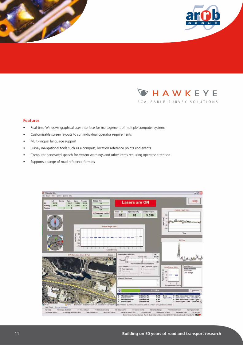
Hawkeye Onlooker Live
Hawkeye Onlooker Live software is an interactive, real-time acquisition control interface that is capable of simultaneously controlling all inputs from the Hawkeye system.
The software runs on a dedicated computer in the vehicle or on a laptop-based system and has an easy-to-use interface that features a fully flexible layout.
The layout is fully customisable to individual operator preferences and survey requirements. The network control interface enables real-time results reporting and the capability to progressively add new Hawkeye modules, without the need for additional software.
Applications• Control and monitoring of the Hawkeye survey systems
• Real-time data acquisition of road survey parameters
• Calibration tool for Hawkeye equipment
• Visual confirmation for data collection
Software Capabilities• Digital display of:
- Profilometry
- Video imagery
- Speed
- Distance
- Geometry
• Graphical display of:
- GPS maps, compass and satellite locations
- Inertial geometry mapping
- Road profile information
• Tabular display of:
- Road location reference points
- Predefined and real-time event point marking
- User defined survey notes tool
- Road profile data
Building on 50 years of road and transport research11
Features
• Real-time Windows graphical user interface for management of multiple computer systems
• Customisable screen layouts to suit individual operator requirements
• Multi-lingual language support
• Survey navigational tools such as a compass, location reference points and events
• Computer generated speech for system warnings and other items requiring operator attention
• Supports a range of road reference formats
S C A L E A B L E S U R V E Y S O L U T I O N S

12 www.arrb.com.au
Hawkeye Processing Toolkit
The Hawkeye Processing Toolkit is a professional data processing, analysis and reporting tool to enable accurate processing of all collected parameters.
The easy-to-use interface features an integrated image viewer and centralised database to review all collected survey parameters. The software can be used to review and rate individual video frames against chainage and GPS, save images to file and zoom-in to inspect areas of interest. Multiple images can be assessed simultaneously and the road can be ‘driven’ at a rate selected by the operator.
Features such as data transfer tools, survey editing tools, data viewing/editing and advanced profiling are among just a few of the ever growing options available for the Hawkeye Processing Toolkit.
Applications• Analysis of survey data
• Pavement condition surveys
• Right-of-way analysis
• Inventory assessment
• Virtual drive-through of roads
• Geographical Information Systems (GIS) applications
Software capabilities• Image area / length / height measurement
• Image stitching
• Asset location (geo-referencing)
• Image export
• Zooming and image resizing
• Graphical inertial / GPS mapping
• Reference and event point markers
• Supports Google background maps

Building on 50 years of road and transport research13
S C A L E A B L E S U R V E Y S O L U T I O N S
Features
• Windows graphical user interface that allows synchronised viewing of data and video
• Calculation of IRI, MPD, SMTD, Rutting, Faulting, Longtidinal Profile and Geometry
• Extensive analysis and reporting capability for geometry, GPS, profiling and video images
• Advanced mapping interface that supports Google background maps
• Centralised databases to allow multiple users to process and view the same survey data simutaneously
• Multi-lingual language support
• User configurable rating forms
• Batch rubber banding and editable reference points
• Survey search filter capabilty
• Export capability to most PMS, GIS and HDM-4 applications
• Batch processing
• Data export capability to CSV, PDF, MS Word, MS Excel, RTF and SHP formats
• Vista Business / Windows 7 / Windows XP compatibility

14 www.arrb.com.au
The Hawkeye Data Viewer is an office-based program that enables enhanced assessment of sites to be completed by providing zoom and measurement tools for reviewing processed surveys.
You can navigate your way through the Viewer by numerous methods including synchronised chainage, GPS path, reference point or frame number. By having this visual record, the need for on-site visual inspections is reduced.
The benefits of high resolution digital imaging for asset management systems include reviewing road pavements, kerbs, footpaths, signs, roadside vegetation, traffic management devices, parks and gardens and many other roadside assets.
Applications• Analysisandplaybackofsurveydata
• Viewingofgraphsandvideoimages
• Viewingofreports
Software capabilities• Asset location (geo-referencing)
• Image export
• Zooming and image resizing
• Reference and event point markers
• Integrated Google background maps
Hawkeye Data Viewer

Building on 50 years of road and transport research15
Specifications Data
ViewerProcessing
Toolkit
Processing of: - Texture (MPD and SMTD) - IRI (predictive low speed IRI < 20 kph) - Ride Number, NAASRA, HATI - Longitudinal profile - Transverse profile, rutting, straight edge - Geometry and Superelevation
Ð Ð Ð Ð Ð Ð
ü ü ü ü ü ü
Video image tools: - Playback tools - Measurement tools: area, length, height - Zooming and image resizing - Image stitching - Image quality enhancements - Asset inventory location: Lat, Long, Alt - Image export (jpeg) - User configurable ratings forms
ü VüüüVüV
ü ü üüüüüü
Reporting: - Report generation tools for profiling, geometry and video rating - Printing of reports
üü
ü ü
Centralised databases V ü
Rubber banding and editable reference points Ð ü
Export tools: - CSV, PDF, MS Word, RTF, SHP - PMS, HDM-4, GIS
üÐ
üü
General: - Synchronised viewing of all data - Survey navigation tools - GPS path with selectable coordinates (U/TM, Geodetic, Custom datum) - GPS Maps. Geographic reference mapping - Dead-reckoning capability to overcome GPS dropout - Display of: survey route with reference points, events, profiling data & geometry
ü ü ü VVü
ü ü ü ü ü ü
ü AvailableÐ Not Available V Viewing capability only
Hawkeye Software Comparison

Head Office:Australia, Victoria:500 Burwood HighwayVermont South VIC 3133AustraliaP: +61 3 9881 1555F: +61 3 9887 [email protected]
ARRB Group LtdABN 68 004 620 651www.arrb.com.au
Regional Offices:
About ARRB:ARRB Group Ltd (ARRB) provides
research, consulting and information services to the road
and transport industry. ARRB applies research outcomes to
develop equipment that collects road and traffic information and
software that assists with decision making across road networks.
ARRB is the leading provider of road research and best practice
workshops in Australia.
MATERIALS, PAVEMENT & CONCRETE DESIGN & TESTING | TRANSPORT POLICY, OPERATIONS & ECONOMICS |
INFRASTRUCTURE ASSET MANAGEMENT | EQUIPMENT MANUFACTURE & DATA COLLECTION SERVICES |
SAFE SYSTEMS | ROAD SAFETY | TRAFFIC ENGINEERING | HEAVY VEHICLE TESTING & SIMULATION | PARKING |
LAND TRANSPORT RESOURCES & INFORMATION | KNOWLEDGE TRANSFER & CAPACITY BUILDING |
Western Australia:191 Carr PlaceLeederville WA 6007AustraliaP: +61 8 9227 3000F: +61 8 9227 [email protected]
China:Floor 13, Zhen Xing Building118 North Hu Bin RoadXiamen PRCP: +86 592 2135 552F: +86 592 2136 663www.arrb-china.com.cn
Queensland:123 Sandgate RoadAlbion QLD 4010AustraliaP: +61 7 3260 3500F: +61 7 3862 [email protected]
UAE:Unit 101, Al Safa TowerSheikh Zayed RoadDubai, UAEP: +971 4332 8532F: +971 4332 8584www.arrb-me.com
South Australia:Aurora BuildingSuite 507, 147 Pirie StAdelaide SA 5000AustraliaP: +61 8 7200 2659F: +61 8 8223 [email protected]
Luxmoore Parking ConsultingGround Floor, 12 Wellington ParadeEast Melbourne, VIC 3002P: +61 3 9417 5277F: +61 3 9416 2602
New South Wales:2-14 Mountain StUltimo NSW 2007AustraliaP: +61 2 9282 4444F: +61 2 9280 [email protected]
September 2010