Hawke, W.C. A report on the flood of February 1955 in the Hunter Valley of New South Wales
86
“And the waters prevailed exceedingly upon the earth" A REPORT O N THE FLOOD OF FEBRUARY, 1955 IN THE HUNTER VALLEY OF NEW SOUTH WALES By W. C. HAWKE, LL.B. Secretary, Hunter Valley Conservation Trust The views and opinions expressed in this Report are those of the Author and are not necessarily those of the Hunter Valley Conservation Trust
-
Upload
maitland-information -
Category
Documents
-
view
218 -
download
2
description
86 pages. Pub by Hunter Valley Conservation Trust
Transcript of Hawke, W.C. A report on the flood of February 1955 in the Hunter Valley of New South Wales
“And the waters prevailed exceedingly upon the earth"
A REPORT O N
THE FLOOD OF FEBRUARY, 1955
IN THE
HUNTER VALLEY
OF
NEW SOUTH WALES
By
W. C. HAWKE, LL.B.
Secretary,
Hunter Valley Conservation Trust
The views and opinions expressed in this Report are those of the Author and are
not necessarily those of the Hunter Valley Conservation Trust
Scanning note:
This document was scanned from a photocopy of the original. In doing so a number of changes have been made to improve readability:
the font has been changed from 10 pt Courier New to 11 pt Ariel;
significant quotes from newspaper and official reports have been indented for emphasis;
the text has been justified;
‘Acknowlegment’, ‘References’ and ‘Map of Hunter River Catchment Area’ have been inserted in ‘Contents’; and
margins have been adjusted so the document will approximate the length of the original.
Page numbering in the ‘Contents’ has been amended to suit the changed format.
Michael Clarke September, 2007
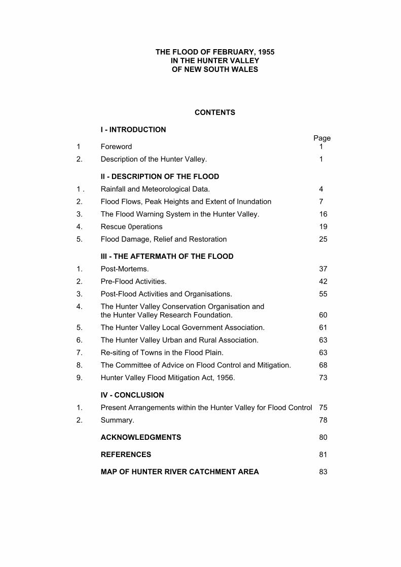
THE FLOOD OF FEBRUARY, 1955
IN THE HUNTER VALLEY
OF NEW SOUTH WALES
CONTENTS
I - INTRODUCTION Page1 Foreword 1
2. Description of the Hunter Valley. 1
ll - DESCRIPTION OF THE FLOOD
1 . Rainfall and Meteorological Data. 4
2. Flood Flows, Peak Heights and Extent of Inundation 7
3. The Flood Warning System in the Hunter Valley. 16
4. Rescue 0perations 19
5. Flood Damage, Relief and Restoration 25
III - THE AFTERMATH OF THE FLOOD
1. Post-Mortems. 37
2. Pre-Flood Activities. 42
3. Post-Flood Activities and Organisations. 55
4. The Hunter Valley Conservation Organisation and the Hunter Valley Research Foundation. 60
5. The Hunter Valley Local Government Association. 61
6. The Hunter Valley Urban and Rural Association. 63
7. Re-siting of Towns in the Flood Plain. 63
8. The Committee of Advice on Flood Control and Mitigation. 68
9. Hunter Valley Flood Mitigation Act, 1956. 73
IV - CONCLUSION
1. Present Arrangements within the Hunter Valley for Flood Control 75
2. Summary. 78
ACKNOWLEDGMENTS 80
REFERENCES 81
MAP OF HUNTER RIVER CATCHMENT AREA 83
1
THE FLOOD OF FEBRUARY, 1955,
IN
THE HUNTER VALLEY
OF
NEW SOUTH WALES
l. INTRODUCTION
1. Foreword.
During the comparatively brief period of settlement of the Hunter Valley in New South Wales, covering barely a century and a half, the Valley has experienced many floods, those of 1820, 1893, and 1955 being of major and catastrophic proportions. As settlement increased and as the area became developed, particularly the flood plain of the Lower Hunter River, so damage tended to become greater with each successive major flood. Over the past fifty years, the Valley has averaged a major flood, that is one over 27 feet in the Hunter River at the Belmore Bridge gauge, Maitland, at least every other year.1
Many interesting stories and unusual experiences in relation to the floods of the last century have been told by the early settlers and in fact, one flood, that of 1893, had become almost a legend, a flood that was virtually a precedent and which, in the opinion of many residents of the Valley, could never be surpassed.
The Hunter waited for three generations before showing beyond any doubt that no flood experienced so far by the people of the Valley can be said to be the greatest that can be expected. During the period 23rd to 27th February, 1955, the river struck with inconceivable force and destroyed for ever the aura of invincibility surrounding the '93 flood.
2. Description of the Hunter Valley
The Hunter Valley is one of the prominent geographical features of Eastern New South Wales, standing out as a tongue of lowland penetrating deeply from the coast into the high lands of the Great Dividing Range for a distance of about 125 miles.
The total area of the entire Hunter Catchment is 8,010 square miles of which an area of 6,750 square miles is located upstream of the City of Maitland. The catchment is one of the largest coastal catchments in the State and extends much farther inland than any other coastal basin. This latter feature results in inland conditions and vegetation and a relatively low average annual rainfall in the western portion of the Valley.
The north-eastern portion of the Valley is comparatively high, mountainous country, rugged and largely wooded, particularly in the upper catchments of the Paterson and Williams Rivers. The north-western section in the Goulburn River catchment is comparatively open country, composed to a great extent of black volcanic soils, while practically the whole of the southern part of the catchment is sandstone from which a large proportion of the sand carried by the stream is derived.2
1 Report on the Hydrologic Features of the Floods of February, 1955, Hunter River Valley,
N.S.W., W.C. & I. C., (April, 1956). 2 "River Control Work in the Non-Tidal Sections of the Hunter River and its Tributaries", A.F.
Reddoch, Journal of the Institution of Engineers, (October-November, 1957).
2
A study of the map will reveal that the Hunter Valley Basin is somewhat circular in shape, with the main indentations on the southern and north-western portions of the perimeter.
The Valley is bounded by the Sugarloaf and Myall ranges in the south-east and south, by the Great Dividing Range in the south-west and west, by that part of the Great Dividing Range known as the Liverpool Range in the north-west and north and by the Mount Royal Range, Barrington Tops and Gloucester Tops in the north-east.
The Hunter River has its source in the Mount Royal Range, at an elevation of about 4,500 feet. Incidentally, the Mount Royal Range is the highest mountain range in the catchment, with an average elevation of 4,000 feet, with some peaks such as Mount Barrington and Carey's Peak rising to just over 5,000 feet. These highlands, including Barrington Tops, experience the heaviest rainfall in the catchment, with annual falls of up to 70 inches. For the first 135 miles of its course to Denman the Hunter flows generally in a south-westerly direction, past Glenbawn Dam, Aberdeen and Muswellbrook. Just below Denman it is joined by the Goulburn River and thence flows generally east-south-east for the remainder of its passage to the South Pacific Ocean at Newcastle, skirting Singleton, Maitland and Raymond Terrace on the way. The Hunter River is 290 miles long from its source in the Mount Royal Range to its mouth at Newcastle.
Glenbawn Dam 1 with a capacity of 293,000 acre feet and draining an area of 500 square miles, is situated on the Hunter River about eight miles upstream of the junction of the Hunter and Pages Rivers, not far from Scone and Aberdeen, and about 85 miles from the source of the river. Muswellbrook is 112 miles from its source, Singleton 196 miles Maitland 248 miles, and Raymond Terrace 271 miles. 2
In its upper reaches, the Hunter River falls steeply from the Mount Royal Range, whilst in the vicinity of Glenbawn Dam, it has a gradient of approximately 9 feet per mile, reducing to about 6 feet per mile near Denman and 3 feet per mile at Singleton. 3 In the Lower River area, between Oakhampton and Morpeth, about 9 miles, the fall is approximately 2¼ feet per mile and between Morpeth and Newcastle a distance of 28 miles, the fall is only 0.43 feet per mile.4
The Sugarloaf and Myall Ranges along the south-eastern boundary of the catchment with elevations ranging from 1,000 to 2,000 feet, provide the source of Wallis Creek and Wollombi Brook. Wollombi Brook (or Cockfighter Creek) , which, despite its limited catchment area of about 700 square miles, is responsible for much of the major flooding below Singleton, flows northerly from the Cessnock-Wollombi region, joining the Hunter River 18 miles upstream of Singleton.
The Great Dividing Range along the south-western boundary of the catchment is an extremely rugged sandstone plateau, attaining a height of over 4,000 feet in the vicinity of Mount Coricudgy. Here rise the main southern tributaries of the Goulburn River - Baerami Creek, Widden Brook, Bylong Creek and Wollar Creek.
The average elevation of the Great Dividing Range along the extreme western boundary from Ulan to Cassilis falls as low as 2,000 feet. The roads from the Hunter Valley to the inland towns of Mudgee, Gulgong, Dunedoo and Coolah traverse this
1 Glenbawn Dam Act, 1946-57 (N.S.W.). Act No. 30, 1946, and Act, No.11, 1957.
2 Report on the Hydrologic Features of the Floods of February, 1955, Hunter River Valley,
N.S.W., W.C. & I.C., (April, 1956) 3 "River Control Work in the Non-Tidal Sections of the Hunter River and its Tributaries", A.F.
Reddoch, Journal of the Institution of Engineers, (October-November, 1957). 4 "Flood Mitigation on the Lower Hunter River, N.S.W.", E.W. Harrison, B.E., Journal of the
Institution of Engineers, (December, 1957).
3
section of the Great Divide. In fact, the main road from Cassilis to Coolah reaches a maximum elevation of 1,500 feet only. Despite its obvious suitability for communication routes from the coastal areas of the State to the inland this low divide has not yet been employed by the State railway network. The construction of a railway link between Sandy Hollow on the Goulburn River and Maryvale on the Great Western Line, has been suspended.
Not far from the village of UIan, the Goulburn River has its source in the Great Dividing Range, at an elevation of only 2,400 feet. The Goulburn River flows generally east-south-east to join the Hunter River near Denman, draining an area of over 3,000 square miles. Fortunately, exceptional rainfall in the Goulburn Catchment, as eventuated in the 1955 flood, is not a frequent occurrence, with the result that in the majority of floods in the Hunter Valley, the flow from the Goulburn system does not present a grave threat to the Lower River, despite the relatively large catchment area. No towns of any size are situated along the Goulburn River, the main centre for the catchment, Merriwa being located on Merriwa Creek a northern tributary of the Goulburn.
The Liverpool Range, which constitutes the northern boundary of the catchment, has an average elevation of about 3,000 feet in the western section, increasing to 3,500 feet in the eastern section. In the west, the main northern tributaries of the Goulburn River - Kunmurra Creek, Krui River, Merriwa Creek and Wybong Creek - all flowing in a southerly direction, have their source. In the vicinity of Murrurundi, in the east, rise some important tributaries of the Hunter River - Dart Brook, Kingdon Ponds, Pages River, Isis River and Pages Creek, the latter draining into Glenbawn Dam. Murrurundi is situated on the Pages River, not far from its source, and Scone on Kingdon Ponds.
The main plateau of the Mount Royal Range running south easterly from the Liverpool Range to Barrington Tops, provides not only the source of the Hunter River, but also the sources of its early tributaries Omadale Brook, Moonan Brook, and Stewarts Brook. All these streams, which flow north-westerly to the Hunter River, are within the Glenbawn Dam catchment area.
A spur, being a continuation of the Mount Royal Range and separating the Paterson-Williams system from the main catchment, runs generally southward towards Maitland. From this spur Rouchel Brook, Foy Brook (Bowmans Creek), Fal Brook (Glennies Creek), and Glendon Brook flow in a south-westerly direction to the Hunter River.
From Barrington Tops the boundary of the catchment runs south-easterly along the Gloucester Tops and southerly along the divide between the Williams and Karuah Rivers, through points slightly to the east of Dungog and Raymond Terrace, terminating at Stockton, a suburb of Newcastle. The main streams in this most easterly section of the catchment, all having their source in the vicinity of Barrington Tops and flowing southward, are the Paterson, Allyn, Williams and Chichester Rivers. These streams drain an area comprising little more than one-tenth of the entire basin, but contribute almost one-half of its annual flow. They, join the Hunter River in the tidal section below Maitland, the confluence of the Paterson River being at Hinton and that of the Williams River at Raymond Terrace. The town of Dungog, situated on the Williams River, is the main centre for this area. Chichester Dam, with a capacity of 18,400 acre feet and comprising part of the Hunter District Water Board's supply system for Newcastle, Maitland and the Coalfields is situated on the Chichester River, 14 miles north of Dungog.
The average annual flow of the entire Hunter River system approaches 1,250,000 acre feet, the contributions of the major stream being:-
4
Hunter River, Muswellbrook - 292,000 acre feet Goulburn River - 135,000 acre foot Wollombi Brook - 132,000 acre foot Hunter River, Singleton - 650,000 acre feet Williams-Paterson Rivers - 564,000 acre foot 1
For a coastal catchment, the average annual rainfall of certain towns in the central and western portion of the Valley is comparatively low. For example, the mean annual rainfall is only 23.56 inches at Scone, 23.29 inches at Muswellbrook, 21.38 inches at Denman and 21.89 inches at Merriwa. The figure for Murrurundi, however, shows a marked increase, being 30.27 inches. Nearer the coast the rainfall increases, the mean annual figures being 27.31 inches at Singleton, 33.07 inchesat Maitland, 36.75 inches at Dungog and 39.82 inches at Raymond Terrace. 1
Over one-quarter of a million people, or approximately eight per cent of the total population of the State of New South Wales live in the Hunter Valley, the great majority residing in the Newcastle, Maitland and Coalfields areas. Only about 12½ per cent of the Valley's population is found in the Upper River area above Singleton. The main cities and towns, with estimated populations for 1958 shown in brackets, are - Newcastle City (136,230), Maitland City (23,030), Cessnock (14, 900), Muswellbrook (6,090), Kurri Kurri (4,850), Singleton (4,750), Raymond Terrace (3,700), Scone (3,630), Weston (3,300), Dungog (2,260), and Abermain (2,200).
A wide variety of activities embracing primary, secondary and tertiary industries, occurs in the Hunter Valley. The heavy industries of Newcastle and the rich coal seams of the Cessnock-Maitland field are well known. Primary industries range from dairying along the river flats and lower slopes to cattle grazing and sheep farming in the uplands, as well as timber getting and sawmilling. Wheat growing, intensive cultivation of crops and vegetables on the rich alluvial flats especially near Maitland, and the vineyards of Pokolbin, complete a diversified agricultural pattern. The City of Newcastle boasts both a University College and one of the busiest ports in Australia. The Valley has been described, justifiably, as almost a complete economic unit in itself, with most phases of rural and industrial development already in existence, with the industrial phase expanding rapidly. 2
II. DESCRIPTION OF THE FLOOD
1. Rainfall and Meteorological Data.
The mean rainfall over the Hunter Catchment during the four months preceding the flood of February, 1955, was approximately 150 per cent of normal This wet season was followed by rains of substantial proportion during the period 14th to 17th February, 19559 when the mean rainfall for the Valley was 4.7 inches with falls up to 11½ inches in the upper reaches of the catchment. This rain was sufficient to cause a minor flood in the Hunter River at Maitland, where the river reached a height of 26 feet 3 inches at the Belmore Bridge gauge, and a major flood in the Williams River. Conditions at the time were warm and humid with scattered rains, evaporation was below normal, and, as a consequence, the soil throughout the catchment remained wet. The catchment was therefore well saturated and, in the event of further heavy rains, the stage was set for a major flood.
The storm which produced the flood was unusual in that equatorial air of high moisture content and to a height of 35,000 feet, penetrated into New South Wales with an inflow rate of 30 knots. This air originated over the East Indies about the middle of February and moved via Darwin and Western Queensland to northern
1 Report on the Hydrologic Features of the Floods of February, 1955, Hunter River Valley
N.S.W, W.C. & I.C, (April, 1956). 2 Report of the Hunter River Flood Mitigation Committee, "Huddleston Report”, (May, 1947).

5
New South Wales. Over Southern Queensland it was met by a stream of moist tropical air from the Pacific which lifted it sufficiently to cause cooling to saturation point. An anti-cyclone moving from west to east increased the convergence of saturated air streams over north and central New South Wales and provided the triggering mechanism for the precipitation of rains of unprecedented intensity for inland areas of New South Wales. The rains commenced during the morning of Wednesday, 23rd February, 1955 and continued and extended with varying intensity and location until Sunday, 27th February, over the north-west, central and Hunter districts of the State. The meteorological situation was remarkable for the penetration so far southward of a deep stream of nearly saturated equatorial air and it is probable that the air mass over northern inland New South Wales contained an amount of precipitable water equalling or exceeding the previous known maximum.1
Rainfall of phenomenal intensity commenced in the Hunter Valley at the headwaters of the Goulburn River during the early afternoon of Wednesday, 23rd February. Heavy rain continued over the whole of the Hunter Valley on Thursday, 24th February, and continued with varying intensities on the following day. By Saturday, 26th February, the flow of equatorial air over New South Wales had practically ceased, being replaced by drier, colder air of southern origin. The rainfall contracted towards the coast and had ceased in the Hunter Valley by Sunday, 27th February. 1
It will be obvious that this flood differed from the usual pattern in that the heaviest rains occurred first in the headwaters, then later towards the coast, thus giving a disastrous accumulation of floodwaters in the lower reaches. Flooding in the Hunter River catchment in most instances results from a well-developed cyclone centred close to the coast. An eastward moving cyclone which intensifies close to the coast produces strong to gale force south-east winds accompanied by heavy rains along the coast. Heaviest rains are centred on the Myall Range and to a less extent on the Mount Royal Range, with subsequent heavy flooding from the south-east catchments, notably Wollombi Brook, and from the north-east catchments draining the Mount Royal Range. Rainfall is very much less on the western catchments feeding the Goulburn River. In summer a cyclone may move south from off the Queensland coast and produce heavy rains in the eastern catchments. In this case the main rains occur on the north-eastern catchment with subsequent major flooding in the Williams and Paterson, Rivers. Rainfall in the Goulburn catchment is again very much reduced. 2 It is the generally accepted opinion that floods of varying patterns can occur almost at any, time of the year.
However the Director of Research, Hunter Valley Research Foundation, (see post), has tended to refute the assertion in the "Huddleston Report" 3 that "the incidence of flooding is very irregular and it is not possible to anticipate at what time of the year a flood will occur". In his paper related to the frequency and incidence of floods at Maitland from 1820 to 1876, he argued that preliminary research indicated the probability of a certain regularity in the flood pattern of the Hunter Valley. "The tendency is for floods to occur in two distinct three-monthly periods - late summer-autumn and winter - and with a disposition to occur more frequently in the late summer-autumn season.'' 4
1 Report on the Hydrologic Features of the Floods of February, 1955, Hunter River Valley,
N.S.W., W.C. & I.C., (April, 1956). 2 Interim Report No. 5 - The 'Incidence and Behaviour of the Record Flood and the Extent of
Inundation of the Towns, Villages and Farm Lands of the Hunter Valley, February, 1955 - Committee of Advice on Flood Control and Mitigation, (July, 1956).3 Report of the Hunter River Flood Mitigation Committee May, 1947)., 24/3/56.
4 Newcastle Morning Herald 24/3/56, "A Survey of Maitland Floods", C. Renwick (March,
1956).
6
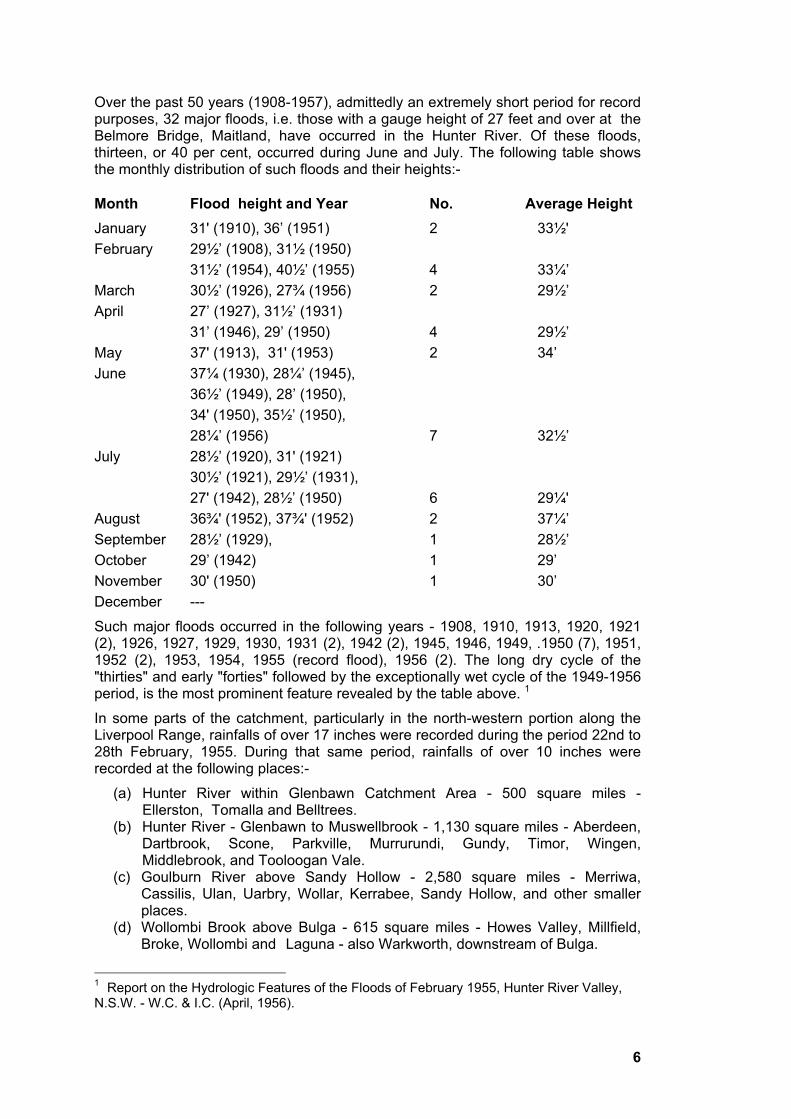
Over the past 50 years (1908-1957), admittedly an extremely short period for record purposes, 32 major floods, i.e. those with a gauge height of 27 feet and over at the Belmore Bridge, Maitland, have occurred in the Hunter River. Of these floods, thirteen, or 40 per cent, occurred during June and July. The following table shows the monthly distribution of such floods and their heights:-
Month Flood height and Year No. Average Height
January 31' (1910), 36’ (1951) 2 33½'
February 29½’ (1908), 31½ (1950)
31½’ (1954), 40½’ (1955) 4 33¼’
March 30½’ (1926), 27¾ (1956) 2 29½’
April 27’ (1927), 31½’ (1931)
31’ (1946), 29’ (1950) 4 29½’
May 37' (1913), 31' (1953) 2 34’
June 37¼ (1930), 28¼’ (1945),
36½’ (1949), 28’ (1950),
34' (1950), 35½’ (1950),
28¼’ (1956) 7 32½’
July 28½’ (1920), 31' (1921)
30½’ (1921), 29½’ (1931),
27' (1942), 28½’ (1950) 6 29¼'
August 36¾' (1952), 37¾' (1952) 2 37¼’
September 28½’ (1929), 1 28½’
October 29’ (1942) 1 29’
November 30' (1950) 1 30’
December ---
Such major floods occurred in the following years - 1908, 1910, 1913, 1920, 1921 (2), 1926, 1927, 1929, 1930, 1931 (2), 1942 (2), 1945, 1946, 1949, .1950 (7), 1951, 1952 (2), 1953, 1954, 1955 (record flood), 1956 (2). The long dry cycle of the "thirties" and early "forties" followed by the exceptionally wet cycle of the 1949-1956 period, is the most prominent feature revealed by the table above. 1
In some parts of the catchment, particularly in the north-western portion along the Liverpool Range, rainfalls of over 17 inches were recorded during the period 22nd to 28th February, 1955. During that same period, rainfalls of over 10 inches were recorded at the following places:-
(a) Hunter River within Glenbawn Catchment Area - 500 square miles - Ellerston, Tomalla and Belltrees.
(b) Hunter River - Glenbawn to Muswellbrook - 1,130 square miles - Aberdeen, Dartbrook, Scone, Parkville, Murrurundi, Gundy, Timor, Wingen, Middlebrook, and Tooloogan Vale.
(c) Goulburn River above Sandy Hollow - 2,580 square miles - Merriwa, Cassilis, Ulan, Uarbry, Wollar, Kerrabee, Sandy Hollow, and other smaller places.
(d) Wollombi Brook above Bulga - 615 square miles - Howes Valley, Millfield, Broke, Wollombi and Laguna - also Warkworth, downstream of Bulga.
1Report on the Hydrologic Features of the Floods of February 1955, Hunter River Valley,
N.S.W. - W.C. & I.C. (April, 1956).
7
(e) Hunter River - Muswellbrook to Singleton - 1,345 square miles - Doyles Creek, Summer Hill, Mount Olive, Glennies Creek, Singleton, Ravensworth, Denman, Kars Springs (17½ to 18 inches), Bunnan, Wybong and Delhurst.
(f) Hunter River - Singleton to Maitland - 580 square miles - Mitchell's Flat and Sedgefield.
(g) Paterson River above Hinton - 400 square miles - Gresford, Eccleston, Lostock and Carrabolla.
(h) Williams River above Mill Dam Falls near Clarence Town - 374 square miles - Munni, Tilligra, Salisbury and Upper Chichester. 1
The average distributions of rainfall over the various parts of the Hunter Valley Catchment were:
Hunter River above Muswellbrook 10.9 inches Goulburn River above Sandy Hollow 11.1 inches Wollombi Brook above Bulga 9.6 inches Hunter River above Singleton 10.8 inches Hunter River above Maitland 10.6 inches Paterson River above Lostock 9.7 inches Williams River above Mill Dam Falls 9.2 inches
The average fall over the whole catchment was 10.6 inches. 1
The intensity of the rainfall can be gauged when it is remembered that the average annual rainfall for many of the locations mentioned, particularly those in the Middle Hunter and Goulburn Catchments, barely exceeds 20 inches. Merriwa, for example, has an average annual rainfall of only 21.89 inches, but 10 inches of rain fell in that town during the period in question and falls of up to 17 inches were recorded at locations not far distant.
Outstanding features of the storm were the prolongation of rain over the Hunter Catchment and the simultaneous flooding of the Hunter River and several western inland streams to record levels. The maximum storm rainfall record in the Hunter River basin was 18.2 inches in the Upper Goulburn River Catchment near Cassilis. Cassilis, itself, has an average annual rainfall of only 22.65 inches.1
As a matter of interest, the weather forecasts for the Hastings, Manning, and Hunter, which appeared in the Sydney Morning Herald during the period in question, are quoted:
Thursday, 24th February 1955: "General rain. Some heavy falls, North-east winds, later tending south-easterly and strengthening. Seas rising to moderate."
Friday 25th February, 1955: "Further heavy rain, East winds, strong and squally, with rough seas. Extreme flood danger in the Hunter Valley and rises expected in Hastings and Manning.
Saturday, 26th February, 1955: "Further rain. Fresh to strong south winds. Rough seas. Rain gradually contracting to coastal. Showers, and easing,"
2. Flood Flows. Peak Heights and Extent of Inundation
Such unprecedented rainfall could have one result only; a flood of the greatest intensity experienced during the period of white settlement in the Hunter Valley. The total flood volume for the entire Hunter River system was approximately 1,700,000 acre feet, this being nearly one and a half times the mean annual discharge from the
1 Report on the Hydrologic Features of the Floods of February 1955, Hunter River Valley,
N.S.W., W.C. & I.C., (April, 1956).
8
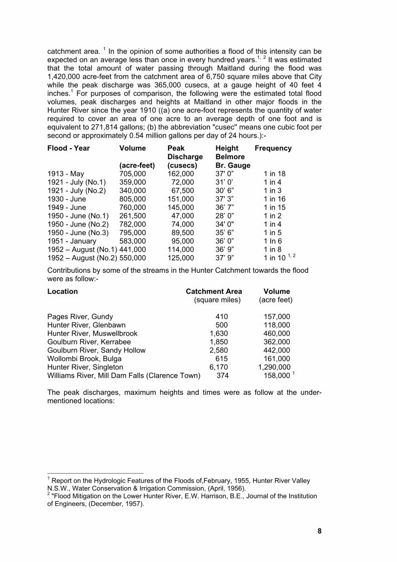
catchment area. 1 In the opinion of some authorities a flood of this intensity can be expected on an average less than once in every hundred years.1, 2 It was estimated that the total amount of water passing through Maitland during the flood was 1,420,000 acre-feet from the catchment area of 6,750 square miles above that City while the peak discharge was 365,000 cusecs, at a gauge height of 40 feet 4 inches.1 For purposes of comparison, the following were the estimated total flood volumes, peak discharges and heights at Maitland in other major floods in the Hunter River since the year 1910 ((a) one acre-foot represents the quantity of water required to cover an area of one acre to an average depth of one foot and is equivalent to 271,814 gallons; (b) the abbreviation "cusec'' means one cubic foot per second or approximately 0.54 million gallons per day of 24 hours.):-
Flood - Year Volume Peak Height Frequency
Discharge Belmore
(acre-feet) (cusecs) Br. Gauge1913 - May 705,000 162,000 37' 0” 1 in 18 1921 - July (No.1) 359,000 72,000 31’ 0’ 1 in 4 1921 - July (No.2) 340,000 67,500 30’ 6” 1 in 3 1930 - June 805,000 151,000 37' 3” 1 in 16 1949 - June 760,000 145,000 36’ 7” 1 in 15 1950 - June (No.1) 261,500 47,000 28’ 0” 1 in 2 1950 - June (No.2) 782,000 74,000 34' 0" 1 in 4 1950 - June (No.3) 795,000 89,500 35’ 6” 1 in 5 1951 - January 583,000 95,000 36’ 0” 1 In 6 1952 – August (No.1) 441,000 114,000 36’ 9” 1 in 8 1952 – August (No.2) 550,000 125,000 37’ 9” 1 in 10 1, 2
Contributions by some of the streams in the Hunter Catchment towards the flood were as follow:-
Location Catchment Area Volume (square miles) (acre feet)
Pages River, Gundy 410 157,000 Hunter River, Glenbawn 500 118,000 Hunter River, Muswellbrook 1,630 460,000 Goulburn River, Kerrabee 1,850 362,000 Goulburn River, Sandy Hollow 2,580 442,000 Wollombi Brook, Bulga 615 161,000 Hunter River, Singleton 6,170 1,290,000 Williams River, Mill Dam Falls (Clarence Town) 374 158,000 1
The peak discharges, maximum heights and times were as follow at the under-mentioned locations:
1 Report on the Hydrologic Features of the Floods of,February, 1955, Hunter River Valley
N.S.W., Water Conservation & Irrigation Commission, (April, 1956).2 "Flood Mitigation on the Lower Hunter River, E.W. Harrison, B.E., Journal of the Institution
of Engineers, (December, 1957).
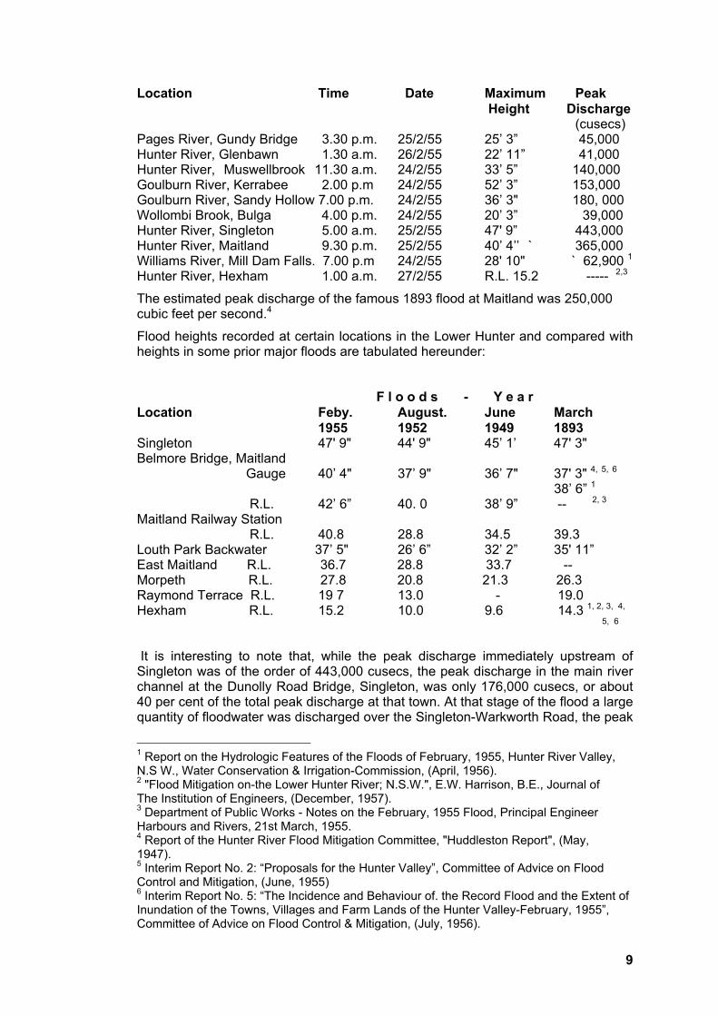
9
Location Time Date Maximum Peak
Height Discharge (cusecs) Pages River, Gundy Bridge 3.30 p.m. 25/2/55 25’ 3” 45,000 Hunter River, Glenbawn 1.30 a.m. 26/2/55 22’ 11” 41,000 Hunter River, Muswellbrook 11.30 a.m. 24/2/55 33’ 5” 140,000 Goulburn River, Kerrabee 2.00 p.m 24/2/55 52’ 3” 153,000 Goulburn River, Sandy Hollow 7.00 p.m. 24/2/55 36’ 3" 180, 000 Wollombi Brook, Bulga 4.00 p.m. 24/2/55 20’ 3” 39,000 Hunter River, Singleton 5.00 a.m. 25/2/55 47' 9” 443,000 Hunter River, Maitland 9.30 p.m. 25/2/55 40’ 4’’ ` 365,000 Williams River, Mill Dam Falls. 7.00 p.m 24/2/55 28' 10" ` 62,900 1
Hunter River, Hexham 1.00 a.m. 27/2/55 R.L. 15.2 ----- 2,3
The estimated peak discharge of the famous 1893 flood at Maitland was 250,000 cubic feet per second.4
Flood heights recorded at certain locations in the Lower Hunter and compared with heights in some prior major floods are tabulated hereunder:
F l o o d s - Y e a r
Location Feby. August. June March
1955 1952 1949 1893 Singleton 47' 9" 44' 9" 45’ 1’ 47' 3" Belmore Bridge, Maitland
Gauge 40’ 4" 37’ 9" 36’ 7" 37' 3" 4, 5, 6
38’ 6” 1
R.L. 42’ 6” 40. 0 38’ 9” -- 2, 3
Maitland Railway Station R.L. 40.8 28.8 34.5 39.3
Louth Park Backwater 37’ 5" 26’ 6” 32’ 2” 35' 11” East Maitland R.L. 36.7 28.8 33.7 -- Morpeth R.L. 27.8 20.8 21.3 26.3 Raymond Terrace R.L. 19 7 13.0 - 19.0 Hexham R.L. 15.2 10.0 9.6 14.3 1, 2, 3, 4,
5, 6
It is interesting to note that, while the peak discharge immediately upstream of Singleton was of the order of 443,000 cusecs, the peak discharge in the main river channel at the Dunolly Road Bridge, Singleton, was only 176,000 cusecs, or about 40 per cent of the total peak discharge at that town. At that stage of the flood a large quantity of floodwater was discharged over the Singleton-Warkworth Road, the peak
1 Report on the Hydrologic Features of the Floods of February, 1955, Hunter River Valley,
N.S W., Water Conservation & Irrigation-Commission, (April, 1956). 2 "Flood Mitigation on-the Lower Hunter River; N.S.W.", E.W. Harrison, B.E., Journal of
The Institution of Engineers, (December, 1957). 3 Department of Public Works - Notes on the February, 1955 Flood, Principal Engineer
Harbours and Rivers, 21st March, 1955. 4 Report of the Hunter River Flood Mitigation Committee, "Huddleston Report", (May,
1947).5 Interim Report No. 2: “Proposals for the Hunter Valley”, Committee of Advice on Flood
Control and Mitigation, (June, 1955) 6 Interim Report No. 5: “The Incidence and Behaviour of. the Record Flood and the Extent of
Inundation of the Towns, Villages and Farm Lands of the Hunter Valley-February, 1955”, Committee of Advice on Flood Control & Mitigation, (July, 1956).
10
discharge being 215,009 cusecs, and by-passed the town of Singleton. However, a small amount of that flow, the peak discharge being 209,000 cusecs, entered the town. The peak discharge under the railway bridge, upstream of the road bridge, was 228,000 cusecs. Between the railway bridge and the road bridge, a distance of about three-quarters of a mile, a peak discharge of 52,000 cusecs was estimated to have flowed over the left and right banks of the river, mainly into Dunolly on the opposite side of the river to the town.1
At Maitland, although the flood reached the unprecedented height of 40' 4" at the Belmore Bridge gauge, of the total quantity of water which passed under the Oakhampton railway bridge, about three miles upstream, amounting to 1,420,000 acre feet, only 720,000 acre feet, or just over 50 per cent, flowed under the Belmore Bridge. The remainder passed under the Long Bridge - 455,000 acre feet - or flowed through the break in the levee at Bolwarra above Lorn - 245,000 acre feet. Peak discharges were -156,000 cusecs down the river channel under the Belmore Bridge; 124,000 cusecs under the Long Bridge into Louth Park from breaches in the right bank above Maitland; and 85,000 cusecs into Bolwarra through a breach in the left bank above Lorn. 1, 2
The mean rainfall for the entire catchment above Maitland was estimated at 10.64 inches and the total precipitation was 3,805,000 acre feet, of which 1,420,000 acre feet, or 36 per cent, was run off. Investigation has shown that during the storm which caused the flood, the mean rainfall for the catchment above Maitland could have been increased, by transposition of the storm centre, to 13.5 inches for the storm period of 72 hours.1 The increased flooding which would have occurred had the storm centre been located directly over the Hunter catchment can doubtless be imagined.
A predominant feature of the flood was that it occurred in two distinct phases which created a peak discharge In the Upper River on 24th February, with a second peak on 25th or 26th February. On the Upper Hunter River above Glenbawn Dam, the second peak was the highest, whilst in tile remaining parts of the Valley the reverse was generally the case. The flood was essentially one of rapidly rising flows with comparatively short duration at the maximum stage in the upper reaches of the Hunter River and its tributaries, and long duration of peak and fall in the lower areas between Singleton and Maitland. 1
For example, at Glenbawn Dam the Hunter River rose to a height of 18 feet 10 inches at 2.30 p.m. on 24th February and 22 feet 11 inches at 1.30 a.m. on 26th February. At Gundy the Pages River reached three peak heights - at 9 a.m. on 24th February, at 3.30 p.m. on 25th February (the highest), and at 3 a.m, on 26th February. At Muswellbrook the Hunter River reached a record height of 33 feet 5 inches at 11.30 a.m. on 24th February, followed by a second peak of 32 feet 9 inches, only 8 inches lower, at 8 a.m. on 26th February. The total flood volume at Muswellbrook was estimated at 460,000 acre feet and the peak discharge 140,000 cusecs. During the past fifty years the previous greatest flood volumes were 269,000 acre feet and 229,000 acre feet in successive floods in June, 1950, while the previous highest peak discharge 65,000 cusecs - occurred in the May, 1913, flood. 1
The peak heights at points along the Goulburn River, where the greatest flood known in its history was experienced, all occurred progressively downstream on 24th February although there was a slight secondary rise in the river during the
1 Report on the Hydrologic Features of the Floods of February, 1955, Hunter River Valley,
N.S.W., Water Conservation & Irrigation Commission, (April, 1956).2 "Flood Mitigation on the Lower Hunter River, N.S.W.", E.W. Harrison, B.E., Journal of the
lnstitution of Engineers, (December, 1957).
11
afternoon of 25th February. At Coggan in the Upper Goulburn, where the river reached a height of 45 feet 5 inches and the total flood volume and peak discharge were 290,000 acre feet and 140,000 cusecs respectively, the previous largest floods since 1910 occurred in July, 1920, the height was 23 feet and the volume and peak discharge 172,000 acre feet and 56,100 cusecs respectively, and in 1950, when the height was 24 feet 6 inches and the total volume of floodwater and peak discharge 89,900 feet and 61,600 cusecs respectively. 1
These later rises were reflected in increases in flood level, giving a second minor peak, along the Hunter River downstream as far as Dalwood, near Branxton, where the peak discharge was 403,000 cusecs and the total flood volume 1,355,000 acre feet. Below that point, the flood level was maintained in the Lower Hunter area for an inordinately long period.
The Wollombi Brook reached its maximum height of 20 feet 3 inches at Bulga at 4 p.m. on 24th February, with a peak discharge of 39,000 cusecs, but in this flood it contributed only 161,000 acre feet, or 11 per cent of the total volume reaching Maitland. In other floods in recent years Wollombi Brook has contributed substantially more to the floodwaters passing through Maitland as the following table shows (readings taken either at Bulga or at Warkworth, about seven miles downstream of Bulga) :-
Flood Height Peak Total % of Flow at
Discharge Volume Maitland
(cusecs) (acre feet)
1913 (May) 36’ 0" 90,000 237,000 33%
1927 (April) 31' 0" 70,000 332,000 96%
1930 (June) 35' 6” 92,300 336,000 42%
1949 (June) 40' 7" 154,000 425,000 56%
1950 (June) (No. 2) 20’ 2” 36,700 164,000 21%
1950 (June) (No.3) 17’ 3'' 21,700 144,000 18%
1951 (Jan.) 20' 0” 360,000 157,000 27%
1952 (Aug.) (No 1) 30' 3" 67,500 286,000 65%
1952 (Aug.) (No. 2) 33’ 9" 91,300 256,000. 46% 1
At Singleton, where the Hunter River was at maximum flow between 4 a.m. and 6 a.m. on 25th February, the river was above the bank level of 44 feet for a period of almost two days from 5 p.m. on 24th February to 4 p.m. on 26th February. In the August, 1952, flood, the river was above that level for a period of no more than six hours, and in the June, 1949, flood for a period of one day.1
The flood contributions of the Paterson and Williams Rivers, which reached their peak during 24th February, were also considerable, approximating 250,000 acre feet. Fortunately, the peak discharges from both these streams occurred in advance of the main Hunter River flood. As stated earlier, these streams enter the Hunter River at points downstream of Maitland.
Portion of the town of Scone was flooded twice in 48 hours, by overflow from Kingdon Ponds and Fig Tree Gully. On the second occasion on Friday, 25th February, water entered business premises in parts of Kelly Street and was about two feet deep in the Golden Fleece Hotel. Homes in the vicinity of and west of Aberdeen Street were flooded to depths of up to two feet.
1 Report on the Hydrologic Features of the Floods of February, 1955, Hunter River Valley,
N.S.W., Water Conservation & Irrigation Commission, (April, 1956).
12
"Scone received its second flooding this morning within a period of 48 hours. It was of far greater proportions than the disastrous visitation of yesterday morning. Business premises in Kelly Street, from the vicinity of the Willow Tree Hotel to and well beyond the "Advocate" Office were entered as the expensive and rushing torrent of mud-stained water soon engulfed the thoroughfare, broke through allotments of land on the western side of the street, cascaded down Liverpool Street to Guernsey Street, rejoining Fig Tree Gully lower down. In its course, the fast-moving and treacherous water crossed the railway line to a depth of at least two feet. It was one of the worst, if not the worst, flooding the town has received for very many years, probably for all time". 1
Portions of the main road between Scone and Gundy were destroyed and a wash-away occurred on the Scone-Aberdeen section of the main Northern Railway Line at Togar, 4 miles south of Scone, resulting in the derailment of the Glen Innes mail train on 24th February. At the junction of the Dart Brook and Kingdon Ponds near Aberdeen, the floodwaters were about three miles wide. 2
Aberdeen experienced three peak flows in 40 hours and houses in the low-lying parts were flooded to depths of three to four feet.
At Muswellbrook the flood inundated the river valley to a width of about 1½ miles2
and invaded a substantial portion of that town, particularly the low-lying portion near the river and South Muswellbrook, about 370 homes being affected. In addition, the gas works were flooded and put out of action.
“The flood struck the lower parts of the town with terrific suddenness. At 8 a.m. all seemed safe, but a few hours later the river rose 10 feet, the waters sweeping over an area extending to the hills skirting Wybong and Kayuga roads. As far as the eye could reach only a sea of water could be seen … Stream met stream to develop into the greatest flood ever experienced in the Upper Hunter. A surging torrent of water formed a separate stream from the river and passed through homes in lower Hill, Brook, Ford and Scott Streets. Early in the day South Muswellbrook was isolated when Muscle Creek waters backed up against pressure from the main stream. Water in the subway reached to within a few feet of the railway bridge .... Backwater from the subway extended beyond the railway station to the Hotel Muswellbrook." 3
The township of Denman located near the confluence of the Hunter and Goulburn Rivers, suffered considerably because of its location and was completely isolated.
"Reports now show that about seven-eighths of Denman was submerged by floodwaters. The whole of the township east of Hunter Street, or, more accurately, east of a line made by Krantz's, the residences of Mr. Bill Phipps, Mr. A. Collins, the R.S.L. Club, up to the butter factory, was under water. The water stretched from that line to O'Brien's Hill, about half a mile up from the Denman bridge on the Muswellbrook side. Most serious damage to the town occurred in the main street, where there was a great accumulation of debris which with the strong current, battered many shops. The water level reached the top of the counters in many shops." 4 Floodwaters entered Cassilis for the first time in 60 years, the Munmurra Creek reaching a height of 40 feet. In
1 Scone Advocate, 25/2/55.
2 Interim Report No. 5: “The Incidence and Behaviour of the Record Flood and the Extent of
Inundation of the Towns, Villages and Farm Lands of the Hunter Valley”, February, 1955, Committee of Advice on Flood Control and Mitigation, (July, 1956). 3 Muswellbrook Chronicle, 25/2/55
4 Muswellbrook Chronicle, 4/3/55
13
parts of the main street the floodwaters were four feet deep and water flooded business premises and homes. 1
At Singleton the whole of the business centre and the main street, together with practically the whole of the residential area, was flooded. The water was 1 foot 6 inches above floor level at the Post Office, 3 feet in the Council Chambers, up to 11 feet deep along the Warkworth Road, and 2 feet 3 inches above rail level at the Railway Station. 2
Increasing anxiety was experienced by those residents of Singleton who had taken refuge at the Railway Station, (sic) they watched the floodwaters rise towards platform level.
"There were about 200 people on the railway station. By 11 o'clock it was surrounded by water, which was rising rapidly and was a swift torrent on both sides of the platform … The lights in the streets and on the railway station were behaving most erratically. By midnight the power failed completely. The level of the water was tested by all and sundry, not once but hundreds of times. The roar of the water was an awesome background, when the lights failed, to the rather mute way in which people either stood or sat around, fearing and rather hoping. I had several conversations with different people trying to explain away the possibility that the water might come higher. Thiselement of fear was helped a lot by wondering about the people opposite and the knowledge that there were still people in some of the houses where we had been in the afternoon. I could not help being nervous. In this "game'' you know that the impossible is always possible. You know that even though the 1893 flood only came so high, there was no certainty that the flood level would not keep rising. ... Time and again one man or another would feel the level of the water. Someone would say: "She's still rising." Then there would be speculation whether it was rising or stationery. This went on for three hours. Then it was realised with great relief, that the water had actually reached a peak and had maintained that level for some time. (A porter) said: "I think I have good news for you. I think it is falling." There was evident immense relief from this news. Sure enough the water continued to fall slowly and for the rest of the night and on Friday there was a fall of about an inch an hour. No more sounds had been coming from the people in the houses. Dawn revealed that they had shifted to the roofs and were huddled there, mutely in the pouring rain." 3
The rapid rise in the Hunter River preceding the flooding at Singleton was phenomenal. At midnight on 23rd February, the gauge at Dunolly Bridge had risen to 18 feet, then being about 29 feet below the level at which flooding of the town commences. By the evening of 24th February, the majority of homes within the town had been flooded. The main damage occurred south of, and adjacent to the railway line where the flow was more than 7 feet per second at a depth in excess of 7 feet. Near Whittingham, the water spread over an area between 1 mile and 1½ miles wide and was in places up to 11 feet deep. The main Northern Railway line was badly damaged between Singleton and Whittingham, where it forms a major obstruction to flood flows in the natural floodway at that location. 4, 5
1 Sydney Morning Herald, 1/3/55.
2 Report on the Hydrologic Features of the Floods of, February, 1955, Hunter River Valley,
N.S.W., Water Conservation & Irrigation Commission, (April, 1956). 3 Newcastle Morning Herald, 28/2/55.
4 Interim Report No. 5: The Incidence and Behaviour of the Record Flood and the Extent of
Inundation of the Towns, Villages & Farmlands of the Hunter Valley - February, 1955, Committee of Advice on Flood Control & Mitigation, (July, 1956).
14
A section of Branxton was flooded and there water covered the main street (New England Highway) to a depth of at least 20 feet at Anvil Creek. There was 13 feet of water in the Commercial Hotel and 4 feet 6 inches in the Bank of New South Wales. Flooding was caused by water backing up Black and Anvil Creeks, Branxton itself being about 4 miles from the Hunter River.
At Maitland the whole area in the vicinity of the main business section of the City, with the exception of a small area extending from High Street more or less between Elgin and Church Streets to the Girls' High School, was inundated, as well as South Maitland, Lorn and parts of East Maitland. The water was 13 feet 8 inches above the rail level at Maitland Railway Station, 5 feet above the deck level of the Long Bridge, 4 feet 6 inches over the ground floor in the Town Hall, and 1 foot 6 inches deep at the Post Office. The floodwater was 10 feet deep over the New England Highway between East Maitland and Wallis Creek, while parts of Louth Park were inundated up to a depth of 16 feet. 1 At Porter's Hollow, near East Maitland, where the overflow of the Hunter River via Howe's Lagoon to Morpeth then commenced at a Belmore Bridge gauge reading of about 20 feet, the overflow did not cease until Saturday, 5th March, more than one week after its commencement.2 At the peak of the flood, a vast expanse of water over two miles wide between East Maitland and Morpeth on the one side and Bolwarra and Largs on the other was moving rapidly towards the sea, completely inundating to great depths some of the best agricultural land in Australia. The flood at Maitland was above the critical level of 27' 0" for a period of 5½ days.1
At Maitland City and the adjoining farmlands, where much reliance was placed on the protection ostensibly afforded by a system of levee banks, mainly along the Hunter River, damage and destruction were intensified when, piece by piece, the greater part of the levee system crumbled under the immense pressure of the floodwaters. The levees commenced to be overtopped in the early hours of Friday, 25th February, and the major breaks developed later that morning. 2
The levee known as Cummin's (or Comerford's) at Oakhampton, about three miles upstream of Maitland and part of the system of levees at that location protecting the South Maitland and Louth Park areas and the City itself, was overtopped at the downstream end at about 5 a.m. on that day and was the first to fail at about 12 noon. As the water level in the Louth Park basin was relatively low at the time, a tremendous head of water rushed into that area from the broken levees at Oakhampton and along Oakhampton Road, sweeping away houses in Mount Pleasant Street and adjoining streets, severely damaging the Long Bridge between the business section of the city and the western suburbs of Telarah-Rutherford, thereby severing access to the Maitland hospital, and destroying the railway embankment and signal box on the main northern line immediately to the west of Maitland Railway Station.
One of the most serious breaks in the levee system occurred at a levee known as Ekert's, on the left bank of the Hunter at Bolwarra, opposite Walka Power Station and about one and a half miles upstream of Maitland. This levee was breached between 12 noon and 4 p.m. on 25th February and the break contributed extensively to the severe damage caused to farmlands and buildings in the Bolwarra flats, particularly that area between the river and Main Road, No. 101 from Lorn to Bolwarra.3
1 Report on the Hydrologic Features of the Floods of February, 1955, Hunter River Valley,
N.S.W., Water Conservation & Irrigation Commission, (April, 1956). 2 Department of Public Works, Notes on the February, 1955, Flood, Principal Engineer,
Harbours & Rivers, 21st March, 1955. 3 “Flood Mitigation on the Lower Hunter River, N.S.W.", E.W. Harrison, B.E., Journal of the
Institution of Engineers, (December, 1957).

15
Many levees in the Lower Hunter area were badly damaged and at some points were completely destroyed, when they were overtopped, resulting in greater damage than would have occurred had there been no levees in existence. That particular hazard must always be accepted where there are no spillway sections and no secondary lines of levees or systems of check banks to control to some degree the first tremendous inrush of water, which occurs when a levee is overtopped and ultimately fails. However, damage to levees was not as extensive as anticipated. Certain levees were overtopped without damage, because of the grass cover and high tailwater levels at the time of overflow. 1
Unfortunately, many of the levees in the Lower Hunter are built right on the edge of the river bank thereby constricting the stream unnecessarily, raising flood heights in the river channel and increasing flood velocity. 2 A number of business premises in Maitland are similarly located along the right bank of the Hunter River immediately downstream of Belmore Bridge. This renders their protection by levees doubly difficult and, in fact, has compelled the local Council to adopt a form of concrete cribbing, in lieu of the standard and widespread practice of building earth levees.
A narrowing of the flood plain between Mount Kanwary and Duckenfield at Green Rocks causes a ponding effect which extends over the Phoenix Park, Dunmore Wallalong, Brisbanefields and Swan Reach areas between Morpeth and Raymond Terrace. During the rising stages of the flood, the direction and intensity of flow changed considerably as the rising water overtopped levees and subsidiary storage basins came into use. The modifying effect of ponding on the flood was indicated by the delay in the flood peak of some 16 hours between Maitland and those areas, where the peak occurred about mid-day on Saturday, 26th February.2 Green Rocks has long been recognised as a major control, which splits the flood plain into two-distinct areas with basically different flood behaviour. Upstream of Green Rocks flood heights are independent of tides; downstream maximum flood heights occur at high tide. An extremely rare feature associated with this ponding effect was the overtopping in the 1955 flood of the saddle in the Duckenfield ridge located between Berry Park (Saltwater Creek) and Main Road 104, from Maitland to Raymond Terrace. There was 4 feet 6 inches of water in the Victoria Hotel at Hinton.
Water entered the low-lying portions of Raymond Terrace, inundating residences and business premises, especially in King Street, where the floodwater was from three to fourteen foot deep. Water even entered the Clare Castle Hotel to a depth of about 1 foot 6 inches. The new road bridge on the Pacific Highway at Windeyer's Creek was overtopped by at least three foot of water.
Almost every home at Hexham and Ash Island was affected by the flood, the water being four foot deep in the school on Ash Island. Up to six feet of water covered the Highway between Tarro and Ironbark Creek for a distance of 4½ miles and there was a depth of 12 feet of water in the factory of the Hunter Valley Co-operative Dairy Co, Pty. Ltd, at Hexham. 3 It was reported that some floodwater reached Port Stephens, via Williamtown and Tilligherry Creek.
Certain suburbs of Newcastle did not escape and floodwaters entered 85 homes in the Shortland-Birmingham Gardens-Wallsend area and caused some damage to industrial undertakings in the suburb of Mayfield. High tide occurred at Newcastle at 11 p.m. on Saturday, 26th February, which more or less coincided with the peak of
1 Department of Public Works, Notes on the February, 1955, Flood, Principal Engineer,
Harbours & Rivers, 21st March, 1955.Interim Report No. 2 Interim Report No. 5: “The Incidence and Behaviour of the Record Flood and the Extent of
Inundation of the Towns, Villages and Farm Lands of the Hunter Valley”, February, 1955, Committee of Advice on Flood Control and Mitigation, (July, 1956).3 Newcastle Morning Herald, 28/2/55.
16
the flood in the estuarine area of the Hunter. The maximum height at the pilot station, Newcastle Harbour, was 4 inches above that of the 1893 flood. Flood levels fluctuated between R.L. 4.4 and R.L. 7.3, the average height being R.L. 5.8. 1
The above facts, centred more or less on focal points along the course of the Hunter River and its tributaries, are given to indicate the extensive nature of the flooding throughout the entire Valley. It is obvious that much more could be told, if space allowed. It must also be clear that the flooding of farms and the small rural communities within the flood plain along the Hunter River and most of its tributaries was on an unprecedented scale.
3. The Flood Warning System in the Hunter Valley
The V.H.F. radio-telephone flood warning system in the Hunter Valley was put to its first real and possibly for many years, its greatest, test during the flood of February, 1955. This system was installed during 1954 by arrangement with the State Flood Warning Committee and comprised radio transceivers at Muswellbrook, Sandy Hollow, Bulga, Singleton and Maitland. The radio network was operated with Maitland as a base station receiving messages direct from Bulga and Singleton, with the latter station relaying to Maitland messages received from Sandy Hollow and Muswellbrook. For flood warning purposes, the Maitland Base Station is suppliedwith river height readings at the upstream stations, the dissemination of the information being made through a broadcasting station at Maitland by the local flood Warning Committee. During the flood the system operated satisfactorily for the period that warnings were necessary. However, the unit at Singleton was out of action for some hours during the peak of the flood due to the loss of the land line between the remote control at the Council Chambers and the transmitter on Reservoir Hill. This difficulty was overcome by operating the unit from the transmitter. When the flood was receding, the units at Sandy Hollow and Singleton failed temporarily as a result of the exhaustion of emergency power supplies. 2
Thursday, 24th February, 1955
At 10.00 a.m. on Thursday, 24th February, the local Flood Warning Committee through the Mayor of Maitland, made its first announcement over the flood warning network:-
"River readings are as follow:- Maitland 29 feet 6 inches Singleton 33 feet 9 inches, Sandy Hollow 23 feat 6 inches, Bulga 16 feet 4 inches. The river at Hexham has commenced to over-flow and traffic should proceed with caution. No north bound traffic can proceed to Singleton. The Paterson River is 23 feet at Paterson. The Williams is overflowing at Dungog. The South Maitland position is gradually getting worse. Wallis Creek is rising and all residents should be prepared for ultimate evacuation. The Mayor of Singleton asks all truck drivers to report to him and all people in low-lying areas should be prepared to leave. The Mayor views the position at Singleton seriously and expects flooding this afternoon. In Maitland and the Lower Hunter all persons in any danger area are cautioned to be well on the alert and ready to move without delay. The position in Maitland is becoming serious and before midnight all residents in threatened areas should be ready to evacuate their property. The ferries on the Williams River are not operating."
Flood reports continued to be given at hourly or half-hourly intervals, depending on the gravity of the position or on the receipt of further alarming information, during the
1 “Flood Mitigation on the Lower Hunter River, N.S.W.", E.W. Harrison, B.E., Journal of the
Institution of Engineers, (December, 1957). 2 Report on the Hydrologic Features of the Floods of, February, 1955, Hunter River Valley,
N.S.W., Water Conservation & Irrigation Commission, (April, 1956).
17
course of that day and the following day. At 2.30 P.M. on. 24th February, it was announced that "the crisis in Maitland is likely to be reached about 2 a.m." on 25th February. 1 At 5.30 p m. the Mayor said that
"at Maitland the crisis should be reached at about 4 a.m. or even later. Again the residential and business section will be dependent upon the stability of the levee banks; if they hold the City will be comparatively safe. If not, the whole central area of Maitland and a large section of the residential area of East Maitland will be inundated. Our people are waiting grimly to meet whatever to-night brings. The position of the farming community on low areas from Singleton to Raymond Terrace is and will be desperate and losses will be immense. The radio flood warning system installed last year is operating most successfully and ample warning of the flood was given to all areas by regular bulletins to press and radio stations. Extension of this system to the Paterson and Williams Rivers is urgent."
The Mayor also stated that:
"the position at Singleton has been critical since 1 p.m. to-day and many people have been evacuated from their homes. A large section of the town is under water."
At 10.00 p.m. the Mayor of Maitland made a further announcement: -
"The Mayor feels that the position has so deteriorated that it is now becoming critical. He now advises all people in the low areas that before morning it is likely that the river will overtop the banks and that the time has come for all people in these areas to leave their houses and go to higher land. This should be done as soon as possible so that it can be done in an orderly manner while there is still time ... The Mayor emphasises there is absolutely no need for anyone to panic, but an orderly evacuation would be in the interests of every one concerned. This warning applies to all residents in the areas of South Maitland Horseshoe Bend and the lower area of East Maitland. The position with regard to Lorn is becoming critical and residents are advised to take every precaution to be able to leave their houses in an emergency.” 2
At 11.30 p.m. it was indicated that, as a result of water rising in the Council Chamber at Singleton the radio system was out of order and messages were being received by telephone.
Friday, 25th February, 1955.
At 1.00 a.m. on Friday, 25th February the latest authentic information from Singleton stated: -
"The river has risen over the top of the gauge which is 50 feet. This information indicates the ultimate danger to Maitland … During the night the river height at the Belmore Bridge, Maitland, gradually rose, exceeding the previous record height at about 7.30 a.m. on the Friday morning. At 8.15 a.m. the gauge reading was 38 feet 6 inches. Earlier that morning the first reports that water was overtopping certain levee's at Bolwarra and along Oakhampton Road were received at 3.20 a.m. At 4 a.m. it was announced that "water is beginning to lap over the banks at several places and it is evident that by 6 a.m. the banks will not be able to hold the river." At 5.30 a.m. came the first ominous report that floodwater was beginning to overtop Cummins (Comerford's) Dam at Oakhampton. The river level at Maitland was then 37 feet 2 inches. The Mayor said: - ''This is tremendously dangerous and if it
1 Maitland Mercury, 24/2/55.
2 Newcastle Morning Herald, 25/2/55.
18
breaks, the 1949 experience will be repeated. The need for evacuation of allareas from Mount Pleasant Street to South Maitland and the Bend is now urgent and the order must be obeyed."
At 7.00 a.m. on Friday, 25th February, came a further, dramatic announcement: -
"The overlapping of Comerford's (Cummin's) Dam is increasing and the danger to the City is growing with every hour. The banks are overflowing in Oakhampton Road, Sempill Street, High Street, Hunter Street and Horse Shoe Bend. The Mayor requests all persons in the area from Mount Pleasant Street to South Maitland Horse Shoe Bend to East Maitland, to vacate their premises within the next two hours in anticipation of the breaking of Comerford's Dam. The Mayor urges that this action be taken now to prevent complete confusion at a later hour … Information has been received that the highest flood in history is now occurring at Hinton and Phoenix Park and danger is increasing right down the river. Water is in the main street of Branxton and people are leaving their homes which are flooded."
At 8.15 a.m. water was flowing freely over the top of Cummin's Dam and a warning was repeated to all residents of the Millers Forest area to evacuate their homes, as the flood height was likely to be a record. At 8.30 a.m. residents of Lorn were urged to evacuate their homes and proceed to BoIwarra. Traffic was stopped on Belmore Bridge where there was 18 inches of wash over the decking. 1
At 10.00 a.m. the Mayor reported: -
“Muswellbrook expects a heavier flood to-day than yesterday. Heavy rain has fallen right up to Murrurundi. Merriwa and Denman are isolated. The reading at Belmore Bridge is now 39 feet 6 inches. The river is still overtopping the banks in many places and is flowing freely over Comerford’s Dam. The Mayor urgently request all people in low-lying areas to evacuate their homes immediately, otherwise they will be out off." At 11.00 a.m. the announcement said that "Scone reports that a wall of water is flowing down the river towards Muswellbrook. Heavy rain is falling at Sandy Hollow ... The Mayor requests that surf clubs or other organisations having control of boats bring them to Maitland urgently … The Mayor also requests residents of Lorn to assist on the river-bank at the end of Roy Street. Sandbags are also required at that spot. No assistance can now be given from the Maitland side as the Belmore Bridge is closed to traffic.''
At 12 noon it was stated that "the position is becoming increasingly grim and from now on the broadcasts will be very brief ... We anticipate shortly that the telephone will be out of action."
Reports from Branxton indicated that at 9 a.m. water there reached the 1893 flood level and by 2.15 p.m. was 7 feet above that level (sic). Water was then “pouring down" High Street, Maitland, and in parts was over 5 feet deep. Transport in the City area was almost impossible.
"People are isolated in many areas and will be desperate if not moved before nightfall. Hundreds of people are at present not accounted for and it is known that fatalities have already occurred."
At 7 p.m. it was indicated that "no river reports have been received and it is estimated that the level at Maitland is over 44 feet." (sic).
The final report issued at 5.30 a.m. on Monday, 28th February, after the flood waters had commenced to subside at Maitland, said simply that "water is gradually receding in Maitland and at the Town Hall the main floor is now clear."
1 Newcastle Sun, 25/2/55.
19
The report went on to deal with the problems of evacuation and restoration work.
Despite such announcements, however, and despite the overwhelming evidence of a disastrous flood coming from the upper catchment, some people were most reluctant to leave and their homes, and, as a consequence, stayed on until rescue operations became necessary. 1 While the tendency to remain on one's own property as long as possible in times of an impending crisis is only human, this tendency on the part of some people placed a heavy burden on the various rescue organisations. Rescue operations were hazardous at any time during the flood and in some locations and particularly at night were virtually impossible. Unfortunately this reluctance to move out of the flood-vulnerable areas resulted in the loss of some lives, which might well have been avoided had the earlier warnings been heeded.
To be completely effective, a flood warning system must not only be as precise as is humanly possible, but must also engender a feeling of absolute confidence in its announcements. Only then can any real measure of success be achieved in having the advice and, in extreme emergencies, the directions issued, accepted and adopted without hesitation by the people affected, particularly where, in the opinion of the authorities, prompt evacuation is necessary. Warnings in relation to short, fast-running streams, such as the coastal rivers of Now South Wales, including the Hunter, afford only a limited time in which to take urgent measures - evacuation of inhabitants, stock, and some belongings - and certainly insufficient time to take elaborate precautions.
Mention should be made of the valuable assistance given by all those concerned with communications and broadcasting - the Police, Army Signal personnel, the staffs of the various Councils in the Hunter Valley, the P.M.G.’s Department, Amalgamated Wireless (Australasia) Limited, and local Broadcasting Stations, not forgetting the many "ham" announcers - in their efforts to furnish information of developments or to disseminate warnings and instructions under the authority of the Flood Warning Committee. Many of them carried on until complete weariness compelled them to take a rest or, until floodwater or damage to lines or lack of power supplies forced them to discontinue operations.
4. Rescue Operations
Some of the most dramatic moments of the flood were provided by the many rescue operations which took place throughout the Valley. These rescue operations caught the imagination of the public and the press alike. The unprecedented rate at which the floodwaters rose, the invasion by floodwaters of areas hitherto regarded as safe, and the inability to believe that such flood heights were possible, caught many people by surprise. The levels attained by the flood in June, 1949, at Maitland were still reasonably fresh in the memories of many and much of the planning of safety measures was done on the basis of that flood, with provision for a further small safety margin.
The few older inhabitants felt even more secure in their memory of the "invincible" flood of 1893. According to one press report 2 an elderly resident of Singleton on being asked by younger residents of that town whether it would be wise for them to leave for higher ground, replied: "Don't pack up, you are talking nonsense! It was an absurdity to suggest," he added, "that there could be a flood worse than that of 1893." But the 1955 flood was eighteen inches higher than the 1893 flood and over six feet higher than the 1949 flood at Maitland Railway Station.
1 Newcastle Morning Herald 3/3/55, Mayor of Maitland.
2 Singleton Argus, 11/3/55.
20
Quite a number of organisations played a gallant role in rescue operations up and down the Hunter Valley. Individuals, too, acting on their own initiative, performed many acts of heroism. Only the highest praise can be bestowed on all those who participated in the saving of human life, on numerous occasions at great risk to themselves.
Surfboat crews from fifteen Surf Life Saving Clubs in the Newcastle area, Army units with "Ducks" and tracked amphibious vehicles, the Royal Australian Navy with its helicopters and the Royal Australian Air Force with its planes and motor transports, ably assisted by the Police, the staffs of Councils and private individuals in small flood rescue boats, all took part in Operation Rescue.
At least 300 personnel of the Royal Australian Air Force were engaged in flood relief duties, while 19 aircraft, including 12 Dakotas, 2 Lincolns and other types flew a total of 1,157 hours. The transport vehicles made available included 30 trucks, 2 utilities, an ambulance, a mobile kitchen and a radio tender. An amount of £50,000 out-of-pocket expenses was expended on these operations.
The Australian Military Forces had at least twenty-six vehicles, including eight "Ducks" and three tracked amphibious vehicles operating in the flooded areas. Army personnel engaged on flood work of all types totalled 471, with an additional 100 volunteering for work from C.M.F. Units. Over 20 radio sets were operated by the Army throughout the Hunter Valley and a large quantity of stores, including blankets, chemicals, petrol and walkie-talkie sets were issued.
The contribution of the Royal Australian Navy consisted of ten aircraft, including five helicopters plus other aircraft on transport missions, and four motor trucks, while 14 air crew and 7 ground crew members were engaged on rescue operations. In addition the Navy supplied large quantities of chemicals, as well as dinghies, lifebelts, petrol and other items. The total cost to the R.A.N. was approximately £l6,000. Unfortunately, the Navy lost a helicopter, worth £54,000, 1 during an attempted rescue of persons trapped in the railway signal box just west of Maitland Railway Station.
The following eye-witness description of that disaster appeared in the press: 2
"It was 12.20 p.m. (Friday, 25th February, 1955). It was near the Maitland railway bridge. About 200 yards away the signal-box stood among swirling floodwaters. I could see men walking around inside the box. Once they came on to the verandah of the box. Women around us were screaming: ''The poor devils, they'll never get out alive. Why don't they send a helicopter?" Floodwaters tore at the box. We could see it swaying and rocking. The water was running at a terrific rate.
"All we could do was to stand there helpless. Then we heard the roar of the helicopter overhead. Women were thrusting umbrellas at the helicopter. They were pointing at the signal box and yelling: "Over there, over there. God, why don't they see it?" The helicopter circled low over the station a couple of times. The pilot appeared to be having difficulty in picking the signal box where the, men were marooned.
"Then with a terrific roar that could be heard over the noise of the flood, the signal box collapsed like a pack of cards. In a few seconds it was matchwood. I could see the heads of men bobbing up and down in the water. Some of the men were clutching at pieces of timber. Back at the bridge women, with tears streaming down their cheeks, were screaming: "The poor devils, it's all over.''
1 Newcastle Morning Herald, 10/3/55.
2Sydney Morning Herald, 26/2/55.
21
"They had hardly got the words out of their mouths when the helicopter swooped down. It hovered over the men as they were swept along by the 40 knot (sic) current. There was a terrific roar from the crowd of 200 watching from the bridge. Grappling ropes snaked down from the helicopter as it came lower and lower.
"We could see the men, their arms clutching upwards for the rope. Then one man grabbed it. He seemed to be an elderly man. Slowly he was hauled up. Then the second man grabbed his legs. They clung like spiders dangling from a cobweb. As the helicopter rose 100 feet above me I could see the terror stricken expressions on their faces.
"The pilot was trying to land them on the bridge where I was standing, between two sets of power lines. But when the pilot got the helicopter lower, he saw that the power lines were too close together. He could not get the swaying grappling rope between them. The helicopter shot sideways to make another circuit.
“Then it happened. The men were swaying and spiralling about 100 feet in the air. As the helicopter rose higher to make its second circuit the man holding the rope lost his strength and let go. Down the men plummeted and broke free. One man hit the water with a terrific splash. In an instant he was swept away.
"The second man hit the high-tension wire. There was a loud explosion and the man's body arched back as a flash of blue flame soared through it. His body bounced off the wires and crashed down on them again. Another flash exploded and hung there for a second. The force of the impact broke the wires and another brilliant flash lit the whole scone. It seemed to hang there for a minute and then the man's body was whirled away in the floodwaters.
"The pilot of the helicopter saw the men fall and came lower over the wires. The grappling rope brushed against one of the wires and instantly thehelicopter was out of control. It spiralled into the raging waters. A second later I saw two men break free of the helicopter wreckage. They were wearing yellow Mae West lifebelts. The last I saw of them they were being swept away at a terrific pace."
Fortunately the crew of the helicopter was later rescued from the floodwaters by a "Duck" about two miles downstream from the scene of the disaster. At the inquest, the pilot of the helicopter stated that he swung away from the overbridge to avoid crashing on the many people, as he was unable to reduce his rate of descent. 1
A man who had been rescued previously from a railway stanchion near the signal box by the helicopter described the incident in the following terms. 2
"About 10 a.m. my mate and I set out to walk home from our job at the cotton mills. When we started out the water was only a few inches deep but after a while it started to rise rapidly. After we had walked about three miles I could see we were in danger of being swept away. With the water up to our chests we scrambled up on to a railway signal post.
"The current below us was so swift it was like the surf. It kept coming up and I thought we wore "goners". I said my prayers. Then we sighted the helicopter and waved frantically to it. It hovered low over us and I told my mate to get off first as he couldn't swim. The helicopter took him off and returned about five minutes later on for me. They lowered a rope and I strapped the belt attached
1 Newcastle Morning Herald, 28/4/55.
2 Newcastle Sun, 25/2/55.
22
to it around my waist. They lifted me off and dropped me on an unflooded area at West Maitland."
It is impossible to indicate the actual number of people rescued by these diverse and extensive operations, but it was stated that about 1,800 people were saved andabout 600 ferried to safety in the Maitland and Lower Hunter areas by surf boat crews alone. 1 With only hurricane lamps and torches to light their way at night, the crews rowed hour after hour through swift waters, which at times reached speeds approaching 10 knots. Several rescues were made by lifesavers swimming long distances with belt and line. Naval helicopters were credited with saving 23 persons. 2 Great difficulty was experienced in operating rescue craft because of the speed of the current, and for a period at the peak flow many of those craft were virtually immobilised.
It was said with wry humour, that the Army was in the water, the Navy in the air, and the Air Force on the land.
The Oakhampton Road-Sempill Street-Mount Pleasant Street area of Maitland, lying in the path of the floodwaters pouring through the breached levee system at Oakhampton suffered probably the most severe mauling of all residential areas in the Hunter Valley. The following description of the destruction wrought and rescues effected in that area appeared in the Newcastle Morning Herald on 28th February:
"Nurses watching from the roof of Maitland Hospital on Friday saw a roaring torrent pick up about 20 houses from the Oakhampton-Mount Pleasant Street, area of Maitland and smash them against Long Bridge. One house had seven people on the roof, and as it smashed into the bridge, over which the water was racing, they all jumped. Afterwards, only three were seen clinging to the bridge. The other four people, including a pregnant woman due to have her child within 48 hours floated five-miles on a mattress and were saved.
"A Senior Constable, who had reached the hospital side of the floodwater by duck on Friday afternoon, said that about 3.50 p.m. he watched the first house from Mount Pleasant Street go down to the bridge. He said two men were on the tiled roof of the house, but as it began to move there were screams and other people came out from under the roof. They included women. There seemed to be about eight people on the roof. As the house hit the bridge everybody jumped and the house smashed up in a second. Then all he could see were three figures on the bridge which was awash.
"On Friday night there were two men on the roof of a green cottage in Mount Pleasant Street. They were standing yelling for help and signalling. At 6 a.m. on Saturday, when the water was still tearing across the bridge at terrific pace, a surfboat crew battled its way through to the house. When the crew reached it, they found, besides the two on the roof, two more men, three women and three or four children and brought them all off. The boat crew then went to the bridge to take off people who had been clinging to it all night, but this time another surfboat arrived first and rescued these people.
"The Constable said: "Words are not capable of telling of the magnificent job done by these surfboat crews.' They worked till they nearly dropped from fatigue. Without them the deathroll would have been much greater."
It was my privilege to witness a rescue operation by a surf boat crew in the early hours of that Saturday morning and I can do no better than quote a description of it,
1 Newcastle Morning Herald, 14/4/55.
2 Sun-Herald, 6/3/55.
23
which appeared in the first edition of the Maitland Mercury published after the flood on 6th March, 1955 :-
"One scene will over remain in the writer's mind. An S.O.S. was received from a family near Brush Farm (between East Maitland and Morpeth) in the early, and perhaps the worst, part of the flood. Within minutes a surfboat crew was on its way.
"Looking back, the way to the scene was easy, but only comparatively easy. The crew went across with the current, over submerged levees and fences, and took off the endangered people.
"Then began the frightening return against the stream. The men, experienced oarsmen all, and with teamwork behind them, won out only after a long and exhausting fight.
"Twice the return had to be stopped to regain strength one of the crew standing in the boat and holding to the top of nearly submerged willows to give the others a rest.
"Three dangerous passages were met and overcome on the trip back to safety. On their return to land with the rescued, the members of the crew, obviously near exhaustion, took only a brief rest before being on the alert for any other calls for help."
Evacuation of many threatened homes was necessary and when evacuation was unduly delayed for one reason or another, this operation became in some degree a rescue operation. A great deal of this work fell on the R.A.A.F. with its high-wheeled transports, when lower vehicles were unable to get through the flooded streets. In the early stages of the flood, even this work was hazardous because of the fast running currents in the streets. As the flood developed, it became impossible.
The R.A.A.F. maintained an aerial reconnaissance of the Valley, supported by the Royal Newcastle Aero Club, in an effort to spot people stranded or marooned on housetops and to direct rescue craft to them. This also proved somewhat difficult because of unfavourable flying conditions caused by low cloud, rain squalls and poor visibility. Flying costs incurred by the R.A.A.F. amounted to £37,034.
Stranded people require food, water, medical supplies, clothing, and blankets. Various types of aircraft were engaged in making the necessary drop of such items to all flood-affected parts of the Hunter Valley. At its peak the daily drop by the R.A.A.F. and the Royal Newcastle Acre Club amounted to about 1,000 parcels in the Maitland area and about 3,000 parcels in the Singleton-Muswellbrook-Denman areas, equivalent to about 50,000 lbs daily. 1 The Royal Newcastle Acre Club flew 450 hours on flood relief work and, as stated before, the R.A.A.F. 1,157 hours. Urgently required medical supplies were flown to isolated townships and localities. Occasional "overshoots" resulted in slight damage to roofs and awnings, but the standard of dropping was consistently high. The eighteenth fairway of the golf course at East Maitland was an excellent "target".
The natural reluctance of people to leave their homes proved a great difficulty and, even in the face of extreme danger, some people had to be forcibly, if illegally, removed for their own safety. Rescue operations ware hampered and to some extent endangered by such an attitude, which to the objective observer is difficult to understand. Indeed, certain surfboat crows were compelled to take grave risks in returning to pick up people who had previously refused assistance.1
One great hazard in rescue and relief operations was the presence of live electricity wires dangerously close the water, as a result of poles being tilted by the force of
1 Newcastle Morning Herald, 1/3/55.
24
the floodwaters or because of the exceptional flood heights. A line on which a member of a "Duck" crew was electrocuted, when the radio aerial contacted high-tension wires near Maitland Railway Station, was designed to have a clearance of 17 feet above the 1949 flood level. The 1955 flood was 6 foot 3 inches higher than the 1949 flood at that location. The re-siting or raising of most electricity supply mains out of reach of serious damage by floodwaters has since been effected by Supply Authorities.
In reviewing rescue operations and equipment used, shortly after the flood, one critic of the position wrote: - 1
"One of the most important questions arising from the flood disaster of the past week concerns rescue equipment in centres subject to periodic inundation. Generally speaking this equipment has been proved inadequate. In most places there have been too few boats available to pick up marooned people.
"On the other hand, helicopters have demonstrated that they are invaluable rescue appliances. Though one was lost in-tragic circumstances, the work performed by others earned the highest admiration and there can be no doubt that a helicopter service should form a part of any future flood rescue organisation.
"Lack of suitable flood boats in the devastated areas has been one of the most woeful features of the 1955 flood visitation. Having experienced many severe floods in the Maitland district, police officers had designed a new type of flood boat, 12 feet 6 inches long, with a beam of 5 feet 3 inches. Two of these boats were made in Sydney and fitted with outboard motors at a total cost of £300each.
"They put up a remarkable performance. Their biggest advantage is that they can go anywhere and, as has been proved, they can "get through" in conditions in which no Army "Duck" could survive. If more boats of this type had been available, many more people could have been rescued promptly and saved from severe hardship and privation. Indeed, loss of life could have been avoided.
"During the past week, helicopters have been used repeatedly for rescues in flood areas. This is the first time in Australia that these machines have been employed on such an extensive scale for work of this kind."
A number of local government bodies in the Lower Hunter area have since acquired suitable flood rescue boats. Two fibre-glass boats have been purchased by Singleton Municipal Council, two by Maitland City Council, with two more on order, one by Lower Hunter Shire Council, with two more on order, and three by Port Stephens Shire Council, as well as three dinghies.
The organisation and co-ordination of flood warning services, rescue and relief work have since become the responsibility of the Civil Defence Organisation, previously known as the State Emergency Services. This Organisation operates through a system of local controls, including an Area Operational Control Centre at NewcastIle, District Operational Control Centres at main towns, and, in essence, a local government system of Wardens, including The Local Controller or Chief Warden, the Deputy Chief Warden, Senior Wardens and Wardens for the various functions necessary in times of emergency and for the various sections of the towns and areas concerned. The system appears somewhat complicated at first glance and in the Hunter Valley has yet to be tested in a major flood crisis. However, in
1 Sydney Morning Herald, 3/3/55.
25
actual operation, the Local Controller supplies information to the District Control which in turn collates the information supplied and furnishes it to the Area Control Centre at Newcastle. The latter Centre is thereby enabled to prepare a complete picture of the flood position and requirements for the entire Hunter Valley. The overall position can then be indicated to the State Control Centre in Sydney.
The objects of the Civil Defence Organisation are to co-ordinate the problem of flood rescue and relief and supplies, and through local organisations, to arrange for such diverse matters as evacuation, housing, water, sewerage and electricity, food and medical supplies, transport, rescues, care of the sick, co-ordination of operations by the Police and the Services, etc. Ground-air signals for the purposes of rescue and supplies have already been adopted and the matter of suitable flood rescue boats investigated.
Communications are most essential in times of flood and much thought has been given to this matter by the Civil Defence Organisation, which had set up a Communications Committee. 1 The Organisation is endeavouring to make the Control Centre at Maitland foolproof, so that in the event of an emergency, communication between vital points within the Maitland City area and to Newcastle and Sydney will be assured in all circumstances. There will be direct lines between the Control Centre and the local Flood Warning Committee and radio communication between Maitland and the State Control in Sydney. The matter of communications is being gradually developed in all its aspects.
The Commonwealth Government proposes spending £700,000 in the development of radio-telephone services throughout Now South Wales to ensure telecommunications and to avoid disruptions to land services in emergencies such as floods. This system will ultimately embrace the entire eastern coast of Australia and flood-affected towns, such as Maitland, will no longer be cut off from a communications viewpoint, whom major floods occur. 2
The Hunter Valley Flood warning system has been extended by the installation of radio transceivers at Clarence Town on the Williams River and at Paterson on the Paterson River.
The system has also been improved by the re-siting of the aerial at Muswellbrook to provide direct contact between that town and Maitland.
As early as October, 1955, it was stated that legislation was being planned to give the Civil Defence Organisation power to order the evacuation of threatened areas, 3
but no action has yet been taken to confer this very wide power on the Organisation.
The need for a central authority to co-ordinate and control all these operations became most apparent in flood of February, 1955, when there was much overlapping and duplication of supplies in some areas, while other affected areas were more or loss overlooked, and when communications failed badly as a result of widespread damage to transmission and telephone lines.
5. Flood Damages, Relief and Restoration
It is hardly necessary to state that the damages sustained and losses incurred were without parallel in the Hunter Valley and by Australian standards extremely high. As a result of a combination of swift and large flood flows and a relatively dense settlement, damages will always be extensive in the absence of major flood mitigation works. Not only are alluvial flats used for intensive agriculture, but parts of Maitland, Muswellbrook, Denman, Raymond Terrace and other smaller towns, and
1 Newcastle Morning Herald, 31/8/55.
2 Newcastle Morning Herald, 18/10/56.
3 Newcastle Morning Herald, 12/10/55
26
almost the whole of Singleton, are actually located in the flood plain of the river. Thus, it is the frequency of fast-moving, high-volume floods, together with what is now seen to be the unfortunate siting of major-towns, that is at the root of the Valley's marked susceptibility to damage. 1
Since the Hunter Valley is a key communications route and food producing area, the effects of a bad flood in the Valley are soon felt throughout the State. Sydney's milk meat and vegetable supplies, as well as those of Newcastle, are normally sharply cut, usually followed by scarcity and high prices, and road and rail traffic to the North Coast, Northern Tablelands and the North-West of New South Wales may be delayed for weeks or else diverted via long and costly alternative routes. In short, floods on the Hunter attack a most vital organ of the nation's economy. 1
It is, of course, impossible to fully and adequately assess all losses direct and indirect, caused by the 1955 flood, the immensity of such a task being obvious. One provisional estimate made by the Police and civic authorities, allegedly on a conservative basis, placed losses as high as £10 million in the Hunter Valley, £5 million for Maitland and the surrounding areas, £2 million for Singleton and districts, and £3 million for Muswellbrook, Scone, Denman and the rest of the Valley. 2 In the writer's opinion, the total loss to the Nation, both direct and indirect, would be nearer the £15 million mark.
Railways
Interference with communications in the Valley was extensive. The cutting of the railway lines, coupled with the flooding and washaways of the road systems, greatly disrupted the transport of essential foodstuffs and supplies to the City areas from places to the north and north-west.
Key communications pass through the Hunter Valley, including the Northern and North-Coast railway lines, and the South Maitland Railway, with the junction at a most vulnerable location at Maitland, and the Pacific and New England Highways, with the junction at the Hexham Bridge over the Hunter River. Direct rail service between Sydney and Brisbane, via the North Coast line, was impossible for a period of over three weeks. In addition, the flooding of the South Maitland Railway from Maitland to Cessnock prevented the transport of coal to Newcastle for a period of over five weeks, although limited quantities were transported by road and via the Richmond Vale line to Hexham after 5th March. The South Railway was not open for traffic until 5th April.
The total cost to the N.S.W. Department of Railways of the restoration of civil engineering works, including signalling services, was approximately £547,000, while the loss of revenue due to the interruption of rail services in the Hunter Valley was estimated at £500,000. The main damage to the South Maitland Railways was the washing away of rail tracks, telephone lines and signalling equipment and the total cost of the restoration of such railways was approximately £30,000. Severe damage was caused to the Northern Line and the Merriwa branch line of the N.S.W. Railways at a number of points in the Hunter Valley, while part of the approach of the bridge over the Hunter River at Oakhampton on the North Coast line was washed away.
The following extracts from the Annual Report of the Department of Railways for the year ended 30th June, 1955, are of interest:
"Various trains had to be terminated short of their destinations on 24th February, 1955. One of these, the Sydney-bound Northern Tablelands
1 "Flood Control", Current Affairs Bulletin, Vol. 17, No. 3, Tutorial Classes Department,
University of Sydney, (November, 1955). 2 Sydney Morning Herald, 4/3/55.

27
Express, was terminated at Muswellbrook, where the passengers were marooned for a week by the floodwaters. It was then found possible to transport them by motor bus on secondary roads through Branxton and Cessnock to Newcastle. Upon arrival at 10.30 p.m. on 1st March, 1955, they boarded a special train for Sydney.
"It was not until 3rd March, 1955, that transhipping could be arranged between Newcastle and Stroud Road (North Coast line). By 14th March it was possible to reduce the transhipping distances to those between High Street (Maitland) and Telarah Stations (North Coast line), and High Street and Farley Stations (Northern line). On 21st March a limited number of trains were operated between High Street and Telarah and by 24th March the completion of an additional track made it possible to discontinue the High Street Telarah Farley transhipping.
"During the period the transhipping of passenger trains was in operation between High Street - Telarah - Farley, from 14th March to 24th March, 80 trains were dealt with involving the necessary arrangements for 13,390 passengers and 590 tons of parcels traffic. Train operations through Maitland were on a restricted basis from 24th March until 3rd April, when, after nearly six weeks, normal services were resumed.
"Although damage to railway tracks and structures was spread over a greater area in the western division (of New South Wales) the greatest damage occurred in the Hunter Valley, mainly in the vicinity of Maitland and Singleton.
"The position at Maitland was very seriously aggravated due to the collapse of Cummins Dam near the main railway bridge over the Hunter River in the vicinity of Oakhampton. The wall of water carried away the whole of the 20 feet high embankment between Nos. 1 and 2 viaducts of the railway river bridge approach over a distance of 5½ chains. This volume of water continued through Maitland to join Fishery and Wallis Creeks near Maitland station. The concentrated damage in this locality was the greatest that occurred to the railway system in these disastrous floods.
"Between Maitland Station and Regent Street overbridge, a distance of 26 chains, the line of six main tracks consisted mainly of the heaviest section rails. The embankment on which they were constructed was washed away and the rails and sleepers were lifted by the force of the water, turned over and deposited in a twisted and tangled mass up to 100 feet downstream. The maximum height of the floodwaters in this vicinity was 17 feet 6 inches over the rails. A signal box in the centre of this section was completely destroyed.
"Between East Maitland and High Street the railway tracks were badly scoured to a depth of four to five feet over a distance of one mile. Silt and debris up to a depth of three feet was deposited over the whole of Maitland Station and Goods Yard. The quantity of silt which had to be removed from this area amounted to approximately 14,000 cubic yards.
"As the flood subsided a single track was laid across the flooded area in four days, even though the water in places was up to seven feet deep. In these deeper parts, sleeper pigsties on rafts were floated out into position to facilitate the bridging of the gap. As soon as the track was laid down on the sleeper pigsties, trucks of spalls and metal ballast were run out to fill and consolidate the embankment, so that it could carry the full weight of a train. A feature of the flood here was the time taken for the water to recede, but the first train moved over this section on 21st March, being only 25 days after the flood. A second track was completed three days later.
28
"From Hanbury Junction (Newcastle) to Telarah, a distance of 17 miles, all railway tracks were under water, except between Thornton and East Maitland, but the line between Newcastle and East Maitland was re-opened to traffic, within a week. One of the two tracks between East Maitland and High Street was made fit for traffic in eight days and the second track was re-opened on the following day.
"Over 4,500 old sleepers, used in the form of sleeper pigsties were required to provide temporary support for the track over the gap caused when the 20 feet high embankment in the vicinity of Oakhampton was washed away. Traffic operated over this section eighteen days after the damage.
"At Maitland Station the floodwaters rose to a height 18 inches greater than that of the record flood of 1893. Only portions of the roofs of the station buildings were visible above the water.
"When the river broke its banks at Singleton, it short-circuited the river bend and rushed through the town and inundated almost every house. Singleton, like Maitland, has had many floods in the past but none as serious as this one. The greatest structural damage done was the complete demolition of the steel bridge consisting of ten 26 feet spans on brick piers near the butter factory over an anabranch of the Hunter River between Singleton and the main river crossing. Even the brick piers, with one exception, were broken off at or near ground level. One steel span was recovered from a position nearly a quarter of a mile downstream. The other spans came to rest and turned over about 50 feet on the downstream side.
"To facilitate the early restoration of traffic a temporary deviation was constructed round the wrecked bridge and was ready for service in eleven days. All the steel spans were recovered and re-erected on temporary timber trestles which were manufactured at the Chullora Workshops, Sydney, and conveyed to Singleton in sections by road transport. The remaining portions ofthe brick piers were used as bases to set up the timber trestles. This temporarily bridge will be used until a new bridge, which will form portion of the duplication of the main northern line between Singleton and Muswellbrook, has been constructed. Trains were operated over the reconstructed bridge on the 28th March, 1955, 32 days after the damage occurred.
"The river also broke its banks higher up than Singleton and continued across the flat country between Whittingham and Singleton railway yards. The down line, consisting of 107lb rails laid in position less than four years ago, together with the up line, was washed off the formation for distances up to 40 feet and the embankment was badly scoured over a distance of two miles.
"Rail traffic was conveyed over this section by single line working in less than two weeks after the flood damage occurred, but double line working was not resumed until 23rd June, 1955."
A modern signal cabin located alongside Maitland Railway Station and well out of flood reach, being over 50 foot from the ground to the cabin, has since been constructed and was opened in August, 1956. Roads
Roads, bridges and streets, too, suffered severe damage, and, in some locations, complete destruction. All roads and streets within the flood plain were naturally, inundated and badly scoured or covered with heavy silt deposits and debris. In the Lower Hunter area, many roads, including the Highways, remained inundated for periods of up to one week or more. Considerable repairs to roads throughout the Hunter Valley were necessary before they were made trafficable once again. The
29
following major road bridges were either partially destroyed or badly damaged: -Ironbark Creek bridge at Hexham, Long Bridge at Maitland, Dunolly Bridge at Singleton, Yarrawa and Sandy Hollow Bridges over the Goulburn River, and Allan Bridge over the Pages River at Segenhoe. The approaches to most bridges were washed out. The Department of Main Roads estimated damage to main roads, bridges on main roads, and ex-national bridges, for which the Department is responsible in the Hunter Valley at £261,000. The total estimated damage to all roads, streets and bridges in the Hunter Valley was £664,000. The greatest damage occurred in the Muswellbrook and Lower Hunter Shires, Singleton Municipality, and Maitland City.
At the Sandy Hollow road bridge over the Goulburn River, a local resident displayed great courage in helping the isolated community to the south of the bridge restore communications. At the time, four spans of the bridge had already been washed away and one of the remaining four spans was in a precarious condition. Debris crashing against the surviving section of the bridge threatened to demolish the entire structure. In these circumstances he made his way to the end surviving span, whence he assisted farmers on the opposite bank in restoring the severed telephone line. Previously as a forethought, a piece of fencing wire had been secured to that portion of the bridge which was considered to be reasonably sound, just prior to the disappearance of the four spans. This became available for use as a light flying fox for the conveyance of food across the flooded river. Later, a wire cable was fed across to carry a larger flying fox made at a nearby farm house, using a home-made engine-generated electric welder. Considerable initiative and tenacity was displayed by this family, who for two days and nights toiled continuously to a point nearing exhaustion to collect the necessary material for the flying fox and to get it functioning. The urgency of the work was stressed by the need to get medical assistance to an expectant mother at Baerami. The flying fox was more or less the only physical means of communication with the rest of the Hunter Valley for the whole of the southern catchment of the Goulburn Valley until "Bailey" spans were placed in the damaged bridge by the Department of Main Roads some weeks later.
As an indication of the severity of the flood at this location, it is interesting to note that on a low-lying flat protruding into the bend of the Goulburn River just below the bridge, large river gums, up to 4½ feet in diameter and probably 300 years old, together with five acres of the river flat were washed away.
Yarrawa Bridge over the Goulburn River, some miles downstream of the Sandy Hollow Bridge, near Denman, was also badly damaged when two spans on the right side of the river were washed away. There, a fishing line attached to a golf ball was the medium used to enable a flying fox to be constructed over the river, according to a press report. 1 "With the line attached," the report stated, "a well known Muswellbrook golfer hit the ball over the Goulburn River with a margin of eight yards to spare. The line was then used to pull a rope across the stream and, later, a strand of wire. The wire was used to allow a flying fox service to be set up, a cut-down oil drum being used to convey foodstuffs, etc., across the stream."
Telephones
The flood caused such havoc to the installations of the Postmaster General's Department in the Hunter Valley, that telephone traffic between any point north of Maitland and anywhere else in the Commonwealth was virtually impossible. As a result, Queensland and northern New South Wales were isolated from the southern States for approximately five days. Telephone communications within such areas as Scone, Muswellbrook, Singleton and Maitland were either restricted or ceased to
1 Muswellbrook Chronicle, 1/3/55.

30
exist. About 2,400 subscribers’ services were out of order in the immediate post-flood period. Approximately £141,000 was spent in repairing flood damaged installations and a further £60,000 in effecting improvements to safeguard such installations from similar flooding in the future.
Electricity and Gas Supplies
Electric transmission lines were either badly damaged or destroyed, the damage being extremely heavy in the Maitland and Singleton areas. The total costs of restoration incurred by the various Supply Authorities in the Hunter Valley, such as Nesca, Maitland City Council, Singleton Municipal Council, Muswellbrook Coal Co. Ltd., and Upper Hunter County Council, amounted to approximately £125,000. In the Upper Hunter area, for example, all mains across rivers and creeks except two high tension crossings, several substations and a quantity of mains adjacent to rivers and creeks were either washed away or damaged to such an extent as to require reconstruction. The pattern of destruction was similar throughout the Valley.
Gas supplies were cut in some towns - Maitland, Muswellbrook and Singleton - and in Maitland, for example, it was over ten days before supplies were restored at a cost of £27,000.
Water Supply
The Hunter District Water Board was involved in a total expenditure of £67,886 in repairing broken water mains, pumping plant and telephone lines. Three major breaks were caused to the 36-inch Chichester Trunk Gravitation Main, the first occurring just north of Tarro and the remaining two just south of Tarro on the Waratah Branch. At the first break, six 28-ft long pipes were moved three to five feet out of line and repairs were effected in two and a half days. The two breaks south of Tarro involved a washaway of a total of 47 pipes, or 1,316 lineal feet of pipeline. A number of the pipes from these two breaks was swept over 100 yards away from the pipeline and repairs extended over a period of approximately three weeks before the Tarro-Waratah Branch was placed back in service.
At Maitland certain cast iron mains of varying diameters were washed away alongside the Long Bridge and the Paterson Road at the Bolwarra Flats. A 10-inch diameter cast iron main laid on the bed of the Hunter River from Walsh Island to Stockton was broken in two places and scoured out, while two 6-inch diameter cast iron mains laid on the bottom of Newcastle Harbour from Newcastle to Stockton were broken in several places. Five sewage pumping stations situated at Maitland, Telarah and Morpeth were inundated and the Morpeth Sewage Treatment Works were flooded.
Primary Production
There was, of course considerable interference with primary production, with consequent shortages and high prices of milk meat and vegetables in the Cities of Sydney and Newcastle. Many head of stock were lost, including valuable dairy herds, although a considerable number of cattle was eventually recovered by the owners. Fodder crops and vegetables were destroyed and numerous irrigation plants along the entire length of the Hunter River and its tributaries, including 76 lost and 114 damaged in the Scone, Aberdeen, Muswellbrook, Denman and Singleton districts, were either washed away or buried under many feet of silt. Fences and farm machinery suffered severely, while huge deposits of debris had to be removed or burnt. Sand and silt of considerable depth - up to ten feet or more in some locations - covered farmlands and this had to be ploughed in or, where the depth was too great, removed, before the land could again be cultivated.

31
From figures quoted in the press, it would seem that almost 4,000 acres of river flats were severely affected by sand, silt and infertile material, while up to 500 acres (or 25 million cubic yards) of alluvial soil were through river bank erosion.
The most valuable and highly productive lands, namely the alluvial flats along the rivers, always suffer the heaviest damage in times of flood. It was estimated that one-third of the best land in the Lower Hunter Shire was ravaged by the flood. 1
However, the Lower River region was not the only area affected. The rich river flats along the entire Hunter system, with few exceptions, were battered beyond all recognition as a result of the magnitude and rapidity of the flood flow. Sixty per cent of Sydney's milk supply was cut off, 2 while the factory of the Hunter Valley Co-operative Dairy Company at Hexham was out of action for twelve days.
Surveys were conducted by the Milk Board and the Department of Agriculture. The former, directed mainly to the dairying industry although covering other agricultural activities to some extent, and related to 2,200 farms in the Hunter Valley, revealed that the total loss suffered by dairy farmers amounted to £510,000 and by agriculturists £53,700. But these figured were by no means complete, as returns were not furnished by all flood-affected farmers. A total of 1,156 farms received aid, the value of the farm restoration work being £209,350. Losses reported included :- cows in production 4,156 or 22.37 per cent 8,924 acres of lucerne crops, 13,610 acres of other crops, 14,638 acres of pastures, 748 acres of vegetables 17,320 tons of conserved fodder, 40,957 chains of fencing, 773 head of cattle (mostly dairy) and 400 head of other stock. Gift fodder distributed to farmers through the Department of Agriculture amounted to 6,000 tons of hay and 2,500 bags of oats.
The Farm Restoration Committee operating in the Maitland District paid out £92,768 towards the restoration of 500 farms in that area. The work undertaken consisted of levelling and spreading sand and silt, removing debris, cleaning drains, repairing farm machinery, restoring fences and supplying seed for crop sowing. The average grant amounted to £213 for each dairy farm and £145 for each agricultural, farm.
Coal
As a result of flooding and transport problems, the loss of production in the Valley Coalfields amounted to 185,200 tons of coal, worth at least £600,000. The number of collieries idle for varying periods amounted to 49, while a total of 428½ days were lost by such collieries, representing 34,240 man-days. Losses were mainly due to disruption of railways but to a lesser degree to the absence of miners on relief and restoration work and to actual mine flooding in some cases. Measures were taken to alleviate the position by the dumping of coal, road lifts where possible, and the use of the Richmond Vale Railway to Hexham when it became free of floodwaters.
Newcastle Industries
Heavy industries in the Mayfield area of Newcastle were flooded to varying degrees, resulting in lose of production and some damage to machinery. Major concerns such as Lysaght's Limited, Joseph Sankey & Sons Pty. Ltd, Rylands Bros. Pty. Ltd, and Newcastle Chemical Co. Pty Ltd were affected. Precautionary measure's had to be taken at the iron and steel works of the Broken Hill Pty. Co. Ltd. 3 The use of Newcastle Harbour by shipping and ferries was impeded by the fast flow of the Hunter River and the vast amount of flood debris passing through the Port on its way to the Pacific Ocean.1 This debris was deposited in large quantities on the beaches in the vicinity of Newcastle. Further siltation within Newcastle Harbour occurred, although this proved to be much less extensive than was at first
1 Maitland Mercury, 9/3/55.
2 Singleton Argus, 18/3/55.
3 Newcastle Morning Herald, 28/2/55.

32
anticipated, as the velocity was sufficient even at high tide, to carry the sediment out to sea, during peak discharge. 1
Homes and Businesses
In the flooded towns of the Hunter Valley flood plain, particularly in Maitland and Singleton, much damage was done to homes and businesses. At Maitland the damage was accentuated by the breaching of the levee system along the river and by the tremendous force of the first inrush of water. Singleton suffered mainly because ninety-five per cent of that town is situated on the flood plain. Unlike Maitland, Singleton was not protected by a levee system.
Throughout the entire Hunter Valley, 58 homes including 31 at Maitland were washed away and destroyed during the course of the flood. A further 193 homes at Maitland were so badly damaged that they had to be later demolished. About 5,200 homes were invaded by floodwaters to depths varying from a few inches to fifteen feet or more. Householders in Scone, Aberdeen, Muswellbrook, Denman, Singleton, Branxton, Maitland, Raymond Terrace, Hexham and in the suburbs of Birmingham Gardens, Shortland and Wallsend in the City of Newcastle, all suffered damage to their homes, furnishings, floor coverings and gardens. Filthy mud and slime remained inches, and in some cases, feet deep in homes, when the floodwaters receded. Cleaning up operations proved disheartening and unpleasant, but those unaffected by the flood, including people from other towns, did all within their power to assist their less fortunate neighbours. The homes of the farming community along the entire flood plain suffered the same fate. In Maitland water entered 2,190 homes, in Singleton 1,250 homes, and in Muswellbrook 370 homes. It was estimated that 500 homes in the Lower Hunter Shire were affected and 300 in the Muswellbrook Shire, including Denman, A total of 239 homes have since been removed to flood-free areas, mainly in Maitland City.
Business premises in the various towns did not escape and considerable losses of merchandise and equipment occurred, while trading activities were more or less at a standstill for some time after the flood. However, this was offset somewhat by the considerable trading that followed the payment of substantial grants to flood victims. It is impossible to indicate the total value of such losses, but one major store in Maitland was alleged to have suffered losses and damage to the extent of £70,000. 2 Total losses at Maitland were estimated at £1 million.3
At Singleton a large sawmill worth about £150,000, which was situated on the right bank of the Hunter River just upstream of the railway bridge, disappeared in the floodwaters, when the river bank on which it was built collapsed, while the old flour mill - an historic landmark at Singleton - which was located on the right bank of the river just below Dunolly Bridge and which was being used as a produce store, was partially destroyed.
There was some looting in the City of Maitland and men were sentenced to imprisonment for periods varying from three to six months for such criminal activities during flood. They were described by the Magistrate as “vultures preying on misfortune" - and "parasites on human society."
1Interim Report No. 5: The Incidence and Behaviour of the Record Flood and the Extent of
Inundation of the Towns, Villages and Farm Lands of the Hunter Valley, February, 1955, Committee of Advice on Flood Control and Mitigation (July, 1955).2 Newcastle Morning Herald, 4/3/55.
3 Maitland Mercury, 8/3/55.
33
Vehicles and Boats
Many vehicles were trapped by the floodwaters and damaged or destroyed. Fortunately, most vehicles were covered by insurance policies. It was estimated by the N.R.M.A. that repairs would be necessary to over 1,000 vehicles. 1 The unprecedented height of the floodwaters and the rapidity of their rise resulted in many vehicles being isolated before they could be driven to the safety of high ground. The overbridges at Maitland and High Street railway stations presented amazing pictures of mechanised columns seeking refuge there at the height of the flood, with the late arrivals partly submerged.
Damage to surfboats used for rescue operations was estimated at £1,500. 2
Newspapers
The press was affected by the flood, the Maitland Mercury and the Singleton Argus being immobilised for periods of nine days and fourteen days respectively. On 24th February, 1955, the headlines in the Maitland Mercury were - ''Disastrous Flood Menaces Valley - Crisis Hour Early To-morrow”. Neither the Maitland Mercury nor the Singleton Argus could be published on Friday, 25th February, 1955. The first edition of the "Mercury" after the flood was printed on 6th March with the headline "Courage and Faith Needed Now". The "Argus" was out of circulation until 11th March when it re-appeared under the headline "Singleton Torn by Raging Floodwaters".
Schools and Churches
A number of churches was inundated and damaged, the much flooded St. Paul’s at South Maitland one of the oldest Anglican churches in Australia, being again flooded to a great depth.
Books were damaged or destroyed in certain libraries the estimated losses suffered by the Maitland City Library being £8,700. 3
Schools suffered, too, and an enforced holiday was experienced by many of the pupils, although some attended other flood-free schools for the time being. Unfortunately, much valuable equipment was lost and text books were destroyed. Some schools, immune from floodwaters, housed homeless people as a temporary measure, while Maitland Girls' High School and Maitland Primary School were used as an emergency hospital, as an emergency centre for evacuees and as a distributing centre for food and clothing. In addition, a canteen was set up in the Domestic Science section. 4
According to one press report, 5 education authorities were of the opinion that the flood had left a deep scar on the minds of many schoolchildren.
"In some schools teachers are using new curriculum methods in a bid to gauge the effect” the report stated. The methods include "free art" in which children are encouraged to express through drawings their reactions. Teachers said that the flood had shaken most of the children badly.
"This had been caused mainly by raging waters pulling at the foundations of their security and family life. Many eight to twelve-year olds had seen things which caused grown men to shudder. In one class of 25 pupils, 14 boys saw the helicopter disaster in which two men were killed. Others sat huddled on
1 Newcastle Morning Herald, 5/3/55.
2 Newcastle Morning Herald, 14/4/55
3 Newcastle Sun, 15/3/55
4 Newcastle Sun, 14/3/55
5Maitland Mercury, 29/3/55
34
roof tops listening to screams above the roar of water in Mount Pleasant Street.
"Their impressions, according to teachers, are often more deep and sharp than those formed by grown-ups. They lack skill, but starkness and imagination make them vivid. It has been found that children express their feelings best when they have chalk, crayons or paints.
"Yesterday I saw some examples which, when interpreted, gave a variety of flood impressions, said a teacher.”Through the crude lines emerged the horror of the flood children's vision. One twelve-year old, who saw the helicopter disaster, painted the machine covered in blue flashes. It is set against a depressing background of black and purple. The setting which covers the greater part of the page is dark, uneven, brown water lapping at a lopsided signal box. The dark colours tend to express the confusion."
A delightful, but touching, sidelight of the flood was the offer of a certain dolls' hospital in Brisbane to repair children's dolls damaged by the flood, free of cost, while the Junior Red Cross was most thoughtful in supplying new toys for children who had lost theirs in the floodwaters.
River Works
River problems, themselves, were accentuated as a result of the raging waters. River bank protection works, which had not had time to consolidate or were outflanked or undermined, were badly damaged or destroyed. Long lengths of river bank were further eroded and valuable alluvial soil lost for ever. The whole of the levee system in the Maitland and Lower Hunter area took a tremendous battering, necessitating extensive reconstruction, re-alignment, and restoration works costing £150,000. Levee restoration was supervised by the Department of Public Works and the greater part of the works was financed by the Government to the extent of 75 per cent and the Hunter Valley Conservation Trust to the extent of 12 per cent of the cost. Strange to relate, however, there was no marked change in the course of the Hunter River, although there was a considerable number of minor changes in the location of the low-flow channel. 1
Fortunately, the damage done at Glenbawn Dam was only light, although the partly completed coffer dam, which at that stage had reached a height of 16 feet only, of a total planned height of 83 feet, was overtopped. The absence of the entire coffer dam resulted in insufficient pressure being built up to force a full capacity flow through the diversion tunnels which had been completed in the previous October. The full design capacity of the diversion tunnel is 25,000 cusses. 2 The estimated peak flow of the 1955 flood at the Glenbawn Dam site was 41,000 cusecs. 3 It may be of interest to note that the maximum discharge capacity of the spillway of the dam will be 60,000 cusecs. 4
Flood Relief Payments
The response to flood relief appeals throughout Australia and in overseas countries was magnificent. In addition to substantial Governmental aid, large sums were raised as a result of such appeals and relief payments made to the many suffering people, a number of whom had lost practically all they possessed. A total amount of
1 "River Control Work in the Non-Tidal Sections of the Hunter River and its Tributaries", A.F.
Reddoch, Journal of the Institution of Engineers, (October-November, 1957). 2 Newcastle Morning Herald, 1/4/55, Minister for Conservation.
3 Report on the Hydrologic Features of the Floods of February, 1955, Hunter River Valley,
N.S.W, Water Conservation & Irrigation Commission, (April, 1956). 4 "The Design of Glenbawn Dam", N.A. Wilson, B.E. & S. Scott, Journal of the Institution of
Engineers, (December, 1957).
35
about £1,450,000 was paid out by way of relief in the Hunter Valley from “donated funds", as distinct from Governmental aid. The additional Governmental aid amounted to at least 40 per cent of such funds - approximately £600,000 - on the basis of a £ for £ contribution between the Commonwealth Government and the State Government. 1 Distribution of the latter funds was arranged by the N.S.W. Government Flood Relief Committee. Moreover, assistance was rendered to employees by many organisations, such as industrial concerns, banks, insurance companies, etc. It is difficult, therefore, to calculate the precise amount granted to flood victims in the Hunter Valley, but it must have totalled in the vicinity of £2¼ million.
The Maitland Flood Relief Committee alone made grants from "donated funds" amounting to £826,330 in the area covered by Maitland City, Lower Hunter Shire and part of the former Kearsley Shire for household losses, removal of homes from the flood area, farm restoration charitable losses, and business losses, where hardship could be shown. About 7,000 applications for relief were received by that Committee.
So, too, in other parts of the Valley flood relief committees were active in making substantial grants for the relief, aid and succour of the distressed. In the Singleton area £432,255 was paid out, at Muswellbrook £91,648, at Raymond Terrace £63,746, and lesser amounts at Newcastle, Scone and Merriwa.
Flood Restoration
In addition, substantial Government grants were made to local government bodies for flood restoration work, varying from 60 per cent to 90 per cent of the total cost, according to the severity of the damage in the various local government areas and to the nature of the work.
The cost of removing silt and debris from the streets of the flooded towns was not light. About £95,000 was expended by the local government authorities concerned, including £52,020 by Maitland City Council and approximately £30,000 by Singleton Municipal Council. Valuable assistance was rendered by councils outside the Hunter Valley and by those within the Valley not seriously affected by the flood, as well as by the Services and certain Commonwealth and State Departments. For example, Sydney City Council spent about £8,000 and the Commonwealth Works Department about £6,000 on the removal of silt from streets and on general restoration in Maitland City. Newcastle City Council's assistance on similar work at Singleton, Maitland and Hexham cost £3,890, while the operation of certain equipment at Singleton and Lorn (Maitland) involved the Forestry Commission in an expenditure of about £1,000. This resume of expenditure on restoration works in the towns is by no means exhaustive. Even so, it was some months before the worst affected towns were restored to a condition resembling in some degree their former state.
The stench arising from a combination of filthy mud and debris, feet deep in places, decaying food and dead animals, ably abetted by a hot March sun and humid conditions was extremely nauseating. It was, indeed, a most unpleasant job for all those engaged in the cleaning of streets, business premises and homes. Fears of disease prompted the responsible authorities to evacuate many rendered temporarily or permanently homeless to flood-free areas. About six thousand were evacuated from Maitland and four thousand from Singleton to various places, including Newcastle, the Greta Migrant Camp, etc. In some localities domestic water
1 Interim Report No.5: The Incidence and Behaviour of the Record Flood and the Extent of
Inundation of the Towns, Villages and Farm Lands of the Hunter Valley, February 1955, Committee of Advice on Flood Control & Mitigation, (July, 1956).
36
was scarce or non-existent, gas and electricity supplies were cut off, the disposal of sewage and decayed food presented grave problems, access to some hospitals was difficult, and there was a shortage of food and fuel. The menace to health was ever present. The prompt measures taken contributed greatly to the prevention of outbreaks of disease and sickness throughout the Valley.
Assistance was rendered by all sections of the community. Direct help came from many parts of the Valley, as well as from the Services, many councils outside the Valley, and Government Departments, for restoration activities and cleaning up operations. Miners assisted at Maitland and Singleton, Dungog residents came to the aid of the people of the Lower River and of Singleton, Newcastle workers helped where they could, Scone residents went to Muswellbrook, while Scone, Aberdeen arid Muswellbrook people lent a timely hand at Singleton, and so on. Voluntary relief organisations were tireless and cheerful in distributing clothing and foodstuffs, arranging billets, and performing countless other relief duties. Householders in flood-free locations took in their flooded neighbours. Adversity always seems to bring out the best in human nature.
These comments which appeared in the annual report of the Soil Conservation Service of N.S.W. for the year ended 30th June, 1955, are indicative of help rendered, not only by that Service, but also by the many Commonwealth and State Departments, the Services, local government bodies, private firms and individuals in the flooded towns and farmlands:
"During the disastrous floods in February, 1955, the Service's officers and plant in the various areas affected were used to assist the local authorities in relief work. Heavy duty trucks and low loaders carried food essential stores and clothing to outlying centres, whilst other plant assisted in restoring road communications throughout shires and cleaning up silt and other debris in municipalities.
"These activities of the Service continued until early May, especially in the Singleton area, although in most areas this emergency work had been completed by the end of March. As at 30th June, 1955, a total of approximately 3,000 tractor hours were worked, motor vehicles travelled approximately 19,100 miles and the estimated cost to the Service was £12,992 (of which £9,653 was spent in the Hunter Valley).
"Additionally, assistance has been given to landholders on whose properties large masses of debris and silt were deposited and whose equipment is inadequate to cope with the removal or distribution of these deposits.
"Large numbers of farms, especially in the Hunter Valley, were affected. Sand and silt deposits varied in extent. On some properties 1 to 4 feet of sand covered up to 15 acres; on others a depth of 5 to 15 feet up to 30 acres; and 2 to 8 feet on areas up to 40 acres. Although some of the deposits comprise good quality alluvial soil, the majority are infertile sand and gravel. The Service's earth-moving plant has been used to spread the smaller deposits in thin layers over the adjacent lands. This is then incorporated in the soil by the landholder using his own farming equipment.”
Flood Insurance
Apart from motor vehicles, only a relatively small amount, if any, of the losses sustained was covered by insurance against flood. It has been suggested from time to time that a State insurance scheme should be set up to provide compensation for flood damage, or that a National Disaster Fund should be instituted, along the lines of the War Damage Fund. For the average householder or businessman full flood insurance with private insurance companies is usually out of the question because
37
of the high premiums. Flood insurance, moreover, is not favoured by private companies because it is "selective", i.e. only people liable to be affected by floods would insure, and since the premium income would be small, and the payouts so heavy, much larger reserves are needed than for other forms of insurance. 1 The Government of New South Wales has indicated that a State Contributory Insurance scheme would be impracticable 2 and the general opinion is much the same in the United States, although in recent years serious thought has been given by Congress in that country to such a proposal. The tendency still is to make payments to flood victims on a disaster relief basis. It is felt, too, in certain quarters that the risk of flood damage in low-lying areas in certain river systems, such as the Hunter, is so extreme that there should be no injudicious encouragement to continue defiance of the natural elements. Most insurance companies still hold that the best flood insurance is flood control.
Loss of Life
Regrettably, fourteen lives were lost, eleven in the Maitland area and three near Singleton, in tragic circumstances during the flood of February, 1955, in the Hunter Valley. Nine died by drowning and five were electrocuted during rescue operations, the latter including a policeman and two servicemen engaged on rescue and relief duties. They were Constable Bernard Orrock of the Water Police, Sydney, Sergeant William McGrath of the C.M.F., Sydney, and Signaller Erie Chard of the Australian Regular Army, Sydney, who were electrocuted when the aerial of their 'duck" fouled an electric high-tension wire near Maitland Station on 26th February. Only the highest praise can be bestowed on those who lost their lives, so that others might be saved.
III. THE AFTERMATH OF THE FLOOD
1. Post-Mortems
Immediately on the heels of the flood and, in fact, during the flood itself, the necessity for and the possibility of greatly increased flood mitigation and control measures in the Hunter Valley were given the usual extensive airing. As was only to be expected, there were the customary bitter accusations of inactivity and incompetence directed against the Departments and bodies responsible for those measures. Scapegoats were sought and locally the Hunter Valley Conservation Trust, constituted in 1950 for the very purpose of flood mitigation and the conservation of natural resources in the Hunter Valley, 3 received the full blast of criticism. Admittedly, few of the works recommended by the Hunter River Flood Mitigation Committee in its report (the "Huddleston Report"), which had been adopted in principle by the State Government in 1948, had been commenced, although considerable investigation and survey had been undertaken by certain State authorities. 4 Good progress had been made with Glenbawn Dam on the Upper Hunter, which, in any event, is essentially for the purpose of irrigation, with a proportion of its storage, about one-third, reserved for flood mitigation purposes. 5
Soil conservation measures were going on apace in the upper catchments. However, little river improvement or afforestation work of any magnitude had been undertaken, while only preliminary surveys had been made in connection with the
1 "Flood Control", Current Affairs Bulletin, Vol. 17, No. 3 Tutorial Classes Department,
University of Sydney, (November, 1955). 2 Newcastle Morning Herald, 3/3/55.
3 Hunter Valley Conservation Trust Act, 1950, (N.S.W.). Act No. 34, 1950 (proclaimed
8/12/50).4 Report of the Hunter River Flood Mitigation Committee, "Huddleston Report", (May, 1947).
5 Glenbawn Dam Act, 1946-57 (N.S.W.). Act No. 30, 1946 and Act No. 11, 1957.
38
proposed Warkworth flood mitigation dam on Wollombi Brook, which had been authorised by State Parliament in 1950. 1
On 25th February, 1955, the Sydney Morning Herald in an editorial stated:
"There is a certain irony in the fact that the soil erosion and floods, which over hundreds of years, created the rich flats of the Hunter Valley, now threaten to destroy them with repetitive violence. How far man himself has contributed to this state of affairs is a matter which can be left to academic dissuasion; the people of Maitland and Singleton will be more concerned with how far man can now put it right.
"Perhaps nothing could prevent occasional floods in these rivers, but something more could surely be done to mitigate their effects. If the Hunter River were longer like the American Mississippi or our own Murray-Darling, something would long ago have been done because it would affect thousands of people in more than one State. It is the fact that the Hunter and north coast rivers affect only a limited area of one State which makes it possible for governments to ignore the problem.
"There is, in fact, a very real difficulty in deciding how much the State is justified in spending on measures, which in any case might be only partially successful, to control floods on any one river."
On the same day the Newcastle Morning Herald wrote at greater length on the problem: -
"A disturbing aspect of floods is that they have become more frequent and more intensive ... It is not so much that the rain this week has been extreme (sic) but simply that the Hunter River has been so clogged through neglect for more than a century that it cannot cope with more than seasonal falls.
"Can anything be done about this grave problem? The national Government with justification according to the Constitution, says it is a matter for the State, even though in truth, the destruction of the rich flats of the Hunter is of national concern. The State Government "accepted the challenge", to use its own words, but then realised that there were other rivers on the North Coast to be considered and frankly pleaded that it had not the money or the manpower to cope with the substantial task of bank protection and the straightening and deepening of the river.
“It is true that a start has been made by setting up the Hunter Valley Conservation Trust and that the Glenbawn Dam, on which the Water Conservation and Irrigation Commission, is concentrating its attention, is proof of achievement and will be a limited contribution to flood control. But if the problem has been faced, it cannot be said that it has been tackled. If members of the Commonwealth and State Governments could but see the destruction that is proceeding at this minute in the Upper Hunter and if they would contrast this loss of land and food-raising potential with the warnings of the Huddleston Committee report, they might move from their defeatism. Nationally, they might project their minds a few decades ahead or to the distant future and might concede that Australia cannot afford to see the Hunter River silted as other rivers have silted in the past and the valley rendered less fertile for the production of food for coming generations. One day the development of Australia will be governed by ability to feed her people. Then the Hunter Valley will be appreciated as it should be appreciated to-day."
Again on 26th February, that same paper voiced the following views: -
1 Warkworth Flood Mitigation and Water Conservation Act, 1950 (N.S.W.). No. 6. 1950.
39
"What is urgently needed is a comprehensive programme, to be carried out over 20 to 30 years, for which the State would make a specific annual allocation. The blank wall of cost should not be insurmountable if thought rather than sympathy is given to the national as well as the human loss that is involved in the present devastation. Unless something is done in a spirit of urgency it will not be many years before the Hunter waterway has been so reduced by siltation that the results of flood will be even more catastrophic than they have been in the six floods in the period beginning in 1949.
"The State Government knows what is required in reafforestation, soil conservation, river bank protection, river realignment and the removal of obstructions in the Lower Hunter and the deepening of the river for port uses, as well as to speed the flow of flood water. But Government outlooks have yet to be re-adjusted to cope with the higher costs consequent upon a period of inflation. The cost of the programme pigeon-holed by the State would be offset by some reduction in the intensity of the floods as well as in restored fertility and the preservation of the vast and rich Hunter Valley for the service of future generations. These are not impractical sentiments; they are truths to be acknowledged by other than those whose homes or properties are affected by a flood that should not have reached a record height."
A feature article in the Sun-Herald on 27th February concluded on this fatalistic note: -
"The frightening thing about these floods is that everybody knows they must come again. Everybody seems to accept it as something inevitable. There's no serious suggestion of moving towns a few miles out of the way, although there is certain to be a lot more talk about flood control. There seems to be something fatalistic in Maitland, preparing now for still more water if not tonight, then in some dim year ahead."
An article in the Sun-Herald a week later reached the following conclusion after inquiries had been made among many flood victims: -
"When the next great floods come roaring down the coastal rivers of New South Wales - whether in 1959 or in 1966 - there will again be tremendous loss of life and tremendous damage to property, because, in the main, the same people will be in the same places. Some don't want to move, and others don't know how. The alternative is to face the fundamental problem: to unite Federal, State and local efforts in a long-term national project, which would dredge rivers, control floods, and shift towns."
A bitterly critical and pessimistic view, rather than a fatalistic one, was taken by the magazine "A.M." on 8th March:
"For decades our politicians and our aldermen have been chattering - always with one eye on the ballot box, of course - about their wonderful anti-flood plans for the Hunter River Valley or some other river valley. And for decades the floods have come down from the hills and, with nothing man-made to delay or divert them, have swept across the valleys to the sea.
"After the death and devastation of every flood there are remorseful post-mortems and hurried promises and, resolutions that it must never happen again - although everyone knows it will happen again. Long-discarded or half-completed plans are brought out and put in the sun to dry. The Government calls for yet another report. Civic leaders declare that areas of drying filth, from which houses have been wiped away many times must never be built on again (although in Maitland last week people were rescued from
40
homes built on land flooded in 1949). Aldermen attack politicians and politicians snarl back at aldermen.
"The volume of words is equalled only by the volume of the flood water that has swept for days past cottages and farmhouses with terrified women and children perched on their slippery roofs.
"But as the floods recede, the dead buried, and the homeless straggle back to homes that are no longer there or homes that are drowned in stinking silt, horror and hardship and recrimination recede as pain recedes from experience into memory.
"And nothing is done to really cope with the problem that has existed almost from first settlement - a problem that is getting worse as the density of population increases on the flood plains of rivers that are always likely to run amok, and more likely to run amok to-day compared with 39 to 50 years ago, because protecting cover has been destroyed, banks allowed to crumble, river beds allowed to silt and shallow.
"Let's face the facts that we have never done much more than fiddle with flood control, that the few million a year the frustrated conservation people have to play with might just as well, for all the ultimate good it does, go to old-age pensioners or polio victims.
''Let's face the facts that floods anywhere cause national loss - lowering of national income, shortage of goods, higher prices, serious drops in personal savings - and that failure to plan and act nationally is a long-range scandal for which many Governments and many civic groups are responsible."
An article in the Sydney Morning Herald on 28th February commenced with these words: -
"Once the destructive waters of the Hunter ... pass away, talk of flood control will begin in earnest. That, at any rate, is the usual pattern of post-flood remorse. It must never happen again, the people of Maitland ... will say. But in all probability, it will happen again - and again. Floods cannot be eliminated. And flood damage is inevitable so long as men choose to live on the flood plains of mighty rivers. Flood damage is, in a sense the price men pay for the advantages of their location. The most that can be hoped for is some degree of protection against floods - a lessening rather than prevention of flood damage. Concentrated capital investment usually prohibits the complete protection which could be gained by moving towns and farms away from the flood plain. And so flood mitigation works are the logical resort. These works - reservoirs to hold back the floodwater, levee banks to prevent it spreading from the river channel on to the flood plains, dredging of the channel to promote rapid getaway - cost tremendous sums of money."
A fortnight later the then Minister for Conservation in New South Wales was reported to have stated 1 that it would cost £55 million to build eight irrigation and flood mitigation dams on the Hunter River. Their construction had been recommended in a 1948 report (the "Huddleston Report") on Hunter Valley flood mitigation. 2 Had these dams existed they would have reduced the height of water in the Hunter in recent floods by only five to six feet." The Minister continued: -
"This is a national problem and can only be dealt with on a national basis. No State Government could meet this huge financial outlay. There must be a combined approach to this problem by local authorities and the State and
1 Sydney Morning Herald, 15/3/55.
2 Report of the Hunter River Flood Mitigation Committee, "Huddleston Report", (May, 1947).
41
Commonwealth Governments. One approach would be town-planning in areas subject to flooding and the moving of towns to higher ground.''
The Premier of New South Wales had earlier - the 3rd March to be precise - stated in Parliament that "the relocation of towns and cities in the flood areas would have to be considered." 1
On March 1st the Newcastle Morning Herald had this to say: -
"It could be that the present wave of almost emotional sympathy will peter out, not long surviving the peak of the crisis and that whatever pangs of uneasiness are now felt about the unsolved if not totally neglected problem of flood control and mitigation will fade.
"It is to be hoped that this does not happen and that the authorities Federal, State and local, will feel under greater compulsion to attack this problem. The working of the official mind, which even at its worst is usually well meaning, can be traced in advance. Not immediately, but after a decent interval, the very enormity of the present flooding will be used to condone inaction. Flood mitigation works based on the requirements of the past would almost certainly have failed to serve their purpose in face of the unprecedented and incalculable nature of these floods, the official realist will say. And, when floods can be so extensive as this, even with some normally susceptible regions untouched, where could a start be prudently or properly made to cope with the problem. In a few months time, as experience tells, these contentions will seem unanswerable to vindicate the policy of the small approach.
"The answer, or part of it lies in the evidence of nation-wide sympathy with the sufferers from the floods. Somewhere in this lies recognition that flood mitigation in the food-producing areas is a national problem that should be attacked on the national front. The difficulties, financial, technological and economic, have been quoted enough to be familiar. But the obstacles can be accepted as insurmountable only at our peril. Floods in the most fertile parts of this State are occurring with an increasing frequency and severity that cannot permit the negative or qualified approach much longer."
A month after this editorial was written, an engineering authority was reported to have stated 2 that, while, the records of floods during the past thirty years show that flood damage has averaged £1¼ million annually, it was estimated that an extensive flood control programme would cost £3 million a year. Relief from flooding can only be achieved, he asserted, at great cost - greater than the country can afford and greater than the monetary loss suffered from floods.3 But it must be conceded that, with the increasing development occurring throughout the State, flood damage costs may eventually overhaul the costs of a flood control programme unless further development in the flood plain is arrested, and, also that if nothing is done because of the high expenditure necessary, these increasing flood damage costs will continue indefinitely and unabated.
Support for the planned re-siting of towns in the path of floodwaters was given in the Sydney Morning Herald on 4th March:
"Plans for flood control on the coastal rivers will take a generation or more to carry out. However far-reaching they may be, they can afford no possible security against further disasters within the next few years, and everything indicates that such floods will occur. It is surely unwise for the population of
1 Sydney Morning Herald, 4/3/55.
2 Singleton Argus, 6/4/55.
3 "The Water Resources of Australia, Their Control and Development'', N.S.W. University of
Technology - "The Flood Problem'' by R.A. Young, (November, 1955).

42
these river flats to drift back and re-settle directly in the path of next year's floods. But it will certainly do so, failiing lead.
"The Premier said yesterday that the best safeguard would be to change the site of some cities and towns, which is obviously true. He rejected the suggestion, however, of a committee of inquiry to consider the replanning of these towns on the ground that many families would not consent to leaving their homes, and that these were largely matters for local government.
"Without resorting to compulsion, Government and authorities could give strong inducements by moving transport and postal facilities-to better sites, and they could obviously do a great deal to help individuals who preferred to move. The present offers an unusual opportunity to devise plans before large scale rebuilding has begun. But it is necessary to act quickly, while everything is still thoroughly unsettled, for once people have drifted back and settled to work in earnest they will be unwilling to make a fresh start.'
2. Pre-Flood Activities
Before examining the foregoing press comments, comprising a few only of the many, a review of the position pior to the 1955 flood might not be out of place. There had been a number of reports - ten in all - on the flood problem In the Hunter Valley, dating back to 1868, prior to the report of the Hunter River Flood Mitigation Committee (the "Huddleston Report") of 1947. 1 These earlier reports, like many later proposals, lacked consistency in their recommendations. Levees were criticised but continued to be constructed, dredging was urged but restricted to ... navigational requirements, various channel schemes were proposed but rejected as impracticable, flood control dams were suggested but opposed on the grounds of cost and technical problems. Moreover, few of the works carried out followed any of the recommended schemes. Eventually, in 1903, the Report of the Parliamentary Standing Committee on Public Works appeared to see the real cause of flooding in the wholesale destruction of timber cover in the Hunter Catchment. That Committee rejected the various flood control works proposed to that date, but urged that extensive forestry measures be undertaken in headwater regions and along river banks.1
The "Huddleston Report" of May, 1947, prepared by a Committee comprised of members of the Water Conservation & Irrigation Commission, Department of Public Works and Soil Conservation Service, after reviewing all these prior recommendations, adopted the modern approach to the flood mitigation problem, i.e., that no one type of work is in itself effective, all are inter-connected in any valley flood mitigation scheme. The Report stated that
''after one hundred years of misuse and neglect the Hunter River and its catchment area are in a deplorable condition".
The Committee warned that it was
"unable to recommend any measures which could be expected to provide immediate effective relief against damage and losses by floods in the Lower Hunter District. Any measures which could be adopted must necessarily be on a large scale and would be extremely costly and would take considerable time to complete."
1 Report of the Hunter River Flood Mitigation Committee, "Huddleston Report", (May, 1947).
43
It stressed that
"any violent interference with the regimen of the river must, naturally alter the existing conditions of things, and that no one can predict with certainty what those alterations will be." 1
Briefly, the "Huddleston Report" recommended the expenditure of £8½ million on the following functions in the Hunter Valley - forestry £500,000, soil conservation £1,000,000, flood control reservoirs £4,300,000, river improvement £2,140,000, and river diversions £560,000. These measures were to be carried out over a period of twenty years by the appropriate State Departments - Forestry Commission, Soil Conservation Service, Water Conservation & Irrigation Commission, and Department of Public Works. 1 As a result of increases in costs and wages since 1948, the proposed expenditure would now total at least £25 million. The Report also suggested that a small tax should be applied on all lands in the Valley and that an Authority with power to arrange for the construction, maintenance, and finance of the proposed works be set up. 1 To this suggestion can be traced the origin of the Hunter Valley Conservation Trust, which was constituted towards the end of 1950.
The Report has been harshly described as a digest of previous reports", 2 with erroneous conclusions based on a long period of droughts. On the contrary, its recommendations were original and comprehensive. It attempted mainly to lay down a general pattern for conservation and flood mitigation in the Valley. The measures proposed were aimed ultimately at restoring the Valley, more or less, to its original condition of productivity.2 The Report, however, left many matters to be reviewed in the light of further extensive and detailed investigations and of river behaviour following subsequent major floods.
To a great extent its basis was the 1930 flood in the Hunter Valley. Discussing the June, 1930, flood, the "Huddleston Report" stated:-
"It will be seen that the greatest contribution to the flood flow came from the eastern and particularly the south-eastern, portion of the catchment, as would be expected from the rainfall distribution. It would appear, from an examination of all the flood characteristics of which there is a record, that this is the rainfall distribution, which causes the highest floods. .... It is, therefore, considered that a rainfall distribution similar to 1930, with corresponding run-offs and flood flows, is the basis which should be adopted for the formulation of flood mitigation measures." 1
In that flood, Wollombi Brook contributed 336,000 acre feet, or 48 per cent. of the total flow at Singleton and 42 per cent of the total flow at Maitland. The 1955 flood, however, was of an entirely different pattern and the question was asked in certain quarters what effect the lessons learned from the later flood would have on therecommendations made by the "Huddleston Committee".
Conferences and meetings were held throughout the Hunter Valley during 1947, 1948 and 1949 to consider the flood problem and mitigation proposals. Explanations were given by Departmental officers, and the Minister for Conservation himself attended some of the meetings. The Hunter Valley Interim Conservation Advisory Committee, comprising the Chairman of the Conservation Authority as Chairman, representatives of the Water Conservation & Irrigation Commission, Soil Conservation Service, Forestry Commission, Department of Public Works, and Department of Agriculture, and six local representatives, two each from the Upper Central and Lower Hunter areas, was constituted in April, 1949, to review further the
1 Report of the Hunter River Flood Mitigation Committee, "Huddleston Report", (May, 1947).
2 A.C. Marshall, President, Patrick Plains Shire Council, Newcastle Morning Herald, 28/4/55,
"Plan for the Hunter Valley.”
44
"Huddleston Report" and to make recommendations concerning the implementation of the proposals made by the "Huddleston Committee". It held meetings at Maitland in July and August, 1949, and at Scone in November, 1949. At its first meeting on 6th and 7th July, 1949, the Interim Committee resolved that "there should be a local body set up with statutory powers to deal with conservation and flood mitigation schemes generally in the Hunter Valley." As a result of further discussions, the concept of a Hunter Valley Conservation Trust was developed and draft legislation was agreed to, which later, with only slight modifications, including an increase in local membership, became the Hunter Valley Conservation Trust Act of 1950.
The Hunter Valley Conservation Trust was constituted by Act of Parliament in 1950 and first met at Maitland on 13th December, 1950. 1 The Trustees comprise a nominated by the Minister for Conservation, of five State authorities viz., of Public Department of Agriculture, Water Conservation & Irrigation Commission, Forestry Commission and Soil Conservation Service, and eight members - three elected and five appointed – from the Valley itself - a total of fourteen. The Chairman and Departmental representatives are appointed for a maximum period of seven years, while the term of office of the local members is three years, all being eligible for re-appointment.
The Trust's primary functions are flood mitigation and the conservation of natural resources in the Hunter Valley. The Trust may report and make recommendations to the Minister for Conservation in relation to soil conservation, afforestation, reforestation, flood mitigation, water conservation, irrigation, and river improvement, including the time of commencement, order and rate of construction, and priority. For the purposes of soil conservation, mitigation of flooding and protection of water storages it has extensive powers of control over land use in the Valley, as regards soil erosion, limitation of stocking, restriction of cultivation, preservation of timber, control of bushfires, and destruction of rabbits. It may recommend to the Minister that certain areas be declared areas of erosion risk or erosion danger, and take appropriate measures therein, including the resumption of areas of erosion danger. Those latter areas are then to be dedicated as State Forest under the control of the Forestry Commission or declared a Management Area and vested in the Trust. 1
The Trust is authorised to levy a conservation rate on all ratable lands in the Trust District, with the exception of those lands having an Unimproved Capital Value of £150 or less. The maximum permissible rate - since 1956 - is 1d. in the £ on the Unimproved Capital Value of land.
The Trust District comprises the whole of the Hunter Catchment with the exception of the City of Greater Newcastle. 1 By an amendment to the Act in 1952, the Trust was empowered to make contributions towards such works as afforestation, reforestation, timber preservation, soil conservation, flood mitigation, and river improvement undertaken by any State Department public authority, council, association, or person.2 In every respect, the Trust is subject to the control and direction of the Minister for Conservation.1
During the Debate in Parliament on the Hunter Valley Conservation Trust Bill, in October, 1950, the then Minister stated:
"The Bill ushers in a new era of conservation and development in this State. It provides for co-operation at three levels: department with department:
1 Hunter Valley Conservation Trust Act (N.S.W.). Act No. 34, 1950. (Proclaimed 8th
December, 1950.)2 Soil Conservation and Hunter Valley Conservation Trust (Amendment) Act, 1952 (N.S.W.).
Act No. 27, 1952. (Proclaimed 1st December, 1952).
45
landholder with landholder: and landholder with department. It places the emphasis fairly and squarely on the river valley as a conservation unit." 1
Up to the time of the 1955 flood, the Trust had met regularly each month throughout the Valley since its inception and had constantly urged the undertaking of many measures relating to soil conservation, flood mitigation, levee banks, river improvement, river bank protection, afforestation, water conservation and irrigation in the Hunter Catchment. It had pressed from time to time for the commencement of the proposed Warkworth flood mitigation dam on Wollombi Brook. 2 However, the absence of powers of direction continued to make difficult the Trust's task of attempting to co-ordinate the policies of Departments, while lack of governmental funds precluded the undertaking of many works recommended by the Trust. The conservation rate levied in the first year of its existence (1951) was ½d. in the £ and from 1952 to 1954, ¼d. in the £. Up to the end of 1954, a total of £77,963 had been levied by the Trust, of which an amount of £7,399 only had been expended by way of grants on actual conservation and flood mitigation measures, viz. levee bank restoration (£4,063), soil conservation (£2,946), and river bank protection (£390). Because of the apparent failure to make any real progress with the problem of flood mitigation, members of the Trust were beginning to experience a growing sense of frustration. Many of the recommendations of the Trust had come to nought, lack of finance being invariably the answer.
In March, 1953, a Committee was appointed to evolve a scheme for the implementation of flood mitigation proposals in the Hunter River. This Committee, which became known as the ''Carroll Committee", was comprised of members of the Department of Public Works, Water Conservation & Irrigation Commission, The Treasury, and the Trust, and issued its report in November, 1953. One of its main functions was to consider the extent of possible legislation which might be required. The Committee concerned itself essentially with the river improvement works proposed in the "Huddleston Report" - river bank protection, river regulation, channel improvements, river diversion, dredging, levee banks, flood gates, flood escapes, and the amelioration of the effects of sand deposits - for the purpose of mitigating to some degree the effects of flooding. It did not concern itself with land use and upper catchment problems such as forestry and soil conservation measures. It stressed that, without flood control storages, each major flood would still leave devastation in its train, although the adverse effects of flooding would be lessened to a considerable extent by the proposed measures. The Committee reviewed the various existing statutes relating to river works and found each one deficient in some respects. 3
The Committee indicated the types of work it was proposed should be carried out, the circumstances in which compensation should be paid, and the financial arrangements which should apply. In particular, it recommended that the State should meet 75 per cent of the cost of works and the Hunter Valley Conservation Trust 25 per cent, and that the Trust should meet the entire cost of maintenance of such works. The Committee recommended that special legislation be enacted to authorise the construction and maintenance of the types of works proposed in its report, in accordance with the financial and compensatory provisions suggested.1
A conference between the Hunter Valley Conservation Trust and the "Carroll Committee" was held during April, 1954, and the Trust's views on the Report were indicated to the Minister for Conservation four months later. The Trust was strongly opposed to many of the proposals of the Committee, particularly those relating to
1Parliamentary Debates N.S.W., 17/10/50
2. Warkworth Flood Mitigation & Water Conservation Act, 1950 (N.S.W.). Act No. 6, 1950.
3 Report of the Committee appointed to evolve a Scheme for the Implementation of Flood
Mitigation Proposals in the Hunter River, "Carroll Report", (November, 1953).

46
the financing of flood mitigation measures in the Hunter Valley. The Trust felt that an excessive financial burden would be placed on the ratepayers of the Valley, if substantial flood mitigation works were to be carried out. Agreement between the Trust and the "Carroll Committee" had not been reached when the flood of 1955 occurred. Nevertheless, the recommendations of the "Carroll Committee" ultimately formed the basis of the legislative proposals of the Committee of Advice on Flood Control and Mitigation set up by thy State Government after the 1955 flood 1 and, with some variations, were written into the Hunter Valley Flood Mitigation Act of 1956. 2
The "Carroll Report" also suggested that the Trust be empowered
"to levy rates on a differential basis to distinguish between those areas which derive benefit from works, and those which contribute to the necessity for the works, in order that the benefited areas should carry a higher proportion of the cost of the works and their maintenance." 1
Much thought was given subsequently to the problem of differential rating by the Trust and a number of schemes providing for the special rating of benefited or protected areas was advanced without agreement being reached, firstly as between Trustees and finally as between the Trust and the Departments concerned. The problems that have arisen in connection with similar schemes in other countries, especially in New Zealand, proved a great deterrent. Nevertheless, the matter is being further investigated by the Trust.
Brief details of the activities of the various State Departments, local government and other bodies, and even individuals, in their attempts to combat flooding in the Hunter Valley prior to the occurrence of the 1955 flood are set out hereunder.
Department of Public Works
Being the original State constructing authority, the Department of Public Works has been concerned with the problem of floods for almost a century. In fact, a number of the earlier reports on flooding in the Hunter, going back to 1868, were submitted by engineers of that Department - E.O. Moriarty in 1868, H.B. Walsh in 1894, E.B. Price in 1897, and C.W. Darley in 1901. These reports dealt essentially with Lower River problems, although some reference was made to upstream flood control storages. 3
The Department's activities are now limited to the relatively small, but flood-susceptible, tidal section and estuarine area of the Hunter Valley, upstream to Oakhampton, just above Maitland. This arrangement of convenience was early agreed upon between the Department of Public Works and the Water Conservation & Irrigation Commission and later confirmed by statute in the Rivers and Foreshores Improvement Act (No.20), 1948. The area of the flood plain in this section is 94,000 acres, or approximately 145 square miles.
The Department was represented on the Hunter River Flood Mitigation Committee (1947), the Hunter Valley Interim Conservation Advisory Committee (1949), and the "Carroll Committee" (1953). It had stressed on a number of occasions that lack of adequate, suitable legislation precluded the Department from undertaking desirable flood mitigation measures in the Lower River area. As a result, apart from surveys
1 Report of the Committee appointed to evolve a Scheme for the Implementation of Flood
Mitigation Proposals in the Hunter River, "Carroll Report", (November, 1953).2 Interim Report No. 2: Proposals for the Hunter Valley Committee of Advice on Flood
Control and Mitigation, (June, 1955).Hunter Valley Flood Mitigation Act 1956 (N.S.W.). Act No.10, 1956, (proclaimed 14th December, 1956).3 Report of the Hunter River Flood Mitigation Committee, "Huddleston Report", (May, 1947).
47
and investigations, little actual construction work had been undertaken prior to the 1955 flood.
In fact, the Department's main function had been essentially the dredging of Newcastle Harbour and the estuarine area, primarily for the purpose of navigation, although such work probably increased to some extent flood discharge from Raymond Terrace downstream. The Newcastle Harbour Improvements Act (No. 6), 1953, provided for the expenditure of £4,460,000 on that section of the river downstream from Hexham to the mouth, including "dredging the North and South Arms of the Hunter River for purposes of flood mitigation and improved navigation", as stated in the Schedule. The average annual tonnage of silt removed from Newcastle Harbour was as follows.- 1865 to 1874, 140,000 tons; 1874 to 1890, 880,000 tons; 1890 to 1915, 2,573,000 tons; 1915 to 1950, 1,830,000 tons; and 1950 to 1956, 3,680,000 tons. 1
In the Maitland - Raymond Terrace section of the River, detailed topographic and hydrographic surveys were commenced in 1949. Detailed investigation commenced during the major flood in 1949 and continued in the major floods of 1950 and1952. Such observations, measurements and surveys clarified flood behaviour to a great extent and confirmed the view that there was no spectacular immediate solution to the flood problem. 2
As a result of the cut-off in the Hunter River at McRae's Hollow, Bolwarra, induced by the 1950 flood, followed by siltation of the previous river channel under Pitnacree Bridge, work became necessary at the former site. Three groynes were constructed on the left bank of the Hunter River at McKimm's Corner, Bolwarra, immediately upstream of McRae's Hollow in 1951-1952 and these proved effective in controlling bank erosion, until they were outflanked by the 1955 flood. At the same time, certain improvements were effected to the new river channel at the McRae's Hollow cut-off.2
New alignment of levee banks proved necessary and this work was undertaken under the supervision of the Department, assisted by certain local government engineers, whenever and wherever possible, without drastically reducing the area of land in use. Advantage was taken of the opportunities afforded when breaches of the levee system occurred as a result of major floods, by restoring such levees along improved alignments and to better specifications and grades. The first opportunity occurred after the 1952 flood, when the levee along the right bank of the Hunter River immediately downstream of the Wallis Creek confluence was re-aligned in co-operation with Maitland City Council, and this procedure was continued wherever practicable. The Trust assisted financially in the restoration of such levees, subject to the work being undertaken in accordance With the requirements of the Department of Public Works.2 This economic sanction assisted the Department in achieving to some extent, albeit at limited locations, its overall plan of levee re-alignment. Plans of the Department's scheme for the section from Oakhampton to Morpeth were prepared and submitted to the Trust.
Earlier in 1941, the Department had constructed floodgates on Wallis Creek near its confluence with the Hunter River at Maitland, as part of the drainage scheme for the Louth Park and South Maitland area. These floodgates were handed over to Maitland City Council for control and maintenance.
The considerable detailed investigation and survey necessary, prior to the commencement of actual works, is being done in sections in the Lower Hunter area, approximating effects in other sections. The Maitland-Morpeth section was the first
1 "Siltation and Dredging of Newcastle Harbour", A.R. Ford, B.E., (Feb. 1958), Journal of the
Institution of Engineers, (July-August, 1958). 2 "Flood Mitigation on the Lower Hunter River N S.W.", E.W. Harrison, B.E., Journal of The
Institution of Engineers, (9 December, 1957).
48
to be investigated, because of its many important problems. Data from field investigations had been assembled, cross sections of the river at critical points taken, the behaviour of recent floods recorded, bank erosion and silt deposits on the flood plain located, detailed soundings made, the long-term effects of cut-offs assessed, and the levee system critically examined, prior to the 1955 flood.
Special investigations had been made of the drainage of Louth Park and the proposed Howe's Lagoon Channel scheme, removal of silt from Wallis Creek, river bank erosion at Belmore Bridge, Maitland, overflow control at Porter's Hollow, the effects of the cut-offs at McRae's Hollow and Narrowgut, the latter having occurred in the 1952 flood, the restriction of flood flow at Green Rocks, the effects of the Hexham road bridge on floods and the proposed Hexham aerodrome on flood storage, and main channel improvement. An aerial survey of the Hunter River below Oakhampton was undertaken.
The hydrographic survey of the river section between Morpeth and Hexham was commenced in August, 1954, while the topographic survey of the flood plain in the same area was completed just prior to the 1955 flood.
Water Conservation & Irrigation Commission
The Water Conservation & Irrigation Commission was constituted by the Irrigation Act (No. 73) 1912, and is concerned, more or less, with the non-tidal sections of the Hunter Valley river systems. Its activities prior to the 1955 flood were extensive, in that it was the Constructing Authority for the Glenbawn Dam on the Hunter River.
The construction of Glenbawn Dam was authorised by Act of Parliament in 1946.1, 2
This rolled-earth and rockfill dam is located on the Hunter River about 8 Miles upstream of the confluence of that river and the Pages River. The total storage capacity of the dam is 293,000 acre feet - 185 000 acre feet for irrigation purposes and a reserve of 106,000 acre feet fop flood mitigation. The main wall is just over half a mile long, with a maximum height of 251 feet. The dam should have a substantial effect on flood heights in the Hunter River downstream as far as Denman, 50 miles away.
Good progress had been made with the dam's construction up to the end of 1954. The total expenditure on the dam to that date was approaching £7 million. The diversion tunnel had been completed in October, 1954, the coffer dam was in the course of construction, being about 50 per cent complete, the excavation of the foundation area was complete, while a start had been made on the earth and rock fill of the main embankment. At the time, about 800 men were employed on the project.
Following the enactment of the Rivers and Foreshores Improvement Act (No. 20) 1948, a start was made by the Commission on river bank protection works in the Hunter Valley, by agreement with and subject to a contribution by the benefited landholder. Works were carried out along the Hunter River at Dunolly Bridge at Singleton, Jerry's Plains, Denman, Wybong Bridge at Muswellbrook, and Aberdeen; the Pages River at Murrurundi and Segenhoe; the Williams River at Fosterton; and along Dart Brook, Kingdon Ponds and Martindale Creek. The total cost of such works was in the vicinity of £35,000 and in each case the Trust had agreed to make a contribution. In addition, similar work had been carried out, without a subsidy by the Trust on the Hunter River at Aberdeen, the Pages River at Murrurundi and Segenhoe, and Bowman's Creek, where training walls were constructed in each case.
1 Glenbawn Dam Act, 1946-57 (N.S.W.). Act No. 30, 1946, and Act No. 11, 1957.
2 "The Design of Glenbawn Dam", N.A. Wilson, B.E. & H.S. Scott, Journal of the Institution of
Engineers (December, 1957).
49
Other cases of river bank erosion were investigated, although no remedial measures were undertaken, either, because of the absence of agreement with the interested landholder or because the work was rendered impracticable by subsequent flood flows. Advice in some minor cases was furnished to landholders. Unfortunately, most of the works completed were either damaged or destroyed by subsequent floods, especially by the flood of 1955.
The policy of the Commission in this regard gradually underwent a change. Small, isolated jobs proved most susceptible to flood damage, while the cost of the more extensive, but desirable works precluded the seeking of contributions from landholders. The outcome was the undertaking of river control works along greater lengths of the river to avoid outflanking and the abolition of such contributions, except in the cases of benefited Departments or councils.
River bank erosion had become a serious problem in the Hunter Valley prior to the 1955 flood. Banks 30 to 40 feet high were crumbling into the river at numerous locations along the Hunter and many of its tributaries, particularly above Singleton. From 1946 to 1955 it was estimated that over a length of 51 miles of the Hunter River from Glenbawn downstream to Alcheringa, 613 acres of rich alluvial land were lost, representing 30 million cubic yards of soil. 1
Surveys and investigations had been carried out by the Commission at the sites of Glenbawn Dam and the proposed dams at Warkworth, Brushy, Kerrabee and Glendon Brook, including considerable drilling at Warkworth. Hydrographic observations of the 1949 flood had been made, the possible effect of Glenbawn and Warkworth Dams on Hunter River flooding had been examined, and sand deposits along the Hunter River and Wollombi Brook had been investigated. Siltation stations were established along the Hunter and Goulburn Rivers, while about 30 stream gauging stations for hydrographic purposes had been set up in the Valley by the end of 1954, as well as a number of gauging stations used solely for flood warning purposes. 2 Aerial surveys of river sections had been undertaken.
In addition, the Commission had assisted materially in the establishment of the flood warning system for the Hunter Valley, which was officially opened in August, 1954. Details of the system are given in an earlier section of this report. The Commission is represented on the State Flood Warning, Committee.
The Commission was also represented on the Hunter River Flood Mitigation Committee (1947), the Hunter Valley Interim Conservation Advisory Committee (1949) and the "Carroll Committee" (1953).
Complete hydrographic records of floods in the Hunter Valley have been kept by the Commission since 1908, the details of which are included in the No. 5 Interim Report of the Committee of Advice on Flood Control and Mitigation. 3, 4
1 "River Control Work in the Non-Tidal Sections of the Hunter River and its Tributaries", A. F.
Reddoch, Journal of the Institution of Engineers Australia, (October - November, 1957). 2 Annual Reports of Water Conservation &'Irrigation Commission.
3 Interim Report No.5: The Incidence and Behaviour of the Record Flood and the Extent of
Inundation of the Towns, Villages and Farm Lands of the Hunter Valley, February, 1955, Committee of Advice on Flood Control and Mitigation, (July, 1956). 4 Report on the Hydrologic Features of the Floods of February, 1955, Hunter River Valley
N.S W., Water Conservation Irrigation Commission, (April, 1956).
50
Soil Conservation Service
The Soil Conservation Service is another member of the Departmental group entrusted with the task of conservation, and flood mitigation. The Service was established as recently as 1938 by the Soil Conservation Act (No.10), 1938.
Its main functions are to conduct research and experimental work in soil conservation and erosion mitigation to provide advice and guidance known as extension services, to landholders in the matter of control of soil erosion, to conduct demonstrations of methods of soil conservation, to undertake mechanical soil conservation work under plant hire agreements utilising Departmental plant, and to carry out catchment area protection operations as laid down in the Soil Conservation Act, 1938-52. Advances may also be obtained at low rates of interest under the Soil Conservation Act to enable landholders to carry out soil conservation programmes as approved by the Soil Conservation Service.
The Service's headquarters in the Hunter Valley were established at Scone in 1947. Soil conservationists are located at Scone, Singleton, Denman, Muswellbrook, Merriwa and Murrurundi. As at 30th June, 1954, 17 soil conservationists, including 3 engaged on research, were stationed in the Hunter Valley, while plant items totalled 129. These numbers considerably exceeded those in most other Soil Conservation Districts in the State. Most of the Service's activity is concentrated in the upper and central areas of the catchment.
In the Hunter Valley, the Service had established 24 major demonstrations and 140 minor demonstrations, including 40 minor demonstrations in the Glenbawn catchment area. Up to the end of June, 1954, it had given agronomic advice to 294 landholders and technical soil conservation advice to 1,108 landholders. Mechanical soil conservation works had been carried out under the supervision of the Service over a total area of 25,567 acres on 207 properties with a total acreage of 397,266. Landholders undertaking mechanical soil conservation works were assisted by a subsidy of 25 per cent of the cost from the Trust subsequent to March, 1954. The total number of plant hire cases was 191, representing an expenditure by landholders of £40,621, for such works as pasture furrows, absorption or graded banks, diversion banks, dams and silt traps, and gully filling. 1
Special attention had been paid to protective work in the Glenbawn Dam catchment, especially the steep slopes thereof, with the object of mitigating siltation, reducing local flood peaks and run-off, encouraging better land use practices, while areas of erosion danger and erosion risk had been demarcated for future treatment.
In the notified Glenbawn Catchment Area of 320,000 acres, comprising 200 landholders, advice had been given to 165 landholders and soil conservation works had been carried out over an area of 4,004 acres on 47 properties, embracing a total of 104,197 acres up to 30th June, 1954.
The Glenbawn Foreshore Area of 16,304 acres had been extensively treated, for the purpose of stabilising that portion of the Glenbawn Catchment. Necessary resumption of areas along the western bank had been effected, rabbits destroyed, stock excluded, regeneration of timber encouraged, mechanical soil conservation work undertaken where possible and areas grassed, and rabbit-proof fencing erected.
In addition to the Glenbawn Catchment, investigation and surveys in relation to erosion, land use, vegetation and topography had been made in the catchment areas of the proposed Brushy Dam on the Pages River, embracing an area of 420
1 Annual Report of the Soil Conservation Service, Year 1953/54.
51
square miles, and the proposed Warkworth Dam on Wollombi Brook, with a catchment of 670 square miles.
A Research Station was established near Scone in 1948 and research work of an extensive nature has since been carried out, especially methods of reducing run-off and erosion by improving the cover of soil protecting pasture plants on grazing land. The value of comprehensive soil conservation works in retaining rainfall in the soil has been amply demonstrated from time to time following heavy storms over the Research Station. This has indicated that much of the rainfall which formerly ran off and contributed to floods, can be retained on the catchment area lands with benefit to these lands, as well as to flood mitigation generally.
Research into catchment area problems entailed mapping land use and erosion measurement of runoff and soil loss, and also siltation and sedimentation in the main streams, a study of the effect of mechanical soil conservation problems of gully stabilisation and a study of the effect of burning off.
Tree seedlings had been distributed to landholders from the tree nursery at Scone Research Station - totalling 13,505 in 1952/53 and 4,820 in 1953/54. Advice to certain councils in the Upper Hunter in relation to roadside erosion control had been given. Considerable attention had been paid to publicity and extension services and copies of the Journal of the Service and pamphlets on soil conservation had been supplied to many landholders from 1947 onwards. 1
The Service has always encouraged a policy of co-operation, rather than coercion, with landholders. The Hunter Valley has been given a very high priority by the Service, which contends strongly that soil conservation on the farms, together with catchment area absorption works throughout the uplands, must be an essential and integral part of any valley flood mitigation scheme, if that scheme is to be successful, and that reliance should not be placed, wholly on river works.
The Soil Conservation Service was represented on the Hunter River Flood Mitigation Committee (1947) and the Hunter Valley Interim Conservation Advisory Committee (1949).
Forestry Commission
The Commission was constituted in its present form by the Forestry Act (No. 55) 1916, as subsequently amended. The functions of the Commission relating to the development, management and utilisation of timbered lands are generally limited by statute to State Forests and Timber Reserves, although control is exercised over the utilisation or destruction of timber on vacant Crown lands and Crown lands hold under most leasehold tenures.
The Commission has no statutory control over timber growing on private property, notwithstanding the fact that almost half the State's timber production is derived private lands.
The area of State Forest within the Hunter Catchment is extremely small comprising some 180,000 acres only on 23 separate reservations, or 3.6 per cent only of the total catchment area. Alienated lands form an overwhelming proportion of the total extent of the Catchment.
The principal reservations are in the South of the catchment (approx. 60,000 acres in the Wollombi Brook catchment), and on the slopes from the Barrington Tops (approx. 50,000 acres), most of the remaining forests being scattered around parts of the South-Eastern and Western perimeters of the catchment.
1 Annual Report of the Soil Conservation Service, Year 1953/54.
52
Except for scattered stands of "brush" or "scrub" found at high elevations in rough topography on the Eastern rim of the catchment (head of the Williams and Allyn Rivers and Fal and Carrow Brooks), and for thickets of Swamp Oak on the wetter river flats, the original timber cover in the valley was provided by a mixture of Eucalyptus species.
These latter species ranged from the dense Snow Gum stands in the Barrington area, through good quality dense hardwood forest in restricted areas of higher elevation and rainfall to a gradually thinning timber cover as elevation and rainfall decreased.
In the driest sections of the valley there is a unique intrusion into coastal territory of certain vegetation distinctive of the arid sections of Western New South Wales.
Even in the most arid sections of the valley there was originally a scattered distribution of tree species.
Much of this tree vegetation has been destroyed in the path of land settlement, notwithstanding the obvious need for shade and shelter for stock during the climatic extremes to which the valley is subject. Extremes of both rainfall and temperature make difficult the task of providing plantations for shade and shelter by the normal introduction of fast growing species, and in the drier localities at least, reliance must be placed on local native species.
Even at this late stage of land settlement, and notwithstanding the need for shade and shelter, there has been little effort to date by landholders to restore timber cover on their properties, or to plant shelterbelts, etc.
The destruction of timber cover for settlement purposes was perhaps logical over extensive areas of undulating topography found in the valley, but the practice has extended to the more remote, steep slopes in the upper catchments of almost all the Hunter tributaries and even on the Glenbawn catchment area, most of which territory is in private ownership.
The cumulative effect of tree cover destruction throughout the valley, extending as it now does to the very rim of the catchment on slopes which are really too steep for normal grazing or stock, etc, must inevitably cause much of the accelerated run-off now common to the valley.
A further less obvious, but material factor causing accelerated run-off is the periodic and severe burning in certain localities, a notable example being areas of poorly timbered country of sandstone formation in the Wollombi Brook and lower Goulburn catchments.
In the latter areas, true agricultural development is practically confined to river or creek flats and to the lower slopes bordering such flats. The upper slopes, most of which are steep, and the ridges and plateaux common to this sandstone country are severely burned at every conceivable opportunity in an effort to obtain temporary grazing thereon.
Fire is also used too freely on steep upper slopes elsewhere in the valley where the native tree vegetation stoutly resists continued efforts at its destruction and is often burned in futile attempts at its further destruction.
Although restricted in its efforts by financial limitations, the Forestry Commission has gradually intensified its management and protection of existing State Forests within the Hunter Catchment. This intensified effort had spread, prior to 1955, from the valuable forests on the Southern rim of the catchment, to other high quality forests on the slopes from the Barrington Tops. Certain accessible forests at lower elevations (near Greta and north of Raymond Terrace) have been intensively
53
managed and protected for longer periods to meet the keen demand for timber products of all types in the Newcastle-Maitland-Cessnock industrial zone.
Rudimentary management only was extended prior to 1955 to the scattered and rather inferior forests in the Western sections of the catchment.
Prior to 1955, the Commission carried out intensive surveys of the Glenbawn Catchment Area, and of other individual areas, such as the Kingdon Ponds catchment, in order to report on the condition of these catchments and on the steps necessary to reforest or otherwise restore timber cover on the steeper sections, at least, of such catchments.
These surveys have demonstrated only too well the extent to which land settlement practices have impaired catchment area values, and have posed, but not solved, the problem of remedial measures on lands mostly in private ownership.
The Commission had also investigated the future use for Park or other purposes of unreserved Crown lands, etc the Barrington Tops areas as well as the improved fire protection for these lands and for the sandstone areas abovementioned in the Western sector of the Hunter Valley.
The Forestry Commission was represented on the Hunter Valley Interim Conservation Advisory Committee (1949), prior to its representation on the Trust.
Local Government Bodies
Despite certain provisions of the Local Government Act (No. 41), 1919, authorising councils to undertake river and flood mitigation works - see Section 406, flood prevention and drainage of swamps; Section 409, cleaning of rivers; Section 410, river bank erosion; Section 494 (1) (b), flood mitigation; and Section 49A, dredging - local government bodies in the Hunter Valley, with the exception of Maitland City Council had undertaken little or no flood mitigation, or river works in their areas up to the time of the 1955 flood. Two councils, viz. Lower Hunter and Port Stephens Shires had provided technical assistance in the supervision of levee bank restoration and, together with Singleton, and Maitland Councils, had been actively interested in the flood warning system for the Hunter Valley.
A number of such councils were, of course, not vitally concerned with the flood problem, but this general lack of activity in river and flood matters coupled with desirability of treating the Valley as a single unit, unfettered by artificial internal boundaries, tended to support the view that an overall body, to a great extent divorced of local government interests, should be given the responsibility for the undertaking of flood mitigation works in the entire Hunter Catchment.
As a matter of interest, the activities of Maitland City Council in this field, prior to the 1955 flood, are briefly indicated.
That portion of Maitland City within the flood plain, with a population of about 9,000 and embracing the main business section, is protected by a system of levees extending along the right bank of the Hunter River, more or less, for a distance of 6 miles, from Cummin's Dam at Oakhampton to Wyborn's Dam at East Maitland. In addition, a levee along the left bank of the river, slightly over a mile, in length, protects the suburb of Lorn. This levee system was developed over a long period of years, by individuals mainly in the Oakhampton and East Maitland areas and substantially by the former West Maitland Municipal Council in the City area proper. Maitland City Council assumed responsibility for the control, maintenance and restoration of the levee system along the right bank of the Hunter River and over the years had realigned and re-built from 70 to 80 per cent of the entire system. The council had also assisted the Lorn Embankment Committee financially in the maintenance of the Lorn levee.
54
Since the Wallis Creek floodgates, near the confluence of that creek with the Hunter River, were handed over to the Maitland City Council in 1941, the council has been responsible for their maintenance and had from time to time replaced broken gates. A limited amount of drainage and tunnel work had been undertaken, as well as some dredging in the vicinity of the Wallis Creek floodgates. Water hyacinth in Wallis Creek had been completely destroyed on several occasions in an attempt to improve drainage in that creek. However, the work had to be limited to the Maitland City area and long lengths of the creek in other local government areas remained untreated, resulting in subsequent re-growth.
Maitland City Council was particularly active in the establishment of the flood warning system for the Hunter Valley, which ultimately came into being in August, 1954. The base station was established at Maitland, in the former Electricity Supply Section of the Council, while the Town Clerk became the chief executive officer of the local Flood Warning Committee. The council accepted responsibility for the maintenance of the base station and, with the Department of Conservation, Singleton Municipal Council, Lower Hunter Shire Council, and Port Stephens Shire Council, is sharing the cost of maintenance of the other stations in the flood system. The capital cost of stations on the network other than the base station was met by the Department of Conservation.
Drainage Unions, Embankment Committees and Individual Landholders
The main flood mitigation function undertaken by drainage unions, embankment committees and individual landholders in the Hunter Valley, almost entirely in the Lower River area, was the construction and maintenance of levee banks.
There were ten drainage unions, constituted under the Drainage Act (No. 29), 1939, in existence in the Hunter Valley at the time of the 1955 flood, all located in the Lower Hunter area. Not all of these unions were concerned with levee systems, their main function being that of local drainage, although drainage might well be regarded as part of any flood mitigation scheme. The drainage unions controlling levees were those of Louth Park, Hinton, and Long Bight and Williamtown. It might be noted that drainage unions have power under the Drainage Act to construct, inter alia, drains, embankments (levees), and floodgates.
Embankment committees had also been formed to construct and maintain varying lengths of levees at various places along the Lower Hunter and Paterson Rivers, those in existence at the time of the flood including Lorn, Bolwarra, Largs-Dunmore, Brush Farm, Woodville-Wallalong, and Millers Forest. These committee's were non-statutory bodies that maintained and supervised the levees in their respective areas, assisted by subsidies from the Trust for restoration of flood damage subsequent to 1952. Some were extremely active others were virtually, dormant. Finance was invariably the great hurdle.
Individual landholders, too, had been active in constructing levees to protect their properties from flooding, especially in the Pitnacree, Raworth, Phoenix Park, and Hinton areas.
Altogether, over 55 miles of levees had been constructed over a period of almost 100 years. As a result there was an absolute lack of co-ordination or any systematic approach to the problem, each individual or organisation being intent on protecting his or its own area, without regard for the welfare of neighbouring landholders or the general good. The object always was to exclude all floodwaters and over the period of development levees tended to become higher and higher. Many were not

55
licensed as required by the Water Act (No.44), 1912, although most levees had been constructed prior to its enactment. 1
Levees were first mentioned by Mr Moriarty in his report of 1868. In general, the early engineers had advised against the construction of levees in the Lower Hunter flood plain, apart from those necessary for the protection of the urban area of West Maitland against flooding both from the river and from the south or Louth Park side. 2 However, levees, once commenced, continued to be built, despite such warnings they were mainly constructed during the period 1870 to 1895 and were rebuilt, where necessary, along new river courses. The old ones were left standing and still exist at some-locations. 1 The most recently constructed levees were those erected at Morpeth, Phoenix Park and Narrowgut, in 1954, 1955 and 1956.
The piecemeal construction of levees over the years, without any planning and co-ordination or overall supervision, resulted in increased damage to the unprotected areas and increased river heights. In many cases the alignment was unsatisfactory and construction inadequate. The levees were in the main too close to the river, blocked off natural flood escapes, and were invariably breached at unpredictable points, although often at certain particular points across floodways, in major floods. 1
3. Post-Flood Activities and Organisations
Let us now examine the predictions and allegations of the press, made at the time of and immediately after the 1955 flood, to determine their accuracy, particularly in the light of subsequent developments. It should be kept in mind that the comments quoted in this report represent only a small proportion of the great number made. Many proposals were put forward, some fantastic, some of merit, but all by well-meaning people. Plans were drawn up by responsible bodies and suggestions were advanced by individuals for the re-siting of towns in the path of floodwaters, for the most suitable and desirable methods of flood control, for the construction of tremendous diversion channels, for the setting up of a Valley Authority and procuring advice from overseas experts; and for countless other matters related to the flood problem. As Piglet thought, while picturing an imaginary conversation with Pooh Bear:
“… really, it wasn't much good having any thing exciting like floods, if you couldn't share them with somebody." 3
A number of organisations had their birth during the immediate aftermath of the flood, some adopting one policy and others a diametrically opposed viewpoint. In fact, there was little unanimity of opinion in the Hunter Valley. Quite often members of the same organisation differed on vital matters.4
The bitterness and recrimination that followed the flood were understandable and this attitude was mirrored by the press. In the emotional post-flood atmosphere a coldly logical and absolutely objective approach to the flood problem was hardly to be expected. The tendency to lay the blame at the door of those Departments and bodies charged with the responsibility of flood mitigation led to some distortion of the real position. In the battle of man against nature, man, despite all his endeavours cannot always be the victor. Moreover, people who settle in the flood plain, with a
1 "Flood Mitigation on the Lower Hunter River, N.S.W.", E.W. Harrison, B.E., Journal of the
Institution of Engineers, (Dec.1957). 2 Report of the Hunter River Flood Mitigation Committee, "Huddleston Report", (May, 1947).
3 Winnie-the-Pooh" by A. A. Milne - Chapter IX "In Which Piglet is entirely Surrounded by
Water."4 Interim Report No. 2: Proposals for the Hunter Valley Committee of Advice on Flood
Control & Mitigation, (June, 1955.)
56
full appreciation of the dangers, must surely realise that catastrophic floods can occur from time to time - such floods have ravaged the Valley in the past and will do so in the future - and that it is the price they pay for the advantage of their location, be it a business or a farm. Should they not then accept some share of the responsibility themselves? To quote a legal maxim "volenti non fit injuria".
An American engineer recently said:-
“We teach our Boy Scouts to pitch their tents on high ground where floodwaters cannot overtake them, but their elders build their factories, homes and cities on any low, flat ground, although it may have been subject repeatedly to overflow by great floods. They then rely on their Congressmen (Government) to see to it that government engineers save them from overflow, AT THE EXPENSE OF THE PUBLIC PURSE." 1
Floods of the magnitude of those of 1820, 1893 and 1955 in the Hunter Valley could be controlled, assuming it to be possible, only at tremendous cost. Should such an attempt be made? Complete control may not be physically possible and it would certainly be unjustified economically, at the present stage of the Valley's development. Suitable sites for flood control dams, which engineers feel are the only means of achieving substantial control, 2 are at a premium and to protect the lower river flood plain, large storage areas in the upper and middle river valleys, would have to be inundated in each major flood and the stored flood-water, released gradually after each such flood. Economically, it might be preferable to attempt to control completely only those floods up to the magnitude of, say, a 15-year flood. In other words as substantial recovery aided by relief grants, from a 100-year flood, occupies a relatively brief, period, should the Government incur tremendous financial liability on works which would be fully utilised only once in every 100 -150 years? Severe inundations halt growth only temporarily and towns can grow into important and prosperous centres, despite repeated floodings.1
That is not to say that the humanitarian aspect should be disregarded and that no attempt should be made to control floods or, at least, to mitigate their effects as far as possible. While experts realise that control of the occasional extreme flood is beyond the State's resources, the Government has already recognised the need for extensive conservation and flood mitigation measures in the Hunter Valley by adopting in principle the recommendations of the "Huddleston Report".3 Such recommendations, if effected in toto, would go a long way towards providing a good measure of control and relief in the Valley.
However, those are long-term measures requiring considerable finance and more qualified technicians. Finance for such works is limited and other flood-susceptible valleys in the State - the Macleay, Richmond, Tweed, etc. - cannot in all fairness be overlooked in the distribution of available funds. Moreover, much detailed investigation is necessary before the recommendations of the Report can implemented. As stated before, the "Huddleston Report" should be regarded only as a general pattern for flood mitigation the Hunter Valley.
Floods and droughts have an apparent tendency to come in cycles although this theory is open to much debate.4 A prolonged, dry period, while bringing its own
1 "How Good is 'Flood Control?", G.H. Matthes, Consulting Engineer, New York, U.S,
Engineering News Record, (November, 1951).2 Interim Report No.2: Proposals for the Hunter Valley-Committee of Advice on Flood Control
and Mitigation, (June, 1955). 3 Report of the Hunter River Flood Mitigation Committee, "Huddleston Report", (May,
1947).4 "Groundwater Resources of the Upper Hunter Valley N.S.W.", W.H, Williamson. M.Sc.
(1958).
57
problems, permits of a fairly complete recovery from the damages of a flood cycle. It is unlikely, therefore, that floods will eventually destroy the rich Hunter Valley flats with "repetitive violence". 1 In fact, the rehabilitation of many flooded areas is achieved with surprising rapidity, as a result of the industry and energy of the landholder. Nor can it be asserted that man himself has by his exploitation of the land created the problem in its entirety. A flood of the magnitude of that of 1955 is so dependent on antecedent conditions and storm precipitation that human influences are insignificant by comparison. 2 This aspect of flooding is stressed in the Report on the River Murray Flood Problem by the River Murray Commission (1957).
It is idle, too, to argue that the rainfall was not extreme and that the main cause of the severe flooding was the fact that the Hunter River had been "clogged through neglect for more than a century". 3 The rainfall was extreme in the Upper Hunter catchment and exceptional in the Goulburn River Valley. The problems associated with controlling a major flood of such magnitude, both economic and physical, have already been stressed. It should be kept in mind that the river channel, even if in perfect condition, was never intended by nature to carry all the floodwaters, which must spread over the flood plain. 4 Even extensive and costly dredging of the river channel would provide only a modicum of additional waterway and further siltation in a single subsequent flood could undo all the good work of dredging, while the catchment remains in its present condition. 5
In any event, there is reason to believe that where the river bed consists mainly of fine sand as is the case in the Lower Hunter, the loose material is scoured out during floods to provide a larger waterway being replaced during the falling stages by fresh supplies from upstream reaches.
This behaviour was observed in the 1955 flood, which removed large accumulations of sand from the channel between Oakhampton and Maitland. 6
Large floods, such as that of 1955, require the whole width of the Valley to flow towards the sea. In all the circumstances, particularly in the absence of flood control storages the general aim should be to retain as much flood water as possible in the river channel and to modify the levee bank system to promote a more uniform distribution of floodwater over the Valley lands, combined with effective post-flood drainage, when the capacity of the river channel is exceeded. The flow of water should be trained in such a way that the power of the river is used as much as possible in the maintenance of its channel. 7
It is true, regrettably, that while in the past floods have been the means of distributing rich silt over the flood plain and in certain circumstances will continue to do so, increasing quantities of sand and infertile material have been deposited on lands in the Hunter Valley in recent floods, particularly in the vicinity of breaches in the levee system. It is the general view that damages caused by flooding now considerably outweigh the benefits of periodic inundation. Most farmers now prefer to use fertilisers to revitalise their land.
1 Sydney Morning Herald, 25/2/55.
2 "The Flood Control Controversy", L.B. Leopold & T. Maddock, The Ronald Press Company,
New York (March, 1954). 3 Newcastle Morning Herald, 25/2/55.
4 Interim Report No.2: Proposals for the Hunter Valley-Committee of Advice on Flood Control
and Mitigation, (June, 1955). 5 “Flood Mitigation on the Lower Hunter River, N. S.W.”, E.W. Harrison, B.E., Journal of the
Institution of Engineers, (Dec, 1957). 6 “Flood Mitigation on the Lower Hunter River, N. S.W.”, E.W. Harrison, B.E., Journal of the
Institution of Engineers, (Dec, 1957).7 Newcastle Morning, 12/5/58, Minister for Public Works.
58
The shifting of major centres out of flood reach, as stressed by the press, has problems, both social and financial. This matter is dealt with extensively later in the report. While towns such as Maitland Singleton, Kempsey, Lismore, etc. should never have been built on the flood plain - in many cases the town site as surveyed initially was located on higher ground away from the river - the historical relationship of water and settlement cannot be denied. Water was vital for transport and for domestic purposes and had to be close at hand in those early pioneering days. As a result villages were established in flood-vulnerable areas on river banks and through trading, transport, and settlement, grew into prosperous towns. As stated by the Sydney Morning Herald on 28th February, 1955,
"concentrated capital investment usually prohibits the complete protection which could be gained by moving towns away from the flood plain."
Farms cannot be moved - they can only be abandoned although in some localities farm dwellings and machinery could probably be transferred to the nearest high ground. The levee bank system built up over a period of over 80 years, and associated land use, both urban and rural in the Lower Hunter area, are firmly established and, as a consequence, have to be accepted as a basis for improvement.1
It is true, indeed, that memories of the flood tend to recede, given a number of flood-free years, and that people and business tend to drift back to oft-flooded areas. This raises a difficult problem for councils and planning authorities, whether to permit such reversion or to place a complete ban on building in certain low-lying areas. The housing shortage, coupled with cheap property in the flood plain, is sufficient to entice some people to take risks. The development of flood-free sites, the provision of adequate services, and financial assistance could overcome the problem to some extent. However, in the absence of rigid zoning, there is no guarantee that people, being incurably optimistic, will not tend to further develop the flood plain, particularly if flood mitigation measures are being planned or undertaken. A public awareness of the hazards associated with settlement in flood-vulnerable areas must be promoted and constantly maintained.
Perhaps more could be done, and should be done, to mitigate floods in the Hunter Valley, despite financial and technical hurdles. It is possible, too, that a start on the problem could have been made somewhat earlier than was the case. Unfortunately, it so often happens that a national or local catastrophe has to be the spur. In that, perhaps lies the salvation of the 1955 flood. It has been said with much justification that floods are the best salesmen for flood control. But Government and public consciousness must be maintained, even in a cycle of droughts and dry river beds when the emphasis is on water conservation. In fact, it has been stated by a Minister for Conservation that
"In a country poor in water resources, where drought is always either with us or just around the corner, we must seriously consider which are to have higher priority - works for water conservation or works for flood mitigation. For a dam built primarily for flood mitigation must stand empty, or largely so, most of the time, ready for the emergency.1
The impression that little had been accomplished prior to the 1955 flood may be only too readily inferred, in light of all the circumstances and post-flood utterances. While substantial and widespread flood control structures did not grace the Hunter countryside, it is submitted that, contrary to general opinion, the State Departments and others concerned had not been idle. Their accomplishments up to that time have been set out briefly in the previous section. River engineering is a hazardous
1 Newcastle Morning Herald, 23/4/54.
59
task and in the initial stages of any new form of construction is sometimes in the nature of an experiment. To reduce this element of risk as far as possible and to ensure that the desired effect is achieved extensive investigation, aided by models, is vital. It is obvious that it is better not to expend public funds at all than to waste them on schemes, which fail or are only partially successful, as a result of haste, arising from local pressure, and inadequate, preliminary survey. On the other hand, the problem cannot be deferred indefinitely. Nor is it possible to satisfy every interested body or person. Investigations conducted after the flood showed an extensive diversity of opinions as to the most desirable measures of flood control. 1
Even experts themselves are not always in agreement. 2, 3 The guiding principle in all the circumstances, it is submitted, must be the greatest good for the greatest number.
The tendency to regard flood control and mitigation as a national problem - the suggested union of Commonwealth, State and local efforts in a long-term national project received great emphasis at the time - is illustrated by certain moves made in the Federal Parliament shortly after the 1955 flood. It should be remembered that the flood affected extensive areas in Central and Western New South Wales, as well as the Hunter Valley. In May, 1955, the Senate defeated a motion to have a select committee set up to deal with floods and similar national disasters. Later that month, a motion in the House of Representatives urging the Commonwealth Government to set up an organisation to prevent floods, mitigate their results, and compensate flood victims, was also defeated. It was asserted that flood control was a matter for the various State Governments and that the Commonwealth Government had no constitutional authority to take any action. 4
However, a Hydro-Meteorological Service has since been set up by the Commonwealth Government, in furtherance of its powers in relation to meteorology.
Subsequent developments clearly showed that the fears expressed by some sections of the press were unfounded. While many would like to see more major works, especially flood control dams, undertaken and greater funds made available for flood mitigation, the post-flood period resulted in considerable activity on the part of the State Government, local government and private bodies. This is evidenced by such measures as the setting up of the State Committee of Advice on Flood Control and Mitigation, plans for the re-siting of towns, and finally the enactment of the Hunter Valley Flood Mitigation Act in 1956, providing for short-term mitigation measures. As a consequence, Departmental activity and spending were stepped up, while the Hunter Valley Conservation Trust had to increase its conservation rate considerably to meet its additional financial commitments under the new Flood Mitigation Act. Moreover, provisions for flood warning, rescue and relief were improved to the extent already indicated under "Rescue Operations", (Part II, Section 4).
Various local bodies were established, two of which, the Hunter Valley Local Government Association and the Hunter Valley Research Foundation, are still functioning. Generally speaking, local interest in the flood problem increased immeasurably as a result of the 1955 flood and these bodies, as well as the Trust and the State Departments concerned, are endeavouring to maintain that interest.
1 Interim Report No.2: Proposals for the Hunter Valley Committee of Advice on Flood Control
and Mitigation, (June, 1955). 2 “The Flood Control Controversy", L.B. Leopold & T. Maddock, The Ronald Press Company
New York, (March 1954). 3 "Flood Control", Current Affairs Bulletin Vol. 17, No. 3, Tutorial Classes Department,
University of Sydney, (November, 1955). 4 Sydney Morning Herald, 27/5/55.
60
These developments are dealt with following pages.
4. The Hunter Valley Conservation Organisation and the Hunter Valley
Research Foundation
The Hunter Valley Conservation Organisation was constituted at a meeting of primary producers at Maitland on 15th April, 1955. Regarding itself as a "permanent watch dog" organisation, it resolved at its first meeting that
"an adequate scheme of water conservation and flood mitigation offers the only real and lasting protection for the Hunter Valley", and urged that
"the State Government give the first priority to such work in the Hunter Valley on the basis of recommendations contained in prior reports, with such modi-fications as new circumstances and re-assessment of the position by competent authority make necessary".
It was agreed that the Organisation should meet every six months and should press by all means in its power, by co-operation with other bodies and by the marshalling of the best available opinion, including overseas opinion, for the abovementioned objectives and to develop and maintain public consciousness of the urgent need for soil and water conservation and flood mitigation in the Hunter Valley. The meeting felt that reliance should not be placed solely on the recommendations in the “Huddleston Report”. 1
At a later meeting at Singleton in July, 1955, the Organisation affirmed that the essential steps towards the solution of flood and conservation problems were threefold:- (a) the provision of an adequate plan of water conservation and flood mitigation; (b) the acceptance by the State Government of such a plan as a special project; and (c) the provision of adequate finance to implement such a programme. The Organisation set up a Committee of Experts comprised mainly of members of Newcastle University College, and a five-year plan of essential research by that Committee, at an estimated cost of £25,000, was presented to the meeting. 2
The Hunter Valley Conservation Organisation gradually dropped out of the limelight and its offspring, the Hunter Valley Research Foundation, a development of the Committee of Experts, took the centre of the stage. The Foundation is controlled by its Memorandum and Articles of Association and is assisted essentially by a research group of scientists from Newcastle University College and by an Advisory Panel comprised of representatives from other Universities, Government Departments and the community at large.
The Research Foundation held its first meeting in September, 1956, and since then, has been active in the field of research. The basis of its approach to the flood mitigation and conservation problem in the Hunter Valley is that "no scheme of flood mitigation can be successful, unless based on sufficient data."
Its main aim is "to provide the citizens of the Hunter Valley with the knowledge which will enable them to tame the Hunter River." 3 It has constantly stressed the lack of adequate research data and has already conferred with and sought the assistance of representatives of various Commonwealth and State Departments and other organisations in that regard.
In a recent statement, the Foundation asserted that its main function
"is to lead the community in the defence as well as the advancement of prosperity of the Hunter Valley by the provision of scientific and economic
1 Maitland Mercury, 15/4/55.
2 Newcastle Morning Herald, 27/7/55
3 Newcastle Morning Herald, 27/7/56.

61
knowledge essential to generation of the works necessary for protection from floods and droughts and for economical development of its natural resources."
This called for the integration by the Foundation of the best scientific and business brains and experience in the State and Commonwealth together with powerful agencies of the State – Government and Private - into the work. The Foundation further asserted that it "helps to defend the future of the Valley, which faces dangers from floods and droughts and the more insidious dangers to happiness and prosperity from the loss of natural resources through erosion, land impoverishment and misuse of land and cover." (Pamphlet entitled "Back The Attack" issued by the Foundation).
A preliminary survey of the frequency and incidence of floods at Maitland from 1820 to 1876 has already been made, while the Foundation's present programme comprises:- (a) the setting up of regional committees and appointment of liaison officers in the local government sphere throughout the Hunter Valley; (b) the seeking of additional grants including grants from the Government; (c) the commencement of research by the establishment of a pilot station at Buttai; (d) overall investigations in the Wollombi Brook Catchment, particularly the matter of flood forecasting; (e) the use of radio-active isotopes to trace silt movements in Newcastle Harbour and later in the entire catchment; (f) the development of the economic field of research, including a regional income survey; (g) land use, land resources and ground water surveys of the Hunter Valley; and (h) the establishment of a research centre near the Newcastle University College. The Foundation has set up the following Research Committees - Hydrology, Land Use Survey, Land Resources, Economic, Geology, and Isotopes - the first five of which are operating in the Wollombi Brook Catchment in furtherance of the "total project" planned for that area.
In addition, a contour model of the Hunter Valley has been prepared, a film of the Valley ("Dark Rain") has been produced, publicity, including the showing of films, has been given much attention, and regular information has been sought concerning weather, soil, stock, and crop conditions throughout the Valley from co-operating citizens.
The Research Foundation has had considerable publicity and is gradually receiving support and recognition from certain sections of the Hunter Valley and Government Departments some of which are represented on the Advisory Panel and the various research committees. It is stressed, however, that complete co-ordination between the Research Foundation on the one hand and the various State and Departments having similar functions on the other is essential, if overlapping of activities and duplication of effort are to be avoided, particularly in view of the investigations already made by those Departments in the Hunter Valley.
A problem which could confront the Foundation eventually is having its recommendations based on its research activities accepted and implemented by the appropriate State constructing authorities, unless its work is essentially supplementary to that of such authorities. It is one thing proposing essential, but costly, works and another to obtain sufficient finance for those works, however necessary and desirable they may be.
5. The Hunter Valley Local Government Association
Local government bodies in the Hunter Valley, too, felt that the time had arrived for concerted action in the field of flood mitigation. The concept commenced to take shape when the Muswellbrook Municipal Council proposed the setting up of a Hunter Valley general joint flood reconstruction committee to be comprised of delegates from that Council, Singleton Municipal Council and Maitland City Council,

62
for the purpose of providing for the removal of homes and, where necessary, whole towns from the path of floodwaters in the Hunter Valley. 1 This proposal was not developed.
Instead, representatives of certain Hunter Valley councils formed themselves into the Hunter Valley Local Government Reconstruction Association at a meeting at Cessnock on 27th March, 1955. 2 In its enthusiasm tempered by necessity the Association decided at a later meeting at Singleton on 3rd April, 1955, to ask the Federal Government to float a loan of £100 million to meet the costs of post-flood reconstruction works, to request the State Government to make immediate 100 per cent grants for restoration works, to ask both Governments to provide flood-free roads and railways, and to urge that river improvement works be commenced. The Association supported in principle the re-siting of towns and farms where possible, and asked that the cost of preparing or revising town planning schemes be met by the State Government. 3 In furtherance of such recommendations a, deputation met the Premier of New South Wales on 18th May, 1955.
The Association continued to meet at regular intervals and at first concerned itself essentially with flood mitigation problems. Some member councils were of the opinion that flood mitigation works in the Hunter Valley could be more satisfactorily undertaken by local government bodies and the feeling was engendered that the Hunter Valley Conservation Trust should be abolished and its functions, together with additional powers of construction, assumed by local government bodies through the medium of a county council.
The Association was re-named the Hunter Valley Local Government Association in April, 1956, and since that date its activities have widened in scope, embracing all matters of interest to local government in the Hunter Valley. While unanimity of opinion has not always been obtained, the majority of councils in the Hunter Valley, including Newcastle City Council, is represented on the Association. Its decisions must, therefore, be given some weight, although the Association is not a statutory body.
As a Reconstruction Association its original object was to make a united approach on the problems arising from the flood of 1955. In its changed form, it stated its objects as being the stimulation and encouragement of member Councils to co-operate on matters of common convenience and interest and to take such actions on behalf of member councils as may be appropriate. 4 Conservation and flood mitigation matters included - (a) flood-free roads and railways; (b) planned restoration of levee banks after full consultation with the councils concerned; (c) dredging of the Lower River and the preservation of the flood plain; (d) protection of the banks of the middle and upper river and its tributaries; (e) planning of towns and villages on flood-free sites and prohibition of further development of residential, commercial and industrial areas on land subject to inundation; (f) discouragement of the erection of farm buildings, especially homesteads, on land subject to inundation, where flood-free sites are available on the farm; (g) building of dams for water conservation; and (h) encouragement of landholders to increase the absorbability of the soil by the adoption of the ''keyline" system. 5
An association concerned with flood problems, known as the Newcastle and District Regional Association, amalgamated with the Local Government Association during the middle of 1956. Twelve of the seventeen councils, whose local government
1 Muswellbrook Chronicle, 8/3/552 Newcastle Morning Herald, 28/3/55.
3 Newcastle Morning Herald, 4/4/55.
4 Muswellbrook Chronicle, 12/6/56.
5 Singleton Argus, 11/4/56.

63
areas were situated wholly or partly within the Hunter Catchment, were represented on the Association, in July, 1958.
6. The Hunter Valley Urban and Rural Association
Another organisation whose genesis can be traced to the immediate aftermath of the flood was the Hunter Valley Urban and Rural Association, which was formed in Maitland in March, 1955, and was comprised entirely of Maitland businessmen and citizens. Initially it was known as the Hunter Valley Flood Mitigation Committee. Its objects were: - (a) to persuade the State and Federal Governments to engage a highly qualified overseas consultant engineer to advise immediately on flood mitigation in the Hunter Valley; (b) to ask those Governments to set up a Hunter Valley Authority to undertake such work; (d) to harness and control the river to reduce flooding; (d) to oppose the proposed re-siting of Maitland City, particularly the business premises; and (e) to co-operate with organisations with similar aims. 1
The Association was diametrically opposed to the proposal made by Maitland City Council to re-site compulsorily that part of the City in the flood plain on higher ground to the east and the west of the City. The view was taken that floods can and should be prevented in the Hunter Valley and that flood control works, which should be undertaken, would obviate the necessity for the shifting of Maitland's homes and business premises out of flood reach.
In July, 1957, the Association went into recess, following the election of its executives to Maitland City Council and to the Maitland Regional Committee of the Hunter Valley Research Foundation. It therefore merged with the Foundation, which had been formed to carry out one of the main objects of the Association - the scientific control of the Hunter River and its tributaries. Another of its objectives had previously been satisfied, when the proposal by Maitland City Council for the re-siting of the City on a compulsory basis was rejected by the State Government.
7. Re-siting of Towns in the Flood Plain
As early as 1890, an engineer, Mr. George Gordon, stated that the town of West Maitland could not be shifted but should be properly protected, and that further settlement should be encouraged to go eastward to higher ground. 2
Until the 1955 flood Maitland City Council strenuously opposed any suggestion that that portion of the City within the flood plain and subject to severe and constant flooding, should be moved to adjacent higher ground. Council argued that such a proposal savoured of defeatism and resulted from a failure on the part of the State Government and its experts to face up to the problem of flood mitigation in the Hunter Valley. 3 However, the immensity of the damage caused by the 1955 flood brought about a complete volte-face on the part of the Council. Early in March, 1955, Maitland City Council, firmly convinced that no human endeavour could ever make Maitland safe from floods, put forward a scheme for the compulsory re-siting of that part of the City within the Hunter flood plain to the high land in the East, Maitland area. The scheme provided for the compulsory removal of the entire population located below the 40-feet contour over a period of five years. The estimated cost, while not precise, was of the order of £15 million and the State Government was to be asked to seek the necessary funds from the Commonwealth Government. 4 The concept of a modern, planned, flood-free city, inhabited by people relieved of all anxiety and fear of flooding, was an alluring one.
1 Newcastle Morning Herald, 13/4/55
2 Report of the Hunter River Flood Mitigation Committee, "Huddleston Report, (May, 1947).
3 Maitland Mercury, 19/8/52.
4 Interim Report No. 4: Re-siting of Flood Plain Residential Settlement, the Hunter Valley and
the Re-siting of Maitland, Committee of Advice on Flood Control & Mitigation, (Sept.1955)

64
Our children and our children's children will call us blessed for our courage and foresight in adopting this plan,"
said the Mayor of Maitland when speaking on the proposal.
"Maitland will rise out of the mud and slush to be a city on the hills overlooking this area, which has been subject to death and destruction this past fortnight." 1
From the outset, opinion in Maitland as to the merits of the plan was divided. Householders in areas subject to flooding were inclined to support the move, whereas many businessmen with premises in High Street were either extremely wary or opposed to the suggestion. Some felt that voluntary removal of residences, with financial assistance, would be sufficient. Others were of the opinion that the huge sum of money involved could be better expanded in carrying out major flood control works, thereby benefiting the entire Valley instead of one town alone. It was argued that if Maitland's scheme were assisted financially, the Government would have an equal obligation to Singleton and all the other towns subject to flooding in other river valleys within the State. 2 It was contended that it would be unwise to view the question of re-siting apart from the general problem of financing post-flood remedial work throughout the Valley and other works which could contribute to the saving and reclamation of the farmlands and to the mitigation of flood danger. 3 In any event, had not an authority in America stated that severe inundations halt growth only temporarily and that many towns there have grown into important and prosperous cities despite repeated invasion by water? 4
While the matter was being hotly debated, not only by those affected, but also by many other interested bodies and individuals, and while the compulsory scheme was being considered by the Committee of Advice on Flood Control and Mitigation set up by the State Government in March, 1955, private householders were already shifting their homes from flood affected areas to higher ground at East Maitland and in the western suburbs. The first house was moved to East Maitland on 20th April, 1955, to be followed by many more homes during the ensuing twelve months. Altogether, 220 houses have been removed to higher ground in the City of Maitland. Home-owners were assisted by the Maitland District Flood Relief Committee to the extent of a maximum amount of £250 per home and a total amount of £56,695 was allocated for that purpose from relief funds. The first few removals were watched with great interest by local residents and it was a novel experience to perceive members of a family at the windows of their home, while it was being drawn at snail pace along the streets of Maitland, together with police escort and with electricians perched on the roof to raise overhead wires.
In the meantime, the compulsory re-siting proposal of Maitland City Council was receiving the attention of the Committee of Advice on Flood Control and Mitigation. One of the duties of that Committee was to examine proposals for the re-siting of towns in flood plains. The Committee published its Interim Report No. 4 on Maitland City Council's proposal on 7th September, 1955. The Committee re-affirmed its belief expressed in its earlier No. 2 Interim Report on flood Mitigation generally in the Hunter Valley that cities and towns should never have been permitted to develop on flood plains and that they should be moved to higher ground as soon as it was
1 Maitland Mercury, 16/3/55.
2 Newcastle Morning Herald, 8/3/55.
3 Newcastle Morning Herald, 21/3/55.
4 "How Good is Flood Control?", G.H. Matthes, Consulting. Engineer, New York, U.S.
Engineering News Record, (November, 1951).
65
economically possible to do so. 1 It was felt that the problem was not entirely of national character, but one primarily for local government action with some financial assistance and encouragement from the Government. Removal of existing buildings, where possible, to high land should be encouraged and it was considered that this could be achieved under existing powers by local government authorities, who might acquire and sub-divide suitable land. Councils should be able to prohibit building or fix minimum floor levels in areas subject to flood. 2
The Committee reached the following conclusions specifically relating to Maitland City Council's proposal:
(a) a plan for re-establishment of parts of the Maitland flood vulnerable area is a necessity;
(b) such a plan should provide for a voluntary and progressive change of residential occupation from the risky to safe areas, but this should be designed in such a way as to cushion the drastic effects which compulsion and attempts at hasty action would inevitably occasion;
(c) certain low-lying areas, generally below the 22 feet 6 inches-contour, should be completely abandoned;
(d) residents should be induced to move by the prospects of better and safer living and with some financial assistance to do so, and any scheme should be entirely a voluntary move;
(e) the plan of Maitland City Council providing for immediate compulsory removal based on Government grants of very large sums is not capable of application in practice. 3
The Committee's recommendations were based to a great extent on the risks factor as shown by technical and statistical information and on the frequency of flooding within the various zones, in the main following contour lines.
The Committee stressed that floods must always be associated with settlement in the river valleys and there are degrees of risks which are inescapable while any form of community occupation continues. All that is humanly possible is to weigh up the many factors, take reasonable precautions and plan for the future. The Committee felt, therefore that the circumstances did not justify the compulsory removal, over a period limited to five years, of the entire population located below the 40 feet contour, particularly having regard to flood frequencies and the short-term and long-term measures of flood mitigation in progress or contemplated. 1
An early move was the banning of building in the flood areas of Maitland and East Maitland until a new planning scheme was decided upon, although restoration and minor alteration of existing buildings were permitted. The Northumberland County Council was directed to prepare a new planning, scheme for the City of Maitland. An area of 3,800 acres within the Lower Hunter Shire, between East Maitland and Thornton, was transferred to Maitland City Council for re-siting and planning purposes in July, 1956. In fact Maitland City Council had earlier, in June, 1955, accepted an advance of £40,000 from the State Government to enable it to acquire
1 Interim Report No. 2: Proposals for the Hunter Valley, Committee of Advice on Flood
Control and Mitigation, (June, 1955). 2 Interim Report No. 4: Re-siting of Flood Plain Residential Settlement, the Hunter Valley and
the Re-siting of Maitland, Committee of Advice on Flood Control and Mitigation, (September, 1955).3 Interim Report No. 4: Re-siting of Flood Plain Residential Settlement, the Hunter Valley and
the Re-siting of Maitland Committee of Advice on Flood Control and Mitigation, (Sept. 1955).
66
sufficient undeveloped high land within such area to provide for full flood-free development of the new city precincts. In May, 1957, Maitland City Council adopted, in principle, the town planning scheme prepared by the Northumberland County Council for the development of its area on high land at East Maitland and Telarah-Rutherford. 1
The new scheme, which provides for a population in Maitland of 35,000 towards the end of the century, superseded a scheme previously prepared by the Northumberland County Council and presented to the Minister for Local Government in 1952. A main consideration was the provision of a commercial centre to accommodate the well-established High Street and, after an intensive survey of existing conditions, it was decided to set aside an area of about 90 acres on the ridge between the One Mile and the Two Mile Creeks at East Maitland for this purpose. Areas for heavy and light industry, special purposes, sports areas, high schools, primary education, etc., have been provided.2
The new area, combined with the existing town of East Maitland and a re-designed Tenambit, has been designed as a complete modern town of six living areas, with the town of Morpeth a separate residential area, three of these being entirely new. These neighbourhoods will be self-contained units, each with its local shopping centre, community sports area, school, etc., and will provide residential zones with a density of about 16 persons to the acre. They will be separated by sub-arterial or ring roads with access to the main wide boulevard connected to the main commercial centre. Through traffic will be catered for by the New England Highway and a by-pass highway skirting the southern limits of the town and possibly in thefuture developing into a flood-free route. A flood-free railway is also proposed on a parallel route to the by-pass highway. A liberal allowance of open space has been provided throughout the area and the town ringed by a green belt. The western suburbs of Rutherford-Telarah have some excellent land for residential development and there has been planned a town of about 13,000 people by extending the existing development to the north and the west. That town will be large enough to support a main commercial centre, which is proposed on vacant land at Rutherford. 2 The original plan by Maitland City Council was therefore abandoned. It is now considered by the County Council that the transfer will be a gradual process, which will probably take 25 years at least to accomplish. 1
However, the Maitland City Council later sought a clarification of the position as regards the "undetermined area", generally below the 40-feet contour within the flood plain, and comprising the main business section of the City, as well as residential areas in South and Central Maitland, part of East Maitland and Lorn. 3
The Northumberland County Council indicated that the matter was receiving consideration, although it had first been intended that the "undetermined" zoning should obtain, at least during the initial period of the scheme, to observe trends and the effectiveness of the proposed flood mitigation measures. The scheme was referred back to the Planning Committee of the County Council for further consideration of the "undetermined" area in Maitland City. 4
The area shown as "undetermined" in the Scheme has since been planned by the County Council in an attempt to control development of the flood area. The central area has been divided into three zones (a) the frequent flood area; (b) the major flood area; and (c) the fringe flood area. The frequent flood area is the part of the
1 Planning scheme for the City of Maitland, Northumberland County Council, District
Planning Scheme, (September, 1957).2 Planning scheme for the City of Maitland, Northumberland County Council, District
Planning Scheme, (September, 1957). 3 Maitland Mercury, 27/11/57.
4 Maitland Mercury, 10/12/57.
67
flood zone below the 23 feet contour. The major flood area is that part of the central plain above the 23 feet contour and includes the existing commercial area and the suburb of Lorn. The fringe flood area is made up of those areas to the east and west of the central plain above the 23 feet contour and extending to the high flood-free land. The scheme has been designed so that new residential development over the whole area is discouraged, allowed only with controlled floor levels in the fringe flood areas and prohibited in the balance of the area. Continued use and maintenance of existing uses are allowed, but alterations and additions to existing buildings are to be controlled by the responsible authority. New commercial and industrial development, except low density types, should not be allowed in frequent flood areas, allowed with conditions in the major flood areas, and allowed in the fringe flood areas. Flood mitigation works are to be protected by controlling development in close proximity to such works. The County Council claims that this is the first attempt in Australia to use town planning legislation in the control of land use in a flood area. 1
As a result of the report of the Committee of Advice on Flood Control and Mitigation, the attitude of Maitland City Council gradually changed and the current tendency is to support business development in the City's commercial area and to allow residential buildings with a floor line on or above the 32 feet 6 inches-contour, in opposition to the plans of the Northumberland County Council. 2 The policy of that planning authority is still to discourage new building or extensive alterations and enlargements below the 40-feet contour. The City Council, however, is relying to a great extent on the recommendations of the Committee of Advice in its No. 4 Interim Report. The tendency not only to remain in, but also to develop further, established locations on the flood plain seems inevitable, while ever there is a lull in a major flooding and memories of the havoc caused by past floods tend to recede. But people should be made to realise that they do so at their own risk.
The alleged view of the Council is that
"public funds are not involved in allowing such development and in the event of damage by future floods, the investor will be well aware of' the possibility of such damage before he develops his property. It will be his risk - not the public risk.”
Experience has shown, however, that this declaration of policy, whether or not restricted to the distribution of relief grants, is unlikely to lesson the agitation, which invariably follows each destructive flood, for the expenditure of large sums of public funds on extensive flood control measures for the protection of the city area.
Maitland City Council agrees that the construction of new home dwellings in the low-lying flood area should be prohibited. A recent survey showed that about 1,900 homes still remain in that part of the City in the flood plain, almost half of which, because of their construction, cannot be moved to higher ground. Two years after the 1955 flood, only 40 per cent of the householders, who can move their homes to higher ground, desired to do so.
As regards the Hunter Valley generally, the Committee of Advice had this to say:-
"(a) In addition to the flood control and mitigation projects there must be a regulation of residential or any type of habitation settlement in certain localities with a total prohibition at least in the more dangerous regions.
"(b) In some localities it may be necessary to regulate future land use in the flood plains.
1 Planning Scheme for the City of Maitland, Northumberland County Council, District
Planning Scheme, (July, 1958).2 Maitland Mercury, 12/9/56.
68
"(c) There should be set in operation a scheme providing for a gradual transfer of buildings from the hazardous and dangerous areas to higher and safer levels.
"(d) Future town development should be directed to high land." 1
In Singleton, where almost the entire town is subject to flooding and where in the 1955 flood, 1,250 homes were affected by flood waters, a scheme for land use control in areas subject to inundation was gradually developed by the joint action of Singleton Municipal Council and Patrick Plains Shire Council. Initially, those councils rejected a recommendation by the Committee of Advice that the boundaries of the area of the Northumberland County Council, the planning authority, be extended to include their own local government areas for the purpose of town planning. The Committee's recommendation was based on the grounds of economy and expediency. 2
Eventually, in accordance with the provisions of Part XIIA of the Local Government Act, 1919, the two councils concerned set up a Joint Town and Country Planning Committee, which first met in July, 1955. 3 An area at Gowrie, about one mile to the west of Singleton, on the opposite side of the Hunter River has been zoned for residential, commercial and industrial development. The sub-division covers an area of about 25 acres, entirely out of flood reach. The major problem confronting those who wish to shift their homes from Singleton to the new site, however, is that the Hunter River has to be crossed. So far, only two homes in Singleton have been moved out of flood reach to higher adjacent ground. The planning scheme for the development of the town of Singleton and parts of the Patrick Plains Shire, as prepared by the planning consultant, was adopted by the joint Authority in June, 1958, subject to certain amendments.
Shortly after the 1955 flood, Muswellbrook Municipal Council too, seriously considered invoking the provisions of Part XIIA of the Local Government Act to prepare a town planning scheme for that Municipality, following the flooding of 370 homes in Muswellbrook. 4 Unfortunately, this commendable proposal was not pursued further by the local council.
8. The Committee of Advice on Flood Control and Mitigation
A number of references has already been made to the Committee of Advice on Flood Control and Mitigation. This important Committee, comprised of members of the Conservation Authority, Water Conservation and Irrigation Commission Department of Public Works, Department of Agriculture, Department of Local-Government and The Treasury, was set up on the 23rd March, 1955, by the State Government. Its terms of reference were as follow: -
"(a) To report and advise on the incidence and behaviour of the recent record flood and the extent of inundation of the towns, villages and farmlands of the Hunter Valley.
"(b) To review the programme of works already planned and in progress in the Hunter Valley for the purpose of flood control and mitigation.
"(c) To advise generally on how flood mitigation measures in the Hunter
1 Interim Report No. 4: Re-siting of Flood Plain Residential Settlement, the Hunter Valley and
the Re-siting of Maitland, Committee of Advice on Flood Control and Mitigation, (September, 1955).2 Interim Report No. 1: Control of Land Use in the Hunter Valley, Committee of Advice on
Flood Control and Mitigation, (April 1955). 3 Singleton Argus, 15/6/55.
4 Muswellbrook Chronicle, 25/3/55.
69
Valley can best be planned so as to minimise the recurring danger to life and damage to property, including an examination of proposals such as those submitted by the Maitland City Council and other authorities.
"(d) To report as to what action would be necessary to implement the recommendations of the Committee relating to flood mitigation, the re-establishment of towns and villages and any other measures.
"(e) Subsequently, to carry out similar reviews and to submit reports in respect of other areas of the State where such action may be desirable." 1
The setting up of this Committee to make a further investigation of the flood problem in the Hunter Valley received general support, on the ground that a re-assessment of the problem was necessary in the light of the calamitous 1955 flood. Some, however, disputed the need for still another Committee, arguing that the Flood Mitigation Committee which had embodied its findings in the "Huddleston Report" in 1947, 2 had examined the position on a broad basis only seven years previously and fearing, at the same time, that this further investigation would result only in needless delay and another report, but in no remedial action. It was asked, pertinently, what had been done to further flood mitigation in the Hunter Valley, despite the "Huddleston Report" of seven years' standing. The rejoinder was that the "Huddleston Report" was in the main based on the pattern of the 1930 flood in the Hunter Valley. The 1955 flood was of an entirely different character and in some respects, therefore, a re-examination of the problem was necessary.
The Committee acted with commendable promptitude and in the first two months of its existence met numerous bodies throughout the length and breadth of the Hunter Valley, including the Hunter Valley Conservation Trust, most local government bodies, and even a number of organisations lacking statutory standing, which cropped up after the flood. The Committee's report, known as the No. 2 Interim Report on the Hunter River Valley, was approved in July, 1955, by the State Government. 1
The Committee commenced by stating that it had adopted the following basic principles: -
"(1) Flood flows of greater intensity than those experienced since white settlement may occur in the future.
“(2) No river channel (except in gorge country) has been designed by nature to carry flood flows - they must overflow on to the flood plain.
“(3) It is not possible by means of levees alone, to protect the whole of the flood plain under all conditions.
“(4) The only method of reducing flood discharge to an appreciable extent is by flood control storages.
“(5) Complementary measures are:- (a) river and estuary channel improvement, (b) floodways, (c) lower river flood relief storages,
(d) levees, and (e) catchment improvement.
“(6) Cities and towns at present located on flood plains should be moved
1 Interim Report No. 2: Proposals for the Hunter Valley Committee of Advice on Flood
Control and Mitigation, (June, 1955). 2 Report of the Hunter River Flood Mitigation Committee, "Huddleston Report", (May, 1947).
70
progressively to high land. No further urban development should be permitted on the flood plain and other development should be regulated." 2
The Committee indicated that there was little unanimity of opinion in the Valley, diametrically opposite views having been expressed at most meetings and often by members of the same organisation. The Report continued:-
"Local opinion appears to be united on one point - that flood control is a national matter and should be paid for largely, if not entirely, by the Commonwealth and/or State Governments. However, the Committee feels that property owners in the Valley should make a substantial contribution towards the cost of works carried out.
"The Committee reached the conclusion that if reasonable flood control is required and if flood flows are to be substantially reduced, then many and costly works will be required. Such works were outlined in the "Huddleston Report" which has already been adopted in principle by the Government. These works would take many years to complete, although the benefits would be regressive and cumulative, and the cost would be great. 1
"The Committee has endeavoured however, to take a realistic attitude towards the availability of money, manpower and materials for the purpose and recommends certain short - term works as being the best method of achieving some of flood mitigation at an early date with the resources which are likely to be available under existing conditions, This does not mean that the Committee does not favour the larger programme of works such as outlined in the "Huddleston Report"; on the contrary, it considers that such works should to be continued to the limit of funds which can be allocated for the purpose, but priority should be given to the short-term measures which would have some immediate but limited effect." 2
The Committee recommended certain short-term measures, estimated to cost £1,020,000 and comprising river control works in the Upper Hunter area and levee, spillway and drainage works in the Lower Hunter area. It proposed that, to finance such works, the State Government should contribute 75 per cent of the costs of construction, maintenance and compensation, and the Hunter Valley Conservation Trust the balance of 25 per cent from the conservation rate it is empowered to levy over the entire Hunter Catchment with the exception of the City of Newcastle. In special cases, contributions should be sought from benefited parties, such as councils and State Departments. It was contended that this arrangement would, subject to the Trust levying its maximum permissible rate of 1d. in the £, permit of a total annual expenditure of £250,000 on such works. 2
The Committee rejected the proposal to set up a special constructing authority for the Hunter Valley to undertake flood mitigation works and confirmed the existing arrangement, whereby river works in the Lower Hunter are the responsibility of the Department of Public Works and those in the Upper Hunter (above Oakhampton) the responsibility of the Water Conservation and Irrigation Commission. The Committee considered that existing legislation was inadequate for the purpose and in fact, stressed that the absence of suitable legislation had previously prevented any substantial progress being made with flood mitigation works. It therefore sought increased legislation authority peculiar to the Hunter Valley for the proposed measures, together with increased legal immunity from damages.2
1 Report of the Hunter River Flood Mitigation Committee, "Huddleston Report”, (May, 1947).
2 Interim Report No.2: Proposals for the Hunter Valley, Committee of Advice on Flood
Control & Mitigation, (June, 1955).
71
As regards long-term measures, the Committee expressed the opinion that no great reduction in flood flows could be achieved other than by the use of flood control storages. It recommended the early completion of the Glenbawn irrigation and flood mitigation dam, with its proposed flood storage in the Upper Hunter of 108,000 acre feet, at an estimated cost to complete of £6 million, 1 and also the completion of investigations and the commencement of construction of the Warkworth flood mitigation dam on Wollombi Brook, near Singleton, with a proposed flood storage of 325,000 acre feet, at an estimated total cost of £6½ million, as soon as the availability of resources permitted. 2 The Committee stated that the position with regard to the construction of other flood control, or dual purpose storages should be reviewed later. The Committee further urged the expansion of soil conservation measures in the Catchment and the afforestation and reforestation of steep slopes. It stated that many river control works, additional to those recommended in the report, would have to be undertaken, as well as Lower River improvement and re-alignment, including the removal of shoals, and the provision of flood waterways and relief storages. 3
The recommendations of the Committee of Advice met with a mixed reception in the Hunter Valley. While the Committee was commended for its expedition, there was much criticism of the financial provisions, particularly the proposal that ratepayers of the Valley provide in the main through the conservation rate levied by the Hunter Valley Conservation Trust 25 per cent of the costs of the proposed short-term measures. Those councils, whose areas are essentially flood-free, offered stiff resistance, arguing that the ratepayers of their areas would be paying substantial amounts for the benefit of other local government areas in the Valley gravely affected by floods, with no hope of any substantial expenditure in their own areas. Other councils, whose areas are subject to flooding, complained that they had been overlooked in the specific proposals made by the Committee of Advice.
The Hunter Valley-Conservation Trust, after long deliberation and animated debate, agreed in principle to the flood mitigation proposals of the Committee, although some misgiving was expressed as to the amount the Trust would be compelled to contribute towards the programme of works. If the total amount to be expended in any one year were to depend on the amount the Trust could afford, it was argued that the overall expenditure would be most inadequate on the basis of a 25 per cent contribution by the Trust and that the programme would be most restricted. A large proportion of the Trust's available funds would eventually be required for maintenance, with a consequent substantial reduction in the amount available for construction. Some Trustees felt that the Trust's share should not exceed 12½ per cent in regard to some of the planned works. However, the overwhelming effect of the 1955 flood and the pressing need for immediate flood mitigation measures felt at the time, were sufficient to persuade the Trust to accept such proposals, its members realising that if the people of the Valley wanted flood works carried out, they would-have to accept some share of the financial burden.
The Newcastle Morning Herald expressed these views on 15th July, 1955:-
"When legislation covering the report is before Parliament, consideration should be given to the place of the Hunter Valley Conservation Trust in future flood-control planning. The Trust should not be by-passed, but should carry out the tasks for which it was created. The first duty of the Trust under the Act under which it was formed is to report and make recommendations to the
1 Glenbawn Dam Act, 1946-57 (N.S.W.). Act No. 30, 1961 and Act .11, 1957.Warkworth
Flood Mitigation & Water Conservation Act, 1950 No. 950 (N.S.W.) Act No.6. 1950. 2 Warkworth Flood Mitigation & Water Conservation Act, 1950 (N.S.W.). Act No.6. 1950.
3 Interim Report No.2: Proposals for the Hunter Valley, Committee of Advice on Flood
Control & Mitigation, (June, 1955).
72
Minister on the whole field of soil conservation, flood control, and river improvement, and to advise on the time of commencement, order, and rate of construction of approved works. It is now proposed that the constructing authorities - the Public Works Department and the Water Conservation & Irrigation Commission - should draw up programmes of works for each year, which they "shall submit to the Trust for its concurrence.”
"The Government may be able to demonstrate that, in view of the need for quick action and for the efficient planning of operations by the responsible departments, advice on priority of works by the Trust should be dispensed with. If that is so, sufficient funds should be left to the Trust, beyond those to be devoted to the four-year programme (sic), for it to get busy with its other important functions relating to the protection of land."
In view of the emphasis placed on financial aspects, especially as regards the Trust, it may be of interest to note that the maximum permissible conservation rate which can now be levied by the Trust, viz. 1d. in the £, would currently yield a return of almost £95,000. However, the highest rate levied by the Trust to date - for the year 1958 - is 3/4d. in the £, the revenue expected therefrom being approximately £70,500. Apart from the first year of the Trust’s existence (1951) when the rate was a ½d. in the £, the rate remained as low as ¼d. in the £ until 1957, when it was increased to d in the £.
To the end of 1957 the Trust had levied £176,320 by way of the conservation rate and had made contributions totalling £123,847 - £60,347 in accordance with the provisions of the Hunter Valley Conservation Trust Act and £63,500 in terms of the Hunter Valley Flood Mitigation Act - mainly for soil conservation works carried out by landholders under the guidance of the Soil Conservation Service and river control and bank protection works undertaken by the Water Conservation and Irrigation Commission in the Upper Hunter, and river improvement and levee restoration undertaken by the Department of Public Works, certain Councils, Drainage Unions, committees and individuals in the Lower Hunter. This represented an overall expenditure in the Valley of about £600,000. It is interesting to note that up to the end of 1955, only £14,751 had been expended on works by the Trust. In the following two years, the Trust's rate of expenditure increased considerably the total amount disbursed being £109,096.
It is expected that as a result of the enactment of the Hunter Valley Flood Mitigation Act of 1956, and of the Trust's consequential financial liability there under for flood mitigation works, the Trust's expenditure under its own Trust Act in the immediate future will probably amount to no more than £10,000 per annum, apart from administrative costs, and will be restricted essentially to soil conservation work in the mid and upper catchment areas. Since March, 1954, the Trust has been making grants amounting to 25 per cent of the cost, to landholders undertaking mechanical soil conservation works under the supervision of the Soil Conservation Service. By way of comparison, contributions in terms of the Hunter Valley Flood Mitigation Act by the Trust are, and probably continue to be, at least for the next few years, of the order of £45,000 to £50,000 per annum. Urgent maintenance work which may be necessitated by flood damage and which is accordingly somewhat unpredictable, could either increase the rate of expenditure by the Trust or reduce, by a corresponding amount expenditure on new construction.
73
9. Hunter Valley Flood Mitigation Act, 1956
The submission to Parliament of the necessary legislation urged by the Committee of Advice on Flood Control and Mitigation 1 was promised by August, l955. 2 It was not until 14th December, 1956, however that the Hunter Valley Flood Mitigation Act became law. 3 There had been much criticism of the delay in bringing the Bill before State Parliament and, in fact, it was not introduced in the Legislative Assembly until 21st June, 1956. The second reading of the Bill did not commence until 3rd July, 1956. This criticism was more than matched during the Debate on the Bill, by the criticism by certain councils in the Hunter Valley of the Bill's financial provisions. 4
The Act itself is with a few minor exceptions, a reiteration of the legislative recommendations, including the financial and compensatory provisions, of the Committee of Advice. 1 These, in turn, were an adoption, with some modifications, of the recommendations of the Committee appointed in March, 1953, to evolve a scheme for the implementation of flood mitigation proposals in the Hunter River. 5
As stated before, this earlier Committee, known as the "Carroll Committee", had issued its report, together with its recommendations, in November, 1953, but agreement had not been reached thereon when the flood of 1955 struck the Hunter Valley.
The preamble to the Act indicates its intentions:-
"An Act to provide for the carrying out of works of flood prevention and mitigation within the Hunter Valley and to make provision otherwise for and in respect of such flood prevention and mitigation; to provide for payments to be made by the Hunter Valley Conservation Trust and by councils in respect of such works; ..." 3
Works to which the Act extends include any work intended to or which might or could have the effect of preventing or mitigating floods or the effects of flooding and particularly:
(a) river bank protection and stabilisation; (b) river regulation;(c) river channel improvement;(d) river diversion; (e) dredging;(f) flood escapes and floodways;(g floodgates; (h) levee banks.
Power to undertake such works and the control of structures or works along streams in the Valley or within proclaimed areas within the flood plain are conferred upon the two constructing authorities, the Department of Public Works in the tidal section, more or less, and the Water Conservation and Irrigation Commission in the remainder of the catchment.
Compensation is payable, but only in the circumstances specified in the Act. Except where provision is made in the Act, no person shall have any claim or right to damages, injunction, or other redress or remedy, for nuisance in connection with
1 Interim Report No.2: Proposals for the Hunter Valley, Committee of Advice on Flood
Control and Mitigation, (June, 1955) 2 Newcastle Morning Herald, 6/7/55.
3 Hunter Valley Flood Mitigation Act, 1956 (N.S.W.). Act No 109 1956, (proclaimed 14th
December, 1956). 4 Patrick Plains Shire Council, Singleton Argus 27/756; Wallarobba Shire Council, Dungog
Chronicle, 18/8/56; et al. 5 Report of the Committee appointed to evolve a scheme for the Implementation of Flood
Mitigation Proposals in the Hunter River - "Carroll Report" - (November, 1953).
74
works undertaken by virtue of the Act, or to any right or claim to abate or remedy any such nuisance.
The Trust is liable to pay one-quarter of the total cost of construction, maintenance and compensation, except where councils or Departments make a contribution, in which case the Trust must pay one-quarter of the balance of the cost, in regard to any works undertaken under the Act. A programme of works must be submitted by the Constructing Authorities to the Trust for its concurrence or otherwise, on or about 1st July, in each year. The estimates are to be made by the Authorities, whose decision in the matter is final. In the event of a dispute between the Constructing Authorities and the Trust, the Minister for Conservation is to determine the matter, having due regard to the Trust's ability to meet its other commitments under its own Act, viz., the Hunter Valley Conservation Trust Act, 1950-52. Urgent maintenance works may be undertaken at any time by the Constructing Authorities, even if they are not included in the programme of works. 1
It should be realised that the Act is an authority only for relatively minor and short-term flood mitigation measures in the Hunter Valley. The entire cost of major control works, such as flood control storages, will continue to be borne by the State, as national works. 2 Time alone will tell whether the Act is the answer, at least in part, to the flood problem in the Hunter Valley, but it does represent one more step forward towards that goal.
Already under the authority of the Flood Mitigation Act, extensive river control works in the Upper Hunter are being carried out by the Water Conservation and Irrigation Commission. Flood mitigation works are not confined to those which will reduce the quantity or intensity of water flowing in the river, but include all works which will reduce the damage which run-off from any particular storm will cause. These river control works are aimed at producing a stable channel where the amount of sediment which the stream can pick up and transport is reduced to a minimum consistent with economy. 3
In the Lower Hunter area, the Department of Public Works has commenced certain flood mitigation works such as river bank protection, removal of hard bars, overflow control works, levees, floodgates and improved drainage and spillways and control banks in floodways. The flood mitigation scheme for this area will not provide complete protection of the farms and urban areas in the valley, but will reduce the frequency and duration of flooding. Furthermore, the scheme will reduce the damage to farmlands and urban development and to the levee bank and drainage systems. While the overall plan and order of construction may not suit every individual, it is expected to be beneficial to the majority. 4
The basis adopted for flood mitigation works in the Lower Hunter area is to retain floodwater as far as practicable, in the river channel. When the capacity of the river channel is no longer sufficient, the works are designed to allow floodwater to leave the river at fixed locations, resulting in a more uniform distribution, instead of by haphazard breaches of the levee system, with resultant deep scouring of farmland and thick deposits of sand. 5
1 Hunter Valley Flood Mitigation Act, 1956 (N.S.W.). Act No.10, 1956, (proclaimed 14th
December, 1956). 2 Interim Report No.2: Proposals for the Hunter Valley, Committee of Advice on Flood
Control & Mitigation, (June, 1955). 3 "River Control Work in the Non-Tidal Sections of the - Hunter River and its Tributaries",
A.F. Reddoch, Journal of the Institution of Engineers, (October-November, 1957). 4 “Flood Mitigation on the Lower Hunter River, N.S.W.", E.W. Harrison, B.E., Journal of the
Institution of Engineers, (December, 1957).
5 Newcastle Morning Herald, 12/5/58, Minister for Public Works.

75
The total expenditure by these two Departments, including the Trust's contribution and additional contributions by councils and other Departments, is currently in the vicinity of £200,000 per annum.
IV. CONCLUSION
1. Present arrangements within the Hunter Valley for Flood Control.
At the present time, the attack on the flood problem in a river basin in New South Wales involves a number of State Authorities - Public Works Department, Water Conservation and Irrigation Commission, Forestry Commission, Soil Conservation Service and Agriculture Department, as well as Local Government bodies and even local committees and drainage unions. In the Hunter Valley there is an additional body; the Hunter Valley Conservation Trust. It is contended that this makes an effective attack on the problem difficult. In fact, at times different Departments may support completely opposed theories. 1 For example, there has been much controversy between engineers and soil conservationists as to the merits of catchment improvement and soil conservation works in assisting flood mitigation.
"Great floods are almost invariably associated with long periods of rainfall during which the soil becomes nearly saturated. ... Under these conditions the possibility of altering the infiltration rate or the retention of water in the soil is minimised." 2 Soil conservationists have been equally critical of major river engineering works, 3 asserting that many of such works "are designed to remedy the effects of floods, but do nothing to prevent them from occurring and recurring." 4
With this controversy should be contrasted the following statement in the "Huddleston Report":-
"To undertake costly public works on any other basis than under a co-ordinated plan dealing with all four (soil conservation, irrigation, floodcontrol, and navigation) simultaneously, is to invite failure by ignoring the overall problem and failing to realise the present degeneration and the tremendous importance of this Valley to the State of New South Wales and its future potentialities in the economic sphere." 5
The ideal was stated by the then Minister for Conservation during the Debate on the Hunter Valley Conservation Trust Bill in Parliament in October, 1950:
"The realisation of the interdependence of soil, water and forestry conservation led logically to the conclusion that the river valley was an ideal unit for conservation programmes ... The question of flood mitigation is part of the overall conservation programme." 6
Some people think that the solution lies in one single organisation for a valley, with wide responsibilities in the given area, but this does not resolve the basic deficiencies, in techniques, in data and in experience. It simply submerges them,
1 "Flood Control", Current Affairs Bulletin, Vol. 17 No. 3, Tutorial Classes Department,
University of Sydney, (November, 1955) 2 "The Flood Control Controversy", L.B. Leopold & T. Maddock, The Ronald Press Company,
New York. 3 "Big Dam Foolishness", E. Peterson, The Devin-Adair Company, New York, (1954).
4 Journal of the Soil Conservation Service of N.S.W., Vol.13, No.1, Foreword by the
Commissioner for Soil Conservation, (January, 1957).5 Report of the Hunter River Flood Mitigation Committee, "Huddleston Report", (May, 1947).
6 New South Wales Parliamentary Debates, 17/10/50.

76
whereas the present divided control, with its occasional conflicts on matters of technique, brings the differences to light. 1
In the Hunter Valley, as already stated, there is the Hunter Valley Conservation Trust, essentially an advisory and co-ordinating body, with rating powers and a connecting link between the people of the Valley and the State Departments concerned with flood mitigation and conservation. However, its effectiveness in the overall scheme for the Valley has been questioned. In fact, it was asserted that "in the main the Trust's advice is futile when State Departments plead financial impotence'' and that in the circumstances "it can do little more than tinker with the problem." 2 Even so, the same newspaper later conceded that, despite its apparent limitations, the Trust has a definite role to fulfil. On 4th April, 1955, it wrote:
"That the Trust has merely dabbled with the problem since advice without money induces fatalism, does not mean that, provided it can be treated seriously by the State Government, it cannot proceed to function as was intended .... The Trust should have the most to say concerning the terrible losses of the recent calamity." 3
Nor has the Trust yet found it necessary to exercise its wide powers of land use control, despite the grim picture of the Valley's degeneration painted in the "Huddleston Report", mainly because of the absence of further severe soil erosion as a result of the destruction of rabbits by myxomatosis, the general good seasons and adequate rainfall (the year 1957 excepted) enjoyed by the Hunter Valley since the Trust's inception, and the co-operation of landholders in voluntarily undertakingsoil conservation measures.
"The section of the "Huddleston Report” dealing with the effects of erosion has not been received with unanimous acclaim, particularly by landowners. The most vocal critic of the report is Councillor A.C. Marshall, President of Patrick Plains Shire, a landowner, and an informed and willing controversialist. He denies the report's contention that the Hunter and its catchment are in a 'deplorable condition ... and among the most badly eroded areas in New South Wales.’ He says these statements are misleading, because the Hunter Valley is more highly productive than it ever has been before. 'It can only be assumed that members of the Huddleston Committee mistook the temporary effect of an abnormal succession of dry seasons as the signs of permanent deterioration, he says.” 4
That the years 1935 to 1947 comprised a severe drought cycle is clearly borne out by Mr. J.C. Foley, BSc, in his publication "Droughts in Australia" (1957) from which the following extracts are quoted:
"In December, 1936, at Singleton the Hunter River was practically dry for miles … The Williams River at Dungog had stopped running and water was being carted. The Hunter at Denman was a series of stagnant pools.
"In 1938 ... the Upper Hunter (was) suffering from drought conditions.
"In January, 1942, … stock owners in the Hunter and Paterson river -valleys were in a parlous plight.
“In 1944 … the Minister for Agriculture estimated the current drought losses throughout Australia at £20 million. Ninety per cent of New South Wales was
1 “The Flood Control Controversy", L.B. Leopold & T. Maddock, The Ronald Press Company,
New York, (March, 1954).2 Newcastle Morning Herald, 26/2/55.
3 Newcastle Morning Herald, 4/4/55.
4 Sydney Morning Herald, 15/6/55.
77
suffering. In December (1944) the Hunter River ceased to flow along a great portion of its course … Frequent and intense dust storms were experienced towards the end of the year. The like had never previously been experienced in New South Wales."
During the period from August, 1931, to June, 1942, there were no floods in the Hunter River reaching or exceeding a height of 27 feet on the Belmore Bridge gaugeat Maitland, only two later In 1942 (July, 27’ 0”); October, 29’ 0”); one in June, 1945 (28' 3"); and one in April, 1946 (31' 0"). 1
In addition, there has been some criticism of the exclusion of the City of Newcastle, at the mouth of the Hunter, or so much of the City as drains into the Hunter estuary, from the Trust District. It has been argued that Newcastle stands to benefit considerably from the activities of the Trust over a long period, more so than some local government areas already in the Trust District, and that the rating of that City would relieve the financial burden on the rest of the Valley. As Newcastle City would probably pay at least as much in rates as the whole of the present Trust District, an alteration of the Trust's constitution would doubtless be necessary in the event of its inclusion. The Trust, itself, in November, 1955, recommended Newcastle's inclusion in the Trust District. 2
Because of its constitution - three members only out of a total of fourteen members are elected by the sixteen local government bodies in the Hunter Valley and one of these solely by Maitland City Council - and the fact that it now levies a substantial rate, the Trust has been attacked as being an undemocratic body in complete negation of the established parliamentary principle of "no taxation without representation". 3 Nevertheless, its constitution does provide for a wide representation of departmental, local government and rural interests and experience. Moreover, the Trust must be given some share of the credit for the undertaking in the Hunter Valley of short-term flood mitigation measures by the appropriate authorities and for the provision by the State Government of funds towards such measures. It might well be that, without the Trust, those works would not be as far advanced go they are at present.
Some organisations and people advocate the setting up of a special authority for the Hunter Valley, along the lines of the Tennessee Valley Authority in the United States, with almost unlimited powers in the field of flood control. It is most unlikely that such a body would be established, however, as it would cut across the powers and functions of the existing State Departments and would become yet another claimant for the State's share of Loan Funds and for the limited skilled staff available. 4, 5 In fact, the Committee of Advice advised against any such move, as, for example a reconstituted Trust, at least for the immediate future. 6 Others urge the establishment of a county council or councils to be charged with the task and
1 Report on the Hydrologic Features of the Floods of February, 1955, Hunter River Valley
N.S.W., Water Conservation and Irrigation Commission, (April, 1956). 2 Shortly after this report was completed, Lower Hunter Shire Council was abolished and a
portion of its area, from Beresfield to Ironbark Creek, and embracing the Hexham Swamp area south to Minmi, and the Estuary Islands, was transferred to Newcastle City Council. By virtue of the Hunter Valley Conservation Trust Act; the transferred area remained within the Trust District. 3 A.C. Marshall; Newcastle Morning Herald 28/4/55; Sydney Morning Herald, 15/6/55;
Singleton Argus 27/7/5 6; Singleton Argus, 7/5/58. et al. 4 "Flood Control", Current Affairs Bulletin, Vol.17, No. 3, Tutorial Classes Department,
University of Sydney, (November, 1955). 5 Chairman of Trust, Newcastle Morning Herald, 1/6/55. "Hunter Authority Need
Questioned."6 Interim Report No.2: Proposals for the Hunter Valley, Committee of Advice on Flood
Control & Mitigation, (June, 1955).
78
one such council has already been established in the Macleay Valley of New South Wales, although the area under its control is limited to the lower part (one-third only) of that catchment. The choice between the various alternatives needs an informed public opinion, particularly in the Valley concerned, to insist that wise choices be made and implemented, 1 and to ensure that the utmost co-operation of all organisations and residents in the Valley is achieved.
One engineering authority has stated that
"in all cases land use is decided largely by individuals, and a clash of interests is inevitable in deciding the methods to be adopted for the control of floods. It follows that a comprehensive scheme should be prepared by a central authority which should carefully consider the needs of individuals, but determine the measures to be taken on the basis of general benefit. This requires close liaison with residents in the valley and a thorough knowledge of local conditions. Proposals should be frequently discussed with local residents, with the object of reconciling the necessarily short-term view of the individual with the broader, long-term view of the authority preparing the scheme." 1
The problem was summed up succinctly in a recent edition of the Current Affairs Bulletin entitled "Flood Control" (Vol. 17, No. 3):-
"To the citizen of the flood areas the case for local, State and Commonwealth planning and assistance to prevent a recurrence of such disasters is overwhelming, not only because his own livelihood and welfare are involved, but because the dimensions of the problem, and the resources involved, transcend personal, local and regional interests, and become not merely a State, but a national concern. To the technical advisers, the problem presents peculiar difficulties, both natural and man-made. Measures that on a long view may appear both urgently necessary and technically practicable may involve one set of objections by settlers and townspeople and another set of objections by regional, State and Federal authorities, each weighing the cost to themselves and finding it too great. And, even among those directly concerned, because the vagaries of natural forces are unpredictable, and men are incurably optimistic, the working out of these decisions tends to lose the sense of urgency which informed all those concerned in the days and weeks immediately after the disaster." 1
2. Summary
Flood damage is to be expected when man encroaches on a part of the river channel, the flood plain. All flood control measures should be viewed in this light. Floods are a natural attribute of rivers and cannot be eliminated. The flood plain is the natural path of floodwaters; floodwaters cannot be confined to the main channel of the river. Flood control, therefore, means the provision of a certain amount of protection from floods. The cost of this protection is the price we pay for occupying the flood plain, and should bear some reasonable relation to the advantage gained by such occupancy.
It should be kept in mind that it is practically never economically justifiable to protect any area completely, and in many cases, it is not physically possible to do so. Moreover, the provision of even a modicum of flood control invites continued and accelerated use of the protected area and the sense of security after the installation
1 “Flood Mitigation on the Lower Hunter River, N.S.W.", E.W. Harrison B.E., Journal of the
Institution of Engineers, (December, 1957).
79
of any flood control programme is often a false one. People tend to confuse a degree of protection with the elimination of floods.
Nor can it be stated unequivocally and without qualification that floods are more severe and larger in number in the present generation than those which occurred prior to settlement. Flood damage has increased, certainly, but only because of the more intensive use of the flood plain. Increased knowledge has led most experts to agree that the number and magnitude of great catastrophic floods are so dependent on antecedent conditions and storm precipitation, that human influences are insignificant by comparison.
No matter what is done on the basis of past floods, however, there is always the probability that a flood will occur which exceeds the maximum experienced in a period of recorded history. 1
MAITLANDJuly, 1958
1 "The Flood Control Controversy", L.B. Leopold & T. Maddock, The Ronald Press Company,
New York, (March, 1954).
80
ACKNOWLEDGMENTS
The author wishes to thank the under mentioned bodies for valuable information supplied and to make the following grateful acknowledgments: -.
The Department of Public Works The Department of Conservation The Water Conservation and Irrigation Commission The Forestry Commission The Soil Conservation Service The Department of Agriculture The Department of Railways The Department of Main Roads The Commonwealth Bureau of Meteorology The Postmaster General's Department, The Joint Coal Board The Royal Australian Navy The Royal Australian Air Force The Australian Military Forces The Milk Board The Hunter Valley Conservation Trust The Hunter District Water Board Municipal, Shire and County Councils in the Hunter ValleyThe Hunter Valley Flood Warning CommitteeThe South Maitland Railways LimitedThe Muswellbrook Coal Co. LimitedThe Hunter Valley Co-operative Dairy Co. LimitedFlood Relief Committees in the Hunter ValleyThe Hunter Valley PressThe Sydney Morning Herald and Sun-HeraldThe Australian Magazine ("A.M.")Current Affairs Bulletin -"Flood Control'' (1955)"The Flood Control Controversy" - Leopold and Maddock"How Good is Flood Control?" - G.H. MatthesNo.1, No.2, No.4 and No.5 Interim Reports - Committee of Advice on Flood Control and Mitigation - (1955 & 1956)Report on the Hydrologic Features of the Floods of February, 1955, in the Hunter Valley - Water Conservation & Irrigation Commission. (1956)Report of the Committee appointed to evolve a Scheme for the Implementation of Flood Mitigation Proposals in the Hunter River (1953) Report of the Hunter River Flood Mitigation Committee (1947)"River Control Work in the Non-Tidal Section of the Hunter River and its Tributaries" - A.F. Reddoch (1957)"Flood Mitigation on the Lower Hunter River, N.S.W." E.W. Harrison (1957) "Siltation and Dredging of Newcastle Harbour'' A.R. Ford (1958)"Droughts in Australia" - J.C. Foley (1957)
- and to all other organisations and persons who kindly and willingly supplied information sought by the author and who assisted in the revision of the report.
81
REFERENCES
Report of the Hunter River Flood Mitigation Committee, "Huddleston Report", (May, 1947).
Report of the Committee appointed to evolve a Scheme for the Implementation of Flood Mitigation Proposals in the Hunter River, "Carroll Report", (November, 1953).
Interim Report No.1: Control of Land Use in the Hunter Valley, Committee of Advice on Flood Control and Mitigation, (April, 1955).
Interim Report No. 2: Proposals for the Hunter Valley, Committee of Advice on Flood Control and Mitigation, (June, 1955).
Interim Report No. 4: Re-siting of Flood Plain Residential Settlement, the Hunter Valley and the Re-siting of Maitland, Committee of Advice on Flood Control and Mitigation, (September, 1955).
Interim Report No. 5: The Incidence and Behaviour of the Record Flood and the Extent of Inundation of the Towns, Villages and Farm Lands of the Hunter Valley,February, 1955, Committee of Advice on Flood Control and Mitigation, (July, 1956).
Report on the Hydrologic Features of the Floods of February, 1955, Hunter River Valley, N.S.W., Water Conservation & Irrigation Commission, (April, 1956).
"Flood Mitigation on the Lower Hunter River, N.S.W.", E.W. Harrison, B.E., Journal of The Institution of Engineers, (December, 1957).
"Siltation and Dredging of Newcastle Harbour", A.R. Ford, B.E. (February, 1958), Journal of The Institution of Engineers, (July - August, 1958).
"River Control Work in the Non-Tidal Sections of the Hunter River and its Tributaries", A.F. Reddoch, Journal of The Institution of Engineers, (October November, 1957).
"The Design of Glenbawn Dam”, N.A. Wilson, B.E., and H.S. Scott, Journal of The Institution of Engineers (December, 1957).
Department of Public Works, “Notes on the February 1955 Flood”, Principal Engineer, Harbours and Rivers, 21st March, 1955.
Journal of the Soil Conservation Service of N.S.W., Vol. 13, No.1 - Foreword by the Commissioner for Soil Conservation, (January, 1957).
"River Murray Flood Problem", River Murray Commission (1957).
"The Water Resources of Australia - Their Control and Development", N.S.W. University of Technology, "The Flood Problem" by R.A. Young, (November, 1955).
"Flood Control" - Current Affairs Bulletin Vol.17, No. 3, Tutorial Classes Department, University of Sydney, (November, 1955).
"A Survey of Maitland Floods", C. Renwick, Newcastle University College, (March, 1956).
"Droughts in Australia", J.C. Foley, B.Sc., (September, 1957).
"Groundwater Resources of the Upper Hunter Valley, N.S.W.”, W.H. Williamson M. Sc., (1958).
Planning Scheme for the City of Maitland, Northumberland County Council, District Planning Scheme, (September, 1957 and July, 1958).
"How Good is Flood Control?" G.H. Matthes, Consulting Engineer, New York, U.S. Engineering News Record, (November, 1951).
82
"The Flood Control Controversy" L.B Leopold and T. Maddock, The Ronald Press Company, New York, (March, 1954).
"Big Dam Foolishness", E. Peterson, The Devin-Adair Company, New York, (1954).
Glenbawn Dam Act, 1946-57 (N.S.W.). Act No. 30, 1946 and Act No. 11, 1957.
Warkworth Flood Mitigation and Water Conservation Act, 1950 (N.S.W.). Act No. 6, 1950.
Hunter Valley Conservation Trust Act, 1950 (N.S.W.). Act No. 34, 1950 (proclaimed 8th December, 1950).
Soil Conservation and Hunter Valley Conservation Trust Amendment) Act, 1952 (N.S.W.). Act No. 27, 1952 (proclaimed 1st December, 1952).
Hunter Valley Flood Mitigation Act, 1956. No. 10, 1956 - (proclaimed 14th December, 1956).
Water Act, 1912 (N.S.W.). Act. No. 44, 1912.
Irrigation Act, 1912 (N.S.W.). Act No. 73, 1912.
Forestry Act, 1916 (N.S.W.). Act No. 55, 1916.
Local Government Act, 1919. (N.S.W.). Act No. 41, 1919.
Soil Conservation Act, 1938 (N.S.W.). Act No. l0, 1938.
Drainage Act, 1939 (N.S.W.). Act No. 29, 1939.
Rivers and Foreshores Improvement Act, 1948 (N.S.W.). Act No. 20, 1948.
Newcastle Harbour Improvements Act, 1953 (N.S.W.). Act No. 61 1953.
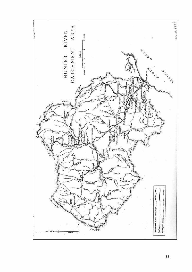
83