Hatherton Canal Restoration - Lichfield
43
Transcript of Hatherton Canal Restoration - Lichfield


Hatherton Canal Restoration
Supplementary Feasibility Report
February 2009 Notice This report was produced by Atkins Limited for the Lichfield and Hatherton Canals Restoration Trust Limited for the specific purpose of demonstrating the feasibility of restoring the Hatherton Canal to navigation. This report supplements a report prepared by Ove Arup & Partners Limited for British Waterways (acting as agents for the Lichfield and Hatherton Canals Restoration Trust Limited) and analyses an alternative route for the eastern section of the restoration that avoids the Cannock Extension Canal SAC site.
This report may not be used by any person other than Lichfield and Hatherton Canals Restoration Trust Limited without the express permission of Lichfield and Hatherton Canals Restoration Trust Limited. In any event, Atkins accepts no liability for any costs, liabilities or losses arising as a result of the use of or reliance upon the contents of this report by any person other than the Lichfield and Hatherton Canals Restoration Trust Limited.
Document History
JOB NUMBER: 5079324 DOCUMENT REF: Hatherton Final 20090211.doc
02 FINAL report JT RG/AC/JB RDE JT 11/02/09
01 FINAL DRAFT report JT - RDE JT 10/02/09
00 PRELIMINARY report JT - RDE JT 30/01/09
Revision Purpose Description Originated Checked Reviewed Authorised Date
5079324/Hatherton Final 20090211.doc

Feasibility Study Report
Contents Section Page Executive Summary 3
1. Introduction 5 1.1 The Lichfield and Hatherton Canals Restoration Trust 5 1.2 The Hatherton Canal Restoration Feasibility Report 5 1.3 Cannock Extension Canal SAC Site 5 1.4 The Trust’s Alternative Route 5 1.5 Scope of Work 6 1.6 Disclaimer 6 2. The Revised Alignment 7 2.1 Methodology 7 2.2 Route and Structures 9 2.3 Potential Mooring Sites and Mooring Basins 19 2.4 Costs 20 3. Environmental Considerations 21 3.1 Cannock Extension Canal SAC 21 3.2 Water Supply 24 3.3 Assessment of other Environmental Impacts 26 4. Conclusion and Recommendations 29 4.1 Conclusion 29 4.2 Recommendations 29 Appendices Appendix A 30 A.1 Scheme Drawings 30 Appendix B 38 B.1 Flood Risk Assessments 38 Appendix C 39 C.1 Cost Estimate 39
5079324/Hatherton Final 20090211.doc
2

Feasibility Study Report
Executive Summary A study into the feasibility of restoring the Hatherton Canal was undertaken by Ove Arup and Partners Limited between 2004 and 2006. The study was commissioned by British Waterways who were acting as agents for the Lichfield and Hatherton Canals Trust.
The eastern end of the route Arup recommended would connect to British Waterways existing network at Grove Basin on the Cannock Extension Canal. The Cannock Extension Canal is designated a Special Area of Conservation (SAC) because of an extensive colony of rare Floating Water Plaintain.
Whilst the Trust wishes to have the restoration proposal incorporated into the Local Development Frameworks of the local authorities, the Environment Agency has indicated that the proposal could have an adverse effect on the Floating Water Plantain. They would therefore recommend that a full Environmental Impact Assessment should be required as part of the planning process.
In order to avoid adverse effects on the SAC, the Trust therefore reviewed the proposed route and identified an alternative which would avoid the SAC site altogether.
The Lichfield and Hatherton Canals Restoration Trust Limited has commissioned Atkins to undertake a supplementary study of this alternative route.
The study has been completed, and the key findings of the exercise are:
• The proposed alternative alignment is not only feasible, but a ground modelling exercise has shown it to be preferable to the original proposed alignment as it avoids a long, deep cutting through potentially contaminated spoil in the vicinity of the abandoned Wyrley No. 3 Colliery;
• The only significant “pinch point” is in the vicinity of the proposed crossing of Gains Lane, where the canal must pass under Gains Lane and over the Wash Brook; this will require localised raising of the carriageway around the proposed bridge by about two metres;
• No other specific engineering difficulties are envisaged – the main structures will be:
- The road bridge crossing Gains Lane
- Refurbishment or possibly replacement of the existing bridge carrying Fishley Lane over the derelict Lord Hay Branch canal
- Seven new locks, four of which will require tail bridges suitable for farm traffic and/or public rights of way
- One fixed accommodation bridge giving access from a track off Gains Lane to the former Wyrley No. 3 Colliery tip
- One lifting bridge for farm access north of Wyrley No. 3 Colliery
- Two main culverts carrying Wash Brook under the canal
- A number of secondary culverts carrying minor tributaries and drainage channels under the canal
• The change to the Arup cost estimate (£48.7 million) is a net reduction of £4.6 million due largely to the alternative route bypassing a long deep cutting through potentially contaminated mining spoil near Wyrley No.3 Colliery, and the consequent reduction in tipping charges.
• The revised cost estimate for the restoration of the entire Hatherton Canal, using Arup’s route from Hatherton Junction to Chainage 7+600, and the revised route from there to Fishley Junction, is therefore £44.1 million.
5079324/Hatherton Final 20090211.doc
3

Feasibility Study Report
• Further and more detailed work could potentially identify areas where additional costs could be driven out, typically in terms of improving the “balance” of earthworks, which reduces the quantities of material to be imported or removed to off-site tip.
• Other than a small amount of additional silt disturbance which could be caused by a possible slight increase in the number of journeys made along the Cannock Extension Canal because of the potential of the restored Hatherton Canal to act as a trip generator, there will be no adverse effect on the water quality of the Cannock Extension Canal SAC site. Due to the potential for an impact on the SAC site an appropriate assessment screening under regulation 48 of the Conservation (Natural Habitats &c.) Regulations 1994 is recommended.
• Changes to the water supply requirements of the revised proposal are small in comparison to the available supply: there would however be small increases in the lockage water consumption caused by the increased drop in the deepest lock, and in evaporative losses, due to the increased length of the revised route which is 11.4 kilometres long, 1.2 kilometres longer than the Arup route.
• The adverse environmental impacts of the scheme could be mitigated with careful design and management, and it should be noted that canal restoration schemes typically bring many environmental improvements to offset any adverse impacts. The key potential adverse impacts and potential mitigation are listed below:
- Landscape impact – the vertical alignment is generally at or close to existing ground level, with only one cutting (200 metres long) and two embankments (200 and 400 metres long) which exceed 2 metres in height
- Trees – the alignment passes through areas of scrubby woodland by the Wyrley No. 3 Colliery tip and around Gains Lane, but loss of habitat could be mitigated by improving management and additional planting in neighbouring areas, together with planting mixed species hedgerows to form new boundaries
- Flood risk – much of the revised alignment lies in the flood plain of the Wash Brook, but careful sizing of new culverts and other measures including potentially compensating for the loss of flood plain would be used in more detailed design stages to ensure that there will be no adverse effect on flood risk
- Nature sites – the MAGIC web-based interactive mapping system indicates that there are no designated nature sites of any kind within 100 metres of the proposed revised canal alignment. Appropriate searches for legally protected and notable species which might be affected should be carried out prior to any construction works.
- Built Heritage – the only significant item of built heritage identified close to the revised alignment is a retaining wall where Gains Lane crosses the former tramway from the Wyrley No. 3 Colliery. The revised alignment has been designed to avoid the wall, and it is anticipated that the carriageway raising required for the Gains Lane crossing could be detailed to avoid changes to this wall.
It is recommended that the revised alignment shown in the drawing 5079324-051 to 5079324-056 should be adopted for the restoration, subject to detailed design. Restoration using this alignment would avoid almost all of the potential; adverse environmental impacts on the Cannock Extension Canal SAC site which were associated with the previous proposed alignment.
A number of secondary recommendations are made regarding further work to develop the initial design outlined in this report. These include undertaking a Stage 2 Flood Risk Assessment and conducting an appropriate assessment screening of the remaining potential impact on the SAC site.
5079324/Hatherton Final 20090211.doc
4

Feasibility Study Report
1. Introduction
1.1 The Lichfield and Hatherton Canals Restoration Trust The Lichfield and Hatherton Canals Restoration Trust aims “to restore the Lichfield Canal and the Hatherton Canal to reopen links between Staffordshire and the West Midlands, for the benefit of the environment, amenity and prosperity of the people of the region and to enchance the nation’s inland waterway system”.
The Trust has already taken significant strides towards this objective, most notably in raising sufficient funds to ensure that structures which would be required for the restoration of both canals were provided at the time of the construction of the M6 Toll motorway. In addition the Trust have purchased some of the land required for the restoration projects and have regular volunteer work teams on both canals which have been excavating infilled sections of the canals and restoring locks and other structures over the last fifteen years.
1.2 The Hatherton Canal Restoration Feasibility Report In 2004, the Trust took the decision to attempt to obtain planning protection for the line of the proposed canals through the proposed Local Development Framework. British Waterways, acting as agents for the Trust, commissioned Ove Arup and Partners to investigate in detail the feasibility of restoring the Hatherton Canal. This work was part financed by the European Union European Regional Development Fund. In 2006 Ove Arup completed the “Hatherton Canal Restoration Feasibility Report” describing how the Hatherton canal might be restored.
1.3 Cannock Extension Canal SAC Site Arup’s proposed eastern connection to the existing canal network would be at Grove Basin on the Cannock Extension Canal. The whole Cannock Extension Canal is an SAC site with a population of rare floating water plantain. The Environment Agency were concerned that the proposal could have an adverse impact on the floating water plantain and indicated that they would recommend that a full Environmental Impact Assessment should be required as part of the planning process. Any such assessment would have to prove that there would be no adverse impact on the floating water plantain before the Local Authority could give planning permission for any part of the canal.
This has proved to be a stumbling block which could prevent the incorporation of the canal restoration scheme in the Local Development Framework which is currently being agreed.
1.4 The Trust’s Alternative Route The Trust considered that it is unlikely that it could be proved that the Arup scheme would not adversely impact the SAC site and have therefore investigated alternative connection points and revisions to the proposed route for the restored canal that would not affect the SAC site.
The Trust, working closely with Little Wyrley Estates and other landowners, developed a route departing from the Arup route at their chainage 7+600 (about half a kilometre south of the northbound toll booth complex on the M6 (Toll) road, adjacent to the A5 between Churchbridge and Norton Canes). From this point, the route follows the valley of the Wash Brook for around 2.6 kilometres, and then climbs across fields for 900 metres to join the line of the former Lord Hay Branch off the Wyrley and Essington Canal. The remaining 300 metres of the revised route would follow the disused branch to a junction with the Wyrley and Essington Canal immediately west of Fishley Footbridge.
5079324/Hatherton Final 20090211.doc
5

Feasibility Study Report
1.5 Scope of Work The scope of the work described in this report was to comment and provide additional detail on the feasibility of the Trust’s proposed alternative alignment, and to comment as to costs, the likely effect of restoring navigation on water quality in the Cannock Extension Canal SAC site, any material changes to the water supply requirements for the revised proposal, and to address any environmental impacts arising from the revised route which are not already covered in the Arup report.
The work has been undertaken to enable the Trust to respond to the local authorities’ request for further information to complete the Local Development Framework response pro-forma.
1.6 Disclaimer The scope of works is specifically limited to producing a supplementary report covering the alternative route only. There has been no review or validation of the contents or conclusions of the Arup study, and, where the Arup study has been commented on this should not be taken to imply any acceptance or not by Atkins of work undertaken by Ove Arup and Partners Limited. Atkins Limited will only be liable for work it has undertaken, and not for any information used which has been obtained from the Arup report.
5079324/Hatherton Final 20090211.doc
6
Feasibility Study Report
2. The Revised Alignment This section describes the methodology used to identify the revised alignment, details the route and structures and discusses potential mooring sites and basins.
2.1 Methodology 2.1.1 Information supplied by the Trust
In addition to digital and paper copies of the Arup report, the Trust provided a map and aerial photograph montage, showing the approximate route they had identified for the canal. An indicative longitudinal section based on contours and spot heights shown on the Ordnance Survey 1:25,000 scale mapping was also provided. In response to our queries, the Trust confirmed that the towpath should be located on the west side of the canal throughout, and that the desired channel section would be Type 2 as shown on Arup drawing C-36-019 Issue 03.
2.1.2 Other Information Used
Ordnance Survey MasterMap 1:2,500 mapping and NextMap 5m Digital Terrain Model data was purchased for an area generally about 250m either side of the proposed alignment.
2.1.3 Design Criteria
The alignment was drawn using the following design criteria which were derived from those agreed between Arup and British Waterways:
• Minimum curve radius 60 metres (Arup / BW had agreed this could be 40m with channel widening, but the section of canal considered here was more rural without the physical constraints which dictated such sharp curve radii)
• 9m navigable canal width with at least a 7.2m wide section at 1.5m deep;
• 3m wide towpath;
• Embankment and cutting batters with maximum slope 1 in 2;
• Headroom (above water level): ideally 2.5 metres, absolute minimum 2.1 metres
• Construction depth of road bridges 0.6 metres from soffit to carriageway level (Arup / BW used 1m, but generally the crossings under consideration were of more heavily used roads with wider spans)
2.1.4 Methodology
PDS ground modelling software was used to produce contours from the Digital Terrain Model, and the approximate alignment, contours and mapping information were overlaid and plotted. This plot was used to inform a site visit and photographic survey undertaken in January 2009. The alternative route under study starts at Arup chainage 7+600 and extends to chainage 11+400 approximately. It was not possible to access the proposed alignment between the following chainages, without trespassing on private land:
• 8+100 and 8+650;
• 8+700 and 8+950;
• 10+450 and 10+750
Notes were made on the composite drawing and were then used for the next stage.
5079324/Hatherton Final 20090211.doc
7

Feasibility Study Report
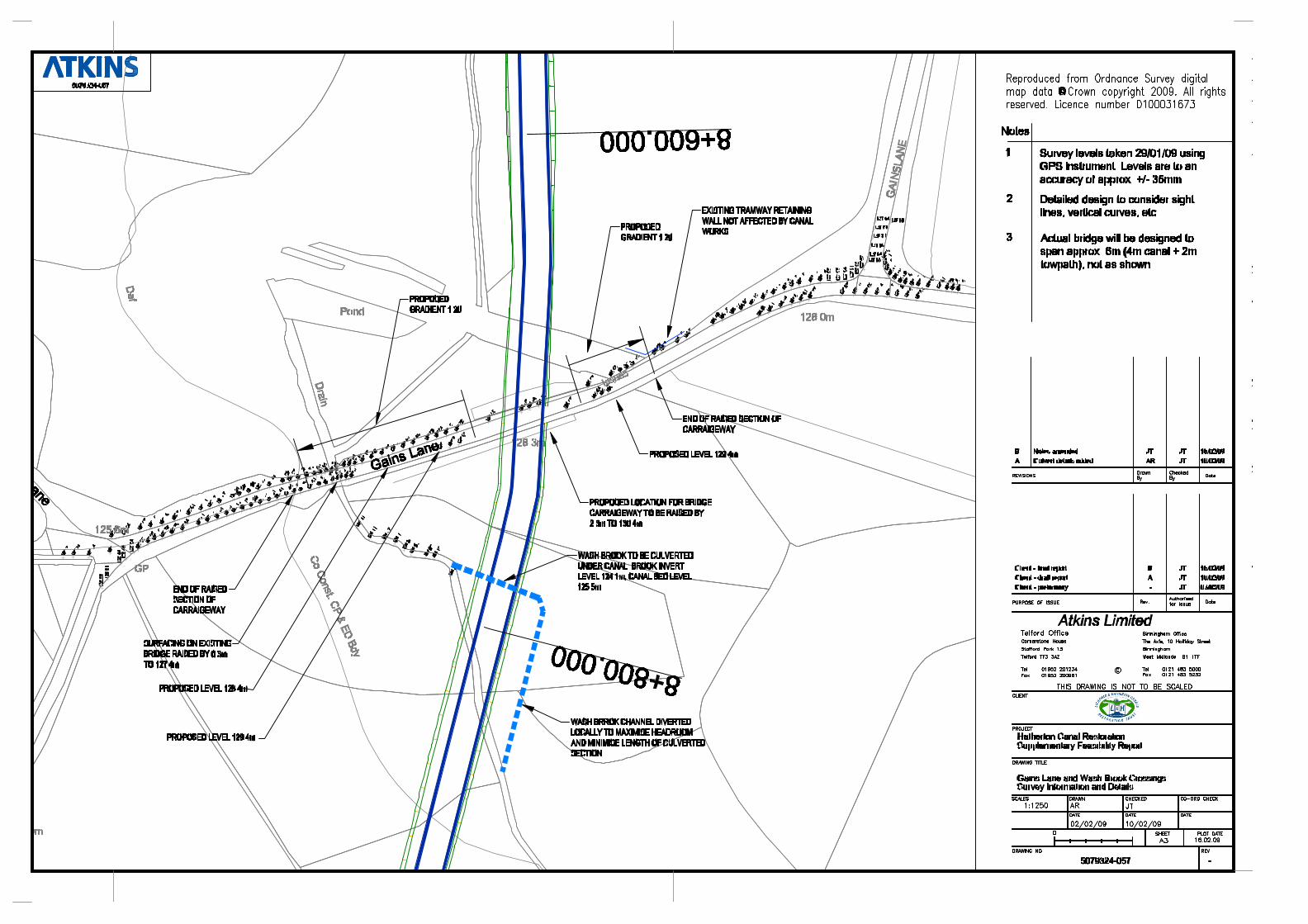
The lock positions proposed by the Trust on their longitudinal section were reviewed in the light of the much more accurate contour information from the digital terrain model and amended where necessary. The principal area of uncertainty was the Gains Lane Crossing, where it was clear that the canal would have to pass under the road and over the Wash Brook in a relatively short distance.
A limited survey of road and stream levels was therefore carried out in this area – the surveyed levels are shown on drawing number 5079324-057. These levels were then used to verify that the proposed canal pound level was suitable.
2.1.5 Locks
Lock “drops” (Arup refer to “depth”, but this can be misleading) on our alignment are generally around 2.8m, with the exception of Colliery Lock (the top lock on the canal) which has been given a slightly greater drop at 3.0m to ensure adequate lockage water is taken into the flight as boats descend, and Gains Lock, which has a drop of 1.8m to set the optimum water level for the upstream pound which includes the Gains Lane Crossing site mentioned above.
2.1.6 Rights of Way and Farm Accesses
Public rights of way and existing farm access routes have been taken into account where these are either visible on the ground or shown on mapping. In a few locations, short diversions of rights of way or accesses have been devised to avoid the necessity of expensive structures.
Overhead services were noted on the site visit and have been taken into account. Underground services are beyond the scope of the current work – it is thought unlikely that many such services exist, except in Gains Lane, and where short sections of low or medium voltage overhead electric cables are undergrounded between poles to pass under National Grid cables.
2.1.7 Maintenance Access
In the context of what is essentially a completely new canal, maintenance access should be considered at design stage. Whilst the minimum standard agreed for the towpath width is 3m, as stated above, there should be at least one access to each lock where the towpath is capable of bearing the loads imposed by maintenance plant. The ability to use small (e.g. 5 tonne) crawler cranes for lock maintenance at many locks on the Shropshire Union Canal has transformed the time taken to repair or replace lock gates etc., since such access was provided. It is therefore suggested that a 4 metre wide towpath, together with suitably designed bank protection, should be provided between the following points:
• chainage 7+520 to chainage 7+840: Holford Lock (see Arup report), and Gains Lock to Norton Hall Farm access
• chainage 8+920 to chainage 9+770: Public footpath (access agreement to track across field edge to be sought with farmer during land purchase) to Dark Lane, Pylon and Cadman’s Locks
• chainage 10+950 to chainage 11+200: Colliery Lock to Fishley Lane Bridge
See section 2.2 for details of the proposed lock locations.
In addition it may be prudent to upgrade the surface of Cadman’s Lane during the construction phase and construct short permanent maintenance links along the offside of the canal to Wash Brook Lock (link approximately 30 metres long) and Golfers’ Lock (link approximately 110 metres long).
5079324/Hatherton Final 20090211.doc
8

Feasibility Study Report
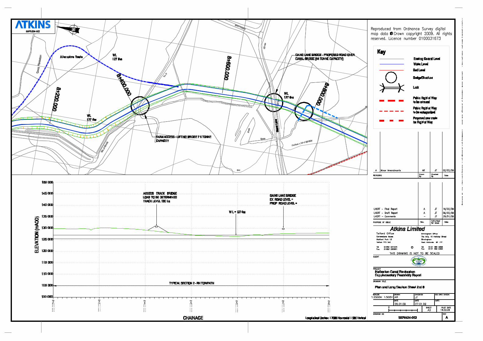
2.2 Route and Structures Plans and longitudinal sections (with chainages) are shown on drawings 5075324-051 to 056. The following paragraphs give details of the route of the canal and the structures required. These paragraphs replace paragraphs 3.25 to 3.29 of the Arup report.
2.2.1 A5 (Watling Street) to Gains Lane
Commencing at the south end of the A5 crossing described in paragraph 3.24 of the Arup report, the proposed alignment (Arup) continues generally south across open fields to a lock proposed by Arup (Holford Lock) at chainage 7+520. This lock is also required for the alternative route under consideration here.
View from north east towards proposed location for lock (in front of hedge / tree line)
80 metres south of the proposed Holford Lock, at chainage 7+600, is the north end of the proposed alternative alignment considered in this report. The canal would continue to follow the edge of the field for a further 80m to chainage 7+680, where a lock (Gains Lock) would raise the water level to 127.0m AOD. A further 50 to 60 metres of straight alignment along the edge of the field has been shown to give adequate space for lock landing moorings. A curve of around 60m radius brings the canal to an east-west orientation and a proposed crossing of the farm track which runs east and north from the Wyrley No. 3 Colliery towards the Wash Brook. The crossing will be located at chainage 7+840.
The canal will cross the track in the foreground of the picture at approximately ground level
5079324/Hatherton Final 20090211.doc
9

Feasibility Study Report
As farm traffic is infrequent, this crossing would be achieved using a lifting bridge. The canal is close to existing ground level in this area so approach embankments for a fixed bridge would be significant intrusions into the landscape and require expensive earthworks. The lift bridge could be of a similar design to the bridge installed by the Trust at Darnford on the Lichfield Canal.
A small culvert may be required about 30m east of the bridge to take land drainage north under the canal from a small valley located behind the midden on the photograph above. Downstream levels are significantly lower than the proposed canal alignment, so local reprofiling should be the most that would be required on the south (upstream) side of this crossing to allow a straight through culvert to be used and avoid an inverted siphon.
Line of small culvert (blue line) and canal (red dots) east of midden and around spoil tip
From this culvert, the canal would contour around the north and east sides of one of the northernmost spoil tip associated with the former Wyrley No. 3 Colliery. The Arup route would have run to the west of this tip. Canal levels have been kept close to the existing ground level through this section to avoid excessive excavation of what may well be contaminated spoil.
At chainage 8+070, the canal would cross the Wash Brook and continue through a short wooded area to reach open fields at chainage 8+210. The Wash Brook culvert will have to be the subject of more detailed work to establish the relative levels of the stream and canal, to model the catchment upstream and size the culvert suitably. It is assumed that a precast concrete culvert of 3m wide and 1.2m high would be suitable, based on the existing culverts further downstream, notably at the upstream end of the pond around 200m north east of the proposed culvert location.
The bottom of the spoil tip, looking along proposed canal alignment, just west of the proposed Wash Brook Culvert
5079324/Hatherton Final 20090211.doc
10

Feasibility Study Report
Wash Brook, just downstream of the proposed culvert. Flow direction is from right (south) to left
(north) in this picture
The canal alignment then runs along the western boundary of two fields to reach the Gains Lane area. The first field (from chainage 8+200 to chainage 8+420) is crossed in a cutting up to 3 metres deep. This cutting is necessary to follow the Trust’s initial alignment (understood to be based on discussions with the land owners). This is the only major cutting on the revised route. Locks further towards the Wyrley and Essington Canal have been located so as to necessitate some embanked sections to achieve an approximate earthworks balance by using spoil from this cutting. An alternative route to the east would avoid the need for the cutting, but would involve purchasing several additional small parcels of land.
At chainage 8+410 an access track crosses the proposed alignment of the canal. This track links Gains Lane and an elevated area to the west, thought to be a tip associated with the Wyrley No. 3 Colliery. A fixed overbridge will have to be provided, but because the area it will serve is raised relative to the canal alignment, an approach embankment will only be required on the Gains Lane side of the bridge. Given the nature of this traffic, the approach embankment could be quite short and relatively steeply graded (around 40 metres long, at a gradient of about 1:12). The structure itself could be a simple box-culvert based precast concrete construction, finished and faced with brick if required, and similar to the recently completed Cappers Bridge on the Lichfield Canal.
From the bridge, the canal continues along the west side of a second field, level with or slightly above the ground level, to reach the proposed Gains Lane Crossing. This field has easy access from Gains Lane and is generally a little below the level of the proposed canal, and would make an excellent mooring basin (see section 2.3.2 below).
Culvert units already owned by the Trust (purchased with ERDF funding) and suitable for the bridge at chainage 8+410)
5079324/Hatherton Final 20090211.doc
11
Feasibility Study Report
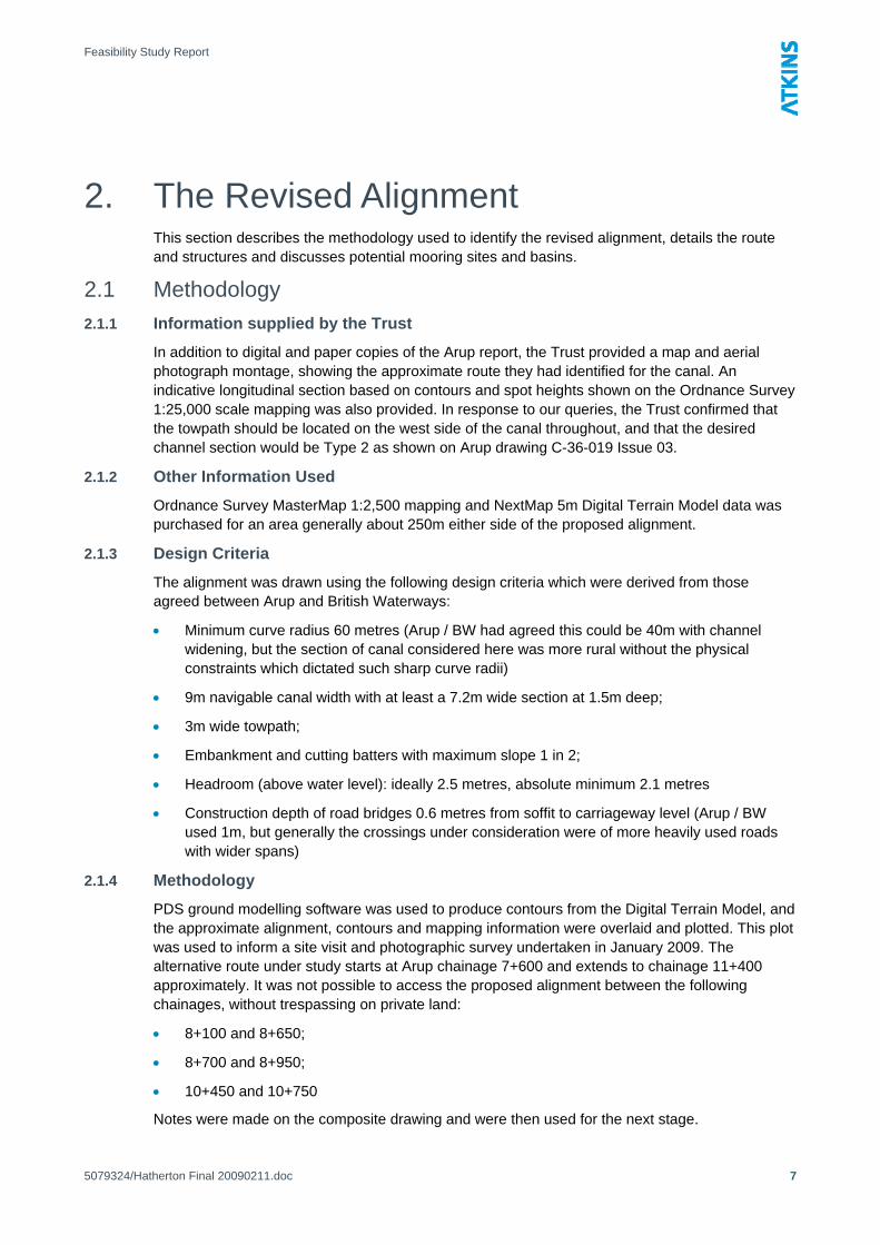
The field north of the Gains Lane crossing, seem from the track linking Gains Lane and the mining tip. Canal
alignment is shown dotted red.
2.2.2 Gains Lane and Wash Brook Crossings
At the south edge of this field (chainage 8+670), the proposed canal would cross the line of a former tramway. The tramway used to link the Wyrley Colliery and the Cannock Extension Canal. There is not much trace of the tramway left at this location, although a short section of retaining wall survives a little to the east where the tramway used to pass under Gains Lane. (NB: the alignment proposed by Arup ran along the course of the disused tramway).
A further 30 metres to the south (chainage 8+700) the proposed line of the canal passes under Gains Lane. This is a busy minor road. An initial limited levelling exercise (see drawing 5079324-057) has established that the carriageway level at this point is around 128.1m AOD. The proposed canal water level is 127.0m AOD. The carriageway would therefore have to be raised. Raising the carriageway to 130.4m AOD would give a 2.4 metre headroom above water level (sufficient for boaters standing on the counter of their narrowboats to pass under the bridge without ducking), and 2.1 metre headroom above the towpath.
Arup’s proposed crossing was around 30 metres to the east (closer to the nearest carriageway pinch point at the junction of Gains Lane and Gorsey Lane). Their proposed solution was similar.
The canal would continue southwards through scrubby waste ground to reach the Wash Brook at about chainage 8+800. The canal bed level will be 125.5m AOD with a pound level of 127m AOD, and, allowing 300mm for a sand blanket and waterproofing layer at the bed, the top surface of the proposed box culvert would be at 125.2m AOD, giving a soffit level of say 124.9m AOD. The river bed level immediately downstream of the proposed culvert is around 124.2m AOD. Surveying upstream of the proposed crossing was not possible at the time of the survey due to flows and safety considerations. The drawing shows a realigned channel over about 60m upstream of the proposed culvert, and it is anticipated that regrading to steepen this relative to the section it replaces, together with some deepening between the proposed culvert and the existing road bridge should be sufficient to give a culvert height of around 1 metre. The width would be sized using a model of the flood hydrology of the upstream catchment.
5079324/Hatherton Final 20090211.doc
12

Feasibility Study Report
The scrubby marsh land around the proposed Wash Brook crossing. The canal alignment is shown
by the red dots, the brook by blue dashed line.
A more detailed study of the optimum configuration of pound level(s), and structures to achieve the crossing of Gains Lane and Wash Brook in this section is recommended, but it is Atkins considered view that the crossing of both is feasibile on the alignment proposed, and that the option selected is likely to be representative of the costs of the finalised solution.
2.2.3 Wash Brook Crossing to Golf Course
From the Wash Brook Crossing at chainage 8+800, the canal runs across the scrubby marsh land shown in the photograph above for about 130m, before crossing into a large field at Chainage 8+970. At this point the canal crosses the line of a public footpath which links Gains Lane and Cadman’s Lane. It is proposed that this right of way be amended to run along the canal towpath between here and chainage 9+250. This would eliminate the requirement for a footbridge, and improve the quality of the right of way.
The proposed alignment leaves the field at approximately chainage 9+110, passing over a drainage ditch and a narrow strip of waste ground to reach and pass across Cadman’s Lane at chainage 9+170. There is an existing culvert for farm access between the field and the waste ground, but this is on the proposed line of the canal and would have to be replaced. This could be achieved by laying a single culvert around 28 metres long which would pass under the canal and a new farm access. Localised regrading of this ditch course may be required, steepening the upstream approach to give sufficient depth under the canal to avoid the use of an inverted siphon.
Proposed alignment runs along the edge of the field to the trees in the distance at chainage 9+110
5079324/Hatherton Final 20090211.doc
13

Feasibility Study Report
The existing culvert at chainage 9+110
Cadman’s Lane is a public footpath and would be severed by the canal crossing. The public footpath would be diverted away from the lane along the offside (east) of the canal for about 95 metres, to cross the canal and re-join Cadman’s Lane on the tail bridge of the next lock.
Cadman’s Lane looking south east from chainage 9+180
From chainage 9+180 to 10+050, the proposed canal alignment is parallel to Cadman’s Lane in open fields. For most of this section a low or medium voltage three phase electrical supply runs on poles parallel to Cadman’s Lane. This could either be retained in a reservation between Cadman’s Lane and the canal, or undergrounded. A short section already runs underground where a high voltage main runs across the line of the canal, supported on a pylon which would be around 25 metres from the eponymous Pylon Lock. Whilst some safety measures may be required during the building of the canal for access, the lock has been sited far enough away from the pylon and cables to enable normal construction plant to be used.
5079324/Hatherton Final 20090211.doc
14

Feasibility Study Report
Looking south east along the proposed alignment (shown with red dots) towards the electricity Pylon.
The alignment rises with three locks (Dark Lane, Pylon, and Cadman’s) from a water level of 127.0m AOD at chainage 9+180 to a water level of 135.4m AOD above Cadman’s Lock beyond chainage 9+770. Each lock would have a 2.8m rise, making the locks slightly deeper than the average depth for the system, but they would not require any exceptional engineering solutions.
At chainage 9+750, a farm access and a ditch course cross Cadman’s Lane. This location has therefore been selected as the location for one of the proposed locks (Cadman’s), as the access could be accommodated by construction of a bridge across the tail of the lock, and the ditch course could be diverted to a culvert under the top end of the lock. There appears to be adequate fall on the ditch course to accommodate this diversion, but the culvert and new sections of ditch would have to be sized by modelling the upstream catchment.
The farm access which crosses Cadman’s Lane. The photograph is taken standing approximately where the
tail bridge over Cadman’s Lock will be located.
The proposed canal alignment continues from Cadman’s Lock, initially on a short embankment, for 300 metres to chainage 10+040 where it re-crosses Cadman’s Lane. This would sever the right of way along Cadman’s Lane, so a diversion is proposed between here and chainage 10+220, with the right of way relocated onto the canal towpath. This has the benefit of avoiding a section of Cadman’s Lane where the Wash Brook has been diverted into the sunken lane for about 120 metres. This section was impassable on foot on the date of our site visit (January 2009).
5079324/Hatherton Final 20090211.doc
15

Feasibility Study Report
Looking upstream along the section of Cadman’s Lane which forms the Wash Brook channel from chainage
10+110 (the canal alignment is in the field to the right)
At chainage 10+220, a further lock, “Wash Brook Lock”, would raise the canal level from 135.4m AOD to 138.2m AOD, again a 2.8m rise. This lock would have a tail bridge which would be used to complete the diversion of the right of way by returning it to Cadman’s Lane, just beyond the section occupied by the Wash Brook.
View from chainage 10+120, on the line, looking south towards the site for Wash Brook Lock (circled)
The canal over this section is generally embanked by an average of 2.5 metres but a maximum of 5 metres above the surrounding ground. The embankment would be the main receptor for material excavated from the cutting between chainage 8+200 and 8+420. During construction a good haul route would have to be established between these locations. If the cutting were avoided using the alternative route discussed above, then some thought would have to be given to a different location for Cadman’s and Wash Brook Locks, or to the economics of importing fill for this embankment.
The alignment continues along the west side of Cadman’s Lane, with the embankment gradually decreasing in height as the surrounding ground rises to reach the point at which the proposed alignment leaves the Cadman’s Lane “corridor” at about chainage 10+430.
5079324/Hatherton Final 20090211.doc 16

Feasibility Study Report
Looking south east from chainage 10+390. The proposed alignment leaves Cadman’s Lane corridor at the angle
in the hedgeline (left background), and then climbs along the hedge in the background past the site of
the proposed Wash Brook Lock
2.2.4 Golf Course to Fishley Junction
At chainage 10+430, the proposed canal alignment makes a sharp turn towards the south and follows the boundary between a large field and the pitch and putt area of Fishley Park Golf Range. 50 metres beyond the turn (far enough to provide a lock landing area and good visibility) is the proposed location for another 2.8m rise lock, “Golfers’ Lock”. This raises the water level from 138.2m AOD to 141.0m AOD.
Above this the canal continues to follow the boundary, inside the field, to reach a public footpath which links Fishley Lane and Hobble End Farm (on the outskirts of Great Wyrley).
Looking downhill from the public footpath towards the proposed site for Golfers’ Lock (proposed site
circled and canal line dotted)
At this point a final lock will be required to raise the level of the proposed canal to the 144.0m AOD level of the Wyrley and Essington Canal. The public footpath will be carried over a lock tail bridge on approximately its existing route. A wooded area to the east of the lock contains shafts associated with the former Fishley Colliery, and this is referenced in the proposed name for this lock – “Colliery Lock”.
5079324/Hatherton Final 20090211.doc 17

Feasibility Study Report
Above the lock the proposed alignment curves east on a slight embankment across an open field to join the derelict Lord Hay Branch Canal about 100 metres north west of Fishley Lane Bridge (also known as Fishley No.1 Bridge).
According to the definitive guide to the abandoned canals of the area1, the canal was abandoned in 1954 and the canal infilled between Fishley Junction on the Wyrley and Essington Canal and Fishley Lane Bridge, but there was (in 1981) evidence of some water on the section west of Fishley Lane Bridge. This western section could not be accessed during Atkins site survey as it is on private land.
Fishley Lane Bridge is still extant, although infilled on the south side of the road. The existing bridge appears to be largely unaltered since abandonment of the canal, and it may be possible to refurbish it and bring it back into use. The towpath, if present, would appear to have been very narrow under the bridge. Sufficient land should however be procured to permit construction of a ramp from Fishley Lane to give vehicular access to the canal towpath on the north side of the road for maintenance. With a suitable gate / barrier, this would also permit users who require a wider towpath or better headroom to bypass the towpath under the bridge, as British Waterways have constructed a similar ramped access to the south of the bridge.
The last 150 metres of the proposed alignment would follow the north side of the embankment of the former Lord Hay Branch, sharing the embankment crest with BW’s existing access track (on the south half of the crest), which would be upgraded to the same standard as the rest of the towpath.
Looking north to Fishley Lane (beyond gates) from the British Waterways access road parallel to the proposed alignment which would be on the right
1 “The Other Sixty Miles”, Richard Chester-Browne, BCN Society 1981 and 1991 5079324/Hatherton Final 20090211.doc
18

Feasibility Study Report
View of the start of the Lord Hay Branch from the roving bridge at Fishley Junction (proposed alignment
shown by red dots)
At Fishley Junction, the towpath of the Wyrley and Essington canal is on the east (far) side of the canal, but the roving bridge at the junction survives in British Waterways ownership.
Fishley Junction from the roving bridge – the first five metres or so are retained as a winding hole
2.3 Potential Mooring Sites and Mooring Basins The potential mooring sites identified along the line of the revised alignment are discussed below. None of the mooring sites are included in the costings for the scheme – it is envisaged that these would be commercially viable sites in their own right and could be developed at a good rate of return on private investment. Normal practise is for the navigation authority to derive revenue for such sites by charging a “connection fee”.
It is noted that the provision of additional moorings at the site at Grove Colliery as discussed in section 3.30 of Arup report would not form part of the proposals if the proposed alternative route is adopted.
2.3.1 Above Holford Lock
Linear or diagonal moorings (a similar arrangement to echelon parking) could be developed along the off (east) side of the canal in land belonging to the Holford Group at Norton Hall farm. These would be accessible via existing farm tracks and the accommodation bridge proposed by Arup.
5079324/Hatherton Final 20090211.doc
19

Feasibility Study Report
2.3.2 North of Gains Lane
The 'hexagonal' field on the north side of the Gains Lane and the off (east) side of the canal would make an excellent mooring basin site. This site is on land belonging to Little Wyrley Estate. There is good vehicular access from Gains Lane which could be improved easily to the required standard. The field is generally at or below the level of the canal, so the earthworks required to dig out and line the basin would be practicable. As the basin would be situated on the off side of the canal, a towpath bridge would not have to be provided. Given the relative simplicity of developing this site for an off-line mooring basin, it is thought that the investment could well be justified in terms of financial returns, despite the relatively small area (around 2 hectares, suitable for up to around 120 boats).
2.3.3 Above Colliery Lock
Off-line moorings could also be developed in the field west side of the proposed Colliery Lock north of the section of the Lord Hay branch which will not be restored. This is the property of Yieldfields Farm. The site is on the towpath side of the canal, so a footbridge (which could be a lifting structure) would have to be provided to take the towpath over the entrance to the basin. There is currently no road access to the field, however this difficulty is also not thought to be insuperable. The site is approximately 1.5 metres below the level of the canal, which would be almost ideal, with the forming of the basin being not much more complicated than digging out topsoil and replacing it with a liner. The area of the site is around 2.8 hectares, and it would be suitable for up to 150 boats.
2.4 Costs The costings included in the Arup report (their Appendix D) have been revisited and revised to reflect the change in the proposed route. The basis for the Arup’s costings has not been reviewed (Arup’s taking-off calculations and rates assumptions were not available), and the rates have not been updated, so the relative costs must be regarded as a like-for-like comparison of costs based on 2005 first quarter prices.
The revised costings for earthworks have been prepared by recalculating the quantities quoted in the Arup report, making a deduction to reflect the section of the Arup route which would not be constructed (from Chainage 7+600 to 10+210) and then adding the estimated quantities for the revised route (from Chainage 7+600 to 11+370). Where the revised quantities were not immediately apparent, the earthworks quantities were increased in line with the additional length (i.e. it was assumed that quantities per 100m of canal would be similar to those calculated by Arup for the original route).
The main change in the earthworks costs is a reduction in cost due largely to the alternative route bypassing a long deep cutting through potentially contaminated mining spoil near Wyrley No.3 Colliery, and the consequent reduction in tipping charges.
A similar approach has been taken to evaluate the effect of using the alternative route in terms of the costs of the structures. The method used is evident from the breakdown attached as Appendix C.
5079324/Hatherton Final 20090211.doc
20

Feasibility Study Report
3. Environmental Considerations 3.1 Cannock Extension Canal SAC
The brief requires specific comment as to the effect of the revised proposals on water quality in the Cannock Extension Canal SAC site. This is important in respect of the colony of floating water plantain which is a European Protected Species and is protected within the SAC.
3.1.1 Floating Water Plantain and Potentially Adverse Population Factors
The Joint Nature Conservation Committee (JNCC) website2 identifies the Cannock Extension Canal SAC site as: “an example of anthropogenic, lowland habitat supporting floating water-plantain Luronium natans at the eastern limit of the plant’s natural distribution in England. A very large population of the species occurs in the Canal, which has a diverse aquatic flora and rich dragonfly fauna, indicative of good water quality. The low volume of boat traffic on this terminal branch of the Wyrley and Essington Canal has allowed open-water plants, including floating water-plantain, to flourish, while depressing the growth of emergents.” The JNCC listing suggests a link between low boat traffic and good water quality, and elsewhere the site suggests that floating water plantain’s “habitat in rivers has been greatly reduced by channel-straightening, dredging and pollution, especially in lowland situations”, all of which point to silt load and bed disturbance as factors which could have an adverse effect on the population.
3.1.2 Description of the SAC
The Cannock Extension Canal is a quiet, dead-end backwater about a mile long. The canal makes a junction with the Wyrley and Essington Canal about a mile east of the east end of the revised alignment proposed for the Hatherton Canal. There is no significant flow of water within the Cannock Extension Canal.
The main uses beyond the SAC designation are for residential moorings and winter moorings. There are two boat yards, both of which specialise in building and repairing boats. Few boat services are provided – there is an Elsan disposal point, but no pump out facilities.
3.1.3 Arup’s Proposals in relation to the SAC
The eastern junction of Arup’s proposed alignment for the Hatherton Canal joined the Cannock Extension Canal at Grove Basin. Whilst Arup made no specific comments as to the effect of this on water quality, it is clear that the effect of this would be to increase dramatically the number of boat movements on the southern section of the Cannock Extension Canal, between the restored Hatherton Canal and the Wyrley and Essington Canal.
3.1.4 Possible Requirement for Environmental Impact Assessment
The Environment Agency had raised concerns about the effect of this increase in traffic on the floating water plantain colony, and indicated that they would recommend that a full Environmental Impact Assessment (EIA) should be performed for any planning application for the restoration. The EIA would then have to demonstrate that there was no adverse environmental impact on the floating water plantain colony. It is unlikely that this could have been proved.
There is also a likely requirement for an Appropriate Assessment under Regulation 48 of the Conservation (Natural Habitats &c.) Regulations 1994. This regulation restricts the granting of planning permission for development which is likely to significantly affect a European site by
2 A short link has been created to the appropriate web page: http://tinyurl.com/dcb89f 5079324/Hatherton Final 20090211.doc
21

Feasibility Study Report
requiring that an appropriate assessment is first carried out of the implications of the development for the site’s conservation objectives.
3.1.5 Causes of Adverse Impacts
There would appear to be four potential causes of increased silt load and bed disturbance which could have an adverse impact on the SAC site: increases in flow rates, mixing of water, dredging, and increased boat traffic.
Increased Flow Rates
Increased flow rates would increase velocities in the canal, particularly in the vicinity of bridge holes and other narrows. This could have the effect of lifting fine silt into suspension and re-depositing it in slower moving waters.
The Arup proposal would result in significant increases in flow rates with water being drawn from the Wyrley and Essington Canal into the Cannock Extension Canal to feed the Hatherton Canal as it descends from the Wolverhampton level towards Churchbridge.
The revised alignment would not require any changes to the existing flow regime in the SAC site, and thus would not cause adverse impacts through this mechanism.
Mixing
Increased mixing of water between the Wyrley and Essington Canal and the Cannock Extension Canal at their junction has clear potential to cause a localised deterioration in water quality around the junction area.
The combination of additional boat traffic and the inflow into the Cannock Extension Canal required to provide feed water for a restored Hatherton Canal on the route proposed in the Arup report could result in a substantial increase in the mixing effect at the junction of the two canals, and along the SAC site as far as the proposed junction for the Hatherton Canal at Grove Basin.
The revised alignment for the Hatherton Canal is remote from the SAC. It is recognised that there would be additional boat traffic along the Wyrley and Essington Canal across the entrance to the Cannock Extension Canal, but there would be very limited mixing of water between the Wyrley and Essington and Cannock Extension canals, and this effect would be highly localised, so the overall effect of this on water quality within the SAC site would be extremely limited.
Dredging
Dredging of the canal bed (to remove obstructions or increase the navigable depth of the canal) would be a significant cause of bed disturbance and short term but large increases in suspended silt loading the canal.
Dredging of the Cannock Extension Canal is not discussed in the Arup report. It is, however, possible that at least spot dredging within the SAC would be required were the Hatherton Canal (a through route) to follow the Arup alignment onto the Cannock Extension Canal. This requirement could arise because of the nature of the boat traffic, with the majority of boaters using the Hatherton Canal (a through route on a cruising ring) lacking the local knowledge of how to deal with underwater obstructions in the channel.
No dredging of existing canals would be required for the revised Hatherton Canal alignment, which connects to the busier Wyrley and Essington canal.
Additional Boat Traffic
The passage of modern canal boats with small, fast revving propellers, can lift silt from the bed of the canal into suspension. An indicator of this is the much clearer condition of the water in many
5079324/Hatherton Final 20090211.doc
22

Feasibility Study Report
canals during the winter period, when fewer boats are moving.3 Additional boat traffic within the SAC could therefore increase bed disturbance and increase the silt load.
The estimate of the number of journeys adopted by Arup’s report for the purposes of their estimate of water supply requirements (section 8.5) was 3,382. This would broadly equate to the number of extra journeys within the SAC site for their proposal.
The revised proposal would only generate minimal extra (over and above current traffic) journeys within the SAC by two mechanisms:
• any boaters with boats moored on the Cannock Extension Canal who chose to make additional trips as a result of the additional cruising opportunities provided by the restored Hatherton Canal (but note that residential moorers do not tend to move their boats very often, and that winter mooring users generally make one journey onto the mooring in autumn and another off it in spring);
• any boaters cruising on the restored Hatherton Canal from elsewhere within the system who chose to navigate the Cannock Extension Canal as well whilst they were in the area, and who would not have done so if the restored Hatherton Canal had not been present
In both cases the numbers are expected to be very small, particularly when compared to the journey numbers for the route proposed in the Arup report. It is, however, recognised that there is potential for adverse impacts via this mechanism, and this should be considered in the Appropriate Assessment.
3.1.6 Possible Mitigation Measures
The only area in which the revised alignment could impact on the SAC site is therefore by generating a small increase in the number of trips made along the Cannock Extension Canal. In order to mitigate this possible impact, the following measures could be investigated as part of the Appropriate Assessment and, if required, instigated as part of the restoration of the Hatherton Canal:
• Publicity for the Hatherton Canal could promote a positive message discouraging waterborne visits to the SAC site due to the sensitive nature of the protected colony of floating water plantain;
• Provision and promotion of additional visitor moorings close to, but not within the SAC site should encourage those interested to leave their boats on the Wyrley and Essington Canal and explore the Cannock Extension Canal on foot4;
• Promotion of the Cannock Extension Canal as a walking route / circular tour from Pelsall Junction;
• Removal of any short term moorings within the SAC site5;
• Discouraging journeys onto the SAC site by making winding (turning boats) at the limit of navigation on the Cannock Extension Canal only available to long term moorers, possibly by providing a locked “gate” at the winding point
3 There are other contributory factors to the water being clearer in the winter months in addition to lower levels of boat traffic, but the effect is more significant in canals than in similar, un-navigable bodies of relatively still water. 4 Changes to mooring provision on the Wyrley and Essington Canal would have to be made by the navigation authority, British Waterways, rather than by the Trust, or the promoters of the restoration of the Hatherton Canal. 5 Changes to the management of the Cannock Extension Canal would have to be made by the navigation authority, British Waterways, rather than by the Trust, or the promoters of the restoration of the Hatherton Canal. 5079324/Hatherton Final 20090211.doc
23

Feasibility Study Report
Publicity for the Hatherton Canal could promote a positive message for boatyard users but discourage casual waterborne visits to the SAC site due to the sensitive nature of the protected colony of floating water plantain, possibly promoting alternative moorings nearby and a walking tour. This might indeed have a spill-over positive effect in actually reducing the number of boat trips made into the SAC despite the additional journey opportunities a restored Hatherton Canal would offer. Taking this line of reasoning further it could even be argued that the restored Hatherton Canal would be a much more attractive alternative cruising opportunity than the Cannock Extension Canal and would, just by its existence, reduce boat journeys into the SAC site.
3.2 Water Supply The supply of water required for the upper reaches of the restored canal would, regardless of the alignment selected, be drawn primarily from the large pound, often referred to as the Wolverhampton Level, of which the Wyrley and Essington Canal forms a part. The discussion of the existing canal system, main surface water drainage, groundwater features and existing water supplies in sections 8.1 to 8.4 of the Arup report is valid for both the route proposed in the Arup report and for the revised proposed alignment.
3.2.1 Water Requirements – Canal Capacity
The revised alignment would increase the capacity of the canal. Capacity is measured in megalitres. A megalitre is a million litres, equivalent to 1,000 cubic metres.
A calculation of the canal capacity (the volume required to fill the canal, ignoring any losses) for the section of the alignment common to both proposals (chainage 0+325 to 7+600 – chainage 0+000 to 0+325 is already in water) is tabulated below:
Chainages Typical Section Length Volume
Arup route (Hatherton Junction to upstream of Holford Lock)
0+325 to 0+630 2 – 11 m³/lin m 305 m 3.35 megalitres
0+630 to 0+700 3 – 9 m³/lin m 70 m 0.63 megalitres
0+700 to 0+800 Culvert – 6 m³/lin m 100 m 0.60 megalitres
0+800 to 1+400 2 – 11 m³/lin m 600 m 6.60 megalitres
1+400 to 1+720 1 – 9.5 m²/lin m 320 m 3.04 megalitres
1+720 to 3+280 2 – 11 m³/lin m 1,560 m 17.16 megalitres
3+280 to 3+600 4 – 9 m³/lin m 320 m 2.88 megalitres
3+600 to 4+000 1 – 9.5 m³/lin m 400 m 3.80 megalitres
4+000 to 4+300 3 (but 9 m wide) – 13.5 m³/lin m 300 m 4.05 megalitres
4+300 to 4+700 4 – 9 m³/lin m 400 m 3.60 megalitres
4+700 to 4+840 Existing channel – assume 15 m³/lin m 140 m 2.10 megalitres
4+840 to 5+000 Existing culvert – 9 m³/lin m 160 m 1.44 megalitres
5+000 to 5+440 2 – 11 m³/lin m 440 m 4.84 megalitres
5+440 to 5+520 Box culvert – 9 m³/lin m 80 m 0.72 megalitres
5+520 to 5+870 4 (but 9 m wide) – 13.5 m³/lin m 350 m 4.73 megalitres
5079324/Hatherton Final 20090211.doc
24

Feasibility Study Report
Chainages Typical Section Length Volume
5+870 to 5+980 Existing culvert – 9 m³/lin m 120 m 1.08 megalitres
5+980 to 6+300 2 (but 12 m wide) – 15.5 m³/lin m6
320 m 4.96 megalitres
6+300 to 6+600 1 – 9.5 m²/lin m 300 m 2.85 megalitres
6+600 to 7+000 2 – 11 m³/lin m 400 m 4.40 megalitres
7+000 to 7+120 Box culvert – 9 m³/lin m 120 m 1.08 megalitres
7+120 to 7+600 2 – 11 m³/lin m 480 m 5.28 megalitres
TOTAL 79.19 megalitres
A calculation of the canal capacity (the volume required to fill the canal, ignoring any losses) for the revised proposed alignment common between chainages 7+600 and 11+400 is tabulated below:
Chainages Typical Section Length Volume
Revised route (upstream of Holford Lock to Fishley Junction)
7+600 to 11+400 2 – 11 m³/lin m 3,800 m 41.80 megalitres
TOTAL 41.80 megalitres
A final calculation of the canal capacity (the volume required to fill the canal, ignoring any losses) for the original alignment between chainages 7+600 and 10+210 is tabulated below:
Chainages Typical Section Length Volume
Original route (upstream of Holford Lock to Grove Basin)
7+600 to 9+920 2 – 11 m³/lin m 2,320 m 25.52 megalitres
9+920 to 10+100 2 (but 12 m wide) – 15.5 m³/lin m 180 m 2.79 megalitres
10+100 to 10+210 3 – 9 m³/lin m 110 m 0.99 megalitres
TOTAL 29.30 megalitres
Summary
The relative canal capacities are therefore:
• Original proposed alignment (Arup): 108 megalitres (our calculation)
• Revised proposed alignment as this report: 121 megalitres
It is unclear how Arup have derived their figure for the capacity of the original proposal (408 megalitres). Their calculations were not provided to the Trust with the report and could not easily be obtained for analysis.
6 On Arup drawings C-36-010 Issue 04 and C-36-011 Issue 04 the plan and longitudinal section are inconsistent as to the proposed channel dimensions. The longitudinal section has been taken to be correct in these areas. 5079324/Hatherton Final 20090211.doc
25
Feasibility Study Report
Supply of sufficient water (in a planned way) to enable either option to be filled on completion is unlikely to be problematic. Filling would normally be expected to take place over winter to ensure that it has minimal impact on water holdings in reservoirs (in this case, Chasewater Reservoir).
The change to the water capacity of the canal is therefore judged to be small and would not materially affect the viability of the restoration project.
3.2.2 Water Requirements – Feed Water
The flow rate for feed water is dependent on two factors, residual losses (lock gate leakage, infiltration, evaporation etc.), and lockages. Feed rates on British Waterways network are measured in units of megalitres per day (Ml/d).
Residual Losses
British Waterways advised Arup that an average figure of 1.75 megalitres per kilometre per week, (0.25 megalitres per kilometre per day), based on their research, would be appropriate for analysis of water feed requirements.
Using this figure, the residual losses are calculated to be:
• Original proposed alignment (Arup): 9.885 km x 0.25 Ml/km/d = 2.5 Ml/d (agrees with the figure of 2.55 Ml/d given in section 8.5 of the Arup report)
• Revised proposed alignment: 11.075 km x 0.25 Ml/km/d = 2.8 Ml/d
Lockage Water
Arup’s report gave a figure of 5.78 Ml/d maximum summer water demand, based on 3382 lockages per year. It is not clear how this has been determined, but it is apparent that the lockage element of this is 3.23 Ml/d (= 5.78 Ml/d – residual losses of 2.55 Ml/d).
This would equate to 20 lockages per day, based on the deepest lock in their proposal (2.7 metre drop), and lock chamber dimensions of 25 metres long and 2.4 metres wide.
Using Arup’s figure of 20 lockages per day, with the revised alignment’s deepest lock (3.0 metre drop) and the same chamber dimensions, the lockage water requirement in summer for the revised proposal is calculated to be 3.60 Ml/d.
Overall Comparison
Peak (summer) feed requirements are as follows:
• Original alignment 5.78 Ml/d
• Revised alignment 6.40 Ml/d
The revised alignment will require an additional 0.62 Ml/d, an increase of about 11%, due to the increased length of the revised alignment and the larger drop in the deepest lock on the revised alignment.
3.3 Assessment of other Environmental Impacts This section only addresses environmental impacts which were not addressed in the Arup study (refer to section 12 – “Environmental Considerations” in Arup’s report. The key potential adverse impacts and suggested mitigation measures are discussed below.
3.3.1 Ecology and Biodiversity
Loss of Natural Habitats
The alignment passes through areas of scrubby woodland by the Wyrley No. 3 Colliery tip and around Gains Lane but loss of habitat could be mitigated by improving management of the remaining area and additional planting in neighbouring areas, together with the planting of mixed
5079324/Hatherton Final 20090211.doc
26
Feasibility Study Report
species hedgerows to form the boundaries of the new canal. Refer to section 12.2.4 and 12.2.6 of the Arup report.
A small pond at the point where the canal crosses Cadman’s Lane crossing is of some quality, and should be retained. This may require careful design to ensure that the canal crossing does not sever the ditches which feed the pond.
Legally and Notable Protected Species
The works and programme should allow for the potential for legally protected and notable species to be present along or close to the proposed canal alignment. This is discussed more fully in section 12.2.4 in the Arup report.
3.3.2 Landscape and Visual
Generally the vertical alignment of the revised route is at or close to existing ground level, with only one cutting (200 metres long) and two embankments (200 and 400 metres long) which exceed 2 metres in height. Most of the revised alignment is bounded on one side by an existing boundary and on the other there are open fields. The new boundaries should be sympathetic with the surrounding area, and a mixed species hedgerow should therefore be specified, with suitable fencing to protect the planting until it is established.
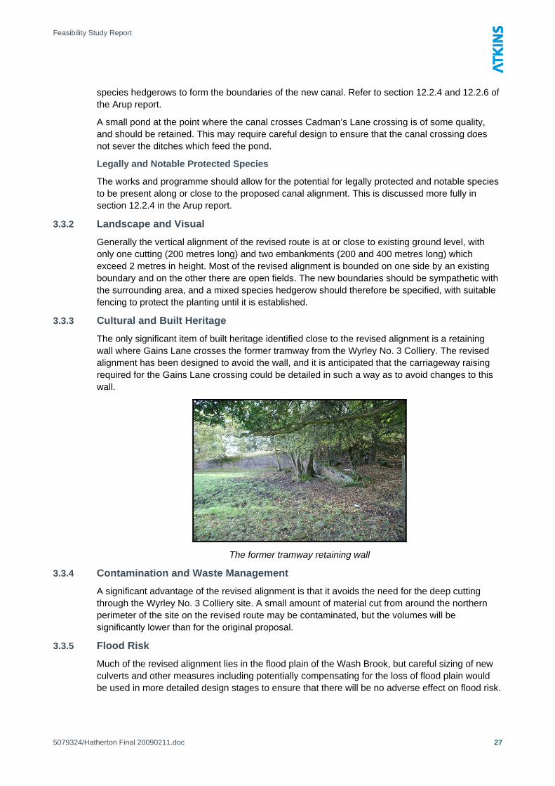
3.3.3 Cultural and Built Heritage
The only significant item of built heritage identified close to the revised alignment is a retaining wall where Gains Lane crosses the former tramway from the Wyrley No. 3 Colliery. The revised alignment has been designed to avoid the wall, and it is anticipated that the carriageway raising required for the Gains Lane crossing could be detailed in such a way as to avoid changes to this wall.
The former tramway retaining wall
3.3.4 Contamination and Waste Management
A significant advantage of the revised alignment is that it avoids the need for the deep cutting through the Wyrley No. 3 Colliery site. A small amount of material cut from around the northern perimeter of the site on the revised route may be contaminated, but the volumes will be significantly lower than for the original proposal.
3.3.5 Flood Risk
Much of the revised alignment lies in the flood plain of the Wash Brook, but careful sizing of new culverts and other measures including potentially compensating for the loss of flood plain would be used in more detailed design stages to ensure that there will be no adverse effect on flood risk.
5079324/Hatherton Final 20090211.doc
27

Feasibility Study Report
It is recommended that a Stage 2 Flood Risk Assessment for the scheme is carried out in early course. This will help to scope the detailed design work and will assist in determining whether a Stage 3 Flood Risk Assessment will be required.
A brief review of the risks identified in the Arup report (section 10.3) has been undertaken and the findings with regard to the alternative alignment (from Chainage 7+600) are outlined below:
Combined Canal and Flood Channels
There are no combined canal and flood channels within the revised alignment (but the Arup comments in their section 10.3.1 will still apply to the canal between chainage 0+000 and 7+600).
Combined Watercourse and Canal Tunnels
There are no combined watercourse and canal tunnels within the revised alignment (but the Arup comments in their section 10.3.1 will still apply to the canal between chainage 0+000 and 7+600).
Water Quality
There are not thought to be any additional risks to local fluvial water quality as a result of the revisions to the proposed canal alignment.
Health and Safety Considerations for Canal Users from Fluvial Flood Events
There are no likely additional risks to canal users from fluvial flood events resulting from the revisions to the proposed canal alignment.
Watercourses and Canal Crossings
In the revised proposed alignment, there are two additional locations where the canal must cross a watercourse. These are both crossings of the Wash Brook, and are located at chainage 8+060 and chainage 8+780. At chainage 8+060 there is sufficient headroom and it should be possible to provide a culvert or culverts which would have adequate capacity to convey the 100 year + 20% storm peak flow. At chainage 8+780, where the canal level is constrained by the need to cross under the road nearby, an inverted siphon culvert may be required (see the notes on such structures in section 10.3.7 of the Arup report), but further study has been recommended to develop the proposals in this area with the aim of optimising both the road and Wash Brook crossings and avoiding the need for the siphon.
Road and Rail Crossings
There is only one additional road crossing required, at Gains Lane, and this will be suitably engineered.
Environmental Impact Assessment
The potential adverse impacts of the revised alignment on the SAC site are dramatically reduced, although there is one remaining issue which could potentially cause a small adverse effect. (see the comments in section 3.1) and these possible impacts will need to be explored through an Appropriate Assessment screening.
A screening opinion from the local planning authority as to whether formal Environmental Impact Assessment will be required should be sought.
5079324/Hatherton Final 20090211.doc
28

Feasibility Study Report
4. Conclusion and Recommendations 4.1 Conclusion
The revised route for the restoration of the Hatherton Canal, avoiding the Cannock Extension Canal SAC site is technically feasible. The route is shown on drawings 5079324-051 to 056, appended to this report.
The effects of the restoration of the Hatherton Canal on the SAC site would be greatly reduced if the revised route is adopted.
The revised route may be preferable to the original proposal in other respects as well, particularly in regard to reducing the amount of potentially contaminated ground to be excavated, and consequently the disposal costs.
The water supply requirements of the revised route are greater than those of the original, by merit of its increased length and the greater drop of the deepest proposed lock, but only by 11%. This should not be an obstacle to the restoration.
The change to the revised route is also beneficial in terms of costs, reducing the estimated cost of the scheme by £4.6 million, from £48.7 million to £44.1 million
4.2 Recommendations It is recommended that the revised route is adopted for the restoration, and that preliminary work such as land purchase and outline design should continue, based on the revised route.
It is further recommended that the revised route should be put forward for inclusion in the Local Development Framework to ensure that the proposed alignment receives planning protection.
There are a number of subsidiary recommendations for further work and study:
• Consultation with Natural England and a formal Appropriate Assessment screening to determine whether full Appropriate Assessment is required should be carried out
• Further survey work and outline design should be carried out in early course for the crossing of Gains Lane and the Wash Brook. This area is shown on drawing 5079324-057, appended to this report. This work should aim to establish in outline the proposed horizontal and vertical alignments for the canal, brook and road in the vicinity of the crossing so that the agreement of the highway authority and Environment Agency to the proposals can be obtained and recorded.
• Some further refining of the pound levels and earthworks balance would be of benefit. This should include a more detailed analysis of the alternative alignment option discussed in sections 2.2.1 and 2.2.3 of this report.
• This report should be issued to British Waterways for their consideration, and, if possible their comments and acceptance of the key findings should be obtained and their support for the principles established.
• Significant work will be required to obtain approval from the Environment Agency for the changes to land drainage required to implement the scheme. This process should be commenced in early course, and a suitable format for this would be by means of undertaking a formal Level 2 Flood Risk Assessment for the entire scheme (refer to Appendix B for an explanation of the Flood Risk Assessment process).
5079324/Hatherton Final 20090211.doc
29

Feasibility Study Report
Appendix A
A.1 Scheme Drawings For details of the section from Hatherton Junction to chainage 7+600, reference should be made to Arup drawings C-36-001 to C-36-012 which were appended to the Arup report. If the revised alignment is adopted from chainage 7+600 to Fishley Junction, the drawings listed below will replace Arup drawings C-36-013 to C-36-016.
• Drawing 5079324-051 – Plan and Long Section Sheet 1 of 6 (chainage 7+600 to 8+200)
• Drawing 5079324-052 – Plan and Long Section Sheet 2 of 6 (chainage 8+200 to 8+800)
• Drawing 5079324-053 – Plan and Long Section Sheet 3 of 6 (chainage 8+800 to 9+400)
• Drawing 5079324-054 – Plan and Long Section Sheet 4 of 6 (chainage 9+400 to 10+000)
• Drawing 5079324-055 – Plan and Long Section Sheet 5 of 6 (chainage 10+000 to 10+600)
• Drawing 5079324-056 – Plan and Long Section Sheet 6 of 6 (chainage 10+600 to 11+400)
An additional drawing shows in more detail the area of the crossing of Gains Lane and Wash Brook discussed in section 2.2.2.
• Drawing 5079324-057 – Gains Lane and Wash Brook Crossings – Survey Info and Details
5079324/Hatherton Final 20090211.doc
30


Feasibility Study Report
Appendix B
B.1 Flood Risk Assessments B.1.1 Methodology
Flood Risk Assessments are prepared in accordance with Planning Policy Statement 25: Development and Flood Risk, Environment Agency standing advice, and following the guidance given in CIRIA Report Development and Flood Risk – Guidance for the Construction Industry. The CIRIA report recommends a tiered approach to flood risk with three levels of assessment that are defined below.
B.1.2 Level 1 – Screening Studies
Screening studies are undertaken to identify whether there are any flooding issues related to a development site which may warrant further consideration.
The objective of the screening study is to:
• Develop an understanding of the potential flood risk to a development site.
• Agree with the Local Planning Authority what aspects of flood risk would need to be addressed in a more detailed flood risk assessment.
B.1.3 Level 2 – Scoping Studies
Scoping studies are to be undertaken if the Level 1 study indicates that the site may lie within an area which is at risk of flooding or that the site may increase flood risk due to increased runoff, to confirm the possible sources of flooding which may affect the site.
The scoping study should include the following objectives:
• Assessment of the availability and adequacy of existing information.
• Qualitative assessment of the flood risk to the site, and the impact of the site on flood risk elsewhere.
• Assessment of the possible scope for appropriate development design and to scope additional work required.
B.1.4 Level 3 – Detailed Studies
Detailed studies are undertaken if the Level 2 study concludes that a quantitative analysis is required to assess flood risk issues related to the development site.
The detailed study should include:
• Quantitative assessment of the potential flood risk to the development.
• Quantitative assessment of the potential impact of development site on flood risk elsewhere.
• Quantitative demonstration of the effectiveness of any proposed mitigation measures.
5079324/Hatherton Final 20090211.doc
38

Feasibility Study Report
Appendix C C.1 Cost Estimate
The revised cost estimate is included overleaf.
5079324/Hatherton Final 20090211.doc
39

Hatherton Canal Restoration
Supplementary Feasibility Study
Estimated Costs of Restoration for Alternative Route Connecting to Wyrley and Essington Canal at Fishley Junction
Item Work Required Quantity Unit Approx Rate Allowance
Earthworks
Canal Channel Puddle clay 45,409 m³ 35.00£ 1,589,315£
(revised quantities based on Hazel faggots 9,576 m 30.00£ 287,280£
Arup figures and adjusted for Rock 3,586 m³ 20.00£ 71,720£
revised length and specific items Sheet Piling 65,607 m² 94.00£ 6,167,058£
where known e.g. reduction in Concrete capping beam 2,979 m 345.00£ 1,027,755£
volume of Disposal of U2 due to Tow path 25,952 m² 15.00£ 389,280£
revised alignment not requiring Excavation 378,797 m³ 1.50£ 568,196£
deep cutting through colliery spoil) Dredging 124,128 m³ 1.80£ 223,430£
Disposal of material on site 285,959 m³ 3.00£ 857,877£
Fill 9,000 m³ 2.00£ 18,000£
Disposal (5km haul + landfill tax) 150,474 m³ 9.00£ 1,354,266£
Disposal U2 49,139 m³ 95.00£ 4,668,205£
Structures
Changes to Arup estimate Original figure (£29,478,000 - £20,863,000) 8,615,000£
Delete A5-Gains Lane 3 new locks 3 no 200,000.00-£ 600,000-£
2 access bridges 25 m 4,500.00-£ 112,500-£
New Wash Brook culvert 2m x 2m 10 item 2,000.00-£ 20,000-£
Delete Gains Lane Crossing New bridge (culvert) 15 m 4,500.00-£ 67,500-£
Raise road by 1.5m 1,500 m² 100.00-£ 150,000-£
Sheet piling 400 m² 100.00-£ 40,000-£
Delete Wyrley Lane Crossing New culvert 15 m 4,500.00-£ 67,500-£
7 new locks 7 no 200,000.00-£ 1,400,000-£
Delete Landfill Access Road Bridge New Bridge (culvert) 15 m 4,500.00-£ 67,500-£
Pedestrian footbridges to join proposed 2 nr pedestrian footbridges 2 no 25,000.00-£ 50,000-£
towpath to Cannock Extension Arm
Add A5-Gains Lane 3 new locks 3 no 200,000.00£ 600,000£
2 access bridges 2 no 100,000.00£ 200,000£
1 lifting access bridge 1 no 75,000.00£ 75,000£
Wash Brook Culverts 4m x 1m 11 item 4,000.00£ 44,000£
Minor culverts 20 m 200.00£ 4,000£
Add Gains Lane Crossing and New bridge as Cappers Lane 1 no 150,000.00£ 150,000£
Wash Brook crossing Raise road by 2.5m incl retaining 350 m² 1,000.00£ 350,000£
Wash Brook Culverts 4m x 1m 11 item 4,000.00£ 44,000£
Stream diversion 100 m 200.00£ 20,000£
Wash Brook to Golf Course 4 new locks 4 no 200,000.00£ 800,000£
Lock tail access bridge 1 no 25,000.00£ 25,000£
Lock tail footbridge 2 no 10,000.00£ 20,000£
Minor culverts 60 m 200.00£ 12,000£
Ditch diversion 60 m 100.00£ 6,000£
Golf course to W&E Canal 2 new locks 2 no 200,000.00£ 400,000£
New or refurbished road bridge 1 no 150,000.00£ 150,000£
Lock tail footbridge 1 no 10,000.00£ 10,000£
Piling for bridge access ramps 900 m² 100.00£ 90,000£
Removal of stank at connection 1 item 5,000.00£ 5,000£
Sub-total 26,267,382£
Preliminaries at 20% of structures costs 20% 5,253,476£
Construction Total 31,520,858£
P:\GBTFA\MandI\Public\507 Jobs\5079324 - Lichfield Canal Feasibility\3 Costs\
Hatherton Cost Estimate.xls
Page 1 of 2
Printed 10/02/2009

Hatherton Canal Restoration
Supplementary Feasibility Study
Estimated Costs of Restoration for Alternative Route Connecting to Wyrley and Essington Canal at Fishley Junction
Construction Total (carried forward) 31,520,858£
Other Items
As Arup report 2,290,000£
ESTIMATED COST 33,810,858£
Specified risk item (as Arup Report) 3,525,000.00£
General Contingency Allowance (at rate specified in Arup Report) 20% 6,762,171.66£
Risk and Contingency Allowance 10,287,172£
TOTAL ESTIMATED COST 44,098,030£
P:\GBTFA\MandI\Public\507 Jobs\5079324 - Lichfield Canal Feasibility\3 Costs\
Hatherton Cost Estimate.xls
Page 2 of 2
Printed 10/02/2009