Hatcham Conservation Area Character Appraisal conservation area character appraisal History of the...
38
Hatcham conservation area character appraisal
-
Upload
phamnguyet -
Category
Documents
-
view
220 -
download
1
Transcript of Hatcham Conservation Area Character Appraisal conservation area character appraisal History of the...

Hatcham conservation area character appraisal

Hatcham conservation area
Hatcham conservation area covers a commercial area along New Cross Road as well as a residential area of terraced housing between New Cross Road and New Cross Gate station. New Cross Road is an old road which originally linked the Kent countryside to London until the area began to develop slowly from farms and country houses in the eighteenth century. Hatcham Park was one of those country houses which was built on land owned by the Haberdashers’ Company. The coming of the railway to New Cross Gate in 1835 prompted speculative development and Hatcham Park was demolished to make way for terraced housing which was strictly controlled by the Haberdashers.
Today New Cross Road is still a busy thoroughfare and commercial centre that offsets the charm and tranquility of the residential terraces which still have the same appearance as when they were finished towards the end of the 19th century. The conservation area was designated in 1990 and amended to end after The Hatcham Liberal Club at no. 367 Queen’s Road in 2006.
This character appraisal provides an assessment and definition of Hatcham’s special historic and architectural interest as recommended by both Planning Policy Guidance Note 15: Planning and the Historic Environment and English Heritage best
practice advice. Appraisals are not comprehensive studies and the omission of a particular building, feature or space should not be taken to imply that it does not contribute to the character of the area. The character of the conservation area derives from all the elements outlined in this appraisal with their interrelationships being just as important as their individual existence.
This appraisal will be a material consideration when determining planning applications and planning appeals relating to Hatcham conservation area. Information on planning controls and appropriate alterations are given in the Hatcham supplementary planning document available from the planning information desk.
This document was made available for public consultation October and November 2005 in accordance with the Planning (local development) Regulations 2004. Residents and businesses in the area were sent details and invited to a public meeting to discuss the character appraisal as well as the proposed Article 4(2) direction and supplementary planning document. The appraisal and supplementary planning document were the subjects of a sustainability appraisal. The sustainability appraisal and consultation statement are available from the Conservation and Urban Design team. This character appraisal was adopted by the Mayorand Cabinet on 22 February 2006.
2

Contents
1. History of the area 5
2. Form & character of the conservation area 11
Character of New Cross Road
209-241 New Cross Road 13
The island site 14
Barclays bank 14
The chemist to former bank 14
141 New Cross Road to All Saints’ Church 15
130-158 New Cross Road 15
Minerva Terrace 16
Former library to Hatcham Park Tavern 16
Staffordshire Terrace 17
157-193 New Cross Road 17
The Five Bells pub 17
Queen’s Road 18
Character of the residential streets Hatcham Park Road 19
Nettleton Road 20
Billington Road 20
Avonley Road 21
Casella Road 21
Brighton Grove 21
Camplin Street 22
Brocklehurst Street 23
Leylang Road 24
Ventnor Road and Egmont Street 24
Barlborough Street, Edric Road and Wrigglesworth Street 25
Hunsdon Road and Monson Road 26
Spatial character 27
Architectural gems 28
3. Elements threatening or damaging the character of the conservation area 31
Neutral areas 32 Negative characteristics 33
Conservation area enhancement 35
Useful contacts 36
3

Hatcham conservation area character appraisal
Hatcham conservation area boundary
4

History of the area
Part 1
5

Hatcham conservation area character appraisal
History of the area
The first mention of a settlement in this area is in the Domesday Book in 1086, which lists a manor containing land for three ploughs, nine villagers and two smallholdings, six acres of meadowland and woodland for three pigs. The name Hatcham is Anglo-Saxon and could have meant ‘Hacci’s Village’ or ‘the village in the clearing in the woods’.
Later mention comes in the form of a manor being conferred by William the Conqueror on his half Brother, Odo Bishop of Bayeaux. Henry II (1154-89) granted land to a Gilbert de Hatcham who built a moated manor house in the area around today’s Egmont Street. This can be seen on the Haberdashers’ Map (right) as a small square to the centre of the map.
The Haberdashers’Map dated 1619. North is to the left on this map.
The seventeenth century
The manor house and environs were bought by the Worshipful Company of Haberdashers in 1614. The Haberdashers was one of the ancient guilds of the City of London which still continues its activities today including its historical involvement in the governance of the City of London.
The company controlled the trade of haberdashers who sold ribbons, beads, purses, gloves, pins, etc and later hats as well. The guild’s work evolved to include the management of donations and bequests made by their members. The Hatcham estate was bought to provide an endowment for William Jones’s school and almshouses in Monmouth, Wales. Jones was a successful haberdasher and Hamburg merchant who left a great fortune to the Haberdashers to maintain his charitable foundation.
The map of 1619 shows roads still present today: the ‘London Waye to Detford’ (now New Cross Road), ‘The Waye from Peckham to Detford’ (now Queen’s Road). It shows the location of ‘New Cross’ (as today) and the continuation of New Cross Road to the east and Lewisham Way. The land at this time was entirely agricultural and woodland.
The manor house, now known as Hatcham Park, was also leased to Thomas Pepy’s (cousin of Samuel) in the 17th century.
6

The eighteenth century
John Rocque’s map (right) shows that although the land is still principally agricultural, some development has sprung up along New Cross Road probably owned by a few wealthy families. Five Bells Lane can clearly be seen with the location of the old Five Bells pub (pictured bottom) at its intersection with New Cross Road, although it is not known if indeed the building on the map was a pub at this date.
Hatcham House can clearly be seen with its gardens and its two entrances. Hatcham House was rebuilt by Joseph Hardcastle who lived there from 1788 to 1819. Hardcastle was born in Leeds and moved there becoming a Russia merchant, philanthropist and a supporter of the abolition of slavery.
The ‘New Cross Turnpike’ can also be seen on the map. The area today takes its name ‘New Cross Gate’ from the toll gate which was originally built in 1718 at the location seen on John Roque’s map.
The turnpike trust charged a fee or toll to use its roads and the money was much needed for maintenance as this road was heavily used by carts bringing agricultural produce from Kent and timber from Surrey and Sussex.
John Rocque’s map of 1745. This map is seen with north to the top
Hatcham House which was demolished in 1869
The old Five Bells public houseFive Bells Lane Bridge
7

Hatcham conservation area character appraisal
The nineteenth century
In 1813 the turnpike was moved to New Cross Gate. The area became a convenient watering hole for travellers as well as their horses and inns such as the Five Bells and the White Hart became established here. The map of 1835 shows the new location of the toll gate and indicates the Five Bells Pub.
Hatcham’s population doubled from just 734 inhabitants in 1801 to 1,555 in 1831. However between 1831 and 1871 the population soared to eleven times its size to 17,168. The increasing urbanisation and road traffic made the cost and inconvenience of turnpike roads unpopular and in 1865 by decree, the New Cross toll gate was closed and removed.
The railway
More importantly the 1835 map shows the Croydon Canal which was converted soon after to a railway with New Cross Gate station opening in 1839. Now the working man could work in the City and live in the suburbs. The 1844 map shows a small amount of housing along New Cross Road which is now listed and some buildings further north on both sides of New Cross Road.
Speculation
Urbanisation progressed as more housing was needed for London’s growing population. Land owners, such as the Haberdashers could get more ground rent for their land if it was used for housing rather than the traditional market gardening.
As leases expired they were renewed by the Haberdashers for building leases. From the 1830s plots of land began to be built on or rebuilt, mainly along New Cross Road to start with. In October 1858 the Haberdashers
started to take a more proactive interest in the area and set up a permanent special committee called the New Cross Estate Committee “consisting of 5 members to be appointed with power to originate and receive suggestions for the laying out and management of the estate at New Cross”.
Ten days later the group was renamed the Hatcham Manor Estate Committee. The land under discussion was not only that north of New Cross Road, but also the
“Tithable Lands in Deptford” 1844
area now known as Telegraph Hill where higher class houses were built.
As in 19th century development all over the country, land was leased to speculative developers who took the financial risk and gain of house building. The developers ranged from builders doing just one or two houses, to larger scale developers, doing whole streets, particularly later in the century when their business had expanded through a string of successful developments.
8
1835

Development of New Cross Road
Minutes of the Haberdasher’s Committee for the Estates between 1827 and 1834 give an interesting account of the evolving development. Building began along New Cross Road with a mixture of residential and commercial buildings. In 1838 James Bacon paid £125 for a 71 year lease on land which included The Five Bells Public House, two cottages and 300 feet of land fronting the highway from the public house to the toll gate.
In 1839 a proposal for 8 houses and 8 shops along this stretch of land was considered by the committee, but was changed at a later date to a uniform terrace of 18 properties, which is what is seen today. The committee exerted its control over the development by specifying: “The elevations of the houses which are to be shops are to correspond with each other and the heights of the storeys throughout to be the same.”
The venture was concluded with the complete rebuilding of the Five Bells which has remained largely unchanged except for a side extension and is listed as a building of special architectural and historic interest.
The Haberdashers acted as a modern day planning authority, controlling the quality of development on their land, probably partly to combat cowboy builders aiming to make maximum profit from a minimum financial outlay, but also to ensure the future success of the development and hence the income to the Haberdasher’s Company. Materials were specified in the committee’s minutes, for example: “hard burnt 1 ½” thick stock brick walls with Yorkshire stone parapets; and cills to front windows and doors in Portland stone” “the mortar to be made of good quick lime and
The Five Bells pub taken in 1931
1868
sharp sand mixed in proper proportions” “Duchess slating, copper nailed onto battens” “windows are to be double hung with brass pulleys, patents lines and weights”.
The accommodation was also defined: the houses in this section of New Cross Road were to contain three clear storeys front and back; be two rooms deep with a kitchen at the rear, but no basement. No gateway, alley or passage was to be permitted without prior approval from the committee.
The policing of building works was also carried out by the
committee which declared “Any building built in an improper manner shall be immediately taken down and rebuilt under the order and direction of the Architect”. On 8 September 1848 a Mr Burtwell of 7 Hatcham Terrace was reported to have built an additional room on the side of his house but had used old fashioned pantiles instead of natural slate on the roof. This was regarded as unacceptable.
The minutes from 1851 record the building of a number of terraces along New Cross Road which can clearly be seen on the map of 1868. This map also shows that the south side of Hatcham Park
9

Hatcham conservation area character appraisal
Road (laid out in 1848) is almost complete as well as some of the north side; the west of Nettleton Road (built 1864) is complete as well as some houses to its east side.The map also shows the rebuilt Five Bells pub and Mr Bacon’s three storey terrace with shops to the ground floors as well as a mixture of villas, terraced houses with front and back gardens and probably shops to the west side.
Residential development in Hatcham Park
In 1840 the Haberdashers Committee for Estates discussed the conversion of the house and grounds of the Hatcham Park mansion for redevelopment. The house was no longer as exclusive as it had been since trains now ran close by. Mr Hardcastle’s surveyor, Mr Beadell showed his plans for laying out streets and roads, but these had to be revised as the proposed roads did not give the possibility of linking up with future roads.
In 1845 the matter was progressed and it was decided that the roads and sewers would be laid progressively out of the proceeds of the sales of building lots. The Haberdashers allowed the sales to be made under the usual conditions of their building leases. It was agreed that profits from the development would be shared by Mr Hardcastle and themselves. In 1848 Mr Hardcastle built the first houses along Five Bells Lane (now Hatcham Park Road).
In January 1850 the road was renamed Hatcham Park Road and in the following March a new street sign in Goldsmith’s Patent Porcelain letters was erected at the New Cross Road end. In 1864 Mr Wallbutton requested a lease of 81 years to build houses on Hatcham Park Terrace, to make a new road (Nettleton Road) and sewer, to build houses
on both sides of the new road, further houses in Hatcham Park Road and in Hart’s Lane.
In 1866 the Haberdashers recorded their view that due to the demolition of working class housing in central London and the advent of affordable rail links, Hatcham would be a good location for housing for the working classes. Earlier the Haberdashers had reported that a railway coach business would bring a superior class of artisan to their estate. Towards the end of Hatcham’s development in July 1880 the Haberdashers recorded that “the various builders have in a very satisfactory manner carried out their several contracts in a very commendable spirit. 190 houses having been erected these last 12 months representing an income of £800 per annum.” For example Mr Edwards built 11 houses in total: 5 in Casella Road and 6 in Cold Blow Lane whilst Mr Oldman built 23 houses: 5 in Casella Road, 6 in Camplin Street, 4 in Leylang Street and 8 in Brocklehurst Street and there were many others.
The estate was complete by the time the area was mapped out in 1894-96. At this time New Cross Road would have been the finest road with tall middle class houses and shops; and Hatcham Park, once landscaped gardens
1894-96
and fields, would have become completely covered in smaller smart terraces for the working classes. Surprisingly the map shows building even in the central island of Eckington Gardens! The Haberdashers’ control has produced an estate of enduring appeal and quality, much of which remains unchanged today.
10
Form & character of the conservation
area Part 2
11

Hatcham conservation area character appraisal
12

The character of New Cross Road New Cross Road is the oldest road in the area, appearing on the Haberdasher’s map of 1619 and as such contains earlier buildings than other roads in the conservation area, having a significant number of buildings - mainly houses - by the 1840s.
The character of the road today is mainly commercial although it does contain some residential buildings, notably nos. 209-241 New Cross Road which are particularly fine.
New Cross Road provides the boundary between Hatcham and the Telegraph Hill conservation area which was also developed by the Haberdashers Company. The hub of activity and visual focus in this part of New Cross Road is the island site, a busy traffic junction containing a listed ventilation pipe surrounded by the area’s most elaborate buildings.
209-241 New Cross Road
These smart early Victorian town houses, built for the wealthy classes are some of the best preserved buildings in Hatcham. Nos. 209-229 are grade II listed and were built by 1844. Nos. 231-241 are somewhat simpler in style and were built between 1844 and 1868 by a local developer called Wallbutton (see history section).
View from New Cross Road traffic island
building to a two storey double fronted villa with classical portico. This in turn is attached to a further terrace of three storey
Nos. 207-219 are a terrace of three storey stock brick town houses. This fine terrace has roofs concealed behind a stucco cornice, georgian paned windows and arched windows to the ground floor. The ‘piano nobile’ or main floor is emphasised by tall georgian paned sash windows with every third window having a stucco pedimented surround.
This terrace is attached by a link
town houses with the front doors set back from the front plane of the buildings. On the south side of New Cross Road fine turn of the century mansion houses provide a contrast with their red brick. These terraces are actually in Telegraph Hill Conservation Area.
Listed terrace Red brick mansion houses on the south side
13

Hatcham conservation area character appraisal
The island site
This key focal point in the conservation area is sadly marred by heavy traffic and its associated infrastructure of traffic lights, signage, bus stops and shelters. The centre piece - created by the ventilation pipe, early convenience railings and hanging baskets - is cluttered by plain barrier railings.
Barclays bank
A key corner building, built in the 1880s-90s and designed in the neo-georgian style. It is a tall buidling for the area and helps provide the sense of arrival in the town’s centre with its three storeys plus attic rooms. The ground floor’s importance is demonstrated by the rusticated stonework and pedimented entrance. Above, eight over eight pane sash windows are set regularly in brown brick with red brick dressings. The two pediment style gables and tall chimneys crown the building
The chemist to the former bank
The buildings on the corner of Queen’s Road and New Cross Road reflect Barclays Bank opposite in a suitable high Victorian style. The White Hart, built c.1870 in stock brick with stucco dressings used to be topped by a stone deer. Carved grapes can be seen in the arches over the windows. The distinctive building with the arched entrance way next door was in existence by the 1840s as a horse dealership and owned by Charles Ranford. When he left, the building was used as the ‘Electric Empire’ cinema from 1909 to 1917. The building is very important to the character of the conservation area due to its age and history (it can be seen on an old picture dated c1840). It also provides variety and welcome space between buildings in the streetscape.
The striking red brick and stone building was built as a bank around the same time as the pub and has a baroque flavour. Three tall storeys plus a mansard roof with pedimented dormers. The first floor windows have arched heads for emphasis and the roofline is particularly distinctive.
The chemist & White Hart public house
This cast iron column was modelled on an Egyptian designs
by Alexander ‘the Greek’ Thomson. The column vented the public
conveniences beneath and was installed in 1897.
It is grade II listed.
Barclays bank
The White Hart , old stables and former bank
14

141 New Cross Road to All Saints’ Church
The modest two storery terrace from 119-141 New Cross Road was built in the late 19th century on land at the edge of the former Hatcham Park estate. The sash windows are typical of this period with only one vertical central glazing bar. The brick lintels are curved with a stucco keystone whereas the earlier terraces have guaged brick flat arches and no keystones.
Nos. 109-117 have three storeys and are of similar design. It is interesting to note that where these terraces meet Casella Road and Billington Road, no effort is made to front these streets, probably because the street layout had not yet been determined.
All Saints’ Church offers an imposing west entrance into the conservation area. Its large rose window nearly fills its Kentish ragstone facade and sits above three pointed arches, two containing the entrance doors. The church was built in 1869 on land gifted by the Hardcastle family and the Haberdasher’s Company. A mature tree fills the space between church and terrace.
130-158 New Cross Road
There is more variety to this side of the street than opposite. Many buildings were built as houses with front and back gardens before 1844 and shopfronts were added later. Nos.150-158 are named Temple Place by a plaque.
Nos. 136-148 are a two storey terrace with nos. 146 and 148 having had a storey added. Nos. 132 and 134 are a pair of three storey stock brick houses with plain slate roofs and prominent moulded brick lintels over their sash windows and french doors.
All Saints’ Church
New Cross Road looking north
Nos.130-158 New Cross Road
15

Hatcham conservation area character appraisal
Minerva Terrace
View showing the Hatcham Arms (far right) and no.96 which is only
two storeys
Minerva Terrace
Minerva Terrace is a particularly dignified composition at nos. 120-128, now damaged visually by painting, window replacement and the addition of dutch blinds. The houses were built between 1833-4 with shopfronts added around 1900.
The terrace is symmetrical with projecting three bay pavilions at either end which have tuscan pilasters. A simple entablature spans the whole terrace and displays the name of the terrace. The windows would have been georgian paned sashes, but none survive.
Former library to Hatcham Park Tavern
The Edwardian library is another key building of elaborate style built in 1911. It is red brick with two rusticated stone pavilions at either end, one displays a dedication plaque with two cherubs. An unsightly builder’s yard breaks the streetscape next door.
Nos. 104-106 New Cross Road are two pairs of early Victorian villa style houses with hipped slate roofs, georgian pane windows and entrances to the sides. Nos. 108-110 are stock brick and display a plaque with the name Park Lodge, whereas nos. 104-106 are stucco fronted and have had shopfronts added.
The buildings up to Hatcham Park Tavern return to a three storery terrace, interrupted slightly by no. 96 which is a charming two storey house with arched windows and a fanlight above the front door. This house is grade II listed. The pub and church opposite are a suitable end point for the conservation area as the road straightens and opens up to views of fewer shops and tower blocks.
Park Lodge
Library dedication Former library plaque
16

Staffordshire Terrace
Nos. 170-176 New Cross Road were built in 1836 as Staffordshire Terrace which is revealed by a plaque on its wall. The houses would have been small with only two rooms upstairs and their shopfronts were added around 1885. The georgian paned sash windows sit in a distinctive Regency style arch and the roof is concealed behind a stucco cornice.
157-193 New Cross Road
This terrace was built by James Bacon whose application to the Haberdasher’s Company is outlined on page 11. The three storery terrace is very uniform and originally would have displayed all georgian paned windows, but few remain today. The roof is again hidden behind a parapet.
The whole terrace is terminated by fine buildings at both ends: the bank to the south and Winkworths at No. 157. The Winkworth’s building presents an elevation onto Hatcham Park Road as well as New Cross Road. Its curved corner and arched window to the first floor make a feature of the building and a suitable visual end to the terrace.
The Five Bells pub
Another key building giving interest to this part of the street and being a good corner building fronting two streets is the Five Bells. A pub has been here for many years (see the picture on page 9) and was rebuilt in this form in 1840. It is a grade II listed building.
Note the decorative bells at its deeply bracketed eaves. Up to this point, the street has the atmosphere and bustle of a main shopping street, but moving northwards from this point, the street starts to lose the busy town centre feel.
The Five Bells public house
The four former houses which comprise Staffordshire Terrace are seen to the centre of the picture
Nos. 157-193 New Cross Road
Detail showing dated name plaque on Staffordshire Terrace
17

Hatcham conservation area character appraisal
Queen’s Road
Only a small part of Queen’s Road is in the conservation area and the buildings resemble other early Victorian terraces in New Cross Road. Views out of the conservation area reveal the turn of the century terraces in Telegraph Hill Conservation Area and the 1900s London County Council fire station.
Buildings of particular interest in Queen’s Road include a pair of early Victorian town houses at nos. 371-373. The are a handed pair stock brick pair with rendered ground floor, classically proportioned windows and parapet roof.
A particularly interesting building is the Hatcham Liberal Club at no. 369 Queen’s Road. Established in 1880, the club was built in the Queen Anne Revival style which was a movement against the neo-Gothic and neo-Classical styles of the mid Victorian period. The red brick, curved Dutch gables and oriel window are borrowed from Tudor styles and the white ceramic window dressings are offset against the brick. Both this and nos 371-373 Queen’s Road are listed.
371-373 Queen’s Road
View along Queen’s Road
Hatcham Liberal Club
18
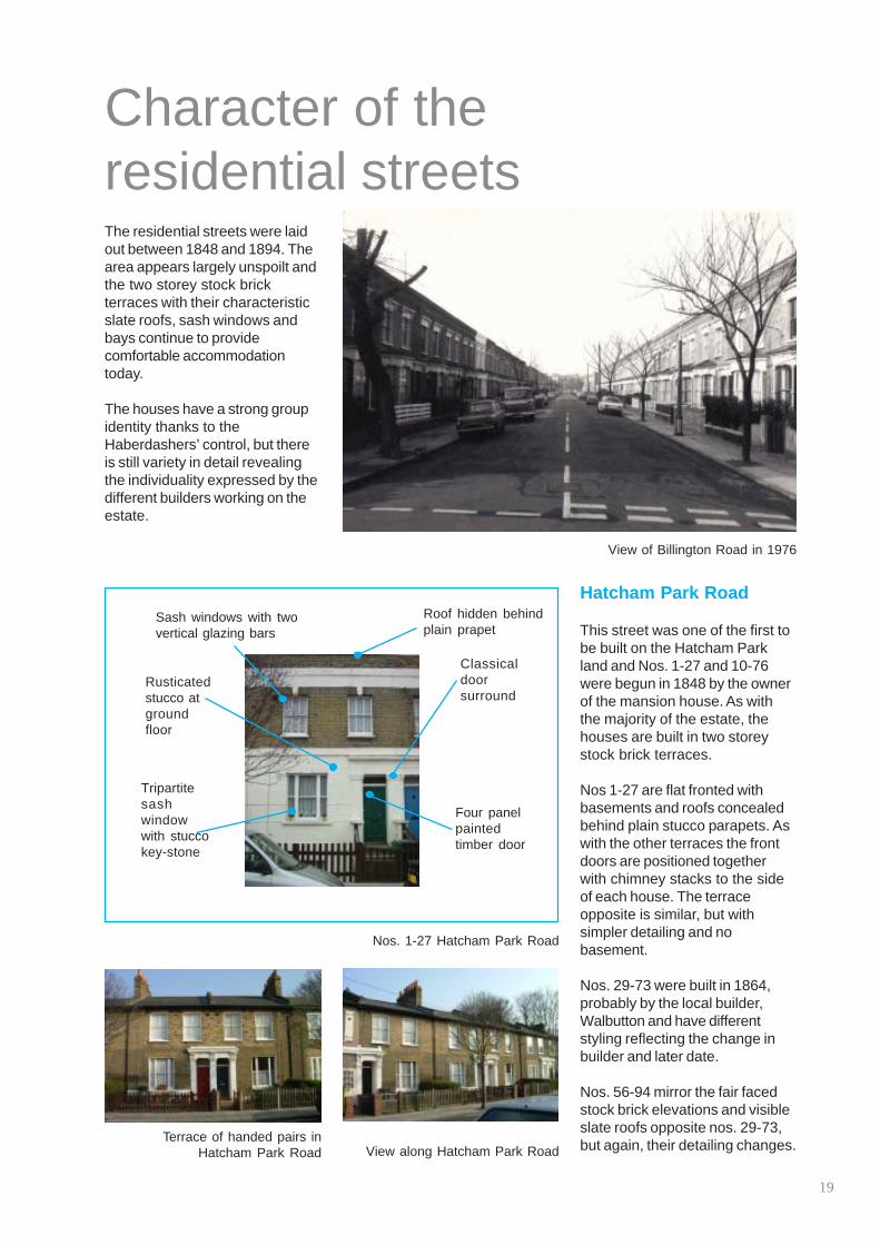
Character of the residential streets The residential streets were laid out between 1848 and 1894. The area appears largely unspoilt and the two storey stock brick terraces with their characteristic slate roofs, sash windows and bays continue to provide comfortable accommodation today.
The houses have a strong group identity thanks to the Haberdashers’ control, but there is still variety in detail revealing the individuality expressed by the different builders working on the estate.
Roof hidden behindSash windows with two plain prapetvertical glazing bars
Classical Rusticated door stucco at surround ground floor
Tripartite sash Four panelwindow paintedwith stucco timber doorkey-stone
Nos. 1-27 Hatcham Park Road
Terrace of handed pairs in Hatcham Park Road View along Hatcham Park Road
View of Billington Road in 1976
Hatcham Park Road
This street was one of the first to be built on the Hatcham Park land and Nos. 1-27 and 10-76 were begun in 1848 by the owner of the mansion house. As with the majority of the estate, the houses are built in two storey stock brick terraces.
Nos 1-27 are flat fronted with basements and roofs concealed behind plain stucco parapets. As with the other terraces the front doors are positioned together with chimney stacks to the side of each house. The terrace opposite is similar, but with simpler detailing and no basement.
Nos. 29-73 were built in 1864, probably by the local builder, Walbutton and have different styling reflecting the change in builder and later date.
Nos. 56-94 mirror the fair faced stock brick elevations and visible slate roofs opposite nos. 29-73, but again, their detailing changes.
19

Hatcham conservation area character appraisal
Nettleton Road
arches over firstsize to the houses built in New
glazing barsGauged brick
Plain classically
Pitched slate roof (not Plain eavesseen)The houses on the west side of
Nettleton Road were built by 1868 and the others were built soon
Sash windowsafter. The houses are three with two verticalstoreys plus basements and are
therefore more comparable in
and second floorCross Road rather than those windowsbuilt on the land of the old mansion house. Feature tripartite
sash window with The entrance doors are paired bracketed cornice
and cillcentrally with the chimney stacks at either side of each house and inspired doublethe houses do not have front door cases gardens except for a small front area.
Billington Road Decorative brick
Billington Road was built in 1876. parapet The terraces are two storey stock brick houses with canted bay windows and roofs concealed
The bay has twobehind decorative brick parapets. cast ironTile paths lead to the front doors columns through small gardens.
Nos. 1-31 have different detailing to the first floor windows which consists of an incised lintel over Slightlythe first floor windows, topped by recessed fronta brick arch with stucco keystone door filled with herringbone brickwork. The frieze part of the bay window also displays a slightly different design.
Rendered basement
Nettleton Road
Stucco bracketed cornice over unpainted gauged brick arch to windows and door
Bay window with slate hipped roof and dentilled eaves
Low front wall with stone coping
Billington Road
View along Nettleton Road Billington Road house with brick arches over windows
20

Avonley Road
This short terrace of houses is a more unusual design in Hatcham conservation area. Built towards the end of the 19th century, these houses are distinctive by their double height canted bays with plain engaged columns and capitals of naturalistic foliage. The bay has a hipped roof with fish scale slate and decorative clay ridge tiles.
Casella Road
The houses in Casella Road are larger than most others in the former Hatcham estate having three storeys and a double height canted bay starting at semi basement level and steps up to the front doors. The end houses have been made prominent by their gable fronted design and more elaborate bay window detail.
These end pavilions are named Hughendon House and Casella House in plaques to their gables. The street was built in 1880. On the north side of the road is an entrance to Eckington Gardens.
Brighton Grove
This very modest terrace was built in 1858 for the employees of the London & Brighton Railway. These small stock brick houses have barely any decoration except for the red rubbed brick lintels and arches over the front doors. Much alteration of doors and windows has taken place in this street.
Leafy ‘Ruskinian’Decorative capitalsclay ridge tiles
Brick arch with key stone. The door is set into a recessed Plain sash porch windows
with horns
Stucco bracketed cornice over unpainted gauged brick arch to windows and door
Double height bay with slateSash windows hipped roofwith central and dentilledglazing barstucco eaves
Recessed front door Cast iron (four columns panelled) to the bay with plain fanlight above
Avonley Road
Decorative brick parapet
Casella Road
Brighton Grove Casella Road end pavilion
21

Hatcham conservation area character appraisal
Camplin Street
Camplin Street is one of the two longest roads in the Hatcham estate part of the conservation area, the other being Brocklehurst Road. The house type is one of the most prevalent in the area and is very similar to those in Barlborough Street, Wrigglesworth Street and Edric Road with the exception of the porch head which is gently curved here rather than half round.
The Royal Archer public house stands at the corner of Camplin Street and Egmont Street and is a key feature building in the street standing a whole storey taller than the houses.
The building’s importance is demonstrated by its rusticated ground floor surmounted by tall windows, some with pediments above at first floor level and the building is crowned by a thick moulded cornice with its roof hidden behind.
Opposite the pub is a shop which although somewhat run-down, is a historic building which shows the self sufficiency of the original development and whose existence contributes to the character of the area.
ChimneyPitched slate roof with visible fire wall stack with single row of terracotta potsSash windows with
single vertical glazing bars
Curved unpainted brick lintels
Painted windows Slightly recessed reveals four panel door with curved brick arch with stucco Single height baykeystone above window with cast
iron columnettes
Camplin Street
View of Camplin Street
Shop at the corner of Egmont Street and Camplin Street
The Royal Archer public house
22
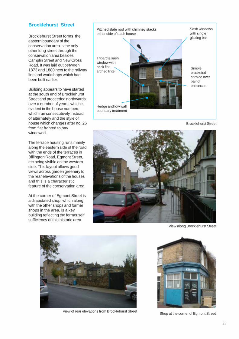
Brocklehurst Street
Brocklehurst Street forms the eastern boundary of the conservation area is the only other long street through the conservation area besides Camplin Street and New Cross Road. It was laid out between 1873 and 1880 next to the railway line and workshops which had been built earlier.
Building appears to have started at the south end of Brocklehurst Street and proceeded northwards over a number of years, which is evident in the house numbers which run consecutively instead of alternately and the style of house which changes after no. 26 from flat fronted to bay windowed.
The terrace housing runs mainly along the eastern side of the road with the ends of the terraces in Billington Road, Egmont Street, etc being visible on the western side. This layout allows good views across garden greenery to the rear elevations of the houses and this is a characteristic feature of the conservation area.
At the corner of Egmont Street is a dilapidated shop, which along with the other shops and former shops in the area, is a key building reflecting the former self sufficiency of this historic area.
Pitched slate roof with chimney stacks either side of each house
Tripartite sash window with brick flat arched lintel
Hedge and low wall boundary treatment
Sash windows with single glazing bar
Simple bracketed cornice over pair of entrances
Brocklehurst Street
View along Brocklehurst Street
View of rear elevations from Brocklehurst Street Shop at the corner of Egmont Street
23

Hatcham conservation area character appraisal
Leylang Road
This short road running between Camplin Street and Brocklehurst Street contains one of the principal house types in the residential part of the conservation area.
The road was named after Mr Langley, a Master of the Haberdasher’s Company and was laid out between 1866 and 1880.
Ventnor Road & Egmont Street
Ventnor Road and Egmont Street are short roads in the conservation area with houses similar to Leylang Road although their roofs are concealed behind brick parapets. Egmont Street was laid out in 1876.
Pitched slate roofs with party fire walls and Sash windows chimneys to the edge of each of houses with single
glazing bar
Painted Segmental brickwindow window andreveals porch heads. Porch archesSingle storey have stuccostucco bay keystones. Thewindow with cast brick archesiron columns and were nothipped roof originally painted
Small front garden
door, slightly door and simple Four panel frontwith path to front
recessedboundary treatment
Leylang road
Roof hidden behind decorative brick parapet Sash windows
with single glazing barSegmental
brick window and porch heads. Porch Painted window arches have reveals stucco keystones. The brick arches were not originally Single storey painted. stucco bay
window with cast iron
Four panel front columns and door, slightly hipped roof recessed
Ventnor Road
View of Egmont Street View of Ventnor Road
24

Barlborough Street Edric Road Wrigglesworth Street
These short roads are filled with terraces of a type which is a variation on the principal house type seen in Leylang Road and many others with the exception that the brick porch head is semi-circular rather than segmental.
Development on the Hatcham Park estate started with Hatcham Park Road and therefore the roads at the northern end of the conservation area were developed some 20-30 years later with Edric Road being laid out in 1884.
The last house in a terrace can othen be of slightly different design if slightly more land was available, as might well have been the case at the end of Wrigglesworth Street. Here the end house has a wider frontage even though the house design remains the same as the rest of the terrace.
On the corner of Barlborough Street and Avonley Road is an old shop, now converted for residential use, but still a prominent key building in the street, particularly as the house is detached unlike the majority of the houses in the conservation area which are terraced.
Brick wall tiled path to Encaustic
Curved porch head
Stucco columns
Stucco capitals
with
front door softening hedging
Edric Road
Converted shop in Barlborough Street
Edric Road with Monson Road School just visible at the end. The
trees make a valuable contibution to the character of the street
25

Hatcham conservation area character appraisal
Hunsdon & Monson Roads
Hunsdon Road and Monson Road are both situated to the north of the conservation area and have terraced housing of the same type as Leylang Road, with Hunsdon Road having some housing similar to those in Avonley Road.
Monson Road has several key buildings within it which include the Duke of Albany public house, an old shopfront opposite the pub and the view to the rear of Monson Road Primary School whose principal elevation can be seen in Hunsdon Road. The school, master’s house and playground are enclosed by a high brick wall with gates giving separate entrance ways to boys and girls. The school was extended in 1900 as shown by a plaque.
The Duke of Albany was built by a builder called Walker and has a
curved frontage to address Monson Road and Barlborough Street and at the time of writing still retained its original outbuildings behind timber gates in Barlborough Street. The height of the pub gives it an imposing appearance and its design makes it a key building in the area. The telephone box outside the pub is listed.
Monson Road Primary School was built in the 1880s and has an imposing presence at the northern end of the conservation area, towering over the low lying terrace housing. The London School Board pioneered elementary education for all children from 1870 and most early London schools were designed by E.R. Robson or his assistant T.J. Bailey in Queen Anne based styles.
This style is seen loosely in Monson Road Primary School with its contrasting red and yellow bricks with white painted multipaned windows, many of which have sadly been replaced by inexpressive upvc units.
Rear elevation of Monson Road School
View of Monson Road
The Duke of Albany public house
Monson Road
26

Spatial character
Hatcham conservation area covers a self sufficient urban area centring around the island site in New Cross Road. The conservation area has two very distinct parts: the commercial New Cross Road and the residential streets behind.
New Cross Road with its three storey terraces and main road traffic has a busy atmosphere even though it is somewhat run down in appearance. The residential streets however, have a more tranquil feel with their modest two storey terraces and tree lined streets.
The focal point of New Cross Road is the island site at the junction of New Cross Road and Queen’s Road. The buildings at this point are attractive and eye catching. The focal point for the residential streets could be said to be the open space in front of the Duke of Albany pub in Monson Road which bleeds into Eckington Gardens across the road.
Eckington Gardens is the only open green space in the conservation area. It is a very urban space with provision for recreational activities such as skateboarding and a children’s play area. There are some trees and lawn as well as a pathway through. Other greenspace is provided by private gardens. Front gardens are very small, but rear gardens are a good size. Some streets cut across terraces and views across gardens can be seen, but other plots of land have been developed with houses fronting all sides which does not give such views. Many residential
streets have street trees which give a softening appearance to the densely packed terraces. A number of buildings in the area can be classified landmark buildings due to their style, size and level of visibility in the area. These are also architectural gems.
Views in the conservation area are mainly local rather than far reaching. Each street has its own slightly different appearance and
end point. Important views include those along New Cross Road, both to and from the island site. From New Cross Road views into the streets of the Telegraph Hill Conservation Area can also be seen.
Hatcham Mews has a separate identity to the rest of the conservation area and many buildings have been converted to live-work units.
27

Hatcham conservation area character appraisal
Architectural gems The New Cross Gate Urban Design Framework and Development Strategy identified a number of ‘gems’ in the area which are reproduced here along with others which have been identified. Listed buildings as well as unlisted buildings which are of particular interest in their own right and contribute to the character and diversity of the conservation
1
2
3
4 5
6
7 8 9
10
11
13
14
15
16
18
19
17
12
area are shown on the map below.
1 All Saints Church, New Cross Road, 1869 10 2 96 New Cross Road, Grade II listed, c1830-40 11 3 4
Park Lodge 108-110 New Cross Road, 1830-40 Former New Cross Library, New Cross Rd, 1911
12 13
5 6
Former stables, New Cross Rd, early 19th century Hatcham Liberal Club, Queen’s Rd. Grade II, c1880 14
7 371-373 Queens Road, Grade II listed, c1840 15 8 Former Bank, New Cross Road, c1880 16 9 The White Hart public house, New Cross Road,
Grade II listed, c1870 17 18 19
Ventilation shaft, New Cross Road, Grade II, 1897 Barclays Bank, New Cross Road, c1890 157 New Cross Road, mid 19th century Hatcham Terrace, 207-229 New Cross Road. Grade II listed,c1840 Five Bells public house, New Cross Rd, Grade II, c1840 Shop in Egmont Street, c1880 Royal Archer public house, Camplin Street, c1880 Shop in Brocklehurst Street, c1880 Duke of Albany public house, Monson Road, c1880 Monson Road Primary School, Hunsdon Road, c1890
28

1
96 New Cross Road, Grade II listed, c1830-40
3
Former New Cross Library, 1911
All Saints Church, 1869 Park Lodge, 1830-40 Former stables, early 19th century
42 5
6 7
The White Hart public
8
house, Grade II listed, c1870
Hatcham Liberal Club, 371-373 Queens Road, Former bank, c1880 Ventilation shaft Grade II listed, c1880 Grade II listed, c1840
9 10
11 12 13 14
157 New Cross Road, mid Hatcham Terrace, 207-229 Five Bells public house. 19th century Grade II listed, c1840 Grade II listed, 1840
Barclays Bank, c1890
1716
Monson Road Primary School. Late 19th century
1915 18
Shop in Egmont Royal Archer public Shop in Brocklehurst Duke of Albany public Street, c1880 house, c1880 Street, c1880 house, c1880
All historic buildings in the conservation area are seen as making a positive contribution to the character of the conservation area which it is desirable to preserve and enhance.
29

Hatcham conservation area character appraisal
30

Threatening or damaging elements
Part 3
31

Hatcham conservation area character appraisal
Neutral areas
The tightly packed layout of the conservation area and hard man-made physical boundaries mean that the extent of neutral areas that do not form part of the character of the area are limited. A neutral area has neither a positive or negative effect on the character of the conservation area.
Residential boundary treatment
In the almost complete absence of original railing details within the estate, it would be inappropriate to define railings as forming part of the current character of the conservation area. Where railings have been installed they are not detailed to an original pattern or fixed in the traditional manner of lead caulked cast iron into coping stones.
However the various existing boundary treatments respect the relationship of house, front garden and boundary which are important to the character of the
Infill development in Billington Road estate.
Post War contextual infill development
There are neutral developments of this type built in traditional materials interpreting the local style in a modern way which serve to complement the historic architecture without detracting from it. These are mainly built on World War II bomb sites.
Residential garages
Where gardens are bounded by the street on one side, the building of garages under permitted development rights has been possible. Although not a positive feature of the conservation area, they are not particularly intrusive.
32

Negative characteristics
Poor quality Post Office building
Poorly sited telephone boxes and the little used Post Office forecourt
Poor quality shopfronts, signage and poor maintenance of the upper
storeys
Post Office and forecourt
The Post Office is wedged between the grandiose Barclays Bank and the listed terrace, in the very centre of the conservation area. The building seen today bears no relation to the character of the conservation area or the quality of the buildings it abuts or even their scale. The bare expanse of paving to the forecourt is unappealing and little used. There is vast potential for improvement in elevational treatment and landscaping of the forecourt area.
Builder’s Yard, 112-114 New Cross Road
This gap site previously contained two semi detached villas similar to those seen at 108 and 110. As a result of bomb damage the site is now used as a builder’s yard and presents an awkward gap in the otherwise tightly packed terraces and paired villas which characterise this end of the conservation area.
Elevational treatment of library, 116 New Cross Road
This beautifully detailed Edwardian library has been defaced by the installation of solid security shutters across the windows and inappropriate signage which should be removed to improve the appearance of this historic building.
Sainsbury’s forecourt and entrance
The development of the superstore, its carpark and petrol station have created a low, concreted, open void in the streetscape. It has also broken the link between Hatcham conservation area and Deptford Town Hall conservation area. Historically the land and buildings around the station were structures relating to the railway. Today, redevelopment has done nothing to create a sense of arrival or departure around New Cross Gate station, nor does it enhance this entrance into either conservation area.
Street furniture
New Cross Road in particular has suffered from a rash of telephone booths, kiosks relating to bus stops, bus shelters and road signage. These elements create visual clutter which, through being poorly sited, needlessly weaken the character of this major route in the conservation area.
Shopfronts
New Cross Road and Queen’s Road have suffered from the installation of poor quality replacement shopfronts and signage, often made of coated aluminium or upvc which has a garish and poor quality appearance in the street.
33

Hatcham conservation area character appraisal
Treatment of commercial upper storeys
Many parts of terraces on New Cross Road have been painted or rendered resulting in the regularity of the terrace being interrupted. Many windows have been replaced with unsuitable hinged upvc units rather than sliding sashes.
The earlier terraces have suffered in particular where multi-paned sashes have been replaced by plain glazed upvc replacements thus completely altering the terrace’s original appearance. Lack of maintenance of upper storeys is a widespread problem and cornices are in need of repair and vegetation can be seen sprouting from roofs and walls.
Unsympathetic repairs
Most buildings in the conservation area have been repointed using hard, grey cement based mortars which have been applied with a weatherstruck finish. This has damaged the appearance of the buildings as the mortar is made more visually prominent than the brick. Hard cement is also very damaging to brick over time.
Permitted development
The houses within the conservation area are remarkably well preserved. However, some have undergone alterations currently permitted by the General Permitted Development Order 1995.
As part of the assessment of the character of the conservation area, a survey of alterations to the residential terraces wasReplacement windows in upvc are
different in appearance to the carried out. At the end of 2004, a characteristic timber framed sliding number of alterations were noted sash windows seen across the that are not in keeping with the conservation area. The door is also of special characteristics outlined innon-traditional design and materials this document (in particular, and is set further forward than other pages 19-26).doors.
Covering brickwork with pebbledash or other coatings obscures brickwork which is otherwise attractive in itself. Such interventions also severely disrupt the unity of the terrace
Timber framed sash windows are a particular feature of the terraced houses, some having glazing bars and all having horns. However, it was noted that 22% of houses in the conservation area have had their sash windows replaced with aluminium or upvc double glazed units which bear no resemblance to the originals in the appearance of their frames, their glass or even their opening methods.
Yet more alarming is the rate of replacement of front doors in either inappropriate styles (such as the modern varnished door with raised panels and triangular panes at the top to resemble a fanlight) or materials such as upvc. 53% of doors have been replaced by unsuitable ones in the conservation area.
Rendering, pebbledashing or painting elevations is particularly damaging to the character of the conservation area as the houses are in terraces and their coherence is easily disrupted. Only 4% of all elevations have been treated in this way, but the seriousness of the intervention is revealed when we see that 22% of houses in Avonley Road have been altered and 19% in Wrigglesworth Street, showing that the problem is more prolific in some areas.
Other unsympathetic alterations include satellite dishes on front elevations (18%); non-slate roofs (7%); closed in porches (5%) and iron security grills (2%). It is recommended that permitted development rights are withdrawn to help preserve the special character of the conservation area.
34

Conservation area enhancement
This character appraisal mainly aims to describe the positive aspects of the conservation area, although the last section demonstrates that there are many improvements that could be made to enhance its appearance.
The council has made an Article 4(2) direction to control small-scale, but cumulatively intrusive developments in the residential part of the conservation area, such as the installation of upvc windows and doors or the changing of roofing materials. Details of planning controls and appropriate alterations are given in the Hatcham supplementary planning document available from the planning information desk.
New Deal for Communities in partnership with the Council and English Heritage will be offering “Restoration Retail” grants for the improvement of the external appearance of commercial properties in New Cross Road. Properties in the scheme’s area include: 109-263 New Cross Road (north side), 92-238 New Cross Road (south side) and 377-397 Queen’s Road. Further details from New Deal for Communities.
The council welcomes mprovements to the conservation area and we suggest the following alterations which will not only enhance the appearance of the conservation area, but also the value of individuals’ properties:
� reinstatement of sash windows where lost
� reinstatement of original style front doors, or the removal of porch doors and security grilles
� removal of render or pebbledash from brickwork
� removal of paint from brickwork, such as door and window lintels
� reinstatement of terracotta chimney pots where missing
� reinstatement of slate or good quality artificial slate to roofs
� repair or reinstatement of architectural detail where lost
� front garden improvements such as the provision of hedging and the reinstate-ment of low stock-brick walls with stone copings; and the reinstatement of tile paths
� resiting of satellite dishes to inconspicuous locations such as the rear garden
� reinstatement of traditional shopfronts and removal of internally illuminated signs
The council aims to improve the public realm where this is in our control. The Transport Division is revising and reissuing a Streetscape Design Guide which will be a guide to appropriate alterations in conservation areas, including the use of appropriate materials, minimisation of clutter and black-painted street furniture.
The Environment Division deals with issues such as fly-tipping, graffiti and street cleansing and has set up a number of ways for these to be reported. Report problems using our Visible Difference website (www.lewisham-visibledifference.org.uk), by texting a photo (details on www.lovelewisham.org) or by calling Envirocall (020 8314 7171).
35

Hatcham conservation area character appraisal
Useful contacts London Borough of Lewisham
Website: www.lewisham.gov.uk
Planning Service Laurence House Fifth floor 1 Catford Road Catford London, SE6 4SW
Planning information desk: 020 8314 7400 Conservation and Urban Design team: 020 8314 6071/8533 Planning Enforcement team: 020 8314 8092
Building Control Laurence House (as above) Tel: 020 8314 8233
Envirocall Report fly-tipping, graffiti, potholes etc on the following phone number or websites: Tel: 020 8314 7171 www.lewishamvisibledifference.org.uk www.lovelewisham.org
New Deal for Communities Unit D Hatcham Mews Business Centre Hatcham Park Mews New Cross Gate SE14 5QA Tel: 020 8314 9894 www.newcrossgatendc.org.uk
Highways Wearside Service Centre Wearside Road Ladywell London, SE13 7EZ Tel: 020 8314 2181
Street trees Wearside Service Centre (as above) Tel: 020 8314 7171
Housing Needs Grants Capital House 47 Rushey Green Catford London, SE6 4AS Tel: 020 8314 6622
Lewisham Local Studies and Archives Centre Lewisham Library 199–201 Lewisham High Street Lewisham, London, SE13 6LG Tel: 020 8297 0682
36

Conservation contacts
The Building Conservation Directory 01747 871717 www.buildingconservation.com
English Heritage 020 7973 3000 or 0870 333 1181 www.english-heritage.org.uk
Register of Architects Accredited in Building Conservation 01625 523784 www.aabc-register.co.uk
Royal Institute of British Architects 020 7307 3700 (ask for specialist conservation architects) www.architecture.com
Royal Institute of Chartered Surveyors 020 7222 7000 (ask for specialist conservation surveyors) www.rics.org
The Society for the Protection of Ancient Buildings (SPAB) 020 7377 1644 www.spab.org.uk. SPAB also operates an advice line – please phone for details.
The Victorian Society 020 8994 1019 www.victorian-society.org.uk
37