Hart County Planning Commission - Horse Cave, … County (Horse Cave) Subdivision...Hart County...
133
Hart County Planning Commission Subdivision Regulations Design and Development Standards Regulations for Hart County and the following Cities: City of Munfordville City of Horse Cave City of Bonnieville Hart County Planning Commission Hart County Courthouse Munfordville, KY 42765 (270) 528-7892 www.hartcountypc.com Enacted by the Hart County Planning Commission on July 3, 2007 1-1
Transcript of Hart County Planning Commission - Horse Cave, … County (Horse Cave) Subdivision...Hart County...

Hart County Planning Commission
Subdivision Regulations
Design and Development Standards
Regulations for Hart County and the following Cities: City of Munfordville City of Horse Cave City of Bonnieville
Hart County Planning Commission Hart County Courthouse
Munfordville, KY 42765
(270) 528-7892
www.hartcountypc.com
Enacted by the Hart County Planning Commission on July 3, 2007
1-1

FEE SCHEDULE 2007
ALL FEES WILL BE CHARGED ON THE PRELIMINARY PLAT
1-2 TRACTS $50.00 3-5 TRACTS (MINOR DIVISION) $100.00 for the first tract and $25.00 for each additional tract. 6 OR MORE TRACTS ANY SIZE (MAJOR DIVISION) $250.00 for the first tract and $25.00 for each additional tract. SUBDIVISION REGULATIONS $25.00 PER COPY
1-2
TABLE OF CONTENTS ARTICLE 1 ADMINISTRATION
100.0 Title 101.0 Authority and Administrative Agency 102.0 Purpose 103.0 Jurisdiction 104.0 Effect of Private Restrictions 105.0 Conflict with Zoning and Other Regulations 106.0 Separability and Previous Regulations 107.0 Amendments 108.0 Plat Approval and Recording 109.0 Revocation of Subdivision Plat 110.0 Interpretation 111.0 Variances, Exceptions, and Waiver of Conditions 112.0 Fees 113.0 Disclaimer of Liability
ARTICLE 2 DEFINITIONS OF WORDS
200.0 Definitions ARTICLE 3 GENERAL PROVISIONS
300.0 General Requirements 301.0 Conformance to Applicable Rules and Regulations 302.0 Community Standards 303.0 Multi – Building Development 304.0 Planned Unit Developments 305.0 Horizontal Property 306.0 Large Tracts or Parcels 307.0 Administrative Officer Review
ARTICLE 4 SUBDIVISION APPLICATION PROCEDURE AND APPROVAL PROCESS
400.0 General Application 401.0 Approval of Subdivision Plat Required 402.0 Classification of Subdivisions 403.0 Minor Subdivisions 404.0 Major Subdivisions 405.0 Preliminary Plat 406.0 Final Plat
ARTICLE 5 SUBDIVISION DESIGN STANDARDS
500.0 Minimum Design Standards 501.0 Relationship to Streets 502.0 Minimum Lot Standards 503.0 Building Setback Lines 504.0 Horizontal Property and Planned Unit Developments 505.0 Mobile Home Parks 506.0 Off – Street Loading and Parking Facilities 507.0 Easements 508.0 Surveying and Monumentation Standards
1-3

509.0 Sanitary Sewage Systems 510.0 Building Site Construction
ARTICLE 6 STREET DESIGN STANDARDS
601.0 General 602.0 Responsibility for Street Construction 603.0 Street Right-Of-Way Standards 604.0 Existing Streets and Roads 605.0 Street Extensions 606.0 Private Streets and Reserve Strips 607.0 Street Names and Addresses 608.0 Street Intersections 609.0 Street Classification 610.0 Pavement Design for Streets 611.0 Minimum Pavement Widths 612.0 Curb and Gutter 613.0 Sidewalks 614.0 Street Alignment 615.0 Clear Site Distance 616.0 Street Grades 617.0 Street Elevations 618.0 Equipment on Streets
ARTICLE 7 WATER SUPPLY AND FIRE HYDRANT REQUIREMENTS
700.0 Water Supply System and Fire Hydrant Installation Requirements
701.0 Water Supply Requirements 702.0 Fire Hydrant Requirements 703.0 Fire Hydrant Type
ARTICLE 8 DEVELOPMENT PLAN REQUIREMENTS
800.0 Purpose 801.0 Applicability 802.0 Content Requirements
ARTICLE 9 SOIL EROSION AND SEDIMENTATION REQUIREMENTS
900.0 Purpose 901.0 Applicability 902.0 Requirements 903.0 Procedure
ARTICLE 10 STORM WATER MANAGEMENT REQUIREMENTS
1000.0 Purpose 1001.0 Applicability 1002.0 Storm Water Drainage 1003.0 Road Drainage System 1004.0 Off Road Drainage System 1005.0 Maintenance of Storm Water System 1006.0 As-Built Drawings
1-4

ARTICLE 11 CONSTRUCTION AND INSPECTION PROCEDURES
1100.0 Purpose 1101.0 Procedure
ARTICLE 12 ASSURANCES FOR COMPLETION AND MAINTENANCE OF IMPROVEMENTS
1200.0 General 1201.0 Improvement Guarantee 1202.0 Reasonable Time Given for Completion of Improvement(s) 1203.0 Reduction of Improvement Guarantee 1204.0 Default 1205.0 As-Built Plans 1206.0 Release
ARTICLE 13 SUBDIVISION PLAT CONTENT
1300.0 Specifications for Submitted Plats 1301.0 Specifications for Submitted As-Built Improvement Drawings
ARTICLE 14 ENFORCEMENT
1400.0 General 1401.0 Penalties 1402.0 Administrative Personnel 1403.0 Appeals
_____________________________________________________________________________
ARTICLE 15 EXHIBIT 1. GENERAL CHECKLISTS FOR MAJOR SUBDIVISION AND DEVELOPMENT PROCEDURES
ARTICLE 16 EXHIBIT 2. MINIMUM REQUIREMENT CHECKLISTS FOR PLATS
ARTICLE 17 EXHIBIT 3. DEVELOPMENT PLAN MINIMUM REQUIREMENT CHECKLIST
ARTICLE 18 EXHIBIT 4. STORM WATER MANAGEMENT MINIMUM REQUIREMENT CHECKLIST
ARTICLE 19 EXHIBIT 5. CERTIFICATES TO APPEAR ON PLATS
1. Administrative Officer Notification 2. Land Surveyor’s Certification 3. Professional Engineer’s Certification 4. Certificate of Ownership and Dedication 5. Certificate of Utility Easement and Dedication 6. Certificate of Drainage Easement and Dedication 7. Certificate of Maintenance of Storm Water Management
Facilities 8. Certificate of Water Service Availability \ 9. Certificate of Sewage Disposal Services 10. Certificate of the Availability of Utility Services 11. Hart River District Health Department 12. Certificate of Fire District Approval
1-5

13. Department of Highways Approval 14. Residual Land Certificate 15. Future Development Requirements 16. Certificate of Approval for Recording 17. County Road Department Certificate
ARTICLE 20 EXHIBIT 6. APPLICATIONS AND FORMS
1. Minor Subdivision Application 2. Major Subdivision Application 3. Subdivision Regulations Variance Application 4. Improvement Guarantee Change Application 5. Improvement Cost Estimates Form
ARTICLE 21 EXHIBIT 7. DETAIL CONSTRUCTION SPECIFICATIONS
1. Street, Curb and Gutter, and Sidewalk Construction 2. Preparation of Existing Granular Base Courses for
Surfacing 3. Asphalt Pavement 4. Portland Cement Concrete Construction
ARTICLE 22 EXHIBIT 8. DETAIL MAPS
1. Fire District Map 2. Electric Utility Service Areas 3. Water Utility Service Areas 4. Telephone Utility Service Areas
ARTICLE 23 EXHIBIT 9. AGRICULTURAL USE APPLICATION
1-6
Article 1. ADMINISTRATION
100.0 TITLE
The full title of these regulations shall be the “Subdivision Regulations of Hart County, Kentucky.” As a short title, these regulations shall be known and cited as the “Subdivision Regulations.”
101.0 AUTHORITY AND ADMINISTRATIVE AGENCY
The Hart County Planning Commission has been empowered to prepare rules and regulations governing the subdivision of land within Hart County, Kentucky under the authority of Section 100.273 of the Kentucky Revised Statutes. The Planning Commission shall be the administering agency for the Subdivision Regulations. The Planning Commission does hereby exercise the power and authority to review, approve or disapprove plats for subdivision of land in Hart County, Kentucky.
102.0 PURPOSE
These regulations are adopted for the following purposes:
102.1 To protect and provide for the public health, safety, and general welfare of Hart County.
102.2 To guide the future growth and development of Hart County in accordance with the Comprehensive Plan.
102.3 To provide for adequate light, air, and privacy, to secure safety from fire, flood, and other danger, and to prevent overcrowding of the land and undue congestion of population.
102.4 To protect the character and the social and economic stability of all parts of Hart County while encouraging orderly and beneficial development.
102.5 To protect and conserve the value of land throughout Hart County and the value of buildings and improvements upon the land, and to minimize the conflicts among the uses of land and buildings.
102.6 To guide public and private policy and action in order to provide adequate and efficient transportation, water, sewerage, drainage, recreation, and other public requirements and facilities.
102.7 To provide the most beneficial relationship between the uses of land and buildings and the circulation of traffic throughout Hart County, having particular regard to the avoidance of congestion in the streets and highways and the pedestrian traffic movements appropriate to the various uses of land and buildings, and to provide for the proper location and width of streets and building lines.
102.8 To establish reasonable standards of design and procedures for subdivisions and re-subdivisions, including the accurate surveying of land, preparing and recording of plats, and the equitable handling of all subdivision plats by providing uniform procedures and standards for observance by both the approving authority and subdividers.
1-7

102.9 To insure that public facilities are available and will have sufficient capacity to serve the proposed subdivision.
102.10 To minimize the pollution of air, streams, and ponds to assure the adequacy of drainage
facilities; to safeguard the water table; to preserve the natural features, and to encourage the wise use and management of natural resources throughout Hart County in order to preserve the integrity, stability, and beauty of the County and the value of the land.
102.11 To preserve the natural beauty and topography of Hart County and to insure appropriate
development with regard to these natural features. 103.0 JURISDICTION
All Persons, Firms, or Developers subdividing or platting lands within the boundaries of Hart County, which includes the cities of Munfordville, Horse Cave and Bonnieville, shall comply with these Subdivision Regulations. When a proposed subdivision of land within Hart County extends into the jurisdiction of another County’s Planning Commission, the development must have the approval of each planning commission with respect to its jurisdiction.
104.0 EFFECT OF PRIVATE RESTRICTIONS
Nothing in these regulations shall be construed to exempt any applicant with regard to all local, state and federal codes and regulations. It is permissible for private restrictions to exceed the otherwise minimum applicable legal requirements. However, private deed or plat restrictions are beyond the enforcement jurisdiction of the Planning Commission.
105.0 CONFLICT WITH ZONING AND OTHER REGULATIONS
These Subdivision Regulations are not intended to interfere with, abrogate, or annul any other ordinance, rule, or regulation, statute, or other provision of law except as provided in these Regulations.
Where there is a discrepancy between the minimum standards set forth in these regulations and those contained in local zoning regulations, building code, or other regulations, law, or ordinance, the regulations, which are more restrictive and impose higher standards or requirements shall govern.
106.0 SEPARABILITY AND PREVIOUS REGULATIONS
Should any section, subsection, paragraph, or provision of these Subdivision Regulations be adjudged by a court of competent jurisdiction to be invalid or unenforceable, such decision shall in no way affect the validity of any other provision of these regulations.
All previous Subdivision Regulations and procedures adopted by the Planning Commission are hereby repealed by the adoption of these Subdivision Regulations.
107.0 AMENDMENTS
The Planning Commission may from time to time revise, modify, or amend these Subdivision Regulations. The Planning Commission in the manner prescribed by the Kentucky Revised Statutes shall hold a public hearing on all proposed amendments. It shall then make its recommendation on the proposed changes to each of the legislative bodies of the cities of Munfordville, Horse Cave and Bonnieville and the Fiscal Court of Hart County.
1-8

108.0 PLAT APPROVAL AND RECORDING
The Planning Commission shall review and grant final approval of any subdivision plat before said plat is eligible for recordation by the Hart County Clerk. A subdivision plat approved prior to the adoption of these regulations that has not been lodged for recordation with the Hart County Clerk shall be lodged for recordation within six (6) months of the adoption of these regulations. Any plat approved prior to the adoption of these regulations that is not lodged for recordation within six (6) months of the effective date of these regulations shall be null, void and ineligible for recordation.
109.0 REVOCATION OF SUBDIVISION PLAT
109.1 Upon application of all persons owning land comprising a subdivision, the Planning Commission may revoke the approval of a subdivision plat, including all dedications of public facilities, easements and rights-of-way.
109.2 As part of their application for revocation, all subdividers shall state under oath
that no person has purchased a lot shown on the plat before any plat shall be revoked.
109.3 A revocation shall become effective only upon:
109.3.1 A notation on the margin of the recorded plat stating that such plat has
been revoked, the date of such vote of revocation, and must be signed by the Chairman, Secretary, or Administrative Officer of the Planning Commission, and;
109.3.2 A written approval of such revocation filed with the Planning
Commission, duly signed by each entity to which an offer of dedication of any public or private facility, easement or right-of-way was made on the plat.
109.4 The remedy provided in this section is in addition to all other remedies provided
by law and shall not impair the right of the Planning Commission or any interested party from filing an action in Circuit Court for such relief as may be appropriate.
110.0 INTERPRETATION
The Planning Commission shall interpret and apply these Subdivision Regulations as the minimum requirements applicable.
110.1 When requiring a higher standard than the minimums stated in these Subdivision
Regulations, the Planning Commission shall be governed by the following standards:
110.1.1 There are specific on site or off site conditions that adversely affects the properties under consideration that would otherwise cause the property to be unsuitable for development, or;
110.1.2 The land to be subdivided shall be such a type and character that the additional
requirements are required in order to insure that the property can be used for building purposes without threat from flooding, erosion, contamination or other man made or environmental hazards.
1-9

111.0 VARIANCES, EXCEPTIONS, AND WAIVER OF CONDITIONS
When the Planning Commission finds that extraordinary hardships or practical difficulties may result from strict compliance with these Subdivision Regulations and/or the purpose of these Subdivision Regulations may be served to a greater extent by an alternative proposal, it may approve variances, exceptions, and waiver of conditions to these Subdivision Regulations so that substantial justice may be done and the public interest served. The variance, exception, or waiver of conditions shall not have the effect of nullifying the intent and purpose of these Subdivision Regulations. 111.1 The Planning Commission shall not approve variances, exception, or waiver of
conditions unless it shall make findings based upon the evidence presented to it that:
111.1.1 The granting of the variance, exception, or waiver of conditions will not be detrimental to the public safety, health, or welfare or injurious to other property;
111.1.2 Because of the particular physical surroundings, shape, or topographical
conditions of the property involved, a particular hardship to the owner would result, as distinguished from a mere inconvenience, if the strict application of these Subdivision Regulations is carried out;
111.1.3 The condition upon which the request is based was not caused by a
willful action by the property owner subsequent to the adoption of the Subdivision Regulations, or;
111.1.4 The relief sought will not in any manner vary the provisions of the Zoning
Regulations, Comprehensive Plan, or official map, except that those documents may be amended in the manner prescribed by law.
The Planning Commission may also consider other factors it may deem relevant in rendering its decision. In granting a variance the Planning Commission may require such conditions as will, in its judgment, substantially secure the objective of the standards or requirements so varied or modified. See Exhibit 6 for Subdivision Regulations Variance Application.
112.0 FEES
Fees for review of applications, subdivision plats, development material, and inspections are hereby authorized and shall be set by the Planning Commission. All applicable fees shall be tendered with the application.
113.0 DISCLAIMER OF LIABILITY
Notwithstanding any provisions of these regulations, no approval of any variance, Development Plan, Subdivision Plat, or portion thereof by the Planning Commission or any other public agency or official, whether employed, elected or appointed, shall operate as a warranty or guarantee of the safety or reasonableness of any variance, Development Plan, Subdivision Plat, or portion thereof, or act in any way to limit or alter any common-law duties imposed on the subdivider or authors of such plans or plats.
1-10

Article 2. DEFINITION OF WORDS 200.0 DEFINITIONS
201.1 For the purpose of these regulations, certain numbers, abbreviations, terms, and words used herein shall be used, interpreted, and defined as set forth in this section and in Kentucky Revised Statutes (KRS) Chapter 100.
201.2 Unless the context clearly indicates to the contrary, words used in the present tense include the future tense; words used in the plural number include the singular; the word “herein" means “in these regulations,” and the word "regulations" means “these Subdivision Regulations.”
201.3 A "Person" includes a Corporation, a Partnership, Limited Liability Company (LLC), and an unincorporated association such as a club; "shall" is always mandatory; a "building" includes a "structure;" a "building" or "structure" includes any part thereof; "used" or "occupied" as applied to any land or building shall be construed to include the words intended, arranged, or designed to be used or occupied.
201.4 As used by these regulations, the following terms are defined as follows:
201.5 Access: A point at which provisions are made for vehicular entrance to or exit from a street, and to or from a lot or other street.
201.6 Access Control: Control of access is the condition where the right of owners or occupants of abutting land or other persons to access, light, air, or view in connection with a highway is fully or partially controlled by public authority, local, state, or federal.
201.7 Accessory Structures: Any structure other than the principal structure and detached there from by at least three (3) feet, directly incidental to or required for the enjoyment of the permitted use of any premises.
201.8 Accessory Use: Any use directly incidental to the permitted principal use of
any premise.
201.9 Administrative Officer: An individual appointed by the Planning Commission to administer the provision of these Subdivision Regulations.
201.10 Average Daily Traffic (ADT): The average number of cars per day that pass over a given point.
201.11 Block: A tract of land enclosed by streets or a combination of streets, railroad right-of-way, or shorelines of waterways or lakes. The length of a block is measured between right-of-way lines of the through streets that intersect the streets running along one side of the block. The length of a block is the greatest distance between streets on opposite sides of the block.
201.12 Buffer: An area within a property, generally adjacent to and parallel with the property line, either consisting of natural existing vegetation or created by the use of trees, shrubs, fences, and beams, designed to limit sight and sound from the site to adjacent properties.
2-11

2-12

201.17 Building Setback Line: A line in the interior of a lot, generally parallel with and measured a specific distance from a lot line, defining the limits of a yard in which no building may be located. 201.17.1 Front Yard Setback Line: A line in the interior of a lot, parallel with and
measured a specific distance from the street right-of-way line. No buildings shall be placed in the space between the front yard setback line and the right-of-way. Lots that front on more than one street or right-of-way must have a front yard setback line and a principal front yard setback line.
201.17.2 Principal Front Yard Setback Line: A line in the interior of a lot, parallel with and measured a specific distance from the street right-of-way line. A principal front yard setback line establishes the direction a principal structure must face on a lot with multiple road frontages. No buildings shall be placed in the space between the principal front yard setback line and the right-of-way.
201.17.3 Rear Yard Setback Line: A line in the interior of a lot, parallel with and measured a specific distance from the rear property line. No buildings shall be placed in the space between the rear yard setback line and the rear property line.
201.17.4 Side Yard Setback Line: A line in the interior of a lot, parallel with and measured a specific distance from the side property line. No buildings shall be placed in the space between the side yard setback line and the side property line.
201.18 Canopy: A roofed structure constructed of fabric or other material supported by a
building or by support extending to the ground under the canopy.
201.19 City Limits: The term “City Limits” in these regulations refers to the municipal or corporate limits of the City of Munfordville, the City of Horse Cave, and the City of Bonnieville.
201.20 Detention Basin: A man-made or natural water collector facility designed to collect surface and sub-surface water in order to impede its flow and to release the same gradually at a rate not greater than that prior to the development of the property, into natural or man-made outlets.
201.21 Developer: A Person, Corporation, Partnership, Limited Liability Company (LLC), or other legal entity or agent thereof which undertakes the activities covered by these Subdivision Regulations. Inasmuch as the subdivision plan drawings are merely a necessary means to the end of assuring proper development, the term “Developer” includes “Subdivider,” “Owner,” “Builder,” etc. although the persons and their precise interest may vary at different project stages.
201.22 Development: Refers to land being subdivided by a Developer in accordance with
these regulations.
201.23 Development Plan: Engineering and land surveying drawings described in these regulations that indicate the proposed manner or layout of specific design features and utility improvements for a subdivision or new development.
2-13

2-14

201.30.1 Corner Lot: A lot that abuts on two intersecting streets at their intersection.
201.30.2 Double-Frontage Lot: Any lot, other than a corner lot, which abuts on two streets.
201.30.3 Flag Lot: An irregularly shaped lot where access is provided from a public street frontage through a narrow, unobstructed strip (or “panhandle”) which is part of the lot. The building site within a flag lot does not immediately abut a public street but is located at the terminus of the access strip described herein. Building setback lines are to be shown the appropriate distance from the terminus of the access strip. No building shall be placed in the access strip. No part of the access strip shall be less than the minimum required width for road frontage.
201.31 Major Construction of Site Improvements: Involves the construction of the following improvements: New streets, including the improvement or widening of existing streets, storm water management facilities, water supply system installation, and fire hydrant installation.
201.32 Major Subdivision: A Major Subdivision is the division of land in six (6) lots or more from the parent tract, and/or where there is a need for major construction of site improvements. A Preliminary Plat, Development Plan and Final Plat are required for this type of procedure.
201.33 Minor Subdivision: A Minor Subdivision is the division of land in five (5) lots or less from the parent tract and where there is no need for major construction of site improvements.
201.34 Mobile Home: A transportable residential structure which is built on its own chassis and designed with or without a permanent foundation for year-round living when connected to the required utilities. As used herein, mobile home shall include a house trailer, but shall not include camping trailer, travel trailer, recreational vehicle, pickup coach or auto camper.
201.35 Mobile Home Park: A tract of land prepared and approved by the Planning Commission for the placement, either free of charge or for revenue purposes, of two or more spaces for mobile or manufactured homes, according to the procedures set forth in Section 505.0.
201.36 Modular or Manufactured Home: A residential unit fabricated on or after July 15, 1976 in an off-site facility for installation or assembly at the building site which meets the Building Code.
201.37 Multi-Building Development: Multi-building development is the construction of two or more buildings on a single plot of ground that will not be divided into smaller parcels.
201.38 Nonconforming Lot: An existing lot whose width, area or other dimension did not conform to these regulations when they became effective.
201.39 Off Street Parking: A temporary storage area for a motor vehicle that is directly accessible to an access aisle and that is not located on a dedicated street right-of-way.
201.40 Owner: Any person, group of persons, firm or firms, corporation or corporations, or any other legal entity having legal title to or sufficient proprietary interest in the land sought to be subdivided under these regulations.
2-15

201.41 Parent Tract: Refers to any existing parcel of land shown as a lot of record and as a contiguous unit in common ownership prior to the adoption of these Subdivision Regulations. The parent tract may be subdivided in accordance with the requirements of a Minor or Major Subdivision of land.
201.42 Plat: A map representing a tract of land showing the boundaries and location of individual properties, easements, streets, and other required information.
201.43 Registered Engineer: A person licensed and registered by the Commonwealth of Kentucky to practice engineering.
201.44 Registered Land Surveyor: A person licensed and registered by the Commonwealth of Kentucky to practice land surveying.
201.45 Right-of-Way: A strip of land occupied or intended to be occupied by a street, crosswalk, railroad, road, electric transmission line, oil or gas pipeline, water main, sanitary sewer main, shade trees, drainage facilities, or for another special use. The usage of the term "right-of-way" for land platting purposes shall mean that every right-of-way hereafter established and shown on a Final Plat is to be separate and distinct from the lots or parcels adjoining such right-of-way and not included within the dimensions or areas of such lots or parcels. Rights-of-way intended for streets, crosswalks, water mains, sanitary sewers, storm drains and drainage facilities, shade trees, or any other use involving maintenance by a public agency shall be dedicated to public use by the owner of the property on which such right-of-way is established.
201.46 Sale or Lease: Any immediate or future transfer of ownership or any possessory interest in land, including contract of sale, lease, devise, intestate succession, or transfer, of an interest in a subdivision or part thereof, whether by metes and bounds, deed, contract, plat, map, lease, devise, interstate succession, or other written instrument.
201.47 Sedimentation: The process of transporting sediment from its site of origin and/or forming silt due to earth disturbing activities.
201.48 Sinkhole: A pit in the ground caused by the dissolving or collapse of underlying rock layers, generally limestone. Some sinkholes result from enlargement of joints or crevices, the overlaying soil slumping into the hollow thus created. Others are formed by collapse of cave roofs.
201.49 Subdivider: Any person (1) who having an interest in land causes it, directly or indirectly, to be divided into a subdivision, or (2) who directly or indirectly, sells leases, or develops, or offers to sell lease, or develop, or advertises for sale, lease, or development, any interest, lot, parcel site, unit, or plat in a subdivision, or (3) who engages directly or through an agent in the business of selling, leasing, developing, or offering for sale, lease, or development a subdivision or any interest, lot, parcel site, unit, or plat in a subdivision, and (4) who is directly or indirectly controlled by, or under direct or indirect common control with any of the foregoing. The term “Subdivider” includes “Developer,” “Owner,” “Builder,” etc., although the persons and their precise interest may vary at different project stages.
2-16
2-17
201.50 Subdivision1: The division of a parcel of land into three (3) or more lots or parcels for the purpose, whether immediate or future, of sale, lease, or building developments or if a new street is involved, any division of a parcel of land. The term includes resubdivision and when appropriate to the context, shall relate to the process of subdivision or to the land subdivided.
201.51 Subdivision Agent: Any person who represents or acts for or on behalf of a
Subdivider or Developer in selling, leasing, or developing, or offering to sell, lease, or develop any interest, lot, parcel, unit, site, or plat in a subdivision, except any attorney-at-law whose representation of another person consists solely of rendering legal services.
201.52 Street: A way set aside for vehicular traffic regardless of size or designation but excluding private easements, right-of-ways and driveways. The term “street” is used interchangeably with the term “road” and “highway”.
201.52.1 Arterial: The streets that serve major centers of activity. Arterials have the highest traffic volumes, speed limits, and right-of-way widths, and are used for moving vehicles safely and efficiently and providing connection between points of heavy traffic generation and neighborhoods at moderate speeds. Typical average daily traffic counts on arterial streets are 3,000 plus vehicles.
201.52.2 Collector: A street that functions to conduct traffic between arterial streets, minor activity centers, and local streets and provides access to adjacent property. Collector streets may be further divided into two classes:
201.52.2.1 Major Collector: Major collectors carry the majority of traffic entering arterial streets. For major collectors, the concept of service to abutting land should be subordinate to the provision of travel for major traffic movements. Generally, major collectors are State maintained roads. The major collector street should carry an average daily traffic count between 1,000 to 3,000 trips per day.
201.52.3.2 Minor Collector: A minor collector street primarily serves residential or commercial development. Roadways within this classification are intended to convey traffic to an adjoining major collector or arterial street. Traffic volume should not exceed 1,000 ADT count per day.
201.52.3 Local: Streets providing vehicular access and services to abutting property. A local street has a directional flow served by one (1) lane in each direction and allows on-street parking. The layout of a local street should discourage through traffic. Traffic volume should not exceed 300 ADT count per day. Local streets can be subdivided further into the following:
1 KRS 100 exempts any division of a parcel of land into a tract of at least five (5) contiguous acres in size for the purpose of agricultural use, as defined in KRS 100.111 (2), and not involving a new street or vehicular way, as defined in KRS 100.111 (20) and (22), from the requirements of the Subdivision Regulations. See Article 23 Exhibit 9 (Agricultural Use Application)
‘201.52.3.1 Alley: Streets used primarily for vehicular service access to the backs or to the sides of properties which otherwise abut on streets.
201.52.3.2 Cul-de-sacs and Tee Turn-Arounds: A type of local street which has only one end open to vehicular traffic and the other end terminated by a permanent vehicular turn-around.
201.52.3.3 Dead-End Street: A street similar to a cul-de-sac and tee turn-arounds except that it provides no vehicular
turn-around at the closed end. This type of street is not allowed in new proposed developments.
201.52.3.4 Marginal Access Streets (Frontage Roads): Streets parallel to and adjacent to arterial or collector streets and which serve to reduce the number of access points to these streets.
201.52.3.5 Commercial and Industrial Street: A local street with two (2) ends open to vehicular traffic or a cul-de-sac, which serves to conduct commercial traffic to and from place of business or industrial establishments, and constructed to sustain the weight and safest requirements imposed by commercial-industrial oriented traffic.
201.52.3.6 Loop Streets: A type of street where both ends terminate at an intersection with the same street and with no other access to the loop street.
201.52.3.7 Private Street: A means of access to a public street. A private street is owned and maintained by the property owners. No future resubdivision can occur on a private street.
201.52.3.8 Residential Street: Any local public street that provides vehicular access for dwelling units to and from other streets within the street system.
201.53 Survey: The process of precisely ascertaining the area, dimensions, and location of a
piece of land.
201.54 Variance: A departure from dimensional terms of these regulations pertaining to height, width, or location of structures, setbacks, and the size of lots, yards and open spaces.
2-18
Article 3. GENERAL PROVISIONS 300.0 GENERAL REQUIREMENTS
The standards of these regulations are adopted only as minimum requirements, and all subdividers should consider developing their subdivision at higher standards. All subdivisions shall result in the creation of lots that are developable and capable of being built upon. No lots may be developed which create building sites that are impracticable to improve due to known problems related to geological formations, soil conditions and areas subject to flood prone conditions.
301.0 CONFORMANCE TO APPLICABLE RULES AND REGULATIONS
In addition to the requirements established herein, all subdivision plats shall comply with the following laws, rules, and regulations:
301.1 All applicable statutory provisions;
301.2 The local zoning ordinance, building codes, and all other applicable laws of the appropriate jurisdictions;
301.3 The Comprehensive Plan of Hart County, Official Map, Public Utilities Plan, and Capital Improvements Program of the local government, including all streets, drainage systems, and parks shown on the Official Map or Comprehensive Plan as adopted;
301.4 The special requirements of these regulations and any rules of the Health Department
and/or appropriate state agencies;
301.5 The rules of the State Highway Department if the subdivision or any lot contained therein abuts a state highway or connecting street;
301.6 The standards and regulations adopted by all boards, commissions, agencies, and officials of the local government, and;
301.7 Plat approval may be withheld if a subdivision is not in conformity with the above guides or policy and purposes of these regulations established in Section 102.0 of these regulations.
302.0 COMMUNITY STANDARDS
302.1 Community Assets
In all subdivisions, due regard shall be shown for natural features such as large trees, unusual rock formations, and water courses; for sites which have historical significance; and for similar assets which if preserved will add attractiveness and value to the subdivision and to the community. The Planning Commission may prepare a list of all such features within its area of subdivision jurisdiction that it deems worthy of preservation.
302.2 Assessing the Need for Public Improvements and Community Facilities
During the review of subdivision plats, the Planning Commission shall consider the adequacy of existing or proposed public improvements and community facilities that will serve the additional population to be housed in a proposed subdivision.
3-19
Specifications for the extent to which land is to be used for public purposes shall be reserved as a condition precedent to approval by the Planning Commission of any subdivision plat. The Planning Commission may require a reservation, not to exceed two (2) years, for parks, open spaces, schools, and other public uses.
303.0 MULTI-BUILDING DEVELOPMENT
303.1 General Provisions
Only one principal building shall be permitted on an individual lot except for Planned Unit Developments and Horizontal Property, see Section 304.0 and 305.0. Where multi-building development occurs, the Developer must establish lot lines for each principal building and setback lines to meet all requirements of these Subdivision Regulations and local Zoning Ordinances, where applicable.
303.2 Administrative Procedure
All multi-building developments shall be reviewed in accordance to the subdivision application procedure and approval process, Article 4, and all other provisions of these Subdivision Regulations.
304.0 PLANNED UNIT DEVELOPMENTS
This type development, commonly referred to as a cluster development, establishes multiple principal buildings of common ownership on one lot. No principal building or unit shall be individually conveyed or sold as if it were entirely independent of the other principal buildings or units of the development.
304.1 General Provisions
The Planning Commission may require additional conditions, such as maximum permitted overall densities, setbacks, height, parking, signage, and minimum open space requirements, that it feels necessary to assure conformity to and achievement of these Subdivision Regulations.
304.1.1 Variances and Waivers of Conditions
Sections of these regulations may be modified by the Planning Commission in the case of plans for complete neighborhoods or other design innovations that achieve the basic objectives of these regulations.
304.1.1.1 Variances to Lot Design Standards
Lot design standards may be varied to accommodate innovative building styles and methods
304.1.1.2 Variances to Subdivision Design Standards Subdivision design standards may be varied to permit an internal private street system, use of physical land features, and a mixture of different land uses.
304.1.1.3 Variances to Transportation Facility Standards
Variances or waivers may be granted for internal private street systems; however, all streets shall be constructed
3-20

in accordance to section 609.0 and 610.0 of these regulations.
304.1.1.4 No Variances to Public Utility Standards
No waivers or variances shall be granted for the required public utilities.
304.2 Administrative Procedure Such development proposals shall be reviewed in accordance to the Major Subdivision application procedure and approval process, Article 4, and all other provisions of these Subdivision Regulations. A detailed Development Plan containing the layout, location, number of units, and dimensions of each unit shall be presented to the Planning Commission for review at the time the Preliminary Plat is filed. No building permit may be issued until the proposed development has received Preliminary Plat and Development Plan approval. 305.0 HORIZONTAL PROPERTY
In accordance with the Horizontal Property Law (KRS 381.805 -381.910), whenever a Developer, the sole owner, or the co-owners of a building or buildings constructed or to be constructed, expressly declare through the recordation of a master deed or lease, a condominium property regime may be established. Once the property is submitted to the condominium property regime, a unit in the building(s) may be individually conveyed and may be the subject of ownership possession or sale and other acts as if it were sole and entirely independent of the other units in the building(s) of which they form a part and the corresponding individual titles and interest shall be recordable. It is the purpose of the condominium property regime plat to provide a process whereby condominiums, townhouses, office spaces, or other units in existing or proposed buildings or structures may be subdivided and offered or proposed to be offered for sale in accordance with requirements as established by these regulations. In order to be processed as a condominium property regime plat, the following requirements must be met in addition to other requirements of the Subdivision Regulations and applicable sections of KRS 381.805 to 381.910:
305.1 Purpose, Intent and Application
The purpose, intent and application of this section are adopted as follows:
305.1.1 To implement and reaffirm the Horizontal Property Law of Kentucky.
305.1.2 To encourage a variety and flexibility in land development and land use for basically residential areas, consistent with the Comprehensive Plan of Hart County, Kentucky.
305.1.3 To provide a framework within which an effective relationship of
residential land use and related activities can be planned on a total basis.
305.2 General Provisions
305.2.1 All projects subject to one or more provisions of Kentucky Revised Statutes 381.805 to 381.910 shall be subject to these regulations.
305.2.2 All projects whether referred to as horizontal properties or condominium
3-21
properties shall be in accord with the Comprehensive Plan of Hart County, Kentucky, and elements thereof.
305.2.3 A master deed or lease which sets forth the particulars enumerated by Kentucky Revised Statutes 381.835 shall not be recorded and es-tablished as a horizontal property regime without having first been reviewed and approved by the Planning Commission. Floor plans meeting the standards set forth in Kentucky Revised Statutes 381.835 (5) shall not be filed in the office of the recording offices without having first been reviewed and approved by the Planning Commission. The maximum permitted overall densities, floor area ratios, and the minimum outdoor area, living space, and recreation area ratios shall be controlled by the zoning district classification in which the project is located.
305.2.4 The permitted uses will be controlled by the zoning district classification in which the project is located.
305.3 Administrative Procedure
305.3.1 A Preliminary and Final Horizontal property regime plat, accompanied with a detailed Development Plan, is required. The establishment, expansion or diminution of a horizontal property regime shall be subject to review and approval by the Planning Commission, in the same manner as approval of a Major Subdivision, as outlined in these Subdivision Regulations.
305.3.2 One (1) copy of the master deed or lease, in accord with the requirements of KRS 381.835 to 381.837 shall be submitted with the final horizontal property regime plat. In addition, a copy of the horizontal property regime plat shall be submitted on a floppy disk if the plat was computer generated.
305.3.3 Horizontal property regime plat fees shall be submitted the same as for Final Plats. The total dwelling units will be treated the same as a total number of lots for a subdivision.
305.3.4 Conflicts with Other Sections of Regulations
In case where this section is in conflict with any other provision of the Subdivision Regulations, the provisions of this section shall take precedence and shall be the controlling provision. In case where this section is in conflict with local Zoning Ordinances, the provisions of the local Zoning Ordinances shall take precedence and shall be the controlling provision.
306.0 LARGE TRACTS OR PARCELS
When land is subdivided into larger parcels than ordinary building lots, such parcels shall be arranged so as to allow for the opening of future streets and logical re-subdivision, see Article 5. Land that is subdivided into large tracts of at least ten (10) contiguous acres shall be exempt from the requirements of Article 7 -Water Supply and Fire Hydrant Requirements and Article 8 -Development Plan Requirements, but shall comply with all other requirements of these Subdivision Regulations.
3-22

307.0 ADMINISTRATIVE OFFICER REVIEW
All proposed Subdivisions, Planned Unit Developments, Mobile Home Parks and Horizontal Property shall be reviewed by the Administrative Officer.
All development data, including Preliminary Plats, Development Plans, and Final Plats, shall be distributed to each utility agency that will serve the proposed development at least fifteen (15) consecutive days prior to the next regular meeting of the Planning Commission at which the item shall be considered.
The Administrative Officer will meet on an appointment basis only. For an appointment you can reach the Administrative Officer at the following phone number: (270) 528-7892. The Administrative Officer shall review the development data, and forward a recommendation to the Planning Commission.
3-23

Article 4. SUBDIVISION APPLICATION PROCEDURE AND APPROVAL PROCESS
400.0 GENERAL APPLICATION
No person or his agent shall sell, offer for sale or subdivide any land before securing approval from the Planning Commission of a plat under the provisions of these Subdivision Regulations.
401.0 APPROVAL OF SUBDIVISION PLAT REQUIRED
401.1 Approval Needed Before Recording
No plat shall be recorded by the Hart County Clerk until the plat has received final approval by the Planning Commission and the approval entered thereon in writing by the Chairman, Secretary, or other duly authorized officer of the Planning Commission.
401.2 No Subdivision of Land Before Approval and Recording
All subdivision of land shall receive Planning Commission approval:
401.2.1 No person or their agent shall subdivide any land, before securing the approval of the planning commission of a plat designating the areas to be subdivided.
401.2.2 No person owning land composing a subdivision, or their agent, shall transfer or sell or agree to sell any lot or parcel of land located within a subdivision by reference to, or by exhibition, or by any other use of a plat of such subdivision, before such plat has received final approval of the Planning Commission and has been recorded. Any such instrument of transfer, sale or contract shall be void and shall not be subject to be recorded, but all rights of such purchaser to damages are hereby preserved. The description of such lot or parcel by metes and bounds in any contract or instrument of transfer or other document used in the process of selling or transferring same shall not exempt the person attempting to transfer from penalties provided or deprive the purchaser of any rights or remedies they may otherwise have. No plat can be referenced or displayed in an advertisement for land being sold until it has received final approval of the Planning Commission and has been recorded.
401.2.3 Any street or other public ground that has been dedicated shall not be accepted by the legislative body until it has received a recommendation from the Planning Commission.
401.3 Plat Void if Revised After Approval
No changes, erasures, modifications, or revisions shall be made on any subdivision plat after approval has been given by the Planning Commission. In the event that any subdivision plat, when recorded, contains any such changes the plat shall be considered null and void and the Planning Commission shall institute proceedings to have said subdivision plat stricken from the records of the County Clerk.
4-24

402.0 CLASSIFICATION OF SUBDIVISIONS
402.1 Subdivisions shall be classified as a Minor Subdivision or a Major Subdivision in accordance with the provisions of this Section.
402.2 Classification of the subdivision shall be made by the Administrative Official in accordance with the definitions of these Subdivision Regulations.
403.0 MINOR SUBDIVISIONS
Minor Subdivisions of five (5) lots or less with no new street construction, including the improvement or widening of existing streets, or no major construction of site improvements shall require only approval of the Administrative Officer or other persons appointed by the Planning Commission. The Administrative Officer may refer any Minor Subdivision Plat to the Planning Commission for its review and approval. The Planning Commission may require a Development Plan, Storm Water Management plan, or other requirements of these regulations for any Minor Subdivision to ensure proper development.
Any series of Minor Subdivisions totaling six (6) or more lots from the parent tract shall comply with the Water Supply and Fire Hydrant Requirements in Article 7 of these regulations.
403.1 To initiate review of a Minor Subdivision Plat the developer shall submit the following documents to the Planning Commission’s Administrative Officer:
403.1.1 Application and applicable Fees; and
403.1.2 The original mylar copy of the Minor Subdivision Plat, one (1) blue line print of the mylar, and one (1) copy of the mylar on letter size paper (8-1/2” x 11”).
403.2 The Planning Commission’s Administrative Officer shall review the Minor Subdivision Plat for compliance with applicable requirements of the Zoning Ordinance and these Subdivision Regulations. Upon determination that all requirements have been met, the Commission’s Administrative Officer shall certify the Minor Subdivision Plat as approved. However, if any questions arise as to the compliance of the plat, it shall be referred to the Planning Commission for action.
403.3 Upon approval of the Minor Subdivision Plat, the original mylar copy of the plat and one (1) blue line print of the mylar shall be lodged for recordation in the Hart County Clerk’s office by the Commission’s Administrative Officer.
404.0 MAJOR SUBDIVISIONS
404.1 A Major Subdivision consists of either of the following:
404.1.1 A subdivision of six (6) or more lots; or
404.1.2 A subdivision involving a new street; or
404.1.3 A subdivision involving the improvement or widening of an existing street; or
404.1.4 A subdivision involving the major construction of site improvements.
4-25
404.2 A Major Subdivision application, Preliminary Plat, Development Plan and Final Plat must be submitted and approved before the Final Plat may be recorded.
404.3 Approval of a Major Subdivision shall consist of two phases: (1) Preliminary Plat and Development Plan; and (2) Final Plat.
405.0 PRELIMINARY PLAT
405.1 Pre-Application Conference
Prior to any disturbance of the surface of the development site or performance of any survey or engineering work, the Developer is encouraged (but not required) to schedule a pre-application conference with the Planning Commission’s Administrative Officer to discuss the proposed development project and the applicable requirements for approval.
405.2 Application, Review and Distribution
The Developer shall file the following documents no fewer than fifteen (15) calendar days prior to the Planning Commission’s scheduled meeting for consideration of the subject application:
405.2.1 Application and applicable Fees;
405.2.2 A Preliminary Plat, including the following:
405.2.2.1 Original mylar copy of the Preliminary Plat and seven (7) blue line prints of the mylar (See Article 13 for Subdivision Plat Content); and
405.2.2.2 The original Preliminary Plat shall contain the Certificate of Agency Notification (Exhibit 5 – Certificate 1) and be signed by the Administrative Officer and
405.2.3 A Development Plan, including the following:
405.2.3.1 Seven (7) blue line prints of the Development Plan and any other supplementary material required by these regulations; (See Article 8 for Development Plan requirements); and
405.2.3.2 A Soil Erosion and Sedimentation Control Plan; (See Article 9 for requirements); and
405.2.3.3 A Storm Water Management Plan; (See Article 10 for requirements); and
4-26

405.3 Commission Action
The Planning Commission will review the Administrative Officer’s recommendations and approve or disapprove the Preliminary Plat and Development Plan within ninety (90) days of submission. If no action is taken by the Planning Commission within ninety (90) days of submission, the Application shall be deemed disapproved.
Planning Commission approval of the Preliminary Plat and Development Plan authorizes the Developer to proceed with site improvements. Approval of the Preliminary Plat shall not constitute acceptance of the Final Plat. Preliminary Plat approval grants a Developer two (2) years within which they shall submit a Final Plat and construct all development improvements. Before expiration, the Planning Commission may extend the approval, in increments not to exceed one year at a time, provided that the Planning Commission finds that progress has been made in the physical construction of improvements. In conjunction with such approval extensions, the Planning Commission shall have the right to require changes in the Development Plan when it finds that time has necessitated such changes for the health, safety, and welfare of the residents of the community, or where applicable ordinances and regulations have been changed. Upon the expiration of any approval periods specified under this Article, the plat shall be deemed not in conformance with these Subdivision Regulations and require re-submittal.
The Planning Commission’s Administrative Officer may approve filed changes from the approved Development Plan.
406.0 FINAL PLAT
406.1 Application, Review and Distribution
Subsequent to the Approval of the Preliminary Plat, the Applicant shall file the following documents no fewer than fifteen (15) calendar days prior to the Planning Commission’s scheduled meeting at which the Final Plat is to be considered:
406.1.1 Updated Application and Review Fees;
406.1.2 A Final Plat, including the following:
406.1.2.1 Original mylar copy of the Final Plat and six (6) blue line prints of the mylar. The original mylar copy of the Final Plat shall contain the appropriate signed Certificates and other required information. (See Article 13 for Subdivision Plat Content); and
406.1.3 Distribution
The Applicant shall distribute one (1) blue line print copy of the Final Plat to the Administrative Officer.
4-27
406.2 Completion of Public Improvements
Developers may begin construction of public improvements after the Preliminary Plat and Development Plan have been approved by the Planning Commission. All public improvements shall be constructed and inspected in accordance with these Subdivision Regulations. In the event any improvements have not been completed at the time of consideration of the Final Plat by the Planning Commission, the Developer shall provide an acceptable Improvement Guarantee. (See Article 12 for Improvement Guarantees).
406.3 Commission Action
All Final Plats shall be approved or disapproved within ninety (90) days from the date the Plat is filed with the Planning Commission. In the event that no action is taken within ninety (90) days, the Final Plat shall be deemed disapproved.
Upon approval of the Final Plat by the Planning Commission, the original mylar copy of the plat and one (1) blue line print of the mylar shall be lodged for recordation in the Hart County Clerk’s office by the Commission’s Administrative Officer within thirty (30) days of approval.
4-28

Article 5. SUBDIVISION DESIGN STANDARDS 500.0 MINIMUM DESIGN STANDARDS
The design of a subdivision development shall conform to the following design standards:
501.0 RELATIONSHIP TO STREETS
501.1 All lots shall front on either:
501.1.1 A public street or road with an all weather surface of one of either rock aggregate, asphalt concrete or portland cement concrete which is capable of safely managing increased traffic volumes from the proposed development, see Section 603.1, and which has been accepted for maintenance by at least one of following governments: federal, state, county, city; or
501.1.2 A new street or road that meets the requirements of the current Subdivision Regulations for Hart County.
501.1.3 In no case shall a lot front on an alley.
501.2 All lots shall have frontage for a minimum distance of at least Seventy-five (75) feet except:
501.2.1 Where local Zoning Ordinances allow different widths; or
501.2.2 Those lots which front on cul-de-sacs or tee turn-arounds shall front on such turnarounds for a minimum distance of at least forty (40) feet.
501.3 Access to Lots
501.3.1 State and Federal Highway Entrance Requirements
Approval from the Department of Highways shall be obtained for all proposed entrances along State and Federal Highways before the entrance is constructed. An entrance constructed and not approved by the Department of Highways shall be removed.
New divisions of land that occur on a State or Federal Highway must submit an approved entrance permit from the Department of Highways before the Planning Commission will grant plat approval, see Exhibit 5 -Certificate 14. Subdivisions of land being sold or transferred to an adjoining property owner with an existing approved entrance are exempt from this requirement unless a new entrance is proposed.
501.3.2 Lots on or Near Arterial Streets
All points of access from an arterial street shall be approved by the Planning Commission, which may require that several such lots be served by a combined marginal access street, Section 608.3.5 of these regulations, in order to limit possible traffic hazards on such street. A lot which abuts a street that intersects an arterial street shall have access
5-29

only to a non-arterial street at a distance of not less than one hundred and twenty-five (125) feet from the intersection.
501.3.3 Lot on or Near Collector Streets
Direct access to lots abutting only on a collector street should be discouraged whenever possible. A lot which abuts only on a collector street shall have access to the lot at a distance not less than one hundred (100) feet from an intersection. A lot which abuts a local street which connects with a collector street shall have access to only the local street at a distance not less than seventy-five (75) feet from the intersection.
501.3.4 Local Streets
Lots that abut only on local streets shall have access at a distance not less than seventy-five (75) feet from an intersection. Lots that abut on a cul-de-sac shall have access only to a cul-de-sac.
501.4 Block Size
501.4.1 Length
Block lengths shall not exceed fifteen hundred (1,500) feet or be less than five hundred (500) feet, except where the Planning Commission considers it necessary to secure efficient use of land or desired features of street layout.
501.4.2 Cross Streets
Blocks over 750 feet in length shall have a cross street near the center of the block connecting the streets. The right-of-way for such streets shall not be less than forty (40) feet in width.
501.4.3 Width
Blocks shall be wide enough to allow two (2) tiers of lots of minimum depth. However, where this would require lots to front on an arterial street or where topographical conditions or the size of the property prevent two (2) tiers of lots, the Planning Commission may approve a single tier of lots of minimum depth.
502.0 MINIMUM LOT STANDARDS
502.1 Lot Dimensions where there is Applicable Zoning Regulations
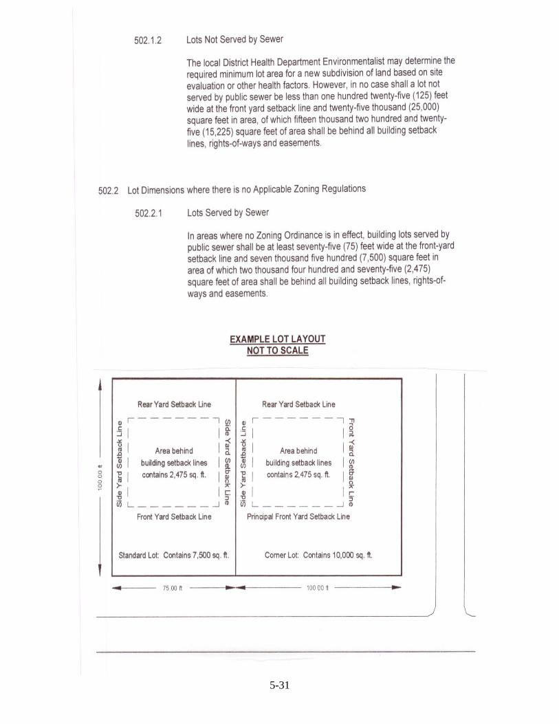
502.1.1 Lots Served by Sewer
The size, shape and orientation of lots must be appropriate for the proposed type of development and conform to these Subdivision Regulations and applicable Zoning Ordinances.
5-30
5-31

5-32

502.3 Maximum Depth
The maximum depth of a new subdivision of land shall not be greater than four (4) times its width at the front yard setback line. This includes all new lots, flag lots, and tracts larger than ten (10) acres. The width / depth ratio for flag lots shall exclude the access strip or “panhandle”. However, the access strip or “panhandle” should not extend greater than five hundred (500) feet.
502.4 Principal Buildings
Only one principal building shall be permitted on an individual lot except for Planned Unit Developments and Horizontal Property, see Section 304.0 and 305.0.
503.0 BUILDING SETBACK LINES
A building setback line is a line located in the interior of a lot, which identifies where no building may be located.
503.1 Required Minimum Building Setback Lines:
503.1.1 Front-Yard Setback Line: A line in the interior of a lot parallel with and measured a specific distance from the street right-of-way line. No buildings shall be placed in the space between the front-yard setback line and the right-of-way. Lots that front on more than one street or right-of-way must have a front-yard setback line for each specific side designating one as the principal front-yard setback line.
503.1.2 Principal Front-Yard Setback Line: A line in the interior of a lot, parallel with and measured a specific distance from the street right-of-way line. A principal front-yard setback line establishes the direction a principal structure must face on a lot with multiple road frontages. No buildings shall be placed in the space between the principal front yard setback line and the right-of-way. In no case shall this distance be less than thirty-five (35) feet.
503.1.3 Rear-Yard Setback Line: A line in the interior of a lot, parallel with and measured a specific distance from the rear property line. No buildings shall be placed in the space between the rear-yard setback line and the rear property line. In no case shall this distance be less than twenty (20) feet.
503.1.4 Side-Yard Setback Line: A line in the interior of a lot, parallel with and measured a specific distance from the side property line. No buildings shall be placed in the space between the side-yard setback line and the side property line. In no case shall this distance be less than ten (10) feet.
5-33

5-34

5-35
504.0 HORIZONTAL PROPERTY AND PLANNED UNIT DEVELOPMENTS
504.1 A minimum of two (2) acres, exclusive of streets, in single ownership shall be developed.
504.2 Minimum Yard Requirements, except as provided in local Zoning Ordinances: Total Width Minimum Width Front yard 35 feet. Rear yard 20 feet Side Yard Attached dwellings, none. End dwellings of attached or semi detached dwellings, 10 feet 504.4 Height Maximum building height is thirty (30) feet, except as provided in local Zoning Ordinances. 504.5 Minimum Area Requirements, except as provided in local Zoning Ordinances:
For proposed developments that are not served by public sanitary sewer the local District Health Department Environmentalist shall determine the required minimum lot area for each proposed unit based on site evaluation or other health factors.
There shall be a minimum open space area or play area of one-half acres per two (2) acres or a fraction thereof developed, exclusive of streets, public ways and parking areas.
504.6 Other Requirements
504.6.1 The total dwelling units in any group of attached dwellings shall not exceed ten (10) units.
504.6.2 It shall be the responsibility of the Developer to make the necessary provisions for the perpetual maintenance of open areas and parking areas subject to the approval of the Planning Commission.
504.6.2 Off-street parking may be permitted either in communal parking garages or areas to which each property owner holds any individual share or on individual lots.
505.0 MOBILE HOME PARKS
All mobile home park developments shall be reviewed in accordance to the subdivision application procedure and approval process, Article 4, and all other provisions of these Subdivision Regulations.
505.1 Permitted
Only mobile and manufactured homes shall be permitted in mobile home parks.

5-36
505.2 Area and Density Requirements
No mobile home park shall be permitted on a lot with a net area of less than three (3) acres in size. The Developer may be permitted to develop the park in stages if the Developer complies with the overall approved plan and has further developed a minimum of ten (10) mobile home spaces for use.
505.3 Mobile Home Space Requirements
Individual mobile home lots within a mobile home park shall not be less than four thousand (4,000) square feet in area where public sanitary sewer is available. For mobile home parks not served by public sanitary sewer the local District Health Department Environmentalist shall determine the required minimum lot area for each proposed unit based on site evaluation or other health factors. The minimum lot width shall be forty (40) feet. In no instance shall more than one mobile home be permitted on a single lot.
505.4 Setback and Spacing
No mobile home or structure shall be located closer than thirty-five (35) feet to a public street right-of-way. No mobile home shall be closer than twenty-five (25) feet from a street within the mobile home park, common parking areas or other common areas. Mobile homes shall be separated from each other and from any other buildings or property lines of the park by at least twenty-five feet (25) feet.
505.5 Frontage
All mobile home parks shall front on a public street or road for at least one hundred fifty (150) feet.
505.6 Streets
All mobile home lots shall abut upon a street. All streets within the mobile home park shall have a right-of-way of not less than fifty (50) feet and a pavement of not less than twenty-two (22) feet wide. Each park shall have at least one street, which gives access to a public street. Such access streets, in either a single mobile park or adjoining parks, shall not be less than 100 feet apart. All streets within the park shall be hard-surfaced as specified in Section 609.0 and 610.0 of these Subdivision Regulations. All streets in the park shall be well lighted.
505.8 Parking
One paved automobile parking area shall be provided on every mobile home lot, plus one (1) parking space for each mobile home lot. This additional parking may be in a central location, but in no case shall such parking be more than three hundred fifty (350) feet from the mobile home space for which it is provided.
505.9 Utilities
All lots within the mobile home park shall be provided with the necessary public utilities.
505.10 Accessory Structures
No accessory structure including patios and pads shall be located within ten (10) feet from any mobile-home lot line.
5-37
505.11 Expansion of Existing Mobile Home Parks
These regulations shall apply to the expansion of any existing mobile home park either present at the adoption of this regulation or in the future.
505.12 Administrative Procedure
The applicant must submit a Preliminary Plat, Development Plan, and Final Plat in compliance with this regulation. The Final Plat shall also show the following information:
505.12.1 Public areas such as visitors parking, recreational areas, etc., if such areas are proposed.
505.12.2 Large-scale plan of one typical mobile home lot showing mobile home location, automobile parking space, etc.
505.12.3 Location of planting for landscaping purposes or as required for protective buffer purposes as a special condition.
505.13 Special Conditions
The Planning Commission may attach reasonable special conditions to its approval of a mobile home park. The applicant must present a valid construction permit from the State Department of Health, Division of Environmental Health, Sanitation Program, Frankfort, Kentucky, as required by Kentucky Revised Statutes 219.150.
506.0 OFF -STREET LOADING AND PARKING FACILITIES
506.1 Required Off-Street Parking Where There Are Zoning Ordinances:
Off-street parking shall be provided in accordance with local Zoning Ordinances where such regulations are in effect.
506.2 Required Off-Street Parking Where There Are No Zoning Ordinances:
Where no local Zoning Ordinance is in effect, off-street automobile storage or standing space shall be provided on any lot on which any of the following uses are hereafter established; such space shall be provided with vehicular access to a street or an alley. For purposes of computing the number of parking spaces required in a given area, total area for parking and maneuvering shall be calculated at no less than two hundred seventy (270) square feet per parking space. The following are minimum requirements for specific uses:
506.3 Off-Street Parking Standards Where No Local Zoning Ordinance is In Effect
The following standards comprise the minimum off-street parking requirements for the several common types of buildings and uses listed below:
506.3.1 Assisted Living Facilities: Two (2) spaces for every three beds or 0.66 spaces per bed.
506.3.2 Auditorium, Theater, Church or Stadium or Other Similar Use: One (1) space for each five seats available at maximum capacity.
506.3.3 Boarding Houses and Rooming Houses: One (1) space for each

room occupied or intended for occupancy by boarders or roomer in addition to the requirements for dwellings.
506.3.4 Commercial or Retail Use: Four (4) spaces for the first thousand (1,000) square feet of floor space used for the sale of merchandise, and one additional space for each additional 250 square feet of such floor space.
506.3.5 Dwellings: Two (2) spaces for each family dwelling unit.
506.3.6 Elementary and Middle Schools: Two (2) spaces for each classroom.
506.3.7 Hospitals: One space for each four beds.
506.3.8 Hotels and Motels: One (1) space per unit plus one space for each three employees. If a restaurant comprises part of the use, the restaurant parking standards shall be required in addition to the above requirements.
506.3.9 Manufacturing and Warehousing: One (1) parking space for each two
(2) employees at maximum employment on a single shift plus one car space for each truck operated by the business.
506.3.10 Nursing Homes: One Space for each two-hundred (200) square feet of gross floor area.
506.3.11 Offices: One (1) space for each two hundred (200) square feet of gross floor area.
506.3.12 Restaurant: One (1) space for each three seats available at maximum capacity. Employee parking shall be provided at the ratio of one space for each three (3) employees.
506.3.13 Uses not elsewhere specified: One (1) space for each two hundred (200) square feet of gross floor area. The Planning Commission may require additional space if it deems necessary.
506.4 Off-Street Loading and Unloading Regulations for Trucks
Every new building or structure intended for use for business or trade shall provide not less than one loading and unloading space that will accommodate semi-trailers and tractors for the loading and unloading of vehicles off the street or public alley. Such space shall have access to a public alley or, if there is no alley, to a public street.
506.5 Additional Parking, Loading and Unloading Regulations
The arrangement of off-street parking space shall be:
506.5.1 Off-street parking space required for any building or use may be located within 400 feet from the premises it serves, but detached there from--or may be consolidated into a large parking area serving other buildings and uses. The Planning Commission must approve either arrangement. Such parking space, if allowed, shall be deemed required space associated with the permitted use and shall not hereafter be reduced or encroached upon in any manner.
5-38
506.5.1.1 Proof of Availability
The Planning Commission may require a plat, deed, and any other proof necessary to show that required parking space, if located off the premises it serves, is controlled by and available to the applicant prior to the granting of a building permit.
506.5.1.2 Surfacing of Parking, Loading, and Unloading Spaces
Parking, loading, and unloading spaces and the access thereto shall comply with current street design standards of these regulations.
507.0 EASEMENTS
Provisions shall be made in every subdivision for a satisfactory electric, telephone, water and gas supply system. Local utility companies that serve the new developments will have the opportunity to review Preliminary Plats, Development Plans and final plans before approval is granted. Each local utility company may request specific easements regarding the proposed new development. The Planning Commission’s Administrative Officer will review the request and determine if the Developer shall incorporate them within their Development Plan.
507.1 Except where alleys are permitted for the purpose, the Planning Commission shall require easements at least twenty (20) feet in width centered along all front, side or rear lot lines for poles, wires, conduits, storm sewers, sanitary sewers, gas mains, water mains, and other utility facilities. Where necessary, the Planning Commission may require easements along side lot lines or across lots.
507.2 Dedication and Connection to Existing Utility Facilities
Whenever land is being subdivided and existing utility facilities are shown on a plat without a dedicated easement, the Developer shall dedicate the necessary easements to accommodate the facilities. When necessary, utility and drainage easements shall connect with existing easements on adjoining properties.
507.3 High Tension Power Lines and High Pressure Pipelines
Where there exists any surface or underground utility, such as high-pressure pipelines, power lines or main lines for water and sewage, the plot plan shall indicate by centerline and all other data available from the utility company the exact location of such facilities and the area of the easement or right-of-way.
To lessen the hazard of such pipe or power lines, the Developer shall comply with the conditions and requirements of the respective charters, ordinances, and/or specifications of the public or private utility owning the particular rights-of-way. Such subdivisions shall also meet the following special conditions:
507.3.1 Streets passing directly beneath high-tension power lines or across high pressure pipelines shall run, as nearly as possible, at right angles to the easements and in no case shall make an angle of less than sixty (60) degrees with the easement at the intersection.
507.3.2 Subdivisions shall be designed so as to best minimize the encroachment of an easement on the lots within the subdivisions.
507.3.3 Septic disposal fields, septic tanks and all appurtenances shall be on the same side of the easement as the building they will serve, unless a
5-39
Kenny Isenberg
Highlight

waiver is granted, in writing, by the local District Health Department, Utility Companies Occupying the easement, and the Planning Commission.
508.0 SURVEYING AND MONUMENTATION STANDARDS
Every boundary corner location which is determined by a land survey on the subdivision property shall be monumented or witness monumented as described and required of every Registered Land Surveyor in Kentucky as specified in Minimum Standards of Practice for Land Surveyors in Kentucky (current addition available from the Kentucky State Board of Registration).
508.1 Iron Pin Monuments
Iron pin monuments three-fourths (3/4) inch in diameter and at least twenty-four (24) inches long shall be placed at all new lot corners. These pins shall be placed only after all grading and other construction has been completed. A guard stake at least 1" x 3" x 24" shall be placed next to each pin with the lot number and the number of the adjoining lot plainly lettered on the flat faces of the stake.
New or existing monuments other than iron pins, such as trees, stones, fence post, etc., shall be referenced to an existing or set iron pin.
509.0 SANITARY SEWAGE SYSTEMS
509.1 Availability of Public Sanitary Sewer Collection System
The Planning Commission shall utilize the following criteria to determine if a Public Sanitary Sewer system should be connected to a proposed development:
509.1.1 The distance from the proposed development site to the existing Public Sanitary Sewer renders connection economically unfeasible; or
509.1.2 Extraordinary measures would be required to construct a system acceptable to the local sewer agency due to unusual topography or other factors.
509.2 Where Public Sanitary Sewer Systems are Accessible
Where the public sanitary sewer system is reasonably accessible or available to the proposed subdivision, the Developer shall construct a subdivision sewer system in accordance with the applicable regulations and connect the subdivision system to the public system.
509.3 Where Public Sanitary Sewer Systems are Not Accessible
Where public sanitary sewer is not available, the Developer shall complete one of the following:
509.2.1 Secure approval of lot sizes for Individual Disposal Systems from the local District Health Department Environmentalist (See Section 502.0); or
509.2.2 Construct a complete Package Treatment System in accordance with the applicable law and regulations.
5-40

509.4 Individual Disposal System
An individual disposal system is a septic tank and disposal field or other approved system constructed, in accordance with the applicable law and regulations, to service an individual lot or tract. Once an individual disposal system is approved by the applicable agency the area of the system cannot be subdivided from the parcel it serves unless a replacement system is installed in accordance with the applicable agency.
509.5 Package Treatment System
A package treatment system is designed to service multiple lots or tracts. All package treatment systems shall be constructed in accordance with the applicable law and regulations.
510.0 BUILDING SITE CONSTRUCTION
510.1 The Building Site Shall Be Free From Flooding
No building site shall be constructed in the flood plain. No building site shall be constructed to create or increase a flooding condition. The building site on each lot shall be at least twelve (12) inches above the elevation of the street pavement. Otherwise, the Developer shall provide a certification by a Professionally Licensed Engineer that the proposed drainage plan will render the site free from flooding.
510.2 Sinkholes
Sinkholes and other similar depressions and the area within twenty-five (25) feet horizontally from the lowest point of said sinkhole or that area subject to periodic flooding, whichever is greater, shall be preserved in its natural state for the purpose of providing drainage of the surrounding area. In cases where it is proposed to fill a sinkhole the Developer shall have a geotechnical report, prepared by a Registered Professional Engineer, with recommendations on the design and construction of the fill area. All subdivision plats shall show sinkhole areas.
510.4 Wells
All subdivision plats shall show the location of existing wells.
510.5 Use of Fill
Any fill used on a building site shall be free from trash, foreign objects, organic material, top soil, soft clay, spongy material, and other objectionable material. The fill material must be layered and compacted in layers not to exceed eight (8) inches in height before each compaction.
5-41

Article 6. STREET DESIGN STANDARDS 600.0 GENERAL
All streets in a proposed subdivision shall conform to these Subdivision Regulations. See Article 11 for construction and inspection procedures and Exhibit 7 for detail construction specifications.
601.0 RESPONSIBILITY FOR STREET CONSTRUCTION
The Developer and any Successor in Title shall be liable and responsible for the construction, maintenance or reconstruction of any improvements required by the Subdivision Regulations. Upon completion, inspection and approval of the street and other required improvements, the appropriate legislative body shall be notified by the Planning Commission that the development has been finally inspected and approved by the Commission.
602.0 STREET RIGHT-OF-WAY STANDARDS
602.1 Dedication of Right-of-Way
Sufficient right-of-way is required to contain the elements of:
• Sufficient street pavement; • Curbing or drainage ditches; • Sidewalks where required; • One street parking; • Public utilities such as water, sewer, and natural gas; and • Turn lanes where required.
602.2 Minimum Right-of-Way Width
The following table gives the minimum right-of-way width:
Street Type Right-of-Way Width
Collector Streets 80 feet
Local Streets
Residential Through, Commercial, and 60 feet Industrial Streets Residential Streets (No Through Streets) 50 feet Marginal Access Streets (Frontage 50 feet Roads) Alleys 30 feet
6-42

602.3 Increased Right-of-Way Necessary
The Planning Commission may require additional right-of-way width when the stated minimum is not adequate due to a dividing median, turning lanes, special ditch line consideration, potential for future development, or similar circumstances. Developments platted along existing streets shall dedicate additional right-of-way necessary to meet the minimum width requirements specified in these regulations. Should the possibility of obtaining additional right-of-way exist, the Planning Commission may reduce the increased dedication up to one-half (1/2) the total necessary to meet the minimum width requirements specified.
602.4 Conflicting Traffic or Land Use
When a proposed subdivision contains or is adjacent to existing or proposed railroad rights-of-way, arterial street rights-of-way, other significant rights-of-way, or conflicting and detrimental land uses; the Planning Commission may require marginal access streets, reverse frontage lots, lots with rear service alleys, lots with additional depth, or other measures which may be necessary for protection of abutting properties and the maintenance or function of major traffic arteries.
603.0 EXISTING STREETS AND ROADS
603.1 Existing Roadways
Where the Planning Commission finds that an existing street abutting and/or giving access to a proposed subdivision has a roadway that is insufficient in width, grade, alignment, surface or drainage to provide adequate access for the traffic to be generated by the proposed subdivision without undue hazards to vehicles and pedestrians, the Development Plan for the proposed subdivision shall include the necessary improvements of the existing street as set forth by the Planning Commission. The above conditions and necessary improvements shall pertain to that portion of the existing street abutting the subdivision or the entire street from the proposed subdivision to a suitable existing street as deemed necessary by the Planning Commission.
603.2 Existing Grades
Where the grade of an existing street will be materially higher or lower than the proposed lots fronting on it, the Planning Commission may, for reason of providing adequate sight distance on driveways, alleviating excessive or hazardous slope, or excessive run-off, require any lot or any part of such lot to be regraded as necessary to be in harmony with the street grade and/or provide slope rights. In any case, where the finished grading of a lot fronting on an existing street will cause drainage problems in that street, the Developer shall, at his expense, install drains in the street or make such other provision as may be necessary to correct the condition.
603.3 Subdivision on Both Sides of Street
Where the subdivision is on both sides of an existing roadway, sufficient right-of-way shall be dedicated to give the street the required right-of-way.
603.4 Subdivision on One Side of Street
Where the subdivision is to take place on only one side of a street, one-half (1/2) of the right-of-way needed to give the street the required right-of-way shall be dedicated.
6-43
603.5 Turning Lanes
When the Planning Commission determines that vehicles turning into a proposed subdivision will adversely affect the capacity of the existing roadway, the Developer shall dedicate sufficient right-of-way and construct a turning lane as necessary to maintain the capacity of the existing roadway.
604.0 STREET EXTENSIONS
604.1 Extension of Present Streets
The street layout of the proposed subdivision shall provide for the continuation or extension of streets already existing in areas adjacent to the area being subdivided unless the Planning Commission deems such continuation or extension undesirable for specific reasons of topography or design.
604.2 Extension of Proposed Streets
Where the Planning Commission determines it is desirable to provide street access to adjoining properties, proposed streets shall be extended by dedication to the boundaries of such properties. Newly constructed streets that dead-end are required to provide a vehicular turn-around.
604.3 Required Width
The street system for the proposed subdivision shall provide for extending existing streets at the same or greater width, but in no case shall a street extension be of less width than the minimum width required in these regulations for a street in its category.
604.4 Half Streets
Dedication of new half-streets along tract boundaries shall not be permitted except to complete the other half where such a street has been previously platted.
605.0 PRIVATE STREETS AND RESERVE STRIPS
605.1 Private Streets
There shall be no private streets platted
within a subdivision.
605.2 Reserve Strips
There shall be no reserved strips in a
subdivision except where there is a vested
interest by a local legislative body and the
conditions of the reserved strip is approved
by the Planning Commission and the local
legislative body.
6-44

606.0 STREET NAMES AND ADDRESSES
606.1 Street names shall be approved by Hart County 911 with no duplication permitted.
606.2 The Developer shall establish the principal front yard, or direction that a principal building must front, for all corner lots. Hart County 911 shall assign addresses for all proposed Major Subdivisions. One address will be assigned for each lot designating the appropriate street name and number. The Major Subdivision plat shall note all assigned addresses and receive approval by Hart County 911.
606.3 Proposed streets which are obviously in alignment with other already existing and named streets shall bear the names of such existing streets, except in areas where Hart County 911 determines that a new road name be assigned for addressing purposes.
606.4 No duplication of street names shall exist, irrespective of the use of a different street suffix.
606.5 Standard Suffix Abbreviations
Periods, hyphens, commas, and question marks are not to be included in road names. Standard abbreviations listed below shall be used:
Avenue AVE Pass PASS Boulevard BLVD Path PATH Cemetery CEM Place PL Circle CIR Plaza PLZ Court CT Road RD Drive DR South S East E Spur SPUR Estate(s) EST Square SQ Highway HWY Street ST Lane LN Terrace TER Loop LOOP Trail TRL Manor MNR Trailer Park TRLR PK North N Way WAY Park PARK West W Parkway PKY 607.0 STREET INTERSECTIONS
607.1 Number of Approaches
Intersections involving more than four basic street approaches shall be prohibited. Merging lanes and deceleration lanes are considered as parts of one street approach.
607.2 Angle of Intersection
For a tangent distance of at least one hundred (100) feet, measured from the intersection of right-of-way lines, all streets should intersect at an angle of ninety (90) degrees.
607.3 Radii at Intersection
6-45

Street curb and edge intersection shall be rounded by radii of at least twenty (20) feet.
607.4 Street Jogs
Street jogs with centerline offsets of less than one hundred and fifty (150) feet for local and three hundred (300) feet for collector streets shall not be made. Only direct approaches in a straight line across from an existing centerline shall be allowed within these minimum distances.
607.5 Excessive Grades at Intersections
When a street grade at the approach to an intersection exceeds three (3) percent, a leveling area shall be provided with grades of not greater than three (3) percent for a distance of fifty (50) feet from the intersection of street centerlines. Vertical curves shall then be used to connect the intersecting grades.
607.6 Minimum Intersection Spacing The minimum standards for intersection spacing measured from centerlines shall be as follows: Major Street Type Intersected Minimum Spacing Arterial Streets 500 Feet* Collector Streets 300 Feet Local Streets 150 Feet
* May vary based upon the recommendation of the Kentucky Department of Transportation.
607.7 Sight Distance at Intersections
The sight distance at intersections is the distance from the stopped vehicles to as far left or right, the driver can see. The minimum stopping sight distance shall be as follows:
If Intersecting with a: Minimum Distance Arterial Streets KDOT* Collector Streets 250 Feet* Local Streets 200 Feet
* May vary based upon the recommendation of the Kentucky Department of Transportation.
6-46

608.0 STREET CLASSIFICATION
608.1 Arterial
All streets classified as arterial streets by the Comprehensive Plan for Hart County may be considered as limited access in accordance with the Kentucky Revised Statutes 177.220 to 177.310, defined herein as fully or partially controlled access. The Planning Commission shall approve all points of access.
608.2 Collector
A Collector Street functions to conduct traffic between major arterial streets, minor activity centers, and local streets. Direct access to abutting property should be discouraged whenever possible. Collector streets may be further divided into two classes:
608.2.1 Major Collector
Major collectors carry the majority of traffic entering arterial streets. For major collectors, the concept of service to abutting land should be subordinate to the provision of travel for major traffic movements. Generally, major collectors are State maintained roads. Directional flow may be served by one or two lanes in each direction. Parking is not permitted.
608.2.2 Minor Collector
A collector street primarily serves residential or commercial development. Roadways within this classification are intended to convey traffic to an adjoining major collector or arterial street. Parking is not permitted.
608.3 Local
For the purpose of providing vehicular access and for service to abutting property. Directional flow is served by one lane in each direction. Parking may be permitted. Layout should discourage through traffic.
608.3.1 Through
A local street with two ends open to vehicular traffic. The primary purpose of the residential (through) street is to conduct traffic to and from dwelling units to other streets within the street system. The length of a residential (through) street shall not extend over 1500 feet without an intersecting street.
608.3.2 Cul-de-sacs and Tee Turn-Arounds
Local streets that are designed to have one end open to vehicular traffic and the other end terminated by a permanent vehicular turn-around. Cul-de-sac streets shall not be longer than fifteen hundred feet (1500). Tee turn-Arounds may only be used for new streets less than five hundred (500) feet or as temporary turn-arounds for developments with proposed future expansion.
608.3.3 Temporary Tee Turn-Arounds
6-47Temporary tee turn-arounds may be used for residential developments

with proposed future expansion. Once development occurs extending a proposed street beyond the temporary turn-around, the aforementioned right-of-way may be deeded to the adjoining property owner(s) if the appropriate legislative body approves a recommendation by the Planning Commission to close the right-of-way. Temporary tee turn-around areas shall be clearly marked on the plat. A written application shall be filed with the Planning Commission and approval noted in the Planning Commission minutes before any temporary turn-around area shall be deeded.
608.3.4 Loop
A local street where both ends terminate at an intersection with the same street. The length of the loop shall not be more than three thousand feet (3000) from the intersecting street.
608.3.5 Marginal Access (Frontage Roads)
Where the proposed subdivision abuts upon or contains an existing or proposed street or highway on which traffic volumes or vehicular speeds warrant special safety considerations, the Planning Commission shall require that marginal access streets be provided in order that no lots will front on such existing or proposed street or highway.
608.3.6 Alleys
Alleys may be provided to give access to the rear of all lots used for business and industrial purposes. Alleys are not required in residential blocks except in cases where the Developer produces evidence of the need for alleys that are satisfactory to the Planning Commission.
608.3.7 Dead-End Streets
A dead-end street is a local street that provides no vehicular turn-around at the closed end. This type of street is not allowed in new proposed developments.
609.0 PAVEMENT DESIGN FOR STREETS
609.1 Residential Streets (No Through Streets) Streets shall be constructed in conformance with the following pavement specifications: Subgrade 6 inches Compacted Subgrade (95% Standard Proctor) Asphalt 6 inches DGA (84% Compaction) 2 inches Base Asphalt 1-1/4 inch Surface Asphalt Concrete 6 inches DGA 7 inches Concrete 609.2 Residential Through Streets shall be constructed in conformance with the following pavement specifications: 6-48

6-49

6-50

6-51

611.2 Requirements when Curb and Gutter are waived
611.2.1 Required Drainage Ditches
Drainage ditches shall be constructed within the street right-of-way. The ditches shall be of adequate size to carry the run-off water and to prevent flooding. The Planning Commission may require concrete lined ditches, grass sod, riprap, or any other improvements needed to prevent flooding and erosion. The ditch line shall be a distance of ten (10) feet or more from the edge-of-pavement on an arterial or Collector Street. On local streets, the drainage ditch line shall be at least six (6) feet from the edge-of-pavement. The shoulder, ditch, and remaining right-of-way shall be sowed in grass seed and covered with straw from the edge-of-pavement to the right-of-way line.
611.2.2 Access Points
Access to lots along streets where drainage ditches are used shall be either by a spill or over a culvert.
611.2.2.1 Use of a Spill
Where a spill is used, it shall be so designed as to prevent water from crossing the ditch. At the ditch line, the spill shall be at least six (6) inches below the street pavement right-of-way line and constructed to allow the free flow of water through the ditch. The spill shall be constructed of Portland cement at least six (6) inches thick and it shall start at the edge-of-pavement and may stop at the right-of-way line.
611.2.2.2 Use of a Culvert
Where a culvert type access is used, an opening of at least fifteen (15) inches shall be made under the access at the ditch line. The Planning Commission may require a greater opening where necessary. Bulkheads shall be constructed on each side of the opening to prevent erosion. The opening shall be constructed so as to maintain the flow of water in the ditch. Steps shall also be taken to prevent the flow of water over the access either from the lot to the street or from the street to the lot.
612.0 SIDEWALKS
For the safety of pedestrians in Major Subdivisions containing lots or tracts less than ten (10) acres, the Developer may construct sidewalks within the street right-of-way on one side of the street.
6-52

612.1 Required Width and Size 612.1.1 Single-Family and Multi-Family Developments Four (4) feet wide and four (4) inches thick. 612.1.2 Commercial Developments Six (6) feet wide and four (4) inches thick. 612.2 Sidewalks along Marginal Access Streets
Where a marginal access road parallels an arterial street, the Planning Commission may waive sidewalks along the arterial street and on the inside of the marginal access street. Sidewalks shall be required on the outside of the marginal access street.
612.3 Sidewalks Adjacent to Streets
Sidewalks shall be placed in the right-of-way parallel to the street and at least three (3) feet from the back of the curb or pavement.
613.0 STREET ALIGNMENT
Horizontal Curve Radius
The minimum horizontal curve radius shall be as follows:
Street Type Minimum Curve Radius Collector Streets 400 feet Local Streets Residential Through, Commercial, 200 feet and Industrial Streets Residential Streets (No Through 175 feet Streets) 614.0 CLEAR SITE DISTANCE No plant materials or manmade objects will be permitted which obstruct visibility from thirty (30) inches high upwards to the sky within the triangular area formed by a straight line connecting the points on the center lines of the street at a distance or ninety (90) feet from their intersections, see example below:
6-53
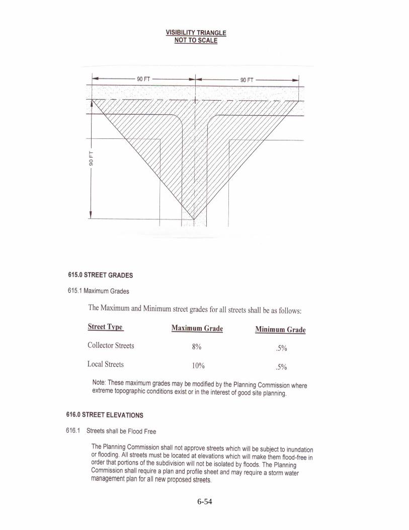
6-54

6-55

Article 7. WATER SUPPLY AND FIRE HYDRANT REQUIREMENTS 700.0 WATER SUPPLY SYSTEM AND FIRE HYDRANT INSTALLATION REQUIREMENTS
The Planning Commission shall require new Major Subdivisions, any series of Minor Subdivisions totaling six (6) or more lots from the parent tract, Mobile Home Parks, Horizontal Property, Planned Unit, Multi-family, Commercial, and Industrial Subdivisions to comply with the Water Supply and Fire Hydrant Requirements of this Article.
Land that is subdivided into large tracts of at least ten (10) contiguous acres shall be exempt from the requirements of this Article until it is resubdivided according to the requirements listed above. Once land is subdivided into any series of lots totaling five (5) or more from the parent tract no portion of the property subdivided may be resubdivided into tracts of less than ten (10) contiguous acres in size until adequate water supply service and fire hydrant improvements have been constructed or a guarantee presented by the proposed subdivider and approved by the Planning Commission and the applicable water agency.
Any plat or subsequent plats that exhibit a tract subject to these requirements shall contain the Future Development Requirements Certificate (Exhibit 5 – Certificate 17) shown below:
FUTURE DEVELOPMENT REQUIREMENTS
No portion of the property shown hereon may be resubdivided into building lots or tracts of less than ten (10) acres until an adequate water supply system and fire hydrant protection is supplied by the proposed subdivider and approved by the Planning Commission and applicable Water Agency. This Certificate shall be shown on all subsequent plats that exhibit any portion of this property until the abovementioned requirements are met.
701.0 WATER SUPPLY REQUIREMENTS
The Developer shall construct a complete water distribution system according to these specifications:
701.1 Water mains shall be no less than six (6) inches in diameter including fire hydrant branch connections and shall be installed in accordance with all applicable regulations of the local water agency having jurisdiction.
701.2 The distribution system shall be equipped with a sufficient number of valves so located that breakage or other interruption will not cause the shut down of any portion of a main greater than 1500 feet. Wherever meters are installed in conjunction with fire hydrants, said meters shall be of the fire protection type and at least six inches in size.
7-56

702.0 FIRE HYDRANT REQUIREMENTS
The Developer shall supply fire hydrant protection according to these specifications:
702.1 Each subdivision shall have fire hydrant spacing within the following distances:
500 feet distance -1 hydrant
1000 feet distance -2 hydrants
1500 feet distance -3 hydrants
702.2 No part of the exterior of the buildings, other than dwellings, shall be further than 500 feet from a hydrant. Distances are to be measured along the shortest feasible exterior route (never measured through buildings) for laying hose.
702.3 Fire hydrants must be located at least 25 feet from the exterior wall of any masonry building, and at least 50 feet from any exterior wall of frame or equivalent construction, including brick and stone veneer.
702.4 Written approval of the Fire Chief or Assistant Chief of the responsible community fire department shall be obtained prior to the approval of all Major Subdivision Final Plats.
702.5 Before final approval of a plat or issuance of an occupancy permit, the Developer must install required fire hydrants, produce a receipt paid in full from the local water authority for fire hydrant installation, or post a cash bond in an amount equal to the cost in which the local water authority charges per fire hydrant to be installed. The bond shall be issued to the Planning Commission and if hydrants are not installed within sixty (60) days of final approval of plats, forfeiture of bonds will take place or occupancy permit shall be denied in addition to forfeiture of bond.
702.6 Fire hydrants shall not be blocked by vegetation. Fire hydrants shall not be blocked at any time by vehicles, fences, buildings, or other enhancements to property. In no case shall any of the aforementioned items be closer than ten feet (10) to a hydrant, excepting livestock holding fences which may exist no closer than two feet (2) to a hydrant. However, no fence shall be built between a hydrant and the highway serving that hydrant.
703.0 FIRE HYDRANT TYPE
703.1 Fire hydrants shall meet the minimum specifications and be installed in conformity with the requirements of the local water authorities.
703.2 Fire hydrants shall be equipped with not less than two 2-1/2 inch outlets and a 4-1/2 inch pumper outlet.
703.3 A gate valve must be installed in the hydrant connection to the road main.
703.4 The color of the hydrant shall be consistent with National Code.
7-57

Article 8. DEVELOPMENT PLAN REQUIREMENTS
800.0 PURPOSE
The purpose of this Article is to establish requirements for detailed Development Plans. The Development Plan is intended to provide a single uniform procedure for total review of a proposed development. In this manner, the Planning Commission can review all aspects of a proposal simultaneously; thus, reducing the time requirement for review.
801.0 APPLICABILITY
A Development Plan is required for all Major Subdivisions containing lots or tracts less than ten (10) acres or any subdivision development that in the estimation of the Planning Commission because of its location, magnitude, or unique character, such plan will best serve the interest of orderly urban growth in Hart County. A Developer must comply with the Development Plan requirements listed below and to the Development Plan requirements of local ordinances or regulations. This allows local government agencies to impose more restrictive Development Plan Requirements. The Planning Commission shall not approve a Major Subdivision Final Plat, until the Development Plan has first received approval.
802.0 CONTENT REQUIREMENTS
The Development Plan shall show the proposed locations, sizes, types, grades, and general design features of each development area. The plan shall be based upon reliable field data and be at a scale no more than one hundred (100) feet to one (1) inch unless approved to do otherwise by the Planning Commission Administrative Officer.
802.1 Authorization to prepare plans
All Development Plans shall be prepared and signed by a Registered Land Surveyor and/or Registered Professional Engineer dependent upon development content, see Exhibit 5 – Certificate 2 and Certificate 3.
802.2 Paper Size
All Development Plans shall be drawn on paper of a size 11" x 17", 18" x 24" or 24" x 36". More than one (1) sheet may be used. Sheets shall be numbered in sequence if more than one (1) sheet is used and each shall be labeled Development Plan.
802.3 Title Block
It shall have a title block located in the lower right-hand corner of the plat. It shall contain the following information:
802.3.1 Name of the subdivision or development.
802.3.2 The name, mailing address, and telephone number of the property owner(s);
802.3.3 The name, mailing address, and telephone number of the Developer(s);
8-58
802.3.4 Graphic and written scale;
802.3.5 North arrow;
802.3.6 Date of preparation;
802.3.7 Property Valuation Administration (PVA) number of property being subdivided, and;
802.3.8 All other pertinent legend data.
802.4 Topographic Map
A topographic map shall show the following:
802.4.1 Topographic contour lines must be depicted with sufficient accuracy to permit the planning of drainage, streets, and other proposed improvements. The plans must include two-foot (2’) contours on land less than five percent (5%) gradient and five-foot (5’) contours on land more than five percent (5%) gradient. The contour lines are not to be more than one hundred feet (100’) apart horizontally and shall extend for at least 40 feet beyond the boundary lines of the proposed development;
802.4.2 Contours shall relate to the United States Geological Survey (USGS) of the area and shall relate to the nearest benchmark. All Contours shall be marked in feet above sea level. The benchmark shall be clearly shown;
802.4.3 Size, top of frame and invert elevations for all culverts, manholes, or catch basins and flow line elevations for all brooks at 100 foot stations. This data for at least 40 feet beyond the boundary lines of the proposed development;
802.4.4 Sinkholes shall be clearly labeled and their low point clearly marked;
802.4.5 All existing watercourses, inland wetlands, floodplains and flowage easements;
802.4.6 Present wooded areas indicated by foliage line;
802.5 Adjacent Property Owners
The Development Plan should show adjacent property and name of adjacent property owners.
802.6 Lotting and Building Setback Lines
All building setback lines shall be shown on the plans. The proposed location of all buildings and structures shall be described.
802.7 Existing and Proposed Street
The names, locations, pavement widths and types, and right-of-way widths of all existing platted streets or proposed streets shall be shown. The distance to the nearest intersection shall be shown.
802.8 Street Profiles
The plan and profile of each proposed street, with elevations and distances for the existing and proposed ground and street grade surface, shall be shown.
8-59

802.9 Street Cross Sections
A typical cross section of each proposed street or other construction item, showing the width of pavement, the location and width of curbs, gutters, and sidewalks, and rights-of-way shall be submitted.
802.10 Soil Erosion and Sedimentation Control Plan
A Soil Erosion and Sedimentation Control Plan are required for all Subdivisions that require major construction of site Improvements. See Article 9 for Soil Erosion and Sedimentation Control Requirements.
802.11 Storm Water Management Plan
A Storm Water Management Plan shall be filed as part of the Development Plan Requirement for proposed Major Subdivisions where curb and guttering is required or being constructed and for proposed Major Subdivisions being developed within any “City Limits”. See Article 10 for Storm Water Management Requirements.
802.12 Grading Plan
Grading Plans showing proposed contours shall accompany all Storm Water Management Plans.
802.12.1 Lot Grading
Lot grading shall be accomplished as follows: Within the limits of the public right-of-way adjacent to street pavements, all final grading for grass strip, sidewalk, and yards to the building structure, shall comply with minimum and maximum grades in accord with typical sections for streets as shown in these regulations.
802.12.2 Top Soil
If grading results in the stripping of topsoil, topsoil shall be uniformly spread over the lots as grading is finished. Temporary silt barriers should be installed around stockpiled topsoil for erosion and sediment control.
802.12.3 Trees
As many trees as can be reasonably utilized in the Development Plan shall be retained and the grading adjusted to the existing grade of the trees where practicable.
802.13 Typical Drawings
All typical drawings shall be in accordance of the specifications and drawings of these regulations and/or those of the Kentucky Transportation Cabinet's design format, where appropriate.
8-60

Article 9. SOIL EROSION AND SEDIMENTATION REQUIREMENTS 900.0 PURPOSE
The purpose of this Article is to establish requirements that would implement Best Management Practices (BMPs) to help control pollutants commonly discharged from development sites and to limit site runoff.
901.0 APPLICABILITY
A Soil Erosion and Sedimentation Control Plan are required for all Subdivisions that require major construction of site Improvements. The plan shall be submitted as part of the Development Plan (Article 8) and shall contain proposed methods to control site runoff, erosion control and water pollution abatement.
902.0 REQUIREMENTS
902.1 Prior Grading or Disturbed Site
The natural ground surface of a proposed Subdivision shall not be graded, stripped, excavated, filled, or otherwise disturbed so that slipping, erosion, or water pollution may occur until the Planning Commission has approved a Development Plan.
902.2 Erosion Control Measures and Water Pollution Abatement
902.2.1 All exposed and graded land will be covered by mulch, grass sod, permanent seeding, or temporary seeding, or a combination of seeding and mulch (hay, straw, or other natural fiber -spread for a 75% or greater ground coverage) within sixty (60) days of exposure.
902.2.2 All exposed and graded land with grades of 8% (an average of 8 feet of fall per 100 feet of length) will be mulched at 75% or greater coverage.
902.2.3 Sediment basins (debris basins, de-silting basins, or silt traps) shall be properly designed according to runoff and sedimentation load calculations and installed during initial grading at locations, which will provide the best protection from off-site damages. A multi-purpose basin used for a silt trap then converted to a detention/retention basin is encouraged if properly designed and located. This combination structure will need to be dredged periodically during construction activities and after stabilization in order to provide adequate storage.
902.2.4 Concentrated flow areas, including storm sewer entrances, will need proper water control barriers to slow the runoff for rill and gully erosion control. These barriers will be a series of pegged straw bales or properly installed silt fence and rock riprap where needed.
902.2.5 Site perimeter silt fence or straw bale barriers shall be installed where bare land overflow is greater than a ratio of 2% slope per 400 feet of slope length (i.e., 4%:200, 8%:100, etc.). These perimeter barriers will be installed at all toe slopes of land 8% or greater in slope and above grade over-falls (at the upper edges of grades) along site perimeters.
9-61

9-62

9-63

9-64
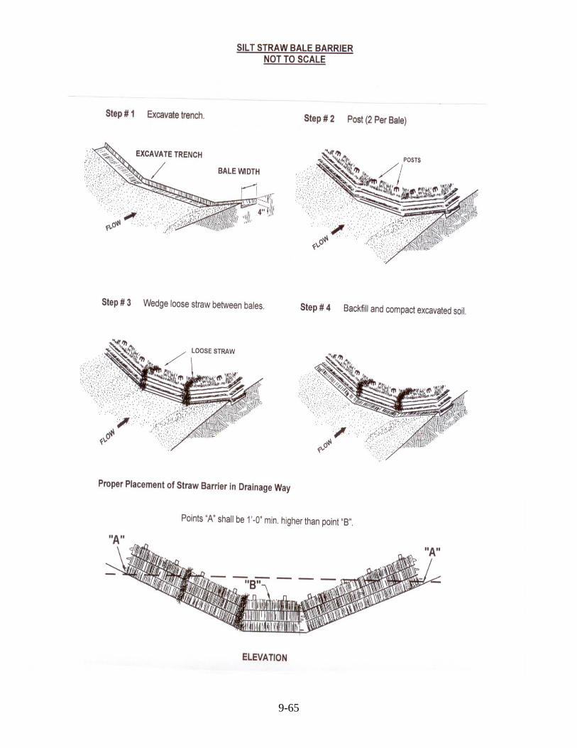
9-65

Article 10. STORM WATER MANAGEMENT REQUIREMENTS 1000.0 PURPOSE
The purpose of this Article is to establish standards for storm water management systems. Storm water management systems are designed to collect and convey storm water runoff from street inlets, runoff control structures, and other locations where the accumulation of storm water is undesirable. The objective is to remove runoff from an area fast enough to avoid unacceptable amounts of ponding damage and inconvenience.
1001.0 APPLICABILITY
A Storm Water Management Plan shall be filed as part of the Development Plan Requirement for proposed Major Subdivisions where curb and guttering is required or being constructed and for proposed Major Subdivisions being developed within any “City Limits”.
When a Storm Water Management Plan is required, the Developer shall provide storm drainage improvements that will prevent aggravation of any existing downstream problem considering both the instantaneous flow rate and flood elevations caused by the increased run off from the development. Storm water facilities shall not be constructed until the Planning Commission has granted Development Plan approval.
1002.0 STORM WATER DRAINAGE
A Storm Water Management Plan shall show the location and profiles of proposed storm water drainage sewers, channels or other drainage ways along proposed streets and easements. All drainage plans should indicate the following information as applicable:
• Statement of the criteria used in the drainage design; • Proposed contours of the development;
• Drainage appurtenances, such as drop boxes, curb and gutter inlets, flumes,
headwalls, street culverts, etc.;
• Pipes and ditch details;
• Entrance tile sizes for each lot;
• Direction of flow;
• Channel slope protection;
• Detention basins;
• Drainage easements; and;
• All other applicable information. See Exhibit 4 for storm water management minimum requirement checklist.
10-66
1003.0 ROAD DRAINAGE SYSTEM
The road drainage system shall serve as the primary drainage collection system and shall be designed to carry roadway, adjacent land, and building storm water drainage. No storm water shall be permitted to enter into the sanitary sewer system.
Road cross drains shall be constructed for the twenty-five (25) year storm rate. Gutters shall be constructed for the ten (10) year storm rate and checked against a twenty-five (25) year storm.
Where curb and gutter is not required by the Planning Commission, headwalls on culvert pipes are required and acceptable provisions must be made to prevent erosion around the inlet and outlet of the pipe. Entrance pipes for each lot shall be sized and indicated on the drainage plan.
1004.0 OFF ROAD DRAINAGE SYSTEMS
When the drainage system is outside of the road right-of-way, the Developer shall make provisions for dedication of a drainage easement. The landowner shall properly maintain all on-site drainage easements.
1004.1 Detention Basins
1004.1.1 A minimum basin volume shall be the difference between the post-development and pre-development twenty-five (25) year storm discharge (rates) discharged from the project area to the basin site, or such volume necessary to sufficiently reduce post-development discharges to the pre-development rate as controlled by the discharge structure.
1004.1.2 Maximum side slopes shall not be greater than a ratio of 2 horizontal to 1 vertical (2:1) and shall be maintainable by the proposed owner of the facility. All storage shall be contained within a drainage easement.
1004.1.3 Discharge control structures shall be multi-stage and capable of limiting 2, 10, and 25 year post-development discharges to pre-development corresponding peak discharge rates and shall be constructed of concrete or other hardened materials, including pipe or approved alternate or equal.
1004.1.4 The emergency spillway shall be sized to accommodate a flow equal to the 100-year storm post-development discharge and constructed of a non-erosive material.
1004.1.5 The dam crest elevation shall not be less than one (1) foot above the emergency spillway invert or overflow elevation.
1004.1.6 Spillways shall be protected from erosion and shall employ energy dissipation, if necessary.
1004.1.7 Dry detention basins shall be fully discharged within 36 hours of the storm event.
1004.2 Drainage Ditches
The side slopes of the ditch shall not be greater than a ratio of 3 horizontal to 1 vertical (3:1). The Developer shall adequately protect all ditches from erosion. Ditches and open channels shall be seeded, sodded, rock rip-raped, or paved depending on grades and types of soils to stabilize the ditch and prevent erosion, as determined by the design Engineer.
10-67
1005.0 MAINTENANCE OF STORM WATER SYSTEM
The owner or successors in title of a lot or property that contains any portion of a detention basin, drainage facility, or drainage easement shall be responsible for properly maintaining their area in order for such storm water management facility to function according to its design and purpose.
In residential subdivisions, the inlets structures and discharge control structures may be dedicated to the appropriate legislative body. The area of the detention basin shall be owned and maintained by the adjoining property owners. Maintenance for all drainage systems shall be included in the recorded deeds and the subdivision’s restricted covenants and shall be noted on the Development Plan and Final Plat, see Exhibit 5 – Certificate 7.
Local county or municipality officials shall be authorized to enter onto any lot or property for the purpose of inspection or repair of any storm water management facility. If any deficiencies are found which might cause the facility to fail to operate as designed, the county or local municipality shall notify the owner of the facility and demand that it be corrected within thirty (30) days. If the current property owner or any future owner fails to adequately maintain the storm water management facility, and does not make corrections after being notified in writing thirty (30) days prior, the county or local municipality may have the necessary work completed and assess the cost to the property owner.
1006.0 AS-BUILT DRAWINGS
“As-built” drawings are mandatory for developments that require a storm water management plan. “As-built” plans shall be dated, signed and meet the approval of the design Engineer and approval of the Planning Commission.
Notes: (1) All computations to be prepared by a Registered Professional Engineer, licensed in the Commonwealth of Kentucky, see Exhibit 5 – Certificate 3; (2) All detention basins and methods to be approved by the Planning Commission; (3) Fencing may be required when the location of the detention area is not easily observed or if the design Engineer determines a safety problem would exist.
10-68
11-69
Article 11. CONSTRUCTION AND INSPECTION PROCEDURES 1100.0 PURPOSE
The purpose of this Article is to set forth the Planning Commission’s construction and inspection procedures. These procedures should create a closer continuity between the Developer, Contractor, Engineer, and representatives of the Planning Commission.
1101.0 PROCEDURE
1101.1 Inspection of Erosion and Sedimentation Control
After the Development Plans and Preliminary Plat are approved or conditionally approved, Developer proceeds with the preparation of erosion and sedimentation control measures.
Prior to any construction grading, stripping, excavation, filling, or other disturbance of the natural ground cover, Developer must implement proper erosion and sedimentation control plans to protect existing developed areas. The Administrative Office shall review erosion and sedimentation control for conformance to the approved or conditionally approved Development Plans and the requirements of the Subdivision Regulations, and notify Developer of needed action.
1101.2 Inspection of Initial Grading Operation
Either The Hart County Road Supervisor or Kentucky Department of Transportation shall periodically inspect the initial grading operation. This field inspection will deal with a general review of the area to be graded within the limits of the roadway with emphasis on the subsoil in particular. The sod and topsoil should be removed from the roadway grading area. The Developer’s design Engineer or their representative shall review the alignment and grade stakes of the proposed roadway. The grade operations shall be inspected periodically throughout its construction period. Ninety-five (95) percent of the standard proctor as determined by a certified independent laboratory, paid for by the Developer, will have to be attained before the grading operations will be acceptable. A graphical copy of the proctor test shall be supplied to the Planning Commissions Administrative Officer.
1101.3 Inspection or Culvert Pipe and Other Drainage Improvements
The Developer’s design Engineer or their representative shall inspect or be present when the installation of culvert pipes is started. A minimum cover of twelve (12) inches in residential and eighteen (18) inches in commercial applications is required. Driveway drainage tiles shall have a minimum cover of six (6) inches. In general reference, the design Engineer shall inspect all proposed drainage improvements and certify that they were constructed in accordance with the approved Development Plans.
1101.4 Inspection of Subgrade Preparation
The subgrade shall meet the density requirements of ninety-five (95) percent of the standard proctor in each lift. All compaction density testing shall be conducted by an independent engineering firm and paid for by the Developer. A graphical copy of the test results shall be supplied to the Planning Commission’s Administrative Officer. The Developer shall give the Planning Commissions Administrative Officer twenty-four (24) hour notice of scheduled density testing. Either The Hart County Road Supervisor or Kentucky Department of Transportation shall periodically inspect all subgrade preparation.
1101.5 Inspection of Curb, Gutter, and Sidewalk Construction
The Developer shall give the Planning Commissions Administrative Officer twenty-four (24) hour notice of scheduled construction of any curb, gutter, or sidewalks. Either The Hart County Road Supervisor or Kentucky Department of Transportation shall periodically inspect the construction of all curb, gutter, or sidewalks.
1101.6 Inspection of Dense Graded Aggregate Base Construction
The Developer shall give Either the Hart County Road Supervisor or the Kentucky Department of Transportation twenty-four (24) hour notice of scheduled dense grade aggregate base construction. All DGA base shall be constructed to at least 84% density. The Planning Commissions Administrative Officer shall periodically inspect the construction of the DGA base.
1101.7 Inspection of Asphalt Base Construction
Either The Hart County Road Supervisor or Kentucky Department of Transportation shall inspect the beginning of the asphalt base application and will periodically inspect the overall progress. If a deficiency develops in the asphalt base course of any consequence, adjustments will be made in the overlying or succeeding asphalt surface course to compensate for the deficiency. The Developer shall give Either the Hart County Road Supervisor or the Kentucky Department of Transportation twenty-four (24) hour notice of scheduled asphalt base construction.
1101.8 Inspection of Asphalt Tack Coat and Asphalt Surface Application
Either The Hart County Road Supervisor or Kentucky Department of Transportation shall inspect the application of asphalt tack coat, if deemed necessary to apply, and the application of asphalt surface course. Periodic inspection will be made of this construction. The Developer shall give either The Hart County Road Supervisor or Kentucky Department of Transportation a twenty-four (24) hour notice of scheduled surface applications. The asphalt surface or topcoat shall not be applied for a period of at least twelve (12) months after completion of the asphalt base construction.
1101.9 Inspection of Final Dressing
Either The Hart County Road Supervisor or Kentucky Department of Transportation will review the final dressing of shoulder and ditches, the backslopes in cuts, and embankment slopes.
1101.10 Inspection at Completion of Construction
The Administrative Officer will inspect the new development in its entirety once all items, appurtenances, and incidentals have been completed in compliance with the approved Development Plan and these Subdivision Regulations. Upon approval of the development as a result of the Final Inspection, the Designated Representative of the Administrative Officer issue a Certificate of Compliance pursuant to KRS 100.277 (4) and forward said certificate to the appropriate legislative body.
Note: See Exhibit 7 for detail construction specifications.
11-70

Article 12. ASSURANCE FOR COMPLETION AND MAINTENANCE OF IMPROVEMENTS
1200.0 GENERAL
No Final Subdivision Plat shall be approved by the Planning Commission or accepted for record by the County Clerk until the required improvements listed in these Subdivision Regulations are constructed in a satisfactory manner and certified as such by the Developer’s Engineer and the Planning Commission’s Administrative Officer gives inspection approval. If such improvements have not been fully constructed at the time of consideration of the Final Plat, the Planning Commission may, but is not required to do so, permit the plat to be approved and recorded prior to completion of such improvements. For any such case, the Developer, to cover the full cost of completing all incomplete improvements, must post an acceptable improvement guarantee. The following requirements and procedures shall apply to such improvement guarantee:
1201.0 IMPROVEMENT GUARANTEE
1201.1 Contract for Improvement Completion
If completion of all improvements, including but not limited to streets, sidewalks, curb and gutters, and storm water management facilities are not complete, or will not be completed prior to Final Plat consideration, the Planning Commission may enter into a contract with the subdivider whereby the Developer shall guarantee to complete all improvements required by these Subdivision Regulations or otherwise specified by the Planning Commission, in a manner satisfactory to the Planning Commission.
1201.2 Guarantee of Contract for Improvement Completion
To secure the contract authorized in this Article of these Subdivision Regulations, the subdivider shall provide, subject to the approval of the Planning Commission and the Commission's attorney, one of the following guarantees:
1201.2.1 Surety Bond
The subdivider shall obtain a security bond from a surety bonding company authorized to do business in the Commonwealth of Kentucky. The bond shall be payable to the Joint City – County Planning Commission of Hart County, Kentucky and shall be in an amount sufficient to pay the entire costs, as estimated by the Developer’s Engineer (Exhibit 6 – Improvement Cost Estimates Form) and approved by the Planning Commission, of installing all required improvements plus fifteen (15) percent of said estimated costs. The duration of the bond shall be until the proposed improvements are constructed, inspected, and approved in accordance with these Subdivision Regulations.
1201.2.2 Cash Deposit
12-71
The subdivider shall deposit cash with the Planning Commission. The amount of the deposit shall be an amount sufficient to pay the entire costs, as estimated by the Developer’s Engineer (Exhibit 6 – Improvement Cost Estimates Form) and approved by the Planning Commission, of installing all required improvements plus fifteen (15) percent of said estimated costs. The duration of the cash deposit shall be until the proposed improvements are constructed, inspected, and approved in accordance with these Subdivision Regulations.

1201.2.3 Escrow Account
In case of an escrow account, the subdivider shall file with the Planning Commission an agreement between the bank and the subdivider guaranteeing the following:
That the funds of said escrow account shall be held in trust until released by the Planning Commission and may not be used, pledged, and/or assigned by the subdivider as collateral and/or security in any other matter during that period. The amount of the escrow account shall be an amount sufficient to pay the entire costs, as estimated by the Developer’s Engineer (Exhibit 6 – Improvement Cost Estimates Form) and approved by the Planning Commission, of installing all required improvements plus fifteen (15) percent of said estimated costs. The duration of the escrow account shall be until the proposed improvements are constructed, inspected, and approved in accordance with these Subdivision Regulations.
1201.2.4 Irrevocable Letter of Credit
The subdivider shall provide, from a bank or other reputable institution, an irrevocable letter of credit. This letter shall be deposited with the Planning Commission and shall state the following:
1201.2.4.1 That the creditor does guarantee funds in an amount equal to the entire costs, as estimated by the Developer’s Engineer (Exhibit 6 – Improvement Cost Estimates Form) and approved by the Planning Commission, of completing all required improvements plus fifteen (15) percent of said estimated costs;
1201.2.4.2 That, in the case of failure on the part of the subdivider to complete the specified improvements within the required time period, the creditor shall pay to the Planning Commission immediately, and without further action, such funds as are necessary to finance the completion of these improvements, up to the limit or credit stated in the letter of credit, and;
1201.2.4.3 In the event that the proposed Irrevocable Letter of Credit is for a term certain, the minimum term shall be for a period of thirty-six (36) months. The Letter of Credit by its terms shall provide that in the event that the Developer is found to be in default by the Planning Commission, the running of the time under the Letter of Credit shall be suspended and the subject Letter of Credit remain in effect for so long as necessary to secure completion of the development pursuant to the applicable law and regulations.
1201.2.4.4 In the event the Planning Commission finds that the Developer is in default and the Developer appeals this decision to the appropriate Circuit Court, then the bank or other reputable institution shall direct payment of the irrevocable letter of credit to the appropriate Circuit Court for distribution pursuant to the order of the court.
12-72

1201.3 If the Developer is a corporation, limited partnership, limited liability company (LLC), or business trust that limits the individual liability of the Developer, the Planning Commission may require the individual Developers to execute a Personal Guaranty of the contract required by Section 1201.1 of this Article.
1202.0 REASONABLE TIME GIVEN FOR COMPLETION OF IMPROVEMENT(S)
When the subdivider has provided surety for the contract as provided for in this Article of these Subdivision Regulations, the Planning Commission shall set a reasonable time for the improvements to be properly installed; however, this period shall be no greater than twenty-four (24) months. At the end of the period, if it is shown that extraordinary conditions exists which will require a longer period of time for the installation of the improvements, the Developer shall file an Improvement Guarantee Change Application requesting a time extension for the completion of improvements. The Planning Commission may grant an additional period of time, up to six (6) months, in which the Developer shall extend the improvement guarantee and properly install all improvements.
1203.0 REDUCTION OF IMPROVEMENT GUARANTEE
If progress has been made on the completion of improvements as provided in these Subdivision Regulations and in a manner satisfactory to the Planning Commission, then at its sole discretion, the Planning Commission may authorize a reduction of the contract for improvement completion.
The Developer shall file an improvement guarantee change application when requesting any reduction of a contract for improvement completion. The Developer’s Engineer shall certify that all completed improvements have been constructed and determine the amount necessary to construct all incomplete improvements (Exhibit 6 – Improvement Cost Estimates Form). If the Planning Commission authorizes the reduction of an improvement guarantee, the reduction shall be based upon the following formula:
New Improvement Guarantee = Total Value of Incomplete Improvements + 15%
1204.0 DEFAULT
1204.1 In the event that the improvements for the development do not conform to these Subdivision Regulations or the improvements are not completed within the period of time allowed by the Planning Commission and the deficiency is not remedied within sixty (60) days of Notice being given by the Designated Representative of the Planning Commission, a Hearing shall be scheduled before the Planning Commission to determine if the Developer is in default. A minimum ten (10) day Notice of Hearing shall be given to the Developer.
1204.2 Based upon a preponderance of the evidence presented at the Hearing, the Planning Commission shall hold a public adjudicatory hearing and determine the following:
1204.2.1 If the Developer is in Default for failure to construct the improvements pursuant to the Development Plan and the applicable regulations;
1204.2.2 Whether the improvements have been completed within the time allowed by the Planning Commission;
1204.2.3 The appropriate measures that should be taken to ensure that the development is completed in accordance with the Development Plan and the applicable regulations; and
12-731204.2.4 Any penalties that are appropriate.
1205.0 AS-BUILT PLANS
The Planning Commission shall require “As-built” plans before any improvement guarantee is released for a proposed subdivision to check and ensure that all improvements were constructed according to proposed Development Plans. All “As built” plans shall be signed, dated and approved by the design Engineer and approved by the Planning Commission.
1206.0 RELEASE
The Planning Commission will release the contract for improvement and accompanying guarantee when the required improvements have been constructed and carried out in accordance with these Subdivision Regulations. Upon Final Inspection and approval of the improvements as provided in these Subdivision Regulations, the Planning Commission shall release the Developer and the applicable Improvement Guarantee.
12-74
Article 13. SUBDIVISION PLAT CONTENT 1300.0 SPECIFICATIONS FOR SUBMITTED PLATS
A Registered Land Surveyor, licensed in the Commonwealth of Kentucky, shall prepare all plats. All plats shall meet the minimum standards of these Subdivision Regulations and the minimum standards established by the Kentucky State Board of Licensures for Professional Engineers and Land Surveyors. Plats shall be filed in accordance with Article 3, Article 4, and shall meet the design standards as set forth in Article 5.
1300.1 All Minor and Major Subdivision plats shall meet the following requirements and contain the information listed below:
1300.1.1 It shall be drawn on paper of a size 11" x 17", 18" x 24", or 24" x 36". More than one (1) sheet may be used. Sheets shall be numbered in sequence if more than one (1) sheet is used.
Plats to be recorded shall be drawn on Mylar. All Plats shall be labeled as Minor Plat, Preliminary Plat, or Final Plat.
1300.1.2 It shall be drawn at a convenient scale.
1300.1.3 It shall have a title block placed on the bottom of the plat and containing the following information:
1300.1.3.1 Name of the subdivision, which shall not duplicate nor closely approximate the name of any other subdivision in Hart County;
1300.1.3.2 The name, mailing address, and telephone number of the property owner(s);
1300.1.3.3 The name, mailing address, and telephone number of the Developer(s);
1300.1.3.4 Graphic and written scale;
1300.1.3.5 North arrow;
1300.1.3.6 Date of preparation;
1300.1.3.7 Property Valuation Administration (PVA) number of property being subdivided, and;
1300.1.3.8 All other pertinent legend data.
1300.1.4 A vicinity map at a scale of 2,000 feet to an inch or larger shall be placed in the upper right-hand corner. It shall show the approximate location of the subdivision to major streets, streams, schools, shopping facilities, or other developments or public facilities.
1300.1.5 All principal structures shall be labeled as they are currently constructed, example: 1 Story Frame, 2 Story Brick, Duplex, Triplex, Mobile Home, Manufactured Home, etc.
13-75
Kenny Isenberg
Cross-Out
Kenny Isenberg
Replacement Text
paper not mylar
Kenny Isenberg
Note
Accepted set by Kenny Isenberg

1300.1.6 All plats shall label accessory structures as they are currently constructed, example: barn, garage, shed, etc.
1300.1.7 Total area of land being subdivided.
1300.1.8 All building setback lines, including requirements of these Subdivision
Regulations, local Zoning Ordinances, and private restrictions.
1300.1.9 Total area behind all building setback lines.
1300.1.10 Current road names and road numbers, if applicable.
1300.1.11 Existing and proposed streets adjacent to the tract and their locations, right-of-way width, pavement width, and pavement type.
1300.1.12 Existing and proposed easements and their locations, widths, and
distances.
1300.1.13 Distance to the nearest intersection.
1300.1.14 The names and location of adjoining property owners along with intersecting property lines.
1300.1.15 All boundary lines and their bearings and distances.
1300.1.16 All floodplain areas shall be shown and clearly labeled and where
available, the actual computed elevation of the regulatory flood shall be noted, as well as the FIRM identification number.
1300.1.17 Lots numbered in numerical order.
1300.1.18 The accurate location, description, and material of all monuments.
1300.1.19 Land Surveyor’s Certification (Exhibit 5 – Certificate 2).
1300.1.20 Certificate of Approval for Recording (Exhibit 5 – Certificate 18).
1300.1.21 All other appropriate Certificates see Exhibit 5.
1300.2 The following information shall appear on the Major Subdivision Preliminary Plat:
1300.2.1 Layout of proposed tracts of land including dimensions of lot lines, lot numbers and minimum building setback lines. Tracts shall be laid out according to sound planning principles.
1300.2.2 Certificate of Agency Notification (Exhibit 5 – Certificate 1).
1300.3 The following information shall appear on the Major Subdivision Final Plat:
1300.3.1 Layout of proposed tracts of land including dimensions of lot lines, lot numbers and minimum building setback lines. Tracts shall be laid out according to sound planning principles.
13-76
13-77
1300.3.2 The Final Plat shall have the signature of the owners of the land to be subdivided stating that they own the land and shall dedicate the necessary rights-of-way and easements to the appropriate governing body. A Certificate of Ownership and Dedication (Exhibit 5 -Certificate 4) shall accompany the Final Plat.
1300.3.3 If a utility easement is proposed or required, the Final Plat shall have the signature of the owners of the land to be subdivided stating that they dedicate the necessary easements to the appropriate utility companies. A Certificate of Utility Easement and Dedication (Exhibit 5 -Certificate 5) shall accompany the Final Plat.
1300.3.4 If a connection or dedication of easement(s) to any water utility is required or proposed, the Final Plat shall receive the approval of the local water agency supplying water service prior to the consideration of the Planning Commission. A Certificate of Water Service Availability (Exhibit 5 -Certificate 8) shall accompany the final plat.
1300.3.5 If a connection to a public sewage system is proposed or required, the Final Plat shall receive the approval of the agency or utility company supplying sewage disposal services prior to the consideration of the Planning Commission. A Certificate of the Availability of Sewage Disposal Services (Exhibit 5 -Certificate 9) shall accompany the Final Plat.
1300.3.6 If a connection or dedication of easement(s) to any utility is required or proposed, the Final Plat shall receive the approval of the agency or utility company supplying each utility service prior to the consideration of the Planning Commission. A Certificate of the Availability of Utility Services (Exhibit 5 -Certificate 10) shall accompany the Final Plat.
1300.3.7 The Final Plat shall receive the approval of the District Health Department Environmentalist prior to consideration by the Planning Commission. A Certificate of Approval shall be signed by the Environmentalist and appear on the Final Plat (Exhibit 5 -Certificate 11).
1300.3.8 The Final Plat shall state the Fire District that serves the new development and receive the approval of the Fire Chief or Assistant Chief of the appropriate jurisdiction. A Certificate of Fire District Approval shall accompany the Final Plat (Exhibit 5 -Certificate 12).
1300.3.8 The Final Plat shall list individual street address for each lot as assigned by the HART COUNTY 911 office and receive the approval of the manager or addressing staff (Exhibit 5 -Certificate 13).
1300.3.9 An approved entrance permit number shall be noted for all proposed developments that abut on a State or Federal Highway (Exhibit 5 -Certificate 14).
1300.3.10 The Final Plat shall be reviewed by the Hart County Conservation District (Exhibit 5 -Certificate 15).
1300.3.11 All other appropriate Certificates, see Exhibit 5.

13-78
1301.0 SPECIFICATIONS FOR SUBMITTED “AS-BUILT” IMPROVEMENT DRAWINGS
These drawings shall generally include the same information as required for Development Plans, except that the “as-built” drawings shall accurately reflect the actual installation of the improvements.
1301.1 Specifically, “As-built” drawings shall meet the following requirements and contain the information listed below:
1301.1.1 It shall be drawn on paper of a size 11" x 17", 18" x 24", or 24" x 36". More than one (1) sheet may be used. Sheets shall be numbered in sequence if more than one (1) sheet is used and labeled As-Built Improvement Drawing.
1301.1.2 It shall be drawn at a convenient scale.
1301.1.3 It shall have a title block placed on the bottom of the plat and containing the following information:
1301.1.3.1 Name of the subdivision, which shall not duplicate nor closely approximate the name of any other subdivision in Hart County;
1301.1.3.2 The name, mailing address, and telephone number of the property owner(s);
1301.1.3.3 The name, mailing address, and telephone number of the Developer(s);
1301.1.3.4 Graphic and written scale;
1301.1.3.5 North arrow;
1301.1.3.6 Date of preparation;
1301.1.3.7 Property Valuation Administration (PVA) number of property being subdivided, and;
1301.1.3.8 All other pertinent legend data.
1301.1.4 A vicinity map at a scale of 2,000 feet to an inch or larger shall be placed in the upper right-hand corner. It shall show the approximate location of the subdivision to major streets, streams, schools, shopping facilities, or other developments or public facilities.
1301.1.5 All principal structures shall be labeled as they are currently constructed, example: 1 Story Frame, 2 Story Brick, Duplex, Triplex, Mobile Home, Manufactured Home, etc.
1301.1.6 All plats shall label accessory structures as they are currently constructed, example: barn, garage, shed, etc.
1301.1.7 Total area of land being subdivided.
1301.1.8 All building setback lines, including requirements of these Subdivision Regulations, local Zoning Ordinances, and private restrictions.
1301.1.9 Total area behind all building setback lines.
1301.1.10 Current road names and road numbers, if applicable.

13-79
1301.1.11 Existing and proposed streets adjacent to the tract and their locations,
right-of-way width, pavement width, and pavement type.
1301.1.12 Existing and proposed easements and their locations, widths, and distances.
1301.1.13 Distance to the nearest intersection.
1301.1.14 The names and location of adjoining property owners along with
intersecting property lines.
1301.1.15 All boundary lines and their bearings and distances.
1301.1.16 All floodplain areas shall be shown and clearly labeled and where available, the actual computed elevation of the regulatory flood shall be noted, as well as the FIRM identification number.
1301.1.17 Lots numbered in numerical order.
1301.1.18 The accurate location, description, and material of all monuments.
1301.1.19 The profile of each street with elevation of ground and street grade.
1301.1.20 A cross-section of each street showing pavement width, rights-of-way
and sidewalks.
1301.1.21 Size, location, and elevation, if applicable, of all storm water drainage improvements.
1301.1.22 Size, location, and elevation, if applicable, of all sewer lines,
manholes and service connections.
1301.1.23 Size and locations of all water lines, fittings, valves, and hydrants.
1301.1.24 Size and locations of all natural gas lines.
1301.1.25 Land Surveyor’s Certification (Exhibit 5 – Certificate 2).
1301.1.26 Professional Engineer’s Certification (Exhibit 5 – Certificate 3).

14-80
Article 14. ENFORCEMENT 1400.0 GENERAL
Much of the authority for regulating land subdivision comes from the necessity for recording tracts of land with the County Clerk as a condition for transfer of ownership. These conditions are set forth in Section 100 of the Kentucky Revised Statutes and in the Articles of these Subdivision Regulations.
1401.0 PENALTIES
Any subdivider, County Clerk, public official, or other persons who does not comply with these Subdivision Regulations, Section 100 of the Kentucky Revised Statutes, the conditions set forth by the Planning Commission, Board of Adjustments, or any court, or does not comply with the plans presented and approved, the Planning Commission may take the following action:
1401.1 Injunctions
The Planning Commission may apply for an injunction against any type of subdivision construction by a subdivider or a landowner.
1401.2 Permits
The Planning Commission may direct the local Building Inspector to issue a stop work order or not to issue building permits or a certificate of occupancy in the subdivision in question.
1401.3 Fines
The Planning Commission may take action to fine any person or entity who is in violation of these provisions or any of the regulations adopted pursuant hereunder for which no other penalty is provided. Upon conviction, the persons or entity shall be fined not less than ten ($10) but no more than five hundred dollars ($500) for each conviction. Each day of violation shall constitute a separate offense.
1402.0 ADMINISTRATIVE PERSONNEL
Kentucky Statutes place the authority of enforcement with the Planning Commission. However, the Planning Commission may delegate its administrative and enforcement authority to various agents responsible to it. In other situations, it may depend on other municipal or county departments for information and advice, as in the case of public utilities inspection.
1402.1 Administrative Official
An administrative official shall be designated by the Planning Commission to administer the Subdivision Regulations. The administrative official may be designated to issue building permits or certificates of occupancy, or both, in accordance with the literal terms of the regulations, but may not have the power to permit any construction, or to permit any use or any change of use which does not conform to the literal terms of the Subdivision Regulations.

14-81
1403.0 APPEALS
A Developer or party before the Planning Commission may appeal a final decision of the Planning Commission.
1403.1 Appeals of Final Decision of Planning Commission
Any appeal of a Final Decision of the Planning Commission may be taken in the following manner:
1403.1.1 Any person or entity claiming to be injured or aggrieved by any final action of the Planning Commission may appeal from the action to the Circuit Court of Hart County. Such appeal shall be taken within thirty (30) days after the final action of the Planning Commission. Final action shall not include Planning Commission's recommendations made to other governmental bodies.
1403.1.2 All appeals shall be taken in the appropriate Circuit Court within thirty (30) days after the action or decision of the Planning Commission, and all decisions that have not been appealed within thirty (30) days shall become final. After the appeal is taken, the procedure shall be governed by the rules of civil procedure.

15-82
Article 15. EXHIBIT 1. GENERAL CHECKLIST FOR MAJOR SUBDIVISION AND DEVELOPMENT PROCEDURES
Simplified description of steps involved in procedure for processing and presenting new subdivision developments to the Hart County Planning Commission.
� Step # 1 Pre-Application Conference
Developer is encouraged to notify the Administrative Officer and discuss their land development intentions for conformance to the Comprehensive Plan, Development Plan Ordinance, Zoning Ordinance, and Subdivision Regulations prior to any disturbance of the natural ground surface or any preliminary survey or engineering work is started.
�Step # 2 Preliminary Plat Process
Developer proceeds with the preparation of their Major Subdivision Application, Preliminary Plat, and Development Plan. The Developer shall file the following documents no fewer than fifteen (15) calendar days prior to the Planning Commission’s scheduled meeting for consideration of the subject application:
□ Application and applicable Fees. □ A Preliminary Plat, including the following: □ Original Mylar copy of the Preliminary Plat and six (6) blue line prints of the Mylar (See Article 13 for Subdivision Plat Content). □ The original Preliminary Plat shall contain the Certificate of Agency Notification (Exhibit 5 – Certificate 1) and be signed by the Administrative Officer of each agency that will review or provide utility service to the proposed development. □ A Development Plan, including the following: □ Seven (7) blue line prints of the Development Plan and any other supplementary material required by these regulations; (See Article 8 for Development Plan requirements). □ A Soil Erosion and Sedimentation Control Plan; (See Article 9 for requirements). □ A Storm Water Management Plan; (See Article 10 for requirements). □Step # 3 Commission Action
The Planning Commission officially acts on the Development Plan and Preliminary Plat.

15-83
�Step # 4 Erosion and Sedimentation Control
After the Development Plan and Preliminary Plat are approved or conditionally approved, Developer proceeds with the preparation of Erosion and Sedimentation Control Measures.
Prior to any construction grading, stripping, excavation, filling, or other disturbance of the natural ground cover, Developer must implement proper erosion and sedimentation control plans to protect existing developed areas. The Planning Commissions Administrative Officer will review erosion and sedimentation control for conformance to the approved or conditionally approved Development Plans and the requirements of the Subdivision Regulations, and notify Developer of needed action.
�Step # 5 Construction Improvements
After the Erosion and Sedimentation Control Measures are implemented and required permits are granted by other local and state agencies, Developer may proceed to construct development improvements.
□ Begin rough grade, drainage and water retention work. � Submit standard proctor test results. � Install utilities; water, sewer, fire hydrants, electric, gas, telephone, cable, etc. � Begin subgrade preparation. � Test subgrade with Planning Commission representative present. Must give 24- hour notice before starting. Need 95 % of the standard proctor. � Construct DGA base. Must give 24-hour notice before starting. � Construct curb, gutters, and sidewalks. Must give 24 hour notice before starting. � Construct bituminous base. Must give 24-hour notice before starting. � Final dressing of shoulders and ditches. � Seeding and sodding of ditches, drainage areas, and exposed lands. � Apply for building permits and begin construction of buildings. � Remove erosion and sedimentation control devices; after good stand of grass is achieved. � Construct bituminous surface. Must give 24-hour notice before starting. � Final inspection conducted by the Planning Commissions Administrative Officer.

15-84
�Step # 6 Final Plat Process
The Developer shall submit the Final Plat to the Planning Commission within two (2) years of the Preliminary Plat approval date. The Applicant shall file the following documents no fewer than fifteen (15) calendar days prior to the Planning Commission’s scheduled meeting at which the Final Plat is to be considered:
� Application and applicable Fees. □ A Preliminary Plat, including the following: � Original Mylar copy of the Final Plat and SIX (6) blue line prints of the Mylar (See Article 13 for Subdivision Plat Content). � Distribution The Applicant shall distribute one (1) blue line print copy of the Final Plat to each applicable agency of the Administrative Officer. � Completion of Public Improvements
Developers may begin construction of public improvements after the Planning Commission has approved the Preliminary Plat and Development Plan. All public improvements shall be constructed and inspected in accordance with these Subdivision Regulations. In the event any improvements have not been completed at the time of consideration of the Final Plat by the Planning Commission, the Developer shall provide an acceptable Improvement Guarantee. (See Article 12 for Improvement Guarantees).
�Step # 7 Commission Actions
The Planning Commission officially acts on the Final Plat.
�Step # 8 Recordation of Final Plat
Upon approval of the Final Plat by the Planning Commission, the original Mylar copy of the plat and one (1) blue line print of the Mylar shall be lodged for recordation in the Hart County Clerk’s office by the Commission’s Administrative Officer within thirty (30) days of approval.
�Step # 9 As Built Plans
The Planning Commission shall require “As-built” plans before any improvement guarantee is released for a proposed subdivision to check and ensure that all improvements were constructed according to proposed Development Plans. All “As-built” plans shall be signed, dated and approved by the design Engineer and approved by the Planning Commission.

15-85
�Step # 10 Release of Improvement Guarantee
The Planning Commission will release the contract for improvement and accompanying guarantee when the required improvements have been constructed and carried out in accordance with these Subdivision Regulations. Upon Final Inspection and approval of the improvements as provided in these Subdivision Regulations, the Planning Commission shall release the Developer and the applicable Improvement Guarantee.
�Step # 11 Final Inspections and Acceptance
The Planning Commission’s Designated Representative will inspect the new development in its entirety once all items, appurtenances, and incidentals have been completed in compliance with the approved Development Plan and these Subdivision Regulations. Upon approval of the development as a result of the Final Inspection, the Designated Representative of the Planning Commission shall issue a Certificate of Compliance pursuant to KRS 100.277 (4) and forward said certificate to the appropriate legislative body.
Note: This Exhibit is presented for general information purposes only. All Developers should consult with the Planning Commission and these Subdivision Regulations for all required steps for new developments.

16-86
Article 16. EXHIBIT 2. MINIMUM REQUIREMENT CHECKLIST FOR PLATS
A General Guideline for Minimum Plat Content Requirements:
□ All plats shall contain the following information and meet the requirements listed below: � It shall be drawn on paper of a size 11" x 17", 18" x 24", or 24" x 36". More than one (1) sheet may be used. Sheets shall be numbered in sequence if more than one (1) sheet is used. � Plats to be recorded shall be drawn on Mylar. All Plats shall be labeled as Minor Plat, Preliminary Plat, or Final Plat. � It shall be drawn at a convenient scale. □ It shall have a title block placed on the bottom of the plat and containing the following information: � Name of the subdivision, which shall not duplicate nor closely approximate the name of any other subdivision in Hart County. � The name, mailing address, and telephone number of the property owner(s). � The name, mailing address, and telephone number of the Developer(s). � Graphic and written scale. � North arrow. � Date of preparation. � Property Valuation Administration (PVA) number of property being subdivided. � All other pertinent legend data. � A vicinity map at a scale of 2,000 feet to an inch or larger shall be placed in the upper right-hand corner. It shall show the approximate location of the subdivision to major streets, streams, schools, shopping facilities, or other developments or public facilities. � All principal structures shall be labeled as they are currently constructed, example: 1 Story Frame, 2 Story Brick, Duplex, Triplex, Mobile Home, Manufactured Home, etc. � All plats shall label accessory structures as they are currently constructed, example: barn, garage, shed, etc. � Total area of land being subdivided. � All building setback lines, including requirements of these Subdivision Regulations, local Zoning Ordinances, and private restrictions. � Total area behind all building setback lines. � Current road names and road numbers, if applicable. � Existing and proposed streets adjacent to the tract and their locations, right-of- way width, pavement width, and pavement type. � Existing and proposed easements and their locations, widths, and distances.

16-87
� Distance to the nearest intersection. � The names and location of adjoining property owners along with intersecting property lines. � All boundary lines and their bearings and distances. � All floodplain areas shall be shown and clearly labeled and where available, the actual computed elevation of the regulatory flood shall be noted, as well as the FIRM identification number. � Lots numbered in numerical order. � The accurate location, description, and material of all monuments. � Land Surveyor’s Certification (Exhibit 5 – Certificate 2). � Certificate of Approval for Recording (Exhibit 5 – Certificate 18). � All other appropriate Certificates, see Exhibit 5. □ The following information shall appear on the Major Subdivision Preliminary Plat: � Layout of proposed tracts of land including dimensions of lot lines, lot numbers and minimum building setback lines. Tracts shall be laid out according to sound planning principles. � Certificate of Agency Notification (Exhibit 5 – Certificate 1). □ The following information shall appear on the Major Subdivision Final Plat: � Layout of proposed tracts of land including dimensions of lot lines, lot numbers and minimum building setback lines. Tracts shall be laid out according to sound planning principles. � The Final Plat shall have the signature of the owners of the land to be subdivided stating that they own the land and shall dedicate the necessary rights-of-way and easements to the appropriate governing body. A Certificate of Ownership and Dedication (Exhibit 5 Certificate 4) shall accompany the Final Plat. � If a utility easement is proposed or required, the Final Plat shall have the signature of the owners of the land to be subdivided stating that they dedicate the necessary easements to the appropriate utility companies. A Certificate of Utility Easement and Dedication (Exhibit 5 -Certificate 5) shall accompany the Final Plat. � If a connection or dedication of easement(s) to any water utility is required or proposed, the Final Plat shall receive the approval of the local water agency supplying water service prior to the consideration of the Planning Commission. A Certificate of Water Service Availability (Exhibit 5 -Certificate 8) shall accompany the Final Plat. □ If a connection to a public sewage system is proposed or required, the Final Plat shall receive the approval of the agency or utility company supplying sewage disposal services prior to the consideration of the Planning Commission. A Certificate of the Availability of Sewage Disposal Services (Exhibit 5 -Certificate 9) shall accompany the Final Plat.

16-88
� If a connection or dedication of easement(s) to any utility is required or proposed, the Final Plat shall receive the approval of the agency or utility company supplying each utility service prior to the consideration of the Planning Commission. A Certificate of the Availability of Utility Services (Exhibit 5 - Certificate 10) shall accompany the Final Plat. � The Final Plat shall receive the approval of the District Health Department Environmentalist prior to consideration by the Planning Commission. A Certificate of Approval shall be signed by the Environmentalist and appear on the Final Plat (Exhibit 5 Certificate 11). □ The Final Plat shall state the Fire District that serves the new development and receive the approval of the Fire Chief or Assistant Chief of the appropriate jurisdiction. A Certificate of Fire District Approval shall accompany the Final Plat (Exhibit 5 -Certificate 12). � The Final Plat shall list individual street address for each lot as assigned by the Hart County 911 and receive the approval of the manager or addressing staff (Exhibit 5 -Certificate 13). □ An approved entrance permit number shall be noted for all proposed developments that abut on a State or Federal Highway (Exhibit 5 -Certificate 14). � The Final Plat shall be reviewed by the Hart County Conservation District (Exhibit 5 Certificate 15). � All other appropriate Certificates, see Exhibit 5. Note: This Exhibit is presented for general information purposes only. All Engineers and
Surveyors should consult with the Planning Commission and these Subdivision Regulations for all required steps for new developments.
17-89
Article 17. EXHIBIT 3. DEVELOPMENT PLAN MINIMUM REQUIREMENT CHECKLIST
A Development Plan should include the following elements:
� It shall have a title block placed on the bottom of the plan and containing the following information: � Name of the subdivision or development. � The name, mailing address, and telephone number of the property owner(s). � The name, mailing address, and telephone number of the Developer(s). � Graphic and written scale. � North arrow. � Date of preparation. � Property Valuation Administration (PVA) number of property being developed. � All other pertinent legend data. � Proposed stages of development, if applicable. � Existing contours of the project referenced to the nearest USGS elevation. � Street data for proposed or existing facilities � Street layout and street names. � Typical street sections, including street paving drainage at sides of pavement, rights-of-way data, proposed slopes, proposed finished centerline surface of the street and the original ground surface, street grades, stationing of vertical P.I.’s and the length of vertical curves, and construction of headwalls and inlets. � Plan and profile of proposed streets showing finished pavement elevations and existing ground. � Distance to nearest intersection. � Lotting pattern with lot numbers � All building setback lines. � Area behind all building setback lines. � Location of all existing structures. � Height, floor area, arrangement of proposed structures, and number of dwelling units. � Location of all drainage structures. � Culverts: All culverts will be terminated at headwalls. Where culverts exist on lot lines between dwellings, necessary easements shall be shown. � Size, invert elevations, and percent of grade of all storm drains, catch basins, and inlets and indicate the pipe materials used, such as concrete, metal, or polyethylene. � Existing tree masses, significant rock outcroppings, sinkholes, wells, streams, rivers, flood plains, and other critical natural features. � Soil Erosion and Sedimentation Control Plans, if applicable. � Storm Water Management Plans, if applicable. � A copy of proposed restrictions and covenants, if applicable, shall accompany the Development Plan.

17-90
� Development summary, in tabular form, showing the following: � Area of development – show acres and square footage. � Current zoning, if applicable. � Area of parking required, if applicable. � Area of parking supplied, if applicable. � Fire district. � Utility providers. � Construction quantities and Improvements see Exhibit 6 – Improvement Cost Estimates Form. � Linear feet, measured along the centerline, of proposed road. � Pavement width. � Linear feet of curbing. � Linear feet of sidewalk. � Number and location of proposed or existing fire hydrants. Note: This Exhibit is presented for general information purposes only. All Engineers and
Surveyors should consult with the Planning Commission and these Subdivision Regulations for all requirements for new developments.
18-91
Article 18. EXHIBIT 4. STORM WATER MANAGEMENT MINIMUM REQUIREMENT
CHECKLIST
A storm water management plan should include the following elements:
� Contours of the project, both existing and proposed. � Street layout and street names. � Typical street sections, including street paving drainage at sides of pavement, rights-of- way data, proposed slopes, proposed finished centerline surface of the street and the original ground surface, street grades, stationing of vertical P.I.’s and the length of vertical curves, and construction of headwalls and inlets. � Lotting pattern with lot numbers � Location of all drainage structures. � Culverts: All culverts will be terminated at headwalls. Where culverts exist on lot lines between dwellings, necessary easements shall be shown. � Statement of the criteria used in the drainage design, including the following: � Rate of precipitation � Formula used in sizing drainage structures � Any constants or factors involved. � Flow calculations on all drainage ditches and storm sewer pipes. � Basin sizing calculations including the sizing of the throttling device if applicable. � Size, invert elevations, and percent of grade of all storm drains, catch basins, and inlets and indicate the pipe materials used, such as concrete, metal, or polyethylene. � Total drainage area contributory to each drainage pipe, including off-site area. � Design and velocity of drainage ditches and method of erosion control to be used on banks and bottoms. � Show on plans where and at what rim elevation all drywells and sinkhole boxes will be. � Plan, dimensional cross-sections, and flow line profiles of all proposed and existing ditches, including right and left bank profiles. � Drainage area contributing to the channel at control points, including off-site areas. � Complete information with respect to out-fall pipes or ditches, including off-site areas. � Maximum flood stage elevations on any stream flowing through or adjacent to the property, or whose proximity may affect drainage or access to the property. � All drainage structures must meet the Kentucky Transportation Cabinet’s design format. � All appropriate Certificates, see Exhibit 5. Note: This Exhibit is presented for general information purposes only. All Engineers should
consult with the Planning Commission and these Subdivision Regulations for all requirements for new developments.

19-92
Article 19. EXHIBIT 5. CERTIFICATES TO APPEAR ON PLATS Certificate 1. LAND SURVEYOR’S CERTIFICATION I (Surveyor’s name printed), a Professional Land Surveyor in the State of Kentucky, do hereby certify that this plat depicts a survey made by me or under my supervision. Further, I certify that the survey meets or exceeds the minimum standards of practice for Professional Land Surveyor’s and that all monuments and permanent control points have either been set or located as described; that their location is correctly shown; and that this plat conforms to all provisions of the current Subdivision Regulations of Hart County.
Date______________
Signature of Professional Land Surveyor, Number, Seal
Certificate 2.
PROFESSIONAL ENGINEER’S CERTIFICATION
I (Engineer’s name printed), a Professional Engineer in the State of Kentucky, do hereby certify that the (Development Plan, Storm Water Management Plan, As-Built Improvement Drawing, or other plan) submitted to the Planning Commission was prepared by me or under my supervision; and all requirements of Kentucky laws and regulations, the Subdivision Regulations of Hart County, and the regulations of local governing authorities have been fully complied with in all respects.
Date______________
Signature of Professional Engineer, Number, Seal
Certificate 3. CERTIFICATE OF OWNERSHIP AND DEDICATION I (we) hereby certify that I am (we are) the owner(s) of the property shown and described hereon and that I (we) hereby adopt this plan of subdivision with my (our) free consent, establish the minimum building setback lines, and dedicate all streets, alleys, walks, parks, easements, and other open spaces to public or private use as shown on the recording plat, unless otherwise noted.
Owner’s Signature, Date
Owner’s Signature, Date

19-93
Certificate 4.
CERTIFICATE OF UTILITY EASEMENT AND DEDICATION
The spaces outlined and designated as utility easements are hereby reserved for the purposes shown, including the right of ingress and egress over all lots to and from all easements and the right to remove any obstructions, natural or man-made therein for the proper installation, operation, and maintenance of the utility by the agency or company using the easement. The easements shall be kept free of all obstructions, including permanent fences, trees, shrubbery, and gardens. It is understood that the Owner/Developer will remove all trees or other obstructions that will interfere with the new construction of utilities using the designated easements.
Owner’s Signature, Date
Owner’s Signature, Date
Certificate 5.
CERTIFICATE OF DRAINAGE EASEMENT AND DEDICATION
The spaces outlined and designated as drainage easements are hereby reserved for the purpose shown. The respective Owner of the lot shall maintain all drainage easements over which said easements cross and no drainage easements shall be altered in any way by filling, changing the contour thereof, or by building any structure thereon, except upon prior written approval by the Planning Commission. This restriction may be enforced by any owner of any lot affected by the drainage over said easement, by the local Building Inspector, or by the Planning Commission.
Owner’s Signature, Date
Owner’s Signature, Date
Certificate 6.
CERTIFICATE OF MAINTENANCE OF STORM WATER MANAGEMENT FACILITIES
The owner or successors in title of a lot or property that contains any portion of a detention basin, drainage facility or drainage easement shall be responsible for properly maintaining their area in order for such storm water management facility to function according to its design and purpose. The county or local municipality shall be authorized to enter onto the lot or property for the purpose of inspection or repair of any storm water management facility. If any deficiencies are found which might cause the facility to fail to operate as designed, the county or local municipality shall notify the owner of the facility and demand that it be corrected within thirty (30) days. If the current property owner or any future owner fails to adequately maintain the storm water management facility, and does not make corrections after being notified in writing thirty (30) days prior, the county or local municipality may have the necessary work completed and assess the cost to the property owner. Owner’s Signature, Date Owner’s Signature, Date
19-94
Certificate 7.
CERTIFICATE OF WATER SERVICE AVAILABILITY
The (Appropriate agency name) has reviewed the Final Plat and hereby certify that: _____ Water service is currently available to the proposed development. _____ Water service is currently not available to the proposed development. _____ Fire protection is currently not available for this development. This subdivision of land cannot be further resubdivided until fire protection is available. _____ Arrangements have been made with this agency to construct water improvements for the proposed development. _____ Arrangements have been made with this agency to construct fire improvements for the proposed development. The water distribution systems of said subdivision shall meet the requirements of this agency and all other requirements for the proper distribution of water. Date______________ ____________________________________ Manager or Engineer of the Appropriate Agency
Certificate 8.
CERTIFICATE OF SEWAGE DISPOSAL SERVICES
The (Appropriate agency name) has reviewed the Final Plat and hereby certify that:
_____ Sanitary sewage service is currently available to the proposed development.
_____ Sanitary sewage service is not currently available to the proposed development.
_____ Arrangements have been made to construct sanitary sewage improvements for the
proposed development. The sewage disposal system of said subdivision shall meet the requirements of this agency and all other requirements for the proper disposal of sewage.
Date______________ _________________________________ Manager or Engineer of the Appropriate Agency

19-95
Certificate 9.
CERTIFICATE OF THE AVAILABILITY OF UTILITY SERVICES
The following agencies have reviewed the Final Plat and hereby certify that arrangements to supply utility service to this development have been approved. The utility distribution system of said subdivision shall meet the requirements of this agency. Farmers Rural Electric Co-op Corp. Kentucky Utilities Co. Warren Rural Electric Co. South Central Rural Telephone Co-op Corp. ATMOS Gas Mediacom Green River Valley Water District Horse Cave Water Munfordville Water Bonnieville Municipal Water Edmonson County Water Caveland Environmental Authority, Inc. Certificate 10.
HART COUNTY HEALTH DEPARTMENT
Onsite sewage disposal system to any proposed residence or other building shall be installed pursuant to the Kentucky onsite sewage disposal system regulations, 902 KAR 10: 081 and 902 KAR 10: 085, and each individual lot shall stand on its own merit as to approval or disapproval.
Date______________ ______________________________ Health Department Environmentalist Certificate 11. CERTIFICATE OF FIRE DISTRICT APPROVAL
I hereby certify that I have reviewed the Final Plat and that the new development meets the requirements set forth by the (Appropriate fire district) Fire Department.
Date______________ ________________________________ Fire Chief or Assistant Chief

19-96
Certificate 12. DEPARTMENT OF HIGHWAYS APPROVAL Access to Highway ________ will require a permit from the Department of Highways. Lots shown on this plat that abuts Highway ________ may be granted access to Highway ________ at locations as shown on the plat only, provided all conditions and requirements of the Department Permits Policy Manual are met. Lot owners shall contact the Permits Engineer with the Department of Highways, at the District #4 Office in Elizabethtown, KY at 270-766-5066. The local department of Highways has approved the current access to Highway ________ as shown on this plat.
Permit Number ________________ Certificate 13. RESIDUAL LAND CERTIFICATE I hereby certify that the residual portion of the property being subdivided meets all the minimum requirements of the current subdivision regulations.
Date______________ Signature of Professional Land Surveyor, Number, Seal
Certificate 14.
FUTURE DEVELOPMENT REQUIREMENTS
No portion of the property shown hereon may be resubdivided into building lots or tracts of less than ten (10) acres until an adequate water supply system and fire hydrant protection is supplied by the proposed subdivider and approved by the Planning Commission and applicable Water Agency. This Certificate shall be shown on all subsequent plats that exhibit any portion of this property until the abovementioned requirements are met. Certificate 15.
CERTIFICATE OF APPROVAL FOR RECORDING I hereby certify that the subdivision plat shown hereon has been found to comply with the Subdivision Regulations for Hart County, Kentucky, with the exception of such variances, if any, as are noted on the plat and/or in the minutes of the Planning Commission, and that it has been approved for recording in the office of the County Clerk of Hart County. Date______________ _____________________________________ Chairperson or Planning Commissions Administrative Officer
Certificate 16.
CERTIFICATION OF THE COUNTY ROAD REQUIREMENT I hereby certify that the plat shown and described hereon has access to a road maintained by the County. _______________________ Date ________ _________________________ Date ______ County Road Supervisor Magistrate

20-97
Article 20. EXHIBIT 6. APPLICATIONS AND FORMS
Minor Subdivision Application
Major Subdivision Application
Subdivision Regulations Variance Application
Improvement Guarantee Change Application
Improvement Cost Estimates Form

20-98
Review No. _______________ MINOR SUBDIVISION APPLICATION
Kenny R. Isenberg, Hart County Administrative Officer P.O. Box 384 Horse Cave, KY 42749 Phone (270) 528-7892
The following Items are to be submitted along with this application:
� The original Minor Plat(s), on mylar, one (1) blue line print of the mylar, and one (1) copy of the mylar on letter size paper (8-1/2” x 11”) � Appropriate Review Fee, payable to the Hart County Planning Commission, is required and of which no part is refundable to the applicant. PART I: (to be completed by applicant)
1. Submittal Date: _______________ 2. Name of Subdivision _____________________________________________________ Area of Subdivision (Total Acres) ____________________________________________ 3. Owner(s) _______________________________________________________________
Address ________________________________________________________________ City_____________________ State / Zip ______________ Phone _________________
4. Project Surveyor _________________________________________________________
Address ________________________________________________________________ City_____________________ State / Zip ______________ Phone _________________ 5. Applicant Source of Title for Parent Tract Deed Book _______________ Page Number _______________ Property Valuation Administration (PVA) Parent Tract Map Number _______________ 6. Have any Lots or Tracts been previously subdivided from the Patent Tract? � No � Yes
If “Yes”, please attach a copy of all Minor Plats depicting the subdivisions that have occurred from the Parent Tract.

20-99
7. Current Zoning, if applicable ______________ 8. Is a variance being requested to the Subdivision Regulations? __________
If “Yes”, see the Subdivision Regulations Variance Application. 9. Is a variance being requested to the Zoning Ordinance? __________ If “Yes”, see the Board of Adjustments Application. I (We) do hereby certify that the information provided herein is both complete and accurate to the best of my (our) knowledge, and I (we) understand that any inaccuracies may be considered just cause for invalidation of this application and any action taken on this application. ____________________________________ Property Owner’s Signature Date ____________________________________ Property Owner’s Signature Date
OFFICE USE ONLY
PART II: (to be completed by the commission staff)
1. Date Application Processed _____________ Fee Received _____________ 2. Action Taken: __________________________________________________________ 3. Notes:
_____________________________________________________________________________
_____________________________________________________________________________
_____________________________________________________________________________
_____________________________________________________________________________
_____________________________________________________________________________
_____________________________________________________________________________
_____________________________________________________________________________

20-100
Review No. _______________
MAJOR SUBDIVISION APPLICATION
Kenny R. Isenberg, Hart County Administrative Officer P.O. Box 384 Horse Cave, KY 42749 Phone (270) 528-7892
The following Items are to be submitted along with this application:
� The original Preliminary Plat(s), on mylar, and six (6) blue line prints of the mylar.
� Seven (7) blue line prints of the Development Plan(s) showing proposed subdivision. � Development Plan Review Fee, payable to the Hart County Planning Commission, is required and of which no part is refundable to the applicant. PART I: (to be completed by applicant) 1. Submittal Date: _______________ 2. Name of Subdivision _____________________________________________________ Area of Subdivision (Total Acres) ____________________________________________ 6. Owner(s) _______________________________________________________________
Address ________________________________________________________________ City_____________________ State / Zip ______________ Phone _________________
7. Project Surveyor _________________________________________________________
Address ________________________________________________________________ City_____________________ State / Zip ______________ Phone _________________ 8. Applicant Source of Title for Parent Tract Deed Book _______________ Page Number _______________ Property Valuation Administration (PVA) Parent Tract Map Number _______________ 6. Have any Lots or Tracts been previously subdivided from the Patent Tract? � No � Yes
If “Yes”, please attach a copy of all Minor Plats depicting the subdivisions that have occurred from the Parent Tract.
7. The subdivider or their agent shall submit all development items to the Commission's Administrative Officer at least fifteen (15) consecutive days prior to the next regular meeting of the Planning Commission, (i.e., first Tuesday of each month).
Submittal Date: _______________
20-101
1. Current Zoning, if applicable ______________ 2. Is a variance being requested to the Subdivision Regulations? __________ If “Yes”, see the Subdivision Regulations Variance Application. 3. Is a variance being requested to the Zoning Ordinance? __________ If “Yes”, see the Board of Adjustments Application. 4. Does this proposed development involve construction of new improvements (ex. streets,
facilities, utilities, etc.)? ____________ If “Yes” see the Construction Cost Estimates Form.
I (We) do hereby certify that the information provided herein is both complete and accurate to the best of my (our) knowledge, and I (we) understand that any inaccuracies may be considered just cause for invalidation of this application and any action taken on this application. ______________________________________ Property Owner’s Signature Date ______________________________________ Property Owner’s Signature Date
Kenny Isenberg
Inserted Text
OFFICE USE ONLY PART II: (to be completed by the commission staff) 1. Date Application Processed _____________ Fee Received _____________ 2. Action Taken: __________________________________________________________ 3. Notes: ___________________________________________________________________________________________________________________________________________________________________________________________________________________________________________________________________________________________________________________________________________________________________________________________________________________________________________________________________________________________________________________________________________________________
Kenny Isenberg
Note
Accepted set by Kenny Isenberg
Kenny Isenberg
Note
Kenny Isenberg
Note
Accepted set by Kenny Isenberg

20-102
OFFICE USE ONLY
PART II: (to be completed by the commission staff)
1. Date Application Received _______________ 2. Preliminary Plat: Date Received _______________ Date of Approval _______________ or Disapproval _____________ 3. Development Plan: Date Received _______________ Fee Received _____________ Date of Approval _______________ or Disapproval _____________ 4. Final Plat: Date Received _______________ Fee Received _____________ Date of Approval _______________ or Disapproval _____________ Date Recorded _______________ 5. Improvement Guarantee Amount = $____________________________________ 6. Date of Improvement Inspection: Fee Received _____________
______ Begin rough grade, drainage and water retention work. ______ Standard proctor test results. ______ Install utilities; water, sewer, fire hydrants, electric, gas, telephone, cable, etc. ______ Begin subgrade preparation. ______ Test subgrade – nuclear density testing. Need 95 % of the standard proctor. ______ Constructed DGA base. ______ Constructed bituminous base. ______ Constructed bituminous surface. ______ Final dressing of shoulders and ditches. ______ Seeding and sodding of ditches and drainage areas. ______Remove erosion and sedimentation control devices; after good stand of grass is achieved. ______ Final inspection of all improvements.
Notes: __________________________________________________________________________________________________________________________________________________________
7. Approval of As-Built drawings _______________
8. Release of Improvement Guarantee _______________ 9. Acceptance recommendation to appropriate legislative body _______________

20-103
Review No. _______________
SUBDIVISION REGULATIONS VARIANCE APPLICATION
Kenny R. Isenberg, Hart County Administrative Officer P.O. Box 384 Horse Cave, KY 42749 Phone (270) 528-7892
The following Items are to be submitted along with this application:
� Appropriate copies of the Plat(s) and/or Development Plan(s) showing proposed request. � One (1) copy of the deed(s) of the property. � Appropriate application fee PART I – Development Information: (to be completed by Applicant)
1. Submittal Date _______________ 2. Have you applied for a variance request before? � No � Yes If “Yes” what type of variance and when was the application filed? __________________ 3. Owner(s)
_____________________________________________________________________ Address ________________________________________________________________ City_____________________ State / Zip ______________
4. Home Telephone Number ____________________ Daytime Telephone Number ________________________ 5. Applicant Information _____________________________________________________ (if different from owner) Address _____________________________________________ City_____________________ State / Zip ______________ Daytime Telephone Number ________________________ 5. Name of Subdivision or Development _________________________________________
Location of Subdivision or Development _______________________________________ Lot Number(s) __________________________________________________________ Deed Book _______________ Page Number _______________
Plat Book ___________ Page Number _______________ Acreage Under Review _______________ Total Acreage _______________

20-104
PART II – Type of Variance Request: (to be completed by Applicant)
Pre-construction / Pre-subdivision Variance
This classification shall apply to the following:
A. The Applicant is requesting a variance to the Subdivision Regulations prior to the construction of proposed improvements or before property is proposed to be subdivided
� The Planning Commission will review and approve or disapprove the application request. � The Applicant shall submit the application and all development items to the Commission's Administrative Officer at least fifteen (15) consecutive days prior to the next regular meeting of the Planning Commission, (i.e., First Tuesday of each month). � Eight (8) copies of the Plat(s) and/or Development Plan(s) showing proposed request are required. � An application fee of $250.00 payable to the Hart County Planning Commission is required and of which no part is refundable to the Applicant. Explanation of Request: (Use Additional Sheets, if necessary) ________________________________________________________________________________________________________________________________________________________________________________________________________________________________________________________________________________________________________________________________________________________________________________________________________________________________________________________________________________________________________________________________________________________________________________________________________________________________________ � Setback Encroachment Variance
� Encroachment of structure constructed prior to August 15th, 1990 This classification shall apply to the following: A. The setback encroachment occurred prior to August 15th, 1990; and B. The Applicant or its predecessor in title acted In good faith at the time the encroachment was constructed; and C. At the time the encroachment was constructed, there was no present or future intention to subdivide the subject property; and D. The Applicant presently desires to convey or subdivide the subject property and the encroachment violates the applicable setback requirements. � The Commission’s Administrative Officer will review and approve, disapprove, or refer the application request to the Planning Commission. � The Applicant shall submit to the Commission's Administrative Officer the application and one (1) copy of the Plat showing the proposed request. � An application fee of $25.00 payable to the Hart County Planning Commission is required and of which no part is refundable to the Applicant.

20-105
Explanation of Request: (Use Additional Sheets, if necessary)
________________________________________________________________________
________________________________________________________________________
________________________________________________________________________
________________________________________________________________________
________________________________________________________________________
________________________________________________________________________
________________________________________________________________________
� Encroachment of structure constructed after August 15th
, 1990
This classification shall apply to the following:
A. The setback encroachment occurred after August 15th, 1990; and
B. The Applicant or its predecessor in title acted In good faith at the time the encroachment was constructed; and
C. At the time the encroachment was constructed, there was no present or future intention to subdivide the subject property; and
D. The Applicant presently desires to convey or subdivide the subject property and the encroachment violates the applicable setback requirements.
� The Planning Commission will review and approve or disapprove the application request. � The Applicant shall submit the application and all development items to the Commission's Administrative Officer at least fifteen (15) consecutive days prior to the next regular meeting of the Planning Commission, (i.e., First Tuesday of each month). � Eight (8) copies of the Plat(s) and/or Development Plan(s) showing proposed request are required. � An application fee of $150.00 payable to the Hart County Planning Commission is required and of which no part is refundable to the Applicant. Explanation of Request: (Use Additional Sheets, if necessary)
________________________________________________________________________
________________________________________________________________________
________________________________________________________________________
________________________________________________________________________
________________________________________________________________________
________________________________________________________________________
________________________________________________________________________
________________________________________________________________________
20-106
� Encroachment of structure constructed after July 1st
, 2001
This classification shall apply to the following:
A. Due diligence was exercised by the Applicant or its predecessor in title to comply with the applicable setback requirement; and
B. A good faith error was made with regard to the location of the subject structure or the applicable setback requirement.
� The Planning Commission will review and approve or disapprove the application request. � The Applicant shall submit the application and all development items to the Commission's Administrative Officer at least fifteen (15) consecutive days prior to the next regular meeting of the Planning Commission, (i.e., First Tuesday of each month). � Eight (8) copies of the Plat(s) and/or Development Plan(s) showing proposed request are required. � An application fee of $250.00 payable to the Hart County Planning Commission is required and of which no part is refundable to the Applicant. Explanation of Request: (Use Additional Sheets, if necessary)
________________________________________________________________________
________________________________________________________________________
________________________________________________________________________
________________________________________________________________________
________________________________________________________________________
________________________________________________________________________ PART III – Applicant basis for variance request: (to be completed by Applicant)
Findings Necessary for Granting Variance Request: Describe the impact the proposed variance(s) will have on the neighborhood or general area and state the reason(s) in support of this request. The explanation should address:
1. 1. The special circumstances of the proposed request; 2. 2. Whether the variance would serve the purpose of enhancing the public welfare, and; 3. 3. Site constraints that made or would make installation of improvement(s) unfeasible. The Planning Commission may also consider other factors it may deem relevant in rendering its decision. In granting a variance, the Planning Commission may require such conditions as will, in its judgment, substantially secure the objectives of the standards or requirements so varied or modified.
Setback Encroachments: If a variance is being requested for a setback encroachment, the Applicant should set forth the facts verifying that due diligence was exercised to determine the applicable setback requirements and to locate the structure in compliance with applicable setback requirements.
The Planning Commission may require that no additions or altercations be made to an existing structure that would further encroach into the setback requirements and that if the structure is replaced, moved, or destroyed, any new structure must comply with all applicable setback requirements.

20-107
Explanation of Request: (Use Additional Sheets, if necessary)
________________________________________________________________________
________________________________________________________________________
________________________________________________________________________
________________________________________________________________________
________________________________________________________________________
________________________________________________________________________
________________________________________________________________________
________________________________________________________________________
________________________________________________________________________
________________________________________________________________________ PART IV – Applicant and Owner Signature:
I (We) do hereby certify that the information provided herein is both complete and accurate to the best of my (our) knowledge, and I (we) understand that any inaccuracies may be considered just cause for invalidation of this application and any action taken on this application.
A variance of any requirement does not exempt the development from any other requirements of the Subdivision Regulations or any local Zoning Ordinance. ____________________________________ Property Owner(s) Signature Date ____________________________________ Applicant(s) Signature Date
OFFICE USE
ONLY PART V: (to be completed by the commission staff)
1. Date Application Received ___________ Fee Received ___________ Check Number ______ 2. Action Taken: ________________________________________________________________ 3. Conditions of Approval: ________________________________________________________
_____________________________________________________________________________
_____________________________________________________________________________
4. Notes: _____________________________________________________________________
_____________________________________________________________________________
_____________________________________________________________________________
20-108
Review No. _______________
IMPROVEMENT GUARANTEE CHANGE APPLICATION
Kenny R. Isenberg, Hart County Administrative Officer P.O. Box 384 Horse Cave, KY 42749 (270) 528-7892
The following Items are to be submitted along with this application:
� Eight (8) copies of the Plat(s) and/or Development Plan(s) showing proposed request. � An Application Fee of $250.00, payable to the Hart County Planning Commission, is required and of which no part is refundable to the applicant. PART I: (to be completed by applicant)
1. Owner(s) _________________________________________________________ Address _______________________________________________________________ City_____________________ State / Zip ______________ Phone _________________ 2. Applicant Information (if different from owner) ______________________________________
Address ________________________________________________________________
City_____________________ State / Zip ______________ Phone ________________ 3. Project Engineer ____________________________________________________ Address _______________________________________________________________ City_____________________ State / Zip ______________ Phone _________________ 4. The subdivider or their agent shall submit all development items to the Commission's Administrative Officer or Staff at least fifteen (15) consecutive days prior to the next regular meeting of the Planning Commission, (i.e., First Tuesday of each month). Submittal Date _______________ 5. Request Type � Time Extension of Improvement Guarantee � Reduction of Improvement Guarantee
if “requesting a Reduction of the Improvement Guarantee see the Construction Cost Estimates Form.

20-109
6. Explanation of Request: (Use Additional Sheets, if necessary)
________________________________________________________________________
________________________________________________________________________
________________________________________________________________________
________________________________________________________________________
________________________________________________________________________
________________________________________________________________________
________________________________________________________________________
7. Development Information
Name of Subdivision or Development _________________________________________
Plat Book ________________ Page Number _______________
Detailed List of Improvements Completed: (Use Additional Sheets, if necessary)
______________________________ ______________________________
______________________________ ______________________________
______________________________ ______________________________
______________________________ ______________________________
______________________________ ______________________________
______________________________ ______________________________ Detailed List of Improvements Remaining to be Completed: (Use Additional Sheets, if necessary)
______________________________ ______________________________
______________________________ ______________________________
______________________________ ______________________________
______________________________ ______________________________
______________________________ ______________________________
______________________________ ______________________________ I (We) do hereby certify that the information provided herein is both complete and accurate to the best of my (our) knowledge, and I (we) understand that any inaccuracies may be considered just cause for invalidation of this application and any action taken on this application. ______________________________________ Property Owner(s) Signature Date ______________________________________ Property Owner(s) Signature Date

20-110
OFFICE USE ONLY
PART II: (to be completed by the commission staff) 1. Date Application Received ________________ Fee Received _____________________ 2. Final Plat: Date of Commission Approval _______________ Date Plat was Recorded ___________ 3. Action Taken: ___________________________________________________________ 4. Conditions of Approval: ____________________________________________________
_______________________________________________________________________
_______________________________________________________________________
_______________________________________________________________________
_______________________________________________________________________
_______________________________________________________________________
_______________________________________________________________________
5. Approved Time Extension Amount = _______________ 6. Approved Reduction Amount = $_______________ New Improvement Guarantee Amount = $_______________
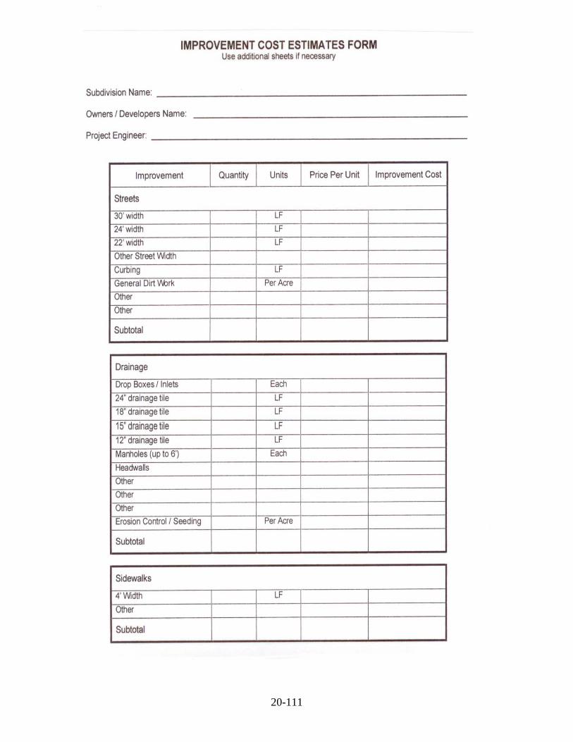
20-111

20-112

20-113

21-114
Article 21. EXHIBIT 7. DETAIL CONSTRUCTION SPECIFICATIONS 1.0 STREET, CURB AND GUTTER, AND SIDEWALK CONSTRUCTION.
The work covered by these Subdivision Regulations consists of the Subdivider or Developer furnishing all labor, equipment, and materials, and performing all operations in connection with the construction of different pavement methods in accord with these specifications and the applicable Development Plan drawings.
1.1 Grading
This term shall consist of all grading above or below subgrade elevations of whatever nature required to bring the street to proper subgrade elevations, including necessary excavation for curb, gutter, sidewalk, construction of embankments, excavation and proper sloping of all cuts, and other work incidental thereto.
1.2 Excavations
All excavations shall be made to approximate grade or subgrade elevations consistent with approved Development Plans. Excavations under ten (10) feet shall not be steeper than a cut slope of 3 horizontal to 1 vertical (3:1). Excavations over ten (10) feet shall not be steeper than a cut slope of 2 horizontal to 1 vertical (2:1).
1.3 Excavation Below Subgrade
Whenever excavations below subgrade elevation to remove spongy or unstable material, organic matter, or other materials is required, the contractor shall remove same and shall replace with compactable soils as per Item 1.4. The excavation can be backfilled with soils that were removed, provided they are clean clayey soils free of organic matter and other deleterious material, aerated and dried to near optimum moisture content or clean clayey borrow soils that have moisture contents near optimum moisture content.
1.4 Construction of Embankment
All surface vegetation and heavy root system shall be removed to eliminate all vegetation from the area upon which the embankment is to be constructed. Soils so removed shall not be used in construction of embankment. These materials shall be stockpiled and spread across scarified areas after the scarified areas have been brought to within inches of finished grade. Embankments shall be constructed of approved soils to approximate subgrade elevation in shallow level layers, 6 to 8 inches, within two (2) percent of optimum moisture content on the dry side of the curve or within three (3) percent of optimum moisture content on the wet side of the curve, compacted with an appropriate type of compaction equipment to a density not less than 95 percent of maximum density, as determined by the standard Proctor moisture-density test (ASTM D698-78 or AASHTO T-99). Embankments greater than ten (10) feet in height shall have soils below ten (10) feet compacted to 95 percent of maximum density, standard Proctor, respectively. Except as otherwise approved by a Qualified/Recognized Geotechnical Engineer, all soils placed in areas directly impacting public improvements shall be constructed to slopes no steeper than 2 horizontal to 1 vertical (2:1) and flatter where possible for ease of maintenance.

21-115
1.5 Backfill
Clayey soils, granular soils, or Portland Cement concrete shall be used to backfill utility crossings beneath and within three (3) feet on either side of the pavement and compacted to the densities stated in Item 1.4. Under no conditions shall granular backfill be flushed with water to obtain compaction. Utilities, which are parallel and within three (3) feet either side of the pavement, shall be compacted.
1.6 Subgrade
The subgrade is defined as the top one (1) foot of the soil profile at finished grade prior to placing the pavement. This top one (1) foot of soil will consist of: (a) compacted fill placed for embankments as outlined in Item 1.4; (b) undisturbed soils in the transitional areas from cut to fill immediately below the topsoil; or (c) undisturbed soils at depths greater than 3 feet below the original ground surface in cut areas. The top one (1) foot of subgrade shall be compacted to 95 percent of maximum density as determined by the standard proctor moisture-density test (ASTM D698-78 or AASHTO T-99) within three (3) percent of optimum moisture content on the dry side of the curve or four (4) percent of optimum moisture content on the wet side of the curve immediately prior to placing the pavement. This specification is similar to the compaction requirements in compacted fill areas since the embankment shall be compacted to 95 percent of maximum density as determined by the standard Proctor moisture-density test, respectively. In transitional areas from cut to fill, the soils have been subject to seasonal changes of freezing and thawing and wetting and drying. These soils will exist at moisture contents well above optimum moisture content and at densities on the order of 60 to 80 percent of maximum density (ASTM D698-78). These soils shall be scarified, aerated, and dried in order to obtain the specified percent compaction for subgrade. Soils in cut areas, three (3) feet below original grade, will exist at moisture contents above optimum moisture content and at densities about 90 percent of maximum density (ASTM D698-78). These soils shall be scarified, aerated, and dried in order to obtain the specified percent compaction for subgrade.
Any soft or yielding areas, resulting from high moisture content that are encountered at the time of construction shall be scarified, aerated, and dried to reduce the moisture content nearer to optimum moisture content, then re-compacted to the specified density.
The subgrade shall be shaped to Development Plan elevations and cross-sections. Immediately prior to placing the concrete, the subgrade shall be checked for conformity with the cross-section shown on the plans by means of an approved template on the side forms. If necessary, the materials shall be removed or added, as required, to bring all portions of the subgrade to correct elevations. The subgrade shall be thoroughly compacted and again checked with the template. Concrete shall not be placed on any part of the subgrade which has not been checked for correct elevation. The subgrade shall be clean of loose or wet material prior to placing concrete.
Prior to placing any pavement materials, the Planning Commission inspector may require the Contractor to proof roll the compacted subgrade with a piece of heavy rubber tired equipment, such as a road grader, loaded backhoe or a loaded single axle dump truck. This allows the Inspector to observe the proof rolling for consistency. Areas, which are subject to excessive pumping or rutting, shall be reworked and re-compacted as described above.
1.7 Equipment for Compaction of Backfill, Embankment, and Subgrade
Any compaction equipment capable of producing the required embankment and subgrade densities, without lamination, will be permitted. Clayey type or cohesive soils shall be compacted with a kneading type compaction equipment, such as a sheep foot roller. Cohesionless soils shall be compacted with vibratory type equipment, such as a vibrating plate or roller. All compaction equipment shall be in good condition and shall be

21-116
operated efficiently to assure uniform compaction.
1.8 Subgrade for Sidewalks and Driveways
Subgrade for driveways shall comply with Item 1.6 except soil density tests are not required. Cohesive soils or lean concrete shall be used under driveways (i.e., apron and sidewalk portion of driveway minimum three (3) feet back of curb for single or two-family or five (5) feet for multifamily or commercial), provided compaction is performed per Item 1.6. For sidewalks between driveways subgrade of cohesive soils shall be uniformly compacted per Item 1.6. Cohesionless or granular soils may be used as a base on subgrade for sidewalks between driveways provided base thickness does not exceed four (4) inches or thickness equivalent to that of the sidewalk and compacted per Item 1.6
1.9 Equipment Operated on Streets
The contractor shall be permitted to operate only rubber tired equipment over any paved street surfaces and shall be responsible for correcting any damage to street surfaces resulting from the contractor's operation. Paved streets, adjacent to new development, shall have all loose soil or mud removed at the end of each day's work.
1.10 Utilities
Special precautions shall be taken by the contractor to avoid damage to existing overhead and underground utilities. Before proceeding with the work, the contractor shall confer with all public or private companies, agencies, or departments that own or operate utilities in the vicinity of the construction work. The contractor shall be diligent in their efforts to use every possible means to locate existing utilities.
1.11 Soil Density Test
Soil density tests, including moisture-density tests (ASTM D698-78 or ASTM D1557-78) and field density tests (ASTM D1556-64 or ASTM D2922-78) are required to determine the percent compaction in accord with the following:
(1) Embankments -a minimum of one (1) test for each three (3) feet in elevation per 400 lineal feet or every 2500 cubic yards, or fraction thereof, of embankment section;
(2) Utility backfill excavations for storm, sanitary sewer and water system
crossings -a minimum of one (1) test for each two (2) feet in elevation per 100 lineal feet, or fraction thereof, of utility trench open cut beneath street subgrade and within three (3) feet outside of street pavements;
(3) Subgrades -a minimum of one (1) test per 100 lineal feet for streets 500
lineal feet or less or one (1) test per 200 lineal feet for streets over 500 lineal feet at each of the following locations, where applicable: i. compacted fill placed for embankments;
ii. undisturbed soils in transitional areas from cut to fill immediately below the topsoil; and
iii. Undisturbed soils at depths greater than 3 feet below the original ground
in cut areas. Density tests of soil embankment, utility excavations, or subgrade are not applicable when at least one of the following conditions exists:

21-117
3.0 ASPHALT PAVEMENT
i. more than five (5) percent of the material contains greater than one (1) inch sieve size particles; or
ii. more than 60 percent of the material contains greater than No. 4 sieve size particles except DGA (dense graded aggregate).
All soil density testing shall be at the expense of the Developer. The results of these tests shall be mailed directly to the Developer, design Engineer, Planning Commission, and the contractor. The results of all soil testing shall be compared to the densities, stated in Items 1.4, 1.5, and 1.6 of these regulations. Any deficiencies found in construction work must be remedied in the field or resolved between the Developer, contractor, and the Planning Commission inspector.
2.0 PREPARATION OF EXISTING GRANULAR BASE COURSES FOR SURFACING 2.1 Description and General Requirements
In areas where granular base course has been placed as a previous stage of street or road construction, the contractor shall blade, shape, and compact the base course in conformance with the required dimensions, line, grade, and cross-section to permit completion of the paving work. When directed by the Planning Commission inspector, additional base course aggregates shall be provided or excess aggregate removed and disposed of, by the contractor, as to provide conformance with the required roadway section.
2.2 Thickness of Surfacing Required for Existing Granular Base Courses
The existing thickness of granular base comprises a portion of the required Design Thickness as specified in Section 601.9 of these regulations.
2.3 Adjusting Manhole Tops
The contractor shall raise or lower existing manhole tops to coincide with the finished grade elevation of the paving.
3.1 Description and General Requirements
This item shall consist of furnishing all materials and performing all construction procedures required to build an asphalt pavement, on a prepared and approved subgrade, conforming to the requirements of these specifications and to the pavement design shown on the approved Development Plans. It may include any, or all, but is not necessarily limited to, materials and methods specified under Item 3.0 only.
Asphalt pavement shall consist of an asphalt surface course, or courses, constructed on an asphalt base course, or courses and/or subbase course, designed in compliance with the requirements of Section 601.9 of these regulations.
3.1.1 Asphalt Surface Course
The asphalt surface course or topcoat shall not be applied for a period of at least twelve (12) months after completion of the asphalt base construction.
Asphalt Surface Course materials and construction shall conform to the current requirements of the Kentucky Department of Transportation, Bureau of Highways, for Asphalt Concrete Surface and Binder (Section 401, 402).

21-118
3.1.2 Asphalt Base Course
Asphalt Base Course materials and construction shall conform to the current requirements of the Kentucky Department of Transportation, Bureau of Highways, Specifications for Asphalt Concrete Base Course (Section 401, 403).
3.1.3 Crushed Aggregate Base Course
3.1.3.1 Description
Crushed Aggregate Base Course, when provided for in the approved structural design of the pavement, shall consist of a granular layer constructed on prepared subgrade or subbase in accord with these specifications and in conformity with the approved dimensions, lines, grades, and cross-sections.
3.1.3.2 Materials and Construction Methods
Crushed Aggregate Base Course shall conform to all the current requirements for materials and construction methods of the Kentucky Department of Transportation for Dense Graded Aggregate Base Course as per Section 303.
3.1.4 Granular Subbase Course
3.1.4.1 Description
Subbase, when provided for in the approved structural design of the pavement, shall consist of a granular layer conforming to the following material and construction specifications.
3.1.4.2 Materials and Construction Methods
Crushed Aggregate Subbase Course shall conform to all the current requirements for materials and construction methods of the Kentucky Department of Transportation for Dense Graded Aggregate Subbase Course as per Section 303.
3.1.5 Asphalt Prime Coat
Asphalt Prime Coat shall be applied to the surface of granular courses upon which asphalt base or surface courses will be constructed. Asphalt Prime shall conform to the Kentucky Department of Transportation requirements for Cutback Asphalt Emulsion Primer Type L, as per Section 407. Prime shall be applied to the surface of granular base course at a rate of 0.25 to 0.50 gallons per square yard, as directed by the Planning Commission inspector, in conformance with requirements of the referred to specification.
3.1.6 Asphalt Tack Coat
Tack Coat shall consist of SS-1h, meeting the current requirements of the Kentucky Department of Transportation. It shall, when directed by the Planning Commission inspector, be diluted with equal parts of water. Application equipment and procedure shall conform to the requirements of the Kentucky Department of Transportation for Tack Coats as per Section 407. Tack Coat shall be applied to the surface of asphalt courses that have become dusty or dry from traffic use at a rate of 0.10

21-119
gallons per square yard of the diluted SS-1h before the subsequent course is constructed or in other circumstances when the Planning Commission inspector so directs.
3.2 Design of Asphalt Pavement Structure
3.2.1 Description
Asphalt pavement structures for subdivision streets shall be designed in conformance with the requirements of this specification. Thickness of the total pavement, and of component layers, shall be determined based on Street Classification.
3.2.2 Pavement Thickness Requirements
Thickness of component layers of the pavement for streets within the right-of-way and of the total pavement structure shall be determined per Section 609.0 of these Subdivision Regulations.
4.0 PORTLAND CEMENT CONCRETE CONSTRUCTION
The cement concrete pavement work shall consist of a single course of cement concrete, including reinforcement and longitudinal and transverse joints, where required, constructed on a prepared subgrade in general conformity with the lines, grades and cross-sections shown on the Development Plans.
4.1 Materials
Concrete shall be composed of Portland Cement, air-entraining agent, aggregates, and water.
4.2 Portland Cement
Cement of the type specified shall conform to requirements of the current ASTM specifications including Portland Cement Type I or Type III -High Early Strength (Designations C 150, C 175 or C 595). Cement, which for any reason has become partially set or which contains lumps of caked cement, shall be rejected. Either packaged or bulk cement may be used.
4.3 Air-Entraining Agent
Air-entraining agents shall conform to the requirements of the current ASTM specifications for air-entraining admixtures for concrete (Designation C 260).
4.4 Admixtures for Concrete
Chemical admixture of the type specified shall conform to requirements of the current ASTM specifications for Admixtures of Type A thru and Type E (Designation C 494). No pozzolans (Fly Ash) will be allowed as substitute for cement.
4.5 Aggregates
All aggregates for concrete shall meet the current standard requirements for concrete pavements of the Kentucky Department for Transportation, Bureau of Highways, or the current ASTM specification for concrete aggregates (Designation C 33). Aggregates shall be so handled that moisture content and gradation are reasonably uniform and do not change appreciably from batch to batch or hour to hour. No aggregates shall be used which have become contaminated or intermixed. Frozen

21-120
aggregates or aggregates containing frozen lumps shall be thawed before use.
4.6 Water
Water used in mixing or curing concrete shall be clean and free from injurious amounts of oil, acids, salt, alkali, or organic materials or other substances harmful to concrete. Normally, water from public supplies, which is suitable for drinking, is satisfactory.
4.7 Reinforcing Steel
Reinforcing steel, if specified, shall conform to current Standard Specifications of the Kentucky Department of Transportation, Bureau of Highways.
4.8 Joints
4.8.1 Expansion Joints
Expansion joints shall be non-extruding pre-formed joint fillers and shall conform to current Standard Specifications of the Kentucky Department of Transportation. The selection of the type will be at the contractor's option.
4.8.2 Joint Sealing Compound
The material used for filling and sealing cracks and/or joints shall be W. R. Meadows Sealtight #164 -Hot Pour Rubber Asphalt Sealer, W. R. Meadows Sealtight Hi-Spec Hot Pour Joint Sealing Compound or approved equal (AASHTO M 173).
4.9 Batching
Batching shall conform to Kentucky Department of Transportation, Bureau of Highways Specification 601.08 through 601.18.
4.9.1 Strength of Concrete
Finished concrete shall attain a minimum expected strength at 28 days of 4000 pounds per square inch compressive strength and/or 570 pounds per square inch flexural strength "modulus of rupture".
Except for sidewalks, curb and gutters, and driveway aprons, at least three (3) test cylinders shall be made for each day's placement for each 100 cubic yards, or portion thereof, by a recognized testing laboratory. One (1) cylinder shall be broken at seven (7) days and two (2) cylinders at 28 days. The results of these tests shall be sent directly to the Planning Commission, Design Engineer, Contractor, and concrete supplier.
The fabricating, curing, breaking, and reporting the test cylinders, slump test, and air content test shall be made at the contractor's expense.
4.9.2 Proportioning Concrete
The proper proportions of cement, water, and aggregates shall be determined in accordance with ACI Standard 613, "Recommended Practice for Selecting Proportions for Concrete", or the Portland Cement Association booklet, "Design and Control of Concrete Mixtures", latest editions.
The entrained air shall be obtained by using an air-entraining agent. All concrete shall be air-entrained in accordance with the following:
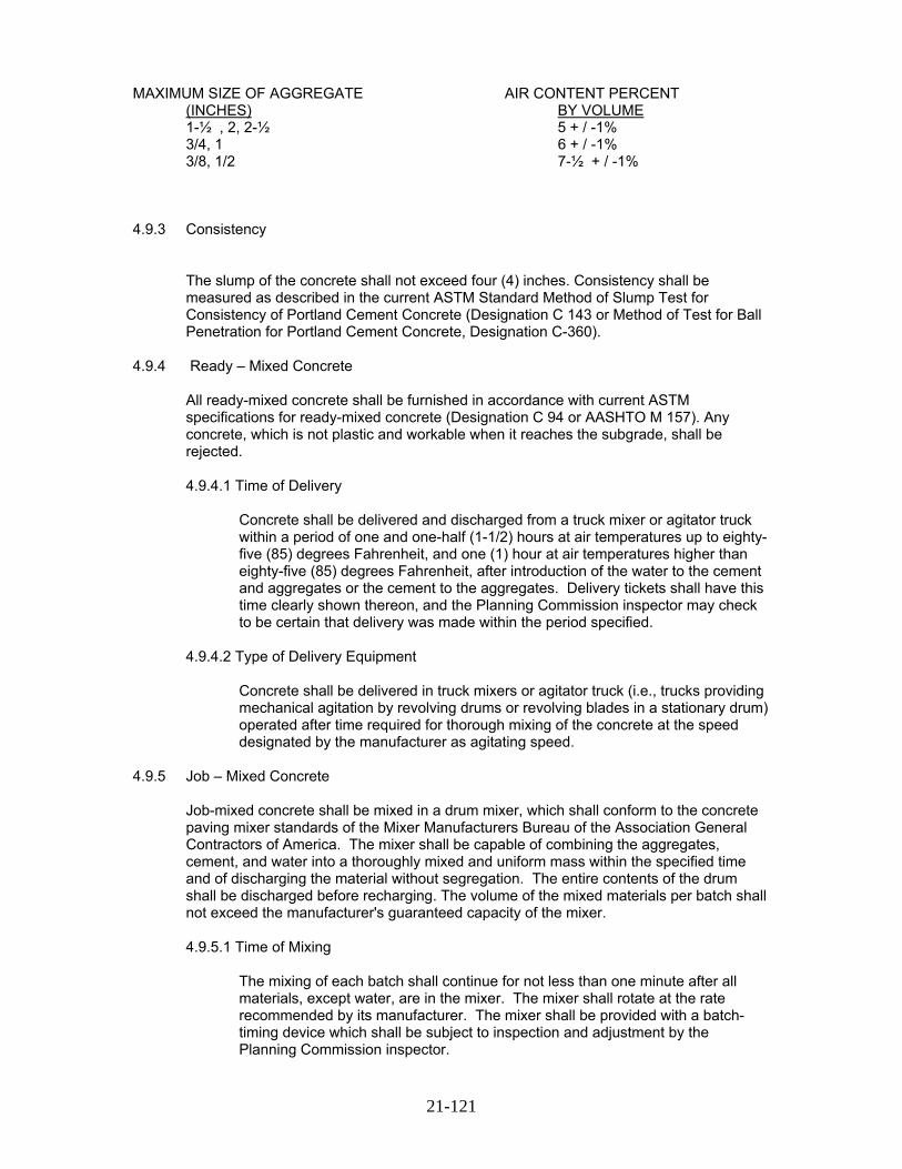
21-121
MAXIMUM SIZE OF AGGREGATE AIR CONTENT PERCENT (INCHES) BY VOLUME 1-½ , 2, 2-½ 5 + / -1% 3/4, 1 6 + / -1% 3/8, 1/2 7-½ + / -1% 4.9.3 Consistency
The slump of the concrete shall not exceed four (4) inches. Consistency shall be measured as described in the current ASTM Standard Method of Slump Test for Consistency of Portland Cement Concrete (Designation C 143 or Method of Test for Ball Penetration for Portland Cement Concrete, Designation C-360).
4.9.4 Ready – Mixed Concrete
All ready-mixed concrete shall be furnished in accordance with current ASTM specifications for ready-mixed concrete (Designation C 94 or AASHTO M 157). Any concrete, which is not plastic and workable when it reaches the subgrade, shall be rejected.
4.9.4.1 Time of Delivery
Concrete shall be delivered and discharged from a truck mixer or agitator truck within a period of one and one-half (1-1/2) hours at air temperatures up to eighty-five (85) degrees Fahrenheit, and one (1) hour at air temperatures higher than eighty-five (85) degrees Fahrenheit, after introduction of the water to the cement and aggregates or the cement to the aggregates. Delivery tickets shall have this time clearly shown thereon, and the Planning Commission inspector may check to be certain that delivery was made within the period specified.
4.9.4.2 Type of Delivery Equipment
Concrete shall be delivered in truck mixers or agitator truck (i.e., trucks providing mechanical agitation by revolving drums or revolving blades in a stationary drum) operated after time required for thorough mixing of the concrete at the speed designated by the manufacturer as agitating speed.
4.9.5 Job – Mixed Concrete
Job-mixed concrete shall be mixed in a drum mixer, which shall conform to the concrete paving mixer standards of the Mixer Manufacturers Bureau of the Association General Contractors of America. The mixer shall be capable of combining the aggregates, cement, and water into a thoroughly mixed and uniform mass within the specified time and of discharging the material without segregation. The entire contents of the drum shall be discharged before recharging. The volume of the mixed materials per batch shall not exceed the manufacturer's guaranteed capacity of the mixer.
4.9.5.1 Time of Mixing
The mixing of each batch shall continue for not less than one minute after all materials, except water, are in the mixer. The mixer shall rotate at the rate recommended by its manufacturer. The mixer shall be provided with a batch-timing device which shall be subject to inspection and adjustment by the Planning Commission inspector.

21-122
4.9.6 Adjusting Slump of Concrete
Measured amounts of water can be added. After adding water, an additional slump test must be made.
4.10 Measuring Air Content
The air content shall be measured in accordance with ASTM Method of Test for Air Content of Freshly Mixed Concrete by the Pressure Method (Designation C 231) or ASTM Method of Test for Air Content of Freshly Mixed Concrete by the Volumetric Method (Designation C 173).
4.11 Forms
Except for slip form paving methods, fixed forms may be made of wood or metal and shall have a depth equal to or greater than the prescribed edge of thickness of the pavement. Each section or form shall be straight, free from bends or warps. The method of connections between the form sections shall be such that the joint thus formed is tight and free from movement in any direction. Forms shall be of such cross-sections and strength and so secured as to resist the pressure of the concrete when placed, and the impact and vibration of any equipment, which they support without springing or settlement.
4.11.1 Setting Forms
The subgrade under the forms shall be compacted and shaped so that the form set shall provide the specified elevation. The supply of forms shall be sufficient to permit their remaining in place for sufficient time so, when removed; the concrete will not be displaced. All forms shall be cleaned and oiled each time they are used.
4.11.2 Grade and Alignment
The alignment and grade elevation of the forms shall be checked by the contractor immediately ahead of concrete placement and necessary corrections will be made. Any forms that have been disturbed or Subgrade that has become unstable shall be corrected and forms reset and rechecked. Any variations in grade and alignment shall be subject to approval of the Design Engineer and Planning Commission Inspector prior to placing concrete.
4.12 Placing Concrete
The concrete shall be mixed in quantities required for immediate use and shall be deposited on the subgrade to the required depth and width of the construction lane in successive batches and in a continuous operation, without the use of intermediate forms or bulk-heads. The concrete shall be placed as uniformly as possible, in order to minimize the amount of additional spreading necessary. While being placed, the concrete shall be vibrated and compacted with suitable tools, so that the formation of voids or honeycomb pockets is prevented.
No concrete shall be placed around manholes or other structures until they have been brought to the required grade and alignment. Additional tamping and compaction will be required after raising manholes.
21-123
4.12.1 Cold Weather Concreting
Concrete may be placed when the air temperature in the shade and away from artificial heat is thirty-five (35) degrees Fahrenheit or higher. No concrete shall be placed upon frozen subgrade. However, if subgrade has been protected from freezing and concrete temperature is 50 degrees or higher, concrete may be placed until ambient temperature drops to 25 degrees. Concrete shall be protected from freezing for a period up to three (3) days or until concrete reaches a compressive strength of 500 psi.
4.12.2 Hot Weather Concreting
Except by approval of the Planning Commission inspector, concrete placing shall cease if the temperature of the plastic concrete cannot be maintained at ninety (90) degrees Fahrenheit or lower.
To facilitate the placement of concrete in hot weather, a retarding chemical admixture Type B or D, in conformance with ASTM C-494, may be used.
4.13 Consolidating and Finishing
The pavement shall be struck off and consolidated with a mechanical finishing machine, vibrating screed, or by hand-finishing methods. A slipform paver may also be used. When a mechanical finishing machine is used, the concrete shall be struck off at such a height that after consolidation and final finishing, it shall be at the elevation as shown on the plans.
The finishing machine shall be provided with a screed, which will consolidate the concrete by pressure, vibration or both. The concrete shall be brought to a true and even surface, free from rock pockets. The edge of the screeds along the curb line may be notched out to allow for sufficient concrete to form the integral curb. Hand-finishing tools shall be kept available for use in case the finishing machine breaks down. When hand finishing is used, the pavement shall be struck off and consolidated by a vibrating screed to the elevation as shown on the plans. When the forward motion of the vibrating screed is stopped, the vibrator shall be shut off; it shall not be allowed to idle on the concrete.
4.13.1 Scraping and Straight Edging
The pavement may be required, by the Planning Commission inspector, where applicable, to be scraped with a straightedge, equipped with handles long enough to permit it to be operated from the edge of the pavement.
When irregularities are discovered, they shall be corrected by adding or removing concrete. All disturbed areas shall be floated with a wooden or metal float not less than three (3) feet long and not less than six (6) inches wide and again straight-edged.
4.13.2 Edging
Before final finishing, is completed, and before the concrete has taken its initial set, the edges of the slab and curb shall be carefully finished with an edger.
4.13.3 Final Surface Finish
A burlap drag or medium broom shall be used as the final finishing method for concrete pavement. The drag shall be at least three (3) feet in width and long enough to cover the entire pavement width. It shall be laid on the surface of the

21-124
pavement and dragged forward in the direction in which the pavement is being laid. If a broom finish is used, the brooming shall be drawn from the center to the edge of pavement using overlapping strokes to produce surface corrugations of uniform appearance about 1/16th inch in depth. The curb shall have the same final finish as the pavement.
The final surface of the concrete pavement and curb shall have a uniform gritty texture, and true to the grades and cross-sections shown on the Development Plans.
4.14 Integral Curb
Curbs shall be required along the edges of all street pavement where shown on the Development Plans and shall conform to cross sections. Curbs may be constructed simultaneously with the pavement with extrusion equipment, hand formed immediately after the finishing operation, or built as a separate construction operation. The integral vertical and rolled curb shall be constructed with or immediately following the finished operation. Special care shall be taken so that the curb construction does not lag the pavement construction and form a "cold joint".
When integral vertical curbs are required along the edges of all street pavement, depressed curbs two (2) inches above gutter line shall be provided at all driveway entrances and at such other locations as designated on the approved Development Plans. In placing concrete curb, sufficient spading shall be done to secure adequate bond with paving slab and eliminate all voids within and back face of the curb.
The placement and construction of all sidewalks curb, and gutters shall be shown on the Development Plan Drawings in accord with Exhibit 10 – Standard Detail Drawings.
4.15 Curing
Concrete shall be cured by protecting it against loss of moisture, rapid temperature change, from rain, flowing water, and mechanical injury for a period of not less than five (5) days from the beginning of the curing operation. Moist curing, waterproof paper, white pigmented liquid membrane compound, or a combination thereof, may be used for curing. Immediately after finishing operations have been completed, the entire surface of the newly placed concrete shall be covered by the curing medium, which is applicable to local conditions and approved by the Planning Commission inspector.
The edge of concrete slabs exposed by the removal of forms shall be protected immediately to provide these surfaces and to prevent injury to concrete edges.
The covering material shall be kept free of any substances, which may be detrimental to the surface of the concrete. The initial curing medium shall be effective and shall be applied so as to prevent checking, cracking, and the appearance of dry spots in the surface of the concrete. The contractor shall have the equipment needed for adequate curing at hand and ready to install before actual concrete placement begins. In all cases in which the curing medium requires the use of water, the curing shall have prior right to all water supplies. Failure to provide sufficient cover material of the type selected, failure to maintain saturation for the entire curing period in the moist-curing methods, lack of water to adequately care for both curing and other requirements, or other failures to comply with curing requirements shall be cause for immediate suspension of concreting operations.
4.15.1 Moist Curing
Moist curing shall be accomplished by covering of burlap, cotton mats, or other approved fabric mat used singly or in combination. Curing mats shall be thoroughly wet when applied and kept continuously wet and in intimate contact

21-125
with the pavement surface for the duration of the moist curing period. Other fabric mats shall conform in design and shall provide a curing medium at least equal to cotton mats. Cotton mats, other fabric mats, and burlap mats and burlap strips shall be furnished in the widths or lengths, after shrinkage, required to cover the entire width and edges of the pavement lane. Mats or burlap shall be lapped at joints between adjacent sheets to prevent drying at this location. Moist curing, when used as initial curing, shall be continued for not less than twenty-four (24) hours. Type and weight of cotton mats for curing concrete shall conform to ASTM C-440 or AASHTO M-73. Burlap strips shall conform to AASHTO M-182.
4.15.2 Waterproof Paper and Polythene Sheeting Curing
The surface of the concrete shall be wetted with a fine spray of water and then covered with the waterproof paper or sheeting. The paper or sheeting shall be in pieces large enough to cover the entire width and edges of the slab and shall be lapped not less than twelve (12) inches. Paper or sheeting shall be adequately weighted to prevent displacement or billowing due to wind. Paper or sheeting folded down over the side of the pavement widths shall be secured by a continuous bank of earth. Tears or holes appearing in the paper or sheeting during the curing period shall be immediately repaired.
4.15.3 Liquid Membrane Curing Compound
Pigmented liquid membrane curing compound shall meet the specifications under ASTM C 309 classified as Type 1-D translucent with fugitive dye, Type 2 -white pigmented or approved equal. The curing compound must be applied to cover the surface completely and uniformly at a rate, which will achieve the performance requirement specified in AASHTO specifications M 148 or ASTM Designation C 309. This method of curing shall be applied immediately behind the final finishing operation or after the initial curing when a combination of methods are used. Failure to provide complete and uniform coverage at the required rate will be cause for discontinuance of this method of curing and the substitution of one of the other approved methods. The compound shall be kept agitated to prevent the pigment from settling. Special care shall be taken to apply the curing compound to the pavement edges immediately after the forms have been removed.
4.16 Pavement Joints
Concrete pavement shall include expansion, contraction, and longitudinal joints. Transverse joints may be expansion and contraction type joints, which shall be continuous across the pavement lane including the curb. Longitudinal joints are parallel to the pavement lanes. Construction joints are necessary when the placement of concrete is delayed. The location of either transverse construction joints may be planned (coincidental with a contraction joint) or emergency (not coincidental with a contraction joint). In general, the location of longitudinal joints shall be centered between pavement lanes except for street widths 30 feet and wider.
The placement and construction of all pavement joints shall be shown on the Development Plan Drawings in accord with the following specifications:
4.16.1 Expansion Joints
Expansion joints shall be Type1. Filler material shall conform to Item 4.8.1 and extend the entire width of the pavement. The filler shall be held accurately in place during the placing and finishing of the concrete by a bulkhead, a metal channel cap or other approved method. Expansion joints shall be installed at the

21-126
following locations: (1) at all street intersections at the point of curvature of the turning radii entering the intersection; and (2) at cul-de-sacs or turnarounds at the point of curvature of the first turning radii approaching the turn-around. In no case shall the expansion joint spacing exceed 150 feet.
No concrete shall be left above the expansion material or across the joint at any point. Any concrete spanning the ends of the joint next to the forms shall be carefully cut away after the forms are removed.
Before the pavement is opened to traffic, the groove above the filler shall be cleaned and sealed with joint sealing material specified in Item 4.8.2.
4.16.2 Contraction Joints
Transverse joints shall be Type 2. Sawed joints shall be equal to a depth of one-fourth (1/4) of the pavement thickness as the minimum established standard continuous across the slab including additional depth at the integral curb faces. Such joints may also be grooved with a metal jointing tool to a depth of one and one half (1-1/2) inches including additional depth and special treatment at integral curb faces to control cracking. Other joint depths used with alternate pavement designs including stabilized pavement subbases shall be shown on the plans and reviewed per industry standards.
In no case shall the contraction joint be spaced at intervals greater than a distance of fifteen (15) feet between joints for integral curb concrete pavement. For concrete curb used with asphalt pavement, contraction joints shall be space at intervals not greater than ten (10) feet.
Where sawed joints are specified, they shall be sawed within a time frame of between four (4) hours and eight (8) hours following placement of each pavement section. However, depending upon temperature, weather conditions, and other factors affecting setting times, variations to these time frames may be required to ensure that joints are sawed early enough to control cracking, but late enough to prevent any damage by blade action to the slab surface and to the concrete immediately adjacent to the joint.
4.16.3 Construction Joints
Transverse construction joints shall be used wherever the placing of concrete is suspended for more than thirty (30) minutes. A transverse construction joint shall be Type 3, with smooth bars (one end lubricated) if the joint occurs at the location of a contraction joint. A transverse construction joint shall be Type 4 with deformed tie bars (both ends bonded) if the joint occurs at any other location. Both Type 3 and Type 4 joints shall be butt type construction formed. In the case of integral curb concrete pavement where construction joints are sawed they shall be saw cut full depth where no vertical face of concrete is undermined creating a void under the pavement. In the case of concrete curb and gutter used with asphalt pavement, special care should be taken to ensure that all surfaces including the joint are uniform and result in the same integrity as an integral curb concrete placement.
4.16.4 Longitudinal Joints
Longitudinal joints between lanes shall be Type 6 of the tied construction type. An alternative longitudinal joint Type 7 may be used with slip-form paving operations. As an option to drilling diagonal bars in Type 7, bent bars may also be injected in fresh concrete before it’s initial set. Following subgrade preparation and testing, bent bars shall not be straightened until the concrete has cured sufficiently to enable bending without fracture of concrete slab as determined by the Planning Commission inspector. The location of longitudinal joints shall be centered between pavement lanes and coincide with lane markings wherever possible, except for street widths of thirty (30) feet and wider where joints shall be located at equal intermediate locations. In these cases, longitudinal joints may be sawed and shall be Type 5.

21-127

21-128
4.16.5 Integral Curb Joints
In the construction of transverse joints, special care must be taken to ensure that all transverse joints extend continuously through the pavement and curb per Items 4.16.2 and 4.16.3.
4.17 Tie Bars
All tie bar reinforcement for concrete pavement shall conform to Item 4.7. All tie bars shall be deformed bars for Types 4, 5, 6, and 7, and plain or smooth bars for Type 1 and 3.
4.18 Joint Sealer
Pavement joint sealer shall be as specified in Item 4.8.2 of these regulations. Application of joint sealer shall be as follows:
Material must be melted in a double boiler, oil jacketed melter equipped with a mechanical agitator, pump, gas pressure gauges, and separate temperature thermometers for both oil bath and melting vat, with accessible control valves and gauges.
On start up of melter, raise the oil bath temperature, not to exceed 450 degrees (F). Add small quantities of crack filler material to the melter and, while continuously agitating, add additional material as needed. Control material temperature at 380 degrees (F). Do not exceed 400 degrees (F) at start up.
The sealing and filling of joints and/or cracks may be done at air temperature of 40 degrees (F) or higher. For best results, cracks should be filled to a depth of 1/4 inch below the surface. Where necessary to limit the depth of the sealant, use cotton or Kraft rope inserted to the correct depth of the cleaned joint or crack.
Small quantities of unused material remaining in the melter may be remelted and used the following day.
4.19 Structures Encountered in the Paved Area
4.19.1 Manholes and Catch Basins
All manholes and catch basins encountered in the areas to be paved shall be raised or lowered to the surface of the new pavement. Catch basins may be separated from the pavement and curb by boxing out around basin.
4.20 Protection and Opening to Traffic
Traffic shall be excluded from the pavement by erecting and maintaining barricades and signs until the concrete is at least seven (7) days old or has attained a compressive strength of 3,500 pounds per square inch and/or a flexural strength of 550 per square inch using Type I Normal Cement certified by a qualified/recognized geotechnical Engineer. Other protection and opening to traffic decisions on other pavement designs using Type III High Early Strength Cement shall be reviewed per industry standards. This traffic restriction shall apply to the contractor's vehicles, as well as general traffic. As soon as curing and sealing are completed, the contractor shall clean up the pavement free from all debris.
21-129
4.21 Curb, Gutter, Sidewalk, and Driveway Aprons
Construction of curb, gutter, sidewalk, and driveway aprons shall require the same care as the street pavement. The preceding requirements shall apply, where pertinent, to the construction of curb, gutter, sidewalks, and driveways within the right-of-way. In addition, sidewalks or driveways shall be constructed so that the transverse joint spacing shall be equal to the width of the sidewalk or driveway, but in no case shall the transverse joint spacing for driveways exceed twelve (12) feet and not greater than five (5) feet for sidewalk spacing. Sidewalks and driveways, within the right-of-way, shall be constructed with a pavement thickness of at least four (4) inches and increased to five (5) inches when included as a part of a driveway. Driveways shall be a minimum of five (5) inches in thickness within the right-of-way. Commercial and industrial entrances will require sidewalk thickness conforming to driveway pavement thickness.
The placement and construction of all sidewalks curb, and gutters shall be shown on the Development Plan Drawings in accord with Exhibit 10 – Standard Detail Drawings.
4.22 Pavement Thickness
Pavement thickness for each type street classification shall be as provided in Section 601.9 of these regulations. Streets that are subjected to exceptionally heavy truck traffic shall require a more complete detailed analysis by the Developer's Engineer and approved by the planning commission's duly authorized representative. All arterial streets shall be designed in accordance with the requirements of the Kentucky Department of Transportation.
4.22.1 Tolerance in Pavement Thickness
Deficiency in pavement thickness determined by drilling or coring new concrete pavement shall not exceed 0.20 inches. When thickness of pavement is deficient by more than 0.20 inches, such areas shall be removed and/or replaced unless otherwise determined by the inspector and a qualified Registered Professional Engineer.
4.22.2 Surface Tolerance
The finished surface shall be tested for smoothness by use of a 10-foot long straightedge placed parallel to the centerline of the pavement in each wheel lane. Ordinates measured from the face of the straightedge to the surface of the pavement shall at no place exceed one-quarter inch. Areas that do not meet the required surface accuracy shall be clearly marked out and the Contractor shall, at his/her own expense, as required by the planning commission's duly authorized representative:
(1) Grind down any areas higher than 1/4 inch but not more than 1/2 inch above the correct surface. (2) Correct any areas lower than 1/4 inch but not lower than 1/2 inch below the correct surface by grinding down the adjacent areas. (3) When the deviation exceeds 1/2 inch from the correct surface, the pavement slab shall be broken out and replaced for a length, width and depth, which will allow the formation of a new slab of the required quality in no way inferior to the adjacent undisturbed slab.
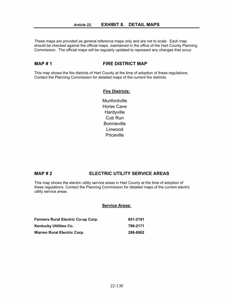
22-130
Article 22. EXHIBIT 8. DETAIL MAPS These maps are provided as general reference maps only and are not to scale. Each map should be checked against the official maps, maintained in the office of the Hart County Planning Commission. The official maps will be regularly updated to represent any changes that occur.
MAP # 1 FIRE DISTRICT MAP
This map shows the fire districts of Hart County at the time of adoption of these regulations. Contact the Planning Commission for detailed maps of the current fire districts.
Fire Districts:
Munfordville Horse Cave Hardyville Cub Run
Bonnieville Linwood Priceville
MAP # 2 ELECTRIC UTILITY SERVICE AREAS
This map shows the electric utility service areas in Hart County at the time of adoption of these regulations. Contact the Planning Commission for detailed maps of the current electric utility service areas.
Service Areas:
Farmers Rural Electric Co-op Corp. 651-2191 Kentucky Utilities Co. 786-2171
Warren Rural Electric Corp. 286-8062

MAP # 3 WATER UTILITY SERVICE AREAS
This map shows the water utility service areas in Hart County at the time of adoption of these regulations. Contact the Planning Commission for detailed maps of the current water utility service areas.
Service Areas:
Green River Valley Water District 773-2135 Bonnieville Municipal Water 531-3212 Horse Cave Water Company 786-2680 Munfordville Water Company 524-5701 Caveland Environmental Authority, Inc. 773-2887 Edmonson County Water 597-2165
MAP # 4 TELEPHONE UTILITY SERVICE AREAS
This map shows the telephone utility service areas in Hart County at the time of adoption of these regulations. Contact the Planning Commission for detailed maps of the current telephone utility service areas.
Service Areas:
South Central Rural Telephone Coop. Corp. 678-2111 Mediacom 800-874-2924
22-131

Article 23. Exhibit 9 AGRICULTURAL USE APPLICATION
Review No. ____________________
AGRICULTURAL USE APPLICATION FOR DIVISION OF REAL ESTATE
Hart County Planning Commission Hart County Courthouse Munfordville, Ky 42765
I (we), the applicant(s), do hereby acknowledge the following:
1. Hart County, Kentucky has adopted Subdivision Regulations for the division of land in Hart County, Kentucky pursuant to KRS 100;
2. KRS 100 exempts any division of a parcel of land into a tract of at least five (5) contiguous
acres in size for the purpose of agricultural use, as defined in KRS 100.111(2), and not involving a new street or vehicular way, as defined in KRS 100.111(20) and (22), from the requirements of the Subdivision Regulations;
3. The size of a tract alone does not determine whether or not the division of land is a subdivision;
and,
4. In addition to the tract size of five (5) acres, the division of land must be for agricultural use in order for the division to be exempt from Subdivision Regulations.
Comes the applicant(s), pursuant to KRS 100.111(2) and (22), and certifies that the following statements are true and correct:
1. The proposed division of land is for agricultural use only, as defined in KRS 100.111(2) and the proposed division consist of a minimum of five (5) contiguous acres;
2. The proposed division of land is not for residential building development for sale or lease to the
public, as set forth in KRS 100.111(2);
3. The proposed division does not involve a new street or vehicular way as set forth in KRS 100.111(20) and (22). Applicant certifies that the division is accessible by an existing street and no new street or vehicular way will be required to furnish ingress and egress to the subject property. Further, applicant certifies that no new street or vehicular way has been created within the year preceding the application for the specific purpose of submitting the subject application; and,
4. Applicant acknowledges that the future land use of the proposed development is limited to
agricultural use only and that any further subdivision or development of the agricultural tract will be restricted until the proposed division complies with the applicable Rules and Regulations of the Hart County Planning Commission.
23-132

23-133
Witness my (our) signature(s) hereto this the ________ day of ___________________, 20____.
_______________________________________
SIGNATURE (PROPERTY OWNER)
__________________________________________
SIGNATURE (PROPERTY OWNER) COMMONWEALTH OF KENTUCKY COUNTY OF _______________ SUBSCRIBED AND SWORN TO before me this the ______ day of ________________, 20___.
____________________________________
NOTARY PUBLIC My Commission Expires:_______________ The following items are to be submitted along with this application fifteen (15) days prior to the Planning Commission’s scheduled meeting at which the application is to be considered: * The original Plat(s), on mylar, and eight (8) blue line prints of the mylar. Any Plat approved pursuant to an Agricultural Application shall have the following notation on the plat:
DIVISION FOR AGRICULTURAL USE
The property shown hereon has been divided for agricultural use, as defined in KRS 100.111(2), and does not comply with the Subdivision Regulations of Hart County. Future land use of the property is limited to agricultural use only and any further subdivision or development will be restricted until the proposed division complies with the applicable rules and regulation of the Hart County Planning Commission. This note shall be shown on all subsequent plats of the subject property until the abovementioned requirements are met.
CERTIFICATE OF APPROVAL FOR RECORDING
I hereby certify that the plat shown hereon has been approved for recording in the office of the County Clerk of Hart County. Date: _________________
____________________________________
Chairman or Planning Commission Staff