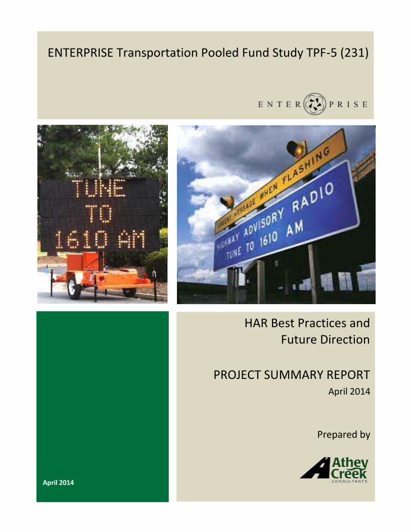
HAR Best Practices and Future Direction PROJECT SUMMARY...
32
April 2014 ENTERPRISE Transportation Pooled Fund Study TPF-5 (231) HAR Best Practices and Future Direction PROJECT SUMMARY REPORT April 2014 Prepared by
Transcript of HAR Best Practices and Future Direction PROJECT SUMMARY...
April 2014
ENTERPRISE Transportation Pooled Fund Study TPF-5 (231)
HAR Best Practices and Future Direction
PROJECT SUMMARY REPORT April 2014
Prepared by
ENTERPRISE HAR Best Practices and Future Direction – April 2014 i
Acknowledgements This document was prepared for the ENTERPRISE Transportation Pooled Fund TPF-5(231) Program.1
With agencies from North America and Europe, the main purpose of ENTERPRISE is to use the pooled
resources of its members, private sector partners and the United States federal government to develop,
evaluate and deploy Intelligent Transportation Systems (ITS).
Special thanks to ISS, MH Corbin and the agencies that contributed information to this report.
Photos in this report are used courtesy of ISS, MH Corbin and other HAR vendors, as well as the agencies
managing HAR deployments throughout the US.
Project Champion Bill Legg, Washington Department of Transportation, was the ENTERPRISE Project Champion for this
effort.
Members of ENTERPRISE Pooled Fund Arizona Department of Transportation
Federal Highway Administration
Georgia Department of Transportation
Idaho Transportation Department
Illinois Department of Transportation
Iowa Department of Transportation
Kansas Department of Transportation
Maricopa County, Arizona
Michigan Department of Transportation
Minnesota Department of Transportation
Mississippi Department of Transportation
Oklahoma Department of Transportation
Ministry of Transportation Ontario
Pennsylvania Department of Transportation
Dutch Ministry of Transport (Rijkswaterstaat)
Texas Department of Transportation
Transport Canada
Virginia Department of Transportation
Washington State Department of Transportation
ENTERPRISE HAR Best Practices and Future Direction – April 2014 ii
Table of Contents
1. Introduction and Overview.............................................................................................................. 1
2. HAR Background ............................................................................................................................. 1
2.1 HAR Governance ...................................................................................................................... 1
2.2 Functional Performance Authorized by FCC .............................................................................. 1
2.3 Allowable Information on HAR ................................................................................................. 2
3. Current HAR Uses ............................................................................................................................ 3
3.1 Use of HAR by State ................................................................................................................. 3
3.2 Specific Uses of HAR ................................................................................................................. 5
4. Value of HAR ................................................................................................................................. 12
4.1 HAR Usage and Value ............................................................................................................. 12
4.2 Other Factors Impacting Value of HAR.................................................................................... 13
5. HAR Technology and Operations ................................................................................................... 14
5.1 Content Creation .................................................................................................................... 14
5.2 Content Delivery to HAR Sites ................................................................................................ 15
5.3 Broadcast Approaches............................................................................................................ 16
5.4 Promoting HAR Use ................................................................................................................ 16
5.5 Maintaining HAR .................................................................................................................... 17
6. Conclusion .................................................................................................................................... 18
Appendix A: PennDOT HAR Messaging Guidelines ................................................................................A-1
Appendix B: WSDOT HAR Message Library Samples .............................................................................. B-1
Appendix C: MH Corbin Preventive Maintenance Schedule................................................................... C-1
Appendix D: HAR Uses and Typical Technology Applications ................................................................ D-1
Appendix E: References ........................................................................................................................ E-1
ENTERPRISE HAR Best Practices and Future Direction – April 2014 1
1. Introduction and Overview This document presents the complete findings of the ENTERPRISE Highway Advisory Radio (HAR) Best
Practices and Future Directions project. The overall intent of this project is to provide ENTERPRISE
member states with guidance to help them better understand how they should pursue HAR
technologies and approaches in the future. To accomplish this, the project goals are defined as follows:
Goal #1: To help members understand how HAR is being used by transportation agencies today;
Goal #2: To help members understand the potential value of HAR; and
Goal #3: To help members understand the current and potential future state of HAR technology
practices.
The remainder of this document presents a general background of HAR, a summary of HAR uses and
value, as well as the current and potential future state of HAR technology practices. Information for this
project was gathered through literature reviews and interviews with transportation agencies operating
HAR and manufacturers of HAR systems.
2. HAR Background HAR is a communication tool that has been used since the late 1970s by government organizations to
deliver public information over short ranges by radio. Systems typically consist of a transmitter, antenna,
recording device and power. Most modern systems use control software and wireless communication
options that allow messages to be recorded or activated remotely. HAR is often used by departments of
transportation, in particular, to deliver information about road conditions, construction and other traffic
conditions.
2.1 HAR Governance Although referred to as HAR by transportation agencies, the Federal Communications Commission (FCC)
regulates and refers to this service as Travelers’ Information Stations (TIS). In the remainder of this
section, the terms TIS and HAR will be used interchangeably. The service was established in 1977 by the
Report and Order in Docket 20509, FCC 77-414, 67 FCC 2d 9172 and is further governed by Rule 47 CFR
90.242 Travelers’ Information Stations.3 FCC mandates that TIS may only be used by governmental
entities and park districts for noncommercial purposes. Specifically, they may be used to transmit
noncommercial voice information pertaining to traffic and road conditions, traffic hazards and travelers’
advisories, directions, availability of lodging, rest stops and service stations, and descriptions of local
points of interest.
2.2 Functional Performance Authorized by FCC The radio signal of a TIS is typically transmitted on the AM band between the 530-1700 kHz frequencies
in 10 kHz increments. The physical broadcast range is constrained by the FCC to a 10 watt transmitter
output power, an antenna height no greater than 15 meters (49.2 feet), and a coverage radius of 3 km
(1.86 miles).
ENTERPRISE HAR Best Practices and Future Direction – April 2014 2
In 2000, the FCC also introduced the option for broadcasting on FM frequencies. Low-power FM (LPFM)
broadcast content is still limited to noncommercial use and there are similar constraints on power,
antenna height and broadcast ranges. Both the LPFM and AM physical restrictions are intended to limit
interference with commercially broadcast radio stations and to maintain the intent of TIS for localized
traveler information. LPFM is further governed by Rule 47 CFR 73.801 Broadcast Regulations Applicable
to LPFM Stations.4
There is a formal licensing process through the FCC that must be followed before a TIS site can become
operational. Filing for LPFM is limited to specific windows determined by the FCC, with the most recent
filing window running from October 17 to November 14, 2013. During the filing process, information
about the broadcasting equipment and site must be provided, along with analysis of the potential for
interference with other commercial broadcasts within the vicinity of the proposed site. For the AM
band, the FCC offers a search tool to facilitate a cursory search of site and frequency information. It is
also common for vendors of TIS products to provide FCC licensing support services for their clients.
In the years since it was first established, the FCC has modified other performance parameters of TIS but
the fundamental public information purpose of these stations has been retained. The most recent of
these modifications, in July 2013, reiterated the permissible content under the TIS rules must continue
to be relevant to travel, an emergency, or an imminent threat of danger. The Report and Order in
Docket 09-19, FCC 13-985 also refined its restrictions on so-called “ribbon” networks of TIS transmitters
(i.e., multiple simulcast transmitters), requiring only that simulcast TIS transmissions be relevant to
travelers in the vicinity of each transmitter in the network. This latest ruling on simulcasting is
encouraging for transportation agencies wanting to provide traveler information along a continuous
roadway network; for example, travel times along a corridor of interstate.
2.3 Allowable Information on HAR TIS, or HAR, systems may be permanently installed or used on a portable basis depending upon the
need. For example, permanent installations are commonly used to share recurring information such as
traffic conditions. Portable deployments are often used for short-term special events to share
information about parking or traffic. Regardless of whether a site is permanent of portable, the FCC
requires the information broadcast must be noncommercial and highly localized in nature to support the
original intent of HAR.
The FCC maintains in its July 2013 ruling that content must be relevant to travel, imminent danger and
emergencies. The ruling also provides additional clarification on the broadcast of weather information
as there have been some debates about when such information is relevant to travel or emergencies. The
rule states that, “TIS operators may transmit weather alerts regarding difficult or hazardous conditions
(whether or not “tone alerted”), as well as information regarding motor vehicle crashes, emergency
points of assembly, road closures and construction, parking, current driving travel times, air flight status,
truck weigh stations, driver rest areas, locations of truck services, and road closures.” The FCC ruling
ENTERPRISE HAR Best Practices and Future Direction – April 2014 3
contends that limiting TIS weather information to potentially hazardous conditions, drivers and other
travelers will know immediately that they are receiving non-routine weather information that could
negatively impact driving conditions.
3. Current HAR Uses Research and discussions with a number of state departments of transportation (DOTs), toll authorities,
and local agencies have identified a variety of HAR operational approaches currently in use. The number
of HAR towers operated by the agencies researched for this project range from one to nearly 100. HAR
broadcast sites are much like dynamic message signs, in that agencies select strategic locations for
deployment based on transportation needs such as construction, route selection points, recurring
congestion, or changing road weather conditions.
3.1 Use of HAR by State Through the research for this project, two states were identified to operate 50 or more HAR sites. A
larger number of states operate 10-50 HAR towers, and several states have less than 10 active
deployment sites. There are also several states not actively using HAR at all. The following table briefly
summarizes HAR use in 20 states.
In addition to those states using HAR, there are several not using the technology at all. Some states have
challenging terrain that makes deployment and radio transmission difficult. Some view HAR as
redundant to other traveler information services such as 511. Another common reason states have
avoided or discontinued using HAR is the lesser quality of the broadcast that travelers hear, particularly
over the AM frequency. West Virginia6, for example, noted that although they have a few county-
operated HAR sites, their state does not utilize HAR for a variety of reasons. Some primary reasons are
that due to topography making it very difficult to deploy HARs; they are using a statewide 511 system;
and, they feel that HAR is too site-specific.
ENTERPRISE HAR Best Practices and Future Direction – April 2014 4
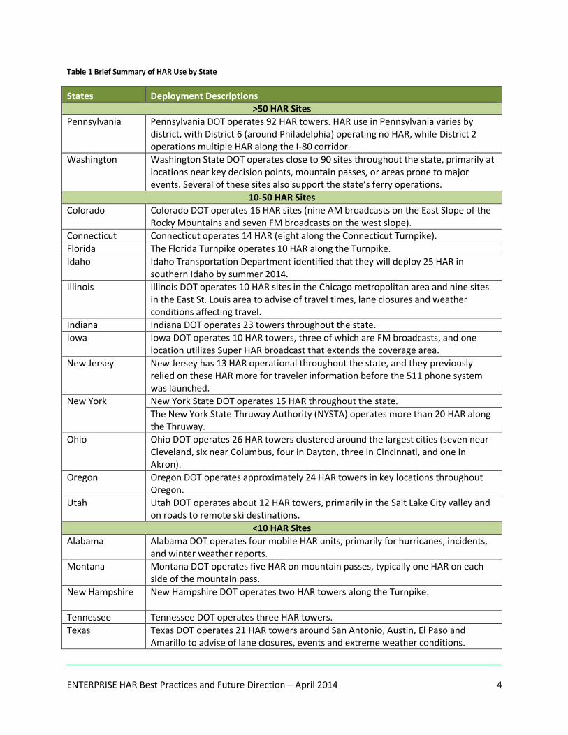
Table 1 Brief Summary of HAR Use by State
States Deployment Descriptions >50 HAR Sites
Pennsylvania Pennsylvania DOT operates 92 HAR towers. HAR use in Pennsylvania varies by district, with District 6 (around Philadelphia) operating no HAR, while District 2 operations multiple HAR along the I-80 corridor.
Washington Washington State DOT operates close to 90 sites throughout the state, primarily at locations near key decision points, mountain passes, or areas prone to major events. Several of these sites also support the state’s ferry operations.
10-50 HAR Sites
Colorado Colorado DOT operates 16 HAR sites (nine AM broadcasts on the East Slope of the Rocky Mountains and seven FM broadcasts on the west slope).
Connecticut Connecticut operates 14 HAR (eight along the Connecticut Turnpike).
Florida The Florida Turnpike operates 10 HAR along the Turnpike.
Idaho Idaho Transportation Department identified that they will deploy 25 HAR in southern Idaho by summer 2014.
Illinois Illinois DOT operates 10 HAR sites in the Chicago metropolitan area and nine sites in the East St. Louis area to advise of travel times, lane closures and weather conditions affecting travel.
Indiana Indiana DOT operates 23 towers throughout the state.
Iowa Iowa DOT operates 10 HAR towers, three of which are FM broadcasts, and one location utilizes Super HAR broadcast that extends the coverage area.
New Jersey New Jersey has 13 HAR operational throughout the state, and they previously relied on these HAR more for traveler information before the 511 phone system was launched.
New York
New York State DOT operates 15 HAR throughout the state.
The New York State Thruway Authority (NYSTA) operates more than 20 HAR along the Thruway.
Ohio Ohio DOT operates 26 HAR towers clustered around the largest cities (seven near Cleveland, six near Columbus, four in Dayton, three in Cincinnati, and one in Akron).
Oregon Oregon DOT operates approximately 24 HAR towers in key locations throughout Oregon.
Utah Utah DOT operates about 12 HAR towers, primarily in the Salt Lake City valley and on roads to remote ski destinations.
<10 HAR Sites
Alabama Alabama DOT operates four mobile HAR units, primarily for hurricanes, incidents, and winter weather reports.
Montana Montana DOT operates five HAR on mountain passes, typically one HAR on each side of the mountain pass.
New Hampshire New Hampshire DOT operates two HAR towers along the Turnpike.
Tennessee Tennessee DOT operates three HAR towers.
Texas Texas DOT operates 21 HAR towers around San Antonio, Austin, El Paso and Amarillo to advise of lane closures, events and extreme weather conditions.

ENTERPRISE HAR Best Practices and Future Direction – April 2014 5
3.2 Specific Uses of HAR This section describes specific uses of HAR that were researched as part of this project. This is not
intended to be an all-inclusive list of HAR uses, but an illustration of several distinct uses of HAR that
were identified during the project.
HAR Use #1: Weather Related Emergencies and Other Major Incidents
HAR Use #2: Lengthy, Detailed or Complex Information
HAR Use #3: When Other Technologies are Temporarily Unavailable
HAR Use #4: Dissemination of Metro-Wide Condition Summaries to Support Thru Traffic
HAR Use #5: Traveler Information Coverage of Entire Metro Area or Region
HAR Use #6: Traveler Alerts about Specific Corridors
HAR Use #7: Disseminate Travel Times
HAR Use #8: Temporary Locations
HAR Use #9: Emergency Weather Radio Broadcasts
HAR Use #10: National Park Traveler Information
3.2.1 HAR Use #1: Weather Related Emergencies and Other Major Incidents
A number of agencies use HAR to alert travelers to large scale weather emergencies or other long term
incidents. These are real-time broadcasts of information that may change quickly, and therefore the
agencies managing these reports typically have reliable communication mechanisms to the HAR
broadcast towers (allowing them to update messages or terminate broadcasts quickly when situations
change). Timeliness of broadcast is critical when HAR is used for emergencies or incidents. Early
generation HAR technology where messages are recorded in the field or even recorded by calling the
HAR station by cellular phone would present challenges for this use. Some examples of this use include:
Washington DOT (WSDOT) Winter Emergencies. WSDOT uses their existing HAR towers to
broadcast messages describing winter emergencies. These may describe road or mountain pass
closures, delays due to landslides or avalanches, or general descriptions of current or pending
weather events that are large scale. WSDOT also uses their HAR towers to broadcast
information about large incidents. These would include long term incidents, expected to impact
one or more roads for several hours.
Pennsylvania DOT (PennDOT) Long Term Incidents. PennDOT uses HAR broadcasts to inform
travelers of incidents with expected long term duration. The PennDOT HAR control software is
currently separate from their Advanced Traffic Management System (ATMS) software but the
plan is for the new ATMS software that PennDOT is developing to incorporate HAR control.
NYSTA Emergencies and Level 1 Events. NYSTA reports all emergencies and level 1 events
entered into their Condition Acquisition and Reporting System (CARS) through their more than
20 HAR towers. The condition reporting system automatically generates recommended HAR
ENTERPRISE HAR Best Practices and Future Direction – April 2014 6
messages, allowing operators to accept the recommended message and transmit to the HAR
tower automatically.
3.2.2 HAR Use #2: Lengthy, Detailed or Complex Information
The Manual on Uniform Traffic Control Devices policy memorandum, Dynamic Message Sign (DMS)
Recommended Practice and Guidance,7 issued by the Federal Highway Administration in July 2004
discourage lengthy messages on DMS, including displays that require travelers to read telephone
numbers, websites, addresses or other lengthy information. The memorandum goes on to describe that
in situations when there is a need to relay extensive information to motorists, it should be done using
511 phone systems, HAR or websites. Of these three options, HAR offers the benefit of location specific
information that can be coupled with a flashing beacon and sign to alert travelers of urgent messages. A
number of agencies use HAR broadcasts when messages are lengthy, detailed or complex. Often, the
need for this type of message is related to a specific fixed location, such as a mountain pass where
vehicles approaching the area are informed of tire chain requirements. Some specific examples of this
use are:
WSDOT Mountain Pass Reports and Chain-up Explanations. WSDOT uses HAR to advise
travelers of mountain pass conditions and to describe current chain-up requirements (e.g.
whether chains are required for all vehicles or specific types of vehicles), and to describe the
available areas for vehicles to park and install chains. The department also works with area ski
resorts to post messages that help manage local traffic.
Oregon DOT (ODOT) Chain-up Instructions. ODOT uses HAR to describe chain-up restrictions
and locations. In Oregon conditions on high elevation stretches of highway can be very different
from lower elevations; therefore many vehicles would be caught off-guard if not for the HAR
messages. Similarly, the rules for who is required to apply tire chains are complex and HAR
messages explain these.
Montana Mountain Pass HAR Dissemination. Montana DOT operates five HAR towers. There
are two at Homestake Pass (I-90 near Butte), two at Bozeman
Hill (I-90 near Bozeman), and one at Lookout Pass (I-90 at the
Idaho State Line) to provide an area report of weather
conditions. The approach is to locate one HAR on each side of
the mountain pass for travelers approaching in either
direction.
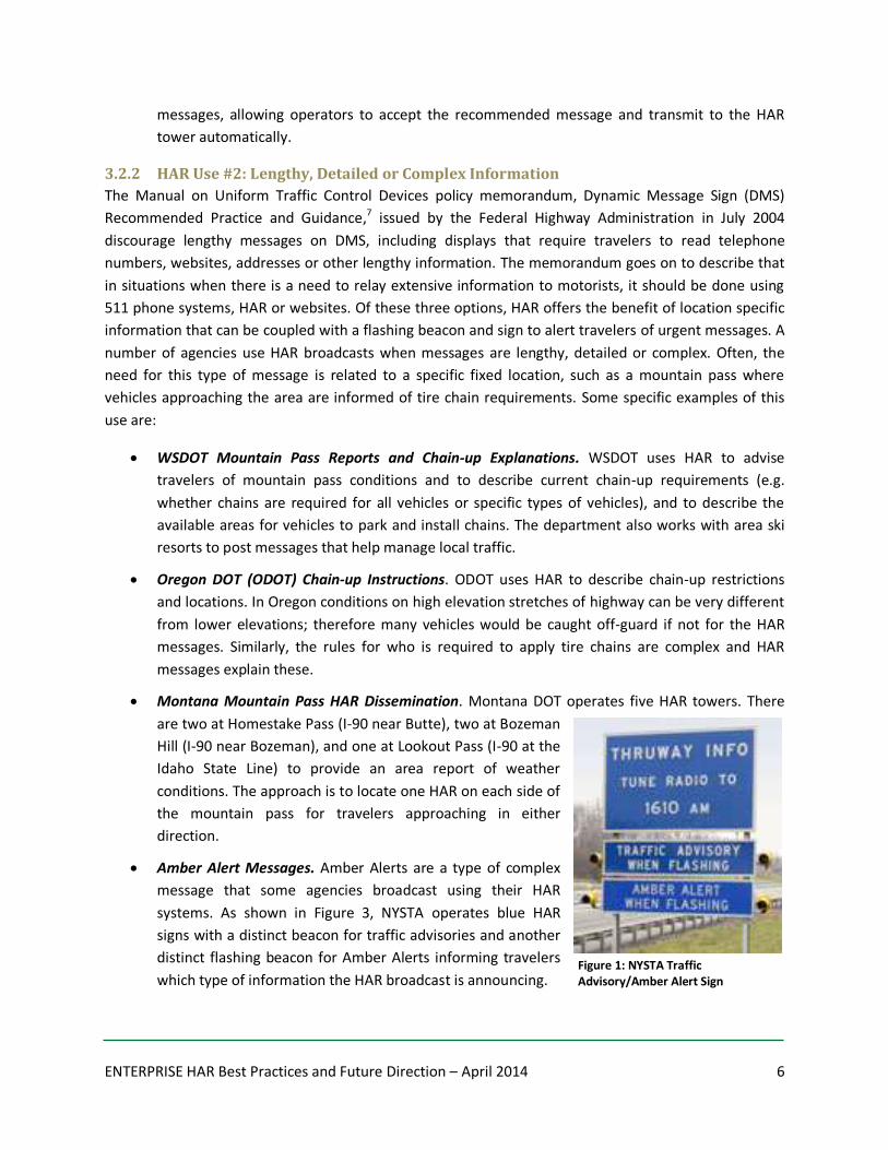
Amber Alert Messages. Amber Alerts are a type of complex
message that some agencies broadcast using their HAR
systems. As shown in Figure 3, NYSTA operates blue HAR
signs with a distinct beacon for traffic advisories and another
distinct flashing beacon for Amber Alerts informing travelers
which type of information the HAR broadcast is announcing. Figure 1: NYSTA Traffic Advisory/Amber Alert Sign
ENTERPRISE HAR Best Practices and Future Direction – April 2014 7
Utah DOT (UDOT) Avalanche Messages. UDOT operates two HAR towers at locations where
travelers are leaving the Salt Lake City Valley and heading up the canyon roads to ski
destinations. UDOT explained that there are small DMS located in these areas, but the small
DMS do not have the space to explain the often complex messages regarding plans for road
closures due to controlled avalanches or unplanned avalanches. UDOT operates under a policy
that does not allow two or more phases to DMS displays, so the DMS is limited to only one
phase and this is not sufficient to describe avalanche conditions. The HAR broadcasts are used
as a supplement to advise travelers of further closure details.
3.2.3 HAR Use #3: When Other Technologies are Temporarily Unavailable
In many situations, HAR broadcast technologies have the advantage over 511 phone systems of not
requiring cellular coverage to communicate to travelers (although some HAR technologies require
cellular to communicate the message to the HAR tower). Therefore, state agencies faced with
emergencies, such as flooding or power outages that eliminate cellular phones have successfully used
HAR when cellular communications no longer allow travelers to access 511 phone systems while
traveling. For example:
Iowa DOT (IADOT) Use of HAR during Flooding Events. During major flooding events in Iowa,
cellular towers were inoperable and large areas lost cellular connectivity. The flooding
conditions were also times when travelers most needed the information from the department’s
511 phone system. Fortunately, the HAR systems in Iowa remained operational and the same
information that automatically feeds the 511 phone system is automatically created into a play
list for the IADOT HAR systems. Iowa also used some portable HAR trailers to serve additional
areas beyond those that were equipped with permanent HAR.
3.2.4 HAR Use #4: Dissemination of Metro-Wide Condition Summaries to Support Thru
Traffic
Commercial vehicles and leisure travelers approaching metro areas often have multiple optional routes
to select from as they pass through or around a metro region (e.g. beltways, parallel routes, etc.). One
use of HAR broadcasts has been to provide information to these travelers as they approach the metro
area, offering a summary of the travel delays or conditions on multiple roads. The extended messaging
capabilities offered by HAR allow for the report to describe conditions more than would be possible
solely using DMS, and the position of the HAR can be in a location such that travelers can hear and
understand the report before key decision points. One example of this is as follows:
Texas DOT (TxDOT) HAR Messages to Commercial Vehicles. TxDOT located a number of HAR
towers on the routes approaching San Antonio. As thru traffic approaches San Antonio (i.e. on I-
10, I-37, and I-35) drivers have the option to remain on their routes or to use the I-410 beltway
around the metro area, resuming their needed route when appropriate. HAR towers were
located and operated to disseminate messages describing the different situations on routes and
allowing through traffic to select the best route through the metro area.
ENTERPRISE HAR Best Practices and Future Direction – April 2014 8
3.2.5 HAR Use #5: Traveler Information Coverage of Entire Metro Area or Region
The circular coverage area of HAR, combined with a coverage radius of several miles allows HAR
coverage for large geographic areas. While most HAR towers are located roadside to a highway, allowing
for travelers on one or more nearby routes to hear broadcasts, those are not the only approaches
agencies have used to disseminate information. Agencies have also deployed HAR towers to cover entire
cities or regions. These could include a series of parking garages or a downtown commuter area,
allowing travelers to tune their car radio while still in the parking garage to understand delays on
different alternate routes. An example of this use is as follows:
Eugene, Oregon Citywide HAR Coverage. ODOT operates a few HAR towers within the city of
Eugene. The intent of these HAR towers is to allow any driver in the city to tune their radio and
hear urgent reports describing travel conditions between Eugene and Portland or between
Eugene and the coast. Eugene is home to the University of Oregon. As a result, there are times
when school events generate considerable traffic departing Eugene for Portland. Additionally,
the roads to the Oregon Coast from Eugene are one lane in each direction and include mountain
passes and other potential hazards. The HAR deployment allows travelers access to the
information before they depart along either route, and provides ODOT the option of including
details that could not be posted on DMS signs.
3.2.6 HAR Use #6: Traveler Alerts about Specific Corridors
For agencies that operate corridors with a geography or topology that creates hazards, or even roads
traveling through isolated areas, there are unique risks for travelers to be stranded without alternate
routes or services. Often, the unique road systems are vulnerable to closures, HAR technologies offer a
mechanism to warn drivers of planned or real-time events on the corridor, ideally at a location where
travelers can still turn around. Some examples include:
UDOT Canyon Corridors to Ski Destinations. UDOT operates two HAR towers at locations where
travelers are leaving the Salt Lake City Valley and heading up the canyon roads to ski
destinations. UDOT regularly monitors the snow accumulation to predict avalanches. UDOT will
also manually dislodge snow buildup in order to prevent large avalanches. For these reasons,
there are many times when UDOT needs to convey messages to travelers as they approach the
corridor, either to warn of current or very near-term closures, or to notify travelers of planned
closures expected in the coming days. The HAR broadcasts are at locations where travelers
could still turn around and choose to delay their trip or pursue an alternate route or destination.
ODOT State Highways Accessing Coastal Communities. Travelers from Oregon’s major
population centers (i.e. Portland, Salem, Eugene) must cross the Pacific mountain range to reach
tourist destinations along the coast. The roads over the mountain passes are typically two-lane
highways with passing lanes located on uphill stretches, and are prone to snow and ice in the
winter and the risk of fallen trees during all months of the year. An example is Highway 18 that
travelers use from the Willamette Valley to Lincoln City, Oregon. ODOT has located HAR towers
at both the east and west sides of the area known to be a ‘snow zone.’ The HAR towers flash
ENTERPRISE HAR Best Practices and Future Direction – April 2014 9
beacons when an alert is played. Travelers who learn of closures or hazardous conditions still
have options to turn around and pursue other routes to or from the coast.
3.2.7 HAR Use #7: Disseminate Travel Times
There are transportation agencies that have enlisted HAR technologies to convey travel times to
travelers. In these situations, travel times are either announced 24/7, during peak periods, or only when
times exceed common travel times. This use is perhaps the most dramatic increase in HAR use since the
1980s. HAR offers some distinct advantages to DMS for travel time dissemination as a number of origins
and destinations can be described, as opposed to the typical DMS approach of presenting times from
the DMS to key landmarks.
NYSTA Automated Travel Times during Peak Periods. NYSTA operates HAR towers that
broadcast travel times during peak periods. NYSTA identified that HAR is effective for relaying
travel times because of the flexibility in being able to describe multiple origins and destinations
(whereas DMS typically report travel times from the DMS to a downstream landmark). NYSTA
also noted that when there is an incident or emergency announced on HAR and the flashing
beacons are on, they continue to broadcast the travel times, in hopes that travelers who tune in
will become educated that travel times are on the HAR and use it on future days even if the
flashing beacons are not activated.
Illinois Metropolitan Area Travel Times. Illinois DOT operates automatic posting of travel times
to HAR on highways around the Chicago and East St. Louis metropolitan areas. Travel times are
updated every five minutes, and IDOT noted that travelers miss the messages and often
complain if they are not operational. Other messages regarding construction, incidents and
hazardous weather conditions are also disseminated using the system.
3.2.8 HAR Use #8: Temporary Locations
Portable units have allowed HAR broadcasts to be used in areas during temporary special events, where
visitors need to learn about parking or directions to venues (e.g. golf tournaments, fairs, etc.), and
during construction. Combining HAR with a portable DMS allows travelers to receive a brief message
about the availability of more detailed information via HAR. Portability may only be limited by terrain
that could limit radio frequency range.
Using HAR for Winter Olympics in Utah. When Utah hosted the 2002 Winter Olympics in Salt
Lake City, the DOT expanded their traveler information system to assist residents with
navigating heavier than normal traffic and to support visitors to the games. CommuterLink
included an integrated network of traffic sensors, closed-circuit television, variable message
signs, freeway ramp meters, website, and HAR. Overall, the system performed well given the
extreme demands of the 2002 Winter Olympics and although it is unlikely that the system will
ever be required to function under this demand again, the extensive usage did highlight some
technical issues with HAR to consider in other temporary deployments. For example, center to
HAR communication was managed over the cellular telephone network to update messages.
The increased cellular network traffic in the area during the games sometimes limited the
ENTERPRISE HAR Best Practices and Future Direction – April 2014 10
agency’s ability to connect with HAR and update messages. The HAR units were also battery
powered with a solar recharge capability. Because the units were transmitting for extended
periods of time during the games, power was sometimes lost when consumption exceeded the
available charging capacity of the solar panels. While some of these issues were unique to the
heavy demands of the Olympic Games, similar issues could occur in other areas with extreme
demands during catastrophic or large-scale event.8
Phoenix International Raceway Use of HAR in TDM Effort. In an effort to decrease congestion
and delay during racing events, the Phoenix International Raceway implemented a travel
demand management effort that included HAR as a traveler information tool. Highlighted as a
case study in the NCHRP 309 report, the Raceway is located in the Phoenix Valley and hosts
several events annually with attendance ranging from several thousand to nearly 150,000
patrons. HAR was used to deliver special messages recorded by race drivers, encouraging
travelers to us the system. During events, HAR was also used to direct traffic to park and ride
lots. Although HAR was not individually evaluated, overall evaluation of the TDM strategies used
by the Raceway suggests the strategies reduced congestion and delay. Looking at parking lot
clearance in particular, in 1998 it took an average of 5.5 hours to clear them and, in 2000, that
time was reduced to 3.5 hours on average. The public also provided positive feedback on the
TDM strategies.9
HAR in New Mexico and Arkansas Construction. In 2002, the FHWA ITS Joint Program Office
conducted a cross-cutting study examining the application of ITS in work zones at sites in four
states to share those experiences with other regions. Two of the states studied used HAR in
their construction projects. The New Mexico State Highway and Transportation Department
used HAR during the reconstruction of “The Big I” interchange in Albuquerque. HAR was used in
conjunction with cameras, DMS, a project web site and media outlets to distribute information
about traffic conditions in the work zone. The Arkansas State Highway and Transportation
Department also used HAR in the 2000 reconstruction I-40 near its intersection with I-55. The
project implemented an automated work zone information system that detected traffic
conditions approaching the work zone and then used that information to deliver messages to
travelers via three HAR sited that covered approximately 23 miles. The system was successfully
used to help travelers choose between I-40 and I-55 based on congestion.10
3.2.9 HAR Use #9: Emergency Weather Radio Broadcasts
When weather impacts traveler or visitor safety in a park setting, HAR has been used to broadcast
emergency weather information. Although routine weather information is prohibited content for HAR,
the 2013 ruling by FCC introduced some degree of flexibility to the licensee to determine when what
constitutes “imminent [threat to] safety-of-life or property,” as well as when emergency conditions
reach the level of a “hurricane, flood, earthquake or similar disaster.” The ruling goes on to state,
“Again, permissible use of the TIS in such conditions could include the transmission of evacuation routes
and the location of shelters, health care and other emergency facilities, as well as weather or other
conditions that may negatively impact driving conditions.”
ENTERPRISE HAR Best Practices and Future Direction – April 2014 11
Greater Yellowstone National Park Traveler and
Weather Information. A network of HAR and DMS were
installed throughout the Yellowstone National Park in
2009-2010 to provide visitors and travelers along the
main park corridor – US89 – with information about
road conditions and changing weather conditions. A
variety of permanent and portable HAR were used at
park entrances, campgrounds and other key locations.
Most unique was the use of 15 National Weather
Service receivers tied to low-power AM transmitters at
the park’s major campgrounds. This system acts as a
low-cost alternative to a HAR, and even though it does
not have the transmitting power (or distance) of a
typical HAR, it provides adequate coverage to disburse
traveler information within the campgrounds. The
same information was also incorporated into the Idaho,
Montana and Wyoming 511 traveler information systems to provide travelers with
information from a greater distance and allow them to select alternate departure times or
routes. This illustrates the potential for HAR and 511 services to coexist and complement
one another.11
3.10 HAR Use #10: National Park Traveler Information
The country’s national parks attract thousands of visitors each year, generating unique traffic
management conditions during peak periods. Compounding the challenge, travelers are often unfamiliar
with the area they are visiting and unaware of how to obtain information about traffic, alternate routes,
road conditions and other details that would make their individual trip smoother and minimize impacts
on the collective travel of all visitors. As one of the governmental entities specifically called out by the
FCC as potential users of TIS, many national parks have implemented broader scale traveler information
systems that leverage the use of HAR in particular.
HAR Used to Promote Transit in Grand Canyon National Park. The Grand Canyon National Park
applied for a grant through the Alternative Transportation for Parks and Public Lands (ATPPL)
Program administered by the Federal Transit Administration to add HAR stations that would
provide traveler information and ultimately support increased transit ridership. The system
included a combination of HAR, DMS and static signs. An evaluation of the pilot project found
that the presence of the system added 368 shuttle passengers per day, an increase of 45.7
percent in shuttle ridership.12
Figure 2: HAR Locations in Yellowstone National Park. Source: WTI
ENTERPRISE HAR Best Practices and Future Direction – April 2014 12
4. Value of HAR Quantifying how often travelers use a system is challenging based on the nature of HAR as a radio
broadcast. Although there are some qualitative market research-based studies that have been
conducted around the value of HAR, many agencies simply know the value of the stations based on
complaints received when a station is inactive or misreporting. This section summarizes the information
gathered from individual states and other studies that have been conducted to estimate the value of
HAR. It also presents some other factors that may impact the value of HAR in the future.
4.1 HAR Usage and Value In November 2012, the National Cooperative Highway Research Program released a study that reviewed
a variety of traveler information systems to understand agency practices, as well as traveler
perspectives and use across the country. Regarding HAR, the NCHRP Project 08-82 report, Deployment,
Use and Effective of Real-Time Traveler Information Systems13 noted, “Highway advisory radio (HAR) has
a long history and general awareness by the public. The following findings were universal across cities
[surveyed for this study]:
Extremely negative response about the sound quality, usefulness, and timeliness of information.
Many travelers never tried HAR because they have heard such negative comments from others
who have tried it.
Others have only tried HAR once and found the quality to be so lacking that they never tried it
again.
Interestingly, several individuals mentioned HAR having potential as a very useful medium
(“everyone has a radio”) to reach travelers with important information while on the roadway,
but the implementation was severely lacking.
The surveys indicate that a fair number of travelers (~18%) across the 6 cities reported trying to
use it en-route as part of their typical decision process. Note that this may be some confusion
from other radio outlets (which had a very strong showing) or a reference to using highway
advisor radio only in extreme cases.”
Although there were negative perceptions about the quality of HAR, the perception of HAR as useful
tool for reaching travelers offers encouragement. These findings speak to the potential for HAR, as well
as the importance of ensuring HAR sites are well-situated in terms of their broadcast range and the
importance of ensuring that quality content is then broadcasted.
In other more localized studies of HAR use, traveler perceptions vary and can often reflect the nature of
the deployment itself. For example, in 2005 Utah studied the use of four advanced traveler information
systems, including HAR, to gauge their effectiveness and identify potential issues that need to be
addressed. HAR is used to provide information concerning construction, road conditions and closures,
special events, traffic information and, in some cases, tourism. During this study, a survey was
conducted of 201 randomly selected licensed drivers at several locations in Salt Lake Valley. Of the four
systems evaluated, HAR was the second most known and used among travelers, with 87% being aware
ENTERPRISE HAR Best Practices and Future Direction – April 2014 13
of and 55% having used HAR. Of those travelers who were aware of HAR, 67% indicated that they
always, often or at least sometimes use the system to obtain information (when flashers on signs were
activated). Travelers were further asked to comment on the information provided by HAR and just over
50% found it helpful. In this deployment, HAR sites were at fixed locations along key, daily travel routes.
The traveler familiarity and quality of information broadcast from these sites likely contributed to the
higher value travelers placed on them.14
In places where travelers are less familiar with the area or simply visiting, HAR may not be used as often
but the information can still be highly valued by travelers. In the Yellowstone National Park HAR
deployment highlighted in the previous section, travelers experienced a variety of permanent and
portable HAR stations where road condition and weather information was broadcast. Sixty-nine percent
of the 335 survey respondents saw signs noting “Visitor Information Tune to 1610 AM” but fewer than
33% indicated that they tuned into the radio station. The lower use of HAR in this case could be
attributed to a lack of traveler familiarity with using HAR in general. However, for those who did tune in,
when asked about the usefulness of the information broadcast, 84% rated the information as useful to
some degree.
In addition to measuring traveler perceptions and use of HAR, value has also been measured in terms of
crash reduction. In Tennessee, a low visibility warning system was installed on I-75 to address recurring
fog-related crashes. The system consisted of environmental sensor stations, visibility sensors, and
vehicle detectors; and used static signs with flashing beacons, variable speed limit signs, dynamic
message signs and HAR to notify motorists of changing road conditions. Acknowledging that this
deployment did not exclusively focus on HAR, it was found that it dramatically reduced crashes. While
there had been over 200 crashes, 130 injuries and 18 fatalities on this section of I-75 since it opened in
1973, only one fog-related crash occurred on the freeway between 1994 and 2003, after the system was
installed.15
Finally, in interviews with the Oregon and Illinois departments of transportation and the New York State
Thruway Authority, it was noted that most feedback on the value of HAR is anecdotal. Many agencies
simply know that HAR broadcasts are valued by travelers when they receive unsolicited positive
comments and, when sites are unavailable, complaints about the lack of information.
4.2 Other Factors Impacting Value of HAR In addition to selecting the appropriate use for HAR and ensuring quality broadcasts and content, there
are number of other factors that will continue to impact the value of HAR. Foremost among these
influences is the changing use of AM/FM radio. The introduction of broader multimedia options built
directly into vehicles, proliferation of cell phones, portable audio devices, in-vehicle navigation,
streaming music and satellite radio are all changing the way motorists use the audio functions in their
vehicles. The Pew Research Center’s Project for Excellence in Journalism: The State of the News Media in
2013 – An Annual Report on American Journalism16 has tracked usage of a variety of media outlets,
including radio, since 2004. In their latest report, there are both good and bad signs for the future of
ENTERPRISE HAR Best Practices and Future Direction – April 2014 14
HAR. On the positive side, the percentage of people who listen to the AM/FM radio each week remained
essentially unchanged in 2012 when 92% of Americans age 12 or older listened to the radio at least
weekly, nearly the same as it was 10 years ago at 94%. A more challenging sign for HAR, the report
further notes that one of the biggest threats to AM/FM news in general is web-based listening which is
growing. The desire for on-demand information that is offered by web-based radio does not bode well
for HAR which must be listened to within a specific physical range and time to be of value. The report
also notes 2012 data from Arbitron that shows 17% of cellphone owners have streamed online radio
from their devices through their car stereos; up by more than a third since 2011.
As options grow for the audio functions in the vehicle, both preference and eventually the awareness of
AM/FM radio could diminish and this would also impact the future value of HAR. However, there are
organizations aimed at maintaining the quality and awareness of information based radio broadcasts
like HAR. The American Association of Information Radio Operators17 (AAIRO) is a nonprofit organization
of information radio station operators and licensees from public agencies across the country. A key
aspect of the organization’s mission is to support information radio as a medium for government to
reach travelers with localized information. AAIRO was one of a handful of organizations that petitioned
the FCC and prompted the 2013 ruling on TIS.
Finally, as the USDOT Connected Vehicle initiative gains momentum and vehicle manufacturers begin to
introduce features that allow vehicles to communicate with roadside infrastructure (referred to as V2I
communication), HAR use could evolve. For sites in strategic locations, the addition of a digital short
range communication (DSRC) transmitter could create new uses for HAR and opportunities to expand its
use.
5. HAR Technology and Operations In addition to information gathered from agencies using HAR, two manufacturers of HAR systems were
contacted for this project – Information Station Specialists18 (ISS) and MH Corbin.19 This section
highlights agency and manufacturer insights on current HAR technology and operational practices used
to create, deliver and broadcast content, promote and maintain HAR.
5.1 Content Creation There are three significant factors that influence the quality of content created for HAR. First, the
information available for HAR broadcasts has changed dramatically in recent years. As agencies have
increased the amount of data gathered about the transportation system, the availability of more
current, accurate and relevant information for travelers has also increased. This offers a greater variety
and quality of information to share with travelers via HAR.
Second, rapidly evolving traveler information services have drawn greater agency attention to
performance and customer needs. The introduction of 511, on-demand alerts, mobile apps and social
media have also changed agency relationships with travelers as they can communicate in more ways
and more often. Agencies often have operating guidelines describing when and how HAR messages
ENTERPRISE HAR Best Practices and Future Direction – April 2014 15
should be used as one way
to ensure quality in the
content of HAR messages.
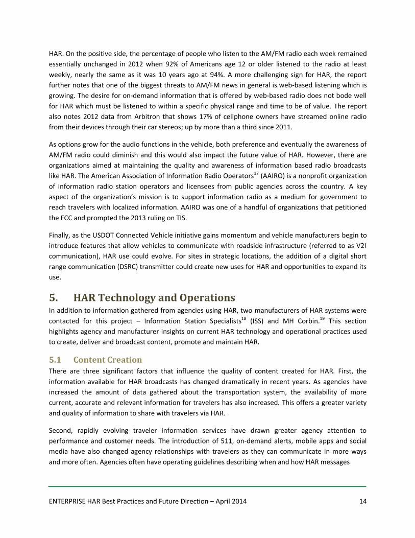
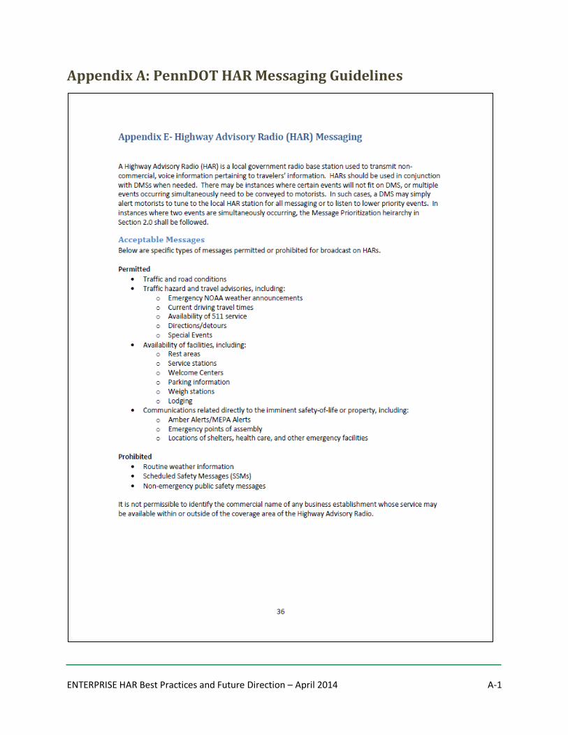
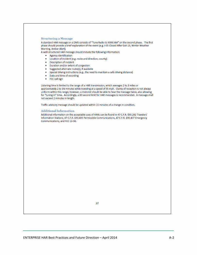
Figure 3 is an excerpt taken
from the PennDOT
guidelines for HAR
messaging. In addition to
describing the content of a
well-structured message,
the guidelines clearly explain the type of messages that may be used and the expectation for updating
messages to maintain relevance. The complete PennDOT guideline is included in Appendix A.
Additionally, some agencies create scripted or pre-recorded messages to ensure quality HAR content.
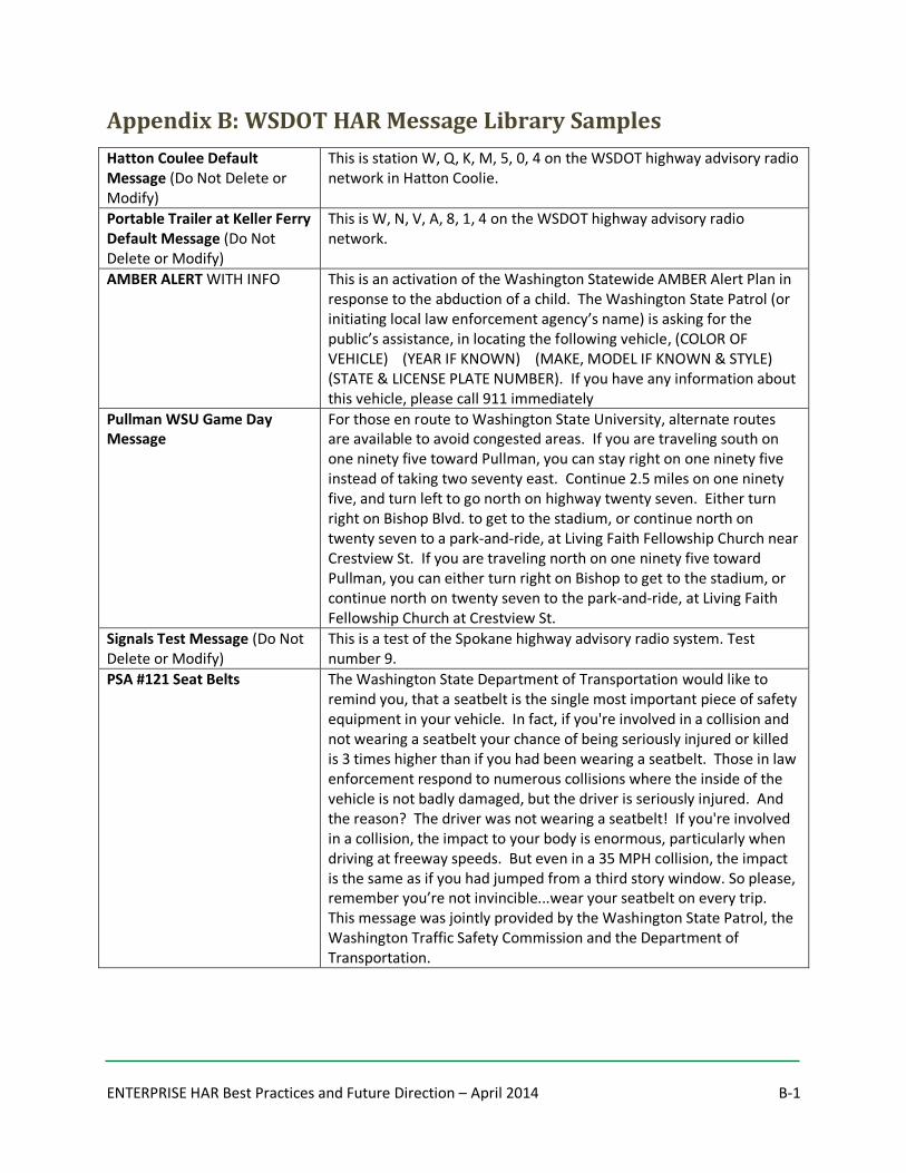
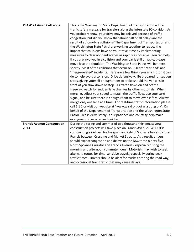
For example, WSDOT maintains an extensive library of scripted messages to accompany their
operational guidelines. The messages cover a variety of scenarios including default call sign and test
messages, AMBER Alerts, special events and construction. Appendix B presents samples of these and
other message scripts from the WSDOT HAR library.
The third factor influencing content quality is the way audio is created, loaded and activated. In the
1980s most agencies called recordings in via voicemail type systems. These messages often contained
background noise and the process was cumbersome for operators to use during urgent situations.
Today, agencies are playing audio files via digital connections that have greatly improved the sound of
content broadcast on HAR. Digital audio files and HAR operating software allow operators to pick pre-
recorded messages and activate them at multiple sites quickly and efficiently. Vendors have also made it
easier for agencies to create higher quality sounding broadcasts for HAR by offering professional
recording services. Sound and information quality have always been challenging factors in the content of
HAR broadcasts. It is important to remember that travelers listen to HAR expecting the sound to be
similar to other radio broadcasts that they hear. Operating guidelines, pre-recorded and scripted
messages, and operating software can all be used to improve the sound and quality of information
broadcast via HAR.
5.2 Content Delivery to HAR Sites Just as the recording of content has changed, so too has the delivery of that content to individual HAR
sites. In the early days of HAR, cassette tapes were recorded and had to be physically taken to the sites.
Telephone interfaces were added next so that sites could be updated with a phone call remotely. Then
software was added and it allowed a computer to make the phone calls. Today, HAR communication
can be managed over digital networks, allowing multiple HAR sites to be updated with a few clicks of the
mouse from an operations center.
There are also different approaches to managing the how the delivery of content occurs. Some agencies
operate fully automated systems where the HAR broadcasts are fed by the same condition reporting
system that feeds 511 telephone or traveler information websites. These automated systems often
report information such as travel times, incidents and construction details. Other systems may rely on
Figure 3: Excerpt from PennDOT Guideline for HAR Messaging

ENTERPRISE HAR Best Practices and Future Direction – April 2014 16
an operator using a HAR user interface to select messages for broadcast by typing the words of the
message or selecting phrases from drop-down lists. Messages are typically pre-recorded in a library of
.wav files or text-to-speech functions can create the audio file that is broadcast at the HAR site. Most
systems also allow operators to create original voice recordings as needed.
5.3 Broadcast Approaches There are portable vs. permanent approaches to the physicality of where a broadcast is delivered. Both
are viable and useful approaches, depending on the need being addressed by HAR. Pricing between the
permanent and portable options is fairly comparable with location playing the biggest part in
determining final cost. Portable systems can range from $35,000-$50,000 and a permanent system can
range from $25,000-$55,000.
Permanent installations are generally selected to provide recurring information such as daily commute
times. These sites are typically located at key decision points such as freeway interchanges. These
locations also offer the benefit of power, landline communication and physical space for the pole
mounted antenna and cabinet to house the HAR equipment. If traffic patterns change over time and a
permanent site becomes less effective, an agency may wish to consider relocating or converting a
permanent site. It is also possible to move a permanent installation from one location to another. It is
also technically possible to convert a permanent installation into a portable station since the equipment
modules are essentially the same between the two. However, the power, communication and housing
changes required for this type of conversion may not be very cost effective as poles, cabinets and
ground mounts from a permanent site often cannot be reused.
Portable deployments are used more often for mobile operations such as construction or emergencies.
The physical equipment for a portable HAR is typically fitted to a trailer with solar power, wireless
communication and a weather-proofed cabinet that allows the unit to essentially be taken anywhere it
may be needed. These units are also often equipped with DMS which gives agencies the ability to both
alert motorists of HAR and deliver the broadcast from one unit. Some agencies have also used portable
equipment in semi-permanent locations; parking the trailers on concrete bases and using them on a
daily basis until or unless an emergency requires them to be moved elsewhere. Portable HAR stations
area also available in even smaller, suitcase-style deployments. These were developed and are most
often used for emergency situations when speed and portability are critical. Portable or permanent, all
of the deployments noted here require FCC licensing to establish a HAR broadcast.
5.4 Promoting HAR Use Transportation agencies frequently promote HAR broadcasts using static blue service signs, often with
flashing beacons that are activated when information is available. Many agencies also use DMS to alert
travelers to messages broadcast on HAR. In situations where HAR offers continuous information (e.g.
parking information near an airport) agencies may even rely solely on a static blue HAR sign with no
flashing beacons.
ENTERPRISE HAR Best Practices and Future Direction – April 2014 17
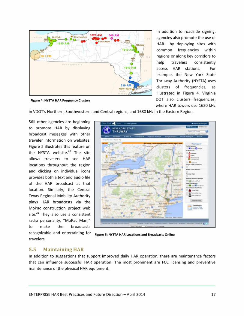
In addition to roadside signing,
agencies also promote the use of
HAR by deploying sites with
common frequencies within
regions or along key corridors to
help travelers consistently
access HAR stations. For
example, the New York State
Thruway Authority (NYSTA) uses
clusters of frequencies, as
illustrated in Figure 4. Virginia
DOT also clusters frequencies,
where HAR towers use 1620 kHz
in VDOT’s Northern, Southwestern, and Central regions, and 1680 kHz in the Eastern Region.
Still other agencies are beginning
to promote HAR by displaying
broadcast messages with other
traveler information on websites.
Figure 5 illustrates this feature on
the NYSTA website.20 The site
allows travelers to see HAR
locations throughout the region
and clicking on individual icons
provides both a text and audio file
of the HAR broadcast at that
location. Similarly, the Central
Texas Regional Mobility Authority
plays HAR broadcasts via the
MoPac construction project web
site.21 They also use a consistent
radio personality, “MoPac Man,”
to make the broadcasts
recognizable and entertaining for
travelers.
5.5 Maintaining HAR In addition to suggestions that support improved daily HAR operation, there are maintenance factors
that can influence successful HAR operation. The most prominent are FCC licensing and preventive
maintenance of the physical HAR equipment.
Figure 4: NYSTA HAR Frequency Clusters
Figure 5: NYSTA HAR Locations and Broadcasts Online
ENTERPRISE HAR Best Practices and Future Direction – April 2014 18
The initial licensing process is complex and includes frequency searches, engineering studies, temporary
assignments and filing with the FCC. Once granted, the initial license is effective for 10 years. Renewing
the license then involves steps similar to those taken for initial licensing. Because of the unique
requirements for licensing, HAR vendors offer support services to agencies specifically for this purpose.
In addition to licensing, there are periodic preventive maintenance steps that should be taken to ensure
that HAR stations are functioning as they should. Regular site inspection of the equipment to ensure it is
operating correctly is important and should include verification that the transmitter is operating within
the requirements of the station’s FCC license. One example of a preventive maintenance check list is
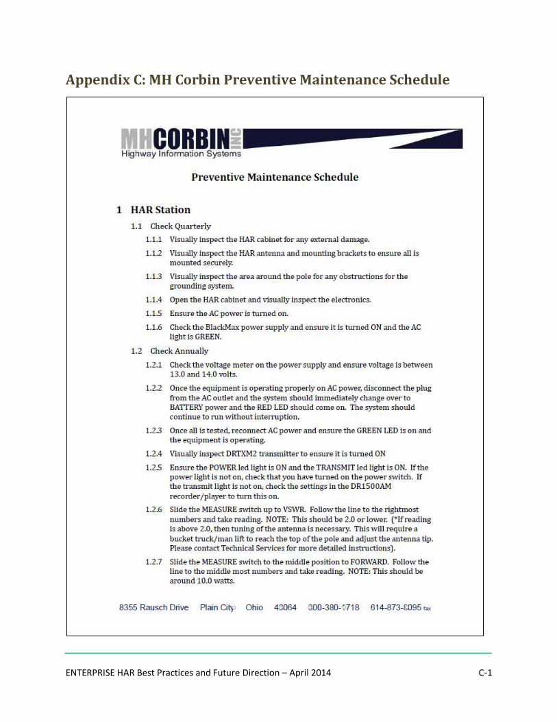
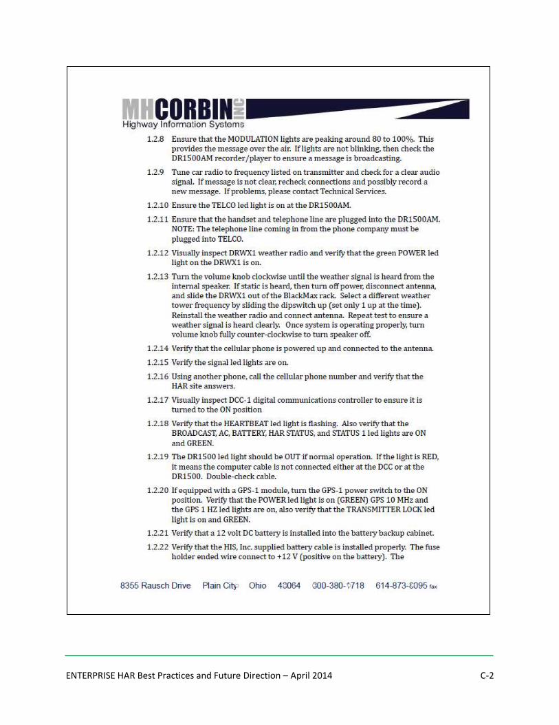
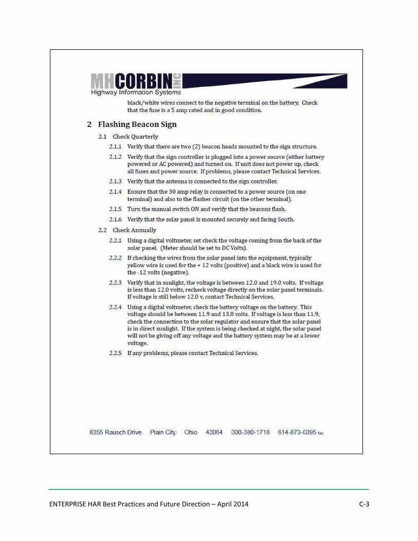
provided in Appendix C, courtesy of MH Corbin.
6. Conclusion In places where HAR is being successfully used, it is likely to continue to be an effective traveler
information tool in the future. The threats of AM radio becoming obsolete and vehicle manufacturers no
longer installing radios have been reported as the impending demise of HAR for years and yet neither
has happened. The advent of the Connected Vehicle initiative could even create a whole new level of
HAR use as existing stations could be retrofitted to serve as the V2I connection points. It is even
conceivable that roadside deployments could broadcast information to portable devices in the vehicle.
Perhaps HAR could provide vehicle to infrastructure communication points for both new and old
vehicles, using AM radio to share information with older vehicles and DSRC to broadcast information to
newer vehicles. Depending on the evolution of HAR, it is possible some states may consider starting or
expanding HAR services.
This summary report has provided general background on HAR and an overview of current HAR
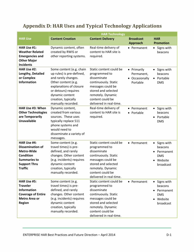
operations and specific uses based on the research conducted for this project. Appendix D also offers a
tabular view of the HAR uses and typical technology applications as a quick reference for the details
provided in the report. The value of HAR and the state of HAR technology have also been summarized
with the intent of helping ENTERPRISE member agencies understand opportunities for HAR within their
organizations.
ENTERPRISE HAR Best Practices and Future Direction – April 2014 A-1
Appendix A: PennDOT HAR Messaging Guidelines
ENTERPRISE HAR Best Practices and Future Direction – April 2014 A-2
ENTERPRISE HAR Best Practices and Future Direction – April 2014 B-1
Appendix B: WSDOT HAR Message Library Samples
Hatton Coulee Default Message (Do Not Delete or Modify)
This is station W, Q, K, M, 5, 0, 4 on the WSDOT highway advisory radio network in Hatton Coolie.
Portable Trailer at Keller Ferry Default Message (Do Not Delete or Modify)
This is W, N, V, A, 8, 1, 4 on the WSDOT highway advisory radio network.
AMBER ALERT WITH INFO This is an activation of the Washington Statewide AMBER Alert Plan in response to the abduction of a child. The Washington State Patrol (or initiating local law enforcement agency’s name) is asking for the public’s assistance, in locating the following vehicle, (COLOR OF VEHICLE) (YEAR IF KNOWN) (MAKE, MODEL IF KNOWN & STYLE) (STATE & LICENSE PLATE NUMBER). If you have any information about this vehicle, please call 911 immediately
Pullman WSU Game Day Message
For those en route to Washington State University, alternate routes are available to avoid congested areas. If you are traveling south on one ninety five toward Pullman, you can stay right on one ninety five instead of taking two seventy east. Continue 2.5 miles on one ninety five, and turn left to go north on highway twenty seven. Either turn right on Bishop Blvd. to get to the stadium, or continue north on twenty seven to a park-and-ride, at Living Faith Fellowship Church near Crestview St. If you are traveling north on one ninety five toward Pullman, you can either turn right on Bishop to get to the stadium, or continue north on twenty seven to the park-and-ride, at Living Faith Fellowship Church at Crestview St.
Signals Test Message (Do Not Delete or Modify)
This is a test of the Spokane highway advisory radio system. Test number 9.
PSA #121 Seat Belts The Washington State Department of Transportation would like to remind you, that a seatbelt is the single most important piece of safety equipment in your vehicle. In fact, if you're involved in a collision and not wearing a seatbelt your chance of being seriously injured or killed is 3 times higher than if you had been wearing a seatbelt. Those in law enforcement respond to numerous collisions where the inside of the vehicle is not badly damaged, but the driver is seriously injured. And the reason? The driver was not wearing a seatbelt! If you're involved in a collision, the impact to your body is enormous, particularly when driving at freeway speeds. But even in a 35 MPH collision, the impact is the same as if you had jumped from a third story window. So please, remember you’re not invincible...wear your seatbelt on every trip. This message was jointly provided by the Washington State Patrol, the Washington Traffic Safety Commission and the Department of Transportation.
ENTERPRISE HAR Best Practices and Future Direction – April 2014 B-2
PSA #124 Avoid Collisions This is the Washington State Department of Transportation with a traffic safety message for travelers along the Interstate 90 corridor. As you probably know, your drive may be delayed because of traffic congestion, but did you know that about half of all delays are the result of automobile collisions? The Department of Transportation and the Washington State Patrol are working together to reduce the impact that collisions have on your travel time by implementing measures to clear accident scenes as rapidly as possible. You can help. If you are involved in a collision and your car is still drivable, please move it to the shoulder. The Washington State Patrol will be there shortly. Most of the collisions that occur on I-90 are "rear-end" and "merge-related" incidents. Here are a few things you as a motorist can do to help avoid a collision. Drive defensively. Be prepared for sudden stops, giving yourself enough room to brake should the vehicles in front of you slow down or stop. As traffic flows on and off the freeway, watch for sudden lane changes by other motorists. When merging, adjust your speed to match the traffic flow, use your turn signal, and be sure there is enough room to move over safely. Always merge only one lane at a time. For real-time traffic information please call 5 1 1 or visit our website at "www.w s d o t dot w a dot g o v". On behalf of the Department of Transportation and the Washington State Patrol, Please drive safely. Your patience and courtesy help make everyone's drive safer and quicker.
Francis Avenue Construction 2013
During the spring and summer of two thousand thirteen, several construction projects will take place on Francis Avenue. WSDOT is constructing a railroad bridge span, and City of Spokane has also closed Francis between Crestline and Market Streets. As a result, drivers should expect congestion and delays on the NSC three ninety five North Spokane Corridor and Francis Avenue - especially during the morning and afternoon commute hours. Motorists may wish to seek alternate routes for time-sensitive travels, especially during peak traffic times. Drivers should be alert for trucks entering the road way, and occasional train traffic that may cause delays.
ENTERPRISE HAR Best Practices and Future Direction – April 2014 C-1
Appendix C: MH Corbin Preventive Maintenance Schedule
ENTERPRISE HAR Best Practices and Future Direction – April 2014 C-2
ENTERPRISE HAR Best Practices and Future Direction – April 2014 C-3
ENTERPRISE HAR Best Practices and Future Direction – April 2014 D-1
Appendix D: HAR Uses and Typical Technology Applications
HAR Use
HAR Technology
Content Creation Content Delivery Broadcast Approach
HAR Promotion
HAR Use #1: Weather Related Emergencies and Other Major Incidents
Dynamic content, often created by RWIS or other reporting systems.
Real-time delivery of content to HAR site is required.
Permanent Signs with beacons
HAR Use #2: Lengthy, Detailed or Complex Information
Some content (e.g. chain up rules) is pre-defined, and rarely changes. Other content (e.g. explanations of closure or detours) requires dynamic content creation, typically manually recorded.
Static content could be programmed to disseminate continuously. Static messages could be stored and selected remotely. Dynamic content could be delivered in real-time.
Primarily Permanent,
Occasionally Portable
Signs with beacons
Portable DMS
HAR Use #3: When Other Technologies are Temporarily Unavailable
Dynamic content, created from various sources. These uses typically replace 511 phone systems and would need to disseminate a variety of messages.
Real-time delivery of content to HAR site is required.
Permanent
Portable
Signs with beacons
Portable DMS
HAR Use #4: Dissemination of Metro-Wide Condition Summaries to Support Thru Traffic
Some content (e.g. travel times) is pre-defined, and rarely changes. Other content (e.g. incidents) requires dynamic content creation, typically manually recorded.
Static content could be programmed to disseminate continuously. Static messages could be stored and selected remotely. Dynamic content could be delivered in real-time.
Permanent Signs with beacons
Permanent DMS
Website broadcast
HAR Use #5: Traveler Information Coverage of Entire Metro Area or Region
Some content (e.g. travel times) is pre-defined, and rarely changes. Other content (e.g. incidents) requires dynamic content creation, typically manually recorded.
Static content could be programmed to disseminate continuously. Static messages could be stored and selected remotely. Dynamic content could be delivered in real-time.
Permanent Signs with beacons
Permanent DMS
Website broadcast

ENTERPRISE HAR Best Practices and Future Direction – April 2014 D-2
HAR Use
HAR Technology
Content Creation Content Delivery Broadcast Approach
HAR Promotion
HAR Use #6: Traveler Alerts about Specific Corridors
Some content (e.g. travel times) is pre-defined, and rarely changes. Other content (e.g. incidents) requires dynamic content creation, typically manually recorded.
Static content could be programmed to disseminate continuously. Static messages could be stored and selected remotely. Dynamic content could be delivered in real-time.
Permanent Signs with beacons
Permanent DMS
Website broadcast
HAR Use #7: Disseminate Travel Times
Some content (e.g. travel times) is pre-defined, and rarely changes. Other content (e.g. incidents) requires dynamic content creation, typically manually recorded.
Static content could be programmed to disseminate continuously. Static messages could be stored and selected remotely. Dynamic content could be delivered in real-time.
Permanent Signs with beacons
Permanent DMS
Website broadcast
HAR Use #8: Temporary Locations
Dynamic content, created from various sources.
Real-time delivery of content to HAR site is required.
Portable Signs with beacons
Portable DMS
HAR Use #9: Emergency Weather Radio Broadcasts
Dynamic content, often created by weather reporting system.
Real-time delivery of content to HAR site is required.
Permanent
Portable
Signs with beacons
Portable DMS
HAR Use #10: National Park Traveler Information
Primarily static content. Static content could be programmed to disseminate continuously. Static messages could be stored and selected remotely. Dynamic content could be delivered in real-time.
Permanent Signs with beacons
Permanent DMS
Website broadcast
ENTERPRISE HAR Best Practices and Future Direction – April 2014 E-1
Appendix E: References
1 ENTERPRISE Transportation Pooled Fund TPF-5(231) Program. http://www.enterprise.prog.org/.
2 Report and Order in Docket 20509, FCC 77-414, 67 FCC 2d 917.
http://fjallfoss.fcc.gov/edocs_public/attachmatch/FCC-77-414A1.pdf.
3 Rule 47 CFR 90.242 Travelers’ Information Stations. http://www.gpo.gov/fdsys/pkg/CFR-2010-title47-
vol5/pdf/CFR-2010-title47-vol5-sec90-242.pdf.
4 Rule 47 CFR 73.801 Broadcast Regulations Applicable to LPFM Stations. http://www.gpo.gov/fdsys/pkg/CFR-
2012-title47-vol4/pdf/CFR-2012-title47-vol4-part73-subpartG.pdf.
5 Report and Order in Docket 09-19, FCC 13-98. http://www.thuneagle.com/media/FCC-13-98A1.pdf.
6 West Virginia Department of Transportation, Bruce Kenney, ITS Coordinator/Systems Management Engineer,
(304) 558-9449, [email protected].
7 Federal Highway Administration Policy Memorandum – Manual on Uniform Traffic Control Devices: Dynamic
Message Sign (DMS) Recommended Practice and Guidance. Federal Highway Administration, Washington, DC. July
16, 2014. http://mutcd.fhwa.dot.gov/res-memorandum_dms.htm.
8 Intelligent Transportation Systems at the 2002 Salt Lake City Winter Olympic Games Event Study – Traffic
Management and Traveler Information. Produced by Iteris, Inc. A report prepared for the Utah Department of
Transportation, Salt Lake City, UT. April 29, 2003. http://ntl.bts.gov/lib/jpodocs/repts_te/13850.html.
9 NCHRP Synthesis 309: Transportation Planning and Management for Special Events. Carson, Jodi L. and Bylsma,
Ryan G., Montana State University. Transportation Research Board, Washington, DC. 2003.
http://onlinepubs.trb.org/onlinepubs/nchrp/nchrp_syn_309d.pdf.
10 Intelligent Transportation Systems in Work Zones: A Cross-Cutting Study – Integrated Work Zone Systems for
Improving Travel Conditions and Safety. Scriba, Tracy. Federal Highway Administration, Washington, DC.
November 2002. http://ntl.bts.gov/lib/jpodocs/repts_te/13600.html.
11 Yellowstone Regional Traveler and Weather Information System U.S. Highway 89 Project. Chaudhari, Jaydeep
and Kack, David. Western Transportation Institute, College of Engineering Montana State University. A report
prepared for Yellowstone National Park, Mammoth, WY. February 2011.
http://www.westerntransportationinstitute.org/documents/reports/4W0173_Final_Report.pdf.
12 Grand Canyon National Park Dynamic Message Sign (DMS) / Highway Advisory Radio (HAR) Pilot Deployment /
Evaluation. Eidswick, Jaime; Ye, Zhirui Ph.D.; and Albert, Steve. A report prepared for Grand Canyon National Park
Federal Lands Highway Division, Arizona. March 2009.
http://www.westerntransportationinstitute.org/documents/reports/4W2106_Final_Report.pdf.
13 Deployment, Use and Effect of Real-Time Traveler Information Systems. Robinson, Emanuel; Jacobs, Thomas;
Frankle, Kathleen; Serulle, Nayel; and, Pack, Michael. Westat and University of Maryland-CATT. Rockville, MD.
November 2012. http://onlinepubs.trb.org/onlinepubs/nchrp/nchrp_w192.pdf.
ENTERPRISE HAR Best Practices and Future Direction – April 2014 E-2
14 Traveler Information Systems – Evaluation of UDOT’s ATIS Technologies. Martin, Dr. Peter T., Associate
Professor, Department of Civil and Environmental Engineering, University of Utah. Salt Lake City, UT. November
2005. http://www.mountain-plains.org/pubs/pdf/MPC05-175.pdf.
15 Best Practices for Road Weather Management, Version 2.0. Prepared by Mitretek Systems, Inc. for the Office of
Transportation Operations, Federal Highway Administration. Washington, DC. May 2003.
http://ntl.bts.gov/lib/jpodocs/repts_te/13828.html.
16 The Pew Research Center’s Project for Excellence in Journalism: The State of the News Media in 2013 – An
Annual Report on American Journalism. Santhanam, Laura; Mitchell, Amy; and, Olmstead, Kenny. Pew Research
Center. Washington, DOT. 2013. http://stateofthemedia.org/2013/audio-digital-drives-listener-experience/audio-
by-the-numbers/.
17 American Association of Information Radio Operators. http://www.aairo.org/.
18 Information Station Specialists. http://www.theradiosource.com/.
19 MH Corbin. http://www.mhcorbin.com/.
20 New York State Thruway Authority. http://www.thruway.ny.gov/travelers/map/index.html.
21 MoPac Improvement Project. http://www.mopacexpress.com/.