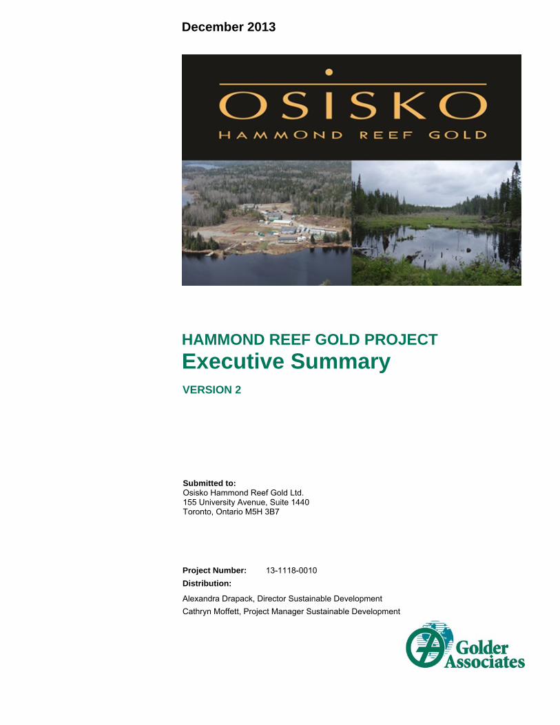
HAMMOND REEF GOLD PROJECT Executive … 2013 HAMMOND REEF GOLD PROJECT Executive Summary Project...
124
December 2013 HAMMOND REEF GOLD PROJECT Executive Summary Project Number: 13-1118-0010 Distribution: Alexandra Drapack, Director Sustainable Development Cathryn Moffett, Project Manager Sustainable Development Submitted to: Osisko Hammond Reef Gold Ltd. 155 University Avenue, Suite 1440 Toronto, Ontario M5H 3B7 VERSION 2
Transcript of HAMMOND REEF GOLD PROJECT Executive … 2013 HAMMOND REEF GOLD PROJECT Executive Summary Project...
December 2013
HAMMOND REEF GOLD PROJECT
Executive Summary
Project Number: 13-1118-0010
Distribution:
Alexandra Drapack, Director Sustainable Development
Cathryn Moffett, Project Manager Sustainable Development
Submitted to:Osisko Hammond Reef Gold Ltd. 155 University Avenue, Suite 1440 Toronto, Ontario M5H 3B7
VERSION 2


EIS/EA REPORT EXECUTIVE SUMMARY VERSION 2
December 2013 Project No. 13-1118-0010 Hammond Reef Gold Project ES-i
Table of Contents
GLOSSARY OF TERMS ........................................................................................................................................................... V
LIST OF UNITS ..................................................................................................................................................................... XVII
INTRODUCTION ........................................................................................................................................................................ 1
Project Location ................................................................................................................................................................ 1
Project Coordinates ........................................................................................................................................................... 2
Project Site Address .......................................................................................................................................................... 2
The Proponent .................................................................................................................................................................. 9
Osisko Mining Corporation ................................................................................................................................................ 9
Summary of New Work ................................................................................................................................................... 10
Report Versions .............................................................................................................................................................. 11
ENVIRONMENTAL ASSESSMENT METHODS ..................................................................................................................... 12
Selection of Valued Ecosystem Components ................................................................................................................. 13
EXISTING CONDITIONS ......................................................................................................................................................... 23
Geology, Geochemistry and Soils ................................................................................................................................... 23
Atmospheric Environment ............................................................................................................................................... 24
Hydrology ........................................................................................................................................................................ 24
Hydrogeology .................................................................................................................................................................. 25
Water and Sediment Quality ........................................................................................................................................... 25
Aquatic Environment ....................................................................................................................................................... 26
Terrestrial Environment ................................................................................................................................................... 28
Socio-economic Environment ......................................................................................................................................... 29
Aboriginal Interests ......................................................................................................................................................... 31
ASSESSMENT OF ALTERNATIVES ...................................................................................................................................... 33
PROJECT DESCRIPTION ....................................................................................................................................................... 34
EFFECTS ASSESSMENT ....................................................................................................................................................... 43
Physical and Biological Environment .............................................................................................................................. 43
Potential Effects to the Physical Environment ................................................................................................................. 61
Geology, Geochemistry and Soils ................................................................................................................................... 61
EIS/EA REPORT EXECUTIVE SUMMARY VERSION 2
December 2013 Project No. 13-1118-0010 Hammond Reef Gold Project ES-ii
Atmospheric Environment ............................................................................................................................................... 61
Water Quantity and Quality ............................................................................................................................................. 63
Mitigation Measures for the Physical Environment .......................................................................................................... 64
Geology, Geochemistry and Soils ................................................................................................................................... 64
Atmospheric Environment ............................................................................................................................................... 65
Water Quantity and Quality ............................................................................................................................................. 65
Potential Effects to the Biological Environment ............................................................................................................... 66
Mitigation for the Biological Environment ........................................................................................................................ 68
Social Environment ......................................................................................................................................................... 71
Socio-Economics ............................................................................................................................................................ 71
Aboriginal Interests ......................................................................................................................................................... 73
Physical and Cultural Heritage Resources ...................................................................................................................... 74
Human Health Risk Assessment ..................................................................................................................................... 74
Mitigation for the Social Environment .............................................................................................................................. 75
Cumulative Impacts ......................................................................................................................................................... 77
Accidents and Malfunctions ............................................................................................................................................ 78
PUBLIC CONSULTATION AND ABORIGINAL ENGAGEMENT ........................................................................................... 78
Government .................................................................................................................................................................... 79
Ministry of Natural Resources (MNR) .............................................................................................................................. 79
Public .............................................................................................................................................................................. 81
Aboriginal Engagement ................................................................................................................................................... 82
Summary of Aboriginal Concerns .................................................................................................................................... 83

EIS/EA REPORT EXECUTIVE SUMMARY VERSION 2
December 2013 Project No. 13-1118-0010 Hammond Reef Gold Project ES-iii
ENVIRONMENTAL AND SOCIAL MANAGEMENT PLANNING ............................................................................................ 88
Health and Safety ............................................................................................................................................................ 89
Physical Environment ...................................................................................................................................................... 89
Biological Environment .................................................................................................................................................... 90
Emergency Planning ....................................................................................................................................................... 91
Social Management Planning ......................................................................................................................................... 91
COMMITMENTS ...................................................................................................................................................................... 92
OTHER APPROVALS ............................................................................................................................................................. 93
BENEFITS OF THE PROJECT ............................................................................................................................................... 93
CONCLUSIONS ....................................................................................................................................................................... 95
Physical Effects ............................................................................................................................................................... 95
Biological Effects ............................................................................................................................................................. 96
Social Effects .................................................................................................................................................................. 97
Socio-Economic Benefits .............................................................................................................................................. 100
Closing Statement ......................................................................................................................................................... 102
TABLES
Table ES-1: Hammond Reef Gold Project Valued Ecosystem Components/Valued Social Components ....................... 15
Table ES-2: Summary of Preferred Alternative Means of Carrying out the Hammond Reef Gold Project ....................... 33
Table ES-3: Project Activities .......................................................................................................................................... 39
Table ES-4: Environmental Impacts Assessment Matrix for Construction Phase ............................................................ 45
Table ES-5: Environmental Impacts Assessment Matrix for Operations Phase .............................................................. 51
Table ES-6: Environmental Impacts Assessment Matrix for Closure and Post-Closure Phases ..................................... 57
Table ES-7: Summary of Overall Socio-economic Effects Assessment Results ............................................................. 71
Table ES-8: Employment Opportunities for the Construction and Operations Phases of the Project ............................ 100
EIS/EA REPORT EXECUTIVE SUMMARY VERSION 2
December 2013 Project No. 13-1118-0010 Hammond Reef Gold Project ES-iv
FIGURES
Figure ES-1: Project Location, Scale of 1:10,000,000 ........................................................................................................ 3
Figure ES-2: Project Location, Scale of 1:100,000 ............................................................................................................. 5
Figure ES-3: Project Location, Scale of 1:50,000 ............................................................................................................... 7
Figure ES-4: Site Layout................................................................................................................................................... 37
Figure ES-5: View 1 Visual Simulation – View of Overburden and waste Rock Stock Piles from Trap Bay of
Upper Marmion ............................................................................................................................................ 97
Figure ES-6 View 3 Visual Simulation – View of Process Plant from Sawbill Bay ........................................................... 98
Figure ES-7: View 8 Visual Simulation – View of Tailings Management Facility from Trapper Cabin .............................. 98
Figure ES-8 View 6 Visual Simulation – View of Tailings Management Facility from Trapper Cabin .............................. 99

EIS/EA REPORT EXECUTIVE SUMMARY VERSION 2
December 2013 Project No. 13-1118-0010 Hammond Reef Gold Project v
GLOSSARY OF TERMS
Term Definition
Abiotic The absence of living organisms. (U.S. Department of the Interior 2012)
Aeolian Materials carried, deposited, produced, or eroded by the wind. (U.S. Department of the Interior 2012)
Aggregate Crushed rock or gravel screened to sizes for use in road surfaces, concrete, or bituminous mixes. A mass or cluster of soil particles, often having a characteristic shape. (U.S. Department of the Interior 2012)
Alkaline Having a pH of 7.0 or above. The condition of water or soil which contains a sufficient amount of alkali substances to raise the pH above 7.0. The quality of being bitter due to alkaline content. (U.S. Department of the Interior 2012)
Ambient Surrounding natural conditions or environment at a given place and time. Environmental or surrounding conditions. (U.S. Department of the Interior 2012)
Anoxic Without oxygen. (U.S. Department of the Interior 2012)
Anthropogenic Generated by humans. Used to indicate soil conditions, disturbances, or stresses that are created by people. (USDA 2012)
Baseline Conditions that would prevail if no actions were taken. (U.S. Department of Interior 2012)
Basin An area having a common outlet for its surface runoff. (NOAA 2012)
Bedrock The solid rock at the surface or underlying other surface materials. Rock of relatively great thickness and extent in its native location. A general term for any solid rock, not exhibiting soil-like properties, that underlies soil or other unconsolidated surficial materials. As distinguished from boulders. The consolidated body of natural solid mineral matter which underlies the overburden soils. The solid rock that underlies all soil, sand, clay, gravel, and other loose materials on the earth's surface. Any sedimentary, igneous, or metamorphic material represented as a unit in geology; being a sound and solid mass, layer, or ledge of mineral matter; and with shear wave velocities greater than 2500 feet per second. (U.S. Department of the Interior 2012)
Bench A working level or step in a cut. (U.S. Department of the Interior 2012)
Benthic Bottom of rivers, lakes, or oceans; organisms that live on the bottom of water bodies. Bottom- or depth-inhabiting. (U.S. Department of the Interior 2012)
Berm A horizontal strip or shelf built into an embankment or cut to break the continuity of the slope, usually for the purpose of reducing erosion or to increase the thickness of the embankment at a point of change in a slope or defined water surface elevation. A horizontal step in the sloping profile of an embankment dam. A shelf that breaks the continuity of a slope, or artificial ridge of earth. A ledge or shoulder, as along the edge of a road or canal. An artificial ridge of earth.
Biophysics A branch of biology that applies the methods of physics to the study of biological structures and processes
Biota Plant and animal life of a region.

EIS/EA REPORT EXECUTIVE SUMMARY VERSION 2
Glossary of Terms (Continued)
December 2013 Project No. 13-1118-0010 Hammond Reef Gold Project vi
Term Definition
Carcinogen A substance capable of inducing cancer in an organism. (FAO 2012)
Carnivore Any flesh-eating or predatory organism.
Catchment Unit watershed; an area from which all the drainage water passes into one stream or other body of water.
Channel Natural or artificial watercourse of perceptible extent, with a definite bed and banks to confine and conduct continuously or periodically flowing water. Rivers and streams. A general term for any natural or artificial facility for conveying water.
Conifer Cone-bearing trees or shrubs, mostly evergreens such as pine, cedar, and spruce.
Cyanidation A method of extracting exposed gold or silver grains from crushed or ground ore by dissolving it in a weak solution of sodium- or calcium cyanide. Also known as cyanide leaching. May be carried out in tanks inside a mill or in heaps of ore outdoors. (INAP 2012)
Dam A barrier built across a watercourse to impound or divert water. A barrier that obstructs, directs, retards, or stores the flow of water. Usually built across a stream. A structure built to hold back a flow of water. (U.S. Department of Interior 2012)
Delta An alluvial sediment deposit normally formed where a river or stream enters a lake or estuary. Flat land mass of sediment deposit formed at the mouths of streams where they enter larger bodies of water. Sediment deltas are usually triangular in plan view, narrow at the upstream end and relatively wide at the downstream end. The sediment particles deposit because the river velocity and gradient are too low to keep the particles in motion. Active deltas contain diverging multiple channels that continually deposit sediment and migrate back and forth across the delta surface. The sediment particles of the delta deposit are usually well sorted such that the coarser particles (gravel and sand) deposit first at the upstream end, while finer particles (silt and clay) deposit farther downstream. A fan-shaped area at the mouth of a river.
Discharge The release or extraction of water from an aquifer. Typical mechanisms of natural discharge are evapotranspiration by phreatophytes, springs, and drains to surface water bodies. Pumping is a man-caused discharge. (University of Idaho 2012)
Drawdown Lowering of a reservoir's water level; process of depleting a reservoir or ground water storage. The drop in the water table or level of water in the ground when water is being pumped from a well. Vertical distance the free water surface elevation is lowered or the reduction of the pressure head due to the removal of free water. The difference between a water level and a lower water level in a reservoir within a particular time. The amount of water used from a reservoir.
Dyke (Dike) A low embankment, usually constructed to close up low areas of the reservoir rim and thus limit the extent of the reservoir. Embankment for restraining a river or a stream. Embankments which contain water within a given course. Usually applied to dams built to protect land from flooding
Effluent Partially or completely treated wastewater flowing out of a treatment facility, reservoir, or basin.

EIS/EA REPORT EXECUTIVE SUMMARY VERSION 2
Glossary of Terms (Continued)
December 2013 Project No. 13-1118-0010 Hammond Reef Gold Project vii
Term Definition
Erosion A gradual wearing away of soil or rock by running water, waves, or wind. Concrete surface disturbance caused by cavitation, abrasion from moving particles in water, impact of pedestrian or vehicular traffic, or impact of ice floes. Surface displacement of soil caused by weathering, dissolution, abrasion, or other transporting. The gradual wearing away of material as a result of abrasive action.
Evaporation Water vapor losses from water surfaces, sprinkler irrigation, and other related factors. Loss of water to the atmosphere. The process by which water is changed from a liquid into a vapor. Water from land areas, bodies of water, and all other moist surfaces is absorbed into the atmosphere as a vapor.
Faulting The movement which produces relative displacement along a fracture in rock.
Flocculant A chemical agent that causes small particles to aggregate. (FAO 2012)
Flotation A milling process using surface active chemicals to selectively modify some mineral surfaces causing them to become attached to air bubbles and float, while others do not and sink. This process allows the selective concentration and recovery of the valuable minerals. Pre-treatments include grinding and addition of the reagents. (INAP 2012)
Fluvial Pertains to streams and stream processes.
Forage Vegetation used for animal consumption.
Geochemistry A science that deals with the chemical composition of and chemical changes in the solid matter of the earth.
Grubbing Removal of stumps, roots, and vegetable matter from the ground surface after clearing and prior to excavation.
Headwater The source and upper part of a stream; water upstream of a dam or powerhouse.
Herbivore Animal that feeds on plants
Hummock A hillock of broken ice which has been forced upward by pressure. (NOAA 2012)
Hydraulic Conductivity A quantitative measure of how easily water flows through soil.
Hydrogeology The geology of ground water, with particular emphasis on the chemistry and movement of water.
Hydrograph A graphical representation of the stage or discharge as a function of time at a particular point on a watercourse; a time-discharge curve of the unsteady flow of water. A graph showing, for a given point on a stream, river, or conduit, the discharge, stage, velocity, available power, rate of runoff, or other property of water with respect to time. This can be measured or modeled.
Impermeable Having a texture that does not permit water to move through quickly. Not easily penetrated. The property of a material or soil that does not allow, or allows only with great difficulty, the movement or passage of water.
Inflow Water that flows into a body of water. The amount of water entering a reservoir expressed in acre-feet per day or cubic feet per second.
Invertebrate All animals without a vertebral column.
Leach To remove components from the soil by the action of water trickling through.
Leachate A liquid that results from water collecting contaminants as it trickles through wastes, agricultural pesticides or fertilizers. Leachate may occur in farming areas, feedlots, and landfills, and may result in hazardous substances entering surface water, ground water, or soil.

EIS/EA REPORT EXECUTIVE SUMMARY VERSION 2
Glossary of Terms (Continued)
December 2013 Project No. 13-1118-0010 Hammond Reef Gold Project viii
Term Definition
Leaching Removal of soluble material from soil or other permeable material by the passage of water through it. The removal of soluble soil material and colloids by percolating water. The process by which soluble substances are dissolved and transported down through the soil by recharge
Lentic Standing waters, such as lakes, ponds, and marshes.
Lichen A composite of fungi and algae or cyanobacteria. The fungi capture and cultivate photosynthetic organisms which together provide themselves needed water and nutrients. Lichen species occur in many colors including black, brown, dark olive green, red, yellow and white. (USDA 2012)
Lineament A rectilinear topographic feature.
Littoral Pertaining to the shore
Lotic Flowing water, such as rivers and streams.
Low-grade ore Extracted ore with a lower gold content.
Mineralization The process by which minerals of interest are geologically or organically formed.
Mulch Material spread on the ground to reduce soil erosion and evaporation of water. Any substance spread or allowed to remain on the soil surface to conserve soil moisture and shield soil particles from the erosive forces of raindrops and runoff.
Oligotrophic Reservoirs and lakes which are nutrient poor and contain little aquatic plant or animal life.
Ore Rock or earth containing workable quantities of a mineral or minerals of commercial value.
Overburden Soil or other unconsolidated materials overlying bedrock.
Pathogenic A disease-causing organism (generally microbial: bacteria, fungi, viruses; but can extend to other organisms: e.g. nematodes etc.). (FAO 2012)
Peat A fibrous mass of organic matter in various stages of decomposition, generally dark brown to black in color and of spongy consistency. A soft light swamp soil consisting mostly of decayed vegetation.
Perennial A plant that flowers continuously for several years. (FAO 2012)
Permeability The measure of the flow of water through soil. The ease (or measurable rate) with which gasses, liquids, or plant roots penetrate or pass through a layer of soil or porous media. The capacity or ability of a porous rock, sediment, or soil to allow the movement of water through its pores.
Permeable Having pores or openings that permit liquids or gasses to pass through.
Potable water Water that is safe and satisfactory for drinking and cooking.
Precipitation As used in hydrology, precipitation is the discharge of water, in a liquid or solid state, out of the atmosphere, generally onto a land or water surface. It is the common process by which atmospheric water becomes surface, or subsurface water. The term "precipitation" is also commonly used to designate the quantity of water that is precipitated. Precipitation includes rainfall, snow, hail, and sleet, and is therefore a more general term than rainfall. (NOAA 2012)
Profundal Deepest part of the ocean or lake where light does not penetrate. This layer usually has fewer nutrients, more silt, and fewer organisms than the surface.
Propane farm A designated area used for the storage of propane tanks

EIS/EA REPORT EXECUTIVE SUMMARY VERSION 2
Glossary of Terms (Continued)
December 2013 Project No. 13-1118-0010 Hammond Reef Gold Project ix
Term Definition
Recharge Mechanisms of inflow to the aquifer. Typical sources of recharge are precipitation, applied irrigation water, underflow from tributary basins and seepage from surface water bodies. (University of Idaho 2012)
Reservoir A body of water impounded by a dam and in which water can be stored. Artificially impounded body of water. Any natural or artificial holding area used to store, regulate, or control water. Body of water, such as a natural or constructed lake, in which water is collected and stored for use. Dam design and reservoir operation utilize reservoir capacity and water surface elevation data. To ensure uniformity in the establishment, use, and publication of these data, the following standard definitions of water surface elevations shall be used.
Runoff The portion of precipitation, snow melt, or irrigation that flows over the soil, eventually making its way to surface water supplies. Liquid water that travels over the surface of the Earth, moving downward due to the law of gravity; runoff is one way in which water that falls as precipitation returns to the ocean.
Sedimentation Deposition of waterborne sediments due to a decrease in velocity and corresponding reduction in the size and amount of sediment which can be carried.
Seep A spot where ground water oozes slowly to the surface, usually forming a pool.
Seepage The slow movement or percolation of water through soil or rock. Movement of water through soil without formation of definite channels. The movement of water into and through the soil from unlined canals, ditches, and water storage facilities. The slow movement or percolation of water through small cracks, pores, interstices, etc., from an embankment, abutment, or foundation.
Sluiceway An opening in a diversion dam used to discharge heavy floating debris safely past the dam.
Slurry Watery mixture of insoluble matter which is pumped beneath a dam to form an impervious barrier. Cement grout.
Spawning To lay eggs, refers mostly to fish.
Spillway A structure that passes normal and/or flood flows in a manner that protects the structural integrity of the dam. Overflow channel of a dam or impoundment structure. A structure over or through which flow is discharged from a reservoir. If the rate of flow is controlled by mechanical means such as gates, it is considered a controlled spillway. If the geometry of the spillway is the only control, it is considered an uncontrolled spillway. Any passageway, channel, or structure designed to discharge surplus water from a reservoir.
Stratification Thermal layering of water in lakes and streams. Lakes usually have three zones of varying temperature, the epilimnion, the metalimnion, and the hypolimnion. The formation of separate layers (of temperature, plant, or animal life) in a lake or reservoir.
Substrate Surface on which a plant or animal grows or is attached. The base on which an organism lives; a substance acted upon
Tailings Second grade or waste material separated from pay material during screening or processing.
Thermocline The middle layer of a lake, separating the upper, warmer portion (epilimnion) from the lower, colder portion (hypolimnion). The middle layer in a thermally stratified lake or reservoir. In this layer there is a rapid decrease in temperature with depth.

EIS/EA REPORT EXECUTIVE SUMMARY VERSION 2
Glossary of Terms (Continued)
December 2013 Project No. 13-1118-0010 Hammond Reef Gold Project x
Term Definition
Till A deposit of sediment formed under a glacier, consisting of an unlayered mixture of clay, silt, sand, and gravel ranging widely in size and shape.
Topsoil The topmost layer of soil, usually containing organic matter. Usually refers to soil containing humus which is capable of supporting plant growth.
Transmissivity The ability of an aquifer to transmit water.
Tributary River or stream flowing into a larger river or stream.
Trophic Level Levels of the food chain. The first trophic level includes photosynthesizers that get energy from the sun. Organisms that eat photosynthesizers make up the second trophic level. Third trophic level organisms eat those in the second level, and so on. It is a simplified way of thinking of the food web. In fact, some organisms eat members of several trophic levels.
Vascular Plant tissue specialized for the conduction of water or nutrients.
Waste rock Rock that does not contain economically recoverable gold that must be fractured and removed in order to gain access to ore.
Watercourse An open conduit either naturally or artificially created which periodically, or continuously contains moving water, or forms a connecting link between two bodies of water. (NOAA 2012)
Watershed Surface drainage area above a specified point on a stream. Area which drains into or past a point. A geographical portion of the Earth's surface from which water drains or runs off to a single place like a river. The area of land that drains its water into a stream or river. All the land and water within the confines of a certain drainage area. Vertically, it extends from the top of the vegetation to the underlying rock layers that confine water movement. An area of land that contributes runoff to one specific delivery point.
Wetland Lands including swamps, marshes, bogs, and similar areas such as wet meadows, river overflows, mudflats, and natural ponds. An area characterized by periodic inundation or saturation, hydric soils, and vegetation adapted for life in saturated soil conditions. Any number of tidal and nontidal areas characterized by saturated or nearly saturated soils most of the year that form an interface between terrestrial and aquatic environments; including freshwater marshes around ponds and channels, and brackish and salt marshes.
EIS/EA REPORT EXECUTIVE SUMMARY VERSION 2
December 2013 Project No. 13-1118-0010 Hammond Reef Gold Project xi
LIST OF ABBREVIATIONS, ACRONYMS AND INITIALISMS
Acronym Definition
AANDC Aboriginal Affairs and Northern Development Canada
ABA Acid-Base Accounting
ADMGO Air Dispersion Modelling Guideline for Ontario
AEDC Atikokan Economic Development Corporation
AERMOD An Air Emissions Dispersion Modeling Software
AGS Atikokan Generating Station
ALS ALS Environmental
AMIRA AMIRA International Ltd
ANFO Ammonium Nitrate Fuel Oil
AP Acid Potential
API Area of Potential Impact
ARD Acid Rock Drainage
ATSDR Agency for Toxic Substances and Disease Registry
ATV All-Terrain Vehicle
AUT Atikokan ON Airport
BCR Bird Conservation Region
BIC Benthic Invertebrate Community
BLM Biotia Ligand Model
BRH Borehole
BSC Bird Studies Canada
CAA Process Connection Assessment and Approval Process
CAMA Canadian Aboriginal Minerals Association
CCME Canadian Council of Ministers of the Environment
CDA Canadian Dam Association
CEA Agency Canadian Environmental Assessment Agency
CEAA Canadian Environmental Assessment Act
CEAC Cooperative Environmental Assessment Committee
CHER Cultural Heritage Evaluation Report
CIM Canadian Institute of Mining
CIP Carbon in Pulp
CIPRP Critical Incident Preparedness and Response Plan
CO Carbon Monoxide
COSEWIC Committee on the Status of Endangered Wildlife in Canada
COSSARO Committee on the Status of Species at Risk in Ontario
CPP Canadian Pension Plan

EIS/EA REPORT EXECUTIVE SUMMARY VERSION 2
List of Abbreviations, Acronyms and Initialisms (Continued)
December 2013 Project No. 13-1118-0010 Hammond Reef Gold Project xii
Acronym Definition
CWQG Canadian Water Quality Guidelines
DEM Digital Elevation Model
DFO Fisheries and Oceans Canada
DNA Deoxyribonucleic Acid
DO Dissolved Oxygen
DOC Dissolved Organic Carbon
DPM Diesel Particulate Matter
EA Environmental Assessment
EAA Ontario Environmental Assessment Act
EAB Environmental Approvals Branch
EC Environment Canada
ECA Environmental Compliance Approval
EDS Environmental Storm Design
EEM Environment Effects Monitoring
EH&S Environmental Health and Safety
EI Employment Insurance
EIS Environmental Impact Statement
ELC Ecological Land Classification
EMP Environmental Management Plan
END Endangered
EPA US Environmental Protection Agency
EPRP Emergency Preparedness and Response Plan
EPT Ephemeroptera, Plecoptera, and Trichoptera
ERA Ecological Risk Assessment
ESA Electrical Safety Authority
ESMP Environmental and Social Management Plan
ETP Effluent Treatment Plant
EW Electrowinning
FFCS Fort Frances Chiefs Secretariat
FMP Forest Management Plans
FN First Nations
FTE Full-Time Equivalent
FWCA Fish and Wildlife Conservation Act
GIS Geographical Information System
GMS G Mining Services Inc.
GDP Gross Domestic Product
GNP Gross National Product

EIS/EA REPORT EXECUTIVE SUMMARY VERSION 2
List of Abbreviations, Acronyms and Initialisms (Continued)
December 2013 Project No. 13-1118-0010 Hammond Reef Gold Project xiii
Acronym Definition
GPS Global Positioning System
GRT Government Review Team
GS Generating Station
HA Highly Annoyed
HADD Harmful Alteration, Disruption or Destruction
HC Hydrocarbons
HCII Specific Critical Noise Level
HCN Hydrogen Cyanide
HCS Highway Capacity Software
HHERA Human Health and Ecological Risk Assessment
HHRA Human Health Risk Assessment
HQ Hazard Quotient
HRWQ Hammond Reef Gold Project surface water/sediment stations
HRWQP Hammond Reef Gold Project water column profile stations
HS&E Health, Safety and Environment
ICP Inductively Coupled Plasma Mass Spectrometry
IESNA Illuminating Engineering Society of North America
IESO Independent Electricity System Operator
ILCR Incremental Lifetime Cancer Risks
IR Information Request
IRS Internal Responsibility System
ISO International Organization for Standardization
ITIS Integrated Taxonomic Information System
JHSC Joint Health and Safety Committees
ISQG Interim Sediment Quality Guideline
LDMLFN Lac de Milles Lacs First Nations
LEL Lowest Effect Level
LIO Land Information Ontario
LISA Linear Infrastructure Study Area
LOS Level of Service
LP Limited Partnership
LSA Local Study Area
MAC Mining Association of Canada
MDC Marmion Deformation Corridor
MDL Minimum Detection Limit
MIBC Methyl Isobutyl Carbinol
MISA Municipal Information Systems Association

EIS/EA REPORT EXECUTIVE SUMMARY VERSION 2
List of Abbreviations, Acronyms and Initialisms (Continued)
December 2013 Project No. 13-1118-0010 Hammond Reef Gold Project xiv
Acronym Definition
ML Metal Leaching
MMER Metal Mining Effluent Regulation
MNDM Ministry of Northern Development and Mines
MNDMF Mines and Forestry’s Project Definition Template for Advanced Exploration and Mine Development Projects
MNO Métis Nation of Ontario
MNR Ontario Ministry of Natural Resources
MODFLOW 3d Groundwater Flow Modelling System
MOE Ontario Ministry of the Environment
MOEE Ministry of Energy and the Environment
MOL Ontario Ministry of Labour
MPMO Major Projects Management Office
MSA Mine Study Area
MSDS Material Safety Data Sheets
MTC Ontario Ministry of Culture, Tourism and Sport
MTCS Ministry of Tourism, Culture and Sports
MTO Ministry of Transportation of Ontario
NAG Net Acid Generation
NAPS National Air Pollutant Surveillance
NNLP No Net Loss Plan
NOX Oxides of Nitrogen
NP Neutralization Potential
NPR Neutralization Potential Ratio
NRVIS Natural Resources and Values Information System
NWHU Northwest Health Unit
NWTAB Northwest Training and Adjustment Board
OBBA Ontario Breeding Bird Atlas
OCAP Ontario Coalition of Aboriginal People
ODWS Ontario Drinking Water Quality Standards
OFAH Ontario Federation of Anglers and Hunters
OHRG Osisko Hammond Reef Gold Ltd
OMA Ontario Mining Association
OMEDT Ontario Ministry of Economic Development and Trade
OMNR Ontario Ministry of Natural Resources
OMOE Ontario Ministry of the Environment
OMS Operations Management and Surveillance
OPP Ontario Provincial Police
ORP Oxygen-Reduction Potential

EIS/EA REPORT EXECUTIVE SUMMARY VERSION 2
List of Abbreviations, Acronyms and Initialisms (Continued)
December 2013 Project No. 13-1118-0010 Hammond Reef Gold Project xv
Acronym Definition
OSHA Occupational Health and Safety Act
OSK Osisko Mining Corporation
Osisko Osisko Mining Corporation
OTR Ontario Typical Range
PAH Polycyclic aromatic hydrocarbons
PAX Potassium Amyl Xanthate
PDAC Prospectors and Developers Association of Canada
PEL Probable effect level
PIF Partners in Flight
POI Point of Impingement
POR Points of Reception
PPCP Process Plant Collection Pond
PPV Peak Particle Velocity
Project Hammond Reef Gold Project
PSQG Ontario Provincial Sediment Quality Guidelines
PTTW Permit to Take Water
PWQO Provincial Water Quality Objectives
QA/QC Quality Assurance/Quality Control
RRDSB Rainy River District School Board
RRDSSAB Rainy River District Social Services Administration Board
RRSA Resource Sharing Agreement
RSA Regional Study Area
SAG Semi-autogenous Grinding
SAR Species at Risk
SARA Canada Species at Risk Act
SDI Simpsons Diversity Index
SEI Simpsons Evenness Index
SEL Severe Effect Level
SFE Shake Flask Extraction
SMP Social Management Plan
SOCC Species Of Conservation Concern
SPM Suspended Particulate Matter
SSWQO Site-Specific Water Quality Objective
STP Sewage Treatment Plant
TBRHSC Thunder Bay Regional Health Sciences Centre
TGS Thermal Generating Station
TIA Tailings Impoundment Area

EIS/EA REPORT EXECUTIVE SUMMARY VERSION 2
List of Abbreviations, Acronyms and Initialisms (Continued)
December 2013 Project No. 13-1118-0010 Hammond Reef Gold Project xvi
Acronym Definition
TIS Traffic Impact Study
TKN Total Kjehldahl Nitrogen
TMF Tailings Management Facility
TOC Total Organic Carbon
TSD Technical Support Document
TSE Toronto Stock Exchange
TSP Total Suspended Particulates
TSS Total Suspended Solids
TSX Toronto Stock Exchange
TUS Traditional Use Study
ULR Upward Light Ratio
UTM Universal Transverse Mercator (coordinate system)
VEC Valued Ecosystem Component
VSC Valued Social Component
WHMIS Workplace Hazardous Materials Information System
WHO World Health Organization
WMU Wildlife Management Unit
WQ Water Quality
WRMF Waste Rock Management Facility
WRS Waste Rock Stockpile
WTF Water Treatment Facility
YOY Young of the Year

EIS/EA REPORT EXECUTIVE SUMMARY VERSION 2
December 2013 Project No. 13-1118-0010 Hammond Reef Gold Project xvii
LIST OF UNITS
Unit Abbreviation
centimetre cm
cubic megametre Mm3
cubic megametres per year Mm3/yr
cubic metre m3
cubic metres per day m3/day
cubic metres per day m3/d
cubic metres per hour m3/hr
cubic metres per second m3/s
cubic metres per year m3/y
days per year d/y
decibel dB
decibel A dBA
degrees Celsius °C
grams g
grams per cubic centimetre g/cm3
grams per cubic metre g/m3
grams per second g/s
grams per square metre per year g/m2/y
grams per tonne g/t
hectare ha
horsepower hp
Hounsfield Unit HU
hour hr
hours per day h/d
kilogram kg
kilograms per cubic metre kg/m3
kilograms per tonne kg/t
kilometre km
kilometres per hour km/hr
kilopascal kPa
kilovolt kV
kilowatt kW
linear decibel dBL

EIS/EA REPORT EXECUTIVE SUMMARY VERSION 2
List Of Units (Continued)
December 2013 Project No. 13-1118-0010 Hammond Reef Gold Project xviii
Unit Abbreviation
litres per day L/day
litres per second L/s
litres per second per square kilometre L/s/km2
megatonne Mt
megawatt MW
metre m
metres above sea level masl
metres below ground surface mbgs
metres per kilometre m/km
metres per second m/s
micrograms per cubic metre μg/m3
micrograms per gram µg/g
micrograms per litre µg/L
micrometre µm
microSiemens per centimetre µS/cm
milligrams mg
milligrams per cubic metre mg/m3
milligrams per kilogram mg/kg
milligrams per kilogram per day mg/kg/d
milligrams per litre mg/L
milligrams per litre as calcium carbonate mg(CaCO3)/L
millilitre mL
millimetre mm
millimetres per second mm/s
ounce oz
parts per million ppm
percent %
square kilometres km2
square metre m2
square metres per day m2/d
thousand k
thousand per year K/yr
tonne t
tonnes of calcium carbonate equivalent per thousand tonnes t CaCO3/1000t
tonnes per cubic metre t/m3

EIS/EA REPORT EXECUTIVE SUMMARY VERSION 2
List Of Units (Continued)
December 2013 Project No. 13-1118-0010 Hammond Reef Gold Project xix
Unit Abbreviation
tonnes per day tpd
Tonnes per year t/y
volt V
weight percent wt %
weight percentage wt %
year y
year yr
years yrs


EIS/EA REPORT EXECUTIVE SUMMARY VERSION 2
December 2013 Project No. 13-1118-0010 Hammond Reef Gold Project 1
INTRODUCTION This Environmental Impact Statement/Environmental Assessment Report (EIS/EA Report) has been prepared
for the proposed Hammond Reef Gold Project (Project) with the objective of meeting provincial requirements for
an Individual Environmental Assessment, and federal requirements for a Comprehensive Environmental
Assessment. The following Executive Summary provides an overview of the EIS/EA Report, including key
figures and tables of the Report.
The EIS/EA Report meets both provincial and federal requirements provided in the Project’s Terms of
Reference (ToR) approved by the Ontario Minister of the Environment (July 2012) (Appendix 1.I), and with the
Environmental Impact Statement Guidelines (EIS Guidelines) issued for the Project by the Canadian
Environmental Assessment Agency (CEA Agency) (December 2011) (Appendix 1.II).
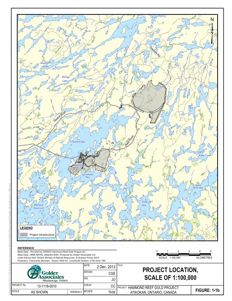
Project Location The location of the Project is shown on Figure ES-1. The Project is located within the Thunder Bay Mining
District in Northwestern Ontario, approximately 170 km west of Thunder Bay and 23 km northeast of the
Town of Atikokan. Thunder Bay is the closest major transportation hub. Atikokan is located immediately north
of the Trans-Canada Highway.
Access to the Hammond Reef property is presently via two routes: the Premier Lake Road, a gravel road that
intersects Highway 623 near Sapawe and the Hardtack-Sawbill Road, a gravel road that intersects
Highway 622 northwest of the Town of Atikokan.
The Project is located within Treaty 3 lands. Treaty 3 includes approximately 55,000 square miles in Ontario
west of Thunder Bay running along the Canadian/American border to the south, and extending slightly into
Manitoba in the west. It includes 28 First Nations communities and the Towns of Atikokan, Fort Frances, Dryden
and Kenora. The First Nations group governing these lands is the Grand Council of Treaty 3, the historic
government of the Anishinabe Nation of Treaty 3.
The Project is also located within an area recognized by the Métis Nation of Ontario as the Treaty 3/Lake of the
Woods/Lac Seul/Rainy River/Rainy Lake traditional harvesting territories, also named Region 1.

EIS/EA REPORT EXECUTIVE SUMMARY VERSION 2
December 2013 Project No. 13-1118-0010 Hammond Reef Gold Project 2
Project Coordinates
The location of the Project Site (centred on the open pits) is:
UTM Coordinates (UTM NAD83 15N):
Easting: 612648.06.
Northing: 5421549.37.
Latitude and longitude:
Latitude: 48° 56' 11.799" North.
Longitude: 97° 27' 42.5124" West.
Project Site Address
The legal description of the Project Site is:
Rainy River District
Sawbill Bay Township
The Project Site address and contact information is:
Osisko Hammond Reef Gold Ltd.
101 Goodwin Avenue
Box 2020
Atikokan, Ontario
Telephone: 807-597-4481
Facsimile: 807-597-2254

!
!
!
!
!
!
!
!
!
!
Ottawa
Kenora Longlac
Toronto
Windsor
Sudbury
Thunder BayTimmins
AtikokanFort Frances
QUEBEC
MANITOBA
G:\Pr
ojects
\2013
\13-11
18-00
10_O
sisko
_Ham
mond
_Ree
f\GIS\
MXDs
\Rep
orting
\EIS\
Chap
ter 1\
Proje
ctLoc
ation
.mxd
FIGURE: 1-1aPROJECT HAMMOND REEF GOLD PROJECTATIKOKAN, ONTARIO, CANADA
Base Data - Provided by OSISKO Hammond Reef Gold Project Ltd.; Base Data - MNR NRVIS, obtained 2004. Produced by Golder Associates Ltd under licence from Ontario Ministry of Natural Resources, © Queens Printer 2012Projection: Transverse Mercator Datum: NAD 83 Coordinate System: UTM Zone 15N
REFERENCE
³
0 100 200 300 400 500
1:10,000,000SCALE KILOMETRES
PROJECT LOCATION,SCALE OF 1:10,000,000
TITLE
13-1118-0010AS SHOWN
DATE
VERSION 2
DESIGN
Mississauga, OntarioPROJECT No.SCALE
GIS
REVIEW THW
JOCGE
2 Dec. 2013
CCCHECK
_̂
PROJECTLOCATION

EIS/EA REPORT EXECUTIVE SUMMARY VERSION 2
December 2013 Project No. 13-1118-0010 Hammond Reef Gold Project 4
Sapawe Rd
Reef Road
Sawbill Road
Bay
Lake
Reservoir
LakeLight
Lake
Hawk
Serpent
Marmion
Mitta Lake
Cornell
Sawbill Bay
UpperSeine Bay
LynxheadBay
G:\Pr
ojects
\2013
\13-11
18-00
10_O
sisko
_Ham
mond
_Ree
f\GIS\
MXDs
\Rep
orting
\EIS\
Chap
ter 1\
Proje
ctLoc
ation
_100
k.mxd
FIGURE: 1-1bPROJECT HAMMOND REEF GOLD PROJECTATIKOKAN, ONTARIO, CANADA
Base Data - Provided by OSISKO Hammond Reef Gold Project Ltd.; Base Data - MNR NRVIS, obtained 2004. Produced by Golder Associates Ltd under licence from Ontario Ministry of Natural Resources, © Queens Printer 2012Projection: Transverse Mercator Datum: NAD 83 Coordinate System: UTM Zone 15N
REFERENCE
³
0 1 2 3 4 5
1:100,000SCALE KILOMETRES
PROJECT LOCATION,SCALE OF 1:100,000
TITLE
13-1118-0010AS SHOWN
DATE
VERSION 2
DESIGN
Mississauga, OntarioPROJECT No.SCALE
GIS
REVIEW THW
JOCGE
2 Dec. 2013
CCCHECK
LEGENDProject Infrastructure

EIS/EA REPORT EXECUTIVE SUMMARY VERSION 2
December 2013 Project No. 13-1118-0010 Hammond Reef Gold Project 6

Sapa
weRd
Reef Road
RABRoad
Sapaw
e Rd
Twin P
ines Ro
adSawbill R
oad
Reef
Road
MittaLake
SawbillBay
LynxheadBay
G:\Pr
ojects
\2013
\13-11
18-00
10_O
sisko
_Ham
mond
_Ree
f\GIS\
MXDs
\Rep
orting
\EIS\
Chap
ter 1\
Proje
ctLoc
ation
_50k
.mxd
FIGURE: 1-1cPROJECT HAMMOND REEF GOLD PROJECTATIKOKAN, ONTARIO, CANADA
Base Data - Provided by OSISKO Hammond Reef Gold Project Ltd.; Base Data - MNR NRVIS, obtained 2004. Produced by Golder Associates Ltd under licence from Ontario Ministry of Natural Resources, © Queens Printer 2012Projection: Transverse Mercator Datum: NAD 83 Coordinate System: UTM Zone 15N
REFERENCE
³
0 0.5 1 1.5 2 2.5
1:50,000SCALE KILOMETRES
PROJECT LOCATION,SCALE OF 1:50,000
TITLE
13-1118-0010AS SHOWN
DATE
VERSION 2
DESIGN
Mississauga, OntarioPROJECT No.SCALE
GIS
REVIEW THW
JOCGE
2 Dec. 2013
CCCHECK
LEGENDProject Infrastructure

EIS/EA REPORT EXECUTIVE SUMMARY VERSION 2
December 2013 Project No. 13-1118-0010 Hammond Reef Gold Project 8

EIS/EA REPORT EXECUTIVE SUMMARY VERSION 2
December 2013 Project No. 13-1118-0010 Hammond Reef Gold Project 9
The Proponent The proponent for the Project is Hammond Reef Gold Ltd. (OHRG). OHRG is a subsidiary of Osisko Mining
Corporation (Osisko) and is 100% owned by Osisko. There are no co-proponents for the Project. Osisko is the
Project sponsor, through OHRG.
Osisko’s corporate contact information is:
Osisko Mining Corporation Ruben Wallin, Vice President, Environment and Sustainable Development
1100 av. des-Canadiens-de-Montreal
Bureau 300, C.P. 211
Montréal, Québec, H3B 2S2
Telephone: 514-735-7131
Facsimile: 514-933-3290
E-mail: [email protected]
Website: www.osisko.com
The primary OHRG contact for the EIS/EA Report is:
Osisko Hammond Reef Gold Ltd. Alexandra Drapack, Director of Sustainable Development
155 University Avenue
Suite 1440
Toronto, Ontario, M5H 3B7
Telephone: 416-363-8653 extension 110
E-mail: [email protected]
Osisko Mining Corporation
Osisko Mining Corporation is a mining company based in Montreal, Quebec. The Company is focused on
acquiring, exploring, developing and mining gold properties, with the aim of becoming a leading mid-tier gold
producer. Its flagship project is the Canadian Malartic gold mine located in the Abitibi mining district of Quebec.
Because the Hammond Reef Gold Project has many similarities to the Canadian Malartic Mine, much of the
design and planning for the Hammond Reef Gold Project has drawn on the successful planning and
implementation of the Canadian Malartic Mine.
Osisko has completed its construction of the Canadian Malartic gold mine in the heart of the Abitibi mining
district. The first gold bar was poured on April 13 2011, and commercial production began in May 2011.
The Canadian Malartic deposit currently represents one of the biggest gold reserves in production in Canada
with Proven and Probable Reserves of 10.1 million ounces of gold (February 2013), and is still growing through
ongoing drilling on adjacent mineralized zones.

EIS/EA REPORT EXECUTIVE SUMMARY VERSION 2
December 2013 Project No. 13-1118-0010 Hammond Reef Gold Project 10
Summary of New Work
Some additional work has been undertaken based on the comments received from Aboriginal groups, the public
and the government review team on the Draft EIS/EA Report. This work includes new and ongoing field studies,
new design and modelling calculations, desktop studies, publication of new reports and revisions to existing
reports. The summary of new work undertaken as a result of the comments received on the Draft EIS/EA report
includes:
Environmental Field Studies
Bat surveys
Water quality sampling
Water level and flows collection
Climate data collection
Environmental Monitoring Plan
Revised to clearly meet guidelines
Expanded to include more detail and commitments
Water Quality Modelling
Additional definition of mixing zone
Conceptual design of effluent diffuser
Mine Waste Alternatives
Alternatives TSD revised substantially to reflect the requirements of the regulatory agencies
Closure Planning
Provided a draft of the Certified Closure Plan to Ministry of Northern Development and Mines (MNDM)
for review and feedback
Revisions to pit filling predictions
A memorandum summarizing Closure Alternatives
Ongoing discussions about reclamation details
EIS/EA REPORT EXECUTIVE SUMMARY VERSION 2
December 2013 Project No. 13-1118-0010 Hammond Reef Gold Project 11
Report Versions
A Draft version of this EIS/EA Report was published for public comment on February 15, 2013. OHRG received
approximately 700 comments from Aboriginal groups, the public and the Government Review Team. The
comments were considered, discussed and incorporated into this Final EIS/EA Report as appropriate. The
document provided herein is the Final version of the EIS/EA Report. Technical Support Documents (TSDs)
were not revised in their entirety; however for each of the TSDs the latest version (Version 2) includes:
Part A: Introduction
Part B: Supplemental Information Package (attached) that provides additional detail on any new work,
updated components, and clarification on any items raised as part of the Information Request process, as
related to the specific TSD.
Part C: Version 1 of the TSD. The Version 1 document should be reviewed within the context of the
Version 2 document, and associated updated information as presented in Part A or Part B should be
considered as correct should it differ from the information presented in Version 1.
Appendix 1.IV provides a copy of each comment received and OHRG’s response to the comment. A detailed
description of major revisions undertaken to the EIS/EA Report is included in the Executive Summary,
Chapter 7, Consultation and Chapter 12, Conclusions.
EIS/EA REPORT EXECUTIVE SUMMARY VERSION 2
December 2013 Project No. 13-1118-0010 Hammond Reef Gold Project 12
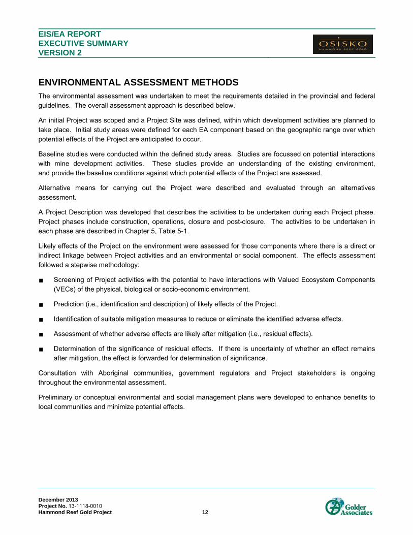
ENVIRONMENTAL ASSESSMENT METHODS The environmental assessment was undertaken to meet the requirements detailed in the provincial and federal
guidelines. The overall assessment approach is described below.
An initial Project was scoped and a Project Site was defined, within which development activities are planned to
take place. Initial study areas were defined for each EA component based on the geographic range over which
potential effects of the Project are anticipated to occur.
Baseline studies were conducted within the defined study areas. Studies are focussed on potential interactions
with mine development activities. These studies provide an understanding of the existing environment,
and provide the baseline conditions against which potential effects of the Project are assessed.
Alternative means for carrying out the Project were described and evaluated through an alternatives
assessment.
A Project Description was developed that describes the activities to be undertaken during each Project phase.
Project phases include construction, operations, closure and post-closure. The activities to be undertaken in
each phase are described in Chapter 5, Table 5-1.
Likely effects of the Project on the environment were assessed for those components where there is a direct or
indirect linkage between Project activities and an environmental or social component. The effects assessment
followed a stepwise methodology:
Screening of Project activities with the potential to have interactions with Valued Ecosystem Components
(VECs) of the physical, biological or socio-economic environment.
Prediction (i.e., identification and description) of likely effects of the Project.
Identification of suitable mitigation measures to reduce or eliminate the identified adverse effects.
Assessment of whether adverse effects are likely after mitigation (i.e., residual effects).
Determination of the significance of residual effects. If there is uncertainty of whether an effect remains
after mitigation, the effect is forwarded for determination of significance.
Consultation with Aboriginal communities, government regulators and Project stakeholders is ongoing
throughout the environmental assessment.
Preliminary or conceptual environmental and social management plans were developed to enhance benefits to
local communities and minimize potential effects.

EIS/EA REPORT EXECUTIVE SUMMARY VERSION 2
December 2013 Project No. 13-1118-0010 Hammond Reef Gold Project 13
Selection of Valued Ecosystem Components The potential effects of the Project are considered with respect to specific criteria and indicators that can be
used to measure changes to attributes of the environment. These include both ecological and socio-economic
attributes, and are referred to as Valued Ecosystem Components and Valued Social Components respectively.
These are collectively referred to Valued Ecosystem Components (VECs).
The VECs provide structure and focus for the environmental assessment. A VEC can be an individual
component of the environment (e.g., a species), or a collection of components that represent one aspect of the
environment (e.g., a wetland ecosystem). VECs for the Project were selected through an issues scoping
exercise that identified the particular components of the environment for which there is public, Aboriginal,
regulatory or scientific concern.
Since the VECs are assessment endpoints, it is important that the selected VECs as evaluated will provide an
appropriate and meaningful indication of the potential effects of the Project. The VECs were selected based on
the following considerations:
1. What major or special ecological features of the Project Site or surrounding area should be protected
from adverse effects from the Project?
2. What aspects of the physical environment (i.e., air, water or land) could be sensitive to the effects of the
Project?
3. What individual species or range of species, of wildlife and plants could be sensitive to the effects of the
Project?
4. What aspects of the socio-economic environment should be considered in assessing the Project?
From an ecological perspective, VECs can represent features of the natural environment considered to be
culturally or scientifically important (e.g., a local wetland or stream). These ecological feature VECs are
complex, comprising several ecological aspects, and affected by a range of pathways (i.e., routes of exposure or
effect). Thus, ecological feature VECs may include:
An aspect of the physical environment (e.g., air or water quality).
An individual plant or animal species (e.g., wild rice or snapping turtle).
VECs are characterized using indicators; where indicators are the attributes of the VEC that might be affected by
the Project. Each indicator requires specific measures that can be quantified and assessed.
Table ES-1 provides a list of the VECs and VSCs selected for the Project. As noted, the table also includes a
summary of the rationale for selection of each VEC/VSC and the indicators which were used to measure and
predict potential effects of the Project on the identified VEC/VSCs.

EIS/EA REPORT EXECUTIVE SUMMARY VERSION 2
December 2013 Project No. 13-1118-0010 Hammond Reef Gold Project 14
Page left intentionally blank

EIS/EA REPORT EXECUTIVE SUMMARY VERSION 2
December 2013 Project No. 13-1118-0010 Hammond Reef Gold Project 15
Table ES-1: Hammond Reef Gold Project Valued Ecosystem Components/Valued Social Components
VEC/VSC Rationale for Selection Indicators
TERRESTRIAL ENVIRONMENT
Habitat VECs
Wetlands Support’s the ecological integrity of the boreal region
Important as wildlife habitat
Support migratory waterfowl breeding
Supports critical habitats for beaver, moose, others
Hydrological functions
Supports traditional use plants (e.g., wild rice)
Extent of wetland habitat
Composition/diversity of wetland plant communities
Hydrological function
Forest Cover Dominant forest plant community that supports the ecological integrity of the boreal region
Important as wildlife habitat
Supports populations of large carnivores such as black bear, wolves and lynx, as well as prey animals such as hare, marten and red squirrel
Abundance of migratory birds utilize habitat for breeding
Socio-economic importance
Extent of forested habitat
Composition of forest plant community
Suitability of habitat in supporting wildlife populations
Group VECs
Species at Risk Bald Eagle Observed in the vicinity of the Project Site
Cultural significance
Provincially, bald eagles are designated as Special Concern under Ontario’s Endangered Species Act
Habitat suitability and availability for bald eagle
Common Nighthawk Bird SAR observed on and in the vicinity of the Project Site
Provincially, Common nighthawk is designated as Special Concern under Ontario’s Endangered Species Act
Breeding habitat occurs on the Project Site
Habitat suitability and availability for common nighthawk
Canada Warbler Bird SAR observed on and in the vicinity of the Project Site
Provincially, Canada warbler is designated as Special Concern under Ontario’s Endangered Species Act
Breeding habitat occurs on the Project Site
Habitat suitability and availability for Canada warbler
Little Brown Myotis Observed in the vicinity of the Project Site
Cultural significance
Provincially, little brown myotis are designated as Special Concern under Ontario’s Endangered Species Act
Habitat suitability and availability for little brown myotis
Northern Myotis Observed in the vicinity of the Project Site
Cultural significance
Provincially, northern myotis are designated as Special Concern under Ontario’s Endangered Species Act
Habitat suitability and availability for northern myotis

EIS/EA REPORT EXECUTIVE SUMMARY VERSION 2
Table ES-1: Hammond Reef Gold Project Valued Ecosystem/Social Components (Continued)
December 2013 Project No. 13-1118-0010 Hammond Reef Gold Project 16
VEC/VSC Rationale for Selection Indicators
TERRESTRIAL ENVIRONMENT (CONTINUED)
Group VECs (Continued)
Species at Risk (Continued)
Snapping Turtle Herpetofaunal SAR observed on and in the vicinity of the Project Site
One of few reptile species in this northern ecosystem
Indicator of wetland function
Habitat suitability and availability for snapping turtle
Furbearers Marten Muskrat Common and abundant in the Project Site
Important prey species for many carnivores in northern environments
May be tolerant of human activities, but may be affected by habitat loss
Traditional and non-traditional uses
Presence/persistence of furbearers
Habitat suitability and availability for furbearers
Upland Breeding Birds Small territory size and high bird density means large numbers of upland birds may be affected by habitat loss
Migratory birds are susceptible to population declines as a result of changing environmental conditions on breeding and overwintering habitats
Relative abundance of breeding birds
Habitat suitability and availability for upland breeding birds
Species VECs
Moose Observed on and in the vicinity of the Project Site
Important subsistence and cultural species
Large herbivorous mammal requiring a large home range
Prey species for large carnivores
Presence/persistence of moose in the area
Habitat suitability and availability for moose
Wild rice Traditional use plant (culturally significant to Aboriginal communities)
Sensitive to fluctuating water levels Potential presence/persistence of wild rice in the area
Habitat suitability and availability for wild rice
AQUATIC ENVIRONMENT
Lower reaches (e.g., downstream) of small streams draining footprint including any mainstem ponds, and stream crossings Potentially affected (altered, diverted) by Project infrastructure
Alteration may result in loss of fish and productivity (e.g., critical habitats, food resources for fish)
Changes can be measured using a variety of standard indicators available (e.g., provincial and federal government criteria)
Benthic invertebrate community
Fish habitat suitability
Fish community (resident assemblages/species present)
Upper Marmion Reservoir (receiver) Socio-economic importance (tourism, angling)
Sensitive receiving water environment
Receiving Bays (mouths of small streams) potentially affected (altered, diverted) by Project infrastructure
Receiving Bays may represent significant habitat for locally important fish species. Alteration of habitats may result in loss of fish and productivity (e.g., critical habitats, food resources for fish)
Changes can be measured using a variety of standard indicators available (e.g., provincial and federal government criteria)
Benthic invertebrate community
Fish habitat suitability (receiving bays)
Fish community (resident assemblages/species present in receiving bays)
Contaminants in fish tissue.

EIS/EA REPORT EXECUTIVE SUMMARY VERSION 2
Table ES-1: Hammond Reef Gold Project Valued Ecosystem/Social Components (Continued)
December 2013 Project No. 13-1118-0010 Hammond Reef Gold Project 17
VEC/VSC Rationale for Selection Indicators
AQUATIC ENVIRONMENT (CONTINUED)
Lizard Lake (receiver) Socio-economic importance (tourism, angling)
Sensitive receiving water environment
Receiving Bays (mouths of small streams) potentially affected (altered, diverted) by Project infrastructure
Receiving Bays may represent significant habitat for locally important fish species. Alteration of habitats may result in loss of fish and productivity (e.g., critical habitats, food resources for fish)
Changes can be measured using a variety of standard indicators available (e.g., provincial and federal government criteria)
Benthic invertebrate community
Fish habitat suitability (receiving bays)
Fish community (resident assemblages/species present in receiving bays)
Contaminants in fish tissue
Walleye Socio-economic importance (angling)
Traditional resource use (First Nation concern
Long lived, top predator species (piscivorous), will accumulate contaminants
Human health; consumed by anglers, subsistence fishers
Walleye habitat
Contaminants in walleye flesh
Smallmouth Bass Socio-economic importance (angling, Bass Classic fishing derby) Smallmouth Bass habitat
Northern Pike Socio-economic importance (angling)
Long lived, top predator species (piscivorous), will accumulate contaminants
Human health; consumed by anglers, subsistence fishers
Northern Pike habitat
Baitfish species Socio-economic importance (commercial baitfish fishery)
Important food resource for large fish species (e.g., walleye) Baitfish habitat
CULTURAL HERITAGE RESOURCES
Archaeological Sites Possible affect to archaeological sites Project related changes to archaeological sites and artifacts
Built Heritage Possible affect to late 19th and early 20th century mine sites Project-related changes to 19th to mid-20th century mine sites
Cultural Heritage Landscapes Possible affect to cultural heritage landscapes Project-related changes to cultural heritage landscapes
ABORIGINAL INTERESTS
Aboriginal community characteristics Potential changes to economic base and educational attainment of Aboriginal communities Project Aboriginal employment
Project contracts awarded to Aboriginal businesses
Education and training of Aboriginal people
Aboriginal heritage resources Importance of Aboriginal heritage resources such as archaeological sites
Importance of specific cultural or spiritual sites Identified archaeological sites and artefacts
Identification of Cultural or spiritual sites
Traditional use of land and resources Aboriginal people have traditionally made use of lands and resources for their personal and community needs
Importance of plants, animals and fish that have been traditionally harvested and consumed by Aboriginal people
Changes or effects identified on the aquatic environment
Changes or effects identified on the terrestrial environment
Availability and quality of country foods

EIS/EA REPORT EXECUTIVE SUMMARY VERSION 2
Table ES-1: Hammond Reef Gold Project Valued Ecosystem/Social Components (Continued)
December 2013 Project No. 13-1118-0010 Hammond Reef Gold Project 18
VEC/VSC Rationale for Selection Indicators
SOCIO-ECONOMIC ENVIRONMENT
Population and demographics Direct job opportunities will attract workers to area for short-term (i.e. construction) and longer term (i.e. operations)
Population change may result in changes in demand on social and physical services and infrastructure
The influx of workers due to the Project could benefit long-term economic and community development, supporting community vibrancy and improved social infrastructure (e.g., housing, organized recreation, support for local business, etc.)
Population change (historical and projections)
Mobility
Age and Gender
Dependency ratios
Economics
Labour market (employment and training) Sustainable employment and training opportunities can develop transferable skills, and long-term regional and local economic benefits
Communities are interested in local recruitment, training and employment
Timing and number of employment opportunities could offset layoffs in other sectors
Loss of employment and income generation at closure may require mitigation measures to avoid adverse effects
Labour force by industry and occupation
Employment and Unemployment rates
Median Income
High school/post-secondary completion rates
Economic development The Project would contribute to diversification of the regional and local economies and either directly or indirectly encourage investment in other business activities, namely through:
Creation of opportunities for local contractors and suppliers
Encouraging new investment in service capacity
Encouraging business creation and expansion
Creation of competitive local suppliers
Loss of business opportunities at closure (~2030) may require mitigation measures to avoid adverse effects
Regional and local economic base
Regional and local supplier base
Local government finances Governments will benefit through increased tax and fee for service revenues
Governments may incur costs related to the provision of services Local government revenues and expenditures

EIS/EA REPORT EXECUTIVE SUMMARY VERSION 2
Table ES-1: Hammond Reef Gold Project Valued Ecosystem/Social Components (Continued)
December 2013 Project No. 13-1118-0010 Hammond Reef Gold Project 19
VEC/VSC Rationale for Selection Indicators
SOCIO-ECONOMIC ENVIRONMENT (CONTINUED)
Services and Infrastructure
Public services and infrastructure Population increase in the LSA may increase demand on services (health, emergency and protection, education, recreation) and water and waste infrastructure
Project activities may increase demand for health, emergency services and waste/water infrastructure
Protection and Emergency:
Police capacity
Ambulance capacity
Fire protection capacity
Health Services:
Number/type of facilities, services and programs
Number of medical practitioners per population
Capacity/capacity utilization
Social Services:
Capacity/capacity utilization
Education:
School enrolment
Capacity utilization
Recreation:
Number/type of recreational facilities
Capacity utilization
Water, Wastewater and Waste Management:
Capacity and capacity utilization of infrastructure
Solid waste management sites and capacity utilization
Utilities:
Capacity and capacity utilization
Housing and accommodation Influx of workers and families may lead to changes in demand for, availability and cost for temporary and permanent housing, and tourism accommodation
Permanent and temporary housing supply
Occupancy rates
Housing costs and availability
Transportation The Project may strain existing road and transportation network due to movement of Project workers, equipment, supplies and products
Traffic volumes (average annual daily traffic counts) and levels of service on relevant access roads and intersections (traffic study to be completed)
Existing transportation network
Land Use and Resources
Outdoor tourism and recreation The Project may affect tourism and recreation activities and opportunities
Loss of employment and income generation by tourist operators may require mitigation measures to avoid adverse effects
Crown land and other tenures
Tourism activities and specific-use areas
Number and types of visitors to the study area
Tourism revenue generation

EIS/EA REPORT EXECUTIVE SUMMARY VERSION 2
Table ES-1: Hammond Reef Gold Project Valued Ecosystem/Social Components (Continued)
December 2013 Project No. 13-1118-0010 Hammond Reef Gold Project 20
VEC/VSC Rationale for Selection Indicators
SOCIO-ECONOMIC ENVIRONMENT (CONTINUED)
Land Use and Resources (Continued)
Hunting The Project may occupy or affect the land base which supports hunting
Loss of employment and income generation by hunters may require mitigation measures to avoid adverse effects
Hunting areas
Wildlife management (e.g., moose, deer, bear) management areas
License sales
Harvest volumes
Trapping The Project may occupy or affect the land base which supports trapping
Loss of employment and income generation by trappers may require mitigation measures to avoid adverse effects
Tenured trapline areas
Harvest volumes
Fishing The Project may occupy land base which supports fishing activities
Loss of fishing opportunity may require mitigation measures to avoid adverse effects Recreational fishing participation (e.g., Atikokan Bass Classic)
Recreational and commercial fishing areas, licence sales and harvest volumes
Baitfish areas and harvest volumes
Conduct a biannual fishing questionnaire of the project workforce to estimate the level of fishing pressure resulting from the Project
Water use and access The Project has the potential to influence the use of and access to water bodies such as the
Marmion Reservoir
The Marmion Reservoir is an important resource for recreational fisheries and tourism, hydro-electric power and other commercial and industrial uses
Recreational fishing participation (e.g., Atikokan Bass Classic)
Water use for hydro-electric power and other industrial and commercial uses
Mining The Project may affect current and future mining and aggregate resource activity Exploration and development projects (current and potential resources)
Mining land use, plans
Forestry The Project occupies forested land
Disrupting access to existing or future harvest land may require mitigation measures to avoid adverse effects
Timber harvesting land base (harvest area, tenure)
ATMOSPHERIC ENVIRONMENT
Air Quality
Ambient air quality Air quality is selected as a VEC since it has been identified as an important aspect of the
environment by both public and regulators. In addition, emissions from the Site activities have the potential to alter the existing air quality
The following compounds have been identified, which are expected to be emitted in measureable amounts from the Site, and for which air quality criteria against which the Site effects can be compared are available:
Particulate matter, including suspended particulate matter (SPM), particles nominally smaller than 10 µm in aerodynamic diameter (PM10), and particles nominally smaller than 2.5 µm in aerodynamic diameter (PM2.5)
Oxides of nitrogen (NOX) and the resulting nitrogen dioxide (NO2)
Sulphur dioxide (SO2)
Carbon monoxide (CO)
Metals, including antimony, arsenic, beryllium, cadmium, chromium, cobalt, copper, lead, manganese, mercury, nickel, selenium, silver, tellurium, tin and vanadium

EIS/EA REPORT EXECUTIVE SUMMARY VERSION 2
Table ES-1: Hammond Reef Gold Project Valued Ecosystem/Social Components (Continued)
December 2013 Project No. 13-1118-0010 Hammond Reef Gold Project 21
VEC/VSC Rationale for Selection Indicators
ATMOSPHERIC ENVIRONMENT (CONTINUED)
Noise
Ambient noise levels Noise levels are selected as a VEC since it has been identified as being important to regulators
and stakeholders. In addition, Site activities have the potential to affect existing noise levels. The effect of the on Site noise sources will be evaluated using the 1-hour equivalent noise level
(Leq). The 1-hour Leq is the energy equivalent continuous sound level, which has the same energy as the time varying signal over a one hour period at the same location.
Other noise indicators are available that are not appropriate for the evaluation of the Site noise levels, but are appropriate for evaluating the indirect effects of changes in noise levels on other VECs (e.g., ecological effects).
Vibration from Blasting
Vibration Levels Vibration levels are selected as a VEC since they have been identified as being important to
regulators and stakeholders. In addition, Project Site activities have the potential to affect existing vibration levels.
The effect of blasting on air vibrations will be evaluated using Peak Air Pressure Level in dBL.
The effect of blasting on ground vibrations will be evaluated us Peak Particle Velocity in mm/s
HYDROLOGY
Surface water quantity The Project may result in changes to surface water quantity within the MSA. Seasonal stream flow in creeks
Seasonal water levels in Marmion Reservoir and Lizard Lake
Catchment areas
Navigability The Project may result in the partial obstruction or change to navigable watercourses or
waterbodies.
Potential for changes in flow, width, depth or gradient of watercourses or waterbodies.
Presence of obstruction.
Flow, width, depth or gradient of waterbody or watercourse.
HYDROGEOLOGY
Groundwater quantity Potential of groundwater flow change within the MSA. Changes in groundwater levels.
WATER QUALITY
Surface Water Quality and Quantity Potential changes in surface water quality due to water intake and discharge and/or from
alteration of runoff processes within the MSA. Substrate metal content.
Amount of organic material.
Dissolved oxygen.
pH.
Temperature.
Total phosphorous.
Total and dissolved metal concentrations in water.
Nutrient content in water.
Total Dissolved Solids.
TKN, TP.
Anions, cations.
Conductivity.

EIS/EA REPORT EXECUTIVE SUMMARY VERSION 2
December 2013 Project No. 13-1118-0010 Hammond Reef Gold Project 22

EIS/EA REPORT EXECUTIVE SUMMARY VERSION 2
December 2013 Project No. 13-1118-0010 Hammond Reef Gold Project 23
EXISTING CONDITIONS
Geology, Geochemistry and Soils The Project Site is underlain by 2.6 billion to 3 billion year old bedrock of the Superior Province of the Canadian
Shield in the Marmion Batholith of the Central Wabigoon Subprovince. The Marmion batholith is a diverse
assemblage of felsic intrusive rocks, varying from granite to tonalite (quartz diorite) with a gneissic tonalite
predominating, and including late stage pegmatite dykes. The Marmion Batholith is transected by a major
structural feature, the 1 to 6 km wide Marmion Deformation Corridor (MDC) (also known as Marmion Lake Fault)
that trends northeast to southwest through the area. The MDC is variably faulted, sheared and altered, and
exhibits a complex braided structure of brecciated and veined granitoid and tonalite rock. This rock mass has
been overprinted with a quartz stockwork that hosts gold mineralization.
The bedrock is overlain by a thin discontinuous veneer of overburden including glacial deposits that accumulated
in low points on the bedrock surface during the progressive retreat of the ice sheet during the end of the
Wisconsinan glaciations. These glacial deposits include glacio-lacustrine (near shore beach deposits,
ice contact deposits and basin/quiet water deposits) and tills that are overlain by younger fluvial
deposits (modern flood plains) and organic (peat) deposits. Bedrock, which is situated at or near the ground
surface throughout much of the area, controls the topography, shallow groundwater and surface drainage
conditions.
Extensive geochemical laboratory testing of 123 samples of waste rock obtained from boreholes drilled in the
area of the mine showed that only one sample could be considered as possibly acid generating.
The conclusions of the completed analysis show that the waste rock will be non-acid generating with excess
neutralization potential primarily resulting from carbonate minerals. The results of the short term leach testing
and kinetic testing support this classification. Samples of potential tailings materials are also classified as
non-acid generating with excess neutralization potential.
Short term and long term leach test results show that pH may be initially alkaline but is near neutral over the
longer term and that concentrations of aluminum, copper, cadmium, iron and zinc have the potential to be
slightly elevated in short term testing relative to comparison criteria with sporadic arsenic, selenium and
vanadium concentrations slightly greater than the comparison criteria in waste rock leach testing. Where these
sample values are above the comparison criteria, additional water quality evaluation within an overall site-wide
context has been conducted as described in the site water quality evaluation.
Gentle topography is characteristic of the area. The granitic rocks of the site are characterized by rounded hills
and shallows slopes. Overburden is generally thin and discontinuous. The geology in which the ore deposit is
located is characterized by granitic rocks. Geochemical testing has shown that the rock types in and around the
proposed open pits are not acid generating, and testing has shown that there is little potential for leaching of
metals.

EIS/EA REPORT EXECUTIVE SUMMARY VERSION 2
December 2013 Project No. 13-1118-0010 Hammond Reef Gold Project 24
Atmospheric Environment The Project Site is located in a typical boreal climate region, which is characterized by long, usually very cold
winters, and short, cool to mild summers. With no major mountain ranges blocking Arctic air masses, winters
are generally very cold. The first snowfall often comes in October and the last snow can come as late as May.
There are no industrial applications within the air quality study area, thus air quality is not impacted by local
sources. The Atikokan Generating Station (AGS) was considered however it is located about 15 km southwest
of the Project site outside the air quality Local Study Area (LSA). The AGS is also currently undergoing
construction to retrofit the former coal plant for burning biofuel. Due to the distance between the AGS and the
Project, there will likely be limited interaction between the AGS and the Project activities.
Northern Ontario does not typically have air quality issues because much of the landscape is natural
and undisturbed. Field studies were not undertaken to characterize the existing air quality conditions,
since available data from Northern Canada stations were used to characterize the existing air quality.
Background measurements are not available for all indicator compounds. Further, it is expected that in remote
locations such as the study area, background air quality values will be lower than the available measured values
and that for indicator compounds such as ammonia the background value will be zero. Therefore, the available
air quality data for particulate matter and combustion gases is considered reasonable and is used to describe
the existing conditions.
Based on the remote nature of the Project and Points of Reception (PORs), the existing noise conditions have
been assumed to be unimpacted by man-made sources and therefore onsite measurements were not required.
Effects of energy released from the Project in the form of air and ground vibrations are most likely to be
experienced by those living in close proximity to the Project. As there are currently no blasting operations within
the study area, an assessment of background conditions is not necessary for this assessment.
Hydrology The Project is located on a peninsula bordered to the east by Lizard Lake, and to the south and west by
Upper Marmion Reservoir. Upper Marmion Reservoir is part of the Seine River system, which originates in the
Savanne River at Raith, flows east-west for about 250 km and empties into Rainy Lake near Fort Frances and
the Canada-U.S. border. The Hammond Reef deposit is located on a peninsula of land extending into the north
end of the Upper Marmion Reservoir, one of three managed reservoirs within the Seine River watershed.
A number of small intermittent and permanent streams occur within the areas to be developed as part of the
Project (the Project footprint). As well, a small waterbody and a number of small intermittent and permanent
watercourses occur in the area where the Tailings Management Facility (TMF) will be constructed. Collectively,
the small streams, ponds and lakes that will be eliminated by the Project contribute less than 1% of the flow into
Upper Marmion Reservoir.
The Upper Marmion Reservoir is currently managed for flood control and hydro-electric power generation.
As part of broad changes to the river systems in the area that began in the 1920’s, the Upper Marmion Reservoir
was created by damming and flooding the existing Seine River. The original flow of the river was altered such
that the system currently drains through a constructed cut (Raft Lake Cut) at the western end of the Reservoir.

EIS/EA REPORT EXECUTIVE SUMMARY VERSION 2
December 2013 Project No. 13-1118-0010 Hammond Reef Gold Project 25
The water level in Upper Marmion Reservoir is maintained by a dam, the Raft Lake Dam, at the western end of
the Raft Lake Cut. From the Raft Lake Dam, the system drains west into Finlayson Lake, where water then
flows south through a constructed channel to the Valerie Falls Generating Station.
As a result of both flood control and hydro-electric power generation requirements, the water level in
Upper Marmion Reservoir fluctuates up to 2.5- 3 m annually as water is drawn down in the spring to provide
flood control capacity.
Hydrogeology Hydrogeological investigations show that groundwater flow from the Project area is outwards towards
Upper Marmion Reservoir. However, there appears to be little direct connection such that as the Reservoir is
drawn down, groundwater levels at most locations do not change. Groundwater flow appears to also contribute
little flow to Upper Marmion Reservoir. The most significant contributor to lake levels in the Project area appears
to be upstream flows from the Seine River and surface runoff from the Seine River/Upper Marmion Reservoir
watershed. These flows are channelled to the Reservoir through a number of small and mid-sized streams that
drain to the Reservoir from outside of the Project area. These water sources are in turn influenced by rainfall
and snowmelt.
Water and Sediment Quality Water quality data indicate that similar conditions exist throughout the waterbodies and watercourses in the
Mine Study Area (MSA), and that the observed water quality is influenced by local geological conditions,
and the presence of wetlands that contribute to fluctuations in pH.
Geochemical testing, soils quality data, and groundwater quality data all show that aluminum and iron, as well as
some other metals are present in leachate samples from all rock types, in soils at above average concentrations
for aluminum, and also present in groundwater samples. All of these are potential sources that can and likely
have influenced water quality in Project Site lakes and streams.
The larger lakes within the system receive natural tributary inflows of slightly lower pH waters that are also
slightly enriched in aluminum and iron, and in some cases, silver and mercury. The combination of local
geologic sources and natural stratification of these lakes determines the fluctuations in aluminum and iron levels
in these waterbodies. The lakes show distinct thermal stratification during the summer months that results in a
decrease in bottom oxygen levels that in turn drives mobility of the major metals, aluminum, iron and manganese
from sediments during periods of low oxygen as a consequence of redox changes in the bottom waters. None of
the larger bodies of water, such as Sawbill Bay, Lynxhead Bay and Lizard Lake appear to experience anoxic
conditions in the deeper basins. This is likely a combination of two influences: the larger surface area that
promotes wind-driven mixing of the water column, and the flow of water through these systems. These lakes
also show evidence of oxygen reduction during the winter months when ice cover prevents mixing of the water
column.

EIS/EA REPORT EXECUTIVE SUMMARY VERSION 2
December 2013 Project No. 13-1118-0010 Hammond Reef Gold Project 26
Conditions in Mitta Lake differ in that oxygen concentrations in the bottom waters of the lake decrease to very
low levels both during summer stratification, and in winter under-ice conditions. The small surface area of the
lake limits wind-driven mixing of the water column, and as a result this lake is more susceptible to oxygen
depletion.
Occasional exceedances of the Canadian Water Quality Guidelines (CWQG) and/or Provincial Water Quality
Objectives (PWQO) for mercury were noted in some waterbodies. Since the geochemical testing has indicated
that the rock types present do not leach mercury, sources related to atmospheric deposition and release from
wetlands are postulated as the reasons for the occasional detection of mercury at concentrations above
detection limits. Similarly, there were occasional exceedances of the PWQO for cobalt and cadmium, though
these are likely from geological sources. The geochemical testing has shown that both can leach from some of
the rock types tested.
Sediment quality in Mitta Lake, Sawbill Bay, Lynxhead Bay, Lizard Lake, as well as upstream in Hawk Bay was
characterized by concentrations of arsenic, cadmium, copper, manganese, lead, nickel and zinc that in one or
more samples exceeded the Ontario Provincial Sediment Quality Guidelines Lowest Effect Level. None of the
metals exceeded the Severe Effect Level, and therefore present minimal risk to aquatic life. Given the similarity
in sediment quality between basins, and since (with the exception of Sawbill Bay) there has historically been no
development in the up-stream bays within the Upper Marmion Reservoir watershed, the values observed are
considered to be natural levels due to the characteristics of the local geology of the region. Concentrations of
these metals were similar in all of the larger waterbodies, and no areas of higher concentrations that could be
related to specific anthropogenic or natural geologic anomalies were noted. Since similar concentrations
occurred in Hawk Bay, upstream of the proposed site in the Seine River, the sediment concentrations likely
reflect general sources to the watershed.
Aquatic Environment Aquatic habitats in the area of the Project include a range of habitat types and sizes. Lentic (still water) habitats
ranged from small wetland ponds to large lakes such as Marmion Reservoir while lotic (moving water)
habitats included small intermittent streams and larger permanent streams. No large rivers occur in the MSA.
While Marmion Reservoir is part of the Seine River system, in the area of the Project it behaves more like a lake,
and is considered as such for the environmental assessment.
Aquatic habitats within the MSA and LSA can be considered as two connected units:
Small waterbodies and watercourses that occur on the upland areas (i.e., the MSA) in which the
Project will be located. The upland area is defined as the area bounded by Lizard Lake to the east,
and Upper Marmion Reservoir, comprised of Lynxhead Bay and Sawbill Bay, to the south and west.
These typically drain to the larger waterbodies.
The larger waterbodies of Lizard Lake and As part of broad changes to the river systems Reservoir into
which the smaller watercourses drain (i.e., the LSA).

EIS/EA REPORT EXECUTIVE SUMMARY VERSION 2
December 2013 Project No. 13-1118-0010 Hammond Reef Gold Project 27
The Marmion Reservoir has been identified by the Ministry of Natural Resources as an important walleye
sports fishery. Within the Marmion Reservoir, Lynxhead Bay Narrows is a potential walleye spawning area.
The Marmion Reservoir also provides habitat for a healthy small mouth bass population.
Headwater drainage systems and associated fish communities that exist within the mine footprint (upstream of
the lower reaches in the watercourses) contribute indirectly to the quality and quantity of fish habitat.
The associated habitat includes predominantly intermittent streams and small waterbodies (beaver
impoundments and some larger ponds), with occasional small lakes and permanent streams. Associated fish
communities are predominantly limited to baitfish and other small-bodied fish. Northern Pike were present in
two of the larger waterbodies within the footprint of the proposed TMF. Upstream passage of fish from the lower
reaches is blocked by natural barriers; however, some downstream movement of fish may occur. Headwater
ponds and streams occur in both the northern area of the Project site where the TMF will be located, and in the
southern section of the site where the mine and associated infrastructure will be located. In these small
headwater ponds and streams fish communities were typically reduced, or in the case of intermittent
watercourses and waterbodies were typically absent. In those waterbodies that had fish populations, these
typically were comprised of northern redbelly dace, finescale dace and fathead minnows.
The lower reaches of the watercourses within the MSA include permanent streams and small waterbodies
(beaver impoundments and larger ponds), with some small lakes that are accessible by fish from Lizard Lake,
Sawbill and Lynxhead Bays. Fish communities are more diverse than headwater drainage systems and include
a greater diversity of small-bodied fish, and commonly support species such as northern pike, white sucker and
yellow perch. Fish passage to and from these features occurs throughout the year, however it may be impeded
by the fluctuating water levels in Sawbill and Lynxhead Bays. There is no documented use of these features by
walleye and smallmouth bass.
Two small lakes would be eliminated by the Project. At the northern end of the site, within the footprint of the
TMF is a small unnamed lake (identified as Area of Potential Impact [API] #2). This lake has a surface area of
approximately 122,000 m2 (12.2 ha), and a maximum depth of 5 m. The range of species encountered in this
lake included adults and juveniles of pumpkinseed, yellow perch, northern pike, white sucker, as well as small-
bodied forage fish such as Iowa darter and blacknose shiner. The lake drains via a small stream to another
small lake (this lake lies outside of the footprint of the Project), that in turn drains to Lizard Lake. Within the
small stream draining from the lake, no fish were obtained, though the presence of fish in the small lake
indicates that fish likely can pass up this stream on occasion. The second lake, Mitta Lake, lies directly over the
gold deposit, and will be eliminated when mining commences. Mitta Lake is a small irregularly shaped lake
within the MSA perched on the peninsula on which the Project will be located. Mitta Lake is a small waterbody
of 17.1 ha in size. The lake is steeply sided, and consists of three deeper basins, which reach a maximum depth
of 16 m. The lake supports populations (both adults and juveniles) of white sucker, brook stickleback, fathead
minnow, Iowa darter, mottled sculpin and finescale dace. No sport fish were encountered in the lake during
sampling. Mitta Lake is drained by a small stream that flows south to Upper Marmion Reservoir.

EIS/EA REPORT EXECUTIVE SUMMARY VERSION 2
December 2013 Project No. 13-1118-0010 Hammond Reef Gold Project 28
Terrestrial Environment The Project lies within the boreal forest region of Ontario, near the transition zones with the Great-Lakes-
St. Lawrence mixed forest region and the prairie grasslands. The forest communities of the area are dominated
by black spruce, jack pine, trembling aspen and white birch. The area supports a range of wildlife species
typical of the boreal forest. A limited number of species-at-risk have been recorded from this area of
Northwestern Ontario, though only the Canada warbler, the common nighthawk, the bald eagle and the
snapping turtle were found to occur within the Project area.
The rolling landscape gives way to wetlands varying in morphology, nutrient content and species richness.
Fens and bogs are present where there is isolation from groundwater; and swamps and marshes are in closer
proximity to groundwater or the shallows of lakes and rivers. The richer wetlands support more species
diversity, while some of the poor, acidic wetlands support few species, those of which are specially adapted to
restricted nutrients. A variety of species were observed throughout the LSA reflecting this variability of habitat
types.
Many traditional use plants such as black spruce, willow (Salix spp.), bog cranberry (Vaccinium vitis-ideae),
Labrador tea (Ledum groenlandicum), and blueberry (Vaccinium myrtilloides) are common in a number of
different ecosite types. However, there are a few traditional use species that are more restricted in their
distribution and tend to only be associated with a single ecosite type, though they may be locally abundant within
that ecosite type. Wild rice (Zizania palustris) has been raised as a species of Aboriginal value but was not
observed in the LSA during field surveys conducted in 2012.
A total of 82 bird species were identified during all breeding season field surveys throughout the MSA and LSA.
The majority of bird species were detected during morning breeding bird point counts. White-throated sparrow
(Zonotrichia albicollis), a habitat generalist (Falls and Kopachena 2010), was the most abundant species
observed. Additional common species included mixed/deciduous forest species such as red-eyed vireo;
coniferous forest species such as Swainson’s thrush (Catharus ustulatus) and wetland (e.g., bog and fen)
species such as yellow-bellied flycatcher (Empidonax flavienventris). The species composition and density is
typical of a boreal hardwood forest bird community, with a diversity of warblers, thrushes, sparrows and vireos.
Species at Risk (SAR) observed during the breeding bird surveys were the Common nighthawk
(Chordeiles minor) and Canada warbler (Wilsonia canadensis). No secretive marsh birds were identified during
the Marsh Bird Surveys. However, 11 species were observed including wetland species such as Wilson’s snipe,
Eastern kingbird (Tyrannus tyrannus), and Ring-necked duck (Aythya collaris). The only potential Least bittern
habitat (e.g., large emergent marshes) was located on Snail Bay in Marmion Reservoir. However, habitat was
marginal and no Least bitterns were observed or responded to playback.
A total of 12 mammal species were observed either during targeted surveys or incidentally during the conduct of
other baseline studies completed between 2010 and 2012. Based on range maps and knowledge of current
distribution, an additional 35 species of mammals potentially occur in the LSA. Of the observed and potentially
occurring mammal species, one is classified as a Species at Risk, Gray fox. However, no Gray foxes were
observed in the LSA, nor is suitable habitat available in the LSA for this species. The reptiles and amphibians in
the LSA and MSA are generally those considered typical of the boreal forest. There is no indication that the
species or habitats at the study site are unique relative to the surrounding area. Snapping turtle is the one
reptile SAR that was identified as occurring in the area. During various field surveys, 28 species of dragonfly
EIS/EA REPORT EXECUTIVE SUMMARY VERSION 2
December 2013 Project No. 13-1118-0010 Hammond Reef Gold Project 29
and butterfly species have been identified in the MSA and LSA. All the species observed are common to the
area and there are none designated under provincial or federal legislation.
In January 2013, several species of bats were added to Ontario’s Species-at-risk list and were, therefore,
considered in the Final EIS/EA Report. Range maps indicate that six species of bats have known home ranges
in the area, all of which were recorded during the 2013 bat field surveys at Hammond Reef.
Socio-economic Environment The Project is located 30 km north of the Town of Atikokan (population ~2,800), within the Rainy River District in
Northwestern Ontario. The City of Thunder Bay (population ~120,000) is located approximately 170 km east
and the Town of Fort Frances (population ~8,000) is located about 150 km to the west.
The Town of Atikokan is a beautiful community, dubbed the Canoe Capital of Canada. The Town is known
regionally for its popular fishing tournament, the Atikokan Bass Classic. The Town also has a history of resource
development including mining and forestry. In 2011, the Town Council passed a resolution in support of the
Hammond Reef Gold Project. The potential influx of workers to the Town of Atikokan could affect housing,
services and infrastructure. The Project also represents potential business opportunities for community
members.
Historically, the local economy centred around two iron ore mines: Steep Rock Iron Mines and Caland Ore. T.
Both mines commenced operations in the early-1950s and remained the main local employers for the next three
decades. During the peak years of production, the Steep Rock Mine employed more than 700 workers and
produced 1.0-1.5 million tonnes of ore annually. For every 100 jobs in the mine an additional 65 jobs were
reportedly generated in the community, resulting in 40,000 person years of employment (Summary of Woods
Gordon Report 1986). Both mines closed in 1979 and the land was deeded back to the Ministry of Natural
Resources. The closing of the mines led to a major local economic downturn in the 1980s.
Forestry has traditionally been an important industry in Northwestern Ontario, including Atikokan. In the early
1900s there were numerous lumber mills in the area around Atikokan. Many lumber companies logged the
Quetico area extensively, Atikokan Forest Products operated a mill in the Sapawe Lake area, and Fibratech
operated in Atikokan as one of North America’s innovative engineered wood producers – manufacturing and
designing quality orientated fibreboard panels. Both of these industries closed in 2007. Currently the only
forestry-related industry in the Town of Atikokan is engaged in manufacturing fuel pellets.
The City of Thunder Bay acts as the centre for regional mining activity. Thunder Bay could potentially provide
a large amount of goods and services required by the Project and may also have a pool of qualified specialized
workers that are not necessarily available locally. The Town of Fort Frances is the main public service and
infrastructure hub of the Rainy River District and may also be a source of goods and services for the Project.
The total population of the Regional Study Area (RSA) is 224,034. The Thunder Bay District represents more
than half of the RSA population, with the majority of the District’s population concentrated in the City of Thunder
Bay. The second largest population centre in the RSA is the City of Kenora with 15,348 followed by the Town of
Fort Frances (7,952) and the City of Dryden (7,617).

EIS/EA REPORT EXECUTIVE SUMMARY VERSION 2
December 2013 Project No. 13-1118-0010 Hammond Reef Gold Project 30
The population of the RSA has decreased comparatively in 2006 and 2001 (235,046 and 234,771 respectively)
relative to the population in 1996 (244,117) (StatsCan 2007; StatsCan 2012). This population fluctuation has
resulted in an overall decrease of 8.2% since 1996. In 2011, the population of Atikokan was 2,787, representing
a 31% decline since 1996 and a 15.4% decline between 2006 to 2011. This decline can be attributed mostly to
the downturn of the local economy resulting from the closure of a number of mining and forestry-related
employers in the town. Conversly, the population of Ontario has demonstrated a growing trend since 1996,
with a population increase of 19.5% over this period.
The economy of Northwestern Ontario has been declining over the past decade. The Gross Domestic Product
for Northwestern Ontario declined by 6.7% between 2001 and 2006, while it increased by 3.5% and 13.6% for
Northeastern Ontario and the rest of Ontario respectively over the same period of time (Rosehart 2008).
The economy of Northwestern Ontario has traditionally been dominated by a small number of large companies
that hire large numbers of workers, which in turn has created service industries dependent on large employers
and their employees (Rosehart 2008). Approximately 76% of employment in Northwestern Ontario (excluding
Thunder Bay) is in the service sector (Northwest Training and Adjustment Board 2010). The decline of the
forestry sector in Ontario in recent years and the subsequent closures of pulp and paper and lumber mills have
had a negative effect on the region’s economic conditions.
Historically, the Town of Atikokan developed around the mining and forestry industry, and remained heavily
dependent on these sectors. With the closing of the community’s most recent mines in 1979, major economic
downturn followed in the 1980s and the forestry sector became the primary employer in the community.
However, with the recent downturn in regional forestry, only one firm, which manufactures fuel pellets, remains
active in the Town of Atikokan.
In 2006, the RSA had an experienced labour force of 117,865 (1.8% of the provincial labour force). In 2006,
the LSA had an experienced labour force of 1,650. Primary industries of employment are forestry and mining;
however many workers are employed outside of Atikokan while their families still reside in Atikokan.
Tourism constitutes approximately 15% of Atikokan’s employment.
Outdoor recreational tourism operators in the LSA host remote camping, hunting and fishing vacations.
These tourism outfitters provide a variety of services including remote fly-in, and drive in wilderness retreats,
guided fishing tours, hunting expeditions, and trapper cabins, as well as accommodations. The Atikokan Tourist
Bureau tracks Atikokan visitors during peak season (May-September). In 2011, 3,697 tourists visited the
Tourist Bureau, 30% of which were only passing by. The most popular reasons for visiting Atikokan were
recreation (approximately 20%), followed by fishing, and visiting friends or family (approximately 10% each).

EIS/EA REPORT EXECUTIVE SUMMARY VERSION 2
December 2013 Project No. 13-1118-0010 Hammond Reef Gold Project 31
Aboriginal Interests The Project is located within the Treaty 3 lands. Treaty 3 is a written agreement between the Saulteaux Tribe
of the Ojibway Indians and Her Majesty the Queen of Great Britain and Ireland signed in 1873 (Chiefs of
Ontario 2005).
Upon signing, each Chief received a British flag and a treaty medal. Treaty 3 includes an 1875 adhesion
(addition to the Treaty) that extends all rights and benefits to the “Half-breeds” (Métis) of Rainy River and
Rainy Lake. The Métis were absorbed into the Little Eagle Band and are now part of the Couchiching First
Nation (Chiefs of Ontario, 2005).
The Métis assert harvesting and trapping rights throughout most of Ontario. Their hunting and harvesting
activities are organized by territories that represent large areas within which the Project is situated.
Each territory has a Captain of the Hunt, designated by the Métis Nation of Ontario (MNO). The Captain of the
Hunt has authority over Métis hunts, issues harvesting certificates and gathers information on the number,
species and location of animals taken. The RSA includes part of two hunting territories, the Rainy Lake/
Rainy River and the Lake of the Woods/Lac Seul. The LSA includes a small part of the Rainy Lake/Rainy River
harvesting territory.
Aboriginal engagement for the Project focussed on nine identified First Nations communities. These nine
communities have been identified by the Crown as having an interest in the Project and having triggered the
duty to consult on the Project. The Project is located in MNO Region 1. Region 1 includes four Métis
communities that may be affected by the Project through employment, business, and education and training
opportunities.
The following Aboriginal communities have been identified as having an interest in the Project:
Métis Nation of Ontario:
Atikokan Métis Council
Kenora Métis Council
Sunset Country Métis Council
Northwest Métis Nation of Ontario Council
First Nations:
Fort Frances Chiefs Secretariat:
Couchiching First Nation
Lac La Croix First Nation
Mitaanjigamiing First Nation
Naicatchewenin First Nation
Nigigoonsiminikaaning First Nation

EIS/EA REPORT EXECUTIVE SUMMARY VERSION 2
December 2013 Project No. 13-1118-0010 Hammond Reef Gold Project 32
Rainy River First Nation
Seine River First Nation
Lac des Milles Lacs First Nation
Wabigoon Lake Ojibway Nation
The Fort Frances Chiefs Secretariat (FFCS) is a regional governing body comprised of the seven chiefs of the
Rainy River District; with the collective authority, granted by the people, to represent the Anishnaabe of
the region. Representing seven individual First Nations, the FFCS identifies issues of common interest,
and collectively determines solutions through advocacy and partnership.
The traditional language of the Anishnabe Nation is Ojibway, although English is also a predominant language.
Knowledge of their Aboriginal language is still present in close to 40% of the population in many communities
within the RSA. The Fort Frances Chiefs Secretariat has been working on an Education Jurisdiction Transfer
that will create a separate school board and enable a culturally-focussed curriculum, including an Ojibway
immersion program. The Ojibway language continues to be used during prayers, oral history and traditional
story telling.
Current unemployment rates reported by the identified First Nations communities are all higher than the
unemployment rate for the Province of Ontario. The median income reported by the identified First Nations
communities, are all lower than the median income for Northwestern Ontario and the Province of Ontario.
Special sites were identified through two separate Traditional Use Studies carried out with First Nations and
Métis people. Special sites were identified for both First Nations and Métis. These sites were identified
and locations were provided to allow OHRG to avoid disturbing any sites from land clearing activities or
placement of Project infrastructure.

EIS/EA REPORT EXECUTIVE SUMMARY VERSION 2
December 2013 Project No. 13-1118-0010 Hammond Reef Gold Project 33
ASSESSMENT OF ALTERNATIVES Revisions to the Alternatives Assessment TSD and Chapter 4 of the EIS/EA Report are considered substantial
between the draft report published in February 2013 and this final report. Environment Canada requested that
OHRG undertake a more detailed mine waste alternatives assessment by including additional sub-accounts and
indicators in the multiple accounts analysis. Mine waste includes the TMF and the waste rock stockpiles.
Environment Canada and OHRG worked together to develop a detailed list of suggested sub-accounts and
indicators for Environment, Economic and Socio-economic accounts based on consultation and other similar
projects. OHRG incorporated all these revisions to the report as detailed in Chapter 4.
Additional changes to the Alternatives Assessment TSD and Chapter 4, outside of mine waste alternatives,
included a stronger link to VECs and an overall revision for consistency and clarity. Some new discussion
regarding the on-site workers accommodation alternative was also provided.
A full range of non-mine waste alternative methods of carrying out the Project were examined and assessed.
Alternatives that meet the Project objectives were identified in the ToR and an initial screening process was
completed. The alternatives that were deemed reasonable were carried forward for further evaluation and were
investigated in greater detail. Comparative summaries of the features of the alternatives, environmental and
social impacts, cost requirements, and discussions of the degree to which the alternative fulfills the need
identified were used to determine which option is best overall. A summary of the preferred alternative for each
Project component is presented in the following table.
Table ES-2: Summary of Preferred Alternative Means of Carrying out the Hammond Reef Gold Project
Project Component Preferred Alternative
Ore processing method Processing using cyanide including a cyanide destruction circuit
Project transmission line Transmission line along Hardtack/Sawbill Road and crossing Sawbill Bay
Sewage treatment facility location Dedicated facilities for the worker accommodation camp and the Mine
Sewage treatment technology Package sewage treatment plant
Water discharge location Overland pipeline to the south with discharge to the south end of Sawbill Bay
Access road Hardtack/Sawbill Road
Worker accommodation camp On-site worker accommodation camp
Tailings Deposition Thickened tailings
A full range of mine waste alternatives have been examined and assessed. Alternatives that met the Project
objectives were identified in the ToR and an initial screening process was completed. The alternatives that were
deemed reasonable were carried forward for further evaluation and were investigated in greater detail.
A multiple accounts analysis including a qualitative/quantitative assessment and value-based decision process
was applied to each alternative in accordance with Environment Canada’s Guidelines for the Assessment of
Alternatives for Mine Waste Disposal (Environment Canada 2011), leading to the selection of the best overall
option. The preferred mine waste alternatives are “Alternative 3” for the Waste Rock Management Facility
(WRMF) – located immediately east of the open pit and mine processing plant and the “Optimized Base Case,”
for the TMF which is located approximately 9 km northeast of the processing plant.
EIS/EA REPORT EXECUTIVE SUMMARY VERSION 2
December 2013 Project No. 13-1118-0010 Hammond Reef Gold Project 34
PROJECT DESCRIPTION The Hammond Reef Gold Project (Project) consists of an open pit gold mine and associated processing
and support facilities. The mine will consist of two open pits, a processing facility, a TMF, a WRMF and
supporting infrastructure that includes a worker accommodation camp for workers. The mine has a projected
operating life of 11 years at an average production rate of approximately 60,000 tonnes of ore per day. The
production rate may be improved or increase over time.
The Project represents a major investment of capital into Ontario and Canada’s economy. Based on capital
costs of OHRG’s Canadian Malartic Mine, it is estimated that the total capital cost of the proposed Hammond
Reef Gold Project would be $1.4 billion ($2012 Canadian). Total output of refined gold is expected to be 369,000
ounces per year.
The Project is expected to support approximately 34,736 Person Years (PYs) of direct, indirect and induced jobs
in Canada over its construction and operations phases, a period of 14 years. Total benefits to Atikokan and
local First Nation communities would be 3,129 jobs over the construction and operations periods, and $456.7
million in wages and salaries to construction workers, mine operators and workers in the supply industries.
Over the 14 year analysis period, the Project is expected to generate $490.8 million in federal and provincial
income tax revenues. During the 11-year operations period the Project would contribute approximately $3.2
billion to national Gross Domestic Product (GDP).
The Project will be completed through four phases: the construction phase during which the necessary
infrastructure will be built; the operations phase during which the mine is developed and the ore is processed;
the closure phase during which production ceases and the site is decommissioned; and the post-closure phase
during which the Project site is monitored.
The Project was defined through consideration of a number of alternatives for developing specific Project
components. Three different alternative locations for the TMF were assessed from which the final location was
selected based on environmental and engineering considerations. Similarly, alternative means for waste rock
management, ore processing, water management, and other site facilities were considered. The Project as
described below represents the selected alternatives for each component based on an assessment of the
potential environmental effects of each alternative together with engineering requirements.
The open pits (located immediately adjacent to one another) will be developed in stages. Initially, overburden
(consisting mainly of top soils) will be removed and stockpiled for later use in reclaiming the site. The waste
rock, (defined as rock that does not contain economically recoverable gold), will be removed by blasting and
trucking to the WRMF. Ore will be extracted from the pits by blasting and will be trucked to the processing
facility for production of gold doré bars. The tailings will be thickened to remove some of the excess water and
will be pumped via an above-ground pipeline to the TMF, to permanently store the tailings. With the exception of
the TMF and the worker accommodation camp, all Project support infrastructure will be located close to the open
pits.
The TMF will be located approximately 9 km to the northeast of the open pit. The TMF will be constructed of
rock and earthen dams that are progressively raised as tailings accumulate in the TMF. The tailings will be
pumped as a thickened slurry from the processing plant to the TMF. Excess water in the tailings will
be collected in the TMF reclaim pond, and then pumped back to the processing plant for re-use. At the base of

EIS/EA REPORT EXECUTIVE SUMMARY VERSION 2
December 2013 Project No. 13-1118-0010 Hammond Reef Gold Project 35
the tailings dams, seepage collection ponds will be constructed to collect seepage water to be pumped back
into the TMF.
Water is required for the processing operation, and the necessary water for processing plant start-up will be
obtained from Upper Marmion Reservoir. Once the processing plant is in operation, process water will be
reused to minimize taking of additional water from Upper Marmion Reservoir. The reused water will be stored in
the Process Plant Collection Pond (PPCP) until it is needed in the processing plant. In addition, storm water and
seepage will be collected from around the WRMF and other facilities and conveyed to the PPCP. Water in the
PPCP will be supplemented with reclaimed tailings water. Under this arrangement, requirements for fresh water
from the Upper Marmion Reservoir will be minimized.
Excess water will be treated through an effluent treatment plant if required and released to the south end of
Sawbill Bay of Upper Marmion Reservoir. Due to Project water needs during years with average or below
average precipitation, all water would be reused, and there should be no discharge from the site. During years
of above average precipitation, some excess water would be produced, which would be treated, if required and
released intermittently to Upper Marmion Reservoir.
In addition to the processing plant, a number of support facilities will be constructed on the site. These include a
truck servicing area to maintain the mine vehicles, a fuel storage area and fuelling facilities for the vehicles,
firefighting equipment facilities, water storage and treatment facilities, and offices. The mine and support
facilities will be located close together near the pits. The mine worker accommodation camp will be located
approximately 10 km to the north, near the location of the existing exploration camp. Workers will be transported
in and out of the worker accommodation camp on a rotational shift basis. It is expected that some workers will
move into the area, taking up residence in the Town of Atikokan while workers from more distant locations will
likely return to their home communities at the end of their shift rotations.
The existing Hardtack-Sawbill Road that leads north from Highway 622 will be widened and straightened in
some places in order to accommodate heavy truck traffic that will bring in construction supplies during the
construction phase and mine operating supplies (such as diesel fuel, processing chemicals, and worker
accommodation camp supplies) during mine operations. Electrical power will be brought to the site via a
transmission line, which follows the same general route as the road alignment for 14.3 km until it crosses over
Sawbill Bay.
Upon completion of mining, the mine will be closed as per regulations under the Ontario Mining Act.
The buildings will be decommissioned, the TMF will be graded and revegetated, and drainage from the Project
infrastructure will be directed to the open pits until such time as water quality indicates that normal runoff flow
directions can be restored. The pits will be left to fill naturally, and it is estimated that approximately 218 years
after operations cease, the pits will overflow to Upper Marmion Reservoir.
Figure ES-4 provides the general arrangement of the Project Site during the operations phase. Table ES-3
outlines the Project activities for each key Project component by Project phase.

EIS/EA REPORT EXECUTIVE SUMMARY VERSION 2
December 2013 Project No. 13-1118-0010 Hammond Reef Gold Project 36

!H
!H
#7
#7
"/
EFFLUENT TREATMENT PLANT
PEBBLE CRUSHING STATIONCONCENTRATOR
GYRATORY CRUSHER PAD
PARKING LOT
PUMPINGSTATION
PROCESS PLANT COLLECTION POND
PROPANE FARM
DETONATORSTORAGE
PUMPINGSTATION
PARKING LOT
TAILINGS MANAGEMENT FACILITY
WEST PIT
EAST PIT
LOW-GRADEORE STOCKPILE OVERBURDEN
STOCKPILE
WASTE ROCKSTOCKPILE
EMULSIONPLANT
PROCESS PLANT COLLECTION POND
POWER SUBSTATION
LIVE ORESTOCKPILE
FUEL BAY
TRUCK SHOP / MINE OFFICESECURITY STATION
ACCOMMODATIONCAMP
CAMP SITE EFFLUENTDISCHARGE POINT
FRESHWATER INTAKE -CAMP SITE POTABLE
FRESHWATER INTAKE -PROCESS AND PLANT POTABLE
EFFLUENT DISCHARGEPOINT
Bay Bay
Light Lake
Lake
Trap
Lake
Lake
LakeVista
Lake
Lizard
Serpent
TurtleMittaLake
Cornell
LongHike
Sawbill Bay
UpperSeineBay
Lynxhead Bay
MarmionReservoir
610000
610000
615000
615000
620000
620000
5420
000
5420
000
5425
000
5425
000
5430
000
5430
000
G:\Pr
ojects
\2013
\13-11
18-00
10_O
sisko
_Ham
mond
_Ree
f\GIS\
MXDs
\Rep
orting
\EIS\C
hapte
r 5\Si
teLay
out.m
xd
³LEGEND
Base Data - Provided by OSISKO Hammond Reef Gold Project Ltd.Base Data - MNR NRVIS, obtained 2004Produced by Golder Associates Ltd under licence from Ontario Ministry of Natural Resources, © Queens Printer 2008Projection: Transverse Mercator Datum: NAD 83 Coordinate System: UTM Zone 15N
VERSION 2
Mississauga, Ontario
DESIGN
SITE LAYOUT
FIGURE: 5-1PROJECT NO. 13-1118-0010 SCALE AS SHOWN
PROJECT
TITLE
GIS
REVIEW
CGE 14 Nov. 2008
CHECK
HAMMOND REEF GOLD PROJECTATIKOKAN, ONTARIO, CANADA
JO 2 Dec. 2013SPSP
2 Dec. 20132 Dec. 2013
!H Freshwater Intake - Camp Site Potable!H Freshwater Intake - Process and Plant Potable"/ Discharge Location#7 Effluent Discharge Point
LakeWetlandMine Site RoadAccess Road (Hardtack / Sawbill)Project Transmission LineFibre Optic Line and Auxiliary Power LineAccommodation CampLaydown AreaOffice and Truck Shop, Explosives Storage and Processing PlantOpen PitsLow-Grade Ore StockpileOverburden StockpileProcess Plant Collection PondPumping StationTailings Management FacilityTailings Management Facility Reclaim PondWaste Rock Stockpile
500 0 500 1,000 1,500 2,000 2,500METERS1:50,000SCALE
REFERENCE
Highway 622
Sawbill Bay
Lynxhead Bay
Marmion
Mitta Lake
Reservoir
³
2,500 0 2,500METERS
EIS/EA REPORT EXECUTIVE SUMMARY VERSION 2
December 2013 Project No. 13-1118-0010 Hammond Reef Gold Project 38
Page left intentionally blank

EIS/EA REPORT EXECUTIVE SUMMARY VERSION 2
December 2013 Project No. 13-1118-0010 Hammond Reef Gold Project 39
Table ES-3: Project Activities
Component Facilities Construction Phase Activities Operations Phase Activities Closure Phase Activities Post-closure Phase Activities
Management, Permitting and Employment
N/A Source and hire construction workforce.
Source operational workforce.
Source and obtain equipment and materials.
Maintain construction permits/monitoring.
Finalize operational permits/plans and monitoring.
Restrict Project Site access.
Maintain operational workforce.
Maintain and manage Project Site.
Maintain operational permits and monitor.
Implement and adjust plans as necessary.
Restrict Project Site access.
Change workforce activities.
Manage closure process.
Implement closure.
Implement monitoring programs.
Restrict Project Site access.
Monitor and maintain as necessary.
Maintain post-closure workforce if necessary.
Restrict Project Site access if necessary.
Linear Infrastructure Access road
(Hardtack/Sawbill).
Project transmission line.
Fibre optic line.
Upgrading/construction of access road (Hardtack/Sawbill).
Construction of project transmission line and electrical substations (tie-in and on-site substation).
Construction of fibre optic line.
Clearing and grubbing.
Drill and blast.
Maintaining access road (Hardtack/Sawbill).
Maintain project transmission line.
Maintain fibre optic line.
Maintaining appropriate access.
Decommission project transmission line when no longer necessary.
Decommission fibre optic line when no longer necessary.
Return applicable portions of access road (Hardtack/Sawbill) to MNR control.
Work with MNR to allow for appropriate road use and access.
Aggregate Nearby aggregate sites. Clearing, grubbing and installation of temporary sediment control
measures.
Stripping and stockpiling of topsoil and overburden as necessary.
Operation of mobile crushing and screening plant.
Excavation crushing and screening aggregate material.
Hauling and transporting material as required.
Clearing, grubbing and installation of temporary sediment control measures.
Stripping and stockpiling of topsoil and overburden as necessary.
Operation of mobile crushing and screening plant.
Excavation crushing and screening aggregate material.
Hauling and transporting material as required.
Decommission following appropriate guidelines once they are no longer required.
Closure and decommission following appropriate guidelines once they are no longer required.
None.

EIS/EA REPORT EXECUTIVE SUMMARY VERSION 2
December 2013 Project No. 13-1118-0010 Hammond Reef Gold Project 40
Component Facilities Construction Phase Activities Operations Phase Activities Closure Phase Activities Post-closure Phase Activities
Support and Ancillary Infrastructure
Mine site road and on-site roads.
Worker accommodation camp.
Office and support facilities.
Warehouses, workshops and maintenance facilities.
Chemicals, fuel and explosives manufacturing facilities.
Fuel storage area.
Explosive storage and preparation.
On-site power distribution (grid).
Off-site waste disposal.
Other ancillary and support infrastructure.
General operation of support and ancillary structure and facilities.
Operation, fuelling and maintenance of vehicles.
Transportation of people and materials.
Operation and maintenance of backup power generation facilities.
Hazardous and non-hazardous waste management.
Control of dust.
Fuel and chemical transportation handling and storage.
Clearing and grubbing of development areas.
Stripping and stockpiling of topsoil.
Preparation of construction facilities (offices, shops, dry, cafeteria and nursing station).
Grading and granular surfacing of laydown areas, including drill and blast and site preparation.
Grading of development areas.
Operation of concrete batch plant.
Construction of facilities.
Construction of on-site roads.
Construction of piping and electrical between buildings.
Construction of diversion ditching and linking water management systems from various facilities.
Construction of support and ancillary infrastructure (explosive storage area, , fuel storage areas, natural gas farm, parking areas, sewage, worker accommodation camp, truck shop, warehouses, backup power generation, other facilities to be determined as part of detailed design).
Haulage of waste from Project Site to disposal in appropriately licensed facilities when required.
General operation of support and ancillary structure and facilities.
Operation, fuelling and maintenance of vehicles.
Transportation of people and materials.
Operation and maintenance of backup power generation facilities.
Hazardous and non-hazardous waste management.
Control of dust and erosion.
Fuel and chemical transportation handling and storage.
Explosive manufacturing, handling and storage.
Haulage of waste from Project Site to disposal in appropriately licensed facilities when required.
Decommissioning of Project facilities.
Operation of temporary offices during closure.
Operation, fuelling and maintenance of vehicles during closure activities.
Transportation of people and materials.
Hazardous and non-hazardous waste management.
Control of dust.
Fuel transportation handling and storage.
Removal of re-useable supplies and materials.
Salvage of equipment and sale of scrap where economical.
Remediation of hydrocarbon impacts as per applicable guidelines if necessary.
Demolition of facilities and disposal in licences landfills.
Project Site reclamation.
Close (scarify and vegetate) all non-essential site roads.
Implement closure monitoring programs.
Haulage of waste from Project Site to disposal in appropriately licensed facilities when required.
Periodic Project Site access only.
No additional waste materials will be placed on-site.
Haulage of waste from Project Site to disposal in appropriately licensed facilities when required.
Ore Processing Facility Ore crushing.
Crushed ore stockpile.
Processing plant (including ore grinding and processing).
Conveyor.
Site grading.
Construction of foundation, superstructure and process components including delivery and assembly.
Construction and surfacing of ore pad.
Construction of ore crushers, grinding mills and conveyors.
Ditching where necessary.
Crushing, grinding and concentration of ore.
Leaching of concentrate.
Electro-winning and smelting of gold.
Operation of cyanide destruction plant and tailings thickener.
Decommissioning of processing plant as per general activities.
None.
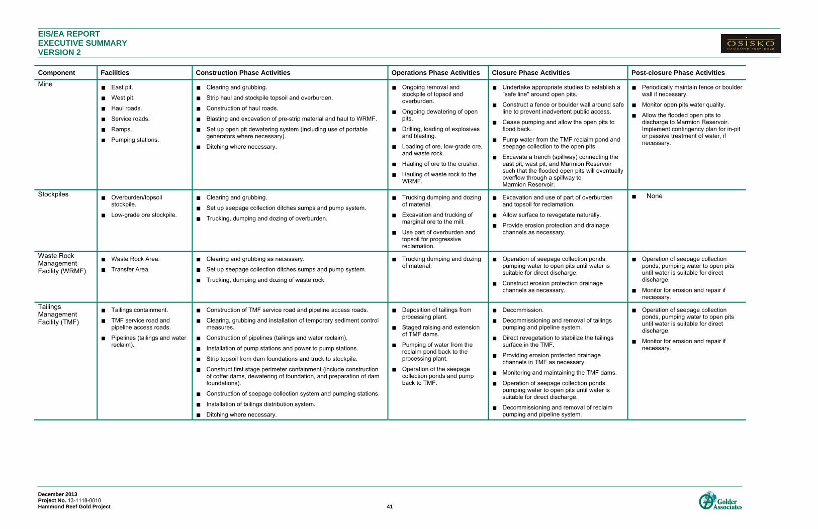
EIS/EA REPORT EXECUTIVE SUMMARY VERSION 2
December 2013 Project No. 13-1118-0010 Hammond Reef Gold Project 41
Component Facilities Construction Phase Activities Operations Phase Activities Closure Phase Activities Post-closure Phase Activities
Mine East pit.
West pit.
Haul roads.
Service roads.
Ramps.
Pumping stations.
Clearing and grubbing.
Strip haul and stockpile topsoil and overburden.
Construction of haul roads.
Blasting and excavation of pre-strip material and haul to WRMF.
Set up open pit dewatering system (including use of portable generators where necessary).
Ditching where necessary.
Ongoing removal and stockpile of topsoil and overburden.
Ongoing dewatering of open pits.
Drilling, loading of explosives and blasting.
Loading of ore, low-grade ore, and waste rock.
Hauling of ore to the crusher.
Hauling of waste rock to the WRMF.
Undertake appropriate studies to establish a "safe line" around open pits.
Construct a fence or boulder wall around safe line to prevent inadvertent public access.
Cease pumping and allow the open pits to flood back.
Pump water from the TMF reclaim pond and seepage collection to the open pits.
Excavate a trench (spillway) connecting the east pit, west pit, and Marmion Reservoir such that the flooded open pits will eventually overflow through a spillway to Marmion Reservoir.
Periodically maintain fence or boulder wall if necessary.
Monitor open pits water quality.
Allow the flooded open pits to discharge to Marmion Reservoir. Implement contingency plan for in-pit or passive treatment of water, if necessary.
Stockpiles Overburden/topsoil
stockpile.
Low-grade ore stockpile.
Clearing and grubbing.
Set up seepage collection ditches sumps and pump system.
Trucking, dumping and dozing of overburden.
Trucking dumping and dozing of material.
Excavation and trucking of marginal ore to the mill.
Use part of overburden and topsoil for progressive reclamation.
Excavation and use of part of overburden and topsoil for reclamation.
Allow surface to revegetate naturally.
Provide erosion protection and drainage channels as necessary.
None
Waste Rock Management Facility (WRMF)
Waste Rock Area.
Transfer Area.
Clearing and grubbing as necessary.
Set up seepage collection ditches sumps and pump system.
Trucking, dumping and dozing of waste rock.
Trucking dumping and dozing of material.
Operation of seepage collection ponds, pumping water to open pits until water is suitable for direct discharge.
Construct erosion protection drainage channels as necessary.
Operation of seepage collection ponds, pumping water to open pits until water is suitable for direct discharge.
Monitor for erosion and repair if necessary.
Tailings Management Facility (TMF)
Tailings containment.
TMF service road and pipeline access roads.
Pipelines (tailings and water reclaim).
Construction of TMF service road and pipeline access roads.
Clearing, grubbing and installation of temporary sediment control measures.
Construction of pipelines (tailings and water reclaim).
Installation of pump stations and power to pump stations.
Strip topsoil from dam foundations and truck to stockpile.
Construct first stage perimeter containment (include construction of coffer dams, dewatering of foundation, and preparation of dam foundations).
Construction of seepage collection system and pumping stations.
Installation of tailings distribution system.
Ditching where necessary.
Deposition of tailings from processing plant.
Staged raising and extension of TMF dams.
Pumping of water from the reclaim pond back to the processing plant.
Operation of the seepage collection ponds and pump back to TMF.
Decommission.
Decommissioning and removal of tailings pumping and pipeline system.
Direct revegetation to stabilize the tailings surface in the TMF.
Providing erosion protected drainage channels in TMF as necessary.
Monitoring and maintaining the TMF dams.
Operation of seepage collection ponds, pumping water to open pits until water is suitable for direct discharge.
Decommissioning and removal of reclaim pumping and pipeline system.
Operation of seepage collection ponds, pumping water to open pits until water is suitable for direct discharge.
Monitor for erosion and repair if necessary.

EIS/EA REPORT EXECUTIVE SUMMARY VERSION 2
December 2013 Project No. 13-1118-0010 Hammond Reef Gold Project 42
Component Facilities Construction Phase Activities Operations Phase Activities Closure Phase Activities Post-closure Phase Activities
Water Management System
On-site water containment.
Effluent treatment plant (ETP).
Ditches and seepage collection ponds (TMF, WRMF, stormwater, stockpiles).
Pumping stations from water containment ditches/sumps.
Dewatering of Mitta Lake including fish rescue and discharge of water to Marmion Reservoir.
Construction of ditches, and ponds (processing plant collection pond, emergency spill pond, seepage collection ponds).
Construction of treatment facilities including an ETP, if necessary, potable water treatment and sewage treatment facility.
Construction of pumping stations (mine water, surface water, fire water, potable water).
Construction of site discharge lines and diffuser (if required).
Operation of seepage collection ponds, pumping water to open pits until water is suitable for direct discharge.
Operation of ETP, if necessary.
Operation of potable water treatment and sewage treatment facility.
Operation of seepage collection ponds, pumping water to open pits until water is suitable for direct discharge.
Operation of seepage collection ponds, pumping water to open pits until water is suitable for direct discharge.

EIS/EA REPORT EXECUTIVE SUMMARY VERSION 2
December 2013 Project No. 13-1118-0010 Hammond Reef Gold Project 43
EFFECTS ASSESSMENT The potential impacts of the Project were assessed through an understanding of the Project components, and
the ways in which these could interact with the natural environment to produce changes. The changes are then
assessed against specific features of the environment, known as VECs to determine the significance of these
changes to biological and socio-economic features of the environment.
Physical and Biological Environment
Changes in physical components in and of themselves are not considered to be significant unless they result in
a measurable adverse effect on biological receptors. Therefore, residual effects are considered for significance
assessment only with respect to changes in ecological receptors that could affect the survival of populations.
Based on the application of this approach, an adverse environmental effect would be categorized as low,
moderate or high according to the following definitions:
Low: Environmental effects which, taking into account mitigation measures, would not result in
measurable changes in terrestrial or aquatic species populations in the LSA or RSA. The assessment
recognizes that there may be localized effects within the MSA, typically related to habitat loss and
displacement of individuals, but that these would not affect the viability of terrestrial or aquatic populations
in the LSA or RSA. No risks to human health would be predicted.
Moderate: Environmental effects which, taking into account mitigation measures, could result in
measurable changes in terrestrial or aquatic species populations that could affect the viability of the
species in the LSA or RSA. Predicted risks to human health could occur under prolonged exposure.
High: Environmental effects which, taking into account mitigation measures, would result in measurable
changes in terrestrial or aquatic species populations that would likely severely affect the viability of the
species in the LSA or RSA. Predicted risks to human health would be likely under prolonged exposure.
A summary of the assessment of the significance of the predicted environmental effects for each major project
component, and for each project phase, is provided below. As noted above, residual effects are considered for
significance assessment only with respect to changes in ecological receptors that could affect the survival of
populations. As a result, the summary tables assess changes in physical components (e.g., surface water flows,
lake levels, water quality) with respect to the effects of these changes on ecological receptors.
Further discussion of potential effects to the physical and biological environment, as well as planned mitigation
measures to minimize those potential effects are also described by component below.

EIS/EA REPORT EXECUTIVE SUMMARY VERSION 2
December 2013 Project No. 13-1118-0010 Hammond Reef Gold Project 44
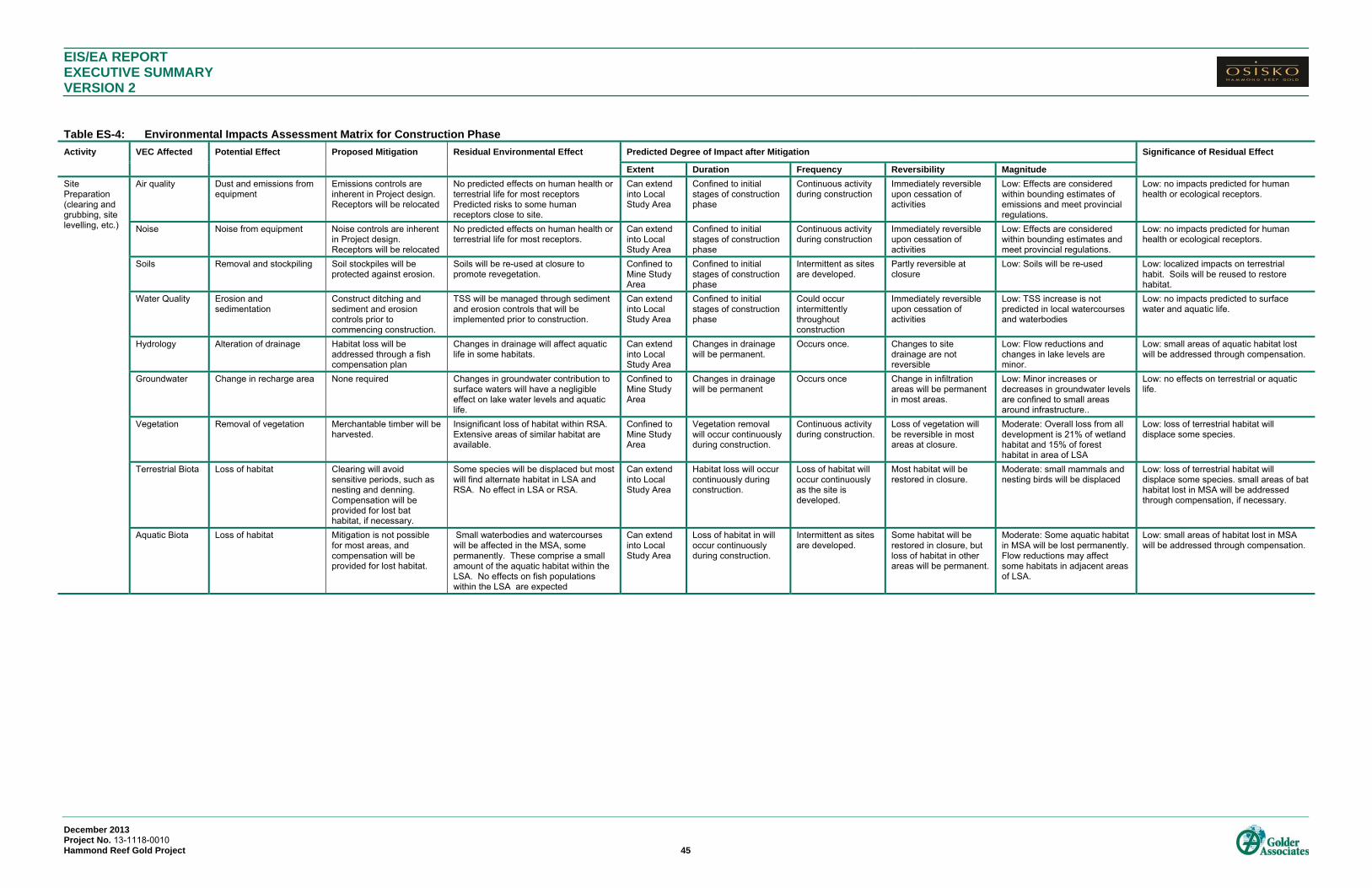
EIS/EA REPORT EXECUTIVE SUMMARY VERSION 2
December 2013 Project No. 13-1118-0010 Hammond Reef Gold Project 45
Table ES-4: Environmental Impacts Assessment Matrix for Construction Phase
Activity VEC Affected Potential Effect Proposed Mitigation Residual Environmental Effect Predicted Degree of Impact after Mitigation Significance of Residual Effect
Extent Duration Frequency Reversibility Magnitude
Site Preparation (clearing and grubbing, site levelling, etc.)
Air quality Dust and emissions from equipment
Emissions controls are inherent in Project design. Receptors will be relocated
No predicted effects on human health or terrestrial life for most receptors Predicted risks to some human receptors close to site.
Can extend into Local Study Area
Confined to initial stages of construction phase
Continuous activity during construction
Immediately reversible upon cessation of activities
Low: Effects are considered within bounding estimates of emissions and meet provincial regulations.
Low: no impacts predicted for human health or ecological receptors.
Noise Noise from equipment Noise controls are inherent in Project design. Receptors will be relocated
No predicted effects on human health or terrestrial life for most receptors.
Can extend into Local Study Area
Confined to initial stages of construction phase
Continuous activity during construction
Immediately reversible upon cessation of activities
Low: Effects are considered within bounding estimates and meet provincial regulations.
Low: no impacts predicted for human health or ecological receptors.
Soils Removal and stockpiling Soil stockpiles will be protected against erosion.
Soils will be re-used at closure to promote revegetation.
Confined to Mine Study Area
Confined to initial stages of construction phase
Intermittent as sites are developed.
Partly reversible at closure
Low: Soils will be re-used Low: localized impacts on terrestrial habit. Soils will be reused to restore habitat.
Water Quality Erosion and sedimentation
Construct ditching and sediment and erosion controls prior to commencing construction.
TSS will be managed through sediment and erosion controls that will be implemented prior to construction.
Can extend into Local Study Area
Confined to initial stages of construction phase
Could occur intermittently throughout construction
Immediately reversible upon cessation of activities
Low: TSS increase is not predicted in local watercourses and waterbodies
Low: no impacts predicted to surface water and aquatic life.
Hydrology Alteration of drainage Habitat loss will be addressed through a fish compensation plan
Changes in drainage will affect aquatic life in some habitats.
Can extend into Local Study Area
Changes in drainage will be permanent.
Occurs once. Changes to site drainage are not reversible
Low: Flow reductions and changes in lake levels are minor.
Low: small areas of aquatic habitat lost will be addressed through compensation.
Groundwater Change in recharge area None required Changes in groundwater contribution to surface waters will have a negligible effect on lake water levels and aquatic life.
Confined to Mine Study Area
Changes in drainage will be permanent
Occurs once Change in infiltration areas will be permanent in most areas.
Low: Minor increases or decreases in groundwater levels are confined to small areas around infrastructure..
Low: no effects on terrestrial or aquatic life.
Vegetation Removal of vegetation Merchantable timber will be harvested.
Insignificant loss of habitat within RSA. Extensive areas of similar habitat are available.
Confined to Mine Study Area
Vegetation removal will occur continuously during construction.
Continuous activity during construction.
Loss of vegetation will be reversible in most areas at closure.
Moderate: Overall loss from all development is 21% of wetland habitat and 15% of forest habitat in area of LSA
Low: loss of terrestrial habitat will displace some species.
Terrestrial Biota Loss of habitat Clearing will avoid sensitive periods, such as nesting and denning. Compensation will be provided for lost bat habitat, if necessary.
Some species will be displaced but most will find alternate habitat in LSA and RSA. No effect in LSA or RSA.
Can extend into Local Study Area
Habitat loss will occur continuously during construction.
Loss of habitat will occur continuously as the site is developed.
Most habitat will be restored in closure.
Moderate: small mammals and nesting birds will be displaced
Low: loss of terrestrial habitat will displace some species. small areas of bat habitat lost in MSA will be addressed through compensation, if necessary.
Aquatic Biota Loss of habitat Mitigation is not possible for most areas, and compensation will be provided for lost habitat.
Small waterbodies and watercourses will be affected in the MSA, some permanently. These comprise a small amount of the aquatic habitat within the LSA. No effects on fish populations within the LSA are expected
Can extend into Local Study Area
Loss of habitat in will occur continuously during construction.
Intermittent as sites are developed.
Some habitat will be restored in closure, but loss of habitat in other areas will be permanent.
Moderate: Some aquatic habitat in MSA will be lost permanently. Flow reductions may affect some habitats in adjacent areas of LSA.
Low: small areas of habitat lost in MSA will be addressed through compensation.

EIS/EA REPORT EXECUTIVE SUMMARY VERSION 2 Table ES-4: Environmental Impacts Assessment Matrix for Construction Phase (Continued)
December 2013 Project No. 13-1118-0010 Hammond Reef Gold Project 46
Activity VEC Affected Potential Effect Proposed Mitigation Residual Environmental Effect Predicted Degree of Impact after Mitigation Significance of Residual Effect
Extent Duration Frequency Reversibility Magnitude
TMF Construction
Air Quality Dust and emissions from equipment
Emissions controls are inherent in Project design. Receptors will be relocated.
No predicted effects on human health or terrestrial life for most receptors. Predicted risks to some human receptors close to site.
Can extend into Local Study Area
Will occur only during construction phase.
Continuous during construction of the TMF
Immediately reversible upon cessation of activities
Low: Effects are considered within bounding estimates of emissions.
Low: no impacts predicted for human health or ecological receptors.
Noise Noise from equipment Noise controls are inherent in Project design. Receptors will be relocated
No predicted effects on human health or terrestrial life for most receptors.
Can extend into Local Study Area
Will occur only during construction phase.
Continuous during construction of the TMF
Immediately reversible upon cessation of activities
Low: Effects are considered within bounding estimates
Low: no impacts predicted for human health or ecological receptors.
Soils Removal and stockpiling Stockpiles will be protected against erosion.
Removal is confined to the footprint of the containment berms.
Confined to Mine Study Area
Will occur only during construction phase.
Continuous during construction of the TMF
Reversible in closure as TMF is graded and soil amendment is added.
Low: Soils will be removed and stockpiled for re-use.
Low: localized impacts on terrestrial habit. Soils will be reused to restore habitat.
Water Quality Erosion and sedimentation Mitigation measures will be implemented prior to commencing construction.
Ditching and erosion control measures will limit TSS in adjacent surface waters.
Can extend into Local Study Area
Will occur only during construction phase.
Intermittent during construction.
Immediately reversible upon cessation of activities
Low: TSS levels predicted to be low and within guidelines.
Low: no impacts predicted to surface water and aquatic life
Hydrology Alteration of drainage Compensation plan will be developed for effects on fish and fish habitat.
Loss of drainage affects fish habitat in on-site waterbodies and in watercourses downstream. Loss of drainage has negligible affect on lake levels in Lizard Lake and Upper Marmion Reservoir.
Can extend into Local Study Area
Changes in drainage persist throughout all project phases
Continuous Not reversible. Low: Loss of drainage area has minimal effect on lake levels.
Low: small areas of aquatic habitat lost will be addressed through compensation.
Groundwater Loss of recharge area None possible Changes in groundwater contribution to surface waters will have a negligible effect on lake water levels and aquatic life.
Confined to Mine Study Area
Changes in infiltration persist throughout all project phases
Continuous Not reversible. Low: Geology and lack of soil cover limit infiltration capacity
Low: no effects on terrestrial or aquatic life are predicted.
Vegetation Removal of vegetation Merchantable timber will be harvested.
Insignificant loss of habitat within RSA. Confined to Mine Study Area
Throughout construction persisting through operations.
One time activity. Some restoration is possible in closure.
Moderate: Overall loss from all development is 21% of wetland habitat and 15% of forest habitat in area of LSA
Low: loss of terrestrial habitat will displace some species.
Terrestrial Biota Loss of habitat Clearing will avoid sensitive periods, such as nesting and denning.
Displaced species will find alternate habitat in LSA and RSA.
Can extend into Local Study Area
Throughout construction persisting through operations.
One time activity Some restoration of habitat is possible in closure
Moderate: small mammals and nesting birds will be displaced
Low: loss of terrestrial habitat will displace some species.
Aquatic Biota Loss of habitat and effects on water quality and quantity
Effects of habitat loss cannot be mitigated. A compensation plan will be developed to address habitat loss.
Some aquatic features are lost entirely. Others will experience changes to natural hydrographs that can limit available habitat. Negligible effect on lake water levels with no affect on lake dwelling aquatic species. No effects on fish populations within the LSA are expected Sediment and erosion controls will minimize impacts of TSS on aquatic life in downstream habitats.
Loss of habitat confined to Mine Study Area. Water quality and quantity effects can extend into Local Study Area
Loss of habitat extends through all project phases. Water quality effects are confined to construction and operations phases.
One time activity for habitat loss. Intermittent for water quality depending on climatic conditions.
Habitat loss in some areas is not reversible.Water quality effects are reversible at closure
Moderate to High: Partial to complete loss of habitats in local waterbodies in MSA. Loss of drainage areas may affect some habitats in adjacent areas of LSA. No changes predicted in Upper Marmion Reservoir.
Low: compensation plan will address loss of small habitat areas affected. No effects on aquatic life due to water quality.
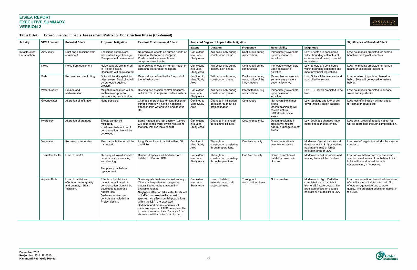
EIS/EA REPORT EXECUTIVE SUMMARY VERSION 2 Table ES-4: Environmental Impacts Assessment Matrix for Construction Phase (Continued)
December 2013 Project No. 13-1118-0010 Hammond Reef Gold Project 47
Activity VEC Affected Potential Effect Proposed Mitigation Residual Environmental Effect Predicted Degree of Impact after Mitigation Significance of Residual Effect
Extent Duration Frequency Reversibility Magnitude
Infrastructure Construction
Air Quality Dust and emissions from equipment
Emissions controls are inherent in Project design. Receptors will be relocated.
No predicted effects on human health or terrestrial life for most receptors. Predicted risks to some human receptors close to site.
Can extend into Local Study Area
Will occur only during construction phase.
Continuous during construction.
Immediately reversible upon cessation of activities
Low: Effects are considered within bounding estimates of emissions and meet provincial regulations.
Low: no impacts predicted for human health or ecological receptors.
Noise Noise from equipment Noise controls are inherent in Project design. Receptors will be relocated
No predicted effects on human health or terrestrial life for most receptors.
Can extend into Local Study Area
Will occur only during construction phase.
Continuous during construction.
Immediately reversible upon cessation of activities
Low: Effects are considered within bounding estimates and meet provincial regulations
Low: no impacts predicted for human health or ecological receptors.
Soils Removal and stockpiling Soils will be stockpiled for later re-use. Stockpiled will be protected against erosion.
Removal is confined to the footprint of the infrastructure.
Confined to Mine Study Area
Will occur only during construction phase.
Continuous during construction of the infrastructure
Reversible in closure in some areas as site is decommissioned.
Low: Soils will be removed and stockpiled for re-use.
Low: localized impacts on terrestrial habit. Soils will be reused to restore habitat.
Water Quality Erosion and sedimentation
Mitigation measures will be implemented prior to commencing construction.
Ditching and erosion control measures will limit TSS in adjacent surface waters.
Can extend into Local Study Area
Will occur only during construction phase.
Intermittent during construction.
Immediately reversible upon cessation of activities
Low: TSS levels predicted to be low.
Low: no impacts predicted to surface water and aquatic life
Groundwater Alteration of infiltration None possible Changes in groundwater contribution to surface waters will have a negligible effect on lake water levels and aquatic life.
Confined to Mine Study Area
Changes in infiltration persist throughout all project phases
Continuous Not reversible in most areas. Decommissioning will restore natural infiltration in some areas.
Low: Geology and lack of soil cover limit infiltration capacity
Low: loss of infiltration will not affect terrestrial or aquatic life.
Hydrology Alteration of drainage Effects cannot be mitigated. to address habitat loss. A compensation plan will be developed
Some habitats are lost entirely. Others will experience water levels reductions that can limit available habitat.
Can extend into Local Study Area
Changes in drainage persist until closure.
Occurs once only. Decommissioning in closure will restore natural drainage in most areas.
Low: Drainage changes have minor effect on lake levels.
Low: small areas of aquatic habitat lost will be addressed through compensation.
Vegetation Removal of vegetation Merchantable timber will be harvested.
Insignificant loss of habitat within LSA and RSA.
Confined to Mine Study Area
Throughout construction persisting through operations.
One time activity. Some restoration is possible in closure.
Moderate: Overall loss from all development is 21% of wetland habitat and 15% of forest habitat in area of LSA
Low: loss of vegetation will displace some species.
Terrestrial Biota Loss of habitat Clearing will avoid sensitive periods, such as nesting and denning. Temporary bat habitat replacement.
Displaced species will find alternate habitat in LSA and RSA.
Can extend into Local Study Area
Throughout construction persisting through operations.
One time activity Some restoration of habitat is possible in closure
Moderate: small mammals and nesting birds will be displaced
Low: loss of habitat will displace some species. small areas of bat habitat lost in MSA will be addressed through compensation, if necessary.
Aquatic Biota Loss of habitat and effects on water quality and quantity. ; Blast Vibration.
Effects of habitat loss cannot be mitigated. A compensation plan will be developed to address habitat loss. Sediment and erosion controls are included in Project design.
Some aquatic features are lost entirely. Others will experience changes to natural hydrographs that can limit available habitat. Negligible effect on lake water levels will not affect on lake dwelling aquatic species. No effects on fish populations within the LSA are expected Sediment and erosion controls will minimize impacts of TSS on aquatic life in downstream habitats. Distance from shoreline will limit effects of blasting.
Can extend into Local Study Area
Loss of habitat extends through all project phases.
Throughout construction phase
Not reversible. Moderate to High: Partial to complete loss of habitats in lsome MSA waterbodies. No predicted effects on aquatic habitats or aquatic life in LSA.
Low: compensation plan will address loss of small areas of habitat affected. No effects on aquatic life due to water quality. No predicted effects on habitat in the LSA.

EIS/EA REPORT EXECUTIVE SUMMARY VERSION 2 Table ES-4: Environmental Impacts Assessment Matrix for Construction Phase (Continued)
December 2013 Project No. 13-1118-0010 Hammond Reef Gold Project 48
Activity VEC Affected Potential Effect Proposed Mitigation Residual Environmental Effect Predicted Degree of Impact after Mitigation Significance of Residual Effect
Extent Duration Frequency Reversibility Magnitude
Site Access Roads
Air quality Dust and emissions from equipment
Dust suppression as required
No predicted effects on human health or terrestrial life.
Can extend into Local Study Area
Will occur only during construction phase.
Continuous during construction.
Immediately reversible upon cessation of activities
Low: Effects are considered within bounding estimates of emissions and meet provincial regulations.
Low: no predicted effects on human health or ecological receptors
Noise Noise from equipment None required No predicted effects on human health. Wildlife will avoid the area due to noise and activity.
Can extend into Local Study Area
Will occur only during construction phase.
Continuous during construction.
Immediately reversible upon cessation of activities
Low: Effects are considered within bounding estimates and meet provincial regulations
Low: no predicted effects on human health or ecological receptors.
Soils Removal and stockpiling Soil stockpiles will be protected against erosion
Soils will be stockpiled for reclamation in closure. Stockpile will be protected against erosion to protect aquatic habitats.
Confined to Mine Study Area
Will occur only during construction phase.
Continuous during construction of roads.
Partly reversible in closure
Low: localized impacts on terrestrial habitat. Soils will be reused to restore habitat.
Water Quality Erosion and sedimentation
Road design will have ditching and sediment controls.
Sediment controls will be implemented to minimize TSS generated during construction. Short construction period minimizes potential impacts on aquatic life.
Can extend into Local Study Area
Will occur only during construction phase.
Continuous during construction of roads.
Immediately reversible upon cessation of activities
Low: short term increase in TSS as crossing is constructed
Low: no impacts predicted to surface water or aquatic life.
Hydrology Alteration of drainage Flow will be maintained during construction
Road will not alter drainage system since channels will not be altered or blocked.
Can extend into Local Study Area
Throughout construction and operations phases.
Continuous Fully reversible Low: Minor restriction of flow during construction..
Low: temporary construction works will have minimal effect on aquatic life.
Groundwater Loss of recharge area None required Road surface will divert runoff to margins where infiltration can occur.
Confined to Mine Study Area
Throughout construction and operations phases.
Continuous Partly reversible in closure
Low: small areas affected. Low: changes in groundwater levels will not affect terrestrial or aquatic habitats.
Vegetation Removal of vegetation Merchantable timber will be harvested.
Insignificant loss of habitat within RSA. Confined to Mine Study Area
Throughout construction and operations phases.
Removal occurs once only as road is constructed.
Partly reversible in closure as some road are decommissioned
Moderate: Overall loss from all development is 21% of wetland habitat and 15% of forest habitat in area of LSA
Low: loss of habitat in small areas may displace some species
Terrestrial Biota Loss of habitat and disturbance of wildlife
Clearing will avoid sensitive periods, such as nesting and denning.
Displaced species will find alternate habitat in LSA and RSA.
Can extend into Local Study Area
Continuous through construction and operations.
Loss of habitat occurs once only. Disturbance of wildlife is continuous.
Partly reversible in closure
Moderate: small mammals and nesting birds will be displaced
Low: loss of habitat in small areas and disturbance will displace some species.
Aquatic Biota Disturbance during construction of stream crossings
Flows will be maintained during construction. Sedimentation will be minimized by constructing during low flow conditions.
Crossing construction will be timed to occur in low flow conditions and to avoid critical periods to minimize impacts on aquatic life.
Can extend into Local Study Area
Short term disturbance, limited to a few days at each crossing.
Once only at each crossing..
Immediately reversible upon completion of construction.
Low: small areas and short term disturbance.
Low: disturbance will be temporary and confined to non-critical periods for aquatic life.
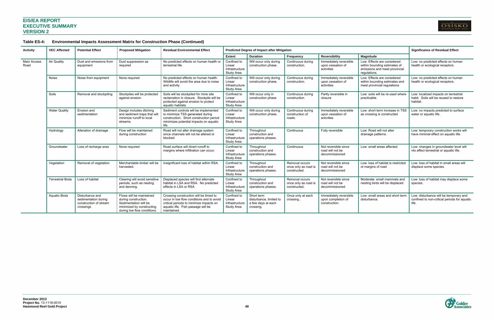
EIS/EA REPORT EXECUTIVE SUMMARY VERSION 2 Table ES-4: Environmental Impacts Assessment Matrix for Construction Phase (Continued)
December 2013 Project No. 13-1118-0010 Hammond Reef Gold Project 49
Activity VEC Affected Potential Effect Proposed Mitigation Residual Environmental Effect Predicted Degree of Impact after Mitigation Significance of Residual Effect
Extent Duration Frequency Reversibility Magnitude
Main Access Road
Air Quality Dust and emissions from equipment
Dust suppression as required
No predicted effects on human health or terrestrial life.
Confined to Linear Infrastructure Study Area
Will occur only during construction phase.
Continuous during construction.
Immediately reversible upon cessation of activities
Low: Effects are considered within bounding estimates of emissions and meet provincial regulations.
Low: no predicted effects on human health or ecological receptors.
Noise Noise from equipment None required No predicted effects on human health. Wildlife will avoid the area due to noise and activity.
Confined to Linear Infrastructure Study Area
Will occur only during construction phase.
Continuous during construction.
Immediately reversible upon cessation of activities
Low: Effects are considered within bounding estimates and meet provincial regulations
Low: no predicted effects on human health or ecological receptors.
Soils Removal and stockpiling Stockpiles will be protected against erosion.
Soils will be stockpiled for mine site reclamation in closure. Stockpile will be protected against erosion to protect aquatic habitats.
Confined to Linear Infrastructure Study Area
Will occur only in construction phase
Continuous during construction.
Partly reversible in closure
Low: soils will be re-used where practicable.
Low: localized impacts on terrestrial habit. Soils will be reused to restore habitat.
Water Quality Erosion and sedimentation
Design includes ditching and sediment traps that will minimize runoff to local streams.
Sediment controls will be implemented to minimize TSS generated during construction. Short construction period minimizes potential impacts on aquatic life.
Confined to Linear Infrastructure Study Area
Will occur only during construction phase.
Continuous during construction of roads.
Immediately reversible upon cessation of activities
Low: short term increase in TSS as crossing is constructed
Low: no impacts predicted to surface water or aquatic life.
Hydrology Alteration of drainage Flow will be maintained during construction
Road will not alter drainage system since channels will not be altered or blocked.
Confined to Linear Infrastructure Study Area
Throughout construction and operations phases.
Continuous Fully reversible Low: Road will not alter drainage patterns.
Low: temporary construction works will have minimal effect on aquatic life.
Groundwater Loss of recharge area None required Road surface will divert runoff to margins where infiltration can occur.
Confined to Linear Infrastructure Study Area
Throughout construction and operations phases.
Continuous Not reversible since road will not be decommissioned
Low: small areas affected. Low: changes in groundwater level will nto affect terrestrial or aquatic life.
Vegetation Removal of vegetation Merchantable timber will be harvested.
Insignificant loss of habitat within RSA. Confined to Linear Infrastructure Study Area
Throughout construction and operations phases.
Removal occurs once only as road is constructed.
Not reversible since road will not be decommissioned
Low: loss of habitat is restricted ot margins of road
Low: loss of habitat in small areas will displace some species.
Terrestrial Biota Loss of habitat Clearing will avoid sensitive periods, such as nesting and denning.
Displaced species will find alternate habitat in LSA and RSA. No predicted effects in LSA or RSA
Confined to Linear Infrastructure Study Area
Throughout construction and operations phases.
Removal occurs once only as road is constructed.
Not reversible since road will not be decommissioned
Moderate: small mammals and nesting birds will be displaced
Low: loss of habitat may displace some species.
Aquatic Biota Disturbance and sedimentation during construction of stream crossings
Flows will be maintained during construction. Sedimentation will be minimized by constructing during low flow conditions.
Crossing construction will be timed to occur in low flow conditions and to avoid critical periods to minimize impacts on aquatic life. Fish passage will be maintained.
Confined to Linear Infrastructure Study Area
Short term disturbance, limited to a few days at each crossing.
Once only at each crossing..
Immediately reversible upon completion of construction.
Low: small areas and short term disturbance.
Low: disturbance will be temporary and confined to non-critical periods for aquatic life.
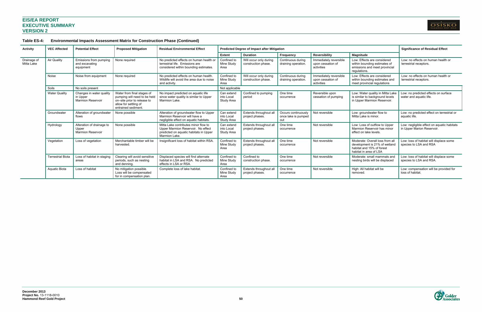
EIS/EA REPORT EXECUTIVE SUMMARY VERSION 2 Table ES-4: Environmental Impacts Assessment Matrix for Construction Phase (Continued)
December 2013 Project No. 13-1118-0010 Hammond Reef Gold Project 50
Activity VEC Affected Potential Effect Proposed Mitigation Residual Environmental Effect Predicted Degree of Impact after Mitigation Significance of Residual Effect
Extent Duration Frequency Reversibility Magnitude
Drainage of Mitta Lake
Air Quality Emissions from pumping and excavating equipment
None required No predicted effects on human health or terrestrial life. Emissions are considered within bounding estimates.
Confined to Mine Study Area
Will occur only during construction phase.
Continuous during draining operation.
Immediately reversible upon cessation of activities
Low: Effects are considered within bounding estimates of emissions and meet provincial regulations.
Low: no effects on human health or terrestrial receptors.
Noise Noise from equipment None required No predicted effects on human health. Wildlife will avoid the area due to noise and activity.
Confined to Mine Study Area
Will occur only during construction phase.
Continuous during draining operation.
Immediately reversible upon cessation of activities
Low: Effects are considered within bounding estimates and meet provincial regulations
Low: no effects on human health or terrestrial receptors.
Soils No soils present Not applicable
Water Quality Changes in water quality in Upper Marmion Reservoir
Water from final stages of pumping will need to be held on–site prior to release to allow for settling of entrained sediment.
No impact predicted on aquatic life since water quality is similar to Upper Marmion Lake.
Can extend into Local Study Area
Confined to pumping period
One time occurrence
Reversible upon cessation of pumping
Low: Water quality in Mitta Lake is similar to background levels in Upper Marmion Reservoir.
Low: no predicted effects on surface water and aquatic life.
Groundwater Alteration of groundwater flows
None possible Alteration of groundwater flow to Upper Marmion Reservoir will have a negligible effect on aquatic habitats.
Can extend into Local Study Area
Extends throughout all project phases.
Occurs continuously once lake is pumped out
Not reversible Low: groundwater flow to Mitta Lake is minor.
Low: no predicted effect on terrestrial or aquatic life.
Hydrology Alteration of drainage to Upper Marmion Reservoir
None possible Mitta Lake contributes minor flow to Upper Marmion Reservoir. No effect predicted on aquatic habitats in Upper Marmion Lake.
Can extend into Local Study Area
Extends throughout all project phases.
One time occurrence
Not reversible Low: Loss of outflow to Upper Marmion Reservoir has minor effect on lake levels.
Low: negligible effect on aquatic habitats in Upper Marion Reservoir.
Vegetation Loss of vegetation Merchantable timber will be harvested.
Insignificant loss of habitat within RSA. Confined to Mine Study Area
Extends throughout all project phases.
One time occurrence
Not reversible Moderate: Overall loss from all development is 21% of wetland habitat and 15% of forest habitat in area of LSA
Low: loss of habitat will displace some species to LSA and RSA
Terrestrial Biota Loss of habitat in staging areas
Clearing will avoid sensitive periods, such as nesting and denning.
Displaced species will find alternate habitat in LSA and RSA. No predicted effects in LSA or RSA.
Confined to Mine Study Area
Confined to construction phase.
One time occurrence
Not reversible Moderate: small mammals and nesting birds will be displaced
Low: loss of habitat will displace some species to LSA and RSA.
Aquatic Biota Loss of habitat No mitigation possible. Loss will be compensated for in compensation plan.
Complete loss of lake habitat. Confined to Mine Study Area
Extends throughout all project phases.
One time occurrence
Not reversible High: All habitat will be removed.
Low: compensation will be provided for loss of habitat.
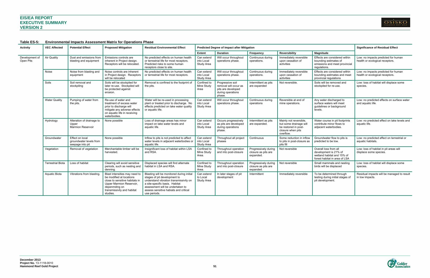
EIS/EA REPORT EXECUTIVE SUMMARY VERSION 2
December 2013 Project No. 13-1118-0010 Hammond Reef Gold Project 51
Table ES-5: Environmental Impacts Assessment Matrix for Operations Phase
Activity VEC Affected Potential Effect Proposed Mitigation Residual Environmental Effect Predicted Degree of Impact after Mitigation Significance of Residual Effect
Extent Duration Frequency Reversibility Magnitude
Development of Open Pits
Air Quality Dust and emissions from blasting and equipment
Emissions controls are inherent in Project design. Receptors will be relocated.
No predicted effects on human health or terrestrial life for most receptors. Predicted risks to some human receptors close to site.
Can extend into Local Study Area
Will occur throughout operations phase.
Continuous during operations.
Immediately reversible upon cessation of activities
Effects are considered within bounding estimates of emissions and meet provincial regulations.
Low: no impacts predicted for human health or ecological receptors.
Noise Noise from blasting and equipment
Noise controls are inherent in Project design. Receptors will be relocated
No predicted effects on human health or terrestrial life for most receptors.
Can extend into Local Study Area
Will occur throughout operations phase.
Continuous during operations.
Immediately reversible upon cessation of activities
Effects are considered within bounding estimates and meet provincial regulations
Low: no impacts predicted for human health or ecological receptors.
Soils Soil removal and stockpiling
Soils will be stockpiled for later re-use. Stockpiled will be protected against erosion.
Removal is confined to the footprint of the pits.
Confined to Mine Study Area
Progressive soil removal will occur as pits are developed during operations phase.
Intermittent as pits are expanded
Not reversible. Soils will be removed and stockpiled for re-use.
Low: loss of habitat will displace some species.
Water Quality Pumping of water from the pits.
Re-use of water and treatment of excess water prior to discharge will mitigate any adverse effects on aquatic life in receiving waterbodies.
Water will be re-used in processing plant or treated prior to discharge. No effects predicted on lake water quality or aquatic life.
Can extend into Local Study Area
Will occur throughout operations phase.
Continuous during operations
Reversible at end of mine operations.
Any water discharged to surface waters will meet guidelines or background levels.
Low: no predicted effects on surface water and aquatic life.
Hydrology Alteration of drainage to Upper Marmion Reservoir
None possible Loss of drainage areas has minor impact on lake water levels and aquatic life.
Can extend into Local Study Area
Occurs progressively as pits are developed during operations phase.
Intermittent as pits are expanded.
Mainly not reversible, but some drainage will be restored in post-closure when pits overflow.
Water course in pit footprints contribute minor flows to adjacent waterbodies.
Low: no predicted effect on lake levels and aquatic life.
Groundwater Effect on local groundwater levels from seepage into pit
None possible Inflow to pits is not predicted to affect water levels in adjacent waterbodies or aquatic life.
Can extend into Local Study Area
Throughout all project phases
Continuous Some reduction in inflow to pits in post-closure as pits fill
Groundwater flow to pits is predicted to be low.
Low: no predicted effect on terrestrial or aquatic habitats.
Vegetation Removal of vegetation Merchantable timber will be harvested.
Insignificant loss of habitat within LSA and RSA.
Confined to Mine Study Area.
Throughout operation and into post-closure
Progressively during closure as pits are expanded.
Not reversible Overall loss from all development is 21% of wetland habitat and 15% of forest habitat in area of LSA
Low: loss of habitat in pit areas will displace some species.
Terrestrial Biota Loss of habitat Clearing will avoid sensitive periods, such as nesting and denning.
Displaced species will find alternate habitat in LSA and RSA.
Confined to Mine Study Area.
Throughout operation and into post-closure
Progressively during closure as pits are expanded.
Not reversible Small mammals and nesting birds will be displaced
Low: loss of habitat will displace some species.
Aquatic Biota Vibrations from blasting. Blast intensities may need to be modified at locations close to sensitive habitats in Upper Marmion Reservoir, depenmding on transmissivity and habitat studies.
Blasting will be monitored during initial stages of pit development to understand vibration transmissivity on a site-specific basis. Habitat assessment will be undertaken to assess sensitive habiats and critical use periods.
Can extend to Local Study Area
In later stages of pit development
Intermittent Immediately reversible To be determined through testing during initial stages of pit development.
Residual impacts will be managed to result in low impacts.

EIS/EA REPORT EXECUTIVE SUMMARY VERSION 2 Table ES-5: Environmental Impacts Assessment Matrix for Operations Phase (Continued)
December 2013 Project No. 13-1118-0010 Hammond Reef Gold Project 52
Activity VEC Affected Potential Effect Proposed Mitigation Residual Environmental Effect Predicted Degree of Impact after Mitigation Significance of Residual Effect
Extent Duration Frequency Reversibility Magnitude
Operation of Processing Plant
Air Quality Dust and emissions Emissions controls are inherent in Project design. Receptors will be relocated.
No predicted effects on human health or terrestrial life for most receptors. Predicted risks to some human receptors close to site.
Can extend into Local Study Area
Will occur throughout operations phase.
Continuous during operations.
Immediately reversible upon cessation of activities
Low: Effects are considered within bounding estimates of emissions and meet provincial regulations.
Low: no impacts predicted for human health or ecological receptors.
Noise Noise Noise controls are inherent in Project design. Receptors will be relocated
No predicted effects on human health or terrestrial life for most receptors.
Can extend into Local Study Area
Will occur throughout operations phase.
Continuous during operations.
Immediately reversible upon cessation of activities
Low: Effects are considered within bounding estimates and meet provincial regulations
Low: no impacts predicted for human health or ecological receptors.
Soils No additional impacts to soils.
Water Quality Effects on surface water quality
None required. Re-use of water and treatment prior to release are inherent in the project design.
Water will be treated as required prior to discharge. No effects predicted on aquatic life.
Can extend into Local Study Area
Throughout operations phase
Continuous during operations
Reversible at closure Low: discharged water will meet guidelines and/or background water quality.
Low: no predicted effects on surface water or aquatic life.
Hydrology Effects on lake water levels from water taking
None required. Re-use of water is inherent in project design.
Water taking will be minimized by re-use of water. Lake levels predicted to change by less than 9 cm. No effects predicted on aquatic life.
Can extend into Local Study Area
Throughout operations phase
Continuous during operations
Reversible at closure Low: minor effect on lake levels
Low: no predicted effects on aquatic habitats
Groundwater Changes in groundwater quantity and quality
None required Groundwater quality and quantity are not predicted to change.
Can extend into Local Study Area
Throughout operations phase
Continuous during operations
Reversible at closure Low: negligible change in groundwater levels predicted.
Low: no predicted effect.
Vegetation Effects of emissions on vegetation
None required No incremental increase in soil concentrations due to emissions. No predicted increase in uptake in vegetation or effects on vegetation.
Confined to Mine Study Area.
Throughout operations phase
Continuous during operations
Reversible at closure Low: predicted soil concentrations are below guidelines and background levels.
Low: no predicted risk to vegetation.
Terrestrial Biota Effects of emissions on wildlife
None required On incremental increase in soil concentrations and no predicted increase in vegetation. No incremental increased risk to wildlife form soil or vegetation ingestion.
Confined to Mine Study Area.
Throughout operations phase
Continuous during operations
Reversible at closure Low: predicted soil concentrations are below guidelines and background levels.
Low: no predicted risks to terrestrial biota.
Aquatic Biota Discharges to aquatic habitats
A treatment facility has been included in the project design.
No effects predicted on aquatic life form any discharges.
Can extend into Local Study Area
Throughout operations phase
Intermittent depending on need for re-use water
Reversible at closure Low: discharge water will meet guidelines or background
Low: no predicted risks to aquatic life.

EIS/EA REPORT EXECUTIVE SUMMARY VERSION 2 Table ES-5: Environmental Impacts Assessment Matrix for Operations Phase (Continued)
December 2013 Project No. 13-1118-0010 Hammond Reef Gold Project 53
Activity VEC Affected Potential Effect Proposed Mitigation Residual Environmental Effect Predicted Degree of Impact after Mitigation Significance of Residual Effect
Extent Duration Frequency Reversibility Magnitude
Operation of TMF
Air Quality No air emissions since tailings will be wet.
Noise Noise None required No predicted effects on human health. Wildlife will avoid the area due to noise and activity.
Confined to Mine Study Area.
Will occur throughout operations phase.
Continuous during operations.
Immediately reversible upon cessation of activities
Low: Effects are considered within bounding estimates and meet provincial regulations
Low: no predicted risks to human health or ecological receptors.
Soils Loss of soils None feasible Soils in TMF footprint will be covered over permanently. Soils will not be salvaged under the TMF.
Confined to Mine Study Area
Progressive covering of soils throughout operations.
Continuous during operations
Not reversible. Soils will be covered over permanently.
Low: area of loss is relatively small within the RSA.
Low:
Water Quality Effects on surface water quality
Design includes seepage collection and reclaim pipeline from TMF to PPCP to eliminate direct release of TMF water to the environment..
Collection of seepage and re-use of tailings water will eliminate discharge of water from the TMF to receiving environments. No effects predicted on aquatic or terrestrial life.
Can extend into Local Study Area
Throughout operations phase
Continuous during operations
Reversible in post-closure
Low: water quality guidelines/background levels in receiving water will not be exceeded
Low: no effects predicted on surface water or aquatic life.
Groundwater Effects on groundwater quality
None require. Low ARD potential in tailings minimizes metals leaching and mobility.
Water quality in TMF seepage is not predicted to result in risks to aquatic life where groundwater expresses to surface waters
Confined to Mine Study Area
Throughout operations and into post-closure
Continuous Not reversible Low: water quality in TMF seepage not predicted to affect groundwater quality
Low: no predicted effects on terrestrial or aquatic life.
Hydrology No additional effects on drainage over construction phase
Vegetation Loss of vegetation Merchantable timber will be harvested.
Moderate loss within LSA but insignificant loss of habitat within RSA.
Confined to Mine Study Area
Progressive loss of vegetation in operations phase as TMF is filled
Continuous during operations phase.
Not reversible. Terrestrial habitat in footprint will be permanently lost.
Moderate: Overall loss from all development is 21% of wetland habitat and 15% of forest habitat in area of LSA
Low: habitat loss will displace some terrestrial wildlife species.
Terrestrial Biota Loss of habitat Clearing will avoid sensitive periods, such as nesting and denning.
Displaced species will find alternate habitat in LSA and RSA. Low effect in RSA.
Can extend into Local Study Area
Progressive loss of habitat in operations phase as TMF is filled.
Continuous during operations phase.
Not reversible. Habitat loss in footprint of TMF is permanent.
Moderate: small mammals and nesting birds will be displaced
Low: habitat loss will displace some species.
Aquatic Biota Effects on surface water quality
Design includes seepage collection and reclaim pipeline from TMF to PPCP to eliminate direct release of TMF water to the environment..
Collection of seepage and re-use of tailings water will eliminate discharge of water from the TMF to receiving environments. No effects predicted on aquatic or terrestrial life.
Can extend into Local Study Area
Throughout operations phase
Continuous during operations.
Low: water quality guidelines/background levels will not be exceeded in receiving waters.
Low: no effects predicted on aquatic life.
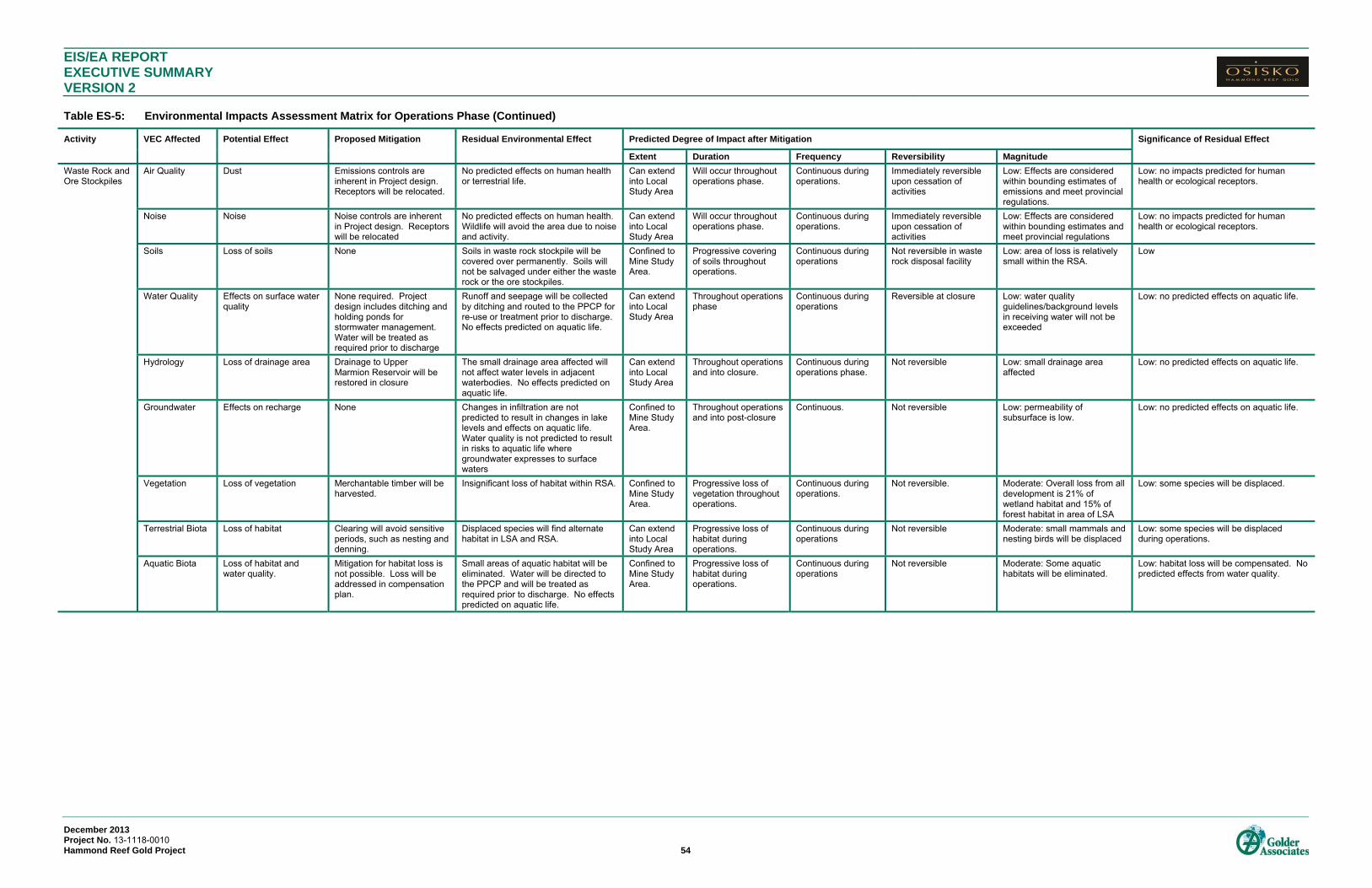
EIS/EA REPORT EXECUTIVE SUMMARY VERSION 2 Table ES-5: Environmental Impacts Assessment Matrix for Operations Phase (Continued)
December 2013 Project No. 13-1118-0010 Hammond Reef Gold Project 54
Activity VEC Affected Potential Effect Proposed Mitigation Residual Environmental Effect Predicted Degree of Impact after Mitigation Significance of Residual Effect
Extent Duration Frequency Reversibility Magnitude
Waste Rock and Ore Stockpiles
Air Quality Dust Emissions controls are inherent in Project design. Receptors will be relocated.
No predicted effects on human health or terrestrial life.
Can extend into Local Study Area
Will occur throughout operations phase.
Continuous during operations.
Immediately reversible upon cessation of activities
Low: Effects are considered within bounding estimates of emissions and meet provincial regulations.
Low: no impacts predicted for human health or ecological receptors.
Noise Noise Noise controls are inherent in Project design. Receptors will be relocated
No predicted effects on human health. Wildlife will avoid the area due to noise and activity.
Can extend into Local Study Area
Will occur throughout operations phase.
Continuous during operations.
Immediately reversible upon cessation of activities
Low: Effects are considered within bounding estimates and meet provincial regulations
Low: no impacts predicted for human health or ecological receptors.
Soils Loss of soils None Soils in waste rock stockpile will be covered over permanently. Soils will not be salvaged under either the waste rock or the ore stockpiles.
Confined to Mine Study Area.
Progressive covering of soils throughout operations.
Continuous during operations
Not reversible in waste rock disposal facility
Low: area of loss is relatively small within the RSA.
Low
Water Quality Effects on surface water quality
None required. Project design includes ditching and holding ponds for stormwater management. Water will be treated as required prior to discharge
Runoff and seepage will be collected by ditching and routed to the PPCP for re-use or treatment prior to discharge. No effects predicted on aquatic life.
Can extend into Local Study Area
Throughout operations phase
Continuous during operations
Reversible at closure Low: water quality guidelines/background levels in receiving water will not be exceeded
Low: no predicted effects on aquatic life.
Hydrology Loss of drainage area Drainage to Upper Marmion Reservoir will be restored in closure
The small drainage area affected will not affect water levels in adjacent waterbodies. No effects predicted on aquatic life.
Can extend into Local Study Area
Throughout operations and into closure.
Continuous during operations phase.
Not reversible Low: small drainage area affected
Low: no predicted effects on aquatic life.
Groundwater Effects on recharge None Changes in infiltration are not predicted to result in changes in lake levels and effects on aquatic life. Water quality is not predicted to result in risks to aquatic life where groundwater expresses to surface waters
Confined to Mine Study Area.
Throughout operations and into post-closure
Continuous. Not reversible Low: permeability of subsurface is low.
Low: no predicted effects on aquatic life.
Vegetation Loss of vegetation Merchantable timber will be harvested.
Insignificant loss of habitat within RSA. Confined to Mine Study Area.
Progressive loss of vegetation throughout operations.
Continuous during operations.
Not reversible. Moderate: Overall loss from all development is 21% of wetland habitat and 15% of forest habitat in area of LSA
Low: some species will be displaced.
Terrestrial Biota Loss of habitat Clearing will avoid sensitive periods, such as nesting and denning.
Displaced species will find alternate habitat in LSA and RSA.
Can extend into Local Study Area
Progressive loss of habitat during operations.
Continuous during operations
Not reversible Moderate: small mammals and nesting birds will be displaced
Low: some species will be displaced during operations.
Aquatic Biota Loss of habitat and water quality.
Mitigation for habitat loss is not possible. Loss will be addressed in compensation plan.
Small areas of aquatic habitat will be eliminated. Water will be directed to the PPCP and will be treated as required prior to discharge. No effects predicted on aquatic life.
Confined to Mine Study Area.
Progressive loss of habitat during operations.
Continuous during operations
Not reversible Moderate: Some aquatic habitats will be eliminated.
Low: habitat loss will be compensated. No predicted effects from water quality.

EIS/EA REPORT EXECUTIVE SUMMARY VERSION 2 Table ES-5: Environmental Impacts Assessment Matrix for Operations Phase (Continued)
December 2013 Project No. 13-1118-0010 Hammond Reef Gold Project 55
Activity VEC Affected Potential Effect Proposed Mitigation Residual Environmental Effect Predicted Degree of Impact after Mitigation Significance of Residual Effect
Extent Duration Frequency Reversibility Magnitude
Operation of Site Water Management System
Air Quality No predicted emissions from WTF
Noise None required No predicted effects on human health. Wildlife will avoid the area due to noise and activity.
Confined to Mine Study Area.
Will occur throughout operations phase.
Continuous during operations.
Immediately reversible upon cessation of activities
Low: Effects are considered within bounding estimates and meet provincial regulations
Low: no predicted effects on human health.
Soils No additional effects on soils
Water Quality Effects on surface water quality
None required. Treatment of discharge is inherent in the Project design.
Discharge will not affect aquatic life. No risks to wildlife from exposure to water in TMF reclaim pond.
Can extend into Local Study Area
Throughout operations phase
Continuous during operations
Reversible in closure Low: Discharges will meet guidelines and/or baseline conditions.
Low: no predicted effects on aquatic life.
Hydrology Water taking and discharge
None required. Project has been designed to minimize taking of freshwater from surface waters by re-use of water wherever possible.
Water taking will be modified by discharge. Net change will result in minor change in lake level. Change will not adversely affect aquatic life.
Can extend into Local Study Area
Throughout operations phase
Continuous during operations
Reversible in closure Low: Minor decrease in lake levels
Low: no predicted effects on aquatic life.
Groundwater Effects on water quality None required. Project design includes partial lining of the PPCP to limit infiltration and collect seepage from the TMF reclaim pond
Part of PPCP will be lined to minimize seepage to groundwater and migration to surface waters. No impacts predicted on aquatic life Water quality is not predicted to result in risks to aquatic life where groundwater expresses to surface waters
Mine Study Area
Throughout operation phase
Continuous during operations
Reversible at closure Low: design minimizes seepage to groundwater
Low: no predicted effects on terrestrial or aquatic life.
Vegetation No additional effects on vegetation
Terrestrial Biota Wildlife exposure to site water impoundments
None required. Measures may be required to keep wildlife away from PPCP if future monitoring shows wildlife are accessing the ponds.
Wildlife exposure to water in the TMF reclaim ponds do not result in predictions of risk. Wildlife exposure to water in the PPCP is not expected due to proximity to processing plant. Noise and activity will discourage wildlife in this area.
Mine Study Area
Throughout operations phase
Continuous Reversible in closure Low: concentrations in TMF reclaim pond are below effects levels.
Low: no predicted effects on terrestrial biota.
Aquatic Biota Effects on surface water quality and quantity
None required. Treatment of discharge is inherent in the Project design.
Small change in lake levels would not affect aquatic life. Discharge water will meet guidelines and/or baseline conditions in receiving waterbodies. No effects predicted on aquatic life. No increase in fish tissue residues predicted.
Can extend into Local Study Area
Throughout operations phase
Continuous during operations
Reversible in closure Low: Minor change in lake levels. Discharges will meet guidelines and/or baseline.
Low: no predicted effects on aquatic life.
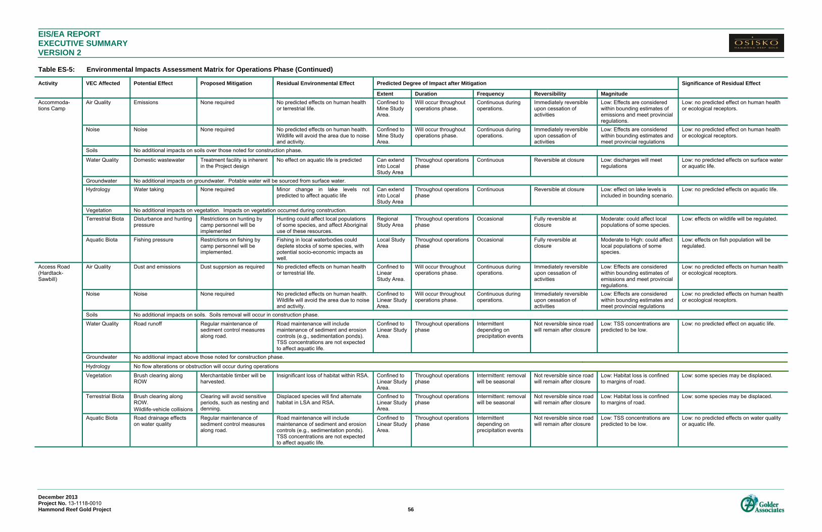
EIS/EA REPORT EXECUTIVE SUMMARY VERSION 2 Table ES-5: Environmental Impacts Assessment Matrix for Operations Phase (Continued)
December 2013 Project No. 13-1118-0010 Hammond Reef Gold Project 56
Activity VEC Affected Potential Effect Proposed Mitigation Residual Environmental Effect Predicted Degree of Impact after Mitigation Significance of Residual Effect
Extent Duration Frequency Reversibility Magnitude
Accommoda-tions Camp
Air Quality Emissions None required No predicted effects on human health or terrestrial life.
Confined to Mine Study Area.
Will occur throughout operations phase.
Continuous during operations.
Immediately reversible upon cessation of activities
Low: Effects are considered within bounding estimates of emissions and meet provincial regulations.
Low: no predicted effect on human health or ecological receptors.
Noise Noise None required No predicted effects on human health. Wildlife will avoid the area due to noise and activity.
Confined to Mine Study Area.
Will occur throughout operations phase.
Continuous during operations.
Immediately reversible upon cessation of activities
Low: Effects are considered within bounding estimates and meet provincial regulations
Low: no predicted effect on human health or ecological receptors.
Soils No additional impacts on soils over those noted for construction phase.
Water Quality Domestic wastewater Treatment facility is inherent in the Project design
No effect on aquatic life is predicted Can extend into Local Study Area
Throughout operations phase
Continuous Reversible at closure Low: discharges will meet regulations
Low: no predicted effects on surface water or aquatic life.
Groundwater No additional impacts on groundwater. Potable water will be sourced from surface water.
Hydrology Water taking None required Minor change in lake levels not predicted to affect aquatic life
Can extend into Local Study Area
Throughout operations phase
Continuous Reversible at closure Low: effect on lake levels is included in bounding scenario.
Low: no predicted effects on aquatic life.
Vegetation No additional impacts on vegetation. Impacts on vegetation occurred during construction.
Terrestrial Biota Disturbance and hunting pressure
Restrictions on hunting by camp personnel will be implemented
Hunting could affect local populations of some species, and affect Aboriginal use of these resources.
Regional Study Area
Throughout operations phase
Occasional Fully reversible at closure
Moderate: could affect local populations of some species.
Low: effects on wildlife will be regulated.
Aquatic Biota Fishing pressure Restrictions on fishing by camp personnel will be implemented.
Fishing in local waterbodies could deplete stocks of some species, with potential socio-economic impacts as well.
Local Study Area
Throughout operations phase
Occasional Fully reversible at closure
Moderate to High: could affect local populations of some species.
Low: effects on fish population will be regulated.
Access Road (Hardtack-Sawbill)
Air Quality Dust and emissions Dust supprsion as required No predicted effects on human health or terrestrial life.
Confined to Linear Study Area.
Will occur throughout operations phase.
Continuous during operations.
Immediately reversible upon cessation of activities
Low: Effects are considered within bounding estimates of emissions and meet provincial regulations.
Low: no predicted effects on human health or ecological receptors.
Noise Noise None required No predicted effects on human health. Wildlife will avoid the area due to noise and activity.
Confined to Linear Study Area.
Will occur throughout operations phase.
Continuous during operations.
Immediately reversible upon cessation of activities
Low: Effects are considered within bounding estimates and meet provincial regulations
Low: no predicted effects on human health or ecological receptors.
Soils No additional impacts on soils. Soils removal will occur in construction phase.
Water Quality Road runoff Regular maintenance of sediment control measures along road.
Road maintenance will include maintenance of sediment and erosion controls (e.g., sedimentation ponds). TSS concentrations are not expected to affect aquatic life.
Confined to Linear Study Area.
Throughout operations phase
Intermittent depending on precipitation events
Not reversible since road will remain after closure
Low: TSS concentrations are predicted to be low.
Low: no predicted effect on aquatic life.
Groundwater No additional impact above those noted for construction phase.
Hydrology No flow alterations or obstruction will occur during operations Vegetation Brush clearing along
ROW Merchantable timber will be harvested.
Insignificant loss of habitat within RSA. Confined to Linear Study Area.
Throughout operations phase
Intermittent: removal will be seasonal
Not reversible since road will remain after closure
Low: Habitat loss is confined to margins of road.
Low: some species may be displaced.
Terrestrial Biota Brush clearing along ROW. Wildlife-vehicle collisions
Clearing will avoid sensitive periods, such as nesting and denning.
Displaced species will find alternate habitat in LSA and RSA.
Confined to Linear Study Area.
Throughout operations phase
Intermittent: removal will be seasonal
Not reversible since road will remain after closure
Low: Habitat loss is confined to margins of road.
Low: some species may be displaced.
Aquatic Biota Road drainage effects on water quality
Regular maintenance of sediment control measures along road.
Road maintenance will include maintenance of sediment and erosion controls (e.g., sedimentation ponds). TSS concentrations are not expected to affect aquatic life.
Confined to Linear Study Area.
Throughout operations phase
Intermittent depending on precipitation events
Not reversible since road will remain after closure
Low: TSS concentrations are predicted to be low.
Low: no predicted effects on water quality or aquatic life.
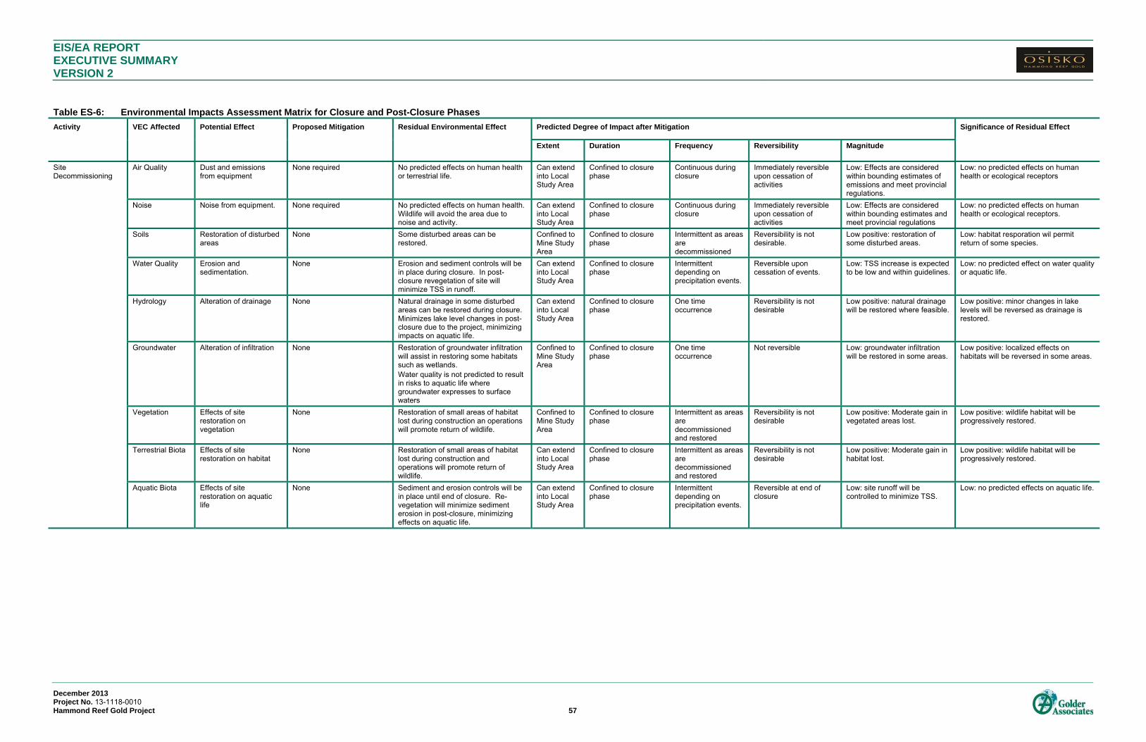
EIS/EA REPORT EXECUTIVE SUMMARY VERSION 2
December 2013 Project No. 13-1118-0010 Hammond Reef Gold Project 57
Table ES-6: Environmental Impacts Assessment Matrix for Closure and Post-Closure Phases
Activity VEC Affected Potential Effect Proposed Mitigation Residual Environmental Effect Predicted Degree of Impact after Mitigation Significance of Residual Effect
Extent Duration Frequency Reversibility Magnitude
Site Decommissioning
Air Quality Dust and emissions from equipment
None required No predicted effects on human health or terrestrial life.
Can extend into Local Study Area
Confined to closure phase
Continuous during closure
Immediately reversible upon cessation of activities
Low: Effects are considered within bounding estimates of emissions and meet provincial regulations.
Low: no predicted effects on human health or ecological receptors
Noise Noise from equipment. None required No predicted effects on human health. Wildlife will avoid the area due to noise and activity.
Can extend into Local Study Area
Confined to closure phase
Continuous during closure
Immediately reversible upon cessation of activities
Low: Effects are considered within bounding estimates and meet provincial regulations
Low: no predicted effects on human health or ecological receptors.
Soils Restoration of disturbed areas
None Some disturbed areas can be restored.
Confined to Mine Study Area
Confined to closure phase
Intermittent as areas are decommissioned
Reversibility is not desirable.
Low positive: restoration of some disturbed areas.
Low: habitat resporation wil permit return of some species.
Water Quality Erosion and sedimentation.
None Erosion and sediment controls will be in place during closure. In post-closure revegetation of site will minimize TSS in runoff.
Can extend into Local Study Area
Confined to closure phase
Intermittent depending on precipitation events.
Reversible upon cessation of events.
Low: TSS increase is expected to be low and within guidelines.
Low: no predicted effect on water quality or aquatic life.
Hydrology Alteration of drainage None Natural drainage in some disturbed areas can be restored during closure. Minimizes lake level changes in post-closure due to the project, minimizing impacts on aquatic life.
Can extend into Local Study Area
Confined to closure phase
One time occurrence
Reversibility is not desirable
Low positive: natural drainage will be restored where feasible.
Low positive: minor changes in lake levels will be reversed as drainage is restored.
Groundwater Alteration of infiltration None Restoration of groundwater infiltration will assist in restoring some habitats such as wetlands. Water quality is not predicted to result in risks to aquatic life where groundwater expresses to surface waters
Confined to Mine Study Area
Confined to closure phase
One time occurrence
Not reversible Low: groundwater infiltration will be restored in some areas.
Low positive: localized effects on habitats will be reversed in some areas.
Vegetation Effects of site restoration on vegetation
None Restoration of small areas of habitat lost during construction an operations will promote return of wildlife.
Confined to Mine Study Area
Confined to closure phase
Intermittent as areas are decommissioned and restored
Reversibility is not desirable
Low positive: Moderate gain in vegetated areas lost.
Low positive: wildlife habitat will be progressively restored.
Terrestrial Biota Effects of site restoration on habitat
None Restoration of small areas of habitat lost during construction and operations will promote return of wildlife.
Can extend into Local Study Area
Confined to closure phase
Intermittent as areas are decommissioned and restored
Reversibility is not desirable
Low positive: Moderate gain in habitat lost.
Low positive: wildlife habitat will be progressively restored.
Aquatic Biota Effects of site restoration on aquatic life
None Sediment and erosion controls will be in place until end of closure. Re-vegetation will minimize sediment erosion in post-closure, minimizing effects on aquatic life.
Can extend into Local Study Area
Confined to closure phase
Intermittent depending on precipitation events.
Reversible at end of closure
Low: site runoff will be controlled to minimize TSS.
Low: no predicted effects on aquatic life.

EIS/EA REPORT EXECUTIVE SUMMARY VERSION 2 Table ES-6: Environmental Impacts Assessment Matrix for Closure and Post-Closure Phases (Continued)
December 2013 Project No. 13-1118-0010 Hammond Reef Gold Project 58
Activity VEC Affected Potential Effect Proposed Mitigation Residual Environmental Effect Predicted Degree of Impact after Mitigation Significance of Residual Effect
Extent Duration Frequency Reversibility Magnitude
Closure of TMF Air Quality Dust and emissions from equipment
None No predicted effects on human health or terrestrial life.
Can extend into Local Study Area
Confined to closure phase
Continuous during closure
Immediately reversible upon cessation of activities
Low: Effects are considered within bounding estimates of emissions and meet provincial regulations.
Low;: no predicted effects on human health or ecological receptors
Noise Noise from equipment None No predicted effects on human health. Wildlife will avoid the area due to noise and activity.
Can extend into Local Study Area
Confined to closure phase
Continuous during closure
Immediately reversible upon cessation of activities
Low: Effects are considered within bounding estimates and meet provincial regulations
Low: no predicted effects on human health or ecological receptors.
Soils No additional impacts on soils
Water Quality Effects on water quality TMF will be sculpted to promote runoff and minimize infiltration. Soil amendment will promote vegetation growth minimizing TSS in runoff to local waterbodies. Excess water will be diverted to open pit until water quality is acceptable for aquatic life.
Seepage from TMF in post-closure is not predicted to affect aquatic life. Runoff will be released to local waterbodies when quality is acceptable for aquatic life.
Can extend into Local Study Area
Confined to closure phase
Continuous during closure
Reversible at end of closure
Low: Discharges will meet guidelines/background levels.
Low: no predicted effects on surface waters or terrestrial or aquatic life.
Hydrology Alteration of drainage Drainage will be routed to Sawbill Bay when water quality is acceptable.
Drainage from the TMF will be routed to surface waters, reducing effects of construction and operation on lake levels.
Can extend into Local Study Area
Extends into post-closure
Continuous Not reversible Low: drainage from TMF in post-closure will be routed to surface waters.
Low: restoration of drainage will restore lake levels minimizing effects on aquatic life.
Groundwater Effects on groundwater quality and quantity
None Sculpting of TMF will reduce infiltration, reducing groundwater levels under the TMF. Reducing seepage of TMF water to local aquifer will minimize effects of TMF seepage on groundwater quality. Water quality is not predicted to result in risks to aquatic life where groundwater expresses to surface waters
Confined to Mine Study Area
Throughout closure and post-closure
One time occurrence
Not reversible Low: reduced infiltration due to sculpting of TMF
Low: no predicted effects on surface waters or ecological receptors.
Vegetation Effects on vegetation None Addition of soil amendment to TMF will promote vegetation growth on TMF in post-closure, restoring some habitat lost during construction and operations.
Confined to Mine Study Area
During closure phase Throughout closure and post-closure
Reversibility is not desirable
Low positive: Moderate increase in vegetated area.
Low positive: some habitat will be restored permitting return of some species.
Terrestrial Biota Effects on habitat None Addition of soil amendment to TMF will promote vegetation growth on TMF in post-closure, restoring some habitat lost during construction and operations and facilitating return of some wildlife.
Can extend into Local Study Area
During closure phase Throughout closure and post-closure
Reversibility is not desirable
Low positive: Moderate increase in vegetated area.
Low positive: some habitat will be restored permitting return of some species.
Aquatic Biota Effects on surface water quality and quantity
TMF will be sculpted to promote runoff and minimize infiltration. Soil amendment will promote vegetation growth minimizing TSS in runoff to local waterbodies. Excess water will be diverted to open pit until water quality is acceptable for aquatic life.
Seepage from TMF in post-closure is not predicted to affect aquatic life. Runoff will be released to local waterbodies when quality is acceptable for aquatic life.
Can extend into Local Study Area
During closure phase Continuous during closure
Reversible at end of closure
Low: Discharges will meet guidelines and/or background levels.
Low: no predicted effects on aquatic life.

EIS/EA REPORT EXECUTIVE SUMMARY VERSION 2 Table ES-6: Environmental Impacts Assessment Matrix for Closure and Post-Closure Phases (Continued)
December 2013 Project No. 13-1118-0010 Hammond Reef Gold Project 59
Activity VEC Affected Potential Effect Proposed Mitigation Residual Environmental Effect Predicted Degree of Impact after Mitigation Significance of Residual Effect
Extent Duration Frequency Reversibility Magnitude
Closure of Waste Rock Stockpile
Air Quality Dust and emissions from equipment
None No predicted effects on human health or terrestrial life.
Can extend into Local Study Area
Confined to closure phase. No emissions in post-closure
Continuous during closure
Immediately reversible upon cessation of activities
Low: Effects are considered within bounding estimates of emissions and meet provincial regulations.
Low: no predicted effect on human health or ecological receptors.
Noise Noise from equipment None No predicted effects on human health. Wildlife will avoid the area due to noise and activity.
Can extend into Local Study Area
Confined to closure phase. No sources of noise in post-closure
Continuous during closure
Immediately reversible upon cessation of activities
Low: Effects are considered within bounding estimates and meet provincial regulations
Low: no predicted effect on human health or ecological receptors.
Soils No additional impacts
Water Quality Effects on water quality None Water will be routed to open pits at closure until seepage water is of acceptable quality to discharge to local waterbodies. No predicted impact on aquatic life.
Can extend into Local Study Area
Closure phase into post-closure
Continuous during closure
Reversible in post-closure
Low: water discharged to local waterbodies will meet guidelines and/or background levels.
Low: no predicted effects on surface waters or aquatic life.
Hydrology Effects on drainage None Small reduction in drainage area until water is of acceptable quality to release to surface waters.
Can extend into Local Study Area
Closure phase potentially into post-closure
Continuous during closure
Reversible in post-closure
Low: drainage area contribution to lake levels is small.
Low: effects on lake levels and aquatic habitat will be progressively reversed.
Groundwater Effects on groundwater quality and quantity
None Shallow groundwater will be intercepted by ditches minimizing impacts of seepage via groundwater to surface waters. Loss of groundwater contribution to surface waters will be restored in post-closure when drainage can be directed to surface waters. Water quality is not predicted to result in risks to aquatic life where groundwater expresses to surface waters
Confined to Mine Study Area
Closure phase potentially into post-closure
Continuous during closure
Reversible in post-closure.
Low: ditches will intercept shallow groundwater.
Low: effects on lake levels and aquatic habitat will be progressively reversed.
Vegetation Restoration of vegetation
None The waste rock stockpile will be left to re-vegetate naturally. Vegetation may not revert fully to pre-development habitat.
Confined to Mine Study Area
Into post-closure Continuous Reversibility is not desirable
Low positive: Some species are expected to colonize the stockpile
Low positive: some habitat will be restored permitting return of some species.
Terrestrial Biota Restoration of habitat None Wildlife will gradually move in as the stockpile re-vegetates. Habitat may not revert fully to pre-development habitat.
Can extend into Local Study Area
Into post-closure Continuous Reversibility is not desirable
Low positive: some habitat lost in construction will be restored.
Low positive: some habitat will be restored permitting return of some species.
Aquatic Biota Effects on surface water quality and quantity
None At closure seepage and runoff water will be directed to the open pits until water is of acceptable quality to discharge directly to local waterbodies. No effects are predicted on aquatic life.
Can extend into Local Study Area
Into post-closure Continuous until water quality is acceptable
Not reversible Low: Water quality will be acceptable for aquatic life upon release to surface waters
Low: no predicted effects on aquatic life.

EIS/EA REPORT EXECUTIVE SUMMARY VERSION 2 Table ES-6: Environmental Impacts Assessment Matrix for Closure and Post-Closure Phases (Continued)
December 2013 Project No. 13-1118-0010 Hammond Reef Gold Project 60
Activity VEC Affected Potential Effect Proposed Mitigation Residual Environmental Effect Predicted Degree of Impact after Mitigation Significance of Residual Effect
Extent Duration Frequency Reversibility Magnitude
Open Pits Air Quality Dust and emissions from equipment
None No predicted effects on human health or terrestrial life.
Confined to Mine Study Area
Throughout closure and post-closure
Continuous during closure
Immediately reversible upon cessation of activities
Low: Effects are considered within bounding estimates of emissions and meet provincial regulations.
Low: no predicted effect on human health or ecological receptors.
Noise Noise from equipment None No predicted effects on human health. Wildlife will avoid the area due to noise and activity.
Confined to Mine Study Area
Throughout closure and post-closure
Continuous during closure
Immediately reversible upon cessation of activities
Low: Effects are considered within bounding estimates and meet provincial regulations
Low: no predicted effect on human health or ecological receptors.
Soils No effect on soils predicted since no soils will be in the open pit
Water Quality Effects on water quality Water quality will be monitored during post-closure to verify that overflow will not affect aquatic life
Pits will overflow after approximately 218 years and drain to Upper Marmion Reservoir. Pit water quality at overflow is predicted to be acceptable for aquatic life.
Can extend into Local Study Area
Throughout closure and post-closure
Continuous Not reversible Low: Pit water quality at overflow will be acceptable for aquatic life
Low: no predicted effect on human health or ecological receptors.
Hydrology Effects on drainage None Pit overflow will restore some of the drainage to Upper Marmion Reservoir that was lost due to the project.
Can extend into Local Study Area
Throughout closure and post-closure
Continuous Not reversible Low positive: Some restoration of original drainage
Low: effects on lake levels and aquatic habitat will be progressively reversed.
Groundwater Effects on groundwater quality and quantity
None Loss of groundwater contribution to adjacent surface waters is minor. Groundwater contribution to surface waterbodies will be restored when pits overflow. Groundwater quality is not predicted to be affected.
Confined to Mine Study Area
Throughout closure and post-closure
Continuous Not reversible Low: groundwater flow to Marmion Reservoir will be restored in post-closure. Quality is not predicted to be affected.
Low: effects on lake levels and aquatic habitat will be progressively reversed.
Vegetation No effects on vegetation predicted since pits will be aquatic habitat
Terrestrial Biota Effects on habitat and wildlife
None Pit water quality will be of acceptable quality for consumption by wildlife.
Confined to Mine Study Area
Throughout closure and post-closure
Continuous Not reversible Low: Water quality in pits will be acceptable quality for wildlife consumption
Low: no predicted effects on ecological receptors.
Aquatic Biota Effects on surface water quality and quantity
None Water quality at overflow is predicted to meet background levels in Upper Marmion Reservoir and/or guidelines for protection of aquatic life. No impacts are predicted on aquatic life.
Can extend into Local Study Area
Throughout closure and post-closure
Continuous Not reversible Low: Overflow water quality will meet guidelines and/or background levels.
Low: no predicted effects on aquatic life.
EIS/EA REPORT EXECUTIVE SUMMARY VERSION 2
December 2013 Project No. 13-1118-0010 Hammond Reef Gold Project 61
Potential Effects to the Physical Environment Geology, Geochemistry and Soils
No adverse effects to geology, geochemistry or soils are predicted to occur from the Project. Geochemical
testing was conducted to confirm whether the waste rock and tailings deposits could be potentially acid
generating and metal leaching. The conclusions of the completed analysis show that the waste rock will be
non-acid generating with excess neutralization potential primarily resulting from carbonate minerals. The results
of the short term leach testing and kinetic testing support this classification.
Relative to comparison criteria, waste rock and tailings samples leachate concentrations were slightly elevated
for aluminum with sporadic concentrations of other metals such as arsenic, copper cadmium, iron, selenium,
vanadium and zinc slightly greater than the comparison criteria. Where these sample values are above the
comparison criteria, additional water quality evaluation within an overall site wide context has been conducted as
described in the site water quality evaluation. Cyanide was considered separately as part of the water quality
analyses as it is introduced as a result of processing.
Construction of the Project will result in vegetation removal which will expose the soil and increase the risk of
erosion. Project activities will also include the potential for spills, leaks and seepage of substances, which could
alter the chemistry of soils and reduce soil capability.
Soil erosion may influence slope stability and water quality, spills may degrade soil quality, and the direct loss of
soil and alteration of terrain may have implications with respect to wildlife use of the LSA and with respect to the
use of the area as a timber resource.
Further assessment of the effects of the Project on soils and terrain was considered as an indirect effect to
wildlife under the terrestrial biology assessment and land use under the socio-economic assessment.
Atmospheric Environment
The potential effects of the Project to the atmospheric environment focused on air quality, noise, light and
vibration.
Forty PORS were originally identified in the air quality and noise assessment. Twenty of these PORs (POR 5-
19, POR 34, POR 36-38 and POR 40) were identified in the Ontario Ministry of Natural Resources (MNR)
mapping data as designated campsites. These locations are simply suggested areas within Crown Land that
could be used for camping by the public. No amenities or services are provided and no payment is required to
camp there, just as is the case with all Crown Land. OHRG does not have the ability to restrict access to Crown
Land, and these identified PORs are not considered specific sites that are required to be included in air and
noise modeling predictions.
Based on this, the number of PORs considered in the air quality and noise assessment has been reduced from
40 to 20. The PORs considered in the revised air quality and noise evaluation are the Town of Atikokan, local
tourism establishments, trapper’s cabins and cottages. Of the 20 possible campsites that were originally
considered in the air quality and noise assessment, three locations were identified as having potentially high
noise levels and six were identified as potentially exceeding particulate matter guidelines. OHRG plans to post
signs at crown land locations in the vicinity of the Project site that, in the past, may have been known to be used

EIS/EA REPORT EXECUTIVE SUMMARY VERSION 2
December 2013 Project No. 13-1118-0010 Hammond Reef Gold Project 62
for camping to indicate the potential for campers to become annoyed by noise levels. A further assessment on
health effects due to the potential increase in particulate matter is presented in the Human Health Risk
Assessment TSD. Human health risks are not considered to be increased significantly by the Project.
Air dispersion modelling was carried out for the Ontario compliance assessment using defined emission rates to
determine the point of impingement concentrations along the Project property boundary and receptors. Ambient
concentrations resulting from Mine Site emissions were predicted at selected groups of receptors and at other
locations of interest in order to provide a better understanding of the potential effects of the Project. In addition,
discrete human health locations within the LSA were identified for assessment under the Human Health Risk
Assessment.
The results of air modelling show that the Project can operate in compliance with s.20 of Ontario
Regulation 419/05 for the Operations Phase in the peak production year as defined by the worst-case operating
conditions. This is considered to be a conservative assessment since not all scenarios comprising worst-case
conditions are likely to be active at any given time. The effects of air emissions on human health are assessed
in the human health risk assessment.
A noise assessment was carried for 20 potentially sensitive PORs which were identified within the vicinity of the
Project. These PORs included tourist establishments, cottages and cabins within the LSA. The modelling
results predicted that noise levels associated with the Project would comply with Ontario Ministry of the
Environment (MOE) noise guidelines.
Fish habitat is sensitive to vibration, particularly active spawning beds and nurseries. Vibration during blasting
and excavation of open pits could cause blast-induced water overpressure level changes at the shoreline,
potentially effecting sensitive fish species during critical life stages.
It is not possible to realistically assess potential effects on fish without site-specific data on peak particle velocity
(PPV) values since this depends to a great extent on the nature of the rock, and the transmissivity. Therefore,
operational blasting monitoring to assess the intensity of blast vibrations at the receptor locations will be
required. During the initial stages of pit development, blast intensities will be monitored and site-specific PPV
will be calculated in order to more accurately predict potential vibration intensities in adjacent aquatic habitats.
The lighting on the Project Site will be positioned in a manner as to not directly illuminate the surrounding areas
or the sky. During the detailed engineering for the Project, options will be selected to avoid or reduce negative
effects and will be considered for incorporation into the Project’s design. As a result, it is expected that the
Project will have limited effects through light trespass and sky glow.

EIS/EA REPORT EXECUTIVE SUMMARY VERSION 2
December 2013 Project No. 13-1118-0010 Hammond Reef Gold Project 63
Water Quantity and Quality
The potential effects of the Project to water quantity and quality focused on hydrology, water and sediment
quality and hydrogeology.
The Project could affect hydrology through changes to streamflows, lake water levels and navigability of water
courses and waterbodies during all four phases of the Project.
The greatest changes to streamflows as a result of Project activities during the Operations phase are expected
to occur in MSA watercourses as a result of changes to their tributary drainage areas. Of the 29 watersheds
evaluated, five will be unaffected.
The expected changes in flows in local scale watercourses include a reduction in flows in Lumby Creek of
approximately 7% to 8%. Changes to the outflows from the Marmion Reservoir and flows in the Seine River
downstream of the Raft Lake Dam may occur due to the Project. Total net reduction in annual mean inflows to
the Reservoir is estimated to be 0.190 m³/s in an average year. Changes in monthly mean outflows from Upper
Marmion Reservoir are expected to be in the range of -3.10% to -0.21% based on single-year lake water
balance modelling.
Changes to water levels will occur in two lakes, and the Upper Marmion Reservoir. Water levels in
Unnamed Lake 5 located to the east of the TMF are expected to be in the range of -2.1 cm to 0.0 cm during the
Operations phase. Changes in water levels in Lizard Lake are expected to be in the range of -2.7 cm to 0.0 cm.
Changes in water levels in the Upper Marmion Reservoir due to Project activities are expected to be in the range
of -9.0 cm to -0.4 cm based on single-year water balance modelling. In an average year, the predicted
maximum reduction in water levels of the Upper Marmion Reservoir is 8.1 cm.
The Project could result in changes to water quality in site, local and regional scale watercourses in all four
phases of the Project. The water quality assessment considers the operations phase to be the worst case
scenario and the focus is on this phase. The presence of a flooded open pit also will also have an influence on
water quality and, thus, a post-closure assessment was also completed. The water quality models were
developed based on the physiography of the area, project description, geochemical test results, process test
results and baseline monitoring data and were used to predict and evaluate potential water quality influences
from the site and impacts in the receiving waters. For lakebed sediment quality the potential Total Suspended
Solids (TSS) discharge from the site and air deposition was considered at the end of mine life.
All parameters are below Municipal/Industrial Strategy for Abatement (MISA) levels and Metal Mining Effluent
Regulation (MMER) discharge guidelines at the point of discharge to the Upper Mamion Reservoir (the diffuser
ports). Site Specific Water Quality Objectives for cyanide and copper are predicted to be reached within
distances of 29 m and 18 m, respectively, from the diffuser ports. Following initial mixing, (i.e. within 100 m of
the diffuser ports), all predicted concentrations during average site discharge conditions during operations are
lower than the CWQG, PWQO and MISA criteria. In general, the predicted results after initial mixing are the
same as or marginally greater than baseline concentrations. The sulphate concentrations in the water column
during average conditions are predicted to increase marginally from 1.6 mg/L as measured in the baseline
studies to 1.8 mg/L.
The Project could result in changes to groundwater levels. No groundwater users were identified in the vicinity
of the Project that could potentially be affected by changes in groundwater levels from Project activities. The

EIS/EA REPORT EXECUTIVE SUMMARY VERSION 2
December 2013 Project No. 13-1118-0010 Hammond Reef Gold Project 64
cone of depression from pit dewatering extends about 700 m from the pit perimeter and underlies a portion of
the WRMF and overburden stockpiles. Within the area of the cone of depression, groundwater levels could
potentially result in a reduction or even elimination of flows in some local streams should there be a significant
connection to the deeper bedrock flow system, however most groundwater flow occurs in more permeable
sediments above the bedrock, thus there is potential for development of a perched water table, or flow above the
de-watered bedrock. Also within this area, seepage losses from the stockpiles could result in flow increases in
some local streams. A seepage collection system is included as an in-design mitigation measure.
Mitigation Measures for the Physical Environment Geology, Geochemistry and Soils
Mitigation for potential effects to terrain and soils will include minimizing the amount and extent of surface
disturbance at any one time. Soil quality changes will also be minimized through implementation of standard
practices for erosion protection during construction and operation and the development and implementation of
an Erosion Management Plan and Spill Management Plan. A geochemical monitoring plan will also be
developed as further outlined in Chapter 8 Environmental Monitoring.
Existing pre-construction topography, elevations and drainage patterns have been documented and will be used
to inform reclamation planning. Throughout all project phases, site drainage will be managed to ensure that
runoff does not cause erosion, flooding or contamination in downstream areas. The water management system
will include collection of runoff and seepage from the WRMF and TMF which will be captured and directed to the
PPCP.
An Erosion Management Plan will be developed prior to construction and implemented throughout all phases of
the Project. The Plan will include topsoil salvage procedures, soil stabilization measures such as the
construction of temporary berms, and a progressive rehabilitation plan. Changes to terrain will be further
mitigated by the development of a reclamation plan that will be prepared to meet regulatory requirements.
Topsoil and overburden will be stockpiled, protected against erosion and used in reclamation of sites where
possible. Waste rock and tailings will be stored appropriately to minimize erosion.
A Spill Management Plan will be developed to mitigate the potential effects of spills. The Spill Management Plan
is further outlined in Chapter 8. A standard spill response procedure and protocol will be developed and roles
and responsibilities will be communicated through the environment department and management teams.
Worker training on spill response protocols will be implemented and a spill response database will be
maintained.

EIS/EA REPORT EXECUTIVE SUMMARY VERSION 2
December 2013 Project No. 13-1118-0010 Hammond Reef Gold Project 65
Atmospheric Environment
With appropriate mitigation measures in place, the Project will operate in compliance with all applicable air, noise
and vibration regulations and guidelines.
In estimating the air emissions associated with the Project certain mitigation measures were considered to be
integral to the design and implementation of the works and activities. These mitigation measures, which are
considered to be typical and consistent with best practices, were incorporated into the emission estimates, and
therefore were incorporated in the effects predictions. These included implementation of appropriate
management practices to control fugitive particulate emissions from haul roads, management of exhaust
emissions from non-road vehicles through regular and routine maintenance of vehicles, and use of enclosures at
the Ore Processing Facility to reduce fugitive emissions.
The noise assessment of the Project included tourism establishments, communities and trapper cabins as the
twenty (20) PORs. Noise levels were deemed to be potentially high at one tourism establishment. OHRG has
an agreement in place with the owner of the tourism establishment to restrict access during the Construction and
Operations phases of the project. Three potential camping areas within the Crown Land surrounding the Project
site were also identified as having potentially high noise levels. OHRG plans to post signs at crown land
locations in the vicinity of the Project site that, in the past, may have been known to be used for camping to
indicate the potential for campers to become annoyed by noise levels.
An adaptive management approach is the proposed mitigation for blasting activities, especially as excavation
approaches the pit perimeter. This approach will include on-site measurements of ground and air vibration
as well as overpressure to develop actual separation distances needed between environmental receptors in
order to meet regulations. The mitigation of vibration effects on sensitive fish habitats could include increasing
the distances between environmental receptors, or reducing the weight of explosive charge detonated per
delay period. The actual location of the pit perimeter (and therefore between environmental receptors) will be
determined during the detailed design stage of the Project.
Water Quantity and Quality
Mitigation that has been included in the water quality predictions include in-design mitigation measures, ongoing
monitoring and data collection, development and implementation of management plans, contingency plan of
treatment as needed and ongoing consultation and discussion with other local water users.
The Project will be designed to an appropriate factor of safety relating to slope stability. Interception wells will be
used to maintain pit wall pressure if necessary. The design of facility and flow patterns of the water
management system will be optimized for the local environment.
A Spill Management Plan will be implemented which will include preventative measures and methods for
appropriate reporting and clean-up of any spills that occur. An Erosion Management Plan will be developed to
identify ongoing measures to be put in place during construction activities to limit TSS discharge. Additionally,
water will be collected and stored if necessary until it can be appropriately treated and discharged.
An Effluent Treatment Plant will be included as a contingency measure. A treatment facility for suspended
solids, nutrient loading or metals would be operated if necessary. Treatment for suspended solids may be
required as a contingency measure if the water within the reclaim pond and PPCP do not naturally allow for
solids to settle. Nutrient loading will be mitigated through the implementation of management controls such as

EIS/EA REPORT EXECUTIVE SUMMARY VERSION 2
December 2013 Project No. 13-1118-0010 Hammond Reef Gold Project 66
explosives management, or use of phosphate-free soaps or solvents. Treatment for metals is not anticipated to
be required.
The Project design will include a Water Management System. The water collection system will operate through
the use of seepage collection ponds, ditches and active pumping. Water management will be implemented
throughout the Project life cycle to capture runoff and seepage. At closure and post closure, pumping will cease
and direct drainage from Project Site will be re-establish natural drainage patterns to lakes and reservoirs.
Discussion with water users and members of the Seine River Watershed Management Plan will be ongoing
throughout the Project. Water quality, climate and hydrology data will be collected and used to inform Project
design and management. Precipitation records will be used for design and flow management.
Water quality, hydrology and hydrogeology monitoring programs will be implemented as further detailed in
Chapter 8, Environmental Management.
Potential Effects to the Biological Environment Potential effects to the terrestrial environment were evaluated through identified VECs including wetlands, forest
cover and wildlife species. Specific attention was given to Species at Risk. Consideration was also given to
those physical components that have been identified as having potential changes and how these physical
changes would affect terrestrial biology VECs.
Potential effects to the terrestrial environment could result mainly through the physical loss and fragmentation of
terrestrial habitat, including birds’ nests. Other physical changes include alteration of flows and drainage
patterns described by the hydrology component that can affect wildlife habitat or habitat suitability. Changes to
surface water and groundwater quality based on the discharge of treated effluent, runoff from WRMF and other
mine facilities may also affect vegetation, soils, sediments and wildlife habitat.
Some terrestrial biology effects could occur due to water use and Project emissions to water and air. Changes
to water levels in Marmion Reservoir due to planned water taking from Upper Marmion Reservoir for process
and potable water supply could affect vegetation in wetlands and wildlife habitat. Air emissions and dust
deposition can cause changes to the chemical and physical properties of surface water, soils and vegetation,
which in turn affect wildlife health.
Activities during operations which have the potential to effect the biological environment include introduction of
invasive plant species which could out-compete native vegetation and accidental spills on the mine site or along
the access road can affect soils and vegetation. Sensory disturbance during construction and operations
including noise, vibrations and proximity to humans can also cause the disturbance and displacement of wildlife.
The Project will also result in improved access to the area which could affect wildlife population sizes through
increased hunting activities.
Species at risk identified in the Project area include birds, reptiles and mammals. Canada warbler was observed
to nest in the Project Site. The preferred habitat of the Canada warbler that would be affected by the Project
was estimated as 11% of the habitat in the Project Site. As a result, some individuals may be displaced to
adjacent habitats. The reptile SAR that has been identified as occurring in the area is the snapping turtle.
Snapping turtles were considered to be unaffected by a change in water level in Lizard Lake of less than 3 cm.

EIS/EA REPORT EXECUTIVE SUMMARY VERSION 2
December 2013 Project No. 13-1118-0010 Hammond Reef Gold Project 67
Range maps indicate that six species of bats have known home ranges in the area, all of which were recorded
during the 2013 bat field surveys. Loss of habitat for maternity roosting and hibernation is considered moderate.
Potential effects to the aquatic environment were evaluated through identified VECs including headwaters, lower
reaches, receiving water bodies and identified fish species. Consideration was also given to those physical
components that have been identified as having potential changes and how these physical changes would affect
aquatic biology VECs.
During construction, the main effect of the Project on the aquatic environment will be habitat loss. A summary of
habitat losses is provided in the aquatic biology effects assessment and includes 0.8 ha of Sawbill Bay, 4 ha of
inlet streams, 0.5 ha of baitfish ponds in the lower reaches, 1.8 ha of headwater streams, 30 ha of lakes and
3.7 ha of baitfish and northern pike ponds in the headwaters. There are also 14 stream crossings or crossing
upgrades on the proposed access road that will result in the loss of habitat within the footprint of the
culvert/bridge structure. All of these habitat losses will be offset by compensation projects outlined in the No-Net
Loss Plan (NNLP) prepared for the project, and as a result, there will be no residual effects from these losses.
In addition to habitat loss, construction activities have the potential to cause mortality of fish present in these
water bodies, thus a fish rescue plan will be developed and implemented as part of the construction phase of the
Project.
During operations, there are a number of potential effects to the aquatic environment. Water withdrawal and
water discharge, vibrations from blasting, groundwater flow and dust creation all interact with the aquatic
environment.
Water withdrawal from Sawbill Bay will result in a reduction in water levels ranging from -9.0 cm to -0.4 cm in
Upper Marmion Reservoir, which can be accommodated within the current operating regime of the reservoir.
As a result there are no significant effects. The discharge of mine waste water from the PPCP will be
intermittent and is predicted to meet water quality guidelines and objectives (PWQOs or CWQGs) or site-specific
water quality objectives. Therefore, there is no predicted effect on aquatic life and this impact is considered
to be negligible. Sewage discharge to Sawbill Creek from the worker accommodation camp upstream of
Sawbill Bay will meet MOE regulatory requirements, and, therefore, there will be no impact on the receiving
waterbodies or VECs.
Operational blasting of the east and west pits will be monitored for vibration effects to fish and fish habitat.
A mitigation management program will be implemented to ensure that Fisheries and Oceans Canada (DFO)
guidelines are met, and, therefore, there will be no impact on fish life cycle stages.
As the open pits are excavated, there is potential for lake water to enter the pits through rock fissures. A Mine
water collection system will be in place to ensure that water levels in Upper Marmion Reservoir are maintained.
As a result, there will be no impact on water levels in Upper Marmion Reservoir. There is potential for
groundwater from the Project Site to migrate to Sawbill Bay and Lizard Lake. Water balance predictions under
worst case conditions are not predicted to result in adverse effects to these receivers.
There is potential for atmospheric deposition of contaminants from mining activities; however, predictive
modeling studies carried out in the Atmospheric TSD have concluded that the effects of atmospheric deposition
of dust and contaminants on aquatic life will be negligible.

EIS/EA REPORT EXECUTIVE SUMMARY VERSION 2
December 2013 Project No. 13-1118-0010 Hammond Reef Gold Project 68
During Project closure groundwater flow, and dust creation will continue to interact with the aquatic environment.
As the open pits begin to fill, there is potential for lake water to enter the pits through rock fissures. During the
closure phase, the Mine water inflow will be monitored. It is estimated that in about 218 years, the open pits
will overflow into Sawbill Bay at which time any inflows to the pit would be balanced by pit overflows to
Upper Marmion Reservoir. There is no anticipated effect on Upper Marmion Reservoir water levels.
During the closure phase, the seepage collection system will remain in place to ensure that contaminated
seepage does not migrate to receivers until such a time as monitoring shows that the seepage is acceptable for
direct release. Although there may be some atmospheric deposition during closure there is no expected
atmospheric contamination of aquatic habitats during closure activities.
Mitigation for the Biological Environment Mitigation measures were developed for the terrestrial and aquatic environment. These mitigation measures are
closely linked to the Environmental Monitoring Plan and Objectives outlined in Chapter 8 of the EIS/EA Report.
Mitigation measures for the biological environment are focussed on potential residual effects and consider both
indirect physical effects and direct biological effects.
Mitigation measures for potential effects to the terrestrial environment will include in design measures, planning
and management measures, compensation projects, training and education measures, and monitoring
strategies.
The Project design and layout of the mine footprint and linear corridor was created to limit the amount of
vegetation that is disturbed. Some of the disturbed overburden and topsoil will be stockpiled as a potential seed
source. This measure will increase re-vegetation success of temporary work spaces. Limiting the use of
all-terrain vehicles on trails and maintaining major transportation routes will also reduce habitat disturbance.
Clearing of vegetation shall take place outside of the nesting bird season (May 15th-July 30th), where possible.
If clearing must take place within this period, a biologist will undertake a nest search to determine if there are
any active nests in the habitat being cleared. If a nest is observed a protected buffer is placed around the nest
until the bird and its young have left the nest.
The Processing Plant will be designed with emission controls, as will the construction and operations equipment.
Operating procedures will be developed to reduce dust generation and emissions. Noise will be mitigated by
housing stationary equipment in buildings and incorporating baffles and/or noise suppressors on equipment.
Hazardous materials and fuel will be stored according to regulatory requirements to protect the environment and
the workers and demarked areas will be established for the storage and handling of hazardous wastes.
Water taking for the processing and make-up water will be minimized by reusing the on-site water supply for
multiple undertakings. Runoff from the Project site and processing facility will be captured and diverted to the
PPCP for re-use. Sewage will be treated prior to discharge.
The water management system will be designed to have enough capacity to store both operating flow and storm
events. Installation of culverts will minimize alteration of flows and drainage patterns along linear corridor.
Creation of wetlands as described in the No Net Loss Plan will attenuate flows.

EIS/EA REPORT EXECUTIVE SUMMARY VERSION 2
December 2013 Project No. 13-1118-0010 Hammond Reef Gold Project 69
Development and implementation of management plans will include an Invasive Species Management Plan, an
Emergency spill management program, Dust management plan and the implementation of a strict “no hunting,
harvesting, trapping or fishing” policy for workers while at the onsite worker accommodation camp.
Loss of bat habitat for maternity roosting and hibernation is considered moderate and will be offset by the
creation or enhancement of other habitats for bats. The details of the compensation plan have yet to be
determined, however preliminary concepts include the installation of bat condos and boxes as well as the
improvement of other mine adits for use a hibernation sites.
Workforce training and education measures are also important mitigation measures. Enforcing speed limits on
access roads and mine road, proper cleaning and maintenance of equipment and Species at Risk worker
education are all important measures to reduce potential effects to the terrestrial environment.
Mitigation measures for potential effects to the aquatic environment include the development of a No Net Loss
Plan, water quality modelling and effluent diffuser design, the implementation of a water management system
and ongoing monitoring of the aquatic environment.
The following is a summary of the fish habitat compensation projects identified as part of No Net Loss Plan:
Fish salvage and rescue operations: during the construction phase.
Stream restoration works at 15 culvert crossings
Stocking of four fishless headwater lakes/ponds.
Constructing berms to create three new headwater ponds.
Creating northern pike spawning habitat adjacent to the mouth of Sawbill Creek
The loss of fish communities in Lizard Lake and Upper Marmion Reservoir includes loss of indirect fish habitat
and genetic diversity. Loss of indirect fish habitat will be offset by projects included in the No Net Loss Plan.
Effects to genetic diversity will be mitigated through fish salvage protocols during which the majority of
impacted fish will be released in other waterbodies in the area, including Lizard Lake, API #8 and
Upper Marmion Reservoir. In addition, fish salvaged from these operations will be used to stock a number of
fishless lakes as part of the NNLP. As a result, this residual effect is considered to be negligible.
The mixing zone at the effluent discharge point was modelled for water quality predictions and mixing potential.
This analysis included preliminary diffuser design work, and concluded the mixing zone will be small.
The Project design will include locating the diffuser in an area of low fish use. As a result, the potential for
exposure of fish to this area will be low and the concentration/duration of effect will be very low. As a result,
there will be no effect of this discharge on fish populations in Upper Marmion Reservoir. No effects are expected
on smallmouth bass, northern pike, walleye or baitfish populations in Upper Marmion Reservoir.
During Mine operations, closure and post-closure, there is potential for “piping” of surface water in
Upper Marmion Reservoir to move via cracks and fissures in the bedrock into the open pits. Once the pits
are full and overflow into Upper Marmion Reservoir, there will be a small net increase in flow into
Marmion Reservoir. As a result, there is no impact on Upper Marmion Reservoir water levels and the effect on
VECs is considered negligible.

EIS/EA REPORT EXECUTIVE SUMMARY VERSION 2
December 2013 Project No. 13-1118-0010 Hammond Reef Gold Project 70
During the operations phase, a Mine water collection and pumping system will ensure that there is no impact on
Upper Marmion Reservoir water levels. Once the Mine is closed and the Mine water intake from Sawbill Bay is
decommissioned, this inflow of water to the pits can easily be accommodated within the current operating regime
for Upper Marmion Reservoir.
An Environmental monitoring program to assess the performance of fish compensation measures will also be
undertaken, as further detailed in Chapter 8 Environmental Monitoring Plan.

EIS/EA REPORT EXECUTIVE SUMMARY VERSION 2
December 2013 Project No. 13-1118-0010 Hammond Reef Gold Project 71
Social Environment Social environment included an assessment of socio-economics, Aboriginal interests, Cultural heritage and
Human health. The socio-economic assessment and Human health risk assessment both identified the potential
for residual effects as described below.
Socio-Economics
The socio-economic impact assessment of the Project has yielded detailed results that are presented in the
Socio-Economic TSD. The overall effect of the Project is summarized in Table ES-7.
Table ES-7: Summary of Overall Socio-economic Effects Assessment Results
Valued Ecosystem
Component
Overall Residual
Effect
Description
Population and Demographics
Positive The population increase associated with the Project will first stem the decline and then augment the population of the Town. This will have an overall beneficial effect on the community.
Labour Market Positive The increase in employment and training and corresponding decrease in unemployment will bring additional income into the LSA, which will contribute to the overall economic wellbeing of the community.
Government Finance Positive Beyond additional revenue to the federal and provincial governments, new construction in the LSA will generate additional property assessment for the Town of Atikokan resulting in revenues that can be applied to the provision of services.
Public Services and Infrastructure
Neutral There is sufficient capacity for existing infrastructure and service delivery to absorb the increases in demand associated with the Project.
Housing and Accommodation
Positive The vacancy rate in the Town of Atikokan will be reduced by the influx of workers and their families, and new housing will be constructed. This will help stabilize the local housing market.
Transportation Low-level adverse effect
The local transportation network currently operates well below capacity levels; hence the increase created by the Project can readily be absorbed.
Outdoor Tourism and Recreation
Low-level adverse effect
Upon the application of mitigation measures required for air quality and/or noise compliance, residual adverse effects on tourism and recreation are unlikely. The overall attractiveness of Atikokan and environs is not likely to be affected by the Project; however a low-level effect through loss of visual aesthetics is anticipated. Of note is that given the mining history in the vicinity of Atikokan, many people coming to Atikokan understand that mining activities take place in this area.
Hunting Low-level adverse effect
No effect is anticipated on the number of hunting licences issued or on general hunting activity in the area. A relatively small amount of land will no longer be available for hunting, which will have a low-level effect on hunting in the LSA.

EIS/EA REPORT EXECUTIVE SUMMARY VERSION 2
December 2013 Project No. 13-1118-0010 Hammond Reef Gold Project 72
Valued Ecosystem
Component
Overall Residual
Effect
Description
Trapping Neutral Upon the application of mitigation for the loss of some portions of tenured trapline areas, no residual adverse effect on trapping is anticipated.
Fishing Neutral Overall fishing activity in the study areas is not likely to be affected.
Mining Positive Beyond the positive effects of the Project described in this TSD, the Project would likely have net beneficial effects on local or regional exploration and development in this sector.
Forestry Neutral Upon the application of mitigation, no residual adverse effect on forestry is likely.
Water Use and Access Neutral Ongoing discussions with the downstream hydro-electric facilities to further understand the potential financial implications of the predicted changes to outflows from the Raft Lake Dam. Upon the application of mitigation, no residual adverse effect other commercial or industrial water users is likely.
The Project will have a positive economic effect through jobs and increased government revenues during the
construction and operations phase. On an annual basis, the operations phase will involve a project workforce of
550 people and over the 11 year operations phase, the estimated direct, indirect and indirect employment is
25,179 FTE or person-years, 13,002 of which will come from Ontario.
The tax revenues from the Project are a positive effect and they represent a major contribution of approximately
$340 million to federal and provincial revenues over the 11-year operations phase. The Project’s municipal tax
contribution to the Town of Atikokan will be indirect through the potential construction of new housing, new local
businesses and an increased population.
The effect on population and demographics is expected to be small during construction and moderate during
operations. Overall, population increase is expected to contribute to the net benefits of the Project. An increase
in the number of Atikokan residents (workers and their families) should serve to reverse the current population
decline in the LSA.
The existing public services and infrastructure in the LSA, including the Town’s plans for a new waste
management facility, are capable of accommodating the small additional demand from the Project and increased
population as a result of the construction phase. Accordingly, no adverse effects are anticipated on this VEC.
Overall, the effect of the Project on housing and worker accommodation is positive. The Project is anticipated to
result in an increase in the demand and cost of housing in the LSA which should contribute to the stabilization of
the local housing market.
The Project is anticipated to result in an increase in traffic, resulting in a Category “C” level of service on
Highway 11B, and an increased volume-to-capacity ratio. The increase still provides for service levels well
within acceptable ranges and the Project should not result in unacceptable traffic congestion.

EIS/EA REPORT EXECUTIVE SUMMARY VERSION 2
December 2013 Project No. 13-1118-0010 Hammond Reef Gold Project 73
The Project could result in effects to hunting because of loss of habitat. The magnitude of the effect is low
because the amount of land removed is less than 5% of the wildlife management unit. The frequency and
reversibility are both high since the effect occurs continuously and is reversible; therefore, the overall
assessment of significance of this effect is assessed as low.
Outdoor tourism and recreation could be affected by the Project because of changes in perception caused by
effects to the visual landscape. This is a permanent change that will be mitigated through ongoing consultation
with tourism operators and OHRG’s commitment to invest in advertising to promote the local industry.
Aboriginal Interests
Effects on Aboriginal Community Characteristics are anticipated to be positive namely those effects on
Employment, Business Activity, and Training and Education. The Project will contribute to the economic
opportunities and development of Aboriginal communities.
Effects on Aboriginal Heritage and Resources through Project-related disturbance of archaeological sites
or restricted access or disturbance of cultural or spiritual sites were identified as being unlikely to occur.
The Project will not result in any physical disturbance of any known sites. As part of the Cultural Heritage
studies for the environmental assessment, Stage 1 and 2 archaeological assessments were conducted on the
area likely to be affected by Project physical activities. No Aboriginal archaeological sites or artefacts were
found.
Effects on Traditional Use of Land and Resources, specifically loss of fishing opportunities, hunting opportunities
and plant harvesting opportunities were assessed as being negligible because any effects would be limited to
the Aboriginal Interests LSA and would not measurably reduce the overall land use opportunities provided within
the RSA. Effects on the consumption of country foods was determined to be unlikely since neither their source
nor safety would be affected. The removal of land base within traplines in the Aboriginal Interests LSA will be
mitigated through agreements with the trapline holders.

EIS/EA REPORT EXECUTIVE SUMMARY VERSION 2
December 2013 Project No. 13-1118-0010 Hammond Reef Gold Project 74
Physical and Cultural Heritage Resources
No significant archaeological sites and artifacts were found, with the exception of two late 19th century
to mid-20th century mine sites, which are likely to be affected by the Project. Two historic mining operations
reside within the footprint of the proposed development, the Hammond Gold Reef Mine, located on the northern
limit of the Mitta Lake Peninsula, and the Sawbill Mine, located north of the east end of the proposed East Pit.
In both cases cultural remains exist that illustrate the location of the abandoned mining operations.
Potential effects on the two former mine sites described above are limited to the LSA since both sites lie outside
of the mine footprint. While potential effects include the destruction, alteration, disturbance, exposure or
isolation of attributes or features of these sites, they are unlikely to be affected by mining activities.
As both of these sites date well into the 20th century the information potential related to archaeological studies is
considered to be low and no further archaeological assessment was conducted.
Human Health Risk Assessment
Residual effects to human health were determined to include noise and increased particulate matter.
Increased noise has the potential to result in an increased risk of hypertension or sleep disturbance to nearby
recreational users or trapline holders. Best management practices will be implemented to minimize activities that
may generate noise (e.g., mine and materials handling, vehicle movement) in particular close to the property
boundaries adjacent to identified receptor locations. To the extent possible, noise will be minimized at night in
these areas as well, to reduce the potential for sleep disturbance.
The particulate matter assessment identified the potential for a residual effect of increased cancer risk for
trappers at two trapper cabins.
Residual effects were evaluated using the assessment criteria identified. The direction of all the residual effects
is negative (i.e., decrease in health from baseline conditions).
EIS/EA REPORT EXECUTIVE SUMMARY VERSION 2
December 2013 Project No. 13-1118-0010 Hammond Reef Gold Project 75
No Contaminants of Potential Concern (COPCs) were identified following the conservative screening process.
Therefore, no adverse health effects are expected as a result of changes in soil and water concentrations.
There are no residual effects from the acute inhalation assessment based on comparison of chemical-specific
predicted maximum 1-hour air concentrations from all receptor locations against the lowest available health-
based screening thresholds.
The chronic inhalation assessment considered anticipated exposure times for each receptor as well as receptor-
specific parameters such as inhalation rate and body weight. All of the HQs were well below MOE target levels,
indicating negligible health effects.
In the particulate matter assessment, concentrations of PM2.5 were below guidelines, indicating negligible
adverse health effects from PM2.5. Annual concentrations of PM10 were also below guidelines and not expected
to cause adverse health effects.
Concentrations of Diesel Particulate Matter (DPM) exceeded the screening threshold for carcinogenic effects;
therefore, DPM was evaluated following the chronic inhalation assessment method. The calculated levels were
less than the target cancer risk of 1 x 10⁻⁶ for all receptors except for one trapper cabin, which was 1.6 x 10⁻⁶.
These predictions assume that the trapper spends 105 days per year, 8 hours a day for 15.5 years at the trapper
cabin. It was also assumed that the maximum annual DPM concentration modelled for the Project exists for the
entire life of the Project. These conservative assumptions contribute to potentially overestimating the cancer
risk. The magnitude of this risk is considered low.
In the noise assessment, measures prescribed by Health Canada for assessing exposure to noise and potential
human health effects were utilized. At receptor locations surrounding the Project, noise levels are within the
ranges reported for increased risk of hypertension and sleep disturbance. The magnitude of effect for noise is
considered to be low based on comparison to Health Canada targets and considering that predicted levels are
in the lower end of ranges for hypertension effects.
Mitigation for the Social Environment The Town of Atikokan is currently planning to construct a new waste management facility and is undergoing the
permitting process for this facility. OHRG is committed to working with the Town of Atikokan to support
the licensing, construction and operation of this new landfill site. The new site will be designed to accommodate
any construction-related waste from the Project.
Mitigation is required for the adverse effects on outdoor tourism and recreation resources that have been directly
affected by the restriction of site access/removal of land as part of the construction of the Project.
Because there may be some perception of negative effects on outdoor tourism and recreation due to
construction of a mine project in the area, and associated effects on visual aesthetics, OHRG has begun to take
steps to reinforce the positive outdoor tourism and recreational reputation of the LSA. As outlined in Chapter 7,
Public Consultation, communications with Tourist Operators has been ongoing including a workshop which
discussed concerns. As a result of this workshop, OHRG has committed to providing support for advertising
efforts to promote the local tourism industry. OHRG also plans ongoing sponsorships of community events such
as the Atikokan Bass Classic.

EIS/EA REPORT EXECUTIVE SUMMARY VERSION 2
December 2013 Project No. 13-1118-0010 Hammond Reef Gold Project 76
Effects to hunting were determined to be a potential residual adverse effect of the Project. In order to mitigate
any increase in hunting pressures that could occur as a result of the Project OHRG will implement a firearms
policy to restrict hunting for workers while staying at the worker accommodation camp. OHRG will also
administer a bi-annual hunting and fishing questionnaire to its workforce in cooperation with MNR.
Mitigation is required for the adverse effects on trapline areas, bait fish blocks and bear management areas that
will be directly affected by the restriction of site access/removal of land as part of the construction of the Project.
The approach to mitigation is compensation and/or relocation based on negotiation with the land user.
Mitigation for adverse effects on trapping, bait fishing and bear hunting will involve negotiated agreements and
benefits upon approval of the EA and a decision to construct. Agreements are currently in place with the
adjacent tourism operator, overlapping trap line holder, bait fish block holder. Satisfactory completion of
negotiations and execution of agreements fully mitigate this effect.
Mitigation to forestry will involve discussions facilitated by MNR between OHRG and Atikokan Forest Products
and Abitibi Consolidated to negotiate compensation, as required. Satisfactory completion of these negotiations
should mitigate any adverse effects of the Project on timber harvest land base.
During the closure phase, OHRG will help communities transition into the loss of Project-related employment
and opportunities for businesses to provide goods and services to the Project. Similar programs have been in
place for changes in workforce when the exploration phase came to a close and included employee transition
planning, training and placement support to assist employees in finding other employment in the community or
elsewhere in the resource extraction sector.
The Aboriginal Interests effects assessment did not identify any adverse effects of the Project that could not be
mitigated or compensated on any of the selected VECs. The following sections discuss a number of preliminary
plans that seek to enhance the positive benefits and/or ensure that implementation of the Project will occur in
harmony with Aboriginal Interests to the extent possible. These initial plans will serve to enhance the continuing
relationship between OHRG and the Aboriginal communities.
OHRG plans to continue its practice of informing Aboriginal communities about the nature and timing of the skills
required for site workers. Existing Aboriginal workers will be encouraged to share their working experiences
within their own communities, thereby helping to overcome some of the barriers to Aboriginal participation in the
wage economy. OHRG will make the workplace a welcoming environment to Aboriginal people by providing
cultural sensitivity training to all members of the Project workforce.
Although no Aboriginal heritage sites or artefacts are identified with the area likely to be affected by the Project
physical activities, there remains the low possibility that a heritage site or artefacts could be encountered
during excavation or earth moving activities. Accordingly, a protocol will be established between OHRG,
the First Nations and Métis regarding actions to be taken in the event, however unlikely, a heritage sire and/or
artefacts are discovered during the construction phase.
Because Aboriginal people will likely continue to occupy the land after mine closure, and because of their
continued stewardship of the land, they will be included in remediation and closure planning for the Project Site.
Additional consideration of benefits to the public and Aboriginal communities is detailed in Chapter 8, Social
Management Planning. This plan includes the use of structured committees for two-way information sharing and
the ongoing inclusion of Aboriginal communities and public stakeholders in the Project planning process.
EIS/EA REPORT EXECUTIVE SUMMARY VERSION 2
December 2013 Project No. 13-1118-0010 Hammond Reef Gold Project 77
Two historic mine sites were identified within the Project area. Given the available historical literature in the form
of government mining reports and the presence of remains such as mine shafts, adits, dams and tramways,
the Ministry of Tourism and Culture recommended that a Cultural Heritage Evaluation Report be undertaken for
the two historic mining operations. Mitigation for potential human health effects includes private agreements that
are in place with local land users for temporary restriction of land access during the Project phases.
Cumulative Impacts The approach to assessing potential cumulative effects uses the results of the impact assessment to assess the
potential effects of the Project on the same physical, biological and socio-economic factors in consideration with
the effects of other past, existing and reasonably foreseeable projects and activities in the same geographic
region as the Project. Appropriate past, existing and proposed projects and activities that could potentially
interact with the project were selected for inclusion in the assessment in consideration of the following:
The predicted effects of the Project;
The spatial and temporal extent of the predicted effects;
The location, timing, size and nature of other projects and their potential effects; and,
The availability of existing data and knowledge of the projects and their potential effects.
Identified projects or activities considered in the cumulative effects assessment include:
The former Steeprock Iron Mine site near Atikokan;
Existing hydro-electric facilities on the Seine River system downstream of the Raft Lake Dam, the closest of
which being the Valerie Falls Generating Station;
Ontario Power Generation’s Atikokan Generating Station near Atikokan;
Planned wood processing facilities, including the Resolute Forest Products Sawmill near Atikokan and
the Rentech Wood Pellet Production Facility in Atikokan (formerly known as the Atikokan Renewable
Fuels Mill);
The former Atiko-Sapawe Gold Mine near Atikokan;
Rainy River Resources proposed Rainy River Gold Project near Fort Frances, Ontario;
Bending Lake Iron Group proposed Josephine Cone Iron Mine project near Ignace, Ontario; and,
Treasury Metals proposed Goliath Gold Project near Dryden, Ontario.
The predicted effects of the Project were then considered against each other project or activity to determine
if there is potential for interaction. If a potential for interaction is identified, an assessment of potential
cumulative effects was performed.
The predicted environmental impacts from the Project components are confined to the mine footprint and
immediately adjacent areas of the LSA. Within the area of impact, the changes in the environmental
components are minor and none of these are predicted to adversely affect local plant or animal populations
beyond the MSA, nor adversely affect surface or groundwater quality beyond the MSA.
EIS/EA REPORT EXECUTIVE SUMMARY VERSION 2
December 2013 Project No. 13-1118-0010 Hammond Reef Gold Project 78
Since the predicted effects are being managed and mitigated such that only local changes will occur that will
have no predicted significant impact on the environmental components, the cumulative effects assessment is
conducted as a limited scope assessment. The lack of physical or biological effects from the Project beyond the
immediate area of the mine development precludes far-reaching environmental effects that could interact with
other projects, and reduces the need for a detailed assessment of cumulative effects against the VECs
considered in the EA.
Accidents and Malfunctions The assessment considered a number of potential health and safety, accident and contingency scenarios that
require planning and preparation in the event that they occur during the operating phase including:
Road accident on main access road resulting in a spill.
Fuel tank rupture on Mine Site.
Hazardous material spill
Tailings pipeline rupture.
Spill of tailings water from TMF reclaim pond.
TMF tailings dam failure.
Flyrock from blasting
Medical emergency
Pit slope failure or water inflow to pit
Fires (on site and forest fire)
Floods and Droughts
Explosion
Emergency preparedness planning will be undertaken and training in emergency response will be provided for
key site staff during construction, operations and closure. The assessment concluded that planning, training,
in-design mitigation measures, monitoring measures and response measures implemented at the Project site
would minimize the environmental effects of potential accidents.
PUBLIC CONSULTATION AND ABORIGINAL ENGAGEMENT The following six regulatory milestones and associated information sharing were carried out with the public,
non-governmental organizations (NGOs), government (local, provincial and federal) and Aboriginal communities.
The first three milestones were documented in the Record of Consultation published as part of the ToR.
1) Project Description
2) Commencement of Terms of Reference
3) Submission of Terms of Reference
EIS/EA REPORT EXECUTIVE SUMMARY VERSION 2
December 2013 Project No. 13-1118-0010 Hammond Reef Gold Project 79
4) Commencement of the EA Report
5) Submission of the EA Report
6) Review of Decommissioning Plans (ongoing)
Government Provincial and federal government agencies have been working together to provide a streamlined consultation
process where possible. Key contacts for the environmental assessment from provincial and federal
governments have been identified as Ministry of Northern Development Mines, Ministry of Environment –
Environmental Assessment and Approvals Branch and the Canadian Environmental Assessment Agency.
Regular meetings took place with the lead agencies and they were kept informed of consultation with others,
particularly with a focus on Crown Oversight of Aboriginal consultation.
The identified Government Review Team (GRT) was proactively engaged in the Project and invited to comment
on OHRG’s approach throughout the environmental assessment process. The GRT was provided the Project
description overview and baseline studies results prior to report publications. A Draft EIS/EA Report was
published and presentations of the EIS/EA results were delivered to the GRT. Discusssions took place on
clarification of details, description of assumptions and justification of approach.
The GRT provided over 700 comments on the Draft EIS/EA Report. These comments were reviewed,
responses were prepared and presentations were provided to the GRT with draft responses to
comments. Additional discussion took place on recommended report revisions and requests for new work.
Formal responses to comments on the Draft EIS/EA Report were compiled and are issued as part of the Final
EIS/EA Report.
Some additional work has been undertaken based on the comments received. This work includes new and
ongoing field studies, new design and modelling calculations, desktop studies, publication of new reports and
revisions to existing reports.
A summary of key concerns from the Government Review Team and corresponding report revisions undertaken
is provided below. These concerns and revisions are further detailed in Chapter 7.
Ministry of Natural Resources (MNR)
On April 4, 2013 approximately 290 comments on the Draft EIS/EA Report were received from Ministry of
Natural Resources (MNR). Several meetings and discussions took place on areas of concern or where draft
responses were deemed to need further clarification. Several revisions to the EIS/EA Report were
recommended by MNR, as provided in the detailed meeting notes.
The following provides a summary of completed and planned discussions to be undertaken with Project
stakeholders based on MNR’s recommendations.
Environmental Monitoring: OHRG hosted a meeting about environmental monitoring including a presentation
which summarized the changes made to Chapter 8 of the EIS/EA Report and a discussion of ongoing concerns
regarding planned environmental monitoring for the Project.
EIS/EA REPORT EXECUTIVE SUMMARY VERSION 2
December 2013 Project No. 13-1118-0010 Hammond Reef Gold Project 80
Closure Planning: OHRG undertook a further assessment of closure alternatives, which is provided as a
supplemental to the Conceptual Closure Plan TSD.
Fishery Management: MNR collects data on fishing estimates and would like OHRG to participate in this
information collection. MNR recommended a site specific count of fishing boats on the lake. Further discussion
is required on the need for clear objectives of undertaking a fishing study.
Water Users: MNR has recommended ongoing discussions and follow up with power producers regarding water
level impacts during drought conditions. OHRG plans to engage the local water users for further discussion and
participate in the Seine River Watershed Management Committee.
Site Specific Water Quality Objectives: Ongoing discussions with MOE are required to discuss specific values
and water quality management plans for the closure phase.
Water Quality
On April 4, 2013, approximately 55 comments regarding water quality were received on the Draft EIS/EA Report
which were mainly focussed on clarification of baseline data, the need for site specific water quality objectives
and requests for new mixing model work to clarify the extent of the effluent mixing zone. Comments from the
GRT also recommended that the on-site worker accommodation camp discharge location be moved
downstream of the intake location. This recommendation has been acted upon and the revised location is
presented in Chapter 5 of the Final EIS/EA Report.
Two meetings took place with regulators to discuss comments received on water quality. The discussion was
focused on potential changes or clarifications needed to finalize the initial water quality results presented in the
Draft EIS/EA Report.
In response to comments and information from the Ministry of Natural Resources that the proposed effluent
discharge location from the accommodation camp is in an area containing potential walleye spawning and
nursery habitat, the effluent discharge and freshwater intake locations have been relocated to an area where
there is no perceived influence on the spawning habitat or other environmental impacts.
Several comments were received from the Ontario Ministry of Environment regarding effluent mixing in Marmion
Reservoir. In response, a conceptual effluent diffuser design and preliminary mixing zone assessment was
completed for the full range of anticipated discharge rates (as predicted in the Site Water Quality TSD)
to estimate the potential extent and anticipated effluent concentration gradients within the near-field mixing zone
at the mine effluent discharge location. The results of this assessment, including a figure showing the
concentration gradients and extent of the mixing zone are provided in the Supplemental Information Package
attached to Version 2 of the Lake Water Quality TSD.
Aquatic Biology
A series of meetings/workshops were held with the GRT to discuss a number of issues specifically related to
Aquatic Biology including collection of baseline data, development of fish habitat accounting methodology,
discussions regarding federal and provincial regulatory requirements and preliminary discussions regarding
compensation for loss of fishing opportunities. OHRG worked with the government review team to finalize a
Fish Habitat Accounting methodology for use in the No Net Loss Plan included in the Aquatic Biology TSD
Supplemental Information Package.

EIS/EA REPORT EXECUTIVE SUMMARY VERSION 2
December 2013 Project No. 13-1118-0010 Hammond Reef Gold Project 81
The following summarizes the key changes:
Habitat losses and compensation projects are categorized based on the applicable legislation or regulatory
Act (i.e., the Metal Mining Effluent Regulations (MMER) and Subsection 35 of the Fisheries Act)
The potential for development of aquatic habitat within the flooded pits at closure is evaluated and
considered;
Additional detail is provided on dissolved oxygen concentrations in the fishless lakes that are proposed to
be stocked as part of the compensation plan;
Additional detail is provided on the access road watercourse crossings and associated compensation
projects; and,
Additional detail is provided on the fish salvage and rescue plan for the fish bearing water bodies that will
be impacted by the Project.
Closure Planning
OHRG has maintained open communication with the GRT throughout the environmental assessment process.
Communications will be ongoing throughout the Project phases and the completion of the environmental
assessment. One key outstanding government consultation requirement is ongoing discussions with MNDM to
ensure the Certified Closure Plan for the Project meets all requirements and expectations. On November 2012,
MNDM provided a letter to OHRG stating they had received a Notice of Project Status for the Hammond Reef
Project. In this letter the Director of Mine Rehabilitation stated that a Closure Plan must be submitted for the
Project prior to mine construction, but that the Closure Plan would not be accepted as filed until the completion
of the provincial and federal environmental assessment processes.
Public OHRG has used a variety of methods to engage with the public including publication of Community News Briefs,
Community Open Houses, meetings and presentations. Draft and Final Reports have been circulated and
responses have been provided to comments from public stakeholders. Throughout communications and
consultation events OHRG has received many questions about Project design details. Many members of the
public have stated their support for the Project and their interest in employment with OHRG. Concerns about
potential effects to the environment and in particular the aquatic environment have also been raised by public
stakeholders.
The public consultation log provided in Appendix 7.III provides details of written issues or concerns received
from the public, OHRG’s response to the issue or concern, and whether follow up action is required to resolve
the issue.
OHRG has provided immediate detailed responses to many questions received from the public. Public
comments were considered during the preparation and revision of the EIS/EA Report. Fishing is an important

EIS/EA REPORT EXECUTIVE SUMMARY VERSION 2
December 2013 Project No. 13-1118-0010 Hammond Reef Gold Project 82
recreational activity and is also the source of income for local tourism operators. Two of the public stakeholders
who submitted written comments on the Draft EIS/EA Report listed potential effects to fish as their key concern.
The Atikokan Sportsmen’s Club and the Ontario Federation of Anglers and Hunters both requested further
sampling of fish tissue and benthic invertebrates in the area would be warranted.
Notwithstanding the fact that the fish tissue sampling undertaken for the EA was sufficient for EA purposes,
OHRG has committed to providing capacity support to Seine River First Nation to collect additional fish tissue
and benthic samples in the Spring of 2014 in conjunction with an environmental study being undertaken with
their community. Data collected will be shared with Seine River First Nation, Ontario Federation of Anglers and
Hunters and the Sportsmen’s Club.
The Marmion Reservoir is a regulated water body that is subject to the Seine River Watershed Management
Plan. The Plan includes target outflow rates at specified dams and target water elevation levels at certain times
of year. The hydrology assessment has concluded that the Hammond Reef Gold Project can operate within
these target rates. Ongoing discussion with existing water users is required to allow for cooperation and
understanding of each other’s seasonal water needs.
Overlapping land users were engaged and mutually beneficial agreements were reached with the identified bait
fish block and bear management area license holder, trapline holders and adjacent tourist operator. Land use
agreements include restriction of access as required for safety during identified Project phases. All agreements
are contingent on the Project moving forward.
In addition to the tourism industry’s concern about aquatic health, the changes to the visual landscape and the
potential effects to the tourism industry was a key concern. A local monitoring committee, the Atikokan/OHRG
Committee, will be established to allow for communication and information sharing between OHRG and the local
public population. The details of the planned committee structure and potential meeting topics are provided in
Chapter 8 under Social Management Planning.
Aboriginal Engagement The Project is located within Treaty 3 lands, the traditional territory of the Anishinaabe people. OHRG has
developed a relationship with the local First Nations people through ongoing information sharing and the signing
of a Resource Sharing Agreement. The First Nations communities with an interest in the Project include the
seven member nations of the Fort Frances Chiefs Secretariat, the Lac de Mille Lacs First Nation and the
Wabigoon Ojibway Nation. The closest First Nations community is located approximately 40 km away from the
Project site.
The Project is also located within an area recognized by the Métis Nation of Ontario as the Treaty 3/Lake of the
Woods/Lac Seul/Rainy River/Rainy Lake traditional harvesting territories. In March 2012, OHRG signed a
Memorandum of Understanding with the Métis Nation of Ontario, including four identified Métis community
councils (Kenora, Sunset Country, Northwest and Atikokan). The agreement allowed for the formation of a
Métis consultation committee for the Project. As of November 2012, the deliverables identified in the agreement
were fulfilled and committee members agreed that adequate consultation on the Project had taken place.
OHRG is actively planning ongoing communications and partnerships with the Métis Nation of Ontario.
All three key Aboriginal groups have provided letters to government stating that OHRG has provided clear and
ongoing communications throughout the Project planning process. OHRG has used a variety of methods to

EIS/EA REPORT EXECUTIVE SUMMARY VERSION 2
December 2013 Project No. 13-1118-0010 Hammond Reef Gold Project 83
engage with interested Aboriginal groups including publication Community Visits, Presentations to Chiefs, Elders
Forums, Committee Meetings and Community Feasts. Draft and Final Reports have been circulated and
responses have been provided to comments from Aboriginal groups.
Summary of Aboriginal Concerns
Throughout communications and engagement events, OHRG heard many concerns about potential long term
effects of the Project on the environment. Although the focus of these comments is often expressed through the
importance of the whole and interconnected environment, environmental concerns are largely related to potential
effects to water quality, ricing areas and the health of fish, and animals that live near the Project Site.
Environmental concerns raised by Aboriginal communities have been addressed in a fulsome way in the EIS/EA
Report and associated TSDs. Specific concerns have also been and will continue to be addressed in plain
language presentations provided to Aboriginal communities.
Many comments have also been received with regards to Project closure, environmental monitoring and
OHRG’s ability to assure the Project Site will not be abandoned as has occurred in past mining projects within
the region. OHRG has included Aboriginal communities in the closure planning process through a series of
presentations and ongoing information sharing. The long term monitoring plan for the Project will include direct
participation of Aboriginal communities, as described further in Chapter 8 of the EIS/EA Report.
A summary of environmental concerns from First Nations communities and OHRG’s response to the concerns
provided below. OHRG will continue to engage with Aboriginal communities, with a focus on specific identified
issues. Appendix 7.V provides a detailed record of communications and a comment response table which
clearly outlines each comment, when it was received, and Osisko’s response to addressing the comment.

EIS/EA REPORT EXECUTIVE SUMMARY VERSION 2
December 2013 Project No. 13-1118-0010 Hammond Reef Gold Project 84
Water Quality
Concerned with release of sulphate at above ambient levels into Marmion Lake
While CWQGs and PWQOs are not available for sulphate, the State of Minnesota has developed a water quality
guideline of 10 mg/L specifically for protection of wild rice (MPCA website 2013). The water quality predictions
under the different Project phases described in Section 6.1.3.5 show that worst case concentrations of sulphate
are predicted to reach 3.7 mg/L at the Raft Lake Dam during the operations phase. Predicted concentrations
under average operating conditions and in post-closure are the same as under baseline conditions (<2 mg/L).
The predicted concentrations are well below the guideline developed by Minnesota and as a result there is no
identified potential effect on wild rice downstream in the Seine River. Since the other water quality parameters
as predicted at the Raft Lake Dam are similar to background levels, there is no predicted effect on wild rice or
other aquatic vegetation in the Seine River from operation of the mine.
To assist in the prediction of effluent quality, will Osisko be sampling internal (Pre effluent) reclaim pond
water quality?
On-going sampling of all water discharged from the mine site will be required as part of the Environmental
Compliance Approval for effluent release to ensure the effluent is compliant with appropriate standards. The
frequency of this sampling will be determined based on the provincial and federal permit requirements. Osisko
may conduct additional sampling prior to effluent release to confirm the suitability of the water for use at the
process plant.
Concerned about current levels of both water and sediment adequately describing conditions in
Marmion Lake and connecting water bodies
Additional studies of the existing aquatic environment, including fish tissue, sediment and benthic studies is
planned to be undertaken with Seine River First Nation and the Atikokan Sportsmens’ Club in Spring 2014.
Groundwater
Concerned that there may be some temporary minor adverse effects due to pond seepage water escaping into
the lake waters. Concerned about potential migration of effluent from the planned Tailings Management Facility
to Long Hike Lake.
Seepage from the TMF to Lizard Lake during operations will be managed through a seepage collection system
that will direct seepage from the TMF back to the TMF. However, it is expected that under worst case
conditions, up to 10% of the seepage may bypass the collection system and will flow to Lizard Lake. Predictions
of worst case conditions resulted in free cyanide concentrations in Lizard Lake of up to 0.006 mg/L. Since the
predicted concentration is only slightly above the guideline of 0.005 mg/L and below the SSWQO of 0.01 mg/L,
there are no predicted adverse effects due to free cyanide.
Seepage from waste rock and ore stockpiles will be routed via ditching to the PPCP, from where it will be re-
used in the processing facility or treated and discharged. As a result, there is no predicted effect on aquatic life.
Fish and Fish Habitat
Concerned with level of mercury in fish.

EIS/EA REPORT EXECUTIVE SUMMARY VERSION 2
December 2013 Project No. 13-1118-0010 Hammond Reef Gold Project 85
Mercury is of particular concern in fish tissues, and some walleye currently exceed consumption restrictions for
some sensitive groups, such as women of child-bearing age and children under 15 years of age (discussed in
Chapter 3). Water quality modeling (Section 6.1.3.5) predicts no change in mercury concentrations in surface
water or sediments during operation and into post-closure. Therefore, concentrations of mercury in walleye or
other fish species are not predicted to increase as a result of discharges from the site (concentrations in geologic
material are currently below detection limits). The slight increases in sulphate levels are also not predicted to
result in increases in methyl mercury production. As described in Section 6.1.3, conditions in Sawbill Bay would
not favour net methyl mercury production due to oxygenated conditions that appear to persist throughout the
water column.
Mercury analyses for benthic invertebrates should also be done as it would provide an assessment of
mercury uptake at specific locations.
Notwithstanding the fact that the fish tissue sampling undertaken for the EA was sufficient for EA purposes,
OHRG has committed to providing capacity support to Seine River First Nation to collect additional fish tissue
and benthic samples in the Spring of 2014 in conjunction with an environmental study being undertaken with
their community. Data collected will be shared with Seine River First Nation, Ontario Federation of Anglers and
Hunters and the Sportsmen’s Club.
How will Osisko implement the envisioned restricted fishery for camp employees without conflicting with
aboriginal treaty rights?
Introduction of a large workforce could exert unsustainable pressure on the local fishery, affecting the
sustainability of fish populations. As a result, fishing by camp personnel while on-site will be restricted to help
maintain fish stocks. The policy regarding restricted fishing for camp employees will not extend to Aboriginal
people, unless they are on shift at the mine site or currently staying at the workers accommodation camp.
Atmospheric Environment
Concerned about impact of possible airborne fugitive dust emissions originating from the Tails Management
facility on the environment.
Fugitive dust throughout the project will be managed through the implementation of a comprehensive fugitive
dust Best Management Practices Plan (BMPP), which will include practices for managing wind erosion from
tailings during Operations and re-vegetation during Closure as described in Section 4.2 of the Conceptual
Closure and Rehabilitation Plan TSD. Some typical steps to be included in the BMPP for managing dust
generation from the tailings areas are ensuring a minimum moisture content of the tailings to keep the area wet
and/or installing wind screens. Wet or moist tailings would have little in the way of dust generation potential. As
stated in the Conceptual Closure and Rehabilitation Plan TSD, the “closure measures are designed to physically
stabilize the tailings surfaces to prevent erosion and dust generation.” The types of closure measures include
covering and vegetating these areas, which would eliminate the dust generation.
The combination of the closure plan activities and the implementation of the BMPP, which includes facility
engagement and accountability, will ensure that the potential emissions from tailings are an insignificant source.

EIS/EA REPORT EXECUTIVE SUMMARY VERSION 2
December 2013 Project No. 13-1118-0010 Hammond Reef Gold Project 86
Therefore, they have been excluded from the assessment as a potential source of particulate matter. This is
standard practice and follows the guidance in Section 7.4 of the Ontario Ministry of the Environment “Procedure
for Preparing an Emission Summary and Dispersion Modelling Report” document dated March 2009.
Once the final design of the Osisko project is confirmed, a comprehensive site-specific BMPP, as described in
Section 3.3 of the Atmospheric Environment TSD, will be created for the site which will include specific
objectives to control fugitive emissions from tailings.
Métis Nation of Ontario
On May 24, 2013 OHRG received a letter from the Métis Nation of Ontario requesting notifying OHRG that an
MNO Negotiations Team had been appointed and requesting the first negotiations meeting take place.
Since receipt of the letter from MNO, ongoing communications have taken place to discuss Shared Interests
between MNO and OHRG. These discussions have included two meetings, for which OHRG prepared
presentations as provided in Appendix 7.V. The nature of the discussion at these meetings is confidential and
therefore some presentation slides have been removed and meeting notes have not been published.
A summary of main points that have been addressed through ongoing discussions include Project and corporate
updates, identification of mechanisms that could increase Project benefits to the Métis community, structure of
future committees and schedule for future meetings.
OHRG’s approach to resolving the concerns listed by the MNO in their April 2012 letter is to arrive at a private
and mutual beneficial agreement that addresses all MNO’s listed concerns. OHRG plans to work with the Métis
Nation of Ontario on an ongoing basis to ensure the communities benefit from the Project. OHRG is committed
to optimizing business opportunities for Métis community members, including the Métis in environmental
monitoring programs and supporting the Métis Way of Life through ongoing investment in Métis culture.
Cultural Concerns
Throughout consultation, OHRG has heard from Aboriginal communities that Aboriginal culture is important.
OHRG has worked with Aboriginal communities to respect customs and provide capacity for traditional
ceremonies at the Project site and within the communities.
Throughout the construction and operations phases of the Project, the established Social and Cultural
Committee will provide oversight and direction for appropriate ceremonies that should take place during Project
meetings. The committee will also promote cross cultural awareness and bring forward suggestions for cultural
investment opportunities.
Traditional knowledge has been incorporated into the environmental assessment through the provision of
capacity for traditional protocols during the consultation process and the consideration of information provided
into the Project design. OHRG has routinely followed advice provided by elders to include drumming and
dancing in Project meetings.
EIS/EA REPORT EXECUTIVE SUMMARY VERSION 2
December 2013 Project No. 13-1118-0010 Hammond Reef Gold Project 87
Information provided by First Nations and Métis have allowed OHRG to avoid placing infrastructure in areas that
are recognized as being special or sacred sites. The effluent treatment plant discharge location and TMF
location have both been adjusted to minimize potential impacts to areas with environmental value as identified
by Aboriginal communities. OHRG also plans to use traditional knowledge to inform the development of
appropriate fish relocation plan for Mitta Lake and other fish-bearing water bodies that will be affected by the
Project.
OHRG recognizes that speaking and hearing the Ojibway language is an important part of Aboriginal culture in
the identified Aboriginal communities. OHRG is committed to incorporating Ojibway information materials into
its consultation program for the Project. OHRG engaged Ojibway translators for the Elders forums, including
traditional use study meetings, and worked with the several individuals from First Nations communities to
translate a Project Overview into Ojibway. This Ojibway-language video has been shared with the First Nations
in community meetings and workshops.
OHRG will continue to communicate with Aboriginal communities about environmental concerns through the
sharing of environmental studies results and assessments. To date, OHRG has provided detailed information to
communities, Chiefs and Elders. Throughout the construction and operations phases of the Project,
the established Environmental Committee will provide a mechanism for sharing environmental information with
First Nations communities.
OHRG is committed to providing economic benefits to Aboriginal communities. Initiatives to maximize the
benefits the Project will have on Aboriginal communities include:
Scholarships.
Partnerships with local academic institutions.
On the job training.
A hire local priority policy.
Targeted employment, training and business opportunities.

EIS/EA REPORT EXECUTIVE SUMMARY VERSION 2
December 2013 Project No. 13-1118-0010 Hammond Reef Gold Project 88
ENVIRONMENTAL AND SOCIAL MANAGEMENT PLANNING Revisions to Chapter 8, the Environmental Monitoring portion of the EIS/EA Report, have been substantial to
include further details and provide a closer link to government guidelines. The revised Chapter 8 is organized by
Physical, Biological and Social environmental components. The Chapter includes a narrative explaining
potential effects by component and providing justification for the focus of the proposed monitoring plan.
The Chapter includes clear presentation of management and monitoring plans through the use of a Management
Planning table and Monitoring Plan table for each physical and biological component considered in
the environmental assessment.
The Management Planning table lists the Project interaction and the potential effect to the environment.
It includes proposed mitigation measures and clear monitoring objectives. The Management Planning table also
includes lists of applicable regulations and guidelines that relate to monitoring objectives. Contingency planning
is included in the Management Planning tables in the event that actual effects differ from predicted effects.
The Monitoring Plan tables bring forward the potential effects listed in the Management Planning tables and
further define indicators to meet the stated monitoring objective. Monitoring Plan tables also include a
description of planned sampling location, sampling method, and estimated frequency and duration of monitoring
plan for each physical and biological component. The biological monitoring tables also provide a direct link to
the VECs described and assessed in Chapter 6 of the EIS/EA Report.
Chapter 8 of the EIS/EA Report represents the Environmental Management Plan (EMP) for the Hammond Reef
Gold Project. The EMP was created to reduce the risks to the environment through consideration of predictions
and development of a plan that allows the predictions to be confirmed. The EMP also includes contingency
planning should the case arise that that actual effects differ from predicted effects.
Once construction and operations commence, environmental monitoring will be an integral part of evaluating the
effectiveness of the EMP.
The objective of the EMP is to ensure that negative impacts on the physical and biological environments are
mitigated; benefits that will arise from the development of the Project are enhanced; and compliance with
existing legislation and consistency with provincial guidelines and best practice is achieved.
Conceptual plans to monitor the effectiveness of mitigation measures, and verify the predicted changes to the
environment have been developed. These include water quantity and quality, groundwater quantity and quality,
terrestrial and aquatic biological monitoring plans, and social management plans. Detailed plans will be
developed in cooperation with Project stakeholders including government and public, as well as with Aboriginal
communities.
Both provincial and federal agencies are anticipated to be included in monitoring plan development and in the
provision of ongoing advice for the environmental management plan. It is anticipated that a lead agency will be
identified to provide direction and review reports.
EIS/EA REPORT EXECUTIVE SUMMARY VERSION 2
December 2013 Project No. 13-1118-0010 Hammond Reef Gold Project 89
Health and Safety The Health and Safety management system in place for the OHRG exploration project will be applied directly to
the constructions and operations phases of the Project. The management system was developed with the intent
of meeting, as a minimum, the legislative requirements within the Occupational Health and Safety Act and
Regulations for Mines and Mining Plants. The Internal Responsibility System in place at Hammond Reef
includes provisions for the Health and Safety Responsibilities of all levels of management, employees and
contractors.
Physical Environment The air quality and vibration monitoring and follow-up program is designed to be appropriate to the scale of the
Project and the effects identified through the environmental assessment process. The program is intended to
confirm the methods used to estimate the Project emissions and the effectiveness of in-design mitigation
measures, and in doing so, assess if alternative mitigation strategies are required to minimize emissions from
the Project and their impacts.
OHRG will prepare a comprehensive water monitoring program that will include groundwater quality, surface
water quality, levels and flows along with meteorology and flow metering of all pumped water. With respect to
the Hydrology monitoring program, the objectives will be to verify the accuracy of the predicted changes, confirm
the assumptions underlying the predicted changes, support the implementation of adaptive management
measures and satisfy compliance monitoring requirements included in the Metal Mining Effluent Regulation,
Environmental Compliance Approvals and Permits to Take Water issued by the Ontario Ministry of the
Environment pursuant to the Ontario Water Resources Act and in Fisheries Act Authorizations issued by
Fisheries and Oceans Canada and authorizations issued pursuant to the Navigable Waters Act (if applicable).
Hydrology field studies will consist of flow and water level monitoring in site, local and regional scale
watercourses and water bodies identified as potentially being affected by Project activities and at key points in
the Project’s water management system to confirm and update estimates of water takings, effluent discharges
and water recycling. Field monitoring activities for Hydrology will be coordinated with monitoring activities for
other disciplines where appropriate, to reduce costs and increase efficiency.
The hydrogeology component of the water monitoring program is designed to allow for long-term monitoring of
the effects of Project activities on groundwater levels and groundwater quality within the LSA throughout all
stages of the Project. The recommended program will comprise the measurement of groundwater levels
(or water pressures) at a number of locations within the Project Site. Data logging pressure transducers will be
used to obtain a continuous record of groundwater level fluctuations at select monitoring locations that
will be supported by quarterly manual depth to water measurements. Groundwater level/pressure monitors will
be located within and adjacent to the open pits and integrated with the program to monitor pit slopes during
excavation.
The water quality monitoring program initiated during the baseline studies will be continued through the
construction, operations and closure phases. The purpose of the program is to verify predictions made during
the impact assessment, evaluate regulatory compliance with the permitting requirements, and provide a basis for
effective water quality management on-site. The number of locations monitored will be reduced from the

EIS/EA REPORT EXECUTIVE SUMMARY VERSION 2
December 2013 Project No. 13-1118-0010 Hammond Reef Gold Project 90
baseline studies to focus on Lizard Lake, Sawbill Bay and Lynxhead Bay, and the watercourses draining from
the Project Site (i.e., the MSA). A more focused list of parameters will be monitored quarterly, including metals
and ions that the baseline studies and modeling have indicated may increase during construction and
operations. This will include TSS, sulphate, chloride and a suite of metals (Inductively Coupled Plasma Mass
Spectrometry scan), as well as arsenic, selenium and mercury. The sampling program (locations sampled,
parameters included and frequency of sampling) may be modified depending on other monitoring requirements
that may be identified under any approvals or permits and will be coordinated with hydrogeology and hydrology
sampling efforts and locations where possible to ensure there is minimal duplication.
A geochemistry monitoring plan will be developed and implemented by OHRG to confirm the characteristics of
the materials mined, placed or otherwise used in construction. The plan will include confirmation samples at
a rate that considers the mine schedule, existing geochemical data, and follows appropriate guidance
documents such as MEND (2009) or INAP (2012) as required under O.Reg 240/00 under the Mining Act
of Ontario. Samples will be analyzed using appropriate test methods for assessment of acid rock drainage/metal
leaching potential, to confirm that the samples fall within the range identified, tested and described in the
Geochemistry, Geology and Soils TSD.
Biological Environment OHRG will prepare a comprehensive Terrestrial Ecology monitoring program based on the residual effects
predicted in the Terrestrial Ecology assessment. The objectives of the Terrestrial Ecology monitoring program
will be to verify the accuracy and predictions of the EIS/EA Report and confirm the effectiveness of mitigation
measures, and in doing so, determine if new mitigation strategies are required.
Loss of bat habitat for maternity roosting and hibernation is considered moderate and will be offset by the
creation or enhancement of other habitats for bats. The details of the compensation plan have yet to be
determined, however preliminary concepts include the installation of bat condos and boxes, as well as
the improvement of other mine adits for use a hibernation sites.
An Aquatic Environment monitoring program will be designed and implemented to confirm water quality,
flow and water level alteration predictions generated during surface water modelling. If the monitoring program
establishes that Project-related effects on the aquatic environment are greater than predicted, fish habitat
suitability and utilization studies will be triggered on aquatic features (APIs) and/or specific VECs.
The environmental monitoring program will include an Environment Effects Monitoring (EEM) program to during
operations through to closure, details of which will follow Environment Canada/MOE requirements. The EEM
will be developed when the Project becomes subject to the Regulations.
The majority of the monitoring activities will be completed as part of the monitoring of habitat offset projects
included in the No Net Loss Plan and/or the Environmental Effects Monitoring Plan.
EIS/EA REPORT EXECUTIVE SUMMARY VERSION 2
December 2013 Project No. 13-1118-0010 Hammond Reef Gold Project 91
Emergency Planning In addressing emergency preparedness and response, the EMP will identify the environmental risks, evaluate
the risks and provide risk management measures to minimize negative effects. Some additional aspects that
are considered for contingency purposes and planning include medical emergencies, fire safety, pit slope failure,
excessive pit inflow, floods and droughts, loss of communication and explosions.
Together the potential accidents, contingency measures and associated environmental risks will form the basis
for development of a Risk Management Plan that will be developed for the Project following EA approval.
The items listed are not intended to provide a comprehensive listing, but rather provide an example of aspects
that will be included in the plan.
Social Management Planning The overall objectives of the Social Management Plan are to provide the means for OHRG to work together with
the Local and Aboriginal Communities to:
Understand community needs.
Clarify community expectations.
Communicate OHRG’s development plans.
Identify mutually beneficial business opportunities.
Identify potential independent business opportunities.
The Social Management Plan was developed to address the avoidance of, minimization of, and/or compensation
for negative socio-economic effects and the enhancement of positive benefits that could result from the Project.
Three separate committees will be engaged and consulted throughout the ongoing Project planning process:
First Nations, Métis and Public (Atikokan/OHRG Committee). The First Nations Resource Sharing Committee
has already been formed, and consultation with Métis and the public has also been ongoing throughout the
exploration and permitting phase of the Project.
A local monitoring committee will be established which will be modelled after the existing Canadian Malartic
Monitoring Committee. The mandate of the Atikokan/OHRG Committee will be to provide a direct link for
communications between community members and OHRG. Information about the Project will be shared with
the Committee, and Committee members will disseminate this information to the community at large. In turn,
community members can approach the Committee with their concerns, and the Committee can share these
community concerns with OHRG.
The First Nations Resource Sharing Committees will provide focussed communications between OHRG and
the First Nation communities, and identify ways that the Project can provide ongoing benefits to identified
Aboriginal communities. The Métis Consultation Committee has met regularly throughout the Project planning
process, and OHRG plans ongoing communications and identification of shared interests to continue through the
Committee.

EIS/EA REPORT EXECUTIVE SUMMARY VERSION 2
December 2013 Project No. 13-1118-0010 Hammond Reef Gold Project 92
COMMITMENTS Commitments are listed by EIS/EA Report Chapter and are directly related to mitigation of potential effects and
enhancement of benefits. Many commitments include in-design considerations and the development of
management plans. The following management plans will be developed and implemented:
Health and Safety Management Plans
Erosion Control Management Plan
Invasive Species Management Plan
Waste Management Plan
Spill Management Plan
Contingency and Risk Management Plan
Hazardous Materials Management System
Emergency Preparedness and Response Plan
Fish salvage and relocation plan
Critical Incident Preparedness and Response Plan
Remediation plan
Nutrient Management Plan
Numerous new commitments have been made between February 2013 when the Draft EIS/EA Report was
published and December 2013 when the Final EIS/EA Report is published. As a result of feedback from
consultation with the Aboriginal groups, the public and the government, OHRG is committed to:
Providing support for advertising for recreation in Atikokan (commitment to Tourism Operators)
Separating topsoil from overburden during stockpiling when possible
Preparing information materials regarding closure phase and undertaking consultation on closure
Enhancing habitat for common nighthawk
Completing a bi-annual workforce fish questionnaire
Completing and a fish tissue study with Seine River First Nation
Adding new water quality sampling locations in deeper basins
Developing and implementing a Greenhouse Gas Management Plan
EIS/EA REPORT EXECUTIVE SUMMARY VERSION 2
December 2013 Project No. 13-1118-0010 Hammond Reef Gold Project 93
OTHER APPROVALS Chapter 10 represents a preliminary list of anticipated permits and approvals required to implement the Project
and additional details regarding each anticipated permit/approval including the agency with jurisdiction,
the applicable Act or Regulation, and the Project activity that will likely trigger the requirement for a
permit/approval. The list of permits/approvals presented is not intended to be a comprehensive list of all
permits/approvals required, and OHRG will consult with federal, provincial and municipal agencies to refine this
list as the Project design is developed.
BENEFITS OF THE PROJECT The environmental assessment of the Project has been carried out early in the Project planning and enables
mitigation to be incorporated into Project design and procedures, thereby limiting likely adverse effects.
In addition, the environmental assessment allows the positive effects of the Project to be identified.
The environmental assessment also provided increased scientific knowledge in the area. The baseline studies
conducted by OHRG included two to three years of information collection on the physical and biological
environment in the local and regional study areas. This information has been published and is publically
available. OHRG also contributed to the collection of traditional land use by First Nations and Métis in the area
through either capacity funding or direct participation in information collection.
The environmental assessment process contributed to the sustainable development of the region by providing
a structured planning process whereby OHRG considered potential environmental effects of the Project and
designed mitigation and management strategies to minimize these effects. The consideration and assessment
of potential cumulative effects in the region assured that natural resource development is carried out in
a sustainable manner.
The environmental assessment provided for Aboriginal consultation, government and public participation in the
Project. Consultation for the Project was carried out at key milestones directly linked to the environmental
assessment process. Public comments received as part of the EIS/EA consultation process were directly
considered throughout the EIS/EA Report finalization process.
Some additional work has been undertaken based on the comments received from Aboriginal groups, the public
and the Government Review Team on the Draft EIS/EA Report. This work includes new and ongoing field
studies, new design and modelling calculations, desktop studies, publication of new reports and revisions
to existing reports. The summary of new work undertaken as a result of comments on the Draft EIS/EA report
includes environmental field studies, development of the Environmental Monitoring Plan, additional water
quality modelling, further assessment of alternatives and further definition of mine waste alternatives accounts.
Closure planning is still underway and is anticipated to be ongoing until the submission of a Certified Closure
Plan subsequent to EA Approval.
The active and ongoing participation of Aboriginal groups, the public and the government review team in the
project planning process is a significant benefit to Canadians that is provided by the EA Process. OHRG’s
commitment towards ongoing engagement with Aboriginal communities and the public through information
sharing and formation of committees is directly tied to the environmental assessment process.

EIS/EA REPORT EXECUTIVE SUMMARY VERSION 2
December 2013 Project No. 13-1118-0010 Hammond Reef Gold Project 94
The Project provides benefits by creating economic activity within the local Aboriginal communities, the Town of
Atikokan and the Rainy River District and by generating tax revenues for federal and provincial governments.
The Project will provide short-term employment during the construction phase and is expected to provide long
term employment on an annual basis during the operations phase by employing a project workforce of 550
people. Over the 11 year operations phase, the estimated direct, indirect and indirect employment is 25,179 FTE
or person-years, 13,002 of which will come from Ontario.
The benefits of the Project are primarily economic and include employment, economic activity, government
revenues and workforce training. The Project is also expected to create a better quality of life for local
community members by OHRG involvement in improving education, culture and recreation activities in the
community.
The Project is anticipated to provide substantial long term social benefits through workforce training.
This includes the enhancement of existing skills and the opportunities that will be provided to train and develop
the skills necessary to gain employment on the Project. Workforce training will occur mainly through on-job and
on-site training programs carried out by OHRG as part of daily operations, but will also include focused off-site
training for specific jobs and task and community-based training.
The economic benefits of the Project will occur within a challenging economic environment. The economy of
Northwestern Ontario has been declining over the past decade. For example, the gross domestic product for
Northwestern Ontario declined by 6.7% between 2001 and 2006, in contrast with an increase of 13.6% for the
rest of Ontario, respectively, over the same period. This economic environment makes the benefits of the Project
even more significant. The Canadian GDP generated by the Project is estimated to be $291.4 million annually,
totaling $3.205 billion over 11 years.
The Project is anticipated to provide substantial long term social benefits through workforce training. This
includes the enhancement of existing skills and the opportunities that will be provided to train and develop the
skills necessary to gain employment on the Project. The development of a skilled workforce will also enhance
the population’s future employability beyond the Project life.

EIS/EA REPORT EXECUTIVE SUMMARY VERSION 2
December 2013 Project No. 13-1118-0010 Hammond Reef Gold Project 95
CONCLUSIONS An assessment of Project alternatives was completed based on a comparison of environmental, socio-economic,
economic and technical criteria and indicators together with engineering requirements. Based on this
assessment of alternatives for each of the Project components, the set of preferred alternative means of carrying
out the Project was chosen.
Key aspects of the Project that were considered with respect to the environmental assessment include, a Mine
with two open pits, an Ore Processing Facility which includes a processing plant, a TMF, a WRMF, Linear
Infrastructure including an access road and a transmission line, a Water Management System, and supporting
infrastructure that includes a worker accommodation camp.
Physical Effects The noise assessment of the Project included tourism establishments, communities and trapper cabins as the
twenty (20) PORs. Noise levels were deemed to be potentially high at one tourism establishment. OHRG has
an agreement in place with the owner of the tourism establishment to restrict access during the Construction and
Operations phases of the Project. Three potential camping areas within the Crown Land surrounding the Project
site were also identified as having potentially high noise levels. OHRG plans to post signs at crown land
locations in the vicinity of the Project site that, in the past, may have been known to be used for camping to
indicate the potential for campers to become annoyed by noise levels.
Changes to water levels will occur in two lakes, and the Upper Marmion Reservoir. Water levels in
Unnamed Lake 5 located to the east of the TMF are expected to be in the range of -2.1 cm to 0.0 cm during the
Operations phase. Changes in water levels in Lizard Lake are expected to be in the range of -2.7 cm to 0.0 cm.
Changes in water levels in the Upper Marmion Reservoir due to Project activities are expected to be in the range
of -9.0 cm to -0.4 cm based on single-year water balance modelling. In an average year, the predicted
maximum reduction in water levels of the Upper Marmion Reservoir is 8.1 cm.
The Project could result in changes to groundwater levels, but is not expected to result in any change to
groundwater quality. No groundwater users were identified in the vicinity of the Project that could potentially be
affected by changes in groundwater levels from Project activities. The cone of depression from pit dewatering
extends about 700 m from the pit perimeter and underlies a portion of the WRMF and overburden stockpiles.
Within the area of the cone of depression, groundwater levels could potentially result in a reduction or even
elimination of flows in some local streams should there be a significant connection to the deeper bedrock flow
system, however most groundwater flow occurs in more permeable sediments above the bedrock, thus there is
potential for development of a perched water table, or flow above the de-watered bedrock. Also within this area,
seepage losses from the stockpiles could result in flow increases in some local streams.

EIS/EA REPORT EXECUTIVE SUMMARY VERSION 2
December 2013 Project No. 13-1118-0010 Hammond Reef Gold Project 96
Biological Effects The total Project footprint will require clearing of approximately 1205.73 ha of vegetation. The direct loss of
wetlands due to the Project footprint is 381.22 ha. This is 21.09% of the wetlands occurring in the Terrestrial
Ecology LSA and approximately 0.06% of the wetlands in the Terrestrial Ecology RSA. With implementation of
mitigation measures, the residual effect of wetland habitat loss is considered to be of low significance.
The direct loss of forest cover due to the Project footprint is 772.15 ha. The overall forest cover loss is
approximately 15% of forest available in the Terrestrial Ecology LSA and 0.21% of the forest occurring in the
Terrestrial Ecology RSA.
OHRG has identified many mitigation and planning measures to reduce the significance of biological effects.
These include development of a Soil Salvage Plan, Invasive Species Management Plan, Waste Management
Plan and Conceptual Closure and Rehabilitation Plan. With implementation of the identified mitigation
measures, the residual effect of wetlands and forest habitat loss is considered to be of low significance.
Loss of bat habitat for maternity roosting and hibernation is considered moderate and will be offset by the
creation or enhancement of other habitats for bats. The details of the compensation plan have yet to
be determined; however, preliminary concepts include the installation of bat condos and boxes as well as the
improvement of other mine adits for use a hibernation sites.
The Project will result in a loss of aquatic habitat. Fish habitat losses include 0.8 ha of Sawbill Bay, 4 ha of inlet
streams, 0.5 ha of baitfish ponds in the lower reaches, 1.8 ha of headwater streams, 30 ha of lakes and 3.7 ha of
baitfish and northern pike ponds in the headwaters. There are also 14 stream crossings or crossing upgrades
on the proposed access road that will result in the loss of habitat within the footprint of the culvert/bridge
structure. All of these habitat losses will be offset by compensation projects outlined in the NNLP being
prepared for the project, and as a result, there will be no residual effects from these losses.
The following is a summary of the fish habitat compensation projects identified as part of No Net Loss Plan:
Fish salvage and rescue operations: during the construction phase.
Stream restoration works at 15 culvert crossings
Stocking of Four fishless headwater lakes/ponds.
Constructing berms to create three new headwater ponds.
Creating northern pike spawning habitat adjacent to the mouth of Sawbill Creek
The loss of fish communities in Lizard Lake and Upper Marmion Reservoir includes loss of indirect fish habitat
and genetic diversity. Loss of indirect fish habitat will be the No Net Loss Plan. Effects to genetic diversity will
be mitigated through fish salvage protocols during which the majority of impacted fish will be released in other
waterbodies in the area, including Lizard Lake, API #8 and Upper Marmion Reservoir. In addition, fish salvaged
from these operations will be used to stock a number of fishless lakes as part of the NNLP. As a result, this
residual effect is considered to be negligible.
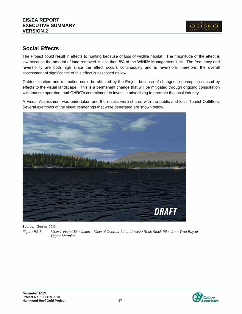
EIS/EA REPORT EXECUTIVE SUMMARY VERSION 2
December 2013 Project No. 13-1118-0010 Hammond Reef Gold Project 97
Social Effects The Project could result in effects to hunting because of loss of wildlife habitat. The magnitude of the effect is
low because the amount of land removed is less than 5% of the Wildlife Management Unit. The frequency and
reversibility are both high since the effect occurs continuously and is reversible; therefore, the overall
assessment of significance of this effect is assessed as low.
Outdoor tourism and recreation could be affected by the Project because of changes in perception caused by
effects to the visual landscape. This is a permanent change that will be mitigated through ongoing consultation
with tourism operators and OHRG’s commitment to invest in advertising to promote the local industry.
A Visual Assessment was undertaken and the results were shared with the public and local Tourist Outfitters.
Several examples of the visual renderings that were generated are shown below.
Source: Genivar 2013.
Figure ES-5: View 1 Visual Simulation – View of Overburden and waste Rock Stock Piles from Trap Bay of Upper Marmion

EIS/EA REPORT EXECUTIVE SUMMARY VERSION 2
December 2013 Project No. 13-1118-0010 Hammond Reef Gold Project 98
Source: Genivar 2013.
Figure ES-6 View 3 Visual Simulation – View of Process Plant from Sawbill Bay
Source: Genivar 2013.
Figure ES-7: View 8 Visual Simulation – View of Tailings Management Facility from Trapper Cabin

EIS/EA REPORT EXECUTIVE SUMMARY VERSION 2
December 2013 Project No. 13-1118-0010 Hammond Reef Gold Project 99
Source: Genivar 2013.
Figure ES-8 View 6 Visual Simulation – View of Tailings Management Facility from Trapper Cabin
The Human Health Risk Assessment showed that concentrations of DPM exceeded the screening threshold for
carcinogenic effects; therefore, DPM was evaluated following the chronic inhalation assessment method. The
calculated levels were less than the target cancer risk of 1 x 10⁻⁶ for all receptors except for one trapper cabin.
OHRG has an agreement in place with the trapline holder to restrict access to the cabin during the Construction
and Operations phases of the Project as required.
Mitigation is required for the adverse effects on trapline areas, bait fish blocks and bear management areas that
will be directly affected by the restriction of site access/removal of land as part of the construction of the Project.
The approach to mitigation is compensation and/or relocation based on negotiation with the land user.
Mitigation for adverse effects on trapping, bait fishing and bear hunting will involve negotiated agreements and
benefits upon approval of the EA and a decision to construct. Agreements are currently in place with the
adjacent tourism operator, overlapping trap line holder, bait fish block holder. Satisfactory completion of
negotiations and execution of agreements fully mitigate this effect.
In the noise assessment, measures prescribed by Health Canada for assessing exposure to noise and potential
human health effects were utilized. At receptor locations surrounding the Project, noise levels are within the
ranges reported for increased risk of hypertension and sleep disturbance. The magnitude of effect for noise is
considered to be low based on comparison to Health Canada targets and considering that predicted levels are in
the lower end of ranges for hypertension effects.

EIS/EA REPORT EXECUTIVE SUMMARY VERSION 2
December 2013 Project No. 13-1118-0010 Hammond Reef Gold Project 100
Socio-Economic Benefits The Project is anticipated to provide substantial socio-economic benefits to Aboriginal people, the local
community and the region and has garnered significant community support through ongoing partnerships and
information sharing.
The construction phase will involve a project workforce of 1,040 FTE or person-years of direct employment on
the Project, 780 of which will come from Ontario. The supplier/service industry will add 4,044 FTE or person-
years of direct employment, 2,335 of which will come from Ontario. Using standard industry multipliers for
indirect and induced employment, the total employment during the construction phase is estimated to be 9,557
FTE or person years, 4,287 of which will come from Ontario.
On an annual basis, the operations phase will involve a project workforce of 550 FTE or person-years of direct
employment on the Project, 440 of which will come from Ontario. The supplier/service industry will add 642 FTE
or person-years of direct employment, 428 of which will come from Ontario. Using standard industry multipliers
for indirect and induced employment, the total annual employment during the operations phase is estimated to
be 2,289 FTE or person years, 1,182 of which will come from Ontario. Over the 11 year operations phase, the
estimated direct, indirect and indirect employment is 25,179 FTE or person-years, 13,002 of which will come
from Ontario.
Table ES-8: Employment Opportunities for the Construction and Operations Phases of the Project
Phase Provincial Direct
National Direct
Provincial direct & indirect
National direct, indirect & induced
Construction Phase
Project workforce (FTE over 30 months)
780 1,040
Supplier/service industry employment
2,335 4,004
Total Employment (Years 1-3) 3,115 5,044 4,287 9,557
Operations Phase
Average annual Project workforce (FTE per year)
440 550
Average annual supplier/service industry employment
428 642
Annual Total Employment 868 1,192 1,182 2,289
Total Employment over 11 years 9,548 13,112 13,002 25,179
EIS/EA REPORT EXECUTIVE SUMMARY VERSION 2
December 2013 Project No. 13-1118-0010 Hammond Reef Gold Project 101
OHRG is committed to providing economic benefits to Aboriginal communities. Initiatives to maximize the
benefits the Project will have on Aboriginal communities include:
Scholarships.
Partnerships with local academic institutions.
On the job training.
A hire local priority policy.
Targeted employment, training and business opportunities.
OHRG aims to promote the utilization of Aboriginal enterprises whenever possible in supplying goods and/or
services required during each phase of the project. The criteria used for the evaluation and awarding of all
contracts by OHRG include cost competitiveness, continuity of supply, quality of work and timeliness.
OHRG will provide employment opportunities for the Project where possible and commercially reasonable.
Members of the surrounding local Aboriginal communities will take priority respecting employment opportunities
so long as they meet the requisite skills, education, experience and other job qualifications of a particular
position. Employment opportunities, and the corresponding job postings, will be communicated to the local
Aboriginal communities in a timely manner.
OHRG provided approximately $22,050 in direct investments to Aboriginal communities in 2012. A variety of
events and organizations were sponsored by OHRG to encourage the promotion of Aboriginal values and way of
life. Sponsorships of sports events and community gatherings were also provided. These investments
represent opportunities for ongoing cultural support of the identified Aboriginal communities throughout Project
operations.

EIS/EA REPORT EXECUTIVE SUMMARY VERSION 2
December 2013 Project No. 13-1118-0010 Hammond Reef Gold Project 102
Closing Statement The project will result in permanent changes to the landscape in the MSA, including a permanent WRMF, TMF
and Flooded Pit that will remain in Post-Closure. That considered, based on the findings of the environmental
assessment and planned mitigation measures, as documented in this EIS/EA Report, the Hammond Reef Gold
Project can be developed such that there is no significant residual impact to the biophysical environment. That
is to say, habitat will be compensated for, where necessary, and the lands of the LSA and RSA, excluding the
MSA, will be suitable for continued recreational enjoyment with no project related impacts to overall ecological or
human health.
Furthermore, it is considered that the Project provides substantial socio-economic benefits to Aboriginal people,
the local community and the region and has garnered significant community support through ongoing
partnerships and information sharing. The Project represents a major investment of capital into Ontario and
Canada’s economy. Based on capital costs of OHRG’s Canadian Malartic Mine, it is estimated that the total
capital cost of the proposed Hammond Reef Gold Project would be $1.4 billion ($2012 Canadian). The Project is
expected to return $36.2 million in personal income tax revenues to the province of Ontario over the 30 month
construction phase. Federal government income tax revenues during the construction phase are estimated to be
another $115.5 million. Throughout the 11 year operations phase, annual provincial personal taxes paid would
be approximately $12.7 million, while federal taxes would amount to another $18.1 million, for an annual total of
$30.8 million.