Hamilton Municipal Heritage Committee Agenda Package
27
City of Hamilton HAMILTON MUNICIPAL HERITAGE COMMITTEE ADDENDUM Meeting #: 18-009 Date: September 13, 2018 Time: 12:00 p.m. Location: Room 264, 2nd Floor, City Hall 71 Main Street West Loren Kolar, Legislative Coordinator (905) 546-2424 ext. 2604 7. STAFF PRESENTATIONS 7.1 Recommendation to Designate the Property Located at 828 Sanatorium Road, Hamilton (Long & Bisby Building) Under Part IV of the Ontario Heritage Act (PED18214) (Ward 8) (presentation to be distributed) *7.1.a Presentation respecting the Recommendation to Designate the Property Located at 828 Sanatorium Road, Hamilton
Transcript of Hamilton Municipal Heritage Committee Agenda Package

City of Hamilton
HAMILTON MUNICIPAL HERITAGE COMMITTEE ADDENDUM
Meeting #: 18-009Date: September 13, 2018Time: 12:00 p.m.
Location: Room 264, 2nd Floor, City Hall71 Main Street West
Loren Kolar, Legislative Coordinator (905) 546-2424 ext. 2604
7. STAFF PRESENTATIONS
7.1 Recommendation to Designate the Property Located at 828 Sanatorium Road,Hamilton (Long & Bisby Building) Under Part IV of the Ontario Heritage Act(PED18214) (Ward 8) (presentation to be distributed)
*7.1.a Presentation respecting the Recommendation to Designate the PropertyLocated at 828 Sanatorium Road, Hamilton
Recommendation to Designate Property Located at 828
Sanatorium Road, Hamilton (Mountain Sanatorium Brow Campus)
Under Part IV of the Ontario Heritage Act (PED18214)
September 13, 2018
PLANNING & ECONOMIC DEVELOPMENT DEPARTMENT Presented by: Jeremy Parsons
Page 2 of 27

PLANNING & ECONOMIC DEVELOPMENT DEPARTMENT
PED18214 – 828 Sanatorium Road, Hamilton Recommendation to Designate the Property Located at 828 Sanatorium
Road, Hamilton Under Part IV of the Ontario Heritage Act (PED18214)
(Ward 8)
Page 3 of 27

PLANNING & ECONOMIC DEVELOPMENT DEPARTMENT
PED18214 Appendix A
Page 4 of 27
PLANNING & ECONOMIC DEVELOPMENT DEPARTMENT
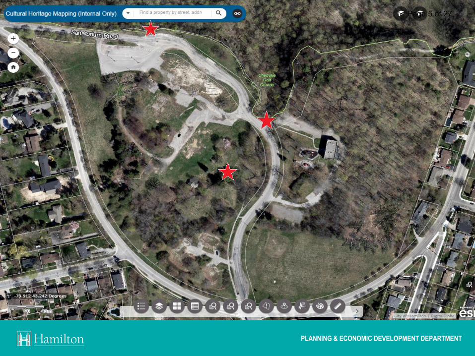
PED18142 Page 5 of 27

PLANNING & ECONOMIC DEVELOPMENT DEPARTMENT
PED18214
South-facing aerial view of the Sanatorium grounds in 1934 (Wilson, Chedoke: More Thank a Sanatorium, 2006).
Page 6 of 27

PLANNING & ECONOMIC DEVELOPMENT DEPARTMENT
PED18214
Undated images of Brow site showing the Brow Building (inset), East & West Pavilions, and ancillary buildings (Wilson, Chedoke: More Thank a Sanatorium, 2006).
Page 7 of 27
PLANNING & ECONOMIC DEVELOPMENT DEPARTMENT
PED18214
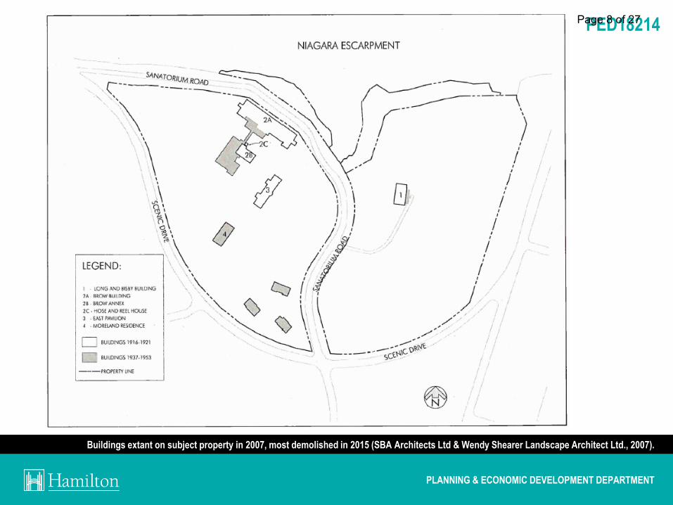
Buildings extant on subject property in 2007, most demolished in 2015 (SBA Architects Ltd & Wendy Shearer Landscape Architect Ltd., 2007).
Page 8 of 27

PLANNING & ECONOMIC DEVELOPMENT DEPARTMENT
PED18214
Annotated map of the once extant buildings of the Mountain Sanatorium (Wilson, Chedoke: More Thank a Sanatorium, 2006).
Page 9 of 27

PLANNING & ECONOMIC DEVELOPMENT DEPARTMENT
PED18214
History of 828 Sanatorium Road:
• 1906: Mountain Sanatorium opens in Hamilton.
• 1916-17: Brow Building, Annex, Hose & Reel House, and East Pavilion built.
• 1920: Long & Bisby Building built.
• 1936: Moreland Residence built.
• 1953: Cross of Lorraine built.
• 1961: Sanatorium becomes Chedoke General & Children’s Hospital.
• 1973: Long & Bisby houses alternative school for teens.
• 1979: Lands become part of Chedoke-McMaster Hospitals.
• 1997: Lands become part of Hamilton Health Sciences.
• 2006: Property sold to Deanlee Management Inc.
• 2007: New owners submit development application, appealed to OMB (2010).
• 2012: OMB ruling handed down.
• 2012: Property sold to Valery (Chedoke Browlands) Developments Inc.
• 2014: Demolition begins on all onsite buildings (except L&B Building)
• 2018: New development proposal initiated through Formal Consultation.
• 2018: Demolition Permit application received for Long & Bisby Building.
Page 10 of 27

PLANNING & ECONOMIC DEVELOPMENT DEPARTMENT
PED18214
Policy Context:
Urban Hamilton Official Plan (UHOP) • The subject lands are designated as Institutional lands in UHOP Schedule E-1. • Following the addition of recently-approved housekeeping amendments, the subject lands
will be designated as comprising Natural Open Space and Medium Density Residential 3.
• Included as a Cultural Heritage Landscape within updated UHOP.
Chedmac Secondary Plan • Includes site-specific heritage policies, including [italics added]:
• “The Long & Bisby Building…shall be retained and conserved through sympathetic adaptive
reuse, where structurally feasible…”
• “…uses contained within any existing heritage building shall not contribute to the overall unit
count gross floor area or density.”
• “Development shall be compatible with the existing cultural heritage landscape, such that
open spaces, plantings and the curvilinear street pattern are maintained and/or referenced in
the new development and that the layout and scale of buildings reflect the existing site…”
• “The preservation and conservation of other heritage resources shall be encouraged.”
Page 11 of 27
PLANNING & ECONOMIC DEVELOPMENT DEPARTMENT
PED18214
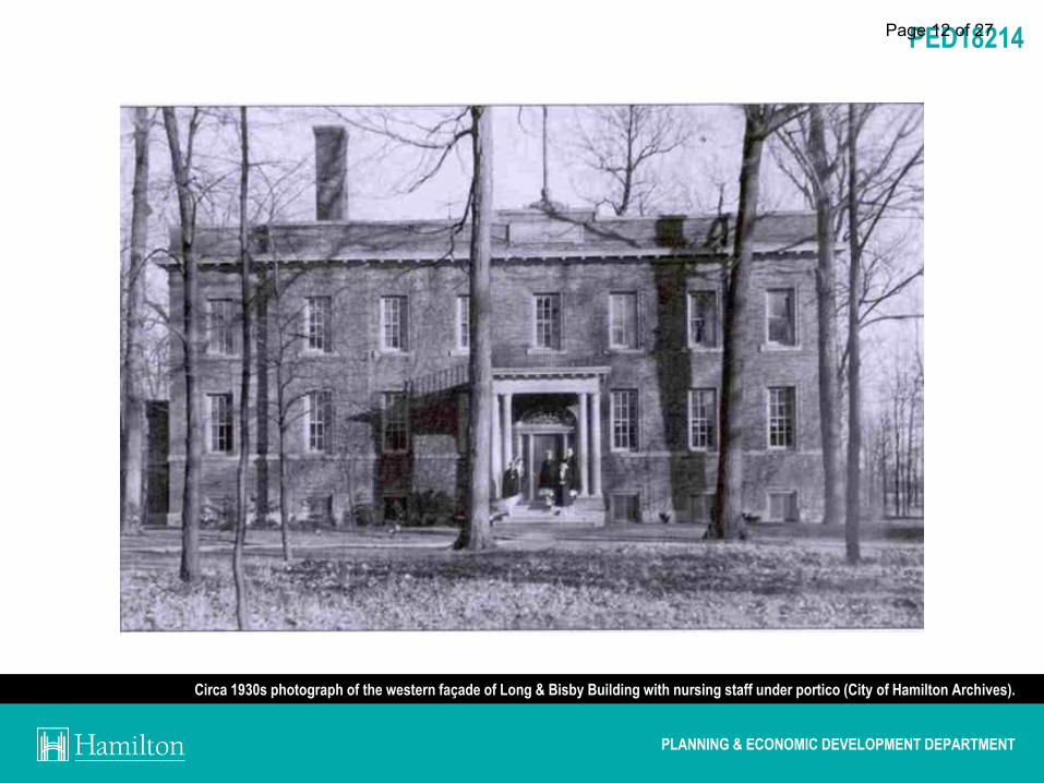
Circa 1930s photograph of the western façade of Long & Bisby Building with nursing staff under portico (City of Hamilton Archives).
Page 12 of 27

PLANNING & ECONOMIC DEVELOPMENT DEPARTMENT
PED18214
East-facing view of the Long & Bisby Building from Sanatorium Road (Parsons, 2018)
Page 13 of 27

PLANNING & ECONOMIC DEVELOPMENT DEPARTMENT
PED18214
Front façade (Parsons, 2018)
Page 14 of 27

PLANNING & ECONOMIC DEVELOPMENT DEPARTMENT
PED18214
A closer view of the entrance with portico, decorative transom window, sidelights, and brick voussoir (City of Hamilton Archives, 2007).
Page 15 of 27
PLANNING & ECONOMIC DEVELOPMENT DEPARTMENT
PED18214
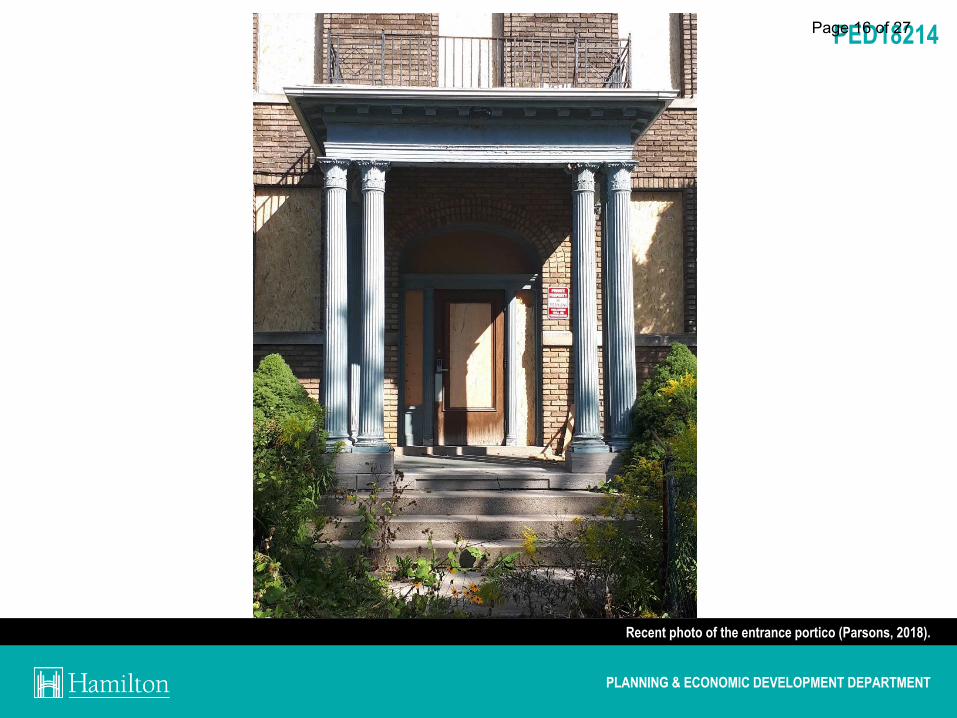
Recent photo of the entrance portico (Parsons, 2018).
Page 16 of 27

PLANNING & ECONOMIC DEVELOPMENT DEPARTMENT
PED18214
Decorative finial feature and inset stone atop the building’s modest parapet . The simple blue frieze board is visible below. (Flickr, 2014).
Page 17 of 27

PLANNING & ECONOMIC DEVELOPMENT DEPARTMENT
PED18214
Photograph of rear elevation with small vestibule additions (Parsons, 2018).
Page 18 of 27

PLANNING & ECONOMIC DEVELOPMENT DEPARTMENT
PED18214 Page 19 of 27
PLANNING & ECONOMIC DEVELOPMENT DEPARTMENT
PED18214
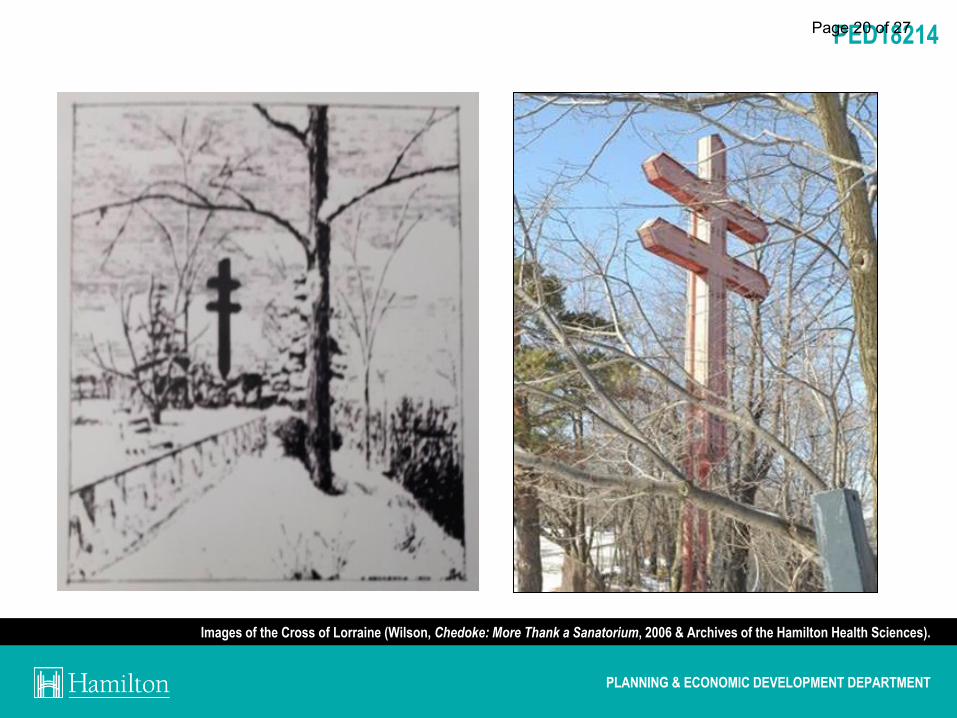
Images of the Cross of Lorraine (Wilson, Chedoke: More Thank a Sanatorium, 2006 & Archives of the Hamilton Health Sciences).
Page 20 of 27

PLANNING & ECONOMIC DEVELOPMENT DEPARTMENT
PED18214
The stone wall and pillars located between Sanatorium Road and the brow’s edge (Google Streetview, 2015).
Page 21 of 27

PLANNING & ECONOMIC DEVELOPMENT DEPARTMENT
PED18214
Evaluation under Ontario Regulation 9/06
1. Design / Physical Value (1/3)
The Long & Bisby Building Is a representative example of institutional Edwardian
Classical architecture. Designed by prominent local architects Witton and Walsh
(1920-1927), the nursing residence was built in 1920 and includes a number of
modest architectural features of note. The property also includes other landscape
features from the Sanatorium’s history including a concrete pedestrian bridge,
concrete stairs, and a stone wall and pillars. The Cross of Lorraine, which was built
in 1953 by the E.L. Ruddy Company, is a unique local landmark of physical value for
its location, size, functionality, and symbolism.
X Displays a high degree of craftsmanship or artistic merit.
X Demonstrates a high degree of technical or scientific achievement.
Page 22 of 27

PLANNING & ECONOMIC DEVELOPMENT DEPARTMENT
PED18214
Evaluation under Ontario Regulation 9/06
2. Historical / Associative Value (2/3)
The property is directly associated with the former Mountain Sanatorium (later
Chedoke Hospital). The L&B Building is last remaining building from the former Brow
campus and the only remaining building associated with WWI chronic care. The
building is also associated with local businessmen W.D. Long and G.H. Bisby who
donated funds for the building and were instrumental in the genesis of the
Sanatorium itself, having donated 96 acres of farmland in 1906. The Cross of
Lorraine is a recognizable symbol and landmark pointing to the site’s history.
X Does not have the potential to yield information that contributes to a greater
understanding of community or culture.
The L&B Building demonstrates or reflects the work of local architects Witton and
Walsh (1920-1927), built by well-known local contractors W. H. Cooper Construction
Ltd. The Cross of Lorraine was built by the E.L. Ruddy Company in 1953.
Page 23 of 27
PLANNING & ECONOMIC DEVELOPMENT DEPARTMENT
PED18214
Evaluation under Ontario Regulation 9/06
3. Contextual Value (3/3)
The property is important in defining and maintaining the character of the area as
former institutional lands and open space with views to the Escarpment. The
property’s tree cover and open space is reminiscent of the site’s historic rural setting
and therapeutic landscape. The property currently retains a curvilinear street pattern
established as part of the original institution.
The property Is historically linked to its surroundings.
The L&B Building and Cross of Lorraine are both identified as local landmarks
located at the edge of the Niagara Escarpment and at the terminus of Sanatorium
Road.
Page 24 of 27

PLANNING & ECONOMIC DEVELOPMENT DEPARTMENT
PED18214
Statement of Cultural Heritage Value or Interest (Appendix C) Heritage Attributes The Long & Bisby Building:
Its location in an open, park-like setting & adjacent to a woodlot;
All exterior elevations and additions;
Roof profile and roofline;
Entrance portico including:
Paired, Corinthian-inspired columns;
Simple cornice brackets; and,
Low metal railing.
Decorative entrance including:
Doorway;
Webbed fanlight;
Sidelights; and,
Brick voussoir.
Eight-bay buff brick façade with projecting ends;
Brick parapet including:
Lower frieze board;
Stone finial accent; and,
Inset stone block.
All window openings, stone sills, and side trim brick headers.
Page 25 of 27

PLANNING & ECONOMIC DEVELOPMENT DEPARTMENT
PED18214
Statement of Cultural Heritage Value or Interest (Appendix C) Heritage Attributes
Landscape Features:
The park-like setting as a cultural heritage
landscape with curvilinear street pattern
and open spaces designed for therapeutic
purposes;
The Cross of Lorraine located along the
edge of the Niagara Escarpment;
The pedestrian bridge over the Chedoke
Creek;
The concrete stairs along the edge of the
Niagara Escarpment; and,
The stone vehicular bridge and associated
stone wall/pillars located west of the Long
& Bisby Building.
Page 26 of 27

THANK YOU FOR ATTENDING
PLANNING & ECONOMIC DEVELOPMENT DEPARTMENT
THE CITY OF HAMILTON MUNICIPAL HERITAGE COMMITTEE
Page 27 of 27