Halting Desertification in the Júcar River Basin Preparatory Action on development of prevention...
23
Halting Desertification in the Júcar River Basin Preparatory Action on development of prevention activities to halt desertification in Europe Brussels, 16 February 2012 Elisa Vargas, Arancha Fidalgo
-
Upload
spencer-richard -
Category
Documents
-
view
215 -
download
1
Transcript of Halting Desertification in the Júcar River Basin Preparatory Action on development of prevention...

Halting Desertification in the Júcar River Basin
Preparatory Action on development of prevention activities to halt desertification in
Europe
Brussels, 16 February 2012
Elisa Vargas, Arancha Fidalgo
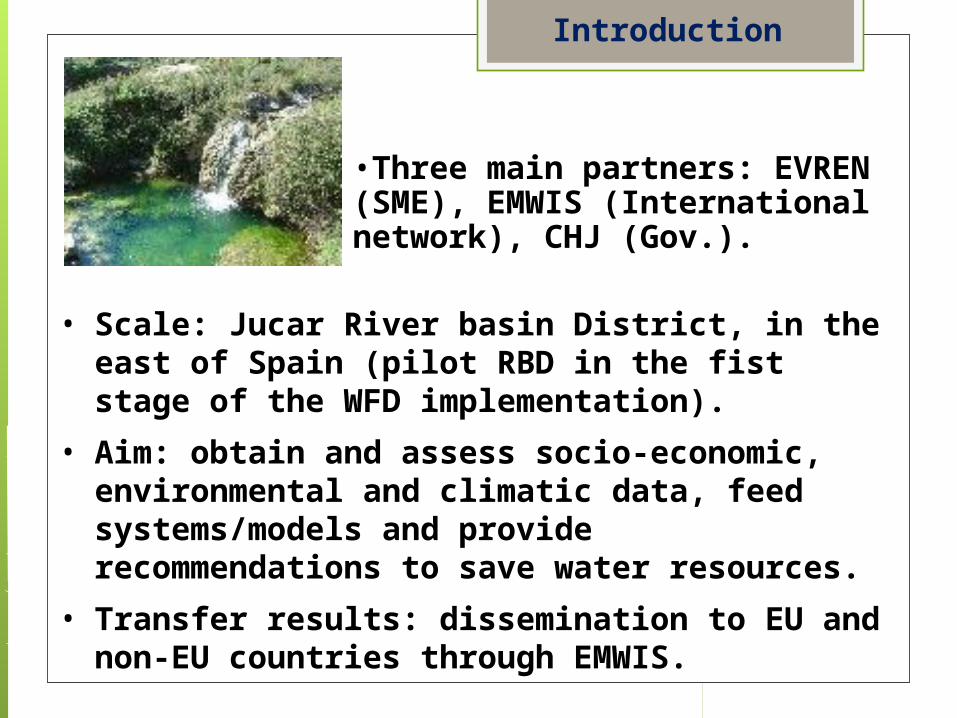
• Scale: Jucar River basin District, in the east of Spain (pilot RBD in the fist stage of the WFD implementation).
• Aim: obtain and assess socio-economic, environmental and climatic data, feed systems/models and provide recommendations to save water resources.
• Transfer results: dissemination to EU and non-EU countries through EMWIS.
Introduction
•Three main partners: EVREN (SME), EMWIS (International network), CHJ (Gov.).

• Environmental Consulting Firm (SME).• 23 years of experience.• Offices in Spain (Madrid, Valencia) and
Ecuador (Quito).• Areas of work:
• Water resources• Agronomy and forest resources• Coastal management• Land planning• Solid wastes• Sustainable touristic developments• Environmental Impact Assessment• Industrial environment• International projects
• Projects developed for Spanish Ministry of Agriculture, Food and Environment, River basin authorities, regional governments, international entities (EC, Plan Bleu-UNEP…).
EVREN

•Euro-Mediterranean Information System on know-how in the water sector•Initiative of the Euro-Mediterranean Partnership.
EMWIS
•Strategic tool for exchanging information and knowledge in the water sector.•Technical unit since 1999: 22 National Focal Points.•Steering Committee: Water Directors from 13 Mediterranean countries.•Joint Process: Coordinating working groups on water scarcity/Droughts and water quality monitoring•Support non-EU countries in implementing National Water Information Systems able to feed SEEA-W•Member of H2020 monitoring and ENPI-SEIS Med team

•Júcar River Basin Authority (CHJ)-Ministry of Agriculture, Food and Environment.
•Autonomous public entity.
•Responsibilities of the authority:
• Development, follow-up and update of the RBMP.
• Administration and control of the water public domain.
• Water resources management, supply follow-up (municipalities).
• Specific hydraulic works.
• Monitoring networks.
• Flood and water quality control hydrological studies.
• Hydrological planning.
• Rights, concessions, abstractions, discharges…
• Development of plans and programs for water saving, economic efficiency and environmental improvement.
• Definition of water quality and demand management action plans and programmes.
• Technical services related to the objectives and assessment to other administrations, institutions and individuals.
CHJ
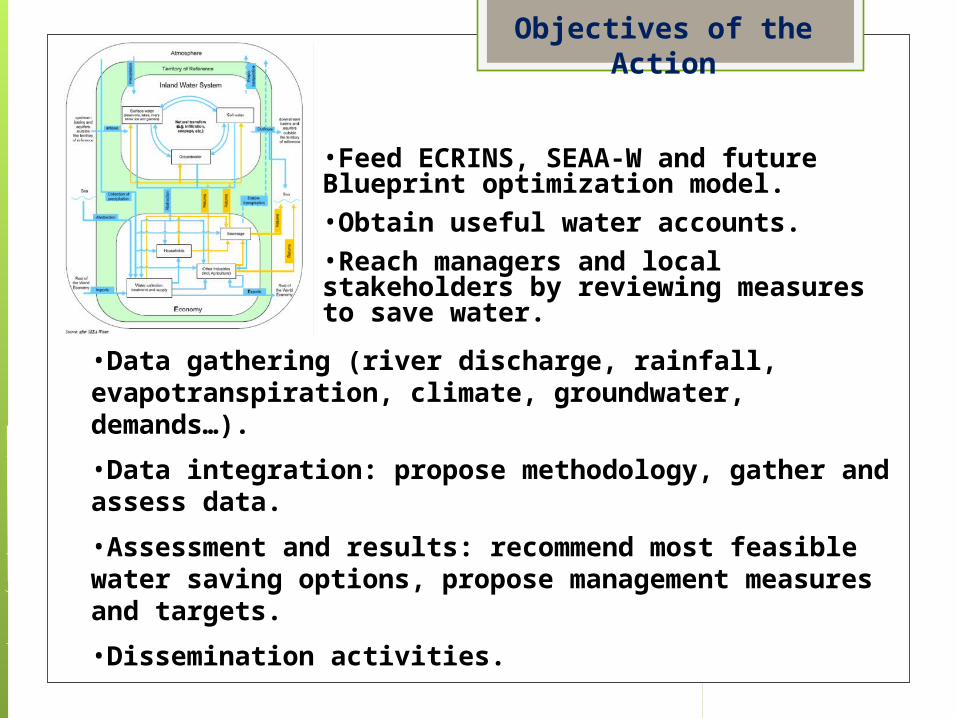
•Data gathering (river discharge, rainfall, evapotranspiration, climate, groundwater, demands…).
•Data integration: propose methodology, gather and assess data.
•Assessment and results: recommend most feasible water saving options, propose management measures and targets.
•Dissemination activities.
Objectives of the Action
•Feed ECRINS, SEAA-W and future Blueprint optimization model. •Obtain useful water accounts.•Reach managers and local stakeholders by reviewing measures to save water.

1.Establishment of background and context. (Jan.-Feb.)
• EU strategies, policies, SEEA-W, ECRINS, Júcar RBD features.
2.Collection of data and contacts with administrations and other partners. (Feb.-Apr.)
• Data delivery feasibility, improvement of datasets.
3.Apply method by SEEA-W and ECRINS specifications. (Apr.-July)
• Disaggregation, detailed water resources balance, identification of measures.
•Assessment and recommendations. (Sept.-Dec.)1.Estimate optimizations and water saving potentials,
propose feasible targets.
•Meetings and deliverables. (12 months)•Dissemination and capacity building. (12 months)
1.Web-site section EVREN, EMWIS e-bulletin and website.
Tasks

•Meetings: • 4 main working team meetings (EVREN+CHJ).
• 3 Partnership meetings (EVREN+EMWIS+CHJ+Stakeholders).
• 2 Video conferences with EC officials.
•Reports• 3 main reports + recommendations.
• Other: brochure, web-site sections, dissemination through e-bulletins, non-EU session, event at the final Blueprint Conference.
•Timetable
Deliverables & timetable

•Surface: 42.851km2.
•Population (2009): 5,1 million.
•Mediterranean climate (average temp. 14-16ºC; average annual rainfall 500 mm).
•High season variability.
•Relevant groundwater resources.
•Water scarcity & droughts.
• Drought management plan since 2007.
•Desertification: overexploitation of aquifers and salinization of soils.
•Relevant demographic and touristic pressures.
•A river basin facing most of the water resources challenges!
Júcar RB main features
CHJ
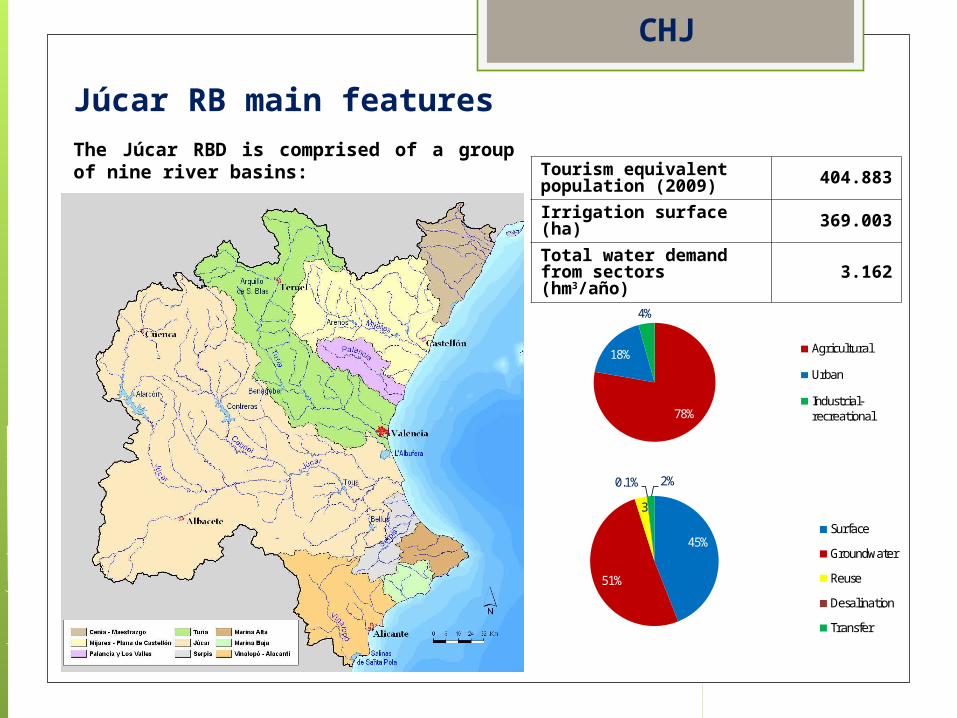
78%
18%
4%
Agricultural
Urban
Industrial-recreational
45%
51%
3
0.1% 2%
Surface
Groundwater
Reuse
Desalination
Transfer
Tourism equivalent population (2009) 404.883
Irrigation surface (ha) 369.003
Total water demand from sectors (hm3/año)
3.162
The Júcar RBD is comprised of a group of nine river basins:
CHJ
Júcar RB main features
Mean Annual Rainfall 21.446 hm3/year
Runoff3.933 hm3
Júcar RB hidrology
Aportación total a la red superficial (hm3 /año)
0300600900
1.2001.5001.8002.1002.4002.7003.0003.3003.6003.9004.2004.5004.8005.1005.4005.7006.0006.3006.600
1940
-41
1943
-44
1946
-47
1949
-50
1952
-53
1955
-56
1958
-59
1961
-62
1964
-65
1967
-68
1970
-71
1973
-74
1976
-77
1979
-80
1982
-83
1985
-86
1988
-89
1991
-92
1994
-95
1997
-98
2000
-01
2003
-04
Año
Aportación total 1940/41-2005/06 1980/81-2005/06 1940/41-1980/81
High spatial and temporal variability; Mediterranean Basin Feature
CHJ
Spatial Distribution of Annual Rainfall (mm/year) Time period: 1980/81–
2008/09.

UNESCO Humidity Index
There are 3 categories of Climatic Regions within the Júcar Basin District:
Semiarid
Sub humid
Humid
The UNESCO Humidity Index is an expression of the ratio:
pirationEvapotransPotentialionPrecipitat
:i
Júcar RBD: water
resources
CHJ

Irrigated crop Surface =
369.003 hectares
Agriculture water demand (2009)
GROSS UNIT DEMAND =
6.660 m³/ha/year
NET UNIT DEMAND=
4.020 m³/ha/year
TOTAL AGRICULTURE DEMAND
2.457,53 Hm3/year
CHJ

Main irrigated crops and irrigation systems
45%
11%7%
6%
6%
5%
5%
8%7%
Citrus
Grain cereal
Outdoor vegetables
Maize and sorghum
Wine grape
Other fruit trees
Rice
Other wood trees
Other herbaceous
CHJ
Sprinkle Irrigation System in Albacete
Drip Irrigation System in Valencia
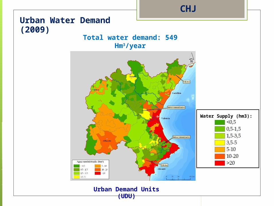
Urban Water Demand (2009)
Urban Demand Units (UDU)
Total water demand: 549 Hm3/year
CHJ
Water Supply (hm3):
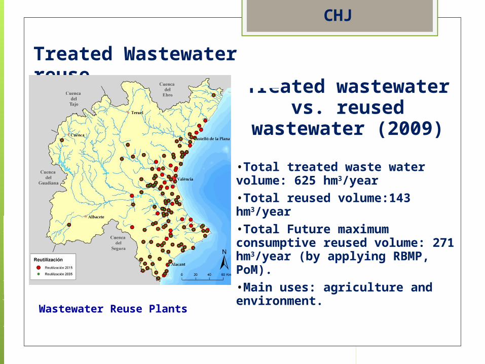
Wastewater Reuse Plants
Treated wastewater vs. reused
wastewater (2009)
•Total treated waste water volume: 625 hm3/year•Total reused volume:143 hm3/year •Total Future maximum consumptive reused volume: 271 hm3/year (by applying RBMP, PoM).•Main uses: agriculture and environment.
Treated Wastewater reuse
CHJ

Some of the most relevant water issues (identified in the draft RBMP).
• Water guarantee improvement and efficiency of traditional irrigation systems.
• Sustainable management of the Mancha Oriental aquifer.
• Overexploitation of GW in the Vinalopó area.
• Adjustment of ecological flows
• Ecosystem degradation
• Control of exotic species
• Adjustment and improvement of water treatment in specific municipalities
• Pollution control and eutrophication (Serpis and Albaida rivers)
• Flood risk reduction (low reach of Júcar River)
• Achievement of GES of the Albufera lake
• Water rights regularization
• Further assessment of wetland water requirements
• Priority substances follow-up
CHJ
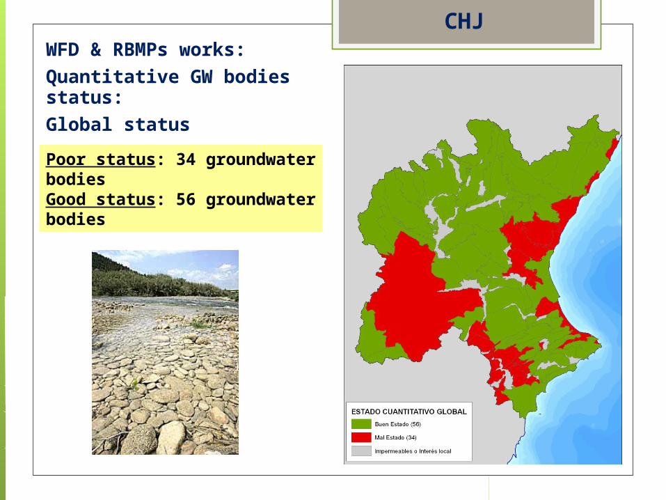
Poor status: 34 groundwater bodiesGood status: 56 groundwater bodies
WFD & RBMPs works:
Quantitative GW bodies status:
Global status
CHJ
Pilot activity on data harmonisation in Tunisia
• 2 technical missions in 2009
• Meetings with all the institutional stakeholders
• Inputs for the financial agreement with the African Water Facility
• Memorandum of understanding signed between 5 ministries for data sharing under SINEAU
• Potential technical assistance to the beneficiaries for:• Joint preparation of the reference data sets by the
national partners• Ensuring coherency with international standards
EMWISExperience related to the action

GW Network
Nappes phréatiques Nappes profondes
Région PuitsPiézomètres Total Forages Piézomètres Total
Nord 1119 327 1446 32 182 214
Centre 784 271 1055 20 224 244
Sud 405 160 565 12 212 224
Total 2308 758 3066 64 618 682
2308 puits ; 1376 piézomètres (500 équipés) ;
64 forages
3748 points d’observations
Experience related to the action EMWIS
Pilot activity on data harmonisation in Jordan
• 2 technical missions in 2010
• Meetings with the main stakeholders
• Validation with and commitment from the Minister of water and irrigation
• Endorsement by the Jordanian Prime Minister
• Draft concept note for a funding request under preparation
EMWISExperience related to the action
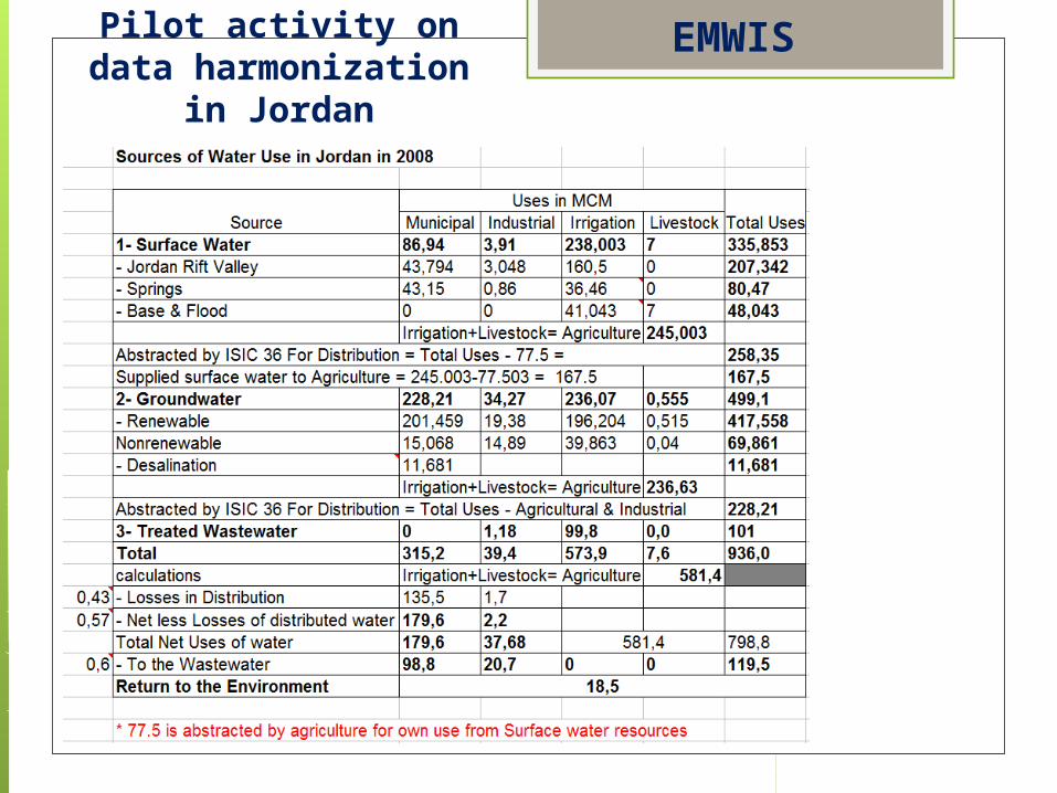
Pilot activity on data harmonization in
Jordan
EMWIS
Thank you for your attention!
Questions and comments:
[email protected]; [email protected]
www.evren.es; www.chj.es