HALSTED PROJECT ENHANCEMENT 7 SOUTH BUS …
2
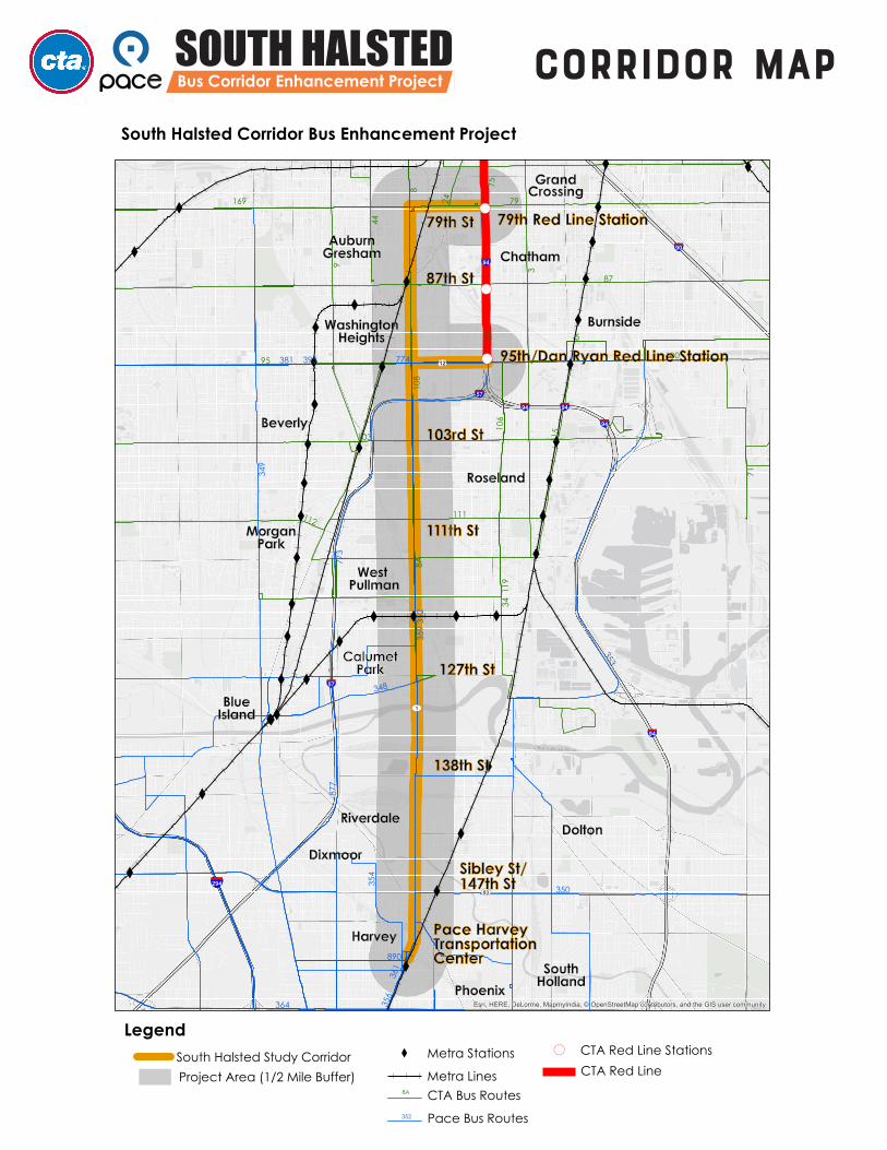
Project Overview The South Halsted Bus Corridor Enhancement Project was initiated by the Chicago Transit Authority (CTA) in partnership with Pace Suburban Bus to improve transit along approximately 11 miles of South Halsted Street, from the Pace Harvey Transportation Center to 79th Street. The corridor also includes segments of 79th and 95th Streets that provide connections to the CTA Red Line 79th and 95th Street Stations. The study corridor is located in the communities of Harvey, Phoenix, Calumet Park, Riverdale, Dixmoor and the City of Chicago neighborhoods of West Pullman, Morgan Park, Roseland, Washington Heights, and Auburn Gresham. This study will explore potential transit improvements for the corridor’s 13,000 daily transit customers. Improvements being considered as part of the project may include enhanced coordinated service plans, realigned bus stops, roadway treatments, and updated passenger amenities. Transit improvements developed in this study will complement CTA’s planned extension of the Red Line to 130th Street from 95th Street, which is currently undergoing the federal environmental review and planning process. PROJECT Corridor Today Current transit service on the corridor is provided by CTA routes #108 and #8A and by Pace routes #348, #350, #352, and #359. The corridor, which is largely commercial, intersects with Metra’s Rock Island Line at the Gresham Station, Metra Electric Line at the West Pullman and Harvey Stations, and the CTA Red Line at the 79th Street and 95th Street Stations. The corridor also serves as a connection point to the Major Taylor Trail and Cook County Forest Preserve’s Whistler Woods and Kickapoo Meadows. Project Contact [email protected] FEB MAR APR MAY JUN JUL AUG SEP OCT NOV DEC Project Kick-off CAG Meeting #1 - Project Needs & Deficiencies - Existing Conditions CAG Meeting #2 - Draft Potential Corridor Improvements CAG Meeting #3 - Draft Recommended Improvements Existing Conditions Analysis Improvement Strategies Development & Evaluation SOUTH HALSTED Bus Corridor Enhancement Project 2018 Project Timeline
Transcript of HALSTED PROJECT ENHANCEMENT 7 SOUTH BUS …
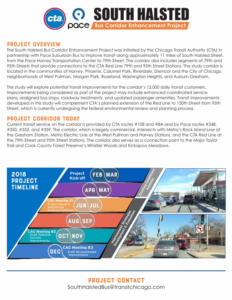
Project OverviewThe South Halsted Bus Corridor Enhancement Project was initiated by the Chicago Transit Authority (CTA) in partnership with Pace Suburban Bus to improve transit along approximately 11 miles of South Halsted Street, from the Pace Harvey Transportation Center to 79th Street. The corridor also includes segments of 79th and 95th Streets that provide connections to the CTA Red Line 79th and 95th Street Stations. The study corridor is located in the communities of Harvey, Phoenix, Calumet Park, Riverdale, Dixmoor and the City of Chicago neighborhoods of West Pullman, Morgan Park, Roseland, Washington Heights, and Auburn Gresham.
This study will explore potential transit improvements for the corridor’s 13,000 daily transit customers. Improvements being considered as part of the project may include enhanced coordinated service plans, realigned bus stops, roadway treatments, and updated passenger amenities. Transit improvements developed in this study will complement CTA’s planned extension of the Red Line to 130th Street from 95th Street, which is currently undergoing the federal environmental review and planning process.
PROJECT Corridor TodayCurrent transit service on the corridor is provided by CTA routes #108 and #8A and by Pace routes #348, #350, #352, and #359. The corridor, which is largely commercial, intersects with Metra’s Rock Island Line at the Gresham Station, Metra Electric Line at the West Pullman and Harvey Stations, and the CTA Red Line at the 79th Street and 95th Street Stations. The corridor also serves as a connection point to the Major Taylor Trail and Cook County Forest Preserve’s Whistler Woods and Kickapoo Meadows.
Project [email protected]
FEB MAR
APR MAY
JUN JUL
AUG SEP
OCT NOV
DEC
ProjectKick-off
CAG Meeting #1- Project Needs & Deficiencies- Existing Conditions
CAG Meeting #2- Draft Potential Corridor Improvements
CAG Meeting #3- Draft Recommended Improvements
Exi
stin
g Con
diti
ons
Ana
lysi
s
Impr
ovem
ent
Str
ateg
ies
Dev
elop
men
t &
Eva
luat
ion
SOUTH HALSTED
BUS CORRIDOR ENHANCEMENT PROJECT6
SOUTH HALSTEDBus Corridor Enhancement Project
8
SOUTH HALSTEDBUS CORRIDOR ENHANCEMENT PROJECT
10
SOUTH HALSTED
BUS CORRIDOR ENHANCEMENT PROJECT
7
SOUTH HALSTEDBUS CORRIDOR ENHANCEMENT PROJECT
9
5 SOUTH HALSTED
BUS CORRIDOR ENHANCEMENT PROJECT
2018ProjectTimeline
Corridor Map
SOUTH HALSTED
BUS CORRIDOR ENHANCEMENT PROJECT6
SOUTH HALSTEDBus Corridor Enhancement Project
8
SOUTH HALSTEDBUS CORRIDOR ENHANCEMENT PROJECT
10
SOUTH HALSTED
BUS CORRIDOR ENHANCEMENT PROJECT
7
SOUTH HALSTEDBUS CORRIDOR ENHANCEMENT PROJECT
9
5 SOUTH HALSTED
BUS CORRIDOR ENHANCEMENT PROJECT
X X X
X
X
X
XXXX
X
X
X
X
X
X
X
X
X
X
X
X
X
X
X
X
X
X
X
X
XX
X
X
X
X
X
X
X
X
X
X
X
X
X
X
X
!(
!(
!(
8
71
115
9
75
24
8A
11111
9
5
95
106
103
100
34
108
44
169
3
87
112
29
79
890
361
348
356
773
359
877
354
364
381 395
350
349
774
352
353
UV1
UV83
0112
§̈¦57
§̈¦94
§̈¦94
§̈¦57
§̈¦94
§̈¦94
§̈¦90
§̈¦294
§̈¦94
Esri, HERE, DeLorme, MapmyIndia, © OpenStreetMap contributors, and the GIS user community
South Halsted Corridor Bus Enhancement Project
Legend
CTA Bus Routes
Pace Bus Routes
South Halsted Study Corridor X Metra Stations
Metra Lines8A
352
CTA Red Line Stations
CTA Red Line
!(
Project Area (1/2 Mile Buffer)
87th St
79th St
103rd St
127th St
138th St
Sibley St/147th St
Pace Harvey TransportationCenter
GrandCrossing
AuburnGresham Chatham
Burnside
Roseland
Beverly
MorganPark
CalumetPark
BlueIsland
Dixmoor
Harvey
Phoenix
SouthHolland
DoltonRiverdale
West Pullman
WashingtonHeights
79th Red Line Station
111th St
95th/Dan Ryan Red Line Station