Habitat Restoration Planning Guide for Natural Resource ...
72
Habitat Restoration Planning Guide for Natural Resource Managers www.environment.sa.gov.au
Transcript of Habitat Restoration Planning Guide for Natural Resource ...

www.environment.sa.gov.au
Habitat Restoration Planning Guide for Natural Resource Managers
www.environment.sa.gov.au

Clarke, I. Stokes, Z. and Wallace, R., 2010, Habitat Restoration Planning Guide for Natural Resource Managers, Government of South Australia, through Department of Environment and Natural Resources, Adelaide
Habitat Restoration Planning Guide for Natural Resource Managers
Native Vegetation Council

ContentsIntroduction . . . . . . . . . . . . . . . . . . . . . . . . . . . . . . . . . . 2
How to use this Guide . . . . . . . . . . . . . . . . . . . . . . . . . . 4
The Restoration Process . . . . . . . . . . . . . . . . . . . . . . . . 5Overview . . . . . . . . . . . . . . . . . . . . . . . . . . . . . . . . . . . . . . . . . . . . . . . . . . . . . . . .5
Summary of the restoration process . . . . . . . . . . . . . . . . . . . . . . . . . . . . . . . . .6
Setting Restoration Goals . . . . . . . . . . . . . . . . . . . . . . 7What is a restoration goal? . . . . . . . . . . . . . . . . . . . . . . . . . . . . . . . . . . . . . . . . .7
Targets of restoration . . . . . . . . . . . . . . . . . . . . . . . . . . . . . . . . . . . . . . . . . . . . . .8
Timeframes for restoration goals . . . . . . . . . . . . . . . . . . . . . . . . . . . . . . . . . . . .9
Summary . . . . . . . . . . . . . . . . . . . . . . . . . . . . . . . . . . . . . . . . . . . . . . . . . . . . . . .10
Further information . . . . . . . . . . . . . . . . . . . . . . . . . . . . . . . . . . . . . . . . . . . . . . .10
Identifying the Restoration Goal State . . . . . . . . . . . .11How habitats have been damaged . . . . . . . . . . . . . . . . . . . . . . . . . . . . . . . .11
Desired qualities of the goal state . . . . . . . . . . . . . . . . . . . . . . . . . . . . . . . . . .12
Habitat adequacy . . . . . . . . . . . . . . . . . . . . . . . . . . . . . . . . . . . . . . . . . . . . . . .12
Habitat inventory . . . . . . . . . . . . . . . . . . . . . . . . . . . . . . . . . . . . . . . . . . . . . . . . 12
Habitat composition and structure . . . . . . . . . . . . . . . . . . . . . . . . . . . . . . . . . 13
Functional roles and groups . . . . . . . . . . . . . . . . . . . . . . . . . . . . . . . . . . . . . . . 14
Habitat connectivity and patch size . . . . . . . . . . . . . . . . . . . . . . . . . . . . . . . 16
Resilient habitat . . . . . . . . . . . . . . . . . . . . . . . . . . . . . . . . . . . . . . . . . . . . . . . . .19
Climate change considerations . . . . . . . . . . . . . . . . . . . . . . . . . . . . . . . . . . .20
Predicted impacts of climate change . . . . . . . . . . . . . . . . . . . . . . . . . . . . . . 20
Maximise adaptive potential . . . . . . . . . . . . . . . . . . . . . . . . . . . . . . . . . . . . . . 20
Reference sites and goal states . . . . . . . . . . . . . . . . . . . . . . . . . . . . . . . . . . . .22
Summary . . . . . . . . . . . . . . . . . . . . . . . . . . . . . . . . . . . . . . . . . . . . . . . . . . . . . . .24
Further information . . . . . . . . . . . . . . . . . . . . . . . . . . . . . . . . . . . . . . . . . . . . . . .25
Site Assessment . . . . . . . . . . . . . . . . . . . . . . . . . . . . . . 26Aims . . . . . . . . . . . . . . . . . . . . . . . . . . . . . . . . . . . . . . . . . . . . . . . . . . . . . . . . . . .26
Soils and landforms . . . . . . . . . . . . . . . . . . . . . . . . . . . . . . . . . . . . . . . . . . . . . .26
Infrastructure . . . . . . . . . . . . . . . . . . . . . . . . . . . . . . . . . . . . . . . . . . . . . . . . . . . .27
Habitat attributes . . . . . . . . . . . . . . . . . . . . . . . . . . . . . . . . . . . . . . . . . . . . . . . .27
Landscape context . . . . . . . . . . . . . . . . . . . . . . . . . . . . . . . . . . . . . . . . . . . . . .27
Threats . . . . . . . . . . . . . . . . . . . . . . . . . . . . . . . . . . . . . . . . . . . . . . . . . . . . . . . . .28
Regeneration potential . . . . . . . . . . . . . . . . . . . . . . . . . . . . . . . . . . . . . . . . . . .29
Investigating the soil seed bank . . . . . . . . . . . . . . . . . . . . . . . . . . . . . . . . . . . 29
Historical influences . . . . . . . . . . . . . . . . . . . . . . . . . . . . . . . . . . . . . . . . . . . . . . 30
Site assessment methods . . . . . . . . . . . . . . . . . . . . . . . . . . . . . . . . . . . . . . . . .31
Qualitative vs. quantitative data collection . . . . . . . . . . . . . . . . . . . . . . . . . 31
Mapping . . . . . . . . . . . . . . . . . . . . . . . . . . . . . . . . . . . . . . . . . . . . . . . . . . . . . . . 31
Summary . . . . . . . . . . . . . . . . . . . . . . . . . . . . . . . . . . . . . . . . . . . . . . . . . . . . . . .32
Further Information . . . . . . . . . . . . . . . . . . . . . . . . . . . . . . . . . . . . . . . . . . . . . . .32
Habitat Restoration Planning Guide for Natural Resource Managers

Restoring Towards a Goal State . . . . . . . . . . . . . . . . . 33States and transitions . . . . . . . . . . . . . . . . . . . . . . . . . . . . . . . . . . . . . . . . . . . . .33
Directing the pathway of change . . . . . . . . . . . . . . . . . . . . . . . . . . . . . . . . . .35
Management context . . . . . . . . . . . . . . . . . . . . . . . . . . . . . . . . . . . . . . . . . . . .39
Maintain . . . . . . . . . . . . . . . . . . . . . . . . . . . . . . . . . . . . . . . . . . . . . . . . . . . . . . . . 39
Improve . . . . . . . . . . . . . . . . . . . . . . . . . . . . . . . . . . . . . . . . . . . . . . . . . . . . . . . . 41
Reconstruct . . . . . . . . . . . . . . . . . . . . . . . . . . . . . . . . . . . . . . . . . . . . . . . . . . . . . 42
Factors affecting management decisions . . . . . . . . . . . . . . . . . . . . . . . . . . .46
Adaptive management . . . . . . . . . . . . . . . . . . . . . . . . . . . . . . . . . . . . . . . . . . .46
Summary . . . . . . . . . . . . . . . . . . . . . . . . . . . . . . . . . . . . . . . . . . . . . . . . . . . . . . .48
Further information . . . . . . . . . . . . . . . . . . . . . . . . . . . . . . . . . . . . . . . . . . . . . . .48
Monitoring and Evaluation . . . . . . . . . . . . . . . . . . . . . .49Objectives . . . . . . . . . . . . . . . . . . . . . . . . . . . . . . . . . . . . . . . . . . . . . . . . . . . . . .49
Linking project milestones and monitoring . . . . . . . . . . . . . . . . . . . . . . . . . .50
Indicators . . . . . . . . . . . . . . . . . . . . . . . . . . . . . . . . . . . . . . . . . . . . . . . . . . . . . . .51
Habitat development . . . . . . . . . . . . . . . . . . . . . . . . . . . . . . . . . . . . . . . . . . . . 51
Ecosystem function . . . . . . . . . . . . . . . . . . . . . . . . . . . . . . . . . . . . . . . . . . . . . . 51
Sampling effort . . . . . . . . . . . . . . . . . . . . . . . . . . . . . . . . . . . . . . . . . . . . . . . . . .54
Giving monitoring data context . . . . . . . . . . . . . . . . . . . . . . . . . . . . . . . . . . .54
Summary . . . . . . . . . . . . . . . . . . . . . . . . . . . . . . . . . . . . . . . . . . . . . . . . . . . . . . .56
Further information . . . . . . . . . . . . . . . . . . . . . . . . . . . . . . . . . . . . . . . . . . . . . . .56
Developing a Restoration Plan . . . . . . . . . . . . . . . . . 57Contents of a restoration plan . . . . . . . . . . . . . . . . . . . . . . . . . . . . . . . . . . . . .57
Using management units . . . . . . . . . . . . . . . . . . . . . . . . . . . . . . . . . . . . . . . . .58
Seeking advice and input . . . . . . . . . . . . . . . . . . . . . . . . . . . . . . . . . . . . . . . . .58
Guide Summary . . . . . . . . . . . . . . . . . . . . . . . . . . . . . .59
Glossary . . . . . . . . . . . . . . . . . . . . . . . . . . . . . . . . . . . . 60
References . . . . . . . . . . . . . . . . . . . . . . . . . . . . . . . . . . 63
1 Habitat Restoration Planning Guide for Natural Resource Managers

IntroductionHabitat loss and degradation is the most important cause of species decline and extinction in Australia. The biodiversity of South Australia’s temperate agricultural regions is in overall decline and it is recognised that a range of restoration actions are needed now to halt further decline.
For the purpose of this guide, ‘ecological restoration’ can be defined as: ‘the assisted recovery of degraded ecological systems’. ‘Habitat restoration’ focuses on providing suitable environments and resources for target species or groups of species that are currently in decline due to past habitat clearance or degradation.
Natural resource managers face many challenges in trying to conserve biodiversity in a changing world. As there are many ecosystems, communities and species in decline, it is not possible (nor always socially or economically feasible) to address all problems of biodiversity decline in all areas. So it is important to prioritise exactly which problem is to be the focus of the restoration effort and identify clear goals.
This guide promotes a goal-based approach to habitat restoration in South Australia’s temperate agricultural regions. Developing ecologically-based goals for restoration will help clarify project planning, implementation, monitoring and evaluation of outcomes.
This booklet aims to provide a guide to natural resource managers for those situations where general restoration actions (such as threat abatement and re-instatement of habitat) will be feasible to prevent further decline of targeted species or species groups. The guide does not prioritise species for restoration but does outline some considerations about the feasibility of restoration given different landscape contexts and starting points. It does not attempt to cover situations such as the re-introduction of fauna where these have become regionally extinct.
The temperate agricultural regions of South Australia cross six Natural Resources Management Board regions, each with a diverse range of landscapes disturbed to varying degrees. Many habitat restoration scenarios are possible. Therefore this guide is not prescriptive. It summarises major ecological concepts relevant to the restoration of terrestrial habitats and outlines some on-ground considerations that could improve project design and implementation. It is up to the individual manager to evaluate the relevance for their own project and site.
It should be recognised that there is considerable debate in the field of restoration ecology about some theoretical concepts and approaches, particularly in the face of climate change. The supporting science is still developing and our understanding of the processes that underpin sustainable systems is increasing with time. It is expected that this document will encourage discussion and feedback as we learn more about actively managing and restoring habitat in our landscapes, and thus favoured approaches may change over time.This section of the management plan discusses the important
Habitat Restoration Planning Guide for Natural Resource Managers 2

Figure 2: Vegetation in transition after a disturbance event (Photo: I . Clarke)
Figure 1: What is the right action to restore to an identified state? (Photo: R . Wallace)
3 Habitat Restoration Planning Guide for Natural Resource Managers 3 Habitat Restoration Planning Guide for Natural Resource Managers

Effective restoration planning requires a good understanding of both ecological concepts and practical considerations. Experienced planners may be familiar with the concepts presented in this guide, in which case the guide may serve as a planning checklist, whereas those new to the topic may find it useful as a basis to understand the complexities of the restoration process and a pointer to find further information. Key sources of further information are given at the end of each chapter and a glossary of terms is included at the end of the guide.
The structure of the guide aims to give background information first that leads up to understanding the major components of a restoration plan.
PART 1: The Restoration ProcessAn overview of the restoration planning process, the need to set clear restoration goals and to have a clear picture of what habitat is being restored for.
PART 2: Setting Restoration Goals How to develop specific measurable, agreed-upon, realistic and time-bound goals
PART 3: Identifying the Restoration Goal StateHow habitats have become degraded. How to determinethe characteristics desired for restored habitat (the ‘goal state’) and factors to consider given future climate change.
PART 4: Site AssessmentHow to assess the current state and condition of a site and the factors that may influence change over time.
PART 5: Restoring Towards a Goal StateAn outline of how site states can change over time. Predicting the outcomes of management and choosing suitable restoration actions. A brief overview of the principles of adaptive management is given so that restoration planners can consider the relevance of this approach when outcomes of management are uncertain.
PART 6: Monitoring and EvaluationAn overview of key considerations for monitoring and evaluation to determine if a habitat restoration project is on track to meet goals.
PART 7: Developing a Restoration PlanA summary of the possible topics to consider as part of a habitat restoration plan. Key tips to aid in planning.
How to use this Guide
Habitat Restoration Planning Guide for Natural Resource Managers 4

OverviewHabitat is a species-specific concept. For example, some species can survive and prosper in areas largely cleared of native vegetation (think of Galahs using open paddocks) whilst others will decline in the same situation. To restore habitat implies that there are one or more problems with the current state of a site or system that requires ‘fixing’ for a particular species or group of species. To restore habitat most effectively and monitor success, planners need to clearly identify target species or groups of species that they are restoring habitat for and why they are doing it.
Landscape-scale restoration goals should ideally be developed to clarify what in the landscape is currently inadequate to meet the needs of the species of interest. Landscape-scale goals should then inform site-scale goals.
Restoration goals should be identified that are specific, measurable, agreed upon, realistic and time-bound. Stakeholder consultation is important for identifying and agreeing upon restoration goals.
The ideal ‘goal state’ (composition and structure) for restored habitat should be identified from an understanding of the target species requirements, what their healthy habitats look like, how ecological communities function and how they may change over time. Ideally, planners need to not only have a clear vision of what the habitat should look like but where it will best be located to fulfill species needs across the wider landscape.
Identifying restoration goals and desired habitat states is an iterative process which begins with understanding the past, current and possible future states of the system being worked on (at the landscape scale and at the site scale). A site assessment should identify the current state of the site and the level of management intervention that is needed to shift the species composition and structure towards the goal state. Goals may need to be redefined if the actions required to meet the goal state are too difficult or require resources beyond those available.
Outcomes of restoration actions, such as revegetation, are often not certain at sites with variable starting conditions and an erratic climate (e.g. unreliable rainfall). Restoration at such sites (particularly where they are large-scale) may be directed through trialing different management approaches. Restoration planners may set up scientific trials in an adaptive management framework so that project managers can learn from outcomes and help direct implementation in later stages.
Timeframes for restoration projects often relate to budget timeframes set by funding bodies, but ecological development generally occurs over a much longer timeframe. Implementation may occur in several different ‘phases’ or stages over time. The time taken for habitat to be restored to the goal state will affect how goal statements are written and how monitoring of outcomes is designed and scheduled.
1 A ‘site’ may be any size and is defined by the area encompassed by project boundaries at the property level.
2 A ‘landscape’ is an area of interest consisting of two or more ecosystems that exchange organisms, energy, water and nutrients; in the scale of hundreds to thousands of hectares.
The Restoration Process
5 Habitat Restoration Planning Guide for Natural Resource Managers

Summary of the restoration processThe fundamental steps for planning and implementing restoration projects are:
Define aspirational restoration goals and target species.1.
Understand what healthy habitat looks like for the target species of interest and how the habitat 2. may naturally change over time (e.g. disturbance cycles).
Define a desired goal state (e.g. plant species composition and structure) for the habitat.3.
Identify the current state and threats to the habitat in the landscape and site of interest 4. (What desired elements are missing? What impact does each threat have?).
Identify general restoration actions that can be undertaken to reach the desired state.5.
Summarise actions in a draft implementation plan, prepare draft budget and work plan.6.
Redefine specific, measurable, agreed-upon, realistic and timebound restoration goal(s) for the system 7. after feasibility review and set achievable milestones.
Develop an adaptive management plan if required (may further redefine goals).8.
Implement the first phase of restoration actions.9.
Monitor outputs and outcomes.10.
Re-evaluate the situation, review assumptions about the system, revise goals/targets/milestones if 11. needed.
Implement other stages of restoration actions (if required) and manage the site(s) adaptively 12. (as informed by monitoring results).
Appropriate stakeholder consultation should be carried out at each step that requires key decisions to be made.
Figure 3: Implement other restoration actions (if required) and manage the site adaptively to reach your identified goals (Photo: R . Wallace)
Habitat Restoration Planning Guide for Natural Resource Managers 6

What is a restoration goal?What should be restored depends on why it is perceived that restoration is necessary. A restoration goal is a description of the desired outcome of restoration. Projects can be developed in one of two ways: goals are defined in the context of a large-scale outcome and sites are then identified for meeting outcomes; or, a site becomes opportunistically available and goals are developed in the context of the site. If the broader restoration goal(s) haven’t been identified through regional planning, a site assessment, and the baseline data collected at the beginning of a project, can inform the development of appropriate goal(s) for a site.
Use the S .M .A .R .T . approach to setting goals, with expected project outcomes that are:
specific•
measurable•
agreed-upon•
realistic •
time-bound.•
‘Specific’ refers to the target of restoration: e.g. the habitat to be restored and the particular species, or species group, that the restored site is aiming to provide habitat for.
‘Measurable’ indicates that the expected outcome (e.g. quantity of habitat being restored and/or target species population change) should be able to be measured compared to some baseline state.
‘Agreed-upon’ recognises that setting project goals goes beyond just ecological considerations. Social and economic factors also need to be considered. Thus the goal-setting process should involve input from representatives of all key stakeholders who may be involved in, affected by, or benefit from the project.
‘Realistic’ means that the goal should be feasible to achieve.
‘Time-bound’ means that there should be an expectation given of how long it will take to reach the goal.
The goal-setting process can utilise a ‘program logic’ process. Start off by identifying aspirational goals or visions for the area of interest and then define further into a hierarchy of SMART goals, output targets and milestones once practical considerations of resourcing, timeframes and feasibility of methods has been taken into account. Higher level goals are further discussed in ‘Desired qualities of the goal state’ on page 12.
Setting Restoration Goals
An example of such a SMART restoration goal for a landscape could be:
“Restore 1000 hectares of woodland habitat types X and Y in landscape A to significantly improve survival and breeding of species in response group Z by 2030 compared to levels in 2010”.
A site-level SMART restoration goal could be:
“Restore 50 hectares of woodland habitat type X at Site A to significantly improve the numbers of pairs of species in response group Z breeding at the site by 2307 compared to levels in 2010”.
7 Habitat Restoration Planning Guide for Natural Resource Managers 7 Habitat Restoration Planning Guide for Natural Resource Managers

Targets of restorationAs habitat is a species-specific concept, habitat restoration goal statements should ideally identify particular species or functional groups that are the targets of restoration. The needs of the target species will determine which habitat composition and structure (i.e which ‘goal state’) is desirable at the restoration site and therefore the level of importance placed on which components are restored.
Identifying the species for which habitat should be restored will depend on the information available and the scope of the restoration program. Certain target species are sometimes chosen because it is thought that by meeting their needs, a wide range of other species will also benefit. Sometimes, species information is lacking and a general landscape approach is taken. Any one approach will not effectively conserve all species in an area. The strengths and weaknesses of some possible approaches to restoration and the focus of restoration programs are summarised in Table 1.
Table 1: Approaches to identifying the targets of restoration, with associated strengths and weaknesses
Target of restoration Restoration focus Strengths and weaknesses
Threatened species Project focuses on providing requirements of species with a conservation rating.
Addresses the specific needs of priority species; can be particularly resource intensive if populations are in critical state so requires cost benefit analysis.
Focal species A group of species that collectively are most at risk of threatening processes within a landscape – restoration efforts are focused on these species assuming that other less threatened species will also be conserved by the actions.
Sound approach if data are available to indicate which species are most at threat (often lacking).
Functional response group
A group of actively declining species that are associated with a particular habitat and are affected by the same threats or losses in habitat components.
Sound approach and may optimise use of resources to target more than one declining species at a time, but data are lacking to confidently identify species trends and functional response groups for many areas.
Keystone species Project focuses on managing for species whose presence is considered crucial to maintaining the organisation and function of the ecosystem.
Data often lacking to identify keystone species; may or may not address needs of individual declining species.
Umbrella species Project focuses on restoring for species that require large areas of habitat, providing the “umbrella” for other species.
Assumes that other species are threatened by the same processes as the umbrella species which may not be the case.
Flagship species Project focuses on restoring habitat for well-known and usually ‘likeable’ species to generate public interest and support.
May provide resources for a range of associated species but may or may not address the needs of species in decline.
Patch size and connectivity across landscape
Project does not necessarily have a species-specific goal; focuses on connectivity, size and arrangement of habitat patches with the general idea that ‘bigger and more connected’ patches are better for overall species diversity.
Often used, this approach may be hit and miss in whether it addresses the habitat needs of priority species currently in decline; may encourage dispersal of pest species if these threats are not addressed concurrently.
Habitat Restoration Planning Guide for Natural Resource Managers 8Habitat Restoration Planning Guide for Natural Resource Managers 8

Some targets of restoration programs may be identified in regional plans (e.g. Regional Natural Resources Management Plans, Conservation Action Plans, Threatened Species Recovery Plans). Obvious targets often mentioned are threatened species. Some threatened species have such low population levels that they will require highly tailored recovery actions that are beyond the scope of this guide.
Unfortunately, for many species there is often not enough data on their particular requirements. It is also very expensive to take a species-by-species approach and there are not enough resources available to manage entirely in this fashion. A feasibility assessment should be undertaken (cost versus likelihood of potential recovery) as some threatened species recovery may be over-demanding of resources to the detriment of wider systems in decline.
Landscapes can be modeled to identify groups of species associated with particular habitats that are in active decline and are believed to be affected by similar threats. Identification of ‘functional response groups’ as priority targets of restoration potentially gives better returns on investment than a single species approach. Landscape modeling and the identification of functional response groups is being undertaken for various regions in SA, but requires further research and development to be available to the NRM community at large.
In the absence of targeted regional goals and if uncertainty about the system is high, then data collection and knowledge gathering itself may need to be the focus of actions. Where some information is available from expert opinion and experience, this can be used to identify possible species at risk and focus further data collection to inform SMART goal setting.
Timeframes for restoration goals When setting timeframes for goals to be achieved, be realistic in what can be achieved given the site’s initial condition, the timeframe of funding availability and how long it takes for a restored community to mature. For example, most South Australian tree species will become reproductive 5-10 years after they are planted, but they will not be at full size structurally for many decades, which may determine their suitability as habitat. Large hollows in tree limbs, an important habitat feature for some fauna, can take in the order of a hundred years and more to fully develop.
Goals may be linked to project funding timeframes and outputs or they may reflect the different phases of restoration and ecosystem development (or both). Depending on the initial state of a site, there are up to four phases that can be associated with achieving a restoration goal (Table 2).
Figure 4: The Malleefowl is a threatened species often used as a ‘flagship’ species to generate interest in conservation projects
9 Habitat Restoration Planning Guide for Natural Resource Managers

Habitat Restoration Planning Guide for Natural Resource Managers 10
Ideally, all projects would develop the restoration site to an advanced ecosystem stage. Due to budget constraints and the short nature of project timeframes, restoration projects that start with a highly degraded system often only deal with the first two phases and are left with the hope that ‘nature will sort out the rest’. Providing for long-term management is an ongoing challenge facing restoration planners.
Further informationWest (2008) gives a brief overview of setting restoration goals and planning considerations.
The ‘focal species’ concept is discussed by Lambeck (1997). Roberge and Angelstam (2004) give an overview of the ‘umbrella species’ concept. ‘Keystone species’ are discussed by Soule et al. (2005) and Lindenmayer and Fischer (2006). Davic (2003) looks at the links between keystone species and functional groups. Ehrenfeld (2000) reviews the relative merits and pitfalls associated with specifying restoration goals focused on selected species versus whole ecosystems.
Lindenmayer and Fischer (2006) review goals and potential restoration targets for conservation and restoration in fragmented landscapes.
Threatened species in South Australia are listed in Schedules 7 to 9 in the National Parks and Widlife Act 1972, available at www.legislation.sa.gov.au
Table 2: The four phases of restoration site development (after Tongway 2004)
Phase Focus of restoration action during phase
Foundation Focus on manipulation of landform, soil texture, water table, salinity (to ensure the nature of underlying factors are appropriate to reach end goal).
Early ecosystem establishment Focus on soil stability, cover and appropriate species mix.
Intermediate ecosystem stage Focus on sustainability of system, e.g. success of regeneration processes, decomposition and nutrient cycling.
Advanced ecosystem stage Focus on niche habitats and ability to recover from disturbance (‘resilience’).
SummaryBe clear about the goal(s) of a restoration project. The desired outcomes will guide project planning, •implementation and monitoring and help to justify budget expenditure.
Goals should be ‘SMART’: specific, measurable, agreed-upon, realistic and timebound.•
Landscape restoration goals should inform site-scale goals.•
The targets of habitat restoration may include species or groups of species that are declining due to •habitat loss and identified as priorities in regional biodiversity conservation plans.
Timeframes to reach restoration goals will differ according to the initial state of a site and can involve •up to four phases of ecological development that may take decades to achieve.
Be clear and realistic with what can be achieved in project timeframes and provide for long-term •management wherever possible.
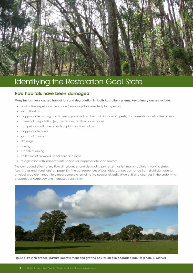
How habitats have been damagedMany factors have caused habitat loss and degradation in South Australian systems . Key primary causes include:
past native vegetation clearance (removing all or selected plant species)•
soil cultivation•
inappropriate grazing and browsing pressure from livestock, introduced pests, and over-abundant native animals•
chemical use/pollution (e.g. herbicides, fertiliser application)•
competition and other effects of plant and animal pests•
inappropriate burns•
spread of disease•
drainage•
mining•
rubbish dumping•
collection of firewood, specimens and rocks •
revegetation with inappropriate species or inappropriate seed sources.•
The compound effect of multiple disturbances and degrading processes has left many habitats in varying states (see ‘States and transitions’ on page 33). The consequences of past disturbances can range from slight damage to physical structure through to almost complete loss of native species diversity (Figure 5) and changes in the underlying properties of hydrology and increased soil salinity.
Identifying the Restoration Goal State
Figure 5: Past clearance, pasture improvement and grazing has resulted in degraded habitat (Photo: I . Clarke)
11 Habitat Restoration Planning Guide for Natural Resource Managers

Desired qualities of the goal stateTo restore damaged habitat, planners need to know what qualities the habitat should have and what the key features would look like . This involves identifying a “goal state” for the restored habitat . The aspirational qualities for restored habitats are that they are:
adequate to meet target species’ requirements over time•
ecologically ‘functional’ and self-sustaining•
resilient to disturbance in the shorter term •
adaptive to change (e.g. climate change) over the longer term.•
It is sometimes also desired that restored areas contribute to the provision of ‘ecosystem services’ (see Box 1). Although a thorough discussion of designing for ecosystem services (or other possible stakeholder goals) is beyond the scope of this guide, using the underlying principles of designing for a self-sustaining community that is also resilient and with potential to adapt to future climate change will provide many ecosystem services. The following sections discuss the key features that should be considered in a restoration project to obtain adequate, self-sustaining and resilient habitat.
Habitat adequacyPlanners need to understand the lifecycle requirements of those species whose presence is seen as essential to meeting the restoration goal and which may have specialist needs. There are several aspects to what makes a habitat adequate for any given species: resources (e.g. food, shelter, breeding sites), access (e.g. movement for dispersal, breeding), disturbance regimes that are within tolerable limits and absence of threats (e.g. exotic grazers and predators). Specific habitat information comes from observation, knowledge of flora and fauna experts, and ecological literature.
Species may be ‘generalists’ and survive in many different ecological communities and environments or they may have ‘specialist’ requirements and be restricted to a particular ecological community or location. Some species habitat preferences change during their lifecycle. They may also require the presence of symbiotic or mutualistic species (e.g. pollinators, seed dispersers, mycorrhizal fungi) to complete their lifecycle.
Habitat inventory
It may be useful for restoration planners to compile a ‘habitat inventory’. This inventory is a compilation of key habitat features (‘keystone structures’) and resources required by the target species or species group for them to successfully complete a lifecycle and maintain a viable population. Such an inventory can be devised and used as a checklist in the site assessment process to evaluate an area’s suitability for the restoration goals and help identify which key species or other elements are needed in a restored community to improve the adequacy of habitat in the project area. This assessment process will iteratively help set realistic goals and milestones and help direct restoration actions and monitoring.
Examples of factors that make up the goal state that may be important to define in a habitat inventory may include:
minimum patch size and connectivity requirements•
specialised food resources•
preferences for particular vegetation densities or structures (e.g. woodland with shrubby understorey; open grassy •woodland; open grassland; or a particular successional stage of disturbed habitat)
special niches for feeding or shelter (e.g. leaf litter, fallen timber, ground cover, bark on trees)•
types of resting spots and breeding sites utilised (standing dead trees, low hanging limbs, hollows in tree limbs or •logs, rocks)
requirements for water•
tolerance to disturbance.•
Habitat Restoration Planning Guide for Natural Resource Managers 12
Box 1: Ecosystem services
Ecosystem services include: provision of food, water, products and energy; carbon sequestration; waste decomposition; purification of water and air; crop pollination; pest and disease control; nutrient dispersal and cycling; seed dispersal; and the provision of cultural, intellectual and spiritual inspiration through, for example, recreational experiences and scientific discovery (Lindenmayer and Burgman, 2005).

Some resources will be provided as plants grow and mature (e.g. leaf litter, hollows). It may be necessary to retain or plan for particular habitat features if these are not at the site and may not automatically appear as part of restoration development (see example in Box 2). Consider also time lags in development and seasonal availability of resources for fauna targets (e.g. different species of flowering plants may produce nectar at different times of year, which means seasonal availability of this resource for honeyeaters).
Habitat composition and structure
Habitat types, structures and compositions are influenced by the physical elements at a site such as soil fertility, topography, geology and hydrology. Restoration planners should be aware that the composition and structural formations of restored habitats should differ within sites according to changes in the physical environment. For example, a patch of remnant vegetation in the Upper South East may contain Desert Stringybark woodland with a dense shrubby understorey on a well-drained sandy rise but dense Melaleuca shrubland without trees on lower wetter ground nearby.
The density of vegetation (both horizontally and vertically) can influence how plants grow and which fauna can make use of the vegetation. Different fauna species are associated with dense vegetation compared to open vegetation. Open space with few or no trees or shrubs provides important habitat that is often overlooked. Areas that were once native grasslands, sedgelands or wetlands (e.g. Figure 6) may be difficult to recognise if the site is now a cleared open pasture paddock. If restoration of these vegetation types is an important part of the habitat for the restoration target species then these areas should be identified and managed for appropriate openness, taking into account weed management issues.
Figure 6: Area of intermittent swampland with sedges – an important habitat component of the Swamp Antechinus in the South East (Photo: I . Clarke)
13 Habitat Restoration Planning Guide for Natural Resource Managers
Box 2: Specific habitat for the Hooded Robin
The Hooded Robin is a declining woodland bird species that feeds predominantly on insects on or near the ground. It preys on insects by swooping from low perches such as dead stumps and low-hanging lateral branches of eucalypt trees. Such features are often absent in dense revegetation plantings where lateral branching may be suppressed and there is not much open space. Thus, if the Hooded Robin were a target species identified as part of the restoration goal, lateral branches and open spaces would need to be specifically identified in the habitat inventory and the restoration goal state. This would then inform revegetation design (where applicable) and site management.

Habitat heterogeneity is the variety of habitat types that exist across an ecosystem or landscape (Figure 7) . Natural habitat variability across the landscape is important to the persistence of many species . For example:
breeding sites may be located in a different habitat to food resources (e.g. some waterbirds will feed in •wetlands but require woodland trees to nest in)
fauna may require access to a range of different vegetation types to get all of their food requirements and the •availability of food resources in any one location may vary according to season (e.g. honeyeaters dependant on nectar need to move according to flowering times if the one habitat does not have sufficient nectar all year round).
Some habitats have suffered a disproportionate level of loss and degradation due to their presence on soils or landforms that were favoured for agricultural landuse or development. The decline of these particular habitats and reduction of habitat heterogeneity may be a cause of many species’ current declines. For example, the preferential clearance and degradation of woodlands that occupied fertile flats and valleys in the Mt Lofty Ranges is suspected to be a major cause of the decline of many species of birds that require productive woodland habitats for part of their lifecycle.
The diversity of species identified for the goal state will depend partly on whether the goal is to restore the patch to meet all resource requirements of the target fauna species throughout the year or whether it is expected that the target species will have access to and feed in other patches and the restored patch is a supplement. A consideration of landscape adequacy for habitat is needed to inform what is required at the patch scale.
Functional roles and groups
When defining the components desired at a site or in a landscape it is helpful to recognise the types of species and interactions that are important in the basic functioning of an ecosystem, although there will be a varying knowledge of which species are vital to make up such a system, especially in a changing environment (e.g. see ‘Predicted impacts of climate change’ on page 20).
The term ‘ecosystem function’ covers a wide range of processes and interactions between biota and their environment . Desirable processes that enable ecosystem function include:
nutrient cycling•
water filtration and cycling•
energy flow (production, consumption and decomposition)•
Figure 7: Habitats change naturally across landscapes with varying topography, geology, soil, hydrology, micro-climate and disturbance regime (Photo: I . Clarke)
Habitat Restoration Planning Guide for Natural Resource Managers 14

soil formation•
pollination•
carbon cycling •
gene flow.•
Functional groups are assemblages (groups) of species that perform a role in the function of an ecosystem (Table 3). To enhance the overall likelihood of creating a self-sustaining system, consider the role and desired abundance of species in different functional groups when identifying the restoration goal state. ‘Keystone species’ may be identified individually in restoration plans as those species known to interact strongly with other species and play a disproportionately important role in maintaining ecosystem function. Given their importance, they may also be the restoration target (refer to Table 1 in the ‘Targets of restoration’ section on page 8).
The concept of ‘ecological redundancy’ assumes that more than one species performs a given role (e.g. pollinator, seed disperser) in an ecosystem. It is thought that some species are ‘drivers’ of community structure and function and others are ecologically redundant ‘passengers’ – the removal of (or failure to restore) the latter does not seem to affect the rest of the community. Thus it may be that not all species from the original ecological community need to be present in a restored area in order for a system to be functional, although with a greater number of ‘functional equivalents’, the greater likelihood that the system will be able to cope with disturbances (see ‘Resilient habitat’ on page 19) or adapt to future climate changes (see ‘Climate change considerations’ on page 20).
Unfortunately, there is little information for South Australian systems on which species are the most functionally important. Planners will often need to use their intuition and investigate ecological literature further to evaluate the importance that each species may have in making up a goal state. For example, to restore a River Red Gum community for hollow-dependent fauna the key plant species is River Red Gum, but what about the small grasses and lilies that would often be a part of a River Red Gum vegetation community? What functional role do they play? If they play a role in the food chain of the target fauna or in allowing regeneration of other plants (compared to competitive exotic pasture grasses) then they may also be components important to invest in.
The presence of fauna that play functional roles such as pollination in a plant community (Figure 8) will affect how the plant community may develop. These fauna species will change over time as plants reach maturity and structural habitat elements appear. Fauna will naturally colonise at some sites, whilst at other sites the potential for development may be limited. The degree of habitat connectivity will partly determine the rate, extent and structure of the developing plant community, as discussed in the next section.
Table 3: Examples of functional groups
Functional group Key processes Example of functional group members
Primary producers Energy flow, carbon cycling, nutrient cycling, water filtration and cycling.
Plants
Pollinators Pollination Birds, insects and small mammals.
Seed dispersers Gene flow Birds, ants.
Decomposers Nutrient cycling, energy flow carbon cycling.
Fungi, bacteria, insects.
Nitrogen fixers Nutrient cycling Plants hosting rhizobial bacteria.
Consumers Nutrient cycling, energy flow, gene flow. Herbivores (many mammals such as kangaroos, wallabies and wombats).
Carnivores (birds of prey, snakes, spiders).
Insectivores (some birds, bats).
Frugivores (some birds).
Nectarivores (some birds, small mammals, insects).
Omnivores (some generalist birds).
15 Habitat Restoration Planning Guide for Natural Resource Managers

Habitat connectivity and patch size
The arrival of Europeans, their land management systems and the exotic species that accompanied them are responsible for a large proportion of habitat loss and degradation in Australian landscapes.
Spatial gaps or discontinuities emerge in a biological system due to vegetation clearance, changes in land use and natural disturbance. The cumulative effects are known as ‘fragmentation’ of habitat. The edges of patches of fragmented habitat have a different range of environmental conditions. ‘Edge effects’ result in a different range of species utilising the perimeter compared to the interior part of patches. Species that require large tracts of intact habitat can become vulnerable and potentially extinct from small fragmented patches where edge effects predominate.
The scale at which habitat is available to an individual species or group of species is important. For example, the home range (area of movement) of the Brown Thornbill in the Mount Lofty Ranges is in the order of 1-5 hectares, whereas the Restless Flycatcher has a home range of 10-100 hectares. In general, habitats that are broken up into small patches support smaller populations. Larger sites hold better habitat potential for a larger range and bigger populations of species. Larger sites also have a greater probability of supporting areas that escape the effects of a single catastrophic event such as wildfire.
The survival of many species depends not just on individual patch size, but on access through, and to, a range of habitats and geographic locations. The suitability of any given environment in terms of its connectivity will vary between species depending on their mode of mobility and tolerance to exposure. For example, a small patch situated in an open landscape surrounded by a few paddock trees may be adequately connected and useful for highly mobile bird species, but is isolated and of limited value to a small mammal that avoids open spaces.
Connectivity is not just the ‘physical’ presence of connected vegetation. It is the absence of barriers that enables species to travel, if required, to find food, shelter and breeding opportunities. Connectivity is particularly important in drought years when resources are limited. In a connected environment, species can breed across sub-populations, which helps to avoid the genetic problems sometimes experienced by small isolated populations.
As a general rule, restoration planners should plan to restore large connected patches as a priority over small isolated patches, but sites should be assessed and prioritised in terms of the needs of the restoration target species. The quality of habitat within the patch, increasing patch size and attention to managing edge effects may take priority over provision of connectivity (e.g. wildlife corridor revegetation) if the species is already highly mobile and is limited by resource availability rather than its ability to move across the landscape.
Figure 8: Pollinators such as insects, birds and small mammals may appear as the system develops, depending on their ability to reach the site (Photo: I . Clarke)
Habitat Restoration Planning Guide for Natural Resource Managers 16

Landscape context
Individual requirements of habitat heterogeneity, scale, and connectivity vary between species and ideally needs to be determined at the landscape scale. Awareness of the level of current landscape adequacy will help drive the decision-making process in a regional habitat restoration program.
As restoration through a reconstruction process such as revegetation will not restore a complete system and is expensive, it is a last resort. Reconstruction actions should be focused on replacing the missing elements in actively declining systems that have the best prospects of recovery given the landscape context.
A number of frameworks describe the state of habitat loss and degradation within landscapes, and help to reinforce the context and opportunities for restoration in any given landscape type . McIntyre and Hobbs (2000) for example, have developed a useful model for defining the level of modification to ‘habitat’ (i .e . the cover of pre-European vegetation) in a landscape:
intact - >90% of habitat intact or with low levels of modification (Figure 9)•
variegated - 60 to 90% habitat intact and/or low to high levels of modification of remaining habitat (Figure 10)•
fragmented - 10 to 60% habitat intact and low to high levels of modification (Figure 11)•
relictual - <10% habitat intact and most remaining habitat highly modified (Figure 12).•
Figure 9: Intact landscape (greater than 90% of habitat intact) (Photo: I . Clarke)
Figure 10: Variegated landscape (60 to 90% of habitat intact) (Photo: I . Clarke)
17 Habitat Restoration Planning Guide for Natural Resource Managers

Figure 11: Fragmented landscape (10 to 60% of habitat intact) (Photo: I . Clarke)
Figure 12: Relictual landscape (less than 10% of habitat intact) (Photo: I . Clarke)
By definition, habitat in good to excellent condition covers intact and variegated landscapes, and they are functionally connected for most species. Theoretically, these landscapes are the least likely to require restoration. Generally, management actions in these landscapes should focus on maintaining and improving the integrity and resilience of a representative range of conservation assets (e.g. as identified in regional plans). Key actions are to monitor and address threats.
In fragmented and relictual landscapes most of the area is devoid of habitat, habitat has been severely modified and fragments are largely isolated. Restoration actions in fragmented landscapes play a role in halting degradation of the best remaining habitats (e.g. through threat abatement) and restoring function of degraded patches (e.g. through improving connectivity, increasing habitat patch size and improving habitat quality).
Some sites in relictual landcapes will possibly be a low priority for some restoration actions as they are too degraded and may not be feasible to recover with the resources available. Restoration actions in relictual landscapes should generally focus less on connectivity and more on improving the condition of the remaining fragments and reconstructing buffer areas around them to help protect from degrading influences.
Some fragmented and relictual landscapes may require other management actions to address landscape-scale threatening processes such as dryland salinity: the initial restoration actions may not be to focus on habitat as such but on other actions that provide amelioration to degrading processes (e.g. strategic control of groundwater recharge).
Habitat Restoration Planning Guide for Natural Resource Managers 18
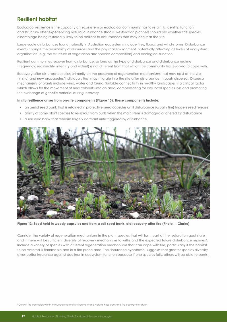
Resilient habitatEcological resilience is the capacity an ecosystem or ecological community has to retain its identity, function and structure after experiencing natural disturbance shocks. Restoration planners should ask whether the species assemblage being restored is likely to be resilient to disturbances that may occur at the site.
Large-scale disturbances found naturally in Australian ecosystems include fires, floods and wind-storms. Disturbance events change the availability of resources and the physical environment, potentially affecting all levels of ecosystem organisation (e.g. the structure of vegetation and species composition) and ecological function.
Resilient communities recover from disturbance, so long as the type of disturbance and disturbance regime (frequency, seasonality, intensity and extent) is not different from that which the community has evolved to cope with.
Recovery after disturbance relies primarily on the presence of regeneration mechanisms that may exist at the site (in situ) and new propagules/individuals that may migrate into the site after disturbance through dispersal. Dispersal mechanisms of plants include wind, water and fauna. Suitable connectivity in healthy landscapes is a critical factor which allows for the movement of new colonists into an area, compensating for any local species loss and promoting the exchange of genetic material during recovery.
In situ resilience arises from on-site components (Figure 13) . These components include:
an aerial seed bank that is retained in protective seed capsules until disturbance (usually fire) triggers seed release•
ability of some plant species to re-sprout from buds when the main stem is damaged or altered by disturbance•
a soil seed bank that remains largely dormant until triggered by disturbance.•
Consider the variety of regeneration mechanisms in the plant species that will form part of the restoration goal state and if there will be sufficient diversity of recovery mechanisms to withstand the expected future disturbance regimes3. Include a variety of species with different regeneration mechanisms that can cope with fire, particularly if the habitat to be restored is flammable and in a fire prone area. The ‘insurance hypothesis’ suggests that greater species diversity gives better insurance against declines in ecosystem function because if one species fails, others will be able to persist.
Figure 13: Seed held in woody capsules and from a soil seed bank, aid recovery after fire (Photo: I . Clarke)
3 Consult fire ecologists within the Department of Environment and Natural Resources and fire ecology literature.
19 Habitat Restoration Planning Guide for Natural Resource Managers

Climate change considerations
Predicted impacts of climate change
Future projections from climate change models for South Australia are not precise but most indicate:
increasing atmospheric carbon dioxide levels•
increase in the mean temperature•
increasing sea levels•
changes in rainfall patterns towards less rainfall for much of South Australia•
changes in seasonal weather patterns•
higher frequencies of extreme weather events•
increased number of fire danger days (leading possibly to higher fire frequency and intensity).•
Rapid global warming and its flow-on environmental effects represent a major threat to biodiversity. There is nothing new about changes in climate; the climate has been changing throughout history and systems have been changing with it. All species have evolved and adapted under the selection pressures brought about by variations in their environment. It is the speed of the predicted change that will be the determining factor, producing an ecological ‘threshold’ that will affect living species in different ways.
It is likely that some communities will be resilient and retain their ecological identity whereas the degree of environmental change will exceed thresholds for other communities bringing about fundamental changes . Such changes possibly include:
changed productivity and nutrient cycling•
alterations in flowering patterns (affecting pollination and seed set)•
potential alterations in species distribution and dispersal patterns •(e.g. spread of ecological generalists at the expense of specialists)
effects on breeding and migratory patterns and timing•
changed food-web interactions.•
Global species loss estimates due to climate change range from 3% to 78% of species going extinct. Such a wide range is indicative of the high degree of uncertainty about the future level and rate of global climate change. The key point is that there is evidence from the scientific community that some level of species loss that is beyond our control will occur if the predicted climate changes eventuate. The determining factor for survival will lie in the magnitude of climate change and whether the inherent resilience of the underlying ecosystem can cope with that magnitude of change.
The uncertainty of future changes means that instead of focusing on species - specific habitat restoration targets, there may need to be more emphasis on providing opportunities for ecosystems to self-adapt and reorganise, and on the maintenance of ecosystem processes that underpin vital ecosystem services. This will require a fundamental shift in restoration planning for which there are currently few clear guidelines.
Based on current knowledge, restoration projects should focus on characteristics of habitats that give the best chance of species persistence in the overall landscape and facilitate adaptation to change, as discussed in the following sections.
Maximise adaptive potential
Adaptation to climate change may occur through natural selection of suitable genetic variants or alterations in species behaviours. The ability for a species to adapt, and the rate of evolution, depends on the degree of heritable genetic variability within each population.
Restoration planners can influence the level of genetic diversity at restoration sites:
indirectly by increasing population sizes•
directly by introducing genetic variants at the site.•
Habitat Restoration Planning Guide for Natural Resource Managers 20

Maximise population size
In general, there is more genetic diversity in larger populations than smaller ones, thus population sizes should be optimised according to the situation . This can be done through:
improving habitat quality for target species•
increasing habitat patch size•
increasing habitat connectivity so that populations can interbreed more readily.•
Introduce genetic variants
In restoration programs using revegetation, the current emphasis on using local provenance seed sources and propagules is under scrutiny. It possibly restricts genetic variation, particularly in fragmented and relictual landscapes where the opportunity for genetic exchange is often limited by lack of connectivity and isolation.
To facilitate adaptation potential, ‘composite provenancing’ of seed may provide a higher degree of variation upon which selection pressures can act. Composite provenancing involves sourcing and mixing seeds of a particular species from multiple locations: the majority of seed is collected locally, but mixed with a smaller amount (10-30%) of seed from healthy populations further away. Selection from a variety of genetic sources may be an option but will vary from case to case and the implications need to be assessed very carefully. The risk with using non-local genetic sources includes introducing maladapted genes and possible production of sterile hybrids.
Facilitate dispersal
Dispersal or migration to more suitable climate zones has occurred with past climate change. Species that are able to persist in a number of habitats but are currently restricted by habitat fragmentation may benefit from enhanced landscape connectivity by increased dispersal opportunities.
Many species considered generalists will have an advantage under climate change because they possess characteristics that favour their spread into disturbed areas or vacant niches left after the decline of local populations of species that do not cope with the changes. These species may not need more physical connections if they can already disperse in fragmented environments, but improved connectivity may increase the rate at which they spread.
Species restricted to specialist habitats (e.g. high elevations, intermittent streams, inland wetlands), or with requirements for mutualists or hosts will be more vulnerable to rapid change than those with generalist habitats. Specialists may not benefit from habitat connectivity if their requirements are very restrictive or other species on which they depend cannot move in tandem.
The risks with assisting dispersal through increased connectivity include increased spread of pests and disease. As any one species increases or decreases in an area, the flow-on effect to other species with which it then interacts (e.g. through competition, predation, pollination, parasitism) may also cause changes in food-web structure and ecosystem processes (see Box 3).
Given this, a precautionary approach is preferable. Connectivity will still be important, but the resulting communities that are brought about by species movements in the future may differ from past communities.
21 Habitat Restoration Planning Guide for Natural Resource Managers
Box 3: Will communities “shift” with changing climate?
“The translation of the climatic envelope of a species to a new location will not result in its demise if all of its requirements are met in the new location and all other species upon which it is ecologically dependant also move in concert. Given these kinds of contingencies, it is very difficult to predict the consequences of climate change for any one species… the movement of whole communities of species in response to shifts in bioclimatic conditions is unlikely. Species persistence will depend on the magnitude of changes and the presence of sufficient genetic variability so that at least some individuals survive novel environmental conditions” (Lindenmayer and Burgman 2005, p 143-144).

Figure 14: Southern Scrub-robin, a species that needs Mallee or Acacia with a shrubby understorey (Photo: I . Clarke)
Reference sites and goal statesIf climate were to stay the same in the future as now, the ideal reference goal state may be the same species diversity and structure as found in natural remnant vegetation on similar landform, soil type and rainfall to the restoration site.
Natural systems are however, very dynamic in nature. The vegetation composition and structure in the early years after disturbances, such as fire, is often different to long-undisturbed areas and supports a different diversity of fauna. Highest species diversity is often found in areas with intermediate levels of disturbance.
Many remnant patches have already been changed by human modification and other degrading processes, adding another layer of difficulty in knowing which sites represent the ‘ideal’ state. Therefore which vegetation community composition and structure is the ‘right’ one to use as a reference for restoration at a site, even without the prospect of climate change, is a challenging question – there may be a range of seral or successional stages that are required in a landscape mosaic to meet the overall habitat needs of the target species or species groups and therefore a range of least-unmodified reference sites is needed.
It should be recognised that it is rarely possible to reconstruct areas to the same state as exists in healthy diverse remnant vegetation when starting from a highly modified state (such as an improved pasture site). This is sometimes because the physical nature of the site has changed but more often because propagation or re-establishment methods are unknown or extremely specialised for many plant species, affecting the level of diversity able to be restored. Thus healthy diverse remnant vegetation will play a role in providing guiding reference sites to determine aspirational goal states in a stable climate, but this will differ from the feasible goal state for a system that requires reconstruction.
A conundrum exists in deciding which goal state will make up quality habitat both now and in a changed future climate and which restoration targets are priorities given climate change considerations. The value of aiming to re-establish ‘original’ plant community types under the threat of climate change needs to be questioned if some of the component species are at high risk of extinction.
Some theorists call for inclusion of non-local species in restoration programs that are predicted to be more suited to the future climate and will be needed to provide certain functions or services. For example, some fauna species that require hollows may survive the changes in climate, but the tree species that provide the hollows may not. Planting tree species now that are adapted to drier, warmer sites may be needed (in theory) to provide future hollows where current hollow-bearing tree species are predicted to be most affected by climate change.
Habitat Restoration Planning Guide for Natural Resource Managers 22

Using non-local species is potentially a high risk strategy . Planners need to weigh up the risks of planting non-local species in terms of their effects on other species in the community in the short term and compare this to the predicted long-term consequences of continuing to use local species only . Risks associated with the use of non-local species include:
possible negative effects from hybridisation with local species•
competition with local species•
their capacity to attract non-local fauna that compete with local fauna•
that they may become a weed species•
that they may not survive to maturity if they are not fully suited to the current site conditions.•
It may be possible to spread risk by trialing plantings that incorporate non-local species that provide a range of functional roles at selected sites and comparing outcomes with local-only plantings through monitoring. This requires planning and co-ordination at the regional level and on-going monitoring over long time frames through an adaptive management framework, which is realistically beyond the scope of many implementation programs.
Do restoration goal states need to differ significantly from reference states based on current remnant ecological communities? There is no clear answer to this question with the knowledge that is currently available. Given all of the above considerations, the focus of restoration planning is turning more towards looking at the functions or roles that each species of ecological communities play in providing not only habitat, but functional ecosystems and ecosystem services. The species assemblage desired may, in theory, be a novel combination, and if so, this should be clearly recognised and all risks assessed in the process of defining the goal state. If the goal state has no current reference site it will affect the confidence with which future outcomes of restoration can be predicted and how comparisons of monitoring data are made and interpreted.
Remnant ecological communities in all their current forms still present our best-known guide for developing habitat restoration goal states for target species in decline. An approach is to aim for a goal state consisting of local species that has a high level of ‘ecological redundancy’. This means that a diverse range of species are restored such that functional groups are likely to be represented by more than one species, reducing the risk of losing functional roles in the overall ecosystem (see also ‘Functional roles and groups’ on page 14). Other factors that can be incorporated into the goal state/management to give best chance of persistence and adaptation are summarised in Table 4.
At a local level much can be learnt by monitoring and evaluating what happens in restoration projects, documenting the outcomes, and dependant on the results over time, adapting species used and management practices as necessary.
Figures 15 and 16: Remnant ecological community on which to develop goal state for degraded area to cater for target species in decline (Photos: R . Wallace)
23 Habitat Restoration Planning Guide for Natural Resource Managers

Table 4: Summary of strategies for restoration projects and their influence on the goal state . Modified from Dunwiddie et al. (2009) and Steffen et al. (2009)
Strategy Influence on Goal State Outcome Risks
Maximise population size of target species
Goal state has species composition similar to remnant habitat reference sites; the scale of the patch being restored is maximised wherever possible
Increased survival probability due to higher population number results in increase in viability of short-term persistence
Need to also reduce threats that directly affect population size or indirectly affect habitat
Introduce genetic material from a range of healthy sources (e.g. composite provenancing of local and wider seed sources for revegetation)
Goal state has species composition similar to remnant habitat reference sites
Increased genetic diversity and potential to adapt; assumed improved likelihood of survival of function over longer term
Natural hybrids may be harmful or beneficial to the conservation of biodiversity. Ideally, to reduce risks, species genetics require study before management decisions are made
Improve connectivity in fragmented systems
Goal state has species composition similar to remnant habitat reference sites; restore or improve areas identified as essential to aid dispersal between populations or to access new habitat
Improved likelihood of survival from increased pathways for dispersal and subsequent colonisation; increases potential for inter-population breeding, improving genetic exchange and potential to adapt
Newcomers can pose management problems because migration to new regions is considered a positive adaptive response to climate change but in some cases they may reduce rather than enhance local biodiversity
Increase ‘ecological redundancy’
Plan to restore a diverse range of species with a range of functional roles; possibly introduce non-local species that provide critical functional roles and are predicted to be better adapted to future conditions
All functional groups are likely to be represented by more than one species; reduced risk of losing functional roles in ecosystem
If non-local species are used, they may have unknown interactive effects on other species in the short term; difficult to predict functionality and stability of any new species mixtures
Habitat Restoration Planning Guide for Natural Resource Managers 24
SummaryPast habitat degradation and loss has lead to a lack of resources and reduced connectivity for •some species.
Restored habitats should ideally be adequate to meet target species requirements over time, be •functional and self-sustaining, be resilient to disturbance and, in the long-term, adaptive to change.
Identify how restoration can address declining population trends of target species: their needs may •include more food or shelter resources to complete their lifecycle, better opportunities to move through fragmented landscapes and reduction of threats.
Identify what the desired features of the restoration site would be to meet the restoration goal: this can •be thought of as the desired ‘goal state’.
A design for the goal state should include considerations for: resource requirements for the target species •over space and time; structural habitat complexity; minimum patch size; and the proximity to, and connectivity with, other habitat patches.

25 Habitat Restoration Planning Guide for Natural Resource Managers
Further informationHistorical changes in the South Australian landscape are reviewed by Williams (1974).
The desired outcomes of ecological restoration projects are overviewed by the Society for Ecological Restoration International Science and Policy Working Group (2004).
Ecosystem services and functions are overviewed by Ehrenfeld (2000) and Lindenmayer and Burgman (2005). Lindenmayer and Burgman (2005) and Walker (1992) look at the concept of ecological redundancy.
Habitat fragmentation and connectivity concepts are discussed in depth by Lindenmayer and Fischer (2006). Management within different landscape contexts is outlined and discussed in McIntyre and Hobbs (1999; 2000).
Considerations of habitat adequacy, connectivity, patch size and restoration design for wildlife habitat are outlined in more detail by Cale (2008), Radford et al. (2004), Bennett et al. (2000) and references therein. The concept of ‘keystone structures’ is discussed by Tews et al. (2004). Habitats used by birds are detailed in depth of the Handbook of Australian, New Zealand and Antarctic Birds (e.g. see Marchant and Higgins 1990).
Regeneration mechanisms and adaptive responses of Australian flora to fire are overviewed by Gill (1981) and Noble and Slatyer (1980). Considerations of fauna and fire are outlined by Whelan et al. (2002) and the implications of future changes in fire regimes in York (2002). Managing for the resilience of ecosystems in a changing world is discussed by Walker and Salt (2006) and Steffen et al. (2009).
Impacts of climate change on biodiversity and conservation management in Australia are summarised by Steffen et al. (2009). Projections for climate changes in South Australia are given in Suppiah et al. (2006). Potential global species loss is described in Berg et al. (2010).
Managing genetic diversity of remnant vegetation and seed sourcing issues for revegetation are discussed by Broadhurst (2007; 2008). Composite provenancing of seed is outlined by Lowe (2010).
Reference sites and goal states are discussed by the Society for Ecological Restoration International Science and Policy Working Group (2004) and in the context of a changing climate in Steffen (2009), Harris et al. (2006) and Hobbs and Suding (2008).
The Nature Conservation Society of SA has guides to assessing bushland in some regions of SA that outline the components expected in healthy ecological communities in SA (for examples see Croft et al. 2005; Pedler et al. 2007).
Summary (continued)Healthy remnant vegetation will play a role in providing reference sites to guide ideas of what the •restoration goal state might look like, but the practical difficulties with restoration will often mean that the state that can feasibly be achieved is a simpler form, at least in the short term, so be guided primarily by the key needs of the target species identified in the restoration goal.
Where possible, incorporate the needs of a range of species from different functional groups and •‘keystone species’ in project design to help restore a functional habitat that is resilient to disturbance.
Larger, connected patches with diverse habitats are more likely to meet the needs of more species, and •be self-sustaining over time, compared to small isolated patches of poor quality habitat.
Current landscape context may influence project focus and design: in some relictual landscapes, •funding resources may be better allocated towards projects that focus first on habitat quality and patch size rather than restoring connections through wildlife corridors.
In the face of climate change, aim to improve the adaptive potential of species to cope with future •changes by maximising population sizes and improving genetic diversity within populations.
In fragmented and relictual landscapes, consider using a range of provenance sources for seed for •revegetation to capture a wide range of genetic diversity, but assess all risks before using any non-local genetic material.

Site Assessment
Habitat Restoration Planning Guide for Natural Resource Managers 26
AimsKey habitat attributes related to restoration goals should be identified as much as possible prior to the site inspection (see ‘Identifying the Restoration Goal State’ on page 11), with the aim that preliminary site assessments can then determine:
which habitat attributes necessary to meet project goal(s) are currently missing or threatened at the site•
the level of intervention required to restore the site (or parts of the site) from any currently undesirable state •to the desired state.
The site assessment aims to show the current state of the site and any current or future threats that may impact on site condition. The data collected would indicate a site’s immediate suitability or its potential suitability for restoration as well as the time period required to direct the desired change. The site assessment process also aims to reveal information that will allow predictions of possible outcomes under different management scenarios, as discussed in ‘Restoring Towards a Goal State’ on page 33.
For large sites, the assessment should also aim to give enough information about the site to determine and map the boundaries of appropriate units for management (see ‘Mapping’ on page 31 and ‘Using management units’ on page 58).
The key factors to assess include: soils and landforms; infrastructure; habitat attributes; landscape context; threats; land-use history and regeneration potential.
Soils and landformsAssess and map physical features at the site as listed in Table 5. Particularly map wherever significant changes occur in soil properties or landform.

Table 5: Soil and landform features to assess at the site level
Feature Relevance to restoration planning
Soil types, pH, salinity, slope and aspect
Key determinants of species suitable to be restored and appropriate reference sites (note: if soil condition has changed over time the site may not now support the original ‘pre-European’ vegetation type).
Indicates erosion potential if ground cover is removed.
Can affect choice of revegetation methods (e.g. direct seeding is less successful on eroding sands and cracking clays than other soils).
Indicates potential for waterlogging.
Can affect access for vehicles or safety of workers.
Nutrient levels (level of plant/weed growth is an indicator)
Will influence future weed growth and persistence and thus potential competition levels for regenerating/revegetated natives.
Soils artificially nutrient rich may be less suitable for restoration of species adapted to nutrient-poor soils.
Soil surface unevenness, level of compaction, depth to rock
Uneven soil surface can affect machinery use.
Very compacted or rocky soil may require ripping or avoidance.
Uneven surface may provide sites for seed capture, successful microsites for seed germination and plant growth.
InfrastructureNote all physical features and infrastructure at the site that may influence the design of restoration or access to the site . These include:
power lines/underground cables•
drainage channels•
roads/tracks•
fencelines/gates•
stockyards•
waterpoints/windmills•
property boundaries.•
Habitat attributesAnalyse the project site and surrounding area for the presence of suitable habitat features as previously identified in a ‘Habitat inventory’ (see page 12). The extent of occurrence or distribution of desired habitat features throughout the site will be an important part of this assessment, as it is not only presence/absence but amount of habitat that can be important.
In the absence of a habitat inventory, sites should ideally be assessed for the extent, composition and condition of remnant vegetation as a minimum. Note that seasonality affects which species are present and visible: site assessments are best conducted in spring, when plant species richness is often at its highest and most plants are easier to identify through flowering.
If planted vegetation is present, assess its functional role and the pros and cons of its contribution to the restoration goal.
Landscape contextAscertain whether or not the site will have the right patch attributes within the landscape context to make a viable habitat contribution . These include the:
potential size of the total area of connected habitat once the site is restored•
shape of the total area of connected habitat •(sufficient protected interior compared to area potentially affected by edge effects)
distance to the next closest habitat patch.•
The relevance of each of these variables will differ for each species and should be considered relevant to the restoration target species and overall landscape context (see ‘Habitat connectivity and patch size’ on page 16).
27 Habitat Restoration Planning Guide for Natural Resource Managers

ThreatsThreats may affect the initial establishment phase for regenerated or revegetated plants and the long-term viability of target species or the restored habitat. Vigilant monitoring and control of threats is important at all sites to ensure that weed competition and feral predation does not cause the restored habitat to become a ‘population sink’ for some native species. A population sink is a site that some species may be initially attracted to, but due to sub-optimal habitat or the presence of predators, for example, their individual survival rate is low.
Coordinated threat control throughout the immediate district is often warranted to achieve longer term results. A comprehensive threat assessment process that goes beyond project boundaries is therefore a primary key to success. Involve all stakeholders in and adjoining the project area wherever possible.
On-site indicators of threats (Table 6) only signal present issues; future threats should also be taken into account by observing the surrounding landscape and talking to land managers in the area about any likely future changes in management or known seasonal problems (e.g. grasshoppers).
Where the restoration scenario calls for increased plant establishment through regeneration or revegetation, the site should initially be managed to reduce threats that are a problem for the early establishment phase of seedlings. These include competitive weeds, disease (e.g. Phytophthora sp) and grazers (including insects, slugs, snails, stock, rabbits, deer and goats).
Weeds must be assessed by criteria that will allow the determination of appropriate methods of control. For example, perennial or summer-growing weeds will have different control methods and timing than annual or winter-growing weeds.
All threats should be assessed in the context of the restoration goal and with the possible impacts of threat abatement actions on other species in mind. Some invasive plant species provide habitat to endangered native fauna. For example, Blackberries can provide cover for the nationally endangered Southern Brown Bandicoot. Where threatened fauna are likely to rely on weeds as habitat, the weeds should have a staged plan for gradual removal and replacement with other suitable habitat.
Table 6: On-site indicators of potential threats
Threat Potential on-site indicators
Predation, grazing, trampling. Presence of livestock or pest animals (e.g. foxes, rabbits, hares, deer, goats); also invertebrates such as grasshoppers, red-legged earth mite, snails.
Presence of dung/scats, diggings, fur, grazed vegetation, animal tracks.
Competition Presence and size/extent/type of weeds.
Presence of exotic animals that may occupy niches of desired fauna (e.g. feral bees in hollows).
Inappropriate fire regime. Requires assessment by a professional fire ecologist. Some indicators of a lack of fire may be senescent vegetation and lack of regeneration; lack of understorey diversity in mature vegetation and a lack of fauna species that require diverse understorey.
Changed hydrological regime.
Dieback/death of plants.
Invasion of sites by plants usually found in either drier or wetter environments.
Disease Yellowing or unhealthy plants, dieback.
Pollution Rubbish dumping, unhealthy plants, dieback.
Soil erosion Lack of cover; unstable soil; tracks and vehicle damage; soil cultivation.
Potential damage or removal of habitat features (e.g. rocks, logs, wood).
Signs of human visitation and use of site; recently cut stumps.
Habitat Restoration Planning Guide for Natural Resource Managers 28
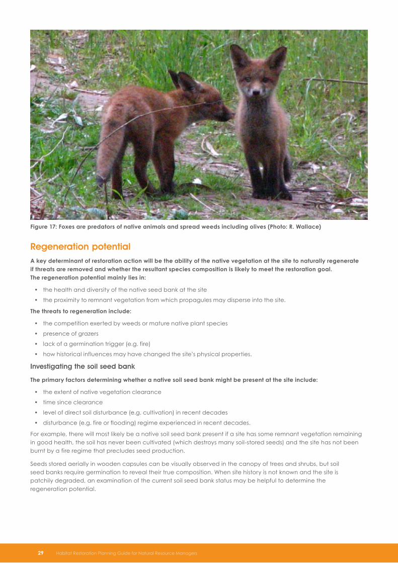
Figure 17: Foxes are predators of native animals and spread weeds including olives (Photo: R . Wallace)
Regeneration potentialA key determinant of restoration action will be the ability of the native vegetation at the site to naturally regenerate if threats are removed and whether the resultant species composition is likely to meet the restoration goal . The regeneration potential mainly lies in:
the health and diversity of the native seed bank at the site•
the proximity to remnant vegetation from which propagules may disperse into the site.•
The threats to regeneration include:
the competition exerted by weeds or mature native plant species•
presence of grazers•
lack of a germination trigger (e.g. fire)•
how historical influences may have changed the site’s physical properties.•
Investigating the soil seed bank
The primary factors determining whether a native soil seed bank might be present at the site include:
the extent of native vegetation clearance•
time since clearance•
level of direct soil disturbance (e.g. cultivation) in recent decades•
disturbance (e.g. fire or flooding) regime experienced in recent decades.•
For example, there will most likely be a native soil seed bank present if a site has some remnant vegetation remaining in good health, the soil has never been cultivated (which destroys many soil-stored seeds) and the site has not been burnt by a fire regime that precludes seed production.
Seeds stored aerially in wooden capsules can be visually observed in the canopy of trees and shrubs, but soil seed banks require germination to reveal their true composition. When site history is not known and the site is patchily degraded, an examination of the current soil seed bank status may be helpful to determine the regeneration potential.
29 Habitat Restoration Planning Guide for Natural Resource Managers

Possible trials that may reveal the species composition and responsiveness of the soil seed bank include:
excluding grazers•
removing weed competition•
burning representative parts of the site to stimulate germination using ‘burn boxes’ (box-like structures of primarily •non-flammable material designed to enable discrete burns to be implemented over an area with minimal threat of fire escape)
scalping off top soil, place in shallow trays in controlled laboratory or nursery conditions to promote germination •and identify resultant seedlings
applying smoke water products to stimulate germination.•
Gaining this assessment information as early in the restoration process as possible will increase the opportunity for success and avoid the unnecessary expense of revegetation where natural regeneration processes can be used instead. Allow for at least ‘one average’ seasonal cycle to pass (may be several years in some regions) to facilitate germination from the soil seed bank and see the response. Set up monitoring plots and/or photopoints.
As this process is expensive and time consuming it is relevant primarily for large-scale sites with long-term project timeframes.
Historical influences
The adequacy of a site to regenerate and support restored habitat should also be assessed in view of possible ecosystem-level changes. An assessment and evaluation of site history (Table 7) can help determine the likelihood that thresholds have been crossed, affecting the ability of the system to recover once threats have been removed.
In many cases this knowledge will be gained through direct observation, by gathering a range of information from land managers and from information in historical documents. Interpretation may be aided with the help of experienced practitioners.
Table 7: Site history information to collect during site assessment
Information required Relevance to restoration planning
Historic disturbance regimes (i.e. fire, flooding) and any subsequent changes or alterations to them from land use change.
Natural regimes indicate potential presence and regeneration potential from a soil seed bank; altered regimes may indicate soil seed bank is depleted.
Helps to determine management of and response to future disturbance regimes.
Vegetation clearance (timing, scale and, if possible, method).
Indicates that some species may have been selectively lost through clearance.
Length of time species may have been lost affects the likelihood of a soil seed bank persisting.
Stock grazing or browsing (e.g. how long ago stock were introduced to the site, management practices relating to stock movements, location of watering points, holding areas).
Indicates that some species may have been selectively lost through grazing/browsing.
Length of time species may have been lost affects the likelihood of a soil seed bank persisting.
Past stock camping may have caused soil compaction, raised soil nutrient levels and increased weediness, which may affect regeneration and revegetation survival.
Previous soil disturbance (such as cultivation or excavation).
Decreases native soil seed bank.
Other agricultural practices (the nature and general timing of application of fertiliser, drainage, irrigation, chemical use).
If a high level of disturbance has chemically or physically altered the nature of the soil, the predictability and level of regeneration processes will often be diminished.
Presence of residual chemicals can affect the germination of seeds and also affect future herbicide use/compatibility.
Habitat Restoration Planning Guide for Natural Resource Managers 30

Site assessment methods
Qualitative vs. quantitative data collection
Initial site assessments may be brief visual overviews that give a qualitative indication of the level of degradation and suitability of a site for restoration. Detailed secondary site assessments can be coordinated with development of a monitoring and evaluation program to collect baseline data (see ‘Monitoring and Evaluation’ on page 49). The two processes are closely linked. Integrating them at the start will ensure that the right data are collected, and in a way that can be interpreted and evaluated in an ongoing monitoring program.
To increase the collective knowledge base and accelerate levels of understanding about the condition of natural assets, investigate where assessment data collection can contribute to wider datasets where possible.
Mapping
Aerial photography is now commonly used to gain an overview of the features at a site (Figure 18). Observation through stereo-pairs4 of aerial photographs can help give an even better understanding of topography, landform, presence of vegetation and man-made features for very large-scale sites prior to field work.
Global positioning system (GPS) technology can contribute to detailed collection of accurate field data during site assessment and can be used with geographic information systems (GIS) to map boundaries and calculate the area for units of particular management interest (Figure 19). Manually marking transition zones or ‘fuzzy boundaries’ on transparent aerial overlay or aerial printout can also be useful in the early stages of site assessment.
Figure 18: Aerial photography can help show variation in a site’s physical features and habitat values that require varying restoration methods and management
4 May be available from the Department of Environment and Natural Resources
31 Habitat Restoration Planning Guide for Natural Resource Managers

Figure 19: Use GIS or hand-drawn overlay on transparency sheet to map distribution of soil types, remnant vegetation types or areas requiring particular management
Further informationFor information on how to consistently characterise landforms, land surface, soil and substrates see the Australian Soil and Land Survey Field Handbook (The National Committee on Soil and Terrain 2009) and Heard and Channon (1997).
Key references for native plant species and vegetation communities in SA include Berkinshaw (2006; 2009; 2010), Costermans (2009), Dashorst and Jessop (2006), Jessop et al. (2006), Nicolle (1997), Prescott (1994; 1995), Maslin (2001) and McCann (1989).
Some regional NRM Board websites contain online plant and fauna info relevant to their region. NatureMaps online at www.naturemaps.sa.gov.au shows the location of large remnant patches of vegetation in SA and relevant flora and fauna survey information. To see the known distribution of plant species in SA and check current scientific names, see the Electronic Flora of South Australia at www.flora.sa.gov.au.
To interpret tracks and traces of mammal fauna at a site see Triggs (2004).
An example of assessing the germination response of the soil seed bank (including the use of smoke and heat treatments) in trials is given in Read et al. (2000).
Habitat Restoration Planning Guide for Natural Resource Managers 32
SummarySite assessments should aim to determine: the current state of a site; which habitat attributes necessary to •meet project goal(s) are currently missing or threatened at the site; and the level of intervention required to restore the site to the desired goal state.
Site assessment information should allow a prediction of possible outcomes to different management •scenarios.
The key factors to assess include: soils and landforms; infrastructure; habitat attributes; landscape •context; threats (to the restoration process and to target species); land-use history and regeneration potential.
Regeneration potential depends on: the presence of a seed bank (in the aerial canopy of plants and •within the soil) at the site and the proximity to other sources of species that may be able to colonise the site through dispersal and natural regeneration.
The presence of a soil seed bank with native seeds depends on land use history: the longer a site has •been cleared for and whether it has been intensely grazed or cultivated, determines how much of a seed bank will have survived to the current time.
Information from a site assessment should be summarised where possible in map form to show where •management issues change over the site; this will help form the basis of appropriate units for management and locations for monitoring in the restoration plan.

Restoring Towards a Goal State
States and transitionsDifferent levels of restoration intervention may be required between and within sites. Sometimes many habitat elements are already present and with the removal of key threats the site will respond through natural regeneration processes, in which case further actions are to simply monitor and evaluate over time. Other sites may not have the ability to regenerate due to a lack of current vegetation and seed sources, so they will need additional intervention to meet the restoration goal (e.g. active replacement of lost species through revegetation).
Planners should recognise that a range of ecological states may be possible for any one locality depending on the level of impact from disturbance. Transitions between states may be caused by a range of disturbances, as outlined in ‘How habitats have been damaged’ on page 11. When the level or type of disturbance experienced by an ecosystem is beyond what the components of the ecosystem are adapted to cope with, its resilience is exceeded and it will not recover to the same state after disturbance ceases (Figure 20). It changes to another state, characterised by a different structure and different processes. It is said to have ‘crossed a threshold’. The new system may continue to change until an ‘alternative stable state’ is reached.
Figure 20: Once an ecosystem has crossed a threshold (such as level of soil salinity) it may not be possible for it to return to its original state, even with intervention (Photo: I . Clarke)
33 Habitat Restoration Planning Guide for Natural Resource Managers

It is important to recognise when a system has changed so much (crossed one or more thresholds) that it cannot be returned to its former state by just removing the disturbing factor or giving the system time. For example, if stock grazing, cultivation and weed invasion have reduced a woodland plant community to just trees over pasture, the system will need more action that just removing stock to restore the community (Figure 21).
The key considerations in how sites may change are:
the current state of the site (likely abundance and composition of regeneration mechanisms present)•
the factors that may influence regeneration and subsequent composition (biotic threats such as grazing •and competition, abiotic threats such as salinity)
the landscape position of the site (connected or isolated from propagules and colonists).•
With experience and research, it is possible to get a feel for how different threats and disturbance factors affect individual organisms, regeneration success and the organisation of communities. The pathway of change and ultimate state can only be hypothesised however, due to the complexity of interacting factors and uncertainty of response.
Figure 21: Example of different system states due to disturbances such as stock grazing and weed invasion – by themselves, stock impacts may not have changed the system permanently (State 2), so stock removal results in a return of the system to an approximation of its original state (State 1), but if highly competitive weeds are present (State 3), removal of grazing will not return the system to its previous state as the weeds will increase and change the system to yet another state (State 4) (Reproduced with permission from West 2008) .
Stress added (grazing)
Stress removed (grazing)
Stress removed (grazing)
State 1 State 2
State 4 State 3
Stress added (weeds)
Threshold
Threshold
Habitat Restoration Planning Guide for Natural Resource Managers 34

Directing the pathway of changeRestoration is about implementing actions that direct the development of a system’s state (its ‘trajectory’) over time towards the restoration goal state.
An example of how an ecological community with different disturbance histories may require different restoration strategies are given in Scenario 1 and 2. In Scenario 1, the system is so disturbed that it has crossed a threshold where vegetation cover is so low and weed competition so high that native vegetation as a whole will not naturally return without intensive management and revegetation. In Scenario 2, the disturbance has not been as great and the starting point has more regeneration potential. Removing threats does not return all of the desired native plants and some revegetation is needed, but not the extent as in Scenario 1.
Scenario 1
A mallee community with chenopod-dominant understorey (Figure 22) was cleared 50 years ago . It had rough paddock renovations that increased soil fertility and several grass fires in the last 15 years . It was grazed heavily, in part from a watering point established in the paddock . As a result the site changed to an alternative state (Figure 23) . The characteristics of the alternative state included:
no overstorey•
understorey dominated by weeds, with only a few native understorey plants (some chenopods and native grasses)•
seed bank in the soil dominated by weeds and with few native understorey seeds due to time since clearance and •altered fire regimes
damaged soil crust and reduced soil biota.•
When grazing was removed, this site remained in a highly weedy state with little native biodiversity, as the intensive disturbance history left few native propagules in the soil seed bank.
After weed control (herbicide application) was initiated, weed cover was reduced initially but heavy weed germination from the soil seed bank occurred in subsequent years. Strategic grazing and ecological burning (hot burn) reduced the ability of weeds to set seed and reduced the weed seed bank in the soil.
The chenopod seed bank had been diminished by past actions and so no chenopod recruitment was expected under this management scenario. Native grasses however, are known to respond with new growth after fire and increased in cover to become the dominant group after follow up weed control was implemented (Figure 24).
Directing a change in the state of the site back towards the original mallee composition would require an increased level of intervention (such as revegetation) as the native soil seed bank has been depleted and the site is too far from outside sources of propagules to make a contribution through regeneration.
Figure 22: Scenario 1 original mallee community (Photo: I . Clarke)
35 Habitat Restoration Planning Guide for Natural Resource Managers

Figure 23: Degradation from farming activities resulted in an alternative state with no overstorey, very little understorey and no soil seed bank (Photo: I . Clarke)
Figure 24: Management actions reduce weeds and promote a stable state with native grasses dominating the site (Photo: I . Clarke)
Habitat Restoration Planning Guide for Natural Resource Managers 36
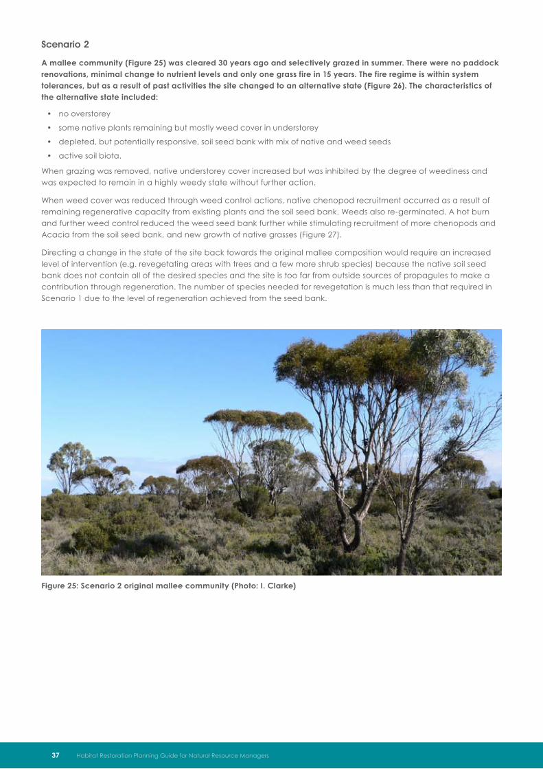
Scenario 2
A mallee community (Figure 25) was cleared 30 years ago and selectively grazed in summer . There were no paddock renovations, minimal change to nutrient levels and only one grass fire in 15 years . The fire regime is within system tolerances, but as a result of past activities the site changed to an alternative state (Figure 26) . The characteristics of the alternative state included:
no overstorey•
some native plants remaining but mostly weed cover in understorey•
depleted, but potentially responsive, soil seed bank with mix of native and weed seeds•
active soil biota.•
When grazing was removed, native understorey cover increased but was inhibited by the degree of weediness and was expected to remain in a highly weedy state without further action.
When weed cover was reduced through weed control actions, native chenopod recruitment occurred as a result of remaining regenerative capacity from existing plants and the soil seed bank. Weeds also re-germinated. A hot burn and further weed control reduced the weed seed bank further while stimulating recruitment of more chenopods and Acacia from the soil seed bank, and new growth of native grasses (Figure 27).
Directing a change in the state of the site back towards the original mallee composition would require an increased level of intervention (e.g. revegetating areas with trees and a few more shrub species) because the native soil seed bank does not contain all of the desired species and the site is too far from outside sources of propagules to make a contribution through regeneration. The number of species needed for revegetation is much less than that required in Scenario 1 due to the level of regeneration achieved from the seed bank.
Figure 25: Scenario 2 original mallee community (Photo: I . Clarke)
37 Habitat Restoration Planning Guide for Natural Resource Managers

Figure 26: Degradation from farming activities resulted in an alternative state with no overstorey, some understorey and a potentially responsive soil seed bank (Photo: I . Clarke)
Figure 27: Weed control and prescribed burning resulted in the return of some of the original understorey species (Photo: I . Clarke)
Habitat Restoration Planning Guide for Natural Resource Managers 38

Management contextSite assessment data can be used to categorise sites or management units (see ‘Using management units’ on page 58) according to their current habitat state and the levels of input required for restoration . These categories are:
maintain existing features or•
improve habitat or•
reconstruct habitat.•
Maintain
The ‘Maintain’ category of management applies to areas of habitat in good to excellent condition with minimal disturbance from farming or other land use practices (Figure 28) . The site assessment will show that the area:
is in good condition•
has minimal or no weed invasion•
has a relatively complete range of species •
has most desirable habitat features present (compared to the desired goal state)•
has a disturbance regime that is appropriate to maintaining desired features.•
The area may require little active management but needs to be protected from potential future degradation. Projects with these areas should focus on threat monitoring and implementing actions to minimise threats and manage disturbance regimes for positive outcomes.
Figure 28: Maintain ‘intact’ habitat – monitor and minimise threats (Photo: I . Clarke)
39 Habitat Restoration Planning Guide for Natural Resource Managers

Managing appropriate disturbance regimes
The consequences of disturbance are not necessarily negative . Disturbance has two primary roles in maintaining the health of many ecosystems found in Australia:
creating conditions for change (e.g. regeneration) and•
influencing dynamics that control community composition.•
Disturbance prevents the establishment of species that are not adapted to the disturbance regime, thus natural disturbance regimes can help maintain community integrity. Disturbance can also improve colonisation outcomes for some species within a community. A temporary reduction in competition after disturbance at intervals helps maintain a variety of species across a community that otherwise may be outcompeted by other dominant species in an undisturbed environment.
Examples of this are the Hills Daisy, Ixodia achillaeoides and many wattles, Acacia species (Figure 29). These species are generally found in low numbers in long-unburnt communities. Fire stimulates germination and can temporarily decrease overstorey competition, allowing much higher abundances in the first few years after fire.
Features of seeds of species adapted to fire include impervious seed coats (Figure30) or seed-coat inhibitors that require heat or stimulation from the water-soluble components of smoke to trigger germination. High soil nitrate levels found after the burning of vegetation also promote greater seedling success.
Figure 29: Post-fire response with Acacia species and Ixodia achillaeoides abundant in the understorey in the early stages of post-fire development (Photo: I . Clarke)
Figure 30: Seeds with impervious seed coats (e .g . many legumes) may respond to fire as a trigger (Photo: I . Clarke)
Habitat Restoration Planning Guide for Natural Resource Managers 40

The alteration of fire or grazing regimes (e.g. continual suppression or very high frequency) may lead to undesirable outcomes in some habitats. Such habitats may need to be managed towards more appropriate regimes if the system begins to show signs that health and diversity of habitat is moving away from an acceptable state.
Examples of using disturbance for management purposes include using:
ecological burns to maintain vegetation diversity and a variety of age classes, where these are key to the survival •of species in the long term
strategic grazing as a management tool to maintain species diversity in naturally open grassy ecosystems.•
Restoration planners need to be able to predict possible outcomes from disturbance events. There will always be unknowns, particularly in degraded systems where site history and landscape context play a directing role in the variety of possible responses and system changes that can result from disturbance. It is important to be aware that if disturbance is used as a management tool at sites in fragmented landscapes, a lack of connectivity (affecting some species recolonisation) and edge effects (e.g. weed invasion) may interfere with recovery.
The decision to intervene or not must be made on a case by case basis and consider all risks and variables pertaining to the site. This will require assessment by expert ecologists and planning that conforms to the Native Vegetation Act 1991 and Native Vegetation Regulations 2003.
Improve
The ‘Improve’ category of management applies to areas with past vegetation clearance or grazing that has left some desirable, but degraded, habitat . The site assessment will show that the area contains:
native vegetation in moderate condition (most desired habitat features present)•
current threats to regeneration•
partial or full regeneration potential if threats are managed.•
Threats to regeneration are often grazing, weed competition or lack of an appropriate germination trigger, therefore improvement actions may include:
reducing total grazing pressure (reducing stock, rabbits, kangaroos, deer, goats)•
controlling weed competition through herbicides, slashing or the use of a strategic grazing regime•
triggering germination of soil seed bank through application of smoke water products or strategic burns•
revegetation of missing species (minimal disturbance methods).•
Figure 31: Partially degraded habitat where a range of native species remain requires improvement through removing threats (e .g . grazing) (Photo: I . Clarke)
41 Habitat Restoration Planning Guide for Natural Resource Managers

Minimal disturbance revegetation
Project sites that have some, but not all, of the desired plant species left are often the most difficult to plan appropriate actions for, particularly when they appear at first to be highly degraded (Figure 32). Although the initial focus is on recognising and using the natural regeneration potential of the site, if the site assessment or monitoring reveal that natural regeneration alone is/will be insufficient to restore all desired plant components then some additional species may need to be introduced through revegetation to reach the goal state.
Revegetation methods that require vehicle access and soil disturbance (such as machine direct seeding) are inappropriate for parts of sites that have reasonably good vegetation already. Take a ‘minimal disturbance’ approach to restoration in these areas by avoiding damage to any existing native plants where possible. Revegetate missing plant species through hand direct seeding or tubestock planting.
Note that competition from mature plants may affect the success of newly germinated or planted seedlings, so do not plant too close to existing trees and shrubs. To reduce competition from weeds, spot spray, cut and swab or ‘weed wipe’ using hand tools as appropriate rather than using boom sprays. Minimise soil disturbance to reduce the potential for further weed germination.
Figure 32: Partially modified habitat that still has some native vegetation (e .g . native grasses in understorey) will require control of grazing pressure and possibly revegetation, depending on the required goal state (Photo: I . Clarke)
Reconstruct
The ‘Reconstruct’ category of management applies to areas previously cleared of all (or almost all) native vegetation (Figure 33) . The site assessment will show that the area contains:
no native vegetation or native vegetation in very poor condition (few or no desired habitat features)•
little to no native regeneration potential (even if threats are managed there is no seed bank from which native •species can regenerate).
The site assessment is also likely to show that the site has been subjected to high grazing pressure, renovated to improved pasture or sown to crops and the soil seed bank is most likely dominated by introduced species as a result.
Habitat Restoration Planning Guide for Natural Resource Managers 42

Figure 33: Degraded areas where few native species remain require reconstruction (Photo: I . Clarke)
Reconstruction of habitat from scratch requires a wide range of management techniques and incurs high costs, particularly on very degraded sites with a long history of site disturbance . Reconstruction methods may include a combination of the following:
revegetation•
slashing and herbicide applications for site preparation –
ripping or scalping for site preparation –
tubestock planting (Figure 34) –
hand direct seeding –
machine direct seeding (Figure 35) –
brush matting (native seed laden branch matting) –
aerial seed broadcasting –
translocation of plants –
application of smoke water products –
soil inoculations with mycorrhizal fungi –
nutrient depletion strategies, e.g. cropping or hay making•
introduction of artificial habitats, e. g relocate fallen hollow logs, provide nest boxes.•
Re-creating system components will often involve actions in phases that may take several years (see ‘Timeframes for restoration goals’ on page 9). Management of weeds and animal pests may be necessary over an even longer timeframe to give the system the best chance of regenerating and becoming self-sustaining.
43 Habitat Restoration Planning Guide for Natural Resource Managers

Figure 34: Tubestock awaiting planting (Photo: I . Clarke)
Figure 35: A combination of direct seeding and tubestock planting has been used at this site to enable a wider range of species to be established (Photo: I . Clarke)
Broad-acre revegetation
The absence of native regeneration potential usually means that broad-acre revegetation is a key reconstruction method in the short term. Continual investment in the NRM sector into revegetation activities over several decades has realised well-refined technologies but it is a difficult and expensive way to create habitat.
Ideally, the aspirational goals of creating adequate, resilient and functional habitats will be reflected in the revegetation design to maximise long-term success. As the level of resourcing can affect what can be achieved, well-understood goals and goal states are essential to direct revegetation design to maximise the return on investment.
Habitat Restoration Planning Guide for Natural Resource Managers 44

The following is a checklist to guide revegetation design as relevant to the restoration goal state . They include:
maximizing the size of restored areas (Figure 36)•
using plant species (a range of trees, shrubs, groundcovers) at spacings that provide appropriate spatial •heterogeneity in structure, focusing on the habitat structures required by target species
using plant species that are essential to provide food resources for target fauna species (this can help decide •whether smaller plants, such as herbs or native grasses should be specifically included); if plant species are the target group, ensure that their regeneration requirements will be met by also providing habitat for any mutualist pollinators/dispersers
using a range of plant species (as appropriate for the type of ecological community being restored) with different •adaptation mechanisms to recover from disturbance (e.g. species that resprout after damage, store long-lived seeds in the soil, have seeds protected in woody capsules)
reinstating genetically viable population numbers of each revegetated species•
selecting genetically healthy propagules; consider ‘composite provenancing’ of seed to improve genetic •variability if local seed sources occur in isolated populations (see Introduce genetic variants on page 21)
managing for healthy soil biota, particularly in sites with degraded soils (consider soil inoculations of •mycorrhizal fungi)
assessing fire risk and include firebreaks and access tracks within and around the revegetation where necessary.•
To achieve a diversity of species, revegetation may need to be implemented in planned stages . They are:
phase one plants which are planted first in any revegetation project. These plants are selected to tolerate extreme •conditions and act as colonising species. Examples include most tree species and hardy understorey species such as woody shrubs. Native grasses may be an initial focus for areas where a native grass understorey is desired
phase two plants which are species best left until the site has begun to stabilize, microclimates are created to •provide protection (e.g. from sun and wind) and weed problems have been reduced. These species will include some delicate understorey species and species that are difficult to establish where weeds dominate. Examples include lilies, climbers and daisies.
Planting in phases does not mean that ‘phase one’ plants cannot be planted throughout the restoration program. Additional ‘phase one’ plants can be planted later in the project, not only to create structural heterogeneity (age classes) but to fill in any failures.
Figure 36: Machine direct seeding can be used to help reconstruct habitat over large areas (Photo: Z . Stokes)
45 Habitat Restoration Planning Guide for Natural Resource Managers

Factors affecting management decisionsRestoration goals will vary in the extent that they are achievable in practice, particularly when using reconstruction methods . Common issues that affect restoration goals or implementation plans are that:
most tree species in SA are easily established from seed, but that propagation or re-establishment methods are •unknown or extremely specialised for many understorey species, affecting the level of diversity able to be economically restored through broad-acre reconstruction methods
revegetated trees and shrubs will usually prosper with good weed control and follow-up management but small •and ‘delicate’ species are resource-intensive to manage after planting, especially in large scale programs and where weeds are abundant
expected regeneration may or may not occur, reducing or increasing the extent of revegetation needed•
after removing stock from a site, there is often an influx of new weeds, native grazers (such as kangaroos) and pests •(e.g. rabbits) that will have deleterious effects on new plant growth and require a follow-up management response
changes in soil fertility, salinity or structure may require a trialing process to test a wider range of species, seed •sources or restoration techniques and may influence the achievability of the initial restoration goal
exceptional seasonal conditions may affect site accessibility and affect implementation methods and schedules; •the risk of failure may need to be spread across time and space when restoring large sites
a change of neighbouring land use (e.g. unexpected development) can affect the adequacy of the site to reach •the restoration goal
stakeholders may have unexpected issues with proposed works that require the works to be modified.•
If species that are difficult or expensive to establish are required at restoration sites to meet ecological goals, then extra support (e.g. financial, technical, industry) may be needed to achieve this. To direct investments, the composition of species desired in restoration goal states and the expected outcomes of restoration need to be clear and justified.
Adaptive managementThe outcomes of restoration actions are highly dependent on site context. Outcomes are sometimes difficult to predict. For large-scale restoration projects that will be undertaken over a long time frame it can be beneficial to implement management actions with uncertain outcomes in an ‘adaptive management’ framework.
Adaptive management is often described as ‘learning by doing’. It is not just management by trial and error, but involves a process where managers predict the possible outcomes of management options and implement a trial for the most logical management option. The implementation works are undertaken and closely monitored in a way that will verify whether the management actions result in the expected outcomes. Management is adjusted according to whether or not the early results obtained are likely to meet project goals.
Where there is great uncertainty about management outcomes, a scientific process to set up predetermined assessments of alternative management interventions as they are implemented will give more information upon which to make later management decisions.
Trialing management interventions using a scientific approach will gain accurate feedback backed up by solid data collection and analysis. To analyse results statistically, scientific methods should be followed with an adequate number of replications of any treatments and appropriate controls for comparison. Trials of this nature require a specific level of expertise to design and implement, possibly in consultation with a professional in this field. A good design should enable early analysis of results to inform the project manager of progress or whether a management intervention should be altered or withdrawn. This early warning may save costs and allows for alternatives to be explored and evaluated without too much delay.
Adaptive management is intimately connected to the monitoring and evaluation process which gathers information on the response of a site (see ‘Monitoring and Evaluation’ on page 49). It may take generations to achieve aspirational restoration goals and systems may need to be managed over the long term, so the ability to pass on accurate data over a project’s life and beyond is vital to success. Use data in an appropriate form to provide clear feedback to successive project managers.
The steps in the adaptive management cycle and the iterative process of testing, evaluation and adjustment are shown in Figure 37.
Habitat Restoration Planning Guide for Natural Resource Managers 46

Figure 37: The adaptive management cycle for a restoration project
Clearly identify the restoration problem,
project goals and management
objectives
Construct a model of the system
with expected responses to management actions (include
expected outcomes of alternative management
scenarios); outline hypotheses, assumptions and
uncertainties
Identify the set of management actions
most appropriate to meet goal/s; design actions to
test hypotheses
Construct a method for quantified
data collection, recording and analysis; collect baseline
data where possible
Implement management actions within
trial framework
Monitor the response of the system
to management actions; compare results to the hypothesized response
Continue with a strategy, revise or
develop new strategies/goals as required;
share learnings
47 Habitat Restoration Planning Guide for Natural Resource Managers

Habitat Restoration Planning Guide for Natural Resource Managers 48
Further informationState and transition concepts are outlined further by West (2008) and Cale (2007).
General restoration and management actions for Australian woodlands are overviewed by Hobbs and Yates (2000) and McIntyre et al. (2002).
Commonly used restoration methods are explained online in the Florabank ‘Native Vegetation Management Tool’ website at www.florabank.org.au. Practical hands-on training for many aspects of restoration is available for members of Trees for Life (see www.treesforlife.org.au).
Dalton (1993) gives a more detailed guide to direct seeding methods for revegetation in South Australia. Examples of native understorey plant species that require specialist restoration methods in SA are given in Murphy and Dalton (1996).
Planning for pest management is detailed further by Braysher and Saunders (2003). Techniques to control weed threats in degraded remnant vegetation are explained in Bradley (2002) and Robertson (2005).
Guidelines for the use of fire as a management tool are available at http://www.environment.sa.gov.au/firemanagement/Fire_and_the_environment/
Adaptive management and use of trials to inform management are discussed by Sabine et al. (2004), Hauser (2008) and O’Connor et al. (2006).
SummarySome sites can be restored by controlling threats and taking advantage of natural regeneration whereas •at other sites, the degradation has been so extreme that the site will not be able to return to the same state that it existed in prior to disturbance.
The level of intervention required may be to ‘maintain’, ‘improve’ or ‘reconstruct’ depending on the •current state of the site, the threats to the site and the proximity of the site to potential colonising sources of desired species.
The focus of maintenance within parts of sites that already have good habitat is to monitor threats and •manage disturbance regimes.
The focus of improvement within partially degraded areas is to encourage species to naturally •regenerate by removing threats, and use low-impact restoration methods to restore missing habitat elements that will not appear through natural regeneration.
The focus of reconstruction in very degraded areas with negligible regeneration potential is to prepare •the site to a state that can be revegetated, introduce the primary elements of habitat through revegetation and, if needed, relocation of structural features (e.g. hollow logs) and manage pests so that the revegetation is able to mature.
Revegetation may need to occur in phases, with hardy colonising species used first to modify site •conditions, then other species less tolerant of exposure used in follow-up plantings once some native cover has been established and weeds have been effectively controlled.
Many factors affect how restoration can be implemented and the outcomes of management actions •are sometimes uncertain; adaptive management trials that compare the results of different management scenarios may improve knowledge and assist with decision making, particularly for large-scale sites with longer project timeframes.

Monitoring and Evaluation
ObjectivesBefore embarking on a monitoring program, it is essential to clarify which aspects of the restoration project are of interest to monitor. The information required may be simply an account of the outputs (e.g. number of hectares protected or plants revegetated) to meet short-term reporting requirements from funding bodies. It is desirable however, that restoration planners, practitioners and investment bodies evaluate whether restoration projects reach their intended outcomes (goals) and improve restoration knowledge through reporting on project successes and failures.
An obvious aim of habitat restoration outcome monitoring is to detect whether the target species or species group that the habitat is being restored for eventually occupies the site. It may be many years before a target group of species is expected to inhabit a restored site, particularly if reconstruction methods have been used. The purpose of monitoring in the early stages of a restoration project may instead be to provide feedback on the results of implementation methods, the project’s stage of development and progress towards or away from the goal state. Such monitoring is essential to guide ongoing management actions to reach the restoration goal.
A monitoring and evaluation program may also aim to:
evaluate assumptions about models or project design used to guide management decisions •
investigate responses to different management actions when linked into an adaptive management framework •(see ‘Adaptive management’ on page 46).
The resources available both now and in the future will influence what data can be collected and thus what the monitoring program can realistically achieve. Many restoration programs suffer from lack of monitoring resources and little or no long-term follow up, thus significant effort is required to ensure that initial data collection is not wasted. Given the range of reasons that restoration managers may embark on monitoring programs and the limited resources sometimes available, they must make sure that the questions being asked are highly focused and well designed. It may be beneficial to link to and inform regional or state programs that have the best chance of ongoing funding and therefore can support the monitoring and reporting effort over the required timeframes.
49 Habitat Restoration Planning Guide for Natural Resource Managers
Linking project milestones and monitoringMonitoring can be linked to points in time (‘milestones’) when a significant output is expected to be completed or a certain interim outcome obtained. Milestones are benchmarks for success, and indicators to prompt changes in management if they are not reached in appropriate timeframes. Such project milestones can be hypothesised in advance by using a process which identifies the rationale behind goals, strategies, outputs and activities (this is sometimes referred to as a ‘program logic’ process).
Collecting monitoring data scientifically will allow objective scrutiny through statistical analysis. It is therefore helpful if project milestone statements are specific, measurable, realistic and time-bound and formulated with the restoration goal in mind. Monitoring questions or hypotheses about outcomes can then be more easily devised to guide the collection of data and link to management decision making. Table 8 shows examples of some milestones and monitoring hypotheses that would inform restoration progress for the following restoration goal:
Restore 50 hectares of woodland habitat type X at Site A to significantly improve the numbers of individuals of species in response group Z successfully breeding at the site by 2030 compared to pre-project levels in 2010.
Table 8: Examples of project milestones (restoration goal given in text) and the relation to possible monitoring hypotheses and management decision making (note: null hypotheses of no change / no difference should be stated where relevant but have been omitted here for brevity)
Project milestone Related monitoring hypotheses Relation to informing management
Reduce fox and rabbit numbers within the restoration site by at least 95% by end of Autumn 2012 compared to pre-control levels in Autumn 2011 and maintain numbers at or below this level until at least the year 2020.
In May 2012, fox abundance and rabbit abundance are both 95% less on average in the site to be restored than the average abundance recorded in May 2011.
In May each year, indicators of fox and rabbit numbers are not statistically different within the restored site from levels found in May 2012 (or other appropriate benchmark figure).
Revegetated plant species do not show signs of grazing pressure (monitored at appropriate intervals).
Target figures for pest animal population reduction should relate to levels that are thought to be effective for reduction of predation on native fauna or grazing of native seedlings. If an impact is still seen on flora or fauna and this can be related to numbers of pests, then more extensive control may be needed.
The restoration area is planted with first phase of native plants (20 species) by August 2012.
In December 2012, 20 revegetated plant species are surviving in the target restoration area (a % native vegetation cover may be specified according to expected level of development).
If fewer than 20 species are found then some aspect of management (e.g. pest control) has failed and replanting with appropriate management will be required. If the reasons for failure are of particular interest then trials that assess the impacts of different variables (rainfall, weed competition, grazing impacts) should be set up in advance.
Total native plant species diversity is at least 50% of that found in the reference site for woodland habitat type X by October 2017.
In October 2017, the diversity of native plant species found on average within (a given area of) the restoration site is at least 50% of the average diversity found within (a given area of) the reference site for woodland habitat type X.
Monitoring the change in diversity over time compared to a desired goal state will inform whether Site A is on an acceptable pathway of development. Observing a diversity that is less than the target state may indicate that more revegetation and/or threat abatement is required. Requires an understanding of timeframes for community development.
Members of target species group Z are successfully reproducing at the site by October 2025.
In October 2025, the average number of young produced at site A for species group Z is not statistically different to average number of young produced for species group Z in habitat type X reference site(s).
If the relative abundance of young over time does not converge towards that found in habitats in reference sites then investigations of causes will help inform management directions.
Habitat Restoration Planning Guide for Natural Resource Managers 50

IndicatorsRestoration sites can be monitored for the presence and abundance of the target species (as per the restoration goal) to indicate the level of habitat suitability. If the target species is found in the desired abundance and is breeding, then the project could be deemed a success. If the target species is not found, further investigations may be needed to determine causal factors.
Monitoring the level of habitat structural development in relation to the goal state and the level of ecosystem function will help to inform managers about whether a project is likely to meet the restoration goal.
As not everything of ecological interest can be practically monitored, key indicators that represent habitat suitability and functioning ecosystems must be chosen. To be effective, indicators must be measurable within reasonable timeframes, relevant to the issue in question, able to be interpreted and cost-efficient. Assumptions behind how indicator data are interpreted should be critically examined as sometimes there is a lack of information about the causal relationships between indicators and the properties of system states they are assumed to indicate.
Habitat development
Choosing indicators for habitat suitability requires that the key habitat requirements of the target species are identified from ecological knowledge of experts or literature (refer to ‘Habitat inventory’ on page 12). There are numerous features that may be important depending on the target species for restoration, but many habitat requirements relate to vegetation structure and plant species composition (e.g. see Box 4).
If monitoring reveals that significant habitat structures desired in the goal state have either not been provided for at the site or they are yet to develop, then this may help to explain the absence of the restoration target species and guide further restoration actions.
Ecosystem function
The numerous ecological processes that make an ecosystem work (such as decomposition, pollination, energy transfer) can be very difficult to monitor directly. Observable indicators that an ecosystem is functional and self-sustaining may include the presence of various functional species groups, natural regeneration and the presence of a ground cover layer with a composition that is comparable to that found in the desired goal state. To understand the importance of comparisons with a goal state, see ‘Giving monitoring data context’ on page 54.
Although the relative diversity within particular functional groups and regeneration compared to reference sites may be used as an indicator of the level of ecosystem function (Table 9), this presupposes a sound understanding of the ecology of the species attributed to each functional group. For many ecosystems, knowledge of the functional roles of species in ecosystem recovery is still quite basic.
The presence and absence of pest animals and weeds should also be monitored throughout the life of a restoration project as another important indicator of habitat suitability. Indicators for animal pests include fresh scats, active burrows, tracks and signs of visible impacts, such as grazed vegetation. If possible, relative abundance of the species should be measured.
Animal and plant pests affect the survival of native species to different extents, so an assessment of the risk posed by pests found at a restoration site is required in order to inform management actions.
51 Habitat Restoration Planning Guide for Natural Resource Managers
Box 4: General habitat features of importance for woodland birds
Kavanagh et al. (2007) summarised general habitat attributes of Australian woodlands that are important factors influencing woodland bird species diversity as:
plant species diversity•
extent of tree cover•
degree of shrub development•
availability of old trees and associated nesting hollows•
tree regeneration•
amount of coarse woody debris (groundcover) and•
proximity to water or riparian zone vegetation.•
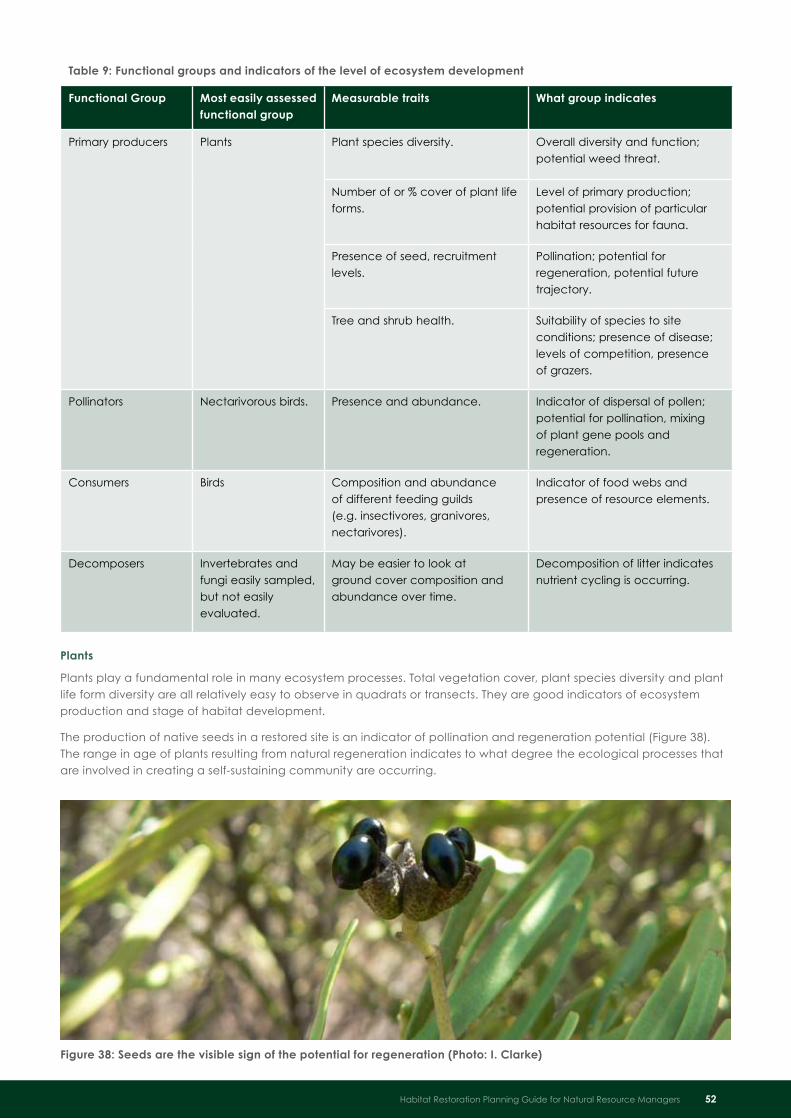
Table 9: Functional groups and indicators of the level of ecosystem development
Functional Group Most easily assessed functional group
Measurable traits What group indicates
Primary producers Plants Plant species diversity. Overall diversity and function; potential weed threat.
Number of or % cover of plant life forms.
Level of primary production; potential provision of particular habitat resources for fauna.
Presence of seed, recruitment levels.
Pollination; potential for regeneration, potential future trajectory.
Tree and shrub health. Suitability of species to site conditions; presence of disease; levels of competition, presence of grazers.
Pollinators Nectarivorous birds. Presence and abundance. Indicator of dispersal of pollen; potential for pollination, mixing of plant gene pools and regeneration.
Consumers Birds Composition and abundance of different feeding guilds (e.g. insectivores, granivores, nectarivores).
Indicator of food webs and presence of resource elements.
Decomposers Invertebrates and fungi easily sampled, but not easily evaluated.
May be easier to look at ground cover composition and abundance over time.
Decomposition of litter indicates nutrient cycling is occurring.
Plants
Plants play a fundamental role in many ecosystem processes. Total vegetation cover, plant species diversity and plant life form diversity are all relatively easy to observe in quadrats or transects. They are good indicators of ecosystem production and stage of habitat development.
The production of native seeds in a restored site is an indicator of pollination and regeneration potential (Figure 38). The range in age of plants resulting from natural regeneration indicates to what degree the ecological processes that are involved in creating a self-sustaining community are occurring.
Figure 38: Seeds are the visible sign of the potential for regeneration (Photo: I . Clarke)
Habitat Restoration Planning Guide for Natural Resource Managers 52

Birds
Birds are relatively easy to observe compared to many other fauna and bird ecology is relatively well-known. Birds have representatives that depend on the full range of animal diets and are sensitive to environmental change. The presence of a diverse range of bird feeding guilds in a restoration site over time indicates that many interacting processes are likely to be occurring successfully (primary productivity, various food webs, pollination).
Invertebrates and fungi
Invertebrates make up the vast majority of species diversity and are closely linked to a variety of ecosystem processes, including nutrient cycling, the development of soil structure and predation. Fungi (Figure 39) are also indicators of nutrient cycling through decomposition. Both invertebrates and fungi species are abundant, diverse and easily collected, but unfortunately their practical use as indicators can be limited due to difficulties with taxonomy and a lack of readily accessible expertise to identify and interpret samples in South Australia.
Ground layer development
The level and composition of ground cover (Figure 40) may be important indicators of habitat for some fauna species. They also indicate the general potential for nutrient recycling, soil stability and soil biodiversity generally. ‘Ground cover’ includes plant cover at the ground level, leaf litter, woody debris, exposed rock and microphytic crust (e.g. cryptogams such as mosses and lichens). Ground cover can be measured using percentage cover estimates in quadrats or along transects.
Figure 39: The fruits of fungi indicate decomposition is occurring but fungi are relatively difficult to identify and evaluate (Photo: I . Clarke)
Figure 40: Ground cover includes leaf litter, mosses, lichens and woody debris (Photo: I . Clarke)
53 Habitat Restoration Planning Guide for Natural Resource Managers

Sampling effortTo reliably detect significant differences between the restored site values over time and to compare values from other sites, it is essential to capture the range of variability found for each indicator by an appropriate intensity of replicated sampling. Take care to collect representative variation in data over both time and space where possible so that natural fluctuations in the variables of interest are accounted for.
Ideally sampling designs are informed by analyses of statistical power which may require input from an expert ecologist or statistician. For smaller projects where statistical analyses may not be of concern, it is still important to ensure that any monitoring observations carried out take into account variability across the whole site, otherwise incorrect conclusions about management progress can be made.
Giving monitoring data contextData obtained from a restoration site can be meaningless to stakeholders unless it is given context. Comparisons should ideally be made to the prior state, an expected state or a desired future state. Depending on the purpose of monitoring, data from the restored site can be measured against data collected at other sites or even hypothetical data derived from an ecological model describing desired system states (Table 10).
Data collected over time to track the effects of management should also be compared to control sites or reference sites to clarify effects of the restoration actions as opposed to broader environmental influences on species responses and ecosystem processes (see Box 5). Comparison of photographs taken at designated photopoints at different times is a good method to show stakeholders a ‘summary’ of change over time.
As described in ‘Reference sites and goal states’ on page 22, given the constraints on restoration practices, there will often be a large discrepancy between the aspirational goal state as represented by healthy remnant vegetation and the expected states for sites that are undergoing reconstruction through revegetation. The section ‘Timeframes for restoration goals’ on page 9 showed four phases of site development that can take decades to accomplish. Thus monitoring of revegetation in the early phases should be evaluated against realistic expectations by comparing to an expected state (see Box 6 for an example).
Identifying expected habitat states for different restoration phases is challenging but will help reveal what is known about the system, clarify the underlying assumptions about how the site is expected to change over time and help to interpret monitoring data.
Table 10: Different ‘states’ that can be used to give context to restoration monitoring
State or type of site Definition of state Purpose of comparison
The baseline state. The state of the site prior to the restoration actions.
To show how the restoration site has changed since project inception.
Control sites. Sites that at the time of project commencement are in a similar state to the restoration site, in similar environmental settings and with similar land use practices, that are not subject to restoration actions.
To scientifically show outcomes of management actions by separating the effects of management from the impact of environmental fluctuations and any other influencing processes.
Reference sites. Sites with habitat in good condition in similar physical and environmental settings to that of the restoration site (may be chosen to represent the goal state and contain plant and animal communities that are desired at the restoration site).
To show the natural variability in the indicators of interest (e.g. as influenced by environmental factors).
The expected state (of the restoration site) for the stage of development.
A hypothetical state that relates to the expected stage of habitat development given the time since restoration actions were initiated; requires knowledge (e.g. a model) of the timing of implementation phases and likely development timeframes for the different indicators of interest.
To evaluate whether or not management actions are meeting realistic expectations according to a restoration plan schedule.
Habitat Restoration Planning Guide for Natural Resource Managers 54

55 Habitat Restoration Planning Guide for Natural Resource Managers
Box 5: Interpreting changes in species diversity at a site over time
Understanding wider regional dynamics through monitoring of reference sites is important to aid in evaluating the effects of restoration actions compared to other influencing factors. Species diversity should ideally be evaluated by comparing the species composition and abundance relative to reference sites that represent desired goal states.
An increase in bird numbers at the restoration site may indicate that the restoration actions have resulted in better habitat. If however, control sites and/or reference sites also show a similar increase in bird numbers at the same time period, it could predominantly be the result of good seasonal conditions.
A drop in bird abundance observed over time at the restoration site could indicate a decrease in habitat quality, that predation is occurring or that a few aggressive species are becoming dominant (e.g. Noisy Miner birds can occupy revegetation sites and aggressively chase smaller birds species out of the area). A similar drop in bird abundance at the same time in reference sites would indicate that the response is more likely to be related to environmental conditions (e.g. drought) or seasonal migrations.
The appearance of new species over time at the restoration site may be in response to restored habitat quality and natural regeneration processes. Alternatively, if the same species are turning up as new species in reference sites, it may indicate wider environmental changes, such as species dispersal due to climate change.
Box 6: Evaluating revegetation monitoring data by comparing against expectations
In a hypothetical example, an intact mature woodland community in good health may be chosen as a reference site representing the aspirational goal state for a revegetation project that aims to provide woodland habitat for five declining bird species. At the start of the project, the reference site may be assessed as having an average of 40 plant species present per 30 m x 30 m sample quadrat.
To reconstruct a similar woodland community starting from a cleared paddock state, the aspirational goal is to end up with an average of the same 40 species present over a similar quadrat area. Only 20 of these species may be able to be grown practically, within the constraints of the budget and project timeframe (five years), but the project may still proceed because it is assumed that these 20 species will eventually be able to provide habitat for the targeted declining birds.
Three of the bird species require mature woodland and may not appear for decades, but two are expected to be able to colonise the revegetation site by year five. The revegetation may be monitored for plant and bird species diversity at year five to assess the value of the site and the restoration progress.
If, for example, 18 planted species are found on average per quadrat, and one target bird species is seen at the restored site whereas 39 plant species and five target bird species are found on average at the reference site, this could be interpreted as:
a ‘poor’ result compared to the reference site (with only 46% of plant species present out of 39 and only •20% of the target bird species) or
a ‘very good’ result compared to the expected state (with 90% of plant species present out of the •expected 20 species that were planted and 50% of the bird species expected to be present at year five).
The monitoring reveals that whilst the plant diversity of the site is poor compared to the aspirational goal state as represented by the reference site data, it is not because the restoration implementation per se has failed, but rather because the site is still in an early stage of development. Another phase of revegetation is needed to establish the two plant species that were originally planned for but failed. More detailed investigations may find the cause of why the second expected target bird species has not appeared and management actions changed accordingly if needed.
Ongoing monitoring for the presence of target bird species at the restoration site relative to the reference site will confirm to what extent the restoration actions are able to meet the restoration goal over the longer term.
This example highlights why it is important for those who are monitoring revegetation project sites (especially if they are not the planners/implementers) to be clear about:
the restoration goal and target species•
what implementation actions were planned to be carried out and when (and has this occurred?)•
the difference between comparing revegetation site data to remnant vegetation reference site values •versus the expected state at different stages of development
the underlying ecology of the system and what assumptions are made in relation to timeframes for •reaching the restoration goal.

Habitat Restoration Planning Guide for Natural Resource Managers 56
SummaryMonitoring projects during implementation stages will allow changes in management if milestones are •not being met or the site is not responding as expected.
Monitoring of restoration projects may be needed to show funding bodies, stakeholders and project •managers that the project is meeting milestones and/or making progress towards reaching its intended outcomes.
Define project milestone statements that are specific, measurable, realistic and time-bound, and •formulated with the restoration goal in mind, to guide the development of monitoring questions and hypotheses.
Where certain target species are desired as part of meeting a restoration goal at a site, monitor to •observe their presence to indicate that the project is successful; as habitats can take decades to develop at sites undergoing reconstruction, other indicators may be chosen that represent the level of habitat suitability as a guide to whether the project is likely to reach intended outcomes.
Indicators of habitat adequacy and ecological function commonly include: vegetation community •structure; plant species diversity; plant life form diversity; plant recruitment levels; plant health; presence of specific habitat features (e.g. trees bearing hollows); threats; bird species diversity, bird guild diversity and ground cover composition and abundance.
Sampling efforts should try to capture the variation that may occur at the site by using replicates across •space and time; otherwise incorrect conclusions can be made about management outcomes and trends.
All indicator data should be given context by comparing values relative to a previous state, an expected •state (given the time since project implementation) or a desired future goal state (as demonstrated by reference sites with healthy habitat).
To determine the effect of the restoration actions as opposed to other influences and the range of •natural variation in data values, comparisons of monitoring data from the restoration site may be made with baseline data (data sampled at the site prior to restoration), control sites (sites similar to that being restored but without any restoration management) and/or reference sites (healthy remnant habitat).
To assess the success of revegetation actions, it is also useful to put monitoring data into context by •comparing results against hypothetical data that is based on what one could reasonably expect to see at the site given the implementation schedule, the extent of revegetation undertaken and the time since implementation.
Further informationLindenmayer and Burgman (2005) and Stem et al. (2004) review biological monitoring, assessment and indicators for biodiversity conservation.
The Nature Conservation Society of South Australia has developed Bushland Condition Monitoring procedures that assess indicators for the habitat elements that are required by native fauna in different vegetation types, including ground cover (see Croft et al. 2005; Pedler et al. 2007).
State-standard native vegetation survey methods used by the South Australian government are given in Heard and Channon (1997). Gibbons and Freudenberger (2006) also give a comprehensive list of variables that can be measured as part of assessing vegetation condition.
O’Connor and Bond (2007) give an overview of photopoint monitoring.
Munro et al. (2007) reviewed papers that monitored the faunal response to revegetation. Several methods to survey birds are evaluated by Watson (2004)

Developing a Restoration Plan
Contents of a restoration planRestoring areas for habitat goals requires both short-term and long-term planning and a preparedness to act when and if required, thus a level of flexibility is essential. A checklist is provided in Box 7 for the items that should ideally be described as part of a restoration plan.
57 Habitat Restoration Planning Guide for Natural Resource Managers
Box 7: Checklist for possible contents of a habitat restoration plan
q Background to the project, stakeholders involved
q Restoration goals, targets and milestones
q Site location and project boundaries
q Rainfall and other climatic considerations
q Physical properties of the soil and landforms over the site
q Physical features (including infrastructure) and their location
q Land use history and prior disturbance at and adjacent to the site
q Current location, state and ‘trajectory’ of native vegetation (if present)
q Condition and distribution of other relevant habitat features currently present
q Proximity to other habitat/remnant vegetation
q Current and potential future threats that need to be addressed in order to reach the restoration goal (include site threats and project risks)
q Management unit locations and their management context (maintain, improve, reconstruct or works exclusion zone)
q Desired habitat goal state (e.g. vegetation composition and structure)
q Management actions, with an implementation schedule prioritized over time and space (with flexibility for adjustment according to adaptive management as the project progresses)
q Standard operating procedures and access to the site
q Indicative resource requirements
q Monitoring and evaluation goals, indicators and schedule
q Location of reference sites (if applicable)
q The process of reporting and review
q Contacts and references (including previous reports)

Figure 41: Use GPS/GIS or aerial overlay identify distinct management zones for large sites
Seeking advice and inputHabitat restoration plans need an ecologically sound basis that also recognises the practical realities of working in the field within limited timeframes and budgets. The skills and experience required to implement successful projects will differ widely depending on the scope of the project. Rarely will one person have all of the knowledge or time required to plan, implement, monitor and evaluate a complex restoration project; be proactive in consulting a range of professional advisers, ecologists, contractors, local experts and local land managers where possible to make the most of their experience.
Habitat Restoration Planning Guide for Natural Resource Managers 58
Using management unitsManaging restoration at a landscape scale can be a complex task, particularly when faced with planning a restoration project for large areas that may encompass a variety of physical conditions. Most large-scale sites contain areas that require different levels of management intervention or different restoration actions at different times. Be prepared for varying success in responses to management actions over a large site.
To enable practical planning, prioritisation, resource budgeting and achievable yearly targets at the site level, create management zones or units in the one project site (Figure 41) . Factors that may be considered in creating a management zone include:
the level and type of intervention required across the site•
the size of unit that can practically be restored/managed within yearly budget given the level of intervention required•
the attitude to risk (smaller yearly targets involving revegetation spreads the risk of failure over different years and thus •different seasonal conditions)
whether progressive de-stocking is required and how this may affect implementation of restoration actions •(e.g. an existing paddock fencing arrangement may become the basis for management units).
Each zone should be defined in terms of its management context (see ‘Management context’ on page 39). Select restoration treatments that minimise any possible detrimental effects of disturbance that will result from restoration activities.

Habitat protection and restoration is urgently needed in South Australia to prevent further species loss as a result of past habitat clearance and degradation.
The aspirational goal of many habitat restoration projects should be to recover a habitat to a state that is self-sustaining, resilient and functional and gives species opportunities for survival and adaptation in the face of climate change. There is ongoing debate around some of the concepts presented in this document about how best to achieve resilience and habitats that will be functional in a potentially changing climate. There is no definitive answer to some of the questions that arise from ecological theory and the conceptual frameworks used in the field of restoration, so any restoration strategy should involve a risk assessment of likely outcomes and impacts.
Some of the actions that can be considered in restoration planning to improve short-term resilience and long-term adaptive potential include:
maximising species diversity and ecological redundancy (the number of species playing similar functional roles)•
improving connectivity•
incorporating species with functional traits suited to the likely future climate and disturbance regimes•
using seed from local and wider gene pools for plant species for revegetation works (‘composite provenancing’) •to improve the viability of species in fragmented environments.
The landscape context of the project site, its current ecological status and disturbance history will determine the level of intervention required to reach the restoration goal . A site assessment will give the information to identify which areas require maintenance of good habitat, improvement of partially degraded habitat and/or reconstruction of very degraded areas, currently without habitat . Reconstructing very degraded sites to be ultimately resilient and functional will require revegetation using tubestock or direct seeding methods . It may involve up to four phases of restoration over a long period of time . The four phases are the:
foundation (focus on manipulation of landform, soil texture, water table, salinity to ensure the nature of underlying •factors are appropriate to reach the end goal)
early ecosystem establishment (focus on soil stability, cover and appropriate species mix, •e.g. through revegetation)
intermediate ecosystem stage (focus on sustainability of system, e.g. success of regeneration processes, •decomposition and nutrient cycling)
advanced ecosystem stage (focus on niche habitats, resilience to threats and disturbance).•
Reaching the advanced ecosystem stage may not be possible within available knowledge and project resources for very degraded sites, especially in relictual landscapes (i.e. landscapes with less than 10% of habitat cover remaining). Each project planner should therefore think about the feasibility of achieving restoration outcomes in terms of landscape context, resources available and time-frame required. Site-specific habitat restoration goals should be developed for restoration target species that will most feasibly improve the site towards a desired state within these limits. Such goals should be “SMART”: specific, measurable, agreed-upon, realistic and time-bound.
A clearly defined goal that can be broken down into quantitatively measurable milestones will assist in allocating resources accurately and enable any planning and on-ground activity to be undertaken with a clear understanding of purpose and direction. Monitoring may be linked to milestones: when they are expected to be achieved and with what measurable outcomes. Iteratively setting such goals, target species and milestones will direct the collection of relevant site assessment data and inform restoration management. Where outcomes of management are unclear, an adaptive management approach may be taken whereby trials of different management scenarios are set up and outcomes monitored to inform management.
Guide Summary
59 Habitat Restoration Planning Guide for Natural Resource Managers

Abiotic: non-biological factors such as soil, water, wind and temperature
Abundance: the density of individuals within a given area
Assemblages: groups of species established in an area
Baseline data: data collected to establish and understand conditions at a given start-point in time prior to experimental or management manipulations; allows an assessment of change
Biodiversity: number, relative abundance, and genetic diversity of organisms and the ecological complexes and processes of which they are a part (includes diversity within species, between species, and of ecosystems)
Biotic: biological or living factors
Browsing: consumption of woody twigs and leaves from trees and shrubs by animals
Burn box: a box-like structure of primarily non-flammable material designed to enable discrete burns to be implemented over an area with minimal threat of fire escape
Colonist: a plant or animal that colonises an area after disturbance
Community: an ecological community is an integrated assemblage of native species that inhabits a particular area
Composition: the combination of species or other elements present (e.g. at a site)
Connectivity: a functional characteristic of a landscape where vegetation or habitat is connected such that it facilitates physical movement, colonisation and interactions between organisms; connectedness of habitat patches - habitat connectivity is a species-specific concept and varies according to a species’ dispersal ability and sensitivity to exposure
Cryptogam: a general term for non-vascular plants that lack specialised fluid conducting tissues, e.g. algae, lichens and fungi
Disturbance regime: a repeated pattern of changes in environmental conditions caused by disturbance that can affect ecosystem function and shape landscapes, community and population structures (e.g. a natural fire regime consists of a certain fire frequency, intensity and season of burning that is variable, but generally repeated over long periods of time)
Drivers: forces or conditions that change a system
Ecological processes: interactions among organisms, and interactions between organism and the abiotic and biotic elements of their environment
Ecological redundancy: the degree to which a given species can be substituted by different species to provide particular ecosystem functions
Ecosystem: the plants, animals, microorganisms within a given area, and the environment that sustains them and their interactions
Ecosystem function: ecological processes and functions that occur in an ecosystem including interactions among organisms, and between organisms and their environment
Ecosystem services: ecological resources and processes of benefit such as food, fibre, fuel, genetic resources, fresh water, pollination, decomposition of waste, natural pest control and climate regulation
Glossary
Habitat Restoration Planning Guide for Natural Resource Managers 60

Edge effects: Effect of increased wind, water, radiation and nutrients at the edge (perimeter) of a patch of vegetation in a cleared or modified setting
Fragmented landscape: a modified landscape with 10-60% habitat cover (e.g. native vegetation cover) remaining, much of which is in a degraded condition
Frugivore: animal that prefers fruit; can be a herbivore or omnivore
Functional equivalent: a species that plays the same role in ecosystem function as others in the same ecological community
Functional groups: species that share physiological, morphological or behavioural traits and play a similar role in ecosystem function
Goal: the aim and intended outcomes of the restoration project
Goal state: the combination of desired features (e.g. species diversity, vegetation community structure, species interactions and physical conditions) that make up the desired state of a site once it is restored (only some of these factors may be able to be expressed in simple statements)
Genetic diversity: the heritable variation between individuals within populations, between populations within species, and between species
Grazing: consumption of grasses and low vegetation by animals
Guild: a group of species that use the same class of environmental resources in a similar way and between which competition can be expected
Habitat: the locality, environment or natural home in which a particular organism lives; a species-specific entity
Habitat degradation: The reduction in quality of an area of habitat for a given species; the species may still occur in the area but, for example, not be able to successfully breed there
Habitat fragmentation: spatial process of habitat subdivision resulting in smaller habitat patches, often brought about through vegetation clearance
Habitat heterogeneity: diversity of habitat (especially differences in structure) in an ecosystem
Habitat loss: loss of suitable habitat for a given species such that the particular species no longer occurs in the area (this is not necessarily the same as vegetation clearance)
Heterogeneity: diversity in patterns of elements or structures over space or time
Hydrology: dynamic processes of the water in an environment, its occurrence, distribution, movement and balances in ecosystems
Inbreeding depression: a loss of vigour among offspring that occurs when closely related individuals mate; results from a loss of genetic diversity and resultant expression of deleterious recessive alleles
Insectivore: animal that mainly eats insects and other invertebrates
Intact landscape: a landscape with >90% habitat cover (e.g. native vegetation cover) remaining, most of which is in good condition
Intervention: implementation of a management action e.g. revegetation, weed control or slashing
Landscape adequacy: all of the necessary resources are present to meet the immediate needs of the species present in that landscape
Landscape: areas consisting of two or more ecosystems that exchange organisms, energy, water and nutrients; in the scale of hundreds to thousands of hectares
Mosaic: variable patterns of different vegetation types and/or vegetation in different successional stages across a landscape
Mutualist: a species that interacts with another species bringing benefits to both species
Mycorrhizal fungi: fungi that form mutualistic interactions with higher plants
61 Habitat Restoration Planning Guide for Natural Resource Managers

Natural regeneration: re-establishment of vegetation through seed germination, sprouting or suckering on a site from a source at the site
Nectarivore: is an animal which eats the nectar from flowers; most commonly birds and insects, but also mammals, most commonly some species of bats
Omnivore: animal that eats plants and animals
Patch: a discrete area or unit of management smaller than the landscape, often homogenous in nature
Population: a group of individuals of the same species that are sufficiently close geographically that they can find each other and reproduce
Population sink: habitat where local mortality exceeds reproduction rates for a given species (e.g. due to poor habitat quality or predation by feral predators)
Propagule: any plant material that is used for propagation or the resulting emergent seedling
Provenance: location or source of genetic material (e.g. seed); sample of genetic material from a relatively cohesive genetic unit (a population, subpopulation or neighbourhood)
Range: the spatial distribution of a species in a given context
Relictual landscape: a modified landscape with less than 10% habitat cover (e.g. native vegetation cover) remaining, much of which is in a very degraded condition
Resilience: the degree to which a system is able to absorb shocks and recover from disturbance while retaining the same basic function and structure
Seed bank: the natural storage of seeds, often dormant, in the soil (soil seed bank) and held in the canopy of plants (aerial seed bank)
Species diversity: the number and relative abundance of different species within a community or a defined area
Species richness: the total number of species within a community or a defined area
State of a system: the relative values of the components that make up that system e.g. proportion of grasses, woody shrubs, trees; fauna assemblages; species ratios; population densities
Succession: after disturbance, a progressive change in ecological community composition and dynamics through time along a known or predicted pathway
System: a set of interacting entities forming an integrated whole (scale dependant on the subject of interest)
Temporal dimensions: the time period related to any aspect of interest
Threatening processes: processes that detrimentally affect, or may detrimentally affect the survival, abundance, distribution or evolutionary development of a native species or ecological community
Threshold: a point at which a small change in environmental conditions can cause a potentially irreversible change in the state of an ecosystem
Trajectory: description of the pathway of change of an ecosystem or community through time (may be in relation to any aspects of interest such as abundance, composition and distribution of species, habitat niches, ground cover, soil fertility); in restoration, the trajectory begins with the unrestored ecosystem and progressively develops through management actions towards the desired state that is expressed in the goals of the restoration project and embodied in the reference ecosystem
Variegated landscape: a modified landscape with 60-90% habitat cover (e.g. native vegetation cover) remaining, much of which is in good condition
Vegetation composition: the array of plant species present in a given area
Vegetation structure: the vertical and horizontal arrangement of plants defining the space within a vegetation type
Habitat Restoration Planning Guide for Natural Resource Managers 62

Bennett, A. F., Kimber, S. L. and Ryan, P. A. (2000). Revegetation and Wildlife: A Guide to Enhancing Revegetated Habitats for Wildlife Conservation in Rural Environments. Environment Australia, Canberra.
Berg, M., ET, K., Driessen, G., Van der Heijden, M., Kooi, B., Kuenen, F., Liefting, M., Verhoef, H. and Ellers, J. (2010). Adapt or disperse: understanding species persistence in a changing world. Global Change Biology 16: 587-598.
Berkinshaw, T. (2006). Native Vegetation of the Northern and Yorke Region. Greening Australia South Australia, Pasadena.
Berkinshaw, T. (2009). Mangroves to Mallee: The Complete Guide to the Vegetation of Temperate South Australia. Greening Australia South Australia, Pasadena.
Berkinshaw, T. (2010). Native Vegetation of the Eyre Peninsula, South Australia. Greening Australia South Australia, Pasadena.
Bradley, J. (2002). Bringing Back the Bush: the Bradley Method of Bush Regeneration. Reed New Holland, Frenchs Forest, NSW.
Braysher, M. and Saunders, G. (2003). Pestplan: A Guide to Setting Priorities and Developing a Management Plan for Pest Animals. University of Canberra and NSW Agriculture, Orange, NSW.
Broadhurst, L. M. (2007). Managing Genetic Diversity in Remnant Vegetation. Technical Note 01/2007. Australian Government, Land and Water Australia, Canberra.
Broadhurst, L. (2008). Seed provenance and other seed sourcing issues. In Stokes, Z. Ed. Improving Biodiversity Outcomes of Restoration Works: Habitat Restoration Workshop Proceedings. DWLBC Report 2008/08, Department of Water, Land and Biodiversity Conservation, Adelaide.
Cale, P. (2007). A contribution to the development of a conceptual framework for landscape management: A landscape state and transition model. In Lindenmayer, D. and Hobbs, R. Eds., Managing and Designing Landscapes for Conservation: Moving from Perspectives to Principles, Wiley-Blackwell, Malden, Massachusetts.
Cale, P. (2008). Habitat restoration for fauna outcomes. In Stokes, Z. Ed. Improving Biodiversity Outcomes of Restoration Works: Habitat Restoration Workshop Proceedings. DWLBC Report 2008/08, Department of Water, Land and Biodiversity Conservation, Adelaide.
Costermans, L. (2009). Native Trees and Shrubs of South-Eastern Australia. Reed New Holland, Sydney.
Croft, S., Pedler, J. and Milne, T. (2005). Bushland Condition Monitoring Manual: Southern Mount Lofty Ranges. Nature Conservation Society of South Australia, Adelaide.
Dalton, G. (1993). Direct Seeding of Trees and Shrubs. Primary Industries SA, Adelaide.
Dashorst, G. R. M. and Jessop, J. (2006). Plants of the Adelaide Plains and Hills. The Board of the Botanic Gardens and State Herbarium of South Australia, Adelaide.
Davic, R. D. (2003). Linking keystone species and functional groups: A new operational definition of the keystone species concept. Conservation Ecology 7: 11.
Dunwiddie, P., Hall, S., Ingraham, M., Bakker, J., Nelson, K., Fuller, R. and E, G. (2009). Rethinking conservation practice in light of climate change. Ecological Restoration 27: 320-329.
References
63 Habitat Restoration Planning Guide for Natural Resource Managers

Ehrenfeld, J. G. (2000). Defining the limits of restoration: The need for realistic goals. Restoration Ecology 8: 2-9.
Gibbons, P. and Freudenberger, D. (2006). An overview of the methods used to assess vegetation condition at the scale of the site. Ecological Management and Restoration 7: S10-S17.
Gill, A. (1981). Adaptive responses of Australian vascular plants to fires. In Gill, A. M., Groves, R. H. and Noble, I. R. Eds., Fire and the Australian Biota, Australian Academy of Science, Canberra.
Harris, J., Hobbs, R., Higgs, E. and James, A. (2006). Ecological restoration and global climate change. Restoration Ecology 14: 170-176.
Hauser, C. (2008). Adaptive management: Live and learn (and plan!). Applied Environmental Decision Analysis Info Sheet #3.2. Available from www.aeda.edu.au.
Heard, L. and Channon, B. (1997). Guide to a Native Vegetation Survey: using the Biological Survey of South Australia Methodology. Department of Housing and Urban Development.
Hobbs, R. and Suding, K., Eds. (2008). New Models for Ecosystem Dynamics and Restoration. Island Press, Washington DC.
Hobbs, R. J. and Yates, C. J., Eds. (2000). Temperate Eucalypt Woodlands in Australia: Biology, Conservation, Management and Restoration. Surrey Beatty & Sons, Chipping Norton NSW.
Jessop, J., Dashorst, G. R. M. and James, F. M. (2006). Grasses of South Australia. The Board of the Botanic Gardens of Adelaide and the State Herbarium, Adelaide, South Australia.
Kavanagh, R. P., Stanton, M. A. and Herring, M. W. (2007). Eucalypt plantings on farms benefit woodland birds in south-eastern Australia. Austral Ecology 32: 635-650.
Lambeck, R. (1997). Focal species: A multi-species umbrella for nature conservation. Conservation Biology 11: 849-856.
Lindenmayer, D. and Burgman, M. (2005). Practical Conservation Biology. CSIRO Publishing, Collingwood, Victoria.
Lindenmayer, D. and Fischer, J. (2006). Habitat Fragmentation and Landscape Change. Island Press, Washington.
Lowe, A. (2010). Composite provenancing of seed for restoration: progressing the ‘local is best’ paradigm for seed sourcing. Supplement to Wingspan 20: 16.
Marchant, S. and Higgins, P. J., Eds. (1990). Handbook of Australian, New Zealand and Antarctic Birds Volume 1: Ratites to Ducks (Part A: Ratites to Petrels). Oxford University Press, Melbourne.
Maslin, B. (2001). Wattle: Acacias of Australia. CD-ROM available from CSIRO Publishing, Collingwood, Victoria.
McCann, I. R. (1989). The Mallee in Flower. The Victorian National Parks Association, Melbourne.
McIntyre, S. and Hobbs, R. J. (1999). A framework for conceptualizing human effects on landscapes and its relevance to management and research models. Conservation Biology 13: 1282-1292.
McIntyre, S. and Hobbs, R. (2000). Human impacts on landscapes: matrix condition and management priorities. In Craig, J. L., Mitchell, N. and Saunders, D. A. Eds., Nature Conservation 5: Conservation in Production Environments, Surrey Beatty and Sons, Chipping Norton.
McIntyre, S., McIvor, J. G. and Heard, K. M., Eds. (2002). Managing and Conserving Grassy Woodlands. CSIRO Publishing, Collingwood, Victoria.
Munro, N. T., Lindenmayer, D. B. and Fischer, J. (2007). Faunal response to revegetation in agricultural areas of Australia: A review. Ecological Management and Restoration 8: 199-207.
Murphy, R. G. and Dalton, G. S. (1996). Understorey Establishment Research: Technical Report 249. Primary Industries South Australia, Murray Bridge.
Nicolle, D. (1997). Eucalypts of South Australia. Nicolle, D., Morphett Vale, South Australia.
Noble, I. R. and Slatyer, R. O. (1980). The use of vital attributes to predict successional changes in plant communities subject to recurrent disturbances. Vegetatio 43: 5-21.
O’Connor, P., Tesoriero, J., Morgan, A. and Bolt, S. (2006). Learning on the Run: Incorporating Trials and Experimentation into the Management of Natural Resources. South Australian Murray-Darling Basin Local Action Planning Groups.
Habitat Restoration Planning Guide for Natural Resource Managers 64

O’Connor, P. J. and Bond, A. J. (2007). Maximizing the effectiveness of photopoint monitoring for ecological management and restoration. Ecological Management and Restoration 8: 228-233.
Pedler, J. A., Croft, S. J. and Milne, T. I. (2007). Bushland Condition Monitoring Manual: Northern Agricultural and Yorke Peninsula Regions. Nature Conservation Society of South Australia, Adelaide.
Prescott, A. (1994). Its Blue With Five Petals: Wildflowers of the Adelaide Region. A. Prescott, Prospect, South Australia.
Prescott, A. (1995). Its Blue With Five Petals, Kangaroo Island Field Guide: Wildflowers of Kangaroo Island and the Fleurieu Peninsula. Ann Prescott and Associates, Adelaide, South Australia.
Radford, J., Bennett, A. and MacRaild, L. (2004). How Much Habitat is Enough? Planning for Wildlife Conservation in Rural Landscapes. Deakin University; Land and Water Australia and Department of Sustainability and Environment, Victoria.
Read, T. R., Bellairs, S. M., Mulligan, D. R. and Lamb, D. (2000). Smoke and heat effects on soil seed bank germination for the re-establishment of a native forest community in New South Wales. Austral Ecology 25: 48-57.
Roberge, J.-M. and Angelstam, P. (2004). Usefulness of the umbrella species concept as a conservation tool. Conservation Biology 18: 76-85.
Robertson, M. (2005). Stop Bushland Weeds: A Guide to Successful Weeding in South Australia’s Bushland. Nature Conservation Society of South Australia Inc., Adelaide.
Sabine, E., Schreiber, G., Bearlin, A., Nicol, S. and Todd, C. (2004). Adaptive management: a synthesis of current understanding and effective application. Ecological Management and Restoration 5: 177-182.
Society for Ecological Restoration International Science and Policy Working Group (2004). The SER International Primer on Ecological Restoration. www.ser.org and Society for Ecological Restoration International, Tucson.
Soule, M., Estes, J., Miller, B. and Honnold, D. (2005). Strongly interacting species, conservation, policy, management and ethics. BioScience 55: 168-176.
Steffen, W., Burbidge, A., Hughes, L., Kitching, R., Lindenmayer, D., Musgrave, W., Stafford Smith, M. and Werner, P. (2009). Australia’s Biodiversity and Climate Change. CSIRO Publishing, Collingwood.
Stem, C., Margoluis, R., Salafsky, N. and Brown, M. (2004). Monitoring and evaluation in conservation: A review of trends and approaches. Conservation Biology 19: 295-309.
Suppiah, R., Preston, B., Whetton, P. H., McInnes, K. L., Jones, R. N., Macadam, I., Bathols, J. and Kirono, D. (2006). Climate Change under Enhanced Greenhouse Conditions in South Australia: An Updated Report on Assessment of Climate Change, Impacts and Risk Management Strategies Relevant to South Australia. CSIRO for the South Australian Government.
Tews, J., Brose, U., Grimm, V., Tielborger, K., Wichmann, M., Shwager, M. and Jeltsch, F. (2004). Animal species diversity driven by habitat heterogeneity/diversity: the importance of keystone structures. Journal of Biogeography 31: 79-92.
The National Committee on Soil and Terrain (2009). Australian Soil and Land Survey Field Handbook, Third Edition. CSIRO Publishing, Canberra.
Tongway, D. (2004). Reading the Landscape: A Training Course in Monitoring Landscapes by Landscape Function Analysis. David Tongway, Weetangera, ACT.
Triggs, B. (2004). Tracks, Scats and Other Traces: A Field Guide to Australian Mammals. Oxford University Press, South Melbourne.
Walker, B. and Salt, D. (2006). Resilience Thinking: Sustaining Ecosystems in a Changing World. Island Press, Washington DC.
Walker, B. H. (1992). Biodiversity and ecological redundancy. Conservation Biology 6: 18-23.
Watson, D. (2004). Comparative evaluation of new approaches to survey birds. Wildlife Research 31: 1-11.
West, A. (2008). Ecological Restoration Goals and Planning. In Stokes, Z. Ed. Improving Biodiversity Outcomes of Restoration Works: Habitat Restoration Workshop Proceedings. DWLBC Report 2008/08, Department of Water, Land and Biodiversity Conservation, Adelaide.
65 Habitat Restoration Planning Guide for Natural Resource Managers

Whelan, R. J., Rodgerson, L., Dickman, C. R. and Sutherland, E. F. (2002). Critical life cycles of plants and animals: developing a process based understanding of population changes in fire-prone landscapes. In Bradstock, R., Williams, J. E. and Gill, A. M. Eds., Flammable Australia : Fire Regimes and Biodiversity of a Continent, Cambridge University Press, Cambridge, UK.
Williams, M. (1974). The Making of the South Australian Landscape. Academic Press, London.
York, A. (2002). Changing Fire Regimes: Implications for Biodiversity Conservation. Red Trucks, Green Futures: Proceedings of a Conference on Ecologically Sustainable Bush Fire Management. Nature Conservation Council of NSW, Sydney, NSW.
Habitat Restoration Planning Guide for Natural Resource Managers


AcknowledgementsThe following are also acknowledged for their valuable input:
Andrew Fisher, Principal Adviser, Department of Environment and Natural Resources
Sarah Lance, Principal Project Officer Biodiversity, South Australian Murray-Darling Basin, Natural Resources Management Board
Peter Cale, Ecologist, Australian Landscape Trust
Nigel Willoughby, Regional Ecologist, Department of Environment and Natural Resources
Anthony Abley, Bush Management Advisor, Department of Environment and Natural Resources
Mike Hodder, Leader Assessments, Department of Environment and Natural Resources
Andrew Allanson, Senior Consultant, Rural Solutions SA

Phil Barron, Barron Environmental
For further information please contact:Department of Environment and Natural Resources Phone Information Line (08) 8204 1910, or see SA White Pages for your local Department of Environment and Natural Resources office. Online information available at: www.environment.sa.gov.au
Permissive Licence© State of South Australia through the Department of Environment and Natural Resources. Apart from fair dealings and other uses permitted by the Copyright Act 1968 (Cth), no part of this publication may be reproduced, published, communicated, transmitted, modified or commercialised without the prior written approval of the Department of Environment and Natural Resources.
Written requests for permission should be addressed to: Communications and Community Engagement Branch, Department of Environment and Natural Resources GPO Box 1047 Adelaide SA 5001
DisclaimerWhile reasonable efforts have been made to ensure the contents of this publication are factually correct, the Department of Environment and Natural Resources makes no representations and accepts no responsibility for the accuracy, completeness or fitness for any particular purpose of the contents, and shall not be liable for any loss or damage that may be occasioned directly or indirectly through the use of or reliance on the contents of this publication.
Reference to any company, product or service in this publication should not be taken as a Departmental endorsement of the company, product or service.
© Department of Environment and Natural Resources | April 2011 | FIS 90918