Habitat conservation redlines for the giant pandas in China · Habitat conservation redlines for...
6
Habitat conservation redlines for the giant pandas in China Lingqiao Kong a,b , Weihua Xu a , Lu Zhang a , Minghao Gong c , Yi Xiao a , Zhiyun Ouyang a, ⁎ a State Key Laboratory of Urban and Regional Ecology, Research Center for Eco-Environmental Sciences, Chinese Academy of Sciences, Beijing, China b University of Chinese Academy of Sciences, Beijing, China c Institute of Wetland Research, Chinese Academy of Forestry, Beijing, China abstract article info Article history: Received 19 November 2015 Received in revised form 5 March 2016 Accepted 24 March 2016 Available online xxxx Considering the impossibility to cover the entire population of an endangered species in protected areas, a new approach (species conservation redlines) was recently been proposed in China. It constitutes the baseline space for species conservation but mapping and managing a species redline is not clear. In this study, a procedure on how to map habitat conservation redlines for the endangered giant panda was proposed. Panda habitat was first modeled based on field survey and remotely sensed data. Redline area was proposed after comparing three different scenarios, covering different proportions of panda habitat and populations. Results showed that the proposed redline area covered 9358 km 2 . This area can protect more than 80% of the populations in all moun- tain regions in the study area, while keeping the connectivity of the habitat. The current nature reserves cover 60% of the redline area. Suggestions on how to manage redline areas inside and outside reserves are proposed, to limit human development activities in panda habitat. Our study provided a new approach for managing panda habitat, and would have implications for conservation of other endangered species in China and the world. © 2016 Elsevier Ltd. All rights reserved. Keywords: Giant panda Habitat Conservation Redline Population Connectivity 1. Introduction Finding the balance between conservation and development is still a challenge globally, and even more serious in a country with a huge pop- ulation such as China. A redline paradigm has evolved at the central gov- ernment level in China in 2011 to set the ecological redline in the key ecological functioning regions, eco-sensitive regions and eco-fragile re- gions (Lü et al., 2013; Zheng and Ouyang, 2014). Through reasonable lay- out and minimum area constraint, the redline is delineated in the regions needing special protection to coordinate the ecological environment and economic development, and the regions must be strictly protected (Rao et al., 2012). Among different redline areas for ecological conservation, the redline for species conservation started to be named by the State For- estry Administration in 2013, and defined by the Environmental Protec- tion Administration (Gao, 2015). The redline for species conservation is based on the establishment of key areas displaying a minimum habitat area to maintain viable populations. This redline constitutes the baseline space for species conservation, and long-termed survival of the popula- tions will be threatened if the redline is occupied by human development. The redline does not only comprise the spatial boundary for controlling human activities but also contains quantitative conservation manage- ment requirements (Yang et al., 2014). Although the definition was pro- posed for two years, there are no readily available procedures to map species conservation redlines. Here we take the endangered giant panda (Ailuropoda melanoleuca) as an example to describe, for the first time, how to delineate a species conservation redline. The giant panda is the symbol of species conservation in China. This species once ranged throughout most of China, northern Vietnam, and northern Myanmar (Pan et al., 2001). However, the geographic distribu- tion of the species in China has sharply declined mainly due to human activities (Hu, 2001). Currently, the wild giant panda is distributed in the six mountain regions (Qinling, Minshan, Qionglai, Daxiangling, Xiaoxiangling and Liangshan) (State Forestry Administration, 2015). During the last 60 years, China has established 67 nature reserves spe- cifically to protect panda habitat. The program of National Wildlife Pro- tection and Nature Reserve Construction, which started in 2001, has promoted the conservation of the giant panda, while the National Forest Conservation Program (NFCP) and the Grain-to-Green Program (GTGP) have shown the potential for restoring and expanding the panda habitat (Xu et al., 2006). In addition, the State Forestry Administration in China has carried out four national surveys of giant pandas. Much research has been carried out on habitat mapping, habitat change (Linderman et al., 2005a; Viña et al., 2010; Vina et al., 2007; Zhang et al., 2014), impacts of climate change and/or natural disasters on the giant panda (Li et al., 2015a, 2015b; Xu et al., 2009; Zheng et al., 2012), design of nature re- serves or corridors (Loucks et al., 2003; Xiao et al., 2011; Xu et al., 2006), and impacts of human factors (Bearer et al., 2008; Linderman et al., 2005b; Liu et al., 2001; Yiming et al., 2003). However, it is still dif- ficult to establish nature reserves in some regions where the panda hab- itat is not under conservation because it will affect local economic development, while also it is difficult to manage the habitat outside re- serves. In addition, different human activities (e.g., road construction, Biological Conservation xxx (2016) xxx–xxx ⁎ Corresponding author. E-mail address: [email protected] (Z. Ouyang). BIOC-06749; No of Pages 6 http://dx.doi.org/10.1016/j.biocon.2016.03.028 0006-3207/© 2016 Elsevier Ltd. All rights reserved. Contents lists available at ScienceDirect Biological Conservation journal homepage: www.elsevier.com/locate/bioc Please cite this article as: Kong, L., et al., Habitat conservation redlines for the giant pandas in China, Biological Conservation (2016), http:// dx.doi.org/10.1016/j.biocon.2016.03.028
Transcript of Habitat conservation redlines for the giant pandas in China · Habitat conservation redlines for...
Biological Conservation xxx (2016) xxx–xxx
BIOC-06749; No of Pages 6
Contents lists available at ScienceDirect
Biological Conservation
j ourna l homepage: www.e lsev ie r .com/ locate /b ioc
Habitat conservation redlines for the giant pandas in China
Lingqiao Kong a,b, Weihua Xu a, Lu Zhang a, Minghao Gong c, Yi Xiao a, Zhiyun Ouyang a,⁎a State Key Laboratory of Urban and Regional Ecology, Research Center for Eco-Environmental Sciences, Chinese Academy of Sciences, Beijing, Chinab University of Chinese Academy of Sciences, Beijing, Chinac Institute of Wetland Research, Chinese Academy of Forestry, Beijing, China
⁎ Corresponding author.E-mail address: [email protected] (Z. Ouyang).
http://dx.doi.org/10.1016/j.biocon.2016.03.0280006-3207/© 2016 Elsevier Ltd. All rights reserved.
Please cite this article as: Kong, L., et al., Hadx.doi.org/10.1016/j.biocon.2016.03.028
a b s t r a c t
a r t i c l e i n f oArticle history:Received 19 November 2015Received in revised form 5 March 2016Accepted 24 March 2016Available online xxxx
Considering the impossibility to cover the entire population of an endangered species in protected areas, a newapproach (species conservation redlines) was recently been proposed in China. It constitutes the baseline spacefor species conservation but mapping and managing a species redline is not clear. In this study, a procedure onhow to map habitat conservation redlines for the endangered giant panda was proposed. Panda habitat wasfirst modeled based on field survey and remotely sensed data. Redline area was proposed after comparingthree different scenarios, covering different proportions of panda habitat and populations. Results showed thatthe proposed redline area covered 9358 km2. This area can protectmore than 80% of the populations in allmoun-tain regions in the study area, while keeping the connectivity of the habitat. The current nature reserves cover60% of the redline area. Suggestions on how to manage redline areas inside and outside reserves are proposed,to limit human development activities in panda habitat. Our study provided a new approach for managingpanda habitat, andwould have implications for conservation of other endangered species in China and theworld.
© 2016 Elsevier Ltd. All rights reserved.
Keywords:Giant pandaHabitatConservationRedlinePopulationConnectivity
1. Introduction
Finding the balance between conservation and development is still achallenge globally, and even more serious in a country with a huge pop-ulation such as China. A redline paradigm has evolved at the central gov-ernment level in China in 2011 to set the ecological redline in the keyecological functioning regions, eco-sensitive regions and eco-fragile re-gions (Lü et al., 2013; Zheng and Ouyang, 2014). Through reasonable lay-out andminimum area constraint, the redline is delineated in the regionsneeding special protection to coordinate the ecological environment andeconomic development, and the regions must be strictly protected (Raoet al., 2012). Among different redline areas for ecological conservation,the redline for species conservation started to be named by the State For-estry Administration in 2013, and defined by the Environmental Protec-tion Administration (Gao, 2015). The redline for species conservation isbased on the establishment of key areas displaying a minimum habitatarea to maintain viable populations. This redline constitutes the baselinespace for species conservation, and long-termed survival of the popula-tionswill be threatened if the redline is occupied byhumandevelopment.The redline does not only comprise the spatial boundary for controllinghuman activities but also contains quantitative conservation manage-ment requirements (Yang et al., 2014). Although the definition was pro-posed for two years, there are no readily available procedures to mapspecies conservation redlines. Here we take the endangered giant
bitat conservation redlines f
panda (Ailuropoda melanoleuca) as an example to describe, for the firsttime, how to delineate a species conservation redline.
The giant panda is the symbol of species conservation in China. Thisspecies once ranged throughout most of China, northern Vietnam, andnorthernMyanmar (Pan et al., 2001). However, the geographic distribu-tion of the species in China has sharply declined mainly due to humanactivities (Hu, 2001). Currently, the wild giant panda is distributed inthe six mountain regions (Qinling, Minshan, Qionglai, Daxiangling,Xiaoxiangling and Liangshan) (State Forestry Administration, 2015).During the last 60 years, China has established 67 nature reserves spe-cifically to protect panda habitat. The program of National Wildlife Pro-tection and Nature Reserve Construction, which started in 2001, haspromoted the conservation of the giant panda, while theNational ForestConservation Program (NFCP) and the Grain-to-Green Program (GTGP)have shown the potential for restoring and expanding the panda habitat(Xu et al., 2006). In addition, the State Forestry Administration in Chinahas carried out four national surveys of giant pandas.Much research hasbeen carried out on habitat mapping, habitat change (Linderman et al.,2005a; Viña et al., 2010; Vina et al., 2007; Zhang et al., 2014), impactsof climate change and/or natural disasters on the giant panda (Li et al.,2015a, 2015b; Xu et al., 2009; Zheng et al., 2012), design of nature re-serves or corridors (Loucks et al., 2003; Xiao et al., 2011; Xu et al.,2006), and impacts of human factors (Bearer et al., 2008; Lindermanet al., 2005b; Liu et al., 2001; Yiming et al., 2003). However, it is still dif-ficult to establish nature reserves in some regionswhere the panda hab-itat is not under conservation because it will affect local economicdevelopment, while also it is difficult to manage the habitat outside re-serves. In addition, different human activities (e.g., road construction,
or the giant pandas in China, Biological Conservation (2016), http://
2 L. Kong et al. / Biological Conservation xxx (2016) xxx–xxx
tourism, large hydropower stations, agricultural expansion, residentialdevelopment) cause reductions and fragmentation of the panda habitat,further threatening the current panda conservation system. Therefore,the development of effective management measures to restrict humanactivities within the panda distribution area is important for panda hab-itat conservation.
In this paper, the approach for delineating the panda habitat conser-vation redline described, generates effective panda habitat conservationmeasures. Specific aims included a habitat assessment across the entiregiant panda geographic range, comparison of different strategies foridentifying the redline area, analysis of the spatial relationship betweenthe redline and the current conservation system, and discussion ofman-agement approaches.
2. Methods
2.1. Study area
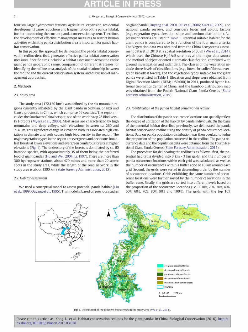
The study area (172,150 km2) was defined by the six mountain re-gions currently inhabited by the giant panda in Sichuan, Shanxi andGansu provinces in China, which comprise 56 counties. The region in-cludes the Southwest China hotspot, one of theworld's top 25 Biodiversi-ty Hotpots (Myers et al., 2000). Most areas are characterized by highmountains and deep valleys, with elevations between ca. 260 and7140 m. This significant change in elevation with its associated high var-iation in climate and soils causes high biodiversity in the region. Themajor vegetation types in the region are evergreen and deciduous broad-leaf forests at lower elevations and evergreen coniferous forests at higherelevations (Fig. 1). The understory of the forests is dominated by ca. 60bamboo species, with approximately 35 of them being the preferredfood of giant pandas (Hu and Wei, 2004; Li, 1997). There are more than300 hydropower stations, about 470 mines and more than 20 scenicspots in the study area, while the length of the road network in thestudy area is about 1300 km (State Forestry Administration, 2015).
2.2. Habitat assessment
We used a conceptual model to assess potential panda habitat (Liuet al., 1999;Ouyang et al., 1995). Thismodel is based onprevious studies
Fig. 1. Distribution of the different forest ty
Please cite this article as: Kong, L., et al., Habitat conservation redlines fdx.doi.org/10.1016/j.biocon.2016.03.028
on giant panda (Ouyang et al., 2001; Xu et al., 2006; Xu et al., 2009), andnational panda surveys, and considers biotic and abiotic factors(e.g., vegetation types, elevation, slope and bamboo distribution). As-sessment criteria are listed in Table 1. Potential suitable habitat for thegiant panda is considered to be a function of the four main criteria.The Vegetation data was obtained from the China Ecosystems assess-ment dataset in 2010 at a spatial resolution of 30 m (Wu et al., 2014),which used the Chinese HJ-1A/B satellites as the major data sourceand method of object oriented automatic classification, combined withground investigation and radar data. The classes of the vegetation in-clude three levels of classifications (e.g., forest, broadleaf forest, ever-green broadleaf forest), and the vegetation types suitable for the giantpanda were listed in Table 1. Elevation and slope were obtained fromDigital Elevation Model (DEM; 1:50,000) in 2011, produced by the Na-tional Geomatics Center of China, and the bamboo distribution mapwas obtained from the Fourth National Giant Panda Census (StateForestry Administration, 2015).
2.3. Identification of the panda habitat conservation redline
The distribution of the panda occurrence locations can spatially reflectthe degree of utilization of the habitat by panda individuals. On the basisof the potential habitat described previously, we delineated the pandahabitat conservation redline using the density of panda occurrence loca-tions. Data on panda population distribution was then overlaid to judgethe proportion of the population conserved in the redline. The panda oc-currence data and thepopulationdatawere obtained from the FourthNa-tional Giant Panda Census (State Forestry Administration, 2015).
The procedure for delineating the redline is as follows: first, the po-tential habitat is divided into 3 km ∗ 3 km grids, and the number ofpanda occurrence locations within each grid was calculated, as well asthe number of occurrences within a buffer zone of 10 km around eachgrid. Second, the grids were sorted in descending order by the numberof occurrence locations. Grids exhibiting the same number of occur-rence locations were further sorted by the number of locations in thebuffer zone. Finally, the grids are sorted into different levels based onthe proportion of the occurrence locations (i.e. 0, 10%, 20%, 30%, 40%,50%, 60%, 70%, 80%, 90% and 100%). The grids with the top 10%
pes in the study area (Wu et al., 2014).
or the giant pandas in China, Biological Conservation (2016), http://
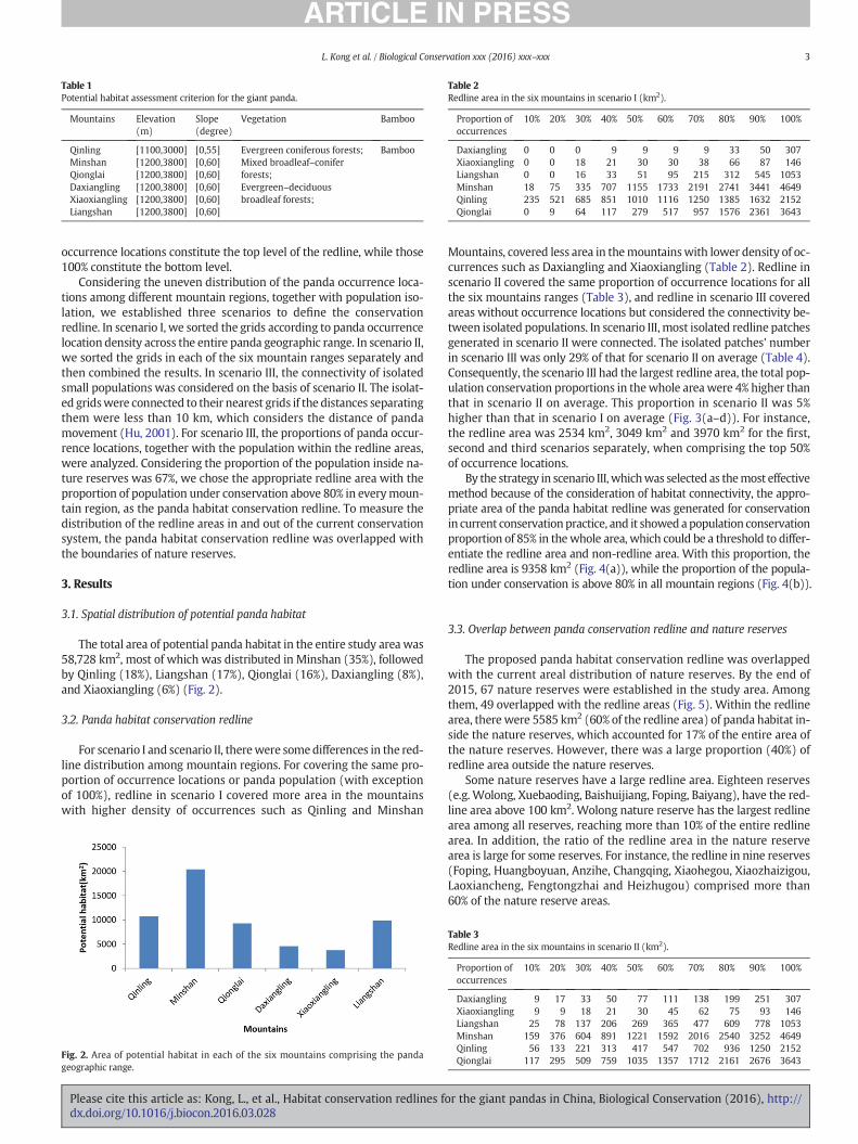
Table 1Potential habitat assessment criterion for the giant panda.
Mountains Elevation(m)
Slope(degree)
Vegetation Bamboo
Qinling [1100,3000] [0,55] Evergreen coniferous forests;Mixed broadleaf–coniferforests;Evergreen–deciduousbroadleaf forests;
BambooMinshan [1200,3800] [0,60]Qionglai [1200,3800] [0,60]Daxiangling [1200,3800] [0,60]Xiaoxiangling [1200,3800] [0,60]Liangshan [1200,3800] [0,60]
Table 2Redline area in the six mountains in scenario I (km2).
Proportion ofoccurrences
10% 20% 30% 40% 50% 60% 70% 80% 90% 100%
Daxiangling 0 0 0 9 9 9 9 33 50 307Xiaoxiangling 0 0 18 21 30 30 38 66 87 146Liangshan 0 0 16 33 51 95 215 312 545 1053Minshan 18 75 335 707 1155 1733 2191 2741 3441 4649Qinling 235 521 685 851 1010 1116 1250 1385 1632 2152Qionglai 0 9 64 117 279 517 957 1576 2361 3643
3L. Kong et al. / Biological Conservation xxx (2016) xxx–xxx
occurrence locations constitute the top level of the redline, while those100% constitute the bottom level.
Considering the uneven distribution of the panda occurrence loca-tions among different mountain regions, together with population iso-lation, we established three scenarios to define the conservationredline. In scenario I, we sorted the grids according to panda occurrencelocation density across the entire panda geographic range. In scenario II,we sorted the grids in each of the six mountain ranges separately andthen combined the results. In scenario III, the connectivity of isolatedsmall populations was considered on the basis of scenario II. The isolat-ed gridswere connected to their nearest grids if the distances separatingthem were less than 10 km, which considers the distance of pandamovement (Hu, 2001). For scenario III, the proportions of panda occur-rence locations, together with the population within the redline areas,were analyzed. Considering the proportion of the population inside na-ture reserves was 67%, we chose the appropriate redline area with theproportion of population under conservation above 80% in everymoun-tain region, as the panda habitat conservation redline. To measure thedistribution of the redline areas in and out of the current conservationsystem, the panda habitat conservation redline was overlapped withthe boundaries of nature reserves.
3. Results
3.1. Spatial distribution of potential panda habitat
The total area of potential panda habitat in the entire study area was58,728 km2, most of which was distributed in Minshan (35%), followedby Qinling (18%), Liangshan (17%), Qionglai (16%), Daxiangling (8%),and Xiaoxiangling (6%) (Fig. 2).
3.2. Panda habitat conservation redline
For scenario I and scenario II, therewere somedifferences in the red-line distribution among mountain regions. For covering the same pro-portion of occurrence locations or panda population (with exceptionof 100%), redline in scenario I covered more area in the mountainswith higher density of occurrences such as Qinling and Minshan
Fig. 2. Area of potential habitat in each of the six mountains comprising the pandageographic range.
Please cite this article as: Kong, L., et al., Habitat conservation redlines fdx.doi.org/10.1016/j.biocon.2016.03.028
Mountains, covered less area in themountainswith lower density of oc-currences such as Daxiangling and Xiaoxiangling (Table 2). Redline inscenario II covered the same proportion of occurrence locations for allthe six mountains ranges (Table 3), and redline in scenario III coveredareas without occurrence locations but considered the connectivity be-tween isolated populations. In scenario III, most isolated redline patchesgenerated in scenario II were connected. The isolated patches' numberin scenario III was only 29% of that for scenario II on average (Table 4).Consequently, the scenario III had the largest redline area, the total pop-ulation conservation proportions in thewhole areawere 4% higher thanthat in scenario II on average. This proportion in scenario II was 5%higher than that in scenario I on average (Fig. 3(a–d)). For instance,the redline area was 2534 km2, 3049 km2 and 3970 km2 for the first,second and third scenarios separately, when comprising the top 50%of occurrence locations.
By the strategy in scenario III,whichwas selected as themost effectivemethod because of the consideration of habitat connectivity, the appro-priate area of the panda habitat redline was generated for conservationin current conservationpractice, and it showed apopulation conservationproportion of 85% in thewhole area, which could be a threshold to differ-entiate the redline area and non-redline area. With this proportion, theredline area is 9358 km2 (Fig. 4(a)), while the proportion of the popula-tion under conservation is above 80% in all mountain regions (Fig. 4(b)).
3.3. Overlap between panda conservation redline and nature reserves
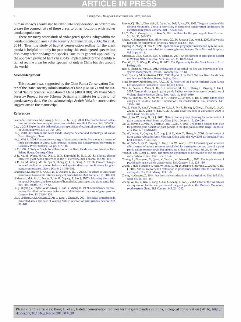
The proposed panda habitat conservation redline was overlappedwith the current areal distribution of nature reserves. By the end of2015, 67 nature reserves were established in the study area. Amongthem, 49 overlapped with the redline areas (Fig. 5). Within the redlinearea, there were 5585 km2 (60% of the redline area) of panda habitat in-side the nature reserves, which accounted for 17% of the entire area ofthe nature reserves. However, there was a large proportion (40%) ofredline area outside the nature reserves.
Some nature reserves have a large redline area. Eighteen reserves(e.g. Wolong, Xuebaoding, Baishuijiang, Foping, Baiyang), have the red-line area above 100 km2. Wolong nature reserve has the largest redlinearea among all reserves, reaching more than 10% of the entire redlinearea. In addition, the ratio of the redline area in the nature reservearea is large for some reserves. For instance, the redline in nine reserves(Foping, Huangboyuan, Anzihe, Changqing, Xiaohegou, Xiaozhaizigou,Laoxiancheng, Fengtongzhai and Heizhugou) comprised more than60% of the nature reserve areas.
Table 3Redline area in the six mountains in scenario II (km2).
Proportion ofoccurrences
10% 20% 30% 40% 50% 60% 70% 80% 90% 100%
Daxiangling 9 17 33 50 77 111 138 199 251 307Xiaoxiangling 9 9 18 21 30 45 62 75 93 146Liangshan 25 78 137 206 269 365 477 609 778 1053Minshan 159 376 604 891 1221 1592 2016 2540 3252 4649Qinling 56 133 221 313 417 547 702 936 1250 2152Qionglai 117 295 509 759 1035 1357 1712 2161 2676 3643
or the giant pandas in China, Biological Conservation (2016), http://
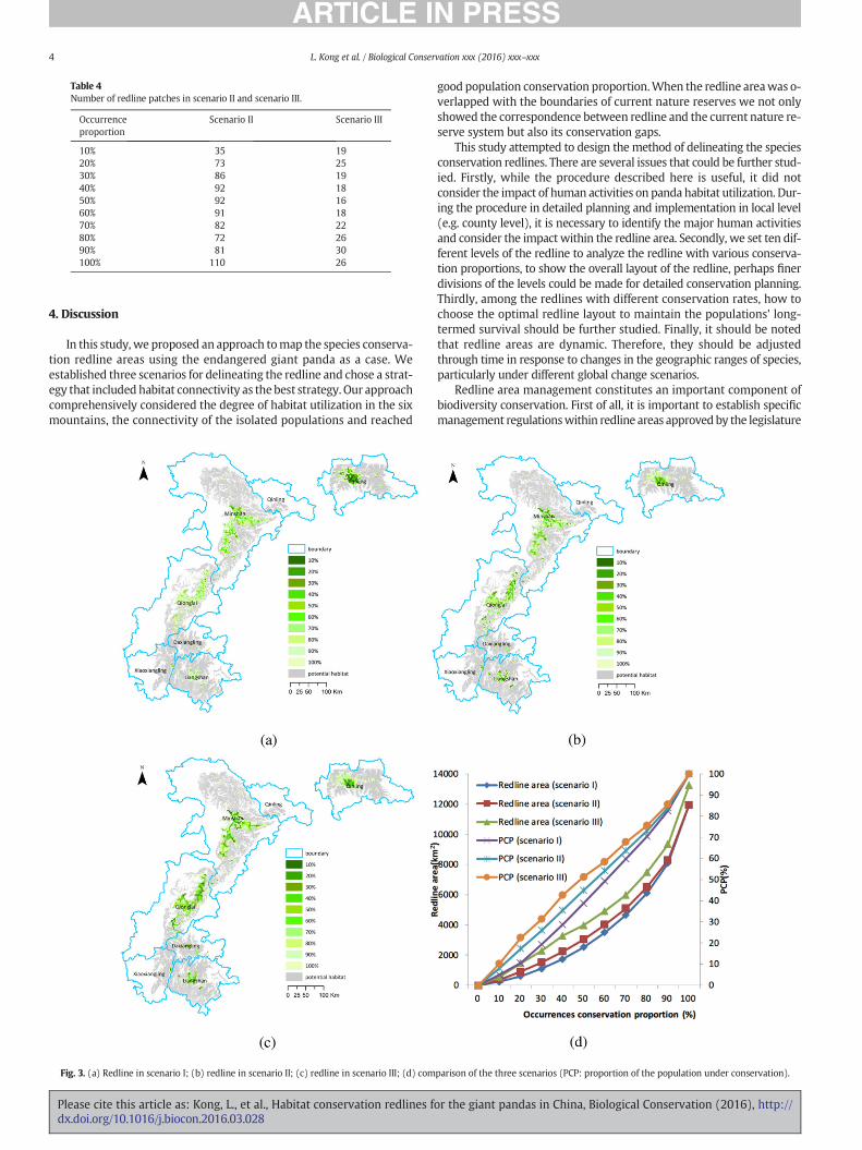
Table 4Number of redline patches in scenario II and scenario III.
Occurrenceproportion
Scenario II Scenario III
10% 35 1920% 73 2530% 86 1940% 92 1850% 92 1660% 91 1870% 82 2280% 72 2690% 81 30100% 110 26
4 L. Kong et al. / Biological Conservation xxx (2016) xxx–xxx
4. Discussion
In this study, we proposed an approach tomap the species conserva-tion redline areas using the endangered giant panda as a case. Weestablished three scenarios for delineating the redline and chose a strat-egy that included habitat connectivity as the best strategy. Our approachcomprehensively considered the degree of habitat utilization in the sixmountains, the connectivity of the isolated populations and reached
Fig. 3. (a) Redline in scenario I; (b) redline in scenario II; (c) redline in scenario III; (d) com
Please cite this article as: Kong, L., et al., Habitat conservation redlines fdx.doi.org/10.1016/j.biocon.2016.03.028
good population conservation proportion.When the redline areawas o-verlapped with the boundaries of current nature reserves we not onlyshowed the correspondence between redline and the current nature re-serve system but also its conservation gaps.
This study attempted to design the method of delineating the speciesconservation redlines. There are several issues that could be further stud-ied. Firstly, while the procedure described here is useful, it did notconsider the impact of human activities on panda habitat utilization. Dur-ing the procedure in detailed planning and implementation in local level(e.g. county level), it is necessary to identify the major human activitiesand consider the impact within the redline area. Secondly, we set ten dif-ferent levels of the redline to analyze the redline with various conserva-tion proportions, to show the overall layout of the redline, perhaps finerdivisions of the levels could be made for detailed conservation planning.Thirdly, among the redlines with different conservation rates, how tochoose the optimal redline layout to maintain the populations' long-termed survival should be further studied. Finally, it should be notedthat redline areas are dynamic. Therefore, they should be adjustedthrough time in response to changes in the geographic ranges of species,particularly under different global change scenarios.
Redline area management constitutes an important component ofbiodiversity conservation. First of all, it is important to establish specificmanagement regulationswithin redline areas approvedby the legislature
parison of the three scenarios (PCP: proportion of the population under conservation).
or the giant pandas in China, Biological Conservation (2016), http://
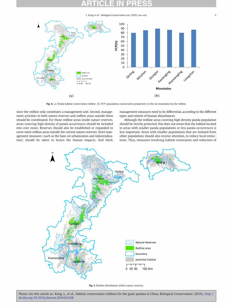
Fig. 4. (a) Panda habitat conservation redline; (b) PCP (population conservation proportion) in the six mountains by the redline.
5L. Kong et al. / Biological Conservation xxx (2016) xxx–xxx
since the redline only constitutes a management unit. Second, manage-ment activities in both nature reserves and redline areas outside themshould be coordinated. For those redline areas inside nature reserves,areas covering high density of panda occurrences should be includedinto core zones. Reserves should also be established or expanded tocover more redline areas outside the current nature reserves. Strict man-agement measures (such as the bans on urbanization and industrializa-tion) should be taken to lessen the human impacts. And third,
Fig. 5. Redline distribution w
Please cite this article as: Kong, L., et al., Habitat conservation redlines fdx.doi.org/10.1016/j.biocon.2016.03.028
management measures need to be differential, according to the differenttypes and extents of human disturbances.
Although the redline areas covering high density panda populationshould be strictly protected, this does not mean that the habitat locatedin areas with smaller panda populations or less panda occurrences isless important. Areas with smaller populations that are isolated fromother populations should also receive attention, to reduce local extinc-tions. Thus, measures involving habitat restoration and reduction of
ithin nature reserves.
or the giant pandas in China, Biological Conservation (2016), http://
6 L. Kong et al. / Biological Conservation xxx (2016) xxx–xxx
human impacts should also be taken into consideration, in order to in-crease the connectivity of these areas to other locations with higherpanda populations.
There are many other kinds of endangered species living within thepanda distribution area (State Forestry Administration, 2006; Xu et al.,2014). Thus, the study of habitat conservation redline for the giantpanda is helpful not only for protecting this endangered species butalso many other endangered species. Due to its general applicabilitythe approach provided here can also be implemented for the identifica-tion of redline areas for other species not only in China but also aroundthe world.
Acknowledgment
This research was supported by the Giant Panda Conservation Cen-ter of the State Forestry Administration of China (CM1417) and the Na-tional Natural Science Foundation of China (40901289). We thank StateForestry Bureau Survey Scheme Designing Institute for provision ofpanda survey data. We also acknowledge Andrés Viña for constructivesuggestions to the manuscript.
References
Bearer, S., Linderman, M., Huang, J., An, L., He, G., Liu, J., 2008. Effects of fuelwood collec-tion and timber harvesting on giant panda habitat use. Biol. Conserv. 141, 385–393.
Gao, J., 2015. Exploring the delineation and supervision of ecological protection redlinesin China. Biodivers. Sci. 23, 705–707.
Hu, J., 2001. Research on the Giant Panda. Shanghai Science and Technology EducationPress. Shanghai, China.
Hu, J., Wei, F., 2004. Comparative ecology of giant pandas in the five mountain ranges oftheir distribution in China. Giant Pandas: Biology and Conservation. University ofCalifornia Press, Berkeley, CA, pp. 137–148.
Li, C., 1997. A Study of Staple Food Bamboo for the Giant Panda. Guizhou Scientific Pub-lishing House, Guiyang, China.
Li, R., Xu, M., Wong, M.H.G., Qiu, S., Li, X., Ehrenfeld, D., Li, D., 2015a. Climate changethreatens giant panda protection in the 21st century. Biol. Conserv. 182, 93–101.
Li, R., Xu, M., Wong, M.H.G., Qiu, S., Sheng, Q., Li, X., Song, Z., 2015b. Climate change-induced decline in bamboo habitats and species diversity: implications for giantpanda conservation. Divers. Distrib. 21, 379–391.
Linderman, M., Bearer, S., An, L., Tan, Y., Ouyang, Z., Liu, J., 2005a. The effects of understorybamboo on broad-scale estimates of giant panda habitat. Biol. Conserv. 121, 383–390.
Linderman, M.A., An, L., Bearer, S., He, G., Ouyang, Z., Liu, J., 2005b. Modeling the spatio-temporal dynamics and interactions of households, landscapes, and giant panda hab-itat. Ecol. Model. 183, 47–65.
Liu, J., Ouyang, Z., Taylor, W.W., Groop, R., Tan, Y., Zhang, H., 1999. A framework for eval-uating the effects of human factors on wildlife habitat: the case of giant pandas.Conserv. Biol. 13, 1360–1370.
Liu, J., Linderman, M., Ouyang, Z., An, L., Yang, J., Zhang, H., 2001. Ecological degradation inprotected areas: the case of Wolong Nature Reserve for giant pandas. Science 292,98–101.
Please cite this article as: Kong, L., et al., Habitat conservation redlines fdx.doi.org/10.1016/j.biocon.2016.03.028
Loucks, C.J., Zhi, L., Dinerstein, E., Dajun,W., Dali, F., Hao, W., 2003. The giant pandas of theQinling Mountains, China: a case study in designing conservation landscapes forelevational migrants. Conserv. Biol. 17, 558–565.
Lü, Y., Ma, Z., Zhang, L., Fu, B., Gao, G., 2013. Redlines for the greening of China. Environ.Sci. Pol. 33, 346–353.
Myers, N., Mittermeier, R.A., Mittermeier, C.G., Da Fonseca, G.A., Kent, J., 2000. Biodiversityhotspots for conservation priorities. Nature 403, 853–858.
Ouyang, Z., Zhang, H., Tan, Y., 1995. Application of geographic information systems in as-sessment of giant panda habitat inWolong Nature Reserve. China Man and BiosphereVol. 3, pp. 8–12.
Ouyang, Z., Liu, J., Xiao, H., Tan, Y., Zhang, H., 2001. An assessment of giant panda habitatin Wolong Nature Reserve. Acta Ecol. Sin. 21, 1869–1874.
Pan, W., Lü, Z., Wang, D., Wang, H., 2001. The Opportunity for the Giant Panda to Exist.Peking Univ.
Rao, S., Zhang, Q., Mou, X., 2012. Delineation of ecological red line and innovation of eco-system management. Environ. Economy 102, 57–60.
State Forestry Administration, P.R.C., 2006. Report of the Third National Giant Panda Cen-sus. Science Publishing House, Beijing, China.
State Forestry Administration, P.R.C., 2015. Report of the Fourth National Giant PandaCensus. Science Publishing House, Beijing, China.
Vina, A., Bearer, S., Chen, X., He, G., Linderman, M., An, L., Zhang, H., Ouyang, Z., Liu, J.,2007. Temporal changes in giant panda habitat connectivity across boundaries ofWolong Nature Reserve, China. Ecol. Appl. 17, 1019–1030.
Viña, A., Tuanmu, M.-N., Xu, W., Li, Y., Ouyang, Z., DeFries, R., Liu, J., 2010. Range-wideanalysis of wildlife habitat: implications for conservation. Biol. Conserv. 143,1960–1969.
Wu, B., Yuan, Q., Yan, C., Wang, Z., Yu, X., Li, A., Ma, R., Huang, J., Chen, J., Chang, C., Liu, C.,Zhang, L., Li, X., Zeng, Y., Bao, A., 2014. Land cover changes of China from 2000 to2010. Quat. Sci. 34, 723–731.
Xiao, J., Xu, W., Kang, D., Li, J., 2011. Nature reserve group planning for conservation ofgiant pandas in North Minshan, China. J. Nat. Conserv. 19, 209–214.
Xu, W., Ouyang, Z., Viña, A., Zheng, H., Liu, J., Xiao, Y., 2006. Designing a conservation planfor protecting the habitat for giant pandas in the Qionglai mountain range, China. Di-vers. Distrib. 12, 610–619.
Xu, W., Wang, X., Ouyang, Z., Zhang, J., Li, Z., Xiao, Y., Zheng, H., 2009. Conservation ofgiant panda habitat in South Minshan, China, after the May 2008 earthquake. Front.Ecol. Environ. 7, 353–358.
Xu, W., Viña, A., Qi, Z., Ouyang, Z., Liu, J., Liu, W., Wan, H., 2014. Evaluating conservationeffectiveness of nature reserves established for surrogate species: case of a giantpanda nature reserve in Qinling Mountains, China. Chin. Geogr. Sci. 24, 60–70.
Yang, B., Gao, J., Zou, C., 2014. The strategic significance of delineation of the ecologicalconservation redline. Chin. Dev. 1, 1–4.
Yiming, L., Zhongwei, G., Qisen, Y., Yushan, W., Niemelä, J., 2003. The implications ofpoaching for giant panda conservation. Biol. Conserv. 111, 125–136.
Zhang, J., Hull, V., Huang, J., Yang, W., Zhou, S., Xu, W., Huang, Y., Ouyang, Z., Zhang, H., Liu,J., 2014. Natural recovery and restoration in giant panda habitat after the Wenchuanearthquake. For. Ecol. Manag. 319, 1–9.
Zheng, H., Ouyang, Z., 2014. Practices and considerations of ecological red line. Bull. Chin.Acad. Sci. 29, 457–461.
Zheng, W., Xu, Y., Liao, L., Yang, X., Gu, X., Shang, T., Ran, J., 2012. Effect of the Wenchuanearthquake on habitat use patterns of the giant panda in the Minshan Mountains,southwestern China. Biol. Conserv. 145, 241–245.
or the giant pandas in China, Biological Conservation (2016), http://