
GXP PLATFORM 2.2 - Geospatial eXploitation Products · —Enhanced ease-of-use through the new...
12
GXP PLATFORM v2.2.1 RELEASE ENHANCEMENTS Geospatial eXploitation Products (GXP ® )
Transcript of GXP PLATFORM 2.2 - Geospatial eXploitation Products · —Enhanced ease-of-use through the new...

GXP PLATFORM v2.2.1RELEASE ENHANCEMENTS
Geospatial eXploitation Products (GXP®)

GXP PLATFORM v2.2.1A POWERFUL FOUNDATION FOR NEW CAPABILITIES IN THE GXP SUITE OF PRODUCTS.
Providing the foundation for development of the most advanced geospatial intelligence, the GXP Platform delivers an unrivaled capacity for identification, visualization, and exploitation of mission critical data.
The GXP Platform provides application developers and system integrators with a configurable solution that can be expanded upon and easily integrated into enterprise deliverables.

— Enhanced ease-of-use through the new Layer Manager
— Infrastructure updates supporting new versions of Internet Explorer (IE11), GeoServer, and NodeJS
— Configurationmanagementupgradesincludingsetupandruntimeusability
— ImprovedinteroperabilitybetweenGXPsolutions
— SuperiorWebperformance
— Supportfornewformats{

LAYER MANAGERIMPLEMENTED IN GXP XPLORER® AND GXP WEBVIEWEasilytoggle,manage,andpositiongeospatialcontentlayers
Content layers – OpenGeospatialConsortium(OGC®)Services – Esri®ArcGISServices – Google Maps – OGCWebMapService(WMS) – Catalogedshapefiles – Catalogedimagery
Layer control – Right-clickonalayertomanagethelayer:
– Move to Top – Move Up – Move Down – MovetoBottom – Renamelayers – DesignatelayersasBasemaps (availableonlyinGXPXplorer)
– Removelayers – Selectcheckboxtoturnlayerson/off
2

Shapefile LayerRequires GeoServer and GXP WebView Pixel Server
Imagery LayerRequires GXP WebView Pixel Server
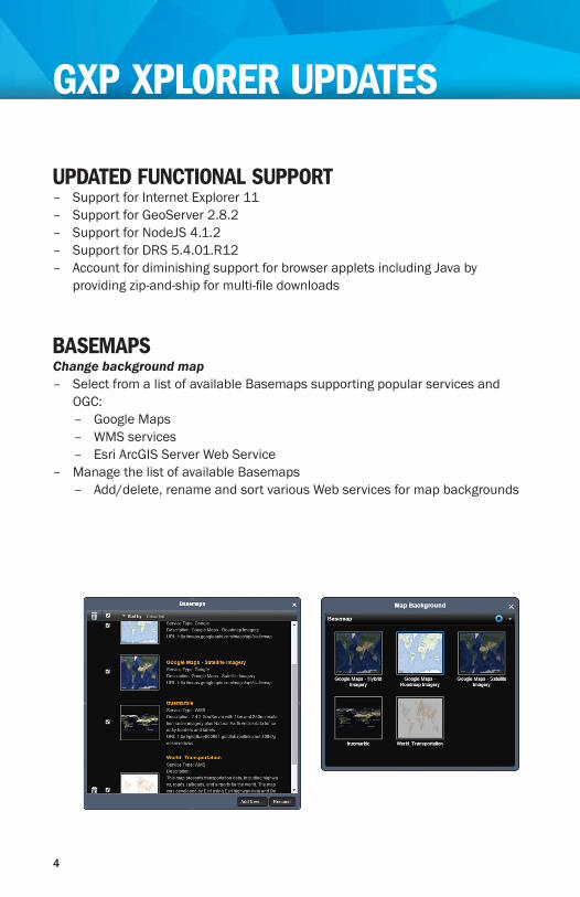
UPDATED FUNCTIONAL SUPPORT – Support for Internet Explorer 11 – Support for GeoServer 2.8.2 – Support for NodeJS 4.1.2 – Support for DRS 5.4.01.R12 – AccountfordiminishingsupportforbrowserappletsincludingJavabyprovidingzip-and-shipformulti-filedownloads
BASEMAPSChange background map
– SelectfromalistofavailableBasemapssupportingpopularservicesandOGC:
– Google Maps – WMS services – EsriArcGISServerWebService
– ManagethelistofavailableBasemaps – Add/delete,renameandsortvariousWebservicesformapbackgrounds
GXP XPLORER UPDATES
4

USABILITYAdministrators can now control global default settings
– Map Grid Display including grid interval and line styles – MapFootprintson/off – AutoSearchon/off – ImageDownloadConversionsettings – Displayedmetadatasettings – Abilitytocustomizeuserinterface
– Controlwhichfunctionsarevisiblebydefault – Passwordadministration
– Specify a character set for password patterns – Createmandatoryuserinformationfields
– Add*toallfieldsthatrequireuserinputfortheconfigurationoftheservercomponents
– Turn off text to coordinate converter
5

STREAM INTO SOCET GXP® Requires GXP WebView Pixel Server – NoneedtodownloadtheimageryforexploitationinSOCETGXP – Imagesensorsupportincludingsensormodeling,stereo,triangulation,
annotation, product creation, etc. – PublishfromSOCETGXPtoGXPXplorer – JPEG2000InteractiveProtocol(JPIP)streamingwithmetadataintoSOCETGXP
6

ADDITIONAL ENHANCEMENTSImproved Web performance
– RunGXPXplorerwithoutabackgroundmapintheListpage – FasterGXPXplorerWebClientpageloading

Identify country code and military region from a shapefile – UpdatecatalogmetadatainGXPXplorerforgeospatialdatatoincludethemilitaryregionandcountrycodeasnewattributes,basedonasetofcountryboundaries
– Countryboundariesareinshapefileformatandcanbeupdatedbythecustomer
Search on SensorFilterqueriesonspecificsensors
Intuitive geotaggingEasilygeotagdatausingJumptoPointontheListpage
Cataloging improvements – Catalognon-standardControlledImageBase(CIB)files(thosewithoutana.tocparentfile)andloadasimagery
– Catalogzippedshapefiles
GENERAL ENHANCEMENTS – SupportsWebMercator(EPSG3857) – JPIPperformanceimprovements:usercansetbuffersize
LAYER MANAGERWith the addition of the Layer Manager, the filmstrip interface in GXP WebView has been removed
– Easilyswitchbetweendifferentgeospatiallayers – Allowmultiplegeospatiallayerstobeloadedtogether – Exploitandannotateanimage,switchimageryandreturntotheoriginalimagewithoutlosingthegraphicslayer
GXP WEBVIEW UPDATES
8

For more information on BAE Systems and GXP products:
AmericasTelephone8003169643|7036684385
Europe, Middle East, and AfricaTelephone+441223370022
Asia, Australia, and Pacific RimTelephone+61261604044
IndiaTelephone+911143412345
Foradditionalcontactinformationandworldwidedistributors,pleasevisitourwebsite:
www.baesystems.com/gxp

©2016BAESystems.Allrightsreserved.
ImageryprovidedcourtesyofDigitalGlobe.MapsprovidedbyGoogle Maps™. Shoreline data courtesy of the National Oceanic andAtmosphericAdministration(NOAA)NationalGeodeticSurvey(NGS)CoastalMappingProgram.Shorelinechangedatacourtesyof the U.S. Geologic Survey (USGS).
Trademarks:GXP,GXPXplorer,Multiport,SOCETGXP,andSOCETSETaretrademarksorregisteredtrademarksofBAESystems.Otherbrands,productnames,andtrademarksarepropertyoftheirrespectiveowners.Approvedforfullpublicreleaseasof2/11/2016.


