Guyana's Readiness Preparation Proposal (R-PP) Forest Carbon ...
128
1 G G u u y y a a n n a a ’ ’ s s R R e e a a d d i i n n e e s s s s P P r r e e p p a a r r a a t t i i o o n n P P r r o o p p o o s s a a l l ( ( R R - - P P P P ) ) F F o o r r e e s s t t C C a a r r b b o o n n P P a a r r t t n n e e r r s s h h i i p p F F a a c c i i l l i i t t y y ( ( F F C C P P F F ) ) D D e e c c e e m m b b e e r r 2 2 0 0 1 1 2 2
-
Upload
nguyenkiet -
Category
Documents
-
view
221 -
download
2
Transcript of Guyana's Readiness Preparation Proposal (R-PP) Forest Carbon ...

1
GGGuuuyyyaaannnaaa’’’sss
RRReeeaaadddiiinnneeessssss PPPrrreeepppaaarrraaatttiiiooonnn PPPrrrooopppooosssaaalll
(((RRR---PPPPPP)))
FFFooorrreeesssttt CCCaaarrrbbbooonnn PPPaaarrrtttnnneeerrrssshhhiiippp FFFaaaccciiillliiitttyyy
(((FFFCCCPPPFFF)))
DDDeeeccceeemmmbbbeeerrr 222000111222

2
Table of Contents
Tables in R-PP .................................................................................................................................. 3
Acronyms ......................................................................................................................................... 4
Executive Summary ......................................................................................................................... 5
Introduction ..................................................................................................................................... 7
Component 1: Organize and Consult ............................................................................................ 12
1a. National Readiness Management Arrangements ................................................................ 12
1b. Stakeholder Consultation and Participation ........................................................................ 20
Component 2: Prepare the REDD+ Strategy ................................................................................ 29
2a. Assessment of Land Use, Forest Policy and Governance ..................................................... 29
2b. REDD+ Strategy Options ....................................................................................................... 57
2c. REDD+ Implementation Framework ..................................................................................... 71
2d. Strategic Social and Environmental Assessment (SESA) ....................................................... 82
Component 3: Develop a Reference Scenario ............................................................................. 86
Component 4: Design a Monitoring System ................................................................................ 95
Component 4a. Emissions and Removals ................................................................................... 97
4b. Other Benefits and Impacts ................................................................................................ 111
Component 5: Schedule and Budget .......................................................................................... 115
Component 6: Design a Programme Monitoring and Evaluation Framework ......................... 120
Bibliography ................................................................................................................................ 123
APPENDICES ................................................................................................................................. 124

3
Tables in R-PP
Component 1a
Diagram 1: Institutional Arrangements for REDD+ Implementation in Guyana Budget Table 1: Summary of National Readiness Management Arrangements Activities and Budget Table 1 - The Roles & Responsibilities of Key Parties Involved in National REDD+ Activities
Component 1b
Table 2: Summary of Previous Awareness Sessions Held Budget Table 2: Summary of Stakeholder Consultation and Participation Activities and Budget
Table 3- Summary of Main Comments Received During Initial Awareness Sessions on REDD+ in 2009
Table 4. Tentative Consultations Timeline
Component 2 a
Table 5. Land Allocation by Forest and Non Forest Area 2009 Budget Table 3: Summary of Assessment of Land Use, Forest Policy and Governance Activities and Budget (Follow-up Activities Needed)
Table 6: Summary of Legislation under Which Government Agencies Responsible For Aspects of REDD+ Implementation Are Bound
Table 7. Summary of Key National Stakeholders & Their Role in REDD+
Table 8- Summary of State Forest Allocations (Source: Forest Sector Information Report (Jan- Dec 2011))
Table 9. Past Efforts to reduce deforestation and forest degradation
Table 10: Guyana’s Key Criteria Used for its National Definition of Forest for REDD+
Table 11: Draft Outline of Planned Initiatives Detailed in Guyana’s REDD+ Governance Development Plan (RGDP)
Table 12: Forest Area Change by Period & Driver from 1990- 2011
Component 2 b
Table 13: Potential REDD+ Activities Table 4 : Summary of Strategy Activities and Budget
Table 14: Potential Aspects for Consideration in of REDD+ Strategy Development
Table 15-Analysis of the Impacts of the Potential REDD+ Activities
Table 16-REDD+ Readiness Activities that will impact on REDD Strategy
Component 2c
Table 17. Summary of Agencies Responsible for REDD+ Implementation Framework Budget Table 5: Summary of Implementation Framework Activities and Budget Table 18 Capacity Building needs, Strategies, and Indicators of Success
Component 2d Budget Table 6: Summary of Social and Environmental Impact Activities and Budget
Component 3
Diagram 2. Reference Scenario Framework Table 7 : Summary of Reference Scenario Activities and Budget Diagram 3: Key decisions to be made by countries when developing their reference levels for REDD+(based on a
methodological framework for developing RLs produced by Winrock International for the World Bank’s Forest Carbon Partnership Facility.
Table 19-Summary of Guyana’s key decisions for establishing its REDD+ reference level.
Table 20. Options for Satellite Data for Guyana
Table 21-Carbon pools selected to include in the RL/REL according to activity
Table 22: Error matrix for Year 1 Forest map
Table 23: Error Matrix used for Deforestation Rates
Table 24. Main drivers of deforestation and forest degradation, methods to measure impact, and pools impacted
Table 25- Illustrative example of potential emission National Look Up Factor Tables for Guyana
Component 4
Table 26 - Forest Change Area by Period & Driver from 1990-2010 Budget Table 8: Summary of Monitoring Activities and Budget Table 27-Interim Degradation Indicators for REDD+ performance in Guyana as outlined in the JCN
Table 28- Main features of the two methods for estimating emission factors.
Table 29-Outline of the Forest Carbon Sampling Strata and the Total Land Area of Each
Map 1- Final stratification map showing location of the PSU for Phase 1
Table 30- GFC GIS Datasets
4
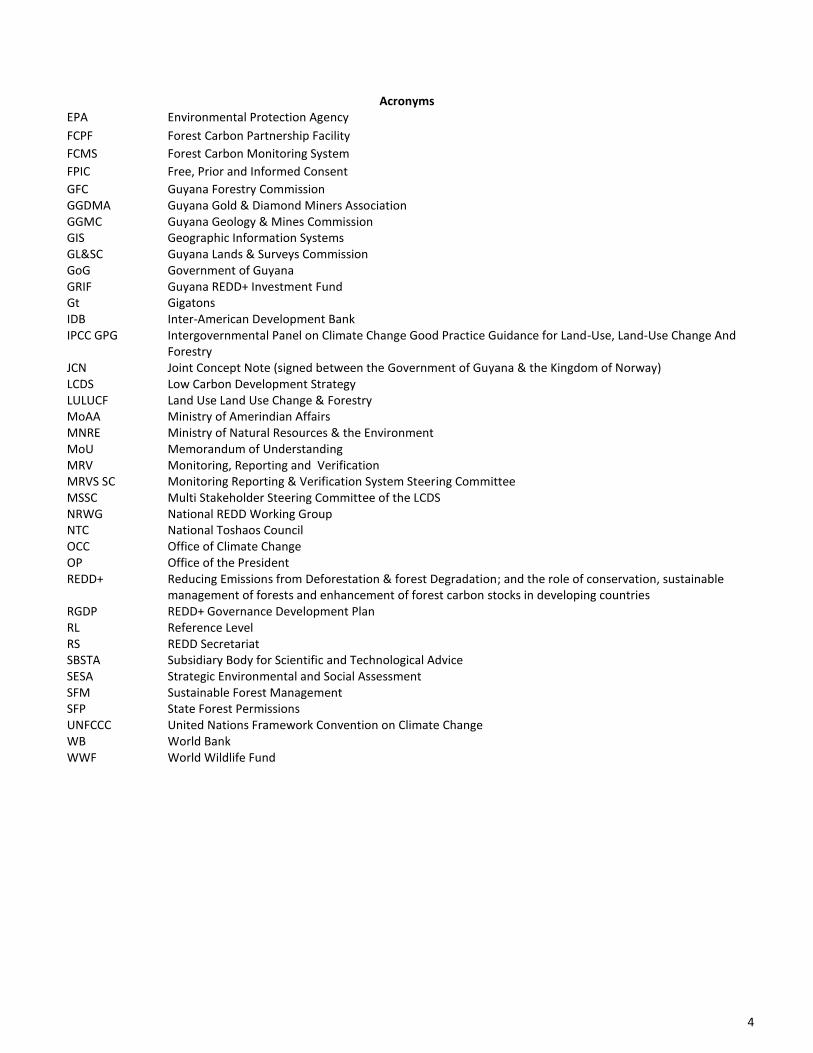
Acronyms EPA Environmental Protection Agency
FCPF Forest Carbon Partnership Facility
FCMS Forest Carbon Monitoring System
FPIC Free, Prior and Informed Consent
GFC Guyana Forestry Commission GGDMA Guyana Gold & Diamond Miners Association GGMC Guyana Geology & Mines Commission GIS Geographic Information Systems GL&SC Guyana Lands & Surveys Commission GoG Government of Guyana GRIF Guyana REDD+ Investment Fund Gt Gigatons IDB Inter-American Development Bank IPCC GPG Intergovernmental Panel on Climate Change Good Practice Guidance for Land-Use, Land-Use Change And
Forestry JCN Joint Concept Note (signed between the Government of Guyana & the Kingdom of Norway) LCDS Low Carbon Development Strategy LULUCF Land Use Land Use Change & Forestry MoAA Ministry of Amerindian Affairs MNRE Ministry of Natural Resources & the Environment MoU Memorandum of Understanding MRV Monitoring, Reporting and Verification MRVS SC Monitoring Reporting & Verification System Steering Committee MSSC Multi Stakeholder Steering Committee of the LCDS NRWG National REDD Working Group NTC National Toshaos Council OCC Office of Climate Change OP Office of the President REDD+ Reducing Emissions from Deforestation & forest Degradation; and the role of conservation, sustainable
management of forests and enhancement of forest carbon stocks in developing countries RGDP REDD+ Governance Development Plan RL Reference Level RS REDD Secretariat SBSTA Subsidiary Body for Scientific and Technological Advice SESA Strategic Environmental and Social Assessment SFM Sustainable Forest Management SFP State Forest Permissions UNFCCC United Nations Framework Convention on Climate Change WB World Bank WWF World Wildlife Fund
5
Executive Summary In global assessment reports, the Guiana Shield has been identified as one of the largest remaining blocks of primary tropical forest on earth, and has the potential to play an important role in mitigating climate change. The region has been reported to contain both the highest percentage of primary forest cover (over 90% is intact tropical forest) and the lowest human population density of any major tropical forested area. Guyana’s forests cover approximately 85% of the country, contain an estimated 5 gigatons (Gt) of CO2 in above ground biomass, and cover an estimated 18.39 million hectares (Guyana Forestry Commission, 2011.) In addition to being one of Guyana’s most valuable natural assets, these forests are suitable for logging and agriculture, and have significant mineral deposits. Should Guyana choose to pursue a development pathway that would lead to increased deforestation from mining, logging and agriculture, there would be significant negative consequences for the world, as the critical ecosystem services that Guyana’s forests currently provide both locally and globally – such as biodiversity, water regulation and carbon sequestration – would be lost. There is increasing global recognition of the fact that protecting forests against deforestation and forest degradation can be important in mitigating climate change– deforestation and forest degradation contribute an estimated 17% of global greenhouse gas emissions. Through the United Nations Framework Convention on Climate Change (UNFCCC) negotiations, mechanisms are emerging where policy decisions to provide long term protection of Guyana’s forests can be recognized as contributing to climate change mitigation. If an effectively designed and appropriately resourced Reducing Emissions from Deforestation and Degradation (REDD+) mechanism is agreed by the Parties to the UNFCCC, Guyana will be able to decide whether to place its forest under long-term protection by establishing an agreed level of forest based greenhouse gas emissions. To prepare for this possible next step, Guyana will undertake a series of REDD+ readiness activities to support a financial basis for payments to Guyana for reducing carbon emissions from deforestation and forest degradation and supporting the conservation, sustainable management of forests and enhancement of forest carbon stocks (REDD+)
1. These activities will
include the execution of technical studies and social and environmental assessments, development of a Monitoring Reporting and Verification System (MRV System), development of pilot demonstration activities, the participation of forest dependent communities and other national stakeholders in the development of roadmaps for capacity building. These activities will be conducted in consonance with the environmental and social safeguards described in the “Common Approach to Environmental and Social Safeguards for Multiple Delivery Partners” (hereafter referred to as the “Common Approach”)
2. The REDD+ readiness
preparation phase will need a high level of political commitment and the active involvement of many sectors and Government institutions. Over the last four (4) years, the Guyana Forestry Commission (GFC) has conducted a series of awareness, consultation and engagement sessions with residents of indigenous communities
3 and villages
4 as well as with other government, non-
government and civil society interest groups, in the ten (10) administrative regions of Guyana. The main objective of these sessions was to inform stakeholders of the REDD+ initiative which the GFC would be coordinating and to receive their initial feedback. This initial feedback was recorded and has been incorporated into the readiness preparation activities. These sessions are a prelude to the official REDD+ Consultations which will take place during the readiness preparation phase (Component 1b) and which the GFC will be implementing in partnership with the National Toshaos Council (NTC), indigenous NGOs and other partners. The REDD+ readiness preparation will involve relevant stakeholders in the designing of the REDD+ strategy and in understanding and managing social and environmental impacts and risks. This will be conducted in a participatory manner with emphasis on consultations with local Amerindian communities and villages as well as other forest dependent groups. Land use planning and interagency coordination have been identified as two integral components to the successful implementation of REDD+ in Guyana. The importance of these elements has also been underlined in Guyana’s Low Carbon Development Strategy (LCDS) as well as in the Memorandum of Understanding signed between the Government of Guyana (GoG) & the Kingdom of Norway (and the accompanying Joint Concept Note). Details on actions relating to land use planning and interagency coordination are discussed in Component 2a. With the establishment of the new Ministry of Natural Resources and the Environment officially in early 2012, interagency coordination has been further boosted as the agencies responsible for natural resources management in Guyana now fall under the purview of this new Ministry.
1 For purposes of Guyana’s R-PP, REDD+ should be construed to mean activities consistent with paragraph 1 (b) (iii) of the Bali Action Plan. Further, Conservation in this paragraph should be construed to include avoided deforestation in the context of Guyana’s R-PP. 2 The Common Approach was approved by the FCPF’s 9th Participants Committee meeting in Oslo, Norway in June 2011. 3 In accordance with the Amerindian Act 2006, means a group of Amerindians organised as a traditional community with a common culture and occupying or using the State Lands which they have traditionally occupied or used. 4 In accordance with the Amerindian Act 2006, a Village or Amerindian Village means a group of Amerindian occupying or using Village lands. Village lands mean lands owned communally by a Village under title granted to a Village Council to hold for the benefit of the Village

6
Land tenure and land rights are priority areas that are included as aspects under the R-PP as the clear definition of the rights over carbon is critical to establishing a benefit sharing mechanism. Advancing efforts in the titling process has therefore been identified as a priority area of component 2b (REDD+ Strategy, Potential REDD+ Activities). The REDD+ Strategy options will be developed in line with the drivers of forest area change and will involve the direct input of national stakeholders. Indigenous people in Guyana, by law, have the right to their titled lands, including their potential use in REDD+ activities. In implementation of REDD+, they will have the option to choose their participation in the REDD+ programme. Communities will therefore choose whether they will participate following careful decision making after having been fully informed and consulted with by the GoG. Communities that are not yet prepared to participate in REDD+ activities may do so at a later stage once they have taken such a decision. At the same time, the ongoing process of titling will be continued. Extending the titling process to untitled Amerindian communities is another important consideration for the REDD+ Strategy as it is an essential element to ensure that the Amerindians will continue to be able to exercise their rights to their natural resources. Amerindian and other forest-dependent communities are a key stakeholder group for the REDD+ preparation phase. They have an important and direct role to play in ensuring that their share of benefits is secured and their livelihoods are maintained and improved. They will participate in discussions so as to ensure equity in the distribution of REDD+ benefits, securing of land rights and promoting REDD+ as an instrument to improving livelihoods. They will also participate in the design of alternative economic opportunities; providing local knowledge of the forest and its past uses; training in forest policy; field based technical work, data collection & monitoring; and information sharing and dissemination. The R-PP proposes the modalities for conducting of a Strategic Environmental and Social Assessment (SESA) of the potential impacts of REDD+ on the environment, access to land and natural resources, as well as on the livelihoods of forest dependent stakeholders (Component/Annex 2d). The potential impacts and risks will be assessed and based on these; appropriate mitigation measures to avoid or manage negative impacts will be developed. Furthermore, the SESA will assess ways to enhance positive impacts on the environment and communities. The SESA will be done in conformance with Guyana’s national environmental regulatory framework as far as possible, in addition, to those of the delivery partner and the Common Approach; the SESA will serve to generate information necessary for the formulation of an Environmental and Social Management Framework for the REDD+ program. The SESA process also will be a platform for additional dialogue on critical issues that have direct implications on the design of the national REDD+ framework and strategy. Guyana’s low historical emissions from deforestation and degradation do not accurately predict expected future emissions. Component 3 of the R-PP will explore various methods and approaches to establish a reference level (RL) specific to Guyana’s national circumstance and to provide guidance for the establishment of a national based on the negotiations at UNFCCC. The development of a national Monitoring, Reporting and Verification System for forest carbon stocks and changes in Guyana is discussed in Component 4. This section details the work that has already commenced, as well as work still to be undertaken through the implementation of the MRV System Road Map. The section outlines that it is required for the MRV system to be developed in line with the accepted principles and procedures of estimation and reporting of carbon emissions and removals at the national level as specified by the Intergovernmental Panel on Climate Change (IPCC) Good Practice Guidance (GPG) for land-use, land-use change and forestry, for reporting on the international level. The Readiness preparation process will work through the following three elements, with an aim of promoting sustainable development in Guyana: a) inter-agency coordination and institutional capabilities, b) stakeholder involvement especially local communities and indigenous peoples and c) technical programmes that will cover areas of REDD+ Strategy building, MRV and Reference Levels among other areas. Overall, the REDD+ Strategy will be centred on not only on maintaining Guyana’s already low rates of deforestation and degradation but also on the continued promotion of sustainable forest management (SFM), conversation and enhancement of carbon stocks, as well as on reducing poverty and improving livelihoods through the implementation of appropriate and feasible alternative economic activities; it will also focus on the development of a well designed and equitable benefits sharing system (Component 2b). Guyana’s proposed outline of Readiness preparation activities has been organised under the general guidance of the FCPF. As reflected in the general structure of the R-PP, the various activities and proposals are outlined under these six key areas. The execution of these activities with funding from the FCPF, as outlined in this R-PP, will be over a thirty six (36) month period. It should be noted that while a total of USD $3,800,000 will be received from the FCPF to fund these activities, overall, the cost of implementing these activities is USD $8,592,000. As such, other sources of funding will have to be sought, as well as there being prioritization of R-PP activities of implementation.

7
Introduction The total land area for Guyana is 21.1 million hectares and spans from 2 to 8° N and 57 to 61° W. Guyana shares common borders with three countries – to the north-west: Venezuela, the south-west: Brazil, and on the east: Suriname. Guyana‘s 460 km coastline faces the Atlantic on the northern part of the South American continent. The coastal plain is only about 16 km. wide but is 459 km long. It is dissected by 16 major rivers and numerous creeks and canals for irrigation and drainage. The main rivers that drain into the Atlantic Ocean include the Essequibo, Demerara, Berbice, and Corentyne. These rivers have the classic wide mouths, mangroves, and longitudinal sand banks so much associated with Amazonia, and mud flows are visible in the ocean from the air. The geology in the centre of the country is a white sand (zanderij) plateau lying over a crystalline plateau penetrated by intrusions of igneous rocks which cause the river rapids and falls Guyana’s population was 751,223 in 2002 (Census 2002, Bureau of Statistics). It is divided into 10 administrative regions with most people and economic activities in the coastal plain. The low population density and difficult terrain in some regions make it costly to provide extensive social services and develop infrastructure critical to support economic development. Guyana’s legal system is based on English common law with certain admixtures of Roman-Dutch law. The country is governed under a Westminster type model, with a President as Head of State, a Prime Minister, and Cabinet of Ministers appointed by the President. Guyana’s legislative system is based on the National Assembly, which comprises 65 seats; to serve five-year terms. With regards to the Judicial System, there is a Supreme Court of Judicature, consisting of the High Court and the Court of Appeal, with right of final appeal to the Caribbean Court of Justice. Geography Guyana has four main geographical areas, these are recognized as: - the Coastal Belt of low lying alluvium which has either been reclaimed for agriculture or which still carries a complex series
of forest, swamp and march communities; - the Lowland Region of undulating forest land, generally below 500 ft elevation, wherein little agriculture is practiced, and
where the main forestry and mining activities are carried out; - the Pakaraima Montane Region, an elevated tableland, rising to an altitude of 9,000 ft at Mount Roraima; - the Southern Uplands of undulating forests and savannahs, generally above 500 ft in elevation. Climate Change & Guyana Guyana will face serious challenges from sea level rise and extreme weather events such as intense rainfall and extensive dry periods (Guyana’s R-PIN, May 30, 2008). The tide gauge data for Guyana has indicated a mean relative sea level rise of 1 cm/yr. It is anticipated that if action is not taken to reduce the amount of greenhouse gas emissions globally to reverse this trend, sea level may continue to rise, with a total increase of 40 cm —60 cm by the end of the 21st Century. Sea level rise and extreme weather events including shifts in the frequencies of El Niño Southern Oscillation and North Atlantic Warming events will have a direct and substantial impact on Guyana and the livelihood of its people. The main expected impacts include water shortage, deceased yields from agriculture, infrastructural damage, flooding, health problems, environmental changes and economic losses as well as social impacts. From 2005 to present, Guyana has experienced a number of climate-related disasters due particularly to extreme weather events. Short-term weather variability such as high intensity rainfall or wind or tidal/wave activity has been recorded as the cause of flooding occurrences not only along the coast of Guyana, but also in hinterland areas, while there have also been sustained periods without rain causing droughts. The most destructive of these was the Flood of January 2005, which was estimated to have cost about G$93 billion. It was estimated that 37 percent of Guyana’s population were severely affected and 48% moderately affected. The experiences in the years identified show that the weather patterns have changed significantly in terms of both intensity and duration of periods of high and low rainfall. The result has been an increase in the occurrence of floods and droughts. The impact has been most severe on the agricultural sector, and points to the need for greater preparedness to deal with any further disasters in the coming years. (Guyana’s Second National Communication to the UNFCCC, March 2012). These unusual weather events are already proving to be more than a mere inconvenience; they are having serious consequences on one of the most critical sectors in Guyana's economy, the agriculture sector. Guyana's agricultural sector is a major contributor to the country's economy, contributing over 30 percent of Guyana’s Gross Domestic Product (GDP) annually, 30 percent of employment and 40 percent of export earnings
5. The rice and sugar sectors alone are the two largest contributors
to foreign exchange earnings. This coupled with the fact that 90 percent of the population lives on the relatively flat coast, which is below mean sea level, and 70 percent depend on agriculture and agricultural related activities for their livelihood 5 http://www.caricom.org/jsp/community/donor_conference_agriculture/agri_profile_guyana.jsp

8
indicates the importance of the sector and the vulnerability to extreme weather events. Meeting the challenges imposed by climate change, through adaptation and mitigation, will require significant financial, technical and human resources as well as a responsible effort by citizens to contribute meaningfully to reduce the effects of climate change. Deploying Guyana’s forests in mitigating the effects of climate change Guyana’s largely pristine forest covers approximately 85 percent of the total land area, contains over 5GtCO2 in above ground biomass, and is estimated at 18.39 million hectares (Guyana Forestry Commission, 2011.). Guyana has had relatively low historical rates of deforestation of 0.02% to 0.056% over the past 20 years as outlined in its recent MRVS Report (Guyana Forestry Commission, 2011). Guyana’s national circumstances indicate that if incentives are not directed to controlling deforestation and degradation, both of these rates and their associated emissions are expected to significantly increase (See Component 3). Guyana’s forest is suitable for the implementation of REDD+ activities because: much of the forested area that is suitable for logging and conversion to agriculture remains intact; there is growing demand globally for mineral resources such as gold; growing national and regional demands for agricultural products and tropical timber; access to Guyana’s forests will be significantly increased during this decade as a major international highway from Brazil through southern Guyana to the north coast will be built. Deforestation and forest degradation occur in the State Forest Estate where logging, mining and agricultural activity co-exist, as well as in other forestlands. Deforestation and forest degradation are driven by five principal factors, namely: 1) the clearing of forested areas for mining; 2) logging; 3) the conversion of forested areas to allow for agricultural activities; 4) infrastructural developments such as roads; 5) Forest Fires. (Source: Guyana’s MRVS 2010 Interim Measures Report). The GoG believes that Government agencies in active collaboration with Amerindian people and other stakeholders including local communities and non-governmental agencies can continue to sustainably utilize, protect and maintain the forests, in an effort to reduce global carbon emissions and at the same time attract resources for the country to grow and develop. The implementation of a REDD+ strategy is viewed as an avenue though which this can be achieved (see Component 2b). For the aspects of benefits attributed to State Lands and the State Forest Estate, the resources garnered will be used to develop low emission economic activities, thus reducing poverty, improving social services (health, education) deliveries, promoting sustainable development and achieving the Millennium Development Goals (MDG). Guyana’s Low Carbon Development Strategy (LCDS) & REDD+ Guyana’s Low Carbon Development Strategy
6 sets out a vision through which economic development and climate change
mitigation will be enabled through the generation of payments for forest services in a mechanism of sustainable utilization and development. The result is intended to be the transformation of Guyana’s economy whilst combating climate change. The Strategy has four key dimensions: (1) value of Guyana’s forests (mitigation), (2) low carbon development opportunities, (3) adaptation plans, and (4) the involvement and socio-economic development of Guyanese. Through the implementation of the LCDS, Guyana would be able to protect its forest and simultaneously seek a development path that promotes the growth of low-carbon economic sectors and reduces deforestation and high-carbon economic activity. The LCDS and REDD+ are integrally linked with the former being the strategic framework and the latter the operational mechanism that will enable the model to be executed and monitored. REDD+ therefore forms one part of the LCDS. The LCDS notes that a successful REDD+ will require generating a willingness to participate from forest countries because REDD+ is a positive development option. It will also require generating a willingness to pay from international sources, whether public or private, because it reduces greenhouse gas emissions. But if these twin sets of objectives are met, Guyana will be able to invest in creating a low deforestation, low carbon, climate resilient economy where Guyana can avoid an estimated cumulative forest-based emissions of 1.5 Gt of CO2e (carbon dioxide equivalent which includes other greenhouse gases) by 2020 that would have been produced by an otherwise economically rational development path (LCDS, May 2010). It is the intention that the ultimate outcome will be that the financing mechanism in place, will take into account the Reference Level that is determined at the level of the COP. REDD+ payments could enable Guyana’s economy to be realigned onto a low-carbon development trajectory. Guyana would be able to generate economic growth at, or in excess of, projected Latin American growth rates over the coming decade, while simultaneously eliminating approximately 30 percent of non-forestry emissions through the use of clean energy. If this approach is successful, it offers economic choices that favour protection, although it will not stop existing economic activities or threaten the employment of those already working in the forest, providing those activities are in accordance with the law and internationally accepted practices for sustainability. Instead, it will lead to action in four areas that are essential to Guyana’s future: 6 http://www.lcds.gov.gy/images/stories/Documents/Low%20Carbon%20Development%20Strategy%20-%20May%202010.pdf
9
1. Investing in low-carbon economic infrastructure - Guyana has identified more than US$1 billion in essential capital projects that can be fully or partially funded through private investment assisted by the Guyana REDD+ Investment Fund (GRIF), an in-country infrastructure investment fund built from forest payments. Among other initiatives, these projects will enable future economic growth to be powered predominantly by clean energy (hydropower), and to make non-forested parts of the country accessible to private investors who can generate low-carbon economic development and employment (largely high-end agriculture and aquaculture). These infrastructure projects would begin to shift the economy toward low-carbon industrial activity, and enable greater resources to be deployed towards ensuring that existing infrastructure in forested areas does not facilitate an increase in deforestation and degradation
2. Facilitating investment and employment in low-carbon economic sectors - Attracting large-scale catalytic investors to Guyana will require incentives to finance industry specific infrastructure and overcome perceived country investment risk. Building on the priority diversification opportunities outlined in the National Competitiveness Strategy, Guyana has identified six priority low-carbon economic sectors: fruits and vegetables, aquaculture, sustainable forestry and wood processing, business process outsourcing, eco-tourism, and possibly bio-ethanol. Guyana plans to focus initially on three sectors: fruits and vegetables, aquaculture, and sustainable forestry. In each of these sectors, long-term market demand exists and Guyana has the essential natural resources to operate at scale.
3. Sustainably managing forest-based economic sectors, in particular forestry and mining - Guyana’s mining and forestry sectors are major contributors to the economy. They provide employment for tens of thousands of Guyanese citizens, income for tens of thousands of families, and generate significant Government revenue that is invested in public services. At the same time, they are the chief contributors to Guyana’s existing, albeit low rates of, deforestation and forest degradation. Reconciling the need to balance the economic value and employment generated by these sectors with the desire to limit forest-based emissions is one of the most important and complex challenges in implementing REDD+ and the LCDS.
4. Generally enhancing the nation’s human capital and creating new opportunities for forest dependent and other indigenous communities- Transforming Guyana’s economy will require striking a balance between attracting large, long-term private investors who will have a catalytic impact on the national economy, and making significant investments in human capital and social services to equip the population for participation in the new economy. It will also require a balance between using forest payments to enhance the opportunities for those who live in the forest and recognizing the rights of other Guyanese citizens, including the urban poor. The importance of benefit sharing with Guyana’s Amerindian communities is particularly important. To meet the needs of both forest dwellers and the population at large, Guyana will invest a significant share of the forest protection funds it receives in initiatives aimed at developing jobs and diversifying the jobs base, and improving the general standards of living of its citizens.
Guyana’s REDD+ Benefit Sharing Mechanism As part of the REDD+ readiness process, a benefits sharing mechanism will be developed. This will address important aspects of benefits sharing for the main stakeholder groups including the government, Indigenous Peoples and other forest dependent groups as well as the private sector. In the design of the system one of the key considerations may be the types of land owners, forest/non-forest cover and impact of deforestation and forest degradation. The State as of December 31, 2011 administered 15.5 million ha ha
7 of State Forest. One part of the benefits sharing mechanism
will be that aspect that addresses private titled lands issued to Amerindian villages. Titled Amerindian villages will have the option to participate in any Interim REDD+ mechanism at any time during the period 2010-2015, in accordance with the principle of free, prior and informed consent. This mechanism will be aimed at providing effective incentives for the implementation of actions to maintain Guyana’s already low rate of deforestation, while building support for REDD+ nationally. Its design will draw on efforts made so far in Guyana in this area. Discussions have started in Guyana on aspects of the benefits sharing mechanism under the LCDS, through the concept paper “Developing a Framework for an “Opt in” Mechanism for Amerindian Communities”
8.
The design process of the benefits sharing mechanism will involve coordination by the OCC, discussion and engagement with Amerindian village leaders, the NTC and other relevant stakeholders with an objective of receiving feedback from indigenous communities and villages that will be used to inform the updating and finalization of the System. It should be noted that in the design of this mechanism, which will reflect on current (local and international) efforts regarding climate financing, there will be examination on how untitled areas can be included and benefit from REDD+ financing.
7 Guyana Forestry Commission - Guyana REDD+ Monitoring Reporting and Verification System (MRVS) Interim Measures Report Final , March 16, 2011 8 Concept Paper on Developing a Framework for an “Opt in” Mechanism for Amerindian Communities, March 2010 http://lcds.gov.gy/images/stories/Documents/%27Opting%20In%27%20Concept%20Paper%20-%20March%207th%20%5Bdraft%5D.pdf
10
Guyana-Norway Partnership On November 9, 2009, the Government of Guyana and the Kingdom of Norway signed a Memorandum of Understanding which set out how the two countries will “work together to provide the world with a relevant, replicable model for how REDD-plus can align the development objectives of forest countries with the world’s need to combat climate change.” Norway committed to providing financial support of up to US$250 million by 2015 for results achieved by Guyana in generating the capacity to reduce emissions from deforestation and forest degradation, whilst creating a replicable model for REDD+. Guyana will be paid by Norway for performance on reducing greenhouse gas emissions from deforestation and forest degradation, and for progress made against enabling conditions including those relating to indigenous rights, consultation, and establishing a MRV system. Joint Concept Note (JCN) The Joint Concept Note accompanies the MoU signed between the Governments of Guyana & Norway. It describes the mechanism through which financial contributions to Guyana are based on results achieved in keeping its deforestation and forest degradation below an agreed level. Guyana’s obligations outlined in the JCN relate to: Indicators of enabling activities - A set of policies and safeguards to ensure that REDD+ contributes to the achievement of the goals set out in the Joint Concept Note accompanying the MoU between the Governments of Guyana and Norway, namely “that Guyana’s LCDS Multi-Stakeholder Steering Committee and other arrangements to ensure systematic and transparent multi-stakeholder consultations will continue and evolve, and enable the participation of stakeholders at all stages of the REDD-plus/LCDS process; protect the rights of indigenous peoples; ensure environmental integrity and protect biodiversity; ensure continual improvements in forest governance; and provide transparent, accountable oversight and governance of the financial support received.” REDD-plus Performance Indicators- A set of forest-based greenhouse gas emissions related indicators, as described in more detail in Component 3 below. These indicators will gradually be substituted as a system for monitoring, reporting and verifying (MRV) emissions from deforestation and forest degradation in Guyana is established. The time frame for this is established in the MRV roadmap. Efforts to support the acceleration of REDD Plus efforts in 2010. The Guyana REDD+ Investment Fund (GRIF) The Guyana REDD+ Investment Fund (GRIF) has been identified as the financial mechanism for the ongoing cooperation on climate change between the Government of Guyana and the Kingdom of Norway. Guyana will invest the contributions it receives through the Guyana Norway MoU and any income earned on them, in implementing its Low Carbon Development Strategy (LCDS). It aims to create a potential model for climate finance that ensures Guyanese sovereignty over LCDS decisions at the same time as demonstrating adherence to internationally accepted standards, such as financial, social and environmental safeguards. The World Bank has been identified to act as the Trustee of the GRIF. It was established to: (i) manage payments provided by Contributors to the GRIF for forest climate services provided by Guyana; and (ii) transfer these payments and any investment income earned on these payments to Partner Entities for Projects and activities that support the implementation of Guyana’s Low Carbon Development Strategy (LCDS). The GRIF will provide financing to Partner Entities for goods, works or services for investment, projects, technical assistance or capacity building activities carried out by Implementing Entities.
9 There
is a Steering Committee (SC) that serves as the oversight and decision-making body for the GRIF and comprises representation of the Government of Guyana, the Government of Norway, the Trustee, Observers and Partner Entities (IDB and UNDP). Projects that are being implemented by the GRIF are REDD+ Strategy Initiatives and forms part of Guyana’s Strategy Low Carbon Development. REDD+ Governance Development Plan (RGDP) The JCN outlines the need for basis for the continued development of a transparent, rules-based, inclusive forest governance, accountability and enforcement system. The development and implementation of this governance model will be integrated with the LCDS. A draft RPGP was prepared, and includes 23 thematic areas, with clear requirements and timelines for its implementation. Several elements of the draft Plan are already being implemented, including the review and revision of the National Forest Policy Statement and the draft National Forest Plan. It includes other areas such reporting on the multiple benefits of REDD-plus, including on measures to protect biological diversity, improved livelihoods, and support good governance. It also outlines the development of a national inter-sectoral, land use planning system, with REDD-plus as the overarching goal and with specific emphasis on managing the impacts of development on forests. The Sustainable Land Management (SLM) project which was led by the GL&SC was conducted with its focus on the requirements of the UNCCD, in 9 Operational Manual Guyana REDD-Plus Investment Fund (GRIF), page 6

11
this, the focus of the project was on land degradation. An outcome of the project was a framework for the review of the draft Land Use Plan (LUP) for Guyana, giving consideration to the LCDS and REDD+. The results may inform efforts undertaken in the development of the national LUP. Additionally, Guyana has also commenced implementation of Independent Forest Monitoring (IFM) as well as has entered into formal negotiations with the European Union Forest Law Enforcement Governance and Trade (EU FLEGT) programme, with the objective of concluding negotiations on a Voluntary Partnership Agreement (VPA) by September 2015. Synchronization of Efforts Guyana’s LCDS and REDD+ work are under-pinned by the Readiness Preparation Proposal (R-PP), which is one of the chosen multilateral route for preparing for REDD+.
10 The R-PP provides the framework through which Guyana will become ready for the
implementation of REDD+. It is through this that REDD+ Readiness preparation initiatives will fit. The LCDS calls for a performance based mechanism to measure and monitor deforestation and forest degradation, thus requiring a Monitoring, Reporting & Verification (MRV) system to be developed and implemented. The MRV system will be one aspect of the performance measurement system of the LCDS. Readiness activities as outlined in the R-PP include, the development of the MRV System amongst other activities such as enhancement of technical and other capacities for Guyana to engage in a forest carbon financing mechanism. During the development of the MRV system, certain interim measures are required to be reported on. Both the LCDS and the R-PP focus on addressing governance related areas that would promote the effective implementation of REDD+ in Guyana. The REDD+ Governance Development Plan (RGDP) has been developed to address these same issues. The initiatives under the RGDP are at varying stages of implementation. Some of the activities detailed in the RGDP form part of the requirements of the MOU signed between the Government of Guyana and the Kingdom of Norway. While the implementation of national REDD+ activities requires inter-sectoral coordination, the GFC has been identified as the main coordinating agency for the implementation of REDD+ in Guyana, as well as the development of the MRV System. The approach the GFC has taken to coordinating these activities, has been to working both cross-sectorally as well as multi-sectorally to include stakeholders groups. Implementation efforts will be further strengthened with the establishment of the new Ministry of Natural Resources and Environment. Through the Ministry there will now be strengthened interagency coordination at all levels, thus ensuring a more efficient and harmonized approach to the implementation of REDD+.
10 LCDS, May 2010- Section 6, page 41
12
Component 1: Organize and Consult
1a. National Readiness Management Arrangements
National REDD+ Management Arrangements This Component summarizes the main institutional arrangements proposed for the implementation of national REDD+ activities, including guiding principles, objectives, methodologies and institutional agreements prepared so far, that pertain to management of Readiness as well as consultation and outreach activities. It outlines the role and function of major parties involved. For R-PP related matters, the GFC will serve as the main coordinating body for these committees/bodies as it is the focal entity responsible for the implementation of key technical aspects of REDD+ in Guyana. To date, an open, inclusive and transparent dialogue has been initiated by both the Office of Climate Change and the Guyana Forestry Commission. With the launch of the LCDS as well as implementation of key technical work such as the development of the MRV system, stakeholder dialogue has become an integral part of these processes. These institutional arrangements will further be boosted through the establishment of the Ministry of Natural Resources & Environment. Guiding Principles The implementation of work detailed in the R-PP will be underpinned by the following guiding principles: - Transparency - this will be achieved through rigorous social accountability mechanisms. - Civic Engagement through an inclusive and participatory process. - Community Empowerment - Amerindian and other forest dependent communities will be empowered
through capacity building, knowledge sharing, information and technical assistance and guidance. Strategic Objectives Activities undertaken in the implementation of the R-PP will strive to achieve the following Strategic objectives: - Incorporation of the needs and expectations of Amerindian and forest dependent communities and other
segments of Guyana’s society into the National REDD+ Framework - Engagement of the Guyanese society in the REDD+ Dialogue - Development and Implementation of an equitable and mutually agreeable Benefits Sharing Mechanism - Design and implementation of an inclusive, transparent and participatory Consultation and Outreach Plan - Support the development of an efficient Conflict Resolution/Grievance mechanism Governance & Management Operational Structure There are a number of key parties that will be involved in the implementation of national REDD+ activities at different levels, involved in various aspects of implementation. These include both government and non- government parties. The following are expected to play a key role in the development and implementation of REDD+:
- The Office of the President - The REDD Secretariat - The Ministry of Natural Resources & Environment - National Toshaos Council
11
- The Guyana Forestry Commission - The MRVS Steering Committee - The Multi Stakeholder Steering Committee of the LCDS (MSSC) - The National REDD+ Working Group - Ministry of Amerindian Affairs (MoAA)
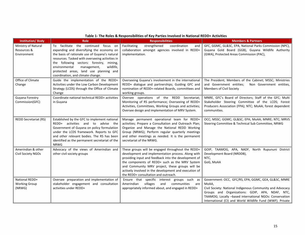
The mandates of these groups and the roles that they will play in the development and implementation of REDD+ activities in Guyana are detailed in Table 1.
11 The NTC comprises over 100 members. The Executive Body of the NTC, in accordance with the Amerindian Act 2006, comprises 20 Toshaos including a Chairperson, and represents the interests of the entire NTC.

13
Decision Making Framework & Coordination Mechanisms For REDD+ in Guyana The Ministry of Natural Resources and Environment was established in early 2012 and has an oversight and coordinating function for agencies with responsibilities for the various natural resources sectors in Guyana, i.e. forestry, mining, environmental management, wildlife, protected areas, land use planning and coordination,. With focuses on strengthening national, regional and local environmental governance, the Ministry aims to address issues such as national development planning; national and international policy setting and technical assistance; sustainable national development and strengthened and harmonized national laws and institutions. The Office of Climate Change, which was established within the Office of the President, will work across the Government to implement the LCDS as well as be the supporting agency for the implementation of the requirements under the MoU between Guyana and Norway. It serves to bring together and align efforts that are already underway and to coordinate efforts by multilateral and non-governmental organizations assisting Guyana’s climate change agenda. The OCC has been designated the focal agency for the UNFCCC. It will provide support to the GFC and REDD Secretariat, the GGMC, EPA, and the GL&SC, as well as ensure coordination with international forestry programs such as the World Bank’s Forest Carbon Partnership Fund (FCPF) and the UN-REDD programme. It will also work closely with Guyana-based and international non-governmental organizations such as Conservation International, World Wildlife Fund for Nature, and Iwokrama. The OCC will also work closely with the Ministry of Amerindian Affairs and individual villages to determine how the “opt in” process for Amerindian villages will proceed and how the benefit sharing mechanism will be implemented. While the OCC will coordinate relevant aspects of climate change work in Guyana, issues relating to the management of resources are dealt with at the level of the respective agencies, for instance, issues related to mining are dealt with by the GGMC, forestry issues by the GFC, environmental management by the EPA, indigenous issues by the MoAA etc. These agencies work closely with each other at many levels including among others, at the levels of the MSSC and Cabinet Sub Committee on Natural Resources. These agencies also work directly with private sector agencies involved within each respective sector as well as communities and NGOs. At the level of the Multi Stakeholder Steering Committee of the LCDS, which was convened to assist and guide the process of the LCDS, these agencies actively participate along with other government and non-government parties. The MSSC has been tasked with the responsibility of overseeing aspects of implementation of the LCDS, including the work on REDD+ and is involved in providing technical inputs to guide many LCDS and climate change initiatives implemented in the country. With the implementation of REDD+ readiness activities, there will be the convening of the National REDD+ Working Group (NRWG). This group will be tasked with overseeing the preparation and implementation of REDD+ activities as it related to stakeholder engagement and consultation and will comprise the representation of a number of key agencies and stakeholder groups. Along with the NRWG, these agencies are also part of the MRVS Steering Committee. Overarching responsibility of this committee is that of overseeing the development of the MRV system, coordinating MRV datasets and overseeing the technical progress under the MRV system. Additionally, the Technical Committee which is a Sub Committee of the Steering Committee, advises the Steering Committee on crucial technical issues, including land use, mining regulations and sustainable environmental practices, all in the context of monitoring, reporting and verifying land area, forest change and carbon impacts, among others. These structures, both coordinating and decision making, will allow for there to be constant flow and exchange of information and decisions. Further, there may be need to expand the physical and technical capacity of each of the institutions responsible for implementing and maintaining the LCDS and REDD+, inclusive of the R-PP and ensuring that implementation is internationally accepted and scientifically supported. This determination will be made as part of the readiness process.

14
Diagram 1: Institutional Arrangements for REDD+ Implementation in Guyana
President
Prime Minister
Office of the President Cabinet
Ministry of Agriculture
Office of Climate Change
Ministry of Amerindian Affairs
Ministry of Natural Resources & Environment
Protected Areas
Commission
Guyana Gold Board
Multi Stakeholder Steering Committee
National Parks
Commission
Guyana Lands & Surveys
Commission
Guyana Geology &
Mines Commission
Guyana Forestry
Commission
Environmental Protection
Agency
Guyana Wildlife
Authority
REDD Secretariat
National REDD+
Working Group
Ministry of Finance Ministry of Public Works & Communication
Constitutional Bodies:
Indigenous Peoples’
Commission & National Toshaos Council
MRVS Steering Committee
Direct Reporting
Institutional Support Provided
15
Table 1- The Roles & Responsibilities of Key Parties Involved in National REDD+ Activities
Institution/ Body Role Responsibilities Members & Partners
Ministry of Natural Resources & Environment
To facilitate the continued focus on expanding and diversifying the economy on the basis of rationale use of Guyana’s natural resources. Tasked with overseeing activities in the following sectors: forestry, mining, environmental management, wildlife, protected areas, land use planning and coordination, and climate change.
Facilitating strengthened coordination and collaboration amongst agencies involved in REDD+ implementation.
GFC, GGMC, GL&SC, EPA, National Parks Commission (NPC), Guyana Gold Board (GGB), Guyana Wildlife Authority (GWA), Protected Areas Commission (PAC),
Office of Climate Change
Guide the implementation of the REDD+ Activities under the Low Carbon Development Strategy (LCDS) through the Office of Climate Change
Overseeing Guyana’s involvement in the international REDD+ dialogue and partnerships; Guiding GFC and nomination of REDD+-related Boards, committees and working groups.
The President; Members of the Cabinet; MSSC; Ministries and Government entities; Non Government entities, Members of Civil Society
Guyana Forestry Commission(GFC)
Coordinate national technical REDD+ activities in Guyana
Oversee operations of the REDD Secretariat; Monitoring of RS performance; Overseeing of REDD+ Activities, Committees, Working Groups and activities; Oversee design and implementation of MRV System.
MNRE, GFC’s Board of Directors; Staff of the GFC; Multi Stakeholder Steering Committee of the LCDS; Forest Producers Association (FPA); NTC; MoAA; forest dependent communities.
REDD Secretariat (RS)
Established by the GFC to implement national REDD+ activities and to advise the Government of Guyana on policy formulation under the LCDS framework. Reports to GFC and other relevant bodies. The RS has been identified as the permanent secretariat of the NRWG
Manage permanent operational team for REDD+ activities; Prepare a Consultation and Outreach Plan; Organize and Manage the National REDD Working Group (NRWG); Perform regular quarterly meetings and other meetings as needed. It is the permanent secretariat of the NRWG.
OCC; MSSC; GGMC; GL≻ EPA; MoAA; MNRE; NTC; MRVS Steering Committee & Technical Sub Committee, NRWG
Amerindian & other Civil Society NGOs
Advocacy of the views of Amerindian and other civil society groups
These groups will be engaged throughout the REDD+ development and implementation process. Along with providing input and feedback into the development of the components of REDD+ such as the MRV System and Community MRV project, these groups will be actively involved in the development and execution of the REDD+ consultation and outreach.
GOIP, TAAMOG, APA, NADF, North Rupununi District Development Board (NRDDB), NTC, GoG, MoAA
National REDD+ Working Group (NRWG)
Oversee preparation and implementation of stakeholder engagement and consultation activities under REDD+
Ensure that specific interest groups such as Amerindian villages and communities are appropriately informed about, and engaged in REDD+
Government: OCC, GFC/RS, EPA, GGMC, GEA, GL&SC, MNRE MoAA, Civil Society: National Indigenous Community and Advocacy Groups and Organizations: GOIP, APA, NDAF, NTC, TAAMOG; Locally –based international NGOs: Conservation International (CI) and World Wildlife Fund (WWF). Private
16
Sector: Private Sector Commission. Academia: University of Guyana.
Multi Stakeholder Steering Committee of the LCDS
Oversee the implementation of activities of the LCDS
Provide input and guidance to the planning and execution of aspects of the LCDS development and implementation, including LCDS financed projects at national and community levels; Provide feedback on Guyana’s Low Carbon Development Strategy; Assist in information dissemination to constituencies; and ; Assist in convening fora within constituencies to promote and discuss the Strategy
OCC, EPA, NTC, MoAA, MoA, GL&SC, GFC, OP, GGMC, Private Sector, GGDMA, TAAMOG, GOIP, NADF, Civil Society, FPA, North Rupununi District Development Board (NRDDB), WWF, CI, Guyana Trade Unions Congress (GTUC), Federation of Independent Trade Unions of Guyana (FITUG), President’s Youth Award Republic of Guyana (PYARD), Women’s Affairs Bureau
MRVS Steering Committee & Technical Sub-Committee
The overarching responsibility of this committee and subcommittee is that of overseeing the development of the MRV System, consolidating the MRV System datasets and reviewing progress in key areas of technical work. Additionally, the Technical Committee advises the Steering Committee on crucial technical issues, including land use, mining regulations and sustainable environmental practices as it related to monitoring, reporting and verification of land area, forest change and carbon impact among others.
Oversee the implementation of MRV System activities; Participate in the review and selection of technical experts to assist in the conducting of key technical work; Monitor and manage the progress made in implementation of MRV System road map activities; Ensuring that scope aligns with the agreed requirements of projects and advise on means by which key stakeholder groups are kept informed of progress in the development of the MRV System; Contribute inputs from representative agencies that each member is a part of, to ensure close cohesion and coordination of MRV System activities implementation.
OCC, GFC, GGMC, GL&SC, MoAA, UG, EPA, FPA, GGDMA, NTC , MNRE
National Toshaos Council
The NTC is the democratically elected body tasked with the responsibility of representing the rights and views of Amerindian communities and villages at the national level.
The NTC has been identified to support the consultation and outreach activities with Amerindian communities and villages on REDD+. Further, the NTC has been identified to be integrally involved in REDD+ implementation, including the MRV System. The Chairperson of the NTC holds a seat on the MRVS Steering Committee.
Toshaos Government & Non-Government partners including indigenous NGOs
17
The REDD Secretariat As part of Guyana’s efforts to provide an enabling environment for the facilitation of key technical aspects of REDD+ activities, the REDD Secretariat (RS) has been established as a unit within the Guyana Forestry Commission (GFC). The Secretariat has been tasked with responsibility for the coordination and implementation of key technical REDD+ activities as detailed in the R-PP, as well as at the level of the Low Carbon Development Strategy framework. In executing its function, the Secretariat will work in close collaboration with a number of key stakeholder and committees, including the Multi Stakeholder Steering Committee (MSSC) of the Low Carbon Development Strategy, the MRVS Steering Committee and the National REDD+ Working Group (NRWG). The RS will be the permanent Secretariat and administrative body of the NRWG. With the establishment of the Ministry of Natural Resources and Environment, the coordinating function of the REDD Secretariat will be strengthened through the improved interagency coordination among the natural resources management agencies that now fall under the purview of the Ministry. The National REDD+ Working Group (NRWG): It is planned for a National REDD+ Working Group (NRWG) to be established, comprising representatives of the following agencies and organizations:
- Guyana Forestry Commission & REDD Secretariat
- Ministry of Natural Resources & Environment
- Ministry of Amerindian Affairs - Office of Climate Change, Office of the President
- National Toshaos Council - Private Sector - Relevant NGOs and Community Groups
(including Amerindian NGOs) - Other relevant Ministries & Academic/Training institution
The NRWG, will be coordinated and chaired by the GFC and involve the input of key stakeholders. It is intended for this to be achieved through the involvement of key agencies/bodies at the government, non-government and private sector levels throughout the entire process. The NRWG will liaise with, provide updates and give feedback to the MSSC of the LCDS on national REDD+ readiness activities. Mandate & Functions of the NRWG The NRWG will be expected to perform an oversight role in providing strategic guidance to the national REDD+ readiness process with specific emphasis on communication, consultation and outreach as well as potential REDD+ activities. The specific functions of the NRWG include:
- Inform and engage communities, Amerindian villages, interest groups, and other stakeholders in the REDD+ preparation and implementation processes;
- Guide and monitor the REDD+ Consultations and Outreach Plan; - Review of educational materials to be used during consultation and outreach sessions; - Assess the effectiveness of the consultation and outreach process and make recommendations; - Review developments in work on identification and demonstration of REDD+ candidate activities; - Assist in the identification and evaluation of alternative economic activities for communities; - Receive updates on progress of land titling process and on designing benefits sharing system; - Identify areas for capacity building and training; - Support the design of the conflict resolution strategy; - Review progress on SESA; - Receive updates on progress in the design of the MRV system and reference scenarios; - Support the implementation of other REDD+ activities.
The Ministry of Amerindian Affairs, National Toshaos Council and Amerindian NGOs will be actively involved throughout the consultation process from the planning phase to partaking in organizing and leading some sessions. The NRWG will convene quarterly or as need arises to discuss issues and propose recommendations particularly on: a) Monitoring the implementation of the Consultations & Outreach Plan; b) Identification of areas in need of capacity building and training; c) Receiving updates on any conflicts that may arise (if any); d) Updating on the status of implementation of other REDD+ Readiness activities. Criteria for Selection for NRWG Members: The GoG will appoint members of the NRWG according to the following criteria: a) Representatives of the Government Ministries, agencies and institutions directly related to LCDS and REDD+; b) Civil society/ NGO

18
groups directly linked to Amerindians and other forest dependent groups; c) Representatives of academia, private sector and locally-based international organizations with relevant knowledge and interest on the subject; d) participating NGOs that have previous involvement in forestry, mining, agriculture or other land uses, as well as environmental services management and/or previous interaction with Amerindian people involving activities in land tenure and natural resources utilization; and/or international experience in carbon financing initiatives (including REDD+) to enable the benefits of lessons learnt from previous experience. MRVS Steering Committee & Technical Sub-Committee With the development of a national Monitoring Reporting & Verification System (MRV System), a MRVS Steering Committee and Technical Sub Committee were convened and meetings initiated. The Steering Committee comprises representation from the GFC, OCC, MNRE, GGMC, EPA, the University of Guyana (UG), GLSC, the Forest Producers Association (FPA), the Guyana Gold and Diamond Mining Association (GGDMA), the MoAA and the NTC. The GFC, GGMC, EPA and GLSC form the MRVS Technical Sub Committee. The overarching responsibility of these two committees is that of overseeing the development of the MRV System, reviewing the MRV System datasets and monitoring and managing the progress made in implementation of MRVS road map activities. The GFC, on behalf of the MRVS Steering Committee (MRVS SC) provides updates on progress to the MSSC. Additionally, the Technical Committee is tasked with providing detailed technical guidance to the MRVS SC on technical MRV System related activities. Integrating REDD+ into the overall land use and forest agenda The process of incorporating REDD+ into forest policy has already commenced, with the review and revision of the National Forest Policy Statement and the National Forest Plan. These two guiding documents promote the conservation, protection, management and sustainable utilization of the nation’s forest resources, while ensuring that the productive capacity of the forests for both goods and services is maintained or enhanced through the work of the GFC. REDD+ will be further incorporated into aspects of natural resources management including infrastructural development, mining, etc. With the advent of the Low Carbon Development Strategy (LCDS) which is a development strategy that seeks to generate financial incentives for the continued and maintained sustainable utilization of forest resources and the resulting maintenance of the current low rates of deforestation and forest degradation through payments achieved from REDD+. The REDD+ Governance Development Plan (RGDP) was developed as a governance model which will be integrated with the LCDS. The RGDP seeks to achieve continued development of a transparent, rules-based, inclusive forest governance, accountability and enforcement system through a number of areas including the development of a national inter-sectoral, land use planning system, with REDD-plus as the overarching goal and with specific emphasis on managing the impacts of development on forests; the review and revision of forest polices and Codes of Practice; and such reporting on the multiple benefits of REDD-plus, including on measures to protect biological diversity, improved livelihoods, and support good governance. Since stakeholder involvement and feedback are integral to the successful implementation of REDD+ in Guyana, emphasis will be placed on ensuring their involvement at various levels in the development and implementation of REDD+. This would involve collaborative effort amongst the key government and non-government agencies and bodies involved in REDD+ implementation. , Overall, the enabling of the institutional arrangements detailed in this component will serve to ensure effective and efficient coordination and synergies in the development of strategies and government programmes related to the REDD+ in Guyana. It will further ensure that there is active stakeholder engagement and participation at various levels. Reporting Responsibilities The GFC, on behalf of the NRWG, will provide quarterly updates to both the MSSC on the progress made, as well as any constraints/limitations faced by the NRWG. Outcomes It is expected that the national institutional arrangements proposed for the implementation of REDD+ in Guyana will achieve the following outcomes: - Coordination and oversight of the development and implementation of REDD+ readiness activities listed in the present R-PP and
ensure active participation of stakeholders; - Ensuring coordination and synergies in the development of strategies and government programmes related to the REDD+
process in Guyana; - Ensuring the quality and inclusivity of national consultations to be conducted; - Receiving updates on issues arising and making inputs on way forward. - Support the development of an appropriate feedback mechanism and a conflict resolution mechanism

19
Next Steps Guyana has already made significant steps in the development of an institutional framework as well as coordination mechanisms for REDD+ implementation in Guyana. This can be seen through the establishment of the Office of Climate Change under the Office of the President, a REDD Secretariat within the GFC and the establishment of a Ministry of Natural Resources and Environment. These offices as well as the coordination mechanisms and committees are fully functional, with clear roles and responsibilities as well as reporting structures. With the commencement of work under the FCPF, the National REDD+ Working Group will be convened to execute its functions as detailed above. Agencies and committees that form part of the national REDD+ institutional framework will continue to work in coordination, being guided and informed by strategic national documents as the LCDS, Joint Concept Note, RGDP and R-PP as well as the outcomes of any technical projects and studies that are conducted as a result of these documents. Performance Indicators:
- The REDD+ Governance & Management Arrangements in place. - Evaluations will be performed based and in compliance with the Common Approach.
Summary As part of Guyana’s efforts to provide an enabling environment for the facilitation key technical aspects of REDD+ activities, the REDD Secretariat (RS) was established as a functional unit within the Guyana Forestry Commission (GFC). The Secretariat has been tasked with responsibility for the coordination and implementation of key technical REDD+ activities as detailed in the R-PP, as well as at the level of the Low Carbon Development Strategy framework. In executing its function, the Secretariat will work in close collaboration with a number of key stakeholder and committees, including the Multi Stakeholder Steering Committee (MSSC) of the Low Carbon Development Strategy, the MRVS Steering Committee and the National REDD+ Working Group (NRWG). With the establishment of the Ministry of Natural Resources and Environment, the coordinating function of the REDD Secretariat will be strengthened through the improved interagency coordination among the natural resources management agencies that now fall under the purview of the Ministry. The Secretariat will be the permanent secretariat for the National REDD+ Working Group (NRWG). The NRWG is expected to perform an oversight role in providing strategic guidance to the national REDD+ readiness process with specific emphasis on communication, consultation and outreach as well as potential REDD+ activities. It will be established with the intention of having the involvement of relevant stakeholder groups, including representatives from Amerindian groups, civil society, NGOs, the private sector, educational institutions as well as from the natural resources management agencies during implementation of consultations and the active involvement in REDD+ activities. It will be the oversight and advisory body for the REDD+ Readiness Preparation. Overall, the enabling of the institutional arrangements for the coordination and implementation of REDD+ will serve to ensure effective and efficient coordination and synergies in the development of strategies and government programmes related to the REDD+ in Guyana. It will further ensure that there is active stakeholder engagement and participation at various levels.
Budget Table 1: Component 1a- Summary of National Readiness Management Arrangements Activities and Budget (USD)
Main Activity Output Indicative activities per output Total
REDD+ Implementation Arrangements
Support the establishment of a functional REDD Secretariat
Prepare and implement ongoing capacity building plan for the REDD Secretariat
200,000
Support the operationalization of the National REDD+ Working Group (NRWG)
Provide institutional strengthening and capacity building the NRWG, inclusive of the NTC and Amerindian NGOs
300,000
Support the operationalization of the National REDD+ Working Group (NRWG)
70,000
Development and establishment of a national conflict resolution strategy
Development and establishment of a national Conflict Resolution Strategy
200,000
Total 770,000
20
Overview The Government of Guyana has placed climate change issues at the top of national priorities through its active involvement in the REDD+ international agenda, while seeking active engagement of relevant stakeholder groups in REDD+ nationally. The GoG has undertaken work at both the strategic and operational levels, with the launching of Guyana’s Low Carbon Development Strategy (LCDS) as well as through interaction with the FCPF with the development of the R-PP. In proceeding with the implementation of REDD+, the GFC, through the REDD Secretariat, in collaboration with the National Toshaos Council and a number of partners are tasked with conducting consultation and outreach activities under the guiding principle of sharing information to promote knowledge sharing, raise awareness, engage society and as a result develop a true participatory REDD+ preparation process. It is acknowledged that the long-term success of both the Low Carbon Development Strategy and Readiness preparation activities will depend on broad-based, inclusive domestic support. The GoG is therefore committed to implementing a robust consultation, participation, and outreach plan geared towards gathering information, issues and opinions from relevant stakeholders and processing these so that possible solutions can be formulated or amended to address the concerns of stakeholders. Furthermore, this activity will inform the relevant stakeholders, provide training, seek inputs and address issues and concerns raised by stakeholders through a continuous, iterative two way process of outreach programmes, consultations and dialogue, incorporation of ideas and effective dissemination of relevant information. The stakeholder Consultation and Participation Plan will be based on the principle of Free, Prior and Informed Consent (FPIC). In recognizing this, the Consultation and Participation Plan is viewed as a vital component for the successful implementation of REDD+. The strategic objectives of this plan are as follows: - To gather information, issues and opinions from key stakeholders and processing it so that possible solutions and policies can be
formulated or amended to address concerns of key relevant stakeholders; - To use the existing participatory mechanisms in place to enhance the active engagement of the relevant stakeholder groups; - To build a two-way communication process through which stakeholders feel informed about and get the opportunity to fully
engage in REDD+ implementation. - In the conducting of the consultation and outreach activities planned under the R-PP, there will be close coordination and
collaboration amongst executing bodies. 1b.1 Information Sharing During the Formulation Phase Previous Awareness Sessions Conducted Prior to the development of the Consultation Plan which will take place during the preparation phase of the R-PP, the GoG took the initiative of formulating the R-PP using its own resources between 2008 to date. During this period, REDD information, sensitization, and awareness sessions were held with 27 community groups, many of which were Amerindian communities. The initial information sharing sessions were conducted within villages and communities in the 10 administrative regions of Guyana targeting specifically: - Amerindian and other forest dependent persons - Loggers & miners - Government ministries and agencies - Women’s groups - NGOs - General public (including students) In addition, the GFC also held an information sharing session with the Amerindian NGOs of Guyana along with the Forest Products Association, the University of Guyana and the Guyana School of Agriculture. The NGOs that participated in these sessions were, The Amerindian Action Movement of Guyana (TAAMOG), the Amerindian Peoples’ Association (APA), the Guyanese Organisation of Indigenous People (GOIP) and the National Amerindian Development Foundation (NADF). This meeting was held on March 5, 2009 at the GFC and followed the format of the other sessions that were held earlier. The objective of these information sharing sessions was to sensitize communities of REDD+. Topics Discussed: Besides the specific issues of each group and/or community, information was also shared and broader topics such as climate change and its implications for the forest livelihoods were also discussed during meetings. Likewise, discussions were held extensively on the potential benefits of REDD and the eventual risks it may bring to the communities. Another topic of discussion, only briefly touched on so far, was that of Benefits Sharing. The additional topics discussed were: - A brief background into forestry in Guyana, pointing out that forests located within Amerindian reservations are private forests.
As such, they do not fall under the mandate of the GFC, however, the GFC can provides support, e.g. in carrying out inventories of forests, as well as advice on the sustainable use of this resource;
1b. Stakeholder Consultation and Participation

21
- Guyana’s position on deforestation does not aim to remove the livelihoods/employment of people - Benefits of forests (economic, social and ecological) - GHG effect and the process of climate change - Various aspects of GFC’s SFM practices - The impacts of deforestation & degradation on the environment - Alternative Economic Opportunities that communities and villages would consider feasible for them to implement once REDD
activities were implemented. - The need for support from villages and for the success of REDD implementation as well as the need for communities and GFC to
work in partnership for the implementation and maintenance of this project. - REDD activities would not be imposed on communities and villages, and also that these activities would not hamper the
development of their respective communities. - The implementation of SFM, its benefits to communities and villages and its link to REDD implementation - The FCPF of the WB & the RPIN and subsequent RPP process
Table 2: Summary of Previous Awareness Sessions Held
Date Name Of Community/Communities Number of Attendees
8/1/2009 Great Falls 51
8/1/2009 47 Miles 20
10/1/2009 Kwakwani 39
10/1/2009 Ituni 44
10/1/2009 Linden 36
13/1/2009 Georgetown; Linden; Parika 90
15/1/2009 Communities surrounding New Amsterdam 28
15/1/2009 Communities surrounding Skeldon 16
16/1/2009 Orealla; Siparuta 185
17/1/2009 Mabaruma 11
18/1/2009 Kwebana 120
20/1/2009 Communities surrounding Anna Regina 35
23/1/2009 Communities of North Rupununi 81
23/1/2009 Communities surrounding Lethem 26
24/1/2009 Nappi 39
24/1/2009 Moca Moca 22
28/1/2009 Santa Mission 44
30/1/2009 Communities surrounding Bartica 37
30/1/2009 Muritaro 68
3/2/2009 Batavia; Caria Caria; Kwebana; Orealla; Siparuta; Three Friends Maria Elizabeth
51
Issues that were raised: the information sharing sessions with the various stakeholder provided an opportunity for participants to voice out their concerns and raised issues on REDD+ and how the implementation of REDD would impact on their lives and livelihoods. General issues raised during awareness sessions were incorporated into the current version of the R-PP and are summarized in Table 3 below.

22
Table 3- Summary of Main Comments Received During Initial Awareness Sessions on REDD+ in 2009
General Areas Raised during Awareness Sessions
Discussion Follow up
The concept of REDD+, the readiness process and the implications of implementation of these
Understanding not only the concept of REDD+, the readiness process and the implications of implementation of these, but also climate change and the role of forests in mitigating climate change - communities pointed out the need to be better informed about these concepts. They requested for the GFC to provide more support in these areas.
GFC to provide more support and information in these areas in upcoming community meetings & REDD+ consultations. The implications for the continuation of Traditional Activities with the implementation of a REDD+ scheme
Benefits Sharing Mechanism as well as potential direct and indirect benefits that would be derived from implementation of REDD+
Securing of Land Rights/Titling
Timeline for implementation of REDD in Guyana
Consultation Process & Community Engagement
Most communities wanted to take advantage of the consultation process to also develop their sustainability plans. This was included in the REDD Strategy component. GFC was requested to develop a consultation methodology to allow for these plans to either be prepared or enhanced during the REDD dialogue. Need for information to be prepared in local language.
Support was expressed for REDD implementation; however, more information would be needed before any definitive decisions could be made. Mitigation measures were proposed and incorporated into the Consultations Plan.
Stakeholders were concerned as to whether there would be a system in place to facilitate community engagement in alternative economic activities.
Potential REDD+ Strategies Communities have pointed out that they have noticed in some areas, that certain species are no longer available in the quantities that once prevailed in the past. Enrichment planting has been identified as a specific REDD strategy that will address this issue.
GFC to provide more support and information in these areas in upcoming community meetings & REDD+ consultations. The need to make maximum use of forest resources was also highlighted by communities in making the point of moving
towards added value forest activities for the benefit of the community. This has informed the inclusion of this area in the draft list of REDD candidate activities.
Several communities have pointed out that non timber forest production is an area that is of specific interest to their communities. As such, this was also flagged as a REDD+ Strategy. In several communities visited, work has already started in producing innovative and creative products from non-timber forest products. This was identified to be of not only economic benefit to the communities, but also for environmental sustenance by making use of the diversified resource base of the forest.
Technical questions regarding REDD+ implementation
Forest fires deforestation and forest degradation were issues that were raised during a few community meetings. The unsustainable use of natural resources and ways better manage these were areas of major concerns among the constituencies consulted.
More technical information to be included in the upcoming consultations to bring additional clarity to these issues The sources of carbon emissions as well as whether specific species of trees stored different amounts of carbon.
The recommendation made by communities that they are best placed in certain locations, to monitor plots established was taken note of and integrated into the plans for biomass monitoring where communities have been identified to assist in collecting data and monitoring established plots. This point has also been flagged in component 2 which outlines the areas in which communities will play a role in the work of the REDD Secretariat.
23
Constraints & Limitations These initial information sessions helped the Government to identify limitations to the methodology utilized. Some of the constraints and limitations are:
- Many communities and villages are located in remote areas and as a result communication and access to these communities will prove to be a challenge and to be costly;
- During consultation sessions, some segments of villages, communities and the wider population may not participate as fully as other segments.
- There may be overlapping and conflicting suggestions from various communities that may impact on the ease in which a final position is reached.
Lessons Learnt: The main lessons learnt so far: - Communities want to be engaged: Communities and other stakeholders want to be prior informed to be able to conduct
productive dialogues so that they can be effectively engaged in the REDD+ process; - Communities want to have concrete results along the way: A concrete result expected from the communities will be a plan
with sustainable economic alternatives to enhance their livelihoods while protecting the forests; - Communities want to be part of the broader, national dialogue: Communications and civic engagement strategies such as
national and regional meetings will be developed in order to attend this demand. - The importance of setting up good consultation processes in the future to enhance the engagement of stakeholders - The importance of sharing information ahead of time to enable stakeholders to engaged in meaningful dialogue with the
government - The importance of setting up communication strategies using the right medium/channels of communication that are
culturally appropriate and could reach communities in geographical isolated areas - The importance of setting up redress mechanisms for grievance and conflict management and resolution - The importance of including NTC, non indigenous communities in REDD+ discussions as well as other Association bodies
including at the private sector and civil society levels.
24
1b.2 Consultation, Participation and Outreach during the Readiness Preparation Phase The GFC is cognizant of the lessons learnt and is fully committed to the development and implementation of an effective multi-stakeholder consultation and participation plan. Furthermore the Government has firmly stated that the forest dependent stakeholders, especially Amerindian stakeholders from both titled and untitled communities must be consulted during the Readiness Preparation phase. Issues affecting these stakeholders will be recorded and taken into consideration during the readiness phase. Based on the experience, knowledge and feedback they received from various stakeholders on the R-PP and the consultation process, the following will be put in place: Operating Principles for Consultation, Participation and Outreach: - Consultation and awareness sessions planned under the R-PP will be executed in collaboration with the Office of Climate
Change by the GFC. The NTC and Amerindian NGOs will also liaise closely with the OCC and the GFC in conducting consultations/awareness sessions. Further, the NTC will be provided with technical guidance from both the OCC & GFC on the more technical aspects of REDD+ implementation, prior to their commencement of their series of REDD+ consultations;
- The consultation and participation process will be built upon the principle of: free, prior and informed consent (FPIC); targeted consultations will be held with the relevant stakeholders identified from the stakeholder analysis including Amerindian communities and villages;
- Information materials will be developed in a user friendly format, so that relevant stakeholders, especially the Amerindian villages and communities will be able to fully understand its content and therefore make free, informed decisions on its contents;
- Every effort will be made to send relevant materials to stakeholders at least 30 days before a given, scheduled consultation process is to be held;
- The consultation and outreach program will be documented and analyzed to determine how stakeholder input will be used, what strategies should be put in place, and which ones should be amended;
- NTC, NGOs and other partners will be engaged to disseminate information amongst stakeholders, so that they fully understand the opportunity and the responsibility of promoting the dialogue within the community, and that the consultations held will indeed represent the understanding and the will of stakeholders affected by REDD+;*
- Consultations will be conducted at the village and community, regional and national levels; Reports from consultations will be sent back to stakeholders in a timely manner and feedback will be sought on the content of the reports;
- Consultations will be implemented in a timely manner, with the proper materials, and to achieve pre-determined objectives/products. Translators will be available during consultations with indigenous communities;
- An appropriate feedback mechanism will be developed to allow for sufficient exchange of views, opinions and recommendations.
*Technical staff from the GFC/OCC will support the consultation process, working with stakeholder groups closely to support technical questions and issues regarding REDD+ activities and proposed REDD+ framework. Further, the GFC will seek to support the NTC and participating NGOs with advice on REDD+ as mutually agreed upon between the two entities. Wherever needed, expert support will be solicited to support both the GFC and NTC in this regard. Methodology: Consultations will be designed and conducted according to national and international standards. To achieve optimum participation, which would enable effective discussions and results, the consultation and outreach program will use the following methods:
- Workshops - Advisory groups
- Interviews - Education outreach and school outreach programs
- Formal and informal discussions - Training
- Surveys - Community Planning Groups
Content of the Consultations: Consultations during Readiness preparation may include the following, among other possible topics: - Current status of the country’s forest and forest policies - Deforestation and forest degradation – main causes and effects - REDD+ details and links to the LCDS, benefits sharing of incentives, impacts and risks, strategy etc. - Land use, land rights and alternative livelihoods - Training needs

25
- The link between community activities and practices and the effective achievement of planned objective - Implementation, monitoring and verification of a REDD+ scheme - Implications on the environment in which livelihoods are earned (mining/logging/hinterland farming/ etc.) by the predicted
impacts of climate change for Guyana - How reliable are these predictions, and what could be done to minimize these risks - Implications of reductions in emissions of forest carbon for forest dependent livelihoods - Implementation of such reductions, in terms of when ,where, and how will they be verified - Areas of training and mentoring available, from whom, where, when and at what cost, and in compliance with the
instruments - Individual, community and national involvement in the above - The structure and modalities in the design of the REDD+ benefits sharing mechanism. Target Audiences Based on the stakeholder mapping the stakeholders below will be targeted for the consultations. These will be updated as more in-depth stakeholder analysis exercises are conducted. These include: - Internal: Staff of GFC, RS, and NRWG; - National: various agencies involved in climate change, natural resources management etc. including the Office of Climate
Change, Ministries of Natural Resources & Environment, Agriculture, Amerindian Affairs, Public Works, Housing, Finance, Local Government, as well as, the Energy, Land Administration, Mining, and Environmental Management sectors;
- Private Sector Bodies: Loggers and Miners Associations, Forest Producers Association, Guyana Gold and Diamond Miners Association, Private Sector Commission (PSC), etc;
- Civil Society Organizations and community organizations & NGOs including Trade Unions Congress (TUC), Federation of Independent Trade Unions of Guyana (FITUG) ; Indigenous NGOs;
- Amerindian villages and communities; - Other forest dependent communities, including miners; - Academia; - International: international community and others. The participation and feedback from stakeholders is critical to the successful implementation of the R-PP and national REDD+ program. Along with Amerindians, participation by other relevant stakeholders such as loggers and miners are also very important to this process, since their operations may bring about varying levels of impact on forests resources, and the implementation of REDD+/LCDS strategies would have implications for their respective operations. Students and young professionals are also an important group to be consulted as they constitute the future population of the country and will be the portion of society benefiting from the outcomes of current governmental decisions. Their active participation in the process would result in increased interest in developing professional skills in the Climate Change and REDD+ arena ultimately working towards Guyana’s success in reducing emissions from deforestation and degradation. Participatory Mechanisms in Place to Enhance Consultations and Stakeholder Engagement: The GoG is committed to an inclusive R-PP preparatory process though the partnering with NGOs and other organizations to implement the consultation and participation process. As previously discussed, the inclusion and feedback from stakeholders is integral to the success of REDD+ implementation nationally, especially in areas such as:
- participation in REDD+ activities, - the design and delivery of a benefits sharing mechanism as well as REDD+ consultations - the selection of national REDD+ Strategies - design of the MRV System & demonstration activities under the MRV System - capacity building and training that would be required to effectively implement REDD+ activities at the community level
Amerindian Sensitization Mechanisms: As discussed in Component 1a, the NTC is a Constitutional Body, that is the democratically elected by national representatives of Amerindian Villages and Communities. Therefore, the GoG has engaged the NTC in execution of activities under both the LCDS & Readiness Preparation. The NTC has been identified to conduct consultation and outreach activities with Amerindian communities on REDD+ and Readiness Preparation on behalf of the GoG, in coordination with the Amerindian NGOs. Further, the NTC has been identified to be integrally involved in various aspects of REDD+ implementation, including the MRV System. The NTC is currently represented at both the levels of the MSSC as well as the MRVS Steering Committee. The MSSC of the LCDS, which was

26
established to, among other functions, oversee the consultation process of the LCDS, would also be used as platform for the REDD+ consultations. Recipients of information obtained from Consultations It is expected that feedback collected from the consultation sessions will first be compiled by both the GFC and NTC (the parties that will be executing the REDD+ consultations). The compiled feedback will then be forwarded to the NRWG for deliberation on the implications on various aspects of REDD+ implementation. The recommendations would then be forwarded to the MSSC for their consideration and subsequent incorporation into guiding documents where applicable. Expected Outcomes for Consultation & Outreach Activities - Higher levels of understanding of the concept of REDD+, the roles that different stakeholders will play in REDD+ as well as the
benefits, risks and challenges that arise from the implementation of a REDD+ Strategy; - Active involvement of stakeholders in REDD+ process; - Involvement of stakeholders in development and implementation of the MRV System, the benefits sharing mechanism,
REDD+ candidate activities, etc; - Opposition/ concerns are well documented and integrated to the extent possible, in the readiness phase; - Development of an appropriate Communications Strategy; - Stakeholders involved in the development of an equitable benefits sharing mechanism; - A final REDD+ strategy based on broad consultation with stakeholders. Considerations for Consultation & Outreach during the Readiness Preparation phase: - Consultations Plan Preparation: The key to having a strong, respected consultation plan is to develop a draft of a consultation
plan with the relevant stakeholders, validate this draft with key stakeholders, finalize the plan and then start the consultation process.
- Plan Validation: the Plan will be revised and validated during a Validation Workshop that will be held. - Incorporation into R-PP: Once revised and validated, the Plan will be fully incorporated as part of the readiness process. - Dissemination Strategy: Plan will be disseminated amongst Amerindian villages and communities, forest dwellers and other
interested audiences through a consistent, ongoing communications strategy. Development of a Consultation & Outreach Plan Prior to the commencement of consultations, a draft Consultation & Outreach Plan will be developed. The development of this plan will be led by the National REDD+ Working Group in collaboration with the National Toshaos Council, and Amerindian NGOs. This draft plan will subsequently undergo a period of stakeholder review in order to ensure that the development of this plan is done in a fully participatory manner and adequately addresses the main tenets of consultation and outreach activities for REDD+.
Table 4. Tentative Consultations Timeline
Activity Strategy Year 1 Year 2 Year 3
Consultation Plan
Prepare Draft
Organize Validation Workshop
Finalize Consultations Plan
Add Final Version to Readiness Activities
Disseminate Plan
Implement Plan
Incorporate Consultations Findings into REDD+ Policies
Report Consultation Findings
Provide Feedback to Consultation Stakeholders
Publicize Consultation Findings
Dissemination of Information Record keeping is a very important aspect of the consultation process as they would be used to not only highlight issues raised during the sessions, but also feedback contained in these records will be used to inform the design of the REDD strategy. Records

27
of the consultation process will be kept so that feedback on key issues raised during the consultation process can be responded to in a timely and appropriate manner. Consulted stakeholders will be informed of the outcomes and how their inputs will be used. The outcome of these consultations will be incorporated into related strategies and programmes. Activities will be conducted in keeping with the Communications Strategy as outlined below. There will also be timely and consistent responses provided to stakeholders based on the feedback they provide. With regards to consultations at the institutional level, the process will be designed to take into considerations how process will be conducted at the institutional level with other government agencies where dialogue will be focused on coordination, policy and decision making. Since the consultation and outreach plan is seen as a means of achieving a goal and not the goal itself, the process will be done on a continuous basis so as keep stakeholders informed to deal with any issues that may arise before, during and after the implementation of REDD+. The NRWG will be the main means by which this communication will be facilitated. Through this, information can be disseminated by the GFC/RS to Amerindian communities, villages and other forest dependent groups. Information will also be exchanged from the communities to the GFC/RS through this Committee. Communications will also be transmitted via the GFC field stations located around the country as well as through the Ministry of Amerindian Affairs and the National Toshaos Council. Dissemination to Amerindian Villages & Communities: The Government of Guyana is committed to broad dissemination of the Consultation Plan in a form and language appropriate to Amerindian people. Special attention and effort will be put into the effective dissemination of the Consultation plan and activities among the Amerindian villages and communities. 1b.3 Communication and Outreach Strategy The primary goals of this Strategy are as follows:
- To improve key stakeholder awareness about the REDD+ process and implications of its implementation; - To improve knowledge and understanding of climate change, the role forests play in climate change mitigation & REDD+; - To promote active participation in activities outlined in the R-PP for REDD+ readiness and implementation; - To position Guyana as a leader in REDD+ through multi-stakeholder inclusion and involvement.
Design As part of the R-PP implementation phase, a Communications Strategy will be designed based on the following framework: Formative Research/Communications needs assessment - As part of the design work, formative research will be carried out to determine the baseline awareness, knowledge and attitudes of target audiences for later comparison with strategy results. Conduct research of secondary sources of information, such as project reports, or existing research is recommended. The involvement of key stakeholders and target audiences in the design phase can also increase commitment, leverage investments, and ensure sustainability. Participatory planning workshop - In order to define the key component of the strategy (objectives, target audiences, messages, activities and tools) a participatory workshop that brings together government agencies, partner organizations, Amerindian groups and stakeholders will be carried out. The workshop will help define a common work plan and delegates’ responsibilities. Communication strategy logical framework- After compiling and analyzing the formative research results and the outcomes of the planning workshop, a logic framework will be produced delineating the specific objectives, target audiences, activities, tools, indicators and detailed budget to be delivered as part of the implementation phase of the R-PP. The communications logic framework is a living document that requires review in sync with the monitoring and evaluation activities. Implementation - During the implementation stage, communications activities should consider local contexts, including language and cultural, political and economic realities. The program should be carried out according to the plan and schedule prepared in the design phase, and should complement the consultation plan. Final materials will be produced and used, partnerships and networks finalized, events organized and monitoring and evaluation activities started. Evaluation- It is fundamental to conduct monitoring and evaluation of the communications program results. Lessons learned through evaluation should be integrated into a continual process of program refinement and redesign. Baseline data should be compared with post activity data. To ensure information about the R-PP and REDD+ strategy continues to flow while the communications strategy is being designed, the GFC/RS, in collaboration with the NTC, will:
- Use the GFC website as repository of public documents related to the FCPF, REDD+ and R-PP - Conduct informative sessions with key stakeholders groups to provide tailored information based on the audience needs - Compile a master stakeholder distribution list to be used for key communications - Develop a frequently asked questions document for public distribution about the process from the beginning

28
- Hire a communication specialist to assist in the development of the strategy Next Steps Along with the previous awareness sessions held by the GFC on REDD+ implementation, preliminary Consultation and Outreach activities have commenced with the launching of the Low Carbon Development Strategy, along with awareness and outreach activities utilizing the local media and internet. The consultations were coordinated by the Office of Climate Change, and overseen by a Multi-Stakeholder Steering Committee. Once funding is received for the conducting of consultations, it is expected that the GFC & NTC, in collaboration with the OCC, will commence the activities as outlined above. Performance Indicators - Convening of the National REDD+ Working Group to oversee the development and execution of REDD+ Consultation and
Outreach Activities. - Capacity building sessions for the members of the National Toshaos Council, Amerindian and other civil society NGOs to build
their technical capacities in conducting REDD+ consultation and outreach sessions. - Total number of consultation and outreach sessions held throughout the country by both the GFC & NTC on REDD+. - Feedback received from targeted stakeholders during the consultation period.
Summary of Consultation and Participation Plan: A Consultation and Participation Plan is a vital component for the preparation of the Readiness Preparation phase. It is geared at gathering information, issues and opinions from stakeholders and processing it so that possible solutions and policies can be formulated or amended to address concerns of participants. This activity will inform stakeholders, provide training, seek inputs and address issues and concerns raised by stakeholders through a continuous, iterative two way process of outreach programmes, consultations and dialogue, incorporation of ideas and effective dissemination of relevant information. The stakeholder Consultation and Participation Plan will be based on the principle of free, prior and informed consent.
Budget Table 2: Component 1b- Summary of Stakeholder Consultation and Participation Activities and Budget (USD)
Main Activity Output Indicative activities per output Total
Consultation and Participation
Effective stakeholder Consultation and participation
Development of a Communication and Outreach Strategy and Action Plan
255,000
Development of Communication and Outreach Material and conduct National Consultation and Outreach Activities
750,000
Dissemination of materials for consultations through various media
270,000
Total 1,275,000

29
Component 2: Prepare the REDD+ Strategy
2a. Assessment of Land Use, Forest Policy and Governance
This Section provides an assessment of the various agencies that are involved in land and natural resources management in Guyana and their projected roles in REDD+ implementation. It aims to discuss the various types of land ownership and land uses and discusses coordination and collaboration amongst the various land management agencies. 2a.1 Land use and land tenure system in Guyana Land tenure in Guyana is administered under the following categories:
- Public land - Privately owned land
2a.1.1 Public Land In Guyana, while the State Lands Act gives the Commissioner of Lands and Surveys the right to be the custodian of all public lands, mining activities on State Land is managed by the GGMC and forestry activities in the State Forests by the GFC. These agencies, along with the GL&SC, EPA, National Parks Commission, Guyana Gold Board, Guyana Wildlife Authority and the Protected Areas Commission now fall under the purview of the Ministry of Natural Resources and Environment. With this new Ministry in place, this provides for a coordinated and integrated approach to the management of these key natural resources. As such, tenure to a particular area with multiple potential uses is enabled through these Committees. The major land uses are classified as follows:
- forestry - agriculture - other land based uses
- mining - protected areas -
Publicly owned lands comprise State Lands and Government Lands. State Lands, formerly called Crown Lands, are controlled by the Commissioner of Lands and Surveys. However as mentioned before, the GFC, the GGMC, and the GL&SC administer land that is utilized for forestry, mining, and agriculture, respectively. Each of these three Government agencies may issue licenses and permits for different purposes over a land space. Government lands are those purchased by, or granted to Government entities to be developed for specific purposes such as hospitals, schools, local government administration, and land development schemes. The lease of State and Government Lands are approved by the President, following a comprehensive, transparent process, while the sale of State and Government Lands has to be approved by the Cabinet. 2a.1.2 Private Lands that are privately owned are divided into two categories:
- Amerindian - Non- Amerindian
Amerindians total approximately 9.1 percent of Guyana’s population and currently own approximately 13.9 percent of the land. This has increased from 6% in the early 1990 s. Shortly after Guyana acquired independence in 1966, an Amerindian Lands Commission was established with the goal of recognizing Amerindians’ right to communal land ownership. The Amerindian Lands Commission Report of 1969 offered a number of recommendations for granting land titles to identified communities that existed prior to 1966. In 1976, the 1951 Amerindian Act was amended to provide for the granting of titles to 64 Amerindian communities. In 1991, 10 other villages were titled, bringing the total of titled villages to 74, approximately 6% of Guyana’s territory. After subsequent reform to the constitutional and legislative framework for Amerindian land ownership, the basis was established for the development of a land titling, demarcation and execution programme. As a result, the total number of titled Amerindian villages is now 96. In parallel, the policy framework was reformed and culminated in the Amerindian Act, 2006 which was formulated out of extensive community consultations with Amerindian villages. This Act made provision for matters of land management, allocation, leasing, titling, demarcation and extension. Titles are now issued in different forms – Amerindian Villages, Amerindian Areas and Amerindian Districts. How the State Manages Land The State plans and manages land through the GL&SC in cooperation with the natural resources agencies of Guyana, namely the GFC, GGMC, National Parks Commission. These agencies now fall under the purview of the Ministry of Natural Resources and Environment, which will now ensure stronger collaboration in the area of land and natural resources management. The GLSC was established on June 1, 2001, through the implementation of Act No. 15 of 1999. The establishment of the Commission replaced the former Lands and Surveys Department of the Ministry of Agriculture. This new Act allowed for greater responsiveness of the institution through improved efficiency and greater accountability. The Commission was established as a semi-autonomous agency to effectively fulfil its mandate. The GL&SC is in the process of developing regional land use maps to identify areas that can be opened for agricultural and other development. These regional maps zone areas for various forms of land use that would be
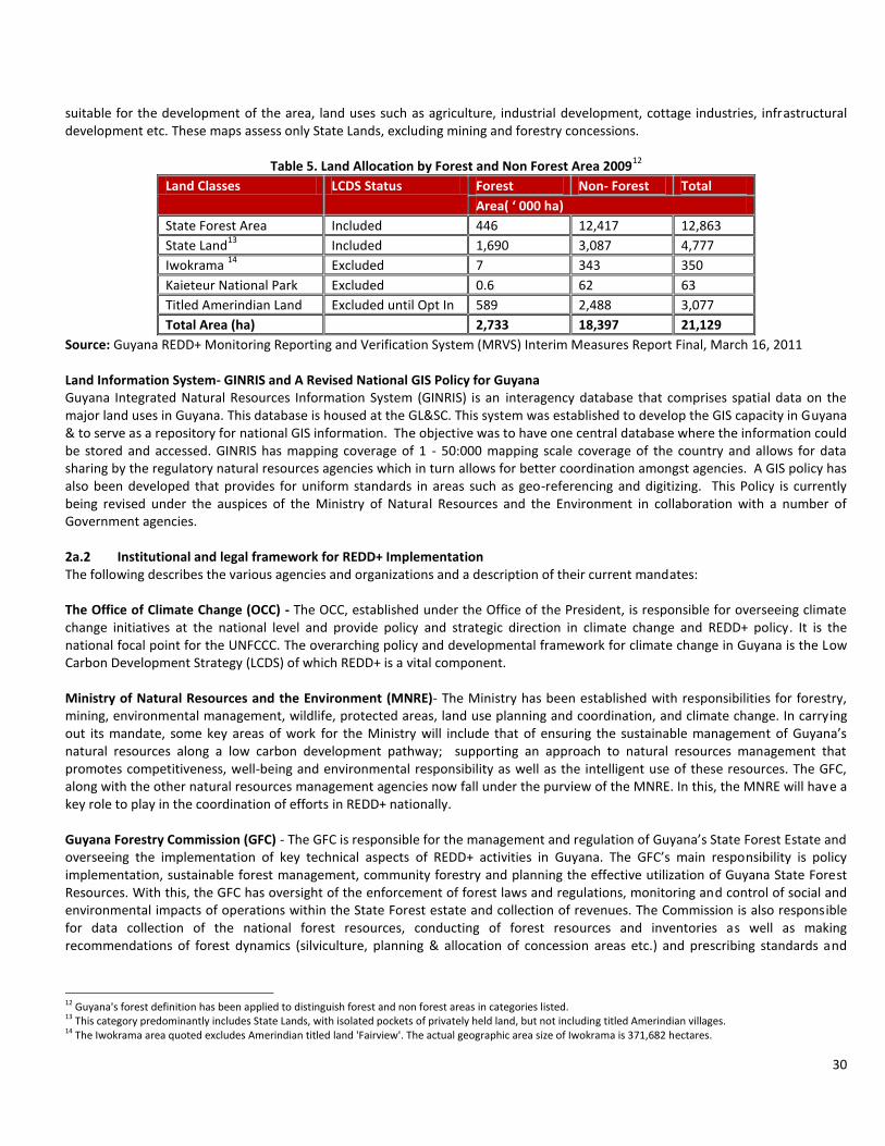
30
suitable for the development of the area, land uses such as agriculture, industrial development, cottage industries, infrastructural development etc. These maps assess only State Lands, excluding mining and forestry concessions.
Table 5. Land Allocation by Forest and Non Forest Area 200912
Land Classes LCDS Status Forest Non- Forest Total
Area( ‘ 000 ha)
State Forest Area Included 446 12,417 12,863
State Land13
Included 1,690 3,087 4,777
Iwokrama 14
Excluded 7 343 350
Kaieteur National Park Excluded 0.6 62 63
Titled Amerindian Land Excluded until Opt In 589 2,488 3,077
Total Area (ha) 2,733 18,397 21,129
Source: Guyana REDD+ Monitoring Reporting and Verification System (MRVS) Interim Measures Report Final, March 16, 2011 Land Information System- GINRIS and A Revised National GIS Policy for Guyana Guyana Integrated Natural Resources Information System (GINRIS) is an interagency database that comprises spatial data on the major land uses in Guyana. This database is housed at the GL&SC. This system was established to develop the GIS capacity in Guyana & to serve as a repository for national GIS information. The objective was to have one central database where the information could be stored and accessed. GINRIS has mapping coverage of 1 - 50:000 mapping scale coverage of the country and allows for data sharing by the regulatory natural resources agencies which in turn allows for better coordination amongst agencies. A GIS policy has also been developed that provides for uniform standards in areas such as geo-referencing and digitizing. This Policy is currently being revised under the auspices of the Ministry of Natural Resources and the Environment in collaboration with a number of Government agencies. 2a.2 Institutional and legal framework for REDD+ Implementation The following describes the various agencies and organizations and a description of their current mandates: The Office of Climate Change (OCC) - The OCC, established under the Office of the President, is responsible for overseeing climate change initiatives at the national level and provide policy and strategic direction in climate change and REDD+ policy. It is the national focal point for the UNFCCC. The overarching policy and developmental framework for climate change in Guyana is the Low Carbon Development Strategy (LCDS) of which REDD+ is a vital component. Ministry of Natural Resources and the Environment (MNRE)- The Ministry has been established with responsibilities for forestry, mining, environmental management, wildlife, protected areas, land use planning and coordination, and climate change. In carrying out its mandate, some key areas of work for the Ministry will include that of ensuring the sustainable management of Guyana’s natural resources along a low carbon development pathway; supporting an approach to natural resources management that promotes competitiveness, well-being and environmental responsibility as well as the intelligent use of these resources. The GFC, along with the other natural resources management agencies now fall under the purview of the MNRE. In this, the MNRE will have a key role to play in the coordination of efforts in REDD+ nationally. Guyana Forestry Commission (GFC) - The GFC is responsible for the management and regulation of Guyana’s State Forest Estate and overseeing the implementation of key technical aspects of REDD+ activities in Guyana. The GFC’s main responsibility is policy implementation, sustainable forest management, community forestry and planning the effective utilization of Guyana State Forest Resources. With this, the GFC has oversight of the enforcement of forest laws and regulations, monitoring and control of social and environmental impacts of operations within the State Forest estate and collection of revenues. The Commission is also responsible for data collection of the national forest resources, conducting of forest resources and inventories as well as making recommendations of forest dynamics (silviculture, planning & allocation of concession areas etc.) and prescribing standards and
12 Guyana's forest definition has been applied to distinguish forest and non forest areas in categories listed. 13 This category predominantly includes State Lands, with isolated pockets of privately held land, but not including titled Amerindian villages. 14 The Iwokrama area quoted excludes Amerindian titled land 'Fairview'. The actual geographic area size of Iwokrama is 371,682 hectares.
31
preparation of operational guidelines for forest management. With regards to private and Amerindian Village lands, the GFC works with the management structure to provide technical assistance for sustainable forest management activities. The passage of the Forests Act in January, 2009, now provides the GFC with a broader range of powers to implement and regulate enhanced forest practices including conservation operations for purposes of carbon sequestration and environmental services. The GFC is therefore expected to play an increasingly pivotal role in implementation, monitoring, and enforcement of REDD+ activities. The GFC has also been tasked with the responsibility of overseeing the development and implementation of the national Monitoring Reporting and Verification System. To conduct these activities, the GFC has established a REDD Secretariat. Guyana Geology and Mines Commission (GGMC) - The Mining Act provides for the management of large, medium and small scale mining claims. The GGMC is responsible for regulating activities in the mineral sector on behalf of the Government as well as to provide the basic prospecting information and advisory services on the available economic mineral prospects. The Commission acts as a national repository for information relating to geology and mineral resources which will facilitate an understanding of the resource base of the country and provides advice to the government on appropriate mineral policy matters so that Guyana's mineral resources can be rationally developed and utilized. Environmental management of both large and small scale operations at the field and policy levels are monitored and implemented by the GGMC. Through a memorandum of understanding between the EPA and the GGMC, the EPA has environmental oversight of mining operations. Guyana Lands & Surveys Commission (GL&SC)- The GL&SC was established on June 1, 2001, through the implementation of the Guyana Lands and Surveys and Commission Act, Act No. 15 of 1999 (Cap 59:05). The GL&SC replaced the former Lands and Surveys Department (LSD) of the Ministry of Agriculture. The GL&SC is the state regulatory body for lands. Its primary role is to survey and map the land and water resources of Guyana; to take charge and act as guardian over all public lands, rivers and creeks, to administer and manage public lands to provide land-based information to a broad range of public and private sector entities and interests, and to develop land policy and land use plans. Additionally, the GL&SC advises the government on policies relating to public lands and land surveys and to administer and enforce laws to public lands and land surveys. Private Sector (PS) - At the operational level, GFC works in close collaboration with the Forest Product Development and Marketing Council (FPDMC) and the Forestry Training Centre Incorporated (FTCI). A Technical Committee comprising GFC and the Forest Products Association (FPA) and a Ministerial Committee comprising the GFC, FPA and Guyana Manufacturing and Services Association (GMSA are parts of efforts to foster a closer working relationship and coordination with the forestry private sector and industry stakeholders. These fora provide a mechanism through which the GFC can have an open dialogue and problem solving mechanism to address issues relating to natural resources management; including in areas of harvesting, forest industry, export regulations, etc. It is expected that along with funding, the PS would participate fully in the implementation of national REDD+ initiatives. National Toshaos Council (NTC) - In accordance with the Amerindian Act, 2006, the National Toshaos Council was established as a body comprising all Toshaos. It outlines that the NTC shall elect an executive committee comprising one Toshao from each administrative region of the country and not more than ten additional Toshaos. Some of the main functions of the NTC as designated by the Act are as follows: - To promote good governance in Villages including investigating matters as requested by a Village and making
recommendations; - To prepare strategies & plans for reducing poverty and improving access to health and education in Villages; - To prepare strategies and plans for the protection, conservation and sustainable management of Village lands and natural
resources; - To provide advice to the Minister on: - The protection of Amerindian culture and heritage, including the identification and designation of Amerindian monuments; - The development of Villages; - The impact of legislation or policy on Villages and any changes that should be made to such legislation or policy. - To coordinate and integrate the activities of Villages on a national basis. The GoG has engaged the NTC in execution of activities under the LCDS overall & the REDD+ pillar in particular. The NTC has been identified to conduct consultation and outreach activities on REDD+ and Guyana’s R-PP, in collaboration with the GoG and indigenous NGOs. In addition to this, the NTC has been engaged at the level of the MSSC of the LCDS as well as the MRVS SC. Overall, the NTC is viewed as an integral partner in the implementation of REDD+ implementation.
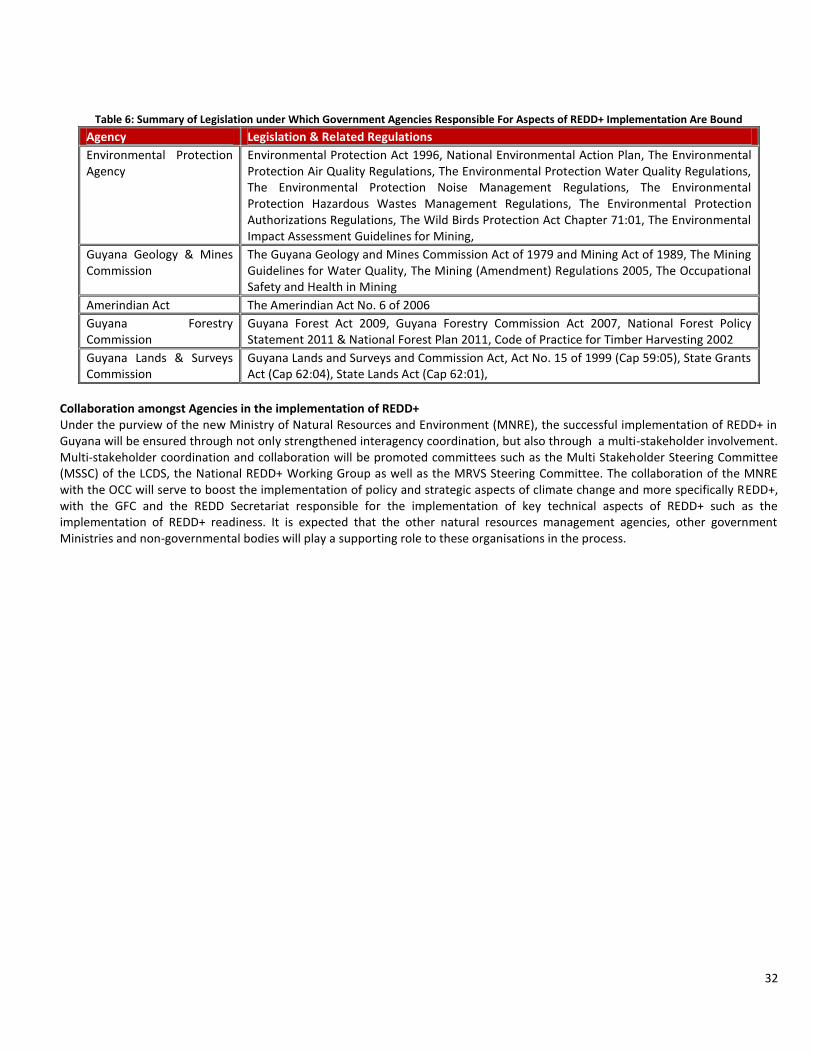
32
Table 6: Summary of Legislation under Which Government Agencies Responsible For Aspects of REDD+ Implementation Are Bound
Agency Legislation & Related Regulations
Environmental Protection Agency
Environmental Protection Act 1996, National Environmental Action Plan, The Environmental Protection Air Quality Regulations, The Environmental Protection Water Quality Regulations, The Environmental Protection Noise Management Regulations, The Environmental Protection Hazardous Wastes Management Regulations, The Environmental Protection Authorizations Regulations, The Wild Birds Protection Act Chapter 71:01, The Environmental Impact Assessment Guidelines for Mining,
Guyana Geology & Mines Commission
The Guyana Geology and Mines Commission Act of 1979 and Mining Act of 1989, The Mining Guidelines for Water Quality, The Mining (Amendment) Regulations 2005, The Occupational Safety and Health in Mining
Amerindian Act The Amerindian Act No. 6 of 2006
Guyana Forestry Commission
Guyana Forest Act 2009, Guyana Forestry Commission Act 2007, National Forest Policy Statement 2011 & National Forest Plan 2011, Code of Practice for Timber Harvesting 2002
Guyana Lands & Surveys Commission
Guyana Lands and Surveys and Commission Act, Act No. 15 of 1999 (Cap 59:05), State Grants Act (Cap 62:04), State Lands Act (Cap 62:01),
Collaboration amongst Agencies in the implementation of REDD+ Under the purview of the new Ministry of Natural Resources and Environment (MNRE), the successful implementation of REDD+ in Guyana will be ensured through not only strengthened interagency coordination, but also through a multi-stakeholder involvement. Multi-stakeholder coordination and collaboration will be promoted committees such as the Multi Stakeholder Steering Committee (MSSC) of the LCDS, the National REDD+ Working Group as well as the MRVS Steering Committee. The collaboration of the MNRE with the OCC will serve to boost the implementation of policy and strategic aspects of climate change and more specifically REDD+, with the GFC and the REDD Secretariat responsible for the implementation of key technical aspects of REDD+ such as the implementation of REDD+ readiness. It is expected that the other natural resources management agencies, other government Ministries and non-governmental bodies will play a supporting role to these organisations in the process.

33
Table 7- Summary of Key National Stakeholders & Their Role in REDD+
Group Ministry/Agency Expected/Tentative Role in REDD+ N
on
- G
ove
rnm
en
t St
akeh
old
ers
Amerindian Communities Design & implementation of REDD+ Readiness and REDD+ activities. Implementation of pilot projects. Engage in consultations and REDD+ dialogue and policy design. Inform Government decisions.
Community-based & Amerindian NGOs Support the implementation and management of community-based conservation, sustainable management, and development projects. Assist in conducting national REDD+ consultations;
International NGOs and multi-lateral institutions
Support Government of Guyana, implement projects within Guyana.
Private Sector Finance and implementation of REDD+ activities within sectors (e.g. forestry, mining, agriculture, tourism, manufacturing, training based institutions, financing & financial services).
Other Forest based Communities Design & implementation of Proposal. Implementation of pilot projects.
Civil Society
Support and advise on REDD+ Projects and implementation. Advocacy, participation in NRWG, foster awareness raising and public information.
National Toshaos Council Assist in conducting national REDD+ consultations; member of the MSSC of the LCDS & MRVS Steering Committee.
Go
vern
men
t St
ake
ho
lder
s
Ministry of Natural Resources & Environment
Coordination of natural resources management agencies involved in the implementation of REDD+. Provide policy direction and other guidance.
Office of Climate Change Political leadership, policy and strategy setting including international representation of climate change issues and agenda for Guyana. Responsible for overseeing implementation of LCDS.
Ministry of Amerindian Affairs Support social, economic and cultural activities in Amerindian communities.
Ministry of Finance Chair of GRIF Steering Committee on behalf of the Government of Guyana. Ministry involved in overseeing the execution of activities under the GRIF and other national initiatives related to REDD+.
Guyana Forestry Commission. Manage and regulates the utilization of state forest while ensuring an optimum and sustained yield of forest produce and maintenance of the environment. Tasked with implementation of key technical aspects of REDD+ implementation, including REDD+ readiness activities.
Guyana Geology and Mines Commission
Manage and regulates the extraction of mineral resources of Guyana. Includes granting and enforcing mining licenses.
Guyana Lands and Surveys Commission Advise the government on policies relating to public lands and land surveys and to administer and enforce laws to public lands and land surveys.
Environmental Protection Agency Promote, facilitate and coordinate effective environmental management and protection; and the sustainable use of Guyana's natural resources.
REDD Secretariat This is a Unit of the GFC. Develop coordinate and implement national REDD+ and Readiness Preparation Proposal activities including those under the FCPF.
University of Guyana Training of personnel at tertiary level. Conducting research into specific REDD+ related activities.
Co
mm
itte
es,
Ad
viso
ry B
od
ies
&
Tech
nic
al S
ub
-
Co
mm
itte
es
MSSC of the LCDS Enabling the participation of affected and interested stakeholders at various stages of the REDD+/LCDS process. Develop and support policy and strategies in relation to climate change and biodiversity respectively.
MRVS Steering Committee Oversee development & implementation of the MRV System. Advise on decisions related to MRV System implementation. Enabling the participation of stakeholders at various stages of the REDD+/LCDS process.
National REDD+ Working Group Oversee preparation and implementation of stakeholder engagement and consultation activities under REDD+

34
2a.3 Amerindian communities and the process of titling Amerindian lands Land titles have been given in different forms, namely as Amerindian villages, Amerindian areas, and Amerindian Districts. Amerindians hold land collectively, although individual/family parcels are identified and generally accepted at the community level. In some communities, the village council has identified parcels for housing, farming, etc. With regards to land titling, Amerindian communities can be classified as follows:
- Titled Villages - Outstanding Demarcation - Untitled Amerindian Communities - Lands earmarked for possible extension - Amerindian Settlements
Amerindian Act 2006 The rights of Indigenous people of Guyana are entrenched in the Guyana constitution and the Amerindian Act of Guyana, one of the very few pieces of legislation in the world that protect the rights of indigenous people. The Amerindian Act 2006 guarantees land rights and sets out a legal process for not only titling of existing villages, but also claims for new lands and extensions to existing lands. The Act was passed by the National Assembly in February 2006 and assented to by the President in March of the same year. The Act provides inter alia for “the recognition and protection of the collective rights of Amerindian Villages and Communities, the granting of land to Amerindian Villages and Communities and the promotion of good governance within Amerindian Villages and Communities”. It defines an Amerindian community as “a group of Amerindians organised as a traditional community with a common culture and occupying or using State Lands which they have traditionally occupied or used.” It further defines an Amerindian Village or Village as “a group of Amerindians occupying or using Village Lands.” Village Lands are defined as “lands owned communally by a Village under title granted to a Village Council to hold for the benefit of the Village.” The Act gives Amerindian communities legal ownership over Amerindian lands. Two of the main important achievements of the Amerindian Act are as follows: It establishes a procedure for land claims to be settled; It transfers authority power from the Government to Amerindian Villages and Village Councils, thus supporting and facilitating local governance. Land & Land Acquisition under the Amerindian Act The Amerindian Act allows for Amerindian Villages to make decisions related to:
- Land occupancy and sustainable use - Traditional activities
To obtain land under the Act, a community must submit a written application and satisfactorily provide other relevant information such as a description of the area requested. If they already have title to the land, and are seeking an extension, demarcation of the already tilted land is a pre-condition to consideration of the extension request. The Minister is then required to cause an investigation into the application. This would involve discussions with the Community. Once the investigation is complete and the Minister approves of the request for title, that title is granted to the Village Council to be held for the benefit of the Village. If an approval is not given, the community can appeal this decision in the High Court. The titling process is an ongoing process that has proven to be very expensive but the Government is fully committed to this process and provides resources for titling and demarcation. Increased technical and human resource to do cadastral surveys will accelerate the process. I. Titled Villages:
There are 96 currently titled Amerindian villages, with 36 satellite villages. (satellite villages are managed by an elected Senior Councillor);
II. Outstanding Demarcation:
Of the 96 titled villages, 70 are demarcated and 6 are bounded by natural boundaries. The remainder are free to request demarcation. Demarcation is processed by the Ministry of Amerindian Affairs executed in accordance with the processes set out in the Amerindian Act 2006. Seven of these villages in Region 7 have not agreed for the village lands to be demarcated*. The Ministry of Amerindian Affairs is constrained by a pending Court matter from addressing land issues concerning these 6 villages.
III. Untitled Amerindian At the date of the RPP, there are 11 Amerindian communities that are eligible for titling

35
Communities:
and 6 of these have submitted applications for grant of state land. These applications are under review and the consultation processes are scheduled;
IV. Lands earmarked for possible extension
8 villages have received approval for extension, 27 villages awaiting processing for extension;
V. Amerindian Settlements:
These are 20 settlements consisting of mainly Amerindian residents. They are not yet eligible to apply for community status, but will likely qualify for titling at various times in the future.
*There currently exists an outstanding land claim issue regarding six Amerindian Villages and the Government of Guyana. These Amerindian Villages have filed the court matter against the Government. This case is currently at the level of the High Court of Guyana. The communities that are involved in this case are Phillipai, Jawalla, Kako, Kamarang, Wamaradong, and Paruima of Region 7 in the Upper Mazaruni District. This matter is currently within the judicial process. Among the priority projects for implementation under the LCDS with funding from the GRIF, is the Amerindian Land Titling project. The objective of this project is to facilitate the Amerindian Land Titling process. The Government of Guyana has set the policy objective of resolving (at this date) Land Titling issues by 2015, for Amerindian villages where two thirds of the adult population request this to be done based on the principles of free, prior and informed consent. Historically, cost has been a barrier to achieving this policy objective – but the Government intends to allocate US$13,358,160 from the Guyana REDD+ Investment Fund (GRIF) via this project to remove this barrier. Through engagement and consultation and based on requests from villages or communities, the project seeks to enable Amerindians to secure their lands and natural resources with a view towards sustainable social and economic development. It is expected that titling of communities and villages will strengthen land tenure security and the expansion of the asset base of Amerindians, allowing for long term planning for their future development. It is also expected to enhance the opportunities for villages to participate in activities related to REDD+ and the LCDS, should they wish to do so
15.
Challenges in Land Titling and Demarcation
16
Achieving the sustainable benefits to be derived from land ownership and management is a challenging and complex task that requires an array of skills, capacity and commitment from parties involved. The high cost attached to land titling and demarcation and the limited human resources available to conduct multiple demarcations simultaneously are two severe challenges that face Amerindian land demarcation. It is estimated that completing demarcation, titling and extension will require over US$18 million. The current process of demarcation involves cadastral surveys of the land, which is significantly more time-consuming than modern technology. However, GIS technology is applied for the production of the plans. In instances where the Villages occupation conflicts with location of titled lands (for example Sawariwau and Katoonarib) the process can be delayed by the need for additional negotiations to arrive at agreement/consent by the villagers. Where occupation runs contrary to a titled area due to unsuitability of area for housing or farming or the area may be mostly swamp lands, negotiations usually result in awards of extensions. Similarly, over time, the method of rotational farming did result in occupancy outside of the titled lands. Upon demarcation, therefore, the residents would feel that they are entitled to all of the land they currently occupy and may not accept the allocation. In areas that have been identified for demarcation or extension, activities such as mining or logging are usually not permitted by the GFC, GL&SC, GGMC and the MoAA, unless these activities occurred prior to same. Through collaboration amongst these agencies, these areas are usually earmarked to ensure that no new activity commences, thus avoiding any potential land use conflicts. The Indigenous Peoples Commission (IPC) - The Guyana Constitution Article 212S provides for the establishment of the Indigenous Peoples’ Commission (IPC) (one of 5 Human Rights Commissions in Guyana).The objective of the IPC is to
15 Amerindian Land Titling- http://www.guyanareddfund.org/index.php?option=com_content&view=article&id=92&Itemid=120 16 Guyana’s REDD+ Governance Development Plan, page 40

36
“establish mechanisms to enhance the status of indigenous peoples and to respond to their legitimate demands and needs”. The IPC’s mandate is to establish mechanisms to enhance the status of indigenous peoples and to respond to their legitimate demands and needs. Specific areas of focus include promoting and protecting the rights of indigenous people, raising awareness of the contributions and problems facing indigenous people and promoting their empowerment through village councils in the local government system. The IPC’s mandate also includes offering recommendations on economic and educational policies to advance the interest of indigenous people and the promulgation of their cultural heritage and languages, especially with regard to their participation in national decision making and other decisions that affect their lives. In education, the body is authorized to offer recommendations on promoting training and technical assistance to support initiatives for indigenous peoples and offer and propose employment practices related to them to employers. Among the members are a woman nominated by the Toshaos Council and two persons including one woman nominated by Amerindian organisations and a member who shall be a nominee chosen from each of the other statutory commissions. The NTC is enshrined in the Guyana Constitution as one of the entities which must submit nominees to the Indigenous Peoples’ Commission. On September 5, 2010 members of the Indigenous Peoples Commission were sworn in by the President. Members of the Commission span a broad framework in Guyana’s society. Economic & Conservation Activities in Amerindian Communities (Refer for Annex 1a for Map of Guyana showing Land Uses) Forestry Once a title is transferred to an Amerindian community, the community owns the forest resources on
that land. Under the Act, the community will have a right to decide who can use the forest. Forests are an integral part of Amerindian culture and communities and villages make use of forest resources as a source of food, building materials, fibres for textiles and weaving, medicine, tannins and dyes.
Mining The Amerindian Act provides two very important rights for Amerindian Communities: Amerindians have traditional privilege to mine - this is recognized in the Amerindian Act. Amerindians have a veto over small-scale and medium-scale mining by external parties on their titled lands except for if there is a larger scale project in the public interest. The Amerindian Act specifies that anyone who wants to do small or medium-scale mining on titled Amerindian lands must receive consent from the community before they can do so. Although Amerindians do not own the minerals, they will control access. Hence they can negotiate with the miners and attach the conditions they want. In protecting the Amerindians rights, the Act stipulates that miners must provide the communities with the information that they need. The Act further provides that Amerindian communities receive benefits from mining. The miner needs to also offer employment to the community before he brings employees from the outside. He needs to offer to buy food and materials from the community. While the community is not bound to take up these jobs or offer to sell anything, the miner is obligated to give them the first chance to do so. With regards to small and medium scale mining, if the community refuses to consent to the activity, then it does not materialize. With regards to large scale mining, if the community refuses to consent to the activity, then that activity cannot take place, unless the Government declares that the mining is in the interest of the public and therefore should go ahead. If the community disagrees with this decision, then they can appeal this in court. In terms of the future identification of large scale mining on Amerindian land, the Amerindian Act 2006 provides for a robust consultation mechanism for large-scale mining (such as prior consultations with local communities, determination by the Amerindian Affairs Minister that the proposed mining is of public interest in mining concessions being subject to village rules, and the provision of legal recourse through the courts). The GoG also reported that, since the passing of the Amerindian Act 2006, it has not issued any large-scale mining concessions in the Amerindian lands. The village of Isseneru, Mazaruni, was recently involved in a land issue regarding mining. The issue was taken to Court, and the Court made a pronouncement. If there has been environmental degradation as a result of mining, Amerindians can seek injunctions through the court, under the Environmental Protection Act, 1996, to stop the activity. They can also ask the court for damages for harm that they might have suffered. Under the Amerindian Act, the miner will have to enter into an agreement with the Amerindian community to take reasonable steps

37
to avoid damage to the environment, to avoid polluting the water supplies etc. Should he breach this agreement, the community can sue him for damages.
Agriculture Agriculture within Amerindian communities exists mostly in the form of traditional rotational agriculture. In this, plots of land are cleared and cultivated temporarily, and then left fallow. During the fallow period, natural forest regeneration may occur. Under the LCDS, economic activities such as logging, mining and agriculture will continue but will need to be in consonance with guidelines laid out in the LCDS.
Protected Areas
The State cannot establish any protected areas over titled lands unless the Amerindian community freely gives its consent. With regards to untitled Amerindian lands, the State cannot set up a protected area that will restrict Amerindian rights or privileges to use or occupy that land unless the Amerindian community freely gives its consent. The Act makes provision for Village Councils to conserve areas of the Village Lands. Part III of the Act deals broadly with governance and expressly provides that the functions of the Village Council are inter alia “to manage and regulate the use and occupation of village lands” and “to promote the sustainable use, protection and conservation of Village lands and the resources on those lands.” The Act further provides for the Village Council to exercise rule-making powers governing among others “the management, use, preservation, protection and conservation of village lands and resources or any part thereof.” Part III of the Act also allows Amerindian villages to establish conservation areas and to make rules governing such areas within their titled lands. In this regard, Village Councils have the authority to proceed to have rules put into effect for conservation and these rules come into effect when the requirements of “consultation with the village”, “consent of two-thirds of members of the village general meeting” and “approval of the Minister” and “gazetting” are satisfied.
2a.4 Main Forms of Economic Activities Conducted in the Forest The forests of Guyana are used for multiple purposes including the harvesting of forest produce, agriculture, mining, research, eco-tourism, conservation and protected areas management and biodiversity reserves protection. Forestry Production volumes of 295,000m
3 of Logs, 15,000m
3 of Roundwood, 76,000m
3 of Sawnwood and 28,000m
3
of Plywood were recorded in 2011. Other products included, Fuel Wood (comprising of Charcoal and Firewood), Splitwood (Shingles and Paling staves), Wattles, Manicole Palm and Mangrove Bark were also produced in the year. (Forest Sector Information Report 2011)
17 Between 1992 and 2011, the contribution
of the forest sector (as a primary product) to GDP has varied between 2.3 percent to 4.9 percent and in 2007 it is recorded at 3.86 percent (citation). Employment related to the forestry sector is estimated at over 20,000. This data does not include family based forest use and as such should not be used as indicative of the full importance of forests to rural communities.
17 http://www.forestry.gov.gy/publications.html

38
Table 8- Summary of State Forest Allocations (Source: Forest Sector Information Report (Jan- Dec 2011))
Classification Count Area (Hectares)
% % %
Area Type
Total Allocation
State Forest
Production Area Allocation
State Forest Permission(SFP) 496 1,704,510 23.37% 20.43% 13.26% Wood Cutting Lease(WCL 2 30,459 0.42% 0.37% 0.24% Timber Sale Agreements (TSA) 27 4,600,848 63.09% 55.15% 35.79% State Forest Exploratory Permits (SFEP)
7 956,258 13.11% 11.46% 7.44%
Total Production Area Allocation 553 7,292,076 100.00% 87.41% 56.73%
Permanent Research & Reserve Areas
GFC Forest Reserves 11 17,796 1.69% 0.21% 0.14% Other Research & Reserves Sites 2 1,032,903 98.31% 12.38% 8.04% Total Research & Reserve Area 13 1,050,699 100.00% 12.59% 8.17%
Total Forests Allocated 566 8,342,775 100.00% 64.90%
Unallocated Forests 4,512,033 35.10% Total State Forest 12,854,807 100.00%
Iwokrama Research Site 371,592 Kaieteur National Park 63,000
Mining Accounting for 10.7% of GDP (at constant 2006 basic prices) (Guyana Bureau of Statistics), the mining
sector has consistently contributed to total goods and services produced in the country. Being capital and labour intensive, the mining industry employs between 15,000-20,000 workers, which represents approximately 10 percent of the labour force (Guyana’s National Development Strategy, 2001- 2010). The mining sector includes both prospecting for and mining for metals, minerals and precious stones as defined in the Mining Act 1989 (Act No. 20 of 1989). Prospecting, exploration and mining operations in Guyana are classified as small, medium, and large scale. Bauxite mining operations are considered large scale. Large scale mining operations in Guyana recover ore by open-pit mining. Medium scale mining operations are focused on recovery of gold, sand, loam, laterite and crushed stone. Medium scale gold mining operations are undertaken almost totally by Guyanese investors, however, there are a large number of Brazilian nationals who have invested in the mining sector through formal and informal arrangements with Guyanese nationals. Small scale mining operations are undertaken primarily for the recovery of gold and diamonds. This sector, which recovers gold primarily by sluicing and mercury amalgamation, provides employment for a relatively large number of individuals. Some miners undertake small scale underground mining. As of December 2009, there are 9,970 mining land claims; each land claim is roughly 10.93 ha, which amounts to a total area of approximately 108,972 ha. There are a total of 657 medium scale mining permits covering 213,602 ha, while there are total 109 large scale prospecting licenses property and 11 large scale mining licenses properties covering a total of 1,045,064 ha (GGMC). There has been an increased in value of gold by about 18 percent each year, from a price of $300 per ounce in 2003 to $1,800 per ounce 2011/2012. In April 2011, gold topped $1,500 per ounce, setting records for both the cost itself and the rate at which the price is going up. This was still not the higheset as Gold prices reached $1,800 an ounce in August 2011, having almost tripled from its 2008 lows of $680. Due to external price factors, export for gold in Guyana brought in more than double what the traditional champion, sugar earned. Gold generated US$281.7 million, which represents more than the combined receipts earned for rice and sugar during 2009
18.
Agriculture Agriculture accounts for over 30 percent of the gross domestic product and employs about 30% of the
18 http://www.stabroeknews.com/2010/archives/02/10/gold-exports-earned-more-than-sugar-rice-combined/
39
labour force. Sugar and its by-products and rice account for most of the agricultural exports; 3,000,000 metric tons of sugarcane and 225,000 metric tons of rice were produced annually in the late 1980s. Coconuts, bananas, plantains, citrus fruit, corn, and a wide variety of tropical fruits and vegetables are cultivated. Large areas of rough pasture exist in the interior savannas. Substantial numbers of cattle, pigs, sheep, and chickens are raised. Cultivation is confined almost entirely to the narrow coastal strip of rich, alluvial soil. Agricultural expansion requires heavy expenditures for protection against flooding and for drainage and irrigation, because part of the strip is below the high-tide mark of the sea and rivers and because of the heavy seasonal rainfall. The Government of Guyana is making efforts to increase the amount of land available for cultivation through reclamation projects. It should be pointed out that some sections of Guyana’s forests are characterized by soils of low fertility, making these areas unsuitable for agricultural development. To date, some large scale agricultural business projects are under consideration. Guyana’s LCDS has also identified agriculture as one of the areas with the greatest opportunities for new growth and diversification for low carbon development.
Other Land Based Uses
This includes lands identified for urban and infrastructural development, such as the proposed Linden to Lethem Road Corridor. These lands are administered by the GL&SC, while gazetted roads are administered by the Ministry of Public Works. With respect to roads, some parts of the forest are inaccessible. However, there are roads in some areas. Logging and mining concessions have contributed to the development of these roads within and around concessions. Based on the payments for forest climate services received by Guyana, these will be invested into a number or priority areas, including the Amaila Falls Hydroelectricity Company. Currently, Guyana relies on imported fuel oil and diesel for its electricity generation, which is both expensive and carbon-intensive. Guyana has identified a hydro site at Amaila Falls which will deliver energy security by meeting the country’s domestic power needs for the foreseeable future, improve Guyana’s balance of payments (fuel imports in 2008 cost approximately 35% of GDP), and reduce end-user costs significantly.
Protected areas and environmental management
The Protected Areas Bill 2011 was passed by the National Assembly in 2011. This legislation set the way forward for the maintenance of ecosystem services, including climate regulation as well as the establishment of the Protected Areas Commission, which provides the framework for the establishment and management of a national system of protected areas. The system will comprise the existing and new state protected areas, Amerindian Protected Areas, Private Protected Areas, and Urban Parks such as the Botanical Gardens and the Zoological Park. The Act also calls for the establishment of an independently governed ‐ National Protected Areas Trust Fund (NPATF) to provide financing for the system of protected areas. There are two protected areas that are governed by separate legislations: Kaieteur National Park and Iwokrama. These cover a total land area of 434, 644 ha (1,074,002 acres). Under the Amerindian Act, the Wai Wai community of Konashen has established their community as a Community Conservation Area. The area is approximately 620,794.3 hectares. Two other areas, Shell Beach (Region 1) and the Kanuku Mountains (Region 9) have been identified as sites to be established as protected areas.
Economic Activities within Indigenous Communities & the Implementation of REDD+ In conformance with the LCDS, along with logging, mining and agriculture by indigenous communities, hunting and farming as subsistence activities will be allowed to continue. Logging, mining and agriculture will need to be consistent with the obligations under the Low Carbon Development Strategy for Villages that Opt In. 2a.5 Summary of past efforts to address deforestation and degradation There have been many direct and indirect efforts by the GoG to reduce deforestation and forest degradation through the various natural resources agencies as outlined in the table below:

40
Table 9- Past Efforts to reduce deforestation and forest degradation
Efforts to Date Outcomes Gaps/ Challenges
Implementation of the Code of Practice (COP) for Harvesting Operations that allows for good practices to be implemented in SFM and legality, including a maximum allowable cut, the harvesting of trees based on various limitations, and compliance with the GFC’s social & environmental guidelines, annual and management plan requirements, execution of forest inventory, ESIA, national log tracking system, legal verification system, strengthened field monitoring. Note that titled Amerindian villages are not mandated to comply with this COP. Initiation of Independent Forest Monitoring (IFM) and exploration of a VPA Scheme under the EU FLEGT.
The issuance, planning and management of concession areas are executed in keeping with GFC’s guidelines which themselves in many cases lend to the implementation of SFM and legality which allow for deforestation and degradation to be kept to a minimum. There is managed extraction, control of gaps size openings and improvements in GFC’s social and environmental guidelines. Also protection of buffer zones in forest areas. Progress in compliance with SFM. Guyana will in the last quarter of 2012, be commencing formal negotiations with the EU with the aim of joining a Voluntary Partnership Agreement under the European Union Forest Law Enforcement Governance and Trade Action Plan. The framework for IFM for Guyana was developed. The first scoping mission has been completed. The field audit of Year 1 has been completed under IFM in the third quarter of 2012 with the report expected to be completed by end of 202.
Wider compliance and enforcement of the Code of Practice is needed. Community groups require additional capacity to implement the CoP. In some cases capacity of institutions needs to be strengthened (GFC, GGMC). New areas allocated would have to undergo capacity building and in some cases commitment of additional resources to enable these to be executed. Training in standards of legality and sustainable logging practices at small, medium and large size operations. VPA to be developed and implemented which includes the Legality Assurance System that will be developed.
The GFC community forestry development programme capacity building sessions have been and continue to be held with communities in forest law, forest inventory and management While Amerindian villages are not mandated to comply with the GFC’s COP etc, many have expressed interest in building capacity in best practices.
A stronger compliance with forest laws, forest inventory and forest management allows for sustainable use of forest resources, thereby decreasing deforestation and forest degradation Stronger compliance by small scale operators can help maintain deforestation and forest degradation at the national level can be maintained at the existing low rate and can even be lowered in the future
Communities often need additional resource support to engage in development activities that will maintain or even lower the existing rate of deforestation.
Efforts to speed up the process and issuance of land titles to Amerindian Communities.
96 village communities have title over their lands With the implementation of REDD+ and the LCDS, one of the priory areas that has been earmarked is that of advancing the land titling process through the revenues generated from REDD.
Cost has historically been a major impediment to progress: it is estimated that completing demarcation, titling and extension will require over US$18 million. Some villages currently exist without title because they do not yet meet the criteria for titling. GRIF funds are being directed to this effort.
Improved outreach activities to educate miners about the mining regulations and best practices in mining operations.
Through these outreach activities, the results have been seen through improved compliance with mining regulations, which in turn resulted in more sustainable use of forest resources, thereby decreasing deforestation and forest degradation. With compliance by both large and small scale operators, deforestation and forest degradation at the national level will be maintained at the existing low rate and can even be lowered in the future.
Implementation of mining regulations needs to be strengthened at small, medium and larger scale operations.

41
Greater coordination amongst the land use sectors to include the impacts of infrastructural development on Guyana’s forests
Greater interagency coordination, as well as the inclusion of the private sector (logging concessionaires etc) has resulted in for more effective planning, monitoring and oversight of infrastructural projects.
Capacity building and support to better understand REDD+ & implications of infrastructural development on REDD+ for effective future M&E.
Efforts to reduce forest clearance as a result of agricultural development, through promotion of agroforestry practices as well as improving soil & water management techniques within these forested areas.
Sustainable agriculture practices, especially with regards to agroforestry practices both at the small and large scales have been developed and implemented among operators. Capacity building and support to better understand REDD+ & implications of agricultural development on REDD+.
Need for more efficient agricultural technologies and practices as well as more qualified personnel to promote these practices amongst developers. More capacity building & support required in various areas.
Note: The Assessment of forest sector and drivers of deforestation will be deepened in the design phase to inform the design of the REDD+ Strategy.

42
2a.6 Guyana’s Definition of Forest for REDD+ The effectiveness of a proposed mechanism for reducing emissions from deforestation and degradation (REDD) can be put at risk using a weak or lacking definition of what constitutes forest. To make an accurate estimation of forest cover, a through definition that states clearly the parameters that constitutes a forest, will be developed and used as a standard for defining and measuring forests in Guyana. Having a standard definition will also improve accuracy in measuring changes in forest carbon stock. Guyana’s definition of forests was informed by the Marrakech Accords (UNFCCC, 2001) which specifies the following parameters be fulfilled in defining a forest: a minimum area of land of 0.05-1.0 hectares (ha) with tree crown cover (or equivalent stocking level) of more than 10-30% with trees with the potential to reach a minimum height of 2-5 m at maturity in situ. In accordance with the Marrakech Accords, Guyana has elected to classify land as forest if it meets the following criteria:
Table 10: Guyana’s Key Criteria Used for its National Definition of Forest for REDD+
Criteria Guyana’s Criteria Discussion
Land Area
Over a minimum area of 1 ha
Guyana’s forest management system builds from one (1) hectare area size, to one block (100) hectare to compartments. In this context, the minimum monitoring unit for Guyana is therefore 1 ha. Guyana considered the relative sizes of the resolution of the imagery to be used in monitoring forest area change, (the minimum mapping unit), and the specified minimum area to be defined as forest. One (1) hectare was thought to be the most ideal size to allow for effective forest area change and monitoring.
Crown cover
Tree cover of minimum 30%
Approximately 50% of Guyana’s State Forest Estate is unallocated for commercial utilization. The remaining 50% is subject to sustainable utilization whereby harvest levels are strictly monitored based on approved quota guidelines. Additionally, selective harvesting is practices and in few cases would the crown cover diminish to lower than 30%. An assessment conducted has estimated that 18.3M or 85% of Guyana’s forest land cover is of crown cover 20% and greater. As such, it is recommended for Guyana to adopt a 30% crown cover threshold in the definition of forest.
Height of Stand
At a minimum height of 5 m
It was recommended that based on Guyana’s forest characteristics, where there is largely undisturbed virgin forest, where trees are predominantly 5 m in height, the minimum threshold for this variable is recommended to be 5 m. From a monitoring perspective, the use of the upper limit (5 m) would require the lowest transaction cost with no added value of going down to 2 m.
The determination of these criteria were based on international guidance outlined, as well as comparison of other country definitions that have similar circumstances to Guyana, an analysis of 1990 satellite imagery and the existing vegetation map to determine Guyana's forest and non-forest cover. This definition was developed at the level of the MRVS Technical Steering Committee, approved by the MRVS Steering Committee and was later endorsed at the level of the MSSC. 2a.7 Forest Policy and Land Use in Guyana The Government of Guyana (GoG) has recognized that effective land use planning is of vital importance to the sound management of Guyana’s vast natural resources. The Governments of Guyana and Germany have collaborated to produce a draft land use plan for a pilot area in Guyana through the Natural Resources Management Project. This project was comprised of the following components: - Establishment of a national database on natural resources based on Geographic Information System (GIS) technology - Establishing a land use planning process in a pilot area based on a participatory approach - Supporting the GoG in providing policy guidelines and adequate legislation with regard to natural resources management
and land use planning, and - Strengthening the institutional capacity of natural resources management agencies. - A National Land Use Plan is being finalized by the GoG. - Achieving integrated land use planning will require the development of both data management infrastructure as well as
institutional relationships to facilitate information sharing.

43
National Forest Policy and Forest Legislation The previous National Forest Policy was approved by the Government in 1997. This was the first official policy statement since 1953 and was developed over a period of two years through a process that involved extensive consultation with stakeholders. The Policy responded to significant changes in Guyana’s economic, social, and political environment over the last fifty years and addresses the country’s national and global responsibility for the sustainable management of the forests. The Policy recognizes the vital role of the forests in maintaining the earth’s climate and ecosystems and their increasing importance as a source of income and wealth for national development. Over the period 2010-2011, the National Forest Policy 2011 was reviewed and revised following a national wide consultation exercise conducted over 2010. The GFC has coordinated with the assistance of technical expertise, the comprehensive review, and revision of the Policy. The revised Policy reflects the dynamic thrust of forest in Guyana and covers areas of forest monitoring and forest management, as well new and emerging areas such as REDD+, and new bilateral and multi lateral cooperation. Among the areas of updates to the Policy, include an update on Guyana’s Low Carbon Development Strategy (LCDS) within the framework of forest planning, management and operations. Under the framework of the LCDS, it was specifically outlined that the harmonization process will continue. The Policy and Plan were also updated to include the revised legislative framework provided by the new Forest Act and the GFC Act and progress in the development and implementation of sustainable forest management policies and strategies. The objectives of the National Forest Policy 2011 are to: - Promote sustainable and efficient forest activities which utilize the broad range of forest resources and contribute to
national development while allowing fair returns to local and foreign entrepreneurs and investors. - Achieve improved sustainable forest resources yield while ensuring the conservation of ecosystems, biodiversity, and the
environment. - Ensure water protection and rehabilitation: prevent and arrest the erosion of soils and the degradation of forests, grazing
lands, soil, and water; promote natural regeneration and reforestation and protect the forest against fire, pest, and other hazards.
A sub-section of the National Forest Policy 2011 addresses the forest industry:
- The fundamental objective shall be to develop a financially and economically viable forest industry. - The number and types of forest based industries established shall be consistent with the capacity of the nation’s
forest for sustainable management. On 22
nd January, 2009 the Forest Act was unanimously approved by Parliament and subsequently received Presidential
assent. This Bill, among other areas, emphasizes the importance of multiple uses of forest resources. The National Forest Plan The first draft National Forest Plan was produced in 2001 by the GFC after a period of wide consultation with stakeholders in the sector. The Plan provides a framework, and identifies programmes and activities that must be accomplished, to ensure implementation of the policy and compliance with the law. Recognizing the broad purview of modern forestry, it stated clear objectives, with associated activities, for national planning, forest resource management, forest industry, research and information, education and training and social development. Both the National Forest Plan and Policy Statement are being reviewed and revised under the REDD+ Governance Development Plan. Over the period 2010 to 2011, the National Forest Plan 2011 was also reviewed and revised. This Plan was reviewed in tandem with the National Forest Policy Statement and was also subsequently finalised. The revised National Forest Policy and Plan are available on the GFC’s website. Governance and Legal Aspects State forests administered by the Guyana Forestry Commission (GFC) account for about close to 15.5 million ha. As of June
2012, 51.0519
percent of state forest had been allocated for timber harvesting. Within the State Forest there are some areas
nationally identified for total or partial conservation activities including the Iwokrama Forest reserve/research sites.
19 Guyana Forestry Commission, Forest Sector Information Report, Half Year Review January - June 2012, page 26

44
In addition to State Forest, a portion of the national forests are under titled Amerindian lands. Additionally, there have been leases of State forests to community groups for the purposes of logging. State Forest Permissions (SFPs) are also issued to Amerindian groups. Within the commercial forestry belt, there has been significant commercial timber production on Amerindian lands which is subject to the same log-tracking system operated on State Lands. The GFC issues three main types of forest concessions for purposes of harvesting: - State Forest Permission (SFP): granted on an two yearly basis for areas under 8,097 hectares of State forests; there is the
option for its renewal after the two year lease period; - Wood Cutting Lease (WCL): granted for periods of up to ten years for areas between 8,097 and 24,000 hectares; a forest
management plan is required, and there is the option for the renewal of the concession; - Timber Sales Agreement (TSA)
20: issued for periods of up to thirty years for areas exceeding 24,000 hectares; a forest
management plan is required, and there is the option for renewal of the concession. One of the challenges that will have to be addressed in terms of land use is the implementation of sustainable forest management techniques and effective land use planning at various levels of stakeholders with differing capacities and resources. In designing and implementing a REDD+ Scheme, emphasis will be placed in capacity building in Amerindian communities. Land Use Policy Land use planning is being approached at both the national and regional levels. These will seek to address the multiple uses of resources. To date, the following Plans have been developed:
- Region 6 East Berbice Land Use Plan. - Linden Lethem Road Corridor Land Use Plan (Draft) - The Region 9 Sub Region Land Use Plan (Draft)
Promoting Effective REDD+ Governance - Guyana’s RGDP, National Coordination & Outstanding Demarcation of Amerindian Lands Coordination of various land uses is a key aspect of Guyana’s RGDP. It is expected that through this RGDP activity, that there will be an established framework for relevant land management agencies are working towards the goals of the REDD+ strategy. The REDD+ Governance Development Plan (RGDP) has been developed to ensure the continued development of a transparent, rules-based, inclusive forest governance, accountability and enforcement system, as outlined in the JCN. It comprises 23 thematic areas, including areas of capacity building, continuation of the process of titling, demarcation and extensions of Amerindian lands, as well as continued harmonization of policies, legislation of land use and other relevant agencies. It is addressed in the RGDP that under the framework of the LCDS, the harmonization process will continue. The natural resources management agencies have started to align their activities within the context of REDD+ and to effect improved collaboration not only at the inter-agency level, but also with forest users and their representative organisations. Recently a Special Land Use Committee has been set up to further coordinate activities of mining and logging, in particular as it relates to forest clearance. Whilst the technical work of harmonization will be conducted by sector institutions, the OCC is facilitating this overall process. Some key elements which will be maintained in the harmonization process are: - Strong inter-agency collaboration to maximize efforts and reduce redundancy; - Identification of areas of contention and ways of addressing these; - Identification of challenges and opportunities to improve harmonization process; - Identification of areas of capacity building needed to enable the effective harmonization process: strengthening of
existing systems, recruiting of specialists, technical reviews, etc; - Information is shared to agencies in an effective and timely manner; - Inclusivity – agencies are engaged in key stages of the REDD+ development process; - Agencies are represented at relevant fora or processes pertaining to REDD+; Underlying the success of REDD+ implementation as well as the development of the LCDS will be the transformation of the Amerindian village economy, of governance and of tenure security and opening windows of opportunities for Amerindians, especially for those that depend on forest resources as means of livelihood. Accordingly, structures will be implemented to
20 The precursor to issuance of a TSA being issued for the first time is a State Forest Exploratory Permit (SFEP)

45
secure land rights by fast-forwarding the granting of titles and facilitating the demarcation of titled Villages. Through the LCDS, the GoG is committed to fast tracking economic projects that are geared towards providing income and employment in every Amerindian cluster. These notwithstanding, the GoG interventions will be guided by the principles of free, prior and informed consent, covering both titled and untitled Amerindian areas, thus ensuring that no one will be forced to participate in REDD+ or the LCDS. As part of the criteria participating in the LCDS and REDD+, the titling and demarcation processes of Amerindian Villages will be accelerated. The rationale for prioritizing Land Titling and Demarcation was also to enable the Villages to understand the boundaries of the lands they own; thereby enabling them to better manage and develop their lands in a sustainable manner. For this reason, providing a mechanism for granting of titles to communities that qualify and demarcating those Villages that accept demarcation will enhance and secure the positions of Villages to participate in LCDS & REDD+ activities. Work has commenced on a number of RDGP activities as detailed in Table 11.

46
Table 11: Draft Outline of Planned Initiatives Detailed in Guyana’s REDD+ Governance Development Plan (RGDP)
RGDP Activity Description Relevance to REDD+ Implementation
Review National Forest Policy Statement (1997
The overall objective of the current National Forest Policy is the conservation, protection, management and utilization of the nation’s forest resources, while ensuring that the productive capacity of the forests for both goods and services is maintained or enhanced.
In 2010-2011, the National Forest Policy Statement was reviewed and revised to reflect changes, both in terms of the development over the past 14 years, as well as in the plans for future development of the sector.
Review National Forest Plan (2001)
The draft National Forest Plan is divided into ten programmes, which follow the key areas of action identified in the Forest Policy. Policy issues are discussed in the identified sections and objectives, programmes and activities are described. For each activity, indicators are defined that will be used to assess progress with implementation. The lead responsibility and key stakeholders that will contribute to and participate in implementation are identified.
As in the case of the National Forest Policy, there have been a number of changes in the economic, legal, environmental and social context over the past 9 years. A revised finalised Plan was therefore completed.
Revise National Forest Policy Statement (1997)
Refer Above
Revise National Forest Plan (2001) Refer Above
Design new revenue structure
One of the main requirements of the Forest Act 2009 is to design and implement a system of revenue charges that reflects the sustainable, optimal and mutually beneficial use of the forest that brings benefits to the State, private investors and end users of forest products. The new revenue structure will revise the existing series of charges implemented to provide for the new system of charges under the Forest Act 2009.
The new Revenue Structure, will be one that is easily and efficiently implementable by both the GFC and the forest sector; reflective of optimal and beneficial utilization of the forest resources; equitable; that takes into consideration relevant economic, legal, social environmental considerations of the sector; and one that encapsulates new and emerging areas of revenue and cost structures affecting Guyana’s forest sector currently, and in the foreseeable future. Work has commenced on the design of the new revenue system.
Implement new Revenue Structure Refer Above
Develop Code of Practice for Processing Operations
A Code of Practice for processing operations is needed for the sector and will provide a bridge between policy and implementation and will guide the industry in best practice for processing. The Code will address Sawmills, Lumber yards and Sawpits. Additionally, the processing sector’s capacity to produce quality products will require support. This is seen as especially important as enhanced capacity building in the forest sector along the industry value chain will encourage more efficient economic and sustainable utilization of the forest resources, thereby reducing wastage, damage to the
The Code that will be developed is expected to build on the current standards that are being implemented that address general sawmill layout and operations. Additionally, the Code will be expected to link to the overall licensing process and GFC’s existing monitoring framework for such operations. It is expected that areas for improvement, both in terms of physical and human capacity to effectively implement the Code from the GFC and industry side, will be identified in this initiative. The Code of Practice has been developed through a consultative

47
environment, whilst maximizing the market potential of Guyana’s wood products.
process with local and international stakeholders. Implementation of the requirements in the Code will undertake a phased approach.
Finalize Code of Practice for NTFPs
In recognizing the significance of non-timber forest products to Guyana’s local economy and the need to capitalize on the multiple uses of our forest resources, the Guyana Forestry Commission (GFC) in 2001 embarked on a project to design a Code of Practice (CoP) for the harvesting of Kufa and Nibbi. The CoP was developed with the aim of promoting sustainable harvesting of Kufa and Nibbi to maintain the resource base so that the future generation will benefit.
At present, there are drafts Codes of Practice for main NTFPs. The next planned step is for these to be finalised. A stakeholder consultation process was executed in 2010-2011, to inform the finalisation. It should be noted that the implementation of the CoP will initially be done in a phased manner to allow stakeholders to gradually adjust to the necessary changes, develop further management capacity by harvesters and most importantly provide training for harvesters and operators. This will eventually phase into mandatory compliance in the medium term.
Review and Update Code of Practice for Harvesting Operations
The Code of Practice (CoP) for Forest Operations contains standards and guidelines which were developed based on ongoing research and practical experience locally and abroad over a period of 10 years. The current draft edition takes into account the results of experience, research, and independent reviews, most notably a field test of the Code carried out by the internationally recognised research organization, Tropenbos in collaboration with Iwokrama and the GFC, which included cost monitoring of various stages.
The Code of Practice has been fully implemented and functions as a tool to ensure that Sustainable Forest Management is achieved. However, the GFC recognises the current need for reviewing and updating the COP. A process has commenced on the identification of key areas for updates and revision.
Implementation of the Legality Assurance System
One of the main focal areas of GFC’s work has been on forest law enforcement and legality. This has been the case not only owing to the legal requirements as set out in the Forest Act, but also owing to a recognition of the importance of legality in ensuring that the benefits from forest resources utilization flow to the right beneficiaries, preventing unfair competition between illegal and legal produce, maintaining a low rate of deforestation and forest degradation, ensuring sustainable development of forest dependent communities, and mitigating climate change.
The legal verification system that was to be developed for implementation in Guyana was designed in such a way to be compatible with other internationally recognized schemes such as the EU Forest Law, Enforcement, Governance and Trade (FLEGT) initiative and the WWF’s Global Forest and Trade Network (GFTN).
Extend community forest activities to additional forest based communities - includes training in SFM implementation, formation of community associations and training in decision making and
Community Forestry has been an important part of the GFC’s work programme over the past 10 years. Many communities have come to depend on the forest for their main source of livelihood and for income generation. The GFC efforts in community forestry over the past 10 years have focused on formalizing the establishment of community groups into formal Associations, assisting them in
The growth and sustainable development of these communities as well as others that may join this grouping rest on the extension of similar community forest activities. Training and capacity building in the implementation of sustainable forest management (SFM) guidelines, and overall effective decision making for various aspect of forest operations, along with other

48
forest management
relevant training needs, overall support to their practices of sustainable forest management, and fostering sustainable development of the community forest resources as a whole. Some of the main areas of community development have been directed towards governance and decision making, financial management, movement of community forest operations along the value chain, marketing and trade, capacity building and training in key areas, and sustainable utilization of forest resources.
essential skill sets, are needed to continually enable community to develop sustainably. As such, work will need to be continued in working with communities, assisting them to meet any identified need in their effective execution of SFM, formalizing their legal status, supporting efforts to extend utilization along the value chain, and overall effective management of forest resources.
Strengthen forest law enforcement and institutional capacity of GFC and the REDD Secretariat, and provide training in new forest law to stakeholders
The concept of REDD+ is new and evolving, encapsulating relevant aspects of sustainable forest management such as forest monitoring and enforcement, along with activities such as establishment of demonstration projects, forest area change and biomass monitoring, along with others. Further, legality is critical to achieving good governance in the forest sector, in that, principles of sustainable forest management as well as activities under a REDD+ agenda cannot be accomplished without strengthening and enhancing the current forest law.
In light of recent developments, as well as upcoming activities, it is imperative that not only the current forest law enforcement, but other areas such in GIS/ Remote Sensing, forest inventories, greenhouse gas inventories etc be strengthened to encompass these. This required for there to be continuous building of institutional capacity at the level of the GFC. Along with this, there will need to be public sensitization sessions to fully engage and inform stakeholders of the activities such as strengthened forest laws, to allow for improved conformance by the sector.
Enhance GFC's monitoring capability and SFM practices implementation
Guyana has maintained a strong and continuously improving system of forest monitoring and regulation in the forest sector, resulting in maintained low rates of illegality, an environment where there is an inherent deterrent to illegal activities, systems of reporting and monitoring that lend to the fulfilment of most elements of an effective chain of custody management system of forest product from the point of harvest to export, and a system that allows for verification of legal origin of forest produce. These have been enabled over the years by the strengthening of the institutional framework, whilst also supporting the sector. Key monitoring tools are in place including the Code of Practice, the log tracking system, concession level and environmental monitoring. GFC has 27 forest monitoring stations located at strategic control points throughout the country and 16 additional mobile monitoring units. Guyana has also developed a Legality Assurance System that will be the basis of engaging with relevant partners as the country advances the efforts in exploring the possibility of being part of international system(s) of legality and verification.
In order for the forest monitoring system in Guyana to be maintained and improved in some cases, continuous enhancement of GFC’s monitoring capability is essential. This will involve developing and implementing relevant systems for legality assessment such as the Legality Assurance System, strengthening field monitoring, and expanding the scope and scale of monitoring activities as a whole to ensure that legality is maintained in the sector.
Assessment of stocking of Small Ensuring sustainable forest management in small concessions is With the Guyana Forestry Commission being one of the lead
49
Concession to inform future possible renewal
imperative to the maintenance of SFM nationally. The GFC has commenced a programme to execute a management level inventory within identified SFPs. Valuable information on the timber stocking density will be obtained. This will inform the future allocation of small concessions for harvesting purposes and more specifically inform the levels of harvest that will be allowed.
agencies for the LCDS and REDD+ readiness activities, it is important to have accurate and updated information on the stocking within concessions for commercial and harvestable species. This will also aid in archiving information on harvesting and growth rates of species within State Forest Permissions.
Continue harmonization of policies, legislation of land use and other relevant agencies
One of the goals of the LCDS is to reform existing forest-dependent sectors, including forestry and mining, where necessary, so that these sectors can operate at the standards necessary to sustainably protect Guyana’s forest. To enable this there is need for continuous harmonisation of policies, legislation and land use planning and management. There already exists a robust system for forest management through policies, legislation, institutions and the mechanisms for coordination in planning and management as described in Component 1. At the level of the agencies responsible for natural resources management (GFC, GGMC, EPA, GLSC), there has been efforts towards improved coordination of land use. There is a draft National Land Use Policy and several corridor and regional land use plans have been prepared. Currently the Guyana Lands and Surveys Commission is undertaking two important projects aimed at strengthening sustainable land-use management. Two noteworthy projects include the ‘Capacity Development and Mainstreaming for Sustainable Land Management (SLM)’ project which is being implemented through the United Nations Development Programme (UNDP) and the ‘Development of Land Use Planning’ which is a project implemented through the European Commission. Both projects are currently underway.
Under the framework of the LCDS, the harmonization process will continue. Many agencies have started to align their activities within the context of REDD+ and to effect improved collaboration not only at the inter-agency level, but also with forest users and their representative organisations. Recently a Special Land Use Committee has been set up to further coordinate activities of mining and logging, in particular as it relates to forest clearance.
Identify lead and support agencies for specific REDD+ activities
REDD+ is a new and constantly evolving concept. This is also because developments in REDD+ occur at different levels: at the UN Negotiations levels, at national and local levels. The capacity of Guyana to support REDD+ activities is therefore influenced by several international and local processes. While the framework for supporting REDD+ activities in Guyana is being developed, there are some clearly defined areas where certain Agencies and institutions can play a strong role.
The key agencies have been identified with their roles defined as: Lead Agencies (the Office of Climate Change, REDD Secretariat & GFC); other Agencies(GGMC, MoA, MoAA, MoF, EPA & GL&SC); Advisory Committees (Cabinet Sub Committee on Natural Resources MSSC, & MRVS SC); Supporting Agencies (UG, Hydro-meteorological Service, locally-based international NGOs such as CI and WWF, Indigenous Community groups (APA, NDAF, GOIP and TAAMOG), Toshaos, community residents, GEA & PSC)

50
& Donor Agencies (WWF, UNDP, IDB, CI etc).
Ensure that training/capacity building is provided to agencies & Ensure that agencies are equipped with resources to undertake designated activities
REDD+ is a new mechanism and effective capacity building and training is a very important aspect of ensuring that Guyana can effectively implement REDD+ activities. Many agencies will have to play key roles in ensuring that capacity is built to support REDD+ activities. Since REDD+ is a new mechanism, there may be challenges that affect their capacity to ensure this. Many agencies are already equipped with certain essential resources and this can help to initiate some activities at an early stage. However, resource availability may pose a challenge for some agencies at different stages of implementation of REDD+ activities.
Critical areas under which capacity building/training will be examined include the following: Institutional capacity building; Technical capacity; Human resources and Financial support. To support the capacity building /training and other needs as identified by agencies, adequate financial and technical resources will be required. These resources can be acquired through many sources including local, regional and international institutions, through existing and new mechanisms.
Development of a System for Reporting on Multiple benefits of REDD+
As indicated in the Joint Concept Note between the Governments of Norway and Guyana: “The development of a system for reporting on the multiple benefits of REDD-plus, including on measures to protect biological diversity, improved livelihoods, good governance, and how the Constitutional protection of the rights of indigenous peoples and local communities are facilitated within the framework of Guyana’s REDD-plus efforts)”.
The development of a system to report on multiple benefits of REDD+ should build from pre-existing mechanisms to avoid duplications of resources and institutions. The implementation of the LCDS and REDD strategy in Guyana will be open and transparent, and international NGO’s would be free to report on activities and progress.
Establishment of criteria for identifying priority areas for Biodiversity within Guyana's Forest
Guyana became a signatory to the United Nations Convention on Biological Diversity (UNCBD/CBD) in 1992 and ratified it in 1994. By signing on to CBD, Guyana has signalled to the international community that it is committed to implementing measures to conserve and sustainably utilize the country’s biological resources. The Environmental Protection Agency (EPA) is the National Focal Point for the UNCBD. The EPA elaborated the criteria to identify priority biodiversity areas after very thorough consultations, which led to the production of the Second National Biodiversity Action Plan.
The strategic approach presented here identifies the general scope or framework within which the process of establishing a system of protected areas has been operating. Within this framework, the areas selected for inclusion in the system are required to satisfy a number of criteria. The strategy adopts a site classification scheme based on international standards, and defines the goal and objectives of establishing a system of protected areas. It then outlines aspects of the organisational framework, management responsibility, implementation, and sustainability of the process.
Development of Multi-Year Plan to continue the process of titling, demarcation and extensions of Amerindian lands
Underlying the development of the Low Carbon Development Strategy will be the transformation of the Amerindian village economy, of governance and of tenure security and opening windows of opportunities for Amerindians, especially for those that depend on forest resources as means of livelihood. Accordingly, structures will be implemented to secure land rights by fast-forwarding the granting of titles and facilitating the demarcation of titled Villages.
Through the LCDS, the Government of Guyana (GoG) is committed to fast tracking economic projects that are geared towards providing income and employment in every Amerindian cluster. These notwithstanding, the GoG interventions will be guided by the principles of free, prior and informed consent, under which principle Amerindian Villages will not be forced to participate in REDD+ nor will any pressure be put to “opt in” to the LCDS.
51
Development of a Mechanism for distribution of REDD+ funds as set out in LCDS
The revised draft of the LCDS places greater emphasis on implementation, and outlines seven key priority areas for investment of forest payments over the next two years.
In 2010 and 2011, Interim REDD+ revenue of between US$60 million and US$111 million in total will be invested in the following: Amaila Falls Equity; Titling and demarcation of Amerindian Villages; Amerindian Development Fund; Information and Communications Technology Infrastructure; Small and Micro enterprise development in low carbon sectors; Research, education and ICT training; Supporting institutions for the LCDS; Adaptation
Publicize relevant information on REDD+ and LCDS efforts including information on funding
The Joint Concept Note in the Guyana Norway Memorandum of Understanding provides: “Transparency and accountability are key to success in any REDD-plus effort. REDD-plus-relevant decisions and data should be publicly available. An overview of funding directed to activities relevant to REDD-plus/LCDS efforts in Guyana shall be made public and be updated on the LCDS website, in order to ensure maximum effectiveness of the funds and to provide transparency concerning contributors to Guyana’s REDD-Plus/LCDS efforts”.
The Government of Guyana is committed to following these principles throughout the process. The LCDS and REDD+ processes have demonstrated transparency, accountability, availability of information and public participation, and will continue to do so. The present structure of transparency and accountability will remain and be further strengthened.

52
2a.8 – Assessment of Deforestation and Forest Degradation in Guyana Forest Change 1990 – 2011 Guyana has commenced and advanced significant work in the area of assessing deforestation and forest degradation. As at December 2011 Guyana has approximately 18. 4 million hectares of forest cover. Guyana currently records a comparatively low deforestation rate. Earlier estimates were in the range of 0.1 - 0.3%, but this study21 suggests the historical and current actual rates are significantly lower than these percentages. To date, Guyana has completed forest area change assessments for the periods 1990 to 2000; 2001 to 2005; 2006 to 2009 September (Benchmark); 01 October, 2009 to 30 September, 2010 (Year 1); and 01 October, 2010 to 31 December, 2011 (Year 2). The benchmark map created, provided a snapshot of forest area as at 30 September 2009 and was created to be used as the base map for future comparison. Subsequent assessments were conducted for 2010 and 2011, mapping and reporting on forest to non-forest changes. The method adopted uses IPCC Approach 3 for estimating land use and for assessing land change at the national level. The five anthropogenic change drivers that lead to deforestation, identified in previous work and by the initial workshop at which the MRV System Road map was developed, include; forestry (clearance activities such as log landings); mining (ground excavation associated with small and large scale mining); infrastructure such as roads (included are harvesting and mining roads); agricultural conversion and fire (all considered anthropogenic and depending on intensity and frequency can lead to deforestation). The main sources of degradation are identified as: selective harvesting of timber; shifting cultivation and fire. Medium resolution satellite images have been used to calculate the forest area in accordance with Guyana’s national definition of forest as at 1990. The total forested area at this point was estimated as 18.3947 million hectares (ha) (with an indicative accuracy of ~91%), of which 15.5 million ha is administered by the State. Forest change between 2010 and 2011, was determined using high resolution (5 m) RapidEye imagery over Year 1 change areas. In other words, the change reported in this Assessment captures only the change that took place in the 15 month period under review – Year 2. The use of 5 m RapidEye imagery is a significant improvement over Year 1, as for a large part of Guyana which accounts for most of the allocated forest area; it offers resolution at 5 m as compared to 30 m primarily used in Year 1. This allows for more refined reporting of change areas. For the remaining areas in Year 2 assessment (areas not covered by Rapideye), Landsat TM and ETM+ were used. The total area converted from forest to non-forest between 1990 and 2009 is estimated at 74 917 ha, while for the period between October 2010 and December 2011 (15 months), forest change of forest to non-forest excluding degradation is estimated at 9 889 hectares. This is calculated by subtracting the initial 1990 forest area from the 2009 September forest area (~19.8 years), same for 2010, and subsequently 2011. The estimate includes all forest to non-forest change i.e. detected mining, road infrastructure, agricultural conversion and fire events that result in deforestation. It does not include forest degradation caused by selective harvesting, fire or shifting agriculture. Over the Year 2 reporting period, this equates to a total deforestation rate of 0.054%. This rate of change is largely similar, and a small percentage lower than Year 1 - October 2009 to September 2011 (12 months) which was reported as 0.056%. Significant progress was made in Year 2, in mapping forest degradation. The area of degradation as measured by direct interpretation (based on a degradation study) of the 5 m RapidEye satellite imagery is 5 460 ha. For the fifteen months Year 2 period (2010 to 2011) deforestation has remained relatively constant at 9 889 ha/yr. This is equivalent to a deforestation rate of 0.054%/yr for the period, which is very similar, and actually a marginal percentage lower, to the Year 1 rate (12 months) of 0.056%/yr. The main deforestation driver for the current forest year reported (Year 2) is mining, inclusive of mining infrastructure which accounts for 94% of the deforestation in this period. A majority (96%) of deforestation is observed in the State Forest Area and temporal analysis of forest change post 1990 indicates that most of the change is clustered around existing road infrastructure and navigable rivers. Changes in Guyana's State Lands The total area converted from forest to non-forest between 1990 and 2009 is estimated at 74 917 ha. This is calculated by subtracting the initial 1990 forest area from the 2009 September forest area (~19.8 years). The estimate includes all forest to non-forest change i.e. detected mining, road infrastructure, agricultural conversion and fire events that result in deforestation. It does not include forest degradation caused by selective harvesting, fire or shifting agriculture. The table below summarises forest area change by period and driver.
21 Guyana Forestry Commission -Guyana REDD+ Monitoring Reporting and Verification System (MRVS) Interim Measures Report Final , March 16, 2011

53
Table 12-Forest Area Change by Period & Driver from 1990- 2011
Driver Historical Period Year 1-2009-10
Year 2 2010-11 (15 months)
1990-2000 2001-2005 2006-2009 Deforestation Degradation
Area (ha)
Forestry (includes forestry infrastructure)
6 094 8 420 4 784 294 233 147
Agriculture 2 030 2 852 1 797 513 52 N/A
Mining (including mining infrastructure)
10 843 21 438 12 624 9 384 9 175 5 287
Infrastructure 590 1 304 195 64 148 5
Fire (deforestation)
1 708 235 32 58 28
Amaila Falls development
225
Area Change 21 267 34 249 19 400 10 287 9 891 5 467
Total Forest Area of Guyana
18 473 394 18 452 127 18 417 878 18 398 478 18 388 190
Total Forest Area of Guyana Remaining
18 452 127 18 417 878 18 398 478 18 388 190 18 378 299
Period Deforestation %
0.01% 0.04% 0.02% 0.056% 0.054%
Source: Guyana Forestry Commission, Guyana REDD+ Monitoring Reporting & Verification System (MRVS), Interim Measures Report 01 October 2010 – 31 December 2011, Version 3, 26 July, 2012
Drivers of Deforestation The main deforestation driver for the first reporting period (termed Year 1), 1 October 2009 to 30 September 2010, was found to be mining. Interpretation of the change areas for the benchmark period identifies mining as the main driver of forest change (60% of the change), particularly between 2000 and 2005. Other noticeable trends show that agricultural development remains stable with an area of 200 to 500 hectares developed annually. Forestry-related activity has decreased, which is mostly accounted for by forest road construction and log landings. Harvesting in managed forest areas is small-scale and selective which means the forest cover remains intact and above the forest definition. The main deforestation driver for the current forest year reported (Year 1) is mining with this accounting for 91% of the deforestation for this period. A majority of deforestation is observed in the State Forest Area. Additionally the temporal analysis of forest change post 1990 indicates that most of the change is clustered around existing road infrastructure and navigable rivers. This provides a useful basis for planning an ongoing monitoring programme that focuses on key hotspot areas. Interpretation of the change areas for the benchmark period identifies mining as the main driver of forest change, particularly between 2000 and 2005. Other noticeable trends show that agricultural development remains stable with an area of 200 to 500 hectares developed annually. Forestry-related activity has decreased, which is mostly accounted for by forest road construction and log landings. Harvesting in managed forest areas is small-scale and selective which means the forest cover remains intact and above the forest definition. Density of deforested areas The highest densities of deforested areas are found in the North Western regions, within the large concession lease areas
22. The
smallest densities were observed in the remote regions of Guyana. When combining the deforestation map derived from the satellite image analysis with the roads density map, it was observed that the highest rates of deforestation occur in the areas with high densities of forest roads.
22 These areas will be specifically targeted under the MRVS
54
Degradation Degradation is a decrease in canopy cover and/or biomass caused by human activities that does not qualify as deforestation. While there is still some debate internationally over the definition of degradation, in the interim, Guyana has adopted definition outlined in IPCC (2003) report as: "A direct human-induced long-term loss (persisting for X years or more) of at least Y% of forest carbon stocks [and forest values] since time T and not qualifying as deforestation or an elected activity under Article 3.4 of the Kyoto Protocol”. Degradation activities
23
A number of activities have been acknowledged to lead to degradation in Guyana including timber extraction. In this, the removal of trees during selective logging (whether legal or illegal) and the incidental damage– broken branches and snapped or uprooted trees – caused by felling timber trees leads to forest degradation through the loss of carbon stocks in standing live trees. In addition, the creation of skid trails, log markets (decks), and logging roads in concessions decrease canopy cover with resultant emissions. However, the gaps created by logging may increase the growth rate of the residual trees and allow ingrowth of saplings. Mining, including small scale mining is another activity that may lead to degradation. This is mining that affects a smaller land area; often less than one hectare can be classed as degradation. This practice is likely to result in fewer trees being cleared per unit area. In addition, some of the mined areas may experience regrowth of vegetative cover over time, rather than remaining in bare ground. Therefore, the immediate impact of such activities should be classified as degradation due to Guyana’s definition of forest having a minimum area of one hectare. Regeneration (gain) could occur over time on small clearings when abandoned. Degradation through burning sometimes happens concurrently with timber harvest or shifting cultivation/rotational farming, when fires escape into the surrounding areas. Where this is common practice, the emissions from fire can be incorporated into the emissions factors for these drivers. Shifting cultivation entails clearing forests for temporary cropping and then either abandoning the crop fields so that they return to forests, or revisiting them on a rotational cycle. Typically such activity results in a scattering of forest clearings that are often small, but can be detected using multi-temporal, co-registered optical (Landsat) imagery. The annual measurements of forest cover change included in GFC’s monitoring plan are expected to effectively detect the dynamics of shifting cultivation areas. Net losses in soil carbon are not usually expected if the fallow period is long (>10 years) and the cultivation period is short (1-2 year) with minimal disturbance. However, if the fallow period is relatively short in practice (5-10 years) and 2-3 years of cultivation, then these activities are likely to generate emissions. Measuring Degradation Due to the array of drivers, agents and consequent activities causing forest degradation and resulting emissions; innovative, driver-specific methods addressing forest degradation have been discussed with GFC and tested so far, and will be implemented through the Forest Carbon Monitoring System. Emissions from degradation from selective logging (legal or illegal) and small-scale mining, will be estimated through the development of emission factors related to the volume of timber extracted. The gain-loss method will be applied. Emissions from degradation occurring due to construction of non-forestry infrastructure will monitored through application of remote sensing techniques such as pixel un-mixing and time-series analyses Planned Upcoming Developmental Activities Amaila Falls Hydro Project -The project is a fundamental component of Guyana’s Low Carbon Development Strategy, and will significantly lower the Guyana’s carbon footprint while reducing the country’s long term energy costs and exposure to imported oil price volatility. It is expected to eliminate over 92% of the country’s energy-related emissions, after the emissions associated with its construction are accounted for. The construction of a new 165MW hydroelectric facility creates an opportunity for Guyana to generate its own power from a clean, natural source. The plant, located where the Amaila and Kuribrong rivers meet, will deliver electricity to Guyana's capital, Georgetown, and its second largest town, Linden, by 270 km high voltage electric transmission line. Construction of the hydro facility and electrical interconnection is anticipated to begin as soon as all necessary approvals are granted and will take approximately four years to complete. There are three parts to the Project: - Hydropower Plant. Construction of a dam where the Amaila and Kuribrong rivers meet will create a reservoir upstream of the
dam. The project is expected to have the capacity to produce 165 MW of electricity by releasing impounded water through turbines specifically designed and built for the plan.
23Sampling Design and Implementation Plan for Guyana’s REDD+ Forest Carbon Monitoring System (FCMS), Guyana Forestry Commission & Winrock International, September 2011

55
- Transmission Lines. Electricity will be delivered from the hydropower plant to Georgetown and Linden through a high-voltage 230-kV transmission line that will be built along with electric substations in Linden and Georgetown. The 270 km long transmission line will be supported on towers approximately 36 m tall and 300 m apart, carrying two circuits thus providing redundancy in the event of loss of one circuit.
- Access Road. In order to access the Project site, new roads will be constructed and some existing roads will be upgraded. A new road approximately 65 km long will be built connecting the project site to the existing Bartica-Potaro Road. Another new road approximately 20 km will be constructed from the existing Mabura Hills Highway to the Essequibo River. Other existing roads will be upgraded in order to provide access needed to move the equipment, supplies, and personnel to build the Project, as well as for future operation and maintenance of the plant and transmission lines. Construction of access roads began in 2010 and will be completed in advance of the construction of the Hydropower Facility.
24
The Georgetown- Lethem Road Project- the Georgetown- Lethem Road project currently provides the only accessible road asses to the south of Guyana from the coast. Further, it provides the only link between Georgetown and Brazil’s federal highway network in the states on Amazonas and Roraima. The establishment of the Georgetown- Lethem Road is of high importance to Guyana and its immediate neighbours, particularly Brazil. The construction of the Georgetown- Lethem Road has been recognized as an essential North- South link in the overall national transportation network. The National Development Strategy (2000), the Poverty Reduction Strategy Paper (PRSP, 2001) and the National Transport Sector Policy (2005) as well as the National Competitiveness Strategy (2006) have all identified this project as one in the GoG’s highest priorities (Mott McDonald and CEMCO Inc, 2008). Next Steps In the implementation of next steps in relation to Land Use, Forest Policy and Governance activities, the following are some of the major next steps to be conducted: - Continued work on the implementation of the activities outlined in the REDD+ Governance Development Plan (RGDP).
Implementation of activities outlined in the RGDP is currently at various stages, some already close to completion, while some are ongoing. Some of the ongoing activities include assessment of land use, policy and governance and update existing policy framework.
- Continuous forest area change assessments to measure the drivers of deforestation and forest degradation over the next five years.
- Continued efforts towards the resolution of outstanding titling, demarcation and extensions. Performance Indicators
- Progress made on RGDP activities; - Outcomes of annual forest area change assessments for the next 3 years; - Continuous monitoring of drivers of forest area change;
24 http://amailahydropower.com/index.php/the-project/
Summary of Assessment of Land Use, Forest Policy and Governance Activities This Component gave an overview of all aspects of land use and administration, as well as forest policy and governance in Guyana. It further provides an overview of the roles and responsibilities of the agencies that are involved in land and natural resources management in Guyana and their projected roles in REDD+ implementation. This addresses actors from private, State and NGO groups. It provides a framework for land ownership and land use and as well as discusses coordination and collaboration amongst the various land management agencies. A detailed assessment of Forest Change over the time period, 1990 – 2011, as informed by Guyana’s MRVS Interim Measures Report for Years 1 and 2 is detailed. From this report, a detailed breakdown of the drivers forest change are assessed and quantified. In addressing policy related issues relating to REDD+ implementation in Guyana, the REDD+ Governance Development Plan (RGDP) is described. This RGDP outlines various activities to be conducted to ensure the continued development of a transparent, rules-based, inclusive forest governance, accountability and enforcement system, as outlined in the JCN.

56
Budget Table 3: Summary of Assessment of Land Use, Forest Policy and Governance Activities and Budget (Follow-up Activities Needed) (USD)
Main Activity Sub-Activity Estimated Cost (in US$)
Year 1 Year 2 Year 3 Year 4 Total
Finalize Assessment of Land Use, Policy and Governance
Updating & finalization of Quick Assessment Report
25,000 0 0 0 25,000
Update existing Policy Framework
Revising National Forest Policy and Plan
30,000 30,000 60,000
Total 55,000 30,000 0 0 85,000
Other Financing. Aspects not included in this budget: Activities covered by RGDP Implementation at Agency Level, Land Titling advanced under National Budget and GRIF supported.
55,000 30,000 85,000
FCPF 0 0 0 0 0

57
2b. REDD+ Strategy Options
The majority of Guyana’s rainforest is suitable for timber extraction and post-harvest agriculture, and significant mineral deposits exist below its surface. While utilizing this resource would prove to be economically rational for Guyana, unsustainable use would have significant negative consequences for the world. The deforestation and forest degradation that would accompany this development path would reduce the critical environmental services that Guyana’s forests provide to the world – such as biodiversity, water regulation and carbon sequestration. However, due to increasing global recognition of the fact that protecting forests is essential to the fight against climate change the conditions under which long-term forest protection might align Guyana’s interests with global needs to combat climate change have become clearer. If a well designed and resourced Reduced Emissions from Deforestation and Degradation (REDD+) mechanism is agreed by the Parties to the United Nations Framework Convention on Climate Change (UNFCCC), Guyana will be able to decide whether to place its forest under long-term protection by establishing a programme under REDD+. It would make forest protection an economically rational choice by placing a value on Guyana’s forest. Guyana can avoid cumulative forest-based emissions of 1.5 gigatons of CO2e (carbon dioxide equivalent which includes other greenhouse gases) by 2020 that would have been produced by an otherwise economically rational development path. Objectives of the REDD+ Strategy The objective of Guyana’s REDD+ strategy is to maintain a low rate of deforestation and forest degradation in Guyana by continuing the development and implementation of related policy, procedures and programmes as well as by robust monitoring and enforcement. These will be aimed at addressing the drivers of forest area change and will be conducted in the context and in support of the national priorities for sustainable development. The strategy will undertake an approach that is participatory, inclusive and will integrate various levels of stakeholders, to ultimately promote sustainable development in Guyana. The development of the REDD+ Strategy will be informed by a number of studies, consultations, study tours, demonstration projects and community programmes, in areas such as sustainable forest management, reduced impact from mining and infrastructure, and equitable benefits sharing. The REDD+ strategy will encompass a range of programmes aimed at reducing the level of forest carbon emissions (compared to the reference scenario) while promoting local development and social inclusion. It may include enhanced procedures, monitoring and enforcement, public participation mechanisms, as well as awareness and dissemination programmes, and the use of incentive instruments (to be developed under this Area). It will address the causes of deforestation identified in Component 2a (existing and potential), as well as address fundamental conditions for success, including land tenure security and the design of an equitable benefit sharing mechanism. The strategy will consider the opportunity costs of REDD+, including the potential foregoing of revenues from carbon-emitting activities (in conjunction with the definition of the reference scenario), the cost of replacing livelihoods and/or the development of alternative sources of income. The development of a national benefits sharing mechanism of REDD+ will be part of the readiness process This system will be aimed at providing effective incentives for the implementation of actions to maintain Guyana’s already low rate of deforestation, while building support for REDD+ nationally. The design of the national benefits sharing mechanism will reflect on current (local and international) efforts regarding climate financing. In this, there will be examination on how untitled areas can be included and benefit from REDD+ financing. REDD+ Strategy The activities for the REDD+ Strategy will be one of the outputs of the REDD preparation phase. The outline of a few likely potential activities have been considered, which can be a starting point for discussions. It is important to note that the activities listed below are in no way exhaustive, and as the relevant studies are conducted, more activities may be considered. The development of the REDD+ strategy will inform not only REDD+ readiness, but the development of the Readiness-Package. The development within key stakeholder groups and natural resources levels will be considered. REDD+ strategies will target key drivers of deforestation and degradation, as identified by the MRV System. Indigenous villages and communities will be involved in the development, design and implementation of REDD+ strategies through various mechanisms and approaches. It should be noted that in addressing the identified drivers of forest area change, there have been strategies identified to address each, e.g. mining, forestry, infrastructure etc. These will be explored and perhaps further expanded during the readiness phase.

58
Design & Selection of Potential REDD+ Candidate Activities The design and selection of REDD+ Candidate Activities will be developed to address the respective drivers of forest area change in Guyana, more specially, mining, logging, infrastructure, fire as well as other factors such as the need for improvements in land user rights and ownership, as well as the need for building of capacities. As previously discussed, the strategy will undertake an approach that is participatory, inclusive and will integrate the involvement of various levels of stakeholders. The development of the REDD+ Strategy will be informed by a number of targeted studies, consultations, study tours, demonstration projects and community programmes. Due to external price factors, export for gold in Guyana brought in more than double what the traditional champion, sugar earned. Production levels have also increase over the past 3 years. Gold generated US$281.7 million, which represents more than the combined receipts earned for rice and sugar during 2009
25. With this in mind, potential REDD+ candidate activities have been
developed to target mining practices in Guyana. Further, trends have shown that agricultural development remains stable with an area of 200 to 500 hectares developed annually. While this may be the case, potential REDD+ candidate activities have been put forth for the agriculture sector, targeting enhanced practices, as well as promoting agroforestry and community forestry initiatives. Forest area change assessment has shown that forestry-related activity has decreased, which is mostly accounted for by forest road construction and log landings. With these trends, potential REDD+ candidate activities have been proposed, targeting the promotion of added value processing, the utilization of non-timber forest products and services as well as the implementation of Independent Forest Monitoring. Along with this, infrastructural practices are targeted in the development of REDD+ candidate activities. It should be further noted that land titling has been identified as one of the key REDD+ candidate activities. The reason for the inclusion of this, is owing to the recognition that issues relating to land tenure may impact on the incidence of deforestation and forest degradation. As part of the REDD+ strategy, pilot projects will be developed. Plans for scaling up of activities will developed as part of the design of the pilot activities. Stakeholder Feedback in the Selection & Finalization of REDD+ Candidate Activities The process of consultation for the selection and finalization of the REDD+ Candidate Activities will be overseen by the NRWG. Through the consultation process detailed in Component 1b, stakeholders will be engaged in the process of discussing appropriate REDD+ Candidate Activities, development of a Road Map for the way forward in the implementation of these activities, as well as the development of appropriate indicators to measure the applicability and success of the implementation of the selected REDD+ Candidate Activities. Other relevant aspects such as capacity building to implement and appropriately monitor these activities will be addressed through this stakeholder process as well. The Guyana Forestry Commission, the REDD Secretariat, in consultation and cooperation with other Government and non-Governmental stakeholders; will coordinate the design and organization of the REDD+ strategy. Activities will be scheduled as outlined in Budget Table 4 to lead to completion of the REDD+ Strategy within a three (3) year period. Studies and pilot/demonstration projects will include verifiability and independent monitoring, economic analysis of alternative land uses and drivers of deforestation. Stakeholder liaison and workshops with other government institutions are already ongoing and will develop further as the strategy unfolds. The demonstration initiatives provided for in the strategy will provide a concrete context for engagement with other stakeholders such as timber companies, mining operators, conservation and other NGOs, Amerindian community groups, as well as informing and updating the general public through the media and GFC website. Along with forest dependent communities, the private sector, especially related to the forest sector, is another important group that will be involved in the design and implementation of the REDD+, due to the fact that the REDD+ strategy options will allow for enhanced reductions in emissions associated with timber harvest activities. Potential REDD+ Candidate Activities 1. Enhance the enforcement of compliance by miners and mining companies with GGMC & EPA’s requirement of
rehabilitation/restoration/reforestation on closure of mined out areas as well as stronger compliance by and improved capacity of miners to implement mining regulations. Further, strengthen the planning capacity of GGMC and enhance intersectoral coordination between GGMC and miners
2. Identification of the areas that are suitable for mining to avoid clearing lands unnecessarily 3. Exploration of the option to revise the restoration bonds to recover vegetation cover after mining
25 http://www.stabroeknews.com/2010/archives/02/10/gold-exports-earned-more-than-sugar-rice-combined/
59
4. Rehabilitation of mined out areas 5. Exploring possible linkages linking the benefit sharing, alternative livelihoods, and land use planning, to mining 6. Reducing impact of logging and promoting added value processing to reduce waste (produce more value while using less
standing carbon) 7. Implementation of Independent Forest Monitoring (IFM) and potentially EU FLEGT through a Voluntary Partnership Agreement 8. Reforestation of forest gaps as well as exploration of plantation activities as well as engaging communities in forest
rehabilitation activities including enrichment planting 9. Utilization of non-timber forest products and services and expanding multiple uses of the forest (good and services), including
exploring the generation of environmental services benefits, to promote alternative sources of economic activities and income generation while reducing the pressure on forests
10. Development of Alternative Economic Opportunities for forest dependent groups 11. Development of the practice of SESA and mitigation plans for future infrastructural development 12. Development & Implementation of a Benefits Sharing System and monitoring of poverty alleviation outcomes 13. Improved coordination & participatory land use planning across multiple sectors (e.g., forestry, mining, land management,
infrastructural development, etc) 14. Consolidation / strengthening of land and user rights Development of a National Forest Fire Management Plan 15. Strengthening institutional capacities These potential activities have been proposed based on the outcomes of the assessment of the drivers of deforestation and degradation. The method to develop Candidate REDD+ Activities will be by studies, consultations, learning events, and pilot/demonstration projects.
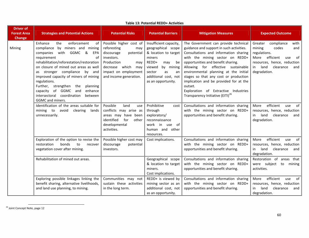
60
Table 13: Potential REDD+ Activities
Driver of Forest Area
Change Strategies and Potential Actions Potential Risks Potential Barriers Mitigation Measures Expected Outcome
Mining
Enhance the enforcement of compliance by miners and mining companies with GGMC & EPA requirement of rehabilitation/reforestation/restoration on closure of mined out areas as well as stronger compliance by and improved capacity of miners of mining regulations. Further, strengthen the planning capacity of GGMC and enhance intersectoral coordination between GGMC and miners.
Possible higher cost of reforesting may discourage potential investors. Production may decrease which may impact on employment and income generation.
Insufficient capacity, geographical scope & location to target miners REDD+ may be viewed by mining sector as an additional cost, not as an opportunity.
The Government can provide technical guidance and support in such activities. Consultations and information sharing with the mining sector on REDD+ opportunities and benefit sharing. Allowing for effective sustainable environmental planning at the initial stages so that any cost or production implication and be provided for at the outset. Exploration of Extractive Industries Transparency Initiative (EITI)
26
Greater compliance with mining codes and regulations. More efficient use of resources, hence, reduction in land clearance and degradation.
Identification of the areas suitable for mining to avoid clearing lands unnecessarily.
Possible land use conflicts may arise as areas may have been identified for other developmental activities.
Prohibitive cost through exploratory/ reconnaissance work in use of human and other resources.
Consultations and information sharing with the mining sector on REDD+ opportunities and benefit sharing.
More efficient use of resources, hence, reduction in land clearance and degradation.
Exploration of the option to revise the restoration bonds to recover vegetation cover after mining.
Possible higher cost may discourage potential investors.
Cost implications.
Consultations and information sharing with the mining sector on REDD+ opportunities and benefit sharing.
More efficient use of resources, hence, reduction in land clearance and degradation.
Rehabilitation of mined out areas. Geographical scope & location to target miners. Cost implications.
Consultations and information sharing with the mining sector on REDD+ opportunities and benefit sharing.
Restoration of areas that were subject to mining activities.
Exploring possible linkages linking the benefit sharing, alternative livelihoods, and land use planning, to mining.
Communities may not sustain these activities in the long term.
REDD+ is viewed by mining sector as an additional cost, not as an opportunity.
Consultations and information sharing with the mining sector on REDD+ opportunities and benefit sharing.
More efficient use of resources, hence, reduction in land clearance and degradation.
26 Joint Concept Note, page 12
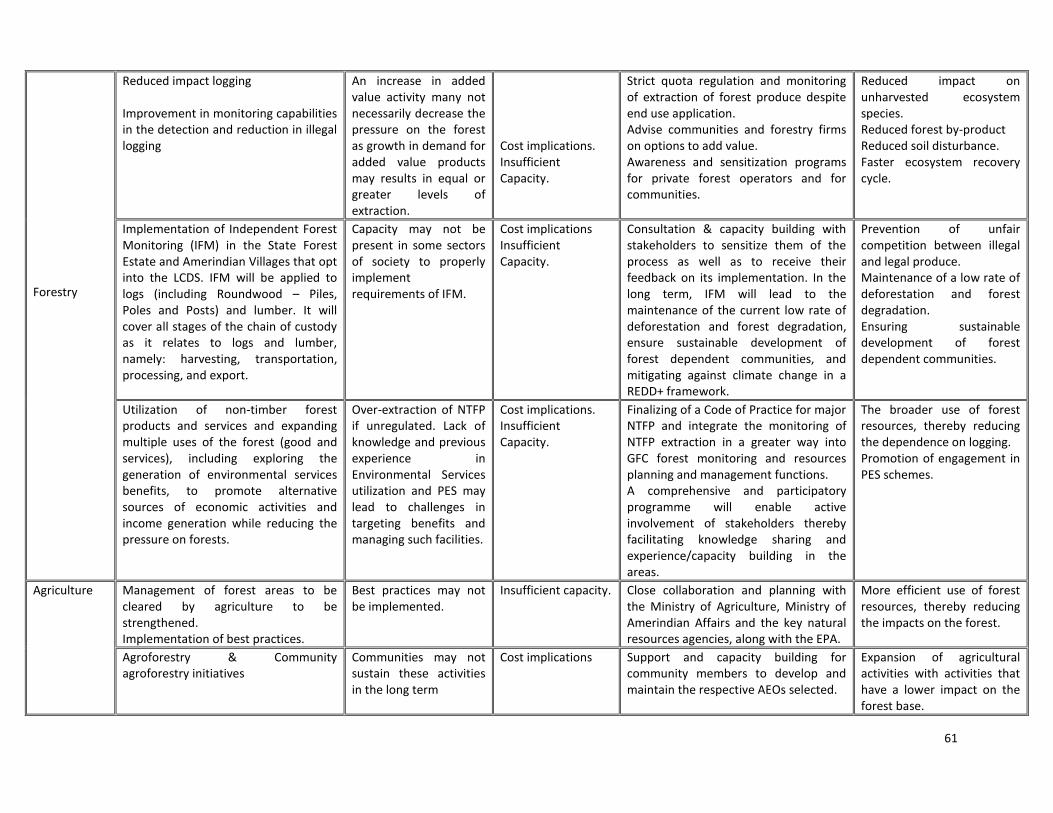
61
Forestry
Reduced impact logging Improvement in monitoring capabilities in the detection and reduction in illegal logging
An increase in added value activity many not necessarily decrease the pressure on the forest as growth in demand for added value products may results in equal or greater levels of extraction.
Cost implications. Insufficient Capacity.
Strict quota regulation and monitoring of extraction of forest produce despite end use application. Advise communities and forestry firms on options to add value. Awareness and sensitization programs for private forest operators and for communities.
Reduced impact on unharvested ecosystem species. Reduced forest by-product Reduced soil disturbance. Faster ecosystem recovery cycle.
Implementation of Independent Forest Monitoring (IFM) in the State Forest Estate and Amerindian Villages that opt into the LCDS. IFM will be applied to logs (including Roundwood – Piles, Poles and Posts) and lumber. It will cover all stages of the chain of custody as it relates to logs and lumber, namely: harvesting, transportation, processing, and export.
Capacity may not be present in some sectors of society to properly implement requirements of IFM.
Cost implications Insufficient Capacity.
Consultation & capacity building with stakeholders to sensitize them of the process as well as to receive their feedback on its implementation. In the long term, IFM will lead to the maintenance of the current low rate of deforestation and forest degradation, ensure sustainable development of forest dependent communities, and mitigating against climate change in a REDD+ framework.
Prevention of unfair competition between illegal and legal produce. Maintenance of a low rate of deforestation and forest degradation. Ensuring sustainable development of forest dependent communities.
Utilization of non-timber forest products and services and expanding multiple uses of the forest (good and services), including exploring the generation of environmental services benefits, to promote alternative sources of economic activities and income generation while reducing the pressure on forests.
Over-extraction of NTFP if unregulated. Lack of knowledge and previous experience in Environmental Services utilization and PES may lead to challenges in targeting benefits and managing such facilities.
Cost implications. Insufficient Capacity.
Finalizing of a Code of Practice for major NTFP and integrate the monitoring of NTFP extraction in a greater way into GFC forest monitoring and resources planning and management functions. A comprehensive and participatory programme will enable active involvement of stakeholders thereby facilitating knowledge sharing and experience/capacity building in the areas.
The broader use of forest resources, thereby reducing the dependence on logging. Promotion of engagement in PES schemes.
Agriculture Management of forest areas to be cleared by agriculture to be strengthened. Implementation of best practices.
Best practices may not be implemented.
Insufficient capacity.
Close collaboration and planning with the Ministry of Agriculture, Ministry of Amerindian Affairs and the key natural resources agencies, along with the EPA.
More efficient use of forest resources, thereby reducing the impacts on the forest.
Agroforestry & Community agroforestry initiatives
Communities may not sustain these activities in the long term
Cost implications Support and capacity building for community members to develop and maintain the respective AEOs selected.
Expansion of agricultural activities with activities that have a lower impact on the forest base.

62
Infrastructure Improved land use planning & coordination amongst agencies*
Development activities may lead to conflicts in land uses in some areas
Insufficient capacity Cost implications
Closer collaboration amongst RS, GFC, GL&SC, MoA, MoPW&C, MoH, GGMC.
Improved coordination amongst land use agencies in Guyana.
Forest Fires Development of a National Forest Fire Management Plan
Communities & other stakeholders may not sustain these activities in the long term.
Insufficient Capacity
The formation of a national forest fire management strategy and action plan will reduce the threat of uncontrolled fires which have the potential to damage expanses of forest and increase emissions. This programme is relatively low cost to implement and has high probability to reduce unwanted fires and emissions. It is reported that the contribution of this driver to deforestation is small in Guyana, however this has not been officially recorded at a given percentage level.
Reduction in the risk of forest degradation due to forest fires.
* Note the following: Activities will be continuous to ensure that their implementation is sustained Some Strategies & Potential Actions may be cross cutting, encompassing all of the drivers of deforestation/ degradation In the implementation of REDD+ candidate activities, a cross sectoral approach will be utilized, whereby multiple land use sectors will be involved in the planning and implementation of REDD+ activities.

63
Table 14: Potential Aspects for Consideration in REDD+ Strategy Development
Factors that Impact on
Forest Area Change
Strategies and Potential Actions
Potential Risks Potential Barriers Mitigation Measures Expected Outcome
Development and Implementation of an effective Benefits Sharing System
Benefits sharing and monitoring of poverty alleviation outcomes
Local villages may lack the capacity to manage direct flows of income. May be faced with complex variables with regards to benefits sharing.
Not all villages have forests on their land. Lack of clear definition of benefits. Uncertainty of future REDD+ mechanism.
Support and capacity building for community members.
General improvements in socio-economic conditions of villages. Agreed benefit sharing mechanism.
Land Rights and Tenure
Consolidation / strengthening of land and user rights
Creation of an imbalance between titled and untitled Amerindian communities.
Not all communities would be eligible for title. Cost of titling.
Closer collaboration of RS with MoAA. Advancing the land titling process.
Fast tracking of titling process to allow for villages to have rights, titles and interest in or over village lands and to manage and regulate the use of and occupation of village lands.*
Further integration of national datasets and information sharing
Newer technologies would create gaps in local capacity.
Insufficient capacity. Cost implications.
Upgrading of technologies Upgrades in the manner in which data is managed and shared, thus improving land management.
Institutional Capacities
Strengthening institutional capacities
With the implementation of REDD+, along with new skill sets, training, capacity building as well as hiring of new staff would be required over land use sectors as well as for communities involved in REDD+ implementation.
Insufficient capacity. Cost implications.
Training & capacity building for agencies involved in REDD+ implementation; Training & capacity building for communities and at the level of the University of Guyana; Development of school curricula on REDD+ & the LDCS.
Improvements in technical & human capacities to address issues relating to REDD+ & the LCDS.
Integration of REDD+ into the development plans and sectoral plans
REDD+ policies and practices integrated into national development
Possible conflicts may arise in the considerations for REDD+ versus the developmental project.
Insufficient capacity. Cost implications.
Training & capacity building for agencies involved in REDD+ implementation. Closer collaboration among agencies.
REDD+ considerations integrated into future development plans.
* It is not expected that all issues related to land titling and demarcation will be solved during this 36 month period, but rather it is the intention to further the work on demarcation and extension, while establishing dialogue on land issues
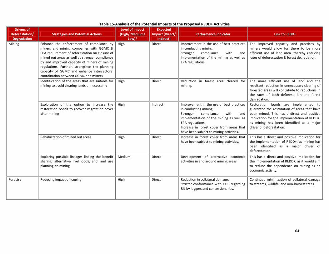
64
Table 15-Analysis of the Potential Impacts of the Proposed REDD+ Activities
Drivers of Deforestation/
Degradation Strategies and Potential Actions
Level of Impact (High/ Medium/
Low)*
Expected Impact (Direct/
Indirect) Performance Indicator Link to REDD+
Mining Enhance the enforcement of compliance by miners and mining companies with GGMC & EPA requirement of reforestation on closure of mined out areas as well as stronger compliance by and improved capacity of miners of mining regulations. Further, strengthen the planning capacity of GGMC and enhance intersectoral coordination between GGMC and miners
High Direct Improvement in the use of best practices in conducting mining; Stronger compliance with and implementation of the mining as well as EPA regulations.
The improved capacity and practices by miners would allow for there to be more efficient use of land area, thereby reducing rates of deforestation & forest degradation.
Identification of the areas that are suitable for mining to avoid clearing lands unnecessarily
High Direct Reduction in forest area cleared for mining.
The more efficient use of land and the resultant reduction in unnecessary clearing of forested areas will contribute to reductions in the rates of both deforestation and forest degradation.
Exploration of the option to increase the restoration bonds to recover vegetation cover after mining
High Indirect Improvement in the use of best practices in conducting mining; Stronger compliance with and implementation of the mining as well as EPA regulations. Increase in forest cover from areas that have been subject to mining activities.
Restoration bonds are implemented to guarantee the restoration of areas that have been mined. This has a direct and positive implication for the implementation of REDD+, as mining has been identified as a major driver of deforestation.
Rehabilitation of mined out areas High Direct Increase in forest cover from areas that have been subject to mining activities.
This has a direct and positive implication for the implementation of REDD+, as mining has been identified as a major driver of deforestation.
Exploring possible linkages linking the benefit sharing, alternative livelihoods, and land use planning, to mining
Medium Direct Development of alternative economic activities in and around mining areas
This has a direct and positive implication for the implementation of REDD+, as it would aim to reduce the dependence on mining as an economic activity.
Forestry Reducing impact of logging High Direct Reduction in collateral damage; Stricter conformance with COP regarding RIL by loggers and concessionaries.
Continued minimization of collateral damage to streams, wildlife, and non-harvest trees.
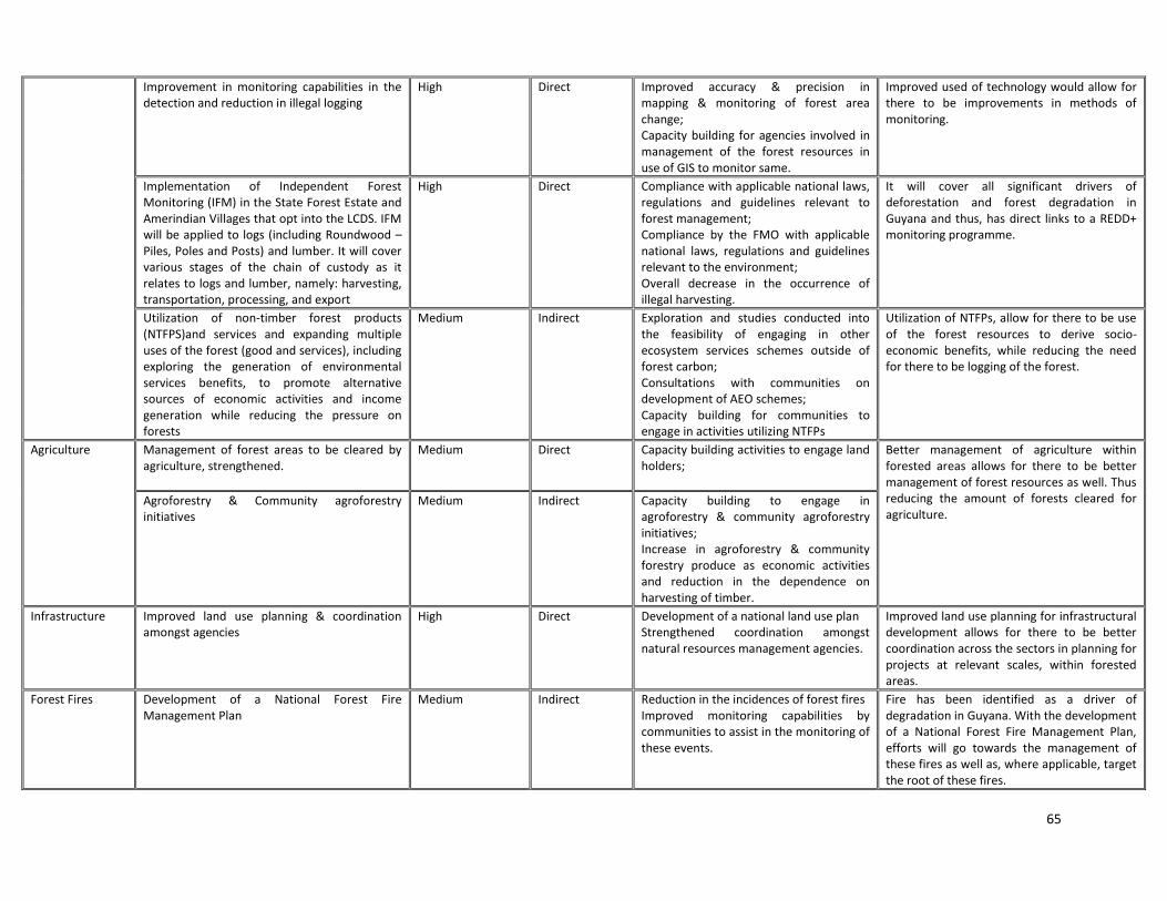
65
Improvement in monitoring capabilities in the detection and reduction in illegal logging
High Direct Improved accuracy & precision in mapping & monitoring of forest area change; Capacity building for agencies involved in management of the forest resources in use of GIS to monitor same.
Improved used of technology would allow for there to be improvements in methods of monitoring.
Implementation of Independent Forest Monitoring (IFM) in the State Forest Estate and Amerindian Villages that opt into the LCDS. IFM will be applied to logs (including Roundwood – Piles, Poles and Posts) and lumber. It will cover various stages of the chain of custody as it relates to logs and lumber, namely: harvesting, transportation, processing, and export
High Direct Compliance with applicable national laws, regulations and guidelines relevant to forest management; Compliance by the FMO with applicable national laws, regulations and guidelines relevant to the environment; Overall decrease in the occurrence of illegal harvesting.
It will cover all significant drivers of deforestation and forest degradation in Guyana and thus, has direct links to a REDD+ monitoring programme.
Utilization of non-timber forest products (NTFPS)and services and expanding multiple uses of the forest (good and services), including exploring the generation of environmental services benefits, to promote alternative sources of economic activities and income generation while reducing the pressure on forests
Medium Indirect Exploration and studies conducted into the feasibility of engaging in other ecosystem services schemes outside of forest carbon; Consultations with communities on development of AEO schemes; Capacity building for communities to engage in activities utilizing NTFPs
Utilization of NTFPs, allow for there to be use of the forest resources to derive socio-economic benefits, while reducing the need for there to be logging of the forest.
Agriculture Management of forest areas to be cleared by agriculture, strengthened.
Medium Direct Capacity building activities to engage land holders;
Better management of agriculture within forested areas allows for there to be better management of forest resources as well. Thus reducing the amount of forests cleared for agriculture.
Agroforestry & Community agroforestry initiatives
Medium Indirect Capacity building to engage in agroforestry & community agroforestry initiatives; Increase in agroforestry & community forestry produce as economic activities and reduction in the dependence on harvesting of timber.
Infrastructure Improved land use planning & coordination amongst agencies
High Direct Development of a national land use plan Strengthened coordination amongst natural resources management agencies.
Improved land use planning for infrastructural development allows for there to be better coordination across the sectors in planning for projects at relevant scales, within forested areas.
Forest Fires Development of a National Forest Fire Management Plan
Medium Indirect Reduction in the incidences of forest fires Improved monitoring capabilities by communities to assist in the monitoring of these events.
Fire has been identified as a driver of degradation in Guyana. With the development of a National Forest Fire Management Plan, efforts will go towards the management of these fires as well as, where applicable, target the root of these fires.

66
Land Rights and Tenure
Consolidation / strengthening of land and user rights
High Direct Resolution of outstanding titling, demarcation and extensions within indigenous communities.
In order for communities to be able to partake in any forest carbon financing mechanisms, land ownership must be ensured and strengthened.
General - Coordination
Further integration of national datasets and information sharing
High Indirect Establishment of a database comprising the datasets of natural resources management agencies; Strengthened coordination and monitoring by these agencies.
Improved coordination and integration of datasets allows for there to be strengthened administration of the State Forest and natural resources utilization
Table 16-REDD+ Readiness Activities that will impact on REDD Strategy
Activity Strategies and Potential Actions Level of Impact
(High/ Medium/ Low)*
Expected Impact (Direct/ Indirect)
Performance Indicator Link to REDD+
Development and Implementation of a Benefits Sharing System
Benefits sharing and monitoring of poverty alleviation outcomes
High Direct Improved socio-economic conditions within forest dependent communities. Improved capacities within communities to manage funds derived through the benefits sharing mechanism.
In participating in a forest carbon finance mechanism, benefits will be derived to communities, whether they participate directly or not. In this case, benefits would be received by communities for services that the forests may offer such as carbon sequestration.
General Institutional Capacities
Strengthening institutional capacities
High Direct Improved sectoral capacities within the relevant agencies as well as coordination amongst agencies in the implementation of REDD+.
REDD+ implementation as well as the potential to engage in other ecosystem services are new areas, requiring new skills and capacities for implementation.
* The impacts are envisaged to be analysed through the development process of the Strategy. The results of this will be part of the MRV System

67
Support to Adapt to the REDD+ Strategy regarding the development & implementation of Alternative Economic Opportunities The implementation of REDD+ activities are not envisioned that any way to prohibit traditional livelihood practices of forest-dependent people in Guyana, including in activities related logging, mining, and small-scale agriculture. Instead, the manner in which these activities are practiced may need, in some cases, to be adjusted to make these practices more sustainable. At this initial stage, the development of a system to address discussions on and implementation of Support to Adapt to REDD+ Strategy and Alternative Economic Opportunities (AEO) has been identified as one of the important REDD+ candidate activities that will be developed in coordination with relevant stakeholders. In terms of alternative economic opportunities, the R-PP does not seek to predetermine what these should be and does not seek to pre-empt what communities may want as AEO. Instead, what it seeks to do is to identify those indigenous groups and other forest-dependent communities will be involved in discussions in development and implementation of AEO. It is expected that through the involvement of relevant Amerindian groups and other stakeholders that there will be discussions and clear identification of feasible AEO, i.e. which would not include unsustainable activities. Demonstration/Pilot Initiatives In the course of the preparation phase, the candidate activities will be discussed with stakeholders through extensive consultations as part of the consultation and outreach plan described in Component 1b and coordinated by the NRWG. Those that appear to be relevant, appropriate and feasible will be piloted as small scale projects in the fields. These will be accompanied by relevant studies, study tours and workshops to ensure that they provide the appropriate lessons learnt. The process that will be used to determine candidate activities will emphasize: community outreach and consultations; study tours with other countries to exchange experiences on potential field demonstration projects; the establishment of clear criteria for evaluation and selection of pilot projects. Relevant pilot activities will be done in collaboration with local partners that have experience within these areas so as to build synergies. It is proposed that of the key pilot/learning activities to be carried out during the preparation phase would be activities relating to: (i) logging; (ii) mining; (iii) community involvement in REDD+. The methodology will emphasize the definition and implementation of forest/carbon and socio-economic monitoring plans and methodology; as well as the analysis and testing of alternatives that address each deforestation and degradation driver. The need for local community engagement in REDD+ activities has been recognised the GoG as an integral aspect in the development of the REDD+ Strategy. As a pilot initiative relating to community involvement in the MRV System, a project in this area has been launched to establish early lessons. This project is being implemented by the Iwokrama International Centre for Rainforest Conservation and Development (Iwokrama), Global Canopy Programme (GCP) and the North Rupununi District Development Board (NRDDB), specifically Annai, and the GFCC. In implementing the demonstration activities, the intentions are as follows: - to build capacity for local communities in Guyana to measure and report on key indicators and metrics
such as forest carbon stocks and biodiversity in relation to relevant drivers of forest area change; - to provide the communities with information that can help underpin their adaptive management
processes and climate change adaptation strategies; - to enable monitoring of the impacts of potential future REDD+ activities that might occur on community
lands (if communities choose to opt-in to the LCDS), with particular regard to social and environmental safeguards;
- to verify that such monitoring produces reliable information that can feed into the national MRV System within the framework of Guyana’s LCDS and in accordance with IPCC guidelines
Trade- off Analysis / Cost-Benefit Analysis (CBA) of each REDD+ candidate activity A trade-off/cost-benefit analysis will be conducted to inform the design of each candidate REDD+ strategy. This process will be coordinated by the GFC/ RS, with oversight by the NRWG. This process will include: - Conducting an evaluation of existing economic activities at the community level; - Identifying spin off benefits and costs that existing economic activities provide to local populations and
nearby communities; - Assessing and quantifying the impacts on the environment/ forest carbon of current economic activities;
68
- Identifying, through stakeholder consultation, suitable alternative economic opportunities that can be undertaken; This activity will involve outlining a full description of the candidate REDD activity in qualitative and quantitative terms (who will do what differently, how many people)
- Assessing and quantifying the benefits, risks, costs, and impacts of the proposed REDD activity on the economic and social livelihoods and the environment and on the carbon balance. As part of the costs for each candidate activity, factor in the cost of replacing livelihoods, if the proposed activity reduces income or access to resources;
- From the proposed alternative economic opportunities, identifying suitable activities will be undertaken in keeping with the expressed needs of stakeholders. Adjust the proposed REDD strategy and propose mitigation measures (social, environmental, economic) in order to minimize costs (including loss of income and loss of access when applicable) and other negative effects (social, environmental, economic) and to optimize carbon gains and other benefits (social, environmental, economic). The objective is to end up with REDD strategies that are as efficient as possible (carbon gains and other benefits should outweigh the costs). The trade-off analysis should indicate clearly when expected benefits from a candidate activity (including its adjustments and mitigation measures) do not outweigh its costs, hence informing the participatory multi-stakeholder debate.
- Identifying and evaluating support that can be provided to help stakeholders adjust and adapt to new policies that affect their livelihoods.
- Assessing the economics of the major land uses causing deforestation & forest degradation. Assessments will be done considering and including in aspects of the analysis, the sustainable development of communities. The REDD Secretariat and NRWG will ensure coordination with the SESA and the Consultation & Outreach Plan. Criteria for Evaluation of REDD+ Candidate Activities In considering the feasibility of and suitability of the proposed REDD+ Activities described above, a number of criteria will be applied including: - Emission reduction potential- the activities have been designed to target specific drivers of deforestation.
As such, it is expected that these REDD+ Activities will result in reductions in emissions or maintenance in the already low level of emissions;
- Scalability & replicability- these are important aspects that will be considered in conducting of demonstration/ pilot activities. It is important that project be adaptable for any size of community, as well as be replicable for other communities to follow;
- Social benefits generated- in considering the feasibility of potential REDD+ Activities, it is important for there to be social benefits derived; and
- Multiple co-benefits- another important consideration that will be that multiple benefits will be derived from these projects.
Incorporation of REDD+ into Guyana’s overall development context The REDD+ Strategy will be incorporated into the overall development of the country through the following ways: - into the national forest policy via the GFC which is the forest policy coordinating body of Guyana - into the LCDS which serves to transform Guyana’s economy whilst combating climate change. - into national climate policy via the OCC, OP which is the principal climate policy coordinating body of
Guyana - in keeping with one of the main goals of Guyana’s Poverty Reduction Strategy (PRSP)- (i) sustained
economic expansion within the context of a deepening participatory democracy - REDD+ will be incorporated into both the national climate change agenda as well as the national forest
policies to ensure that there is a holistic approach to its implementation, rather than a fragmented one. This will be accomplished through collaboration and coordination by relevant parties involved as well as with the involvement of the MNRE.
It should be noted that policy and governance issues have been identified as an important part of the REDD+ agenda for Guyana. The REDD+ Governance Development Plan (RGDP), which includes aspects on a land use

69
plan for Guyana, revision of the National Forest Policy Statement & National Forest Plan etc, addresses these issues. (Component 2a) Expected Outcome The expected outcome of this component is a set of REDD+ policies and programmes including a benefits sharing system that have been informed by stakeholders inputs and international experience. These activities must show the potential to reduce emissions as well as be replicable, monitorable, cost efficient and be the basis for Guyana’s low carbon economy. Potential loss of local income must be compensated, and this cost must be factored in the economic analysis of trade-offs. It would also encourage non-timber forest activities, generate employment and income, and sustain and improve indigenous and community livelihoods, and economic growth. Next Steps Discussions have started in Guyana on some aspects of the benefits sharing mechanism. The design process of the benefits sharing mechanism will involve coordination by the OCC, discussion and engagement with Amerindian village leaders, the NTC and other relevant stakeholders with an objective of receiving feedback from indigenous communities and villages that will be used to inform the updating and finalization of the System. Demonstration Activities have also been initiated, targeting communities within the North Rupununi Development District This Demonstration project on Community MRV aims to build capacity for local communities in the North Rupununi region of Guyana to measure and report on key indicators and metrics such as forest carbon stocks and biodiversity in relation to important drivers of forest change (such as forestry, fires, mineral exploitation and infrastructure); to provide the communities with information that can help underpin their adaptive management processes and climate change adaptation strategies; to enable monitoring of the impacts of potential future REDD+ activities that might occur on community lands (if communities choose to opt-in to the LCDS), with particular regard to social and environmental safeguards; and to verify that such monitoring produces reliable information that can feed into the national MRV System within the framework of Guyana’s LCDS and in accordance with IPCC guidelines. Consultation and outreach is a tool that will be integral to the successful development of the national REDD+ Strategy. As such consultations will be ongoing during this phase, once funding is received and implementation commences. Performance Indicators - Consultations with forest dependent communities in the development and selection of feasible and
appropriate REDD+ Candidate Activities as well as ; - Consultations on the development and selection of alternative economic opportunities as well as in the
development and implementation of pilot demonstration activities; - Development of REDD+ Candidate activities targeting the drivers of forest area change; - Studies, consultations, study tours, demonstration projects and community programmes conducted to
inform the REDD+ Strategy.

70
Summary The objective of Guyana’s REDD+ strategy is to maintain Guyana’s low rates of deforestation and forest degradation by implementing related policy, procedures and legislation as well as monitoring and enforcement. The strategy will undertake an approach that is participatory, inclusive and integrates various levels of stakeholders, and will pursue the sustainable development of Guyana. The development of the REDD+ Strategy will be informed by a number of studies, consultations, study tours, demonstration projects and community programmes, in areas such as sustainable forest management, reduced impact from mining and infrastructure, and equitable benefits sharing. Guyana’s REDD+ strategy will encompass a range of policies and programmes aimed at reducing the level of forest carbon emissions (compared to the reference scenario) while promoting local development and social inclusion. The REDD+ strategy may include enhanced policies, procedures, monitoring and enforcement, public participation mechanisms, as well as awareness and dissemination programmes, and the use of incentive instruments. The strategy will address the causes of deforestation identified in chapter 1 (existing and potential), including in the mining, infrastructure, and agriculture and forest sectors. The REDD+ strategy will also address fundamental conditions for success including land tenure security and the design of an equitable benefit sharing mechanism. The strategy will consider the opportunity costs of REDD+, including the potential foregoing of revenues from carbon-emitting activities (in conjunction with the definition of the reference scenario), the cost of replacing livelihoods and/or the development of alternative sources of income. The design of the REDD+ Strategy will follow a multi-stakeholder participatory process.
Budget Table 4 : Component 2b- Summary of Strategy Activities and Budget (USD)
Main Activity Output Indicative activities per output Total
Design REDD+ Strategy Options
Identify/Design REDD + Strategy Options
Identify/ Design REDD+ Strategy Options
100,000
Design and implementation of REDD+ Pilot projects
Design and implement REDD+ pilot projects
200,000
Examine/Assess REDD + Strategy Options
Examine/ Assess REDD+ Strategy Options
1,007,000
Conduct specific studies, workshops and study tours, including trade off analysis.
130,000
Total 1,437,000

71
2c. REDD+ Implementation Framework
2c.1: Implementation Framework. Objectives of this sub-component The general objective of this component is to develop the institutional framework that will coordinate the REDD+ programmes and ensure multi-stakeholder participation during the implementation phase. The design of the REDD+ implementation framework will be characterized by inclusiveness and participation, starting from the coordination and participation mechanisms that are being put in place for the Readiness preparation phase, and building upon experiences as the process progresses. This is expected to be an iterative process of adjustment and refinement in which the multi-stakeholder NRWG will play a key role. It is the expected outcome that REDD+ based and forest carbon valuations will be incorporated into land use policies and decisions, and development and investment project impact assessments across various sectors, with the necessary institutional mechanisms created or adapted to enable and ensure this process. 2c.1.1 International Conventions The national REDD+ Implementation Framework will be prepared in keeping with the goals of the United Nations Framework Convention on Climate Change (UNFCCC); the IPCC Guidelines for National Greenhouse Gas Inventories; the United Nations Declaration on the Rights of Indigenous Peoples (UNDRIP); and the Convention on Biological Diversity (CBD). The UNDRIP emphasizes the rights of Amerindians to maintain and strengthen their own institutions, cultures and traditions and to pursue their development in keeping with their own needs and aspirations. It also prohibits discrimination against Amerindian and promotes their full and effective participation in matters relating to and affecting this stakeholder group, and their right to remain distinct and to pursue their own visions of economic and social development. Consequently the principle of free, prior and informed consent will guide the process. Lessons will be drawn from project initiatives that are coordinated though relevant international discussions at ITTO, UNFCCC, CBD and other fora. 2c.1.2 Key considerations of the REDD+ implementation framework The development and implementation of the REDD+ Implementation Framework is all encompassing, including sectors of development. The following elements listed below are key areas that will be targeted during the REDD+ readiness phase in the development of the REDD+ Implementation Framework:
a. Inclusions of REDD+ considerations in key policies governing land use and natural resource management in Guyana- (this includes the updating of guidelines). In the development of the REDD+ Implementation Framework, REDD+ and key considerations for implementation of REDD+ must be incorporated into policy framework governing land use and natural resources utilization in Guyana. Along with these considerations, the Implementation Framework will be developed in keeping with the principles of international standards and agreements, from the more technical agreements as the UNFCCC, GOFC GOLD etc; to observing the rights of the Amerindians through agreements as the UNDRIP; to the conducting of consultation and outreach in keeping with the principles of FPIC among others. A review of the legal and policy framework relevant to REDD will be conducted as part of the SESA (see section 2d). Various natural resources are governed by separate legislation. Whilst these pieces of legislation effectively address the respective natural resource use, in some cases there is need for greater cohesion in implementation to allow for integrated natural resource usage. This can be done through several means, including through Policy.
b. Pursue efforts to address land tenure - through collaboration with Government agencies and communities, working together to address relevant aspects of land tenure arrangements. Cost has historically been a major impediment to progress: it is estimated that completing demarcation, titling and extension will require over US$18 million. With Interim REDD+ payments in 2010 and 2011, a total of US$6 million will be allocated to accelerate the demarcation and titling programme, addressing those villages with currently outstanding requests, and communicating the processes for demarcation and titling to those villages that have not yet chosen to do this.
c. Address the drivers of forest area change- through review of policy and guidelines governing the key drivers of forest area change, as discussed in Component 2a, with the intention to comprehensively assess the requirements for compliance with existing, and if necessary, new and revised guidelines. It
72
would be further necessary to develop/ adopt definitions of deforestation and forest degradation for Guyana.
d. Strengthened Monitoring & Enforcement within the sectors- there will be continued and increased stringent monitoring and enforcement of compliance of the operators by the respective regulatory bodies, including transparency/public information and independent monitoring.
e. Review and address relevant aspects of carbon ownership - This review and clarification of carbon ownership will be conducted across different land tenure and management options. These efforts will be conducted on tandem with the work done under the LCDS.
f. Design benefit-sharing mechanism* - This will be conducted in tandem with the work of the LCDS. It should be noted that the development of this System will be linked to the development of the Opt In mechanism and is currently being developed at the level of the Multi Stakeholder Steering Committee of the LCDS. This Benefits Sharing Mechanism will be dependent, amongst other factors, upon the following:
I. The need to engage beneficiaries directly through a number of stakeholder consultations (refer to Component 1b)
II. The need to improve livelihoods sustainably III. Development of a system that is transparent and accountable IV. Development of a system that promotes equitable distribution of benefits V. A system that respects traditional social structures and reaches vulnerable groups.
g. Stakeholder involvement in relevant aspects of REDD+ readiness implementation- throughout the implementation of REDD+ activities, and in the development of the REDD+ Implementation Framework, including the activities listed above, stakeholder involvement will play an integral role.
h. Closer collaboration with the Private Sector- as previously discussed the REDD+ Implementation Framework aims to incorporate forest carbon valuations into land use policies and decisions as well as development and investment projects across various sectors. It is therefore imperative for strengthened engagement of the private sector to ensure that correct valuations.
The LCDS outlines that REDD+ payments will be distributed pro rata for the benefit of Amerindian villages that choose to participate. Payments may also be made in certain circumstances to compensate those whose present livelihoods will be affected negatively by verified emissions reductions. Particular attention will be given to the methodology for livelihood improvements for displaced forest workers, such as miners.
27
Amerindian communities that choose to participate or “Opt In” will essentially be committing their forests to a REDD+ Agreement with the Government and in return receive payments which will be allocated to further Amerindian development through a pro rata share of forest compensation payments that accrue to Guyana. Efforts are underway to develop the Opting In Mechanism. This has been urged by a general indication by Amerindian villages to be part of the LCDS process as reflected in the LCDS stakeholder engagements and consultations and also a willingness by some villages to Opt In.’ Several villages have already sent formal notification of this. In designing this mechanism, the current efforts reflect benefits being directed towards titled communities with forests. This mechanism will enable communities that receive title overtime to become eligible to be part of this mechanism. To this end, the Concept Paper on Developing a Framework for an “Opt in” Mechanism for Amerindian Communities has been prepared and is currently going through a period of stakeholder feedback. This paper outlines the modalities for the development of the Opt In Mechanism under the LCDS. REDD+ & Future Forest Activities Along with the key areas that will be targeted in the development of the REDD+ Implementation Plan, a number of other activities will be targeted as well. For instance, with the implementation of REDD+ activities, it is expected that sustainable mining, forestry and agricultural activities will be allowed to continue in accordance with the laws and guidelines which govern these sectors. Existing policies and procedures may need to be updated to further enhance the implementation of sustainable management. In addition, Projects that are currently going through the development process (as in the case of existing forest concessions and
27 Implementing Benefit Sharing Arrangements for Indigenous Lands and Impacted Workers. LCDS, May 2012, page 41

73
mining leases) will continue. However, they must adhere to national requirements under current laws and environmental management procedures and practices. With regards to hunting, gathering and other subsistence level activities
28 by Amerindians and other forest
dependent groups, these activities will also be not be disrupted. To the extent that some adjustments may need to be made to make these activities more sustainable, communities will be provided with adaptation support and alternative economic opportunities, as outlined in Component 2b. Subsistence activities are allowed under the current legislative structure which provides for continued utilization of forestry resources for subsistence use by Amerindian communities. Sustainable forest management activities can be continued under the REDD+ framework and will be guided by various relevant and appropriate guidelines and policies.
Table 17. Summary of Agencies Responsible for REDD+ Implementation Framework
Activity Responsible Agencies Supporting Bodies Legal Mandate of Responsible
Agencies
Establish and develop a communication link with other countries (as appropriate) to enable the sharing of ideas and lessons learnt
OCC, GFC/RS Ministry of Foreign Affairs, FCPF & relevant NGOs
GFC- forest regulation & management RS- coordination of REDD+ activities Ministry of Foreign Affairs- to promote the interests of Guyana within the international community
Collaborate with government agencies working to address land tenure arrangements
MoAA, OCC, GFC. GGMC, GL&SC
MNRE, Ministry of Housing & Water, NTC
GFC & RS, GL&SC- Ensure that management of State and government lands is in accordance with legislation and Government policy;
Strengthening key implementing agencies such as the GFC, RS, Office of Climate Change
GFC/RS GL&SC, GGMC, EPA and relevant NGOs (CI, WWF, Iwokrama)
GFC- forest regulation & management RS- coordination of REDD+ activities
Review and address relevant aspects of carbon ownership across different tenure and management options
GFC/RS & Office of Climate Change (OP)
MoAA, GGMC, MNRE, GL&SC and relevant NGOs
GFC & RS, OCC- responsible for overseeing the formulation & implementation of the climate change agenda for Guyana, including the Low Carbon Development Strategy
Implementation of national and project-based carbon accounting and registry capabilities
GFC/RS, OCC, GGMC, GL&SC, MoAA, MNRE and community stakeholders & relevant NGOs
GFC,RS
Creation of transparent benefits sharing arrangements for targeted financial incentives for REDD+
GFC/RS & OCC MoAA, Ministry of Finance & community stakeholders
GFC & RS , OCC
Develop and implement capacity building plan for government agencies on issues related to climate change and forest carbon
GFC/RS, OCC GL&SC, GGMC, EPA, WWF, CI, Iwokrama
GFC & RS , OCC
28 Subsistence level activities refer to those that are non-commercial in nature.

74
2c.1.3 Regulatory framework REDD+ is an integral part of Guyana’s Low-Carbon Development Strategy. Under this Strategy, the R-PP will allow for an effective mechanism to be developed and implemented to monitor, report and verify forest carbon stock under a forest carbon financing mechanism which is being proposed under the LCDS. It is, in a sense, the operational mechanism that will allow for forest cover and carbon change and financial incentives to be monitored, reported and verified and will result in a transparency and fiduciary oversight to be provided to the model of incentives payments as provided for under the LCDS. Once these payments are provided, Guyana can protect its forest and simultaneously seek a development path that maximizes the growth of low-carbon economic sectors and minimizes deforestation and high-carbon economic activity. This would lead to action in three areas that are essential to Guyana’s future: (a) Investing in low-carbon economic infrastructure; (b) Facilitating investment and employment in low-carbon economic sectors; (c) Generally enhancing the nation’s human capital and creating new opportunities for forest-dependent and other indigenous communities. Benefit Sharing Mechanism Amerindian communities own their own land, and may also choose to participate in a REDD+ mechanism in the coming years. The principle of free, prior and informed consent (FPIC) will under-pin the process of the development and implementation of the benefits sharing mechanism for REDD+.
This principle will apply both to the LCDS as well as
activities outlined in the R-PP. The design of the national benefits sharing mechanism will reflect on current (local and international) efforts regarding climate financing. It will take into consideration several possibilities in its design including issues of titled and untitled areas; lands with forest and non- forests areas; as well as other pertinent issues specific to the local context. It is envisioned that over the next few years, Amerindian villages will have a choice of whether to enter a REDD+ agreement and, assuming continuing adherence to the agreement, receive a pro rata share of forest compensation payments. The decision to become involved will likely be based on whether participation will lead to improved access to opportunities and services for forest-dependent communities. Communities will be asked to propose priority improvement opportunities, such as expansion of social services including health and education, provision of low-carbon energy sources (most villages are not on the national grid so need alternate power sources), and provision of clean water. Beneficiaries will have the option to choose whether payments might flow directly to individual villages or go into a broader scheme, such as the Amerindian Development Fund in the case of the LCDS; which would be a grant based program where indigenous groups (not just those who live in the forest) could apply for funds for development programs (possibly similar to the Brazilian Amazon Fund). The development of the benefits sharing mechanism for REDD+ will be done in conformance with the following:
- Stakeholders will be fully consulted. - The amount of incentive payments to these stakeholders, the timing and the form in which this payment takes
place need to be decided and linked directly to actions agreed with them. - A mechanism which is trusted and has the necessary accountability provisions should be in place to disburse
timely payments to stakeholders. - Information about transactions should be available in the public domain for scrutiny by civil society,
government and private sector. - Benefit sharing agreements should be flexible and allow for necessary changes based on learning and have
clear dispute settlement mechanisms. 2c.1.4 Support from Development Partners Collaboration with Development Partners In order for Guyana to attain Readiness there must be collaboration with local and international organizations and agencies. These bodies will provide the technical expertise and funding that is essential to helping Guyana build the capacity needed to implement REDD+ strategies successfully. The Government of Guyana is working through other donors through specific project related and bilateral donors to acquire other funding for the R-PP implementation. At present, the GoG and Government of Norway have signed a Memorandum of Understanding to foster a partnership related to issues of climate change, biodiversity and sustainable, low carbon development. This support will assist in the setting up of a MRV System as laid out in

75
Component 4. Through this agreement, the Guyana REDD+ Investment Fund (GRIF) was created. The GRIF is a multi-contributor financial mechanism which will support is financing two sets of activities:
- The implementation of Guyana’s Low Carbon Development Strategy (LCDS); - Guyana’s efforts in building capacity to improve overall REDD+ and LCDS efforts.
Pending the creation of an international REDD+ mechanism, the Guyana REDD+ Investment Fund (GRIF) represents an effort to create an innovative climate finance mechanism which balances national sovereignty over investment priorities with ensuring that REDD+ funds adhere to globally accepted financial, environmental and social safeguards. The Trustee (i) receives payments for forest climate services provided by Guyana; and (ii) transfers these payments and any investment income earned on these payments, net of any administrative costs, to Partner Entities, for projects and activities that support the implementation of Guyana's LCDS. Transfer of funds takes place on approval by the GRIF Steering Committee, which consists of Guyana and Norway, with observers from Partner Entities, and Guyanese and Norwegian civil society. Partner Entities provide operational services for the approved LCDS investments, and apply their own globally accepted operational procedures and safeguards. As of March 2011, Guyana and Norway have approved as Partner Entities the Inter-American Development Bank (IDB), the World Bank and the United Nations Development Group. Norwegian support to GRIF – alone or in combination with other contributors – will not exceed the sum calculated on the basis of the above described methodology (neither in 2010 nor in future years). It is also likely that while support from Norway will be sufficient to provide majority funding for results delivered by Guyana, in a given year, it is unlikely to equal the total sum earned by Guyana. Therefore, to ensure that the incentives which underpin the partnership are fully in place, Guyana and Norway will work together to seek to get other Participants to join the partnership. The Participants’ goal is to reach agreement with other Participants by the end of August 2011. Based on progress at that point, this JCN will be updated by the end of September 2011. Once other Participants are in place with sufficient commitments to the Partnership, this will enable Norwegian (and other Participants’) contributions to vary directly with performance, i.e. a reduction in estimated emissions will lead to relatively higher contributions, increases to relatively lower contributions.
29
Several donors and international partners have expressed an interest in supporting Guyana’s REDD+ preparation and related activities, including the World Bank, World Wildlife Fund (WWF), United Nations Development Programme (UNDP), Inter-American Development Bank (IDB), the German Development Bank (KfW) and Conservation International (CI). Other institutions such as the FAO, IDB, the German Government, USA and the ITTO may be approached for possible technical assistance. The GFC has also been targeting other areas for REDD+ support, such as through the ITTO Thematic Programme on REDDES (REDD & Enhancing Environmental Services in tropical forests) to secure finances to support forest resources assessment at the national and community levels, to better enable planning and management of deforestation and forest degradation, as well as through other organisations as the IDB through Knowledge and Capacity Building Products (KCPs); and the Guiana Shield Facility, which was established as an outcome of the Guiana Shield Initiative Project, and aims to) is to promote and support the conservation and sustainable development of the Guiana Shield eco-region. The GoG will continue to identify and target other donor possibilities to further support the R-PP implementation, which may include WWF, GEF, UNDP, FAO, FIP, IDB, CI, KfW etc, along with seeking technical support from agencies such as Clinton Climate Initiative, ESRI & McKinsey and Company. This assistance may be in the form of technical inputs to carry out forest monitoring and planning work involving remote sensing analyses and technical strengthening particularly for the REDD Secretariat and the GFC, to execute and manage the REDD+ programme. In order to ensure that there is coordination of efforts with regards to donor funding and support, while avoiding overlaps, is the task of the GFC, RS and the OCC. Through collaboration by these key bodies for REDD+ implementation, with the guidance of key documents as the LCDS, R-PP and MRV System Road Map, decisions are made with regards to accessing of funding as well as allocation of funding / support received outside of GRIF funding. Outputs and lessons learnt from existing and previous donor support programmes were considered in the compilation of the R-PP and have influenced the identification of REDD+ strategies and approaches, as one example, through the outputs of the US supported Guyana Trade & Investment Programme the targeted REDD+ candidate activity of increasing added value processing was informed. Further the outputs of the Agriculture Diversification Programme have largely informed the targeted agroforestry initiative identified under the REDD+ strategy initiative. Additionally, the
29 Joint Concept Note, March 31, 2011

76
WWF supported programme with the GGMC targeted at capacity enhancement has informed the identification of the REDD+ candidate activities that address capacity building in the mining sector to facilitate greater enforcement. With regard to the assessment of deforestation in earlier years, support from the donor community has involved a combination of technical and financial assistance in implementing key activities, such as:
Activity Donor Status
Estimating biomass for forests in Guyana Tropenbos, CI, WWF Completed
Assessing land area change through remote sensing imagery analyses
International Tropical Timber Organisation
Completed
Ecological and financial, Sustainable Management of the Guiana Shield Eco-region – Guyana Shield Initiative Phase 2
EU, The Dutch Government, UNDP, IUCN Netherlands Committee
Ongoing
Guyana’s reporting and assessment requirements of under the UNCCD (including National Action Programme and Report on Implementation), addressing issues of land degradation and drivers of change
UNDCCD Completed
Biodiversity mainstreaming through avoided deforestation – Case study on the Georgetown Lethem roadway addressing potential land cover change, impact on carbon storage and biodiversity, including scenario modelling
IDB Completed
The first listed project was successful in providing biomass estimates based on soil types. Additional work needs to be done at a more detailed level, incorporating reference scenario modelling and the development of a monitoring system. The other projects listed are currently in execution, from which the results will inform the work to be done under the REDD Readiness preparation phase. 2c.2 Investment and Capacity Building Requirements for REDD+ Readiness The assessment of investments and capacity building requirements will be done as part of the Readiness phase. It is recognized that more investment and capacity building will be necessary to enable Guyana to be effectively able to sustain national level activities in the implementation of a forest carbon financing mechanism. Guyana will seek to learn from, and share experiences with other countries that are preparing for this initiative and will work closely with local and international organizations to facilitate the smooth and successful transition to a state of ‘readiness’. Guyana is actively pursuing efforts towards building local capacity both at local and international fora, targeting the key technical experts that are actively involved in REDD+ implementation in Guyana, not only at the level of Government agencies, but also through civil society groups as the NTC and committees such as the MRVS Steering Committee. Capacity building activities will be linked to the components of the R-PP, targeting key technical areas as GIS and Remote Sensing, forest carbon stock assessment and forest area change assessment, forest policy, legality and governance and reference levels. Further, other areas as training in FPIC, conducting of consultation and outreach activities and monitoring and evaluation of projects will be targeted. Along with capacity building for key implementing agencies, forest dependent communities will also be targeted for capacity building. Areas for capacity building will be developed in consultation with these communities. This process will be overseen by the NRWG. Objectives: This sub-component aims to: a. Assess current capacity of implementing agencies and key partners (GFC, EPA, other government agencies’ and
relevant authorities’, and stakeholders’ and communities’ (including Amerindian villages and communities)). b. Identify capacity building activities that will enable Guyana to implement the national REDD+ Strategy, as outlined
in Guyana’s LCDS, R-PP and MRV System Road Map. c. Estimate the financial resources required to carry out capacity building, training and development of institutional
capabilities. d. Identify potential sources of funding and organizations/institutions that will be able to provide the technical
assistance necessary to help Guyana in her efforts to implement the REDD+ strategy.

77
e. Develop a road map for the implementation of these activities to ensure Guyana achieves its capacity to implement ‘readiness’ in three years as well as be able to sustainable manage the implementation of REDD+ after this period.
Expected Outcome: Guyana will work with relevant agencies, stakeholders and other partners to ensure that within three years, the basic capacities and institutional capabilities to implement REDD+ strategies will be developed. More advanced capacity building will be a long term, continued effort that is not expected to be completed within the next three years. Preparation plans will aim to create basic capacity needed to:
- Coordinate REDD+ efforts in the country, including effective consultations with communities and the development of a benefits sharing system;
- Measure and monitor emissions from Guyana’s forests compared with the reference baseline; - Implement activities outlined in the LCDS & JCN; - Enable forest dependent communities to actively participate in REDD+ readiness activities.
Investment Assessment Report & Capacity Building Road Map In order to be able to successfully implement REDD+, Guyana will require an assessment of the investment requirements needs to build local capacities as well as conduct a capacity needs assessment of the local capacities. These assessments will go towards helping to develop a road map outlining the necessary capacity requirements needed to engage in such a system as well as attach a cost to these requirements. This Road map will serve to pinpoint the areas where capacity building is required, for both government and nongovernment partners, and seek to list the expected outcomes and capacity improvements for these different phases. This capacity building process will help provide the foundations for the eligibility to participate in REDD results-based crediting mechanisms. In both the readiness and the implementation phase the large emphasis on measurements and monitoring will be extended to reporting and verification, i.e. through the establishment capacities to apply the IPCC GPG for international reporting. 2c.2.1 Activities As previously discussed, the capacity building activities will be moulded to target the requirements of each operational component of the R-PP i.e. among others, GIS and Remote Sensing, forest carbon stock assessment and forest area change assessment, forest policy, legality and governance and reference levels. Further, other areas as training in FPIC, conducting of consultation and outreach activities and monitoring and evaluation of projects will be targeted. In the building of these capacities, a number of activities will be conducted during the Readiness Phase, including: a. Conduct Investment Assessment and develop capacity building Road Map for national and community level needs
to engage in REDD+ activities. The ability of the key agencies to conduct activities taking place in the forests of Guyana during readiness activities must be assessed to determine the investments that will be needed to execute this task effectively. The necessary framework, the Road Map, to develop and improve these capacities will be developed from this;
b. Ensure that the modalities and execution of consultation and outreach activities are in conformance with FPIC; The promotion, training and education on the interpretation and implementation of natural resources legislation, policy and guidelines, specifically targeting legislation such as the Forest Act, Amerindian Act, Mining Act and Environmental Protection Act among others;
c. Effective monitoring of State Forests is essential to inhibit illegal activities and unsustainable practices that contribute to forest area change.
d. Develop a programme to target investment and capacity building need of forest dependent communities to utilize best practices that will further lead to the maintenance of the low rate of deforestation in Guyana. This includes the training in methodologies to measure and monitor drivers of forest area change within their forested lands (See Component 2b, Demonstration Projects); use of GPS technology in tracking and monitoring of forest fires; planning and management of the resources to be derived from REDD+ to their communities as well as the development of alternative economic activities that are applicable and appropriate to the rights and practices of their traditions and culture;
e. Develop a training and education programme for miners on REDD+ as well as sustainable use of forest resources for mining.
f. Develop programme to promote the use of more sustainable agricultural practices in order to minimize the effect of the effects of agriculture on the forest resources, as well as to promote the use of more efficient technologies.
78
g. New infrastructural development across the country has implications for Guyana’s forests. A capacity building and support plan needs to be developed to promote a better understanding of REDD+ & implications of infrastructural development on REDD+ as well as to promote better planning oversight and implementation of projects.
h. Developing capacities to design, manage and execute a benefits sharing mechanism to ensure that incentives are transparently and equitably shared as well as ways and means by which this can be monitored.
i. Building of capacities in the technologies as well as methodologies to conduct forest area change assessment and forest carbon stock assessment, as part of the MRV System (See Component 4). Along with this, capacity will be build in the use of models to establish reference scenarios (refer to Component 3).
j. Assess and enhance the data management infrastructure of the agencies, including hardware and software upgrades and the development of protocols for data transfer, processing, and archiving. There further needs to be the development of national data infrastructure for carbon inventory data as well as spatial data.
k. Improve the capacity building requirements by exploring the addition of curricula programs at the University of Guyana in Climate Change, REDD+ and LCDS related matters. This will allow for the building the capacity within Guyana and ensuring the long-term sustainability of the national REDD+ system.
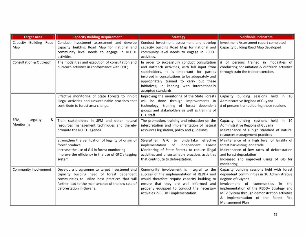
79
Target Area Capacity Building Requirement Strategy Verifiable Indicators
Capacity Building Road Map
Conduct Investment assessment and develop capacity building Road Map for national and community level needs to engage in REDD+ activities.
Conduct Investment assessment and develop capacity building Road Map for national and community level needs to engage in REDD+ activities.
Investment Assessment report completed Capacity building Road Map developed
Consultation & Outreach The modalities and execution of consultation and outreach activities in conformance with FPIC;
In order to successfully conduct consultation and outreach activities, with full input from stakeholders, it is important for parties involved in consultations to be adequately and appropriately trained to carry out these initiatives, in keeping with internationally accepted standards.
# of persons trained in modalities of conducting consultation & outreach activities through train the trainer exercises
SFM, Legality & Monitoring
Effective monitoring of State Forests to inhibit illegal activities and unsustainable practices that contribute to forest area change.
Improving the monitoring of the State Forests will be done through improvements in technology, training of forest dependent groups and stakeholders as well as training of GFC staff.
Capacity building sessions held in 10 Administrative Regions of Guyana # of persons trained during these sessions
Train stakeholders in SFM and other natural resources management techniques and thereby promote the REDD+ agenda
The promotion, training and education on the interpretation and implementation of natural resources legislation, policy and guidelines.
Capacity building sessions held in 10 Administrative Regions of Guyana Maintenance of a high standard of natural resources management practices
Strengthen the verification of legality of origin of forest produce increase the use of GIS in forest monitoring Improve the efficiency in the use of GFC’s tagging system
Strengthen GFC to undertake effective implementation of Independent Forest Monitoring of State Forests to reduce illegal activities and unsustainable practices activities that contribute to deforestation.
Maintenance of a high level of legality of forest harvesting, and trade. Maintenance of low rates of deforestation and forest degradation Increased and improved usage of GIS for monitoring
Community Involvement Develop a programme to target investment and capacity building need of forest dependent communities to utilize best practices that will further lead to the maintenance of the low rate of deforestation in Guyana.
Community involvement is integral to the success of the implementation of REDD+ and would therefore require capacity building to ensure that they are well informed and properly equipped to conduct the necessary activities in REDD+ implementation.
Capacity building sessions held with forest dependent communities in 10 Administrative Regions of Guyana Involvement of communities in the implementation of the REDD+ Strategy and MRV System through demonstration activities & implementation of the Forest Fire Management Plan

80
Mining Develop the capacity of the mining sector to improve mining practices and reduce forest degradation & deforestation
Develop a training and education programme for miners on REDD+ as well as In mining regulations and best practices
Capacity building sessions held in 10 administrative regions # of person & communities trained in SFM practices
Agriculture Improve agricultural practices and reduce its impacts on the forest sector
Programme to promote more REDD+ & sustainable agricultural practices & efficient technologies
Capacity building sessions held in 10 administrative regions # of persons trained during these sessions Infrastructure Plan developed to promote a better
understanding of REDD+ which is expected to lead to better M&E
Capacity building and support plan for infrastructural development & REDD+
Benefits Sharing Ensure that a system of benefit sharing is developed that satisfies the needs of both the GoG and the communities involved
Establish accountable funding/benefits sharing mechanisms to ensure that incentives go to the right people
Mechanism developed for benefits sharing
Reference Level & MRV System
Building of capacities in the technologies as well as methodologies to conduct Reference Scenario Modelling & to Monitor Report & Verify activities resulting in forest area change
Key technical skills are required to ensure the sustainability of activities for the building of a MRV System as well as in the measurement of reference levels. This will further address enhancements of capacity, staffing and technological capabilities within relevant groups and the definition of roles and responsibilities to develop the Reference Scenario. There further needs to be the development of national data infrastructure for carbon inventory data as well as spatial data.
# of persons trained in aspects of forest area change assessment # of persons trained in aspects of forest carbon stock assessment # of persons trained in use of models for reference levels
Assess and enhance the data management infrastructure of the agencies, including hardware and software upgrades and the development of protocols for data transfer, processing, and archiving.
# of persons trained in the use of GIS software and equipment; analysis of RS images Ongoing capacity building sessions with staff of implementing agencies
Improve the capacity building requirements by exploring the addition of curricular programs at the University of Guyana in Climate Change, REDD+ and LCDS related matters.
This will allow for the building the capacity within Guyana and ensuring the long-term sustainability of the national REDD+ system.
Addition of curricula relating to Climate Change, REDD+ and LCDS related matters. # of persons enrolled in these programmes
Table 18 Capacity Building needs, Strategies, and Indicators of Success

81
Next Steps Activities in the development of the REDD+ Implementation Framework to some extent have already commenced, as some of these activities are linked to those outlined in the RGDP (refer to Component 2a). In proceeding with the development of this component, it is imperative for there to be wide stakeholder involvement in the development and implementation of the REDD+ Implementation Framework. Performance Indicators
- Review of relevant guiding documents and guidelines related to each sector, and exploration of areas of recommendations that can be made for the incorporation of REDD+ implementation and considerations; Collaboration and coordination with international entities in REDD+ implementation
- Development of a capacity building road map for REDD+ implementation; - Involvement of key stakeholders through consultation and outreach as well as capacity building sessions.
Budget Table 5: Component 2c- Summary of Implementation Framework Activities and Budget (USD) Main Activity Output Indicative activities per output Total
2.2. Implementation Framework
Examine Investment and Capacity needs
Assess the investment requirements and develop capacity building plan for institutions
65,000
Training and education on the interpretation and implementation of natural resources legislation, policy and guidelines.
75,000
Enable effective communication other partners
Establish and develop a communication link with other countries (as appropriate) to enable the sharing of ideas and lessons learnt
45,000
Address matters regarding land tenure
Collaborate with government agencies working on land tenure arrangements as well as examine aspects of carbon ownership across different tenure and management options
35,000
REDD+ further mainstreamed into the national climate agenda
Establishment of an equitable and mutually-agreeable benefits sharing mechanism
90,000
Total 310,000
Summary The Component seeks to develop institutional frameworks and capacity for coordination on land use in the context of REDD+, for carbon monitoring and reporting to be included within impact assessments and cost-benefit studies, and to access forest carbon financing schemes and equitable benefits sharing mechanisms. The assessment of investments and capacity building requirements will be done as part of the Readiness phase. It is recognized that more investment and capacity building will be necessary to enable Guyana to gain the maximum benefit from any post-Kyoto REDD+ scheme. Guyana will work with relevant agencies, stakeholders and other partners to ensure that within three years, the basic capacities and institutional capabilities to implement REDD+ strategies will be developed. Capacity building will be a long term, continued effort that is not expected to be completed within the next three years.
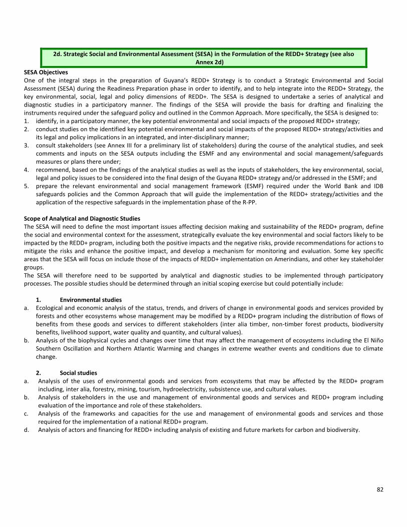
82
2d. Strategic Social and Environmental Assessment (SESA) in the Formulation of the REDD+ Strategy (see also Annex 2d)
SESA Objectives One of the integral steps in the preparation of Guyana’s REDD+ Strategy is to conduct a Strategic Environmental and Social Assessment (SESA) during the Readiness Preparation phase in order to identify, and to help integrate into the REDD+ Strategy, the key environmental, social, legal and policy dimensions of REDD+. The SESA is designed to undertake a series of analytical and diagnostic studies in a participatory manner. The findings of the SESA will provide the basis for drafting and finalizing the instruments required under the safeguard policy and outlined in the Common Approach. More specifically, the SESA is designed to: 1. identify, in a participatory manner, the key potential environmental and social impacts of the proposed REDD+ strategy; 2. conduct studies on the identified key potential environmental and social impacts of the proposed REDD+ strategy/activities and
its legal and policy implications in an integrated, and inter-disciplinary manner; 3. consult stakeholders (see Annex III for a preliminary list of stakeholders) during the course of the analytical studies, and seek
comments and inputs on the SESA outputs including the ESMF and any environmental and social management/safeguards measures or plans there under;
4. recommend, based on the findings of the analytical studies as well as the inputs of stakeholders, the key environmental, social, legal and policy issues to be considered into the final design of the Guyana REDD+ strategy and/or addressed in the ESMF; and
5. prepare the relevant environmental and social management framework (ESMF) required under the World Bank and IDB safeguards policies and the Common Approach that will guide the implementation of the REDD+ strategy/activities and the application of the respective safeguards in the implementation phase of the R-PP.
Scope of Analytical and Diagnostic Studies The SESA will need to define the most important issues affecting decision making and sustainability of the REDD+ program, define the social and environmental context for the assessment, strategically evaluate the key environmental and social factors likely to be impacted by the REDD+ program, including both the positive impacts and the negative risks, provide recommendations for actions to mitigate the risks and enhance the positive impact, and develop a mechanism for monitoring and evaluation. Some key specific areas that the SESA will focus on include those of the impacts of REDD+ implementation on Amerindians, and other key stakeholder groups. The SESA will therefore need to be supported by analytical and diagnostic studies to be implemented through participatory processes. The possible studies should be determined through an initial scoping exercise but could potentially include:
1. Environmental studies a. Ecological and economic analysis of the status, trends, and drivers of change in environmental goods and services provided by
forests and other ecosystems whose management may be modified by a REDD+ program including the distribution of flows of benefits from these goods and services to different stakeholders (inter alia timber, non-timber forest products, biodiversity benefits, livelihood support, water quality and quantity, and cultural values).
b. Analysis of the biophysical cycles and changes over time that may affect the management of ecosystems including the El Niño Southern Oscillation and Northern Atlantic Warming and changes in extreme weather events and conditions due to climate change. 2. Social studies
a. Analysis of the uses of environmental goods and services from ecosystems that may be affected by the REDD+ program including, inter alia, forestry, mining, tourism, hydroelectricity, subsistence use, and cultural values.
b. Analysis of stakeholders in the use and management of environmental goods and services and REDD+ program including evaluation of the importance and role of these stakeholders.
c. Analysis of the frameworks and capacities for the use and management of environmental goods and services and those required for the implementation of a national REDD+ program.
d. Analysis of actors and financing for REDD+ including analysis of existing and future markets for carbon and biodiversity.

83
3. Institutional studies a. Documentation and analysis of the relevant international treaties, agreements, instruments, and their interpretation relating to
REDD+ programs including, inter alia, those relating to carbon emissions, benefit sharing, indigenous rights, biodiversity, and resource management.
b. Documentation and analysis of the relevant national policy, legislation, and their interpretation relating to REDD+ programs in Guyana including, inter alia, those relating to carbon emissions, benefit sharing, indigenous rights, biodiversity, and resource management.
4. Analysis of compliance with World Bank and IDB Safeguard and Disclosure Policies including the Common Approach Anticipating potential impacts that may result from the implementation of the REDD+ strategy, the following World Bank safeguard policies appear applicable, at this time; to the proposed REDD+ operation in Guyana:
30
- Environmental Assessment (OP 4.01) - Natural Habitats (OP 4.04) - Forests (OP 4.36) - Physical Cultural Resources (OP 4.11) - Indigenous Peoples (OP 4.10) - Involuntary Resettlement (OP 4.12) (To manage restriction of access to natural resources) - Safety of Dams (OP 4.37) (TBD) - Projects on International Waterways (OP 7.50 ) (TBD) - Projects in Disputed Areas (OP 7.60) In addition, the following IDB policies appear applicable to the proposed REDD+ operation in Guyana: - Environment and Safeguards Policy (OP-703) - Indigenous Peoples Policy (OP-765) - Involuntary Resettlement Policy (OP-710) - Gender Equity in Development Policy (OP-270) The World Bank and IDB policies are encompassed in the Common Approach which requires safeguard outcomes equivalent to the highest applicable standard. Steps for SESA Consultative Process Component 1b of the Guyana R-PP details the overall consultation and participation framework of stakeholders in preparing the Guyana REDD+ Strategy during the Readiness Preparation phase. Drawing upon the principles of consultation and participation outlined in Component 1b, the SESA consultative process will specifically guide the analytical and diagnostic studies to be carried out during the Readiness Preparation phase. A specific budget is allocated for the SESA consultative process. It is imperative that consultations on the SESA during the Readiness Preparation phase involve key stakeholders such as the traditional Amerindian village councils, the National Toshaos’ Council (NTC) and the NGOs, representing the Amerindian People and other stakeholder groups (small-scale logging and mining communities). The SESA will plan, implement and finalize its activities in the following manner: Phase 1 (First Phase of Readiness Grant)
1. Dissemination of the draft SESA ToR to seek initial feedback from stakeholders; 2. Workshops with representative national stakeholders; 3. Finalization of the SESA ToR integrating the initial feedback received; and 4. Disclosure of finalized SESA ToR.
30
Readiness Safeguard Data Sheet (RSDS) has been prepared to document the application of safeguard policies to the Guyana REDD+ operation supported by FCPF. Final determination on the application of World Bank safeguard policies to the REDD+ operations will be made during the Readiness Preparation phase and complemented by a screening in accordance with IDB policies and guidelines.

84
Part 2 (During Readiness Preparation Phase) 1. Establish clear working relationship between the team preparing and implementing the consultations and the team
developing the REDD+ Strategy for Guyana 2. Organization of a series of focused workshops/consultation sessions to share information and seek inputs and feedback on
the findings of the analytical and diagnostic studies. The workshops/consultations will be organized at the local, regional, and national levels. Relevant documents will be made available prior to such workshops/consultations. Amerindian People will be consulted in an adequate and culturally-appropriate manner following the international good practices and taking into account their issues of language and gender;
3. Organization of a national workshop to present and discuss the final findings of the analytical and diagnostic studies and to agree on the key findings to be integrated into the REDD+ Strategy; and
4. Public disclosure of the World Bank and IDB environmental and social management framework, for the REDD+ strategy in Guyana and its revision through a series of focused workshops with the Amerindian people and other stakeholders (small-scale logging and mining communities).
The estimated duration of the SESA process is approximately 12-18 months, including the preparation of the relevant World Bank and IDB ESMF. This timeline does not include the time needed to incorporate the findings of the SESA in the preparation of the Guyana REDD+ Strategy and subsequent preparation of the Readiness Package. Key Professional Expertise In order to help build local capacity, national expertise (NGOs, Academia, etc.) will constitute a part of the consultancy team, where the required skill sets are available, with responsibility for conducting the analytical and diagnostic studies. Furthermore, the NTC will conduct the consultations with Amerindian communities and villages in order to assist in accounting for local and traditional knowledge and the community-level expertise. The analytical and diagnostic work as well as the drafting of the ESMF will be carried out by qualified professionals with expertise (see Annex IV for required expertise), including the following:
a. Environmental Experts b. Social Scientists c. Legal Experts d. Experts on World Bank and IDB safeguard policies and the use of the Common Approach e. Experts in participation/culturally-appropriate consultation, outreach and communication f. Economists and sector experts in forestry, mining, etc.
SESA Outputs The SESA team will prepare the following specific reports and documents in close consultations with key stakeholders, including the Amerindian People and other stakeholders: 1. Environment and Social Management Framework (ESMF) acceptable to the World Bank and IDB (see Annex 2 for details on the requirements) that will include specific sections on safeguards policies, including:
a. Environmental and Social Assessment (ESA) to address any potential environmental and/or social impacts as required by the World Bank Environmental Assessment Policy (OP 4.01) and in the IDB Environment and Safeguards Policy (OP-703);
b. Resettlement Policy Framework (RPF) to address any potential land expropriation and/or physical relocation as required by the World Bank Involuntary Resettlement Policy (OP 4.12) and the IDB Involuntary Resettlement Policy (OP-710);
c. Process Framework (PF) for restriction of access to natural resources as required by the World Bank Involuntary Resettlement Policy (OP 4.12), which will also include restriction of access to natural resources outside of parks and protected areas and in accordance with the livelihood restoration provisions of OP-710; and
d. Indigenous Peoples Planning Framework (IPPF) including a complete evaluation of the potential impacts on Indigenous Peoples, consultation and agreement with them, and benefit-sharing arrangements, as required by the World Bank Indigenous Peoples Policy (OP 4.10) and the IDB Indigenous Peoples Policy (OP-765).
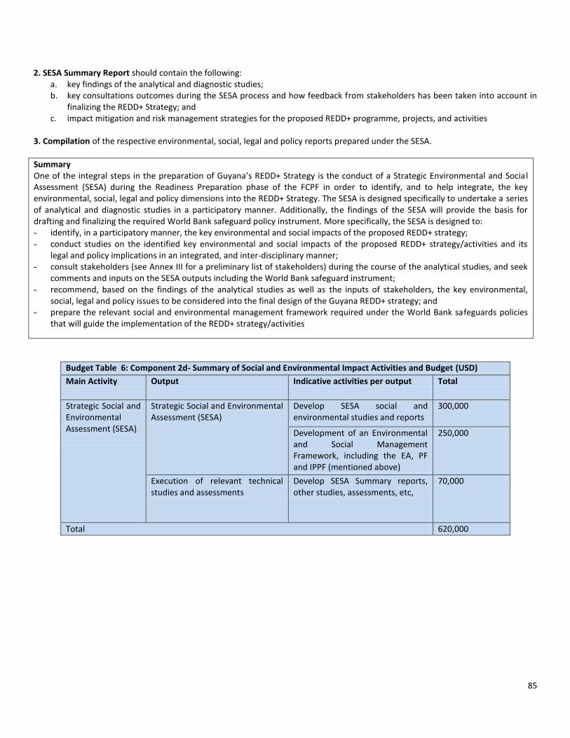
85
2. SESA Summary Report should contain the following: a. key findings of the analytical and diagnostic studies; b. key consultations outcomes during the SESA process and how feedback from stakeholders has been taken into account in
finalizing the REDD+ Strategy; and c. impact mitigation and risk management strategies for the proposed REDD+ programme, projects, and activities
3. Compilation of the respective environmental, social, legal and policy reports prepared under the SESA.
Summary One of the integral steps in the preparation of Guyana’s REDD+ Strategy is the conduct of a Strategic Environmental and Socia l Assessment (SESA) during the Readiness Preparation phase of the FCPF in order to identify, and to help integrate, the key environmental, social, legal and policy dimensions into the REDD+ Strategy. The SESA is designed specifically to undertake a series of analytical and diagnostic studies in a participatory manner. Additionally, the findings of the SESA will provide the basis for drafting and finalizing the required World Bank safeguard policy instrument. More specifically, the SESA is designed to: - identify, in a participatory manner, the key environmental and social impacts of the proposed REDD+ strategy; - conduct studies on the identified key environmental and social impacts of the proposed REDD+ strategy/activities and its
legal and policy implications in an integrated, and inter-disciplinary manner; - consult stakeholders (see Annex III for a preliminary list of stakeholders) during the course of the analytical studies, and seek
comments and inputs on the SESA outputs including the World Bank safeguard instrument; - recommend, based on the findings of the analytical studies as well as the inputs of stakeholders, the key environmental,
social, legal and policy issues to be considered into the final design of the Guyana REDD+ strategy; and - prepare the relevant social and environmental management framework required under the World Bank safeguards policies
that will guide the implementation of the REDD+ strategy/activities
Budget Table 6: Component 2d- Summary of Social and Environmental Impact Activities and Budget (USD)
Main Activity Output Indicative activities per output Total
Strategic Social and Environmental Assessment (SESA)
Strategic Social and Environmental Assessment (SESA)
Develop SESA social and environmental studies and reports
300,000
Development of an Environmental and Social Management Framework, including the EA, PF and IPPF (mentioned above)
250,000
Execution of relevant technical studies and assessments
Develop SESA Summary reports, other studies, assessments, etc,
70,000
Total 620,000

86
Component 3: Develop a Reference Scenario
Objectives for this component: The relatively low deforestation rate in Guyana is 0.02 to 0.06% (Guyana’s MRVS Interim Measures Report 2010). Using an average above-ground stock of 340 t CO2e per hectare (the average of the estimates of Hans ter Steege, 2001, and Brown (1997), and an additional 20 percent of biomass below ground, the deforestation emissions since 2000 is averaged to be 22.6 million t CO2e per year. It is more difficult to estimate the historical emissions from degradation. The estimate of emissions from deforestation and degradation requires assessing reference levels based on Guyana’s national circumstances, which will be that of a stock based approach. This method will be applied given that Guyana is a country that has had, and continues to have, high forest cover and a low rate of deforestation (HFLD). Currently technical negotiations at the level of the UNFCCC have so far continued to take into consideration the important factor of national circumstances. These negotiations have supported the use of reference levels, as opposed to reference emissions levels, for HFLD countries like Guyana. Through using this approach, forest carbon financing payments will be based on stocks rather than emissions levels. These reference levels should represent the historical rate of deforestation and forest degradation in “forested land” at the national scale. Given the rather low rate of deforestation in Guyana, the method of establishing the reference level will likely use a future projected approach. Guyana’s reference scenario will be developed following the Intergovernmental Panel on Climate Change Good Practice Guidelines (IPCC GPGs) and will establish the historic emissions level and a projected reference level, using both field data and remote sensing data. Approaches for creating projections are defined in this Component. Expected Outcome: There are two main outcomes: (a) the establishing of the historic reference level and (b) the development of the projected reference level based on the stock based approach. Reference Scenario Framework The Framework which will be used is outlined in Diagram 2, and has informed the Activities set out to achieve the outcome:
Reference Scenario of Forest Carbon Stocks and Change: historic trend, carbon stock data (from plots established and from ter Steege) and carbon models.
Reference Scenario of Forest Carbon Degradation and Change
Reference Scenario of Forest Cover Change: Data will be assembled to cover an interval of 5 to 10 years as will be determined by data availability – this will include forest inventory, biomass data (ter Steege), and satellite and radar images, using the National Vegetation map.
Assessment of Historical Reference Level
Deforestation and Degradation Data: Historic trends assessed, baseline forest cover map developed using
Landsat, JERS and high resolution data (inc. RapidEye), and forest inventory data assembled: this will include management level and pre-harvest level forest data.
Assessment of Projected Reference Level
Projection data and methods: various scenarios for economic growth and land use policies, involving for example, progression of mining, agricultural development and timber extraction to achieve a normative target of GDP growth under three main scenarios/approaches outlined in this Component.
Reference Scenario projection into the Future: deforestation (forest area change) and degradation (biomass and carbon density change).
REDD Secretariat will review scenario, consultations will be conducted and scenario will be subject to expert review.
Figure 2. Reference Scenario Framework

87
3.1 Assessment of Historic Trend Guyana has assessed the international policy discussions on REDD+ and reference scenarios. This is summarized below
31:
- For REDD+ the reference scenario under discussion is a national-level trend based on or projected from historical trends from forest change. These trends would be measured over multiple years (5–10) in order to reduce the impact of anomalous years.
- The reference period selected will likely be finalized through negotiations, but a more recent reference period (in the last 5–10 years) may better reflect current land-use trends and be most feasible given constraints in available data.
Because financial compensation would be based on verifiable performance against an agreed reference level, a credible method for measurement of performance is absolutely essential. Time Period of data for estimating historic reference level: The timeframe for the historic reference period for developing the reference scenario will be from 1990. The period October 1, 2009 to September 30, 2010 is used as the base year for Year 1 of the Forest Area Change Assessment as well as established in the MRV System. Guyana is a high forest, low deforestation (HFLD) country and as far back as utilization of the forest has been occurring; there have been low rates of deforestation and forest degradation. To be able to understand in a more comprehensive and holistic way, the historic impacts of various drivers on the forest, an extended time series allows for a more precise understanding to be enabled. Going as far back as 1990 allows for this to be achieved as well as for there to be comparisons rendered between the period 1990-2000, when older policies would have prevailed, and the more recent period of 2000-2009, when newer policies prioritizing sustainable management of the natural resources would have been in effect. Developing a Reference Level for Guyana Winrock International, an international expert on REDD+ supporting the REDD+ efforts of the GFC, developed a draft methodological framework for the World Bank’s Forest Carbon Partnership Facility (FCPF) to assist participant countries in enhancing their near-term capacity for producing RLs at the national scale as part of their eventual REDD+ Readiness Package. The framework enables countries to become more familiar with methods, available data, and tools so that participant countries can be better prepared in the near term to engage in analytic activities proposed in their FCPF country Readiness Preparation Plans (R-PPs). During the drafting of the framework, Winrock worked with representatives of several countries, including Guyana, to incorporate opinions and feedback into the guidance document. This section outlines the resulting RL framework as a guideline for how a credible RL for Guyana should be established. Seven key decisions are included in the framework and are shown in Diagram 3.
Diagram 3- Key decisions to be made by countries when developing their reference levels for REDD+ (based on a methodological framework for developing RLs produced by Winrock International for the World Bank’s Forest Carbon Partnership Facility. Based on the requirements outlined above, Guyana has made most of the decisions required to establish its RL, and these are summarized in Table 19. Because a stepwise approach to developing the RL is possible, for some countries it may make sense to begin with including in the RL only the REDD+ interventions that will have the most significant impacts, adding in additional activities (as well as intervention programs to address these) as time, data, and resources allow. Guyana has chosen to include in its RL from deforestation and forest degradation but not removals from carbon stock enhancements.
31 Olander, P., et al, Reference Scenarios for Deforestation and Forest Degradation in support of REDD+: a review of data and methods. http://www.sage.wisc.edu/pubs/articles/F-L/gibbs/erl8_2_025011.pdf
1. Determine
Scope of
Activities
2. Finalize Forest
Definition
3. Determine
Scale (National or
Summed
Subnational)
4. Determine
Which
Pools/Gases to
Include
5. Link RL/MRV to
a National
Forest Inventory?
6. Adjust for
National
Circumstances?
7. Should a
Location Analysis
Be Included?

88
Table 19-Summary of Guyana’s key decisions for establishing its REDD+ Reference Level
Key Decision for REDD+ RL/REL Guyana’s Decision
Determine Scope of Activities Include deforestation (from agriculture, mining, infrastructure) Include forest degradation (from timber harvesting, fire, small scale mining, shifting cultivation)
Finalize Forest Definition Minimum tree cover: 30% Minimum height: 5 m Minimum area: 1 ha
Scale of REDD+ RL National (no subnational)
Pools/Gases Pools: (activity specific) Aboveground biomass Belowground biomass Dead wood Soil carbon Wood products (timber harvesting only) Gases: Include CO2 Exclude N2O Exclude CH4
Link REDD+ to National Forest Inventory?
The method that has been developed is based on specifically designed forest carbon stock assessment carried out in Guyana at Tier 2 level.
Adjust for National Circumstances? To be determined. This is expected to be based following specific detailed identification of event, and conservative assessment of the likely impacts.
Location Analysis? No
Existing Data
a. Forest inventory data from previous surveys and aerial photographic interpretation databank, national vegetation map, LANDSAT images for entire land cover over period 2005 to 2009. Selected swaths from Formosat, ALOS, CBERS and Aster image providers.
b. Recent annual coverage of RapidEye data for 2010-2011, and 2012. c. Timber Extraction Data from 1990 to present. d. Forest areas allocation data from 1990 to present. e. Macro economic and social data: GDP, employment, growth rates, inflation, per capita income levels, production by GDP
economic activity areas (mining, agriculture, manufacturing, etc), housing statistics, population, etc. f. Forest Inventory data from national inventory, and areas specific inventory of 1970, 1990 and 2000 to present at
management level (sampling at 2 percent to 5 percent) and preharvest level (100 percent inventory of selected species). g. Already there are 45 biomass permanent sampling plots established, with data currently being collected and collated. h. The quality, specifically in terms of accuracy and consistency of the above data, are medium to high in accuracy. Number 1
is high in completeness with regards to forest inventory, API and LANDSAT coverage. i. Table 19 below provides an overview of the images that GFC holds or that are currently available in image archives. A
description of their application and basic technical specifications is also provided

89
Table 20- Options for Satellite Data for Guyana
Application Satellite Spectral Bands Resolution Image Extent (km)
Coverage
Land use & Forest Change Mapping
SPOT VNIR & SWIR23 5, 10 or 20 m 60 x 60 Full coverage but cloudy
CBERS24 VNIR ~20 m 120x 120 Scattered
DMC VNIR 22 m & 32 m 660 x 4100 Scattered cloud
RapidEye VNIR 5m 25 X 25 Full coverage (Aug to Dec 2011 and tasked for 2012)
ResourceSat1 (IRS)
VNIR & SWIR 23.5 m (LISS-3) 56 m AWiFS
142 x142 & 774 x 774
Scattered only 2 LISS-3 scenes available
Landsat 5 & 7 VNIR & SWIR and thermal bands
30 m VNIR & SWIR 90 m thermal
185 km Full temporal coverage to Sept 2009
Landsat MSS VNIR 80 m 185 km Scattered pre 1990
Monitoring Broad scale Forest Change
MODIS VNIR 250 m Approx. 2000 km Daily coverage from two satellites Terra &Aqua. Complete coverage for end Sept 2009 and 2010
Radar Palsar RADAR Single and dual polarisation
50 m ~70 - 70 Selected scenes provided by GEO FCT for 2008-09 period
Verification & Accuracy Assessment
Aerial photography
Panchromatic with some colour images around coastal areas
1:40 000 Unregistered Historical spanning from 1950-1970
IKONOS VNIR 1 m pan 4 m multi-spectral
11 x 11 km Scattered around coastal regions
Kompsat 2 VNIR 1 m pan 4 m multi-spectral
16 x 16 km Scattered
CBERS (HRC) Panchromatic 2.7 m 27 Scattered
SPOT 5 VNIR & SWIR 2.5, 5 m & 10 m 60 x 60 km Scattered
ASTER VNIR &SWIR &thermal bands
15 m 60 x 60 km Scattered
RapidEye MS0 5-6.5 25 X 25 Scattered
ALOS Visible & near infrared
10 m 70 x 70 km Scattered
Source: Guyana REDD+ Monitoring Reporting and Verification System (MRVS) Interim Measures Report Final, March 16, 2011
New Data a. Results of assessment conducted under the MRV System in forest area assessment and biomass assessment and monitoring.
This also includes assessment results of various drivers of deforestation and forest degradation. b. Socio economic and macro economic data, for future periods, including projected GDP data, natural resources utilization:
forestry, mining, agriculture, housing statistics, urban development, per capita income levels, population growth rates, etc. from relevant agencies.
c. High resolution data sets from a provider that meets the requirements of Guyana: <10 percent cloud cover, 2 m to 15 m resolution with preferably 24 km to 70 km or more swath. (as smaller swaths can be costly to secure for total areas that may be required). To allow for greater accuracy, high resolution data and aerial photographs will be needed to supplement medium resolution data.
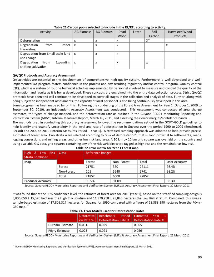
90
Table 21-Carbon pools selected to include in the RL/REL according to activity.
Activity AG Biomass BG Biomass Dead Wood
Litter Soil Carbon
Harvested Wood Products
Deforestation x x x X*
Degradation from Timber Harvesting
x x x x
Degradation from Small scale land use change
x x x
Degradation from Expanding shifting cultivation
x x x x
QA/QC Protocols and Accuracy Assessment QA activities are essential to the development of comprehensive, high-quality system. Furthermore, a well-developed and well-implemented QA program fosters confidence in the process and any resulting regulatory and/or control program. Quality control (QC), which is a system of routine technical activities implemented by personnel involved to measure and control the quality of the information and results as it is being developed. These concepts are engrained into the entire data collection process. Strict QA/QC protocols have been and will continue to be developed to cover all stages in the collection and analysis of data. Further, along with being subject to independent assessments, the capacity of local personnel is also being continuously developed in this area. Some progress has been made so far on this. Following the conducting of the Forest Area Assessment for Year 1 (October 1, 2009 to September 30, 2010), an independent Accuracy Assessment was conducted. This Assessment was conducted of area change estimates, the types of change mapped, and the deforestation rate as outlined in the Guyana REDD+ Monitoring Reporting and Verification System (MRVS) Interim Measures Report, March 16, 2011, and assessing their error margins/confidence bands. The methods used in conducting this accuracy assessment followed the recommendations set out in the GOFC-GOLD guidelines to help identify and quantify uncertainty in the level and rate of deforestation in Guyana over the period 1990 to 2009 (Benchmark Period) and 2009 to 2010 (Interim Measures Period – Year 1). A stratified sampling approach was adopted to help provide precise estimates of forest area. Two strata were selected according to “risk of deforestation”, that is, land proximal to settlements, roads, logging concessions and mining areas, and other low risk land area. A 10 km by 10 km grid square was overlaid on the country and using available GIS data, grid squares containing any of the risk variables were tagged as high risk and the remainder as low risk.
Table 22 Error matrix for Year 1 Forest map
High & Low Risk Strata Combined
Class Reference Images
Map Forest Non- Forest Total User Accuracy
Forest 21751 360 22111 98.4%
Non-Forest 101 5640 5741 98.2%
Total 21852 6000 27852
Producer Accuracy 99.5% 94.0% 98.3%
Source: Guyana REDD+ Monitoring Reporting and Verification System (MRVS), Accuracy Assessment Final Report, 22 March 2011
It was found that at the 95% confidence level, the estimate of forest area for 2010 (Year 1), based on the stratified sampling design is 5,835,059 ± 15,376 hectares the High Risk stratum and 11,970,258 ± 28,845 hectares the Low Risk stratum. Combined, this gives a sample-based estimate of 17,805,317 hectares for Guyana for 1990 compared with a figure of 18,388,190 hectares from the Pöyry-GFC map.
32
Table 23- Error Matrix used for Deforestation Rates
Deforestation Rate %
Benchmark Period Deforestation Rate %
Estimated Year 1 Deforestation Rate %
Durham Estimate 0.031 0.029 0.065
Pöyry Estimate 0.023 0.021 0.056
Source: Guyana REDD+ Monitoring Reporting and Verification System (MRVS), Accuracy Assessment Final Report, 22 March 2011
32 Guyana REDD+ Monitoring Reporting and Verification System (MRVS), Accuracy Assessment Final Report, 22 March 2011
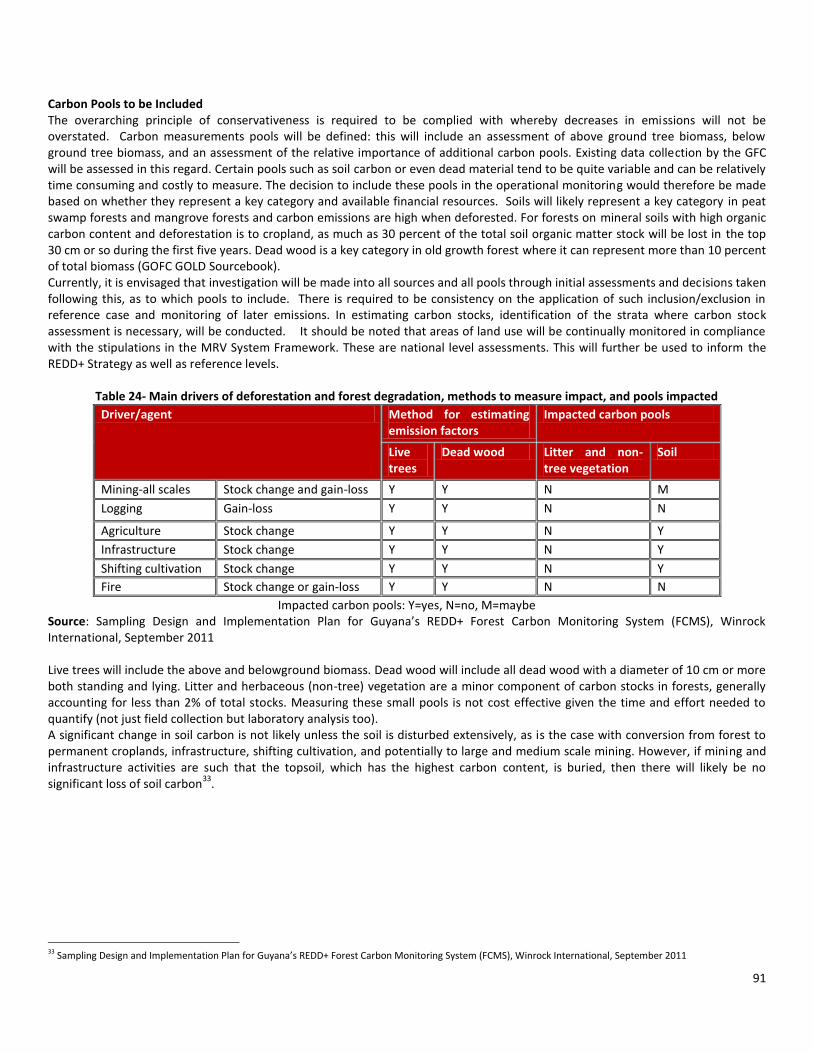
91
Carbon Pools to be Included The overarching principle of conservativeness is required to be complied with whereby decreases in emissions will not be overstated. Carbon measurements pools will be defined: this will include an assessment of above ground tree biomass, below ground tree biomass, and an assessment of the relative importance of additional carbon pools. Existing data collection by the GFC will be assessed in this regard. Certain pools such as soil carbon or even dead material tend to be quite variable and can be relatively time consuming and costly to measure. The decision to include these pools in the operational monitoring would therefore be made based on whether they represent a key category and available financial resources. Soils will likely represent a key category in peat swamp forests and mangrove forests and carbon emissions are high when deforested. For forests on mineral soils with high organic carbon content and deforestation is to cropland, as much as 30 percent of the total soil organic matter stock will be lost in the top 30 cm or so during the first five years. Dead wood is a key category in old growth forest where it can represent more than 10 percent of total biomass (GOFC GOLD Sourcebook). Currently, it is envisaged that investigation will be made into all sources and all pools through initial assessments and decisions taken following this, as to which pools to include. There is required to be consistency on the application of such inclusion/exclusion in reference case and monitoring of later emissions. In estimating carbon stocks, identification of the strata where carbon stock assessment is necessary, will be conducted. It should be noted that areas of land use will be continually monitored in compliance with the stipulations in the MRV System Framework. These are national level assessments. This will further be used to inform the REDD+ Strategy as well as reference levels.
Table 24- Main drivers of deforestation and forest degradation, methods to measure impact, and pools impacted
Driver/agent Method for estimating emission factors
Impacted carbon pools
Live trees
Dead wood Litter and non-tree vegetation
Soil
Mining-all scales Stock change and gain-loss Y Y N M
Logging Gain-loss Y Y N N
Agriculture Stock change Y Y N Y
Infrastructure Stock change Y Y N Y
Shifting cultivation Stock change Y Y N Y
Fire Stock change or gain-loss Y Y N N
Impacted carbon pools: Y=yes, N=no, M=maybe Source: Sampling Design and Implementation Plan for Guyana’s REDD+ Forest Carbon Monitoring System (FCMS), Winrock International, September 2011 Live trees will include the above and belowground biomass. Dead wood will include all dead wood with a diameter of 10 cm or more both standing and lying. Litter and herbaceous (non-tree) vegetation are a minor component of carbon stocks in forests, generally accounting for less than 2% of total stocks. Measuring these small pools is not cost effective given the time and effort needed to quantify (not just field collection but laboratory analysis too). A significant change in soil carbon is not likely unless the soil is disturbed extensively, as is the case with conversion from forest to permanent croplands, infrastructure, shifting cultivation, and potentially to large and medium scale mining. However, if mining and infrastructure activities are such that the topsoil, which has the highest carbon content, is buried, then there will likely be no significant loss of soil carbon
33.
33 Sampling Design and Implementation Plan for Guyana’s REDD+ Forest Carbon Monitoring System (FCMS), Winrock International, September 2011

92
Soil Carbon Large-scale mining effectively reduces all of the carbon stocks of the forest vegetation (live and dead biomass) to zero. Ground excavation activities have a major impact on the soil, removing the top soil, which then often gets buried when overburden is excavated and piled onto the topsoil. However, it is not clear if the top soil, including soil organic matter, is buried or not, that will greatly affect how the emissions from the soil disturbance will be estimated. Deforestation also results from the conversion of forest land to agricultural uses. This reduces carbon present in all forest vegetation to practically zero, and if converted to annual croplands, as is common in Guyana, losses in soil carbon will also occur. In terms of infrastructure, emission factors from soil disturbance due to building roads will depend on whether a road is paved or not. If paved, it will be assumed there are no carbon emissions. For unpaved roads, the carbon emissions will be estimated. When large enough in scale and intensity, fires can be detected with satellite imagery. The impact of fires on the soil carbon pool likely depends on the intensity of the fire. With relatively low intensity of fires, the soil will not get hot enough to cause a reduction and if anything it could increase stocks due to the formation of charcoal from burned debris. Even if losses occur, if the area is allowed to re-grow then the soil carbon is likely to recover. A number of special studies are scheduled to be conducted to investigate a number of the abovementioned issues. The forest carbon data collected from the abovementioned carbon pools will be used to produce emission factor tables with data specific to Guyana. The table below illustrates an example of how an emission factor table from deforestation could be presented for Guyana.
Table 25- Illustrative example of potential emission National Look Up Factor Tables for Guyana.
Change agent/Driver – Deforestation (stock change)
Stratum Mining (>1 ha in size) (t CO2e ha-1)
Infrastructure (t CO2e ha-1)
Logging Infrastructure (t CO2e ha-1)
Agriculture (t CO2e ha-1)
Fire (t CO2e ha-1)
Mixed forests high potential for change
Mixed forest medium potential for change
These factor tables could be divided by phases, with values representing GHG emissions in tonnes CO2e ha-1 or tonnes CO2e m-3, as appropriate with uncertainty values in parentheses. Combining this information with the area and type of change observed within each stratum would result in estimates of GHG emissions through time
34.
3.2 Assessment of Projected Future Reference Level Approaches for projection of reference level, and rationale for selection are outlined below. The approaches that are tentatively identified to be used are:
a. Scenario 1 – Projection based on historic trend prior using the business as usual approach (without REDD+) b. Scenario 2 – Projection based on undertaking a development plan to realize macroeconomic targets c. Scenario 3- Projections based on Guyana fully utilizing its forests for various natural resources extractive activities and
other uses, to generate revenues for development- which will take into various considerations including the opting in/ no opt in of Amerindian communities.
The reason for this selection is to allow for the implications on emissions using the current trend, projected into the future to be realized; secondly, to assess the implications on emissions for Guyana’s development goals to be realized; and thirdly to assess the implications for Guyana’s development plans with an effective carbon financing mechanism in place. The scenarios chosen will be finalized as part of the Readiness process. Considerations for reference scenario modelling will be taken with regards to existing arrangements with other partners as well as developments in procedures and guidelines made by various internationally recognised groups and fora.
34 IBID

93
Initial Exploratory Works in Reference Levels Modelling future reference scenarios will require advice from national and international experts trained in financial and economic modelling to establish a sound methodology for projecting historic emissions over different time periods and under different economic and development scenarios. Through a KfW/CI/GFC Initiative, Avoided Deforestation through Consolidation and Creation of Protected Areas and Carbon Financing Mechanisms in the Guiana Region (Guyana), exploratory work in this area will executed over the period October 2011- October 2012. This project was aimed at exploring various methods and approaches to establish Reference Levels, specific to Guyana’s national circumstance and to provide guidance for the establishment of a national RL after an outcome at UNFCCC. In executing this activity the consultant shall pay attention to (i) land cover change; (ii) forest carbon density and deforestation; and (iii) forest degradation. Moreover, the assessment should include the three land-use categories as described by the Good Practice Guidance of the Intergovernmental Panel on Climate Change namely: forests converted to other lands (covering deforestation); other lands converted to forest (covering expansion of forest carbon stocks by afforestation or reforestation); and forests remaining as forest (covering forest degradation, sustainable management of forests, and conservation of forest carbon stocks). Specifically the project explored the following areas:
a. Develop historical trend reference scenarios and models to reflect future development plans for Guyana; b. Examine the appropriateness of various methodologies and approaches such as compensated reductions; adjusted
reference levels; stock flow approach; combined incentives among others to establish reference levels; c. Determine and recommend the approaches and methodologies most suitable to Guyana’s context as a HFLD country and its
national circumstance taking the full scope of REDD+ into consideration to establish its national RL; d. Develop guidelines and/or criteria for the establishment of RLs in keeping with UNFCCC discussions to:
o Contribute to the mitigation of climate change o Use historical emissions and removals for national baselines o Ensure overall environmental integrity o Adjusted as required by national circumstances to improve accuracy
e. Provide guidance on the establishment and use of compensation baseline (crediting baseline) to ensure additionally, enhance effectiveness, efficiency and equity and avoid international leakage;
Activities to achieve outcome: The list below gives a more detailed appraisal of those activities and further actions required for the development of a reference scenario:
1. Assessment of data available on forest area, land cover change and carbon density. 2. Development of historical trend reference scenario for looking at land cover change, forest carbon density and
deforestation and forest degradation. 3. Complete reference scenario modelling for: development plan, trends and macroeconomic trends forecasting following
compilation of data on these areas. This will also include an analysis of bottlenecks/constraints to rational economic development in the key sectors (why large scale projects that may take place in the future did not take place in the past, and why do they become possible today, e.g. availability of financial resources, investors confidence, inaccessibility, soil fertility, technology progress, Brazil’s growth, etc.). This will make the projection-based scenario more robust) Steps 1, 2 and 3 will include technical workshops and consultations through the Consultation and Participation plan (Component 1b) to ensure stakeholders feedback in the process
4. Integration of MRV System data and results into Reference Scenario Modelling 5. Review by independent expert.
Partners and organizations involved: GFC will lead and coordinate this component, using the services of specialist consultants; facilitate workshops and consultations, and provide datasets relating to the forestry components. The Bureau of Statistics will be the primary source for data required for non-forestry components. The Ministry of Finance will review and guide economic projections of GDP that will drive consumption components. Other relevant Ministries and agencies will be consulted as required to fill any gaps in data and confirm model assumptions. Indicators of performance for this objective:
- Data on forest area, land cover change and carbon density. - Historical reference scenario developed, with stakeholders’ feedback

94
- Reference scenarios projection completed with stakeholders’ feedback - Review completed by independent Expert.
Table 7 : Summary of Reference Scenario Activities and Budget (USD)
Main Activity Sub-Activity Estimated Cost (US$)
Year 1 Year 2 Year 3 Year 4 Total
Design reference scenario model in readiness framework
Integration of MRV System data and results into Reference Scenario Modelling
75,000 75,000 150,000
Develop reference models
Historical reference scenario developed, with stakeholders feedback
100,000 100,000
Reference scenarios projection completed with stakeholders feedback
0
Conduct Independent assessment
Review by independent expert 50,000 50,000
Total 75,000 175,000 50,000 0 300,000
Other Financing: GRIF, CI KfW Support, CCI 75,000 175,000 50,000 300,000
FCPF 0 0 0 0 0
Summary The relatively low deforestation rate in Guyana is 0.02 to 0.06% (Guyana’s MRVS Interim Measures Report 2010). Using an average above-ground stock of 340 t CO2e per hectare (the average of the estimates of Hans ter Steege, 2001, and Brown (1997), and an additional 20 percent of biomass below ground, the deforestation emissions since 2000 averaged 22.6 million t CO2e per year. It is more difficult to estimate the historical emissions from degradation. The reference scenario will be developed following the Intergovernmental Panel on Climate Change Good Practice Guidelines (IPCC GPGs) and will establish the historic reference level and projected reference level, using both field data and remote sensing data. Tentative approaches for creating projections are defined in this Component.

95
Component 4: Design a Monitoring System
While policy and compensations mechanisms for implementing REDD+ are still under discussion within the UNFCCC, the draft text on methodology for REDD+ produced by SBSTA 30 in June 2009 and SBSTA 31 in December 2009, makes it clear that not only reduced emissions from deforestation and degradation, but also forest conservation, sustainable forest management and forest enhancement are included in the declaration following the Conference of Parties (COP) in Cancun Mexico in December 2010. These three elements are jointly referred to as ‘REDD+’. In this regards, it will now allow HFLD countries such as Guyana to benefit from existing good practices already being carried out, such as sustainable forest management practices, enhancement and conservation. This creates some certainty clarity about the contours of the agreement and what will be credited, as well as opportunities to use a variety of approaches to measuring and monitoring. One key measure to quantify the role of a forest for climate change mitigation is to the sum of the carbon stored in its terrestrial pools (i.e. vegetation biomass and soil carbon). It can be assumed that any change in the forest carbon stocks from direct or indirect human activities has an impact on the climate with the overall goal to reduce the amount of emissions to the atmosphere and to maintain or increase the overall terrestrial carbon pool. Thus, climate change REDD+ mitigation activities currently under discussion internationally would encourage:
- the long-term conservation of forests to maintain its current or natural carbon reservoir, - changing the impact of human activities (i.e. causing carbon emissions from land use) in forests to stabilize or increase
terrestrial carbon stocks in the long-term, - change in current human activities towards reforestation of land to increase the terrestrial carbon sink.
It is currently not practical or efficient to measure and report the stocks and changes for the whole terrestrial carbon reservoir with the level of detail and certainty to address drivers and processes that have an impact on REDD+. However, Readiness activities in Guyana should begin in order to create future capacity, given the following:
- Current human land use impacts causing carbon emissions are focused in specific areas and regions and should, perhaps, be primarily addressed in the very near-term. However, it is the long-term stabilization or increase of the terrestrial carbon reservoir as a whole that will decide on the effectiveness of the activities initiated today and to eventually implement a low carbon development strategy for Guyana.
- Resources to address REDD+ will be limited and not suitable to address all issues everywhere at the same time. While all requirements and forest change drivers and processes should be addressed from the beginning, their entry points will vary and priority setting and efficient implementation strategies will be needed at the international, national and sub-national level.
Guyana has already commenced the development of a national MRV System. As an initial step to the design of a MRV System for Guyana, a road map was designed following a stakeholder participation session. The development of such a road map considered several aspects that have been elaborated in the facilitation process and for preparing Terms of Reference for developing an REDD+ MRV system:
1. Requirements for the MRV system: - The accepted principles and procedures of estimation and reporting of carbon emissions and removals at the national level
should meet criteria specified by the IPCC Good Practice Guidelines and Guidance for reporting on the international level; - The system should measure other social and environmental impacts (positive and negative) of the REDD+ strategy; - The particulars of the national REDD+ strategy that have been selected, since different activities have different MRV
implications;
2. Bridging the capacity gap through a detailed plan to establish sustained MRV capacities within the country: - Capacity gap assessment based on the state of the existing national forest monitoring technical capabilities and the
requirements for the MRV system; - Develop a road map and foster its implementation through a sustained and efficient institutional framework including
competence in measuring and monitoring at different levels, support of national policies and REDD+ actions, international reporting and verification, and linking MRV of actions and MRV of transactions.
The outcomes of the initiative, as outlined in the MRV capacity development roadmap, are as follows:

96
- The overall goal is a capacity development process to establish a sustained MRV for implementing REDD+ policies and results-based compensation for such activities in the long-term as a contribution to Guyana’s low carbon development pathway and support for the sustainable development of natural resources;
- The development of a national REDD+ MRV system that uses a phased approach along a roadmap that specifies near-term priorities & long-term targets; builds upon existing capacities and data; and international requirements and national needs; and has the objective to support annual estimation; reporting and verification of forest-related carbon emissions and removals at the national level,
- The MRV system evolution is directly linked with REDD+ policy development and implementation and contains a systematic national monitoring, reporting and verification system and a sub-national programme to support MRV for local REDD+ activities;
- A strong institutional base and the establishment and maintenance of partnership and cooperation at all levels as enabling framework.
Seven specific areas were identified where activities are recommended for the first phase and should start as soon as possible:
- Develop and implement a national mechanism and institutional framework - Implement a comprehensive forest area change assessment for historical periods - Build carbon stock measurement and monitoring capacities - Build measurement and monitoring capacities for social and environmental variables - Develop MRV for a set of sub-national REDD+ demonstration activities - Engagement with the international community - Sustain an internal and national communication mechanisms - Conduct and support research on key issues.
MRVS Steering Committee & Technical Sub-Committee As part of the oversight and guiding mechanism for the MRV System development and implementation for Guyana, a MRVS Steering Committee and Technical Sub-Committee have been established. The MRVS Steering Committee comprises representatives from GFC, GGMC, GL&SC, NTC, EPA, FPA, GGDMA, UG, MNRE and MoAA. The Technical Subcommittee comprises technical experts from GFC, GGMC, GL&SC, and EPA. These members are expected to provide technical oversight to the implementation of various aspects of the MRV as well as provide advice to the MRVS Steering Committee. The primary function of the MRVS Steering Committee is to take responsibility for overseeing the development and implementation of Guyana’s Monitoring Reporting & Verification System. The Steering Committee will continue to monitor and review the status of various aspects of the MRV System development, as well as provide oversight of project deliverables. Members are tasked with ensuring that objectives of the various components of MRV System development are being adequately addressed. More specifically, the Committee is expected to carry out the following functions:
- Oversee the implementation of all MRV System activities; - Provide assistance to the project when required; - Ensure that scope aligns with the agreed requirements of projects and advise on means by which key stakeholder groups
are kept informed of progress in the development of the MRV System; - Contribute inputs from representative agencies that each member is a part of, to ensure close cohesion and coordination of
MRV System activities implementation. - Participate in the review and selection of consultants from the bidding process; - Monitor and manage the progress made in implementation of MRV System road map activities;
The MRVS SC is chaired by the GFC and will provide regular updates to both the NRWG and the MSSC of the LCDS. The land use agencies, particularly with mandates for agriculture, mining and indigenous lands have been involved in a process of continually improving datasets managed by their various agencies. These include datasets on mining areas, agriculture areas, and forestry areas etc. Key land use agencies are part of this MRVS Steering Committee, which has a main function regarding data management and sharing.

97
4a.1 Guidelines and Principles The UNFCCC SBSTA negotiation text (December 2009) refers to the need to establish monitoring systems that use an appropriate combination of remote sensing and ground-based forest carbon inventory approaches with a focus on estimating anthropogenic forest-related greenhouse gas emissions by sources, removals by sinks, forest carbon stocks and forest area changes. It is agreed that the IPCC Good Practice Guidelines on Land Use Land Use Change and Forestry (LULUCF) provide suitable and agreed methods and procedures to estimate and report on carbon stock changes for deforestation, forest degradation, forest conservation, reforestation, afforestation etc. All MRV activities and estimates should follow the five IPCC reporting principles and should particularly be transparent, comparable, consistent, as accurate and complete as possible, and should reduce uncertainties, as far as national capabilities and capacities permit). It is further indicated that these monitoring systems and their results will be open to independent review as agreed by the Conference of the Parties. These considerations clearly point at the need for country-specific and country-driven solutions for developing capacities and partnerships that certainly go beyond technical MRV considerations and include a participatory process and the exploration of co-benefits and synergies. CIFOR has been proposing the “3 E’s concept” of efficiency, effectiveness and equity as guidance for both REDD+ related policies and MRV developments and their linkages in REDD+ Readiness and implementation. The 3 E’s concept, for example, provides a framework to consider the diverse set of needs and requirements for both policy and MRV on the national and sub-national level:
- Efficiency: using transparent, consistent and cost-effective data sources and procedures, sets up an institutional infrastructure and establishes sustained capacities within the country that meet its national and international REDD+ requirements and enables to report forest carbon changes using the IPCC GPG in the long-term;
- Effectiveness: supports and is driven by the development and implementation of a national REDD+ policy and its areas of priority area of actions;
- Equity: integrates MRV actors and activities for local measurements and monitoring, national-level monitoring and estimation, and international guidance, and supports independent review, to ensure participation and transparency among different stakeholders involved.
These considerations currently provide the most comprehensive and up to date foundations to develop MRV systems as part of national Readiness process. Building upon the existing guidance and principles, the workshop discussions did go deeper in assessing requirements and capacity needs, and providing suggestion for MRV capacity development strategies and actions that reflect Guyana’s specific country circumstances. The process will follow the fundamental assumptions: 1. The overall goal is to establish a capacity development process to implement a sustained MRV system for implementing REDD+
policies and results-based compensation for such activities in the long-term as contribution to Guyana’s low carbon development pathway. In general, any progress for REDD+ MRV fosters integrated decision making for resource management, and, thus, by itself, provides an important foundation for any future development.
2. The development of a national REDD+ MRV system uses a phased approach along a roadmap that specifies near-term priorities & long-term targets and is based on:
a. Building upon existing capacities and data, international requirements and national needs for Guyana’s REDD+ participation,
b. the objective to support annual estimation, reporting and verification of forest-related carbon emissions and removals on the national level,
c. the need to maintain some flexibility to adjust the activities in case the details of REDD+ compensation mechanisms are agreed internationally;
3. The MRV system evolution is directly linked with REDD+ policy development and implementation and contains a systematic national monitoring, reporting and verification system and a sub-national programme to support MRV for local REDD+ activities;
4. A strong institutional set up and the establishment and maintenance of partnership and cooperation on all levels provides the framework that includes:
a. a steering body coordinating all REDD+ MRV activities and the implementation of the roadmap, b. the Guyana Forestry Commission as executive agency, c. a process for involving relevant national stakeholders involved in MRV and REDD+ implementation and mechanisms to
ensure transparent and open exchange and management of data,
Component 4a. Emissions and Removals

98
d. building partnerships and cooperation with key national and international organizations that help Guyana in implementing the road map.
Approach to Designing and Implementing a MRV System for Monitoring Activity Data In the design and implementation of the MRV System, Guyana has so far, taken the following steps: a. Guyana under initial MRV System work has been using land management data, i.e., non RS data (refer Component 3, Table 12.
Options for Satellite Data for Guyana). b. In the FCMS work, the GFC will be integrating key aspects of field data collection with Remote Sensing. A national lookup table
will be developed for annual reporting, in essence means that RS data is used along with field data collection and assessment. c. As part of FCSM several special studies will be undertaken to better inform several aspects of activity data, e.g. shifting
agriculture d. Initial work has already commenced on setting up REDD+ demonstration activities among GFC, Iwokrama and the communities
of the North Rupununi District Development Board (NRDDB) (refer to component 2b) 4a.2 Assessing Drivers of Deforestation Identification of Gaps The formulation and implementation of a national system to monitor emissions and emission reductions would be the basis for performance payments. Independent third party verification of this monitoring is critical. This process would entail training staff of the Guyana Forestry Commission (GFC) and other relevant agencies, and the capturing of forest data for assessment (of forest carbon stock) purposes, as well as processing and analysis of this data. Data from remote sensing, forest inventories etc. would also be incorporated in this analysis. The GoG intends to maximize the benefits that can accrue from its natural resources to support its national development. Specifically, if the Strategy to reduce long term GHG emissions attracts incentives to cover forest management costs, carbon transaction costs, and community opportunity costs, then the residual funding can be utilized for renewable energy and other low carbon economic development. Such strategies are expected to serve in the overall development of key cross-cutting sectors of the country. The application of a robust system of monitoring, planning and strategy development, necessary for marketing and receiving investments for ecosystem services will assist in streamlining forest governance processes through application of sound verifiable and rigorous principles, ensuring that good environmental practice already enshrined in the Guyana laws, are integrated into development. Socio-economic data and analysis will be needed to determine the underlying forces that create the conditions which favour the deforestation and degradation outlined above. 4a.3 Monitoring Forests and Forest Area Change Activity Data - Approaches One of the areas identified as initial activities involve the assessment of forest area change. IPCC GPG suggested Approach 2 for reporting activity data involves tracking of land conversions between categories. Both approaches 1 and 2 provide “net” area changes. Approach 3 extends Approach 2 by using spatially explicit land conversion information; thus allowing for an estimation of both “gross” and “net” changes. Thus, Approach 3 which allows the spatial tracking of land change trajectories is the suggested practical approach for REDD+ implementation (GOFC-GOLD Sourcebook). The MRV System is expected to adopt an Approach 3 method, in assessing activity data. Initial work on emission factors will commence in the first phase of the initiative. This will begin by utilizing existing and newly collected data on carbon stocks, and will be informed by processes of destructive sampling and targeted sampling. The emission factors are derived from assessments of the changes in carbon stocks in the various carbon pools of a forest. Carbon stock information can be obtained at different Tier levels: Tier 1 uses IPCC default values (i.e. biomass in different forest biomes, carbon fraction etc.); Tier 2 requires some country-specific carbon data (i.e. from field inventories, permanent plots), and Tier 3 national inventory-type data of carbon stocks in different pools and assessment of any change in pools through repeated measurements or modelling. Moving from Tier 1 to Tier 3 increases the accuracy and precision of the estimates, but also increases the complexity and the costs of monitoring (GOFC-GOLD Sourcebook). The MRV System for Guyana will commence with a Tier 2 approach for the Readiness phase with accuracy and precision assessments conducted, and cost of monitoring tabulated. Capacities will be built progressively in the system for movement to a Tier 3 approach. Over the period 2010 to 2012, a number of activities have commenced in this area.

99
Remote Sensing The establishment of the MRVS Steering Committee for the REDD+ MRVS was required as an initial activity in the first phase of the Road Map. This body has already been established and is functional. One of the aspects that this Body oversees, is the coordination of data and key inputs and the setting up of a national mechanism to feed into the LCDS framework. This data infrastructure includes a consolidation of existing remote sensing data and resources that are currently available. Human capacity will need to be built in areas of automated interpretation for deforestation, as well as other areas related to processing and analysis of the results, and the monitoring of areas undergoing forest degradation. Some work on this has started already. GIS and remote sensing capability reside at the GFC, GL&SC and the GGMC. In order to allow for an integrated approach to executing Approach 3, it is required for a system to be developed and housed at the Guyana Forestry Commission, that will complement GINRIS, and that will allow for networking from key agencies that will record and report on individual sector data. The agencies that will be linked to this system are the GFC, GLSC, GGMC, the Hydrometeorological Division, Ministry of Amerindian Affairs, and other relevant agencies that may be identified. Work has also commenced in this area. Algorithms are required to be developed to interpret and estimate emissions. Interpretation will commence with visual interpretation and will move towards automated methods, the latter of which may be done by supervised labelling and clustering, and will be accompanied by training and correction phases. Also required, is pre processing of images which needs to be accompanied by geometric correction, cloud and cloud shadow detection and removal, radiometric corrections and image segmentation. Measurement of Deforestation & Forest Degradation Deforestation: Forest Area Change Assessment and the establishment and implementation of a Forest Carbon Monitoring System are key components of the national MRV System. These have been designed to continuously conduct monitoring, reporting and verifying deforestation at national scale. Additionally, to address the international concerns of leakage, national scale monitoring has been identified as a key scientific principle to guide the national reporting on deforestation. Progress has been made in these areas over the past 2 years (called year 1 and year 2), in Guyana. For the year 1 period (2009 to 2010) deforestation has increases to around 10 287 ha/yr. This is equivalent to an annual deforestation rate of 0.06%/yr which is an increase over the benchmark period (0.02%/yr). The main deforestation driver for the current forest year reported (Year 1) is mining with this accounting for 91% of the deforestation for this period. A majority (85%) of deforestation is observed in the State Forest Area. Additionally the temporal analysis of forest change post 1990 indicates that most of the change is clustered around existing road infrastructure and navigable rivers. This provides a useful basis for planning an ongoing monitoring programme that focuses on key hotspot areas. The findings of this assessment will enable targets for REDD+ activities to be designed that aim to bring about the largest positive impact in maintaining forest cover whilst enabling continued sustainable development and improved livelihood of Guyanese. It is important to note that REDD+ Strategies have been informed by initial work in deforestation and forest degradation in the Guyana MRVS Interim Measures Report. Development of MRV System and moving it forward as well as in the development and implementation of the Forest Carbon Monitoring System (FCMS) will be based on this framework. The design of the FCMS follows the framework of the Forest Area Assessment and the REDD+ Strategy design. Degradation: As an established methodology is not yet in place to measure forest degradation, interim indicators are currently being used. These interim indicators are detailed in the Joint Concept Note (Pages 18-20), accompanying the MoU between Guyana and Norway. These degradation indicators are as follows:
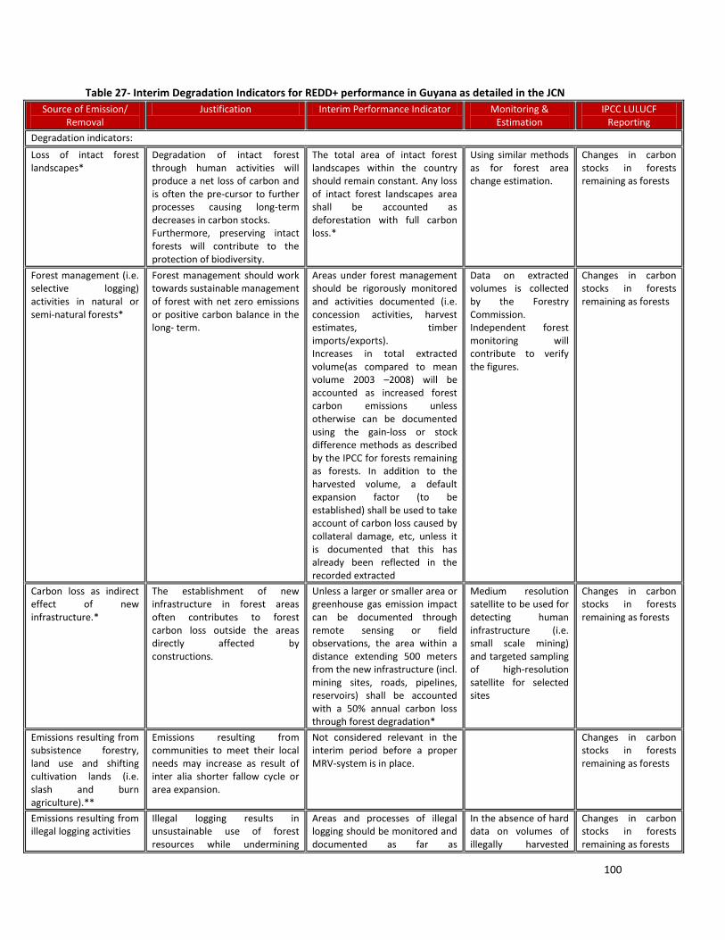
100
Table 27- Interim Degradation Indicators for REDD+ performance in Guyana as detailed in the JCN
Source of Emission/ Removal
Justification Interim Performance Indicator Monitoring & Estimation
IPCC LULUCF Reporting
Degradation indicators:
Loss of intact forest landscapes*
Degradation of intact forest through human activities will produce a net loss of carbon and is often the pre-cursor to further processes causing long-term decreases in carbon stocks. Furthermore, preserving intact forests will contribute to the protection of biodiversity.
The total area of intact forest landscapes within the country should remain constant. Any loss of intact forest landscapes area shall be accounted as deforestation with full carbon loss.*
Using similar methods as for forest area change estimation.
Changes in carbon stocks in forests remaining as forests
Forest management (i.e. selective logging) activities in natural or semi-natural forests*
Forest management should work towards sustainable management of forest with net zero emissions or positive carbon balance in the long- term.
Areas under forest management should be rigorously monitored and activities documented (i.e. concession activities, harvest estimates, timber imports/exports). Increases in total extracted volume(as compared to mean volume 2003 –2008) will be accounted as increased forest carbon emissions unless otherwise can be documented using the gain-loss or stock difference methods as described by the IPCC for forests remaining as forests. In addition to the harvested volume, a default expansion factor (to be established) shall be used to take account of carbon loss caused by collateral damage, etc, unless it is documented that this has already been reflected in the recorded extracted
Data on extracted volumes is collected by the Forestry Commission. Independent forest monitoring will contribute to verify the figures.
Changes in carbon stocks in forests remaining as forests
Carbon loss as indirect effect of new infrastructure.*
The establishment of new infrastructure in forest areas often contributes to forest carbon loss outside the areas directly affected by constructions.
Unless a larger or smaller area or greenhouse gas emission impact can be documented through remote sensing or field observations, the area within a distance extending 500 meters from the new infrastructure (incl. mining sites, roads, pipelines, reservoirs) shall be accounted with a 50% annual carbon loss through forest degradation*
Medium resolution satellite to be used for detecting human infrastructure (i.e. small scale mining) and targeted sampling of high-resolution satellite for selected sites
Changes in carbon stocks in forests remaining as forests
Emissions resulting from subsistence forestry, land use and shifting cultivation lands (i.e. slash and burn agriculture).**
Emissions resulting from communities to meet their local needs may increase as result of inter alia shorter fallow cycle or area expansion.
Not considered relevant in the interim period before a proper MRV-system is in place.
Changes in carbon stocks in forests remaining as forests
Emissions resulting from illegal logging activities
Illegal logging results in unsustainable use of forest resources while undermining
Areas and processes of illegal logging should be monitored and documented as far as
In the absence of hard data on volumes of illegally harvested
Changes in carbon stocks in forests remaining as forests
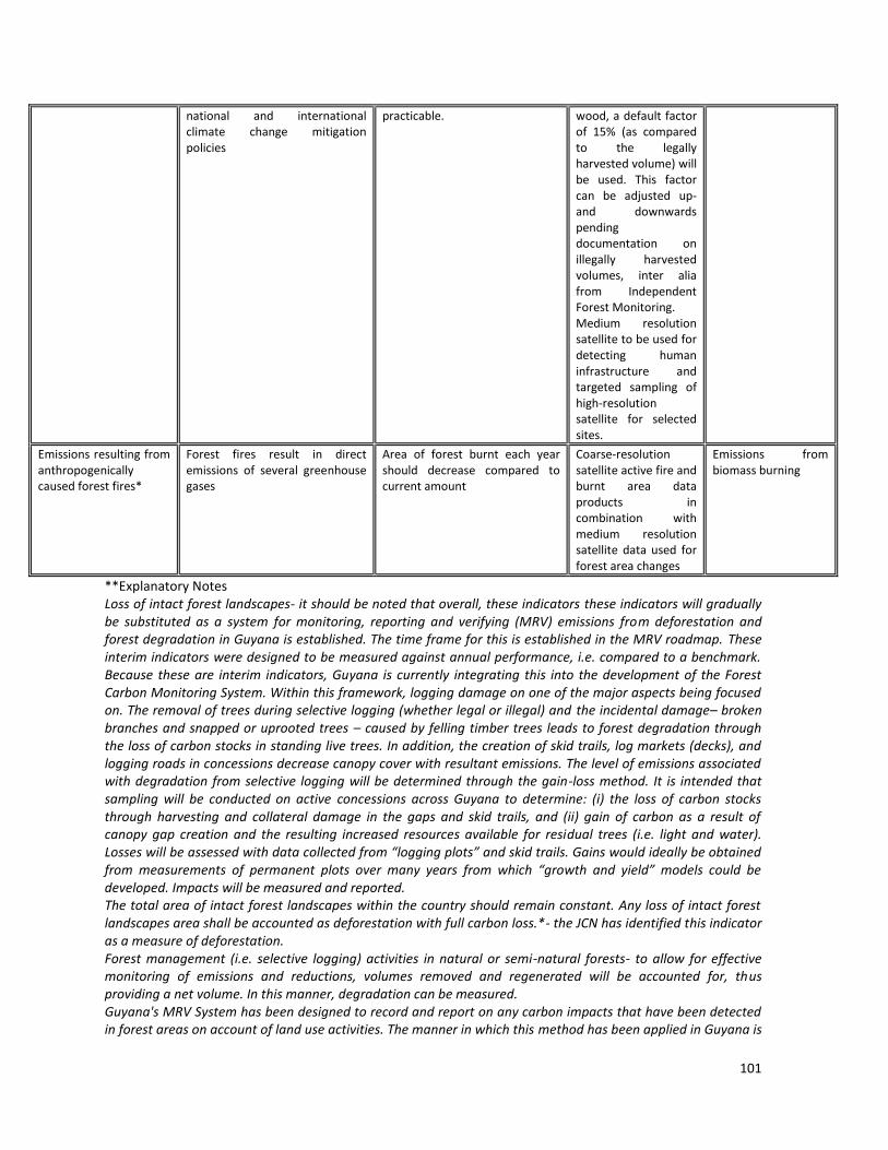
101
national and international climate change mitigation policies
practicable.
wood, a default factor of 15% (as compared to the legally harvested volume) will be used. This factor can be adjusted up-and downwards pending documentation on illegally harvested volumes, inter alia from Independent Forest Monitoring. Medium resolution satellite to be used for detecting human infrastructure and targeted sampling of high-resolution satellite for selected sites.
Emissions resulting from anthropogenically caused forest fires*
Forest fires result in direct emissions of several greenhouse gases
Area of forest burnt each year should decrease compared to current amount
Coarse-resolution satellite active fire and burnt area data products in combination with medium resolution satellite data used for forest area changes
Emissions from biomass burning
**Explanatory Notes Loss of intact forest landscapes- it should be noted that overall, these indicators these indicators will gradually be substituted as a system for monitoring, reporting and verifying (MRV) emissions from deforestation and forest degradation in Guyana is established. The time frame for this is established in the MRV roadmap. These interim indicators were designed to be measured against annual performance, i.e. compared to a benchmark. Because these are interim indicators, Guyana is currently integrating this into the development of the Forest Carbon Monitoring System. Within this framework, logging damage on one of the major aspects being focused on. The removal of trees during selective logging (whether legal or illegal) and the incidental damage– broken branches and snapped or uprooted trees – caused by felling timber trees leads to forest degradation through the loss of carbon stocks in standing live trees. In addition, the creation of skid trails, log markets (decks), and logging roads in concessions decrease canopy cover with resultant emissions. The level of emissions associated with degradation from selective logging will be determined through the gain-loss method. It is intended that sampling will be conducted on active concessions across Guyana to determine: (i) the loss of carbon stocks through harvesting and collateral damage in the gaps and skid trails, and (ii) gain of carbon as a result of canopy gap creation and the resulting increased resources available for residual trees (i.e. light and water). Losses will be assessed with data collected from “logging plots” and skid trails. Gains would ideally be obtained from measurements of permanent plots over many years from which “growth and yield” models could be developed. Impacts will be measured and reported. The total area of intact forest landscapes within the country should remain constant. Any loss of intact forest landscapes area shall be accounted as deforestation with full carbon loss.*- the JCN has identified this indicator as a measure of deforestation. Forest management (i.e. selective logging) activities in natural or semi-natural forests- to allow for effective monitoring of emissions and reductions, volumes removed and regenerated will be accounted for, thus providing a net volume. In this manner, degradation can be measured. Guyana's MRV System has been designed to record and report on any carbon impacts that have been detected in forest areas on account of land use activities. The manner in which this method has been applied in Guyana is
102
through the joint utilization of remote sensing imagery analysis and forest carbon stock assessment activities. Considering a possible threshold is one area that Guyana may explore in the further development of the MRV System.Unless a larger or smaller area or greenhouse gas emission impact can be documented through remote sensing or field observations, the area within a distance extending 500 meters from the new infrastructure (incl. mining sites, roads, pipelines, reservoirs) shall be accounted with a 50% annual carbon loss through forest degradation- 500 m was set as a conservative measure in reporting on degradation from new infrastructure and is expected as just an interim guide. GIS and Remote Sensing techniques will be used to ascertain the impacts of these activities and will be reported over the interim period. Areas that have been subject to change from forest to non- forest areas are accounted for as deforestation in each assessment period. In addition to this, intact forest landscapes (IFL) is being assessed for the same areas that have already been subject to the deforestation assessment. Any additional impacts outside of deforestation are those that are assessed under IFL and other degradation indicators.Emissions resulting from anthropogenically caused forest fires- these will be monitored from two perspectives- deforestation and degradation. In accordance with Guyana’s definition of forests, fires that lead to 1 ha or more of forest clearance will be classified as deforestation, while fires leading to lead to less than 1 ha of forest clearance will be measured as degradation. It should be noted that forests that are affected be fires as a result of shifting agriculture is classified as degradation. Based on assessments conducted in Guyana, it was found that fires that are anthropogenically caused are in managed lands and result in changes to land use. In so doing, these are treated separately and hence there is no double counting. Assessment of Degradation In assessing degradation, the intensity, extent of area and technique to be used are important considerations. Very high spatial resolution sensors will be required for mapping low intensity degradation. This will be informed by activity data. The spectral resolution and quality of the radiometric signal must be taken into account for monitoring forest degradation at high spatial resolution. The estimation of the abundance of the materials (i.e., end-members) found with the forested pixels, through SMA, requires at least four spectral bands placed in spectral regions that contrast the end members spectral signatures
35. The Brazilian model will
be assessed for possible extrapolation to Guyana, as outlined in GOFC-GOLD Source Book. Additionally, Brazil’s DETEX system will be assessed for possible applicability to Guyana. The Sample Design should also recommend a field based monitoring system that will allow for ground monitoring of degradation, again informed by activity data. Additionally, the feasibility of using airborne LiDAR to estimate the effect of degradation on forest carbon stocks will be investigated (Asner 2009). In terms of progress so far, Guyana has collaborated with two international expert firms, in the area of evaluating and demonstrating the feasibility of mapping deforestation and degradation from mining and related small scale disturbance for Guyana’s MRV System. Together with GFC, these experts have assessed the technical challenges in characterizing deforestation/degradation from mining using fine scale optical and SAR imagery. Resource and Capacity Requirement Capacity will need to be built at the institutional level at the GFC to operate such a system as well as to utilize satellite images for forest degradation monitoring and assessment. Defining key terms in Guyana’s context for the MRV System is an important aspect of the preliminary work that will be done. This includes defining forests, deforestation, forest degradation, etc. Work has already begun in the areas of capacity development both in forest area and forest carbon stock assessments. 4a.4 Monitoring Forest Carbon Stocks Field Data As outlined in the Roadmap, the activities that will be undertaken in the initial stage will include the design and implementation of a national carbon measurement system. This will involve the designing of national and sub-national stratification, the development of sample design and the conducting of required statistical analyses and the development of protocols for measurement of all carbon pools. To date, work has advanced in each of these areas.
35 GOFC-GOLD p. 32
103
4a.5 Method of Estimating CO2 Emissions Appropriate carbon pools will be assessed and emissions and net removals will also be determined. Land conversion by sub categories (if necessary) within various land uses will also be required to be defined and emissions and net removals will be assessed as per these sub categories. In conducting overall carbon estimating, carbon emissions into the atmosphere, transfer of carbon to other pools will also have to be considered, like in the case of biomass to deadwood during logging. The LULUCF Guidelines recommend either a stock-difference method or a gain-loss method for estimating the annual carbon stock change in biomass and dead organic matter (DOM) in “Forests Remaining Forests” (the land-use subcategory that encompasses forest degradation). In general, the gain-loss method is applicable for all tiers, while the stock-difference method is more suited to Tiers 2 and 3 assuming its application involves accurate and complete forest inventories based on sample plots. (GOFC-GOLD Sourcebook) The stock based approach as well as the gain loss approach will be assessed for applicability. It is recognized that the stock based approach requires estimates in both mineral and organic soil. Whether this is assessed as possible during the carbon stock assessment process will determine the suitability of this process. The Gain Loss Method requires for biomass growth rates to be collected. In the Tier 2 method, a combination of methods can be used to assess some carbon pools, e.g. soil. The method that will be used by Guyana will need to be consistently and uniformed applied and IPCC compliant. Methodological Approaches for the Estimation of Emissions from Various Drivers
36
The estimation of GHG emissions across Guyana as a whole is not possible without effective consideration of how carbon stocks may be distributed across the country with respect to specific drivers or agents of land-use change and other physiognomic features of the landscape (i.e., forest type, elevation, soils composition, etc.). Often forest carbon stocks vary based on forest type, and because Guyana has diverse forests, initial attempts at stratification incorporated forest type. However based on preliminary data collection from pilot plots, it was found that there is no significant difference in carbon stocks across multiple forest types in Guyana. The various drivers of land-use change, however, do result in GHG emissions of different magnitudes. For example, forest degradation through selective logging is likely to have a different GHG emission profile than deforestation from large-scale mining activities. A key first step in estimating emissions and removals is to stratify the forests as a whole is not possible without proper consideration of how carbon stocks may be distributed across the country with respect to specific drivers or agents of land-use change and other physiognomic features of the landscape (i.e., forest type, elevation, soils composition, etc.). Stratification of the forest lands is also important for developing a cost effective sampling plan and to increase the accuracy and precision of the resulting emission factors. The IPCC (Good Practice Guidance 2003, and Agriculture, Forestry, and Other Land Uses [AFOLU] 2006) provides the framework for estimating emissions and removals of CO2 in the AFOLU sector and will be used to design the FCMS for Guyana. The IPCC framework is based on estimating emissions and removals in five IPCC recognized carbon pools (aboveground biomass, belowground biomass, soil organic matter, litter, and dead wood) caused by changes in forest cover. Depending on country circumstances, all carbon pools do not need to be included in the design. A ‘key category’ analysis is used for determining which carbon pools should be included to accurately capture the emissions and removals from changes in forest cover. For the purposes of this sampling design, we include the following two categories of forest lands to be consistent with the IPCC GPG/AFOLU framework:
- Forest Land converted to other lands (Cropland, Grassland, Wetlands, Other, Settlements) is equivalent to deforestation
- Forest Land remaining Forest Land is equivalent to forest degradation and enhancement of carbon stocks (and also includes the activities of forest conservation and sustainable management of forests as part of the “plus” in REDD+).
At this point, activities on the development of Guyana’s MRV System have focused on the measurement deforestation is based on the forest/non forest map; as such, only forest changing to non forest will be
36 Sampling Design and Implementation Plan for Guyana’s REDD+ Forest Carbon Monitoring System (FCMS), Guyana Forestry Commission & Winrock International, September 2011

104
measured. The MRV System is based on the analysis of forest and non forest areas that are both analysed for change during each reporting period. In so doing, any forest to non-forest change will be mapped by driver and vice versa. The IPCC Guidelines refer to two basic inputs with which to estimate greenhouse gas emissions and removals: activity data and emissions factors. “Activity data” refer to the extent of a category, and in the case of deforestation and forest degradation/ enhancements refers to the change in areal extent of those categories, presented in hectares over a known time frame (usually per year). For the purposes of this report, activity data are referred to as area data. “Emission factors” refer to emissions/removals of greenhouse gases per unit area, e.g. tonnes carbon dioxide emitted per hectare of deforestation. Emissions/removals resulting from land-use conversion are manifested in changes in ecosystem carbon stocks, and for consistency with the IPCC framework, we use units of carbon rather than carbon dioxide, specifically tonnes of carbon per hectare (t C ha-1), to express emission factors. In the case of degradation, activity data may be something other than area impacted, such as cubic meters of timber removed, in which case emissions factors will be expressed as tonnes of carbon emitted per cubic meter removed. The activity data are covered by the GFC’s Year 1 Forest Area Change Assessment that was based on use of remote sensing imagery to estimate the changes in forest area. In this work, the focus is on developing emission factors for the drivers that cause change in forest cover in Guyana. There are two different but equally valid methods to estimate emissions factors: (1) the gain-loss method, in which the net balance of additions to and removals from a carbon pool is estimated; and (2) the stock-change method, in which the difference in carbon stocks caused by a change in forest cover is estimated. The distinction between these two approaches is a critical concept to understand before sampling design considerations in a REDD+ context can be discussed. When estimating emission factors for deforestation and afforestation/reforestation, the stock-change method is appropriate because carbon stocks can be obtained both before and after the events. When estimating emission factors for forest degradation or enhancement of carbon stocks in existing forests, the gain-loss method is more appropriate. Table 28- Main features of the two methods for estimating emission factors.
Stock-Change Gain-Loss
Definition Difference in C stocks in a particular pool in pre- and post-forest cover change
Net balance of additions to and removals from a carbon pool
Data requirements
Data needed on forest carbon stocks in key pools and fate of carbon after conversion
Annual data needed on Classes associated with tree harvest (felled tree and collateral damage in gap and from skid trails), and gains such as annual rates of forest growth post-harvest
Applications Most appropriate for avoided deforestation and afforestation/reforestation
Most appropriate for forest degradation caused by tree harvest and enhancement of carbon stocks in existing forests
Stratification & Data Collection In the development of robust emission factors for each activity that drives deforestation and degradation an intensive, thorough, initial sampling has been developed. The objective of this sample design is to objective is to estimate changes in carbon stocks across Guyana in locations that are most likely to undergo land use change in the future. Due to the spatial variability of land-use change drivers as well as the spatial variability of forest carbon stocks, a stratified sampling design was used to develop this framework. This stratified sampling design will allow the GFC maximum flexibility in designing a sampling protocol within each stratum that is tailored to the desired level of precision as well as the time and resources available to collect the data. Stratification criteria for the FCMS should include both ecological considerations that affect how much carbon is contained within in a given area of land as well as human pressure considerations related to how the land is being used (and how it will be used in the future). Because it is inefficient and unrealistic to measure forested areas across the country, the sample design we will focus on specific areas of interest, those areas (strata) that are most likely to experience change (deforestation or forest degradation) in next 10 years or so. Humans tend to deforest areas that are within a close approximation to roads and settlements (accessible for clearing),

105
clearly demarcating some areas as having high potential for future change and others low potential. The most recent historical periods, 2000-2005 and 2005-2009 were considered for defining the pattern of forest change. The total forested area was stratified into three (3) categories for sampling, High Potential for Change; Medium Potential for Change & Low Potential for Change, within each category, the land area was further sub-categorized into More Accessible and Less Accessible areas. The table below outlines this breakdown: Table 29-Outline of the Forest Carbon Sampling Strata and the Total Land Area of Each
Forest Carbon Sampling Strata Area (ha)
High Potential for change More accessible 2,406,962
Less accessible 3,052,513
Medium potential for change More accessible 1,545,518
Less accessible 4,393,950
Low Potential for change More accessible 391,208
Less accessible 5,847,870
Methodology The Map 1 below illustrates the stratification to be used in data collection for phase one of the development of the Forest Carbon Monitoring System. In order of priority, areas subjected to the highest potential for forest area change will be targeted first, followed by the medium threat areas, followed by the low threat areas. Map 1- Final stratification map showing location of the PSU for Phase 1
(Source: Sampling Design and Implementation Plan for Guyana’s REDD+ Forest Carbon Monitoring System (FCMS), Winrock International, September 2011)

106
Data collection will follow the steps outlined below, as described in the Sampling Design and Implementation Plan for Guyana’s REDD+ Forest Carbon Monitoring System (FCMS). Phase I Activities that have been completed or have commenced in Guyana are: 1. Collect field data in cluster plots to estimate the carbon stocks in aboveground, belowground, dead
biomass and soil pools in all plots – 20 cluster plots in the more accessible stratum, 15 in the less accessible.
2. Analyze data, calculating average carbon stocks and confidence intervals for the areas of high potential for change.
3. Establish and collect data in additional logging plots (at least 60) needed to reach target in concessions on 40 and 60 year cutting cycles; measure length and width of skid trails in a selection of small logging concessions.
4. Commission special studies on the following: - Soil carbon - Effects of fire on carbon stocks where fire causes both deforestation and degradation - Compile data to quantify factors for estimating proportion of timber going into long term wood
products - Shifting cultivation
o Refine survey questions regarding shifting cultivation and broaden respondents to survey
o Develop a time series of carbon sequestration versus time for each forest strata/practice combination
- Future studies to validate or increase the database of wood density values - Other degradation studies in process
o Small scale mining o Carbon stocks of firewood collection leases o Develop forest degradation factors and the width of their impact zones in the 500 m
buffers around deforestation infrastructure 5. Put together data entry and analysis framework for emission factors (file naming systems, file
organization, design data analysis worksheets, calculation of national factors, etc.) and develop emission factors for all deforestation and forest degradation drivers along with their corresponding uncertainty estimates.
6. Develop a tool to combine table of emission factors by each driver with area change data to automatically generate estimates of total emissions for each driver.
7. The IPCC (2006) recommends several indicators of quality for inventory and reporting: transparency, completeness, consistency, comparability, and accuracy.
PHASE II – Planned Activities:
1. Establish preliminary plots in areas of medium potential for change. 2. Using this preliminary data, determine number of Primary Sampling Units to sample within both more
and less accessible medium potential for change strata. 3. Analyze data, calculating average carbon stocks and confidence intervals for the areas of medium
potential for change. 4. Incorporate these stocks into table of emission factors.
Data Management The GFC has been performing the function as a national data clearinghouse to provide additional QA/QC control measures for the MRV System, to ensure against double counting. A combination of satellite and spatial datasets from three key agencies (GFC, GL&SC & GGMC) has been evaluated and assembled. These datasets form a base layer and also assist with identification of forest change events.

107
Table 30- GFC GIS Datasets
Data Group Layer Name Created/ Update Freq Description
Admin Guyana_boundary August 2010 Updated country boundary for Guyana.
Hydro waterbody August 2010 Water bodies layer, digitised from geocorrected Landsat imagery
Soil & Vegetation
soil_data 1960 National Soil map of Guyana. Produced by NARI
simpleveg 2001 National vegetation map of Guyana. Produced by Dr ter Steege
regionalveg 1960s Regional vegetation map for Guyana. (partial coverage only)
Forest Reserves
forest_ResAlloc_2010
6 monthly
ArcView3.3 Project containing a number of shapefiles detailing all forestry allocated areas – roads, reserves and Amerindian areas.
GFC_Reserves_dd NA A merged layer of GFC’s forest reserves
Bio-reserves_dd NA A merged layer of national bio-reserve/protected area
Managed Forest Areas
State_Forest_2006 2006 Layer showing the extent of the state forest boundary
TSA_WCL_Merged 6 monthly A merged layer showing all active Timber Sales Agreements (TSA) and Wood Cutting Leases (WCL) (large forest concessions
PropSFEP_Merged
6 monthly A merged layer of all proposed State Forest Exploratory Permits
activeSFEP_Merged
6 monthly A merged layer of all active State Forest Exploratory Permits
activeSFPs_Merged 6 monthly All active State Forest Permits (small forest concessions). Merged by Division – Demerara, Essequibo, Berbice, North West
logging_Camps
NA Point location of logging camp sites, based on the Annual Operating plan
harvest_Areas NA Polygons showing extent of harvest activities (pre 2008, 2008 & 2009)
Roads gps roads_dd 3-6 months All GPS roads and trails as at August 2010.
Gazetteer
placenames
NA Place names incl. villages, topographic and rivers features
Amerindian Areas
Amerindian_ areas_GL&SC
Upon titling process being finalised
Titled Amerindian areas in Guyana. Divided into administrative
Agricultural Leases
GFCAGleases
Upon titling Agricultural leases that fall within the State Forest Estate (Administrative Regions: 1, 2, 3, 6, 7, 8 and 10)
Mining Areas
LRG_Scale-Aug2010_region, MED_Scale-Aug2010_region, Mining dredges
Upon granting of mining permit/licence/claim
Large and Medium scale mining areas including dredge locations
108
A Standard Operating Procedure has been developed to define the procedures that are to be performed in data entry, validation, management and storage of field data collected for a REDD+ initiative in Guyana. These data collected includes: Biomass data, Logging Impact data, Destructive Sampling of trees data and Trees Growth Plot data. This SOP describes:
- Field data management procedures - Data entry procedures - Data validation procedures - Data storages and backup procedures
4a.6 Reporting under the MRV System The main principles of transparency, consistency, comparability, completeness and accuracy will be the key to an effective reporting framework. The reporting framework will be IPCC compliant. Although the reporting framework has not yet been decided at the level of the Conference of Parties, until such time that they are designed, the exiting GHG inventory reporting format will be referred to as a guide to this process. Reporting tables include classification of initial and final land use categories, identification and measurement of activity data, emissions factors, total change on carbon stock and total CO2 emissions. Relevant explanations and notations should also be provided in reporting formats. An example of this table is presented in GOFC-GOLD Sourcebook. Reporting will also be done in the initial phases prior to the MRV System being completed, along the interim performance indicators (mainly area based indicators) that Guyana will be required to report on as part of a financing mechanism. Under the Guyana Norway MoU, annual reporting is required. These reports are part of MRV System and had been set up to report on interim REDD+ indicators whilst the full MRV System is being designed. Following the period of this agreement, an assessment of the requirements and lessons learnt from this annual reporting will be conducted. This will then inform a determination of the frequency of reporting following, on agreements like the Guyana Norway MoU may also influence the frequency of reporting in the future. 4a.7 Verification Quality assurance and quality control procedures will be required to be developed. Accuracy assessments will be used to provide a check for bias and of confidence in predictions, through testing the system in a range of circumstances to check whether any inaccuracies in the results are biased toward over or underestimation in a national inventory. MRV systems are a long-term proposition and should be allowed to evolve over time. There will therefore be a need for continuous improvement in the system. Using the verifications and accuracy assessments efforts can be made to progressively improve models over time. Uncertainty assessment will also be required to assess the confidence that can be placed in the overall result of the model application at the reporting scale. Accuracy assessments are an important part of testing for any bias in inventory results. Validation and verification are also required and this is planned to be done by an independent 3rd Party expert. On completion of the Year 1 Assessment of Forest Area Change Assessment, the report, its content, methodology, analysis and results were subject to an Accuracy Assessment as well as independent third party verification. In the accuracy assessment, methods used followed the recommendations set out in the GOFC-GOLD guidelines to help identify and quantify uncertainty in the level and rate of deforestation in Guyana over the period 1990 to 2009 (Benchmark Period) and 2009 to 2010 (Interim Measures Period – Year 1). High spatial resolution imagery combined with low altitude photography and field visits are used to assess the wall-to-wall mapping of Guyana undertaken in the Year 1 Assessment of Forest Area Change Assessment. In particular, imagery from the German RapidEye satellite constellation system, the UK-led DMC satellite constellation and IKONOS provided sources for assessment of the 2010 (Year 1) mapping. A stratified sampling approach was adopted to help provide precise estimates of forest area. Two strata were selected according to “risk of deforestation”, that is, land proximal to settlements, roads, logging concessions and mining areas, and other low risk land area. A 10 km by 10 km grid square was overlaid on the country and using available GIS data, grid squares containing any of the risk variables were tagged as high risk and the remainder as low risk. The independent third party was contracted to perform a non-accredited verification of the Interim REDD+ Performance Indicators under the Guyana Norway REDD+ Partnership. This third party was tasked to verify the

109
results in the deforestation and forest degradation as detailed in the Guyana REDD+ Interim Measures Report. These results we verified by following the principled and requirements for verifying GHG Inventories and validating or verifying GHG projects defined by ISO 14064-3/27/. It must be noted that this is not an accredited verification applying ISO 14064-3/27/. But rather, this standard served to provide guidance for the definition of the verification plan. The objectives of the verification were as follows:
- Methodology verification- conformance of the analysis methodology and monitoring system in place against applicable validation/ verification criteria;
- Verification that the validates methodology has been followed to obtain the reported results; - Verification of the results of the Interim Performance Indicators; - Verification that the comments from stakeholders have been taken into account in the Guyana REDD+
Interim Measures Report This approach is expected to be continued in a similar manner over the MRV System period. 4a.8 Capacity Gap Assessment The evaluation of Guyana’s capacities and REDD+ specific characteristics provide the basis to specify the recommendations and next steps for developing capacities for the implementation of an MRV System for Guyana. Starting with an assessment of current capacities, additional information on country-specific characteristics and requirements for REDD+ were analyzed and discussed. The capacity gap assessment was performed for both international requirements (IPCC GPG) and national needs (through an assessment of current forest change processes). As synthesis of the capacity gap assessment, the national MRV development principles defined seven key action areas as immediate activities for starting the capacity development process for Guyana:
1. Develop and implement a national mechanism and institutional framework: - Steering body for the MRV system development (Office of climate change as coordinator of
activities) - Coordination and integration of national datasets through a high-level national technical
committee accompanied by a related legislative reform and development of a national data management system and infrastructure
- Participation, scientific advice and international partnering, i.e. through the establishment of a technical and scientific advisory group
2. Conduct a comprehensive forest area change assessment for a historical period: - Processing and interpretation of historical archived satellite datasets at national level for
forest area change, benchmark forest map and exploration of the monitoring of forest degradation
- Capacity building component included from the beginning 3. Build carbon stock measurement capacities:
- Design a national and sub-national stratification - Design protocols and implement measurements in all carbon pools - Targeted sampling and surveys to establish national conversions/expansion factors
4. Develop MRV for a set of REDD+ demonstration activities - Focus on key drivers/processes and engagement with implementation actors (i.e. land
owners, communities) - Conduct detailed monitoring at demonstration sites
5. Engagement with international community: - Explore the possibility of the GEO Task to help in satellite data acquisition from 2009 onwards - Partner with international organizations and research partners - Seek further advise/coordination with international activities
6. Sustained internal communication mechanism on MRV: - Development communication plan and outreach materials - Conduct a series of regional workshops and consultation to inform about REDD+ and MRV
7. Conduct/support research on key issues

110
- Scoping exercise for linking policy and MRV (actions, transactions) - Detailed national driver assessment and methods for reference level projection - Co-benefits of MRV (i.e. to support LCDS) and tools for decision-support in the context of
integrated natural resources management The execution of the work will be centralized at the Guyana Forestry Commission and this agency will be the focal agency for coordinating all aspects of data collection, analysis, research execution and assessments and for routine continuous monitoring of the system. This agency will work with consultants, data providers and suppliers, and stakeholders of the MRV System. 4a.9 Road Map for MRV System Development (See also Annex 4a) The development of a road map for the establishment of a system for measurement, reporting, and verification (MRV) as an initial investment to participate in any REDD+ mechanism requires the consideration of a number of necessary steps and different types of gaps to be addressed in different phases. The road map lists expected outcomes and capacity improvements for these different phases, as well as, a set of specific activities to fill four different types of gaps, and can be found in Annex 4a. Most importantly, REDD+ policy should drive MRV activities and vice versa, and this interaction needs to be established from the beginning. One of the fundamental questions initially is whether sufficient data are existing for the country to explore REDD+ opportunities and formulate a national REDD+ policy strategy and scope, and demonstrate implementation activities. This issue is targeted in the first phase and should be tackled right away, also considering opportunities for early REDD+ implementation and demonstrations. The seven priority action areas from the workshop discussions provided in the previous section will be used as baseline to specify efforts for the first phase. Activities include the establishment of institutional arrangements and filling some existing gaps to first derive initial datasets (data gap filling). The results should provide a thorough understanding on the activities of drivers and processes and their forest carbon impact, and how policies can be defined and implemented to affect them. In this phase, Guyana will also be aiming to build basic capacities to report on a set of interim performance indicators that will respond to an international REDD+ mechanism, focused on area based changes. The co-evolution of the MRV system and the national policy mechanisms to support the positive impact of REDD+ actions continues in the Readiness phase where the development of technical capacities, institutional arrangements and policies will result in the establishment of the reference level. This process will help provide the foundations for the eligibility to participate in REDD+ results-based crediting mechanisms. In both the Readiness and the implementation phase the large emphasis on measurements and monitoring will be extended to reporting and verification, i.e. through the establishment capacities to apply the IPCC GPG for international reporting. The implementation process may also include an effort to fill a methodological gap. Initial measurement and monitoring activities will use readily available (historical) data and methods that may be limited in achieving, for example, accuracy and completeness in national forest carbon monitoring and the GHG inventory. Furthermore, a consolidated national REDD+ implementation strategy and an analysis of IPCC key categories will result in a prioritization of what needs to monitored, reported and verified in the long-term with the main objective being to contribute to efforts in the key areas and processes designated with respect to REDD+ implementation actions. The current road map is associated with a timeline of 2010/11 for phase 1, 2011/12 for phase 2 and post 2012/13 for the implementation phase. This timing reflects the current planning and maybe accelerated if desired, i.e. the need to move towards a full Tier 3 system for participating in new REDD+ compensation instruments. The road map for MRV of Emissions and Removals can be found in Annex 4a.
111
4b. Other Benefits and Impacts
Within the Roadmap of the MRV System, it is detailed that exploration will be conducted into non carbon ecosystem services and the feasibility of these within the national MRV System. In this, the requirements of a monitoring system for carbon as well as non carbon variables will be assessed. Section 4b.1 discusses some of the other potential benefits and impacts that may be derived. 4b.1 Some of the other benefits which are foreseen are: - Involvement and empowerment of local communities though building the capacities of local communities to become engaged
in activities relating to the MRV System. While Guyana’s approach to the MRV System is that of a national approach, its success lies with the involvement of local communities, the private sector and to some extent, local NGOs. This will allow for the local communities to engage more effectively in any emerging forest payment schemes such as REDD+. It is foreseen that communities will benefit from new training and employment opportunities and will support REDD+ benefit-sharing mechanisms that compensate them or provide incentives for maintaining their forests.
- Multiple benefits from monitoring of non-carbon services such as biodiversity, production of food and water, watershed protection, disaster prevention: preventing floods, soil erosion and landslides etc. Some of the foreseen benefits are for examples socio-economic in terms of improved livelihoods; and ecosystem services, such as protection of biodiversity and watersheds. The monitoring of these multiple benefits will make it possible for Guyana to adapt national REDD+ strategies in order to avoid harm and maximize multiple benefits.
- More coordinated and harmonized monitoring and enforcement by the local natural resources management agencies - through improved institutional capacity and strengthening, the natural resources management agencies can monitor not only changes in carbon, but non- carbon elements. Improvements in areas such as remote sensing, carbon stock assessment and governance have been highlighted.
- Expansion of access to services, and the creation of new economic opportunities for Amerindian and other forest dependent communities through improved social services (including health and education), low-carbon energy sources, clean water and employment which does do not threaten the forest.
- Improve services to the broader Guyana citizenry, including improving and expanding job prospects, promoting private sector entrepreneurship, and improving social services with a particular focus on health and education.
Biodiversity & PES In investigating the role of biodiversity and Payment for Ecosystem Services (PES) Schemes, a number of initiatives are being undertaken, including:
a. ‘Strengthening Guyana’s Capacity to Manage Forest Resources and Environmental Services through Resources Assessment and Monitoring Changes in Deforestation and Degradation’ that conducted initial work on the exploration of ecosystem services in Guyana and, supported by the ITTO, aimed to:
- Assess the potential and feasibility of market based and other remuneration systems for compensating environmental services through the assessment of available market mechanisms,
- Assess the incentives programmes and remuneration systems for environmental services appropriate for Guyana - Evaluate the requirements that are necessary to access identified markets and remuneration systems appropriate for Guyana. - This focused on carbon markets, watershed services and biodiversity (both direct & indirect)
b. CI/KfW funded, Avoided Deforestation through Consolidation and Creation of Protected Areas and Carbon Financing Mechanisms in the Guiana Region (Guyana). Under this project, there will be exploration methodological issues regarding the integration of ecosystem services. Specifically, the consultant shall:
- Identify ecosystem services relevant for national well-being, inclusive of those identified in the ITTO study, using desk review as the primary source of data;
- Prioritise the identified ecosystem services according to relevance and in discussion with national stakeholders, inclusive of Conservation International Guyana;
- Evaluate the requirements necessary for the development of a monitoring system for the priority ecosystem services; - Examine the requirements of integrating the monitoring of priority ecosystem services into the proposed existing framework of
the national MRV System; - Recommend a measurement based upon practicability and available historic data; - Recommend a monitoring scheme for ecosystem services that is compatible with Guyana’s MRV System design.

112
The results obtained from this overall activity will allow for the Government of Guyana to be better informed on the requirements of engaging in markets for key or priority ecosystem services, provide a solid basis for decision making and assess the feasibility of incorporating relevant ecosystem services into the MRV System.
c. ROBIN (Role Of Biodiversity In climate change mitigatioN) will deliver the knowledge and tools required to inform large-scale policy and local resource use decisions for the delivery of multiple ecosystem services under future scenarios for socio-economic and climate change. The project aims at providing information for policy & resource use options under scenarios of socio-economic & climate change to: quantify interactions between terrestrial Biodiversity, land use and Climate Change Mitigation potential in tropical Latin America and develop scenarios for Climate Change Mitigation options. The project will achieve this by combining new techniques (including remote sensing) for Biodiversity assessments in complex multi-functional landscapes, data-based analyses, integrated modelling & participatory-driven approaches at local & regional scales. Its objectives will be to:
- Quantify the role of biodiversity in terrestrial ecosystems in South and Mesoamerica in mitigating climate change; - Quantify local and regional interactions between biodiversity, land use and climate change mitigation potential and the delivery
of other key ecosystem services; - Evaluate the socio-ecological consequences of changes in biodiversity and ecosystem services under climate change; - Evaluate the effects of current climate change mitigation policies and actions on ecological and socio-economic conditions; - Analyse the impacts of alternative land-use scenarios (and other mitigation options) aimed at maximising climate mitigation
potential while minimising loss of biodiversity and ecosystem services and avoiding undesirable ecological and socio-economic effects; and
- Provide guidance on land-use planning and other climate change mitigation options such as low carbon strategies and bio-fuel production.
The project is funded by the European Union, through its Seventh Framework Programme , under the Sub-programme Area: Potential of biodiversity and ecosystems for the mitigation of climate change The ROBIN Consortium consists of twelve partners from three continents; six in Europe (Natural Environment Research Council – Centre for Ecology and Hydrology (NERC-CEH), UK ,ALTERRA, Netherlands, Institute of Social Ecology, Alpen-Adria Universität Klagenfurt, Austria (UNI-KLU), Potsdam Institute for Climate Impact Research, Germany (PIK), Wageningen University, Netherlands (WU) and Universidad Politécnica de Madrid, Spain (UPM)), three in Meso-America (National Commission for Knowledge and Use of Biodiversity , Mexico(CONABIO), Instituto de Ecología, A.C.) (INECOL) and Universidad Nacional Autónoma de México (UNAM)) and three in South America (Brazilian Agricultural Research Corporation (EMBRAPA), Bolivian Institute of Forest Research (IBIF) and GFC). To meet these objectives the project will bring together an inter-disciplinary team from Europe and Latin America undertaking research aimed at understanding the relationships between biodiversity and climate change mitigation options. The work will be carried out using a combination of long-term locally derived data, data-based analyses; cross-scale integrated modelling and participatory approaches at local (landscape) and regional scales. Regional studies in Mesoamerica and Amazonia will be used to develop broad scale understanding of the relationships between biodiversity and climate mitigation options and will produce results that feed into policy processes. Local case studies, selected from 16 multi-functional landscape-scale sites across a climatic gradient in tropical forest areas of Latin America, will be used to understand the drivers and barriers affecting the adoption by stakeholders of response options for both climate change mitigation and biodiversity management. These sites will also be used to investigate “unforeseen consequences” of mitigation options arising from collateral effects on biodiversity and trade-offs with other ecosystem services. The main impacts of the work will be improved outcomes from climate change mitigation and biodiversity protection measures, decreased rates of biodiversity loss and improved design and implementation of REDD+ and REDD++ schemes in Latin America to ensure increased storage of carbon in forests and multi-functional landscapes. 4b.2 How the MRV System will monitor social and environmental impacts, and how it will build on the existing environmental and social monitoring systems of the country Guyana has a national environmental legislation in the form of the Environmental Protection Act, 1996, the objective of which is to "to provide for the management, conservation, protection and improvement of the environment, the prevention or control of pollution, the assessment of the impact of economic development on the environment, the sustain- able use of natural resources and for matters incidental thereto or connected therewith.” The MRV through assessments of the inclusion of non-carbon benefits will evaluate means by which environmental and social monitoring can be incorporated into the MRV System in accordance with the national legislation.

113
4b.3 How key governance factors pertinent to REDD implementation will be addressed by the monitoring system Governance issues within the entire REDD+ framework for Guyana, inclusive of the MRV System, will be addressed by the REDD+ Governance Development Plan (refer to Component 2a). The 23 sections of the RGDP are focused around areas of training and capacity building, legality and verification, improving GFC’s monitoring capacity, extending community forest activities to additional forest based communities - includes training in SFM implementation, formation of community associations and training in decision making and forest management etc. 4b.4. Scope and role for local communities, NGOs, various government agencies or institutes, and the private sector in the MRV system For the MRV System to be successfully implemented and managed, it is important for there to be in the involvement of not only government stakeholders, but also communities, NGOs and the Private Sector. With the implementation of demonstration projects (refer to Component 2b) these stakeholder groups will be engaged in both implementation and management of these projects. Training, capacity build as well as equipment will be provided to communities and other institutions that will be involved. For villages that Opt In, they will be expected to management these project without government involvement, unless requested by these communities; as such, they will be expected to sustainably manage these projects. Further, the integration of these stakeholders into the process will ensure participation and transparency amongst the various stakeholders involved. 4b.4 Assessment of existing capacities The capacity gap assessment was performed for both international requirements (IPCC GPG) and national needs (through an assessment of current forest change processes, Table below). This table also identified main processes that impact on forest carbon change in Guyana’s forest. Performance Indicators: a. Continued Forest Area Change Assessment to monitor the drivers of change b. Implementation of the Forest Carbon Monitoring System, using both field data as well as RS & GIS data c. Continued capacity building for relevant parties involved to ensure the sustainability of the MRV System d. Exploration of non-carbon PES schemes and their suitability for Guyana e. A QA/QC system in place for ensuring data quality, management and storage
Summary The establishment of this monitoring system seeks to provide annual, accurate estimates of changes in forest cover and degradation with national coverage by a transparent, objective and verifiable methodology. The reporting system provides comparisons between monitoring system output summaries and the reference scenario to provide net changes in carbon for REDD+ accounting. The verification system requires that procedures and data sources are objective, well-documented, secure and verifiable, and are subject to such peer-review and external audit as may be determined necessary.
Main Activity Sub-Activity Estimated Cost (in USD$)
Year 1 Year 2 Year 3 Year 4 Total
Establish data and information framework
Gather and integrate information & fill data gaps for national REDD+ opportunities, scoping and policy development
450,000 200,000 200,000 100,000 950,000
Develop key capacities to execute MRV
Develop capacities, conduct historical monitoring, and implement a (minimum) IPCC Tier 2 national forest carbon monitoring, establish the reference level and report on interim performance
950,000 500,000 50000 30000 1,530,000
Execute MRV on routine basis
Monitor Other Benefits 50,000 50,000 40000 140,000

114
Establish consistent and continuous MRV supporting national REDD+ actions and international IPCC GPG-based reporting and verification
450,000 500,000 140,000 1,090,000
Total 1,450,000 1,200,000 790,000 270,000 3,710,000
Government 50,000 30,000 30,000 110,000
Other Financing: GRIF, CI KfW Support 1,400,000 1,170,000 760,000 270,000 3,600,000
FCPF 0 0 0 0 0
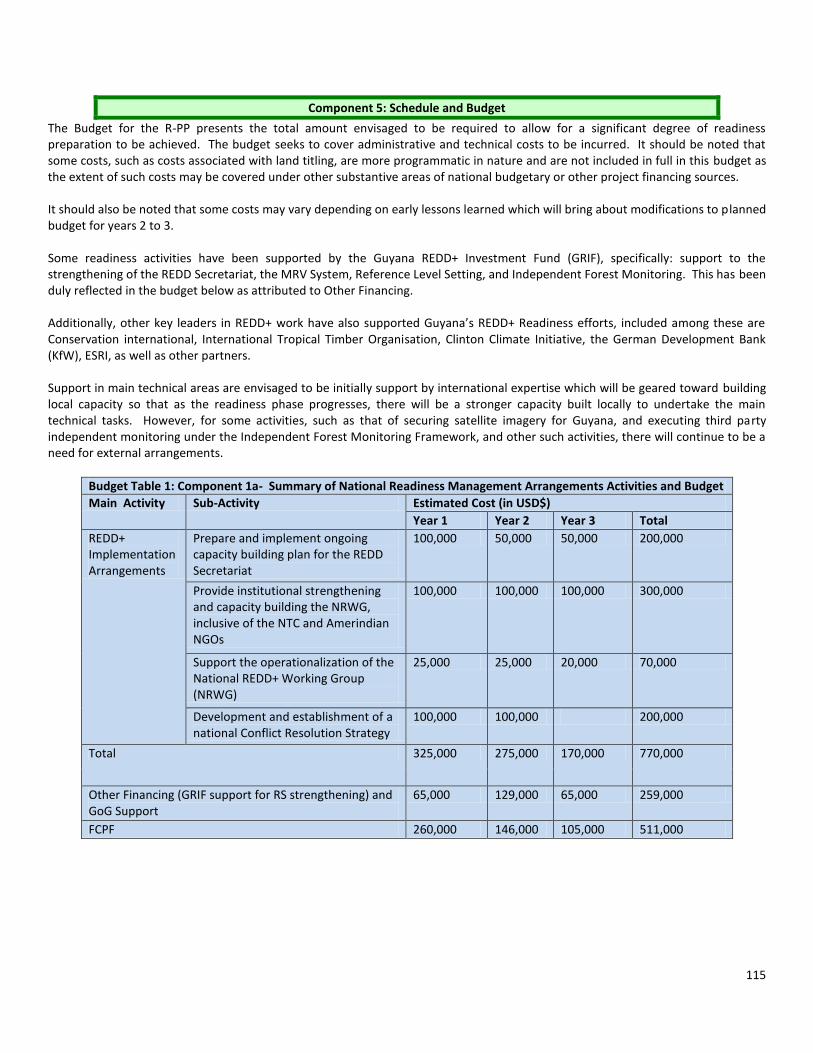
115
Component 5: Schedule and Budget
The Budget for the R-PP presents the total amount envisaged to be required to allow for a significant degree of readiness preparation to be achieved. The budget seeks to cover administrative and technical costs to be incurred. It should be noted that some costs, such as costs associated with land titling, are more programmatic in nature and are not included in full in this budget as the extent of such costs may be covered under other substantive areas of national budgetary or other project financing sources. It should also be noted that some costs may vary depending on early lessons learned which will bring about modifications to planned budget for years 2 to 3. Some readiness activities have been supported by the Guyana REDD+ Investment Fund (GRIF), specifically: support to the strengthening of the REDD Secretariat, the MRV System, Reference Level Setting, and Independent Forest Monitoring. This has been duly reflected in the budget below as attributed to Other Financing. Additionally, other key leaders in REDD+ work have also supported Guyana’s REDD+ Readiness efforts, included among these are Conservation international, International Tropical Timber Organisation, Clinton Climate Initiative, the German Development Bank (KfW), ESRI, as well as other partners. Support in main technical areas are envisaged to be initially support by international expertise which will be geared toward building local capacity so that as the readiness phase progresses, there will be a stronger capacity built locally to undertake the main technical tasks. However, for some activities, such as that of securing satellite imagery for Guyana, and executing third party independent monitoring under the Independent Forest Monitoring Framework, and other such activities, there will continue to be a need for external arrangements.
Budget Table 1: Component 1a- Summary of National Readiness Management Arrangements Activities and Budget
Main Activity Sub-Activity Estimated Cost (in USD$)
Year 1 Year 2 Year 3 Total
REDD+ Implementation Arrangements
Prepare and implement ongoing capacity building plan for the REDD Secretariat
100,000 50,000 50,000 200,000
Provide institutional strengthening and capacity building the NRWG, inclusive of the NTC and Amerindian NGOs
100,000 100,000 100,000 300,000
Support the operationalization of the National REDD+ Working Group (NRWG)
25,000 25,000 20,000 70,000
Development and establishment of a national Conflict Resolution Strategy
100,000 100,000 200,000
Total 325,000 275,000 170,000 770,000
Other Financing (GRIF support for RS strengthening) and GoG Support
65,000 129,000 65,000 259,000
FCPF 260,000 146,000 105,000 511,000
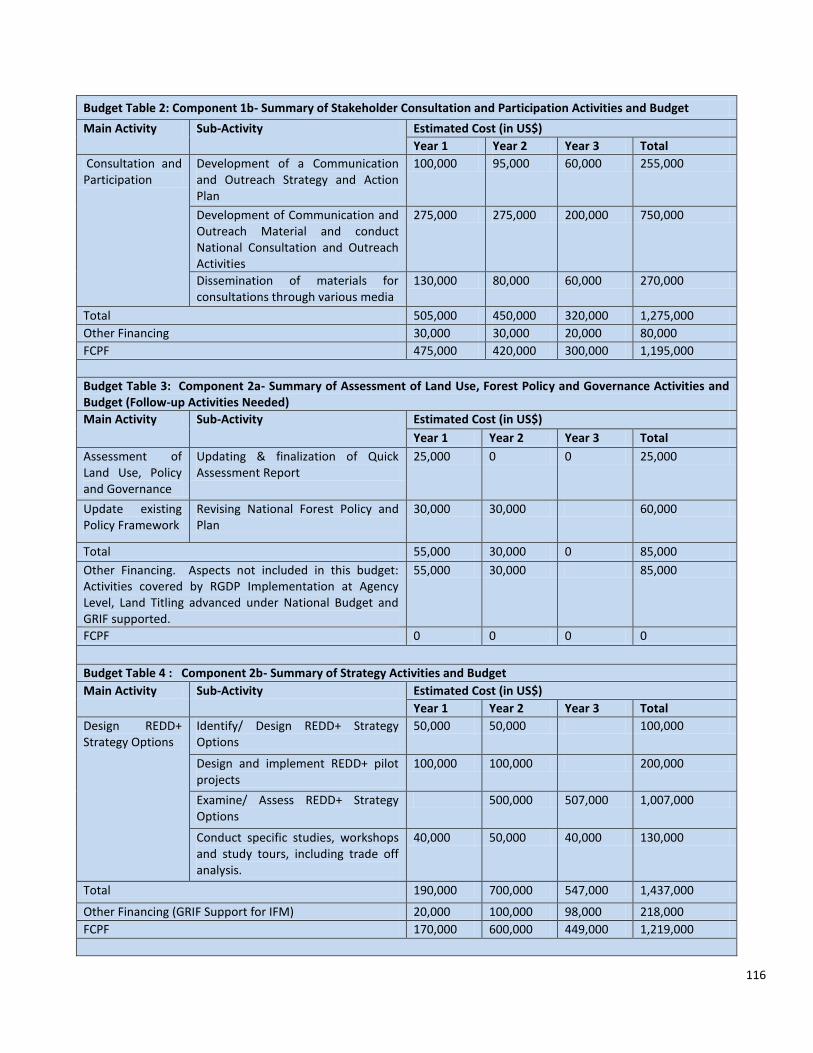
116
Budget Table 2: Component 1b- Summary of Stakeholder Consultation and Participation Activities and Budget
Main Activity Sub-Activity Estimated Cost (in US$)
Year 1 Year 2 Year 3 Total
Consultation and Participation
Development of a Communication and Outreach Strategy and Action Plan
100,000 95,000 60,000 255,000
Development of Communication and Outreach Material and conduct National Consultation and Outreach Activities
275,000 275,000 200,000 750,000
Dissemination of materials for consultations through various media
130,000 80,000 60,000 270,000
Total 505,000 450,000 320,000 1,275,000
Other Financing 30,000 30,000 20,000 80,000
FCPF 475,000 420,000 300,000 1,195,000
Budget Table 3: Component 2a- Summary of Assessment of Land Use, Forest Policy and Governance Activities and Budget (Follow-up Activities Needed)
Main Activity Sub-Activity Estimated Cost (in US$)
Year 1 Year 2 Year 3 Total
Assessment of Land Use, Policy and Governance
Updating & finalization of Quick Assessment Report
25,000 0 0 25,000
Update existing Policy Framework
Revising National Forest Policy and Plan
30,000 30,000 60,000
Total 55,000 30,000 0 85,000
Other Financing. Aspects not included in this budget: Activities covered by RGDP Implementation at Agency Level, Land Titling advanced under National Budget and GRIF supported.
55,000 30,000 85,000
FCPF 0 0 0 0
Budget Table 4 : Component 2b- Summary of Strategy Activities and Budget
Main Activity Sub-Activity Estimated Cost (in US$)
Year 1 Year 2 Year 3 Total
Design REDD+ Strategy Options
Identify/ Design REDD+ Strategy Options
50,000 50,000 100,000
Design and implement REDD+ pilot projects
100,000 100,000 200,000
Examine/ Assess REDD+ Strategy Options
500,000 507,000 1,007,000
Conduct specific studies, workshops and study tours, including trade off analysis.
40,000 50,000 40,000 130,000
Total 190,000 700,000 547,000 1,437,000
Other Financing (GRIF Support for IFM) 20,000 100,000 98,000 218,000
FCPF 170,000 600,000 449,000 1,219,000
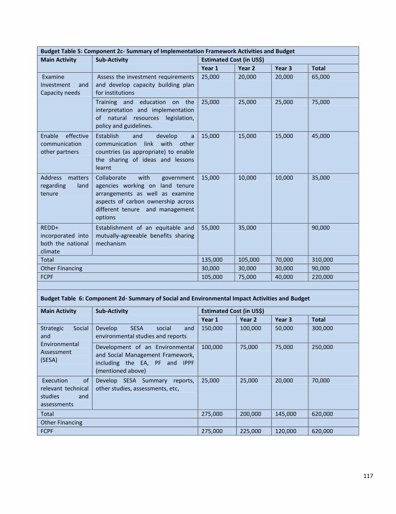
117
Budget Table 5: Component 2c- Summary of Implementation Framework Activities and Budget
Main Activity Sub-Activity Estimated Cost (in US$)
Year 1 Year 2 Year 3 Total
Examine Investment and Capacity needs
Assess the investment requirements and develop capacity building plan for institutions
25,000 20,000 20,000 65,000
Training and education on the interpretation and implementation of natural resources legislation, policy and guidelines.
25,000 25,000 25,000 75,000
Enable effective communication other partners
Establish and develop a communication link with other countries (as appropriate) to enable the sharing of ideas and lessons learnt
15,000 15,000 15,000 45,000
Address matters regarding land tenure
Collaborate with government agencies working on land tenure arrangements as well as examine aspects of carbon ownership across different tenure and management options
15,000 10,000 10,000 35,000
REDD+ incorporated into both the national climate
Establishment of an equitable and mutually-agreeable benefits sharing mechanism
55,000 35,000 90,000
Total 135,000 105,000 70,000 310,000
Other Financing 30,000 30,000 30,000 90,000
FCPF 105,000 75,000 40,000 220,000
Budget Table 6: Component 2d- Summary of Social and Environmental Impact Activities and Budget
Main Activity Sub-Activity Estimated Cost (in US$)
Year 1 Year 2 Year 3 Total
Strategic Social and Environmental Assessment (SESA)
Develop SESA social and environmental studies and reports
150,000 100,000 50,000 300,000
Development of an Environmental and Social Management Framework, including the EA, PF and IPPF (mentioned above)
100,000 75,000 75,000 250,000
Execution of relevant technical studies and assessments
Develop SESA Summary reports, other studies, assessments, etc,
25,000 25,000 20,000 70,000
Total 275,000 200,000 145,000 620,000
Other Financing
FCPF 275,000 225,000 120,000 620,000

118
Table 7: Component 3- Summary of Reference Scenario Activities and Budget
Main Activity Sub-Activity Estimated Cost (US$)
Year 1 Year 2 Year 3 Year 4 Total
Design & develop reference scenario model in readiness framework
Integration of MRV System data and results into Reference Scenario Modelling
75,000 75,000 150,000
Historical reference scenario developed, with stakeholders feedback
100,000 100,000
Reference scenarios projection completed with stakeholders feedback
0
Conduct Independent assessment
Review by independent expert. 50,000 50,000
Total 75,000 175,000 50,000 0 300,000
Other Financing: GRIF, CI KfW Support, CCI 75,000 175,000 50,000 300,000
FCPF 0 0 0 0 0
Budget Table 8: Component 4- Summary of Monitoring Activities and Budget
Main Activity Sub-Activity Estimated Cost (in US$)
Year 1 Year 2 Year 3 Year 4 Total
Establish data and information framework
Gather and integrate information & fill data gaps for national REDD+ opportunities, scoping and policy development
450,000 200,000 200,000 100,000 950,000
Develop key capacities to execute MRV
Develop capacities, conduct historical monitoring, and implement a (minimum) IPCC Tier 2 national forest carbon monitoring, establish the reference level and report on interim performance
950,000 500,000 50,000 30,000 1,530,000
Execute MRV on routine basis
Monitor Other Benefits 50,000 50,000 40,000 140,000
Establish consistent and continuous MRV supporting national REDD+ actions and international IPCC GPG-based reporting and verification
450,000 500,000 140,000 1,090,000
Total 1,450,000 1,200,000 790,000 270,000 3,710,000
Government 50,000 30,000 30,000 110,000
Other Financing: GRIF, CI KfW Support 1,400,000 1,170,000 760,000 270,000 3,600,000
FCPF 0 0 0 0 0
Table 9: Component 6- Summary of Programme M&E Activities and Budget
Main Activity Sub-Activity Estimated Cost (US$)
Year 1 Year 2 Year 3 Year 4 Total
Monitor and evaluate activities
Finalise Monitoring Framework 5,000 5,000
Monitor and evaluate Progress and develop Progress Reports
5,000 5,000 5,000 15,000
Report on activities progress
Disseminate reports and deliverables 15,000 10,000 10,000 35,000

119
Develop final M&E Report 15,000 15,000
Assemble Guyana’s REDD Readiness Package
Develop Package
Conduct on Elements of Package 5,000 5,000 5,000 15,000
Total 30,000 20,000 35,000 85,000
Other Financing 10,000 10,000 30,000 50,000
FCPF 20,000 10,000 5,000 35,000
Summary Table of Total Amount Requested from FCPF by Component
Component Amount Requested (USD)
Component 1a- Summary of National Readiness Management Arrangements Activities
511000
Component 1b- Summary of Stakeholder Consultation and Participation Activities
1,195,000
Component 2a- Summary of Assessment of Land Use, Forest Policy and Governance Activities
0
Component 2b- Summary of Strategy Activities 1,219,000
Component 2c- Summary of Implementation Framework Activities
220,000
Component 2d- Summary of Social and Environmental Impact Activities
620,000
Component 3- Summary of Reference Scenario Activities
0
Component 4- Summary of Monitoring Activities 0
Component 6- Summary of Programme M&E Activities
35,000
Total 3,800,000

120
Component 6: Design a Programme Monitoring and Evaluation Framework
The REDD Secretariat will coordinate the preparation of monitoring and progress reports according to the requirements of FCPF. All activity centres will submit quarterly (as appropriate) and annual reports, which will form the basis for compilation of quarterly and annual programme reports. The M& E framework has been designed using Mid Phase and Readiness Indicators to measure the progress and success of the activities in the components to be implemented. These measurements will be conducted both midway through and at the end of REDD+ readiness implementation. These evaluations will be conducted by the OCC, GFC & REDD Secretariat.
Table showing Mid Phase & Readiness Indicators to be used in the System for Monitoring & Evaluation of Components of the R-PP
Component Mid-phase indicators/deliverables Readiness indicators/deliverables
Component 1- Organize and Consult
1a. National Readiness Management Arrangements
Reports from meeting held by the RS with the NRWG Reporting structure for the NRWG Discussions on conflict resolution protocol
Meeting reports of the RS & NRWG Effective conflict resolution protocol Outreach and consultation reports
1b. Stakeholder Consultation and Participation
Educational materials on REDD+ Schedule for Consultation and Outreach activities Summary of initial dissemination
Reports from consultations (based on communities’ inputs & feedback) Reports from Consultations available online. Final Report on consultation and outreach activities in accordance with Plan
Component 2: Prepare the REDD+ Strategy
2a. Assessment of Land Use, Forest Policy and Governance
Forest Policy and Plan revised
Revised National Forest Plan Revised National Forest Policy
2b. REDD+ Strategy Options
Tentative list of REDD+ candidate activities Specific studies outline Feedback process documented Report on identified demonstration activities
List of REDD+ candidate activities Specific studies, workshops, etc completed. Design and evaluation of three Pilot projects Trade off analysis
2c. REDD+ Implementation Framework
Initial Assessment on investment requirements and capacity building plan Outline of benefits sharing mechanism Communication link developed between other FCPF countries and Guyana
Investment and Capacity Plan Benefits Sharing mechanism Effective communication link
2d. Social and Environmental Impacts
Initial consultation reports and technical reports on SESA Framework 2. Initial technical assessments
Consultation and Participation Framework for SESA Monitoring and Evaluation Framework for SESA Consultation Reports Technical Studies and Assessments

121
M&E is viewed as a critical component in the implementation of the R-PP. In conducting this M&E, each activity will be evaluated in terms of its approach and the outcome of each. At the Mid Phase, it will be done to effectively conduct ongoing performance monitoring. The overall objective at this phase will be to Monitor performance of projects, introduce corrective measures as needed, and distil lessons from project implementation. The GFC & RS will closely monitor the implementation of readiness activities. A range of performance indicators will be monitored on a quarterly basis, while importantly, the Readiness indicators related to general project objectives would be monitored at the end of implementation.
Component Performance Indicators
1a The REDD+ Governance & Management Arrangements will be monitored. Evaluations will be performed based and in compliance with the Common Approach.
1b Convening of the National REDD+ Working Group to oversee the development and execution of REDD+ Consultation and Outreach Activities. Capacity building sessions for the members of the National Toshaos Council to build their technical capacities in conducting REDD+ consultation and outreach sessions. Total number of consultation and outreach sessions held throughout the country by both the GFC & NTC on REDD+. Feedback received from targeted stakeholders during the consultation period.
2a Completion/Continuation of identified activities in RGDP that are allocated to the GFC; Outcomes of annual forest area change assessments for the next five years; Continuous monitoring of drivers of forest area change;
2b Consultations with forest dependent communities in the development and selection of feasible and appropriate REDD+ Candidate Activities as well as ; Consultations on the development and selection of alternative economic opportunities as well as in the development and implementation of pilot demonstration activities; Development of REDD+ Candidate activities targeting the drivers of forest area change; Studies, consultations, study tours, demonstration projects and community programmes conducted to inform the REDD+ Strategy,
2c Review and revision of policy documents and guidelines related to each sector, to incorporate REDD+ implementation and considerations into each;
Component 3: Develop a Reference Scenario
Develop a Reference Scenario
Acquisition of satellite & Remote Sensing images for specified historical period Forest Area Assessment report Reference Scenarios Assessment report
Data on forest area, land cover change and carbon density. Historical reference scenario developed Reference scenarios projection completed Review completed by independent Expert
Component 4: Design a Monitoring System
4a. Emissions and Removals
Benchmark Forest Map Reports on Capacity Building Session Methodology (sample design, protocols, long term monitoring plan) developed for monitoring of forest carbon stock. Report on interim performance Reports from MRVS Steering Committee meetings & Technical Subcommittee meetings
Forest area change assessment for historical and current period Carbon assessment and monitoring for carbon pools Data and Reporting framework for MRV System Consistent and continuous MRV System reporting Report on REDD+ Policy and Opportunities

122
Collaboration and coordination with international entities in REDD+ implementation Development of a capacity building road map for REDD+ implementation; Involvement of key stakeholders through consultation and outreach as well as capacity building sessions
2d Identification of the key environmental and social impacts as well as the legal and policy implications of the proposed REDD+ strategy Consultations sessions conducted with stakeholders on the SESA Preparation of a social and environmental management framework to guide the implementation of the REDD+ strategy implementation. Compliance with Environmental & Social Safeguard Policies.
3 Data on forest area, land cover change and carbon density. Historical reference scenario developed, with stakeholders’ feedback Reference scenarios projection completed with stakeholders’ feedback Review completed by independent Expert.
4 Continued Forest Area Change Assessment to monitor the drivers of change Implementation of the Forest Carbon Monitoring System, using both field data as well as RS & GIS data Continued capacity building for parties involved to ensure the sustainability of the MRV System Exploration of non-carbon PES schemes and their suitability for Guyana
Summary The REDD Secretariat, as the permanent secretariat of the NRWG, will coordinate the preparation of monitoring and progress reports according to the requirements of FCPF using inputs from the NRWG and relevant specialized agencies. All activity centres will submit quarterly (as appropriate) and annual reports, which will form the basis for compilation of quarterly and annual programme reports.
Table 2: Summary of Programme M&E Activities and Budget
Main Activity Sub-Activity Estimated Cost (US$)
Year 1 Year 2 Year 3 Year 4 Total
Monitor and evaluate activities
Finalise Monitoring Framework
5,000 5,000
Monitor and evaluate Progress and develop Progress Reports
5,000 5,000 5,000
15,000
Report on activities progress
Disseminate reports and deliverables
15,000 10,000 10,000 35,000
Develop final M&E Report
15,000 15,000
Assemble Guyana’s REDD Readiness Package
Develop Package
Conduct on Elements of Package
5,000 5,000 5,000 15,000
Total 30,000 20,000 35,000 85,000
Other Financing 10,000 10,000 30,000 50,000
FCPF 20,000 10,000 5,000 35,000

123
Bibliography 1. Government of Guyana, Guyana Second National Communication to the UNFCCC, August 2012 2. Guyana Forestry Commission Guyana REDD+ Monitoring Reporting and Verification System (MRVS) Interim Measures Report
Final, March 16, 2011 3. Guyana Forestry Commission, Guyana REDD+ Monitoring Reporting & Verification System (MRVS) Interim Measures Report 01
October 2010 – 31 December 2011 Version 1, 15 June 2012 4. Guyana Forestry Commission, Terms of Reference for Developing Capacities for a national Monitoring, Reporting and
Verification System to support REDD+ participation of Guyana Background, Capacity Assessment and Roadmap, November 13, 2009
5. Guyana Forestry Commission and Winrock International, A Pilot Study to Assess Forest Degradation Surrounding New Infrastructure, February 2012
6. Guyana Forestry Commission and Winrock International, Establishing a Reference Level for REDD+ in Guyana, June 2012 7. Guyana Forestry Commission and Winrock International, Sampling Design and Implementation Plan for Guyana’s REDD+ Forest
Carbon Monitoring System (FCMS) Final, July 2012 8. Guyana Forestry Commission and Winrock International, Spatial Analysis for Forest Carbon Stratification for Guyana (FCMS)
Interim Technical Report, May 2011 9. Guyana Forestry Commission and Winrock International, Standard Operating Procedures for the Forest Carbon Monitoring
System of Guyana, September 2011 10. Office of the President Republic of Guyana, Developing a Framework for an “Opt in” Mechanism for Amerindian Communities
Concept Paper, March 2010 11. Office of the President Republic of Guyana, Guyana’s REDD+ Governance Development Plan, Working Draft, June 2011 Websites 1. Amaila Hydropower Project Overview, September 12, 2012 http://amailahydropower.com/Project.cfm 2. Guyana - Norway Partnership, Oct 1, 2012
http://www.lcds.gov.gy/index.php?option=com_content&view=article&id=405&Itemid=158 3. The Guyana REDD+ Investment Fund (GRIF) Fact Sheet, September 3, 2012
http://www.guyanareddfund.org/images/stories/pdffiles/GRIF_Fact_Sheet_September.pdf 4. Guyana Forestry Commission, Forest Sector Information Report Annual Review 2011, October 5, 2012
http://www.forestry.gov.gy/Downloads/Forest_Sector_Information_Report_January_to_December_2011.pdf

124
APPENDICES

125
MRVS Road Map Objectives and expected key results for different phase
National strategy (2010/11) Country Readiness (2011/12) Implementation (post 2012)
Objectives Gather and integrate information & fill data gaps for national REDD+ opportunities, scoping and policy development
Develop capacities, conduct historical monitoring, and implement a (minimum) IPCC Tier 2 national forest carbon monitoring, establish the reference level and report on interim performance
Establish consistent and continuous MRV supporting national REDD+ actions and international IPCC GPG-based reporting and verification
Key results and national capacities developed
Comprehensive MRV roadmap developed and national MRV steering body operational Improved national capacities on LCDS, REDD+, IPCC-LULUCF, and carbon dynamics Framework and capacities to demonstrate REDD+ implementation and interim performance All data available and accessible (including acquisition of new forest carbon data) on drivers and processes needed for developing a national REDD+ policy and interim implementation plan Established communication and participation mechanism to involve relevant stakeholders nationally and internationally Approaches for setting reference levels, linking MRV and policy, and MRV co-benefits and synergies are explored and defined
Capacities in place for consistent and continuous acquisition and analysis of key data for Tier 2 nationally and Tier 3 for demonstration/activity sites including international reporting using IPCC LULUCF; uncertainty assessment MRV improvement plan developed Reference level established based on historical data, and future developments using internationally accepted methods All data available and accessible for an updated national REDD+ implementation plan Regular reporting on REDD+ demonstrations and interim performance Continued engagement with key national stakeholders for REDD+ implementation and assuring long-term sustainability of MRV capacities (i.e. universities) Monitoring system explored to cover key variables for other ecosystem services
IPCC key category analysis and assessment for Tier 3 approaches completed and implemented (if desired) Independent international review of full MRV system completed Capacity in place and implementation to deliver verification and compliance assessment for REDD+ results-based compensation National data infrastructure of forest greenhouse gas inventory and assessment in place for regular reporting Implementation plan to use new and proven technologies to reduce uncertainties and increase efficiency of MRV system Framework developed that links REDD+ into LCDS monitoring, reporting and verification system
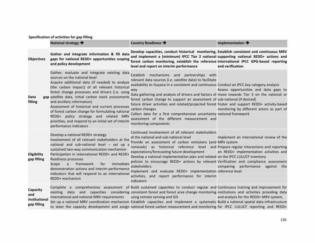
126
Specification of activities for gap filling
National strategy Country Readiness Implementation
Objectives Gather and integrate information & fill data gaps for national REDD+ opportunities scoping and policy development
Develop capacities, conduct historical monitoring, and implement a (minimum) IPCC Tier 2 national forest carbon monitoring, establish the reference level and report on interim performance
Establish consistent and continuous MRV supporting national REDD+ actions and international IPCC GPG-based reporting and verification
Data gap filling
Gather, evaluate and integrate existing data sources on the national level Acquire additional data (if needed) to analyze (the carbon impact) of all relevant historical forest change processes and drivers (i.e. using satellite data, initial carbon stock assessments and ancillary information) Assessment of historical and current processes of forest carbon change for formulating national REDD+ policy strategy and related MRV priorities, and respond to an initial set of interim performance indicators
Establish mechanisms and partnerships with relevant data sources (i.e. satellite data) to facilitate availability to Guyana in a consistent and continuous way Data gathering and analysis of drivers and factors of forest carbon change to support an assessment of future driver activities and related/projected forest carbon changes Collect data for a first comprehensive uncertainty assessment of the different measurement and monitoring components
Conduct an IPCC key category analysis Assess opportunities and data gaps to move towards Tier 3 on the national or sub-national (if desired) Foster and support REDD+ activity-based monitoring by different actors as part of national framework
Eligibility gap filling
Develop a national REDD+ strategy Involvement of all relevant stakeholders at the national and sub-national level – set up a sustained two-way communication mechanism Participation in international REDD+ and REDD+ Readiness processes Scope a framework for immediate demonstration actions and interim performance indicators that will respond to an international REDD+ mechanism
Continued involvement of all relevant stakeholders at the national and sub-national level Provide an assessment of carbon emissions (and removals) as historical reference level and expectations/forecasting future development Develop a national implementation plan and related policies to encourage REDD+ actions by relevant stakeholders Implement and evaluate REDD+ implementation activities, and report performance for interim indicators
Implement an international review of the MRV system Prepare regular interactions and reporting on REDD+ implementation activities and on the IPCC LULUCF inventory Verification and compliance assessment comparing performance against the reference level
Capacity and institutional gap filling
Complete a comprehensive assessment of existing data and capacities considering international and national MRV requirements Set up a national MRV coordination mechanism to steer the capacity development and assign
Build sustained capacities to conduct regular and consistent forest and forest area change monitoring using remote sensing and GIS Establish capacities and implement a systematic national forest carbon measurement and monitoring
Continuous training and improvement for institutions and activities providing data and analysis for the REDD+ MRV system, Build a national spatial data infrastructure for IPCC LULUCF reporting and REDD+
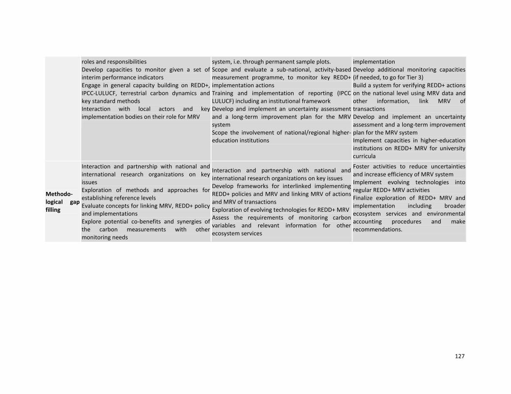
127
roles and responsibilities Develop capacities to monitor given a set of interim performance indicators Engage in general capacity building on REDD+, IPCC-LULUCF, terrestrial carbon dynamics and key standard methods Interaction with local actors and key implementation bodies on their role for MRV
system, i.e. through permanent sample plots. Scope and evaluate a sub-national, activity-based measurement programme, to monitor key REDD+ implementation actions Training and implementation of reporting (IPCC LULUCF) including an institutional framework Develop and implement an uncertainty assessment and a long-term improvement plan for the MRV system Scope the involvement of national/regional higher-education institutions
implementation Develop additional monitoring capacities (if needed, to go for Tier 3) Build a system for verifying REDD+ actions on the national level using MRV data and other information, link MRV of transactions Develop and implement an uncertainty assessment and a long-term improvement plan for the MRV system Implement capacities in higher-education institutions on REDD+ MRV for university curricula
Methodo-logical gap filling
Interaction and partnership with national and international research organizations on key issues Exploration of methods and approaches for establishing reference levels Evaluate concepts for linking MRV, REDD+ policy and implementations Explore potential co-benefits and synergies of the carbon measurements with other monitoring needs
Interaction and partnership with national and international research organizations on key issues Develop frameworks for interlinked implementing REDD+ policies and MRV and linking MRV of actions and MRV of transactions Exploration of evolving technologies for REDD+ MRV Assess the requirements of monitoring carbon variables and relevant information for other ecosystem services
Foster activities to reduce uncertainties and increase efficiency of MRV system Implement evolving technologies into regular REDD+ MRV activities Finalize exploration of REDD+ MRV and implementation including broader ecosystem services and environmental accounting procedures and make recommendations.

128