GULFPORT HARBOR - dtic.mil · in the Gulfport Harbor deep draft navigation project. A draft survey...
83
COESAM/PDFC-89/09 DC , i7 GULFPORT HARBOR MISSISSIPPI cv, FINAL O ENVIRONMENTAL IMPACT STATEMENT DTIC ELECTE JUN 22 1990| USArmy Corps JUNE 1989 of Englneer ISThIBUTION STATEMENT -A MobileDistrt EApproved for public release; Distribution Unlimited , 0o 06 .21 111
Transcript of GULFPORT HARBOR - dtic.mil · in the Gulfport Harbor deep draft navigation project. A draft survey...
COESAM/PDFC-89/09 DC ,
i7
GULFPORT HARBOR
MISSISSIPPIcv,
FINAL
O ENVIRONMENTAL IMPACTSTATEMENT
DTICELECTEJUN 22 1990|
USArmy Corps JUNE 1989of Englneer ISThIBUTION STATEMENT -A
MobileDistrt EApproved for public release;Distribution Unlimited
, 0o 06 .21 111
SECURITY CLASSIFICATION OF THIS PAGE -"oner Date Entered)
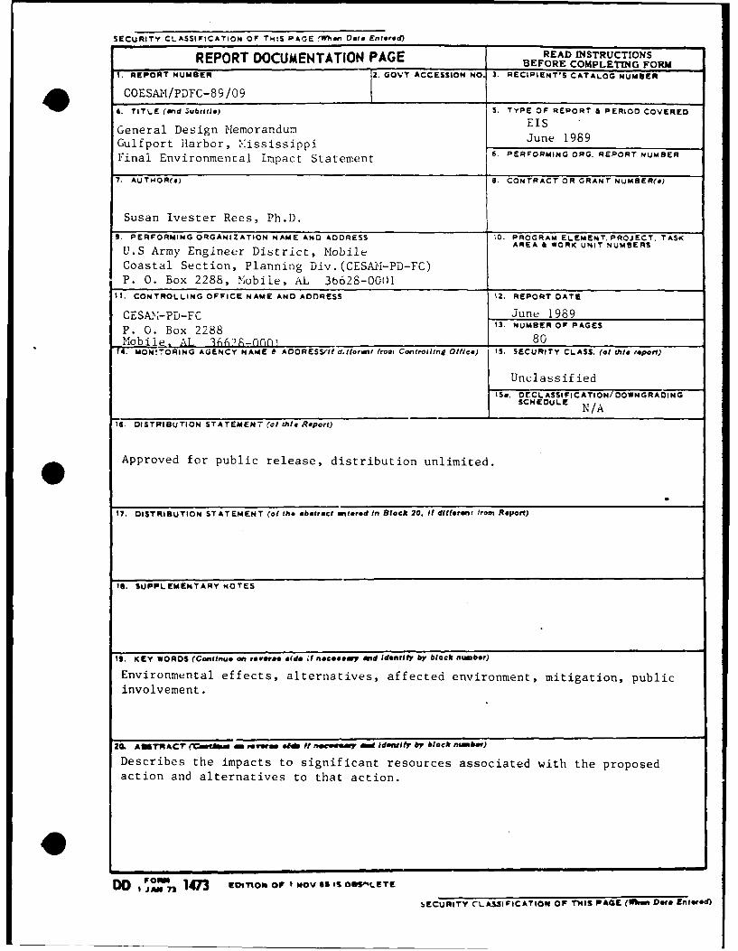
REOTDOCUMENTATION PAGE READ INSTRUCTIONSREPORTBEFORE COMPLETING FORM-REPORT NUMBER .GOTACCESSION NO. 3. RECIPIENT'S CATALOG NUMBER
4. TTLE and ubtile)S. TYPE OF REPORT & PERIOD COVERED
Gulfport Harbor, M.ississippi June 1989Final Environmenral Impact Statement 6, PERFORMING ORG. REPORT NUMBER
7. AUTiIOR(s) 18. CONTRACT OR GRANT NUMBER(e)
Susan Ivester Rees, Ph.D.9. PERFORMING ORGANIZATION NAME AND ADDRESS 10. PROGRAM ELEMENT. PROJECT. TASK
U.S Army Engineer District, Mobile AE I OKUI UBR
Coastal Section, Planning Div.(CESA !-PD-FC)P. 0. Box 2288, Mobile, AL 36628-00(Ul
11. CONTROLLING OFFICE NAME AND ADDRESS 12. REPORT DATE
CESAY,'-PD-FC June 1989P. 0. Box 2288 13. NUMBER OFPAGESI1Mobile. AL '1662-060pf 80
14. ON!ORING A(CLNCY NAME & AOORESS/II' d.fforant front Con'trolling Office) IS. SECURITY CLASS. (at tisl dwpet)
Unclassified
15a. DrCL ASSI F1CATION/ DOWNGRADIN GSCHEDULE N/A
t6. DISTRIBUTION STATEMEN7 (cl this Repor't)
Approved for public release, distribution unlimited.
17. DISTRIBUTION STATEMENT (of the abstract antored in Block 20. It different from, Report)
1S. SUPPLEMENTARY NOTES
19. KEY WORDS (Coniitnue on, teveree eside i nocesoay and Identify by black rnber)
Environmental effects, alternatives, affected environment, mitigation, publicinvolvement.
ICL AftR ACr M(Cfitha ME evmm 6041 ft "I'006" o identf by block "mbe)
Describes the impacts to significant resources associated with the proposedaction and alternatives to that action.
DO 1 OBI 147n Etxnonor IMov 6ss Os--ETE
bECURITY CLASSIFICATIOP( of THIS PACE (Uhi Dot& Entered)
COESAM/PDFC- 89/09
GULFPORT HARBOR
MISSISSIPPI
FINAL0 ENVIRONMENTAL IMPACT
STATEMENT
Accession For
or IG NTS GEDTIC TABco.pyG Unannounc~ed
justifictin.
FINAL
ENVIRONMENTAL IMPACT STATEMENT
GULFPORT HARBORHARRISON COUNTY, MISSISSIPPI
NAVIGATION IMPROVEMENTS
TABLE OF CONTENTS
ITEM PAGE
ABSTRACT EIS-1
SUMMARY := 4MAJOR CONCLUSIONS AND FINDINGS EIS-4AREAS OF CONTROVERSY EIS-5UNRESOLVED ISSUES ElS-5RELATION TO ENVIRONMENTAL REQUIREMENTS ElS-5
NEED FOR AND OBJECTIVES OF ACTION EIS-6STUDY AUTHORITY EIS-6PUBLIC CONCERNS EIS-7
PLANNING OBJECTIVES EIS-7
ALTERNATIVES EIS-8PLANS CONSIDERED DURING THE STUDY EIS-8
PLANS ELIMINATED FROM FURTHER STUDY EIS-8PLANS CONSIDERED IN DETAIL EIS-10RECOMMENDED PLAN, REVISED DRAFT EIS DATED 1988 EIS-15RECOMMENDED PLAN EIS-15
AFFECTED ENVIRONMENT EIS-18GENERAL ENVIRONMENTAL CONDITIONS EIS-18SIGNIFICANT RESOURCES EIS-21
ENVIRONMENTAL EFFECTS EIS-35
SUMMARY OF MITIGATION MEASURES EIS-48
LIST OF PREPARERS EIS-49
PUBLIC INVOLVEMENT ElS-50PUBLIC INVOLVEMENT PROGRAM EIS-50
REQUIRED COORDINATION EIS-50STATEMENT RECIPIENTS EIS-50PUBLIC VIEWS AND RESPONSES, REVISED DRAFT EIS DATED 1977 EIS-51
PUBLIC VIEWS AND RESPONSES, REVISED DRAFT EIS DATED 1988 EIS-52
BIBLIOGRAPHY EIS-67
EIS-i
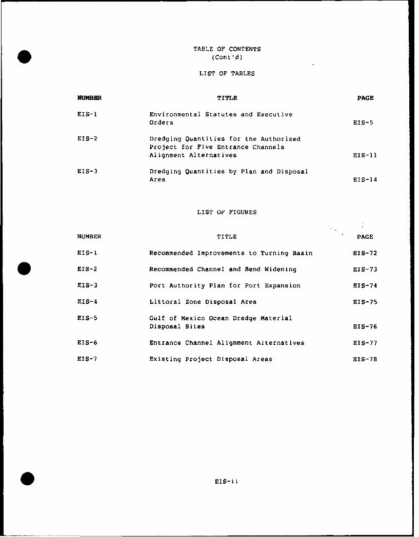
TABLE OF CONTENTS
(Cont'd)
LIST OF TABLES
NUMBER TITLE PAGE
EIS-l Environmental Statutes and Executive
Orders EIS-5
EIS-2 Dredging Quantities for the Authorized
Project for Five Entrance ChannelsAlignment Alternatives EIS-l1
EIS-3 Dredging Quantities by Plan and DisposalArea EIS-14
LIST Oe FIGURES
NUMBER TITLE PAGE
EIS-I Recommended Improvements to Turning Basin EIS-72
EIS-2 Recommended Channel and Bend Widening EIS-73
EIS-3 Port Authority Plan for Port Expansion EIS-74
EIS-4 Littoral Zone Disposal Area EIS-75
EIS-5 Gulf of Mexico Ocean Dredge MaterialDisposal Sites EIS-76
EIS-6 Entrance Channel Alignment Alternatives EIS-77
EIS-7 Existing Project Disposal Areas EIS-78
EIS-ii
FINAL
ENVIRONMENTAL IMPACT STATEMENT
GULFPORT HARBOR
HARRISON COUNTY, MISSISSIPPI
NAVIGATION IMPROVEMENTS
The responsible lead agency is the U. S. Army Enyirieer District Mobile.
Abstract. The Mobile District has investigated public concerns of the
Gulfport, Mississippi, area related to providing increased width and depth
in the Gulfport Harbor deep draft navigation project. A draft survey
report, including the draft Environmental inmiact Statement (DESj, wac i.led
with the Council on Environmental Quality (CEQ) on June 7, 1976. Based un
the commen t s received or the DEIS, a revised Dr>!S was filed with CEQ or July
2u, 1977. Ar, Addendum t- the revised DEIS, -- r, tairirg coordination and
comment and responses on the revised DEIS, as filed with the U. S.
Environmental Protectior Agency or, December 18, 197/. This report was
transmitted to Congress on November 23, 1978. These documents recommerded
the construction of a 36- by 300-foot cnannel in Mississippi Sound and a 38-
by 400-foot channel across Snip is',rnd bar into the Gulf of Mexico. This
--t ,recommendation al-eo included the modificatio.ri of the existing harbor
dimensions, realignment of the channel throig. Ship Island Pass, and the
construction of a deposition basin for littoral drift at the west end of
Ship Island. A total of 23.79 miilion cubic yards of material would be
removed during construction of the project; 8.15 million by hopper dredgefor disposal in the Gulf of Mexico; and 15.64 million cubic yards would be
deposited by pipeline dredge in Mississippi Sound. Two economically and
engineeringly feasible methods were under consideration for disposal of the
Mississippi Sound material: (1) placement in a thin layer over sound
bottoms and (2) construction of three islands in the sound. During annual
maintenance of the project, up to 3.74 millicrn cubic yards of material would
be deposited in open water on both sides of the sound channel and up to 0.44
million cubic yards would be hopper dredged in the gulf. The report
recommended that authorization of Phase I design memorandum stage of advance
engineering and design be accomplished rather than construction. <Studies to
be conducted during Phase I investigations would determine which of th-e-
alternatives would be implemented should the project be authorized (USACE
1976). The Addendum to the revised DEIS indicated that all feasible
alternatives would be considered during the Phase I investigations,including the use of specially designed equipment (Gulf disposal of
Mississippi Sound material) (USACE 1978).
Improvement of the Gulfport Harbor navigation project was initially
authorized by the Fiscal Year 1985 Supplemental Appropriations Act (P.L.
99-88) in accordance with the 1976 Report. As a result of this
authorization, studies were initiated relative to the construction of
islands within the sound and the impacts of thin-layer disposal of new work
material. This initial authorization was subsequently modified by The Water
Resources Development Act of 1986 (P.L. 99-662). Section 202 (a) of P.L.
0EIS-
99-662 authorizes fur construction: "The project for navigation, Gulfport
Harbor, Mississippi: Report of the Chief of Engineers, House DocumentNumbered 96-]8, at a total cost of $81,700,000, with an est-imated first
Federal cost, of $61,100,000 and an estimated first non-Federal cost of
$20,600,000; except that, for reasons of environmental quality, dredgedmaterial from such project shall be disposed of in open water in the Gulf ofMexico in accordance with all provisions of Federal law. For the purpose ofeconomic evaluation of this project the benefits froii such open waterdisposal shall be deemed to be at least equal to the costs of such disposal.
A revised DEIS, circulated in 1988, considered the widening and deepening ofthe existing Gulfport Harbor navigation channel from its current 30- by 220-
foot dimensions in the turning basin, anchorage area, and Mississippi Soundand 32- by 30t- foot dimensions in the Gulf of Mexico up to the authorizeddimensions of 36 feet deep by 300 feet wide and 38 feet deep by 400 feetwide, respectively. Five alignmerts for the cianrel segment through ShipIsland Pass are also considered. In addit_., the expansion of existing p-rtfacilities through fill of 29 acres of shall,,. bottoms adjacent to thewestern side uf the port is considered. This expansion would be
accomplished by the Port of Gulfport and is currently under review throngh
the Corps of Engineers regulatory program (Department of the Army PermitApplication Number 88-00954-L). Material from tne construction andmaintenance of the project would be disposed in the EPA-designated oceandredged material disposal areas on either side of the Gulfport Channel south
of Ship Island Pass. Mitigation for filli.g 29 acres of shallow bottomswill be accomplished by the Port of Gulfport under the auspices of th- C-orps
* regulatory program.
The Water Resources Development Act of 1988 (P.L. 100-676) further modifiedthe authorized project to include: "... to dispose, inaccordance with allprovisions of Federal law, of dredged material ...
(B) from construction of such project by tnLn layer disposal in the
Mississippi Sound under the demonstration program carried out under
paragraph(2);
(C) from operation and maintenance of such project by disposal in theMississippi Sound under a plan developed by the Secretary and approved bythe Administrator of the Environmental Protection Agency, if the Secretary,
after consultation with the study team established under paragraph (3),determines that the report submitted under paragraph (2)(H) indicates thatthere will be no unacceptable adverse environmental impacts from such
disposal ...".
The plan recommended in this Final EIS would result in the placement ofapproximately 1 million cubic yards of new work material in MississippiSound during the test of thin-layer disposal, the remaining new workmaterial would be disposed in the EPA-designated ocean dredged materialdisposal sites at Gulfport. Future maintenance would be accomplished
utilizing open water disposal areas in the Mississippi Sound, the littoralarea in Ship Island Pass or the beach nourishment area at Fort
Massachusetts, and the EPA-designated ODMDS. In addition, a three year
SEIS-2
monitoring prgram is established to determine the impacts of this new workplacement as we'! as the placere[t of mainterance dredged material in athin-layer ir, Mississippi Sound.
If y ,u would like furtherinformation to this
statement, please contact
Dr. Susan Ivester ReesU. S. Army Engineer District MobLileP. 0. Box 2288Moi le, Alabama 36628-0001(20'5) 690-2724
0
ENVIRONMENTAL IMPACT STATEMENT
GULFPORT HARBOR, MISSISSIPPINAVIGATION CHANNEL IMPROVEMENTS
1.0 SUMMARY.
1.1 Major Conclusions and Findings. The following plan for the improvementof the Gulfport Harbor navigation channel is recommended for construction(See Figures EIS-l, EIS-2, EIS-3, EIS-4, and EIS-5):
o Deepening the entrance and southern portion of the turning basin to 36feet,
o Deepening the northern portion of the turning basin to 32 feet,
o Deepening the Mississippi Sound channel to 36 feet at the existingwidth of 220 feet,
o Deepening the Ship Island Pass and Gulf channels to 38 feet at theexisting width of 300 feet,
o Realignment of the channel across the bar in Ship Island Passapproximately 1900 feet to the west along alignment A,
o Provision of bend widening at Station 415+07.68 (Bend 1 at width of 480feet), Station 674+68.33 (Bend 2 at width of 660 feet), and Station994+60.79 (Bend 3 at width of 824 feet),
o Disposal of suitable material dredged from the Ship Island Pass channelin the littoral zone southeast of Cat Island or in the beach nourishmentarea at Fort Massachusetts,
o Disposal of new work material dredged from the Mississippi Sound andGulf of Mexico channels in the EPA-designated ocean disposal sites atGulfport, except as described below,
o Disposal of approximately 1.5 million cubic yards of virgin materialdredged from the harbor entrance area (turning basin) in the proposed Portof Gulfport expansion area,
o Disposal of approximately I million cubic yards of virgin materialdredged from the Mississippi Sound channel in a thin-layer during thedemonstration program investigating the effects of such disposal on marineresources, and
o Disposal of future maintenance material using a combination of open
water disposal sites in Mississippi Sound, the littoral zone and/or beachnourishment sites, and the EPA-designated ocean disposal sites.
1.2 Areas of Controversy. None.
EIS-4
1.3 Unresolved Issues. The plan of study for the demonstration project has
not been finalized. Meetings with the National Marine Fisheries have beenscheduled for 21 - 22 February 1990 to resolve issues concerning monitoringaspects relative to marine mammal, reptile and fishery resources. Oncefinalized a copy of the plan will be provided to all interested parties.
1.4 Relation to Environmental Requirements. The recommended plan as well
as the other alternatives are in compliance with applicable statutes andexecutive orders, as provided on Table EIS-l, for this stage of planning.
1.5 The Draft Environmental Impact Statement (DEIS) was filed with theCouncil on Environmental Quality (CEQ) on June 7, 1976; the first revisedDEIS was filed with CEO on July 20, 1977; an Addendum to the first revisedDEIS was filed with EPA on December 18, 1977; the second revized DEIS wasfiled with EPA on November 11, 1988, the Final Environmental Impact
Statement (FEIS) was filed with EPA on
TABLE EIS-I
Environmental Statutes and Executive Orders
Federal Statutes
Archeological and Historic Preservation Act, as amended, 16 USC 469,
et. seq.
Clean Air Act, as amended, 42 USC 1857h-7, et seq.Clean Water Act, as amended, (Federal Water Pollution Control Act)
33 USC 1251, et seq.Coastal Zone Management Act, as amended, 17 USC 1451, et seq.Endangered Species Act, as amended, 16 USC 1531 et seq.
Estuary Protection Act, 16 USC 1221, et seq.Federal Water Project Recreation Act, as amended, 16 USC 460-1(12), et seq.Fish and Wildlife Coordination Act, as amended, 16 USC 661, et seq.Land and Water Conservation Fund Act, as amended, 16 USC 4601-4601-11,
et seq.Marine Protection, Research and Sanctuaries Act, 33 USC 1401, et seq.National Historic Preservation Act, as amended, 16 USC 470a, wL seq.National Environmental Policy Act, as amended, 42 USC 4321, et seq.
Rivers and Harbors Act, 33 USC 401 et seq.Watershed Protection and Flood Prevention Act, 16 USC 1001, et seq.Wild and Scenic Rivers Act, as amended, 16 USC 1271, et seq.Uniform Relocation Assistance and Real Property Acquisition Policies
Act of 1970 (PL 91-646)The Gulf Islands National Seashore (GIN) System (PL 91-660)Coastal Barrier Resources Act (PL 97-348)
Executive Orders, Memoranda, etc.
Flood Plain Management (E.O. 11988)Protection of Wetlands (E.O. 11990)Environmental Effects Abroad of Major Federal Actions (E.O. 12114)Analysis of Impacts on Prime and Unique Farmland (CEO Memorandum, 11 Aug 80)
EIS-5
2.0 NEED FOR AND OBJECTIVES OF ACTION.
2.1 Study Authority. Authority for this study is cntained in SenatePublic Works Committee Resolution adopted on September 23, 1965. This
resolution requested that the Board of Engineers for Rivers ard Harborsdetermine the advisability of modifying Gulfport Harbor. Further, Sectior,
304 of the River and Harbor Act of 1965 authorized and directed the
Secretary of the Army to begin survey scope studies. Preparation of acombined report was requested by the Chief ,f Engineers on October 4 1965.
The draft survey report, including draft Environmenta Impact Statement, was
coordinated i, June 1976 and subsequently revised irn ily 19// and December
1977. This report was transmitted to Congress it Nuvember 1918 andrecommended the authorization of Phase 1 design memorandum stage of advance
engineering and design be accomplished rather L an c Aistructi-jA. Studies tobe conducted during Phase I investigations wo'uld determine which of the
alternatives would be implemented should the pr. ject be authorized (USACE]976). The firial EIS wou ld be prepared afte, c.)rci1JSioOr (;f the Phase I
studies. Improvement of the Gulfport Harb, r ravigati.r, project wasinitially authorized by the Fiscal Year 198% Supplemental Appropriatiunls Act(P.1 99-38) it, acc rda,,,ce with the 1976 R- , rt arid subsequent. ly m1,dified byThe Water Resources Development Act of 1986 (P.1.. 99-662).
Sect ion 202 (a) of P.L. 99-662 authorized f r c .,struction: "ITne f)roject
for navigation, Gulfport Harbor, Mississippi: Report of the Chief ofEngineers, House Document Numbered 96-18, at a total cost of $81,700,00U,
with an estimated first Federal cost of $61,106,000 and an estimated first
non-Federal cost of $20,600,500; except that-, f-r reasons of environmental
quality, dredged material from such project shall be disposed of in openwater in the Gulf of Mexico in accordance with all provisions of Federal
law. For the purpose of economic evaluation of this project the benefits
from such open water disposal shall be deemed t be at least equal to the
costs of such disposal".
The Water Resources Development Act of 1988 (P.L. 1u0-676) further modified
the authorized project t, include: "...to d:spuse, in accordance with all
provisions of Federal law, of dredged material ...
(B) from construction of such project by trin layer disposal in the
Mississippi Sound under the demonstration pr-,gram carried out under
paragraph(2);
(C) from operation and maintenance of such project by disposal in theMississippi Sound under a plan developed by the Secretary and approved by
the Administrator of the Environmental Protectiur Agency if the Secretary,
after consultation with the study team established under paragraph (3),determines that the report submitted under paragraph (2)(H) indicates that
there will be no unacceptable adverse environmental impacts from such
disposal
The 1977 revised draft discussed several possible techniques for the
disposal of dredged material, however, due t, the age of the revised draft
0 EIS-6
EIS and the information contained within it, as well as the aithorzir g
legislation, the document was re\vsed and re-coordinated pri 4 i- tLhe
preparation of the Final EIS.
2.2 Public Concerns. Thie economric sttuct. e of Harrison County is heavily
dependent upon the provision of services to the tourist trade and benefits
provided by the Port of Gultport. Histcrically the port served lumbel ;ng
arid agricultural industries within Mississippi, changing in the 197U's I.,
support industrial plants in the region and serving as the nation's nimber ibarnana port. In recent years, with the worid-wide shift towards transp,,r
of containerized cargo, the P1rt of Gulfport nas modified it's operatio-z t
meet these demands. Harris.un Cou.nty, therefore, depends to a large extent
on the continual improvement of t he Port of Glfp urt and related channel
activities to stay abreast of changes in world marine transport. Public
concerns considered in tLe pr.posed study therefure pLimarily center around
the need for improved waterhorne transportation facilities at the Port of
Gulfport. The General Desig:, Memorandum, -11fp -.rt Harbor, Mississippi,
which accompanies this fir,al EIS examiries in detail, the problems, 1heed,,
and opportunities of the Port of Gcifport, M:ssissippi.
2.3 Planning Objectives. T!;e fol i Uny oL] ;vct.'es are the basis I, r
formulation of the alternatives considered in this study.
Improve the economic efficiency -f moving comm-dities into and out of tlh-
Port of Gulfport.
Increase navigational safety in the Gulfpcrt Harbor navigation channels,
especially in channel bends, and reduce the chance of hazard to life and
property.
Provide an adequate and acceptable dredged material disposal plan for
project modifications and continued maintenance of the Gulfport Harbor
channels.
Reduce or prevent additional saltwater intrusion into the groundwater
aquifers.
Coordinate dredging and disposal alternatives sc that no conflicts arisewith existing management plans for the Gulf Islands National Seashore
properties on the barrier islands adjacent to the channel system and the
State of Mississippi's Coastal Management Plan.
Avoid irreversible commitments of resources to future uses.
Manage, protect, preserve, or enhance valuable resources such as:
oyster reefswetland and submerged habitats
commercial and sport fish habitats.
Design and conduct a monitoring program to determine the effects
associated with the thin layer disposal of new work and maintenance ma,.erial
on marine resources.
EIS-7
3.0 ALTERNATIVES.
3.1 Plans Considered During the Study. The 1976 leasibility Reportconsidered a number of plans for improvements at Guitport. Included inthese were widening the channel in Mississippi S,.u:,d to 300 feet at theexisting 3u-foo.t depth ard deepening the channel in 2-foot increments toaccommodate vessels ranging up to 35,000 dead weight tons (DWT) up to amaximum depth of 36 feet and widening the channel across the bar into the
Gulf of Mexico t, 400 feet at the existing 32-flot depth and deepening tilechannel in 2-foot increments to a maximum depth of 38 feet. Also includedwere the realignment of the Ship Island Channel, adjustment of the width-ofthe turning basin and enlargement of the charnel entrance to the turningbasin. A number of disposal options were also considered including: openwater alongside the channels, creation of islands within Mississippi Sound,thin-layer disposal within Mississippi Soudr,, and the use of speciallydesigned equipment to transport the dredged material to sites within the
Gulf of Mexico.
The plan recommended ir, the 1976 FeasibL :t, Report consists of enlargijgthe ship channel to provide a depth of 38 feet and a width of 400 feet fromthe 38-foot depth contour in the Gulf c f Mex:co for a distance of abcut 9.1miles to a point in Mississippi Sound near the western end of Ship Island;enlarging the channel through Mississippi Surid to a depth of 36.feet ard awidth of 300 feet for a distance of about 11.8 miles between the iriner endof the gulf entrance channel and the tulning basin at Gulfport; realigningthe ship channel through Ship Island Pass to a location generally parallelto and about 1,000 feet west of that presently authorized, with a depositionbasin for littoral drift 38 feet deep, 300 feet wide and 2,000 feet longadjacent to the east side of the channel at the west end of Ship Island; andenlarging and adjusting the dimensions of the turning basin and channelentrance by extending the southern limits of the basin seaward about 1,180feet along the west pier and 2,300 feet along the west side of the shipchannel, decreasing the width of the turning basin from 1,320 feet, aspresently authorized, to 1,120 feet, and deepening the basin and adjustedchannel approach to 36 feet. Channel excavation between the gulf and thedeposition basin at the west end of Ship Island would be by hopper dredge,with materials deposited in a deep-water disposal area in the gulf.Excavation of the remainder of the ship channel, the deposition basin anidthe turning basin would be by hydraulic pipeline dredge, with the materialeither thinly spread over an area comprising 9,740 acres of bottom in thesound or used for the construction of three islands on the west side of thechannel in the sound.
3.2 Plans Eliminated From Further Study. Imprcozient of the GulfportHarbor navigation project was initially authorized by the Fiscal Year 1985Supplemental Appropriations Act (P.L. 99-88) in accordance with the 1976Report. As a result of this authorization, studies were initiated relativeto the construction of islands within the sound, the impacts of thin-layerdisposal of new work material, and the coastal processes associated withchannel shoaling and the westward migration of Ship I!Jand.
3.2.1 Island Construction. The construction of three islands in
EIS-8
Mississippi, as discussed in, the 1976 report, was eliminated from further
study for a rnumber of reasons. Geotechnical studies, initiated after
passage of P.L. 99-88, indicated that the predominant soils-encountered in
the Mississippi Sound Channel segment are plastic clays, poorly graded
sands, and silty sands with occasional pockets of clayey sands and silty
clays. From the harbor area to the vicinity ot the Gulf Intracoastal
Waterway, six to eight feet of clay overlie the sandy soils arid in some
areas no sand was found down to the maximum prcject depth of -40 feet MLLW.
In addition, the majority of the clay soils existing in the harbor and
channel down to the maximum project depth do not appear to have
characteristics that would be conducive to clay ball formation.
A two dimensional, depth averaged, numerical model was developed during tbe
Mississippi Sound and Adjacent Areas Study (USACE 1984). This model was
used to simulate circulation and salinity patterns within the area of the
existing Gulfport Harbor project and under a scenario involving construction
of islands. Three islands were 'constructed' in Mississippi Sound on the
west side of the channel covering approximately 52,j to 700 acres.
Comparison of the existing conditions to thmse projected with the three
islands in place indicated that velocities were increased between the
mainland and the closest island by approxiiTately 0.2 to 0.5 fps and in the
immediate vicinity of the other two islands. Since the velocities were
projected to increase primarily near the islands, it would be possible forlocalized erosion of the islands to occur if protection was not pr6vided .
This information combined with the depth of water in the areas selected for
island construction, the quantity of suitable material, and the soft
foundation conditions in this area of Mississippi Sound indicated that
island construction within the Sound was not economically feasible compared
to other alternatives. In addition, the possibility of material being
eroded from the islands and being returned to the channel was considered
significant in terms of future maintenance of the channel.
3.2.2 Channel Alignment Through Ship Island Pass. Adjustments to the
channel alignment through Ship Island Pass were investigated because ofseveral bends which are difficult and hazardous to navigate. The original
authorized channel extended straight across the bar at Ship Island Pass,roughly perpendicular to the length of Ship Island. As a result of the
westward migration of the island, the western tip of the island encroaches
into the ship channel. A study by the U.S. Army Wateiways Experiment
Station, Coastal Engineering Research Center (See Appendix B) indicates that
the western end of Ship Island is migrating to the west at an approximate
rate of 38 feet per year. Five different channel alignments were proposed
to alleviate the problem of encroachment by the island (Figure EIS-6).
Alignments A, B, C, and E are at varying distances west of the existing
alignment. Alignment D would be a re-creation of the original authorized
channel.
The 20-inch diameter crude oil submarine pipeline owned by the Chevron
Pipeline Company crosses the existing navigation channel in Mississippi
Sound. Implementation of alignment A would require the relocation of this
pipeline from it's current depth. Implementation of any other alignment
would not require relocation.
EIS-9
Although alignmentt A would require the initia. ecavation of more materialthan any of the other proposed alignments the lorg-term maintenance of
alignment A is estimated to be significantly Jess than any bther alignments.Table EIS-2 provides estimated quantities fr,..m each of the alignments for
the authorized dimensions. As can oe seen fr im thi s table, a~proximate1y14.6 million cubic yards of new work material would be removed fromMississippi Sound and Ship Island Pass Channel segments with alignment Acompared to 13.4 million cubic yards for aliyryment B which is the nexthighest quantity. Annual maintenance from these channels with alignment A
is estimated to be 3.8 million cubic yards cr 4.3 million cubic yards foralignment B which is the next highest maintetance quantity. Alternativealignments B, C, D, or E were eliminated from further consideration due tothe economic and environmental impacts associated with their implementati4o'.
3.2.3 Channel Depths. Channel depths of 30, 32, 34, 36, and 38 feet wereconsidered during reformulation of the project it. late 1987. The designvessel for the Gulfport Channel is a 35,00& dwt bulk carrier 686 feet long,with a 100-foot beam and a maximum draft of 38 feet. An operational staticdraft of 32 feet was assumed for the designi porposes. These vessels, lignt
loaded, have been utilizing the existing Gulfport Channel for a number ofyears. Based on the vessel characteristics and the physical environmental
of the Gulfport area, allowances of 4 feet and 6 feet, respectively, wereadded to the operational static draft for the Mississippi Sound and Gulfchannels, respectively. Channel depths of 3(, 32, and 34 feet, therefo-,were not considered in detail.
3.3 Plans Considered in Detail. The authorization c~ntained iti P.L. 99-88
was subsequently modified by The Water Resources Development Act of 1986(P.L. 99-662). Section 202 (a) of P.L. 99-662 authorizes for construction:"The project for navigation, Gulfport Harbcr, Mississippi: Report of theChief of Engineers, House Document Numbered 96-18, at a total cost of$81,700,000, with an estimated first Federal cost of $61,100,000 and an
estimated first non-Federal cost of $20,600,000; except that, for reasons ofenvironmental quality, dredged material from such project shall be disposedof in open water in the Gulf of Mexico in accordance with all provisions ofFederal law. For the purpose of economic evaluation of this project thebenefits from such open water disposal shall be deemed to be at least equalto the costs of such disposal". Although this authorization specifies thatdredged material will be disposed in the Gulf of Mexico, an alternativedisposal concept, i.e., thin-layer disposal, was considered in detail toprovide the basis for determining the economic benefits associated with gulf
disposal. In addition to "No Action", four alternative plans for improving
the Gulfport Channel were considered in detail. The aspects of each ofthese plans, denoted plans A, B, C, and D are detailed below. Many of theaspects are common to all plans as denoted in the discussion.
3.3.1 "No Action" Alternative. Maintenance of the existing projectprovides waterborne transportation via: an, 8 mile long, 32-foot deep by 300-foot wide channel from the Gulf of Mexico across Ship Island Bar into
Mississippi Sound, thence a channel 11 miles long, 30 feet deep by 220 feet
wide to the 30-foot deep 1,320- by 2,640-foot turning basin. The project
EIS-10
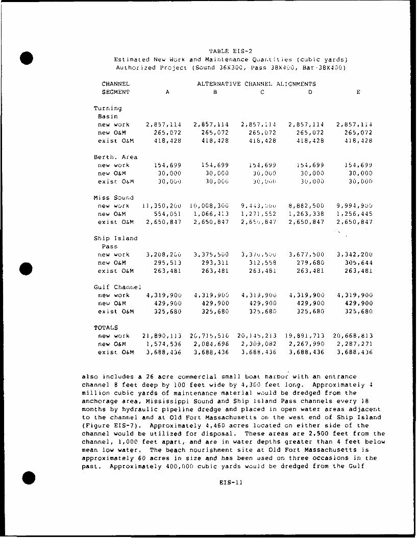
TABLE EIS-2Estimated New Work and Maintenance Qjartities (cubic yards)Authorized Project (Sound 36X300, Pass 38X400, Bar-38X400)
CHANNEL ALTERNATIVE CHANNEL ALIGNMENTS
SEGMENT A B C D E
Turning
Basinnew work 2,857,114 2,857,114 2,857,114 2,857,114 2,857,114new O&M 265,072 265,072 265,072 265,072 265,072
exist O&M 418,428 418,428 418,428 418,428 418,428
Berth. Areanew work 154,699 154,699 154,699 154,699 154,699
new O&M 30,000 30,000 30,000 30,000 30,000
exist O&M 30,000 30,000 30,0'Ok 30,000 30,000
Miss Soundnew work 11,350,200 10,008,300 9,443,00u 8,882,500 9,994,900new O&M 554,051 1,066,413 1,271,552 1,263,338 1,256,445
exist O&M 2,650,847 2,650,847 2,651,847 2,650,847 2,650,847
Ship IslandPass
new work 3,208,200 3,375,500 3,3?1',50u 3,677,500 3,342,200new O&M 295,513 293,311 312,558 279,680 305,644
exist O&M 263,481 263,481 263,481 263,481 263,481
Gulf Channelnew work 4,319,900 4,319,900 4,319,900 4,319,900 4,319,900
new O&M 429,900 429,900 429,900 429,900 429,900exist O&M 325,680 325,680 325,680 325,680 325,680
TOTALSnew work 21,890,113 20,715,510 20,145,213 19,891,713 20,668,813
new O&M 1,574,536 2,084,696 2,309,082 2,267,990 2,287,271
exist O&M 3,688,436 3,688,436 3,688,436 3,688,436 3,688,436
also includes a 26 acre commercial small boat harbor with an entrance
channel 8 feet deep by 100 feet wide by 4,300 feet long. Approximately 4million cubic yards of maintenance material would be dredged from the
anchorage area, Mississippi Sound and Ship Island Pass channels every 18
months by hydraulic pipeline dredge and placed in open water areas adjacent
to the channel and at Old Fort Massachusetts or, the west end of Ship Island(Figure EIS-7). Approximately 4,460 acres located on either side of the
channel would be utilized for disposal. These areas are 2,500 feet from thechannel, 1,000 feet apart, and are in water depths greater than 4 feet belowmean low water. The beach nourishment site at Old Fort Massachusetts is
approximately 60 acres in size and has been used on three occasions in the
past. Approximately 400,000 cubic yards would be dredged from the Gulf
0EIS-11
channel annually and disposed in tLe EPA-designated gulf disposal sites atGulfport.
3.3.2 Turning Basin and Entrance Channel Dimensions. Public Law 99-662
authorized modification of the turning basin from 30 reet deep by 1320 feetwide by 2640 feet long to 36 feet deep by 1126 feeL wide by 2640 feet longwith enlargement of the entrance to the basil- from a point 2300 feet south
of the southeast corner and along an angle of about 45 degrees. The localsponsor for this project, the Mississippi State Port Authority at Gulfport,has investigated the stability of the existing East and West Pier wharves.As a result of these investigations and review of current and anticipatedberthing practices, the Port Authority has piuposed that a two tier basin beconstructed. As shown on Figure EIS-I the entrance and southern portion -ofthe basin will be deepened to 36 feet as authorized. The northern portionof the basin will be deepened to 32 feet. An existing submerged timber andstone breakwater at the southern end of tLhe turrning basin will be removedduring construction. The rock arid debris will e st*.red on the east side &fthe port for future use. Approximately i00 ) feet &f stabilization will berequired along the West Pier wharf. This aspect is common to all plans
considered in detail.
3.3.3 Channel Depth. A char nel depth of 36 feel in Mississippi Sound and
38 feet in Ship Island Pass and the Gulf of Mexico are common to-all plansconsidered in detail. The actual dredge depth of these channels is 40 ard42 feet respectively, including advanced maintenance and allowable
overdepth.
0 3.3.4 Channel Width. Determination of adequate channel width is based ontraffic, vessel, channel, and sea characteristics. The existing channelwidths are less than those prescribed for the design vessel. The guides
utilized in channel design indicate that a width of 300 feet for the soundchannel and 400 in the pass and gulf channels would be appropriate.However, pilots have been navigating the existing 220-foot wide cnannel fora number of years with the design vessel, and although they report somedifficulty during periods of strong cross winds, no collisions or groundingsattributable to insufficient channel width have occurred. In addition,vessels larger than the design vessel are safely using the Bayou Casottechannel at Pascagoula which is 38 by 225 feet. For this reason channelwidths of 220 and 300 feet in the sound and pass/gulf, respectively werecarried forward for detailed analysis along with the authorized widthdimensions of 300 and 400 feet, for the sound and pass/gulf respectively.Alternative plans A and C represent the 220/360-foot dimension; plans B andD represent the 300/400-foot dimension.
3.3.5 Ship Island Pass Channel Alignment. As discussed earlier, onlyalignment A was carried forward for detail analysis. Alignment A wouldrelocate the channel approximately 1900 feet to the west of Ship Island,eliminating the existing dogleg and delaying shoaling problems associatedwith the island migration for approximately 50 years. The abandoned portion
of the existing channel would be used as a deposition basin along the eastside of the new channel. This eliminates the need for the construction ofthe deposition basin as authorized in P.L. 99-662.
0EIS-12
The submerged pipeline owned by the Chevronr Pipeline Company would be
relocated to a deeper depth along it's same alig.ment.
3.3.6 Bend Widening. Widening of the chann;el at each of the three bends as
shown on Figure EIS-2 is provided to reduce navigation problems. The
quantities of materials required to be dreaoed it. beAd widening have beer,
included in the overall dredging quantities discussed below. This aspect is
common to all plans considered in detail.
3.3.7 Port Expansion. The State of Mississippi Pert Authority at Gulfport
has determined that additional container st,-rage space is needed for
existing commerce, and anticipated irncreased future commerce, with orwithout the considered project improvement. Accordingly, in June 1988 tie
Port Authority filed application for a Departmerit of the Army permit
pursuant to Section 404 of the Clean Water Act (33 USC 1344) and Section 10
of the River and Harbor Act of 1899 (33 USC 463). The Port Authority plan
for expansion would provide approximately 29 acres of storage on the west
side of West Pier. The area to be filled is shallow estuarine bottoms
varying from approximately -l to -9 feet MSL. This area would be diked to a
height of +10 feet MSL and approximately 1.5 million cubic yards of virgin
material would be removed from an area near the entrance to the turning
basin to fill the site. The area to be dredged to provide the fill would be
dredged under the authorized plan for navigation improvements shQuld the
port expansion not occur. This aspect is common to all plans consIdered.in
detail.
3.3.8 Disposal Alternatives. As indicated earlier, two generic disposal
methods are considered in detail, gulf disp-sal and thin layer disposal,
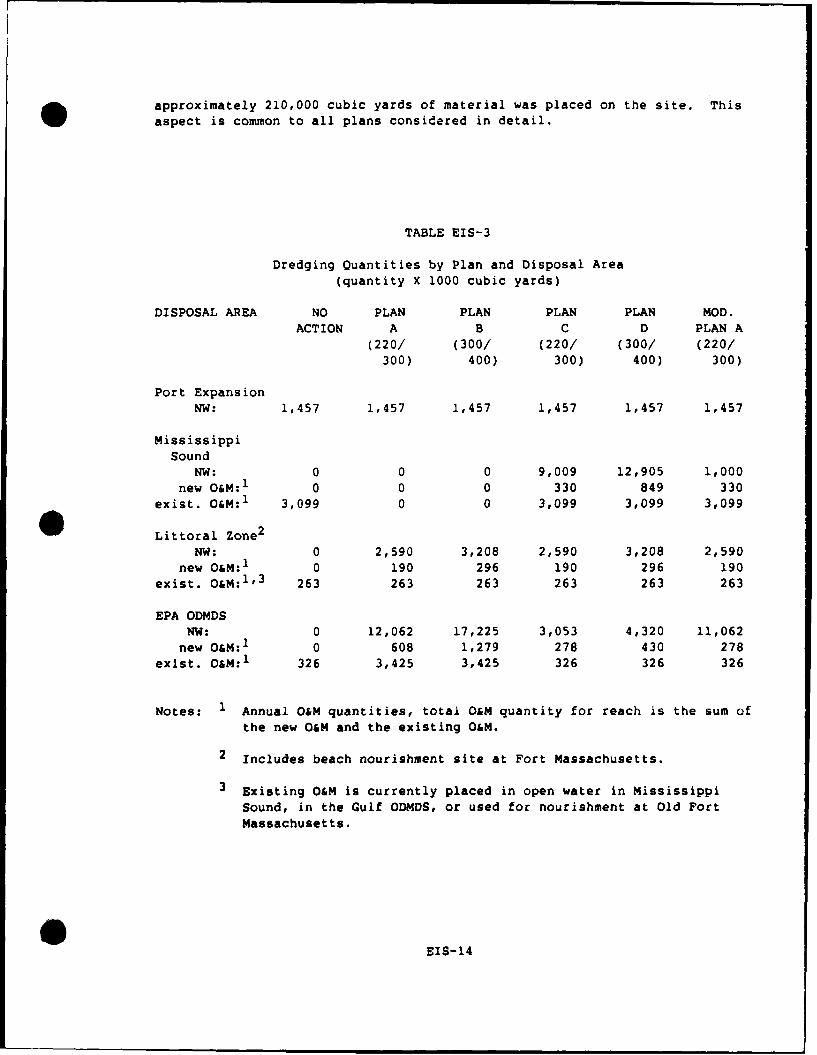
along with littoral zone disposal and beach nourishment. Table EIS-3
presents a matrix of plan, channel segment, dredged material quantity, arid
disposal areas.
3.3.8.1 Littoral Zone Disposal. New Work arid maintenance material dredged
from the Ship Island Pass reach of the Gulfport Channel would be placed in a
littoral zone disposal site west of the channel, southeast of Cat Island in
14 to 20 feet of water (Figure EIS-4). The disposal of the sandy materialdredged from the pass reach into this area would supplement the littoraldrift system of Cat Island and possibly the Chandeleur Island system. The
disposal of these materials has been evaluated following the 404(b)(1)
Guidelines in compliance with the Clean Water Act of 1977, 33 USC 1251 (See
Appendix D). This aspect is common to all plans considered in detail.
3.3.8.2 Beach Nourishment at Fort Massachusetts, West Ship Island. The
National Park Service, Gulf Islands National Seashore, in a letter datedAugust 1, 1988, asked that we consider the placement of suitable material
dredged from the Ship Island Pass Channel on the shoreline adjacent to FortMassachusetts as had been done in the past. Approximately 60 acres adjacentto the fort would be utilized for disposal of variable amounts of dredged
material at four to six year intervals depending on the erosion rate of the
island. The National Park Service would be responsible for the incremental
cost of this disposal option over that described above for littoral zone
disposal. In 1983, the last time beach nourishment was requested,
EIS-13
approximately 210,000 cubic yards of material was placed on the site. Thisaspect is common to all plans considered in detail.
TABLE EIS-3
Dredging Quantities by Plan and Disposal Area
(quantity X 1000 cubic yards)
DISPOSAL AREA NO PLAN PLAN PLAN PLAN MOD.ACTION A B C D PLAN A
(220/ (300/ (220/ (300/ (220/
300) 400) 300) 400) 300)
Port ExpansionNW: 1,457 1,457 1,457 1,457 1,457 1,457
MississippiSound
NW: 0 0 0 9,009 12,905 1,000new O&M:1 0 0 0 330 849 330
exist. O&M:1 3,099 0 0 3,099 3,099 3,099
0Littoral Zone2NW: 0 2,590 3,208 2,590 3,208 2,590
new O&M:1 0 190 296 190 296 190exist. O&M:1'3 263 263 263 263 263 263
EPA ODMDSNW: 0 12,062 17,225 3,053 4,320 11,062
new O&M:1 0 608 1,279 278 430 278exist. O&M: 1 326 3,425 3,425 326 326 326
Notes: 1 Annual O&M quantities, total O&M quantity for reach is the sum of
the new O&M and the existing O&M.
2 Includes beach nourishment site at Fort Massachusetts.
3 Existing O&M is currently placed in open water in Mississippi
Sound, in the Gulf ODMDS, or used for nourishment at Old FortMassachusetts.
EEIS-14
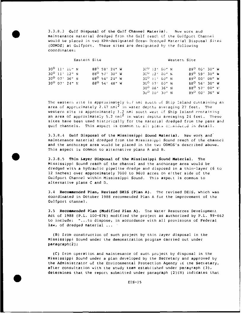
3.3.8.3 Gulf Disposal of the Gulf Channel Material. New work aidmaintenance material dredged from the Gulf reach of the Gulfport Channelwould be placed in two EPA-designated Oceain Dredged Material Disposal Sites(ODMDS) at Gulfport. These sites are designated by the following
coordinates:
Eastern Site Western Site
300 11' L0" N 88D 58- 24" W 300 12' 00" N 890 00' 30" W300 11' 12" N 880 57' 30" W 30 12' 00" N 890 59' 30" W300 07 36" N 880 54' 24" W 300 11' 00" N 890 00, 00" W300 07' 24" N 880 54' 48" W 300 07' 00" N 880 56- 30" W
30o 06' 36" N 880 57' 00" Y
300 10' 3," N 890 00' 36" W
The easterr, site is approximately u.1 nmi suth f Ship Isla nd contairin anarea of approx:imately 2.47 rmi 2 in water depths averaging 27 feet. Thewestern site is approximately 1.2 nmi south west of Ship Island containingan area of approximately 5.2 nmi2 in water depths averaging 24 feet. These
sites have been used historically for the material dredged from the pass andgulf channels. This aspect is common to all plai.s cz11sijL, d irn detail.
3.3.8.4 Gulf Disposal of the Mississippi Sound Material. New work andmaintenance material dredged from the Mississippi Sound reach of the channeland the anchorage area would be placed in the two ODMDS's described abov*.This aspect is common to alternative plans A and B.
3.3.8.5 Thin Layer Disposal of the Mississippi Sound Material. TheMississippi Sound reach of the channel and the anchorage area would bedredged with a hydraulic pipeline dredge and disposed in a thin-layer (6 to12 inches) over approximately 7000 to 9600 acres on either side of theGulfport Channel within Mississippi Sound. This aspeut is common toalternative plans C and D.
3.4 Recommended Plan, Revised DEIS (Plan A). The revised DEIS, which wascoordinated in October 1988 recommended Plan A for the improvement of theGulfport channel.
3.5 Recommended Plan (Modified Plan A). The Water Resources DevelopmentAct of 1988 (P.L. 100-676) modified the project as authorized by P.L. 99-662to include: "... to dispose, in accordance with all provisions of Federallaw, of dredged material ...
(B) from construction of such project by thin layer disposal in theMississippi Sound under the demonstration program carried out under
paragraph(2);
(C) from operation and maintenance of such project by disposal in theMississippi Sound under a plan developed by the Secretary and approved by
the Administrator of the Environmental Protection Agency it the Secretary,after consultation with the study team established under paragraph (3),determines that the report submitted under paragraph (2)(H) indicates that
EIS-15
there will be no unacceptable adverse ervlronmental impacts from such
disposal ...
Approximately I million cubic yards of virgin material dredged from the
Mississippi Sound reach of the channel will be placed in a layer no more
than 12 inches in thickness over approximately 1,000 acres on the west side
of the Gulfport Channel. This material, along with a portion of the
maintenance material from the existing channel, will be monitored for a
period of up to three years to determine the effects of this type disposal
on marine resources. Future maintenance of the improved channel will follow
existing practice, i.e. open water disposal in Mississippi Sound, littoral
zone and/or beach nourishment at Fort Massachusetts, and gulf disposal in
the EPA-designated ODMDs at Gulfport.
Features of the plan recommended for the improvement of the Gulfport channel
(Modified Plan A) include:
o Provision cf a 38- by 330-fo ,t channei from the 38-foot depth contour
in the Gulf of Mexico across Ship Island Bar into the Mississippi Sound.
I Provision of a 36- by 220-fo ct channel across Mississippi Sound from
Ship Island Bar to the Turning Basin.
o Provision of a two tiered tuiniing basin 1120 feet wide by 2640 feet-
long with enlargement of the entrance to the basin from a point 2300 feet
south of the southeast corner and along an angle of about 45 degrees. The
entrance and southern portion of the basin will be 36 feet deep, the
northern portion of the basin 32 feet deep.
o Provision of widening of the bends.
o Removal of the submerged timbei and stone breakwater.
o Realignment of the Ship Island Pass reach approximately 1960 feet west
of the existing alignment.
o Disposal of approximately 1.5 million cubic yards of new work material
dredged from the anchorage entrance area in a 29 acre Port expansion area.
o Disposal of sandy dredged material in a littoral zone site southeast of
Cat Island. A total of 2,589,700 cubic yards of new work material and a
total of approximately 22 million cubic yards of maintenance material would
be disposed in this site over the 50 year project life.
o Disposal of new work material from the anchorage area and Mississippi
Sound and Gulf channels in the EPA-designated ODMDS at Gulfport, except as
described below. Approximately 11 million cubic yards of new work material
and would be disposed in these sites.
o Disposal of 1 million cubic yards of new work material from the
Mississippi Sound rhannel in Mississippi Sound under a thin layer
demonstration program.
EIS-16
o Disposal of maintenance material from ttie turning basin and MississippiSound channels under a continuing practice of open water disposal inMississippi Sound. Approximately 3.9 million cubic yards would be disposedon an 18 month cycle resulting in approximately 130 million cubic yardswould be disposed over the 50 year project life. Continued open waterdisposal is dependent upon the results of the monitoring program describedbelow.
o Disposal of maintenance material dredged from tho Gulf Entrance channelin the EPA-designated ODMDS at Gulfport. Approximately 755,600 cubic yardswould be disposed in these sites annually for a total of 38 million cubicyards over the project life.
o Design arid conduct of a three year monitoring program to assess theimpacts associated with the thin layer disposal of new work and maintenancedredged material (See Appendix D).
0
0 EIS-17
4.0 AFFECTED ENVIRONMENT.
4.1 General Environmental Conditions. Gulfport Harbor is a land filled
harbor area on the southern shore of Harrison County in western Mississippi.
Physiographically this area is in the Coastal Lowlands subdivision of theEast Gulf Coastal Plain section of the Coastal Plain Province. This area
ranges in elevation from sea level to about 30 feet. The essentially flat
to gently undulating, locally swampy Coastal [Lowlands are underlain by
alluvial, deltaic, estuarine, and coastal deposits and merge with the
fluvial-deltaic plains of the streams of the area. Tnis portion of the Gulf
Coast has beer classified as an "alluvial" cuast, a terraced, deltaic plain
(Upshaw, Creath, and Brooks 1966). The slope of the plain is considered
steep since it drops as much as 8 feet per mile in some areas. The marsh-es
in this area are narrow and the river drainage basins small. (Water and Air
Research, Inc. 1975) The shoreline in the .< i,,ity of Gulfport Harbor
consists of a manmade beach beyond a concrete seawall. The area offshore
the barrier islands is part of the Mississippi-Alabama Shelf section of the
Continental Shelf Provir,ce.
The barrier islands consist of a broad, well-developed beach backed by dunes
on the gulf side. Beach and intermittent marsh occur on the north shore of
the islands. The interior of the islands is either broad, low sand flats, 1to 2 feet above sea level, with marshes ard shallow lakes or vegetated beach
ridges 5 to 15 feet above sea level. Erosir, of the eastern ends Of the.
islands and accretion on the western ends indicate considerable occurrertce
of longshore drift. The rate of accretion is greater than tne rate of
erosion so that the islands have migrated westward with time. The barrier
island facies consist of well-sorted, medium-grained, mature quartzose sand
containing less than 3 percent feldspar and having a mineral suite rich in
staurolite and kyanite. The average width of the facies is 2.5 miles, with
an average thickness of 40 feet. Immediately south of the barrier island
system is a nearshore fine-grained facies similar in lithology to that ofMississippi Sound. Movement of sediment from the sound forms a fine-grained
facies which overlaps the Mississippi-Alabama shelf sand facies in a zone
about 7 miles wide, south ot the islands.
The Mississippi-Alabama shelf is a trianguJan area, on the seaward side of
the barrier islands, extending from the Mississippi River delta on the west
to the DeSoto canyon south of Panama City, Florida on the east. The shelf
is about 80 miles wide in the west and is an extensive, almost flat plain
bounded on the landward side by the relatively steep but narrow shoreface of
the Mississippi Sound.
Mississippi Sound is a shallow coastal lagoon, measuring 80 miles along the
Gulf of Mexico coast from Mobile Bay, Alabama, in the east, to Lake Borgne,
Louisiana, in the west. It is nine miles wide, measured along a north-south
axis, extending from the Mississippi Coastline to a string of sandy barrier
islands which separate Mississippi Sound from the Gulf of Mexico. Thelagoon has a mean low water depth of only 10 feet and more than 99% of the
system is shallower than 20 feet at mean low water.
EIS-18
Within recernt geologic time, the shoreline of Mississippi has alteredfrequently. Sea level has varied from about 20 feet to -350 feet inresponse to continental glaciation and melt. DUrillg the time of greatestglaciation, sea level was 300 to 350 feet lower than the present level andstreams entrenched themselves in deep narrow valleys. In the iast 5000years the sea level has stabilized at its present level with the valleys aidlowlands filled and with the creation of the barrier islands this area hasbecome what is now known as the Mississippi Sound.
The following description of the geological history of the Mississippi S'und
is taken from Otvos (1981) as summarized by Bahr et al. (1983). Themainland shoreline of Mississippi is located on ancient beach ridges, theGulfport Formation overlying the Biloxi Formation, that formed about 1.25:million years B.P., during the Sangomor interglacia, period when sea levelstood higher than at present. During the late Pleistocene period of sealevel decline, river trenches were eroded into, the prairie terrace in tleGulf of Mexico seaward of the location of the barrier islands. Theseentrenchments filled with sediments as sea lev'el rose again ir. the lateWisconsin and early Holocene until sea level starnlized about 4,500 B.P.The bays along the Mississippi coast formed at this time, as sea waterfilled the coastal depressions, and most of tne area now occupied byMississippi Sound was a marine system as evidenced by the presence of mar-iieforaminifera remains in sediment cores. The area around the mouth of thePearl River and the nearshore area was brackish in nature. The barrierislands formed about 4,000 years B.P. from the accretion of bottom sedim-.ts
that had originally eroded from the Alabama mainland. These islands formed
a 230 km long barrier island-shoal chain that extended between DauphinIsland, Alabama and the present Jefferson Parish-New Orleans metropolitanarea. Between 3,000 and 2,300 years B.P., St. Bernard delta sediments fromthe Mississippi River prograded into the gulf to about 3-20 km south of thePresent Cat, Ship, and Horn Islands. The delta reduced wave energy from thewest and stopped the progradation of Cat Island. After the Mississippi
River abandoned the St. Bernard distributary, erosion of delta sediments ledto severe erosion of the Misbissippi coastal marshlands. The Chandeleur
Island chain formed parallel to the original delta lobe shore and has since
migrated westward.
The Mississippi Sound receives both high saline waters from the Gulf ofMexico and freshwater from the streams which drain some 20,000 square milesof land area. Major streams which contribute inflows are the PascagoulaRiver, the Pearl Piver, and to some degree the Mobile River. Gulf watersenter the Sound through the deep passes between the barrier islands with thehelp of tidal forces. This mixing of freshwater runoff and saline watershave created a dynamic estuarine environment.
The Gulfport area has a humid, warm-temperate to sub-tropical climate,although occasional subfreezing temperatures do occur Air temperatures areinfluenced by the Gulf of Mexico, with average annual temperatures rangingbetween 60oF to 700 F. Summer temperatures are influenced by the BermudaHigh, a semipermanent high-pressure cell that extends over portions of theGulf of Mexico near 300 N latitude. During the spring to early fall,anticyclonic winds generated by the high-pressure cell blow predominantly
EIS-19
from the southeastern sector argc have a high moisture cor,tent which tends t,
keep coastal temperatures lower than those of inland areas.- DUrnrig late
fall and winter the winds are associated with frontal passages, causing
resultant wind flow from the northern sector. Temperatures remain
relatively mild, ranging fr( i lows in the 4-,'s tO highs ir the 6U's (OF).
The normal annual rainfall within the study area is among the nighest in the
United States. Rainfall amounts average between 55 to 64 inches and is
fairly evenly distributed over the year. Thunderstorm frequency is one uf
the highest in the United States. Relative humidity is fairly constant
throughout both the day and the year and is usually highest between 240u and
0600 hours (83%) and lowest between 1200 and 20(:J hours (62%). Cloudiness
tends to be highest in the winter and summer with lower values in the spring
and fall. Much of the summer cloudiness consists of convective cumulus orhigh, thin clouds. Winter cloudiness is generally associated with movement
of extra tropical cyclones and their associated frontal systems. Periods of
low visibility from November through May c r respond with heavy fg periods.
Winter fogs are fairly frequent in the Gulfp,rt area as the rivers and
tributaries empty cold water into the warmer gulf waters. Heavy rains and
high humidity during the summer are probably responsible for occasional low
visibility.
A hurricane is a trpicai cyclone with wind velocities of 74 mph or great-er.
Most hurricanes form in zones between 80 and 150 N latitude, where-the sea
surface temperature is high and the Coriolis force is strong enough to cause
the spinning of winds around low-pressure centers. Hurricanes pose a -
definite threat to the Gulfport area from June through October, being most
frequent during September. These late summer hurricanes tend to originate
in the eastern North Atlantic near the Cape Verde Islands and are often
severe. Those hurricanes arising in June and July usually originate in thewestern Atlantic or Caribbean and tend to be weak. The high winds typically
generated by hurricanes are ordinarily not as destructive as the marked rise
in water level, referred to as hurricane surge. Hurricane Camille is the
last storm to have directly impacted the Gulfport area and almost completely
destroyed the entire Mississippi Coast. This small but devastating storm
came inland in the St. Louis Bay/Waveland area on Auguist 17, 1969. Winds
were estimated near 200 mph at the center of the hurrcane with tides rising
in excess of 22 feet. The probability of a tropical -form or hurricane
affecting the area of Gulfport has been calculated as 13% for a tropical
storm, 6% for a hurricane, and 1% for a severe hurricane each year.
Although wind direction tends to be variable throughout the year, the
overall pattern is for northerly winds from September through February and
southerly winds the remainder of the year. Throughout the year, wind speeds
average 7-10 knots.
The Gulfport Harbor area is located in a densely developed area. Either
side of the port facilities is man-made beach flanked by seawall. Behind
the seawall are extensive commercial and residential developments. The
major biotic communities within the area are the nearshore Gulf of Mexico,
estuarine open waters, barrier islands, and urban areas. Commercial
fisheries utilize the open water areas throughout their life cycles. A
number of threatened or endangered species ranges overlap the study area.
EIS-20
4.2 Significant Resources.
4.2.1 Vegetation. Due to the developed nature &f the area-vegetation such
as emergent wetlands or forested areas comprises very little of the habitatswithin the study area. The barrier islands support saline marsh development
along their protected shores. The island marshes are typically divided into
three zones. The high marsh occurs at elevations approximately 1 meterabove MSL and is characterized by salt marsh fimbristylis (Fimbristyliscastanea) and salt meadow cordgrass (Spartina patels). These areas areinundated only on highest tides and the plants are less salt tolerant than
those in the other zones. The brackish and tidal zones are dominated by
black needlerush (Juncus roemerianus) and spike rush (Eleocharis spp.) andsmooth cordgrass (Spartina alternifiora), respectively (Eleuterius, L. 19-3;U.S. Department of Interior 1978). There arc approximately 258 acres of
saline marshes on East and West Ship Island. Cat Island and the ChandeleuL
Islands are relatively natural with extensive marsh areas.
Some freshwater marsh habitat may be four.d ur the inland portions of theseislands. These habitats are characterized Ly sawgrass (Cladium jamaicense),arrow-head (Sagittaria spp.), alligator weed (Alternanthera philoxeroides),
and cattails (Typha spp.). The higher porti ,ns of the islands support bothbeach-dune associations and maritime strand habitats. The land-water
interface is characterized by beach conditions which support sea oats
(Uniola paniculata), morning glory (_pomoea spp.), an;: pennywort(Hydrocotyle bonariensis). The beach habitat intergrpdes into dune
conditions vegetated by saw palmetto (Serenua repens), seaside rosemary
(Ceratiola ericoides), sea oats, morning glory, and pennywort. Upland
vegetation found on the islands includes slash pine (Pinus elliottii) andwax myrtle (Myrica cerifera).
In this area of the Mississippi Sound submersed grass beds are restricted tothe northern shores of the barrier islands. These areas are characterizedby turtle grass (Thalassia testudinum), manatee grass (Cymodocea manatorum),
shoal grass (Halodule wrightii), and widgeon grass (Ruppia maritima).Approximately 20,000 acres of submersed grassbeds were present inMississippi Sound prior to 1969, however, in late 1969, Hurricane Camille
caused the destruction of the majcrity of these areas (Eleuterius, L. 1973).Recent studies by the National Park Service indicate that small (less than
50 acres) patches of shoal grass are located within 1,500 feet of theshoreline of East and West Ship Islands (US Department of Interior, 1978).Extensive grassbeds are located on the western side of the Chandeleur
Islands in Chandeleur Sound.
4.2.2 Aquatic Resources. Estuarine and Gulf open water areas dominate tle
delineated study area. These areas range in depth from less than 1-foot MLWto depths greater than 60 feet and contain a variety of resources important
to the functioning of the ecosystem.
Intertidal and subtidal bottoms are populated by communities of macrofaunawhose structure is dependent upon substrate, salinity, temperature, depth,
and ecological relationships. Of the five benthic communities which havebeen identified within the study area, the open sound, muddy-sand community
0EIS-21
occupies over 70% of the study area. Although there are no oyster reefswithin the study area, the Square Hanokerchief Shoal reef, the largest in
Mississippi, is just west of the study area.
The major fisheries of the study area include menhaden, mullet, croakers,
brown and white shrimp, blue crab, and oysters. Christmas and Waller (1973)
reported 138 species of finfish taken from Mississippi Sound. The bay
anchovy (Anchoa mitchilli) was the most abundant species, making up over 70%
of the catch. Menhaden (Brevoortia patronus), Atlantic croaker
(Micropogonias undulatus), and spot (Leiostomus xarithu-rus) were also
abundant. Mississippi's reported commercial landings of finfish and
shellfish averaged 357.8 million pounds with a dockside value of 36.7million dollars. Most of the commercial fishing acti.ity is located in the
Pascagoula-Moss Point area, however finfish and shEll. ish are landed at
Gulfport and Pass Christian and trucked elsewhere for processing. Harrison
County is the leading shellfish producing area jr, the state, accounting for
more than half of the landings of shrimp, blue craL, arid oysters.
These species and others common to the area are estuarine dependent, i.e.,
they spend part or all of their lives in estuaries. A typical estuarine
dependent species spawns in the Gulf of Mexic,, and the larvae are then
carried into the estuaries where they mature. The stage from the egg to.
juvenile, during which transport from offshre waters to low salinity areas
is accomplished, is probably the most critical of all in the life historiesof the important fishery organisms of the northern Gulf of Mexico. The
threat to individuals during this time may oe broken down into threedistinct phases: (1) transport from the offshore waters to the vicinity of
the tidal passes; (2) transport through the passes into the ciuaries; and(3) distribution within the estuaries after entrance .ias been obtained
(Gunter, 1967). Since these forms are typically incapable of sustained
locomotion, any significant increase or decrease in flow through the barrier
island pass could impact the migration of these forms.
The margins of Ship and Cat Islands, the Chandeleur Islands, and the
grassbeds around these islands serve as the dominant nursery grounds during
the spring and summer months. In autumn these areas are still important,
but usage is riot as heavy due to the seaward migration of many late
juveniles (Benson, 1982 and USACE, 1984). Analysis of data by the U. S.
Fish and Wildlife Service during the Mississippi Sound Study (USACE 1984)shows that Ship Island Pass does serve as an important migratory route
between Lake Borgne and western Mississippi Sound and the Gulf of Mexico.
Adult fish distribution is more heavily weighted toward the Lake
Borgne/western Mississippi Sound area than in the vicinity of the Gulfport
channel. The area seaward of West and East Ship Islands has been identified
as a natural Spanish mackerel (Scomberomorus maculatus) congregation area
(Bahr et al., 1983).
4.2.3 Wildlife Resources. Wildlife habitat consists of the open waters of
Mississippi Sound and the Gulf of Mexico, and the wetland and ujland areas
of the barrier islands. The barrier islands provide habitat for a number of
birds, some small mammals, and sea turtles. Many shorebirds and wading
birds frequent the islands including herons, egrets, terns, gulls, and black
EIS-22
skimmers (Rynchops nigra). Tropical migrants such as warblers, grosbeaks,and tanagers are present on the islands during the spring ard fall. The
islands also provide nesting habitat for a number of wading-and shorebirds.Cat Island has provided historic nesting habitat for least terns and in allprobability this species still nests on the island. Black skimmers have
historically nested on Ship Island. The Chandeleur Islands and MississippiDelta provide extensive nesting habitat for a number of birds including
laughing gulls (Larus atricillus), brown pelicar,s (Pelecanus occidentalis),great egrets (Casmerodius albus), snowy egrets (Egretta thula), tricoloredherons (Hydranassa tricolor), black-crowned night heron (Nycticorox
nycticorox), little blue herons (Florida caerulea), black skimmers, caspiai
terns (Hydroprogne caspia) and reddish egret (Dichromanassa rufescens)(Keller et al., 1984). Fifteen active osprey (Pandion haliaetus) nests have
been identified on Ship Island (US. Departmer.t of Interior 1988).
Although extensively developed, the Harrisonr County shoreline houses fivenesting colonies of least terns. Three of these colonies are located to thewest of the Gulfport Harbor facilities, and two to the east.
Due to the distance between the mainland and the barrier islands, the mammalpopulations are limited to a few species ir,clidii.g raccoon (Prcyon lot,1varius), nutria (Myocastor coypus bonariensis), and black rat (Rattusrattus). Mammals typically found in the Mississippi Sound and nearshore
Guif of Mexico include the Atlantic bottleiosed dolphin (Tursiops truncaLus)and the Atlantic spotted dolphin (Stenella pLagiodon). A number of whalesare also known to occur offshore and occasionally within Mississippi Soundincluding the fin whale (Balaenoptera physalus), sperm whale (Physeter
catodon), and the short-finned pilot whale (Glotficephala macrorhynchus). Alarge baleen whale was reported beached on the north shore of Ship Island inthe spring of 1967 (Christmas and Waller 1973). The Florida manatee(Tricheucus manatus latirostris) has been recorded from the estuarine waters
of Mississippi on several occasions (Gunter 1954, Caldwell and Caldwell
1973, Gunter and Corcoran 1981).
Sea turtles are also known to regularly use the gulf waters near the barrierislands and may occur within Mississippi Sound. Five bpecies, including theloggerhead (Caretta caretta), green turtle (Chelonia mydas), hawksbill
(Eretmochelys imbricata), leatnerback (Dermochelys coriacea) and theAtlantic ridley (Lepidochelys kempi). Loggerhead turtles were reportednesting on Ship Island during the 1987 nesting season (T. Simons, Personal
Communication).
4.2.4 Endangered and Threatened Species. The National Marine Fisheries
Service indicated that a number of threatened and endangered species mayoccur off the coast of Mississippi including: the finback whale(Balaenoptera physalus), humpback whale (Megaptera novaeangliae), sei whale
(B. borealis), green sea turtle (Chelonia mydas), Kemp's (Atlantic) ridleysea turtle (Lepidochelys kempi), leatherback sea turtle (Dermochelys
coriacea), and the loggerhead sea turtle (Caretta caretta).
Finback whaleF are cosmopolitan and occur in all oceans. In the Gulf ofMexico this species is present throughout the year and sightings at sea have
0 EIS-23
been recorded in the northern Gulf between 28o ard 300 N latitude and 860
and 880 W longitude. Strandings have been recorded along Florida, Texas,
and Louisiana (Schmidly 1981). Humpback whales also occur -in all oceans,
however prior to 1981 tne only recent record foi the Gulf of Mexico was in
April 1962 at the mouth of Tampa Bay (Layne 1965). Other sightings have
been in deep water (>200 meters) off the Alabama 'Florida coast. Sei whales
strandings have been recorded from the coasts of Mississippi and Louisiana
in the vicinity of the Mississippi River Delta (Schmidly 1981).
Although marine turtles occasionally enter estuaries (Behler and King 1979),
they generally prefer higher salinity waters such as those of the Gulf of
Mexico. Nesting may occur throughout the range but most nesting occurs *&n
restricted areas of beach that the turtles return to each nesting season,.Foraging areas are often very far from nesting beaches and in order to nest,
turtles may migrate long distances. Mating generally takes place in
offshore waters near the nesting beach and males rarely come ashore (Fuller
1978).
Green turtles are most abundant between 35 °' n-rth and 350 south latitudes,
particularly in the Caribbean. Immature turtles are found along the Floridawest coast (Carr and Caldwell, 1956) arid adults have been known to nest on
the barrier islands of the northern Gulf coast in the past.
Only a small portion of loggerhead nesting occurs in the Gulf. Abbut 90...
percent of the total nesting effort in the United States occurs on the south
Atlantic coast of Florida (Carr and Carr 197/). Christmas and Waller (1973)
reported loggerhead nestings on the beaches of the Mississippi Sound barrier
islands. Ogren (1977) stated that historically the loggerhead nested on theremote beaches of Cat, Ship, Horn, Petit Bois, and Dauphin Islands. Human
disturbance, natural predation, and island development have reduced the useof the barrier islands for nestings. Normally I to 2 loggerhead crawls are
noted on the Mississippi barrier islands each year. One nesting attempt was
noted on June 7, 1987, on east Ship Island which repiesents the onlyconfirmed nesting attempt on the Mississippi Islands in the last four years
(T. Simons personal communication).
The leatherback is probably the most oceanic of all sea turtles, preferring
deep waters (Rebel 1974). It occasionally enters shallow waters andestuaries usually in the more northern waters of it's range (Barbour 1972).Leatherbacks are frequently seen in the Gulf of Mexico and are seasonallyabundant off the Florida coast near Panama City (Pritchard 1976).
Kemp's ridley sea turtles are probably the most endangered cf the seaturtles in the Gulf of Mexico. Their nesting is restricted to a small
stretch of beach near Rancho Nuevo, Ramaulipas, Mexico. Immature ridley's
are regularly encountered (strandings) in the Mississippi Sound and adjacent
to the barrier islands (R. Smith, National Park Service). Ogren (personalcommunication) indicated that this species tends to congregate in shallowwater vegetated areas within the estuaries.
The U. S. Fish and Wildlife Service indicated that a number of threatenedand endangered species under it's jurisdiction could ccur within the
EIS-24
the Gulfport area including the Florida manatee (Trichecus manatus), thz
Florida Panther (Felis concolor), the bald eagle (Haliaeetus leucocephalus),peregrine faic3n (Falco peregrinus), brown pelican (Pelecanus occidentalis),
Bachmann's warbler (Vermivora bachmanii), ivcory-Lilled woodpecker
(Campephilus principalis), red-cockaded woodpecker (Picoides dentrocoposborealis), American alligator (Alligator mississippiensis), and the eastern
indigo snake (Drymarchon corais couperi).
As discussed in Section 4.2.3 above, the Florida manatee has beer, recorded
from the estuarine waters of Mississippi. Maratees occur alung the coast
and in coastal rivers of the southeastern United States from North Carolina
southward to southern Florida and westward in the Gulf of Mexico to southern
Texas and Veracruz, thence through the West Indies and Caribbean waters of
Central America to northern South America. The species is intolerant of low
temperatures, and even in Florida its numbers are often seriously reduced as
a consequence of occasional spells of cold weather (Lowery 1974). Since the
species is restricted to warmer waters, it was surmised that the manateesrecorded from the Mississippi area wandered westward from Florida waters
(Gunter and Corcoran 1981).
The Florida Panther formerly occurred frmrn h-rthern British Columbia across
southern Canada to New Brunswick and Nova Scotia and south to Patagonia-a t
the southern extremity of South America (Lowery 1974). Preferred habitat ofthe cougar is riverine swamps and it may still occur in the lower PearlRiver Delta of Louisiana and Mississippi.
Bachmann's warbler is probably the rarest uf North American songbirds andmay be close to extinction. It inhabits the borders of swamps, especiallywhere the forest crown is open and blackberry bushes are frequent. Thespecies breeds usually in the upper part of the Coastal Plain and in theMississippi Valley from southern Indiana and eastern Missouri south toLouisiana, east through the Gulf states, and north to coastal Virginia.Because it frequently moves its nesting locality, has secretive habits,lacks a distinctive song, and generally frequents places of difficultaccess, the species may go undetected. It is known to migrate through theFlorida Keys, occasionally also the Bahamas, to winter in western Cuba, theIsle of Pines, and rarely Mississippi, Georgia, and Florida (Imhof 1976).The Ivory-billed woodpecker may also be extinct. This species inhabitedvirgin bottomland hardwood forests and as these woodlands were exploited,the bird, apparently unable to adapt itself, steadily retreated. It waslast reported in Alabama in 1907, in Louisiana in 194., and in Florida in1950. The red-cockaded woodpecker is a local permane..t resident of pineywoods in the southern part of the state. It usually lives and nests inwoods in which about one-quarter or more of the trees are pines. Fornesting this species requires a mature pine with a dead heart. This speciesranges from eastern Oklahoma, Kentucky, and southern Maryland south toeastern Texas and southern Florida (Imhof 1976).
Prior to 1957, the brown pelican was a common breeding resident of theMississippi Gulf Coast. Between 1957 and 1959, the brown pelican populationalong the entire Gulf Coast was virtually wiped out. Evidence points to DDTand other pesticides which concentrated in the pelican's aquatic food
EIS-25
source. Since 1973, the species appears to have made a comeback,particularly along the southeast Atlantic c. ast, Florida and Alabama. Thepelican breeds in colonies on lonely shores and ;solated is-ands along thePacific Coast from California to Chile, wintering north to British Columbia,and along the Atlantic, Gulf, and Caribbean coasts from North Carolina toGuyana, wintering north to North Carolina (Imhof 1976).
The bald eagle was a locally common, breediny, winter resident or the GulfCoast. About 1960 the breeding population began to dwindle much like thepelican. The bald eagle uses sticks to build a hugn nest at the top of atall tree, usually a live one, close to the water. The species is residentfrom northwestern Alaska, northern Mackenzie, and Labrador south to southernLower California, northern Mexico, and Florioa. It breeds locallythroughout this range in favorable localities such as coastal Alaska, theupper Mississippi Valley, the Great Lakes, Chesapeake Bay, and the Gulfcoast, but is absent from arid regions (Imhof 1976). A bald eagle hackingprogram was initiated by the National Park Service in the winter of 1985 onHorn Island, east of Gulfport. The intent of tnis program is to try toreestablish populations along the coastal regions, however it will be
several years before the success of this effort is known (US Department ofInterior 1988). The peregrine falcon is present on the Mississippi Gulfcoast during migration, especially in the fall. Preferred nesting site-i-s atall cliff near water, but it may occur in a variety of places near water.
The Eastern indigo snake has probably suffered more from the effects ofcivilization than any other southeastern snake (Mount 1975). It is a largeconspicuous slow-moving snake which prefers open desolate areas inconjunction with gopher tortoise burrows. Recently, the species has beenintroduce, into coastal Alabama by Auburn University n hopes ofreestablishing its population. The Mississippi alligitor population hadbeen steadily declining throughout it range because of excessive hunting andpoaching. However, as a result of protective measures their numbers haveincreased all along the Gulf coast and in September 1988, a controlled huntwas allowed in Florida. Alligators prefer swamps, lakes, sloughs, andsluggish streams but are also common in bayous and smaller streams thatdrain into the estuaries.
4.2.5 Air Quality. Air quality of the Harrison County coastal area isconsidered good. Cloudiness tends to be hignest in the winter and summerwith lower values in the spring and fall. Much of the summer cloudinessconsists of convective cumulus or high, thin clouds. Winter cloudiness isgenerally associated with movement of extra tropical cyclones and theirassociated frontal systems. Periods of low visibility from November throughMay correspond with heavy fog periods. Winter fogs are fairly frequentalong the gulf coast as the larger rivers and tributaries empty cold waterinto the warmer gulf waters. Heavy rains and high humidity during thesummer are probably responsible for occasional low visibility.
4.2.6 Water Quality. Water quality of western Mississippi Sound includingthe G,,lfport area is good. With the exception of areas immediately adjacentto the shoreline and along the navigation channel, which are classified forrecreational use, the sound is classified as recreational waters and for
ETS-26
shellfish harvest.
Dissolved oxygen concentrations within the sound typically vary between 7mg/i to 12 mg/i (saturation) during the spring, and between 6 mg/i1 to 12mg/1 during the summer, reflecting dilution of the various oxygen demandingwastes entering the sound. Nutrient values are highly variable, bothtemporally and spatially, in response to freshwater inflow and seasonal
factors. pH values tend to be highest in winter and lowest in late summerand early fall. Nitrite-nitrogen is lowest in winter and summer with maximaoccurring in the spring while nitrate-nitrogen is highest in winter andspring with summer and fall levels being much lower. Orthophosphate tendsto be highest in spring and summer with a pronourced east to west decline inconcentrations. Orthophosphates reach highest levels during spring andsummer while total phosphates reached highest concentrations (Eleuterius1979).
Salinity values within the study area are highly variable. Duiing springhigh freshwater inflow periods, salinities vary betwetrn I and 20 parts perthousan (ppt) with a general decreasing trend fron, e-st to west inMississippi Sound. The summer lower inflow period can range between 5 to 29ppt exhibiting the same decreasing trend as the spring. The system is well-mixed throughout the water column except within the navigation channels-ndbarrier island passes (Kjerfve 1983). Salinities in the nearshore Gulf-ofMexico.are more oceanic in nature ranging around 20 to 35 ppt with'
stratification being temporarily variable.
Dissolved oxygen (DO) concentrations in the rearshore Gulf of Mexico have
been shown to exhibit some seasonal variation with low DO values prevalentduring summer months. These low values are attributed to stratification and
isolation of bottom waters from surface waters, turbidity, and organicloading (Turner and Allen 1982). Hydrographic studies performed duringJanuary and June, 1980, in the vicinity of the Gulfport ocean disposal sitesindicated minor stratification. Surface DO levels ranged from 4.94 to 5.33ml/l in January and 4.21 to 5.58 ml/l in June while bottom DO level rangedfrom 5.17 to 5.33 ml/i in January and 2.10 to 2.23 ml/l in June (EPA 1986).Mean annual DO concentrations range from 6 to 9 ppm throughout the region(Barry A. Vittor & Associates, Inc., 1985).
Analysis of selected metals, nutrients, and organics from waters in thevicinity of the ocean disposal sites at Gulfport in 1980 resulted in tracelevels which were lower than those reported for the Mississippi Delta Region(Dames and Moore 1979). Pesticide concentrations were below detectablelevels, however PCBs were detected during January and ranged from 0.0008 to0.0014 ng/l (EPA 1986). These concentrations are comparable to those
reported for the northeastern Gulf Shelf waters (Rinkel and Jones 1973).
4.2.7 Circulation. Freshwater discharge into this area of MississippiSound is primarily from the Pearl River and averages approximately 12,800cfs. The Pearl River receives drainage from a basin of approximately 8,700
square miles. In addition freshwater from the Mississippi River may enterMississippi Sound during flood conditions via Bonnet Carre Spillway intoLake Pontchartrain & Lake Borgne. Since it's construction in 1927, the
0 EIS-27
spillway has operated on seven occasions, 1937, 1945, 1950, 1973, 1975,1979, and 1983. During these periods the floodway was in operation forbetween 13 to 75 days with average discharge of approximate4y 141,000 cfs.
Circulation patterns within the study area are controlled by astronomicaltides, winds, and, to a lesser degree, freshwater discharge. In MississippiSound and adjacent gulf waters the tidal variation is diurnal with anaverage period of 24.8 hours. The tidal wave progresses from south to northand enters the sound first through Horn Island Pass near Pascagoula,Mississippi and splits, traveling both eastward and westward causing as much
as a 6-hour phase shift within Mississippi Sound. The eastward progressinghigh water reaches Pass aux Herons approximately one hour-after entering thesound. On the flood tide, water enters through Petit Bois Pass and is
deflected eastward toward Mobile Bay. On the ebb tide, water residing in
eastern Mississippi Sound flows south-west through the Pass. In additionsome water from Mobile Bay moves through Pass aux Herons into eastern
Mississippi Sound.
The effect of the wind on circulation in this area is significant. Thesuperimposed wind-induced current shifts the tifurcation area at Horn IslandPass either toward the east or west depending on the east/west wind
component and whether the tide is ebbing or flooding. A wind with aneastern component induces a general westward current in the sound causingthe bifurcation area to shift to the east (Petit Bois Pass) during'the floodtide and to the west (Dog Keys Pass) on the ebb. Winds with a western
component set up a general eastward circulation pattern in the sound. Windswith dominant north and south components have minimal effect on the overall
circulation pattern, however may have significant localized effects. Thesewind components cause the development of eddies within the shallower areas
of the sound tending to disrupt and diffuse tidal currents. These eddieshave been shown to be strongest in the eastern half of the sound including
the study area.
Winds with strong north or south components have a significant effect onwater surface elevation within Mississippi Sound. Northerly winds tend todepress water levels while southerly winds raise water levels. Schroeder
and Wiseman (1985) analyzed wind (1974-1984) and sea level elevations (1973-1983) in coastal Alabama and found that the passage of winter cold fronts
(also called northers) during October through March could cause significahitperturbations in sea level. Huh et al. (1984) (in Schroeder and Wiseman,1985) noted that the winter cold front storms occurred in a three phasecycle: prefrontal, frontal passage, and cold-air outbreak/high pressure.The prefrontal phase is characterized by falling barometric pressure,
strengthening of southerly winds, and warm, moist air conditions. Thefrontal passage involves an abrupt reversal of these conditions, accompaniedby a squall line passage, strong wind shear, precipitation, and a rapid drop
in air temperature. During the cold-air outbreak/high-pressure phase,pressure rises rapidly and strong winds rotate from northwest to northeast.
Seas and sea level, set up by the prefrontal southerly winds and fallingatmospheric pressure, are set down by the strong northerly winds and risingpressure. Differences in sea level elevation between prefrontal set up andpost-frontal set down are commonly 2.5 to 3.0 feet and occur over periods of
EIS-28
12 to 24 hours.
0 Water velocities range between 0 to 3 feet per second (fps)- in the barrierisland passes and between 0 to 0.8 fps in the sound. The region west ofBiloxi and east of Petit Bois Pass have the higher velocities whilevelocities near the Pascagoula area are the lowest. Generally, peakvelocities throughout the sound will increase by 40 percent per one foot
increase in the tidal range. East/west wind components tend to increasevelocities in the sound between Biloxi, Mississippi and Mobile Bay.North/south wind components have small, localized, erratic effects on water
velocities.
Within the Gulf, south of the barrier islands to the 120-foot depth contour,meteorological forcing results from (1) the daily, land-sea breeze cycle and
associated small pressure changes, and (2) the passage of fronts. Thedominant force to the system results from the passage of fronts. Dimego et
al. (1976) in Kjerfve (1984) report that roughly 8 frontal passages permonth can be expected within the Gulf between November and January (winter),
6 frontal passages per month between March and May (spring), and 2 weak,slow-moving frontal passages per month between July and September (summer).During the winter, the fronts are highly energetic with respect to wind and
atmospheric pressure due to the sharp contrast between the adjoining airmasses and the passage of pressure system centers through the region. Thespring fronts are still highly energetic but the typical ground track oftheir low pressure centers is slightly north of the region. The summerfrontal passages are less frequent, traveling along paths well north of the
region and exerting very 1ittic influence within the Gulf.
Wave intensity on the Mississippi-Alabama shelf is low to moderate with waveperiods ranging from three to eight seconds and wave heights rarely over 7
feet. Hurricane or storm conditions, however, may produce larger waves.The region of the Gulf of Mexico offshore in the project area is
characterized by transient net currents that are largely driven by windforcing. The diurnal tide in this area is much less pronounced than mostother shelf regions of United States, but is the most obvious source ofvariation in water level and is the driving force of the oscillatory
currents on inner shelf. As in Mississippi Sound the tide in this area isdefined as microtidal. This area of the northern Gulf of Mexico is boundedby the barrier islands, Cat and Ship, on the north and the Chandeleur
Islands and the shallow waters of Chandeleur Sound on the west and
southwest.
4.2.8 Sediment Quality. Soils in the harbor area contain soft black andgray clays of high plasticity, firm gray clayey sand, firm silty clay, andpoorly graded medium to fine grained sand. A majority of the materialwithin the turning basin, just outside of the harbor proper, consists offirm clays, clay-sands, and sands. The material down to elevation -40 MLLW(Mean Lower Low Water) is suitable for construction fill. The predominantsoils encountered in the Mississippi Sound channel segment are plasticclays, poorly graded sands, and silty sands. Occasional pockets of clayeysands and silty clays are also present. From the harbor area to the regionof the Gulf Intracoastal Waterway, typically there are six to eight feet of
EIS-29
clay overlying the sandy soils, although alurg some stretches of the channel
no sand is found down to -40 MLLW. Near Ship Island, the upper levelsediments are composed almost entirely of sara and silty sand. Both finegrained soils such as plastic clays, clayey silty sands, and silts and sandy
soils are found in the Snip Island Pass segment. Most of the clay materialin this area is very soft or soft. In the Gulf Channel, the soils consist
almost entirely of soft gray plastic clay.
Past chemical studies of sediments from western Mississippi Sound ard theGulfport area indicated relatively low concentrations of nutrients, total
organic carbon, heavy metals, pesticides, phenols, and hydrocarbons (Walker1976, O'Brien 1980, Lytle and Lytle 1985). Toxicity and bioaccumulation
studies were performed by the Environmental Protection Agency in 1988.Results of these studies indicated that the toxicity of the sediments testedwas minimal. Survival in 100% suspended solid phase (SSP) of the sediments
was greater than 80% and not significantly different from SSP prepared withreference sediments. Exposure to the sediments for 10 days had little
observable adverse effect on oysters (Crassostrea virginica) or pink shrimp(Penaeus duorarum). Survival of oysters was 96% in the reference sedimentand 90% in sediments from the project area. Shrimp survival was 100% if- thereference sediment and > 94% in site sedimerts. Survival of lugworms(Arenicola cristata) exposed to sediments from sites 2 and 3 was not
significantly different to survival in reference sediments. Survival oflugworms exposed to sediment from the northernmost sampling location (Site1), however, was significantly different from survival in reference
sediments.
Chemical analyses performed on sediments and on tissues from the organismsutilized in the toxicity tests revealed no residues of pesticides or PCBs ineither the sediments or the tissues before or after exposure. Residues ofseveral heavy metals were detected in sediments and in tissues of organismsbefore and after exposure. Using analysis of variance at the 0.05probability level, concentrations of metals in oysters and lugworms exposedto project sediments were not significantly greater than concentrations ofmetals in animals exposed to a reference sediment. Although statisticallysignificant differences were determined for selenium and zinc in shrimp,
appropriate consideration should be given to the magnitude of these numbers.(For more detail refer to Appendix D).
4.2.9 Groundwater Resources. Within coastal Mississippi, many differentsands of Miocene, Pliocene, Pleistocene and recent age contain fresh water.Formations in the freshwater sections in ascending order are the Pascagoula,
Graham Ferry, and Citronelle. Overlying these deposits in many areas areterrace deposits and alluvium. There are no thick, consistent, traceablesand beds within this segment of the study area. Formations in thefreshwater sections dip towards the south in Jackson County and to the
southwest in Hancock County, being deeper in southwes. Hancock Co,-. nianin north Jackson County. The base of the freshwater zone varies from lessthan 1,500 feet to more than 2,500 feet below sea level in Harrison County.Harrison County uses more than 50 MGD from ground water sources formunicipal and industrial purposes. Groundwater levels in artesian aquifersstatewide continue long-term declining trends. Generally, in wells screened
EIS-30
in the Miocene aquifers in southern Mississippi, water levels declined about1 foot between water year 1982 to 1983. During this same time, well levelsin the Graham Ferry Formation declined approximately 2 feet-. The shallowCitronelle aquifer showed slightly higher water levels (Tate et al. 1985).Groundwater quality is generally good. Dissolved solids concentrations arevariable and generally increase with depth. Some concentrations are low.Groundwater quality in the Gulfport area is good. However, some wells inJackson County, in particular the Moss Point-Pascagoula area, produce waterapproaching or slightly exceeding the maximum allowable concentration of 1.2mg/l for fluoride and chloride concentrations ir water from the PascagoulaFormation in this area have steadily increased over the years (Baughman etal. 1976). Increase in chloride concentration is an indicator of saltwaterencroachment in the area, resulting from heavy withdrawals. In 1982, the--Mississippi Bureau of Pollution Control identified the Pascagoula, MossPoint, and Biloxi areas as having problems resulting from overpumping.Although groundwater resources in the Gulfport area are not of greatconcern, recent information indicates that saturation levels have beenreazhed with respect to pumping and current efforts are being expended tc,
locate wells in the western portion of the area to spread out pumpingrequirements (James Spencer, Personal Communication 1988).
4.2.10 Land Resource and Use. Gulfport Harbor is a manmade facility soithof the seawall separating Mississippi Sound and the Harrison County
mainland. The Harrison County shoreline from Biloxi Bay to St Louis Bay ishighly developed, comprised of the cities of Biloxi, Gulfport, Long Beach,and Pass Christian. The Gulfport city limits extend approximately ninemiles in an east-west direction from the Biloxi city Limits on the east tothe Long Beach city limits on the west. The Harrison County IndustrialSeaway forms much of the northern boundary of the city.
The barrier islands of the northern Gulf of Mexico are in anerosion/deposition cycle which results in the westward migration of theislands through time. The historical formatiun of the St. Bernard subdeltaof the Mississippi River in the area south of Cat, Sh p, and Horn Islandsserved to reduce wave energy from the west and stoppeO the progradation ofCat Island. After the Mississippi River abandoned the St. Bernarddistributary, erosion of delta sediments led to severe erosion of theMississippi coastal marshlands. The Chandeleur Island chain which wasformed parallel to the original delta lobe shore and has since migratedwestward and is currently experiencing erosion and some subsidence. In 1969Ship Island was breached during Hurricane Camille and the two islands haveremained distinct since.
Cat Island is within the Coastal Barrier Resources System (CBRS) asestablished by the Coastal Barriers Resources Act (CBRA) of 1982 (P.L. 97-348). Under CBRA, no new expenditures or new financial assistance may bemade available under authority of any Federal law for any purpose within theCBRS, except as provided in Section 6 of the Act. Expenditures or financialassistance made available under authority of any Federal law shall be newif:
(1) in any case with respect to which specific appropriations are
EIS-31
required, no money for construction or purchase purposes was appropriatedbefore the date of the enactment of this Act; or
(2) no legally binding commitment for the exper~diture or financialassistance was made before such date of enactment.
Under Section 6, the appropriate Federal offices, after consultation withthe Department of Interior, may make Federal expenditures or financialassistance available within units of the CBRS if the proposed action fallswithin the following exceptions:
(1) facilities necessary for energy exploration and development(2) ship channel maintenance and dredge disposal(3) maintenance of highways(4) military activities essential to national defense(5) Coast Guard facilities(6) Activities permitted, if compatible with the purposes of the CBRA,
including:(a) management of fish, wildlife, and theit habitat(b) establishment of air and water navigation devices(c) projects under the Land and Water Conservation Act and Coastal
Zone Management Act(d) scientific research(e) emergency actions related to disaster reli-f(f) maintenance of roads not a part of aj, essential system(g) non-structural projects for shoreline stabilization.
4.2.11 Mineral Exploration and Production. Currently there are no mineralexploration or production activities ongoing in the immediate vicinity ofthe Gulfport Channel in Mississippi Sound. Chevron has a permit for anexploratory gas well in Mississippi Sound in the vicinity of the western endof Cat Island. Active lease areas in the Gulf of Mexico are locatedsoutheast of the project area in areas greater than 3 miles from the barrierisland shorelines.
4.2.12 Demography. The three coastal counties have grown three times asfast as the state as a whole (US Department of Commerce 1952, 1967, 1977,1983b). Jackson County has grown the fastest, almost twice the rate ofgrowth of Harrison County and almost triple the rate of Hancock County.Commercial and industrial development and coastal amenities(beaches/recreational) have been the major strengths and attractiveness ofthe coastal counties.
The housing stock of the coastal counties has increased 209 percent from1960 to 1980, which is a 40 percent faster housing stock increase than theState of Mississippi (US Department of Commerce 1980). Housing occupancyrates in the three coastal counties was about 91 percent during this period.There are mainly two reasons for the housing stock to increase faster thanpopulation growth: 1) gradually decreasing family sizes, and 2) increasingnumbers of single person households.
4.2.13 Economy. Harrison County enjoys the greatest per capita income of
EIS-32
the three coastal counties (U S Department of Commerce 1983a). This incomeis earned mainly from wholesale/retail trade, government and professionalemployment. Jackson County has the second highest per capita income whichis mainly from Ingalls Shipbuilding and large industrial employers in theBayou Casotte Industrial Complex. Although the per capita income of Jacksonand Harrison counties is greater than that of the state, both are 20 and 25percent, respectively, less than the per capita income of the region and
country.
Approximately 93 percent of the commerce moving through the Port of Gulfportduring the period between 1980-1986 is export or impot trade, with imports
53 percent greater than exports. The remaining 7 percent consists of coast-wide domestic shipments. The seven year average for commerce amounted to.1,239,015 tons. The principal foreign products moving in deep draft vesselsinclude imported containerized fresh and canned fruits with a backhaul ofpaper and paperboard, dually imported ilmenite ore and containers with abackhaul of containers; and exported and imported miscellaneous products incontainers. In 1986 approximately 50 percent of the tonnage through theport was containerized. For more informati-r on the operations of the Portof Gulfport refer to Appendix A to the General Design Memorandum entitled"Economic Analysis".
4.2.14 Community Cohesion. Two very generalized types of cohesion areexhibited by the citizens of the Gulfport area. The first is a traditiorialtype, based on long and cherished friendships, kinship ties, religious ties,and a sense of community developed out of many years of close interactionand interdependence. The second is much less important and is a more
formalized economic type of cohesion.
4.2.15 Recreational Opportunities. The Mississippi Gulf Coast and the
shoreline of Harrison County in particular offers a diversity ofrecreational and cultural activities including fishing, boating, and beach
activities. Harrison County has :.cn- LI otz. :. Qxtensivenourishment project for the beaches and has prepared a development plan toprovide for beach and parking facilities to enhance the recreational use ofthe shoreline (Harrison County 1986). The Bert Jones Yacht Basin is locatedimmediately adjacent to the Port facility on the east and the Gulfpurt Small
Craft Harbor is on the west. These facilities provide for commercial andrecreational boating activities. In addition to these facilities, numerousmarinas are located in the Biloxi and Bay St. Louis areas.
4.2.16 Noise. Noise problems are those associated with day-to-dayactivities, such as vehicular traffic, marine traffic, and ship loading andunloading activities. US Highway 90, which separates the port and beachareas from the residential and commercial areas to the north is a major
source of noise.
4.2.17 Aesthetics. The aesthetic appeal of the Gulfport area is generally
good. Sand beach areas extend for a number of miles on either side of theport facility. The area to the north of the port is characteristic of acommercial area. Residential areas extend on either side of the commercialdevelopment. Many of the homes facing the Mississippi Sound are set back on
0EIS-33
large lots witn large oak trees scattered through the lawn.
4.2.18 Transportation. U. S. Highway 90 forms the northern boundary of the
port facility and extends from Florida to California. Interstate Highway10, a major east-west artery is north of the City of Gulfport. U. S.Highway 49 runs northward from Gulfport to Jackson, MS. The GulfportMunicipal Airport is located to the north of the Port. Gulfport isapproximately 73 miles west and east of Mobile, AL and New Orleans, LA,respectively. Both of these cities are served by major airline companies.
The Gulfport Harbor area is served by the Seaboard System and the ICGRailroad.
4.2.19 Public Facilities and Services. Mississippi Putwer Company provides
electricity to the study area from their Jack Watson Generating Plant northof the city. Water and sewer are provided by the City of Gulfport WaterDepartment and natural gas is supplied by Entex.
4.2.20 Cultural Resources. Considering the age of many cities along tnenorthern Gulf coast, Gulfport is a relative newcomer, not being incorporateduntil 1899. The origins cf the city are linked to the vast timber resourcesof late 19th century coastal Mississippi, the development of the railroad,
and the unique natural harbor present at Ship Island (Mistovich.1987). Anumber of National Register of Historic Places (NRHP) sites aLe located in
the study area including: the 85 acre Fort Massachusetts Historic Districtand the 15 acre Ship Island Lighthouse District, administered by theNational Park Service and the 26 acre Harbor Square Historic District whichrepresents the city's original business district. In addition the U. S.Post Office and Courthouse, completed in 1910, the Hewes Building, and theMilner House are NRHP listings.
In 1987 documentary research was conducted to determine the potential forsubmerged historic properties in the vicinity of the Gulfport Channel. As aresult of this study it was determined that with the exception of the
channel in the vicinity of Ship Island, there was little potential forsubmerged historic properties along the remainder of the channel. Nineshipwrecks were identified for the Ship and Cat islands vicinity at thistime (Mistovich 1987). An underwater remote sensing survey was completed in1988 (USACE 1988) to insure that significant submerged historic propertieswere evaluated. A total of one hundred and eighteen magnetic anoralies wererecorded of which 20 appeared to warrant further evaluation. Three of these
anomalies lie along alignment A, 6 on alignment B, 3 on alignment BB, 3 onalignment C, and 5 on alignment D. In November, 1988, underwaterarcheological investigations were conducted to determine the culturalsignificance of five magnetic anomalies. Three of the anomalies (A-1-1, A-2-8, and A-3-7) were located on channel alignment A. Anomalies BB-1-1 andC-1-6 were located at the intersections of alternate channels BB and C withchannel alignment A. None of these targets proved to represent culturallysignificant materials. The Mississippi State Historic Preservation Officerhas agreed that no further cultural resources investigations are required
for the Gulfport Harbor project. The report describing culturalinvestigations is included in Appendix D of the General Design Memorandum.
EIS-34
5.0 ENVIRONMENTAL EFFECTS.
5.1 Vegetation. No adverse impacts to vegetation occur with the "NoAction" and no adverse impacts would occur with implementation of any of the
plans. Mitigation of the proposed port expans1iri area by the Port ofGulfport could enhance vegetated habitats in the area of western Mississippi
Sound. Options which have been suggested include:
a) restoration of disturbed wetland areas in the Back Bay Biloxi/Bay St.Louis areas;
b) creation of wetland areas in the Back Bay Biloxi/Bay St. Louis areas;and
c) enhancement of disturbed areas in the Back Bay Biloxi/Bay St. Louisareas. The proposed mitigation options are discussed in more detail inSection 6 "Summary of Mitigation Measures".
5.2 Aquatic Resources.
5.2.1 "Nu Action" Alternative. Maintenance f the existing project underthe "No Action" alternative requires the disposal of approximately 3.3million cubic yards of material dredged from the arichorage area, Mississippi
Sound, and Ship Island Pass channels every 18 months by pipeline dredge.Approximately 4,500 acres, in 10 sites located on both sides of the chanel,in Mississippi Sound and a 60 acre beach nourishment area at FortMassachusetts could be impacted during a maintenance cycle (Figure EIS-7).These areas range in depth from approximately 4.5 feet (northeast portion ofarea 1) to over 19 feet MLW (area 10). A portirn of area 1 is characterized
as shallow (coastal margin) mud habitat, areas 2 through 9 are characterizedas deep (open sound) muddy sand habitat, anid area 10 is characterized as
clean sand (tidal pass/shallow sound) habitat. The macroinfaunal resourcesof the channel bottoms would continue to be disrupted on an 18 monthfrequency. In addition, the resources of the open water disposal areaswould be covered with approximately 1-foot of dredged material. Althoughmany of the organisms would be smothered, some would be able to migrate
through this material. Other forms would migrate into the area or settle aslarvae from the overlying water column. Studies performed at Gulfportindicate that repopulation was very rapid and that any transitory decreaseor loss in population due to dredging and disposal was completely offsetwithin six weeks (WAR 1975). Use of area 10, located in Ship Island Pass,would not have significant impacts to the benthic community since the
organisms living in these areas are adapted to the highly variable physicalconditions caused by waves and sediment transport. Use of the beachnourishment site at Fort Massachusetts would disrupt the intertidalcommunities along this section of shoreline of West Ship Island. Theseimpacts would be similar to the use of area 10. In addition to theMississippi Sound sites, approximately 400,000 cubic yards of material wouldcontinue to be disposed in the two EPA designated ocean disposal sites on an
annual basis. These sites are characterized as offshore mud bottomhabitat. The impacts associated with the disposal into these sites has beenevaluated by the Environmental Protection Agency (1986) and that informationis incorporated into this EIS by reference.
Motile aquatic resources such as shrimp, crabs arid fi.n would tend to avoid
EIS-35
the area where dredging and disposal operatiojns were ongoing. Larval andyoung age class aquatic organisms may become entrained during the dredgingand disposal process due to their limited motility. The degree of theseimpacts would vary with the location and temporal setting of the operations.Impacts would be expected to be most severe in the spring in the area ofShip Island Pass which is probably utilized as a migratory route. Theoverall impacts to the fishery resources of Mississippi Sound however, areunknown. No oyster resources are impacted under the "No Action"
alternative.
5.2.2 impacts Common to All Plans Considerea in Detail. Expansion of thePort facility through the addition of 29 acres on the west side as shown onFigure EIS-3 is common to all plans considered in detail, including the -!'oAction" alternative. Twenty-nine acres of shallow subtidal habitat rangingin depth from to approximately - 9 feet in depth would be filled to an
elevation of * 10 feet MSL. In order to mitigate for the impacts associatedwith this actior,, a number of options have beer, desigiied by an interagencycommittee at the request of the port authority. These mitigation optionsare discussed in more detail in Section 6 "Summary of Mitigation Measures".Mitigation will be undertaken by the port authority as a condition of theSection 404 permit issued by the Department Af Army, Corps of Engineers.
Use of the beach nourishment area at Fort Massachusetts on West Ship Island
is common to all plans considered in detail. The impacts associated wiLLthis alternative would be the same as for the "No Action" alternative and
would be temporary and not significant to aquatic resources.
Use of the littoral zone disposal area east of Cat Island would have minorshort duration impacts on aquatic resources. The aquatic organismsutilizing this area are adapted to wave induced sedimentaticn and littoralsediment transport and the disposal impacts should be similar to the naturalsedimentary processes of the area. Although the possibility exists thatsome mounding of materials may occur with this disposal option, the wave
climate on the Gulf shore of the barrier islands is such that this should
not pose significant impacts to the resources of Cat Island.
The relocation of the pipeline is required for all plans considered in
detail. Since the pipeline would be deepened only in the vicinity of therealigned channel, along the current pipeline alignme: t, only very minordisturbance of the bottom would occur and resultant irpacts to aquaticresources would be insignificant.
Removal of the timber and stone breakwateL would result in the removal offirm substrate and attached epifaunal organisms. This impact is notconsidered significant since a greater amount of this habitat would be addedto the system via the bank protection for the port expansion area.Epifaunal organisms such as barnacles and oysters would colonize the new
firm substrate immediately after it's placement in Mississippi Sound.
Motile aquatic resources such as shrimp, crabs and fish would tend to avoid
the area where dredging and disposal operations were ongoing. Larval andyoung age class aquatic organisms may become entrained during the dredging
EIS-36
and disposal process due to their limited motility. The degree of theseimpacts would vary with the location and temporal setting of the operations.Impacts would be expected to be most severe in the spring in the area of
Ship Island Pass which is probably utilized as a migratory route. Theoverall impacts to the fishery resources of Mississippi Sound however, are
unknown. No oyster resources would be impacted with any alternative plansconsidered in detail.
5.2.3 Plans A and C. Deepening the channel in Mississippi Sound by 6 feetwith the implementation of Plans A and C would result in the conversion of
approximately 57 acres of bottoms alongside the channel in Mississippi Soundfrom the current depths of 8 to 16 feet to depths ranging from 38 feet to-8
feet. This 'widening' is due to the adjusted side slopes from thedeepening. Approximately 55 acres in the Gulf of Mexico would be similarly
deepened from the existing depth of 22 to 36 feet to 38 to 22 feet.Organisms representative of the deep open sound and offshore mud habitatswould colonize the channel and it's side slopes so no change in benthic
communities is expected. These areas would be disturbed on an 18 month
basis as with the "No Action" alternative.
Realignment of the entrance channel would result in the conversion of
approximately 160 acres of hard sand bottoms from the existing 12 to 18 feetand 100 acres of hard sand bottoms ranging from 18 to 22 feet to~depths-ranging to 38 feet. Organisms in this area are adapted to the phygicalrigors ot the tidal pass inlet and are similar to organisms occupyinggreater depths in the inlet, therefore the impacts associated with this
conversion are not considered significant. This area would be disturbed on
an 18 month basis during maintenance dredging; howevei, repopulation wouldreturn the area to normal levels between maintenance -1cles. The existing
channel through Ship Island Pass would be allowed to fill in; therefore,with time the total change to the habitat within Ship Island Pass would be
negligible.
Implementation of Plan A would result in the disposal of approximately 12million cubic yards of new work material in the two EPA designated oceandisposal sites at Gulfport. These areas represent a total of approximately
5500 acres of offshore mud bottoms. The impacts associated with the
disposal into these sites has been evaluated by the Environmental ProtectionAgency (1986) and that information is incorporated into this EIS byreference. In their evaluation, concern was raised relative to the quantity
of material which might be placed in these sites. These impacts areaddressed in Section 5.7 of this EIS. In addition, approximately 4 millioncubic yards of maintenance material would be placed in these sites annually
for the life of the project.
Implementation of Plan C would result in the disposal of approximately 3million cubic yards of new work material in the two EPA designated ocean
disposal sites. This would result in a thin layer (< 1-foot) of dredgedmaterial being placed on these sites. Although many of the organisms wouldbe smothered, some would be able to migrate through this material. Other
forms would migrate into the area or settle as larvae from the overlyingwater column; therefore, the use of these site should not result in
0 EIS-37
significant impacts to the aquatic resources of the area. Approximately600,000 cubic yards of maintenance material would be placed in these sitesannually. This represents an increase of about 100 percent-over that whichis currently placed in the sites during maintenance of the existing projecthowever, the impacts should not be dissimilar tc, those of the "No Action"
alternative. In addition to the use of the Gulf disposal sites,approximately 9 million cubic yards of new work material would be placed ina thin-layer (< 1-foot) over approximately 7,000 acres of bottoms ofMississippi Sound ranging from 9 to 18 feet in depth. Thin layer disposal
of new work material has been tested utilizing 50,000 cubic yards of virginmaterial dredged from the Gulfport Channel. The results of this testindicate that recovery from the thin layer deposition begins as early as 6weeks after disposal operations are completed and that within 20 weeks there
are no significant differences between disposal and reference areas (TAI1988). The direct extrapolation of these results to the disposal of 8.9million yards is not possible since during the test tLe dredging operationtook only 2 days whereas the time required under Plan C is approximately 11months. In addition, only 250 acres were iiLvolved in the thin-layer test.Additional information would be required to adequately address the totalimpacts of thin-layer diqposal of 9 million cubic yards of new workmaterial. Approximately 3.4 million cubic yards of maintenance materialwould be placed in Mississippi Sound arnually under Plan C. This representsan increase in quantity of approximately 10 percent over the quantity -
disposed in Mississippi Sound under the "No Action" alternative; therefor-e,the impacts wou]d be similar to those described in Section 5.2.1.
As discussed in Section 5.7 below, it is possible that a significantquantity of the material disposed at the Gulfport sites will not remainwithin the boundaries of the site. The site is probably dispersive in
nature since historic use has not resulted in shallowing. Both the new workand maintenance material is not expected to clump or form clay balls
therefore it will primarily react as unconsolidated particles of silts andclays. Impacts associated with the migration of this material from thesites are not expected to significantly affect aquatic resources since thematerials to be dumped are similar in size and composition to the sedimentsof this region of the northern Gulf of Mexico. In addition, the organismsliving in this area of the gulf are adapted to influxes of highly turbidfreshwater from the Mississippi and Pearl Rivers. Monitoring of the siteswill be initiated after completion of construction to determine the nature
and level of impacts to this area of the gulf.
5.2.4 Plans B and D. Deepening and widening the channel in MississippiSound with the implementation of Plans B and D would result in theconversion of approximately 133 acres of bottoms alongside the channel inMississippi Sound from the current depths of 8 to 16 feet to depths rangingfrom 38 feet to 8 feet. Approximately 147 acres in the Gulf of Mexico wouldbe similarly deepened from the existing depth of 22 to 36 feet to 38 to 22
feet. Organisms representative of the deep open sound and offshore mudhabitats would colonize the channel and it's side slopes so no change inbenthic communities is expected. These areas would be disturbed on an 18month basis as with the "No Action" alternative.
0 EIS-38
Realignment of the entrance channel would result in the conversion ofapproximately 187 acres of hard sand bottoms from the existing 12 to 18 feetand 119 acres of hard sand bottoms ranging from 18 to 22 feet to depthsranging to 38 feet. Organisms in this area are adapted to the physicalrigors of the tidal pass inlet and are similar t org,.nisms occupyinggreater depths in the inlet, therefore the impacts as Dciated with thisconversion are not considered significant. This area would be disturbed onan 18 month basis during maintenance dredging however repopulation wouldreturn the area to normal levels between maintenance cycles. The existingchannel through Ship Island Pass would be allowed to fill in; therefore,with time the total change to the habitat within Ship Island Pass would benegligible.
Implementation of Plan B would result in the disposal of approximately 17million cubic yards of new work material in the two EPA designated oceandisposal sites at Gulfport. These areas represent a total of approximately5500 acres of offshore mud bottoms. The impacts associated with thedisposal into these sites has been evaluated by the Environmental ProtectionAgency (1986) and that information is incorporated into this EIS byreference. In their evaluation, concern was raised relative to the quantityof material which might be placed in these sites. These impacts are
addressed in Section 5.7 of this EIS. In addition, approximately 4.7million cubic yards of maintenance material would be placed in these sitesannually for the life of the project.
Implementation of Plan D would result in the disposal of approximately 4.3million cubic yards of new work material in the two EPA designated oceandisposal sites. This would result in a thin layer (< 1-foot) of dredged
material being placed on these sites. The impacts associated with thedisposal of new work material in the gulf would be similar to thosedescribed for Plan C above. Approximately 800,000 cubic yards ofmaintenance material would be placed in these sites annually. Although thequantity of maintenance material is increased two-fold, the impacts would besimilar to those of the "No Action" alternative. In addition to the use ofthe Gulf disposal sites, approximately 12.9 million cubic yards of new workmaterial would be placed in a thin-layer (< 1-foot) over approximately 9,616acres of bottoms ranging from 9 to 18 feet in depth. As described for PlanC, the direct extrapolation of the results of the initial Gulfport thin-layer test to the disposal of 12.9 million yards is not possible sinceduring the test the dredging operation took only 2 days, whereas the timerequired under Plan C would be over 12 months. In addition, only 250 acreswere involved in the thin-layer test. Additional information would berequired to adequately address the total impacts of thin-layer disposal of12.9 million cubic yards of new work material. Approximately 3.9 millioncubic yards of maintenance material would be placed in Mississippi Soundannually under Plan C. This represents an increase in quantity of only 0.8percent over the quantity disposed in Mississippi Sound under the "NoAction" alternative therefore the impacts would be similar to thosedescribed in Section 5.2.1.
As discussed in Section 5.7 below, it is possible that a significantquantity of the material disposed at the Gulfport sites will not remain
EIS-39
within the boundaries of the site. The site is probably dispersive inO nature since historic use has not resulted in shallowing. Both the new work
and maintenance material is not. expected to clump or form clay balls;therefore, it will primarily react as unconsolidated particles of silts andclays. Impacts associated with the migration of this material from thesites are not expected to significantly affect aquatic resources since thematerials to be dumped are similar in size and composition to the sedimentsof this region of the northern Gulf of Mexico. In addition, the organismsliving in this area of the gulf are adapted to influxes of highly turbidfreshwater from the Mississippi and Pearl Rivers. Monitoring of the siteswill be initiated after completion of construction to determine the natureand level of impacts to this area of the gulf.
5.2.5 Recommended Plan, Modified Plan A. Deepening the channel inMississippi Sound by 6 feet with the implementation of Modified Plan A wouldresult in the conversion of approximately 57 acres of bottoms alongside thechannel in Mississippi Sound from the current depths of 8 to 16 feet todepths ranging from 38 feet to 8 feet. Tnis 'widening' is due to theadjusted side slopes from the deepening. Approximately 55 acres in the Gulfof Mexico would be similarly deepened from the existing depths of 22 to 36feet to 38 to 22 feet. Organisms representative of the deep open sound andoffshore mud habitats would colonize the channel and side slopes so nochange in benthic communities is expected. These areas would be~disturbedon an 18 month basis as with the "No Action" alternative.
Realignment of the entrance channel would result in the conversion ofapproximately 160 acres of hard sand bottoms from the existing 12 to 18 feetand 100 acres of hard sand bottoms ranging from 18 to 22 feet to depthsranging to 38 feet. Organisms in this area are adapted to the physicalrigors of the tidal pass inlet and are similar to organisms occupyinggreater depths in the inlet, therefore the impacts associated with thisconversion are not considered significant. This area could be disturbed onan 18 month basis during maintenance dredging; however, repopulation wouldreturn the area to normal levels between maintenance cycles. The existingchannel through Ship Island Pass would be allowed to fill in; therefore,with time the total change to the habitat within Ship Island Pass would benegligible. Projected maintenance of this channel is minimal since theexisting channel would be allowed to fill, thereby capturing most of thelittoral drift material.
Implementation of this plan would result in the disposal of approximately 11million cubic yards of new work material in the two EPA designated oceandisposal sites at Gulfport. These areas represent a total of approximately5500 acres of offshore mud bottoms. The impacts associated with thedisposal into these sites has been evaluated by the Environmental ProtectionAgency (1986) and that information is incorporated into this EIS byreference. In their evaluation, concern was raised relative to the quantityof material which might be placed in these sites. These impacts areaddressed in Section 5.7 of this EIS. In addition, approximately 600,000cubic yards of maintenance material would be placed in these sites annuallyfor the life of the project. This represents an increase of approximately278,000 cubic yards over that which is placed into these sites under the "No
O EIS-40
Action" alternative.
Approximately I million cubic yards of new work material dredged during theconstruction of the Mississippi Sound channel would be placed in a layer nogreater than 12 inches in thickness over about 1,00U acres of Mississippi
Sound bottoms during a demonstration program on thin layer disposal. Theseareas are located in the southern half of Mississippi Sound, east of theGulfport Channel, and are characterized as deep (open sound) muddy sandhabitat. The areas have historically been designated to receive maintenancematerial from the existing project but have not been used in the recent
past.
Future maintenance material dredged from the turning basin and Mississippi
Sound channel would be disposed utilizing open water disposal areas alongthe channel as is currently practiced. These areas have been described inSection 5.2.1 above. Impacts would be similar to those occurring under the"No Action" alternative since maintenance quantities are only projected to
increase by 10% or 330,000 cubic yards.
5.3 Wildlife Resources. Disposal at the existing Gulf of Mexico sites and
disposal at area 10 under the "No Action" alternlative would continue todisrupt possible use of the area by various species of sea turtles found
during spring and summer. These impacts, however, are not considered --significant. No other wildlife resources would be impacted under the "Nu-Action" alternative. Disposal in the gulf disposal areas and shallowlittoral zone east of Cat Island (all plans) would have impacts similar tothe "No Action" alternative. Dredging to realign the channel through Ship
Island Pass is not expected to have any impacts on sea turtles since thisarea is hard sand which is not conducive to burrowing or hibernation byturtles. No other wildlife resources would be impacted by implementationof the other alternatives. Some possible benefits to the wildlife of CatIsland may be gained through the littoral disposal of sandy materials west
of the channel, however it is not possible to quantify these benefits atthis time.
5.4 Endangered and Threatened Species. The "No Action" alternative wouldnot impact any endangered or threatened species.
Endangered species coordination was initiated with the U. S. Fish and
Wildlife Service in August 1988 and with the National Marine FisheriesService in September 1988. As required under Section 7 of the EndangeredSpecies Act of 1973, as amended, the revised Draft EIS constituted thebiological assessment, and was transmitted to both agencies by letter datedNovember 1,1988.
The Fish and Wildlife Service provided a list of 20 species which may occur
in the study area including the Florida manatee, Florida panther, 5 speciesof whales, the bald eagle, peregrine falcon, brown pelican, Bachmann'swarbler, ivory-billed and red-cockaded woodpeckers, American alligator,
eastern indigo snake, and 5 species of sea turtles. The National MarineFisheries Service indicated that the five species of whales and five species
of marine turtles may be present. As indicated in Section 4.2.4 of this
0 EIS-41
document, the majority of the species listed by the Fish and Wildlife
Service are restricted to upland areas. Exceptions include the Floridamanatee which only occasionally wanders into this area of the Gulf and theAmerican alligator which prefers swamps, lakes, sloughs, and sluggishstreams alona the mainland. Whales -re primarily restricted to cpen g2waters and therefore would not be impacted by implementation of therecommended plan. Sea turtles may occur withii the Mississippi Sound andmay nest on the gulf beaches of the barrier islands as indicated in
Section 4.2.4. Of prime importance is the Kemp's (Atlantic) ridley turtlewhich is considered to be the most endangered of the species listed for this
area. This turtle is known from the Mississippi Sound and is typicallyassociated with shallow vegetated habitats. The recommended plan does riotrequire dredging or disposal near any shallow vegetated habitats thereforeno impacts to this species are expected to occur. Dredging to realign thechannel through Ship Island Pass is not expected to have any impacts on seaturtles since this area is hard sand which is not conducive to burrowing orhibernation by turtles. The other species occur less frequently within the
sound and therefore would not be impacted by the proposed action.
The U.S. Fish and Wildlife Service, in the Final Fish and WildlifeCoordination Act Report dated November 1988, indicated that no adverseeffects on endangered species were expected. This report has been includedin Appendix D to the General Design Memorandum. The National Ma~irie --
Fisheries Service concurred with the determination that no adverse'effectson species under their purview would be impacted by the proposed action
(Section 8, Appendix D).
5.5 Air Quality. For the "No Action" alternative the existing air qualitywithin the project area would remain unchanged. The activities associatedwith dredging or disposal would temporarily reduce local air quality levels
due to exhaust emissions of the equipment used. These impacts are the samefor the "No Action" and the recommended plan and are considered to beinsignificant and limited to the immediate constructicn area. Construction
associated with the expansion of the Port of Gulfport dould result intemporary impacts to air quality within the Port facility. These impacts
are considered to be insignificant due to the industrialized nature of thePort and would be limited to the immediate construction area. Any induceddevelopment into the area by the project improvement would be subject toState and Federal regulatory procedures to control emissions and protect theair quality.
5.6 Water Quality. Under the "No Action" alternative the existing waterquality within the project area would remain the same or possibly improve insome areas while declining in other areas in the future. Open waterdisposal at the existing sites in Mississippi Sound and the EPA approvedGulf disposal areas would result in temporary localized increases inturbidity and nutrients and decreases in dissolved oxygen within the water
column. Short term localized effects of this nature would also be present
at the dredge cutterhead during maintenance operations.
Expansion of the port facility through the addition of 29 acres of parkingand staging facilities could impact water quality of Mississippi Sound
0 EIS-42
through spills and stormwater run-off. As part of the mitigation for theimpacts associated with this expansion, the port authority has agreed to
implement a stormwater management plan. This plan in addition to the use ofbest management practices will minimize the possible impact to water qualityfrom the use of the facility.
The disposal of materials in the littoral zone east of Cat Island and/or thebeach nourishment site at Fort Massachusetts (all alternatives) would haveno long term impact on water quality. The materials to be disposed in this
area are primarily scoured coarse grain sands which would settle quicklythrough the water column to the bottom where they would enter into thenatural littoral process. This action has been evaluated subject to theSection 404(b) Guidelines and this evaluation is contained in Appendix D...
Removal of the breakwater and relocation of the pipeline would causetemporary increases in turbidity and suspended solids concentrations in thevicinity of the construction activities. These increases would be shortterm and within the natural range of variability of these parameters in thisarea.
Disposal of one million cubic yards of new work mater al in MississippiSound with implementation of Modified Plan A would recult in increases insuspended solids and turbidity. The significance of other impacts to waterquality unknown at this time, however since this demonstration program is.restricted to 3 separate 10 day disposal events it is felt that any impactswould be short term in nature. Investigation of possible impacts to waterquality is part of the three year demonstration program which is containedin Appendix D. This action has been evaluated subject to the Section 404(b)Guidelines and this evaluation is contained in Appendix D. Disposal of 12to 17 million cubic yards of new work material (Plans C and D, respectively)would effect water quality within Mississippi Sound for up to one yearduring construction. The significance of these impacts is unknown, howeverthe system naturally experiences highly turbid conditions.
Disposal of maintenance material in Mississippi Sound under Plans C and Dand Modified Plan A would have impacts similar to the "No Action"alternative since the increase in quantity is only on the order of 10% or330,000 cubic yards. At a dredging rate of 30,000 cubic yards per day thiswould increase the length of disposal operations by 11 days. Disposal ofmaintenance material under Modified Plan A has been evaluated subject to theSection 404(b) Guidelines and this evaluation is contained in Appendix D.
Disposal of dredged material in the Gulfport ODMDS under all plans wouldprobably not result in significant impacts to water quality. Short termincreases in turbidity and nutrient levels would be expected to occur in thevicinity of the dump zone. Decreases in near bottom dissolved oxygen levelswould probably occur in this zone as well. Due to the depths within thesesites and nature of the materials proposed for disposal, mounding is notexpected to pose a problem. Impacts would be of a longer duration duringconstruction of alternatives C or D or Modified Plan A; however, overallimpacts would not be significant. The impacts associated with Modified PlanA on ocean resources have been evaluated in accordance with Section 103 of
EIS-43
the Marine Protection, Research, and Sanctuaries Act. This evaluation is
contained in Appendix D.
Improvements to the channel could possibly result in the wedge of salt watermoving lanaward in the channel and possibly impacting groundwater rcso-'ces.It is not felt that a significant movement of the salt wedge would occur,however, since the channel depth would only be increased by 6 feet.Numerical model applications comparing a 'preproject' condition (channeldepth of 10 - 12 feet and Camille Cut closed) to the existing condition(channel depth of 30 - 32 feet and Camille Cut opened, concluded that nosignificant changes in salinity patterns within MiEsi-sippi Sound haveoccurred due to the construction of the project. It appeared that greaterimpacts occurred due to the opening of Camille Cut in 1969.
5.7 Circulation. During the Mississippi Sound and Adjacent Areas Study theGulfport Harbor complex was analyzed utilizing a two-dimensionalhydrodynamic model. The major focus of these studies was to determine theimpacts associated with different disposal practices and not improving thechannel per se, however, the results do provide insight into the impactsassociated with channel improvement. As part of these studies, preprojectconditions, i.e. channel depth 10-12 feet, was compared to existingconditions, i.e. channel depth 30 - 32 feet. These preproject conditiousalso included the closure of Camille Cut, a break in Ship Island-caused byHurricane Camille in 1969. Results of this comparison indicated that nosignificant changes in circulation or salinity patterns had occurred due to
construction of the existing project. Velocities were shown to increaseslightly (0.2 fps) in a 3 mile area north of the GIWW and within Ship IslandPass. The impacts associated with the opening of Camille Cut appears tohave resulted in greater impact to circulation and salinity patterns of thisregion of Mississippi Sound than construction of the existing Federalproject at Gulfport. Other model studies investigating the impacts
associated with the improvements of the Federal projects at Pascagoula,Mississippi, and Mobile, Alabama, have indicated that the deepening and orwidening of these channels would result in localized changes in currentvelocities and salinity gradients but that these changes do not result insignificant chang% in overall circulation or salinity patterns.
Comparison of model results from the existing channel and the scenarioinvolving the thin-layer disposal of construction material in MississippiSound did not reveal any impacts to circulation that could be the result ofthe disposal. The materials which are to be dredged at Gulfport are softwith a very high water content. The disposal of these materials undernormal circumstances results in thin-layer deposition of dredged material.
As indicated in Section 5.2.3, the Environmental Protection Agency indicatedconcern relative to the quantity of material which could be placed at theocean disposal sites. Historic use of these sites has not resulted inshallowing of depths which indicates that the site is dispersive in nature.The nature of the material to be disposed in these sites during theconstruction and maintenance of the Gulfport project does not indicate thatclumping or mounding after disposal will be a problem. The material has avery high water content, possible as high as 70%, therefore the material
0ElS-44
will tend to spread when it hits the bottom after disposal and significant
quantities could become entrained in the water column and be transportedfrom the site.
5.8 Sediment Ouality. The impact of di-posal of sediments from theGulfport Channel in open water on marine organisms has been evaluated by theEnvironmental Protection Agency (1988) following standard toxicity andbioaccumulation procedures. Results of these evaluations indicate that thetoxicity of the materials proposed for disposal are minimal and although theorganisms tested showed some ability to bioaccumulate certain parameters,the magnitude of this poLential is not considered significant. Residues ofselected pesticides and PCB's were not detected in either sediments oranimal tissues before or after exposure, but several heavy metals weredetected. Although statistically significant differences were determinedfor zinc and selenium in shrimp (Penaeus duorarum), the magnitude of thedifferences may not indicate a bioaccumulation potential. Alipiatic andaromatic petroleum hydrocarbon residues were detezted in shrimp and lugwormsexposed to sediments and in sediments from within the harbor and the upperportion of the Mississippi Sound Channel. Cuncentrations of residues ofboth fractions were high - in lugworms exposed to channel sediment than toreference sediment. No statistically significar;t differences could be foundfor shrimp. Although "significant" bioaccumulation did occur in some .--instances, the magnitude of this bioaccumulation must be consider-ed. Whenthe magnitude (< 3.3X) is considered, it is apparent that thebioaccumulation which occurred during these studies does not warrantconcern. This is based on a comparison of the uptake of single chemicals in
laboratory tests under conditions of constant exposure. In such tests,commonly conducted with similar organisms and pesticides/toxic substances,bioaccumulation of chemicals in tissue >l0OX the chemical concentration inwater is usually of little concern, particularly when the expectedenvironmental concentration of the chemical is less or much less than theconcentration tested in the laboratory. Potential exposure, a factor thatthese tests were not intended to address, is an essential factor in
conducting any risk assessment.
5.9 Groundwater Resources. Groundwater resources of the Gulfport area aregood under the existing project and no significant changes are projected tooccur in the future under the "No Action" alternative. No changes ingroundwater resources are expected with the implementation of any of theplans considered in detail.
5.10 Land Resource and Use. The proposed 29 acre expansion by the Port ofGulfport is projected to occur with or without implementation of any of theplans considered in detail. Erosion around Fort Massachusetts is expectedto continue to occur under the "No Action" alternative and beach nourishmentwould be accomplished on a four to six year cycle depending on the abilityof the National Park Service to pay any incremental costs associated withthis operation. Implementation of any of the plans considered in detail mayresult in a slowing of the erosion of the western end of West Ship Island.The realignment of the channel approximately 1900 feet to the west of theexisting channel would negate the need to maintain the channel anddeposition basin adjacent to the western end of the island. Material in the
0EIS-45
littoral drift would be trapped in the old channel and could possibly0 provide stability to the end of the island. Data are not currentlyavailable to determine the accuracy of this projection.
As discussed ir, Section 4.2.10, Cat Island is a part of the Coastal Barrier
Resources System (CBRS) which prohibits expenditure of Federal funds exceptas provided in Section 6 of the Act. Even though the proposed littoral zonedisposal area is outside the boundaries of the Cat Island CBRS Unit, some ofthe materials disposed in this area will more than likely be transportedonto the shores of the island by the littoral drift currents. TheDepartment of Interior has indicated that currently there is no new sand
entering the Cat Island system, so the island must maintain itself by usingits own sand. Sand from the north-south trending part of the island is --eroding, and incidental waves are using that material to extend the SouthSpit. The proposed disposal therefore could indirectly provide 'new' sand
to the system and alleviate the erosion on the north-south part of theisland (DOI 1987).
5.11 Mineral Exploration and Production. N3 impacts to mineral explorationand production would occur from implementation uf any of the alternatives
considered in detail.
5.12 Demography. No impacts to demography would occur from implementationof any of the alternatives considered in detail.
5.13 Economy. Under the "No Action" alternative the economic output of thePort of Gulfport would continue at present levels and possible decline in
the future due to the inadequacy of the channel for ships of -he fleet.Implementation of any of the plans considered in detail would allow thevessels which currently call at the port to do so in a fully loaded state.This would not only save the shipper rescurces but would also allow fullutilization of the facilities at Gulfport. For additional informationplease refer to the General Design Memorandum Main Report and the EconomicAppendix, Appendix A.
5.14 Community Cohesion. No impact to community cohesion would occur withimplementation of any of the alternatives considered in detail.
5.15 Recreational Opportunities. None of the plans considered in detailwould have a direct effect on recreational opportunity of the Gulfport area.Indirect effects may result from increased economic output from the portwhich translates into increased resources for individual recreation
activities.
5.16 Noise. For the "No Action" alternative the existing noise levels inthe project area would remain the same. Construction and maintenance of anyof the alternative plans considered in detail would cause elevatedbackground noise levels due to the equipment used. Duration of increasednoise level would be increased during construction; dtration duringmaintenance operations would remain the same. During each instance, howeverthe levels would be similar to those during the "No Action" alternative.These elevated noise levels are of a temporary nature and since much of the
0 EIS-46
area is removed from inhabited areas these impacts would not be significant.There would be no long-term noise impact on fish or wildlife.
5.17 Aesthetics. Under the "No Action" alternative the aesthetics of thearea wouij remain in a similar condition to that currently existing. Thepresence of the dredge and attendant equipment would continue to cause atemporary degradation in aesthetics during each 18 month maintenance cycle.Implementation of any of the alternative plans would have similar impacts tothe "No Action" alternative. The expansion of the port facility wouldresult in a change in the aesthetics of that area however, with properonsite management this change would not be detrimental to the area.
5.18 Transportation. Under the "No Action" alternative transportation -itothe Port of Gulfport would continue to be restricted by the 30-foot channel.Implementation of any of the alternatives would greatly enhance waterbornetransportation into the port. Other transportation facilities would not beadversely affected by any of the plans.
5.19 Public Facilities and Services. Public faciiities and services if;Gulfport and this area of the Mississippi Coast would not be adverselyaffected by any of the plans considered in detail.
5.20 Cultural Resources. The "No Action" alternative would have no affect
on the cultural resources of the area. The periodic nourishment of the FortMassachusetts area would continue to preserve this historic structure. Thiswould continue with any of the plans considered in detail. No impacts tounderwater archeological resources would occur with any of the plansconsidered in detail (See Section 5, Appendix D).
EIS-47
6.0 SUMMARY OF MITIGATION MEASURES. An interagency team was assembled bythe Mississippi Bureau of Marine Resources at the request of the Port ofGulfport. This team consisted of representatives of the U.-S. Army Corps ofEngineers, Environmental Protection Agency, Fish and Wildlife Service,National Marine Fisheries Service, Mississippi Bureau of Pollution Control,Mississippi Bureau of Marine Resources, and the Port of Gulfport. As aresult of a this coordination, a number of generic mitigation projects weresuggested and furnished to the port staff. The Port Authority will beresponsible for the implementation of the mitigation plan as a condition tothe Section 404 Permit issued by the Corps of Engineers. There is noadditional mitigation required for the implementation of the recommendedplan.
The suggested generic mitigation projects and their relative mitigation
credits are listed below. Twenty-nine mitigation credits have beenrecommended by a number of the agencies listed ahove to adequately mitigatefor the impacts resulting from the filling uf 29 acres and the possiblewater quality impacts resulting from the construction and use of theexpansion area. The final mitigation plan is under consideration by theinteragency team and the details of the approved plan will be incorporatedinto the Department of Army permit.
I. Establish fish haven with rip-rap material presently stored at Potfacility (Credit 3:1, e.g., 3 acres of fish haven would be required for *<,iieacre of botttom filled).
2. Restoration of disturbed wetlands areas in the Jack Bay Biloxi/Bay St.Louis areas (i.e., return filled wetlands/uplands to wetlands - Credit 1.5:1to 1:1 determined by on-site inspection).
3. Creation of wetland areas in the Back Bay Biloxi/Bay St. Louis areas
(Credit 1:1)
4. Enhancement of disturbed wetland areas in the Back Bay/Bay St. Louisareas (i.e., opening diked marsh areas to improve tidal flushing - Credit3:1).
5. Establish new oyster reefs with cultch material and live oysters
(Credit 2:1).
6. Enhancement of existing oyster reefs with cultch material (Credit3:1).
7. Creation of waterbottoms (from upland areas - Credit 1:1).
8. Implement a comprehensive stormwater management plan for the Portwhich will eliminate stormwater discharge into Mississippi Sound (Credit 1:1up to 15 acres maximum credit).
EIS-48
7.0 LIST OF PREPARERS.-Role in RDEIS
Name Expertise Experience Preparation
J. Baker Engineering, 7 years, Formulation of
Civil Operations, AIternatives,
Mobile District Cost Estimates
J. Brandt Environmental 3 years, Project
Laws and Environmental Manager,
Regulatioris Compliance, Fort Dept Army
Benning, GA; 8 Permit
years, Regulatory Application
Program, Mobile MS88-00954-L
District
C. Flakes Environmental 7 years, Environmental
Laws and Environmental Compliance
Regulations Compliance, Manager
Mobile District
D. Gibbens Archeology 10 years, Cultural Effects oL-
Resource Management, Cultural
Mobile District Resources
J. Grandison Community 7 years, City Planning; Study Manager,
Planner 4 years, Community Formulation of
Development; 7 years Alternatives
Study Management,
Mobile District
S. Ivester Rees Oceanography 6 years, Assistart EISProfessor, Univ. Preparation
Alabama; 7 years
EIS Studies,
Mobile District
0 EIS-49
6.0 PUBLIC INVOLVEMENT.
8.1 Public Involvement Program. Public involvenent vas initiated duringthe development of the Feasibility Report and is continuing with thecoordination of this document.
8.2 Required Coordination. Coordination for this study began in 1974.Principal Federal agencies with whicn coordination has been conductedinclude the Bish and Wildlife Service, National Marine Fisheries Service,Gulf of Mexico Fishery Management Council, Gulf Islands National Seashore(National Park Service) and Environmental Protection Agency. At t.ie Statelevel coordination has been through the State of Mississippi Department ofuildlife Conservation, Bureau of Marine Resources and it's predecessor theMississippi Marine Resources Center, Mississippi Department of NaturalResources, Bureau of Pollution Control, and Mississippi State HistoricPreservation Officer.
8.3 Statement of Recipients. This final Envirunmental Impact Statement isbeing sent to the following:
Governor Ray Mabius
Advisory Council on Historic PreservationFederal Highway AdministrationFood and Drug AdministrationHeritage Conservation and Recreation ServiceDepartment of Interior
Fish and Wildlife ServiceNational Park Service
Department of CommenceNational Marine Fisheries ServiceGulf of Mexico Fishery Management Council
Department of Transportation
Coast GuardDepartment of Health and Human ServicesDepartment of EnergyDepartment of Housing and Urban DevelopmentSoil Conservation ServiceEnvironmental Protection AgencyFederal Maritime CommissionFederal Highway AdministrationFederal Aviation AdministrationFederal Railroad AdministrationFederal Emergency Management AdministrationU S Forest Service
Alabama-Mississippi Sea Grant ConsortiumMississippi Department of Natural ResourcesMississippi Department of Wildlife ConservationMississippi Department of Archives and HistoryState Conservation ServiceGulf Coast Research Laboratory
EIS-50
L
Public Interests
8.4 Public Views, Revised Draft EIS Dated June 20, 1977. A revised Draft
Environmental impact Statement was circulated for review and comment to
appropriate Federal, State, and local governmenital agencies on June 20,
1977. The following is a summary of the comments received on that document.
8.4.1 The Environmental Protection Agency indicated that certain features
of the project, such as the proposed island construction/stabilization andthe method of disposal were environmentally questionable arid that furtherresearch in these two areas was necessary. They also indicated that the
cost of the EQ plan, i.e., depositing all Sound materials in the Gulf,should be re-evaluated on the basis of a regional operation arid more
realistic figures on the cost of equipment.
8.4.2 The Department of Health, Education, and Welfare recommended that amonitoring plan be established to safeguard the shellfish and finfish of the
harbor area.
8.4.3 The Department of Commerce, National Oceanic and Atmospheric
Administration, National Marine Fisheries Service commented that they werepleased to note that their interests in regard to circulation and biological
effects of spoil islands and the 'thin layer' disposal plan, and,reconsideration of alternatives including offshore disposal were to be
addressed in the Phase i Advanced Engineering arid Design recommended by theBoard of Engineers. They also indicated they wuuld be agreeable to a
decision to fund construction employing only offshore disposal.
8.4.4 The Department of the Interior indicated that the proposed projectwould, in their opinion, adversely impact Mississippi Sound's valuable fish
and wildlife resources but that the degree of impact could not presently bedetermined because of a lack of knowledge concerning the material's
interaction with the biological and hydrological conditions within the
Sound. In general, they indicated support for the recommendation for Phase1 studies and that they would oppose authorization for construction prior to
completion of adequate biological and hydrological studies of Mississippi
Sound.
8.4.5 The Office of the Governor, State of Mississippi indicated general
agreement with the proposed report on the Gulfport Harbor project. Theprincipal concern raised by the Governor's Office was in regard to therecommendation that a Phase 1 Study be authorized. "It is the opinion of
the Mississippi Marine Resources Council, other State agencies, andconcerned environmental groups that the creation of artificial islandswithin the Mississippi Sound is the only feasible method of dredge spoil
disposal. The Marine Resources Council also believes that ecologicalbaseline studies, or even a physical model of the Mississippi Sound, couldproceed concurrently with the creation of these islands. It is my feeling
that the project has received sufficient study, and I urge you to eliminate
this requirement that will result in further delays for a much neededproject."
EIS-51
8.4.6 The Mississippi Department of Archives ard History indicated a need
for a magnetometer survey of all disposal areas.
8.4.7 The Onondaga Audubor Society, Inc. of Syracuse, New York indicated a
concern over the reintroduction of toxic chemicals into coastal food chains
of various bird species. They also indicated their opinion that disposal ofdredged material should be undertaken only on very well-diked upland areas,
or in deep Gulf waters at a depth sufficient to keep contaminated sediments
beyond normal coastal wave and biological processes.
An Addendum to the revised Draft EIS containing responses to these comments
was filed with the Environmental Protection Agency on December 18, 1977.
8.5 Public Views, Revised Draft EIS Dated October 1988. The major commentsreceived on the RDEIS are concerned with the following topics:
Adherence to safety guidelines to mirimize hazards during constructior.
Protection of Fort Massachusetts
Thin layer disposal
Coastal Barrier Resources Act
All Comments have been appropriately respondeo to and necessary changes have
been made to the text of the EIS or General Design Memorandum as
specifically indicated in the Public Views and Responses Section (Paragraph
8.6).
8.6 Public Views and Responses. The RDEIS was coordinated with the
agencies and individuals listed in Section 8.3 above. A total of fiveletters of comment were received concerning the RDEIS. Copies of these
letters follow. Comments were received from the following:
FEIS Page Number
of Letter
U. S. Environmental Protection Agency, Region IV EIS-53
Department of Health & Human Services EIS-55
U. S. Department of Transportation,
Federal Highway Administration EIS-57
U. S. Department of Interior EIS-59
State of Mississippi,
State Clearinghouse for Federal Programs EIS-65
EIS-52
UNITED STATES ENVINONMENTAL IHOTEC [ION AGENCY
0348 COUPITLAND STNE&TATLANTA, (ORGIA ilS035
JAN; ; 1988
4 PM- EA/GJM
Colonel Larry S. BonineDistrict EngineerU.S. Army Corps of Engirners, MobileP.O. Box 2288Mobile, Alabama 36628-0001
SUBJECr: Draft Envi rouuintal Impact S tatefkmnt-Nav igat ion ImrovewrintsTo Gulfport Harbor (Harrison County), MississippiEPA Log No.: DR-COE-E32070-MS
W.ar Colonel Bonine:
Under the authority of ScctiL 309 ot Lhe Clean Air Act and Section 12(2) (C)of the National Environmental Policy Act, EPA, Region IV has reviewed Lhu,subject document. The recouinended plan (Alternative A) contains the:design elements/mitigation features for the channel upgrades andospuildisposal options which ware agreed upon by the involved parties duriijthe recurrent interagency coordination mretings on this facility. Asresult of this resolution, a rating of LO has been assigned. That is, wu
have no significant environmental objections to the project dS it iscurrently proposed. However, in the event that any substantive modifi-cations are made to the present design, we reserve the prerogative ofproviding additional oamTent/evaluation on the environmental ramificd-tions of these modifications.
If we can be of any further assistance, plt.-se fel free to contact Dr.Gerald J. Miller of my statt at FTS 257-7109 or 404/3,7-7109.
Sincerely yours,
Heinz J. Mueller, Acting ChiefNEPA Review StaffE.nvi ror nental Assesa,,nt Branch
FIS-S3
Response to U. S. Environmental Protection Agency, Region IV
1. Comment noted. We appreciate EPA's contribution to the-Gulfportstudies. The plan (Modified Plan A) recommended in this FEIS is differentfrom that reviewed during the coordination of the revised DEIS. The EPA,both Region IV and Headquarters, have been involved in the evolution ofModified Plan A and the development of the Demonstration Program toinvestigate the effects of thin layer disposal on marine resources. EPAwill continue to be a major player in these efforts and in the developmentof the final plan for the future maintenance of the improved project asrequired in the Water Resources Development Act of 1988 (P. L. 100-676).
0
0 IS5
DEPARTMENT OF HEALTH & HUMAN SERVICES Public Hagldli Swvi,
Con"rs toer Dibem COnliul
Allantd GA 30333December 23, 1t1J8
laugh A. McClellanChief, Environment and
Resources BranchDistrict EngineerMobile District, U.S. Army
Corps of EngineersP.O. Box 2288Mobile, Alabama 36638-0001
Dear Mr. McClellan:
We hdve reviewed the Draft General Li nui MeHIuLranduin and Envirunmenit . ImpactStatement (DEIS) for "Gulfport Harbor, Mississippi". We are respondin6 onbehalf of the U.S. Public Health Service. We have reviewed the document furpossible health effects and found no extraordinary potential impacts on publichealth and safety. The project appears to offer a considerable naviaLi4inimprovement for the Gulfport Harbor. We did note a statement in thedocumentation certifying that dredged sediments proposed for ocean dispok;iIare free from significant toxic compounds. Since the project will involveconstruction/dredging operations, we reconmend close adherence to OccupatluilSafety and Health Adminkstratlon uta durds as well as other relevant satutyguldelines to minimize hazards during the project.
Thank you for sending this document tor our review. Please insure that we d['u
included on your mailing list for the Final Report and environmentalassessment as well as further documents which are developed under the Nat ioiiaEnvironmental Policy Act (INPA).
Sincerely yours.
David K. Clapp, Ph.D.. P.E., CIIIEnvironmental Health ScientistSpecial Programs GroupCenter for Environmental Health
and Injury Control
1IS-55
Response to Department of Health and Human Services.
1. Comment noted. We appreciate the U.S. Public Health Service review ofthe documents. All Contractors of the U.S. Army Corps of Engineers arerequired to abide by the U.S. Army Corps of Engineers Safety Manual whichincorporates all Occupational Safety and Health Administration requirementsfor this type work as well as Coast Guard Regulations.
EIS-56
CUS. Department AIA.VITId Ui.=on Ofl0c# i.. gfi. tiet
ot Transportation kngo.,., gn1y Ai... ,t , 0
Federal Highway November 10, 1 USX
Admlnistration
IN RIMY lIER TO
IlEC-AL
Mr. Hugh A. McClellanChief, Environment and
Resources BranchDepartment of the ArmyMobile District, Corps of Engineers1p. 0. Iox 2288Mobile, Alabama 36628-OOUI
Dear Mr. McClellan:
Subject: Draft General Design Memoranduimi andRevised Draft EnvironmentalImpact Statement (DEIS) forNavigation Improvements at GulfportHlarbor, Mississippi
We have reviewed the subject DEIS and have no comnments to offer; however,we appreciate the opportunity to respond.
Sincerely yours,
//
- oe DS . %ilkerson/Division Administrator
Response to U.S,. Department of Transportation, Federal HighwayAdministration
1. No comment required.
0
0I-5
kAke
iiii States Dep~d~ LJjartmentLZ 4ia tzl, A &.I~~ MrKA
i.i. ,, ,NvIUNNILN'lAL Pll I I i
-o t(i. RUSSELL FEIJL.'L kit 111 1PIN,75 SPRING S rI'rLI, N
A'rLAN'I'A, HRJ.. GLOL {o i, .
ER 88/980
Colonel Larry BonineDistrict EngineerUS, Army Corps of EngineersP,O, Box 2288Mobile, Alabama 36628-0001
Dear Colonel Bonine:
We have reviewed the draft environmental statement and draft general designmemorandum for navigation improvements at Gulfport Harbor, Mississippi, andhave the following comments,
General Comments
The draft environmental impact statentent and general design ifemorandumadequately address resources of concern to the Department of the Interior,The recoumended plan provides the greatest potential for long termpreservation of natural and historic features and values encompassed byGulf Islands National Seashore,
Past efforts to provide for the protection of Fort Massachusetts have beenclose cooperative efforts between the Corps of Engineers (Corps) and theNational Park Service, While the recoamended plan is believed to have thegreatest potential for minimizing future impacts to the geomorphiccharacter of Ship Island, the ability to protect Fort Massachusetts throughperiodic beach renourishment is being compromised, Protection measureswill no longer be readily incorporated within periodic maintenance 2operations, from both a logistic an fiscal perspective, FortMassachusetts is an historic resource of national significance, thepreservation of which is a shared responsibility aniong all Federalagencies, Additional consideration should be given to firmly incorporatingthe periodic beach renourishment of West Ship Island within the plans andassociated cost analysis for initial construction and future maintenance ofthe Gulfport Ship Channel,
lhe disruption of codstal processe which hds resulted from the existin9channel alignment and maintenance practices has significantly impacted thenatural dynamics and stability of the Ship Island landforms, The proposed
0EIS-59
westward realignment of the channel should provide for the resumption ofnatural island migration and may contribute to a lessening of erosionalstress in the vicinity of Fort Massachusetts, a National Historic Registersite,
The incremental increase in cost estimate for renourishment of beaches oilWest Ship Island is based upon the use of a hydraulic dredge, mobilizedexclusively for this aspect, Given the proposed use of a hopper dredge forthe construction of the Gulf and Ship Island Pass sege nts of the project, 4the reports should clarify whether the use of a hopper dredge with pumpoutcapability was considered in evaluating options and co.t analysis for beachnourishment,
Some efforts ust be expended to guarantee the quality of the fill destined 5for the western end of Ship Island. This fill should match the nativematerial and be low in organic and/or hydrogen sulfide content,
A major concern of the Department of the Interior involves the posible useof a new thin layer dijsmsal method in the Mississippi.Sound, As currentlyproposed under the recommended Plan A, all of the material dredged from theMississippi Sound portion of the channel will be disposed in the gulf. Wehave continued to support gulf disposal in lieu of thin layer disposalover the more shallow waters of the Sound. A major reason for thisposition is that adequate impact studies associated with thin layerdisposal have not been conducted for long-term disposal such as thatproposed for Gulfport Harbor, The Corps, Mobile District, conducted ashort-term (2-day dredging) impact analysis of thin layer in the Sound inDecember of 1986, However, this small project was in no way comparable tothe magnitude of that being proposed which will require almost 1 year ofdredging,
Even though thin layer has not been proposed ds a feature of the 6reconmended Plan A, it is being considered as a possible feature of thisproject as proposed under alternative Plans C and D, Furthermore,implementation of the thin layer disposal method has been authorized (withspecific restrictions) in the Water Resource Development Act of 1988 (Act),In general, the Act authorizes the Secretary of Army to use thin layerdisposal as a demonstration program for the purpose of evaluating the costand benefits of such disposal method and also for environmental impactanalysis, If thin layer disposal is pursued, the Act directs that it firstbe adequately studied under guidelines established by a study team composedof Federal and State reviewing agencies, Such studies should include butnot be limited to features such as location and number of test sites,amounts of dredged material for testing, duration of test, and organisms tobe tested,
EIS-60
On several previous occasions, the Fish and Wildlife Service has expressedconcerns over the thin layer disposal method and the inadequacy of paststudies, Letters of October 20, 1987, and April 21, 1988, to the MobileCorps District Engineer clearly express our concerns over this issue, TheFish and Wildlife Service also submitted a final Fish and WildlifeCoordination Act Report (November 1988) which supports the recomnuended planthat requires gulf disposal of new work and inintenance material,
If the thin layer disposal irethod is to be further considered by tie Corps,then future environmental documents should adequately address studies,inpact analysis, and final opinions of the study team, In addition,consideration should be given to the possible use of equipment used forthis alternative for beach nourishment at West Ship Island, If the thinlayer alternative is selected as the preferred alternative withoutconsideration of these studies and recomrwendations, the Department mayconsider referral of this matter to the Council on Environmental Quality(CEQ) for their review,
Specific Conmments
Page EIS-33, Section 5,2,2. Paragraph 3 - This section should addressimpacts, if any, this project could have on barrier islands (Cat Island) 7and reasons it will or will not involve the Cuastal Barriers Resources Act.
Page EIS-39, Section 5,6, Paragraph 5 - The statement that the disposal ofnew work and maintenance in Mississippi Sound under Plans C and D wouldhave similar impacts to the "no action" alternative should be deleted,Plans C and D both incorporate the use of thin layer disposal which asstated on Pages 35 and 36 will require more study before the impact of thisdisposal method can be determined, This paragraph should state that theimpacts of Alternatives C and D are currently unknown and should not beimplemented until adequate impact studies are conducted that are acceptableto Federal and State reviewing agencies,
Page 32, Paragraph 67, General Design Memorandum - The estimate ofincremental increase in cost required to renourish the shoreline of WestShip Island adjacent to Fort Massachusetts as opposed to littoral disposalis believed to be inaccurate, This estimate is based upon the 1983dredging contract and incorrectly states the amount of material pumped tothe beach as 2,590,000 cubic yards, As documented by a post dredging 9report from the contractor the actual aniount deposited during thisoperation was approximately 210.000 cubic yards, This amount is alsobelieved to reflect the upper limit of current existing need forrenourishment at Fort Massachusetts, A revised estimate of incrementalincrease in cost for beach renourishoent of West Ship I.land is needed, andshould be included in the final reports,
EIS-6I
Suioiiary Comments
Bureaus within the Department have coordinated with the Corps throughoutthe planning process and a position regarding this action has beenrepeatedly stated, As expressed in the final Fish and WildlifeCoordination Act Report, there are no objections to the current recoilkendedplan Wttich incorporates GuIt-(dsposal .f all new work and maintenance 10material.-' Wealso hii -n bbjJ-tiono the permitted port expansion of 29acres provided adequate mitigation is provided. Serious considerationneeds to be made for beaih nourishment on West Ship Island for protectionof Fort Massachusetts,
We do not believe that adequate studies have been conducted to determinethe environnental inacts of thin layer disposal. If a study team, asprescribed by the Act, is designated for purposes of studying thin layerdisposal, the Department would like to be an active participant. If future iienvironmental documents recommend thin layer for this project withoutadequate environmental safeguards such as the guidance and recomnendationsof a Federal and State agency study team, then the Service would likelyrefer the issue to CEQ,
Thnak you for the opportunity to review and commkent on the Gulfport Harbordocuments,
Sincerely yours,
-/ _ '..- . .. .
James li, Lee'" Regional Environmw'ntal Officer
L IS-62
Response to U.S. Department of the Interior
1. Comment noted. No response necessary.
2. Periodic beach nourishment of Fort Massachusetts is still a viableoption with the proposed improvements to the Gulfport Harbor. Every effortwill be made to utilize dredged materials to protect the Fort, a National
monument, from damages caused by shoreline erosion. We will continue tocoordinate with the National Park Service, as in the past, relative tofuture nourishment actions on Ship Island.
3. Comment noted. Although the maintenance of the existing Ship IslandPass channel impedes the westward drift of the island, the most significant
impact to the natural dynamics and stability of the island resulted fromHurricane Camille in 1969. We agree that relocation of the pass channel
should provide for resumption of island migration.
4. This section of the General Design Memorandum has been modified. Duringthe contracting process, the Corps of Engineers typically specifies disposal
areas not dredging equipment required for use. Contractors then bid on thejob utilizing the equipment they wish to use. Given the location of thelittoral zone disposal area and the beach nourishment area a hopper withpumpout capability or a hydraulic pipeline dredge could perform the work.
5. Comment noted. The material removed from the Ship Island Pass channelis predominately littoral drift material that has been trapped within the
channel and therefore is characteristic of material currently on ShipIsland. If the nature of the material is in question, the National ParkService should determine whether it is acceptable prior to requesting thebeach nourishment activities.
6. Comment noted. The Corps of Engineers is aware of the U.S. Fish andWildlife Service concerns relative to thin layer disposal. The Daphne FieldOffice has been involved in the evolution of Modified Plan A and thedevelopment of the Demonstration Program to investigate the effects of thinlayer disposal on marine resources. They will continue to be a major playerin these efforts and in the development of the final plan for the futuremaintenance of the improved project as required in the Water ResourcesDevelopment Act of 1988 (P. L. 100-676).
We acknowledge your right to refer this matter to the Council onEnvironmental Quality for review.
7. Comment noted. A paragraph has been added to Section 4.2.10, entitled'Land Resource and Use', of the FEIS which describes the Coastal Barrier
Resources Act and it's relationship to the proposed activities. A paragraphhas also been added to Section 5.10, pages EIS-45 and EIS-46 which describesthe indirect effects the use of the proposed littoral zone disposal may haveon alleviating shoreline erosion on Cat Island. The actual activities,
however, are outside the boundaries of the Cat Island Unit.
EIS-63
8. Comment noted. Changes have been made tnroughut Section 5 of the FEISto include the impacts associated with Modified Plan A.
9. We agree. The appropriate changes have been made in the General Design,Memorandum. Additional information has also been provided in the FElSrelative to this issue.
10. Comment noted. We have been in contact with Mr. Larry Goldman, DapnneField Office relative to the final Fish and Wildlife Coordination Act Report
and the need for a modification to include an assessment of the impactsassociated with Modified Plan A. A mitigation plan is currently beingdeveloped for the port expansion activities by an interagency team includingthe Fish and Wildlife Service. We will continue to maintain closecoordination with the National Park Service concerning the beach nourishmentissue.
11. Comment noted. The Fish and Wildlife Servce is an active member ofthe Gulfrport Harbor Demonstration Study Team.
EIS-64
STATE OF MISSISSiPPI01-FICL 09- THE UOVk4NUH
JOHN HORHN MARY BUCKLEYExecutive Director Director
Federal-State Piograms Department of Planning and Plicy
MEMORANDUMDepartment of the Army
TO: Mobile District, Corps of Engineers DATE: December 2, 19bP. 0. Box 2288Mobile, AL 36628
FROM: STATE CLEARINGHOUSE FOR FEDERAL PROGRAMS
SUBJECT: REVIEW COMMENTSActivity: Draft General Design rleviorarlum adnd Revised Drdft EnvilrortcilLilImpact Statement (DEIS) for naviyation improvements at Gulfport lHldbutMississippi.
State Application Identifier Number: MS8811 08-003R
Location: Harrison/Southern Contact: Dr. SuSdn Ive Ler kees
The State Clc3ringhouse, in cooperation with state agencies interested or possibly affected,has completed the review process for the activity described above.
INTERGOVERNMENTAL REVIEW PROCESS COMPLIANCE:
( ) We are enclosing the comments received from the state agencies for your considerationand appropriate action.The remaining agencies involved in the review did not have com-ments or recommendations to offer at this time. A copy of this letter is to be attachedto the application as evidence of compliance with Executivt, Order 12372 reviewrequirements.
(),"Conditional clearance pending Archives and History's approval.( None of the state agencies involved in the review had comments or recommendations
to offer at this time. This concludes the State Clearinghouse review, and we encourageappropriate action as soon as possible. A copy of this letter is to be attached to the ap-plication as evidence of compliance with Executive Order 12372 review requirements.
() The review of this activity is being extended for a period not to exceed 60 days from thereceipt of notification to allow adequate time for review.
COASTAL PROGRAM COMPLIANCE (Coastal area activities only):() The activity has been reviewed and complies with the Mississippi Coastal Program. A
consistency certification is to be issued by the Bureau of Marine Resources in accor-dance with the Coastal Zone Management Act.
( ) The activity has been reviewed and does not comply with the Mississippi Coastal Program.
cc: Funding Agency (As requested by applicant)
LI S- S
Ike Santord Ruading - 637 Norlt, Pvlbludatt Strut - Jckun, Me-tubi ppi 39201 - (bOl) 354-71toO" ' ,', 1 ,~r lt Fml~l,3 .! u "i 1

Response to State of Mississippi, State Clearinghouse for Federal Programs
1. No response necessary.
EIS-66
BIBLIOGRAPHY
Bahr, L. M., R. Costanza, J. W. Day, Jr., S. E. Bayley, C. Neill, S. G.Leibowitz, and J. Fruci. 1983. Ecological Characterization of the
Mississippi Deltaic Plain Region: A Narrative with Management
Recommendations. U.S. Fish and Wildlife Service, Office of Biological
Services, Washington, D. C. FWS/OBS-82/69.189 pp.
Baughman, W. T., A. R. Bicker, Jr., and E. E. Luper. 1976. Inventory of
Ground-Water Resources in Mississippi's Coastal Area. Prepared by theMississippi Geological, Economic and Topographical Survey in cooperation
with the Mississippi Marine Resources Council. 71 pp.
Benson, N.G. 1982. Life History Requirements of Selected Finfish and
Shellfish in Mississippi Sound and Adjacent Areas. U.S. Fish and WildlifeService, Office of Biological Services, Washington, D. C. FWS/OBS-81,51.
97 pp.
Caldwell, M. C. and D. K. Caldwell. 1973. Marine Mammals of the Eastern
Gulf of Mexico. In: Jones, J. J., R. E. Ring, M. 0. Rinkel, and R. E.Smith (eds). A Summary of Knowledge of the Eastern Gulf of Mexico, 1973.
State Univ. System of Florida, Inst. Oceanography, St. Petersburg,
Florida.
Carr, A. F. and 9. K. Caldwell. 1956. The Ecology a,. Migrations of SeaTurtles, 1. Results of Field Work in Florida, 1955. Amer. Mus.
Novitates. 1793:1-24.
Carr, D and P. H. Carr. 1977. Survey and Reconnaissance of Nesting Shores
and Coastal Habitats of Marine Turtles in Florida, Puerto Rico, and theU.S. Virgin Islands. Report to Nat. Mar. Fish. Serv. 34 pp.
Christmas, J. Y. and R. S. Waller. 1973. Estuarine Vertebrates. In:Christmas, J. Y. (ed). Cooperative Gulf of Mexico Estuarine Inventory and
Study, Mississippi. Phase IV, Biology. Gulf Coast Research Laboratory,
Ocean Springs, Mississippi. pp. 320-434.
Dames and Moore. 1979. The Mississippi, Alabama, Florida, Outer
Continental Shelf Baseline Environmental Survey, MAFLA 19"77-1978.Prepared for Bureau of Land Management, Washington, D. C., Contract No.
AA550-CT 7-34, 3 vol.
Eleuterius, C. 1979. Mississippi Sound: A Hydrographic and Climatic
Atlas. 135 pp.
Eleuterius, L. N. 1973. The Marshes of Mississippi. In: Christmas, J. Y.(ed). Cooperative Gulf of Mexico Estuarine Inventory and Study,
Mississippi. Phase IV, Biology. Gulf Coast Research Lab. pp. 147-190.
Fuller, D. A. 1978. The Habitats, Distribution, and Incidental Capture of
Sea Turtles in the Gulf of Mexico. Center for Wetland Resources,Louisiana State University, Baton Rouge, Louisiana.
EIS-67
Gunter, G. 1967. Fisheries of the Gulf of Mexico. In: Lauff, G. H. (ed).Estuaries. AAAS Publ. 83:621-638.
• 1954. Ma:,.1L in thL CIf Cf M:exico. I Galtsoff, R. S. (ed).Gulf of Mexico, Its Origin, Waters, and Marine Life. U. S. Fish andWildlife Service, Fishery Bull. 89:534-545.
Gunter, G. and G. Corcoran. 1981. Mississippi Manatees. Gulf Research
Rpts. 7(l):97-99.
harrison County, Mississippi. 1986. Sand Beach Master Plan, Harrison
County, Mississippi.
Imhof, T. A. 1976. Alabama Birds. 2nd Edition. Univ. of Alabama Press.Tuscaloosa, Alabama. 445 pp..
Keller, C. E., J. A. Spendelow, and R. D. Greer. 1984. Atlas of Wading
Bird and Seabird Nesting Colonies in Coastal Louisiana, Mississippi, andAlabama: 1983. U.S. Fish and Wildlife Service, Office of Biological
Services, Washington, D. C. FWS/OBS-84/13. 127 pp.
Kjerfve, B. 1983. Analysis and synthesis of oceanic conditions in
Mississippi Sound, April-October 1980. Prepared under contract, with the
Mobile District, U.S. Army Corps of Engineers, Contract No. DACW01-82-Q-
0022. 438 pp.
Layne, J. N. 1965. Observations on Marine Mammals in Florida Waters.Bull. FL. State Mus. 9:131-181.
Lowery, G. H., Jr. 1974. The Mammals of Louisiana and Its Adjacent Waters.
Louisiana State University Press, Baton Rouge, Louisiana.
Lytle, T. F. and J. S. Lytle. 1985. Pollutart Transport in Mississippi
Sound. Mississippi-Alabama Sea Grant Publ. Nz. MASGP-82-038. 124 pp.
Mistovich, T. S. 1987. Documentary Researcn, Submerged Cultural Resourcesin the Vicinity of Gulfport, Mississippi. Final Report to U.S. ArmyEngineer District Mobile. Contract No. DACW0!-87-M-3058.
Mount, R. H. 1975. The Reptiles and Amphibians of Alabama. Auburn Agric.
Expt. Station, Auburn, Alabama. 347 pp.
O'Brien, P. A. 1980. The Geochemistry of Trace Metals in the BottomSediments of Mississippi Sound. Masters Thesis. The University ofMississippi, Oxford, Mississippi. 67 pp.
Ogren, L. H., Personal Communication. 1988. National Marine Fisheries
Service, Panama City, Florida.
Ogren, L. H. 1977. Survey and Reconnaissance of Sea Turtles in theNorthern Gulf of Mexico. Nat. Mar. Fish. Serv., Panama City, Florida.
8 pp.
EIS-68
Otvos, E. G. 1981. Geologic Evolution of the Mississippi Sound Area,Mississippi/Alabama. In: Symposium on Mississippi Sound. Sponsored byMississippi Bureau of Marine Resources, U.S. Army Corps of EngineersMobile District, Mississippi-Alabama Sea Grant Consortium. MASGP-81-007.
Pritchard, P. C. H. 1976. Post-nesting Movements of Turtles (Cheloniidaeand Dermochelidae) tagged in the Guianas. Copiea 1976(4):740-754.
Rebel, T. P. 1974. Sea Turtles and the Turtle Industry of the West Indies,Florida, and the Gulf of Mexico. Univ. Miami Press, Coral Gables,Florida. 250 pp.
Rinkel, M. 0. and J. I. Jones (eds). 1973. Escarosa 1: An OceanographicSurvey of the Florida Territorial Sea of Escamtia and Santa Rosa Counties.State of Florida, Department of Natural Resources Coastal CoordinatingCouncil. 366 pp.
Schmidly, D. J. 1981. Marine Mammals of the Southeastern United StatesCoast and the Gulf of Mexico. U.S. Fish and Wildlife Service, Office ofBiological Services, Washington, D. C. FWS'OBS-80/41. 165 pp.
Schroeder, W. W. and W. J. Wiseman. 1985. An Analysis of the Winds (1974-1984) and Sea Level Elevations (1973-1983) in Coastal Alabama.
Mississippi-Alabama Sea Grant Consortium, Ocean Springs, Mississippi.MASGP-84-024.
T. Simons, Personal Communication. 1988. National Park Service, GulfIslands National Seashore.
R. Smith, Personal Communication. 1988. National Park Service, GulfIslands National Seashore.
J. Spencer, Personal Communication. 1988. Mississippi Bureau of Land andWater Resources. Jackson, Mississippi.
TAI Environmental Sciences, Inc. 1988. Monitoring Environmental ImpactsAssociated with Open-Water Thin-Layer Disposal of New Work DredgedMaterial at Gulfport Harbor, Mississippi. Final Report to U.S. ArmyEngineer District Mobile. Contract No. DACWOI-87-C-0020.
U.S. Army Corps of Engineers, Mobile District. 1988. Underwater RemoteSensing Survey, Vicinity of Ship Island, Gulfport Harbor, Mississippi.
. 1984. Mississippi Sound and Adjacent Areas Dredged MaterialDisposal Study, Feasibility Report, 3 vols. Mobile, AL.
. 1978. Supplemental Information Report to the Revised DraftEnvironmental Impact Statement, Gulfport Harbor Channel Deepening-Navigation, Harrison County, Mississippi. Mobile, AL.
. 1976. Draft Environmental Impact Statement, Gulfport Harbor ChannelDeepening Navigation, Harrison County, Mississippi. Mobile, AL.
EIS-69
U.S. Department of Commerce, Bureau of the Census. 1983a. Census ofPopulation and Housing, 1980: Summary Tape File 14 (Microfiche).
Washington, D.C.
1983b. City and County Data Book. Washington, D.C.
1977. City and County Data Book. Washington, D.C.
1967. City and County Data Book. Washington, D.C.
1952. City and County Data Book. Washington, D.C.
U. S. Department of Interior. 1987. Report to Congress: Coastal BarrierResources System. Proposed Recommendations for Additions to or Deletionsfrom the Coastal Barrier Resources System. Volume 17, Mississippi.
Washington, D.C.
U.S. Environmental Protection Agency. 1988a. Effects of Sediment from theGulfport, Mississippi, Channel on Representative Marine Organisms. U.S.Environmental Protection Agency, Environmental Research Laboratory, GulfBreeze, Florida. Preliminary Report to U.S. Army Engineer District,Mobile.
1988b. Chemical Analyses of Sediment from Three Sites in Gulfport,Mississippi and Tissues of Marine Organisms Exposed to the Sediment. U.S.Environmental Protection Agency, Environmental Research Laboratory, GulfBreeze, Florida. Preliminary Report to U.S. Army Engineer District,Mobile.
. 1986. Final Environmental Impact Statement (EIS) for the Pensacola,Florida, Mobile, Alabama, and Gulfport, Mississippi Dredged MaterialDisposal Site Designation. U.S. Environmental Protection Agency, Region
IV, Atlanta, Georgia.
U.S. Department of Interior, Fish and Wildlife Service. 1988. Draft Fishand Wildlife Coordination Act Report on Gulfport Harbor Project,Mississippi. Daphne Ecological Services Office, Daphne, Alabama.
U.S. Department of Interior, National Park Service. 1978. Gulf IslandsNational Seashore, Florida/Mississippi. Final Environmental Impact
Statement. 384 pp.
Upshaw, Charles F., Wilgus B. Creath, and Frank L. Brooks. 1966. Sediments
and Microfauna Off the Coast of Mississippi and Adjacent Sites.Mississippi Geological and Topographical Survey Bulletin No. 106.
Walker, W. W. 1976. Pesticides and their Residues in the Mississippi
Coastal Zone. J. Miss. Acad. Sci. 21:148-154.
EIS-70
Water and Air Research, Inc. 1975. A Study or the Effects of MaintenanceDredging on Selected Ecological Parameters in the Gulfport Ship Channel,
Gulfport, Mississippi. Final Report to U.S. Army Engineer District MobileUnder Contract Number DACW01-74-C-0156.
EIS-71
I I I I ll In
~iI III
!Ii :
II /ih IU .,
" " Hl' ' :4
" l x !i i i i Ii 3 ~ '3
J t II 'u ."5;
: 1 i "
I I I i L -i i' :i 1
i 11 i i1 i:, iI----4._
3.' r- -- -. - - -- . 3-
Jil :. . - tn- _:-i', , .
S, ,EIS-72 FI UPE EIS-1.
BENDD WIEIG
ATQ
----------------------- ---------
'. - ... . I..
W
, 6-- - -- -
CA V..
ISLAND
t**' SG&'A'
OAR~.
CHANNEL.I**
SEN WIDTHW/ b6'Ras0s*' -..- **
SIA.67*68.-C2)OOOS
u. s Is m9
IA.994#60/79 GULFPORT HARBOR, MISSISSIPPI
RECOMMENDED CHANNEL
BEND WIDENING BEND WIDENINGSATci FIGUJPE EIS-2
FIS-73
HARBOR-BASIN
FILL I
'RE 'k.
AI
of Suitable materisl ftcathis ars" to be placed
APPROX SCALA IN FEENMI;
PERMIT APLICION B
W~~~s AlP.SE EINFEE
SEEIS-7A
I . P
.2 Ii A.
\ \ ' d
* 01 ,P) < "
, , -' ' - -P \ - .
• - ,,'x ..".
E ' , \ - . a\ -
',. ../ ... , , '.. .I .U,, . ...... : " . I S-7
I Il b g#
gZ
EI -7
3r
Ld x
0 ' ... .. .
cca -
FIGUPE EIS-oEIS-7"
b %W
VV
4L
CU1 AlCl a
* 4