Gulf of Mexico Artificial Reef Programs
28
Gulf of Mexico Artificial Reef Programs: An Overview Texas Parks and Wildlife Department Artificial Reef Program J. Dale Shively 9 June 2016
Transcript of Gulf of Mexico Artificial Reef Programs

Gulf of Mexico Artificial Reef Programs: An Overview
Texas Parks and Wildlife Department Artificial Reef Program
J. Dale Shively 9 June 2016

Regional Experience
Presenter
Presentation Notes
The five Gulf of Mexico states (Florida, Alabama, Mississippi, Louisiana, and Texas) comprise over 2,200 miles of gulf shoreline. Until recently, state waters extended from shoreline to three nautical miles offshore, except for Florida and Texas whose state waters reach out to nine nautical miles. Now, all states claim nine nautical miles for fishery management purposes. Unofficial reefing began in most states in the 1950s or earlier, followed by reefing of surplus WWII Liberty Ships in the mid-1970s. State artificial reef programs were not formally established until the late 1970s beginning with Florida and Alabama, followed by Louisiana (1986), Texas (1989), and Mississippi (1999).

Physical Comparison of States
STATE GOM SHORELINE (Miles)
NUMBER OF REEFS
Acres (est.)
3,100 reefs Florida 1,350 457,676 (2,100 in Gulf)
Alabama 53 1,030 sq miles 872,974 permitted
Mississippi 44 15 reefs 16,000
9 offshore Louisiana 397 planning areas 3,051,172
(3,600 sq nm) 78 reefs Texas 367 5,000 (10 nearshore)
Presenter
Presentation Notes
Each state quantifies its reefing activity differently, but overall, there are approximately 4.4 million acres (~2% of GOM in US waters) of Gulf bottom that are designated as artificial reefs. Some states such as Alabama defines a “reef” as all structures within a 50 meter radius and has approximately 12,000 reefs, other states such as Florida designate reefs based on clusters of materials referred to as “patch reefs”, whereas others such as Texas count entire “reef sites” as reefs. Florida’s offshore reef areas range in size from 0.001 acre to 83,059 acres and are located within swimming distance of the beach (snorkeling reefs) to areas located about 40nm offshore. Alabama’s offshore reef areas range in size from 324 acres to 232,993 acres and are located from approximately 3nm offshore to approximately 60nm offshore. Mississippi’s offshore reef areas range from 8 acres to 10,000 acres for a total 16,000 acres and are located approximately from 4nm to 45nm offshore. Louisiana has large area reef sites (LARS) for its Rigs-to-Reefs program. Reef sizes offshore Texas range from 40 acres to 1,650 acres, and are located from 5nm to over 100nm offshore.

Alabama
Presenter
Presentation Notes
Slide showing Alabama in-bay reef sites,

Alabama
Presenter
Presentation Notes
Alabama’s offshore reef areas range in size from 324 acres to 232,993 acres and are located from 3nm to 60nm offshore.

GoM Water Depth Contour Map
Cameron Intracoastal City
Fourchon Venice
Harbor Island
Louisiana Reef Planning Areas
Texas Reef Planning Area Texas Reef Sites
Presenter
Presentation Notes
Slide showing offshore reefing (previously planning) areas off Texas and large area reef sites off Louisiana.

Presenter
Presentation Notes
Texas reef sites are located in water depths ranging from 35 ft to 350 ft; (currently – with a 660 ft project in the works) GP created in 1990 – it set a 3nm distance between reef sites, 85 ft clearance, no public notice – set a standard – but not a given for all reef sites outside of GP – created to expedite the process of reefing as didn’t have to go on public notice, so saved a month or two on the process

Quarry Rocks Concrete Culverts
Reef Balls
Shallow Water Reefs
Bridges and Causeways
Reef Pyramids
Presenter
Presentation Notes
Reef subprograms are similar among states. As with all states, water depth is the critical factor that limits the type of material available. Nearshore reefs are designed for small profile materials such as predesigned reef balls, pyramids and concrete culvert. Nearshore reefs in Texas are built to allow state water fishing especially to capture the red snapper fishing for recreational fishermen.

Ships-to-Reefs
Presenter
Presentation Notes
Ships-to-reefs can contain vessels ranging from small boats to the USS Oriskany aircraft carrier reefed offshore of Florida.

Reefing Materials by State
STATE Nearshore / Shallow Water Materials Ships-to-Reefs
military (CV Vandenberg pyramids / reefballs / Florida / Liberty Ships) / barges / concrete / metal / rock cargo
pyramids / white goods / poultry transport devices / Alabama barge / Liberty Ships / tug concrete / eco reef / metal / voting machines
concrete rubble / culverts / Liberty Ships / steel hull Mississippi pyramids / reef ball / vessels / barge / shrimp
Armored Personnel Carriers boat / tug

Reefing Materials by State
STATE Nearshore / Shallow Water Materials Ships-to-Reefs
shell / limestone / bridge Louisiana material / concrete / bridge / tug
Armored Personnel Carriers
reef balls / pyramids / Liberty Ships / Tx culverts / utility poles / fly-Texas Clipper / cargo / tugs / ash blocks / quarry rocks / barges / shrimp boats hatchery troughs

Rigs-to-Reefs Program
Presenter
Presentation Notes
A requirement by the U.S. Department of Interior that offshore oil and gas platforms must be removed completely when they are no longer producing and that the sea floor must be restored to its original condition. The use of offshore platforms for artificial reef development can be a practical and economically attractive alternative to platform dismantling.

Rigs-to-Reefs
STATE Rigs-to-Reefs (est.)
Florida N/A
Alabama 6
Mississippi 7
Louisiana 365
Texas 150
Presenter
Presentation Notes
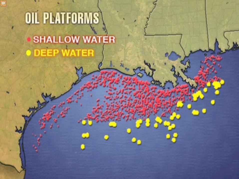
With the significant petroleum resource in the western Gulf, Louisiana and Texas have extensive petroleum platform reefs (rigs-to-reefs) with over 500 platforms reefed to date.
Presenter
Presentation Notes
This is obvious when you see the distribution of the 3,000+ standing platforms off TX and LA. (This does not include Deep Water Structures which are being discussed for decommissioning now).

Deck Wellhead
Boat Landing Top of Jacket
Cellar Deck
Main Deck
Helideck
Pile
Mudline
Piles
Well Conductor
Jacket
Jacket Leg
Jacket Bracing
Deck Leg
Reservoir
TYPICAL OFFSHORE PLATFORM
Presenter
Presentation Notes
For those not that familiar with petroleum platforms, we are only interested in the jacket (or legs) for reefing, which includes the conductors. Decks are prohibited by BOEM/BSEE and are taken into shore for reuse or scrapped.

14
12
10
8
6
4
2
0
TPWD Oil & Gas Donations 19
9019
9119
9219
9319
9419
9519
9619
9719
9819
9920
0020
0120
0220
0320
0420
0520
0620
0720
0820
0920
1020
1120
1220
1320
14
Presenter
Presentation Notes
Rig donations are cyclic and dependent on many outside factors such as oil prices and BSEE regulations. This is just a view on TX donations. BSEE Push for “Idle Iron” Removal. 25 % of Platforms Currently Idle, 52 % of Wells Currently Idle.

Fish Species Targeted
• Florida – General reef species, red snapper, gaggrouper, red grouper
• Alabama / Mississippi – Red snapper, Grey Triggerfish, Greater Amberjack, snapper species,gag grouper, flounder spotted seatrout,sheepshead
• Louisiana / Texas – General reef species with some concentration on Red snapper
Presenter
Presentation Notes
Artificial reefs are designed towards general reef fish assemblages but there have been some cases where reef habitat was specifically designed for specific species such as grey triggerfish (Alabama and Mississippi), red snapper (Alabama, Florida, Mississippi and Texas), gag grouper (Florida, Mississippi and Alabama), red grouper (Alabama and Florida) and amberjack (Alabama and Florida).

Artificial Reef Planning
• All GOM state artificial reef programs operate under approved statefisheries management plans
• All utilize the GSMFC Guidelines for Marine Artificial Reef Materials
• Enhance, conserve, and create marine habitat in general
• Provide habitat for certain target species on a case-by-case basis (FL-grouper; AL-grey triggerfish; TX-red snapper)
• Provide for fishing and diving opportunities (prime diving sites inFlorida; limited in other states due to water clarity)

Program Concerns
• Need for increased analysis of information on the biological outcome of specific reef designs (FL, TX)
• Public misconceptions on what artificial reefs can and can’t do in regard to fisheries management (FL)
• High fishing pressure at artificial reefs creates challenges for research and monitoring (FL)
• Rising labor, materials and equipment costs (ALL)
• Limited pool of marine contractors willing to undertake small artificial reef projects (FL)
• Limited waterfront artificial reef material staging areas (FL, TX)

Program Concerns
• Lack of public awareness of programs (TX)
• Project funding (e.g. low oil prices affect rigs-to-reef donations (LA, TX)
• Changing regulatory requirements (TX)
• Invasive species such as lionfish (ALL)
• Need for more scientific study such as socioeconomic, biological, and reef design (ALL)
• Lack of information and data on reef biological performance, especially in regard to target reef fish species objectives (FL)

Program Concerns
• Standardization of data collection and monitoring (physical and biological) (ALL)
• Better integration of reef development with fisheries management (ALL)


Back Up Slides

-
ARTIFICIAL REEF
DEVELOPMENT IN NEARSHORE TEXAS STATE WATERS OF THE
GULF OF MEXICO
DEEPWATER HORIZON NATURAL RESOURCE DAMAGE
ASSESSMENT COUNCIL
On April 20, 2010, an explosion on the
Deepwater Horizon MC252 drilling platform in the
Gulf of Mexico caused the rig to sink and oil began leaking into the Gulf. Before it was finally capped in mid July,
almost 5 million barrels of oil were released into the
Gulf.
Submitted Projects
ARTIFICIAL REEF
DEVELOPMENT IN OFFSHORE TEXAS WATERS OF THE GULF OF MEXICO
Presenter
Presentation Notes
Matagorda, Vancouver, and a Ship site (HI-A-424) – if not ship – then Corpus Site

Proposed TPWD Restore Act Projects
Presenter
Presentation Notes
The proposed artificial reef projects are located along the mid to upper Texas coast to supplement an already existing system of artificial reefs and permitted reef sites, which are represented as yellow dots. As you can see, there are not a lot of reefs inside state waters. State waters are located to the left of the red line and extend approximately 10 miles from the shoreline. Both the Freeport and Matagorda Artificial Reefs projects are being proposed because the projects would be located in state waters and would be more readily accessible than other existing artificial reefs. The Ship Reef would be located approximately 67 miles offshore from Galveston, TX in federal waters. This site is near the Flower Garden Banks National Marine Sanctuary, which is shown here on the map. The Corpus Artificial Reef, which is an alternative to the Ship Reef, would only be implemented if the Ship Reef was unable to be carried out for technical reasons, such as not being able to find an appropriate ship. Notes: Red line is the demarcation between state and federal waters. In Texas, federal waters begin 9 nautical miles off the coast. The Freeport, Matagorda, and Corpus Reef projects are located within state waters.

Estimated Cost: $2,155,365
BA–336 Proposed Vancouver Reefing Location: 6 miles south of Freeport
Presenter
Presentation Notes
The second proposed artificial reef project is the expansion of the existing Freeport Artificial Reef, an action that surveys have shown the public supported in the past. The center of this 160-acre permitted reef site already contains artificial reef materials consisting of the sunken Vancouver Liberty Ship as well as surrounding quarry rock and concrete structures. This project would place 800 to 950 concrete pyramids in the unoccupied portions of the reef site using the same methods as those described for Matagorda Artificial Reef. Like Matagorda, the purpose of this project is to create habitat that would attract reef fish and enhance recreational fishing opportunities. NOTES: The figure is a diagram of the entire 160-acre permitted reef area Gray triangles indicate the area where concrete pyramids are currently located. Red oval depicts the location and orientation of the Vancouver Liberty Ship. Other artificial reef materials are currently in the Project area within the area designated by the black square.

HI-A-424 – Proposed Ship Project Location: 67 miles offshore of Galveston
Estimated Cost: $1,785,765
Presenter
Presentation Notes
Slide 25: Just FYI. The ship project was the 3rd project in the list even though you show it first. Thus the dollar amount for the project was just what was left over after the other 2 nearshore projects were accounted for. We know this will not fund the entire project so the balance will come from the reef donation account. Many types of materials can be used to create artificial reefs including concrete pyramids, concrete culverts, and retired ships. In areas with decent water clarity, recreational divers may prefer artificial reef materials that provide high-quality, visually interesting experiences, such as a ship. As the name implies, the Ship Reef Project would sink a ship to create an artificial reef, which is a project that TPWD’s Artificial Reef Program has received a lot of public support for in the past. The ship would be at least 200 feet long and would be sunk in approximately 135 feet of water. The project would create a visually interesting artificial reef with a profile no higher than 75 feet from the sea floor. Prior to sinking, the ship would been cleaned of hazardous substances to meet Environmental Protection Agency (EPA) criteria, modified to meet clearance and safety requirements, as well as pass all required Federal and State inspections. A sinking plan would be developed for the use of explosives, which would be used to drive the ship in an upright position to the sea floor. This would create reef habitat that would be suitable to enhance recreational experiences for both anglers and divers. The level of Early Restoration funding for this project is lower than the other artificial reef projects because, given all the public support it has received, TPWD’s Artificial Reef Program would contribute approximately $2.4 million to the project. If for some reason, this project becomes technically infeasible, for example, because of an inability to find a suitable ship, then the Corpus Artificial Reef Project would be implemented. Notes: Image of a diver on a reef

BA-439 – Proposed Matagorda Reefing Location: 10 miles southeast of Matagorda County
Estimated Cost: $3,486,398
Presenter
Presentation Notes
The Matagorda Artificial Reef project area is 160-acres in 75ft of water. 1600 pyramid reefs are proposed for reefing. The Matagorda Artificial Reef project area is 160-acres, which is about the same size as the golf course on Pleasure Island (150 acres), [Galveston TAMU campus (135 acres), Corpus TAMU campus (240 acres)], and is located in an area which does not currently have any other reefs. This project would place about 1,600 predesigned concrete pyramids on the sea floor, which in this area is generally a sandy bottom habitat. The pyramids would be slowly lowered by a crane from a marine vessel as shown in the photograph. These artificial reef materials are known to attract reef fish, which would enhance recreational fishing opportunities. NOTES: This is a picture of concrete pyramids that have been used in similar artificial reef projects. We are proposing to use concrete pyramids for the Matagorda, Freeport, and Corpus reef projects.