GUJARAT TECHNOLOGICAL UNIVERSITY - …mytoolbag.in/media/GTUPAPERS/1/2/CIVIL/S3/GAG.pdf · rocks);...
24
Transcript of GUJARAT TECHNOLOGICAL UNIVERSITY - …mytoolbag.in/media/GTUPAPERS/1/2/CIVIL/S3/GAG.pdf · rocks);...

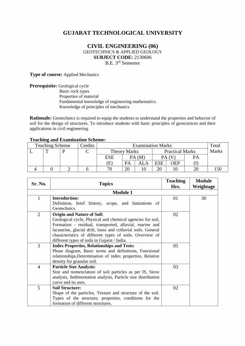
GUJARAT TECHNOLOGICAL UNIVERSITY
CIVIL ENGINEERING (06) GEOTECHNICS & APPLIED GEOLOGY
SUBJECT CODE: 2130606
B.E. 3rd Semester
Type of course: Applied Mechanics
Prerequisite: Geological cycle
Basic rock types
Properties of material
Fundamental knowledge of engineering mathematics.
Knowledge of principles of mechanics
Rationale: Geotechnics is required to equip the students to understand the properties and behavior of
soil for the design of structures. To introduce students with basic principles of geosciences and their
applications in civil engineering.
Teaching and Examination Scheme:
Teaching Scheme Credits Examination Marks Total
Marks L T P C Theory Marks Practical Marks
ESE
(E)
PA (M) PA (V) PA
(I) PA ALA ESE OEP
4 0 2 6 70 20 10 20 10 20 150
Sr. No. Topics Teaching
Hrs.
Module
Weightage
Module 1
1 Introduction:
Definition, brief history, scope, and limitations of
Geotechnics.
01 30
2 Origin and Nature of Soil:
Geological cycle, Physical and chemical agencies for soil,
Formation - residual, transported, alluvial, marine and
lacustrine, glacial drift, loess and colluvial soils. General
characteristics of different types of soils. Overview of
different types of soils in Gujarat / India.
02
3 Index Properties, Relationships and Tests:
Phase diagram, Basic terms and definitions, Functional
relationships,Determination of index properties, Relative
density for granular soil.
05
4 Particle Size Analysis:
Size and nomenclature of soil particles as per IS, Sieve
analysis, Sedimentation analysis, Particle size distribution
curve and its uses.
03
5 Soil Structure:
Shape of the particles, Texture and structure of the soil.
Types of the structure, properties, conditions for the
formation of different structures.
02

6 Soil Consistency:
Consistency limits and its determination, different indices,
Field moisture equivalent, Activity, Sensitivity &
Thixotropy of soil.
03
7 Soil Classification:
Objectives, Basis, Textural, Unified soil classification, IS
classification method, group index. Field identification
and General characteristics of the soil.
03
Module 2
8 Soil Water:
Free water and held water, Structural water and absorbed
water, Capillary
02 20
9 Permeability and Seepage:
Darcy's law and its validity, Factors affecting
permeability, Laboratory permeability tests, Introduction
to field permeability test, Permeability of stratified soil
masses, Laplace equation (2-D), Seepage pressure, Quick
condition, Flow net, its characteristics and application.
07
Module 3
10 Physical Geology:
Branches and scope of Geology; Surface processes and
landforms: Weathering and Erosion; Introduction to
geological agents (river, wind, oceans, glaciers,
groundwater) and their actions (erosion, transport and
deposition). Interior of the Earth: internal structure of
earth, study of core, mental and crust of the Earth.
Processes responsible for volcanism (Process of volcanic
eruption, types of volcanoes and volcanic hazard) and
earthquake (Causes of earthquake occurrence,
Distribution (seismic zoning), Seismo-tectonic setup of
India, seismic hazard: Tsunamis, Active fault rupture,
liquefaction). Plate Tectonics: Introduction to the concept
of plate tectonics, mechanism responsible for plate
movement, types of plate boundaries, processes and
features associated with plate boundaries. Continental drift
and sea floor spreading.
06 25
11 Mineralogy and Petrology:
Physical properties of minerals, major rock forming
minerals, occurrence and use of minerals. Introduction to
major rock types (Igneous, sedimentary and metamorphic
rocks); their genesis, classification and structures;
engineering properties of rocks, advantages and
disadvantages of different rock types at constructions
sites.
06
Module 4
12 Geological time-scale and laws of stratigraphy:
Introduction to geological time scale and stratigraphy,
Laws of stratigraphy.
01 25
13 Structural geology:
Introduction to primary and secondary geological
structures. Study of geological faults, folds, joints and
active faulting. Their origin, types and engineering
consideration. Geological mapping: study of Strike and
dip using models and numerical problems, preparation of
07

geological cross section.
14 Hydrogeology:
Hydrological cycle and groundwater occurrence. 01
15 Geology in Civil Engineering:
Geological investigations during planning for tunnels,
dams-reservoirs-runways-roads and buildings. Landslide
and mass movement: Introduction, types, mitigation and
prevention of landslide and mass movement. Remote
sensing and Geographical Information System (GIS):
Introduction to remote sensing and GIS, use of remote
sensing and GIS in geological investigations and
geological hazard mitigation.
07
Reference Books:
1. Arora K. R., Soil Mechanics & Foundation Engineering, Standard Publications.
2. Punmia B. C., Soil Mechanics & Foundations, Laxmi Publications,
3. Murthy V. N. S., Soil Mechanics & Foundation Engineering, Dhanpat Rai, Engineering
4. Alamsingh; Soil Mechanics & Foundation Engineering; CBS Publishers & Distributors, Delhi
5. Gopal Ranjan & Rao A. S. R., Basic & Applied Soil Mechanics, New Age International
Publishers
6. Das Braja M; Principles of Geotechnical Engineering; Thomson Asia Pvt. Ltd.
7. G. H. Davis, Stephen J. Reynolds and Charles F. Kluth, Structural Geology of Rocks and
Regions 3rd Edition, Wiley 2012.
8. S. K. Ghosh, Structural Geology: Fundamentals and Modern Developments, Elsevier Ltd,
2013.
9. F. G. Bell, Engineering Geology Second Edition, Elsevier Ltd, 2007..
10. Parbin Singh, Engineering and General Geology, S. K. Kataria & Sons 2010.
Course Outcome:
After learning the course the students shall be able to:
1. Know soil formation, types of soils, types of soils found in various parts of India.
2. Determine the index properties and interrelationships between various soil parameters.
3. Understand the different types of soil classification systems. Classify field soils as per particle
size and atterberg’s indices.
4. Know types of soil water found in nature, it’s permeability characteristics and seepage
determination.
5. Students will understand forces acting upon the surface of the Earth. Students will be able to
appreciate processes and geological agents involved in the shaping surface of the earth, and will
learn about the landforms produced as a result of these processes.
6. Students will be made familiar with the internal structure of the Earth, its properties and
processes.
7. Students will learn theory of continental drift and sea-floor spreading. Students will also be able
to understand mechanism and processes involved with plate tectonics, types of plate boundaries,
processes happening at the plate-boundaries and geological features produced at the plate-
boundaries.
8. Students will be able to know about hazards due to volcanic and seismic activity.
9. Students will be able to identify major mineral and rock types in hand-specimen.
10. Students will become familiar with the different types of geological structure and understand
hazard associated with their presence at site.
11. Students will be able to predict the likely engineering behaviour of rocks under specified geologic
conditions.
12. Students will be able to interpret engineering geologic maps.
13. Students will learn about use of satellite data and GIS for engineering geology.
List of Experiments:
Geotechnics lab:
1. Visual identification and specific gravity
2. Sieve Analysis
3. Hydrometer Analysis
4. Liquid and Plastic Limit Test
5. Shrinkage limit Test
6. In-situ Density-Core Cutter & Sand Replacement method
7. Permeability Test: Constant and Variable Head
Geology Lab:
1. Study of physical properties of major rock forming minerals.
2. Study of rock specimen.
3. Study of Strike and dip using models.
4. Numerical problems related to dip, strike and outcrop.
5. Preparation of geological cross section.
6. Case study: Geologic problems encountered during civil engineering projects.
7. Interpretation of satellite data and use of GIS software.
Field Application:
To collect various soil samples from local area and classify the soil as per IS.
Geologic field tour to study different types of geological structures and rocks.
Design Oriented Problems:
1. Prepare a chart showing soils available at different regions of Gujarat State with tentative soil
properties, Which actually results in prediction of soil behavior approximately.
2. Prepare a working model to make student understand concept of permeability for different
types of soil.
3. Prepare a working model which demonstrates horizontal and vertical permeability for
stratified mass.
Term Work:
Term work shall consist of laboratory work (Minimum 05 Experiments from listed below) and
tutorials (minimum 15 problems) based on above course. Practical examinations shall consist of oral
based on term work and above course.
List of Open Source Software/learning website:www.nptel.iitm.ac.in/courses/
*PA (M): 10 marks for Active Learning Assignments, 20 marks for other methods of PA
ACTIVE LEARNING ASSIGNMENTS: Preparation of power-point slides, which include videos,
animations, pictures, graphics for better understanding theory and practical work – The faculty will
allocate chapters/ parts of chapters to groups of students so that the entire syllabus to be covered. The
power-point slides should be put up on the web-site of the College/ Institute, along with the names of
the students of the group, the name of the faculty, Department and College on the first slide. The best
three works should submit to GTU.
1
Seat No.: ________ Enrolment No.___________
GUJARAT TECHNOLOGICAL UNIVERSITY BE - SEMESTER–III (NEW) - EXAMINATION – SUMMER 2017
Subject Code: 2130606 Date: 09/06/2017 Subject Name: Geotechnics & Applied Geology Time: 10:30 AM to 01:00 PM Total Marks: 70 Instructions:
1. Attempt all questions. 2. Make suitable assumptions wherever necessary. 3. Figures to the right indicate full marks.
Q.1 Short Questions 14
1 What is Alluvial soils?
2 Define Specific Gravity of soils.
3 Which soil is practically impermeable?
4 What is the effective size of soil?
5 In which type of soil honeycomb structure is observed.
6 State the Darcy’s law.
7 Give the size of sand particles.
8 What is capillary water?
9 When slope of the deposit is less than 10o , the deposits are called____________.
10 What is the thickness of mantle?
11 Give the examples of colourless minerals.
12 What is Aquifer?
13 The smallest clay mineral is_____________.
14 Give the method for finding bulk density of cohessionless soils.
Q.2 (a) Derive ɤd = ɤb/(1+w)
03
(b) Sample of sandy soil has 33% porosity. Find density index if maximum and
minimum dry unit weight of sample is respectively 18 kN/m3 and 14 kN/m3. Take
specific gravity of soil as 2.6.
04
(c) What is the scope of geotechnical engineering in the field of civil engineering? 07
OR
(c) With schematic diagram explain different types of soil structures. 07
Q.3 (a) Discuss the IS classification system. 03
(b) Soil sample has a liquid limit of 30%, plastic limit 17% and flow index of 13%.
Water content of soil is 19%. Determine (i) Plasticity Index, (ii) Liquidity Index,
(iii) Consistency Index, and (iv) Toughness Index.
04
(c) Explain Activity, Sensitivity and Thixotropy of soils. 07
OR
Q.3 (a) Define the following terms: (i) Gravitational Water (ii) Structural
Water (iii) Adsorbed Water
03
(b) A soil sample of height 60 mm and cross sectional area of 100 cm2 was subjected
to falling head permeability test. In a time interval of 6 minutes, the head dropped
from 60 cm to 35 cm. If the cross sectional area of the stand pipe is 2 cm2,
compute the coefficient of permeability of the soil sample. If the same sample is
subjected to a constant head of 20 cm, calculate the total quantity of water that will
be collected after flowing through the sample.
04
(c) State and explain factors affecting permeability of soils.
07
Q.4 (a) Enlist the different causes of earthquakes. 03
(b) Define Weathering and discuss the process involved in chemical weathering. 04

2
*************
(c) What is an earthquake? Describe the types of earthquake waves. 07 OR
Q.4 (a) Write short note on agents of metamorphism. 03
(b) Explain ‘rock cycle’. 04
(c) Describe the applications of geology in civil engineering. 07
Q.5 (a) Define aquifer? How are they formed and classified? 03
(b) Explain permeability and porosity of rocks. 04
(c) Give the classification of faults based on apparent movements. 07
OR
Q.5 (a) What are landslides? How they are caused? 03
(b) What are the limitations of GIS. 04
(c) What is remote sensing? Explain the application of remote sensing in engineering
geology. 07

1
Seat No.: ________ Enrolment No.___________
GUJARAT TECHNOLOGICAL UNIVERSITY BE - SEMESTER–III(New) • EXAMINATION – WINTER 2016
Subject Code:2130606 Date:09/01/2017
Subject Name:Geotechnics & Applied Geology
Time: 10:30 AM to 01:00 PM Total Marks: 70 Instructions:
1. Attempt all questions.
2. Make suitable assumptions wherever necessary.
3. Figures to the right indicate full marks.
Q.1 Short Questions 14
1 The soil transported by water is called ___________.
2 Define the term: Degree of saturation
3 If the void ratio of a soil sample is 20%, the porosity is _______.
4 What is the value of plasticity index for a sandy soil?
5 A soil having particles of nearly same size is called ______
6 In IS soil classification system, what is the symbol for well graded
sand?
7 Which corrections are applied in hydrometer analysis?
8 Which clay mineral has the maximum swelling property?
9 For which type of soil, falling head permeability test is performed?
10 Define the term: Cleavage.
11 Which mineral has the minimum and maximum hardness on a
Mohr’s scale?
12 Define the epicenter of an earth quake.
13 Define the term : Run off.
14 What are the side effects of an earth quake?
Q.2 (a) The porosity of a soil sample is 35% . Calculate its void ratio, dry
density, saturated density and submerged density. Take G = 2.7. 03
(b) Explain grain size distribution by sieve analysis. 04
(c) Describe various factors affecting permeability of a soil mass. 07
OR
(c) Describe the different types of soil structure in detail. 07
Q.3 (a) What is a quick sand? Explain the meaning of critical hydraulic
gradient. 03
(b) Explain total stress, effective stress and neutral stress. 04
(c) Explain the characteristics of flow net with any two applications. 07
OR
Q.3 (a) Derive the functional relationship between bulk density, dry
density and moisture content, 𝛾𝑑= γ/ 1+w,
03
(b) Write a short note on the adsorbed water. 04
(c) Calculate the plasticity index, liquidity index and consistency
index of a soil mass for a given data. Natural water content : 50%,
Liquid limit : 55%, Plastic limit 25%. What would be the type of
soil on a plasticity chart?
07
Q.4 (a) What is the importance of geology for civil engineering? 03
(b) Explain the agents which are responsible for metamorphic
changes.
04
(c) Enlist the different engineering properties of rocks and explain
them. 07
OR

2
Q.4 (a) Define and explain the process of chemical weathering. 03
(b) Write a short note on seismic zoning of India. 04
(c) Explain different laws of stratigraphy. 07
Q.5 (a) Write a short note on types of land slides. 03
(b) Explain uses of minerals. 04
(c) What are the application of remote sensing in geological
investigation? 07
OR
Q.5 (a) Explain hydrological cycle with figure. 03
(b) Explain geological investigation during planning of a building. 04
(c) Define the term joint and write a short note on types of joints. 07
*************
1
Seat No.: ________ Enrolment No.___________
GUJARAT TECHNOLOGICAL UNIVERSITY
BE - SEMESTER–III(New) EXAMINATION – SUMMER 2016
Subject Code:2130606 Date:31/05/2016
Subject Name:Geotechnics & Applied Geology Time:10:30 AM to 01:00 PM Total Marks: 70 Instructions:
1. Attempt all questions.
2. Make suitable assumptions wherever necessary. 3. Figures to the right indicate full marks.
MARKS
Q.1 Short Questions 14
1 The soil transported by wind is called ___________.
2 Define the term: water content.
3 If the porosity of a soil sample is 20%, the void ratio is _______.
4 What is the value of plasticity index for a sandy soil?
5 State the particle size range of silt.
6 In IS soil classification system, what is the symbol for sandy silt?
7 Usually the shape of clay particle is ________.
8 Which clay mineral has the maximum swelling property?
9 For which type of soil, constant head permeability test is performed?
?performed?
10 State Darcy’s law.
11 On a Mohr’s scale, which mineral has the maximum hardness?
12 Define the magnitude of an earth quake.
13 Define the term: aquifer.
14 What are the side effects of an earth quake?
Q.2 (a) Give the general over view of soil types in Gujarat. 03
(b) Describe the terms with their probable range : co-efficient of uniformity
and co-efficient of curvature 04
(c) Describe the step by step procedure to perform permeability test on a fine
grained soil in the laboratory. 07
OR
(c) Describe step by step procedure to perform liquid limit test in the
laboratory.
07
Q.3 (a) Distinguish between density and relative density. 03
(b) If the bulk unit weight of a wet soil mass is 19.80 kN/m3, find dry density,
void ratio and degree of saturation of soil mass. consider water content is
12%.
04
(c) Explain the characteristics of flow net with its applications. 07
OR
Q.3 (a) Derive the functional relationship e.Sr = m.G 03
(b) Write a short note on the capillary water. 04
(c) Write a short note on the types of soil structure. 07
Q.4 (a) What is the importance of geology for civil engineering? 03
(b) According to the mode of origin, give the classification of rocks. 04
(c) Explain the terms: dip and strike with neat sketches. Give the classification
of faults 07
OR
Q.4 (a) Define weathering and explain the process of physical weathering. 03
(b) Describe in brief types of earth quake waves. 04
(c) Write a short note on the types of land slides. 07

2
Q.5 (a) What do you understand by the term liquifaction? 03
(b) Explain how sedimentary rocks are formed. 04
(c) Write a short note on the internal structure of the earth. 07
OR
Q.5 (a) Define terms: evaporation and transpiration. 03
(b) Write the classification of folds. 04
(c) Write a short note on application of remote sensing in engineering
geology. 07
*************
1
Seat No.: ________ Enrolment No.___________
GUJARAT TECHNOLOGICAL UNIVERSITY BE - SEMESTER–III (New) EXAMINATION – WINTER 2015
Subject Code:2130606 Date:21/12/2015
Subject Name: Geotechnics & Applied Geology
Time: 2:30pm to 5:00pm Total Marks: 70 Instructions:
1. Attempt all questions.
2. Make suitable assumptions wherever necessary.
3. Figures to the right indicate full marks.
MARKS
Q.1 Short Questions 14
1 State the Darcy’s Law.
2 When are you addressing the sediments as “Quick Sand”.
3 Which parameter controls the coefficient of permeability
in a soil?
in a soil?
4 What does Liquidity Index indicate?
5 Which clay mineral show swelling property?
6 State the Hardness of Apatite.
7 What is the significance of particle-size analysis?
8 Which soil can have more adsorbed water?
9 State the volcanic equivalent of Granite?
10 Which age rocks occupy the core of Anticline?
11 Is Color and Luster of Hematite same or different?
State the reason.
12 What is the process involved when Feldspar changes into
Kaolinite; when decomposition takes place?
13 What are the factors controlling the landslides?
14 Which silicate structure Quartz family crystallizes?
Q.2 (a) A coarse grained soil has a void ratio of 0.78 and specific
gravity as 2.67. Calculate the critical gradient. 03
(b) Discuss briefly the scope of Geotechnical engineering in
relation to Civil Engineering. 04
(c) How to identify the different soils in the field? 07
OR
(c) Discuss the structure of different Soils 07
Q.3 (a) Describe the soils of Gujarat State 03
(b) Define Permeability. Discuss the factors affecting the
permeability of the soils. 04
(c) The consistency limits of clay are: Liquid limit=52 %;
Plastic limits=30 % and shrinkage limit=18 %. If a
specimen shrinks from a volume of 39.5 cm3, at liquid
limit; to a volume of 24.2 cm 3, at shrinkage limit.
Calculate true specific gravity, and shrinkage ratio?
07
OR
Q.3 (a) Derive ɤd=ɤb/(1+w) 03
(b) Explain Laplace (2-D Flow) equation for permeability of
a soil 04
(c) An undisturbed soil sample has total wt of 2060grams,
volume of 2000cc, water content =11 % and specific 07
2
gravity =2.68. Compute (i) Void ratio, (ii) porosity, (iii)
degree of Saturation, (iv) Water content to make sample
fully saturated and (v) Efficient unit weight of soil
sample.
Q.4 (a) On what basis are the silicate minerals classified? Give
with the examples. 03
(b) Discuss the tabular classification of igneous rocks. 04
(c) Define metamorphism. Explain different types of
Metamorphism. State 4 metamorphic rocks and how are
they formed?
07
OR
Q.4 (a) Define Weathering and discuss the process involved in
chemical weathering. 03
(b) Discuss the interior of Earth. 04
(c) Define the plate tectonic theory. Explain the convergent
boundary margin with diagram 07
Q.5 (a) What is a geological time scale? Indicate its purpose. 03
(b) Distinguish between the Pairs; a. Strike and dip; b.
Normal and reverse faults; 04
(c) What are folds? How they are formed? Describe with
neat sketches the different types of folds. Add note on the
engineering significance of folds.
07
OR
Q.5 (a) Define aquifer? How are they formed and classified? 03
(b) Define spatial, spectral and radiometric resolutions.
Discuss their importance in remote sensing applications. 04
(c) Describe the important geological conditions for driving
in tunnel and underground excavations. Discuss the
geological problems.
07
*************
1
Seat No.: ________ Enrolment No.___________
GUJARAT TECHNOLOGICAL UNIVERSITY BE - SEMESTER–III • EXAMINATION – WINTER • 2014
Subject Code: 2130606 Date: 01-01-2015
Subject Name: Geotechnics and Applied Geology
Time: 02.30 pm - 05.00 pm Total Marks: 70 Instructions:
1. Attempt all questions.
2. Make suitable assumptions wherever necessary.
3. Figures to the right indicate full marks.
Q.1 (a) What is the scope of geotechnical engineering in the field of civil engineering? 07
(b) What is weathering? Enumerate the type of weathering. Distinguish between
physical and chemical weathering.
07
Q.2 (a) A soil sample has a porosity of 40 percent. The specific gravity of solids is 2.70.
Calculate (a) void ratio, (b) dry density, (c) unit weight if the soil is 50%
saturated and (d) unit weight if the soil is completely saturated.
07
(b) What is an earthquake? What are the causes of earthquakes? Describe in brief
the types of earthquake waves.
07
OR
(b) How is geology related to civil engineering? Discuss the scope of application of
geological knowledge in the planning and execution of engineering works.
07
Q.3 (a) Define the following terms: (i) water content (ii) void ratio (iii) porosity (iv) Unit
weight of solids (v) Air content (vi) Bulk Unit weight (vii)Specific gravity
07
(b) Discus in brief the importance of study of geology for a civil engineer. 07
OR
Q.3 (a) A soil sample has a liquid limit of 30%, plastic limit 17% and flow index of 13%.
Natural water content of soil is 19%. Determine: (i) plasticity index (ii) liquidity
index (iii) consistency index(iv) Toughness index
07
(b) Define laws of stratigraphy. 07
Q.4 (a) Enlist the various methods of water content determine and explain oven drying
method.
07
(b) Define the terms: (i) permeability (ii) seepage (iii)coefficient of
permeability(iv)Darcy’s law (v) flow net(vi) Discharge velocity(vii)Hydraulic
gradient(i)
07
OR
Q.4 (a) Define a mineral describe in brief the various physical properties of minerals
which help in their identification.
07
(b) Explain grain size distribution by sieve analysis. 07
Q.5 (a) What are faults? How they are classified? Illustrate with neat and suitable
diagram.
07
(b) What is texture of the soil? 07
OR
Q.5 (a) What are the purposes of the soil classification? 07
(b) Write short notes on the following: (i) water table and perched water table (ii)
confined aquifer and unconfined aquifer
07
*************

1
Seat No.: ________ Enrolment No.___________
GUJARAT TECHNOLOGICAL UNIVERSITY BE - SEMESTER–IV (OLD) - EXAMINATION – SUMMER 2017
Subject Code: 140604 Date: 14/06/2017 Subject Name: Engineering Geology Time: 10:30 AM to 01:00 PM Total Marks: 70 Instructions:
1. Attempt all questions. 2. Make suitable assumptions wherever necessary. 3. Figures to the right indicate full marks.
Q.1 (a) What is geology? Describe in brief main branches of geology. 07
(b) Describe prediction of earthquake& describe earthquake waves. 07
Q.2 (a) Give the definition of Weathering. Describe the chemical weathering in detail. 07
(b) Describe the term plate-tectonics & describe the plate boundaries. 07
OR
(b) Write short notes on (i) sand dunes (ii) loess 07
Q.3 (a) What is mineralogy? Describe the physical properties of mineral. In detail
describe only hardness & streak.
07
(b) What is the origin of sedimentary rocks? Give classification of sedimentary
rocks.
07
OR
Q.3 (a) What is crystal? Describe elements of crystallography. 07
(b) What is petrology? Describe the structures of igneous rocks. 07
Q.4 (a) Define the terms: aquifer, aquiclude, aquitard, porosity, permeability, specific
yield, ground water recharge.
07
(b) What is tunnel? Describe tunneling in different type of rocks. 07 OR
Q.4 (a) Application of remote-sensing. 07
(b) What is a geological criterion for site selection of dam& reservoir? 07
Q.5 (a) Give the terminology of fold & fault in detail. 07
(b) Give the classification of fault based on apparent moment. 07
OR
Q.5 (a) Explain dip & strike, anticline & syncline with neat sketch. 07
(b) Give classification of fault based on apparent movement. 07
*************

1
Seat No.: ________ Enrolment No.___________
GUJARAT TECHNOLOGICAL UNIVERSITY BE - SEMESTER–IV(OLD) • EXAMINATION – WINTER 2016
Subject Code:140604 Date:25/11/2016
Subject Name:Engineering Geology
Time: 02:30 PM to 05:00 PM Total Marks: 70 Instructions:
1. Attempt all questions. 2. Make suitable assumptions wherever necessary. 3. Figures to the right indicate full marks.

2
1
Seat No.: ________ Enrolment No.___________
GUJARAT TECHNOLOGICAL UNIVERSITY BE - SEMESTER–IV EXAMINATION – SUMMER 2016
Subject Code:140604 Date:08/06/2016 Subject Name:Engineering Geology Time:10:30 AM to 01:00 PM Total Marks: 70 Instructions:
1. Attempt all questions. 2. Make suitable assumptions wherever necessary. 3. Figures to the right indicate full marks.
Q.1 (a) Write objectives of Engineering Geology. Write note on scope of Engineering
geology in the field of Civil Engineering.
07
(b) Enlist various property of Mineral to identify them. Explain any 3 of them. 07
Q.2 (a) Write short notes on : i. Sediment transportation by river ii. Structures in
Igneous rocks
07
(b) Define earthquake. Explain magnitude and intensity of an earthquake. 07
OR
(b) Write note on seismic waves and their characteristics. 07
Q.3 (a) How joints differ from faults? Describe development of sheet joints and
columnar joints in rock mass.
07
(b) How folds and faults are recognized in the field? 07
OR
Q.3 (a) Explain favorable and unfavorable ground water conditions for reservoir construction. 07
(b) Write a note on geological investigation carried out for the tunnel structures. 07
Q.4 (a) How does geology influence the design of tunnel? Comment on suitability of tunnel
structures in hard and soft rock formations.
07
(b) How geological maps and geological profile are essential in site selection of civil
engineering projects?
07
OR
Q.4 (a) How geological knowledge may be helpful in highway construction? Add your note
for geological consideration in railways.
07
(b) Describe suitability of dam structures on deformed rock mass with neat sketches. 07
Q.5 (a) Write short notes on types of metamorphism and the agencies involved in it. 07
(b) How the sedimentary rocks are formed? Describe texture of the sedimentary rocks. 07
OR
Q.5 (a) How igneous rocks are formed in the field. Write their engineering significance. 07
(b) Write note on wind erosion. Add your note with desert encroachment and
challenges for civil engineers.
07
*************

1
Seat No.: ________ Enrolment No.___________
GUJARAT TECHNOLOGICAL UNIVERSITY BE - SEMESTER–IV EXAMINATION – WINTER 2015
Subject Code: 140604 Date:04/01/2016
Subject Name: Engineering Geology
Time: 02:30pm to 05:00pm Total Marks: 70 Instructions:
1. Attempt all questions.
2. Make suitable assumptions wherever necessary.
3. Figures to the right indicate full marks.
Q.1 (a) Application of geology in civil engineering. 07
(b) Give the definition of Weathering. Describe the chemical weathering in detail. 07
Q.2 (a) Define the term plate-tectonics & describe the plate boundaries. 07
(b) What is mineralogy? Describe the physical properties of mineral. In detail describe
only hardness& streak.
07
OR
(b) What is crystal? Describe elements of crystallography. 07
Q.3 (a) What is petrology? Describe the structures of igneous rocks. 07
(b) What is the origin of sedimentary rocks? Give classification of sedimentary rocks. 07
OR
Q.3 (a) Describe the agents & kind of metamorphisms. 07
(b) What are the geological properties of building stone? Describe Granite & Marble. 07
Q.4 (a) Give the terminology of fold & fault in detail 07
(b) Define the terms: unconformity, inlier, outlier, outcrop, joint dip strike. 07
OR
Q.4 (a) Give the classification of fault based on apparent moment. 07
(b) Describe prediction of earthquake.& describe earthquake waves 07
Q.5 (a) Define the terms: aquifer, aquiclude, aquitard, porosity, permeability, specific
yield, ground water recharge.
07
(b) What is tunnel? Describe tunneling in different type of rocks. 07
OR
Q.5 (a) Give definition of landslides. Describe factor affecting landslides. 07
(b) What is a geological criterion for site selection of dam& reservoir? 07
*************

Seat No.: ________ Enrolment No.___________
GUJARAT TECHNOLOGICAL UNIVERSITY BE – SEMESTER IV EXAMINATION – SUMMER 2015
Subject Code: 140604 Date: 05/06/2015 Subject Name: Engineering Geology Time: 10.30am-01.00pm Total Marks: 70 Instructions:
1. Attempt all questions. 2. Draw neat sketch and quote suitable examples 3. Figures to the right indicate full marks.
Q.1 (a) Write objectives of engineering geology. Explain the application of engineering
geology in the field of civil engineering. 07
(b) Define earthquake. Describe P-waves, S-waves and Intensity of an earthquake. 07 Q.2 (a) Write short notes on: (i) Frost action and thermal action - weathering on rock
(ii) Oxidation and reduction type of weathering on rock 07
(b) Enlist geological natural agencies and geological work. Describe erosion work of river water with the features developed in rock mass.
07
OR (b) Explain transportation work of wind. Add your note with engineering problem
of desert advancement and remedial measures to control it. 07
Q.3 (a) Write Short notes On: (i) Colour and luster property of mineral (ii) Mechanical structure in sedimentary rocks
07
(b) Define lava and magma. Describe the way of formation of igneous rocks. Write subgroups of igneous rocks based on its occurrence.
07
OR Q.3 (a) Write short notes on: (i) Hardness property and Moh’s scale of hardness
(ii) Metamorphic changes in rocks 07
(b) Explain elastic rebound theory of an earthquake. Add your note with various plate boundaries and their characteristics.
07
Q.4 (a) Explain water bearing qualities of rock formation. Add note on confined and unconfined aquifers of rocks. Quote suitable rock examples.
07
(b) Explain fold and its causative factors. Write engineering importance of fold. 07 OR
Q.4 (a) Differentiate normal and reverse fault. Write engineering importance of fault. 07 (b) Define mass movement. Write note on internal causative factors of mass
movement and remedial measures to control it. 07
Q.5 (a) What is Remote sensing and GIS techniques? Explain significance of remote sensing in geology and watershed projects.
07
(b) Describe geological investigation required for the site selection of the tunnel alignment. How water level in region influences the alignments of the tunnel?
07
OR Q.5 (a) Discuss suitability of geological conditions for dam construction. Write note on
various forces act on dams influenced by geological factors. 07
(b) Define geological maps and topographical maps. Which are the components seen in geological maps? Write its engineering importance.
07
*************
1

1
Seat No.: ________ Enrolment No.___________
GUJARAT TECHNOLOGICAL UNIVERSITY BE - SEMESTER–IV • EXAMINATION – WINTER • 2014
Subject Code: 140604 Date: 05-01-2015
Subject Name: Engineering Geology
Time: 02:30 pm - 05:00 pm Total Marks: 70 Instructions:
1. Attempt all questions.
2. Make suitable assumptions wherever necessary.
3. Figures to the right indicate full marks.
Q.1 (a) Define geology. Give the significance of study of geological science in civil
engineering practices.
07
(b) Define mineral and rock. Describe three important physical properties of
minerals.
07
Q.2 (a) Enlist the different geological agents? Discuss about the weathering patterns
observed in rocks.
07
(b) Explain how landslides can be controlled. 07
OR
(b) Drawing a diagram, describe the various parts of a typical fold. 07
Q.3 (a) State the different applications of remote sensing and GIS in civil engineering. 07
(b) Describe the rock cycle. 07
OR
Q.3 (a) What are sedimentary rocks? How are these rocks formed? 07
(b) What is metamorphism? Describe types of metamorphism with suitable
illustrations. 07
Q.4 (a) Describe various sources of ground water. 07
(b) What is a dam? List their types. Critically explain the geological problems
encountered during the construction of dams.
07
OR
Q.4 (a) Discuss the role of porosity and permeability in occurrence of ground water. 07
(b) Narrate in detail the usefulness of geological maps and sections. 07
Q.5 (a) Describe the important geological properties of building stones. 07
(b) Explain the dip and strike of a bed and anticline and syncline with the help of
sketches.
07
OR
Q.5 (a) State the objects of geological investigations. 07
(b) Discuss on the need and importance of artificial recharging of ground water. 07
*************

1
Seat No.: ________ Enrolment No.___________
GUJARAT TECHNOLOGICAL UNIVERSITY BE - SEMESTER–IV • EXAMINATION – SUMMER • 2014
Subject Code: 140604 Date: 27-06-2014
Subject Name: Engineering Geology
Time: 10:30 am - 01:00 pm Total Marks: 70 Instructions:
1. Attempt all questions.
2. Make suitable assumptions wherever necessary.
3. Figures to the right indicate full marks.
Q.1 (a) Define engineering geology. Explain technical responsibilities of a civil engineer
and an engineering geologist in civil engineering projects.
07
(b) Define mineral. Describe in detail Moh’s scale of hardness and cleavage as
physical properties of minerals.
07
Q.2 (a) Explain (1) Magnitude and Intensity of an earthquake. (2)Branches of geology
important in civil engineering.
07
(b) What are geological agents? Describe in detail the mechanical weathering of
rocks.
07
OR
(b) Define the terms weathering, erosion and denudation. Explain river meandering. 07
Q.3 (a) Define crystal. Enlist elements of a crystal. Write note on any one
crystallographic system.
07
(b) What is an earthquake? Describe the types of earthquake waves and concepts of
plate tectonics.
07
OR
Q.3 (a) Explain dip and strike, normal and reverse faults with neat sketches. 07
(b) What are folds? Explain various terminology of a typical fold with neat sketches. 07
Q.4 (a) What are sedimentary rocks? Describe the formation of clastic sedimentary rock
and write tabular classification of sedimentary rocks.
07
(b) Describe the factors and kinds of metamorphism. 07
OR
Q.4 (a) Define and explain (1) Equigranular and Ophitic textures (2) Dykes (3)
Batholith.
07
(b) Write notes on rock cycle and sand dunes. 07
Q.5 (a) Enlist and explain briefly the geological criteria for site selection of dam. 07
(b) What does landslide mean? State various factors affecting landslides. 07
OR
Q.5 (a) Porosity and Permeability. 04
(b) Streak and forms as physical properties of minerals. 06
(c) Explain remote sensing and geographical positioning system. 04
*************
1/1
Seat No.: ________ Enrolment No.___________
Describe the decomposition of rocks, giving suitable examples.Define a mineral? Describe the Streak and Hardness properties of minerals.
Write notes on the following topics:(i) Significance of Geology in civil engineering practices(ii) Components of a typical fault
Elaborate how can landslides be prevented?
What are earthquakes and tsunamis? Add a note on prediction of earthquakes.
Write detailed notes on the following topics:Factors and types of metamorphism Dykes and sills
Describe the Rock Cycle in detail.What are sedimentary rocks? Narrate how are these formed?
Write notes on the following topics:Anticlines and synclinesArtificial recharging of subsurface water
Write a note on application of Remote Sensing and GIS in civil engineering.Narrate the significance of geological maps and sections.
Narrate the merits and demerits of a tunnel alignment passing through faulted rock formations.Write detailed notes on crystallographic axes and elements of symmetry.
Classify the following rocks as per their origin:(i) Gabbro (ii) Slate (iii) Granite (iv) Marble(v) Limestone (vi) Shale (vii) Schist
Describe the zonal distribution of ground water.
GUJARAT TECHNOLOGICAL UNIVERSITYBE - SEMESTER–IV • EXAMINATION – SUMMER 2013
Subject Code: 140604 Date: 19-06-2013 Subject Name: Engineering GeologyTime: 10:30am – 01:00pm Total Marks: 70Instructions:
1. Attempt all questions. 2. Make suitable assumptions wherever necessary.3. Figures to the right indicate full marks.
Q.1 (a) 07(b) 07
Q.2 (a) 07
(b) 07OR
(b) 07
Q.3 (a) 07(b) 07
ORQ.3 (a) 07
(b) 07
Q.4 (a)(b)
0707
OR
Q.4 (a) 07(b) 07
Q.5 (a) 07
(b) 07OR
Q.5 (a) 07
(b) 07
*************