Guidelines for Wind Resource Assessment: Best Practices for ...
49
GUIDELINES FOR WIND RESOURCE ASSESSMENT: BEST PRACTICES FOR COUNTRIES INITIATING WIND DEVELOPMENT ASIAN DEVELOPMENT BANK
Transcript of Guidelines for Wind Resource Assessment: Best Practices for ...

GUIDELINES FOR WIND RESOURCE ASSESSMENT:BEST PRACTICES FOR COUNTRIES INITIATING WIND DEVELOPMENT
ASIAN DEVELOPMENT BANK
Guidelines for Wind Resource AssessmentBest Practices for Countries Initiating Wind Development
Wind Resource Assessment (WRA) is a pivotal step in the development phase because it determines the bankability of wind projects. The Asian Development Bank’s Quantum Leap in Wind Power Development in Asia and the Pacific project has developed WRA guidelines that encapsulate best practices for new and emerging wind energy markets with the goal of accelerating wind energy development. The guidelines address challenges to policy support for WRA, wind measurement, wind data processing, wind flow modeling, and estimation of losses and uncertainty. These are challenges faced in these markets by policy makers, implementation agencies, utilities, developers, and financiers.
About the Asian Development Bank
ADB’s vision is an Asia and Pacific region free of poverty. Its mission is to help its developing member countries reduce poverty and improve the quality of life of their people. Despite the region’s many successes, it remains home to approximately two-thirds of the world’s poor: 1.6 billion people who live on less than $2 a day, with 733 million struggling on less than $1.25 a day. ADB is committed to reducing poverty through inclusive economic growth, environmentally sustainable growth, and regional integration.
Based in Manila, ADB is owned by 67 members, including 48 from the region. Its main instruments for helping its developing member countries are policy dialogue, loans, equity investments, guarantees, grants, and technical assistance.
ASIAN DEVELOPMENT BANK6 ADB Avenue, Mandaluyong City1550 Metro Manila. Philippineswww.adb.org

ASIAN DEVELOPMENT BANK
GUIDELINES FOR WIND RESOURCE ASSESSMENT: BEST PRACTICES FOR COUNTRIES INITIATING WIND DEVELOPMENTMay 2014

Printed on recycled paper
© 2014 Asian Development Bank.
All rights reserved. Published 2014.Printed in the Philippines.
ISBN 978-92-9254-562-8 (Print), 978-92-9254-563-5 (PDF)Publication Stock No. TIM146446
Cataloging-In-Publication Data
Asian Development Bank. Guidelines for wind resource assessment: Best practices for countries initiating wind development.Mandaluyong City, Philippines: Asian Development Bank, 2014.
1. Wind.�2. Wind energy.�3. Renewable energy.�I. Asian Development Bank.
The views expressed in this publication are those of the authors and do not necessarily refl ect the views and policies of the Asian Development Bank (ADB) or its Board of Governors or the governments they represent.
ADB does not guarantee the accuracy of the data included in this publication and accepts no responsibility for any consequence of their use.
By making any designation of or reference to a particular territory or geographic area, or by using the term “country” in this document, ADB does not intend to make any judgments as to the legal or other status of any territory or area.
ADB encourages printing or copying information exclusively for personal and noncommercial use with proper acknowledgment of ADB. Users are restricted from reselling, redistributing, or creating derivative works for commercial purposes without the express, written consent of ADB.
Note:In this publication, “$” refers to US dollars.
6 ADB Avenue, Mandaluyong City1550 Metro Manila, PhilippinesTel +63 2 632 4444Fax +63 2 636 2444www.adb.org
For orders, please contact: Public Information CenterFax +63 2 636 [email protected]

iii
Contents
List of Tables and Figures iv
Foreword v
Executive Summary vii
Abbreviations ix
I. Introduction to Wind Resource Assessments 1II. Wind Energy Project Life Cycle 2III. Importance of Accurate Wind Resource Assessments 4
A. Wind Resource Assessment Challenges 4B. Impact of Wind Resource Assessments on Financial Feasibility 5C. Impact of Wind Resource Assessments on Grid Integration 6D. Special Note for Small and Medium-Sized Wind Projects 6
IV. Wind Resource Assessment Process 7
A. Loss and Uncertainty Estimation 8B. Bankable Wind Resource Assessments 10
V. Best Practices for Wind Resource Assessments 11
A. Policy 111. Feed-in Tari� 112. Licensing Guidelines 113. Grant or Low-Interest Loan for Wind Resource Assessments 124. Long-Term (10–20 Years) Measurement for High-Quality
Reference Wind Data 13
B. Countrywide Resource Assessment 14C. Project-Specifi c Measurement 14D. Managing Resource Assessment Uncertainty 15
VI. Conclusions 18VII. References 19
Appendixes
1. Nuts and Bolts of Wind Resource Assessments 202. Wind Measurement 223. Prospecting and Methodology and Tools for Micrositing of Met-masts 29
iv
Tables and Figures
TABLES 1 Description of the Activities in the Life Cycle of a Wind Energy Project 3 2 Description of the Five Stages of a Wind Resource Assessment 8 3 Best Practices from the Perspectives of the Five Stakeholders 16 A1.1 List of Measured Parameters in a Wind Resource Assessment 20 A1.2 List of Computed Parameters in a Wind Resource Assessment 21 A2.1 Description of Met-Towers, Sensors, and Confi guration 22 A2.2 Description of the Tasks for Estimating Annual Energy Production 26
FIGURES 1 Activities in the Life Cycle of a Wind Energy Project 2 2 Five Stages of a Wind Resource Assessment 7 3 Illustration of Exceedance Probabilities 10 A2.1 Process for Estimation of Annual Energy Production 26
v
Foreword
Wind energy enjoys a unique place in climate change mitigation. It is the most mature and the most cost-e� ective solution to reducing global greenhouse gas (GHG) emissions from the electricity sector, which is the largest contributor of GHG emissions. Signifi cant improvements to performance and cost of wind power plants have occurred in the past 20 years, enabling wind energy to reach cost parity with newly built conventional power plants in mature wind energy markets, in areas with good wind resource, and when the costs of GHGs are included.
The Asian Development Bank (ADB) has been at the forefront of fi nancing clean energy projects in Asia and the Pacifi c. It is committed to promoting clean energy as a means of increasing access to clean and a� ordable energy for people throughout the region. This is done by assisting countries in terms of fi nancing, knowledge sharing, technical support, and capacity development. ADB’s Strategy 2020 provides climate change responses as an integral component of sustainable growth and poverty reduction. ADB provides much-needed support for the deployment of clean energy technology in the region. A target was set to reach $2 billion a year in clean energy investments by 2013. This target was met, and even exceeded, in 2011, 2 years early, with $2.13 billion invested. Specifi c to wind power projects, ADB has invested $1.22 billion in loans and equity between 2005 and 2013. It has funded multiple technical assistance programs in this area. In 2011, ADB approved the regional technical assistance for the Quantum Leap in Wind Power Development in Asia and the Pacifi c with an investment of $2 million for the formulation of comprehensive multistakeholder road maps; detailed wind resource assessments; and conduct of prefeasibility studies, grid integration, and other analyses in Mongolia, the Philippines, and Sri Lanka.
This publication contains guidelines that were developed by the Quantum Leap in Wind Power Development in Asia and the Pacifi c Technical Assistance team as an encapsulation of the best practices with regard to bankable wind resource assessments (WRAs) in new and emerging wind energy markets. The WRA, specifi cally wind measurement, is in most cases the longest lead time activity in a wind project. It is also the most pivotal activity because it determines the bankability of the wind project. The developing member countries face unique technical and fi nancial challenges during the WRA process, which hamper wind project developers’ ability to obtain fi nancing. Although conditions in each country are di� erent, this publication highlights the common challenges and proposes solutions, with the goal of accelerating the development phase of a wind energy project. The underlying message of the guidelines in this publication is that execution of a WRA—wind measurement, wind fl ow

vi
Foreword
modeling, and estimation of losses and uncertainty—requires rigor and experience. In support of this message, the guidelines provide details about the components of a WRA and the expectations of investors. The guidelines are intended to help policy makers, implementing agencies, private developers, utility companies, and investors in developing member countries toward exceeding wind energy deployment targets.
Gil-Hong KimDirectorSustainable Infrastructure DivisionRegional and Sustainable Development DepartmentAsian Development Bank

vii
Executive Summary
Wind power is the fastest-growing renewable energy worldwide. In countries with viable wind resources, deployment of wind power features prominently in the renewable energy road map. A pivotal activity during the development phase of a wind project is wind resource assessment (WRA).
WRA quantifi es the wind resource; therefore, it is a key activity not only to determine the fi nancial feasibility of a specifi c wind project, but also to map the wind resources for a region or a country. This publication will focus on the emerging wind energy markets. The emphasis of the guidelines is on WRA for a specifi c wind project, with specifi c attention to the ingredients of a bankable WRA.
In developing wind energy markets, it is common to encounter bankable WRAs that do not meet international standards with respect to (i) on-site wind measurement with tall towers and high-quality instruments for a period of at least 1 year; (ii) auditable data acquisition, processing, and archiving; (iii) rigorous modeling of wind fl ow based on a linear model for simple terrain and a computational fl uid dynamics model for complex terrain; and (iv) a credible estimate of losses and uncertainties.
A poorly executed WRA that does not meet international standards can signifi cantly increase the lead time of the wind project, for example, from 2 years to over 5 years. In such cases, in addition to the delay, the developer is forced to invest additional capital. A strong and committed developer may continue with more investment, but large fraction of fi nancially weak developers choose to abandon projects, even though these projects hold development licenses and land concessions.
Recommended strategies to assist developers and increase chances of success for wind projects in the development phase include the following:
(i) O� er grants or low-interest loans to qualifi ed developers with strict conditions that pertain to use of best practices for bankable WRAs.
(ii) Create licensing guidelines that clearly state conditions on the quality of WRAs prior to issuing a generation license.
(iii) Develop capacity of developers through knowledge transfer and training.(iv) Develop long-term wind measurement campaign to collect high-quality long-
term wind data.
All these strategies lead to a higher probability that the projects under development are fi nanced and subsequently built.

viii
Executive Summary
The output of a bankable WRA is average annual energy production (AEP), net AEP after losses, and uncertainty associated with net AEP. This information is used in fi nancial analysis of the project, with uncertainty playing a prominent role. Uncertainty is used to determine the viability of a wind project; it is common to model two scenarios: P75-AEP (i.e., 75% likelihood that predicted AEP or higher will be achieved) and P90-AEP, and others. Higher uncertainty leads to lower P75-AEP and P90-AEP. Typically, the P75-AEP is used by equity investors, while the P90-AEP is used by debt investors to evaluate the suitability of investment in a wind project. Hence, during the development stage, strong due diligence must be exercised in order to minimize uncertainties due to measurement, modeling, and other factors.
The intended audiences of this publication are stakeholders in wind power development, including the ministry responsible for renewable energy, regulators, utilities, private developers, and WRA and/or measurement service providers. The main content of the publication is nontechnical, while the technical details may be found in the appendixes.

ix
Abbreviations
AEP – annual energy productionCFD – computational fl uid dynamicsDSCR – debt service coverage ratioEIA – environmental impact assessmentEPC – engineering procurement and constructionFiT – feed-in tari� GIS – geographic information systemGWh – gigawatt-hour (unit of measure of energy)LIDAR – light detection and rangingLWF – linear wind fl ow MCP – measure–correlate–predictNWP – numerical weather prediction O&M – operation and maintenanceP50, P75, P90 – exceedance probabilitiesPPA – power purchase agreementQLW - Quantum Leap in Wind Power Development in Asia
and the Pacifi cSODAR – sonic detection and rangingWPP – wind power plantWRA – wind resource assessmentWRM - wind resource mapWTG – wind turbine generator
Note: P50, P75, and P90 represent exceedance probabilities, i.e., 50%, 75%, and 90% likelihood that predicted AEP or higher will be achieved.
Team Leader: Bo An, Quantum Leap in Wind Power Development in Asia and the Pacifi c TA Project Leader, Regional and Sustainable Development Department (RSDD)
Team Members: Pramod Jain, Consultant (lead author) Patricia P. Calcetas, Senior Energy O� cer, RSDD
Peer Reviewers: Aiming Zhou, Senior Energy Specialist, RSDD Pradeep Perera, Principal Energy Specialist,
East Asia Department Pradeep Tharakan, Senior Climate Change Specialist,
Southeast Asia Department Cindy Tiangco, Energy Specialist,
Central and West Asia Department Yong Chen and Gauri Singh of International
Renewable Energy Agency (IRENA)


1
I.� Introduction to Wind Resource Assessments
Wind energy is widely recognized as one of the cheapest forms of clean and renewable energy. In fact, in several countries, wind energy has achieved cost parity with fossil fuel-based sources of electricity generation for new electricity generation plants (McCrone et al. 2014).
The input raw material (feedstock) for a wind power plant (WPP) is wind; therefore, there is no pollution or environmental degradation due to mining and/or transporting of raw materials like coal, crude oil, or natural gas. The output is clean electricity with absolutely no pollutants—no carbon dioxide, sulfur oxides, nitrogen oxides, or mercury compounds—and the WPP does not use water. All these favorable characteristics of WPPs provide signifi cant tangible benefi ts in terms of improved health and conservation of natural resources.
WPPs use wind as the only resource and their output therefore depends on the wind resource present on-site. Wind resource assessment (WRA) is the discipline of quantifying the wind resource. This publication will discuss various aspects of the WRA with an emphasis on the new and emerging wind markets. With this in mind, it will focus on two tasks of the WRA: wind measurement and wind resource modeling. These are the earliest tasks in the WRA and prone to costly mistakes. The mistakes lead to a project that is not bankable. In order to make the project bankable, a developer may be required, depending on circumstances, to start over, measure for several years, or redo wind resource modeling.
The publication starts with an introduction to the wind project development life cycle and the prominent role played by the WRA task. This is followed by a description of the importance of high-quality WRAs. The next section describes the steps in the WRA process. It is followed by description of WRA best practices from two perspectives: enabling policies and management of uncertainty by the developer.
Questions answered in this publication: 1. What are the e� ective
ways to promote early stage development of wind projects that lead to successful deployment?
2. What constitutes a bankable wind resource assessment (WRA)?
3. How is WRA used in fi nancial analysis of a project?
4. For emerging wind markets, what are the best practices for conducting a WRA?
5. What are the consequences of a poorly executed WRA?

2
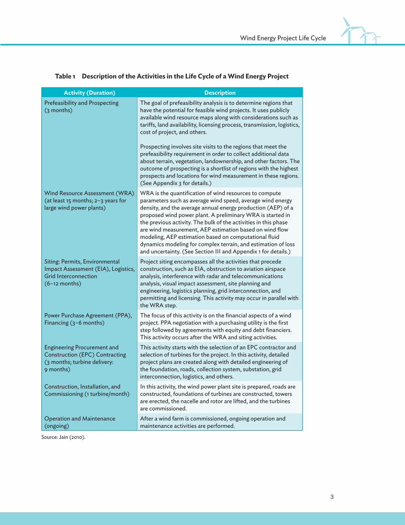
II.� Wind Energy Project Life Cycle
The seven activities in the life cycle of a wind project are shown in Figure 1. The duration of each activity and a description of the activities are given in Table 1. WRA is a pivotal activity in the life cycle of a wind project because it governs the fi nancial viability of the project. It involves wind measurement for at least 1 year, modeling of wind fl ow, computation of annual energy production (AEP), and estimation of losses and uncertainty associated with AEP. In new wind markets, this activity may stretch to over 5 years, as fi nanciers demand longer measurements, with taller meteorological towers (or met-masts) and with higher-quality instruments. The reason is that in new wind markets, there is sparse or no high-quality wind data that can be used to verify the measured data and to verify the wind resource model’s extrapolations into the future, to the entire wind-farm area and to hub height.
Prefeasibility and Prospecting
WindResource
Assessment
Siting: Permits, EIA, Logistics,
Interconnection
Operation and Maintenance
Construction Installation
Commissioning
EPCContracting
PPAFinancing
Figure 1�Activities in the Life Cycle of a Wind Energy Project
EIA = environmental impact assessment, EPC = engineering procurement and construction, PPA = power purchase agreement.
Source: Jain, Pramod. 2010. Wind Energy Engineering. New York: McGraw-Hill.
Wind resource assessment is the longest step in most wind projects, and it determines the future of a project.
3
Wind Energy Project Life Cycle
Table 1�Description of the Activities in the Life Cycle of a Wind Energy Project
Activity (Duration) DescriptionPrefeasibility and Prospecting(3 months)
The goal of prefeasibility analysis is to determine regions that have the potential for feasible wind projects. It uses publicly available wind resource maps along with considerations such as tari� s, land availability, licensing process, transmission, logistics, cost of project, and others.
Prospecting involves site visits to the regions that meet the prefeasibility requirement in order to collect additional data about terrain, vegetation, landownership, and other factors. The outcome of prospecting is a shortlist of regions with the highest prospects and locations for wind measurement in these regions.(See Appendix 3 for details.)
Wind Resource Assessment (WRA)(at least 15 months; 2–3 years for large wind power plants)
WRA is the quantifi cation of wind resources to compute parameters such as average wind speed, average wind energy density, and the average annual energy production (AEP) of a proposed wind power plant. A preliminary WRA is started in the previous activity. The bulk of the activities in this phase are wind measurement, AEP estimation based on wind fl ow modeling, AEP estimation based on computational fl uid dynamics modeling for complex terrain, and estimation of loss and uncertainty. (See Section III and Appendix 1 for details.)
Siting: Permits, Environmental Impact Assessment (EIA), Logistics, Grid Interconnection (6–12 months)
Project siting encompasses all the activities that precede construction, such as EIA, obstruction to aviation airspace analysis, interference with radar and telecommunications analysis, visual impact assessment, site planning and engineering, logistics planning, grid interconnection, and permitting and licensing. This activity may occur in parallel with the WRA step.
Power Purchase Agreement (PPA), Financing (3–6 months)
The focus of this activity is on the fi nancial aspects of a wind project. PPA negotiation with a purchasing utility is the fi rst step followed by agreements with equity and debt fi nanciers. This activity occurs after the WRA and siting activities.
Engineering Procurement and Construction (EPC) Contracting (3 months; turbine delivery: 9 months)
This activity starts with the selection of an EPC contractor and selection of turbines for the project. In this activity, detailed project plans are created along with detailed engineering of the foundation, roads, collection system, substation, grid interconnection, logistics, and others.
Construction, Installation, and Commissioning (1 turbine/month)
In this activity, the wind power plant site is prepared, roads are constructed, foundations of turbines are constructed, towers are erected, the nacelle and rotor are lifted, and the turbines are commissioned.
Operation and Maintenance(ongoing)
After a wind farm is commissioned, ongoing operation and maintenance activities are performed.
Source: Jain (2010).
4
III.� Importance of Accurate Wind Resource Assessments
The importance of accuracy in wind resource may be illustrated through these two cases:
1) Inaccuracy of ±5% in wind measurement can lead to approximately ±10% inaccuracy in AEP, which in turn will lead to ±10% inaccuracy in revenue, and fi nally this inaccuracy can be the di� erence between a fi nancially viable and a fi nancially unviable wind project. Hence, a lot of emphasis is placed on accurate wind speed measurements because this translates into higher accuracy in the estimate of a project’s fi nancial returns, a key requirement of fi nanciers.
2) WPP projects are often delayed or rejected by fi nanciers not because the wind resource is lacking, but because the WRA was conducted with insu� cient rigor with respect to technical due diligence on measurement instruments, measurement setup, data management, wind fl ow modeling, and assumptions.
This section will highlight the challenges associated with performing an accurate WRA and the impact on the fi nancial feasibility of a wind project.
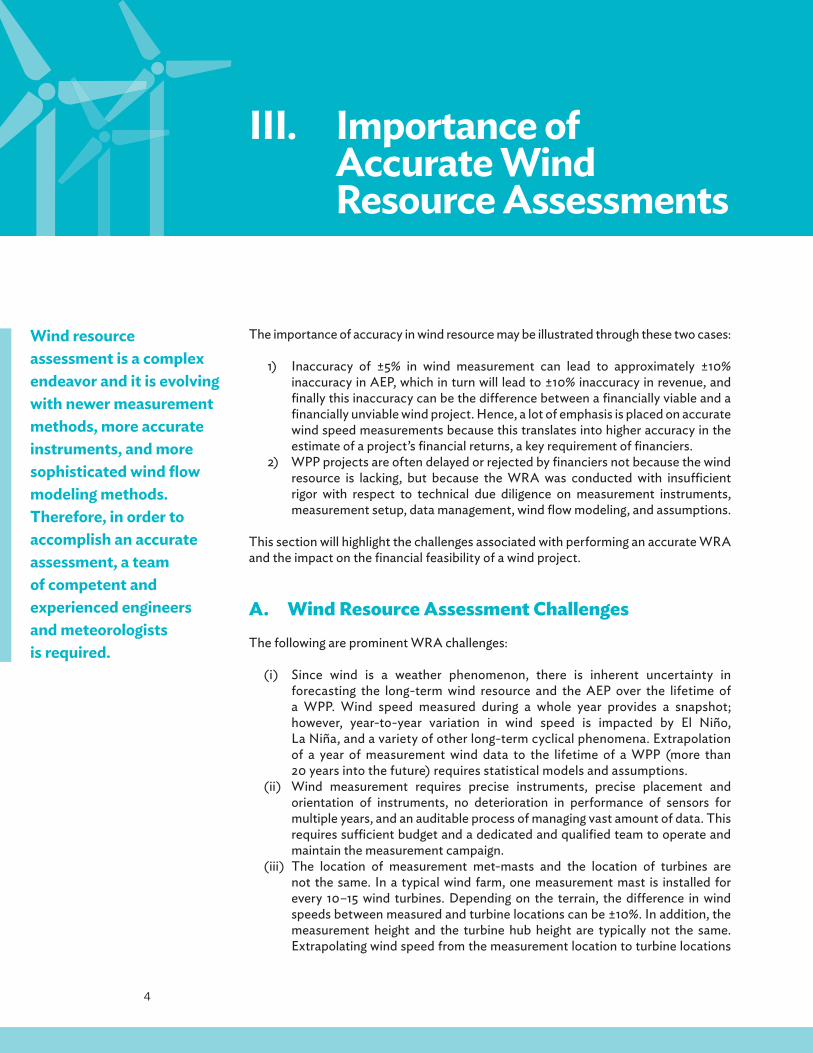
A.�Wind Resource Assessment ChallengesThe following are prominent WRA challenges:
(i) Since wind is a weather phenomenon, there is inherent uncertainty in forecasting the long-term wind resource and the AEP over the lifetime of a WPP. Wind speed measured during a whole year provides a snapshot; however, year-to-year variation in wind speed is impacted by El Niño, La Niña, and a variety of other long-term cyclical phenomena. Extrapolation of a year of measurement wind data to the lifetime of a WPP (more than 20 years into the future) requires statistical models and assumptions.
(ii) Wind measurement requires precise instruments, precise placement and orientation of instruments, no deterioration in performance of sensors for multiple years, and an auditable process of managing vast amount of data. This requires su� cient budget and a dedicated and qualifi ed team to operate and maintain the measurement campaign.
(iii) The location of measurement met-masts and the location of turbines are not the same. In a typical wind farm, one measurement mast is installed for every 10–15 wind turbines. Depending on the terrain, the di� erence in wind speeds between measured and turbine locations can be ±10%. In addition, the measurement height and the turbine hub height are typically not the same. Extrapolating wind speed from the measurement location to turbine locations
Wind resource assessment is a complex endeavor and it is evolving with newer measurement methods, more accurate instruments, and more sophisticated wind fl ow modeling methods. Therefore, in order to accomplish an accurate assessment, a team of competent and experienced engineers and meteorologists is required.

5
Importance of Accurate Wind Resource Assessments
For a project to be fi nancially viable, the
returns on the project should be commensurate
with the risk of a project. Wind resource
assessment provides the main ingredients in this
risk–return calculus.
and from measurement height to hub height requires wind fl ow modeling. Wind fl ow models are one of the most complex computational models in physics. Solving these models requires simplifying assumptions such as linearity, thermal stability, simple terrain, etc. All these factors introduce uncertainty in estimates of average wind speed at hub height and average AEP.
B.� Impact of Wind Resource Assessments on Financial Feasibility
The WRA is the core activity that determines the viability of a wind project. In simple terms, there are two impacts of the WRA on the fi nancial feasibility of a project:
(i) The primary output of a WRA is the AEP of a project, which directly infl uences the revenue of a project. If the AEP is low, then the revenue is low; hence, the project is less attractive.
(ii) The next most important output of a WRA is the uncertainty associated with AEP, which directly infl uences the risk of a project. Higher uncertainty implies higher risk, which implies lower P75 and P90 AEP (see Section IV. A for details), hence lower debt service coverage ratio and lower return on equity.
Salkhit wind farm in Mongolia.
Clea
n En
ergy
LLC
, Mon
golia

6
Guidelines for Wind Resource Assessment: Best Practices for Countries Initiating Wind Development
C.� Impact of Wind Resource Assessments on Grid Integration
Before a wind project is connected to the grid, a detailed system impact study is performed to understand the impact on the grid of connecting variable power from a wind project. A system impact study involves load fl ow, short-circuit, and dynamic stability analyses. The analyses require an accurate time series of 10-minute AEP data for at least 1 year, which is supplied by the WRA. The output of the analyses is a list of upgrades required in the grid to safely and reliably inject wind energy into the grid. Note for wind power penetration of less than 5% of total generation, typically there are no upgrades or minimal upgrades. In case upgrades are required, one or more of the following are on the list: transmission system, substations, protection systems, and control systems of existing generators and new generators.
The second major impact of wind power is to system operations. System operations is responsible for minute-to-minute, hour-to-hour, and day-to-day balancing of system-wide load and energy production. To comprehend the impact of the WRA on system operations, consider the following situation. When load is decreasing, conventional power plants reduce production. Since the marginal cost of wind is close to zero, its merit order is the highest, which means all the wind energy should be dispatched. However, there comes a point when the production at all the conventional power plants is at the lower limit and load is still falling. In such extreme situations, wind production may be curtailed. The amount of annual curtailment is important to fi nanciers, utilities, developers, and policy makers; it is predicted by running a simulation of the network with data about load, generators, and 10-minute AEP time series data from the WRA.
D.� Special Note for Small and Medium-Sized Wind Projects
The focus of this publication is on utility-scale wind projects. Nevertheless, the guidelines apply to small and medium-sized wind projects as well. For such projects, it is common to fi nd cases in which one or more of the following are not performed: On-site measurement close to hub height using quality instruments, wind fl ow modeling using GIS model of terrain and roughness, long-term correction of AEP, and uncertainty estimates of AEP. Such poorly conducted WRAs most certainly lead to inability to determine the fi nancial viability of these projects. The result is a rude shock after project commissioning at the signifi cantly lower energy than that predicted. This is one of the primary causes of abandonment of a large fraction of small and medium-sized wind projects—the actual revenue generated during operations is unable to cover the cost of operation and maintenance. It is, therefore, imperative that a rigorous WRA be performed for all wind projects regardless of size.
Information about curtailment of wind energy is valuable for predicting annual revenue of a wind power plant, and it is valuable to policy makers to fi nd alternate uses of wind power such as battery storage, pumped hydro, compressed air storage, and thermal storage.

7
IV.� Wind Resource Assessment Process
The life cycle of WRA is described in this chapter. The fi ve stages of WRA process are illustrated in Figure 2. Its output is a bankable WRA.
Stage I: Prospecting
Stage II: Wind
Measurement
Stage III: Linear Wind Flow Model
Based Estimation of
AEP
Stage IV: CFD Model
Based Estimation of
AEP
Stage V: Loss and
Uncertainty Estimation
Bankable WRA
Figure 2�Five Stages of a Wind Resource Assessment
AEP = annual energy production, CFD = computational fl uid dynamics, WRA = wind resource assessment.
Source: Jain (2010).
Seguwantivu wind farm in Sri Lanka.
Win
d Fo
rce
(Pvt
.) Lt
d., S
ri La
nka

8
Guidelines for Wind Resource Assessment: Best Practices for Countries Initiating Wind Development
Table 2�Description of the Five Stages of a Wind Resource Assessment
Stages of a Wind Resource Assessment Description
Stage I: Prospecting Prospecting begins with high-level analysis of wind-rich areas. Two useful sources of high-level wind data are 3Tier (3tier.com) and AWS Truepower (AWSTruepower.com). Both provide wind data based on numerical weather prediction mesoscale model and reanalysis data. These data are used to perform a preliminary wind resource assessment (WRA) with the goal of comparing areas based on annual energy production (AEP). At this stage, the AEP accuracy is +/-50%. (See Appendix 3 for details.)
Stage II: Wind Measurement At least 1 year of on-site wind measurement is required in the project area. Traditional met-masts and remote wind measurement are two methods. (See Appendix 2 for details.)
Stage III: Linear Wind Flow Model Based Estimation of AEP
Linear wind fl ow models such as WAsP are used for the core spatial extrapolation and AEP computation. Other software tools are WindPRO, Wind Farmer, and OpenWind. The spatial and vertical extrapolations performed here are valid for mildly changing terrain, thermal stability (no convection), and terrain in which roughness around the measured sites are similar to roughness around the turbine sites.
Stage IV: CFD Model Based Estimation of AEP
Computational fl uid dynamics (CFD) modeling is performed if assumptions of the stage III model are not valid. It is required for cases with complex terrain and thermal instability. CFD is modeled on a three-dimensional grid, and these models are run on high-performance computer clusters. Although CFD models add cost to a WRA, it is worth the investment when assumptions related to stage III of a WRA are not completely valid.
Stage V: Loss and Uncertainty Estimation
This is an important component of a WRA. (See Section IV. A for a detailed explanation.)
Source: Jain (2010).
The individual stages are briefl y described in Table 2.
Stages I and II are described in Appendixes 2 and 3. Stages III and IV are detailed modeling tasks and are described in Jain (2010) and Brower (2012). Stage V is described next.
A.�Loss and Uncertainty EstimationFinanciers of a wind project are keen to understand the sources and amount of both losses and uncertainty. Although losses and uncertainty are often mentioned together, these are mutually exclusive concepts.
Losses are estimates of a decrease in energy output that is known. As an example, 6% is the estimate of energy loss due to wake. This is one component of the estimated loss. Other sources of losses are electrical, plant availability, turbine performance, environmental, and curtailment. In developed markets and in regions with well-known

9
Wind Resource Assessment Process
wind conditions, total losses are in the range of 10%–12%. For complex projects, total losses can be in the vicinity of 15%. Losses are taken out of AEP estimates from stages III and IV to yield net AEP.
Uncertainty, on the other hand, is a statistical concept that describes the variability associated with an estimate. As an example, consider a case with an estimate of net AEP of 100 gigawatt-hours and uncertainty of 10% as shown in Figure 3. Several factors may cause uncertainty in the estimate, which is measured in terms of standard deviation of net AEP. Common sources of uncertainty are wind speed measurement, wind speed extrapolation (spatial, vertical, and temporal), power curve, wake, air density, and others. In developed markets and regions with well-known wind conditions, total uncertainty (measured in terms of standard deviation of AEP as a percentage of average AEP) is about 12%, and for newer markets, it may be 20%–25%.
AEP for di� erent exceedance probabilities (P75, P90, P95)1 are computed by subtracting appropriate multiples of standard deviation from net AEP (Jain 2010), as is illustrated in Figure 3.
1 Note: P50, P75, and P90 represent exceedance probabilities, i.e., 50%, 75%, and 90% likelihood that predicted AEP or higher will be achieved.
Uncertainty plays a pivotal role in
bankable wind resource assessments. Financiers
are not only interested in a project that has
made every e� ort to reduce uncertainty, but also adopted a rigorous
approach to analyzing and estimating uncertainty.
An 80-meter met-mast in Mannar, Sri Lanka. The measurement project is funded by the Asian Development Bank.
Win
d Fo
rce
(Pvt
.) Lt
d., S
ri La
nka

10
Guidelines for Wind Resource Assessment: Best Practices for Countries Initiating Wind Development
0
10
20
30
40
50
60
70
80
90
100
60 70 80 90 100 110 120 130 140
Prob
abili
ty o
f Exc
eeda
nce
Average Annual Energy Production in GWh
B.�Bankable Wind Resource AssessmentsThe output of the WRA process is a bankable WRA. The concise description is: “A bankable resource estimate is one in which enough (high quality) verifi able data is available to quantify the uncertainty in wind resource at the planned wind project location.” (Jain 2010, p. 167). A nonbankable WRA “… is normally the fi rst stage of resource estimation when not all the uncertainties in wind conditions are completely understood or quantifi ed and, therefore, the return on investment has a high degree of uncertainty” (Jain 2010, p. 167).
Figure 3�Illustration of Exceedance Probabilities
GWh = gigawatt-hour.
Note: In this illustration, average annual energy production is 100 GWh and uncertainty is 10 GWh (or 10%). Here, P50 is 100 GWh, P75 is 93.2 GWh, P84 is 90 GWh, P90 is 87.2 GWh, P95 is 83.5 GWh, and P97 is 80 GWh.
Source: Jain (2010).

11
V.� Best Practices for Wind Resource Assessments
The focus of this section will be on WRA best practices for emerging wind energy markets. The best practices cover three areas: policy support for WRA, wind measurement, and management of resource assessment uncertainty.
A.�Policy
1.�Feed-in Tari� During the developing phase of the wind industry, the most important element of policy is tari� s. A feed-in tari� (FiT) is the most widely used and it is accepted as the most e� ective model for setting a tari� for renewable energy. Although FiT is not the focus of this publication, it must be at a level that refl ects both the wind resources present in the country and the anticipated cost of a wind project.
2.�Licensing GuidelinesAfter the precondition of a su� ciently high level of FiT is met, a policy prescription that can signifi cantly reduce the lead time of wind projects is licensing guidelines that stipulate a minimum set of requirements that the WRA of a project should meet in order to qualify for a generation license:
(i) At least 1 year of on-site wind measurement data should be collected with a met-tower of at least 60 meters height that is equipped with calibrated and high-quality anemometers at three heights.
(ii) The AEP should be based on a linear wind fl ow model for a simple terrain or a computational fl uid dynamics (CFD) model for a complex terrain.
(iii) Long-term correction of AEP should be computed to account for annual variability of the wind climate.
(iv) Site-specifi c losses and uncertainty should be estimated.(v) Extreme wind speed should be estimated to select a class of turbines suitable
for the site.
The licensing guidelines should encapsulate the best practices of WRAs by requiring a detailed WRA report that contains the abovementioned components. Such requirements not only cull out weak developers but also attract foreign and domestic capital because fi nanciers have a higher degree of confi dence in the readiness of a project.
Mongolia, the Philippines, Sri Lanka, and Viet Nam
have a feed-in tari� for wind energy.
Licensing guidelines in Mongolia, the Philippines, and Sri Lanka are lacking.
They do not have requirements related
to the key components of wind resource
assessments.

12
Guidelines for Wind Resource Assessment: Best Practices for Countries Initiating Wind Development
3.�Grant or Low-Interest Loan for Wind Resource AssessmentsThe next policy prescription to accelerate wind development is to provide grants or low-interest loans to qualifi ed developers for the WRA stage of a wind project. For a fi rst-time wind project developer, the WRA activity may seem too long and expensive. The typical length of a WRA for a medium-sized wind farm of 20 megawatts should be 2+ years at a cost of approximately $250,000. Based on the author’s experience in new wind markets that are in the developing phase, fi rst-time developers are reluctant to invest 2+ years and $250,000 to prove the viability of a wind project, despite enthusiasm for wind energy. The reluctance is because investment (grant, debt, or equity) for proving project feasibility is not available in these countries. Because of this reason, fi rst-time developers often take shortcuts with wind measurements, such as using shorter met-towers, using uncalibrated and lower accuracy instruments, not replacing damaged or faulty instruments, and not paying attention to data processing, and poor data recovery. These shortcuts invariably delay the project because fi nanciers require a rigorous WRA.
The grant/loan program may be used as a vehicle to improve the quality of wind measurement by private developers. The following is a list of possible avenues:
(i) Use international wind energy experts to review the grant/loan applications.(ii) Publish a checklist that covers the following aspects of a measurement
campaign: location, personnel, instruments, installation, and operation and maintenance. A grant/loan application should be required to follow the checklist.
(iii) Require a meteorologist or climate scientist on the team with experience in on-site measurements.
(iv) Encourage partnership with in-country research organizations, with the goals of both injecting scientifi c rigor in measurement and enhancing the capabilities of the scientifi c community within the country.
In order to put wind projects on the correct path during the nascent stage, a seed investment fund should be set up to invest in high-quality bankable WRAs. This fund should mandate that
(i) project developers pursue a high-quality measurement campaign as described in Section V. B and in Appendix 2; and
(ii) project developers share wind measurement data for the purposes of enhancing countrywide wind resource maps.
Sharing of wind data requires special mention in emerging wind energy markets. The lack of high-quality wind resource maps that are validated with high-quality measurements is a serious impediment to sustained growth of the wind industry. As a result of lack of high-quality wind resource maps, the cost of wind development remains high and the lead time from concept to commissioning of wind projects stays long. However, for competitive reasons, project developers are unwilling to share wind measurement data, a precious commodity. There are several methods to approach the problem of sharing wind data. The Quantum Leap in Wind Power Development in Asia and the Pacifi c (QLW) Program at the Asian Development Bank devised a wind data sharing approach in the Philippines. Similar approaches should be part of a grant/loan program to increase the accuracy of wind resource maps through on-the-ground measurements.
The United States Department of Energy and the European Environment Agency fund both the private and the public sectors through grants for basic research in wind resource assessment. One of the outcomes is two large sets of long-term wind data called global reanalysis data: one produced by the European Centre for Medium-Range Weather Forecasts called ERA-40 and one produced by the National Centers for Environmental Prediction and the National Center for Atmospheric Research in the United States.

13
Best Practices for Wind Resource Assessments
QLW partnered with the United States Department of Energy’s National Renewable Energy Laboratory (NREL) to create a program in which private developers and the Philippines’ Department of Energy could securely upload wind data to an NREL server. NREL, with funding from the United States Agency for International Development, updated the wind resource map of the Philippines, incorporating measurement data from multiple developers and multiple sites for model validation while still allowing the site-specifi c measured data to remain proprietary.
The resulting wind resource map will be publicly available through the Philippines Geospatial Toolkit (GsT), a map-based software application developed by NREL. The GsT provides a user-friendly, interactive platform for visualizing and quantifying wind and other renewable energy resource potential based on user-defi ned queries and constraints. In addition to wind resource data, the GsT integrates other geographic information system (GIS) data related to land use, infrastructure, load centers, etc. This platform and the underlying data are intended to enable integrated resource planning, high-level renewable energy prospecting, and assessment of technical and economic renewable energy potential.
In other countries, a data sharing program may be conducted in collaboration with NREL, 3Tier, AWS Truepower, or a local research organization, with the use of confi dentiality agreements. Although raw data are preferred, daily aggregation of 1 or more years of measurement data at two or more heights is acceptable.
4.� Long-Term (10–20 Years) Measurement for High-Quality Reference Wind Data
One of the critical components of a bankable WRA is the long-term correction of AEP. AEP estimates are computed using measured wind data (for 1 or more years) and microscale modeling of wind resources with software such as WAsP, as described in Appendix 2-D. Like rainfall and other weather elements, wind is cyclical, so the question is: how can a 1-year (or short-term) measurement be used as a basis for predicting energy production for 20 years in the future?
The short-term measurement may have been made during a low or high period of the cycle; therefore, to a fi nancier, the risk of a wind project whose AEP is computed from a short-term measurement is very high. Hence, a wind project without a long-term AEP correction is not fundable. To compute the long-term corrected AEP, good-quality long-term wind data sets are required, along with methods like measure–correlate–predict (MCP). Lacking good-quality long-term wind data and low correlations with concurrently measured data, fi nanciers require a project to measure wind speed for 3–5 years.
Although reanalysis data and mesoscale numerical weather prediction model data (referred to as derived data sets) are publicly available for the past 30+ years, the quality of such wind data is poor in developing countries. The reason is that there are few or no long-term quality measurements at 50+ meters above the ground level (referred to as observed data sets), which form the primary input to computing long-term wind data sets.
From a policy standpoint, a country can signifi cantly impact the risk profi le of wind projects by setting up infrastructure to collect long-term reference wind data. This
The Quantum Leap in Wind Power Development in Asia and the Pacifi c was
instrumental in creating a wind data sharing in
the Philippines with the goal of updating the country’s wind resource map. Private developers
and the Department of Energy of the Philippines
uploaded measurement data to a server of the
United States National Renewable Energy
Laboratory (NREL). NREL used reanalysis data, a
mesoscale numerical weather prediction model,
and shared measurement data to update the wind
resource map.

14
Guidelines for Wind Resource Assessment: Best Practices for Countries Initiating Wind Development
is done by installing tall permanent met-masts, with a life of over 10 years, in regions with the highest resource prospects to generate a high-quality reference wind speed data set. Such data can signifi cantly reduce the duration and cost of wind projects (Jain 2010, McCrone et al. 2014).
B.�Countrywide Resource AssessmentA wind resource map (WRM) for a country is the starting point for all wind development. Developers rely on WRM for prospecting, and policy makers use it for developing wind energy road maps. Therefore, a high-quality WRM is crucial to lowering the cost and duration of WRA. Since wind is a localized phenomenon, an e� ective approach to planning and implementing wind energy policies is to defi ne zones or corridors for wind development.
Wind energy corridors are regions screened for wind resources, land availability, infrastructure, and other factors with the goal of focusing the e� orts of all the agencies involved in licenses, approvals, and permits to the identifi ed regions. Policy makers and implementation agencies should fund wind corridor-specifi c: (i) high-quality, long-term meteorological measurements as described above, (ii) research and development of wind fl ow modeling, and (iii) data collection and modeling of extreme wind speed events. Such initiatives would lower the uncertainty of all projects in the corridor in three key areas: (i) long-term correction of AEP, (ii) extrapolation of wind speed to the entire project area and to hub height, and (ii) choice of the most appropriate class of turbine as opposed to the most conservative class of turbine. This investment is not project specifi c, rather it signifi cantly benefi ts the entire wind industry in the country.
C.� Project-Specifi c MeasurementProject-specifi c on-site measurement is the most time-consuming and may be the most expensive activity in the WRA. When done with rigor, project-specifi c measurement may lead to a high-quality bankable WRA. The properties of a high-quality measurement campaign, according to Jain (2010) and McCrone et al. (2014), are:
(i) Use a high-quality (preferably Class I anemometer) calibrated anemometer, as close to hub height as possible (preferably >2/3 of hub height). Install anemometers, preferably at three heights, so that vertical extrapolation may be accurately performed.
(ii) Use redundant anemometers so that potential for loss of data due to tower shadow or sensor failure is minimal. Use long booms to minimize the impact of fl ow distortion.
(iii) Deploy two or more met-masts for a wind-farm site, preferably one met-mast for every 5–8 turbines or 10–20 MW capacity (the lower number is for a complex terrain and the higher number for a simple terrain).
(iv) Collect and analyze daily data feeds rigorously. Ensure that raw data are archived and an audit trail exists for data corrections, so that the data can be independently verifi ed.
(v) Collect data for at least 1 year; if measurement is done for more than 1 year, then collect data for a full 2 or 3 years.
ADB’s Quantum Leap in Wind Power Development in Asia and the Pacifi c is funding long-term measurement campaigns in Mongolia, the Philippines, and Sri Lanka.

15
Best Practices for Wind Resource Assessments
D.�Managing Resource Assessment UncertaintyOften a WRA is nonbankable, not because the wind resource is lacking, but because the uncertainty associated with AEP is high. High uncertainty in resource assessment is due to insu� cient rigor with respect to technical due diligence on measurement, data, wind fl ow models, and assumptions. The following is a description of the detailed impact of higher uncertainty, under the assumption that the debt provider evaluates the WPP project with P90-AEP:
(i) Higher uncertainty leads to lower P90-AEP, which leads to lower P90-revenue, which leads to lower P90-cash fl ow, which in turn leads to lower return on equity.
(ii) Lower cash fl ow leaves a smaller cushion for payment of principal and interest on debt. In other words, the debt service coverage ratio (DSCR)2 is lower. Most debt issuers expect the minimum DSCR for a project to be in the range of 1.25 to 1.3. When this minimum DSCR cannot be met, a project is forced to reduce the amount of debt, which means higher equity is required, which leads to lower return on equity.
2�This is the ratio of net operating income to the sum of principal and interest. All quantities are annual.
Sonic Detection and Ranging (SODAR) at the PowerGen wind farm in Sri Lanka.
Win
d Fo
rce
(Pvt
.) Lt
d., S
ri La
nka

16
Guidelines for Wind Resource Assessment: Best Practices for Countries Initiating Wind Development
The double impact on return on equity as described often causes a project to be one of the following:
(i) Delayed while the project developer attempts to reduce uncertainty. Reduction in uncertainty may be accomplished through additional years of measurement with higher-accuracy sensors or installation of new met-masts. This results in higher investment and longer lead time for projects.
(ii) Abandoned because the developer does not wish to invest more to continue the development phase of the project.
In order to avoid such scenarios, uncertainty should be managed from the very fi rst day. The measurement practices mentioned in the previous section contribute greatly to lowering of uncertainty. Other large sources of uncertainty arise from terrain complexity. For complex terrains, this uncertainty may be reduced by increasing the number of measurement stations, deploying remote sensing instruments, and using CFD wind fl ow models for extrapolation.
There are fi ve primary stakeholders of the WRA: policy makers, private developers, implementation agencies, donors and fi nancing agencies, and utilities. The best practices presented above are summarized in Table 3 from the perspective of the fi ve classes of stakeholders.
Table 3�Best Practices from the Perspectives of the Five Stakeholders
Stakeholders Best PracticesPolicy makers Licensing Guidelines: Detailed licensing guidelines should
be developed with requirements about duration and quality of measurement, and quality of wind fl ow modeling and data processing.Country-wide resource assessment: Fund research and development on improving predictability of wind fl ow modelsLong-Term (10–20 Years) Measurement for High-Quality Reference Wind Data: Fund ongoing research and development of long-term measurement campaigns in resource rich areas.Grant or Low-Interest Loan for Wind Resource Assessments: Develop fund (grants, low-interest loans) to fund development of bankable wind resource assessments.
Private developers Managing Resource Assessment Uncertainty: Higher quality measurement and wind fl ow modeling.Project-Specifi c Measurement: Implement international best practices and perform with rigor.
Implementation agencies Licensing Guidelines: Coordinate among all agencies involved with licensing, permitting, and approving wind projects to develop transparent and rigorous criteria.Countrywide resource assessment: Fund research and development on improving predictability of wind fl ow models.
continued on next page

17
Best Practices for Wind Resource Assessments
Stakeholders Best PracticesDonors/Financing agencies Grant or Low-Interest Loan for Wind Resource
Assessments: Fund development of high quality bankable wind resource assessments.Long-Term (10–20 Years) Measurement for High-Quality: Fund long-term measurement campaigns.
Utilities Countrywide resource assessment: Basis for corridor-wide system impact study and planning for construction or upgrade of transmission lines and associated infrastructure.Project-Specifi c Measurement: Accurate estimate of annual energy production, which forms the basis for wind project-specifi c grid impact study.
Source: Authors.
Table 3 continued

18
VI.�Conclusions
WRA is a pivotal step in the development phase of a wind project. Even if the wind resource is su� cient for a viable project, the di� erence between a bankable and non-bankable WRA is the amount of due diligence exercised during the performance of wind measurement and wind fl ow modeling to compute AEP. With respect to due diligence, fi nanciers look for the developer’s e� orts to reduce uncertainty during the WRA and the developer’s ability to estimate the remaining uncertainty.
Based on the author’s experiences in countries with emerging wind energy markets, a large fraction of developers (i) do not conduct WRAs with su� cient due diligence and (ii) do not adequately understand the concept of uncertainty and its implications on the bankability of a WRA. There are various reasons: ignorance about requirements of bankable WRAs and/or lack of funds to invest in the development activity.
Key policy support required for WRAs, to enable accelerated wind development, are the following:
(i) Rigorous licensing preconditions for wind farms, with clearly stated requirements and checklist for WRAs, with an intent to proactively inform developers about the need for quality and rigor in bankable WRAs.
(ii) Low-cost fi nancing or grants for qualifi ed wind energy developers to perform WRAs.
(iii) Long-term quality wind measurement campaign in order to(a) collect reference data, which will reduce uncertainty; and(b) map the wind resources to a greater level of detail in areas with promising
wind resources.(iv) Capacity building to transfer knowledge about best practices of WRAs.

19
VII.�References
Brower, Michael, ed. 2012. Wind Resource Assessment. Hoboken, New Jersey: John Wiley & Sons.
Jain, Pramod. 2010. Wind Energy Engineering. New York: McGraw-Hill.
Kelley, Neil D., Bonnie J. Jonkman, George N. Scott, and Yelena L. Pichugina. 2007. Comparing Pulsed Doppler LIDAR and SODAR and Direct Measurements for Wind Assessment. National Renewable Energy Laboratory (NREL), Golden, Colorado. NREL/CP-500-41792.
McCrone, Angus, Eric Usher, Virginia Sonntag-O’Brien, Ulf Moslener, and Christine Grüning, eds. 2014. Global Trends in Renewable Energy Investment 2014. Frankfurt School–UNEP Collaborating Centre, United Nations Environment Programme (UNEP), and Bloomberg New Energy Finance.
Mortensen, Niels G. 2013. Planning and Development of Wind Farms: Wind Resource Assessment and Siting. DTU Wind Energy Report-I-45. January.
National Renewable Energy Laboratory. 1997. Wind Resource Assessment Handbook. April. Available at http://www.nrel.gov/wind/pdfs/22223.pdf

20
Appendix 1: Nuts and Bolts of Wind Resource Assessments
This section will give readers a quick preview of detailed parameters of interest in a wind resource assessment.
A.�Parameters Associated with WindA wind measurement campaign will capture the parameters listed in Table A1.1.
Table A1.1�List of Measured Parameters in a Wind Resource Assessment
Parameter Detailed Description
1Wind speed at height h1, h2, h3For example h1=80 m, h2= 60 m, h3= 40 m
Wind speed statistics are recorded every 10 minutes for at least 1 year
2 Wind direction at height h4 and h5. For example, h4= 75 m, h5 = 50 m
Wind direction statistics are recorded every 10 minutes for at least 1 year
3Wind statistics (mentioned in items 1 and 2 above) for wind speed and wind direction
Within a 10-minute interval, the following statistics are recorded:• mean wind speed, standard deviation of
wind speed, maximum wind speed, and minimum wind speed
• mean wind direction, standard deviation of wind direction, maximum wind direction, and minimum wind direction
m = meter.
Source: Jain (2010).

21
Nuts and Bolts of Wind Resource Assessments
The parameters in Table A1.2 are computed from the measurement data.
Table A1.2�List of Computed Parameters in a Wind Resource Assessment
Parameter Detailed Description
1 Average annual wind speed (AWS) at hub height
Computed at each turbine location by extrapolating AWS from measurement locations. WAsP, a leading software for wind resource modeling, is one methodology for extrapolation.
2 Turbulence intensity (TI)Ratio of standard deviation of wind speed to the average wind speed. TI is used to select the class of turbine.
3 Shear
Measure of how wind speed changes with elevation from the ground. This is used to project wind speed from measurement heights to turbine hub height.
4 Weibull parameters
The Weibull function describes the probability density function of wind speed. It has two parameters: shape factor and scale factor. These are used in annual energy production (AEP) calculation.
5 Air densityComputed based on elevation from sea level, temperature, humidity, and barometric pressure. It is used in the AEP computation.
6 Average annual energy productionComputed for each turbine in the planned wind farm based on wind speed profi le and the turbine’s power production curve.
7 Long-term correction to AEPComputed using high-quality long-term wind data and a technique called measure–correlate–predict.
8 Net long-term corrected AEPEstimated losses are subtracted from Gross AEP in items 6 and 7 to obtain net AEP. This is the amount of energy delivered to the grid.
9 AEP for di� erent exceedance probabilities
Net long-term corrected AEP is reduced by multiples of standard deviation of AEP to compute P75, P90, P95, and other AEP.
Source: Jain (2010).

22
Appendix 2: Wind Measurement
At least 1 year of on-site wind measurement is a prerequisite for a bankable wind resource assessment. Broadly speaking, there are two types of wind measurements: in situ and remote sensing. In situ measurements are done with meteorological towers (also called met-masts or met-towers). There are two options for remote sensing: Sonic Detection and Ranging (SODAR), which is based on sound waves and Light Detection and Ranging (LIDAR), which is based on light waves. Both types of measurement provide wind speed, wind direction, temperature, barometric pressure, relative humidity, solar radiation, and a few other atmospheric conditions.
A.� Wind Measurement Based on Meteorological TowersA met-tower is the most popular method of measuring wind speed. The most commonly used confi guration of a met-tower is shown in Table A2.1.
Table A2.1�Description of Met-Towers, Sensors, and Confi guration
Item Description
Types of met-towers
Temporary: Met-towers with a life of 3–5 years, used for project-specifi c assessment of wind resourcesPermanent: Met-towers with a life of 20 years, used for long-term measurements or used in wind farm as a reference mast
Size and type
Temporary: 80 m monopole (or tubular) towers are recommended for new projects. A 60-m monopole tower is the most popular.Permanent: Lattice towers
Number of anemometersTwo Class I calibrated anemometers at 80 mTwo calibrated anemometers at 60 mTwo calibrated anemometers at 40 m
Number of wind vanes Two wind vanes: One at 75 m and a second at 55 m
Orientation of anemometers
If wind direction is predominantly from one direction, then place the two anemometers at +45/–45-degree angles to the primary wind direction, such that the two anemometers make an angle of 90 degrees.
Orientation of wind vane The wind vane must be parallel to one of the anemometers. Both wind vanes must be parallel.
Boom length The boom on which the anemometers are mounted must be at least six times the diameter of the pole.
continued on next page

23
Wind Measurement
Item Description
Other sensorsTemperature, barometric pressure, relative humidity, and solar radiation sensors are installed at a height of about 3 m from ground level.
Data logger and communication unit
Normally, a 15-channel data logger is used to receive sensor readings every second and record statistics every 10 minutes. A memory card stores the statistics.A communication unit which contains a wireless modem is used to transmit recorded data once every day.
Others Grounding and lightning protection are important to protect the sensors, data logger, communication unit, and the tower.
m = meter.
Source: Jain (2010).
B.�Remote Wind MeasurementAs the hub heights and blade lengths of turbines have increased, met-tower-based measurements at heights of 50 meters (m), 60 m, and 80 m are inadequate to provide an accurate estimate for wind speed at the hub height, let alone over the entire turbine rotor. With both hub heights and rotor radius above 100 m and 50 m, met-towers of 150 m or more would be required to measure the wind speed over the entire turbine rotor. This would be cost prohibitive. Remote sensing provides a method to measure wind speed in this range of heights (Jain 2010).
Ground-based remote sensing for wind measurements has been in regular use since the 1990s. However, serious commercialization started in the 2000s. There are two primary technologies:
(i) SODAR is based on measuring the Doppler shift in the frequency of the sound waves that are backscattered by temperature fl uctuations in the atmosphere.
(ii) LIDAR is based on the shift in frequencies because of refl ection of light rays from small aerosol particles in the air.
The advantages of remote sensing compared to met-towers are numerous (Jain 2010):
(i) Ability to measure wind speed at heights higher than “economically” feasible by met-towers
(ii) Ability to measure over large range of heights from 40 m to 200 m(iii) Ability to measure wind shear directly over a large range of heights(iv) Ability to measure the vertical component of wind speed(v) No obstructions and shadow e� ects because of guy wires, booms, and tower(vi) Ease of deployment, specifi cally in areas where guy wires cannot be anchored;
o� shore wind measurements commonly use remote sensing(vii) Mobility of the remote sensing unit, which leads to fl exibility in terms of rapid
deployment and adjustments(viii) Ease of repair(ix) Unobtrusive and may be easily concealed as opposed to a tall met-tower that
may be visible for miles; most units are about 2 m x 2 m x 3 m.
Table A2.1 continued

24
Appendix 2
The limitations of remote sensing, according to Jain (2010), include
(i) Data from remote sensing devices are just starting to be bankable when used in conjunction with traditional met-towers.
(ii) The SODAR data set is usually not as complete as cup anemometer data. The reason is that data depend on backscatter of small fl uctuations of the thermal refractive index in the atmosphere. SODAR performs poorly when the atmosphere is thermally well mixed (afternoon), in the presence of precipitation, and in the presence of ambient sound. Therefore, signal-to-noise fi lters are crucial; setting the fi lter too high will cause useful data to be rejected; or if set too low, noisy data will be included in the data set. Operator experience can be crucial in setting fi lters for accepting data with a smaller signal-to-noise ratio. Raw SODAR data also undergo complex data processing algorithms that are proprietary to the manufacturer.
(iii) Wind speeds are measured and averaged over a larger volume, whereas a cup anemometer measures almost at a point. SODAR measurements at 100 m typically use 15,000–20,000 times the volume of air compared to a cup anemometer.
(iv) In a complex terrain, the measurements may not correlate well with met-tower data.
(v) On-site calibration of SODAR is required. LIDAR usually does not require on-site calibration.
(vi) The SODAR-created audio signal is a chirping noise; therefore, it must be placed with an appropriate setback from residences and other inhabited structures. The chirp audio signal is also susceptible to echoes because of interactions with structures and trees.
(vii) SODAR and LIDAR are expensive—SODAR is about 1.5 to 2 times, while LIDAR is about 4 to 5 times the cost of met-mast.
C.�Designing a Wind Measurement CampaignIn this section, three design elements of a wind measurement campaign are covered: type and number of met-towers, placement of met-towers, and duration of the measurement campaign. Although the primary drivers for a measurement campaign are to improve the accuracy of prediction of energy output of the wind project, other factors, such as economics and project schedule, can play an important role. It is not unusual for a wind project to start with a small number of met-towers to prospect and to subsequently add additional met-towers as fi nanciers demand higher accuracy in wind resources over the planned wind-farm area.
Since wind is highly dependent on local conditions such as contour, roughness, and obstacles, in an ideal case, wind measurement should be performed at the planned location of a turbine. This would yield the highest accuracy in predicting energy output. However, Jain (2010) cited two issues:
(i) One of the purposes of a wind measurement campaign is to determine the best location of turbines; therefore, turbine locations are not known a priori. Unless wind measurements are done, micrositing of turbines cannot be done.
(ii) When designing a wind farm consisting of multiple turbines, it is very expensive to measure wind at each turbine location.

25
Wind Measurement
Therefore, a wind measurement campaign must start with what is known and design a process that can economically generate reasonably accurate energy predictions. A process for designing a wind measurement campaign, which may be adapted to specifi c needs of a project, is as follows (Jain 2010):
(i) Conduct a preliminary wind resource assessment of the area under consideration. This applies to both single turbine and wind-farm installations. The outcome of the preliminary wind resource assessment will be a wind resource map of suitable granularity. For the purposes of this discussion, it is assumed that wind resources are available for a 200-m x 200-m grid. The resource map may be based on computer simulations using numerical weather prediction models or a wind resource-prediction model such as WAsP or others.
(ii) The preliminary location of wind turbine generators (WTGs) may be computed by running a layout optimization model (for example, Optimize in WindPRO) with a wind resource map from step (i) and a variety of constraints. Constraints include maximum wind-farm capacity; minimum capacity factor; turbine tower height and rotor diameter; distances between turbines; and other setback criteria such as distance between turbine and property boundary, public roads, transmission, and inhabited areas. In this phase, the constraints are guidelines rather than precise. For a single turbine case, a location with the highest wind resource that satisfi es all the constraints is the location of the met-tower. For a wind farm, go to step (iii).
(iii) In the preliminary WTG layout, form clusters of WTGs. If the wind farm is in a complex terrain, 5–7 WTGs may be grouped into one cluster. If it is a simpler terrain with very little changes in elevation and roughness, then 10–12 WTGs may be grouped into one cluster. The clusters will be based on distance. Clusters are best formed visually; the borders of clusters may be drawn manually on a computer-aided design (CAD) drawing or on paper. The ratio between WTGs and met-towers of 5–7 or 10–12 are normal guidelines for determining the number of fi xed met-towers for wind measurement. Rarely will all clusters have the same number of WTGs.
(iv) In each cluster, fi nd the median wind speed WTG. This WTG location or a location in the vicinity would be a location for the placement of met-towers. Measuring at the best or worst wind resource location in the cluster would yield wind measurements that have to be either extrapolated down or extrapolated up to all points in the cluster, which would lead to higher inaccuracies. Normally a set of two or three locations is chosen in each cluster. For instance, the three locations are location with median wind speed and the two locations with the smallest di� erence from the median wind speed.
The goal of this step is to pick one location in each cluster such that for the wind farm as a whole, the met-tower locations are su� ciently spread out geographically. This step is best done visually, starting with the median wind speed location in each cluster and then examining the proximity of these locations. If the median locations of two clusters are geographically close, alternate locations are chosen from the set.
26
Appendix 2
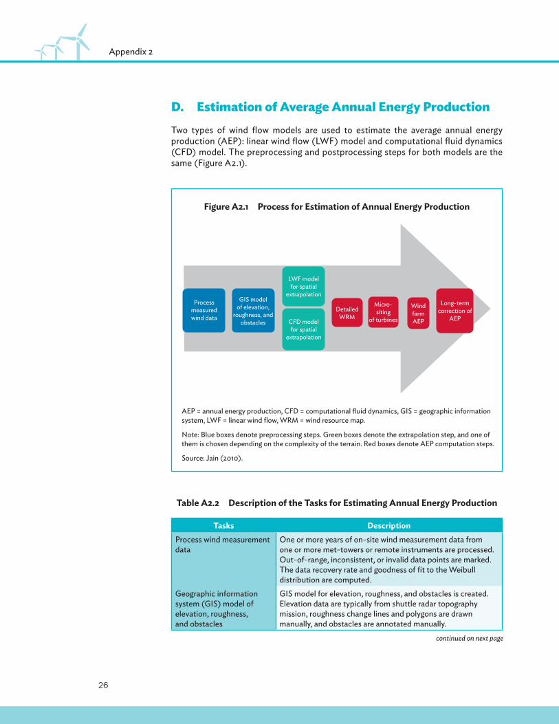
D.�Estimation of Average Annual Energy ProductionTwo types of wind fl ow models are used to estimate the average annual energy production (AEP): linear wind fl ow (LWF) model and computational fl uid dynamics (CFD) model. The preprocessing and postprocessing steps for both models are the same (Figure A2.1).
Figure A2.1�Process for Estimation of Annual Energy Production
AEP = annual energy production, CFD = computational fl uid dynamics, GIS = geographic information system, LWF = linear wind fl ow, WRM = wind resource map.
Note: Blue boxes denote preprocessing steps. Green boxes denote the extrapolation step, and one of them is chosen depending on the complexity of the terrain. Red boxes denote AEP computation steps.
Source: Jain (2010).
Process measured wind data
GIS model of elevation,
roughness, and obstacles
LWF model for spatial
extrapolation
Detailed WRM
Micro-siting
of turbines
Long-term correction of
AEP
Wind farm AEPCFD model
for spatial extrapolation
Table A2.2�Description of the Tasks for Estimating Annual Energy Production
Tasks DescriptionProcess wind measurement data
One or more years of on-site wind measurement data from one or more met-towers or remote instruments are processed. Out-of-range, inconsistent, or invalid data points are marked. The data recovery rate and goodness of fi t to the Weibull distribution are computed.
Geographic information system (GIS) model of elevation, roughness, and obstacles
GIS model for elevation, roughness, and obstacles is created. Elevation data are typically from shuttle radar topography mission, roughness change lines and polygons are drawn manually, and obstacles are annotated manually.
continued on next page

27
Wind Measurement
Tasks DescriptionLinear wind fl ow (LWF) model for spatial extrapolation
If the project area under consideration has a mild terrain (slopes less than 30 degrees) and a thermally stable atmosphere, and satisfi es other conditions, then use an LWF model for extrapolating measured wind speed at met-tower locations to a 50-meter x 50-meter grid that covers the entire area of interest. Linear formulations use the Jackson–Hunt model; WAsP implements this model.
Computational fl uid dynamics (CFD) model for spatial extrapolation
If the linear assumptions are not satisfi ed, then use a CFD model for extrapolating measured wind speed at met-tower locations to a 50-meter x 50-meter grid that covers the entire area of interest. Wind fl ow is modeled on a three-dimensional grid, and these models are run on high-performance computer clusters. The input wind and terrain data are the same for both the LWF and CFD models.
Micrositing of turbines with detailed wind resource maps
The output of LWF or CFD is a detailed wind resource map. This map specifi es the average wind energy density (or average wind speed) at each grid point. The objective of micrositing wind turbines is to pick a set of locations that cumulatively yield the highest wind energy density while satisfying constraints such as a) the distance between turbines in the primary direction of wind is 9D and perpendicular to the direction of wind is 3D, where D is the rotor diameter of turbine; b) the slope at the location is less than 15 degrees; c) adequate setback from roads, transmission lines, residential or industrial structures, and others.
Computation of wind farm average annual energy production (AEP)
After micrositing of turbines is complete and a turbine has been chosen for the wind farm, gross average AEP is computed. The computation uses the extrapolated wind speed at the turbine locations and hub height, along with the turbine’s power production curve.
Long-term correction of AEP
The gross AEP computed in the previous step is specifi c to the measurement period. In order to compute the average over the life of a turbine (20–25 years), a statistical process is used to extrapolate from measurement years. Measure–correlate–predict is a commonly used method to perform this extrapolation that yields long-term corrected gross AEP. Note that long-term correction of AEP is a requirement for a bankable wind resource assessment.
Source: Jain (2010).
E.�Optimizing Wind FarmWind farm optimization is an important activity in the “Micrositing of turbines with detailed wind resource map” task in Table A2.2. It involves optimizing the selection and layout of turbine with the goal of maximizing the net AEP. Considerations that are vital in the selection of turbines (size of the rotor and hub height) are extreme wind speeds that cause high structural loads on blades and tower. IEC 61400-1 is the wind industry standard for classifying turbines based on extreme wind speed.
Table A2.2 continued

28
Appendix 2
With respect to layout of turbines, wake losses and setback conditions are the vital considerations. WRA software like WAsP, WindPRO, Wind Farmer and OpenWind possess modules to assist with optimal layout of turbines.
It is worth mentioning that although the wind farm optimization activity is important, it is rarely an impediment to a bankable WRA because the turbine manufacturer provides substantial assistance in this regard. Before a turbine manufacturer accepts an order for turbines, it performs a detailed engineering analysis of wind data (measured and extreme wind speed), wind farm terrain, turbine models and turbine layout. The result of the analysis is manufacturer recommended turbine model and layout, and a warranty for the turbines with strict stipulations for limits on structural loading of turbines. The warranty is voided if the proposed turbine model is placed in a location that does not meet the stipulation.

29
Appendix 3: Prospecting and Methodology and Tools for Micrositing of Met-masts
A.�ProspectingProspecting is the fi rst stage of a wind resource assessment. It typically starts with a publicly available, countrywide wind resource map from the National Renewable Energy Laboratory, 3Tier, or AWS Truepower. These maps are coarse, usually at granularity of 50 kilometers x 50 kilometers. From these color maps, a developer identifi es regions that are rich in wind resources. Basic due diligence is then performed to narrow down the choices to the most promising regions that are worthy of further consideration. This due diligence may involve conducting a basic desktop analysis, which uses the following data:
(i) Wind speed or wind energy density for each region of interest from the wind resource maps.
(ii) Proximity to power transmission lines and road network. This may be done by overlaying a map of transmission and road networks on the wind resource map. Regions that are close to infrastructure should be preferred.
(iii) Terrain features and environmental and/or cultural value of regions under consideration. A wind-rich region may be eliminated if it is in high mountain ranges, a national forest, or environmentally or culturally sensitive areas.
After the list of regions clears the basic desktop analysis, site visits are conducted to perform site assessments. The following aspects are examined:
(i) Strength of observed wind resource from examining the fl agging of local vegetation and conversations with locals
(ii) Availability of land (size and type of ownership)(iii) Terrain, elevation, and vegetation(iv) Soil type and condition(v) Availability and quality of roads(vi) Micrositing of wind measurement locations in the region

30
Appendix 3
B.�Methodology and Tools for Micrositing of Met-mastsFor each site, a wind engineer should carry the following items.
(i) Maps: topographical maps (1:25,000 or 1:100,000), satellite maps from Google Earth
(ii) Global positioning system (GPS) receiver with compass, or separate(iii) Camera(iv) General site recording sheet
(a) Coordinates(b) Summary wind data (from 3Tier or other sources):
1. Wind speed monthly average during travel period2. Wind direction average during travel period3. Peak wind hours during travel period4. O� -peak wind hours during travel period
(c) Handheld anemometer wind speed recording sheet
(v) Roughness recording sheet(vi) Obstacles recording sheet(vii) Elevation recording sheet
In addition, the engineer may fi nd a handheld anemometer and laser distance meter with clinometer functionality, or clinometer with odometer useful instruments during fi eld inspections.

31
Prospecting and Methodology and Tools for Micrositing of Met-masts
Site Name:
Visited by: Date:
Site owner:
Geographical reference, GPS Readings
Location 1 Elevation (in meters):
Latitude: Longitude:
Site description:
Location 2 Elevation (in meters):
Latitude: Longitude:
Site description:
Location 3 Elevation (in meters):
Latitude: Longitude:
Site description:
Location 4 Elevation (in meters):
Latitude: Longitude:
Site description:

32
Appendix 3
C.�Wind DataThe data should be recorded in the following tables before the site visit for the month of site visit. NREL, 3Tier, and AWS Truepower are sources of monthly average wind speed and wind direction.
Monthly wind speed average: Monthly wind direction average:
Peak wind time (hours): O� -peak wind time (hours):
Date of visit: Location:
Wind speed should be recorded using a handheld anemometer. If wind direction is constant, only the fi rst row should be recorded. Note that these readings are highly unreliable, because these are point measurements close to the surface. Therefore, this is an optional activity.
Time Wind speed Wind direction
Time Wind speed Wind direction

33
Prospecting and Methodology and Tools for Micrositing of Met-masts
D.�Obstacle Description
Date of visit: Location:
# α1 R1 α2 R2 H d P Comments
Note: α1 and α2 are given in degrees clockwise from North; R1, R2 (Radius 1 and 2), H (height), and d (depth) are in meters; P is porosity (0 = wall, no wind can fl ow through).
Source: WAsP.

34
Appendix 3
a) Drawing of Obstacle map
b) Additional Information

35
Prospecting and Methodology and Tools for Micrositing of Met-masts
E.�Roughness Recording Sheet
# D Z01 X1 Z02 X2 Z03 Comments
1 000
2 030
3 060
4 090
5 120
6 150
7 180
8 210
9 240
10 270
11 300
12 330
Note: D denotes sector: 000 is the North sector, 090 is East sector. Each sector is 30 degrees wide; z01, z02, and z03 are vegetation types: H = houses, S = bare soil, SG = small grass, ST = small trees/shrubs, TG = tall grass, TT = tall trees, W = water; X1 and X2 are given in meters (should be specifi ed in 100-meter intervals).
Source: WAsP.
X1 X2

36
Appendix 3
F.�Elevation Recording SheetElevation changes should be recorded. X1 and X2 are distances where elevation change is signifi cant. Elevations should be recorded only if online terrain maps are inaccurate.
# D Z1 X1 Z2 X2 Z3 Comments
1 000
2 030
3 060
4 090
5 120
6 150
7 180
8 210
9 240
10 270
11 300
12 330
Z1, Z2, and Z3 are elevations in meters.
Source: WAsP.

37
Prospecting and Methodology and Tools for Micrositing of Met-masts
G.�Suitability of Site for Wind Measurement
� All aspects satisfactory
� Major points satisfactory, concerns/required corrections outlined below
� Site not satisfactory, reasons outlined below
Further details:
Distance from road=
Type of road=
Type of soil=
Animal issues =
Security issues=
Clearing of land required=
Suitability for wind farm=
Approximate size of land available for wind farm=

GUIDELINES FOR WIND RESOURCE ASSESSMENT:BEST PRACTICES FOR COUNTRIES INITIATING WIND DEVELOPMENT
ASIAN DEVELOPMENT BANK
Guidelines for Wind Resource AssessmentBest Practices for Countries Initiating Wind Development
Wind Resource Assessment (WRA) is a pivotal step in the development phase because it determines the bankability of wind projects. The Asian Development Bank’s Quantum Leap in Wind Power Development in Asia and the Pacific project has developed WRA guidelines that encapsulate best practices for new and emerging wind energy markets with the goal of accelerating wind energy development. The guidelines address challenges to policy support for WRA, wind measurement, wind data processing, wind flow modeling, and estimation of losses and uncertainty. These are challenges faced in these markets by policy makers, implementation agencies, utilities, developers, and financiers.
About the Asian Development Bank
ADB’s vision is an Asia and Pacific region free of poverty. Its mission is to help its developing member countries reduce poverty and improve the quality of life of their people. Despite the region’s many successes, it remains home to approximately two-thirds of the world’s poor: 1.6 billion people who live on less than $2 a day, with 733 million struggling on less than $1.25 a day. ADB is committed to reducing poverty through inclusive economic growth, environmentally sustainable growth, and regional integration.
Based in Manila, ADB is owned by 67 members, including 48 from the region. Its main instruments for helping its developing member countries are policy dialogue, loans, equity investments, guarantees, grants, and technical assistance.
ASIAN DEVELOPMENT BANK6 ADB Avenue, Mandaluyong City1550 Metro Manila. Philippineswww.adb.org