Guidelines and Recommendations for River Information …€¦ · Guidelines and Recommendations for...
46
GE.12- ECE/TRANS/SC.3/165/Rev.1 ECONOMIC COMMISSION FOR EUROPE INLAND TRANSPORT COMMITTEE Working Party on Inland Water Transport Guidelines and Recommendations for River Information Services Revision 1 UNITED NATIONS New York and Geneva, 2012
Transcript of Guidelines and Recommendations for River Information …€¦ · Guidelines and Recommendations for...

GE.12-
ECE/TRANS/SC.3/165/Rev.1
ECONOMIC COMMISSION FOR EUROPE
INLAND TRANSPORT COMMITTEE
Working Party on Inland Water Transport
Guidelines and Recommendations for River Information Services
Revision 1
UNITED NATIONS New York and Geneva, 2012

ECE/TRANS/SC.3/165/Rev.1
2
Additions and amendments to Resolution No. 57 on Guidelines and Recommendations for River Information Services
Resolution No. 73 (adopted on 14 October 2011 by the Working Party on Inland Water Transport)
The Working Party on Inland Water Transport,
Considering Resolution No. 57 of the Working Party on Inland Water Transport on recommendations on Guidelines and Recommendations for River Information Services (RIS) (TRANS/SC.3/165),
Responding to the policy recommendation No. 3 of the UNECE White Paper on Efficient and Sustainable Inland Water Transport in Europe to promote the use of River Information Service and other information communication technologies (ECE/TRANS/SC.3/189, para. 212),
Taking into account the results of the revision of the RIS Guidelines of the World Association for Waterborne Transport Infrastructure (PIANC),
Willing to reflect in the UNECE guidelines on River Information Services the progress in developing and implementing RIS related standards and in developing information technologies, in general,
Bearing in mind the report of the Working Party on the Standardization of Technical and Safety Requirements in Inland Navigation on its thirty-ninth session (ECE/TRANS/SC.3/WP.3/78, paras. 33–34),
1. Decides to replace the text of the annex to Resolution No. 57 with the text contained in the annex to this Resolution;
2. Requests Governments to inform the Executive Secretary of the Economic Commission for Europe whether they accept this resolution;
3. Requests the Executive Secretary of the Economic Commission for Europe to place the question of the application of this resolution periodically on the agenda of the Working Party on Inland Water Transport.

ECE/TRANS/SC.3/165/Rev.1
3
Annex
Guidelines and Recommendations for River Information Services
Summary
1. Traffic and transport services and systems for inland navigation should be harmonised by using the internationally approved approach for River Information Services (RIS).
2. Harmonised RIS should cover the rivers, canals, lakes and ports in a river basin over a wide area, often beyond national boundaries.
3. RIS are not dealing with internal commercial activities between one or more of the involved companies, but are open for interfacing with commercial activities.
4. In the focus points of RIS coverage areas, Vessel Traffic Services (VTS) may be established locally with the emphasis on traffic organization. Reference is made to the Inland VTS Guidelines of IALA. However, RIS does not necessarily need to include a VTS.
5. These RIS Guidelines describe the principles and general requirements for planning, implementing and operational use of River Information Services and related systems. These RIS Guidelines should be complemented with detailed guidelines and standards for applications in specific parts of the world.
6. In order to promote mutual understanding between all stakeholders in RIS, the terms and definitions given in these RIS Guidelines should be used in further standardization work and in application design (chapter 2).
7. Achieving the objectives of RIS very much depends upon the role of the stakeholders in the RIS arena and on the interactions between the stakeholders in inland navigation across national and organizational borders (chapter 3).
8. The individual services are supported by currently available RIS Key technologies like Inland ECDIS, Inland AIS, Electronic Reporting and Notices to Skippers and general supporting technical systems like radar and VHF radio (chapter 4).
9. RIS references and code tables including hull data and RIS index are basic elements in the RIS-key technologies and are an important link between the various RIS services (chapter 4).
10. Standards for the RIS key technologies should be maintained and further developed in cooperation with the maritime world and the standardization organizations (chapter 4).
11. The development of RIS services as specified in these RIS Guidelines should be applied in transforming policy objectives into the development of services, systems and applications (chapter 5).
12. Successful implementation of River Information Services requires a structured approach starting with a mission statement on objectives that should be achieved by the implementation of RIS (chapter 6).

ECE/TRANS/SC.3/165/Rev.1
4
13. The rapid development of information and communication technology will pave the way to new application possibilities for inland navigation worldwide, and will make these RIS Guidelines a “living” document.

ECE/TRANS/SC.3/165/Rev.1
5
Abbreviations
ADN European Agreement concerning the International Carriage of Dangerous Goods by Inland Waterways
AIS Automatic identification system (transponder)
AtoN Aids to Navigation
BPMN Business Process Modeling Notation
CAS Calamity abatement support
CCNR Central Commission for the Navigation of the Rhine
CFM Cargo and Fleet Management
DC Danube Commission
DGPS Differential global positioning system
EC European Commission
ECDIS Electronic chart display and information system
UNECE United Nations Economic Commission for Europe
ENC Electronic navigational chart
ERI Electronic Reporting International
ETA Estimated time of arrival
ETD Estimated time of departure
FAT Factory Acceptance Test
FIS Fairway information service
FOR Functional and Operational Requirements
GNSS Global navigation satellite system
GPS Global positioning system (USA)
GSM Global system for mobile communication
IALA International Association of Maritime Aids to Navigation and Lighthouse Authorities
ID Identification Code
IEC International Electrotechnical Commission
IHO International Hydrographic Organisation
ILE Information for Law Enforcement
IMO International Maritime Organization
ISO International Organization for Standardization
ISRS Inland Ship Reporting Standard
ECE/TRANS/SC.3/165/Rev.1
6
ITL Information for Transport Logistics
ITU International Telecommunication Union
LBM Lock and bridge management
MKD Minimum keyboard display
NtS Notices to skippers
PIANC World Association for Waterborne Transport Infrastructure
PTM Port and terminal management
RIS River Information Services
RTA Required time of arrival
SAT Site acceptance test
SOA Service oriented architecture
SOLAS International Convention for the Safety of Life at Sea
SOTDMA Self-organising time division multiple access
ST Statistics
STI Strategic traffic information (image)
TI Traffic information
TM Traffic management
TP Traffic planning
UN/CEFACT UN Centre for Trade Facilitation and Electronic Business
UN/EDIFACT UN Electronic data interchange for administration, commerce and transport

ECE/TRANS/SC.3/165/Rev.1
7
1. Introduction
1.1 There is an increasing need for information exchange between parties in the inland navigation world. In particular, the exchange of traffic related information, dealing with safety, and transport related information mainly focused on efficiency, may benefit actors involved in both types of activities. During the last decades, a significant number of services and systems, dealing with vessel traffic and transport management, have been developed, implemented and put into operation. International guidelines for River Information Services (RIS Guidelines) are needed to guarantee that the already existing standards for river information systems and services can be implemented in a harmonised way by mean of a common framework.
1.2 These RIS Guidelines describe the principles and general requirements for planning, implementing and operational use of River Information Services and related systems.
1.3 These RIS Guidelines are equally applicable to the traffic of cargo vessels, passenger vessels and pleasure craft.
1.4 The implementation of River Information Services based on these RIS Guidelines require the use of RIS key technologies as standardized by the European Commission, and/or the Central Commission for the Navigation on the Rhine (CCNR). For the European Union (EU), these standards are a precondition for the implementation of RIS in the member States. These standards are:
(a) Tracking and Tracing standard. Formalised as Commission Regulation (EC) No. 415/2007 of 13 March 2007 concerning the technical specifications for Vessel Tracking and Tracing systems;
(b) Notice to Skippers standard. Formalised as Commission Regulation (EC) No. 416/2007 of 22 March 2007 concerning the technical specifications for Notices to Skippers.;
(c) Electronic Reporting standard. Formalised as Commission Regulation (EU) No. 164/2010 of 25 January 2010 concerning the technical specifications for Electronic Reporting;
(d) Standard for Electronic Chart Display and Information System for Inland Navigation, Inland ECDIS, Edition 2.0, dd. 23–11–2006 as formalized by the CCNR as Protocol 2006–II–22. The transition from Edition 2.0 to Edition 2.1 of the Standard is in force and dated 22–10–2008;
(e) Guidelines and Criteria for Vessel Traffic Services on Inland Waterways, of 31 May 2006. Enclosure to CCNR protocol 2006–I–20 and IALA recommendation V–120 of June 2001.
1.5 These RIS Guidelines should be used in conjunction with international regulations, recommendations and guidelines, such as:
(a) Regional Arrangement Concerning the Radiotelephone Service on Inland waterways (Europe), 2000;
(b) European Commission, Directive 2006/87/EC Technical requirements for inland waterway vessels, 2006;
(c) Harmonised Commodity Description and Coding System of the WCO (worldwide);
(d) UN Code for Trade and Transport Locations UN/LOCODE (worldwide);
ECE/TRANS/SC.3/165/Rev.1
8
(e) EDIFACT Standard of the UN (worldwide);
(f) Standardized UNECE Vocabulary for Radio Connections in Inland Navigation (ECE/TRANS/SC.3/185);
(g) UNECE Resolution No. 48 on Recommendation on electronic chart display and information system for inland navigation (Inland ECDIS) (ECE/TRANS/SC.3/156/ Rev.1);
(h) UNECE Resolution No. 58 on Guidelines and Criteria for Vessel Traffic Services on Inland Waterways – (TRANS/SC.3/166);
(i) UNECE Resolution No. 60 on International Standards for Notices to Skippers and for Electronic Ship Reporting in Inland Navigation (ECE/TRANS/SC.3/175 as amended);
(j) UNECE Resolution No. 63, International Standard for Tracking and Tracing on Inland Waterways (VTT) (ECE/TRANS/SC.3/176).
1.6 An important aspect of the implementation of River Information Services is that the national and local authorities have the responsibility and the possibility for issuing regulations on how to implement and use the systems. Special issues in this field are the rules and regulations with respect to the protection of the confidentiality of personal and commercial information. For cross-border data exchange, it is recognised that regulations in the RIS context should be issued.
2. Definitions
The following terms are used in connection with River Information Services in these RIS Guidelines:
2.1 River Information Services (RIS)
River Information Services mean the harmonised information services to support traffic and transport management in inland navigation, including interfaces to other transport modes. RIS aim at contributing to a safe and efficient transport process and utilizing the inland waterways to their fullest extent. RIS are already in operation in manifold ways.
Explanatory notes:
(a) RIS include interfaces with other transport modes on sea, roads and railways;
(b) Rivers in the context of RIS include all types of inland waterways, e.g. canals, lakes and ports, too;
(c) RIS is also the generic term for all individual information services to support inland navigation in a harmonised way;
(d) RIS collect, process, assess and disseminate fairway, traffic and transport information;
(e) RIS are not dealing with internal commercial activities between one or more of the involved companies, but RIS are open for interfacing with commercial activities.
2.2 RIS system
For the purpose of RIS, modern river information systems consist of one or more harmonised IT systems. An IT system (information technology system) is the totality of

ECE/TRANS/SC.3/165/Rev.1
9
human resources, hardware, software, communication means and regulations in order to fulfil the task of processing information.
2.3 RIS area
The RIS area is the formally described area, where RIS are active. A RIS area may comprise the waterways in a geographical river basin, including the territories of one or more countries (e.g. in a situation where a waterway forms the borderline between two countries). A RIS area may include a VTS area with a VTS centre.
2.4 RIS centre
A RIS centre is the place, where the services are managed by operators. A RIS may exist without a RIS centre (e.g. an Internet service, a buoys service). When ship/shore interaction in both ways (e.g. by VHF service) is intended, one or more RIS centres are needed. If a VTS centre or a lock exists in a RIS area, they may also be used as RIS centres. It is recommended to concentrate all services in a RIS area into one single RIS centre.
2.5 Inland VTS
Inland Vessel Traffic Service is a service, implemented by a competent authority, designed to improve the safety and efficiency of vessel traffic and to protect the environment. The service should have the capability to interact with the traffic and to respond to traffic situations developing in the VTS area.
VTS should comprise at least an information service and may include others, such as navigational assistance service, or a traffic organization service, or both, as defined below:
(a) An information service is a service to ensure that essential information becomes available in time for on-board navigational decision-making;
(b) A navigational assistance service is a service to assist on-board navigational decision-making and to monitor its effects. Navigational assistance is especially of importance in reduced visibility, or difficult meteorological circumstances or in case of defects, or deficiencies affecting the radar, steering or propulsion. Navigational assistance is given in due form of position information at the request of the traffic participant or in special circumstances when deemed necessary by the VTS operator;
(c) A traffic organization service is a service to prevent the development of dangerous vessel traffic situations by managing of traffic movements and to provide for the safe and efficient movement of vessel traffic within the VTS area.
Where present, Inland VTS are part of River Information Services. Within RIS, Inland VTS belongs to the group of traffic management services emphasizing information service and traffic organization.
2.6 VTS area
A VTS area is the delineated, formally declared service area of a VTS. A VTS area may be subdivided in sub-areas or sectors.
2.7 VTS centre
A VTS centre is the centre from where the VTS is operated. Each sub-area of the VTS may have its own sub-centre.
2.8 Competent authority
The competent authority is the authority made responsible for safety, in whole or in part, by the government, including environmental friendliness and efficiency of vessel traffic. The competent authority usually has the tasks of planning, arranging funding and of commissioning of RIS.
ECE/TRANS/SC.3/165/Rev.1
10
2.9 RIS authority
The RIS authority is the authority responsible for the management, operation and coordination of RIS, the interaction with participating vessels, and safe and effective provision of the service.
2.10 RIS operator
The RIS operator is a person performing one or more tasks contributing to the services of RIS.
2.11 RIS provider
The RIS provider is the organization or organizational unit assigned or contracted to operate the RIS-System and to provide RIS Services.
2.12 RIS users
The user of the services can be described in a number of different groups: rescue and emergency service provider, law enforcement agency for cargo inspection, law enforcement agency for immigration control, law enforcement agency for traffic rules, accident and incident investigation body, organization in charge of collecting statistical data, fleet manager, competent authority for traffic management, lock operator, bridge operator, terminal operator, port operator, skipper, ship owner, cargo owner, consignee, consignor, berth operator, fire brigade, forwarder, freight broker and shipping agent.
2.13 Explanatory notes on vessels participating in RIS
(a) All vessels, commercial inland vessels and seagoing vessels sailing on inland waterways as well as recreational vessels, sailing in a RIS area can make use of River Information Services;
(b) Vessels navigating in a RIS area shall make use of mandatory services and are recommended to make use, as far as possible, of the information provided by RIS;
(c) Decisions concerning the actual navigation and the manoeuvring of the vessel remain within the responsibility of the skipper. Any information provided by the RIS cannot replace any decision made by the skipper.
2.14 Levels of RIS information
River Information Services work on the basis of different information levels. Fairway information contains the data of the waterway only. Traffic information has the information on vessels in the RIS area. Traffic information can be divided in tactical traffic information and strategic traffic information. Traffic information is provided by traffic images.
There are three levels of information:
(a) Fairway information (FI) contains geographical, hydrological, and administrative information regarding the waterway (fairway) in the RIS area that is required by the RIS users to plan, execute and monitor a voyage. Fairway information is a one-way information: shore to ship or shore to office (users’ office);
(b) Tactical traffic information (TTI) is the information affecting the skipper’s or the VTS operator’s immediate decisions with respect to navigation in the actual traffic situation and the close geographic surroundings. A tactical traffic image contains position information and specific vessel information of all targets detected by a radar and presented on an electronic navigational chart, and – if available – enhanced by external traffic information, such as the information delivered by an AIS. TTI may be provided onboard of a vessel or on shore, e.g. in a VTS centre;
ECE/TRANS/SC.3/165/Rev.1
11
(c) Strategic traffic information (STI) is the information affecting the medium and long-term decisions of RIS users. A strategic traffic image contributes to the planning decision capabilities regarding a safe and efficient voyage. A strategic traffic image is produced in a RIS centre and delivered to the users on demand. A strategic traffic image contains all relevant vessels in the RIS area with their characteristics, cargoes and positions, stored in a database and presented in a table or on an electronic map. Strategic traffic information may be provided by a RIS/VTS centre or by an office.
2.15 Vessel tracking and tracing
Vessel tracking means the function of maintaining status information of the vessel, such as the current position and characteristics, and – if needed – combined with information on cargo and consignments.
Vessel tracing means the retrieving of information concerning the whereabouts of the vessel and – if needed – information on cargo, consignments and equipment.
Part of this service can be fulfilled for example by Inland AIS as given in section 4.3. Other parts can be fulfilled by a ship reporting system as given in section 4.4.
2.16 RIS Key technology
A technology that holds a central position in the services to be provided in the RIS arena. The RIS technologies are Inland ECDIS, Electronic Reporting, Inland AIS and Notices to Skippers.
3. RIS objectives, services and stakeholders
3.1 General
The inland navigation sector includes many parties such as national authorities, port authorities, vessel owners, skippers, providers of nautical services, customs, etc. Achieving the objectives of RIS very much depends on interactions between these parties across national and organizational borders, hence, the RIS Guidelines shall describe generic solutions.
The implementation guidelines will not consider how stakeholders are organized, as this may vary in different regions, countries and organizations. The RIS Guidelines must focus on the core responsibilities that, e.g. due to international agreements and regulations, have to be handled everywhere and consequently the guidelines will combine responsibilities into generic roles that can be played by different stakeholders and organizations.
3.2 RIS objectives
RIS has three main objectives:
(a) Transport should be safe:
(i) Minimise injuries;
(ii) Minimise fatalities;
(iii) Minimise voyage incidents.
(b) Transport should be efficient:
(i) Maximise the capacity of waterways;
(ii) Maximise the carrying capacity of vessels;
ECE/TRANS/SC.3/165/Rev.1
12
(iii) Reduce travel time;
(iv) Reduce workload of RIS users;
(v) Reduce transport costs;
(vi) Reduce fuel consumption;
(vii) Provide efficient and economical link between transport modes;
(viii) Provide efficient harbours and terminals.
(c) Transport should be environmentally friendly:
(i) Reduce environmental hazard;
(ii) Reduce polluting emissions (in particular CO2 emissions) and spills due to accidents, illegal actions or normal operations.
These objectives should be met under the constraints that RIS is supplied in a manner that is reliable, cost efficient and legally sound.
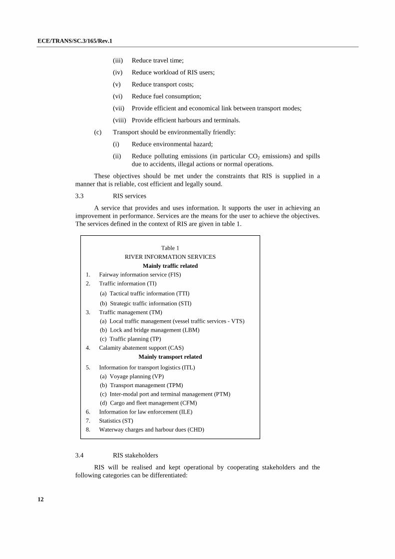
3.3 RIS services
A service that provides and uses information. It supports the user in achieving an improvement in performance. Services are the means for the user to achieve the objectives. The services defined in the context of RIS are given in table 1.
3.4 RIS stakeholders
RIS will be realised and kept operational by cooperating stakeholders and the following categories can be differentiated:
Table 1
RIVER INFORMATION SERVICES
Mainly traffic related
1. Fairway information service (FIS)
2. Traffic information (TI)
(a) Tactical traffic information (TTI)
(b) Strategic traffic information (STI)
3. Traffic management (TM)
(a) Local traffic management (vessel traffic services - VTS)
(b) Lock and bridge management (LBM)
(c) Traffic planning (TP)
4. Calamity abatement support (CAS)
Mainly transport related
5. Information for transport logistics (ITL)
(a) Voyage planning (VP)
(b) Transport management (TPM)
(c) Inter-modal port and terminal management (PTM)
(d) Cargo and fleet management (CFM)
6. Information for law enforcement (ILE)
7. Statistics (ST)
8. Waterway charges and harbour dues (CHD)
ECE/TRANS/SC.3/165/Rev.1
13
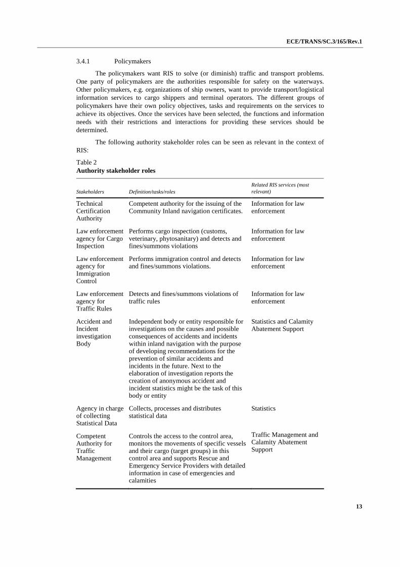
3.4.1 Policymakers
The policymakers want RIS to solve (or diminish) traffic and transport problems. One party of policymakers are the authorities responsible for safety on the waterways. Other policymakers, e.g. organizations of ship owners, want to provide transport/logistical information services to cargo shippers and terminal operators. The different groups of policymakers have their own policy objectives, tasks and requirements on the services to achieve its objectives. Once the services have been selected, the functions and information needs with their restrictions and interactions for providing these services should be determined.
The following authority stakeholder roles can be seen as relevant in the context of RIS:
Table 2 Authority stakeholder roles
Stakeholders Definition/tasks/roles Related RIS services (most relevant)
Technical Certification Authority
Competent authority for the issuing of the Community Inland navigation certificates.
Information for law enforcement
Law enforcement agency for Cargo Inspection
Performs cargo inspection (customs, veterinary, phytosanitary) and detects and fines/summons violations
Information for law enforcement
Law enforcement agency for Immigration Control
Performs immigration control and detects and fines/summons violations.
Information for law enforcement
Law enforcement agency for Traffic Rules
Detects and fines/summons violations of traffic rules
Information for law enforcement
Accident and Incident investigation Body
Independent body or entity responsible for investigations on the causes and possible consequences of accidents and incidents within inland navigation with the purpose of developing recommendations for the prevention of similar accidents and incidents in the future. Next to the elaboration of investigation reports the creation of anonymous accident and incident statistics might be the task of this body or entity
Statistics and Calamity Abatement Support
Agency in charge of collecting Statistical Data
Collects, processes and distributes statistical data
Statistics
Competent Authority for Traffic Management
Controls the access to the control area, monitors the movements of specific vessels and their cargo (target groups) in this control area and supports Rescue and Emergency Service Providers with detailed information in case of emergencies and calamities
Traffic Management and Calamity Abatement Support
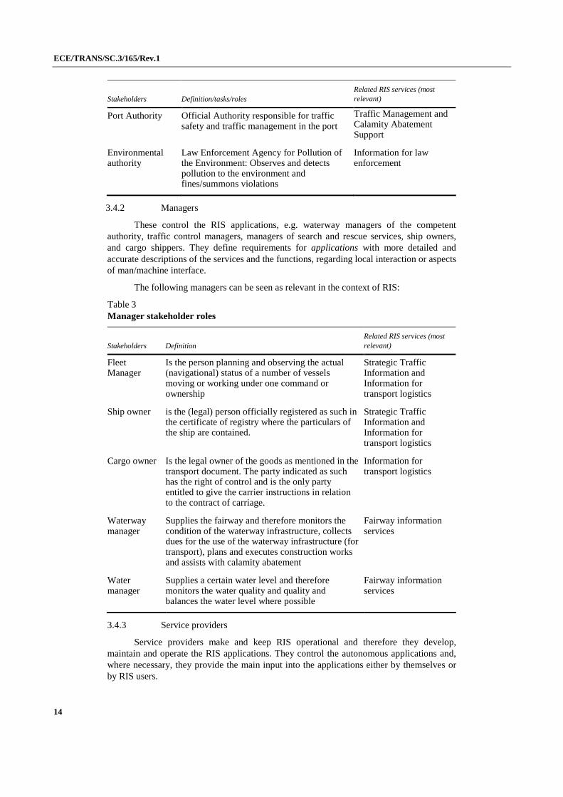
ECE/TRANS/SC.3/165/Rev.1
14
Stakeholders Definition/tasks/roles Related RIS services (most relevant)
Port Authority Official Authority responsible for traffic safety and traffic management in the port
Traffic Management and Calamity Abatement Support
Environmental authority
Law Enforcement Agency for Pollution of the Environment: Observes and detects pollution to the environment and fines/summons violations
Information for law enforcement
3.4.2 Managers
These control the RIS applications, e.g. waterway managers of the competent authority, traffic control managers, managers of search and rescue services, ship owners, and cargo shippers. They define requirements for applications with more detailed and accurate descriptions of the services and the functions, regarding local interaction or aspects of man/machine interface.
The following managers can be seen as relevant in the context of RIS:
Table 3 Manager stakeholder roles
Stakeholders Definition Related RIS services (most relevant)
Fleet Manager
Is the person planning and observing the actual (navigational) status of a number of vessels moving or working under one command or ownership
Strategic Traffic Information and Information for transport logistics
Ship owner is the (legal) person officially registered as such in the certificate of registry where the particulars of the ship are contained.
Strategic Traffic Information and Information for transport logistics
Cargo owner Is the legal owner of the goods as mentioned in the transport document. The party indicated as such has the right of control and is the only party entitled to give the carrier instructions in relation to the contract of carriage.
Information for transport logistics
Waterway manager
Supplies the fairway and therefore monitors the condition of the waterway infrastructure, collects dues for the use of the waterway infrastructure (for transport), plans and executes construction works and assists with calamity abatement
Fairway information services
Water manager
Supplies a certain water level and therefore monitors the water quality and quality and balances the water level where possible
Fairway information services
3.4.3 Service providers
Service providers make and keep RIS operational and therefore they develop, maintain and operate the RIS applications. They control the autonomous applications and, where necessary, they provide the main input into the applications either by themselves or by RIS users.

ECE/TRANS/SC.3/165/Rev.1
15
Table 4 Services provider stakeholder roles
Stakeholders Definition related RIS services (most relevant)
RIS Provider Being the organization or organizational unit assigned or contracted to operate the RIS-System and to provide RIS Services
Fairway Information Services, tactical and strategic Traffic Information Services
Rescue and Emergency service Provider
Responsible for the search and rescue and emergency services (deals with a calamity and takes care of the people, animals, cargo and vessel involved)
Calamity Abatement Support
3.4.4 RIS Users:
The RIS users can be described in a number of different groups.
Table 5 User Stakeholder roles
Stakeholders Definition related RIS services (most relevant)
Rescue and Emergency Service Provider
Responsible for the search and rescue and emergency services (deals with a calamity and takes care of the people, animals, cargo and vessel involved)
Calamity Abatement Support
Law enforcement agency for Cargo Inspection
Performs cargo inspection (customs, veterinary, phytosanitary) and detects and fines/summons violations
Information for law enforcement
Law enforcement agency for Immigration Control
Performs immigration control and detects and fines/summons violations.
Information for law enforcement
Law enforcement agency for Traffic Rules
Detects and fine/summons violations of traffic rules
Information for law enforcement
Accident and Incident investigation Body
Independent body or entity responsible for investigations on the causes and possible consequences of accidents and incidents within inland navigation with the purpose of developing recommendations for the prevention of similar accidents and incidents in the future.
Calamity Abatement Support and Statistics
Organization in charge of collecting Statistical Data
Collects, processes and distributes statistical data Statistics

ECE/TRANS/SC.3/165/Rev.1
16
Stakeholders Definition related RIS services (most relevant)
Fleet Manager is the person planning and observing the actual (navigational) status of a number of vessels, moving or working under one command or ownership
Strategic traffic information and Information for transport logistics
Competent Authority for Traffic Management
Controls the access to the control area, monitors the movements of specific vessels and their cargo (target groups) in this control area and supports Rescue and Emergency Service Providers with detailed information in case of emergencies and calamities
Traffic Management and
Calamity Abatement Support
Lock Operator
Monitors and controls the smooth and safe progress of traffic around a and through a lock and is responsible for the locking process in itself
Traffic Management
Bridge Operator
monitors and controls the fluent and safe progress of traffic around a moveable bridge and who is responsible for the operation of a movable bridge
Traffic Management
Terminal Operator
is a party carrying out the functions of loading, stowing and discharging the cargo of a ship.
Strategic traffic information and Information for transport logistics
Port Operator Commercial user responsible for the commercial business within the port. Supplies the port and therefore monitors the condition of the port infrastructure, collects dues for the use of the port infrastructure (for transhipments and transport), plans and executes construction works and assists with calamity abatement
Strategic traffic information and Information for transport logistics
Ship master (synonym: Captain, Skipper, Boat master) is the person responsible for the overall safety of the vessel, cargo, passengers and crew and thereby for the voyage plan of the vessel and the condition of the vessel, the cargo, passengers and the quality and quantity of the crew
Fairway information Services and tactical and strategic Traffic Information
Ship owner is the (legal) person officially registered as such in the certificate of registry where the particulars of the ship are contained.
Strategic traffic information and Information for transport logistics
Cargo owner Is the legal owner of the goods as mentioned in the transport document. The party indicated as such has the right of control and is the only party entitled to give the carrier instructions in relation to the contract of carriage.
Strategic traffic information and Information for transport logistics
Consignee is the party such as mentioned in the transport document by which goods, cargo or containers are to be received.
Strategic traffic information and Information for transport logistics
ECE/TRANS/SC.3/165/Rev.1
17
Stakeholders Definition related RIS services (most relevant)
Consignor The merchant (person) by whom, in whose name or on whose behalf a contract of carriage of goods has been concluded with a carrier or any party by whom, in whose name or on whose behalf the goods are actually delivered to the carrier in relation to the contract of carriage.
Strategic traffic information and Information for transport logistics
Berth operator Monitors and controls the fluent and safe progress of traffic around a berth and who is responsible for the use of a berth.
Strategic traffic information and Information for transport logistics
Fire brigade Rescue and Emergency Service Providers: Responsible for the search & rescue and emergency services (deals with a calamity and takes care of the people, animals, cargo and vessels involved).
Emergency Service/Salvage service: Assist search & rescue and emergency services
Calamity Abatement Support
Forwarder (synonym: Freight broker) is the party arranging the carriage of goods including connecting services and/or associated formalities on behalf of shipper and consignee.
Strategic traffic information and Information for transport logistics
Shipping agent
The shipping agent is a person or organization authorised to act for or on behalf of another person or organization, such as the forwarding agent, the custom agent and the carrier agent.
Strategic traffic information and Information for transport logistics
3.4.5 System engineers:
These prepare system specifications and integrate hardware and software components into system components. RIS and VTS suppliers, system integrators, and telecommunication operators will combine the system components into complete systems which enable RIS services.
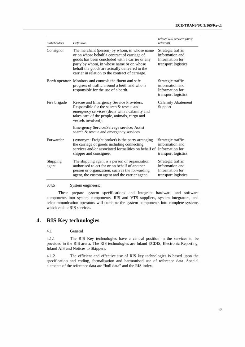
4. RIS Key technologies
4.1 General
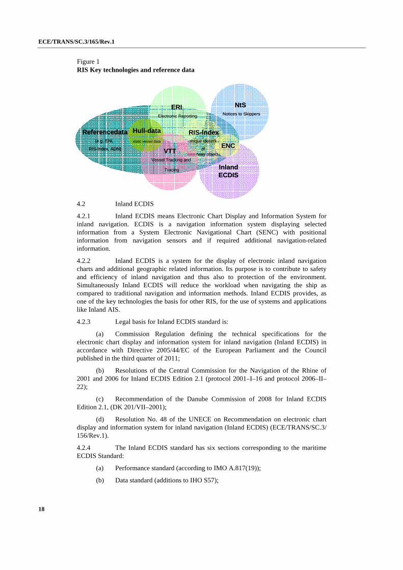
4.1.1 The RIS Key technologies have a central position in the services to be provided in the RIS arena. The RIS technologies are Inland ECDIS, Electronic Reporting, Inland AIS and Notices to Skippers.
4.1.2 The efficient and effective use of RIS key technologies is based upon the specification and coding, formalisation and harmonised use of reference data. Special elements of the reference data are “hull data” and the RIS index.
ECE/TRANS/SC.3/165/Rev.1
18
Figure 1 RIS Key technologies and reference data
4.2 Inland ECDIS
4.2.1 Inland ECDIS means Electronic Chart Display and Information System for inland navigation. ECDIS is a navigation information system displaying selected information from a System Electronic Navigational Chart (SENC) with positional information from navigation sensors and if required additional navigation-related information.
4.2.2 Inland ECDIS is a system for the display of electronic inland navigation charts and additional geographic related information. Its purpose is to contribute to safety and efficiency of inland navigation and thus also to protection of the environment. Simultaneously Inland ECDIS will reduce the workload when navigating the ship as compared to traditional navigation and information methods. Inland ECDIS provides, as one of the key technologies the basis for other RIS, for the use of systems and applications like Inland AIS.
4.2.3 Legal basis for Inland ECDIS standard is:
(a) Commission Regulation defining the technical specifications for the electronic chart display and information system for inland navigation (Inland ECDIS) in accordance with Directive 2005/44/EC of the European Parliament and the Council published in the third quarter of 2011;
(b) Resolutions of the Central Commission for the Navigation of the Rhine of 2001 and 2006 for Inland ECDIS Edition 2.1 (protocol 2001–I–16 and protocol 2006–II–22);
(c) Recommendation of the Danube Commission of 2008 for Inland ECDIS Edition 2.1, (DK 201/VII–2001);
(d) Resolution No. 48 of the UNECE on Recommendation on electronic chart display and information system for inland navigation (Inland ECDIS) (ECE/TRANS/SC.3/ 156/Rev.1).
4.2.4 The Inland ECDIS standard has six sections corresponding to the maritime ECDIS Standard:
(a) Performance standard (according to IMO A.817(19));
(b) Data standard (additions to IHO S57);
Inland ECDIS
RIS-Indexunique identifier
ofwaterway objects
ERIElectronic Reporting
NtSNotices to Skippers
VTT Vessel Tracking and
Tracing
Hull-data
static vessel data
Referencedata(e.g. ENI,
RIS-Index, ADN) ENC
Inland ECDIS
RIS-Indexunique identifier
ofwaterway objects
ERIElectronic Reporting
NtSNotices to Skippers
VTT Vessel Tracking and
Tracing
Hull-data
static vessel data
Referencedata(e.g. ENI,
RIS-Index, ADN) ENC
ECE/TRANS/SC.3/165/Rev.1
19
(c) Codes for producers and waterways – complements IHO Standard S–62;
(d) Presentation standard (additions to IHO S52);
(e) Operational and performance requirements, methods of testing and required test results (according to IEC–1174);
(f) Glossary of terms.
4.2.5 Inland ECDIS is compatible with maritime ECDIS, that means:
(a) Inland vessels sailing in maritime waters with Inland ECDIS equipment get all maritime ENC information;
(b) Sea going vessels sailing in inland waters with maritime ECDIS equipment get all information being equal to marine information (e.g. river banks), but they do not get the additional inland information (e.g. inland notice marks).
4.2.6 Sea-river vessels are recommended to use the additional Inland ECDIS software libraries in order to obtain full Inland ENC information.
4.2.7 Inland ECDIS shall use chart information (ENC) as specified by the IHO S57 Standard (edition 3.0) with the additions of the Inland ECDIS Standard.
4.2.8 The presentation shall be in accordance with the IHO S52 Standard (edition 3.0) and with the amendments of the Inland ECDIS Standard.
4.2.9 Inland ECDIS may be used in navigation mode or in information mode.
4.2.10 Navigation mode means the use of Inland ECDIS with traffic information by radar overlay. Inland ECDIS in navigation mode may be operated in three configurations:
(a) Separate installation of Inland ECDIS and radar equipment; the latter sending the radar signal to the Inland ECDIS computer;
(b) As before, but only one monitor used;
(c) Radar equipment with integrated Inland ECDIS functionality. It is recommended to develop and use this configuration in the future.
4.2.11 Information Mode means the use of Inland ECDIS without traffic information by radar overlay. For an Inland ECDIS application designed for Information Mode only, the requirements of navigation mode are to be understood as recommendations.
4.2.12 In the navigation mode, an Inland ECDIS (operating system software, application software and hardware) shall have a high level of reliability and availability at least of the same level as other means of navigation.
4.2.13 Inland ECDIS equipment for navigation mode shall be certified by the competent authority.
4.2.14 In navigation mode Electronic Navigational Charts (ENCs) shall be used which are certified by the waterway authorities.
4.2.15 It is recommended to include the water depths to the ENC (depths contours) for shallow river stretches that determine the draught of the vessels. The water depths may be related to a reference water level or to the actual water level.
4.3 Inland AIS
4.3.1 Inland AIS (AIS stands for “Automatic Identification System”) is a RIS key technology for the automatic exchange of identification and nautical data between ships and between ships and shore installations.
ECE/TRANS/SC.3/165/Rev.1
20
4.3.2 Inland AIS is an instrument for the tracking and tracing of inland navigation vessels with the goal to improve safety and efficiency of Inland Navigation supporting onboard decisions (TTI and STI), shore-based Traffic Management (TM) including Vessel Traffic Services (VTS, Lock and Bridge Management (LBM) and Traffic Planning (TP), Calamity Abatement Support (CAS), Information for Transport Logistics (ITL) and Information for Law Enforcement (ILE).
4.3.3 AIS is a ship borne radio data system, exchanging static, dynamic and voyage related vessel data between equipped vessels and between equipped vessels and shore stations. Ship borne AIS stations broadcast the vessel’s identity, position and other data in regular intervals. By receiving these transmissions, ship borne or shore based AIS stations within the radio range can automatically locate, identify and track AIS equipped vessels on an appropriate display like radar or Inland ECDIS.
4.3.4 AIS is a cooperative procedure, therefore all those wishing to use and participate in the system must be equipped with an AIS device.
4.3.5 AIS is an additional source of navigation-related information. AIS does not replace navigation-related services such as tracking by radar and VTS, but in fact supports them. The strength of AIS lies in the detection and tracking of those craft fitted with it. AIS and radar complement one another due to their different characteristics.
4.3.6 The legal basis for Inland AIS is:
(a) Resolution of the Central Commission for Navigation on the Rhine (CCNR) of 2006: (Protocol 2006–I–21);
(b) Commission Regulation (EC) No. 415/2007 of 2007 concerning the technical specifications for vessel tracking and tracing systems referred to in Article 5 of Directive 2005/44/EC of the European Parliament and of the Council on harmonised River Information Services (RIS) on inland waterways;
(c) CCNR Resolutions of 2007: “Vessel Tracking and Tracing Standard for Inland Navigation – Type approval, installation and operation of Inland AIS devices on inland navigation vessels” (Protocol 2007–I–15 and 2007–II–24);
(d) UNECE Resolution No. 60 on International Standards for Notices to Skippers and for Electronic Ship Reporting in Inland Navigation (ECE/TRANS/SC.3/175 as amended).
4.3.7 The Inland AIS Standard defines:
(a) Functional requirements for Inland AIS devices;
(b) Technical requirements for Inland AIS devices;
(c) Specification of AIS messages for the exchange of messages between Inland AIS devices via radio;
(d) Specification of AIS data sets for data exchange between Inland AIS devices and connected applications.
4.3.8 The information content of Inland AIS basically tallies that of maritime AIS, while providing additional information specific to inland waterways. In view of their shared information content, Inland AIS and maritime AIS are compatible. All data transmitted can be received by both maritime and Inland AIS devices to be visually displayed and analysed. However the specifically Inland AIS information is only transmitted and assessed by Inland AIS devices.
4.3.9 For seagoing vessels is a carriage requirement according to the SOLAS convention. In Austria there is a carriage requirement for Inland AIS.

ECE/TRANS/SC.3/165/Rev.1
21
4.3.10 In many RIS related processes the implementation and use of Inland AIS onboard as well as on shore is a pre-condition. The full scale benefit of Inland AIS for RIS services requires a carriage requirement for Inland AIS.
4.3.11 System regulations for maritime AIS are:
(a) IMO Resolution MSC.74(69) annex 3: Recommendation on performance standards for AIS;
(b) ITU Recommendation ITU-R M1371: Technical characteristics for an universal ship borne automatic identification system, using time division multiple access in the VHF maritime mobile band;
(c) IALA Technical clarifications on recommandation ITU-R M.1371–1;
(d) IEC 61993–2 Automatic identification systems (AIS) part 2: class A ship borne equipment of the universal ship borne automatic identification system (AIS);
(e) IALA Guidelines on the automatic identification system (AIS).
4.3.12 The following operating modes can be distinguished for AIS:
(a) Ship to ship: All vessels fitted with AIS are able to receive static and dynamic information from all other vessels equipped with AIS within the area of coverage. Inland AIS may be used in combination with Inland ECDIS or radar to enhance a TTI and STI;
(b) Ship to shore: Data from vessels equipped with AIS can also be picked up by AIS base stations and relayed to an RIS Centre where it can be used to display Tactical Traffic Information (TTI) and Strategic Traffic Information (STI);
(c) Shore to ship: Safety-related data can be transmitted to vessels by shore installations.
4.3.13 Various kinds of AIS device types or AIS stations may be distinguished:
(a) AIS mobile stations of Class A on all seagoing vessels subject to the requirements of the International Maritime Organization (IMO) SOLAS Chapter V;
(b) AIS mobile stations of Class B CS/SO with restricted functionality, i.e. on seagoing leisure craft;
(c) Inland AIS mobile stations, derivatives of AIS mobile stations of Class A with full Class A functionality at VDL level plus additional inland navigation functions.
(d) AIS base stations, including shore-based Simplex repeater stations;
(e) AIS nautical signal stations for use on signalling devices such as beacons and buoys (“Aids to Navigation” AtoN).
4.3.14 AIS operates on the internationally defined VHF frequencies AIS 1 (161,975 MHz) and AIS 2 (162,025 MHz) and may be switched to other channels in the VHF maritime band.
4.3.15 The information transmitted by Inland AIS can be divided into the following categories:
(a) Static information, such as vessel number, call-sign, vessel name, vessel type;
(b) Dynamic information, such as position of the ship with data on accuracy and integrity status;
(c) Voyage-related information, such as length and beam of combinations, dangerous cargo;

ECE/TRANS/SC.3/165/Rev.1
22
(d) Information specific to inland navigation such as Standard European Vessel Number, type of combination, number of blue cones/lights as per ADN, estimated time of arrival (ETA) at locks, bridges, terminals, borders and presence of “blue signs”.
4.3.16 For transmitting messages Inland AIS uses the same parameters and the same structure as AIS mobile stations of Class A, which the IMO prescribes for maritime navigation (IMO-AIS). Fields with unused parameters are defined as “not available”. Elements marked with “*” must be dealt with differently from seagoing vessels.
4.3.17 The Inland AIS (mobile) device shall be in permanent operation whenever the ship is at anchor or en route. When in port, operation will take place in accordance with the local port regulations.
4.3.18 The shipmaster shall manually input the following data at the start of the voyage and whenever the data is amended:
(a) Correct navigation status;
(b) Type of combination;
(c) Length/beam of combination;
(d) Category of dangerous cargo;
(e) Draught of the ship;
(f) Loaded/unloaded;
(g) Port of destination and ETA.
The conning skipper must check data to ensure that the static ship data is correct and reflect the latest situation. This must be done at least once a month but preferably at the start of every voyage. At certain intervals the shipmaster must also check the dynamic data of his or her own AIS device.
4.3.19 A so called minimum keyboard and display (MKD) for Inland AIS devices serves to input voyage-related ship data and other vessel-specific data such as status indication and alarm messages. The MKD may also show AIS messages received, such as ship name, distance and heading of the reporting ship, alphanumerically. Other ship data can be displayed by selecting a given ship. This form of displaying AIS data is not suited for navigational support. When using AIS data for navigation a graphical display similar to Inland ECDIS is essential.
4.3.20 A peculiar trait of AIS is the autonomous mode which uses the SOTDMA (Self-Organising Time Division Multiple Access) procedure, thus dispensing with the need for a coordinating base station.
4.4 Electronic reporting
4.4.1 Electronic (Ship) reporting (ERI) is a RIS key technology that facilitates the RIS services Strategic Traffic Information (STI), Traffic Management (TM), Calamity Abatement Support (CAS), Statistics (ST), Law enforcement (ILE), Waterway charges and harbour dues (CHD) as well as Transport Logistics (TL).
4.4.2 Electronic Reporting in Inland Navigation facilitates electronic data interchange (EDI) between partners in inland navigation as well as partners in the multimodal transport chain involving inland navigation and avoids the reporting of the same information related to a voyage several times to different authorities and/or commercial parties.

ECE/TRANS/SC.3/165/Rev.1
23
4.4.3 The legal basis for electronic reporting is:
(a) Commission Regulation (EU) No. 164/2010 of 2010 on the technical specifications for electronic ship reporting in inland navigation referred to in article 5 of Directive 2005/44/EC of The European Parliament and of the Council of 2005 on harmonised River Information Services (RIS);
(b) CCNR Resolution of 2003: (Resolution 2003–I–23);
(c) United Nations recommendations regarding the interchange of trade data (UN CEFACT recommendation 25, 31 and 32, EDI and E-Commerce agreements);
(d) UNECE Resolution No. 60 on International Standards for Notices to Skippers and for Electronic Ship Reporting in Inland Navigation (ECE/TRANS/SC.3/ 175 as amended).
4.4.4 Electronic reporting supports safety and calamity abatement services and as such electronic reporting should be made mandatory.
4.4.5 Electronic reporting includes the following messaging procedures
(a) Ship-to-authority messaging dealing with:
(i) Transport notification messages on the voyages of loaded or empty ships within the jurisdictional area of the authority where such is applicable;
(ii) Arrival notification and position reports at locks, bridges, reporting points of traffic centres.
(b) Authority-to-authority messaging dealing with transport notifications for ships, carrying cargo or being empty, travelling from one jurisdictional area to the other;
(c) Authority-to-ship messaging mainly consists of acknowledgements and responses to previously submitted notification messages and may also include the sending of fairway information, such as Notices to Skippers.
4.4.6 Transport notification are to inform the competent authorities of the intention to make specified voyage with a specified ship, either carrying a specified cargo or being empty. The transport notification can either originate from the skipper of the ship or from the shipper of the cargo on behalf of the skipper.
4.4.7 Transport notifications shall be sent before the start of a voyage respectively before entering the jurisdictional area of a competent authority and subsequently after every significant change of the voyage data, e.g. number of crew onboard or number of barges in the convoy.
4.4.8 When a ship requires a permit for the voyage or part thereof, the competent waterway authority shall acknowledge the message after processing the contents of the notification. The acknowledgement will include the permission together with a reference or where applicable a refusal for such a permit together with further details upon the action to be taken.
4.4.9 Arrival notification and position reports are to inform the local waterway operators – such as lock masters, bridge operators, traffic centre operators, ports and docking crew – of the impending arrival of a ship. Position reports shall be sent at certain reporting points at the waterway. Arrival notifications and position reports can be obtained by several means, either active or passive:
(a) Visual/manual;
(b) By VHF radio;
ECE/TRANS/SC.3/165/Rev.1
24
(c) By mobile Inland AIS station.
4.4.10 The competent authorities shall be able, as far as ship reporting is required by national or international regulations, to receive electronic ship reports of the required data from ships.
4.4.11 In cross-border transport, electronic reports shall be transmitted to the competent authorities of the neighbouring jurisdictional area and any such transmission shall be completed before arrival of the vessels at the border.
4.4.12 The competent authorities shall take the necessary measures to ensure the confidentiality, integrity and security of information sent to them pursuant this standard. They must use such information only for the purposes of the intended services, for example calamity abatement, border control, customs.
4.4.13 A request to forward information contained in a ship-to-authority-message to any other involved party will not be executed without explicit approval from the owner of the information being the skipper of the vessel or the shipper of the cargo.
4.4.14 An agreement on the protection of privacy between all involved public and private parties shall be concluded for new applications, based on UNECE Recommendation 26 that contains a “Model Interchange Agreement”.
4.5 Notices to Skippers
4.5.1 Notices to Skippers is a RIS key technology which provides in a standardized way and language independent:
(a) fairway and traffic related information, as well as;
(b) hydrographical information as there are weather information, water level information and ice information.
Notices to Skippers is supporting Fairway Information Services (FIS) and transport planning as part of the Information for Transport Logistic (ITL).
4.5.2 The legal basis for Notices to Skippers is:
(a) Commission Regulation 416/2007 concerning the technical specifications for Notices to Skippers as referred to in Article 5 of Directive 2005/44/EC of the European Parliament and of the Council on harmonised river information services (RIS);
(b) CCNR Resolution of 2004: (Resolution 2004–I–17);
(c) UNECE Resolution No. 60 on International Standards for Notices to Skippers and for Electronic Ship Reporting in Inland Navigation (ECE/TRANS/ SC.3/175 as amended).
4.5.3 A standardized Notices to Skippers in XML-format contains therefore 5 different sections:
(a) Identification;
(b) Fairway and traffic related messages;
(c) Water level related messages;
(d) Ice messages;
(e) Weather related messages.
4.5.4 The content of the messages is encoded in a machine readable XML-file. This file can be used by software applications like voyage planning or Inland ECDIS onboard of a vessel or by internet sites. The encoded information can be used directly for

ECE/TRANS/SC.3/165/Rev.1
25
calculations, as for example in voyage planning, or be translated to the language of the user and displayed. The reference tables of the standard contain 21 languages of the member countries of the European Union and additional 3 languages, namely Croatian, Serbian and Russian language.
4.5.5 The standard for Notices to Skippers provides a standardized data format, which can be used for publishing notices to skippers on the internet (pull-services) or for distribution by e-mail (push services).
4.5.6 The standardization of Notices to Skippers is compatible with the data structure of Inland ECDIS to facilitate integration of Notices to Skippers in Inland ECDIS.
4.5.7 Fairway information should be provided at a national level or preferably on an (International) fairway network level by implementing one single dissemination point of contact.
4.5.8 A standardized method for exchanging Notices to Skippers by means of Web Service (WS) technology is currently in a trial phase. WS will enable an easier and more secure method for exchanging Notices to Skippers between authorities as well as private companies and/or operators.
4.6 Reference data needed for RIS Key technologies
RIS references and code tables are key elements in the RIS-standards and are an important link between the various RIS services. The exchange of computerized data without direct human interference between the RIS users and the RIS services is facilitated by the use of codes and references.
To ensure proper exchange of data there are a number of pre-conditions:
(a) Reference and code tables are not static, they may change by international and or local rules and regulations. The need for harmonization and standardization, however, requires that the reference and codes tables are stable and consistent;
(b) In order to ensure interoperability, throughout the whole transport and logistics chain, there is the general principle that the components of the RIS reference data shall be kept in line with international standards such as the ISO, UNECE recommendations and other relevant standards.
In order to guarantee a solid basis for the use of reference data and code tables, special attention is required for data maintenance, maintenance procedures and distribution of the reference data and code tables.
4.6.1 Hull data
(a) To receive RIS services, the hull data of the vessels sailing through a RIS area shall be available;
(b) Data of the ship’s hull is an important basic input parameter for mainly traffic-related RIS services (e.g. the dimensions of the vessels will be required for the planning of the locking processes);
(c) The unique identification (number) of a vessel should be treated as a unique identifier in RIS services;
(d) Data of the ship’s hull will includes the following elements:
(i) Unique identification of the ship;
(ii) Name of the ship;
(iii) Type of ship;
ECE/TRANS/SC.3/165/Rev.1
26
(iv) Length of the vessel;
(v) Breadth of the vessel;
(vi) Maximum draught of the vessel;
(vii) Operator of the vessel.
(e) The hull data should be related to technical inspections as the inspection authorities also generate the data of the hull.
4.6.2 RIS Index
(a) A special group of reference data is covered by the RIS index. Inland ECDIS and Notices to Skippers requires unambiguous coding of locations of geographic objects. This is however also relevant for Electronic reporting and tracking and tracing activities;
(b) A location code is the only machine readable link between Electronic Reporting, Inland ECDIS and Notices to Skippers. The location code is a unique ID for each piece of infrastructure, which is of importance for RIS;
(c) The location code used in the RIS environment is a 20-digit alphanumerical code – the ISRS code – which consists of the following data elements:
(i) UN Country code (2 letters) ;
(ii) UN Location code (3 letters) ;
(iii) Fairway section code (5 digits, alphanumerical);
(iv) Terminal code or passage point code (5 digits, alphanumerical);
(v) Fairway section hectometre (5 digits, numerical);
(d) The RIS Index is a list of location codes with additional information on the objects like their characteristics (name, fairway, …), restrictions (available depth, clearance, …), operating times, etc.;
(e) In an international fairway network the introduction of a harmonised fairway ID is seen as a positive contribution to the need for linking the RIS index of different countries;
(f) Each object in the RIS index shall have only one ISRS code, even when those objects are located on common stretches of a waterway for two or more countries.
4.7 Basic technologies related to RIS
Apart from the RIS Key technologies, the basic technologies – like radar and radiotelephone services via VHF, which for many decades have been important navigation supporting technologies will not be replaced by RIS key technologies but are supporting the use of RIS services.
4.7.1 Radiotelephone service on inland waterways
(a) The radiotelephone service on inland waterways enables the establishment of radio communication for specific purposes by using agreed upon channels and an agreed operational procedure (service categories). The radiotelephone service comprises five service categories:
(i) Ship-to-ship;
(ii) Nautical information;
(iii) Ship-to-port authorities;

ECE/TRANS/SC.3/165/Rev.1
27
(iv) On-board communications;
(v) Public correspondence (service on a non-mandatory basis).
Of these five categories, only the first three are important for RIS. The radiotelephone service enables direct and fast communication between skippers, waterway authorities and port authorities. It is best suited for urgently needed information on a real time basis.
(b) The radiotelephone service is based on the following rules and regulations:
(i) Radio Regulations of the International Telecommunication Union ITU (worldwide);
(ii) Regional Arrangement Concerning the Radiotelephone Service on Inland Waterways (Europe, 06.04.2000);
(iii) Standardized UNECE Vocabulary for Radio Connections in Inland Navigation (UN Economic Commission for Europe No. 35, 1997);
(iv) National inland waterway rules for navigation.
(c) In the service categories ship-to-ship, nautical information and ship-to-port-authorities, the transmission of messages should deal exclusively with the safety of human life and with the movement and the safety of vessels;
(d) Fairway information provision by voice in the nautical information (shore/ship) service category is recommended to be implemented:
(i) For urgent information needing to be updated frequently and having to be communicated on a real time basis;
(ii) For dynamic information having to be communicated on a daily basis.
(e) The urgent and dynamic information to be communicated by VHF radio concerns for example:
(i) Incidents and calamities;
(ii) Temporary obstructions in the fairway, malfunctions of aids to navigation;
(iii) Short-term changes of lock and bridge operating times;
(iv) Restrictions in navigation caused by weather conditions, flood and ice.
(f) The RIS area shall be fully covered by the range of the VHF base stations for nautical information;
(g) In the nautical information service category, Notices to Skippers may be transmitted “to all users” as:
(i) Scheduled reports on the state of the waterways including water level reports at the gauges at fixed times of the day;
(ii) Urgent reports at special events (e.g. traffic regulations after accidents).
(h) It shall be possible for the operator in a RIS centre to answer specific questions of skippers on demand and to receive reports from skippers.
4.7.2 Radar
(a) Radar should be used as the primary navigation tool and is the basis for tactical traffic images onboard of a vessel;

ECE/TRANS/SC.3/165/Rev.1
28
(b) The use of ECDIS in Navigation Mode the traffic image shall be overlaid with radar and preferable Inland AIS;
(c) In Navigation Mode the radar image shall have the highest display priority;
(d) Shore based radar should be the primary information for a tactical traffic image in a VTS.
4.8 Open Standards
4.8.1 The implementation of RIS will depend on the functionalities that are already available in (an) organization(s). The approach will be very different if it can be started with a green field situation on one hand or for example when it RIS has to be integrated into an existing VTS environment.
4.8.2 RIS can be implemented by (a) RIS organization(s) or another organization that is responsible for the provision of the RIS services. Nevertheless communication and data exchange with different organizations will be necessary.
4.8.3 As mentioned in section 6.1 RIS services can be seen as a stack of services that can be implemented via different projects in time depending on the needs of an organization. Many partners can be involved in this process.
4.8.4 It is, therefore, very important that the applications that are developed for the implementation of RIS are built on open standards to make them compatible with applications of other RIS organizations, e.g. machine to machine data exchange should be based on web services. New technologies like Service Oriented Architecture (SOA), which are specially developed for environments where the business rules continuously can and shall change, should be taken into account for the implementation. The use of open standards, at least for data exchange with other parties, should be recommended. Annex I gives an example of how a SOA application could be build on the basis of SOA where technologies like BPMN (Business Process Modeling Notation) are used.
5. RIS services and recommendations on the implementation of RIS services
5.1 Relation between RIS Key technologies and RIS services
The relation between the RIS services and RIS Key technologies as depicted in Chapter 4 and based on experience in previous research and implementation experience is reflected in figure 2.

ECE/TRANS/SC.3/165/Rev.1
29
Figure 2 Relation between RIS Key Technologies and RIS Services
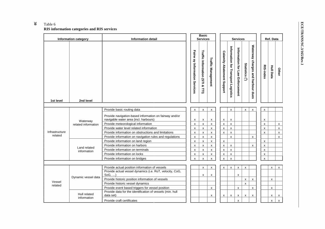
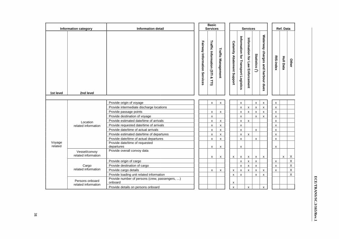
5.2 Information categories and RIS services
The functional decomposition of River Information Services (RIS) allows the allocation of information provision to user demands. Table 6 shows connections between information categories, the RIS services and the RIS reference data. The reference data is seen as essential for different information categories and as such separately depicted in the underneath table. The table below gives an example as a guide to the user of the guidelines and may assist the user in making his/her own list. In paragraph 5.3 and further, the different services are specified in detail. In annex II, a second level of information details is added to the table as additional information to table 6.
EC
E/T
RA
NS
/SC
.3/165/Rev.1
30 Table 6 RIS information categories and RIS services
Information category Information detail Basic
Services Services Ref. Data
1st level 2nd level
Fairw
ay Info
rmatio
n S
ervices
Traffic In
form
ation
(ST
I & T
TI)
Traffic M
anag
emen
t
C
alamity A
batem
ent S
up
po
rt
Info
rmatio
n fo
r Tran
spo
rt Lo
gistics
Info
rmatio
n fo
r Law
En
forcem
ent
Statistics ( 1)
Waterw
ay charg
es and
harb
ou
r du
es
R
IS-in
dex
Hu
ll Data
Oth
er
Provide basic routing data x x x x x x x
Provide navigation-based information on fairway and/or navigable water area (incl. harbours) x x x x x x Provide meteorological information x x x x x x x Provide water level related information x x x x x x x Provide information on obstructions and limitations x x x x x x x
Waterway related information
Provide information on navigation rules and regulations x x x x x x Provide information on land region x x x x x Provide information on harbors x x x x x x x Provide information on terminals x x x x x x Provide information on locks x x x x x x
Infrastructure related
Land related information
Provide information on bridges x x x x x x
Provide actual position information of vessels x x x x x x x x Provide actual vessel dynamics (i.e. RoT, velocity, CoG, SoG, …) x x x Provide historic position information of vessels x x x Provide historic vessel dynamics x
Dynamic vessel data
Provide event based triggers for vessel position x x x x Provide data for the identification of vessels (min. hull data set) x x x x x x x x
Vessel related
Hull related information
Provide craft certificates x x x
EC
E/T
RA
NS
/SC
.3/165/Rev.1
31
Information category Information detail Basic
Services Services Ref. Data
1st level 2nd level
Fairw
ay Info
rmatio
n S
ervices
Traffic In
form
ation
(ST
I & T
TI)
Traffic M
anag
emen
t
C
alamity A
batem
ent S
up
po
rt
Info
rmatio
n fo
r Tran
spo
rt Lo
gistics
Info
rmatio
n fo
r Law
En
forcem
ent
Statistics ( 1)
Waterw
ay charg
es and
harb
ou
r du
es
R
IS-in
dex
Hu
ll Data
Oth
er
Provide origin of voyage x x x x x x Provide intermediate discharge locations x x x x x Provide passage points x x x x x x x Provide destination of voyage x x x x x Provide estimated date/time of arrivals x x x x x Provide requested date/time of arrivals x x x x Provide date/time of actual arrivals x x x x x Provide estimated date/time of departures x x x x x Provide date/time of actual departures x x x x x
Location related information
Provide date/time of requested departures x x x x
Vessel/convoy related information
Provide overall convoy data
x x x x x x x x X Provide origin of cargo x x x x X Provide destination of cargo x x x x X Provide cargo details x x x x x x x x X
Cargo related information
Provide loading unit related information x x x x X Provide number of persons (crew, passengers, …) onboard x
Voyage related
Persons onboard related information
Provide details on persons onboard x x x

ECE/TRANS/SC.3/165/Rev.1
32
5.3 Fairway information service (FIS)
5.3.1 Fairway information contains static and dynamic as well as urgent information regarding the fairway. Static and dynamic information should be communicated on a scheduled basis.
5.3.2 Fairway information should be provided on national level or preferably on (International) fairway network level by creating and implementing one single dissemination point of contact.
5.3.3 Safety related data as provided should be certified by the competent authority.
5.3.4 Fairway Information Services should be given with an indication of the quality of the information. Depending on the type of data, this quality can expressed in terms of accuracy, reliability, age, completeness, conformity to standards, etc. The user should be informed at least on:
(a) Reliability of the information;
(b) Accuracy and age of the information;
(c) Completeness of the information.
5.3.4 The urgent information needs to be updated very frequently and/or should be communicated on a real time basis by VHF radio or Inland AIS.
5.4 Traffic information service
5.4.1 General
Information concerning the traffic situation may be provided in two ways:
(a) As tactical traffic information (TTI) using radar and – if available a Inland AIS system with underlying Inland Electronic Navigational Charts (Inland ENC);
(b) As strategic traffic information (STI) using an Inland AIS network and/or an electronic ship reporting system.
5.4.2 Tactical traffic information (TTI) Service:
5.4.2.1 Vessels should be equipped with radar in order to monitor all other ships in the close navigational area to the vessel.
5.4.2.2 A tactical traffic image onboard should be enhanced at least by displaying the radar information and an AIS vessel information on an electronic navigational chart (ENC).
5.4.2.3 The integrated display should be in accordance with the requirements for the navigation mode of the Inland ECDIS standard.
5.4.2.4 If a vessel is using the navigation mode of Inland ECDIS, the vessel’s position should be derived from a continuous positioning system of which the accuracy is consistent with the requirements of safe navigation.
5.4.2.5 If a vessel is using the navigation mode of Inland ECDIS, at least the safety relevant geo-objects should be included into the ENC. The competent authority should verify the safety relevant information in the ENC.
5.4.2.6 The use of Inland AIS onboard a vessel as an additional position sensor for detection of surrounding vessels should fulfil the requirements of the relevant standard. The vessel information should be identified on the tactical traffic image and other additional information on these vessels should be available.

ECE/TRANS/SC.3/165/Rev.1
33
5.4.2.7 Tactical traffic information on shore is used in local traffic management (e.g. VTS centres).
5.4.3 Strategic traffic information (STI)
5.4.3.1 Strategic traffic information should be implemented, when a permanent monitoring of the traffic situation in the RIS area is needed for medium term and long term decisions.
5.4.3.2 Strategic traffic information can be helpful to the following services:
(a) Lock and bridge management (calculation of estimated time of arrival – ETA – and required time of arrival – RTA);
(b) Voyage planning;
(c) Calamity abatement support (vessel and cargo data);
(d) Terminal management (calculation of ETA and RTA).
5.4.3.3 For strategic traffic and transport management supporting services a ship reporting system should be established by the competent authority. The system has the task of collecting, processing and verifying and disseminating the reported information on vessel position, voyage and cargo.
5.4.3.4 Special attention is needed for privacy regulation when strategic traffic and transport services are implemented.
5.4.3.5 For transport management services data exchange with private parties should be supported but requires strict authorisation rules and a legal basis for the exchange of this information. A single point of contact on the (inter-)national network level for the provision of this strategic information is recommended.
5.4.3.6 Data interchange should be established between authorities within the waterway network. For this data exchange standards are to be developed.
5.5 Traffic management
5.5.1 Vessel traffic services (VTS)
5.5.1.1 Reference is made to the Inland VTS Guidelines of IALA and the CCNR guidelines on inland VTS (para. 1.4).
5.5.1.2 Vessel Traffic Services by means of a tactical traffic image on shore should be established for the safety of navigation in critical local situations, the efficiency of traffic and the protection of the environment from potential dangers of shipping. It emphasizes traffic monitoring. The difficult local situations may be:
(a) Complex traffic patterns;
(b) High amount of accidents;
(c) High traffic density;
(d) Narrow fairway and/or shoals;
(e) Narrow bends;
(f) Narrow and/or many bridges;
(g) Fast water currents and/or cross currents;
(h) Fairway with traffic regulations, e.g. one-way traffic;
(i) Conjunction of waterways.

ECE/TRANS/SC.3/165/Rev.1
34
5.5.1.3 The Tactical Traffic Image (TTI) is produced by collecting shore based radar and vessel tracking and tracing information and displaying the vessel information on an Inland ECDIS. The standards for Inland ECDIS and inland vessel tracking and tracing should be used. For a long river stretch and heavy traffic, the TTI may be enhanced by target tracking.
5.5.2 Lock and bridge management
5.5.2.1 RIS should optimise the traffic flow by:
(a) Support of the lock/bridge master in short-term decisions for planning of the lock and bridge cycle by presentation of an electronic lock diary, by a database, and by registration of waiting times;
(b) Support of the lock/bridge master in medium-term decisions by data exchange with the neighbouring locks;
(c) Support of the skipper by providing information on waiting times and/or expected time of passing;
(d) Optimising of lock cycles by calculation of ETAs/RTAs for a chain of locks, providing information on RTAs to skippers.
5.5.2.2 An electronic ship reporting system, an Inland AIS network and appropriate means of communication are recommended to be established in order to enhance lock and bridge planning.
5.5.3 Traffic Planning
5.5.3.1 Traffic planning should improve the passage time on a fairway or transport corridor by providing information on the state of the fairway and passing times at locks and bridges on a fairway or corridor in an integral approach.
5.5.3.2 Through electronic reporting and availability of tactical and strategic traffic information RIS authorities can better anticipate the demand for use of facilities in the RIS area and provide enhanced Traffic Management Services.
5.5.3.3 Based on an ETA at the final destination, the RIS authority can advice a ship to adapt its ETA and so optimize not only the resources but also the arrival of the ship. This allows for better use of infrastructure and reduced waiting times leading to improved efficiency.
5.5.3.4 RIS traffic planning (TP) optimizes the voyage planning of vessels.
5.6 Calamity abatement support
5.6.1 Calamity Abatement Support means the supporting actions necessary to limit the consequences of a calamity.
5.6.2 Calamity Abatement support is facilitated by reporting of the vessels position, voyage and transport data at the beginning of a voyage. This information should be continuously updated during the voyage. In case of an accident, the RIS centre delivers the data without delay to the emergency services.
5.6.3 It is the responsibility of the skipper to report the required data.
5.6.4 A ship reporting system with a database and appropriate means of communication should be established.
5.6.5 Position and sailing direction of the vessel should be reported by VHF or automatically via Inland AIS:
(a) When entering or leaving a RIS area;

ECE/TRANS/SC.3/165/Rev.1
35
(b) At specified reporting points within the RIS area;
(c) When the data has been changed;
(d) Before and after stops of longer than a specific period.
5.6.7 In case of accidents, responsible RIS authorities of a neighbouring RIS area should be informed on the type, status and possible consequences of an accident.
5.7 Information for transport logistics
5.7.1 Logistic Services of RIS comprise:
(a) Voyage planning;
(b) Transport management;
(c) Inter-modal port and terminal management;
(d) Cargo and fleet management.
5.7.2 Voyage planning is the task of the skipper and the vessel owner. Voyage planning comprises the planning of the loading and the draught of the vessel, as well as the planning of the ETA and of possible loadings or unloading during the voyage. RIS should support voyage planning by
(a) Fairway information service;
(b) Strategic traffic information;
(c) Traffic planning;
(d) Lock and bridge management.
5.7.3 Transport management means the management of the transport chain beyond the scope of navigation driven by freight brokers and transport service quality managers. It is aimed at:
(a) Controlling the overall performance of the contracted fleet managers/skippers and terminal operators;
(b) Controlling the progress in the contracted transport systems;
(c) Monitoring unexpected events which might lead to a conflict with the transport preconditions;
(d) Finalising the transport (delivery and invoice).
5.7.4 The competent authorities should design their information systems in a way that the information exchange between public and private partners is possible.
5.7.5 Communication and information exchange between private and public partners in RIS for logistic applications should be carried out according to the procedures and standards that are agreed for RIS.
5.7.6 The competent authorities should provide ample room for logistic services within the bounds of their possibilities, such as:
(a) The exchange of information between users and customers relating to vessels and terminals;
(b) Fleet planning support;
(c) ETA/RTA negotiations between vessels and terminals;
(d) Vessel tracking and tracing;
ECE/TRANS/SC.3/165/Rev.1
36
(e) Electronic market places.
5.7.7 Confidentiality of data exchange in a RIS needs to be ensured. In cases where logistic information is provided by systems operated by a competent authority, this authority should take the necessary steps to ensure the protection of confidentiality of commercial information. When confidential data is provided to third parties, privacy regulations have to be taken into account.
5.8 Information for law enforcement
Law enforcement ensures that people within a given jurisdiction adhere to the laws of that jurisdiction. RIS supports law enforcement in inland navigation in the fields of:
(a) Cross-border management (e.g. the movement of people controlled by the immigration service, customs);
(b) Compliance with the requirements for traffic safety;
(c) Compliance with environmental requirements.
5.9 Information for statistics
5.9.1 The RIS Services for Statistics is mainly based up the other RIS services, in particular on Fairway Information Services, Traffic Information and Traffic Management. By means of storing this data over a defined period of time, statistical analysis can be made.
5.9.2 The type of analysis and the storage time of the data will also be determined by privacy regulations.
5.9.3 Statistical analysis might include the following:
(a) Number of days per year, during which a waterway is not available due to flood or low water periods;
(b) Number of vessels on a specific stretch of the fairway;
(c) Traffic volume;
(d) Cargo transported;
(e) Number of lock operations.
5.10 Information for waterway charges and port dues
5.10.1 The RIS Services for waterway charges and port dues is mainly based on the RIS key technologies like Electronic Reporting and Tracking and Tracing systems.
5.10.2 Privacy regulations are essential pre-conditions to this service.
6. Structured approach of the implementation of RIS services
6.1 General
6.1.1 The need for RIS should be carefully assessed, based on a cost-benefit analysis and a consultation of the user groups.
6.1.2 In those cases where RIS are deemed to be necessary for the safety of traffic flow, the protection of the environment, the efficiency of transport and to augment the traffic on the waterways while keeping the safety at least on the same level, the

ECE/TRANS/SC.3/165/Rev.1
37
competent authority should provide the necessary expertise and arrange funding to provide the desired levels of technology and expertise to meet the objectives.
6.1.3 The RIS services, as defined in Chapter 5 and their relation with the RIS Key Technologies (see Figure 2), can be seen as a layered model similar to that presented in Figure 3. The implementation of RIS should contain a least Fairway Information Services and in the next step it can be extended with traffic information, then with traffic management as the primary services. Based on these three primary services the other services can be implemented.
Figure 3 RIS services
6.2 Mission Statement
6.2.1 The first step towards a structured approach for the implementation of RIS is the definition of a mission statement.
6.2.2 A mission statement is a formal, written statement of the organization or RIS authority on objectives that should be achieved by the implementation of River Information Services. The mission statement should guide the actions of the organization, spell out its overall goal, provide a sense of direction and guide decision-making. It provides “the framework or context within which the company's strategies are formulated”.
6.3 Steps of a structured approach for the implementation of RIS
The mission statement has to be translated into a vision statement, i.e. define what the organization wants to realise without specifying how it will be done. Before the vision statement can be defined training is necessary for the involved partners in existing directives and the technical specifications on RIS and other relevant documents.
6.3.1 Vision Statement
A structured approach for the content of the vision statement contains at least the following items:
(a) Definition of the Primary Stakeholders: They have the capabilities, funding and authority (legal basis) to make decisions for realising RIS. They contain at least the authorities that will be responsible for the RIS centre(s) and its organization. To get a

ECE/TRANS/SC.3/165/Rev.1
38
clear view on this it is important to define the working area for which RIS services will provided;
(b) Definition of Secondary Stakeholders: These stakeholders are involved in the realization for RIS but do not have the authority to take decisions, e.g. the skippers, providers of hydrographical, hydrological and meteorological data;
(c) RIS Key actors: The primary and secondary stakeholders should form the RIS Key Actors;
(d) Definition of the RIS Services: Figure 3 gives an overview of the stack of the RIS services which are described in more detail in Chapter 5. Chapter 4 gives an overview of the four RIS Key technologies and Figure 2 gives an overview of the relation between RIS Key technologies – RIS Services and Reference data (RIS Index and Hull data). The Primary Stakeholders will have to decide which RIS services they need and to what level of detail each service will be provided. It is recommended to implement at least FIS, TI and TM. The Primary Stakeholders should also decide which organization will implement a certain service;
(e) The RIS Key technologies: The type of RIS services define which RIS Key technologies are necessary to be implemented as can been seen from table 6;
(f) Definition of the RIS Index: The four RIS Key technologies heavily depend upon the RIS Index. The realization of the RIS Index is necessary and experience shows that this is not an easy task to create and to keep it updated. Special attention should be given to objects in a cross border situation where the entries in the RIS Index should be aligned with the neighbouring countries;
(g) Evaluation of existing systems: The primary stakeholders should decide if they want to realize RIS on the basis of new systems or existing systems. The decision to use new systems or existing systems should be evaluated on the basis of cost, availability, reliability and training of personnel;
(h) Demands on the level of availability and reliability (down time) and other requirements with respect to the Quality of Information Services: The availability of each RIS service has to be defined, will it be available between office hours or does it need to be 24/7/365 availability. The reliability (redundancy) of the used system for the implementation of the RIS services has to be defined. Does it have to be a reliability of e.g. 99.5 per cent or 99.9 per cent?
(i) Definition of data exchange: The definition of data exchange can be defined on two levels:
(i) Internal: This contains the data exchange with organizations that feed the different systems used for the implementation of RIS, e.g. hydro meteo organizations that provide water levels for NtS;
(ii) External: Which information and how will be exchanged with neighbouring RIS organizations. A lot of effort on this level has already been done and defined by the IRIS Europe I and II project. There can be also other organizations that need information, e.g. the government in case of CAS.
(j) Training of personnel: The selection of RIS services that will be implemented. Procedures on how these RIS services will be used and maintained must be defined. A function of these procedures is the knowledge (capacity) of the RIS operators that has to be defined together with the necessary training;
(k) General Planning: For the implementation of the RIS services a time schedule should be made on the basis of the services that will be implemented taking into

ECE/TRANS/SC.3/165/Rev.1
39
account the layered structure, as shown in Figure 3. It is important to take into account that different partners, organizations and international regulations can be involved in the realization of RIS. This can be a very important factor for the definition of the critical path of within any planning framework;
(l) Estimation of Cost: The estimation of the cost should contain different items:
(i) A calculation of the total cost of implementing the RIS services;
(ii) The cost for the management and maintenance of the systems and infrastructure e.g. FIS portal, Inland AIS network;
(iii) Estimation of costs for updates like Inland ENC’s;
(iv) Estimation of costs due to updates and amendments of regulations;
(v) Costs for initial training of the personnel and update of the training depending on the adjustments in the procedures of how to use the RIS services.
6.3.2 Implementation of the mission statement
6.3.2.1 The vision statement forms the basis for implementing RIS. It forms the blue print of the project which should contain at least the following steps:
(a) Definition of the functional and operational requirements (FOR). This is the translation of the objectives, defined in the vision statement, into requirements that can be implemented. This should be user driven. It defines what should be realized without being concerned on how the solution should be made. An important task in this phase is also the definition of the non-functional requirements like for example availability of the solution, does it need for example 24/7/365 availability, scalability of the solution, etc.;
(b) Prototyping: a prototype should be developed and evaluated by the users. This will result in an update/change of the FOR. It is very important that the users get a feeling of the functionality that will be provided before the developments starts;
(c) Technical design: This will translate the FOR in the description on how the system has to be developed. The FOR will be extended with a number of technical issues and an important driving force will be the non-functional requirements;
(d) Implementation: on the basis of the FOR and technical design the solution will be developed;
(e) FAT: factory acceptance test, the implementer proves in a simulated environment that the implementation fulfils the FOR;
(f) SAT: site acceptance test – the implementer shows that the implementation fulfils the FOR and non-FOR in the real environment;
(g) Training: the users get a training in the use of the implemented systems;
(h) System test: the implementer proves that the implementation works without any problems during a number of days when it is used in a real time situation;
(i) Documentation: is provided on how the implementation is built. A user guide is provided. The necessary information to maintain the installed equipment and systems is set out and planned.
6.3.2.2 The items mentioned above are a minimum list of the necessary steps for planning and realizing the implementation of a RIS project. There are different methods

ECE/TRANS/SC.3/165/Rev.1
40
to define the execution of the project, for example the waterfall or Agile methodology. The chosen methodology will depend on the implementer, the type of the project, the way an organization works, etc. But it should be taken into account that the FOR and prototyping can take an essential and significant part of the total time foreseen for the project and experience shows that these are the basis for a successful project.
6.4 Legal considerations
6.4.1 The liability element of compliance with RIS guidance is an important consideration which can only be decided on a case-by-case basis in accordance with national law. Consequently, a RIS authority should take into account the legal implications in the event of a shipping accident, where RIS operators may have failed to carry out their duty competently.
6.4.2 Other legal considerations should include at least the following aspects:
(a) Definition of the tasks and the responsibilities of the responsible RIS authority;
(b) Provisions for regulating data exchange at national and (if applicable) at international level;
(c) Rules and regulation for the data storage, especially taking into account data privacy regulations.
6.4.3 The legal considerations should be outlined upfront to be able to identify the relevant actions (e.g. amendment of the inland shipping legislation, preparation and conclusion of administrative agreements).
6.5 Training
6.5.1 The successful delivery of RIS depends upon competent and experienced personnel to fulfil the responsibilities of a RIS authority. The recruitment, selection and training of suitable personnel are a prerequisite to the provision of professionally qualified personnel capable of contributing to safe and efficient vessel operations. Such personnel will help to ensure that full regard is given to the diverse tasks inherent in RIS activities.
6.5.2 Training will depend on the RIS services that the organization wants to implement, the existing organization (Is it starting with a green field situation or will RIS be integrated in already existing situation like a VTS centre? Are there trained VTS personnel? Are there operational procedures in the organization?).
6.5.3 The following recommendations on training can be defined:
(a) First the organization, responsible of implementing the RIS, has to define the capabilities that are needed from the personnel, depending on the RIS services that shall be implemented. This should answer the question “What to train?”;
(b) Then the organization should make a matrix based on the needed capabilities and the capabilities of the available personnel that could be taken into account to fulfil the required needs after the necessary training. This should answer the question “Who to train?”, i.e. if the organization can fulfil the implementation of RIS with the existing personnel or if there is a need for new personnel;
(c) The result of the above steps result in a schema that defines “Who has to be trained in what?”;
(d) Training means that there is a training environment. This is a very important element during the definition of the functional and operational requirements.

ECE/TRANS/SC.3/165/Rev.1
41
The implementation of RIS should make it possible that the provided solution can work in a simulated mode and that previously situations can be replayed for training purposes;
(e) The above steps define the need of a separate environment for training. This solves the answer to the question “Where to train?”;
(f) Due to the evolution in the RIS environment a continuously updated programme of training has to be foreseen.

ECE/TRANS/SC.3/165/Rev.1
42
Annex I
Open Standards – Service Oriented Architecture stack
Figure 1 Service Oriented Architecture stack
The most important open standards that can be recommended for this model are:
• HTTP, Hyper Text Transfer Protocol (HTTP) – W3C: www.w3.org/Protocols/
• File Transfer Protocol (FTP) – W3C: www.w3.org/Protocols/rfc959/
• HyperText Markup Language (HTML) – W3C: www.w3.org/TR/REC-html32
• Cascading Style Sheets (CSS) – W3C: www.w3.org/TR/REC-CSS1
• eXtensible Markup Language (XML) – W3C: www.w3.org/XML/
• XML Schema Definition Language (XSD) – W3C: www.w3.org/XML/Schema.
• Extensible Stylesheet Language Transformations (XSLT) W3C: www.w3.org/TR/ xslt
• XML Query (Xquery) – W3C: www.w3.org/TR/xquery/
• XML Path taal of XML Path Language (XPath) – W3C: www.w3.org/TR/xpath
• Simple Object Access Protocol (SOAP) – W3C: www.w3.org/TR/soap/
• Web Service Description Language (WSDL) – W3C: www.w3.org/TR/wsdl
• Web Ontology Language (OWL) – W3C: www.w3.org/TR/owl-features
ECE/TRANS/SC.3/165/Rev.1
43
• Universal Description, Discovery and Integration (UDDI) – oasis-open.org: www. uddi.org/pubs/uddi_v3.htm
• Web Services Inspection Language (WSIL) – IBM: www.ibm.com/developerworks/ library/specification/ws-wsilspec/
• Web Services Reliable Messaging – oasis-open.org: www.oasis-open.org/ committees/tc_home.php?wg_abbrev=wsrm
• Web Services Transaction Management – oasis-open.org: www.oasis-open.org/ committees/tc_home.php?wg_abbrev=ws-tx
• XML Encryption Syntax and Processing – W3C: www.w3.org/TR/xmlenc-core/
• Security Services (SAML) – oasis-open.org: www.oasis-open.org/committees/ tc_home.php?wg_abbrev=security
• XML Signature Syntax and Processing – W3C: www.w3.org/TR/xmldsig-core/
• WS-Policy – W3C: www.w3.org/Submission/WS-Policy/
• WS-PolicyAssertions – oasis: http://docs.oasis-open.org/ws-rx/wsrmp/200702/ wsrmp-1.1-spec-os-01.html
• WS-SecurityPolicy – oasis: http://docs.oasis-open.org/ws-sx/ws-securitypolicy/ 200702
• WS-PolicyAttachment –W3C: http://www.w3.org/Submission/WS-PolicyAttachment/
• Web Services Business Process Execution Language (BPEL4WS) – oasis-open.org: www.oasis-open.org/committees/tc_home.php?wg_abbrev=wsbpel
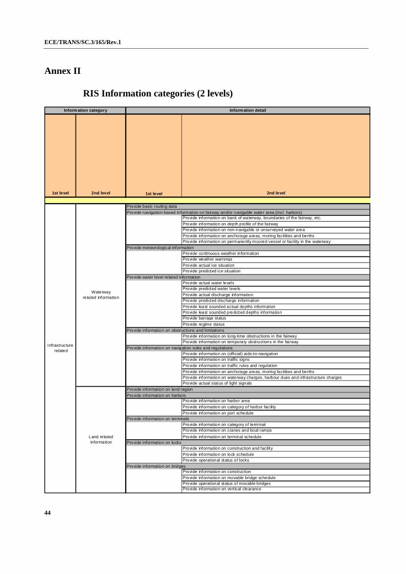
ECE/TRANS/SC.3/165/Rev.1
44
Annex II
RIS Information categories (2 levels)
1st level 2nd level 1st level 2nd level
Provide basic routing data
Provide navigation-based information on fairway and/or navigable water area (incl. harbors)Provide information on bank of waterway, boundaries of the fairway, etc.
Provide information on depth profile of the fairwayProvide information on non-navigable or unsurveyed water area
Provide information on anchorage areas, moring facilities and berthsProvide information on permanently moored vessel or facility in the waterway
Provide meteorological informationProvide continuous weather informationProvide weather warnings
Provide actual ice situationProvide predicted ice situation
Provide water level related informationProvide actual water levelsProvide predicted water levels
Provide actual discharge informationProvide predicted discharge information
Provide least sounded actual depths informationProvide least sounded predicted depths informationProvide barrage status
Provide regime status
Provide information on obstructions and limitationsProvide information on long-time obstructions in the fairwayProvide information on temporary obstruct ions in the fairway
Provide information on navigation rules and regulationsProvide information on (official) aids-to-navigationProvide information on traffic signs
Provide information on traffic rules and regulat ion
Provide information on anchorage areas, moring facilities and berthsProvide information on waterway charges, harbour dues and infrastructure chargesProvide actual status of light signals
Provide information on land region
Provide information on harborsProvide information on harbor area
Provide information on category of harbor facility
Provide information on port scheduleProvide information on terminals
Provide information on category of terminalProvide information on cranes and boat ramps
Provide information on terminal scheduleProvide information on locks
Provide information on construction and facility
Provide information on lock scheduleProvide operational status of locks
Provide information on bridgesProvide information on construction
Provide information on movable bridge scheduleProvide operational status of movable bridgesProvide information on vertical clearance
Information detail
Infrastructure related
Waterway related information
Land related information
Information category

ECE/TRANS/SC.3/165/Rev.1
45
1st level 2nd level 1st level 2nd level
Provide actual position information of vessels
Provide actual vessel dynamics (i.e. RoT, velocity, CoG, SoG, …)Provide historic position information of vessels
Provide historic vessel dynamicsProvide event based triggers for vessel position
Provide notifications of arrivals at defined (passage) points of the waterwayProvide notifications of arrivals or departures at defined locations on the waterway
Provide data for the identif ication of vessels (min. hull data set)
Provide craft certificates
Provide community certificate
Provide ADN tank certificate
Provide ADN dry certificate
Provide measurement certificate
Provide other cert ificate
Provide origin of voyageProvide intermediate discharge locations
Provide passage pointsProvide destination of voyage
Provide estimated date/ time of arrivalsProvide requested date/t ime of arrivalsProvide date/time of actual arrivals
Provide estimated date/ time of departuresProvide date/time of actual departures
Provide date/time of requested departuresProvide overall convoy data
Provide convoy typeProvide information on the hulls of a convoyProvide information on the characterist ics of a convoy
Provide origin of cargo (²)Provide destination of cargo (²)Provide cargo details
Provide details of cargo sender
Provide details of cargo receiverProvide details of non-dangerous cargoProvide details of dangerous cargo
Provide port of loadingProvide estimated date/time of departure at loading place
Provide port of dischargeProvide estimated date/time of arrival at discharge place
Provide loading unit related informationProvide number of containers on boardProvide information on type of containers on board
Provide number of persons (crew, passengers, …) on boardProvide details on persons on board
Vessel related
Dynamic vessel data
Hull related information
Voyage related
Vessel/convoy related information
Cargo related information
Persons on board related information
Location related information
Information detailInformation category

ECE/TRANS/SC.3/165/Rev.1
46
Annex III
Relation between Services and Systems
Relation between Services and Systems
SERVICE
Traffic information
Traffic management Information for
transport logistics
SYSTEM
Fai
rway
info
rmat
ion
Tac
tica
l
Stra
tegi
c
Ves
sel t
raff
ic s
ervi
ces
Nav
igat
iona
l sup
port
Loc
k an
d br
idge
man
agem
ent
Cal
amit
y ab
atem
ent s
uppo
rt
Voy
age
plan
ning
Tra
nspo
rt m
anag
emen
t
Inte
r-m
odal
por
t and
te
rmin
al m
anag
emen
t
Fle
et a
nd c
argo
man
agem
ent
Info
rmat
ion
fo
r la
w e
nfor
cem
ent
Stat
isti
cs
Wat
erw
ay c
harg
es a
nd h
arbo
ur
dues
Visual aids to navigation
x
Radar reflecting aids to navigation
x x
Light signals x x x
Mobile phone (voice and data)
x x x x x x x x x x
GNSS for vessel positioning
x x x x x x
VHF radio x x x x x x x x x x
Internet x x x x x x x x
Vessel based radar
x x x
Shore based radar
x x x x
Shore based CCTV cameras
x x x
Electronic navigational chart
x x x x x x
Vessel tracking and tracing system
x x x x x x x x x x x
Ship reporting system
x x x x x x x x x