
GUIDANCE MANUAL FOR ENVIRONMENTAL REPORT PREPARATION … · 2017-02-22 · GUIDANCE MANUAL FOR...
246
FEDERAL ENERGY REGULATORY COMMISSION Office of Energy Projects GUIDANCE MANUAL FOR ENVIRONMENTAL REPORT PREPARATION For Applications Filed Under the Natural Gas Act Volume I February 2017
Transcript of GUIDANCE MANUAL FOR ENVIRONMENTAL REPORT PREPARATION … · 2017-02-22 · GUIDANCE MANUAL FOR...

FEDERAL ENERGY REGULATORY COMMISSION
Office of Energy Projects
GUIDANCE MANUAL
FOR
ENVIRONMENTAL REPORT
PREPARATION For Applications Filed Under the
Natural Gas Act
Volume I
February 2017


GUIDANCE MANUAL FOR
ENVIRONMENTAL REPORT PREPARATION
For Applications Filed Under the
Natural Gas Act
TABLE OF CONTENTS
PAGE
Commission Staff Guidance i February 2017
VOLUME I
ACRONYMS AND ABBREVIATIONS ....................................................................... vii
KEY TO DATA SOURCES ............................................................................................ ix
1.0 INTRODUCTION ............................................................................................... 1-1
1.1 Purpose of the Manual ................................................................................ 1-1
1.2 Public Comments ....................................................................................... 1-3
1.3 Overview of the Manual ............................................................................. 1-4
2.0 LANDOWNER NOTIFICATION AND STAKEHOLDER OUTREACH ... 2-1
2.1 Landowner Notification ............................................................................. 2-1
2.2 Stakeholder Outreach ................................................................................. 2-6
3.0 FERC’S PRE-FILING PROCESS ..................................................................... 3-1
3.1 Initial FERC Consultation .......................................................................... 3-1
3.2 Initial Filing/Request to Use Pre-filing Process ......................................... 3-2
3.3 Pre-Filing Activities and Submittals .......................................................... 3-3
4.0 PREPARING ENVIRONMENTAL REPORTS FOR NATURAL GAS
ACT SECTION 7 APPLICATIONS ................................................................. 4-1
KEY PRINCIPLES OF RESOURCE REPORT PREPARATION ...................... 4-3
CUMULATIVE IMPACTS .................................................................................. 4-7
4.1 Resource Report 1 – General Project Description ................................... 4-13
4.1.1 Proposed Facilities ....................................................................... 4-14
4.1.2 Land Requirements ...................................................................... 4-22
4.1.3 Construction Procedures .............................................................. 4-27
4.1.4 Operation and Maintenance ......................................................... 4-33
4.1.5 Future Plans and Abandonment ................................................... 4-33
4.1.6 Permits and Approvals ................................................................. 4-34
4.1.7 Affected Landowners ................................................................... 4-35
4.1.8 Nonjurisdictional Facilities .......................................................... 4-36
4.2 Resource Report 2 – Water Use and Quality ........................................... 4-38
4.2.1 Groundwater Resources ............................................................... 4-39

GUIDANCE MANUAL FOR
ENVIRONMENTAL REPORT PREPARATION
For Applications Filed Under the
Natural Gas Act
TABLE OF CONTENTS
PAGE
Commission Staff Guidance ii February 2017
4.2.2 Surface Water Resources ............................................................. 4-43
4.2.3 Wetlands ...................................................................................... 4-51
4.3 Resource Report 3 – Fish, Wildlife, and Vegetation ................................ 4-56
4.3.1 Fisheries and Other Aquatic Resources ....................................... 4-57
4.3.2 Wildlife ........................................................................................ 4-60
4.3.3 Vegetation .................................................................................... 4-63
4.3.4 Endangered, Threatened, and Special Status Species .................. 4-66
4.4 Resource Report 4 – Cultural Resources .................................................. 4-70
4.4.1 Application ................................................................................... 4-71
4.4.2 Post-filing, Pre-Certificate/Authorization Requirements ............ 4-74
4.4.3 Preconstruction Requirements ..................................................... 4-75
4.5 Resource Report 5 – Socioeconomics ...................................................... 4-76
4.5.1 Existing Socioeconomic Conditions ............................................ 4-77
4.5.2 Impacts of Project Construction and Operation ........................... 4-80
4.6 Resource Report 6 – Geological Resources ............................................. 4-83
4.6.1 Geologic Setting .......................................................................... 4-84
4.6.2 Blasting ........................................................................................ 4-84
4.6.3 Mineral Resources ....................................................................... 4-85
4.6.4 Geologic and Other Natural Hazards ........................................... 4-86
4.6.5 LNG Facilities in Seismic Risk Areas ......................................... 4-89
4.6.6 Paleontology ................................................................................ 4-89
4.6.7 Geotechnical Investigations ......................................................... 4-89
4.7 Resource Report 7 – Soils ........................................................................ 4-91
4.7.1 Pipeline ........................................................................................ 4-91
4.7.2 Aboveground Facilities ................................................................ 4-92
4.7.3 Impacts of Project Construction and Operation ........................... 4-94
4.7.4 Consultations ............................................................................... 4-96
4.7.5 Mitigation ..................................................................................... 4-97
4.8 Resource Report 8 – Land Use, Recreation and Aesthetics ..................... 4-98
4.8.1 Land Use ...................................................................................... 4-98
4.8.2 Residential Areas ....................................................................... 4-109
4.8.3 Public Land, Recreation, and Other Designated or Special Use
Areas .......................................................................................... 4-113
4.8.4 Contaminated or Hazardous Waste Sites ................................... 4-117
4.8.5 Coastal Zone Management Areas .............................................. 4-117

GUIDANCE MANUAL FOR
ENVIRONMENTAL REPORT PREPARATION
For Applications Filed Under the
Natural Gas Act
TABLE OF CONTENTS
PAGE
Commission Staff Guidance iii February 2017
4.8.6 Visual Resources ........................................................................ 4-118
4.8.7 Applications for Rights-of-Way and Other Land Use ............... 4-118
4.9 Resource Report 9 – Air and Noise Quality ........................................... 4-119
4.9.1 Air Quality ................................................................................. 4-120
4.9.2 Noise and Vibration ................................................................... 4-128
4.10 Resource Report 10 – Alternatives ......................................................... 4-134
4.10.1 General Guidance ...................................................................... 4-135
4.10.2 No-Action Alternative ............................................................... 4-135
4.10.3 System Alternatives ................................................................... 4-136
4.10.4 Route Alternatives ..................................................................... 4-139
4.10.5 Alternative Sites for Aboveground Facilities ............................ 4-145
4.10.6 Alternative Layouts/Design ....................................................... 4-147
4.11 Resource Report 11 – Reliability and Safety ......................................... 4-148
4.11.1 LNG Facilities ............................................................................ 4-148
4.11.2 Pipeline Facilities ....................................................................... 4-148
4.12 Resource Report 12 – PCB Contamination ............................................ 4-150
4.13 Resource Report 13 – Additional Information Related to LNG Plants . 4-151
5.0 APPLICANT-PREPARED DRAFT ENVIRONMENTAL
ASSESSMENTS FOR NATURAL GAS ACT APPLICATIONS .................. 5-1
6.0 PROVIDING A THIRD-PARTY CONTRACTOR TO ASSIST FERC IN
DEVELOPING ENVIRONMENTAL DOCUMENTS FOR
NATURAL GAS ACT APPLICATIONS ......................................................... 6-1
7.0 PREPARING OTHER NATURAL GAS ACT AND NATURAL GAS
POLICY ACT FILINGS ..................................................................................... 7-1
7.1 Standard Environmental Conditions Under Blanket Certificates –
Section 157.206(b) ..................................................................................... 7-1
7.2 Blanket Certificate – Part 157, Subpart F .................................................. 7-5
7.2.1 Annual Reporting ........................................................................... 7-6
7.2.2 Prior Notice to the Federal Energy Regulatory Commission ........ 7-8
7.2.3 Prior Notice Filings for Major Eligible Facilities
(Section 157.208(b)) and Others .................................................... 7-9
7.2.4 Prior Notice Filings for Delivery Points (Section 157.211(a)(2))
and Abandonments (Section 157.216(b)) .................................... 7-10

GUIDANCE MANUAL FOR
ENVIRONMENTAL REPORT PREPARATION
For Applications Filed Under the
Natural Gas Act
TABLE OF CONTENTS
PAGE
Commission Staff Guidance iv February 2017
7.2.5 Prior Notice Filings for Underground Storage Field Facilities
(Section 157.213(b)) and Increases in Storage Capacity
(Section 157.214) ......................................................................... 7-11
7.2.6 Landowner Notification ............................................................... 7-11
7.3 Natural Gas Policy Act Section 311 Projects – Part 284, Subpart A ....... 7-12
7.3.1 Annual Report .............................................................................. 7-12
7.3.2 Advance Notifications ................................................................. 7-13
7.4 Auxiliary Installations and Replacement Projects – Section 2.55 ........... 7-13
EXAMPLE TABLES
Table 3.3-1 Information Outstanding for Draft Resource Reports .......................... 3-5
Table 4.1.1-1 Pipeline Facilities ................................................................................ 4-17
Table 4.1.1-2 Aboveground Facilities ....................................................................... 4-17
Table 4.1.2-1 Summary of Land Requirements for Pipeline Facilities .................... 4-26
Table 4.1.2-2 Summary of Land Requirements for Aboveground Facilities ............ 4-27
Table 4.1.6-1 Environmental Permits, Approvals, and Consultations ...................... 4-35
Table 4.2.1-1 Water Supply Wells and Springs Within 150 Feet of Project
Construction Areas ............................................................................. 4-41
Table 4.2.1-2 Locally Zoned Aquifer Protection Areas Crossed by the
Pipeline Route ..................................................................................... 4-41
Table 4.2.2-1 Waterbodies Crossed by the Project ................................................... 4-44
Table 4.2.2-2 Public Water Supply Watershed Areas Crossed by the Pipeline
Route or in Proximity to Aboveground Facilities............................... 4-48
Table 4.2.3-1 Wetlands Crossed by the Pipeline Route ............................................ 4-53
Table 4.2.3-2 Summary of Wetland Types Crossed by the Pipeline Route .............. 4-53
Table 4.3.1-1 Representative Fish Species in Waterbodies Crossed by the
Project ................................................................................................. 4-57
Table 4.3.1-2 Fisheries of Special Concern in the Vicinity of the Project ............... 4-59
Table 4.3.2-1 Sensitive Wildlife Habitat Types Affected by Construction and
Operation of the Project ...................................................................... 4-62
Table 4.3.2-2 Birds of Conservation Concern Potentially Occurring in the
Vicinity of the Project ......................................................................... 4-63

GUIDANCE MANUAL FOR
ENVIRONMENTAL REPORT PREPARATION
For Applications Filed Under the
Natural Gas Act
TABLE OF CONTENTS
PAGE
Commission Staff Guidance v February 2017
Table 4.3.3-1 Vegetation Communities Affected by Construction and
Operation of the Project ...................................................................... 4-65
Table 4.3.4-1 Federally and State-listed Species Potentially Occurring in the
Vicinity of the Project ......................................................................... 4-67
Table 4.4.1-1 Survey Status of Pipeline Route (current as of [DATE]) ................... 4-73
Table 4.4.1-2 Survey Status of Aboveground Facilities (current as of
[DATE]) .............................................................................................. 4-73
Table 4.4.1-3 Cultural Resources Identified in Survey Corridor .............................. 4-73
Table 4.5.1-1 Existing Socioeconomic Conditions in the Project Area .................... 4-78
Table 4.5.1-2 Housing Characteristics in the Project Area ....................................... 4-78
Table 4.5.1-3 Public Services in the Project Area .................................................... 4-79
Table 4.5.1-4 Demographic Statistics for Counties Crossed by the Project
Facilities .............................................................................................. 4-79
Table 4.5.1-5 Economic Statistics for Counties Crossed by the Project
Facilities .............................................................................................. 4-80
Table 4.6.3-1 Mineral Resources in the Vicinity of the Pipelines ............................ 4-85
Table 4.7.1-1 Selected Physical and Interpretive Characteristics of the Soil
Map Units Within the Project Area .................................................... 4-93
Table 4.7.3-1 Soil Characteristics by Milepost Segment for Each Soil Map
Unit Along the Proposed Pipeline Route ............................................ 4-95
Table 4.7.3-2 Acres of Soil Characteristics Affected by the Proposed Pipeline ...... 4-96
Table 4.8.1-1 Land Uses Crossed by the Pipelines ................................................. 4-101
Table 4.8.1-2 Land Uses Affected by Construction and Operation of the
Project ............................................................................................... 4-102
Table 4.8.1-3 Existing Rights-of-Way Adjacent to the Pipelines ........................... 4-105
Table 4.8.1-4 Locations Where Loop Would Be More or Less than 25 Feet
from the Existing Pipeline ................................................................ 4-105
Table 4.8.1-5 Additional Temporary Workspaces or Staging Areas ...................... 4-106
Table 4.8.1-6 Access Roads .................................................................................... 4-107
Table 4.8.2-1 Residences Within 50 Feet of Construction Work Area and
Proposed Mitigation .......................................................................... 4-111
Table 4.8.3-1 Agency/Landowner Contacts ............................................................ 4-115
Table 4.8.3-2 Public Land and Designated Recreation Areas, Scenic Areas, or
Other Special Use Areas Crossed by Construction Right-of-
Way ................................................................................................... 4-116

GUIDANCE MANUAL FOR
ENVIRONMENTAL REPORT PREPARATION
For Applications Filed Under the
Natural Gas Act
TABLE OF CONTENTS
PAGE
Commission Staff Guidance vi February 2017
Table 4.9.1-1 Construction Emissions (Year 1–Year 2) ......................................... 4-124
Table 4.9.1-2 Operational Emissions Summary ..................................................... 4-126
Table 4.9.1-3 Compressor Station ABC AERSCREEN Modeling Results ............ 4-128
Table 4.9.2-1 Noise Quality Analysis for the ABC Compressor Station ............... 4-133
Table 4.10.3-1 Comparison of System Alternatives .................................................. 4-138
Table 4.10.4-1 Environmental Factors That May Be Considered for Analysis of
Route Alternatives/Variations ........................................................... 4-142
EXAMPLE FIGURES
Figure 4.1.1-1 Project Overview Map ........................................................................ 4-18
Figure 4.1.1-2 Typical Pipeline Route Map ............................................................... 4-20
Figure 4.1.1-3 Typical Aerial Photo-Based Alignment Sheet .................................... 4-21
Figure 4.1.1-4 Typical Compressor Station Location Map and Plot Plan ................. 4-23
Figure 4.1.2-1 Typical Construction Right-of-Way Adjacent to Existing
Pipeline ............................................................................................... 4-25
Figure 4.6.4-1 Probabilistic Peak Ground Accelerations ........................................... 4-87
Figure 4.8.2-1 Site-specific Residential Plan ........................................................... 4-112
Figure 4.10.3-1 System Alternative ............................................................................ 4-137
Figure 4.10.4-1 Major Route Alternatives.................................................................. 4-140
Figure 4.10.4-2 Route Variation Map ........................................................................ 4-144
LIST OF ATTACHMENTS
Attachment 1 Minimum and Full Filing Requirements for Environmental Reports
Attachment 2 Cumulative Impacts Example Tables
VOLUME II
Liquefied Natural Gas Project Resource Reports 11 & 13 Supplemental Guidance

GUIDANCE MANUAL FOR
ENVIRONMENTAL REPORT PREPARATION
For Applications Filed Under the
Natural Gas Act
TABLE OF CONTENTS
Commission Staff Guidance vii February 2017
ACRONYMS AND ABBREVIATIONS
APE Area of Potential Effect
ATWS additional temporary workspace
CEQ Council on Environmental Quality
CFR Code of Federal Regulations
CO carbon monoxide
CO2 carbon dioxide
CO2e carbon dioxide equivalent
Coast Guard U.S. Coast Guard
COE U.S. Army Corps of Engineers
Commission Federal Energy Regulatory Commission
CZMA Coastal Zone Management Act of 1972
dBA decibels on the A-weighted scale
DOT U.S. Department of Transportation
EA environmental assessment
EFH essential fish habitat
EIS environmental impact statement
EPA U.S. Environmental Protection Agency
ESA Endangered Species Act of 1973
FERC Federal Energy Regulatory Commission
FWS U.S. Fish and Wildlife Service, U.S. Department of the Interior
GHG greenhouse gas
HAP hazardous air pollutant
HDD horizontal directional drill
IPaC Information Planning and Conservation
Ld daytime ambient equivalent sound level
Ldn day-night sound level
Leq 24-hour equivalent sound level
LiDAR Light Detection and Ranging
Ln nighttime ambient equivalent sound level
LNG liquefied natural gas
NAAQS National Ambient Air Quality Standards
NEPA National Environmental Policy Act of 1969
NGA Natural Gas Act of 1938
NGPA Natural Gas Policy Act of 1978

GUIDANCE MANUAL FOR
ENVIRONMENTAL REPORT PREPARATION
For Applications Filed Under the
Natural Gas Act
TABLE OF CONTENTS
Commission Staff Guidance viii February 2017
NHPA National Historic Preservation Act of 1966
NO2 nitrogen dioxide
NOAA Fisheries National Marine Fisheries Service, National Oceanic and
Atmospheric Administration
NOX nitrogen oxides
NRCS Natural Resources Conservation Service, U.S. Department of
Agriculture
NRHP National Register of Historic Places
NSA noise-sensitive area
NWI National Wetlands Inventory, U.S. Fish and Wildlife Service
OEP Office of Energy Projects, Federal Energy Regulatory Commission
PCB polychlorinated biphenyl
Plan Upland Erosion Control, Revegetation, and Maintenance Plan
Procedures Wetland and Waterbody Construction and Mitigation Procedures
PSD Prevention of Significant Deterioration
SHPO State Historic Preservation Office
SSURGO Soil Survey Geographic Database
THPO Tribal Historic Preservation Officer
USGS U.S. Geological Survey
VOC volatile organic compound

GUIDANCE MANUAL FOR
ENVIRONMENTAL REPORT PREPARATION
For Applications Filed Under the
Natural Gas Act
TABLE OF CONTENTS
Commission Staff Guidance ix February 2017
KEY TO DATA SOURCES
A Aerial Photographs
B Agency Consultation
C Agricultural Extension Agents
D Applicant
E State or county groundwater databases (e.g., Board of Health, Department of
Natural Resource water divisions)
F U.S. Army Corps of Engineers
G Community Noise, U.S. Environmental Protection Agency 1971
H Comprehensive Plans, County or Land Management Agencies
I County/Municipal Agencies
J U.S. Environmental Protection Agency
K Erosion Control and Drainage Plan Handbooks, State and County
L Field Surveys
M Fishery Biologist, State or Regional
N U.S. Fish and Wildlife Service
O National Wetlands Inventory Maps
P Geological Survey Personnel, Federal, State, and Local
Q Landowners
R Manufacturer’s Data
S Mineral Resource Maps, Federal and State
T National Marine Fisheries Service, National Oceanic and Atmospheric
Administration
U Noise Surveys
V National Park Service
W Natural Resources Conservation Service
X Natural Resources Conservation Service Soil Surveys or Soil Survey Geographic
Database (SSURGO)
Y Upland Erosion Control, Revegetation, and Maintenance Plan
Z Wetland and Waterbody Construction and Mitigation Procedures
AA Resource Reports 2, 3, and 4
BB Resource Report 8
CC Soil Authorities, Other than Natural Resources Conservation Service
DD State Agencies
EE State Air Quality Agency

GUIDANCE MANUAL FOR
ENVIRONMENTAL REPORT PREPARATION
For Applications Filed Under the
Natural Gas Act
TABLE OF CONTENTS
Commission Staff Guidance x February 2017
FF State Drinking Water Division
GG State Water Quality Division
HH State Wetland Maps
II Surficial Geologic and Bedrock Geologic Maps
JJ U.S. Department of Labor
KK U.S. Bureau of the Census
LL U.S. Department of Transportation
MM U.S. Geological Survey Topographic Maps
NN Environmental Justice Screening and Mapping Tool

Commission Staff Guidance 1-1 February 2017
1.0 INTRODUCTION
1.1 PURPOSE OF THE MANUAL
To facilitate our1 environmental review process, we provide this manual as
guidance to sponsors of natural gas projects. The purpose is to improve the overall
quality and consistency of data analyses and formatting in the resource reports that
comprise the Environmental Report to be filed under the Federal Energy Regulatory
Commission’s (FERC or Commission) regulations that implement the National
Environmental Policy Act of 1969 (NEPA).2 While the regulatory requirements and
definitions provided here are current as of the time this manual is being prepared,
regulations are periodically revised. You should refer directly to the regulations in effect
at the time you prepare your filings.
The purpose of NEPA is to ensure that an agency carefully considers the
environmental impacts of a proposed action and reasonable alternatives. NEPA
guarantees that the relevant information will be made available to the larger audiences
that may also play a role in both the decision-making process and the implementation of
that decision. We intend that this manual will help project sponsors prepare complete
filings that cover topics in a uniform fashion and that allow for the most efficient
environmental review.
Environmental issues and concerns evolve over time because of ongoing research
and experience, and public input drives a large part of the NEPA process. To address this
evolution, the 2016 version of the manual (which replaces the original 2002 version)
identifies certain information that is not required by regulation but that Commission staff
1“We,” “us,” and “our” refer to the environmental staff of the Federal Energy
Regulatory Commission’s Office of Energy Projects. “You,” whether explicit or
implied, refers to the applicant proposing a natural gas project or to the applicant’s
agent(s) who prepares, uses, or reviews these types of environmental documents. 2
The Commission’s regulations, which appear in Title 18, Chapter I of the Code of
Federal Regulations (CFR), are noted in this document only by part or section, for
instance part 380 or section 2.55, with no reference to title, chapter, or code. The
Commission’s regulations in part 380 implement NEPA, with section 380.12
specifically addressing Environmental Reports for Natural Gas Act applications.
Where we refer to other agencies’ regulations we include a full citation. For instance,
our regulations supplement the Council on Environmental Quality’s regulations that
implement NEPA. 40 CFR §§ 1500.1 to 1508.28 (2015). NEPA itself appears in
Title 42 of the United States Code in sections 4321 to 4370h.

Commission Staff Guidance 1-2 February 2017
requests for some proposals to address scoping comments, concerns from cooperating
agencies, and issues that have emerged or become more relevant since the current
regulations were promulgated. Often we need this information to document compliance
with other federal statutes, such as the Migratory Bird Treaty Act or consultations under
section 7 of the Endangered Species Act of 1973 (ESA) or section 305(b) of the
Magnuson-Stevens Fishery Conservation and Management Act. To the extent that such
information is applicable and available, we recommend that applicants provide it to
facilitate the environmental review process. Omissions can cause delays in our
processing of applications and increase the need for supplemental data requests.
We intend only to provide guidance to the industry. This manual does not
substitute for, amend, or supersede the Commission’s regulations under the Natural Gas
Act of 1938 (NGA) or the Commission’s and Council on Environmental Quality’s (CEQ)
regulations under NEPA. It imposes no new legal obligations and grants no additional
rights. We use non-mandatory language such as “recommend,” “encourage,” and “may”
to describe Commission staff’s recommendations that will help the Commission meet its
obligations under NEPA. We use mandatory language such as “required,” “must,” and
“must not” to describe controlling requirements under the terms of statutes and
regulations. The manual discusses our preferred format for certain documents and data
presentation. However, you can use an alternative approach if it satisfies the
requirements of the applicable statutes and regulations.
We composed this manual to be useful to all applicants proposing natural gas
projects. But because each project is unique, it is not possible to provide guidance that
applies to all possible scenarios. Some of the guidance may not be appropriate for the
scope of a proposed project or may not apply at all. As indicated later in the manual,
applicants should evaluate the specific issues, impacts, and public and agency comments
relevant to their individual projects and adjust the content of their resource reports and
analyses accordingly, while also meeting the existing regulatory filing requirements. The
level of detail and scope of the Environmental Report should be proportional to the
complexity of the proposed project. If the information is not applicable and is not an
existing requirement under the Commission’s regulations, then there is no need to
address that information.
Additionally, we recommend that applicants refer to other recent environmental
assessments (EA), environmental impact statements (EIS), and Commission orders
regarding similar projects (available on the Commission’s website, www.ferc.gov, and
eLibrary) to see how various issues have been addressed.

Commission Staff Guidance 1-3 February 2017
1.2 PUBLIC COMMENTS
On December 18, 2015, we issued a Notice of Availability of the Draft Guidance
Manual for Environmental Report Preparation and Request for Comments.3 We received
comments from a variety of industry representatives, trade associations, federal and state
agencies, non-governmental organizations, public interest groups, consultants, and other
interested parties. We reviewed and considered each comment and modified several
portions of the document in response. We declined to modify the document where
comments either were too project- or location-specific to be included in general guidance,
regarded topics that we concluded are adequately or more accurately addressed as
written, or were not specific to the guidance manual.
Additionally, multiple commenters raised general concerns discussed below:
The guidance manual cannot substitute for, amend, or supersede
regulations. Several commenters worried that the guidance provided in this
manual might be viewed as binding by other agencies or the public. Some
objected that the guidance manual has the effect of changing the substantive
requirements for applications without notice-and-comment rulemaking. To
the extent that these comments were made in the context of specific
resource reports (e.g., Resource Reports 9 and 13), we address them in the
relevant sections of the manual. We emphasize again that the manual’s
identification of certain “recommended” information, beyond the
information required by regulation, does not alter the minimum filing
requirements that an applicant must meet to avoid the rejection of an
application. We have modified the manual throughout and incorporated
commenters’ recommended language in some sections to convey more
clearly that the guidance provided in this manual does not alter existing
regulations.
The guidance manual should not take a one-size-fits-all approach:
Commenters worried that the manual would not apply equally to all
projects and that an applicant’s failure to provide all of the manual’s
recommended information could delay issuance of environmental
documents. However, the manual recognizes that each project is unique
and that the information required to develop a complete application will
vary by project. We agree with commenters that not all of the
recommended information identified in the manual will apply uniformly to
3 Docket No. AD16-3-000; see 80 Fed. Reg. 80,353 (Dec. 24, 2015). On January 14,
2016, we issued a notice extending the deadline for comments from January 19 to
January 29, 2016.

Commission Staff Guidance 1-4 February 2017
all projects. Commission staff evaluates projects on an individual basis,
and if information necessary for the environmental review is not provided,
staff identifies that information in comments on draft resource reports, if
applicable, or in data requests. As noted above, following the guidance
where applicable may reduce the number of data requests. Note, however,
that the regulations are clear for projects using the pre-filing process (see
section 157.21), that the application must contain all of the information we
have specified in our comments after our review of the prospective
applicant’s draft materials filed during the pre-filing process. Also note
that an applicant’s failure to respond to our data requests within the
specified timeframe during the application process may result in delays
because we consider this requested information necessary to continue
preparing the environmental document.
Suggested information may not be available at the time an application is
filed: Several commenters noted that some of the recommended
information identified in the manual might not be available in time to be
included in draft resource reports or in the application. However, we note
that some of this information may be necessary to complete consultation
with other agencies or to complete the necessary impact analyses. We
suggest that applicants provide the best available scientific information,
citing the source, at the time of filing (and identify it as preliminary,
anticipated, estimated, etc., as applicable), including information for areas
that lack permission for access. We recommended that you provide an
estimated date for the submittal of information that is not yet available.
1.3 OVERVIEW OF THE MANUAL
This guidance manual is divided into two volumes. Volume I describes the
information that is required or recommended for natural gas projects and includes the
sections described below. Volume II specifically addresses additional information
required or recommended for liquefied natural gas (LNG) facilities, including the LNG-
related sections of Resource Reports 6, 11, and 13.
Section 2.0 of Volume I describes the requirements to notify affected landowners
about applications under sections 3, 7(b), and 7(c) of the NGA and about activities under
the blanket certificate program, as implemented in part 153 and in subparts A and F of
part 157 of the Commission’s regulations, respectively. Section 2.0 also broadly
addresses overall stakeholder outreach.
Section 3.0 addresses activities and environmental documents required during the
pre-filing process described in section 157.21 of the Commission’s regulations.

Commission Staff Guidance 1-5 February 2017
Section 4.0 covers environmental documentation for applications prepared under
sections 7(b) and 7(c) of the NGA, as implemented in subpart A of part 157 of the
Commission’s regulations as well as some of the additional information for LNG
facilities proposed under section 3 of the NGA, as implemented in subpart B of part 153
of the Commission’s regulations (see Volume II of this manual for additional details
regarding applications involving LNG facilities). Section 4.0 also discusses some key
principles that you should follow when preparing resource reports, provides guidance on
addressing cumulative impacts, and describes in detail the basis, content, and format for
the resource reports to satisfy current Commission and NEPA requirements and to
facilitate our environmental review.
Section 5.0 describes the process by which you can submit an applicant-prepared
draft EA with your application.
Section 6.0 describes the option for you to engage a third-party contractor to assist
us in the development of an EA and or EIS.
Section 7.0 outlines the environmental information required or recommended for
activities under a blanket certificate (subpart F of part 157); under section 311 of the
Natural Gas Policy Act of 1978 (NGPA) (implemented in subparts A, B, and C of part
284); or under the certificate exclusions for auxiliary installations and for replacement of
deteriorated or obsolete facilities (section 2.55 of part 2).


Commission Staff Guidance 2-1 February 2017
2.0 LANDOWNER NOTIFICATION AND
STAKEHOLDER OUTREACH
2.1 LANDOWNER NOTIFICATION
This section describes requirements and recommendations for notification of all
affected landowners regarding applications prepared under sections 3, 7(b), and 7(c) of
the NGA; and about activities under the blanket certificate program, as implemented in
part 153 and in subparts A and F of part 157 of the Commission’s regulations,
respectively.4
You must make a good faith effort to notify all affected landowners; towns and
communities; and local, state, and federal governments and agencies involved in the
project. You should also make an effort to include other stakeholders, such as
environmental organizations, with an interest in the project in your outreach efforts (see
section 2.2 of this manual). “All affected landowners” (as defined in section 157.6(d)(2))
includes owners of property interests, as noted in the most recent county/city tax records
as receiving the tax notice, whose property:
is directly affected (that is, crossed or used) by the proposed activity,
including all facility sites, rights-of-way, access roads, pipe and contractor
yards, and temporary workspaces;
abuts either side of an existing right-of-way or facility site owned in fee by
any utility company, or abuts the edge of a proposed facility site or right-of-
way that runs along a property line in the area in which the facilities would
be constructed, or contains a residence within 50 feet of the proposed
construction work area;
is within 0.5 mile of proposed compressors or their enclosures (or LNG
facilities); or
is within the area of proposed new storage fields or proposed expansions of
storage fields, including any applicable buffer zone.
4Sections 153.3, 157.6(d), and 157.203(d).

Commission Staff Guidance 2-2 February 2017
Failure to make the required landowner notifications can cause delays in the
environmental review process and potentially affect the project schedule. You should
review the landowner notification requirements in section 157.6(d) early in the process to
allow time to identify landowners and prepare the notification materials. If you are using
the Commission’s pre-filing process, also review section 157.21, which addresses
landowner notifications and other stakeholder outreach to be conducted during the pre-
filing period.
While the landowner notification requirements provided here are current as of the
time this manual is being prepared, regulations are periodically revised. Therefore, you
should refer directly to the regulations in effect at the time you are preparing your
notifications.
Landowner Notifications for Section 3 and Sections 7(b) and 7(c) Projects
If you are using the Commission’s pre-filing process (discussed in section 3.0 of
this manual), you must contact all affected landowners and other stakeholders who have
not already been informed about the project within 14 days of the Director of the Office
of Energy Projects’ (OEP) issuance of a notice commencing the pre-filing process.
Once an application is filed under section 3, 7(b)5, or 7(c) of the NGA, good faith
efforts to notify affected landowners and local, state, or federal jurisdictions must be
made:
by certified or first class mail sent within 3 business days following the date
the Commission issues a notice of the application; or
by hand, within the same time period; and
by publishing notice twice of the filing of the application, no later than
14 days after the date that a docket number is assigned to the application, in
a daily or weekly newspaper of general circulation in each county in which
the project is located.
5 The referenced notifications are not required for abandonment of facilities by sale or
transfer where the easement will continue to be used for transportation of natural gas.
Section 157.6(d)(1). These notifications are also not required for abandonment by
leased capacity.

Commission Staff Guidance 2-3 February 2017
Notifications to affected landowners must include:
the docket number of the filing;
the most recent edition of the Commission’s pamphlet An Interstate
Natural Gas Facility on My Land? What Do I Need to Know? explaining
the Commission’s certificate process and addressing the basic concerns of
landowners. However, the pamphlet need not be included for pipeline
notifications of abandonment, or published in newspaper notices. Instead,
the regulations state that you must provide the title of the pamphlet and
indicate its availability at the Commission’s internet address;
a description of the applicant and the proposed project, its location
(including a general location map), its purpose, and the timing of the
project;
a general description of what you will need from the landowner if the
project is approved and how the landowner may contact you, including a
local or toll-free phone number and a name of a specific person to contact
who is knowledgeable about the project;
a brief summary of the landowner’s rights before the Commission and in
proceedings under the eminent domain rules of the relevant state. You
need not include the latter information in the published newspaper notice,
but the regulations state that the newspaper notice must provide the
Commission’s internet address and the telephone number for the
Commission’s Office of External Affairs;
information on how the landowner can get a copy of the application from
the company or the location(s) where a copy of the application can be
found; and
a copy of the Commission’s notice of application, specifically stating the
date by which timely motions to intervene are due, together with the
Commission’s information sheet on how to intervene in Commission
proceedings. However, you need not include the notice of application and
information sheet in the published newspaper notice. Instead, the
regulations state that the newspaper notice must indicate that a separate
notice is to be mailed to landowners and government entities.
If any notice is returned as undeliverable, you must make a reasonable attempt to
find the correct address and notify the landowner. You must file an updated list of
landowners within 30 days of the date the application was filed, including information
concerning any notices that were returned as undeliverable.

Commission Staff Guidance 2-4 February 2017
Subpart F Blanket Certificates
For automatic authorizations under the blanket certificate program
(section 157.203(b)), you must make a good faith effort to notify all affected landowners
in writing at least 45 days prior to commencing construction or at the time that you
initiate easement negotiations, whichever is earlier.6 A landowner may waive the 45-day
prior notice requirement in writing as long as the notice has been provided. The
notifications must include at least:
a brief description of the facilities to be constructed or replaced and the
effect the construction activity will have on the landowner’s property;
the name and phone number of your representative who is knowledgeable
about the project; and
a description of your environmental complaint resolution procedure, which
must:
o provide clear and simple directions for identifying and resolving
environmental mitigation problems and concerns during project
construction and restoration of the right-of-way;
o provide a local or toll-free phone number and name of a specific
person responsible for responding to landowner problems and
concerns;
o instruct landowners that if they are not satisfied with the response,
they may call your Hotline; and
o instruct landowners that if they are still not satisfied with the
response, they may contact the Commission’s Landowner Helpline
at the current telephone number and email address, which must be
provided in the notification.
For projects for which the Commission must receive prior notification,7 you must
make a good faith effort to notify affected landowners in writing within at least
3 business days following the date that a docket number is assigned to the application or
6 Section 157.203(d)(1).
7 Section 157.203(c).

Commission Staff Guidance 2-5 February 2017
at the time that you initiate easement negotiations, whichever is earlier. The notifications
must include at least:
a brief description of the applicant and the proposed project, including the
facilities to be constructed or replaced and the location (including a general
location map), project purpose, project timing, and the effect the
construction activity will have on the landowner's property;
a general description of what you will need from the landowner if the
project is approved, and how the landowner may contact you, including a
local or toll-free phone number and a name of a specific person to contact
who is knowledgeable about your project;
the docket number (if assigned) for your application;
a general description of the blanket certificate program and procedures, as
posted on the Commission’s website at the time the landowner notification
is prepared, and the link to the information on the Commission’s website;
a brief summary of the landowner’s rights in Commission proceedings and
in proceedings under the relevant eminent domain rules;
the following paragraph8:
This project is being proposed under the prior notice requirements of the
blanket certificate program administered by the Federal Energy Regulatory
Commission. Under the Commission’s regulations, you have the right to
protest this project within 60 days of the date the Commission issues a
notice of the pipeline’s filing. If you file a protest, you should include the
docket number listed in this letter and provide the specific reasons for your
protest. The protest should be mailed to the Secretary of the Federal
Energy Regulatory Commission, 888 First St. NE., Room 1A, Washington,
DC 20426. A copy of the protest should be mailed to the pipeline at
[pipeline address]. If you have any questions concerning these procedures
you can call the Commission’s Office of External Affairs at (202) 502-
6088;9 and
8 We recommend you also explain the option to electronically file information with the
Commission. 9 The Commission’s Office of External Affairs can also be reached at the toll-free
number (866) 208-3372, and by TTY at: (202) 502-8659.
Commission Staff Guidance 2-6 February 2017
a description of your environmental complaint resolution procedure as
described above for automatic authorizations.
No landowner notice is required under the blanket certificate program if any of the
four exceptions listed in section 157.203(d)(3) apply. The four exceptions are:
replacements that would have been done under section 2.55 of the
Commission’s regulations but are not of the same capacity (as long as they
are in the same location as the replaced facilities) and do not cause any
ground disturbance, or any replacement done for safety, U.S. Department of
Transportation (DOT) compliance, environmental, or unplanned
maintenance reasons that are unforeseen and require immediate attention;
abandonments that involve only the sale or transfer of the facilities, and
where the easement will continue to be used for transportation of natural
gas;
services or facilities requested by the landowner if that is the only
landowner affected; or
activities that do not involve ground disturbance or changes to operating air
or noise emissions.
2.2 STAKEHOLDER OUTREACH
We have developed a document entitled Suggested Best Practices for Industry
Outreach Programs to Stakeholders, which is available on the Commission website.
This document presents common practices and highlights the tools that we believe should
be implemented by Commission-regulated entities to effectively engage stakeholders in
the siting, construction, and operation of interstate natural gas facilities and LNG
facilities.

Commission Staff Guidance 3-1 February 2017
3.0 FERC’S PRE-FILING PROCESS
The pre-filing process is required for LNG terminal facilities and related
jurisdictional natural gas facilities. For other natural gas projects, you, as the prospective
applicant, may voluntarily request approval to use the pre-filing process. We particularly
recommend the pre-filing process for complex projects or those anticipated to involve
significant public interest, as well as projects for which you propose to submit an
applicant-prepared draft EA. The pre-filing process is meant to increase predictability
and reduce risk by allowing proactive interaction between the prospective applicant,
Commission staff, other agencies, landowners, and other stakeholders and by identifying
and addressing issues during the planning phase before an application is submitted. From
our perspective, the pre-filing process typically requires a larger investment of time and
resources by Commission staff and other agencies, so we expect that you will produce a
more complete application at the time of filing to reflect this increased investment.
The procedures before and during pre-filing are described in section 157.21, which
identifies initial consultation with the Commission, content required in your initial filing
to request to use the pre-filing process, and other pre-filing activities and submittals.
Section 157.21 also lists some of the activities that we undertake, with the third-party
contractor if one is used, during the pre-filing period.
As indicated in section 157.21, an application should not be filed until at least 180
days after the Director of OEP issues a notice commencing the pre-filing process. While
this establishes a typical minimum period of 6 months, the actual duration of the pre-
filing period varies by project. We encourage you to work with the Director of OEP or
the Director’s designee during the initial consultation (discussed in section 3.1) regarding
the pre-filing schedule.
3.1 INITIAL FERC CONSULTATION
You must consult with the Director of OEP before submitting a request to use the
pre-filing process. The initial consultation, or “pre-filing meeting,” typically occurs at
the Commission’s office in Washington, D.C. During the consultation, you should be
prepared to introduce the project to Commission staff, describe (for non-LNG projects)
the benefits of using the pre-filing process, present the proposed schedule for both pre-
filing and post-filing activities, and discuss the status of efforts to obtain the information
required for the pre-filing request. While not specifically required in the regulations, we
recommend that you bring an initial draft of the pre-filing request to the pre-filing
meeting. During this meeting, we consider what regulatory path and NEPA document
will be most appropriate for the project and whether a third-party contractor will be

Commission Staff Guidance 3-2 February 2017
needed. If you anticipate that a third-party contractor may be needed, we also strongly
recommend that you bring a draft Request for Proposal for our review.10
3.2 INITIAL FILING/REQUEST TO USE PRE-FILING PROCESS
The required contents of the initial filing (for LNG projects) or pre-filing request
letter (for other natural gas facilities) are listed in section 157.21(d). We do not reiterate
the requirements here because the regulations may be revised over time and you should
consult the regulations directly. However, it is important to note that several of the items
listed require significant advance planning and actions. If you do not build sufficient lead
time into the schedule to conduct these activities before initiating pre-filing discussions
with the Commission, the project schedule could be at risk. Examples of some of the
longer lead-time items include, but are not limited to:
a list of relevant federal and state agencies in the project area with
applicable permitting requirements, including:
o a statement that those agencies are aware of your intention to use the
pre-filing process;
o names and telephone numbers (we also recommend email addresses)
of the agency personnel contacted;
o whether the agencies have agreed to participate in the pre-filing
process;
o how you have accounted for agency schedules for issuance of
federal authorizations; and
o when you propose to file applications with those agencies;
a list and description of the interest of other persons and organizations who
have been contacted about the project, including contact names and
telephone numbers (we also recommend email addresses);
a description of work that has already been done (e.g., contacting
stakeholders [including Indian tribes], agency consultations, project
engineering, route planning, environmental and engineering contractor
engagement, environmental surveys/studies, and open houses); and
identification of the environmental firms, engineering firms, and sub-
contractors under contract to develop the project;
10 Refer to the Commission’s Handbook for Using Third-Party Contractors to Prepare
Environmental Documents For Natural Gas Facilities and Hydropower Projects for
more information on the third-party contracting program and guidelines for preparing
Requests for Proposals.

Commission Staff Guidance 3-3 February 2017
either all proposals from potential third-party contractors that responded to
the Request for Proposal, if applicable, from which we may select one to
help prepare the requisite NEPA documents, or a proposal to submit an
applicant-prepared draft EA if approved by the Director of OEP;
a description of a Public Participation Plan that identifies specific tools
and actions to facilitate stakeholder communications and public
information, including a project website and a single point of contact as
well as other information; and
for LNG terminal projects, certification either that a Letter of Intent and a
Preliminary Waterway Suitability Assessment have been submitted to the
U.S. Coast Guard (Coast Guard) or, for modifications to an existing or
approved LNG terminal, that the Coast Guard did not require such
information.
3.3 PRE-FILING ACTIVITIES AND SUBMITTALS
Once the Director of OEP issues a notice approving the use of pre-filing, you must
complete activities and file certain documents and reports in accordance with the
timeframes specified in section 157.21(f). Please refer directly to the regulations when
planning and preparing these activities and documents. Note that the prescribed
timeframes may be modified by a project-specific schedule agreed upon with
Commission staff if project-specific issues warrant a different schedule.
While carrying out the pre-filing activities, we encourage you to communicate
regularly with us to address project-specific questions, coordinate meetings and site
visits, and keep us apprised of project developments. In addition to the monthly status
reports required under section 157.21(f)(6), Commission project managers may establish
a schedule of regular conference calls (e.g., weekly or bi-weekly).
The following paragraphs do not address all of the items required under
section 157.21(f), but provide guidance for certain key activities.
Open Houses
Within 7 days of the Director’s notice commencing the pre-filing process and after
consulting the Commission staff’s project manager assigned to your project, you must
establish dates and locations of applicant-sponsored open houses and other meetings with
stakeholders (including federal and state agencies). We or our third-party contractor, or
both, generally attend the open houses to respond to questions regarding our
environmental review process; therefore, it is necessary that you coordinate with us
regarding meeting dates and logistics. Keep in mind that third-party contracts must be
executed within 14 days of the commencement of pre-filing and prior to the open houses
to allow for the contractor’s participation. You should account for this timeframe in
planning the open house dates. Your published notice of the open houses should reflect

Commission Staff Guidance 3-4 February 2017
our attendance and role, and we should review this description prior to issuance. We may
also elect to conduct site visits or agency meetings in conjunction with travel for open
houses.
Although the general discussions that take place at open houses are not part of the
public record, we encourage you to file comments received at these events to help
identify project-specific issues.
Landowner and Stakeholder Contacts
Within 14 days of the Director’s notice commencing the pre-filing process, you
must contact all stakeholders that had not already been informed about the project,
including all affected landowners as defined in section 157.6(d)(2). You must submit a
stakeholder mailing list to us within 30 days. You should consult with us on the format
of the mailing list to ensure that it conforms to our publication requirements. See
section 2.0 of this manual for further discussion of landowner notification and
stakeholder outreach.
Initial Draft Resource Report 1 and Summary of Alternatives
Within 30 days of the Director’s notice commencing the pre-filing process, you
must file a first draft of Resource Report 1 and a summary of alternatives considered for
the project. We recognize that information available at this point in the process may not
be complete or fully refined. However, at a minimum, these early drafts should provide
sufficient information for us to issue a Notice of Intent to prepare a NEPA document.
Such information includes, but is not limited to, a clear description of the proposed
project, location map(s), purpose and need, schedule, land requirements, applicable
permits, and construction methods. Draft Resource Report 1 should reflect the overall
format and structure planned for future drafts and should indicate where information will
be provided in a later draft. Although the summary of alternatives is not referred to at
this point as a draft Resource Report 10, we recommend a similar approach. The
alternatives summary should, at a minimum, identify major system and route alternatives
that you considered as well as alternative sites that you considered for aboveground
facilities.
Scoping
The Commission’s issuance of the Notice of Intent to prepare a NEPA document
formally starts the NEPA process and scoping period. The Notice of Intent announces
the dates and locations of scoping sessions, if applicable, that we will host. Public
comments provided at the scoping session become part of the public record. Although
the scoping sessions are Commission staff-led sessions, our project manager may ask you
to provide an overview of your project and/or provide alignment sheets for public
viewing.
Commission Staff Guidance 3-5 February 2017
The Notice of Intent to prepare a NEPA document also identifies the closing date
of the official scoping period during which interested persons/participants should submit
comments on the project. The purpose of specifying a closing date for the scoping period
is to provide time for you to address comments in the draft resource reports. It is
important to note, however, that we will continue to accept and respond to comments at
any time during and after the pre-filing period until it is no longer practical as we prepare
to issue the NEPA document.
Within 14 days of the close of the scoping period, you must respond to issues
raised during the scoping period as required by section 157.21(f)(9). For projects with
significant public interest, scoping comments may be voluminous, and it is not unusual
for scoping comments to be filed after the end of the comment period. If you find that
14 days is not sufficient to develop responses, you should file a statement by the 14-day
deadline indicating when you plan to file a complete response. Additionally, because the
purpose of scoping is to identify issues to be addressed in the NEPA document, scoping
comments raising similar issues can be grouped together for the purpose of preparing
responses.
Draft Resource Reports
Unless a different schedule has been agreed upon, you must submit draft Resource
Reports 1 through 12 within 60 days of the end of the scoping period. Note that this
includes a second draft Resource Report 1 that should be further developed than the
initial draft submitted at the 30-day point. Where you plan to provide certain information
at a later date, you should clearly indicate at the appropriate locations within the draft
resource reports what information will be provided at what date. Clearly acknowledging
such planned information facilitates our review and assures us that you are aware that the
information is needed and that you plan to provide it. We recommend that you create a
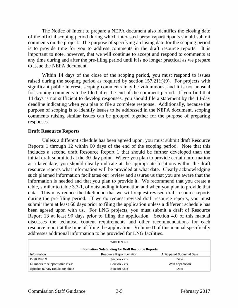
table, similar to table 3.3-1, of outstanding information and when you plan to provide that
data. This may reduce the likelihood that we will request revised draft resource reports
during the pre-filing period. If we do request revised draft resource reports, you must
submit them at least 60 days prior to filing the application unless a different schedule has
been agreed upon with us. For LNG projects, you must submit a draft of Resource
Report 13 at least 90 days prior to filing the application. Section 4.0 of this manual
discusses the technical content requirements and other recommendations for each
resource report at the time of filing the application. Volume II of this manual specifically
addresses additional information to be provided for LNG facilities.
TABLE 3.3-1
Information Outstanding for Draft Resource Reports
Information Resource Report Location Anticipated Submittal Date
Draft Plan X Section x.x.x Date
Numbers to support table x.x-x Section x.x.x With application
Species survey results for site Z Section x.x.x Date

Commission Staff Guidance 3-6 February 2017
Certification of Follow-on Waterway Suitability Assessment Submittal
Upon the Director’s notice commencing the pre-filing process for LNG projects,
you must certify that you will submit a Follow-on Waterway Suitability Assessment to
the Coast Guard no later than the filing of an application with the Commission. If a
Follow-on Waterway Suitability Assessment is not required for modifications to an
existing or approved LNG terminal, you must certify that the Coast Guard has indicated
that a Follow-on Waterway Suitability Assessment is not required.

Commission Staff Guidance 4-1 February 2017
4.0 PREPARING ENVIRONMENTAL REPORTS FOR
NATURAL GAS ACT SECTION 7 APPLICATIONS
This guidance manual does not change or substitute for any law, regulation, or
any other legally binding requirement. Where practical, we have distinguished between
legal obligations and Commission staff's interpretations or recommendations. We use
mandatory language such as “required,” “must,” and “must not” to describe controlling
requirements under statutes and regulations. We use non-mandatory language such as
“recommend,” “encourage,” and “may” to describe Commission staff’s
recommendations that will help the Commission meet its obligations under
NEPA. However, because clear distinctions are not always practical, a reader should
consult the regulations directly to determine the information legally required in order to
meet the filing requirements of 18 CFR 380.12.
Applicants who do not use the pre-filing process instead initiate the environmental
review process by filing an application. The application must include resource reports as
specified in sections 157.14(a)(6-a), 380.3, and 380.12 (as discussed in section 3.0,
applicants using the pre-filing process must submit draft resource reports before filing an
application). This section addresses the preparation of resource reports in detail. The
information in this guidance manual regarding the format and content of resource reports
is based on our needs and preferences to facilitate the creation of a thorough NEPA
document that will be useful to the Commission. If other federal agencies will use your
resource reports (and/or the Commission’s NEPA document) to fulfill their NEPA
responsibilities, you may need to include additional information in the resource reports.
You should discuss this with Commission staff and the appropriate agency staff as early
as possible.
You may also propose to file an applicant-prepared draft EA (upon coordination
with the Director of OEP), or to retain a third-party contractor to assist us in preparing an
EA or EIS. Neither of these options takes the place of your resource reports, which are a
required part of the application. Sections 5 and 6 of this manual address the preparation
of an applicant-prepared draft EA and the use of a third-party contractor, respectively.
The purpose of this section is to clearly identify the technical content requirements
for each resource report that will allow us to efficiently review an application and
conduct the environmental review process. We also identify information that is not
specifically required in the regulations, but is often needed to allow for a complete and
thorough environmental review. Note that the information required to develop a
complete application for one project may not be the same for another project, even of
similar scope. In this section, we attempt to be inclusive about the information required
for most projects, but you should evaluate the specific issues, impacts, and comments

Commission Staff Guidance 4-2 February 2017
relevant to your own project and adjust the content of your resource reports accordingly
while also meeting the filing requirements in section 380.12. This section also provides
guidance on how to collect required data, which agencies to contact, what data sources
have been reliable in the past, and what presentation techniques are recommended. In
many cases, we provide sample templates for presenting information in tabular formats,
some of which include illustrative sample content and/or footnotes. The templates are
effective presentation formats based on our experience, but they are not mandatory and
you should modify them (including the use of footnotes where necessary for
clarification), as appropriate, for your individual project.
We provide guidance on all of the resource reports identified in section 380.12 as
follows:
Volume I
Resource Report 1 – General Project Description
Resource Report 2 – Water Use and Quality
Resource Report 3 – Fish, Wildlife, and Vegetation
Resource Report 4 – Cultural Resources
Resource Report 5 – Socioeconomics
Resource Report 6 – Geological Resources
Resource Report 7 – Soils
Resource Report 8 – Land Use, Recreation, and Aesthetics
Resource Report 9 – Air Quality and Noise
Resource Report 10 – Alternatives
Resource Report 11 – Reliability and Safety (Pipeline Facilities)
Resource Report 12 – PCB Contamination
Volume II
Resource Report 11 – Reliability and Safety (LNG facilities)
Resource Report 13 – Engineering and Design Material
Note that material filed under another docket may be incorporated by reference.
You should clearly identify where the information is contained (for example, the docket
number and filing date, or eLibrary accession number). This incorporation by reference
should be limited to items and issues that are not project-specific. However, to facilitate
our review, we recommend that you incorporate the material directly into the current
filing rather than only incorporating it by reference.

Commission Staff Guidance 4-3 February 2017
KEY PRINCIPLES OF RESOURCE REPORT PREPARATION
You should follow certain general principles throughout the preparation of the
resource reports. Following these principles should reduce the amount of information
that must be verified through data requests or independent research by Commission staff.
These principles are summarized below:
Provide concise, specific statements of environmental impacts and
proposed mitigation. The detail provided in each resource report should
be commensurate with the complexity of the action and the potential for
environmental impact. Each resource report must address:
o existing conditions or resources that may be directly or indirectly
affected by the project or that may affect the project;
o effects on the resource as a result of construction, operation,
maintenance, or abandonment of the project;
o any proposed measures to enhance the environment;
o any proposed measures to avoid, minimize, or otherwise mitigate
adverse effects;
o a discussion of the cumulative impact that may result from the
combination of impacts from the proposed project and from other
past, present, and reasonably foreseeable actions that mutually affect
one or more resources (further discussion of cumulative impact is
provided below);
o a list of references/data sources (publications, reports, other
literature, and communications, including agency contacts) that you
used to prepare the resource reports, and appropriate citations to
those references within the text; and
o evidence of agency consultation used to identify existing resources,
potential impacts, and appropriate mitigation measures. You should
also clearly identify which agency-recommended mitigation
measures you will adopt.
Although there is no required format for presenting information in resource
reports, we have found that organizing each resource report to first discuss
the existing environment with respect to a given resource, and to then
discuss potential project impacts and proposed mitigation measures related
to that resource, facilitates our review. For example, the preferred format
for addressing waterbody and wetland resources in Resource Report 2

Commission Staff Guidance 4-4 February 2017
would be as follows for a simple project involving a pipeline and a new
compressor station located at a separate and distinct location (assume that
omitted section 2.1 addresses groundwater):
2.2 Surface Waters
2.2.1 Proposed Pipeline
2.2.1.1 Existing Environment
2.2.1.2 Potential Impacts and Proposed Mitigation
2.2.2 Compressor Station
2.2.2.1 Existing Environment
2.2.2.2 Potential Impacts and Proposed Mitigation
2.3 Wetlands
2.3.1 Proposed Pipeline
2.3.1.1 Existing Environment
2.3.1.2 Potential Impacts and Proposed Mitigation
2.3.2 Compressor Station
2.3.2.1 Existing Environment
2.3.2.2 Potential Impacts and Proposed Mitigation
This basic organizational approach can be adapted as needed to more
complex projects involving multiple types of facilities and/or multiple
states.
Clearly identify the facilities analyzed in the resource reports and
ensure that the analysis addresses all facilities currently proposed.
Often applicants will initiate environmental studies on one set of project
facilities, but will then change the facilities, or the design or locations of the
facilities, before the application is filed with the Commission. Not
infrequently we find either that resource reports include information on
facilities or facility locations that are different from those proposed in the
application, or that the supporting documentation for a resource report (e.g.,
U.S. Fish and Wildlife Services [FWS] consultation letters and cultural
resource survey reports) does not cover the facilities actually proposed in
the application. Each resource report and the supporting agency
documentation should clearly identify the facilities being evaluated and
should evaluate all currently proposed facilities.
At a minimum, each resource report must provide the information
required by the applicable subsection under section 380.12. If any of
this information is not provided, identify the reason why it is not
addressed or not applicable. Attachment 1 to this manual provides the
full filing requirements in section 380.12, as well as a copy of Appendix A
to part 380, which lists the minimum filing requirements that must be
included for application acceptance. For projects using the pre-filing

Commission Staff Guidance 4-5 February 2017
process, in which draft resource reports are submitted and reviewed by
Commission staff before the application is filed, the resource reports in the
application should cover all of the available information required by
section 380.12, as well as address our comments on the draft resource
reports and comments made by stakeholders during pre-filing. We
recommend that you include a matrix with the filing that identifies where
each of our comments on the draft resource reports has been addressed. For
projects that do not use the pre-filing process, an applicant who includes
information beyond the minimum filing requirements allows a more
efficient review process, reducing the need for supplemental filings and
reducing the number of data requests we may need to issue in order to
obtain sufficient information. In addition to attachment 1 providing the full
and minimum filing requirements, we have also included a list at the
beginning of each of the following subsections identifying additional
information that we recommend be included in each resource report if
applicable to your project, as well as to note information that applicants
often omit or misinterpret from the regulations. Excluding this additional
information from the resource reports may result in a larger number of data
requests.
Failure to include any of the information specified in the minimum filing
requirements of the regulations can result in rejection of an application,
unless the Director of OEP determines that you have provided an
acceptable reason for the item’s absence and an acceptable schedule for
filing it. Failure to file within that accepted schedule may also result in
rejection of the application.
If the project is exempt from certain filing or reporting requirements,
clearly provide the basis for such an exemption in the appropriate
resource reports. It is frequently unclear whether missing information is
not applicable to a project or whether the topic was inadvertently missed in
the analysis. If you believe that a particular resource report is not required
for the project, we recommend that you include a cover sheet for that
resource report with a brief explanation why. The resource reports should
clearly identify issues or topics that have not yet been adequately
addressed, and studies or surveys that have not been completed at the time
of filing (identified by milepost/location and percentage of total required
survey), including the reason for the delay in providing this information. In
each case, you should provide the anticipated schedule to complete all
outstanding issues or studies and the anticipated filing date.
Ensure that all data are accurate and consistent throughout the
resource reports. Common data are often referred to in several different
resource reports. Examples include the length of the pipeline or size of the

Commission Staff Guidance 4-6 February 2017
aboveground facilities, acres required for construction and new permanent
rights-of-way or extra work areas, acres of forest clearing, acres of wetlands
affected, acres of land use types affected, and numbers and dimensions of
temporary and permanent access roads.
These data are fundamental to the assessment of impacts and should be
consistent between different resource reports. For presented acreages,
clearly identify their mathematical basis and use the values consistently
throughout the resource reports. Note there are instances when desktop
data may be used instead of survey data, for example in an alternatives
comparison, and potential data discrepancies should be explained.
Use consistent project terminology throughout the resource reports.
Similar to the above bullet regarding quantitative data, it is important to
establish and define common terminology and to use it consistently
throughout all resource reports. This applies to terminology such as the
names of the proposed facilities, names and abbreviations for applicants
and other entities referred to in the resource reports, types of workspaces,
and referenced construction methods.
Provide documentation of consultation to date with federal, state, and
local agencies and other individuals. We must verify the data and
conclusions presented in the resource reports as part of our environmental
review and preparation of EAs and EISs. Each resource report should
include a list of all publications, reports, and other literature or
communications cited or used for analysis, including the name, title, and
telephone number of each person or agency contacted. Note that records of
communication should show both directions of correspondence (i.e., what
information was sent to the agency and the agency’s response). You should
include all mapping to document that the agency reviewed the same project
as that presented in the application to the Commission. Agency
correspondence is best divided by resource area and included in the
respective resource report to facilitate review by each Commission staff
specialist. For large or complex projects requiring extensive agency
consultation and coordination, it is helpful to Commission staff if you
include an index of agency correspondence identifying where each item can
be found within the filing.
Ensure that the application includes Exhibit J (for interstate facilities)
or Exhibit H (for import/export facilities).11
Exhibits J and H provide
11
18 CFR §157.14(a)(12) (2015) (under section 7 of the NGA); id. §153.8(9) (2015)
(under section 3 of the NGA).

Commission Staff Guidance 4-7 February 2017
information about federal authorizations required for the project. Although
not part of the Environmental Report, these required application exhibits
are often prepared in coordination with the applicant’s environmental staff.
We find that applicants sometimes overlook these exhibits, which can result
in an application being found incomplete. Ensure that the information
provided in Exhibits J and/or H is consistent with the information provided
in the resource reports.
CUMULATIVE IMPACTS
NEPA requires the lead federal agency to consider the potential cumulative impact
of a proposal under its review. The CEQ regulations define cumulative impact as “the
impact on the environment which results from the incremental impact of the action [being
studied] when added to other past, present, and reasonably foreseeable future actions.
Cumulative impacts can result from individually minor, but collectively significant,
actions taking place over a period of time.”12
Conducting the cumulative analysis should
“focus on important cumulative issues, recognizing that a better decision, rather than a
perfect cumulative effects analysis, is the goal of NEPA…”13
In accordance with section 380.12(b)(3), you must identify the cumulative effects
on the relevant resource in each resource report. We have seen that some applicants
prefer to provide this information in one place (e.g., as a subsection of Resource
Report 1) rather than to separately address cumulative impact for each resource in the
applicable resource report. This is acceptable as long as you address all of the resources,
and you provide an appropriate cross-reference in each resource report. The guidance
below is meant to assist you in identifying potential cumulative effects in a manner that
will allow us to prepare a complete cumulative impact analysis. Each project is unique,
and the appropriate cumulative impact analysis will be determined by many factors,
including the scope and magnitude of the proposed action.
Discuss how the impacts from your project may contribute incrementally to
impacts on these resources from other past, present, and reasonably foreseeable actions.
For each affected resource, the geographical area to be considered will vary to reflect the
general area in which the project and other development activities could contribute to
cumulative impacts. This area is sometimes referred to as the geographic scope of the
cumulative impacts analysis (geographic scope). Thus, an important first step in
approaching the cumulative impacts analysis is to define the geographic scope for each
resource. Typically, this depends in part on the type, extent, and location of the proposed
project. As stated in CEQ guidance, the scope of the cumulative impact analysis is
12
40 CFR § 1508.7 (2015). 13
CEQ, Considering Cumulative Effects Under the National Environmental Policy Act
at 7 (January 1997).

Commission Staff Guidance 4-8 February 2017
related to the magnitude of the environmental impacts of the proposed action.14
Proposed
actions of limited scope typically do not require as comprehensive an assessment of
cumulative impact as proposed actions that have significant environmental impacts over a
large area. But given that individually minor actions can be collectively significant, you
should not completely dismiss actions resulting in temporary or localized impacts (for
example, air impacts from construction of pipelines). The geographic scope also depends
on the type of resource being affected. For example, the geographic scope for buried
cultural resources may extend just beyond the limits of the disturbed construction area,
while the geographic scope for air quality could extend well beyond the immediate limits
of the project.
In determining whether the project contributes to cumulative impacts on resources
within the geographic scope, consider the spatial and temporal migration of impacts away
from construction and/or operation work areas. For example, robust erosion control
mechanisms and swift stabilization of a right-of-way would limit the migration of
disturbed soils from the disturbed right-of-way. An open-cut stream crossing, however,
would generate turbidity and sedimentation impacts that would travel for some distance
from the actual work areas.
For construction, the temporal migration of impacts is linked to the duration of
time for stabilization and full restoration. Tree clearing, for example, is either a
permanent or long-term impact. Consequently, it may make sense to consider potential
cumulative effects of other actions across a longer span of time or across a larger
geographic area. In all cases you should provide ample justification for the time span and
geographic scope used. For operation, the temporal migration of impacts extends across
the project’s entire useful life.
We recommend that considerations for developing the cumulative impact analysis
include the items identified below.
Determine the resources on which your project would have a direct and
indirect impact. If a resource is not directly or indirectly affected by your
project, it does not need to be considered for cumulative impacts; however,
you should state this.
Establish the geographic scope. This should include a discussion of the
extent to which you would anticipate your project’s direct and indirect
impacts would occur (i.e., project impact zone). Note that other past,
present, or reasonably foreseeable actions could be located outside of your
project’s project impact zone. The impacts from these other actions could
14
CEQ Guidance on the Consideration of Past Actions in Cumulative Effects Analysis.
June 24, 2005 (CEQ 1995 Guidance).

Commission Staff Guidance 4-9 February 2017
be additive with your project impact and, therefore, may result in a
cumulative impact.
CEQ guidance for identifying the geographic scope recommends the use of
natural boundaries: e.g., watersheds, mountain ranges. Natural factors,
such as prevalent wind direction, elevation, topography, etc., may also
influence the geographic scope. Resources that might be interdependent
within larger natural boundaries may include soils that support vegetation
that supports wildlife. Socioeconomic impacts, which do not lend
themselves to natural boundaries, are better considered using administrative
boundaries.
In determining the appropriate geographic scope, consider:
o the type of resource impact, i.e., whether the impact would be
confined and unlikely to affect off-right-of-way areas other than
potentially those abutting the construction workspace
(e.g., disturbing buried cultural resources or soils) or whether the
impact would extend beyond the immediate area (e.g., emitting air15
and noise pollution, fragmenting animal habitat);
o the appropriate way to describe the geographic scope, which may be
a defined distance from the project activities (e.g., x feet or x miles
from construction areas), a natural resource boundary
(e.g., watershed), an administrative boundary (e.g., county), or a
distance determined by modeling or measurement resulting in
impacts (e.g., air quality receptors, noise-sensitive area [NSA],
visual impact area); and
o cumulative analyses performed for other permitting processes which
may determine specific facilities or distances to be considered
(e.g., cumulative air modeling for a Prevention of Significant
Deterioration [PSD] permit).
Consider and explain in the supporting analysis the duration of the impact
and whether it is temporary or permanent (e.g., noise from construction
would be short term and temporary, impacts from forest clearing in the
15
Although climate change is a global concern, the CEQ has indicated that NEPA
analyses regarding climate change should focus locally or regionally. You should
provide the data needed to support our NEPA analysis (e.g., the project’s contribution
to GHG emissions; local or state GHG emissions; and any local, state, or regional
goals for GHG emissions or climate change).

Commission Staff Guidance 4-10 February 2017
right-of-way would be long term, and air quality impacts due to emissions
from new LNG or compressor facilities would be permanent).
Explain the rationale for the geographic and temporal scopes determined
for each resource. For projects using the pre-filing process, we recommend
that you discuss your determinations and the rationale with Commission
staff prior to proceeding with data collection.
Once you have determined the geographic and temporal scopes for each resource
potentially affected by the project, you should identify other past, present, and reasonably
foreseeable actions (federal, non-federal, and private) that could contribute to cumulative
impacts on each resource. The simple test is to determine if the other action has direct or
indirect impacts that need to be considered in conjunction with the direct and indirect
impacts of your project to adequately disclose the additive impact to a resource within the
geographic scope considered. You should not just provide an extensive list of projects
within a very large region. You need to identify the resources affected by the other
developmental activities in the geographic scope. Remember that you are only looking
for effects on the resources that your project affects.
Where past actions have become part of the existing nature of an area, it may be
appropriate to include them as part of the baseline for examining cumulative impacts
(e.g., the forest clearing in the 1800s that has been consistently farmed, lands subject to
ongoing grazing). Consider whether the past action continues to contribute to discernable
impacts on a resource. If not, then it should not be included (however, some historical
context may prove useful). If it does, include the present effects of the past actions in the
analysis.16
To facilitate research and to identify the appropriate information sources, it may
be helpful to divide other actions into categories that have similar impacts on resources.
For example, other linear projects such as jurisdictional and nonjurisdictional pipelines
and electric transmission rights-of-way may share certain characteristics that would allow
a more concise discussion. Sources of information may include, but are not limited to,
federal and state agencies, local and regional planning and zoning departments, chambers
of commerce, and economic development organizations. You should provide citations
for the information sources used to identify other projects within the geographic scope.
You should also include nonjurisdictional facilities associated with the proposed project,
such as electrical transmission lines and water pipelines, as well as facilities proposed for
16
CEQ advises that agencies can “generally conduct an adequate cumulative effects
analysis by focusing on the current aggregate effects of past actions without delving
into the historical details of individual past actions.” (CEQ 1995 Guidance at 2).

Commission Staff Guidance 4-11 February 2017
the customer, if applicable. For each other action identified, we recommend that you
provide17
:
the project name and sponsor;
a description of the project;
the county and state;
the distance from the proposed project;
the milepost location where it crosses the proposed facilities or the nearest
proposed project facility milepost;
quantitative impacts on specific resources, if available (e.g., 5 acres of
temporary impact on wetlands and 8 acres of forest clearing);
any known permits/authorizations or environmental review required; and
the current status and schedule of the project (e.g., proposed for October
2016, under construction, completed).
A map showing the identified actions in relation to the proposed project could also
be useful to visualize the potential for cumulative effects. It may also be helpful to
provide layouts of the facilities, if known.
The available information about the environmental impacts of other actions varies
depending on the type of action and the applicable permitting processes. For example,
specific and quantitative information for other Commission-regulated projects may be
accessible through our eLibrary system, while available information for certain
commercial developments may be more limited. Consequently, the cumulative impact
analysis is generally based on a combination of qualitative and quantitative information.
As the cumulative impact analysis is fundamentally an additive analysis, quantitative
information is far more meaningful and should be provided where available (e.g., acres of
each resource impact such as vegetation, land use, or wetland areas). Where quantitative
information is not available, the text should include a discussion based on qualitative
impacts. Remember that the CEQ guidance indicates that the focus should be on “truly
meaningful effects.”
We recommend that applicants use a tabular format to present the geographic
scope for each resource; the other past, present, and reasonably foreseeable actions
considered in the cumulative impact analysis for each resource; and the impacts of other
actions on those resources. The format of the table(s) will depend on the size and
17
It is often helpful to include this information in table format.

Commission Staff Guidance 4-12 February 2017
complexity of the project and the number of other actions to be considered in the
analysis. Attachment 2 provides two sample tables that could be adapted for use based
on project-specific situations.
Table 1 in attachment 2 illustrates how you might identify the other actions
considered in the cumulative impact analysis and how you might quantify the impacts of
those actions on affected resources where available.
Table 2 in attachment 2 provides examples from CEQ guidance of geographic
areas that could be used for the cumulative impact analysis. Understanding the specific
characteristics of a project area will dictate the geographic scope. We recommend that
you consider those characteristics and provide rationale as to how you selected your
geographic scope, for each resource.

Commission Staff Guidance 4-13 February 2017
4.1 RESOURCE REPORT 1 – GENERAL PROJECT DESCRIPTION
INFORMATION OFTEN MISSING AND RESULTING IN DATA REQUESTS
INFORMATION
POTENTIAL DATA
SOURCES a
Describe all authorizations required to complete the proposed action and the status of applications
for such authorizations, including actual or anticipated submittal and receipt dates.
D
Provide plot/site plans of all aboveground facilities that are not completely within the right-of-
way.
D
Provide detailed typical construction right-of-way cross-section diagrams for each proposed right-
of-way configuration showing information such as widths and relative locations of existing rights-
of-way, new permanent rights-of-way, and temporary construction rights-of-way. Clearly
identify any overlap of existing rights-of-way for projects involving collocation. Identify by pipeline facility and milepost where each right-of-way configuration would apply.
BB
Summarize the total acreage of land affected by construction and operation of the project. BB
Describe the cathodic protection system; include associated land requirements as appropriate. D
Describe construction and restoration methods for offshore facilities as well as onshore facilities. D
For proposed abandonments, describe how the right-of-way would be restored, who would own
the site or right-of-way after abandonment, who would be responsible for facilities that would be abandoned in place, and whether landowners were given the opportunity to request removal.
D
If Resource Report 5 – Socioeconomics is not provided, provide the start and end dates of
construction, the anticipated number of pipeline spreads that would be used, and the estimated
workforce per spread.
D
If the project includes construction in the federal offshore area, include in the discussion of
required authorizations and clearances the status of consultations with the Bureau of Ocean
Energy Management, Regulation and Enforcement. File with the Bureau of Ocean Energy
Management, Regulation and Enforcement for right-of-way grants at the same time or before filing your application with the Commission.
D
For project involving the import or export of natural gas/liquefied natural gas and construction of
liquefied natural gas facilities, include in the discussion of required authorizations and clearances
the status of consultations and authorizations required from the U.S. Department of Energy, U.S. Coast Guard, and the Federal Aviation Administration, as applicable.
D
Send two (2) additional copies of topographic maps and aerial images/photographs directly to the environmental staff of the Office of Energy Projects.
D
Provide an electronic copy of the landowner list directly to Commission environmental staff.
Check with Commission staff for required format.
D
a D Applicant
BB Resource Report 8
This guidance manual does not change or substitute for any law, regulation, or
any other legally binding requirement. Where practical, we have distinguished between
legal obligations and Commission staff's interpretations or recommendations. We use
mandatory language such as “required,” “must,” and “must not” to describe controlling
requirements under statutes and regulations. We use non-mandatory language such as
“recommend,” “encourage,” and “may” to describe Commission staff’s
recommendations that will help the Commission meet its obligations under
NEPA. However, because clear distinctions are not always practical, a reader should
consult the regulations directly to determine the information legally required in order to
meet the filing requirements of 18 CFR 380.12.

Commission Staff Guidance 4-14 February 2017
Resource Report 1 is required for all applications and lays the groundwork for the
other resource reports. This resource report describes the facilities associated with the
project; the purpose of and need for the project; procedures for construction, restoration,
and operation of the facilities; timetables for construction; future plans for related
construction; compliance with regulations and codes; and permits and consultations
required for the project. Resource Report 1 also establishes the terminology for the
various project components and the entities involved, which should be used consistently
through all of the resource reports.
4.1.1 Proposed Facilities
4.1.1.1 Purpose and Need
Describe the purpose of and need for the proposed facilities. We recommend that
you include the specific geographic market(s) to be served, total volume of gas to be
delivered by the facilities in cubic feet per day, the location of the gas receipt and
delivery points, a listing of each customer, the status of precedent agreements with
customers, and the volume of gas delivery to each customer. As noted in section 4.10 of
this manual (Resource Report 10 – Alternatives), the statement of purpose and need in
Resource Report 1 should provide sufficient detail to support the analysis of alternatives
to the proposed project.
4.1.1.2 Location and Description of Facilities
Provide a detailed description of the length, number, type, and size of all facilities
to be constructed, modified, abandoned, replaced, or removed. Include the following
information in the description:
For each pipeline segment (new pipeline or loop), provide:
o the name or segment designation;
o the pipeline diameter in inches;
o the existing and/or proposed maximum allowable operating pressure;
o the approximate length in miles;
o the beginning and ending mileposts18
;
18
Although mileposts are referenced throughout this manual, station numbers are also
acceptable. You may use existing mileposts or surveyed station numbers for loops or
abandonments. However, whatever method you choose should be used consistently
throughout the resource reports. Additionally, if you incorporate route modifications
into the project during the environmental review period, we recommend that you
provide a clear explanation of any renaming or renumbering of mileposts. Generally,
we find that a renaming or coding convention (e.g., placing an “R” in front of

Commission Staff Guidance 4-15 February 2017
o the type of activity (loop, new, replacement, or abandonment); and
o the location by county and state.
For abandonments, indicate:
o whether facilities would be abandoned “in place” or removed
(identify abandonment method by milepost if multiple methods are
proposed);
o the length of each segment to be abandoned; and
o the beginning and ending milepost of each segment to be abandoned.
For replacements, indicate:
o whether pipelines would be replaced in the same trench;
o the length of each segment to be replaced; and
o the beginning and ending milepost of each segment to be replaced.
For each aboveground facility (compressor or meter station,19
well, or LNG
facility), provide:
o the name or facility designation;
o the type of facility;
o the type of activity (modification, new, abandonment, replacement,
or removal);
o the amount of horsepower and source of power (gas or electric), if
applicable;
o the milepost location, if appropriate;
o the location by county and state;
mileposts for those that occur along reroutes, while retaining the previously
established mileposts for unchanged portions of the route) is more efficient than
renumbering all of the project mileposts. However, if you decide to revise all of the
mileposts, you should update all milepost references in the text and tables throughout
the Environmental Report. 19
The term “meter station,” used throughout the document, might imply an independent
meter station, a combined meter and regulating station, or an independent regulating
station.

Commission Staff Guidance 4-16 February 2017
o the amount of overlap with existing facilities versus new disturbance
for facilities proposed to be modified; and
o whether facilities proposed to be abandoned would be abandoned in-
place or removed.
For each associated facility (block valve, drip tank, regulator, pig
launcher/receiver, etc.) that would be placed within existing or new
permanent right-of-way or aboveground facility sites, you should provide:
o the name or facility designation;
o the type of facility (for valves, we recommend that you indicate
whether it is automatic, remote, or manually operated);
o the type of activity (modification, new, abandonment, replacement,
or removal);
o the milepost location;
o the location by county and state;
o the amount of overlap with existing facilities versus new
disturbances for facilities proposed to be modified; and
o whether facilities proposed to be abandoned would be abandoned in
place or removed.
For projects that involve multiple facilities, we recommend that you summarize
the above information as shown in example tables 4.1.1-1 and 4.1.1-2.
Identify all jurisdictional facilities related to the project, including blanket
certificate activities (subpart F of part 157) and auxiliary and replacement activities
(section 2.55). Also identify jurisdictional facilities that would be constructed by other
companies. Identify the other companies and describe where the facilities would be
located and the status of the Commission’s approval process. If an application has been
filed, include the docket number.

Commission Staff Guidance 4-17 February 2017
TABLE 4.1.1-1
Pipeline Facilities
Pipeline Diameter/Type County, State
Mileposts a
Length (miles) Begin End
New Pipelines
xx-inch-diameter Mainline Pipeline
Subtotal
xx-inch-diameter Loop A
Subtotal
Pipeline Replacement
xx-inch-diameter Replacement Segment A
b
Subtotal
TOTAL PIPELINES
____________________ a Mileposts are reference points and may not equal total length due to rounding.
b Old pipe to be removed and replaced in same trench.
TABLE 4.1.1-2
Aboveground Facilities
Facility Type and Name Approximate
Milepost County, State Description
Compressor Stations
Compressor Station A x.x County, ST Install [describe compressor units] with a total of xxx horsepower of compression
Compressor Station B x.x County, ST Retire one [describe compressor unit] and install a new xxx horsepower [describe compressor unit]
Meter and Regulation Facilities
Meter Station A x.x County, ST Install new meter and regulation facilities and tie-in with Company X pipeline.
Meter Station B x.x County, ST Install new meter and regulation facilities
Pig Launchers and Receivers
Pig Launcher x.x County, ST Install pig launcher within Compressor Station A fenceline
Pig Receiver x.x County, ST Install pig receiver within permanent pipeline right-of-way
4.1.1.3 Location Maps, Detailed Route Maps, and Plot/Site Plans
You must provide a map(s) showing the location of all proposed pipeline and
aboveground facilities in relationship to existing pipeline facilities (see figure 4.1.1-1).
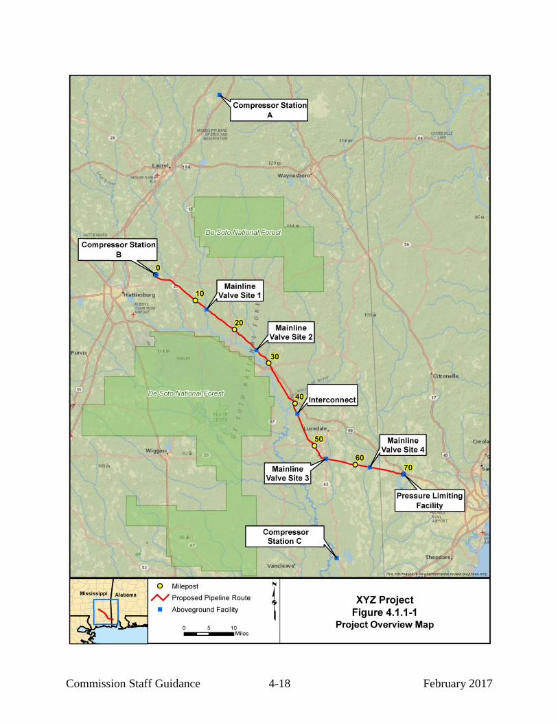
Commission Staff Guidance 4-18 February 2017

Commission Staff Guidance 4-19 February 2017
Clearly and accurately show all proposed pipeline segments, aboveground
facilities (including block valves, drip tanks, communications towers, etc.), pipe storage
yards, extra work/staging areas, contractor yards, and access roads on current original
1:24,000/1:25,000 scale U.S. Geological Survey (USGS) 7.5-minute series topographic
maps or maps of equivalent detail, and 1:6,000 or greater scale aerial photographs or
photo-based alignment sheets that are preferably not more than 1 year old. If you use
older aerial photography, it must accurately depict current land use and development.
Aerial photography or photo-based alignment sheets should be provided in D-size
(22-inch by 34-inch, preferably in a bound roll rather than as individually folded sheets)
or other size format acceptable to the Commission Project Manager. We recommend that
each map sheet and alignment sheet includes a north direction arrow. In addition to the
full-size maps, we also encourage you to provide working copies of topographic maps (in
color) and aerial photography/alignment sheets in 17-inch by 11-inch format. In addition
to the information required to be filed as part of the application, for projects in pre-filing,
you should consult with the Commission Project Manager to determine the number of
copies of topographic maps and aerial photographs that should be provided directly to us
and to the Commission third-party contractor.
Pipeline alignment sheets and topographic maps must cover at least a 0.5-mile-
wide corridor centered on the pipeline and clearly show the pipeline centerline with
integer mileposts identified. You should show milepost markers clearly and accurately
on the maps and photos because mileposts are used to locate and describe site-specific
impacts, mitigation measures, and recommendations. In some cases it may be helpful to
identify mileposts at smaller intervals (e.g., 0.1-mile or 0.5-mile), especially if there are
numerous features of concern along the route or if the maps are of a scale that
necessitates smaller intervals for reference points.
We recommend that the alignment sheets also show the location and widths of the
proposed temporary and permanent rights-of-way, proposed locations and dimensions of
additional temporary workspaces (ATWS), property boundaries and tract numbers,
proposed temporary and permanent access roads, proposed horizontal directional drill
(HDD) entry and exit locations, and, if available, sensitive environmental resources such
as streams and wetlands (using different color shading or lines can assist us in identifying
these sensitive resources) (see figures 4.1.1-2 and 4.1.1-3). Although not required, it is
extremely helpful if you provide a means for Commission staff and our contractors to
match landowners to property tracts shown on the alignment sheets, as this allows us to
better understand and address issues raised during scoping or in correspondence we
receive from landowners. You can accomplish this by filing separate copies of alignment
sheets (full-size or 17-inch by 11-inch format) that include landowner names in addition
to property boundaries. Another approach is to provide a separate reference table listing
the landowner of each property tract. Alignment sheets that include landowner names or
tables with names, if provided, should be filed as “Privileged” to maintain landowner
privacy; however, a copy of the alignment sheets without landowner names is still
required to be filed as public within the docket.

Com
missio
n S
taff Gu
idan
ce
4-2
0
Feb
ruary
201
7

Com
missio
n S
taff Gu
idan
ce
4-2
1
Feb
ruary
201
7
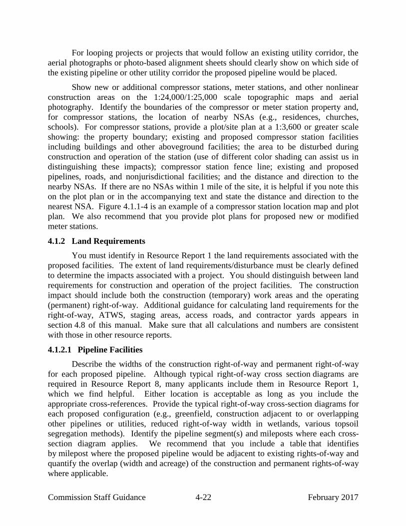
Commission Staff Guidance 4-22 February 2017
For looping projects or projects that would follow an existing utility corridor, the
aerial photographs or photo-based alignment sheets should clearly show on which side of
the existing pipeline or other utility corridor the proposed pipeline would be placed.
Show new or additional compressor stations, meter stations, and other nonlinear
construction areas on the 1:24,000/1:25,000 scale topographic maps and aerial
photography. Identify the boundaries of the compressor or meter station property and,
for compressor stations, the location of nearby NSAs (e.g., residences, churches,
schools). For compressor stations, provide a plot/site plan at a 1:3,600 or greater scale
showing: the property boundary; existing and proposed compressor station facilities
including buildings and other aboveground facilities; the area to be disturbed during
construction and operation of the station (use of different color shading can assist us in
distinguishing these impacts); compressor station fence line; existing and proposed
pipelines, roads, and nonjurisdictional facilities; and the distance and direction to the
nearby NSAs. If there are no NSAs within 1 mile of the site, it is helpful if you note this
on the plot plan or in the accompanying text and state the distance and direction to the
nearest NSA. Figure 4.1.1-4 is an example of a compressor station location map and plot
plan. We also recommend that you provide plot plans for proposed new or modified
meter stations.
4.1.2 Land Requirements
You must identify in Resource Report 1 the land requirements associated with the
proposed facilities. The extent of land requirements/disturbance must be clearly defined
to determine the impacts associated with a project. You should distinguish between land
requirements for construction and operation of the project facilities. The construction
impact should include both the construction (temporary) work areas and the operating
(permanent) right-of-way. Additional guidance for calculating land requirements for the
right-of-way, ATWS, staging areas, access roads, and contractor yards appears in
section 4.8 of this manual. Make sure that all calculations and numbers are consistent
with those in other resource reports.
4.1.2.1 Pipeline Facilities
Describe the widths of the construction right-of-way and permanent right-of-way
for each proposed pipeline. Although typical right-of-way cross section diagrams are
required in Resource Report 8, many applicants include them in Resource Report 1,
which we find helpful. Either location is acceptable as long as you include the
appropriate cross-references. Provide the typical right-of-way cross-section diagrams for
each proposed configuration (e.g., greenfield, construction adjacent to or overlapping
other pipelines or utilities, reduced right-of-way width in wetlands, various topsoil
segregation methods). Identify the pipeline segment(s) and mileposts where each cross-
section diagram applies. We recommend that you include a table that identifies
by milepost where the proposed pipeline would be adjacent to existing rights-of-way and
quantify the overlap (width and acreage) of the construction and permanent rights-of-way
where applicable.

Commission Staff Guidance 4-23 February 2017

Commission Staff Guidance 4-24 February 2017
Each typical diagram should identify the pipeline it pertains to and should show:
the width of the total construction right-of-way;
the width of the new permanent right-of-way;
the width of the temporary construction right-of-way;
the width of the existing right-of-way used for part of the construction
right-of-way, if applicable;
the location of existing and proposed pipelines; and
the distance of the proposed pipeline from the nearest existing pipeline or
other collocated facilities (e.g., power poles, roads) to the extent known and
practicable.
If the temporary construction right-of-way or new permanent pipeline right-of-
way would overlap existing utility or transportation corridor rights-of-way, you should
identify the type of facilities within the existing corridor and provide a table indicating
where each diagram applies by milepost. Include the following in each typical diagram:
the width of the existing utility or transportation right-of-way;
the width of the existing utility or transportation right-of-way overlapped
by the proposed temporary construction right-of-way;
the width of the existing utility or transportation right-of-way overlapped
by the proposed new permanent right-of-way or existing permanent right-
of-way; and
an estimate of the number of acres within the overlapped temporary and
permanent rights-of-way.
Figure 4.1.2-1 is an example of a typical pipeline project right-of-way cross
section for locations where the applicant would install a new pipeline adjacent to an
existing pipeline.
In addition to the construction and permanent right-of-way requirements, include
land requirements for ATWS, staging areas for the project (e.g., as required for road,
railroad, waterbody, and wetland crossings; areas of steep side slope; areas at the
beginning and end of each pipeline segment for contractor mobilization/demobilization;
pipe and contractor storage yards, new or modified access roads; staging and pull-back
areas for HDDs). We recommend that you summarize the land requirements for the
pipeline facilities as shown in example table 4.1.2-1.

Commission Staff Guidance 4-25 February 2017

Commission Staff Guidance 4-26 February 2017
TABLE 4.1.2-1
Summary of Land Requirements for Pipeline Facilities a
Facility County, State
Land Affected During Construction
(acres)c
Land Affected During Operation
(acres)
Pipeline Right-of-Way b
Subtotal
Additional Temporary Workspaces
Subtotal
Staging Areas
Subtotal
Other Work Areas
Temporary Access Roads
Permanent Access Roads
Contractor Yard
Subtotal
TOTAL LAND REQUIREMENTS FOR PIPELINES
____________________ a The numbers in this table have been rounded for presentation purposes. As a result, the totals may not reflect the sum of
the addends. b Based on a x-foot-wide construction right-of-way and a x-foot-wide permanent right-of-way.
c Land affected during construction includes both temporary and permanent work areas.
4.1.2.2 Aboveground Facilities
For each aboveground facility, provide the following information:
total site area in acres (property size);
amount of land required for construction, including access roads, laydown
areas, and other areas (disturbed during construction);
amount of land required for facility operation, including access roads,
communication facilities, parking, and other areas (permanently disturbed);
and
amount of land to be fenced on the site.
We recommend that you summarize the above information as shown in example
Table 4.1.2-2.

Commission Staff Guidance 4-27 February 2017
TABLE 4.1.2-2
Summary of Land Requirements for Aboveground Facilities a
Facility County, State Land Affected During Construction (acres)
b
Land Required During Operation (acres)
Compressor/Meter Station, MP x.x
Pressure Regulating Station, MP x.x
Block Valves c
Block Valve, MP x.x
Block Valve, MP x.x
Block Valve, MP x.x
Block Valve, MP x.x
Pig Launcher d
Pig Receiver d
TOTAL LAND REQUIREMENTS FOR ABOVEGROUND FACILITIES
____________________ a The numbers in this table have been rounded for presentation purposes. As a result, the totals may not reflect the sum of
the addends. b Land affected during construction includes both temporary and permanent work areas.
c Each block valve will be constructed within the x-foot-wide construction right-of-way and operated within the x-foot-wide
permanent easement. No additional land will be required for construction or operation of these facilities. d The pig launcher and pig receiver sites will be constructed and operated within the compressor/meter station site at
MP x.x and within the pressure regulating station site at MP x.x, respectively. No additional land will be required for construction and operation of these facilities.
4.1.3 Construction Procedures
Describe the procedures and personnel training that would be implemented to
ensure that project construction would comply with the mitigation measures identified in
the filed application and the requirements of other federal and state permits.
State the anticipated number of environmental inspectors that would be assigned
to each construction spread, and describe the role of the environmental inspector(s),
which, at a minimum, must include the responsibilities described in our current Upland
Erosion Control, Revegetation, and Maintenance Plan (Plan).
If you do not provide Resource Report 5 – Socioeconomics, then include the
following estimated workforce requirements information of Resource Report 1:
number of construction spreads and their milepost boundaries;
average and peak workforce in each construction spread;
duration of construction (e.g., days, months) from initial clearing to final
restoration; and
number of new permanent employment positions created for project
operations and where these employees would be located.

Commission Staff Guidance 4-28 February 2017
We also recommend that you include the anticipated percentage of the workforce
that would be local hires and the anticipated months and year(s) of construction.
4.1.3.1 Pipeline
Summarize the construction and restoration techniques to be used for the project.
For pipelines, we recommend that you describe:
procedures for marking (e.g., flagging) the construction right-of-way,
access roads, extra work/staging areas, and sensitive resource or restriction
areas (e.g., wetlands, no-fueling zones);
procedures for clearing, grading, trenching, stringing, bending, welding, x-
ray or radiographic inspection, hydrostatic testing, pipeline coating and
coating repair, backfilling, and restoration;
procedures associated with installation of cathodic protection systems and
locations of any cathodic protection systems that would be installed outside
the temporary or permanent construction area20
;
procedures and locations to be used for disposing of timber, slash, and rock;
excavation depths, range of estimated trench width, and depth of cover over
the pipeline, including identification of any areas where the pipeline would
be buried deeper than usual (e.g., streams, agricultural fields with drain
tiles) and the burial depths at these locations; and
pipeline construction schedule by segment/facility, including approximate
start date and duration for overall construction/restoration.
In addition to the standard construction methods, describe the construction and
restoration techniques to be used in the following areas or times:
Rugged topography – Describe side slope construction techniques, width of
the construction right-of-way, erosion control and revegetation procedures,
and the milepost locations where the construction technique would be used
(see sections 4.6 and 4.7 of this manual, which address Geological
Resources and Soils, respectively).
20
If the locations of cathodic protection systems are not known at the time of filing, you
should describe the applicable process for regulatory approval to install these
facilities.

Commission Staff Guidance 4-29 February 2017
Residential areas – Describe the specific construction mitigation techniques
(e.g., reduced construction right-of-way, stove-pipe or drag-section
techniques) that would be used in residential areas (see section 4.8.1 of this
manual).
Active croplands – Describe how drain tiles would be identified and
repaired if damaged during construction. Also describe the methods of
topsoil segregation, procedures for minimizing soil compaction and
removing rock, and special construction techniques that would be used for
orchards or other specialty crops (see sections 4.7 and 4.8.1 of this manual).
Road crossings (we also recommend including similar information for
railroad crossings) – Describe the methods for crossing federal, state, and
local roads. Include a crossing table indicating milepost locations and the
anticipated methods to be used at each road/railroad crossing. If roads
would be open cut, describe the duration of construction, how access would
be maintained along/across each road, and what safety controls (e.g.,
establishment of a detour, use of flagmen) would be implemented.
Blasting – Describe blasting procedures including methods to reduce the
amount of blasting needed (e.g., use of rock rippers), handling of
explosives, measures to control each blast, and monitoring and mitigation
measures to minimize impacts (e.g., use of mats to control fly rock,
vibration monitoring at nearby structures, notification of landowners prior
to blasting, testing pre- and post-construction well water yield). As
appropriate, provide cross-references to relevant sections of Resource
Reports 2, 3, 4, and/or 6.
In addition to the above, we also encourage you to describe construction and
restoration methods for the following:
Utility crossings – Describe the methods to be used for crossing existing
pipelines or other utilities, including safety controls and coordination with
utility owners/managers.
Wetlands – Describe each construction technique (e.g., standard, push/pull,
boring, HDD, direct pipe) that would be used and the conditions in which
each would be used. Also see section 4.2.3 of this manual, and provide
cross-references if appropriate.
Waterbodies – Describe each construction technique that would be used for
waterbody crossings, including major or sensitive waterbodies, and the
conditions in which each method would be used. Also see section 4.2.2 of
this manual, and provide cross-references if appropriate.
Commission Staff Guidance 4-30 February 2017
Winter Construction – If construction would occur through winter months
and construction or restoration methods would be modified during this
timeframe, develop and file a winter construction plan in accordance with
our Plan (section III.I).
For abandonment or replacement projects, explain, as appropriate, the sequence of
steps to be followed to abandon facilities in place or to abandon and remove facilities.
For facilities to be abandoned in place, you must identify who would own and be
responsible for the site after abandonment and whether landowners had the opportunity to
request removal. You must indicate whether landowners’ requests for removal of
abandoned facilities would be honored, and provide explanations if they would not. For
facilities to be abandoned and removed, describe how the pipeline would be cleaned and
how the resulting materials would be handled and disposed. If facilities to be abandoned
or replaced may have been exposed to polychlorinated biphenyl (PCB) contamination,
provide a cross-reference to Resource Report 12, which describes requirements related to
potential PCB contamination. If asbestos may be present, provide a cross-reference to the
appropriate resource report in which this issue is discussed (see section 4.8.1.3 of this
guidance manual for further discussion). Also specify whether replacement pipeline
would be placed adjacent to the existing pipeline or in the same trench as the existing
pipeline after the existing pipeline is removed. If the existing pipeline would be
removed, but same-trench replacement is not proposed, you should explain why and
describe the sequence of removal and replacement activities.
You must specify whether the project would be constructed using our Plan and
Wetland and Waterbody Construction and Mitigation Procedures (Procedures). If you
propose any modifications/alternative measures to our Plan and Procedures or propose to
use your own erosion control and mitigation plan during construction and restoration,
compare the proposed measures with the respective measures in the Plan and Procedures
and indicate how they would provide equal or greater protection of environmental
resources. Any proposed modifications/alternative measures to the Plan and Procedures
must be identified and discussed further in the appropriate resource report; you should
describe and justify them on a project- or site-specific basis, as appropriate. Note that the
term “variance” does not apply until after the Commission issues an Order authorizing
the project.
With the exceptions of Resource Reports 6 and 13, the section 380.12 filing
requirements do not specifically identify information uniquely applicable to LNG
projects or projects involving offshore pipelines; however, many such projects have been
proposed in recent years. Therefore, where applicable, we provide guidance about
information that we find helpful in conducting our environmental review of projects that
involve these types of facilities. Our guidance is based on our experience reviewing
many such projects and the issues that are often raised during the scoping process.
Additionally, some of this information may be necessary for other agency consultations

Commission Staff Guidance 4-31 February 2017
that we have responsibility to oversee. If the information is not available at the time of
application, you should provide the best available information or estimates, and an
estimated timeframe for when the information will be provided. For projects that require
offshore construction or dredging, jetting, or plowing for the installation of offshore
pipelines or shipping facilities, we recommend that you provide the following in
Resource Report 1 or provide a cross-reference to where the information can be found in
another resource report:
the volume in cubic yards of material to be excavated in total and for each
component of the project including, as appropriate, the ship berth, turning
basin, shipping channel improvements, and/or pipeline installation;
aerial photography or alignment sheets showing the areas to be excavated;
the area of seabed directly affected by excavation, spoil placement, and
anchor placement;
a description of each excavation method to be used (e.g., clamshell bucket,
suction dredge jetting, plow);
the days/weeks/months of anticipated construction and anticipated
construction hours associated with each activity (including each dredging
or trenching method; the pipe fabrication and lay method; and the trench
backfilling method);
if dredging is planned, indicate whether the dredge material would be
sidecast onto the seabed or temporarily stored in barges;
indicate whether the trench would be backfilled and the material that would
be used as backfill (e.g., whether it would be the excavated native material
or imported material); if imported material would be used, include the
volume and source of material required;
the location where excess dredge material would be disposed of and the
process used for dewatering the dredge material prior to disposal;
the name, location, size, availability, and necessary federal and/or state
permits for any dredged material placement areas to be used;
a list of each type of equipment and vessel anticipated to be used and the
numbers of each type that would be deployed during construction;

Commission Staff Guidance 4-32 February 2017
the anticipated daily or weekly movements of vessels (i.e., vessel traffic),
including the number of round trips to and from shore and the anticipated
operating speed of each vessel;
a discussion of the anchoring systems or dynamic positioning systems to be
used to station and move the vessels during construction;
a discussion of any piles that are proposed including the anticipated number
and location of the piles; the pile material, diameter, length, and installation
depth; the method used to install the piles; and the duration of time to
install the piles; and
a description of procedures to be implemented to minimize sedimentation,
turbidity, noise, and spills.
For LNG projects that involve shipping you should provide:
the anticipated number of ships that would call on the facility weekly and
annually;
the anticipated size of the ships including draft, length, width, carrying
capacity, and height when loaded and unloaded;
the duration of the transit from the outer boundary of the Exclusive
Economic Zone to the port;
the ship route out to the outer boundary of the Exclusive Economic Zone;
the size of any anticipated security zones while the ship is transiting and
moored at the facility;
the length of time each ship would be at the terminal for unloading and
loading;
a list and description of the engines and other equipment that you anticipate
would be operating during transit and while at the port; and
a description of the use of tugs, harbor pilots, etc. to guide and maneuver
the LNG ship.

Commission Staff Guidance 4-33 February 2017
4.1.3.2 Aboveground Facilities
You should describe the stages and sequence of construction procedures for
aboveground facilities. For LNG plants and compressor stations, include the
approximate duration of construction of each facility, the estimated number of
construction workers for each facility, foundation excavation depths, number and depths
of pilings, and associated facilities (e.g., access roads, office building). For sites that
would be abandoned, describe the procedures for dismantling and disposing of buildings,
foundations, and equipment, and for restoring the site. You must indicate whether
landowners’ requests for removal of abandoned facilities would or would not be honored,
and provide explanations if they would not.
You should describe the aboveground facilities to be abandoned or removed
would be cleaned and how the resulting materials would be handled and disposed. If any
of the facilities or sites are potentially contaminated (e.g., with PCBs, asbestos,
hydrocarbons [including natural gas liquids, oils, lubricants, or fuels], or other regulated
contaminants), briefly describe how you would use contaminated site management, as
well as the status of any necessary permits and approvals. Alternatively, include a cross-
reference(s) to the resource report(s) in which this information is provided.
4.1.4 Operation and Maintenance
You should provide a general description of the operation and maintenance
practices for the project, including federal, state, and local regulations and guidelines that
would be followed.
For pipelines, we recommend that you include a description of the type and
frequency of gas leak and cathodic protection surveys, aerial inspections, and right-of-
way maintenance. For right-of-way maintenance practices, you should include the time
of year for maintenance activities, the permanent right-of-way width that would be
maintained in an herbaceous condition, and whether herbicides would be used.
For aboveground facilities, describe normal operation and maintenance
procedures. We recommend that you describe whether the facilities would be staffed
24 hours a day or maintained from a central operation center and include a description of
new operations or district offices that the project would require.
4.1.5 Future Plans and Abandonment
You must provide information on the existing or reasonably foreseeable plans to
expand or abandon the currently proposed facilities at a later time. You should also
include plans for other projects that are or will be functionally or financially
interdependent with the currently proposed facilities. Describe the type, size, and
location of planned future facilities, extended schedule for construction or abandonment

Commission Staff Guidance 4-34 February 2017
and the anticipated regulatory approvals that would be required, approximate volume of
gas to be transported, and a description of how the current project affects these future
plans.
4.1.6 Permits and Approvals
You must identify all authorizations required21
for the project (in addition to the
Commission’s Certificate of Public Convenience and Necessity or Authorization). You
should provide the following information:
the name of the permitting/approval agency and the name and telephone
number of the person contacted;
type of permits/approvals or consultation;
the current status of the permits/approvals filings (e.g., estimated schedule
for permit filing, date of actual filing, and date that permit/approval was
granted or is anticipated); and
the environmental mitigation requirements specified in any permit or
proposed in any permit application not described elsewhere in the resource
reports.
We recommend that you summarize the above information as shown in example
table 4.1.6-1. Note that the information regarding federal permits should be consistent
with that provided in Exhibit J of the application under section 7 of the NGA (or Exhibit
H, for applications under section 3 of the NGA), which must identify federal
authorizations required for the project; the federal agency or officer, or state agency or
officer acting pursuant to delegated federal authority, who would issue each required
authorization; the date that each request for authorization was submitted; why any request
was not submitted and the date that submission is expected; and the date by which final
action on each federal authorization has been requested or is expected. We encourage
applicants to begin consulting with permitting agencies early in order to determine the
appropriate permitting processes and associated timeframes.
21
You should include all known permits that you plan to apply for and obtain.

Commission Staff Guidance 4-35 February 2017
TABLE 4.1.6-1
Environmental Permits, Approvals, and Consultations
Agency Permit/Approval/Consultation Submittal Date (Anticipated)
Approval Date (Anticipated)
Federal
Federal Energy Regulatory Commission
Certificate of Public Convenience and Necessity under section 7(c) of the Natural Gas Act
DATE (DATE)
U.S. Army Corps of Engineers –[District]
Permit for the discharge of dredge or fill material into waters of the U.S. under section 404 of the Clean Water Act, for activities affecting navigable waters under section 10 of the Rivers and Harbors Act, and crossing of federal levees under Title 33 United States Code section 408 (Navigation and Navigable Waters).
DATE (DATE)
U.S. Fish and Wildlife Service – [Region/Field Office]
Consultations for impacts on federally listed threatened and endangered species and critical habitat under section 7 of the Endangered Species Act, the Migratory Bird Treaty Act, the Bald and Gold Eagle Protection Act, and the Fish and Wildlife Coordination Act
DATE (DATE)
U.S. Department of Agriculture, Natural Resources Conservation Service
Recommendations for seed mixes
Consultation regarding lands enrolled in the Wetland Reserve Program, Wetland Reserve Easements Program, or other Agricultural Conservation Easement Programs
DATE
DATE
DATE
DATE
U.S. Department of Agriculture, Farm Service Agency
Consultation on lands enrolled in the Conservation Reserve Program
DATE DATE
State
[Applicable state agency]
Minor source operating permit (DATE) (DATE)
[Applicable state agency]
General Permit for Construction Stormwater Discharge under the National Pollution Discharge Elimination System
(DATE) (DATE)
General Permit for Construction Dewatering and Discharge of Hydrostatic Test Water under the National Pollution Discharge Elimination System
(DATE) (DATE)
Water Quality Certificate under section 401 of the Clean Water Act
DATE (DATE)
[Applicable state agency]
State Water Crossing Permit (DATE) (DATE)
[Applicable state agency]
Water appropriation permit (DATE) (DATE)
[Applicable state agency]
Consultation for impacts on fisheries, wildlife, and state-listed species
DATE DATE
[Applicable state agency]
Consultation for impacts on historic properties under section 106 of the National Historic Preservation Act
DATE DATE
[Applicable state agency]
Right-of-Way Grant to cross state lands (DATE) (DATE)
Local
[Applicable local agency]
Levee/Ditch Crossing Permits (DATE) (DATE)
4.1.7 Affected Landowners
You must provide the names and addresses of all affected landowners and you
should also include the addresses of towns, communities, and local, state, and federal
governments and agencies involved with the project. Affected landowners as defined in
section 157.6(d)(2) include property owners directly affected (i.e., property crossed or
used) by the proposed activity, adjacent landowners (landowners not directly affected but
whose properties abut the edge of a proposed facility site or right-of-way that runs along

Commission Staff Guidance 4-36 February 2017
a property line in the area in which the facilities would be constructed, or contains a
residence within 50 feet of the proposed construction work area), landowners with
property within 0.5 mile of proposed compressor stations or LNG terminals, tanks, and
other facilities, and property owners within the area of proposed storage fields. You must
make a good faith effort to notify all affected landowners. We recommend that you
provide a list to the Commission including all the addresses used for the landowner
notifications. To facilitate use by Commission staff in mailing notices (e.g., Notice of
Intent to prepare an EA or EIS, or Notice of Availability of a draft or final EIS), we
recommend checking with the Commission Project Manager regarding the preferred
format for the mailing list, and provide updated lists as warranted based on route
modifications, returned mailings, or other new information. Landowner mailing lists
should be filed as “Privileged” to protect landowner privacy.
Additional information on landowner notification requirements is included in
section 2.0 of this guidance manual.
4.1.8 Nonjurisdictional Facilities
Under NEPA, the Commission may need to consider the environmental impact of
related nonjurisdictional facilities that would be constructed for the purpose of delivering,
receiving, or using the proposed gas volumes. Examples of nonjurisdictional facilities
could include major power facilities, such as cogeneration plants, as well as less
significant facilities, such as lateral pipeline connections built by local distribution
companies or utility services for compressor stations.
Applicants are required to address four factors for nonjurisdictional facilities, as
listed in section 380.12(c)(2)(ii). Commission staff typically evaluate related
nonjurisdictional facilities in our cumulative impact analysis. Therefore, you must
provide the following information, to the extent available, regarding the identified
nonjurisdictional facilities, including auxiliary facilities and facilities built by other
companies:
a brief description of each facility, including its owner or sponsor;
gas consumption or megawatt size, as appropriate;
the length and diameter of any interconnecting pipeline or power line to be
constructed;
land requirements;
required permits, including any applicable regulatory siting process;
the latest status of federal, state, and local permits/approvals;

Commission Staff Guidance 4-37 February 2017
construction status;
current 1:24,000/1:25,000 scale topographic maps showing the location of
the facilities relative to the proposed jurisdictional facilities;
documentation that the appropriate State Historic Preservation Office
(SHPO) or duly authorized Tribal Historic Preservation Office (THPO) has
been contacted regarding whether properties eligible for listing on the
National Register of Historic Places (NRHP) would be affected, or on the
need to perform cultural resources surveys to support such a determination;
documentation of consultation with the FWS (and the National Oceanic and
Atmospheric Administration, National Marine Fisheries Service [NOAA
Fisheries], if appropriate) regarding potential impacts of the proposed
facility on federally listed threatened and endangered species; and
for facilities within a designated coastal management zone, a determination
from the state agency of consistency with the coastal zone management
program or evidence that the owner has requested such a determination.
If available, evidence that adequate comment or consultation has taken place
should be in the form of a letter from the responsible state agency.
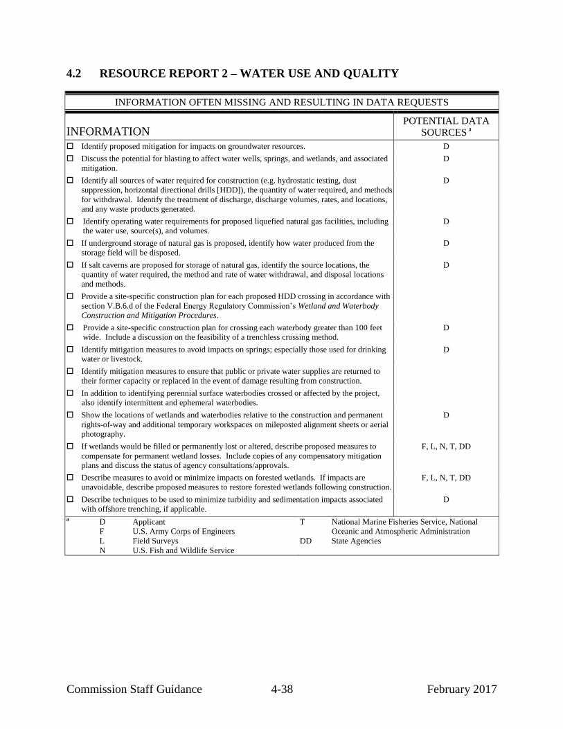
Commission Staff Guidance 4-38 February 2017
4.2 RESOURCE REPORT 2 – WATER USE AND QUALITY
INFORMATION OFTEN MISSING AND RESULTING IN DATA REQUESTS
INFORMATION POTENTIAL DATA
SOURCES a
Identify proposed mitigation for impacts on groundwater resources. D
Discuss the potential for blasting to affect water wells, springs, and wetlands, and associated
mitigation.
D
Identify all sources of water required for construction (e.g. hydrostatic testing, dust
suppression, horizontal directional drills [HDD]), the quantity of water required, and methods
for withdrawal. Identify the treatment of discharge, discharge volumes, rates, and locations, and any waste products generated.
D
Identify operating water requirements for proposed liquefied natural gas facilities, including the water use, source(s), and volumes.
D
If underground storage of natural gas is proposed, identify how water produced from the
storage field will be disposed.
D
If salt caverns are proposed for storage of natural gas, identify the source locations, the
quantity of water required, the method and rate of water withdrawal, and disposal locations
and methods.
D
Provide a site-specific construction plan for each proposed HDD crossing in accordance with
section V.B.6.d of the Federal Energy Regulatory Commission’s Wetland and Waterbody Construction and Mitigation Procedures.
Provide a site-specific construction plan for crossing each waterbody greater than 100 feet
wide. Include a discussion on the feasibility of a trenchless crossing method.
D
Identify mitigation measures to avoid impacts on springs; especially those used for drinking water or livestock.
D
Identify mitigation measures to ensure that public or private water supplies are returned to
their former capacity or replaced in the event of damage resulting from construction.
In addition to identifying perennial surface waterbodies crossed or affected by the project, also identify intermittent and ephemeral waterbodies.
Show the locations of wetlands and waterbodies relative to the construction and permanent
rights-of-way and additional temporary workspaces on mileposted alignment sheets or aerial photography.
D
If wetlands would be filled or permanently lost or altered, describe proposed measures to
compensate for permanent wetland losses. Include copies of any compensatory mitigation plans and discuss the status of agency consultations/approvals.
F, L, N, T, DD
Describe measures to avoid or minimize impacts on forested wetlands. If impacts are
unavoidable, describe proposed measures to restore forested wetlands following construction.
F, L, N, T, DD
Describe techniques to be used to minimize turbidity and sedimentation impacts associated
with offshore trenching, if applicable.
D
a D Applicant F U.S. Army Corps of Engineers
L Field Surveys
N U.S. Fish and Wildlife Service
T National Marine Fisheries Service, National
Oceanic and Atmospheric Administration
DD State Agencies

Commission Staff Guidance 4-39 February 2017
This guidance manual does not change or substitute for any law, regulation, or
any other legally binding requirement. Where practical, we have distinguished between
legal obligations and Commission staff's interpretations or recommendations. We use
mandatory language such as “required,” “must,” and “must not” to describe controlling
requirements under statutes and regulations. We use non-mandatory language such as
“recommend,” “encourage,” and “may” to describe Commission staff’s
recommendations that will help the Commission meet its obligations under
NEPA. However, because clear distinctions are not always practical, a reader should
consult the regulations directly to determine the information legally required in order to
meet the filing requirements of 18 CFR 380.12.
Resource Report 2 is required for all applications, except for projects that involve
only facilities constructed within previously disturbed areas of existing aboveground
facilities where no wetlands or waterbodies exist on or abut the site and where there
would be no significant increase in water use. The report must describe water quality and
provide data sufficient to determine the project’s expected impact on water quality and
the effectiveness of mitigation, enhancement, or protective measures.
In text and tabular form, this report should present the sources used to identify and
quantify impacts of construction on water use and quality. Be sure to cite the sources of
provided information and include copies of relevant agency correspondence, as
appropriate. It should also discuss special techniques that you would use to avoid,
minimize, or otherwise mitigate impacts during construction across water resources.
4.2.1 Groundwater Resources
Provide a brief description of the existing groundwater resources and use in the
project area. You should identify:
information on each aquifer underlying the project area, including aquifer
type (i.e., confined, semi-confined, or unconfined), depth and thickness,
depth to water from ground level, current and projected uses, average yield,
seasonal fluctuations, known or suspected contamination problems, and
water quality;
wells and springs within 150 feet of the project, including but not limited to
public, residential, agricultural, industrial, and livestock wells, their
capacity and water quality; and
large-capacity groundwater withdrawals in proximity to the project,
including municipal, industrial, and mining withdrawals.

Commission Staff Guidance 4-40 February 2017
This type of information is typically available from state and federal hydrologic
publications, and databases maintained by the applicable state or county agency, (e.g.,
Board of Health, a water division within the agency that manages natural resources). If
groundwater is not the main source of drinking water, you should indicate in the surface
water section of the resource report the water supplier/company supplying water for
residents in the area and the surface water source(s).
You must identify segments of the pipeline and other aboveground facilities that
overlie U.S. Environmental Protection Agency (EPA)-designated or state-designated sole
source aquifers and state or local wellhead protection areas. Describe any restrictions
associated with working within these areas. Information regarding sole source aquifers
can be obtained from the regional EPA Groundwater Divisions. You should also identify
areas of contaminated soil or groundwater from computer databases and/or by contacting
the appropriate state Waste Management Division or Groundwater Division.
In order to conduct our analysis, we may request additional information if any
areas of karst would be affected by construction and/or operation of the project (which
should be identified in Resource Report 6). We recommend that you describe specialized
techniques to protect groundwater resources in these areas and identify how the internal
drainage/runoff towards karst features within project work areas would be addressed. If
any HDD operations are proposed in karst areas, we recommend that you identify all
wells and springs within 1,000 feet of the work areas and describe the degree of karst
through desktop assessments, lineament/fracture trace analysis using aerial photographs
in stereo pair with 60 percent overlap or Light Detection and Ranging (LiDAR) imagery
analysis, field reconnaissance, and site surveys including results of geophysical
investigations that were conducted. (See also section 4.6.4 of this guidance manual.)
If a large quantity of groundwater would be used for the project (e.g., for
hydrostatic testing or solution mining storage caverns) you should provide a detailed
groundwater resource and aquifer pumping test analysis to describe aquifer coefficients
and use these data to predict water-level drawdown impacts on other groundwater uses
within the pumping zone of influence. Also, we recommend that you describe in detail
the proposed wastewater disposal methods and identify all regulatory requirements for
the groundwater withdrawal/disposal and the status of approvals.
4.2.1.1 Water Supply Wells
While there are few requirements in the regulations for disclosure of groundwater
impacts and mitigation, in order to fulfill our NEPA responsibility, we recommend that
you provide all of the information in this section.

Commission Staff Guidance 4-41 February 2017
You must identify by milepost all water supply wells, including private,
community, irrigation, livestock, and municipal/public wells, and springs within 150 feet
of any area that would be disturbed by construction. This includes the construction right-
of-way, extra work areas, new access roads, pipe storage and contractor yards, and sites
for new or modified aboveground facilities (see example table 4.2.1-1). Public supply
well information can generally be obtained from the local municipalities or county and/or
state agencies that compile information on drinking water supplies. Information on
private wells and springs will likely need to be obtained through field surveys or
discussions with affected landowners. Note that although the regulations only require
you to identify water wells within 150 feet of work areas, prior to construction you will
need to identify wells beyond this distance in order to implement the refueling
restrictions discussed in section 4.2.1.2).
Contact the municipal or public well owners/operators and the state drinking water
division for the counties crossed to determine whether the pipeline crosses a protected
watershed area associated with a supply well. We recommend that you provide
correspondence with these groups/individuals. Additionally, we recommend that you
present the information, including the crossed length of the protected watershed
by milepost, in the text of the report or in tabular form (see example table 4.2.1-2).
TABLE 4.2.1-1
Water Supply Wells and Springs Within 150 Feet of Project Construction Areas
Facility County, State Approximate
Milepost Water
Supply Type Distance and
Direction
Pipelines
Mainline County, ST x.x Domestic well xx feet east
County, ST x.x Rural water supply xx feet west
County, ST x.x Spring xx feet east
Loop A County, ST x.x Municipal well xx feet northeast
County, ST x.x Spring xx feet west
Loop B County, ST x.x Domestic well xx feet southeast
County, ST x.x Spring xx feet west
Aboveground Facilities
Compressor Station A County, ST N/A Spring xx feet southeast
TABLE 4.2.1-2
Locally Zoned Aquifer Protection Areas Crossed by the Pipeline Route
Facility Town, State Approximate Mileposts Water Supply Length of Crossing of
Protection Area
Mainline Town, ST x.x to y.y ABC Water District xxx
Town, ST x.x to y.y DEF Water District xxx
Loop A Town, ST x.x to y.y GHI Water District xxx

Commission Staff Guidance 4-42 February 2017
Where blasting would be required, discuss both the potential for blasting to affect
water wells and springs and the measures you will take to detect and remedy such effects.
(See also section 4.6 of this manual.)
4.2.1.2 Groundwater Impacts and Mitigation
Discuss potential impacts on groundwater, including fluctuations in groundwater
levels, potential effects on yields and/or water quality, and risks associated with
encountering contaminated groundwater, encountering contaminated soil with potential
for cross-contamination, and spilling hazardous materials during construction.
Describe measures to minimize and mitigate the impact on groundwater by using
special blasting techniques, trench breakers, groundwater interceptor drains, dewatering
methods, and restrictions on refueling and storage of hazardous substances (generally
prohibit refueling and storage of hazardous materials within a 200-foot radius of private
wells, and 400-foot radius of community and municipal wells). Include a plan for
monitoring groundwater quality and yield for all public and private supply wells within at
least 150 feet of construction, with the owner’s permission, before and after construction
to determine whether water supplies have been affected by pipeline construction
activities. Also indicate what types of mitigation measures would be undertaken to
ensure that the water supply is returned to its former capacity in the event of damage
resulting from construction (e.g., providing temporary sources of potable water,
restoration, repair, or replacement of water supplies).
If contaminated soil or groundwater is present, describe its specific location, type
of contaminant, and mitigation measures to avoid, minimize, or otherwise mitigate
impacts.
If you propose to create underground storage of natural gas, you must identify how
water produced from the storage field would be disposed. For salt caverns, you must
identify the source locations, the quantity required, and the method and rate of
withdrawal of water for solution mining, as well as the means of disposal of resulting
brine. You should discuss the depths of the caverns and disposal wells and how the wells
would be cased.

Commission Staff Guidance 4-43 February 2017
4.2.2 Surface Water Resources
Identify all waterbodies22
crossed by the pipeline based on field surveys and
1:24,000/1:25,000 scale USGS topographic maps. You should provide relevant
information about dry swales or dry washes, if applicable to the area; these features may
require additional planning and/or protections than typically afforded (e.g., if there is a
high likelihood they would flow during construction or they provide habitat for federally
listed species). Provide a table listing by milepost all of the waterbodies that would be
crossed including a unique identifier from field delineations (where applicable), name,
type (e.g., perennial, intermittent, ephemeral, canal), the water’s edge to water’s edge
width at the crossing location, the associated state water quality classification, and the
proposed crossing method. If not provided in a separate table in Resource Report 3, also
include the general fishery type (e.g., coldwater, coolwater, warmwater). This
information can be obtained from the state water quality and fisheries departments. We
recommend that you summarize the above information as shown in example
table 4.2.2-1.
If field data are not available due to lack of access permission or seasonal
conditions, it is acceptable to use data obtained from desktop resources such as the FWS
National Wetlands Inventory (NWI), the National Hydrography Dataset, and USGS
topographic maps until field surveys are completed. Features identified using desktop
data should be clearly identified in the waterbody table. Identify, either within the
waterbody crossing table or within the text discussion, any potable water intake sources
within 3 miles downstream of any waterbody crossing locations (see section 4.2.2.5
below). Additionally, identify any waterbodies that would be crossed that are listed on
the state’s Clean Water Act (CWA) section 303(d) List of Impaired Waters, including the
cause of the impairment.
22
Note that for the purposes of natural gas projects, the Commission’s definition of a
“waterbody” differs from the EPA and the COE definitions of “waters of the United
States.” As defined in the Procedures, a “waterbody” includes any natural or
artificial stream, river, or drainage with perceptible flow at the time of crossing, and
other permanent waterbodies such as ponds and lakes.

Com
missio
n S
taff Gu
idan
ce
4-4
4
Feb
ruary
20
17
TABLE 4.2.2-1
Waterbodies Crossed by the Project
Milepost Feature ID a Waterbody Name Flow Regime
b
Water’s Edge to Water’s Edge
Crossing Width (feet)
State Water Quality
Classification
County Fishery Type Crossing Method
Mainline Pipeline
Loop A
____________________ a
Feature ID is unique code designated to waterbodies identified during field surveys. b Flow regime based on USGS topographic mapping. IT = Intermittent; PN = Perennial; E=Ephemeral

Commission Staff Guidance 4-45 February 2017
Provide a site-specific crossing plan for each crossing of a major waterbody (i.e.,
greater than 100 feet wide at the water’s edge), including offshore construction. Each
crossing plan should include:
the method to be used to excavate the trench underwater (e.g., dredging,
HDD, direct pipe, plowing, jetting, redirecting flow);
the planned depth below the river or seabed, including, for HDD crossings,
a drawing with a plan and profile view showing the drill entry and exit
locations;
the location of the construction and permanent right-of-way and ATWS,
including pipe fabrication and pullback areas, any areas disturbed between
the entry and exit locations, and onshore and offshore equipment staging
areas;
for offshore construction, identify both the surface area to be occupied by
equipment and the area of the bed to be disturbed by dredging, trenching,
anchors (including anchor cable sweep), piles, etc.;
the location of the spoil storage (e.g., on the river or seabed, on barges,
and/or onshore) and the mitigation measures that would be used to control
and store the spoil;
the method to pull the pipeline across the waterbody, including the amount
of time required for the pull;
the method to backfill the trench underwater (such as natural redeposition,
mechanical placement, or backfill plow);
a description of the sequence and duration of each stage of construction and
the total length of time to conduct the crossing (including estimated start
date);
a discussion of any special mitigation to minimize impact on riparian
vegetation; and
for navigable streams or waterbodies used for recreation, a discussion of
how boat traffic through the construction area would be managed, and how
the interruption of boat traffic would be minimized.

Commission Staff Guidance 4-46 February 2017
If you propose an HDD or direct pipe crossing, provide the following additional
information:
size and location of staging areas for the entry and exit pits;
the source of water for both the drilling mud and hydrostatic testing of the
pipe section;
how the drilling operation would be monitored for inadvertent releases of
drilling mud;
any drilling fluid additives proposed to be used;
the steps that would be followed to stop or minimize the size of an
inadvertent release of drilling mud;
the procedures that would be used to contain and clean up any inadvertent
releases (include response procedures if the release occurs in an upland,
wetland, or flowing stream, as applicable);
the conditions under which a drilling operation would be abandoned and
how an abandoned drill hole would be sealed, if necessary;
the type and extent of any disturbance proposed to occur along the drill
path (e.g., minimal hand clearing for tracking wires, clearing of an access
path for equipment and water appropriation); and
if there is a potential to encounter contaminated sediments during drilling,
the measures that would be implemented, such as the use of casings, to
avoid the migration of contaminants along the drill path.
You should indicate whether there is any contingency plan for the waterbody
crossing in the event that the drill is unsuccessful or proves infeasible. If so, we
recommend that you provide site-specific plans that include a scaled drawing identifying
all areas to be disturbed by construction and a copy of any permits issued. We also
recommend that you conduct geotechnical studies as early in the planning process as
practicable to determine whether HDD is a suitable method for the specific crossing
location and to facilitate the development of appropriate crossing plans.
If you propose an in-stream crossing method (e.g., clamshell dredging) for a major
waterbody rather than HDD, direct pipe, or a similar trenchless technique, we
recommend that you:
describe why an HDD or similar technique is not practicable (e.g., due to
results of the geotechnical feasibility study or impact on another resource
outside of the waterbody);

Commission Staff Guidance 4-47 February 2017
indicate how the proposed crossing method sufficiently avoids and
minimizes impacts on aquatic resources in and downstream of the project
area; and
describe the riverbed material and characterize the intensity and duration of
turbidity and sedimentation impacts including downstream impacts
(distance/duration) from the proposed crossing method.
Additionally, you should describe how you chose the proposed crossing method
from among alternative in-stream construction methods (e.g., coffer dam, open and
closed bucket dredges, drag line, excavator, hydraulic dredge).
For proposals that involve offshore construction (including dredging at LNG dock
facilities), you should describe the seabed material, and provide the results of any
sediment modeling indicating the predicted fate and transport of excavated or dredged
sediments. Describe the models that were used; the assumed ambient average and range
of total suspended sediments in the waterbody; the anticipated direction, duration, and
concentration of sediment plumes during construction; and the anticipated extent and
depths of redeposited sediments on the riverbed or seabed. If you propose dredging,
provide a detailed discussion of the dredge material disposal location and method and the
associated coordination with the appropriate federal and state agencies.
4.2.2.1 Contaminated Sediments
Identify all waterbody crossings that may have sediments contaminated with toxic
chemicals along with a description of the type of contamination (e.g., agricultural,
industrial). For offshore sediment analysis, identify the type and concentration of any
sediment contaminants, if applicable. Contact state water quality agencies for this
information. For surface water crossings involving contaminated sediments, provide a
copy of any approved sediment sampling plan(s) used and summarize the results of any
physical or chemical analyses conducted. Discuss the potential impacts on water quality
associated with disturbing the contaminated sediments and describe measures to prevent
or minimize resuspension of sediments during construction. The proposed mitigation
measures should include comments and recommendations from the appropriate federal or
state agency(ies). Provide the name and phone number of the agency contact and include
copies of all related correspondence.
4.2.2.2 Public Watershed Areas
Identify municipal watershed areas and associated reservoirs, if any, and any
state/locally designated surface water protection areas that would be crossed by the
pipeline or in which aboveground facilities would be located. State drinking water
agencies typically have maps or reports that list public surface water supplies. Once
these are identified, you should contact the appropriate local agencies regarding the

Commission Staff Guidance 4-48 February 2017
presence of designated protection areas. In a table summarizing such areas, you should
include the length by milepost of each area crossed by pipeline or by or near
aboveground facilities, the distance and direction of the water supply from the project
facilities, and whether the project would cross the water supply upstream or downstream
of where water is withdrawn (see example table 4.2.2-2). If the project would affect
surface water protection areas, you should explain why these areas were not avoided, and
include a discussion of potential impacts and proposed mitigation measures. Proposed
mitigation, if necessary, should include written comments and recommendations of the
appropriate state or local agencies and a clear indication of whether those
recommendations would be adopted.
TABLE 4.2.2-2
Public Water Supply Watershed Areas Crossed by the Pipeline Route or in Proximity to Aboveground Facilities
Facility County, State Approximate Milepost(s)
Surface Water Supply
Distance/Direction of Water Supply
from Project Facilities
Project Facilities Upstream/
Downstream of Withdrawals
Pipelines
Mainline County, ST x.x to y.y ABC Reservoir 0.5 mile east Downstream
Loop A
Aboveground Facilities
Compressor Station A
4.2.2.3 Floodplains
Executive Order No. 1198823
requires federal agencies under the Executive
Branch to avoid (to the extent possible) long- and short-term adverse impacts associated
with occupancy and modification of floodplains. If the project would require placing
facilities within floodplains, you should identify the applicable facilities and locations.
For each facility, we recommend that you describe the volume of lost flood storage
capacity within the applicable floodplain. Additionally, you should describe efforts to
avoid, minimize, and otherwise mitigate impacts within floodplains and justify why the
facilities must be placed within floodplains.
4.2.2.4 Hydrostatic Test Water and Water for Dust Suppression
Identify all sources of water and the proposed quantity of water required from
each source for hydrostatic testing of each pipeline segment (including HDD segments
prior to installation) and of aboveground facilities such as LNG facilities and tanks, as
23
42 Fed. Reg. 26,951 (May 24, 1977).

Commission Staff Guidance 4-49 February 2017
well as for dust suppression. Describe the withdrawal and discharge methods, how you
would obtain access to the withdrawal location, the anticipated withdrawal and discharge
rates, and the discharge locations by milepost. Indicate whether the test water would be
discharged in upland areas or into a waterbody channel. If you plan to discharge water
into a different watershed than its source, provide documentation of any associated
communication with appropriate agencies. Describe measures to minimize impacts from
withdrawal or discharge, such as by sequential reuse of test water for multiple segments
or for dust suppression. If the project will be within karst areas, we recommend that you
address how you would manage hydrostatic water discharges to avoid triggering surficial
collapse and raveling of soils through karst features or within areas underlain by karst.
State whether you would adopt the hydrostatic testing procedures identified in section VII
of our Procedures, including but not limited to screening the intakes, placing energy
dissipation devices at the discharge locations, and maintaining adequate flow rates to
protect aquatic life and provide for downstream withdrawals by existing users.
Contact appropriate state and federal agencies to determine whether any
significant fisheries or designated exceptional quality waters would be affected and
whether a permit is needed for water withdrawal and discharge activities. Identify the
applicable appropriation and discharge permits and the administering agency(ies). If
sensitive surface waters would be used for withdrawal or discharge, provide comments
and recommendations from the appropriate agency and indicate whether you would adopt
the recommendations.
Discuss the quality of discharge water resulting from contact with the pipeline,
particularly if an existing pipeline is being retested, and identify any physical or chemical
testing of the discharge. Describe any chemical or physical treatment of the pipeline or
hydrostatic test water and, if applicable, provide copies of correspondence with the
appropriate agencies concurring that the use of such treatment is acceptable. Discuss
waste products generated and disposal methods.
4.2.2.5 Construction Permits
Contact state water resources agencies to identify the permits required for
construction across surface waters, including but not limited to water quality certification
under section 401 of the CWA. In addition, contact the appropriate office of the U.S.
Army Corps of Engineers (COE) regarding the CWA section 404 evaluation and indicate
whether the COE believes that the project would meet the requirements of a nationwide
permit (specify which one(s)), or would require a regional permit or an individual permit.
Identify navigable waterways that would be crossed and the associated need for
COE authorization under section 10 of the Rivers and Harbors Act of 1899. Construction
across a navigable waterway may require an individual permit. Provide a copy of all
correspondence with the COE regarding permit determination.

Commission Staff Guidance 4-50 February 2017
4.2.2.6 Sensitive Surface Waters
Identify sensitive waterbodies that may be affected by the project; consult with
state agencies as needed to identify those waterbodies and potential mitigation measures
that may be required during construction. Sensitive surface waters include but are not
limited to the following:
waters that do not meet the water quality standards associated with the
waters’ designated beneficial uses;
surface waters that have been designated for intensified water quality
management and improvement;
waterbodies that contain threatened or endangered species or critical
habitat;
waterbodies that are crossed less than 3 miles upstream of potable water
intake structures (provide the distance from the crossing to the supply
intake should be provided along with the name of the intake owner);
outstanding or exceptional quality waterbodies;
waters of particular ecological and recreational importance;
waterbodies located in sensitive and protected watershed areas;
waterbodies and intermittent drainages that have steep banks, potentially
unstable soils, high volume flows, and actively eroding banks;
surface waters that have important riparian areas; and
rivers on or designated to be added to the Nationwide Rivers Inventory or a
state river inventory (see section 4.8 of this manual).
Describe the effects of construction and operation of the pipeline on designated
sensitive waterbodies and proposed mitigation. Describe in appropriate detail the
construction methods, the location of staging areas, recommendations from federal, state,
and local agencies, and how you would implement the recommendations. If you propose
not to carry out any of these recommendations, you should provide specific reason(s) and
identify whether you propose other mitigation.
4.2.2.7 Waterbody Construction and Mitigation Procedures
Describe proposed waterbody crossing methods (or cross-reference the appropriate
sections in Resource Report 1), including typical workspace and staging area

Commission Staff Guidance 4-51 February 2017
requirements at waterbody crossings. Also, identify and describe waterbodies where
staging areas are likely to be more extensive. Commission staff considers dry swales and
dry washes to be waterbodies if there is water flowing in them at the time of construction.
Therefore, you should include these features in the discussion of waterbody construction
and mitigation procedures, and be prepared to cross these features in accordance with the
Procedures in the event of unforeseen water flow at the time of construction.
Discuss potential project impacts on surface waters, including water quality
impacts (both physical and chemical); increased potential for runoff, bank erosion, and
sedimentation; effects of vegetation removal (including permanent loss of trees); and the
potential for spills of hazardous materials. Identify measures for minimizing impacts on
surface waters. Describe specific crossing and restoration procedures; erosion and
sediment controls; dewatering methods; and restrictions on refueling and storage of
hazardous substances.
Indicate whether you would adopt our current Procedures for the project. If not,
include your proposed procedures for waterbody construction methods, compare them
with our Procedures, and explain any differences. For any individual provisions that, due
to site-specific conditions, you consider unnecessary, technically infeasible, or
unsuitable, identify the location by milepost, describe the site-specific conditions that
preclude use of the Procedures, and propose alternative measures, explaining how the
proposed alternative measures would provide equal or greater protection to the resource.
For any ATWS that would be within 50 feet of a waterbody, provide a site-specific
explanation of the circumstances and a detailed justification why a 50-foot buffer cannot
be maintained. Include documentation of consultation with state agencies where
appropriate to support proposed alternative measures.
4.2.3 Wetlands
4.2.3.1 Existing Resources
On all accessible property tracts, identify wetlands that would be affected by the
project based on field-based wetland delineations of all accessible areas using the current
federal manual and applicable regional supplements. Include a summary of the wetland
delineation report(s) as an attachment to this resource report.
On inaccessible property tracts,24
use FWS NWI maps, where available, to
determine the locations and types of wetlands that would be affected by construction and
operation of the facilities. If NWI maps have not been prepared for all or parts of the
project area, identify wetlands using information from other available sources, which
24
We consider “inaccessible” to primarily include tracts for which landowner
permission has not been secured for survey purposes.

Commission Staff Guidance 4-52 February 2017
may include state wetland maps; county soil maps from the Natural Resources
Conservation Service (NRCS) of the U.S. Department of Agriculture; USGS topographic
maps; and aerial photographs. Identify the information source and classify wetlands
according to the NWI classification system. Include with the application labeled
and mileposted alignment sheets or aerial photography showing the locations of the field
delineated and mapped wetlands. We may also request copies of NWI maps with the
facilities and mileposts clearly marked if field delineations have not been completed for
most of the project. As a rule of thumb, provide project mapping of wetland impacts
using the best available resolution.
We recommend that you identify and discuss major wetland complexes or
significant wetlands, as identified by field review and/or by state or federal agencies.
Also, you should identify acres of wetland affected by agriculture, silviculture, or
rangeland, if any.
We recommend that you provide a table of wetlands that would be affected by the
project, including those affected by ATWS and staging areas, access roads, and
contractor and pipe storage yards. This table should include a list of facilities
and milepost locations of each wetland and how the wetland was identified (e.g., field
delineated, NWI maps). For delineated wetlands you should provide a unique identifier
that can be used to locate the wetland on the alignment sheets. Also, you should list the
classification of each wetland according to the NWI classification system, the crossing
length, anticipated crossing method, and the acreage of construction and operation
impacts. An explanation in a table footnote or in the text of how you calculated the
impact acreages is also helpful (e.g. using GIS to measure the area of the wetland
polygon within the construction work area; calculating based on crossing length and
right-of-way width). We recommend that you summarize the above information as
shown in example table 4.2.3-1.
4.2.3.2 Construction and Operation Impacts
Discuss impacts on wetlands that would result from construction and operation of
the proposed facilities. We recommend that you provide a summary table listing the total
length crossed and total area affected, separated by wetland type and by facility (see
example table 4.2.3-2). For pipelines, the table should calculate the acreage of forested
and scrub-shrub wetlands that would sit within the proposed vegetation maintenance corridor
in the permanent right-of-way and so be converted to non-forested or non-woody wetland
types. Additionally, you should identify any wetland areas that would be filled or
otherwise permanently lost and quantify the associated acreage. For wetland impacts that
would be limited to construction, you should indicate the expected duration of restoration
to pre-existing conditions; specifically estimating the time required to reestablish the
vegetation community.

Commission Staff Guidance 4-53 February 2017
TABLE 4.2.3-1
Wetlands Crossed by the Pipeline Route
Approx. Milepost
Wetland I.D.
National Wetlands Inventory
Classification a
Source
b
Approximate Crossing
Length (feet) c
Acreage Affected During Construction
d
Acreage Affected During
Operation e
Crossing Method
Mainline
Subtotal
Loop A
Subtotal
Project Total
____________________ a PEM – Palustrine, Emergent, may be Temporarily, Seasonally, or Semi-permanently Flooded
PSS – Palustrine, Scrub/Shrub, may be Temporarily or Seasonally Flooded PFO – Palustrine, Forested
b FD = Field Delineation. NWI = National Wetlands Inventory, used where field delineations not conducted due to lack of
access permission. c Length of centerline crossing calculated from field delineated or NWI polygons, rounded to the nearest foot. Zeroes
indicate wetlands not crossed by the project centerline, but still located within the construction workspace. d Based on a x-foot wide construction corridor; acreage determined by geographic information system polygon
measurements. Construction impacts for wetlands crossed by horizontal directional drill (HDD) would be minimal, consisting only of hand-clearing of a narrow path for the HDD guide wires.
e In accordance with right-of-way maintenance practices specified in the Federal Energy Regulatory Commission’s Wetland
and Waterbody Construction and Mitigation Procedures, the company would maintain a 10-foot-wide strip over the pipeline in an herbaceous condition. Trees within 15 feet of the pipeline with roots that could compromise the integrity of the pipeline coating may be selectively cut. Values rounded to nearest hundredth of an acre. For HDD crossings, the company would not maintain the permanent right-of-way between the HDD entry and exit points.
TABLE 4.2.3-2
Summary of Wetland Types Crossed by the Pipeline Route
National Wetlands Inventory Classification
a
Approximate Crossing
Length (feet) b
Acreage Affected During Construction
c
Acreage Affected During Operation
d
Mainline
PEM
PSS
PFO
Subtotal
Loop A
PEM
PSS
PFO
Subtotal
Project Total
__________________________________________ a PEM – Palustrine, Emergent, may be Temporarily, Seasonally, or Semi-permanently Flooded
PSS – Palustrine, Scrub/Shrub, may be Temporarily or Seasonally Flooded
PFO – Palustrine, Forested b The length of centerline crossing was calculated from field delineated or National Wetlands Inventory polygons, rounded
to the nearest foot. c Based on a x-foot-wide construction corridor; acreage determined by geographic information system polygon
measurements. d No wetlands would be permanently filled as a result of construction or operation of the pipeline. In accordance with right-
of-way maintenance practices specified in Federal Energy Regulatory Commission’s Wetland and Waterbody Construction and Mitigation Procedures, company will maintain a 10-foot-wide strip over the pipeline in an herbaceous condition. Trees within 15 feet of the pipeline with roots that could compromise the integrity of the pipeline coating may be selectively cut. Values rounded to nearest hundredth of an acre.

Commission Staff Guidance 4-54 February 2017
Indicate whether you would adopt our current Procedures for the project. If not,
include your proposed procedures for wetland construction methods, compare them with
our Procedures, and explain any differences. For any individual provisions that, due to
site-specific conditions, you consider to be unnecessary, technically infeasible, or
unsuitable, identify the location by milepost, describe the site-specific conditions that
preclude the use of the Procedures, propose alternative measures, and explain how the
proposed alternative measures would provide equal or greater protection to the resource.
For each workspace that would be in or within 50 feet of a wetland, provide a detailed
site-specific explanation of the circumstances and a detailed justification as to why a
50-foot buffer cannot be maintained. Provide similar site-specific information and
justification at locations where a construction right-of-way greater than 75 feet wide is
proposed in a wetland. Include documentation of consultation with state agencies where
appropriate to support alternative measures. Where required by the Procedures (i.e.,
section II.B.), include site-specific plans for proposed exceptions to the Procedures.
You should discuss potential construction impacts on vernal pools or other
shallow wetlands, including the potential for these areas to be drained. Discuss the
potential for blasting to affect wetlands, including the potential to drain perched wetlands,
and measures to be taken to detect and remedy such effects (e.g., trench breakers, sealing
the trench).
Describe typical ATWS and staging area requirements at wetland crossings. Also,
identify and describe wetlands where staging areas are likely to be more extensive.
Alignment sheets should clearly depict wetland boundaries and associated construction
workspace (including the construction right-of-way and ATWS) and the boundaries of
the permanent right-of-way as shown on figure 4.1.1-3).
Describe all efforts to avoid or minimize impacts on forested wetlands (note that
section 380.15 states that when siting pipeline facilities, project sponsors should avoid
wetlands and forested areas, among other resources, where practicable). If forested
wetlands would be affected, describe proposed measures to restore these areas following
construction, including planting of wetland trees or shrubs as appropriate. Restoration
plans should include post-construction monitoring, and the development and application
of criteria to determine restoration success in accordance with our Procedures. Consult
with appropriate agencies such as the COE and land management agencies to develop
restoration plans, and provide copies of agencies’ written recommendations.
If the project would result in permanent wetland losses or the permanent
conversion of woody wetland types to other wetland cover types, you should describe
efforts that have been or will be taken to avoid, minimize, and otherwise mitigate these

Commission Staff Guidance 4-55 February 2017
losses or conversions. Include any proposals to compensate for these losses (e.g.,
wetland banking, in-lieu fee programs, or permittee responsible mitigation).25
When
available, include copies of proposed compensatory mitigation plans submitted to the
COE or appropriate state agency, and any correspondence with respective agencies
regarding the plans. Typically, compensation plans identify the location of the mitigation
site(s), describe the proposed mitigation, identify the party(ies) responsible for the
mitigation, and identify the criteria to determine mitigation success.
We recommend that you identify any special permits required for construction
within wetlands, comments from respective permitting agencies, and if known, special
permit conditions. For major projects, you should arrange for pre-application meetings
with the EPA, COE, and appropriate tribal, state, and local authorities to determine
wetland permitting requirements. Describe the results of any such meetings and file
associated correspondence.
25
Compensatory mitigation should comply with the Clean Water Act section 404(b)1
Guidelines, 40 CFR pt. 230, subpt. J; the Memorandum of Agreement between COE
and EPA Concerning the Determination of Mitigation Under CWA Section 404(b)(1)
Guidelines (Feb. 6, 1990); and the White House Office on Environmental Policy,
Protecting America’s Wetlands: A Fair, Flexible, and Effective Approach (Aug. 24,
1993).

Commission Staff Guidance 4-56 February 2017
4.3 RESOURCE REPORT 3 – FISH, WILDLIFE, AND VEGETATION
INFORMATION OFTEN MISSING AND RESULTING IN DATA REQUESTS
INFORMATION
POTENTIAL DATA
SOURCES a
Provide copies of correspondence from federal and state fish and wildlife agencies along with
responses to their recommendations to avoid or minimize impacts on fisheries, wildlife, and vegetation.
M, N, T, DD, D
Provide a list of significant wildlife habitats crossed by the project. Specify locations by milepost, and include length and width of crossing at each significant wildlife habitat.
L, M, N, DD
Provide a description of project-specific measures that would be implemented during
construction and operation of the project to avoid or minimize impacts on migratory birds. Include comments from the U.S. Fish and Wildlife Service on the proposed measures.
D, N
For aquatic and marine species, be sure to include effects of sedimentation, changes to
substrate, effects of blasting, etc. This information may be needed on a location-specific
(i.e., milepost) basis and may require geophysical and other surveys. Results of such surveys and analyses should be included in the application.
D, M, N, T
a D Applicant
L Field Surveys
M Fishery Biologist, State or Regional
N U.S. Fish and Wildlife Service
T National Marine Fisheries Service, National
Oceanic and Atmospheric Administration,
DD State Agencies
This guidance manual does not change or substitute for any law, regulation, or
any other legally binding requirement. Where practical, we have distinguished between
legal obligations and Commission staff's interpretations or recommendations. We use
mandatory language such as “required,” “must,” and “must not” to describe controlling
requirements under statutes and regulations. We use non-mandatory language such as
“recommend,” “encourage,” and “may” to describe Commission staff’s
recommendations that will help the Commission meet its obligations under
NEPA. However, because clear distinctions are not always practical, a reader should
consult the regulations directly to determine the information legally required in order to
meet the filing requirements of 18 CFR 380.12.
Resource Report 3 is required for all applications, except those involving only
facilities within the improved area of an existing compressor, meter, or regulating station.
You should also provide Resource Report 3 if the proposed activities within the improved
area of an existing compressor, meter, or regulating station would affect wildlife due to
increased noise or lighting. This resource report describes existing fish, wildlife, and
vegetation resources that would be directly and indirectly affected by the project. The
report must describe the existing resources; the expected impacts on these resources,
including potential effects on biodiversity, from construction and operation of the
proposed facilities; and the measures proposed to avoid, minimize, or otherwise mitigate
these impacts. Also describe all consultation with state fish and wildlife or land
management agencies, the FWS, and NOAA Fisheries for projects potentially affecting
marine species. Additionally, describe relevant consultations with federal land
management agencies, Native American tribes, or private conservation organizations if

Commission Staff Guidance 4-57 February 2017
the project would be within lands managed by these entities. The report must include as
appendices or attachments copies of all correspondence with appropriate agencies. For
large or complex projects, we recommend that you provide an index of agency
correspondence identifying where each item can be found. Also include copies of any
studies or reports on field surveys that have been completed for the project. You need
not include extensive lists of all species known or suspected of inhabiting the project
area.
For LNG projects or projects involving offshore pipelines, Resource Report 3
should address all aquatic/marine resources (e.g., marine mammals, sea turtles, benthic
organisms, and submerged aquatic vegetation) that could potentially be affected in
addition to fisheries.
4.3.1 Fisheries and Other Aquatic Resources
4.3.1.1 Fishery Classification
Classify the fishery type supported by each surface waterbody that would be
crossed or otherwise affected by the project. Where available, use the state fishery
classification (e.g., warmwater, coldwater, saltwater, or anadromous).
You may include the classification information as a separate column on the
surface water table (see table 4.2.1-1 in section 4.2 of this manual), or include it in a
separate table. You should identify the surface waters disturbed by each facility segment,
the corresponding milepost at the crossing location, the county and state for each
crossing, and the type of fishery the surface water supports.
If a state fishery classification is unavailable, you should contact the regional or
local state fishery biologist to determine what type of fishery occurs in the general
vicinity of each crossing location. Also provide, in tabular format, a list of representative
fish species known to occur in the project vicinity, separated by fishery type (see example
table 4.3.1-1).
TABLE 4.3.1-1
Representative Fish Species in Waterbodies Crossed by the Project
Freshwater
Coldwater
Anadromous
Catadromous
Estuarine
Marine

Commission Staff Guidance 4-58 February 2017
4.3.1.2 Fisheries of Special Concern
Describe any surface waters that support fisheries of special concern in the vicinity
of the crossing location. These may include surface waters containing fisheries of
exceptional recreational value, such as waters that support coldwater fisheries through
natural reproduction, provide habitat for protected species, are assigned special state
fishery management regulations, or are designated as essential fish habitat (EFH).26
Other special-concern fisheries may include those where economic investments have
been implemented, such as clean-up or stocking programs, or those that support
commercial or tribal harvests.
Provide documentation of coordination with the following agencies, as applicable:
NOAA Fisheries, Protected Resources Division – federally listed species
and critical habitats (also see section 4.3.4 below);
NOAA Fisheries, Habitat Conservation Division – EFH;
state wildlife agencies or special interest groups – trout-stocking or other
sports fisheries programs; and
other federal and state agencies and Native American tribes – surface
waters supporting fisheries of special concern in the vicinity of the project.
Identify the project components and corresponding milepost or location for each
special-concern fishery, the name of the waterbody, and the fishery issue associated with
that waterbody. We recommend that you summarize the above information as shown in
example table 4.3.1-2. Include threatened and endangered species and their critical
habitat in this table if applicable.
26
The regional Fishery Management Councils designate EFH as part of their fishery
management plans under the Magnuson-Stevens Fishery Conservation Management
Act of 1976, as amended.

Commission Staff Guidance 4-59 February 2017
TABLE 4.3.1-2
Fisheries of Special Concern in the Vicinity of the Project
Facility/Waterbody Name Milepost County State Fishery Concern a, b
Loop 1
Loop 2
__________________________ a Threatened and endangered species are federally or state-listed threatened, endangered, or proposed species.
b Trout stocked waters are waters where trout are stocked for recreational fishing. Trout spawning habitat includes waters
with naturally occurring spawning populations of trout.
4.3.1.3 Construction and Operation Impacts
Based on the proposed construction and operation procedures, determine and
describe the effects of construction and operation of the project on fishery resources.
Where you propose special construction or operation techniques or procedures for site-
specific areas, describe the impacts based on using these techniques. As you evaluate and
discuss impacts on fishery resources, consider the time of year when construction within
or across surface waters would occur; the site-specific need for underwater blasting, pile-
driving, or dredging if applicable; and the potential for habitat loss, including shoreline
and in-stream cover loss and loss or sedimentation of critical spawning habitat. Also
address the potential for impacts caused by interruption of fish spawning migrations both
upstream and downstream of in-water activities (where applicable), turbidity, water
intake or discharge, and potential fish mortality from toxic substance spills or blasting
activity.
To allow us to conduct our environmental review for LNG projects or projects
involving offshore pipelines, we recommend that you also analyze (A) aquatic resource
impacts associated with suspension and redeposition of sediments and potential
disturbance of contaminated sediments; (B) impacts on fish (including ichthyoplankton)
and benthic organisms arising from ship hoteling requirements like intake or discharge of
ballast water or cooling water (e.g., impingement/entrainment; changes in temperature,
pH, dissolved oxygen levels and salinity; and introduction of nonindigenous species); and
(C) potential aquatic resource impacts associated with shipping, pile driving, dredging,
plowing, and/or jetting (e.g., ship strike, impingement, lighting, underwater noise due to
pressure waves measured in decibels re 1 microPascal at 1 meter, and turbidity and
sedimentation impacts on food/prey). Depending on the species affected (e.g., marine
mammals or sea turtles), some of this information may be more appropriately included in
the Threatened, Endangered, and Special Status Species section discussed below.

Commission Staff Guidance 4-60 February 2017
In the discussion of proposed mitigation, you should address those construction
procedures or changes in operation, beyond the typical construction and operation
procedures, that are proposed to reduce the impact on fishery resources. If not described
in Resource Report 2, you should include proposed measures to avoid or minimize
impacts on macroinvertebrates and aquatic life during water withdrawals associated with
construction or hydrostatic testing. Mitigation to reduce impacts on fisheries may include
scheduling waterbody crossings to avoid sensitive spawning or migration periods, or the
use of specialized construction procedures, such as direct pipe, HDD, fluming, scare
charges, bubble curtains, use of screens on water intakes, or use of portable construction
bridges to avoid in-stream construction and reduce the levels of turbidity or downstream
sedimentation. If you propose screening, you should describe the mesh size as well as
the fishery resource(s) that you intend to protect by screening.
If fisheries of special concern would be affected by construction or operation of
the project you should describe site-specific measures that you would implement to avoid
or minimize impacts. Provide complete copies of written correspondence to and from
state and federal agencies. If the project would affect EFH, you should prepare and
submit a draft EFH Assessment with your Commission application describing EFH
present in the vicinity of the project and managed species potentially occurring in the
area, analyzing potential effects on EFH and managed species, proposing mitigation that
would eliminate or minimize these potential impacts, and documenting your responses to
all comments and recommendations from the NOAA Fisheries Habitat Conservation
Division regarding EFH. Regulations regarding EFH consultation can be found at
Title 50 of the Code of Federal Regulations (CFR), Part 600, Subpart K.
4.3.2 Wildlife
4.3.2.1 Existing Resources
Describe the various types of terrestrial and wetland habitats that would be
affected by the project. Describe habitat types by vegetation cover types and ensure that
they are consistent with vegetation cover types described in the vegetation section of
Resource Report 3, wetlands described in Resource Report 2, and, where applicable, land
use types used in Resource Report 8. List representative wildlife species for each of the
described habitat types. Identify any species with significant recreational, aesthetic, or
commercial value.
4.3.2.2 Construction and Operation Impacts
Describe short-term, long-term, and permanent impacts on wildlife resources
caused by construction and operation of the proposed project. Calculate the loss of
forested habitats and other habitats, and distinguish between temporary impacts (i.e., the

Commission Staff Guidance 4-61 February 2017
portion of the construction right-of-way and all ATWS that would be allowed to revert to
preconstruction condition after construction is complete) and permanent impacts (i.e., the
portion of the right-of-way that would be permanently maintained in a cleared condition
or aboveground facility sites that would be converted to non-vegetated surfaces or to
other vegetation types such as grass). As relevant, discuss impacts from fragmentation of
forested areas and related edge impacts/effects.
If you propose to construct facilities at night or to operate large aboveground
facilities such as LNG facilities or large compressor stations, we recommend that you
analyze potential impacts on wildlife due to increased lighting, noise, or gas flaring.
Describe proposed mitigation to avoid or minimize impacts on wildlife, especially
significant habitats or habitat within wildlife management areas or preserves. Identify
any mitigation measures recommended by state or federal agencies, including measures
to allow for wildlife movement and protection during construction activities, and indicate
whether you would implement those measures.
4.3.2.3 Unique and Sensitive Wildlife and Habitat
Significant and Sensitive Habitat
Identify and describe significant or sensitive habitats. These may include habitats
that provide breeding, rearing, nesting, or calving areas; migration routes; or high-quality
cover or forage areas (e.g., large tracts of contiguous forest, mature cypress swamp,
established wildlife movement corridors). Sensitive wildlife habitat typically includes,
but is not limited to, existing or proposed National Wildlife Refuges, state wildlife
management areas, or privately owned management areas or preserves. Depending on
the project area, examples of sensitive or significant wildlife habitat could also include
big game winter ranges, wild horse or wild burro areas, elk ranges, and others. For each
sensitive habitat, describe how and by whom it is managed.
Tabulate the sensitive wildlife habitats within the project area, indicating the
pipeline segment or aboveground facility that would affect the habitat, the beginning and
ending milepost locations, the habitat type or name, the length of the crossing in feet, and
the width of the proposed construction right-of-way at the crossing location (see example
table 4.3.2-1). Provide timing windows, if applicable, and describe specific restoration
plans for sensitive habitats as well as applicable resource agency comments.

Commission Staff Guidance 4-62 February 2017
TABLE 4.3.2-1
Sensitive Wildlife Habitat Types Affected by Construction and Operation of the Project
Facility Milepost (Entry)
Milepost (Exit)
Crossing Length (feet)
Crossing Width (feet)
Acreage Affected
Habitat Type / Name Constr. Oper.
Mainline 200
x.x x.x xxx xx x.x x.x ABC Wildlife Management Area
x.x x.x xxx xx x.x x.x Mature pine forest
x.x x.x xxx xx x.x x.x Cypress swamp
Mainline 300
x.x x.x xxx xx x.x x.x DEF National Wildlife Refuge
x.x x.x xxx xx x.x x.x Cypress swamp
Meter Station A NA NA NA NA x.x x.x Mature pine forest
____________________
Note: NA = Not applicable
Migratory Birds
Migratory birds are protected under the Migratory Bird Treaty Act, and bald and
golden eagles are additionally protected under the Bald and Golden Eagle Protection Act.
Executive Order 13186, Responsibilities of Federal Agencies to Protect Migratory Birds
directs federal agencies under the Executive Branch to work with the FWS to promote the
conservation of migratory bird populations.27
To implement this order, the FWS and the
Commission entered into a Memorandum of Understanding (March 30, 2011) that
focuses on avoiding or minimizing adverse impacts on migratory birds and strengthening
migratory bird conservation through enhanced collaboration between our two agencies.
To assist us in evaluating impacts on migratory birds, you should identify the Bird
Conservation Region(s) that would be crossed by the project and the corresponding Birds
of Conservation Concern28
potentially occurring within the project area. For each
species, indicate seasonal occurrence within the region (i.e., breeding, wintering,
migratory), nesting habitat if relevant, and potential occurrence within the project area.
We recommend that you summarize the above information as shown in example
table 4.3.2-2. Due to their sensitivity to human activity, identify colonial waterbird
rookeries documented or observed within 1 mile of the project area.
27
66 Fed. Reg. 3853 (Jan. 17, 2001). 28
The list of Birds of Conservation Concern is published and updated periodically by
the Division of Migratory Bird Management within the FWS.

Commission Staff Guidance 4-63 February 2017
TABLE 4.3.2-2
Birds of Conservation Concern Potentially Occurring in the Vicinity of the Project
Common Name Scientific Name Colonial
Waterbird Breeds in Region
Nesting Habitat a
Ground Shrub Tree
American bittern Botaurus lentiginosus X X X o o
____________________
Note: “–“ = not applicable; “o” = does not nest in habitat type a
Nesting habitat type is only provided for those species that breed in Bird Conservation Region XX.
B=Breeding.
Sources: U.S. Fish and Wildlife Service, 2008; Cornell Lab of Ornithology, 2015.
You should describe potential impacts on migratory birds due to construction and
operation of the project. This discussion may refer to the analysis in the wildlife section,
but should provide a more detailed analysis that is specific to impacts on birds and their
habitats that could be affected by the project. Your discussion should address compliance
with the Migratory Bird Treaty Act and the Bald and Golden Eagle Protection Act. The
level of analysis should be commensurate with the scope of potential impacts on
migratory birds and their habitat and should include a discussion of flyways, timing in
relation to seasonal movement, and potential impacts from clearing, habitat conversion,
artificial lighting, and flaring. If forest fragmentation or edge effects would occur, you
should analyze potential impacts on both interior- and edge-dwelling species.
Describe project-specific conservation measures that you would implement during
construction and operation to avoid or minimize impacts on migratory birds, including,
but not limited to, establishment of buffer zones or any timing restrictions for
construction activities. Include documentation of coordination with the FWS and the
agency’s comments on the proposed mitigation measures.
4.3.3 Vegetation
4.3.3.1 Existing Resources
Describe the vegetation cover types that would be crossed or otherwise affected by
the proposed project. Each description should include characteristic plant species. Also
describe the vegetation within the existing rights-of-way (for a looping project or other
project with construction within or adjacent to existing rights-of-way) and within station
yards or off-right-of-way workspaces that would be disturbed. If looping or replacing an
existing pipeline, describe vegetation maintenance practices on the existing rights-of-
way, including normal frequency and average width of the maintained right-of-way.

Commission Staff Guidance 4-64 February 2017
Note that non-vegetated areas (e.g., commercial/industrial land, open water) should not
be included as vegetation cover types.
Describe and identify by beginning and ending milepost and length of crossing
(in feet) any affected vegetation types, plant communities, or individual trees that are
unique, sensitive, or protected (e.g., mature forest, large stands of contiguous forest,
native prairie, mima mounds, sagebrush steppe community, state specimen trees).
Federally or state-listed endangered or threatened plants should be discussed in the
section of Resource Report 3 that addresses Threatened, Endangered, and Special Status
Species (see section 4.3.4).
4.3.3.2 Construction and Operation Impacts
Provide the total acreage of vegetation, by cover type, that would be affected
during both construction and operation. Base acreage calculations on the dimensions of
the construction and permanent rights-of-way as shown on the cross-section diagrams
submitted in Resource Report 1. Describe maintenance practices as they would affect
vegetation (e.g., converting forest vegetation within the maintained permanent right-of-
way, maintaining any areas within HDD paths during operations). Include all ATWS,
staging areas, and contractor and pipe storage yards. The total acreage of vegetation
affected should equal the total area affected by the project facilities as reported in
Resource Reports 1 and 8 minus any non-vegetated areas; if not, then explain the
difference quantitatively. If applicable, you should describe any restoration or
monitoring activities required or recommended by other agencies in addition to those in
our Plan, and identify which of those you propose to implement.
You may determine the acreage of affected vegetation types by review of aerial
photographs supplemented with ground truthing, as necessary. Emphasize forest and
sensitive vegetation, or other vegetation types for which clearing or operating
maintenance practices would result in a long-term or permanent impact. For large
projects, we recommend that you summarize vegetation clearing information as shown in
example table 4.3.3-1.
Calculate the area of unique or sensitive vegetation types or communities that
would be affected by construction and the area of these types that would be within the
permanent right-of-way. Provide copies of correspondence with federal, state, and local
agencies, and describe measures proposed to avoid, minimize, or otherwise mitigate the
impact on sensitive vegetation types.

Commission Staff Guidance 4-65 February 2017
TABLE 4.3.3-1
Vegetation Communities Affected by Construction and Operation of the Project (in acres) a
Facilities
Agricultural Upland
Herbaceous Upland Shrub
Mixed Hardwood
Loblolly Forest
Estuarine Wetland
Palustrine Wetland Total
Const. Oper. Const. Oper. Const. Oper. Const. Oper. Const. Oper. Const. Oper. Const.b Oper.
c
Pipeline Facilities
Mainline 1
Mainline 2 Loop
Subtotal
Aboveground Facilities
Compressor Station 1
Meter Station 1
Meter Station 2
Subtotal
TOTAL
____________________ a
The totals shown in this table may not equal the sum of the addends due to rounding. b Total construction impacts include both temporary and permanent work areas.
c Operation impacts include only new permanent easement or facility footprint (i.e., land within the existing meter stations is
not included).
4.3.3.3 Noxious Weeds and Invasive Species
You should describe noxious weeds and invasive species identified within the
project area during surveys, including aquatic, wetland, and upland species. Describe
measures that you have developed in coordination with the appropriate agencies to
prevent the introduction or spread of invasive species, noxious weeds, and/or soil pests
resulting from construction and operation.29
If you propose equipment cleaning, describe
the timing, frequency, and procedures that you would use, as well as how you would
29
See NRCS, USDA, General Manual tit. 190, pt. 414, Invasive Species Policy (July
2010). “Noxious weeds” are plant species designated by the Secretary of Agriculture,
Secretary of the Interior, or by state law or regulation, that generally “possess one or
more of the characteristics of being aggressive and difficult to manage, parasitic, a
carrier or host of deleterious insects or disease, and being non-native, new to, or not
common to the United States.” Id. § 414.3(G). “Invasive species are those species
whose introduction causes or is likely to cause “economic or environmental harm or
harm to human health.” A plant species is considered “invasive” only when it occurs
on the federal or state-specific noxious weed list or a list developed by the state-
specific Department of Agriculture with their partners and approved by the State
Technical Committee which prohibits or cautions its use due to invasive qualities. Id.
§ 414.3(D).

Commission Staff Guidance 4-66 February 2017
remove invasive plants from the site without increasing dispersion. If you propose to use
water at cleaning stations, describe the source of the water, water volumes, and how you
would withdraw and dispose of the water.
4.3.4 Endangered, Threatened, and Special Status Species
In accordance with section 380.13, the project sponsor, acting as the
Commission’s non-federal representative, must initiate informal consultation with the
FWS’s Ecological Services field office and/or NOAA Fisheries’ Protected Resources
Division, as appropriate, to determine whether any federally listed or proposed
endangered or threatened species or designated or proposed critical habitat potentially
occur in the vicinity of the proposed project. We also recommend consulting with state
wildlife agencies as these agencies often maintain records of federally listed species
occurrences. If federal, state, or tribal lands occur within the proposed project area,
determine during early project coordination whether any additional sensitive species may
be present in the vicinity of the project. Documentation of early coordination is
particularly important if other agencies will adopt the Commission’s NEPA document in
their own permit review processes. Regulations regarding consultation under the ESA
can be found in 50 CFR 402, Subparts A and B.
Include in your Commission application recent copies of species lists from the
relevant agencies and tribes. In particular, we recommend that you provide either a
current copy of the FWS’ Information Planning and Conservation (IPaC) Trust Resource
Report, the current and applicable official species list for the project area from the FWS’s
Ecological Services Field Office, or a clearance letter signed or stamped by the FWS.
Include in your Commission application complete copies of written
correspondence to and from the FWS, NOAA Fisheries, and/or other applicable agencies.
Correspondence should clearly reflect the project description, project area, and any buffer
zones reviewed by the FWS and/or NOAA Fisheries. If the FWS and/or NOAA
Fisheries have issued clearance letters stating that no listed or proposed species would be
affected, but you have since modified the project (e.g., pipeline reroute, modifications to
the project footprint or area of affect) or your clearance letters are more than 1 year old
(unless otherwise noted in the clearance letter), contact the FWS and/or NOAA Fisheries
to determine whether updated letters are required and provide copies of the updated
documentation. Although not required, the applicant may request written concurrence
from the FWS and/or NOAA Fisheries if the project would have no effect on listed
species or critical habitat. However, concurrence with no-effect findings is not required
by section 7 of the ESA, so the FWS and/or NOAA Fisheries may not respond to such
requests. In these instances, you should submit documentation of agency coordination
(via a telephone conversation or meeting) with your Commission application as part of
the informal consultation, including information on how you came to a no-effect finding

Commission Staff Guidance 4-67 February 2017
for each species. If you use the IPaC system to reach a conclusion of no effect, the
results of this search should be filed with the Commission.
4.3.4.1 Existing Resources
We recommend that you prepare a table that identifies the endangered and
threatened species, both proposed or listed by federal or state agencies, that potentially
occur in the vicinity of the project (see example table 4.3.4-1). While candidate species
have no legal protection under the ESA, we recommend that you include them to avoid
future potential conflicts if the species are later proposed for listing. The table should
include the common and scientific name of the species, its federal and state status
designations (including critical habitat), and the project component where the species or
suitable habitat may occur. Also include in the table a brief description of the potentially
suitable habitat for each species and anticipated project impacts on that species.
TABLE 4.3.4-1
Federally and State-listed Species Potentially Occurring in the Vicinity of the Project
Common Name Scientific Name
Federal Status State Status County, State
Project Components
Anticipated Project Impacts and Habitat Assessment
Birds
Piping plover Charadrius melodus
Threatened, Critical Habitat
Threatened/ Endangered
County, ST Mainline
Lateral 1
Impacts are not anticipated The species breeds in the northern United States and Canada and overwinters along the coast of the Gulf of Mexico. Wintering habitat includes sandy beaches along the shoreline of the Gulf of Mexico. No suitable wintering habitat would be affected by Lateral 1.
No destruction or adverse modification of critical habitat
The nearest designated critical habitat is over 20 miles south of Lateral 1 and includes the shoreline on either side of the entrance to the Calcasieu Ship Channel. Therefore, no impacts on designated critical habitat are anticipated.
Reptiles/Amphibians
Insects
Mammals
Plants

Commission Staff Guidance 4-68 February 2017
We find it helpful when you also provide figures for listed species showing the
locations of designated critical habitat or areas of potential habitat in relation to the
locations of project facilities.
If the FWS and/or NOAA Fisheries recommend that you conduct project-specific
field surveys for one or more federally listed or proposed species, you must complete
these surveys for all accessible project areas and file the results with the application. For
those areas not accessible due to lack of landowner permission or where you could not
conduct surveys prior to filing due to seasonal survey restrictions, provide a timetable for
completing the surveys and filing survey reports. Surveys should be conducted by
qualified biologists using methodology approved by the FWS and/or NOAA Fisheries.
Provide copies of survey reports and FWS and/or NOAA Fisheries comments on the
reports. Consult with the FWS and/or NOAA Fisheries to determine whether these
documents should be filed with the Commission as public or privileged. Survey reports
should include the following information:
name(s) and qualifications of person(s) conducting survey;
methods and date(s) of the survey;
locations and sizes of areas surveyed, including milepost locations for
pipeline routes;
areas where species or potential habitats were located, including milepost
locations for pipeline routes;
potential impact on the species or habitat, both positive and negative, that
could result from construction and operation of the proposed project; and
proposed measures that would avoid, minimize, or otherwise mitigate
potential negative impact.
You should prepare a brief description of each federally listed or proposed
endangered or threatened species that potentially occurs in the vicinity of the project.
The description should include general background information that is appropriate to the
project area (e.g., regional distribution, habitat preference, and important dates such as
for breeding, nesting, calving, migration, or overwintering), as well as project-specific
information such as known locations of designated or proposed critical habitat, suitable
habitat, or occupied habitat. Identify any specific recommendations made by the FWS or
NOAA Fisheries and indicate whether you would implement those recommendations.
Coordinate with the appropriate state agencies to determine state-listed
endangered or threatened species that potentially occur in the vicinity of the project. We
recommend that you provide the same information for state-listed species as described
above for federally listed or proposed species.

Commission Staff Guidance 4-69 February 2017
If nonjurisdictional facilities would be constructed in conjunction with the
proposed project and if warranted based on the information provided in Resource
Report 1 (see section 4.1.8 of this manual), you should work with the nonjurisdictional
company and provide the same information for the nonjurisdictional facilities, if
available, as described above for the proposed facilities.
4.3.4.2 Construction and Operation Impacts
Describe the impacts on each species identified in section 4.3.4.1 that would result
from construction and operation of the project. If you could not conduct surveys for a
species because of timing or lack of landowner permission, and the species potentially
occurs within the project area, you may assume it is present and provide the information
below (including mitigation) to facilitate a timely consultation process. The impacts
analysis should address all comments and recommendations provided by federal and state
agencies and describe mitigation measures that you would implement. In accordance
with section 380.13(b), if the project may affect federally listed or proposed species or
designated or proposed critical habitat, then you must prepare and submit with your
Commission application a draft Biological Assessment containing the following
information for the relevant species:30
life history and habitat requirements;
existing land uses of the different habitats;
results of detailed surveys (if warranted or requested by the agency) to
determine whether individuals, populations, or suitable unoccupied habitat
exists in the proposed project's area of effect;
species occurrence by facility;
potential impacts, both beneficial and negative, that could result from the
construction and operation of the proposed project, or disturbance
associated with the abandonment, if applicable;
proposed measures that would avoid, minimize, or otherwise mitigate these
potential impacts; and
responses to all FWS and NOAA Fisheries comments and
recommendations for federally listed or proposed species.
30
Do not submit the draft Biological Assessment directly to the FWS or NOAA
Fisheries.

Commission Staff Guidance 4-70 February 2017
4.4 RESOURCE REPORT 4 – CULTURAL RESOURCES
INFORMATION OFTEN MISSING AND RESULTING IN DATA REQUESTS
INFORMATION
POTENTIAL
DATA SOURCE a
Identify the project area and the project’s impacts in terms of direct and indirect effects on cultural
resources.
D
Provide a project map with mileposts clearly showing boundaries of all survey areas (right-of-
way, extra work areas, access roads, etc.). Ensure that you mark mileposts, clearly specify survey corridor widths, and clearly indicate where you have not completed surveys.
D
Provide documentation of consultation with applicable State Historic Preservation Offices
(SHPO), Tribal Historic Preservation Offices (THPO), b and land-managing agencies regarding the need for and required extent of cultural resource surveys.
D
Provide a narrative summary of overview results, cultural resource surveys completed, identified
cultural resources and any cultural resource issues.
D
Provide a project specific Ethnographic Analysis (can be part of Overview/Survey Report). D Identify by mileposts any areas requiring survey where the landowner denied access. D Provide written comments on the Overview and Survey Reports from the applicable SHPOs,
THPOs, and land-managing agencies, if available.
D
Provide a Summary Table of completion status of cultural resource surveys, and applicable SHPO
or THPO and land-managing agency comments on the reports.
D
Provide a Summary Table of identified cultural resources, and applicable SHPO or THPO and
land-managing agency comments on the eligibility recommendations for those resources.
D
Provide a brief summary of the status of contact with federally recognized Indian tribes, including
copies of all related correspondence and records of verbal communications.
D
Provide a brief summary of comments received from stakeholders regarding cultural resources. D
Provide a schedule for completing any outstanding cultural resource studies. D Provide an Unanticipated Discoveries Plan for the project area, referencing appropriate state
statues.
D
a D Applicant b As defined by the Advisory Council on Historic Preservation at Title 36 Code of Federal Regulations Part 800.16(w),
THPO means the tribal official appointed by the tribe’s chief governing authority or designated by a tribal ordinance or
preservation program who has assumed the responsibilities of the SHPO for purposes of complying with section 106 of the National Historic Preservation Act on tribal lands, in accordance with section 101(d)(2) of the act.
This guidance manual does not change or substitute for any law, regulation, or
any other legally binding requirement. Where practical, we have distinguished between
legal obligations and Commission staff's interpretations or recommendations. We use
mandatory language such as “required,” “must,” and “must not” to describe controlling
requirements under statutes and regulations. We use non-mandatory language such as
“recommend,” “encourage,” and “may” to describe Commission staff’s
recommendations that will help the Commission meet its obligations under
NEPA. However, because clear distinctions are not always practical, a reader should
consult the regulations directly to determine the information legally required in order to
meet the filing requirements of 18 CFR 380.12.

Commission Staff Guidance 4-71 February 2017
Resource Report 4 is required for all applications. This report addresses the nature
(description) and significance of cultural resources within the project’s Area of Potential
Effect (APE), including any “historic properties” (districts, buildings, structures, sites,
and/or objects listed on or eligible for listing on the NRHP) or any traditional cultural
properties. The APE includes the area that may be directly or indirectly affected by
construction, operation, and maintenance of proposed facilities, and associated activities.
It may extend beyond the spatial limits of the project’s construction and permanent right-
of-way.
4.4.1 Application
Resource Report 4 should include:
a description of the project’s APE referencing both potential direct and
indirect effects to cultural resources. This may differ from the construction
and permanent rights-of-way as indirect effects could include visual,
auditory, or physical effects, such as emissions or vibration arising from
construction;
documentation of the need for a cultural resource survey, and the level of
survey required, based on consultation with the applicable SHPO(s) or
THPO(s), and land-managing agencies. If surveys are necessary, you must
file the Survey Report(s) with the application;
documentation of initial cultural resources consultation/contact with the
applicable SHPO(s), THPO(s), federally recognized Indian tribes, land-
managing agencies, and, as appropriate, organizations and other
stakeholders. Documentation includes copies of pertinent meeting notes,
emails, phone logs, and correspondence (including any attachments, in
color if originally provided in color). Documentation should clearly show
that the facilities reviewed by the agencies, tribes, and other parties are the
same as those proposed in the application;
a summary (tabular, if appropriate) of the status of cultural resources
investigations undertaken to date. See example tables 4.4.1-1, 4.4.1-2, and
4.4.1-3. Identify by milepost any areas that could not be surveyed because
the landowner denied access;
a narrative summary of the completed Overview and Survey Reports,
identifying any cultural resources issues. The summary should not identify
specific property locations or sensitive information about cultural resource
sites;

Commission Staff Guidance 4-72 February 2017
copies of all completed Cultural Resource Overview and Survey Reports,
as appropriate. The Survey Report(s) must include a brief management
summary, including a statement of the number of acres surveyed. You may
combine the Overview and Survey Reports;
a project map clearly showing the boundaries of all areas that have been
surveyed and that are to be investigated, with the survey corridor widths
clearly specified;
an Ethnographic Analysis specific to the project area included with or
separate from the Survey Report(s). An Ethnographic Analysis may
include one or more types of analyses that facilitate the identification of
ethnographic resources such as traditional cultural properties, cultural or
ethnographic landscapes, oral history, or studies of traditional ecological
knowledge. The general objective of an Ethnographic Analysis is to
identify any Native American groups or other groups with ties to the project
area as a first step to then identify properties of traditional religious or
cultural importance to the tribes, interested persons, and ethnic groups. The
Ethnographic Analysis may include, but is not limited to, archival research,
tribal interviews, questionnaires, participant observation, or field
investigations, to be conducted by qualified people;
a list identifying by milepost any areas requiring survey where the
landowner has denied access;
written comments on the Overview and Survey Reports, if available, from
the applicable SHPOs, THPOs, and land-managing agencies, as
appropriate;
applicable SHPO, THPO, and land-managing agency comments on the
eligibility recommendations for identified cultural resources;
a brief summary of the status of contact with federally recognized Indian
tribes regarding traditional cultural properties and concerns. Include copies
of all related correspondence;
information necessary to address comments filed in the public record,
received from the public during open houses and scoping sessions;
a plan for dealing with the unanticipated discovery of historic properties or
human remains, referencing the appropriate state statutes; and
a schedule for completing any outstanding cultural resource studies.

Commission Staff Guidance 4-73 February 2017
TABLE 4.4.1-1
Survey Status of Pipeline Route (current as of [DATE])
Facility County, State
Milepost
Survey Status
Start End
Mainline Pipeline Surveyed
Pending survey completion a
Surveyed
Pending survey completion b
Lateral A
Lateral B
a Landowner denied access permission
b Flooded at time of survey
Note: Block valve and pig launcher/receiver locations are included within the survey corridor for the pipeline.
TABLE 4.4.1-2
Survey Status of Aboveground Facilities (current as of [DATE])
Facility Approximate
Milepost County, State Area
(acres) Survey Status
Compressor Stations
Compressor Station 1
Compressor Station 2
Meter Stations
Meter Station 1
Meter Station 2
TABLE 4.4.1-3
Cultural Resources Identified in Survey Corridor
Facility/County/ Resource Number Resource Type
Applicant NRHP Assessment
Applicant Recommendations
SHPO Comments
(if available)
MAINLINE
Walworth/WI
[Resource ID No]
Historic rock alignment Not eligible No further investigation Concur, not eligible
[Resource ID No]
Precontact lithic scatter and historic rock cairn
Unevaluated Avoid or additional testing
Avoid or additional testing
[Resource ID No]
Historic railroad (active) Eligible/contributing No further investigation; to be avoided by conventional boring
Concur, eligible/contributing; cultural resource monitor; maintain 50-foot setback for bore entry and exit
LATERAL A
McHenry/IL
[Resource ID No]
Historic wagon road Eligible Avoid or develop mitigation plan
Concur, eligible; mitigation if avoidance is not possible
[Resource ID No]
Precontact lithic scatter Not eligible Evaluative testing completed; no further investigation
Concur; not eligible
[Resource ID No]
Historic road Not eligible No further investigation Concur; not eligible

Commission Staff Guidance 4-74 February 2017
You should provide copies of Overview/Survey Reports, Evaluation Reports (if
required), Unanticipated Discoveries Plans, and documentation of consultation/contact as
appendices to Resource Report 4. Do not include specific information about cultural
resources site location and ownership in the main body of Resource Report 4. Confine
such information to appended reports. Request privileged treatment for all material filed
with the Commission containing location, character, and ownership information about
cultural resources. You must clearly label the cover pages and all relevant pages or
portions of the appended reports in bold lettering “CONTAINS PRIVILEGED
INFORMATION – DO NOT RELEASE.”
4.4.2 Post-filing, Pre-Certificate/Authorization Requirements
After filing your application with the Commission, file the following additional
information, which we need before we can complete the environmental analysis and issue
a certificate or authorization:
if not filed with the application, any applicable SHPO, THPO, or land-
managing agency comments on reports;
any Evaluation Report(s) required by the applicable SHPO, THPO, or land-
managing agencies. If a required evaluation entails extensive subsurface
testing, substantial excavation, or other procedures that affect the integrity
of a cultural resource, prepare a testing plan in consultation with us and the
applicable SHPO, THPO, or land-managing agencies;
any applicable SHPO, THPO, or land-managing agency comments on
Evaluation Report(s);
written comments from the applicable SHPO, THPO, and land-managing
agencies on the NRHP eligibility of all identified cultural resources in the
project’s APE; and
any Treatment Plan(s), if required, addressing how effects on historic
properties that cannot be avoided would be mitigated. Prepare the
Treatment Plan(s) in consultation/contact with us and the applicable SHPO,
THPO, land-managing agencies, and federally recognized Indian tribes, as
appropriate. We will not authorize you to implement the approved
Treatment Plan(s) until after we have issued the certificate or authorization.

Commission Staff Guidance 4-75 February 2017
4.4.3 Preconstruction Requirements
Prior to construction in any area, you must file all additional reports of cultural
resource investigations, except monitoring during construction, and all additional
documentation of consultation/contact. This could include:
any of the items in section 4.4.2 not already provided;
Survey Reports for areas of the APE not previously identified or where the
landowners had denied access;
written comments from the applicable SHPO, THPO, and land-managing
agencies for all remaining reports; and
notification of completion of any implemented Treatment Plans.
Commission staff provides additional guidance on preparing cultural resources
documents in the most recent version of Guidelines for Reporting on Cultural Resources
Investigations for Pipeline Projects issued by the OEP, which is available on the
Commission’s website.

Commission Staff Guidance 4-76 February 2017
4.5 RESOURCE REPORT 5 – SOCIOECONOMICS
INFORMATION OFTEN MISSING AND RESULTING IN DATA REQUESTS
INFORMATION
POTENTIAL
DATA SOURCES a
Evaluate the impact of any substantial immigration of people on governmental facilities and
services and describe plans to reduce the impact on local infrastructure.
D
Describe on-site workforce requirements, including the number of construction personnel who
currently reside within the impact area, who would commute daily to the site from outside the impact area, or who would relocate temporarily and permanently within the impact area.
D
Estimate total worker payroll and material purchases during construction and operation. D
Estimate project-related ad valorem and local tax revenues.
Determine whether existing housing within the project area is sufficient to meet the needs of the additional population.
D
I
Describe the number and types of residences and businesses that would be displaced by the
project, procedures to be used to acquire these properties, and types and amounts of relocation
assistance payments.
D, I
Describe impacts on local traffic due to construction- and operation-related traffic and worker
commuting. Address impacts on marine traffic where applicable (e.g., LNG import/export facilities).
D, I, DD
Evaluate the effects of the project on minority and low income populations in consideration of
Executive Order 12898. b
J, KK, NN
Conduct a fiscal impact analysis evaluating incremental local government expenditures in relation
to incremental local government revenues that would result from construction of the project.
Incremental expenditures include, but are not limited to, school operating costs, road maintenance and repair, public safety, and public utility costs.
D, I, JJ
a D Applicant KK U.S. Bureau of the Census
I County/Municipal Agencies NN U.S. Environmental Protection Agency
DD State Agencies Environmental Justice Screening and Mapping
JJ U.S. Department of Labor Tool
b 59 Fed. Reg. 7629 (Feb. 16, 1994).
This guidance manual does not change or substitute for any law, regulation, or
any other legally binding requirement. Where practical, we have distinguished between
legal obligations and Commission staff's interpretations or recommendations. We use
mandatory language such as “required,” “must,” and “must not” to describe controlling
requirements under statutes and regulations. We use non-mandatory language such as
“recommend,” “encourage,” and “may” to describe Commission staff’s
recommendations that will help the Commission meet its obligations under
NEPA. However, because clear distinctions are not always practical, a reader should
consult the regulations directly to determine the information legally required in order to
meet the filing requirements of 18 CFR 380.12.
Resource Report 5 is required if the applicant proposes significant aboveground
facilities, such as conditioning or LNG facilities or large new compressor stations. This
resource report is not required under section 380.12(g) for projects that only involve
pipeline(s), expansion or modifications to existing compressor stations, or other
associated facilities; however, many applicants elect to prepare Resource Report 5 for

Commission Staff Guidance 4-77 February 2017
major pipeline projects (and we recommend that you do). Additionally, Commission
staff may recommend that applicants provide this resource report for minor projects or
those with only below-ground facilities, in instances where concerns are raised during
project coordination or as a result of public or agency comments. Furthermore, federal,
state, or local land managing agencies may require that the applicant analyze the
socioeconomic impact of pipeline construction as part of their review process to grant
rights-of-way.
4.5.1 Existing Socioeconomic Conditions
Summarize the existing socioeconomic conditions in the socioeconomic impact
area (section 380.12(g)(l)). The socioeconomic impact area generally comprises the
municipalities or counties where the facilities would be located or which might be
affected by construction and operation of the project.
Depending on the specific agency/public concerns, describe the following existing
socioeconomic conditions within the project area (in text and/or tables):
current population and population density statistics;
per capita income;
minority populations and poverty rates;
number and composition of workforce (e.g., manufacturing; transportation
and public utilities; wholesale trade; retail trade; finance, insurance, and
real estate; and services);
current unemployment rate (latest year of record);
number of units and vacancy rates for temporary housing (e.g., apartment
rentals, hotels/motels, and campgrounds) and proximity to the construction
area;
location and availability of local government public services (e.g., police,
fire protection, medical services, and schools);
local tax revenues and sources of funding (e.g., personal property, sales,
hotel/motel occupancy); and
other relevant factors, such as condition and proximity of major
transportation routes and typical traffic loads within the project area.

Commission Staff Guidance 4-78 February 2017
We recommend that for a pipeline project you summarize the above information
as shown in example tables 4.5.1-1, 4.5.1-2, 4.5.1-3, 4.5.1-4, and 4.5.1-5. For an LNG
facility, a greater level of detail may be required because the project may have a greater
impact on a more limited area.
Population statistics are available from the Bureau of the Census. Labor statistics
are available from the Bureau of the Census, the Bureau of Labor Statistics within the
U.S. Department of Labor, or the affected states’ departments of employment. All
provided employment data should be for the most recent year of record. Additional data
including demographic and environmental indicators are available from the EPA,
including the EPA’s Environmental Justice Screening and Mapping Tool which can be
used to consider potential impacts on minority and low-income populations. Detailed
information on housing, transportation networks, and public services is generally
available from county or regional planning offices or local municipalities and should also
be based on the most recent available information. Remember to include citations for all
data.
TABLE 4.5.1-1
Existing Socioeconomic Conditions in the Project Area
State/County
Population Population Density (per square mile)
Per Capita Income
Civilian Labor Force
Unemployment Rate
Top Two Major Industries
2012a 2012
a 2012
a 2012
b 2012
b 2013
c
State
County A
County B
County C
____________________ a U.S. Census Bureau, 2014a
b [State] Workforce Commission, 2013
c City-Data, 2013
TABLE 4.5.1-2
Housing Characteristics in the Project Area
State/County Housing Units
a
Vacant Housing Units
a
Vacant Housing Units
for Renta
For Seasonal, Recreational, or Occasional Use
a
Rental Vacancy Rate
(percent)a
Number of Hotels and Motels
b
State
County A
County B
County C
____________________ a U.S. Census Bureau, 2014b
b Yellowbook, 2013 (number of “Hotels and Motels” as advertised on www.yellowbook.com). Some of these hotels and
motels may be located in adjacent parishes.

Commission Staff Guidance 4-79 February 2017
TABLE 4.5.1-3
Public Services in the Project Area
County, State Number of Public
Schoolsa
Number of Sheriff’s Departments
b
Number of Police Departments
b
Number of Fire and Rescue Departments
c
Number of Hospitals/Beds
d
County, ST
County, ST
County, ST
____________________ a Public Schools K12, 2014
b USA Cops, 2013
c USA Fire & Rescue, 2013
d [State] Hospital Inform, 2013
TABLE 4.5.1-4
Demographic Statistics for Counties Crossed by the Project Facilities
State/ County
Total Population
White (percent)
African American (percent)
Native American
and Alaskan Native
(percent) Asian
(percent)
Native Hawaiian
and Pacific
Islander (percent)
Other Race
(percent)
Hispanic or Latino
Origin (percent)
Total Minority
a
(percent)
State
County
County
County
State
County
County
County
State
County
County
County
__________________________
Sources: U.S. Census Bureau, 201X, 201X a “Minority” refers to people who reported their ethnicity and race as something other than non-Hispanic White.

Commission Staff Guidance 4-80 February 2017
TABLE 4.5.1-5
Economic Statistics for Counties Crossed by the Project Facilities
State/County Median Household Income
(2009 to 2013)
Persons Below Poverty (2009 to 2013)
(percent)
State
County
County
County
State
County
County
County
State
County
County
____________________ Source: 2009–2013 American Community Survey 5-Year Estimates
4.5.2 Impacts of Project Construction and Operation
Address the socioeconomic impact of constructing and operating the proposed
project. This analysis should include the following:
Population – Estimate the total number of construction workers who reside
within the project area, who would commute daily to the construction site
from places outside the project area, and who would temporarily or
permanently relocate to the municipality or county area. For relocating
workers, estimate the duration of their stay.
Employment – Estimate the effect of construction and operation on
unemployment rates for the region, including on-site workforce
requirements and payroll. If known, identify the number or percent of the
workforce that would be hired locally.
Housing – Assess the effect of construction worker immigration on the
availability of housing. Most construction workers prefer temporary
housing; therefore, in areas that support seasonal tourism and where
construction is scheduled for the peak season, construction workers may
displace tourists. This may be a concern for motel and campground
operators who are dependent on repeat business and may be reluctant to
provide housing for construction workers because seasonal trade could
potentially be turned away and lost. If there is a potential for a housing
shortage, identify mitigation measures. These may include providing
temporary camp sites or busing workers from more distant areas where
temporary lodging is available.

Commission Staff Guidance 4-81 February 2017
Displacement of residences or businesses – Identify the number of
residences or businesses that would be removed by construction and
operation of project facilities. The discussion should include procedures to
acquire properties, payments that would be made to affected landowners for
relocation assistance and for loss of the property, and the status of
negotiations.
Infrastructure – Assess the effect of immigration on municipal services,
such as police, fire protection, medical facilities, and schools. If estimated
immigration would potentially burden existing municipal services, identify
proposed plans to alleviate this impact. These plans may include providing
funds for hiring additional policemen, fire fighters, or medical personnel
during the period of construction. For schools, determine whether an influx
of construction workers’ school-age children would significantly alter
teacher-pupil ratios. Assess the incremental costs to the local community
versus the incremental increase in revenues that would result from the
construction of the project.
Construction payroll and material purchases – Estimate the dollar value of
construction payroll and material purchases that would affect the local
economy. You should discuss related payroll, sales taxes, and other local
revenue.
Tax revenues – Estimate the dollar value of ad valorem and other tax
revenues to be paid to each municipality affected by operation of the
facility.
Transportation – Determine the effect of the movement of construction
equipment, materials, and workers on the local road network. This may
require estimates of construction-related traffic trips to and from the work
site, frequency of the trips over the construction period, potential road
closures, and times of peak traffic volumes. Mitigation could include
constructing new roads, repairing roads to preconstruction conditions, or
avoiding existing peak traffic periods. For larger projects, a Traffic
Management Plan may be warranted, including how the applicant would
maintain an acceptable DOT Level of Service on the local/regional
transportation network during peak hours.
Resource Report 5 should also address marine transportation if applicable
(e.g., for projects involving LNG import/export facilities). You should
include information about existing marine traffic in shipping channels and
other waterways to be used by project-related vessels, estimated marine
traffic required for construction and operation of the project (including

Commission Staff Guidance 4-82 February 2017
types of vessels and frequency), impacts of project-related marine traffic,
and proposed mitigation as appropriate.
Provide impacts on transportation from project operation (e.g., adjacent to
aboveground facilities with gated entrances and along the waterway for
LNG and support vessels) and mitigation measures to minimize those
impacts.
Economic impacts due to loss of production in agricultural/pasture land or
timberland – Determine the economic effect of construction and operation
of the proposed project on land resources. Identify acreage that would be
temporarily and permanently removed from production during construction
and operation of the facilities. Discuss the effect on the local or regional
economy and compensation to be paid for lost production until the land
regains former production or for the life of the facility.
Economic impacts on commercial fishing – For LNG facilities or other
projects involving offshore disturbance, determine the economic effect of
construction and operation of the project on commercial fishery resources.
Identify the type of fishery resources affected, describe the type and
duration of impacts, and discuss the effect on the local or regional economy
and compensation to be paid for lost income.
Environmental Justice (Executive Order 1289831
) – Address the
environmental effects, including human health, social, and economic
effects, of the project on minority and low-income communities or Native
American programs. Identify any non-English speaking groups that would
be affected by the project. Describe the efforts to identify and
communicate with these groups and individuals and the measures used to
avoid and minimize project impacts. If the project would affect
environmental justice populations, we may request more detailed
demographic information.
Other issues as warranted – Issues addressed based on project-specific
circumstances or public or agency comments may include, but not
necessarily be limited to, training of emergency response personnel, and
effects on local tourism as it relates to the economy. If tourism (seasonal or
year-round) is an important industry in the project area or is identified as an
issue during scoping, you should identify the particular tourist attractions,
events and time of year of the events, and the potential project-related
impacts.
31
59 Fed. Reg. 7629 (Feb. 16, 1994).

Commission Staff Guidance 4-83 February 2017
4.6 RESOURCE REPORT 6 – GEOLOGICAL RESOURCES
INFORMATION OFTEN MISSING AND RESULTING IN DATA REQUESTS
INFORMATION
POTENTIAL DATA
SOURCES a
Identify any sensitive paleontological resource areas crossed by the proposed facilities.
(Usually only if raised in scoping or if the project affects federal lands.)
B
Briefly summarize the physiography and bedrock geology of the project. D
If proposed pipeline crosses active drilling areas, describe plan for coordinating with drillers
to ensure early identification of other companies’ planned new wells, gathering lines, and
aboveground facilities.
D
If the application is for underground storage facilities: D
Describe monitoring of potential effects of the operation of adjacent storage or production facilities on the proposed facility, and vice versa;
D
Describe measures taken to locate and determine the condition of old wells within the
field and buffer zone and how the applicant would reduce risk from failure of known and undiscovered wells; and
D
Identify and discuss safety and environmental safeguards required by state and federal
drilling regulations.
D
a B Agency Consultation
D Applicant
This guidance manual does not change or substitute for any law, regulation, or
any other legally binding requirement. Where practical, we have distinguished between
legal obligations and Commission staff's interpretations or recommendations. We use
mandatory language such as “required,” “must,” and “must not” to describe controlling
requirements under statutes and regulations. We use non-mandatory language such as
“recommend,” “encourage,” and “may” to describe Commission staff’s
recommendations that will help the Commission meet its obligations under
NEPA. However, because clear distinctions are not always practical, a reader should
consult the regulations directly to determine the information legally required in order to
meet the filing requirements of 18 CFR 380.12.
Resource Report 6 is required for all applications involving LNG facilities and
other applications except those involving only facilities within the boundaries of existing
aboveground facilities, such as a compressor, meter, or regulating station. The report
must describe geological resources and hazards in the project area that might be directly
or indirectly affected by the proposed action or that could place the proposed facilities at
risk, the potential effects of those hazards on the facility, and the methods proposed to
reduce the effects or risks. For natural gas storage projects that involve commercially
sensitive cavern designs, the sensitive design information should be filed separately as
“Privileged and Confidential.” However, the applicant should also file a “Public” version
of Resource Report 6 to allow Commission staff to accurately describe geologic
conditions, potential project impacts, and proposed mitigation in the NEPA document.

Commission Staff Guidance 4-84 February 2017
4.6.1 Geologic Setting
Describe the physiographic provinces and sub-provinces and the topography of the
project area, including any distinguishing landforms. Describe relative relief with ranges
in feet and elevations relative to mean sea level identified from USGS quadrangle maps.
If the application includes many pipeline segments in a wide variety of geologic settings,
a table may be useful in presenting these data. You should also describe the surficial
geology and bedrock geology that would be within the area affected by the project (e.g., by
trench excavation, foundation work, storage field development, or HDD). This summary
should identify the milepost locations where the bedrock is likely to be near (less than
5 feet below) the surface.
If you propose a storage field, describe the bedrock stratigraphy of the area,
including the depth and thickness of the storage formation as well as the overlying cap
rock. Also discuss well/lithologic logs and address the design of the wells, including
borehole diameters, and the number, length, and type of well casings to be used. Address
the ability of the cap rock to contain the storage gas at full operating pressures, to prevent
the fracturing of bedrock/subformations, and to prevent the migration of gas out of the
storage formation. If you propose salt solution mining to create the storage caverns,
provide information regarding the size and dimension of the caverns, cap rock integrity,
water appropriation, brine handling, and disposal plans.
4.6.2 Blasting
List any applicable federal, state, and local blasting regulations, including the
responsible agency and necessary permits. Summarize the requirements of the
regulations and verify that you would conduct blasting in accordance with applicable
regulations. State and local fire marshals can usually provide information and guidelines
regarding blasting regulations.
Identify by facility and milepost all locations where blasting may be required
using sources such as surficial geologic maps, Soil Survey Geographic Database
(SSURGO) data or NRCS soil surveys, and field surveys. Discuss the peak particle
velocities expected and analyze potential impacts on all wells within 150 feet of proposed
construction areas including water, oil and gas, observation, and monitoring wells, and on
springs, wetlands, slopes, structures, historic properties, and adjacent pipelines. Include a
blasting plan that describes the mitigation measures that would be used to monitor and
control adverse impacts, including the handling of explosives and measures to minimize
the magnitude of the charges, vibrations, and flyrock. Also discuss measures that address
safety concerns. Specifically describe the procedures for pre- and post-blast inspections
of structures. Additionally, describe the procedures for pre- and post-blast
inspections/monitoring of wells within 150 feet of proposed construction areas or provide
a cross-reference to where this information is provided in Resource Report 2, if
applicable. Include specifications for monitoring vibration and for testing well yield and
water quality to be done before, during, or after blasting. Identify measures that you

Commission Staff Guidance 4-85 February 2017
would take to rectify any damage caused by blasting, such as replacing or repairing
damaged water supplies or structures.
4.6.3 Mineral Resources
Describe mineral resources currently exploited or potentially exploitable in the
project area. Examples of information that may be used to identify surface and
subsurface mines or oil and gas fields on or within about 0.25 mile of the construction
right-of-way include aerial photographs, USGS topographic maps, mineral resource maps
and listings; and other published information, field surveys, and consultation with the gas
company, property owners, and state and local agencies. Prepare a table that identifies
by milepost all active, inactive, and planned mining operations crossed by (or adjacent to)
the pipeline or directly affected by associated facilities (see example table 4.6.3-1).
Specify the sources used to identify these areas. If any active surface mines or land that
is leased for future surface mining would be crossed, include the name, address, and
phone number of the owner/operator, which could be filed as Privileged and Confidential,
and describe any negotiations that you have undertaken or will undertake to secure the
pipeline right-of-way through the mines. Describe the buffer zone between the proposed
construction areas and current and future mine areas. Identify any landowner or operator
concerns about the proposed facilities and identify the proposed measures to address
these concerns. State whether a route alternative will be required. Also address the
potential for the project to hinder mine reclamation or expansion efforts.
TABLE 4.6.3-1
Mineral Resources in the Vicinity of the Pipelines
Facility Approximate
Milepost County, State Mineral Resource
Distance/Direction from Construction Work Area
(feet)
Mainline
Loop A
Loop B
Specify methods to prevent project-induced contamination from surface mines or
from mine tailings along the right-of-way. If runoff from the mine tailings is a potential
hazard, describe the hazard and specific methods that you would use to control the
problem.

Commission Staff Guidance 4-86 February 2017
4.6.4 Geologic and Other Natural Hazards
Potential geologic hazards include earthquakes, active faults, growth faults, areas
susceptible to soil liquefaction, areas susceptible to landsliding or slumping, and ground
subsidence due to karst terrain, fluid extraction (water or hydrocarbons), earthquakes, and
underground mining. Other natural hazards include volcanism, extreme winds and
flooding (including scour effects) associated with hurricanes, flashfloods, storm surge,
tsunami, or sea level rise due to climate change. Identify by milepost and describe the
geologic hazards and concerns that exist or have the potential to develop in or near the
project area. Use sources such as bedrock, surficial, and structural geologic maps;
contacts with the USGS, state geologic surveys, and local sources; LiDAR analysis;
comprehensive plans and other published information; aerial photographs; or field
surveys. Provide topographic maps showing locations of the various geologic hazards
with respect to the proposed pipeline or aboveground structures. Include the criteria and
sources of information used to identify these areas. Describe the impact that the geologic
hazard could have on the construction and operation of the facility. Describe how you
would site or design the project to avoid or minimize the effects from the identified
hazards. Identify areas that you recommend for slope remediation prior to pipeline
installation. Include all geotechnical investigations and any past experience with slope
instability in the project area. Describe in detail any monitoring that you would conduct
before, during, and after constructing the pipeline and associated facilities, including any
proposed slope stability monitoring and any use of slope retention devices such as rock
bolts, retaining walls, or nets.
Discuss the seismic risk across the project area. Identify the site seismicity areas
for potential soil liquefaction, and areas for potential surficial fault rupture for all pipeline
and aboveground facilities. Consult state and USGS seismicity maps for these data (see
example shown on figure 4.6.4-1). Identify past and recent seismic events, and
characterize the potential ground shaking from future earthquakes using the USGS
seismic hazard mapping model or other models that allow for the calculation of peak
ground acceleration for various return periods, including 10 percent (top) and 2 percent
(bottom) probabilities of exceedance in 50 years, and for specific locations for soft rock
site conditions.32
For LNG facilities, use the same return periods to also provide the peak
ground acceleration and spectral accelerations values for 0.2 and 1.0 second periods for
site soil conditions based on the site-specific hazard study. If structures and pipelines
would cross faults, identify the locations of the faults on site plans and perform a
subsurface investigation to characterize the age of the fault movement. Consult Volume
II of this manual for additional guidance related to LNG facilities.
32
Examples of soft rock include sand, silt, clay, typically soft alluvial sediments, or
dredge fill. Hard rock includes well lithified bedrock, sandstone, shale, or igneous or
metamorphic rocks such as basalt, granite, or schist.

Commission Staff Guidance 4-87 February 2017
[Insert figure 4.6.4-1 Seismic Zonation Map]

Commission Staff Guidance 4-88 February 2017
4.6.4.1 Landslides
Identify by milepost areas susceptible to slope failures including any areas along
an existing pipeline system where landslides have previously occurred. Site-specific
information should be obtained from state or county geologic publications, USGS
topographic maps, LiDAR analysis, and field reconnaissance. A site-specific
investigation by an independent geotechnical consultant may prove necessary on a case-
by-case basis to identify slope instability hazard areas. Where there are
recommendations by the independent geotechnical consultant, you should make clear
which ones you agree to adopt. For aboveground facilities, describe the slope conditions
surrounding each facility and identify any nearby, upslope springs or seeps bordering the
facility. Include maps showing the locations of landslide susceptibility and provide
copies of any specific studies conducted to identify these areas. Rank the relative hazard
of each area in terms of its potential to damage the pipeline or aboveground facilities and
identify proposed measures to monitor conditions and/or minimize risks, including use of
non-native backfill, slope and trench breakers, groundwater interceptor drains, and other
measures to stabilize the slopes or divert water away from the right-of-way. In areas
where slope instability may affect the pipeline or facility, identify the location, length,
and angle of the slope. In areas of known or suspected bedrock controlled landslides,
provide the expected strike and dip of the bedrock with respect to the slope face and
anticipated depth of the slide surface. Describe the methods that you would use to
mitigate, backfill, and restore these areas; the material you would use as backfill; and any
special measures that you would employ to stabilize these slopes prior to revegetation.
4.6.4.2 Karst
In areas where karst terrain is present, and ground subsidence is a potential hazard,
include maps showing the locations of karst and provide a table showing the locations
and types of karst terrain present by milepost or facility. Identify the sources used to
determine the locations of karst terrain. If areas of moderate to high potential for karst
are crossed, submit a report that includes the results of any desktop assessments,
lineament/fracture trace and LiDAR analysis, field reconnaissance, and site surveys.
Include results of geophysical investigations that you conducted. Rank the relative
hazard of each area in terms of its potential to damage the pipeline or aboveground
facilities and describe measures that you would use to mitigate karst risks. Also describe
the catchment basins that contribute to major springs in karst areas.
4.6.4.3 Flooding and Scour
Evaluate the potential for flash flooding or scouring that could expose the pipeline
or affect aboveground facilities. Identify where this may occur and describe measures to
protect the facilities from flood or scour damage. If the potential for deep scouring
exists, provide a study that models the possible effects and identifies mitigation to
counter these effects. In coastal areas, discuss the potential for storm surge impacts
Commission Staff Guidance 4-89 February 2017
associated with hurricanes and other high energy storms and identify measures such as
increased burial depth, armoring, protective berms, and the like that you would employ to
protect the pipeline and aboveground facilities from these effects. For aboveground
facilities, identify existing site elevations and whether the facilities would be in a
100-year or 500-year Federal Emergency Management Agency floodplain. If within a
floodplain, also, provide elevations for water both while still and with wind and wave
effects during the 100- and 500-year return period floods for the site. Indicate the
planned elevations following construction, evaluate the effect of the facility in reducing
flood storage (if within a floodplain), and discuss proposed measures to reduce potential
storm surge or flooding impacts. Additionally, assess the proposed design in the context
of climate change and anticipated sea level rise or storm surge flooding. Specifically,
describe the predicted rise in sea levels or flood elevations at the site, evaluate the
associated risk to the facility, and discuss the measures that you incorporated into the
design to mitigate for higher sea or flood levels. In addition, for LNG facilities and any
aboveground facilities that could be affected by a tsunami, provide the estimated
inundation elevation levels for the Design Tsunami used to evaluate the potential risk and
develop the site design.
4.6.5 LNG Facilities in Seismic Risk Areas
If the application involves an LNG facility, you will need to prepare a site-specific
seismic hazard report on earthquake hazards along with engineering specifically for the
LNG facility portion of the project. See Volume II of this guidance manual for additional
information.
4.6.6 Paleontology
If the project is in an area known to contain sensitive paleontological resources
(either based on published information, field surveys, or stakeholder comments), or if
requested by applicable land managing agencies, you should address these issues and
conduct appropriate paleontological studies, where appropriate. You should also address
paleontology if the project crosses federal lands or lands managed by other land-
managing agencies that require paleontological studies as part of the review process to
grant rights-of-way. Summarize the results of any desktop reviews, field investigations,
and agency consultations related to paleontological resources and provide references for
any identified paleontological resources. Describe proposed measures to avoid or
minimize impacts, and provide an unanticipated discovery plan, developed in
coordination with the appropriate agency, that you would implement in the event of a
discovery of paleontological resources during construction.
4.6.7 Geotechnical Investigations
If the project involves one or more HDDs, an LNG facility, storage field, or
compressor station with known geologic hazards, provide additional details regarding the

Commission Staff Guidance 4-90 February 2017
geological conditions along the drill path or at the storage field, compressor station, or
LNG facility. We would use these additional details to prepare the environmental
document. Consult Volume II of this manual for additional guidance related to
geotechnical investigations for LNG facilities. The additional details for HDDs may
include, but are not limited to:
geotechnical logs for test borings conducted along the planned drill path;
a description of the subsurface lithology along the drill path including the
results of standard penetration tests, and bedrock coring including core
recovery and rock quality designation results for each core run;
an HDD feasibility study conducted by a qualified contractor to evaluate
the potential for a successful drill and inadvertent releases of drilling fluids;
and
cross section/profiles which depict the pipeline alignment depth, each
geotechnical boring results (lithology, standard penetration tests, core
recovery, and rock quality designation values), and the top of the zone of
saturation (water table).
Provide copies of geotechnical investigations that have been conducted and
summarize the results of these studies. If you plan to conduct future geotechnical
investigations, identify the types of studies planned and indicate when you will complete
them and provide them to the Commission. Provide any proposed ground improvement
and type of foundation including details of deep foundations if used e.g., proposed pile
type and their depth.
For each HDD, describe any subsurface conditions identified by geotechnical
investigations that may increase the risk of drill complications (e.g., unplanned
inadvertent returns, drill hole collapse, contamination) and describe the measures that
would be implemented to minimize these risks. Describe the criteria for identifying a
drill failure, discuss how the drill hole would be abandoned and plugged in the event of
such a failure, and identify applicable state regulations or requirements. For salt dome
storage projects, describe pre- and post-construction geologic conditions within the salt
dome and the proposed method for mining and disposing of the salt. If brine disposal
would include reinjection of the brine, describe the geologic conditions of the layers that
would receive the brine and the separation of these layers from aquifers. Also describe
how aquifers would be isolated from the brine and protected from brine migration.
Include studies conducted to support these conclusions.

Commission Staff Guidance 4-91 February 2017
4.7 RESOURCE REPORT 7 – SOILS
INFORMATION OFTEN MISSING AND RESULTING IN DATA REQUESTS
INFORMATION
POTENTIAL DATA
SOURCES a
If the applicant generally proposes to adopt the Federal Energy Regulatory Commission
staff’s Upland Erosion Control, Revegetation, and Maintenance Plan except at certain
locations, identify on a site-specific basis locations where alternative measures are proposed, and describe the alternative measures that will ensure an equal or greater level of protection.
D
Identify invasive species and/or noxious weeds that occur in the area and measure to prevent
the introduction and/or spread of these species (if not addressed in Resource Report 3).
D, W
Provide documentation of consultation with the U.S. Department of Agriculture’s Natural
Resources Conservation Service or other applicable agencies regarding seed mixes, erosion control, and invasive species/noxious weeds.
D, W, CC
a D Applicant
W Natural Resources Conservation Service
CC Soil authorities other than Natural Resources Conservation Service
This guidance manual does not change or substitute for any law, regulation, or
any other legally binding requirement. Where practical, we have distinguished between
legal obligations and Commission staff's interpretations or recommendations. We use
mandatory language such as “required,” “must,” and “must not” to describe controlling
requirements under statutes and regulations. We use non-mandatory language such as
“recommend,” “encourage,” and “may” to describe Commission staff’s
recommendations that will help the Commission meet its obligations under
NEPA. However, because clear distinctions are not always practical, a reader should
consult the regulations directly to determine the information legally required in order to
meet the filing requirements of 18 CFR 380.12.
Resource Report 7 is required for all applications except those not involving soil
disturbance. It must describe the soils that would be affected by the proposed project, the
effect on those soils, and measures proposed to avoid or minimize impact. The report
should identify the resources used to assess the impact of construction on soils. It should
summarize findings in tabular and text form.
4.7.1 Pipeline
Use SSURGO data or NRCS county soil surveys to identify the soils that would be
affected by the pipeline installation and operation. Appropriate land management or
other soil management agencies may also have information. If published soil surveys are
unavailable, substitute the best available soils data. Generally, unpublished soils
information can be obtained by providing the county NRCS office with maps of the
facilities (check the NRCS website or consult with the appropriate NRCS state offices to
determine the names and phone numbers of the appropriate NRCS districts in the project

Commission Staff Guidance 4-92 February 2017
area). Other sources of information include state and county soil maps and other
environmental reports in the same general area.
Include a table that lists the physical and interpretive characteristics of each map
unit. To support your analysis of soil impacts, we recommend that you include the map
unit symbol and unit name, component name and percentage of unit, percent slope,
surface texture, drainage class, permeability, coarse fragment content and depth to
bedrock, taxonomic classification, parent material, landform(s), and any other relevant
attributes. We recommend that you summarize the above information as shown in
example table 4.7.1-1.
The regulatory filing requirements for Resource Report 7 do not specifically
address offshore pipelines; however, projects involving offshore pipelines have become
more common in recent years. For such projects, we recommend that you describe by
segment and milepost the physical and chemical characteristics of the sediments that
would be disturbed. Specify the data sources used, including any vibracoring or other
field sampling that you conducted.
4.7.2 Aboveground Facilities
Use photo-based detailed soil unit maps published by SSURGO or other sources to
identify and describe the soils at each aboveground facility site. At a minimum, provide
this information for sites greater than 5 acres as required by section 380.12(i)(2).
However, we recommend that you provide the information for sites greater than 0.5 acre
to assist us in conducting our environmental review. You must include the following:
a list of the soil series within the property and the percentage of the
property composed of each series;
a list of the percentage of each series that could be permanently disturbed;
a description of the characteristic of each soil series; and
an indication of which are classified as prime or unique farmland by the
NRCS.
It may be helpful to provide a plot plan showing the area of each soil unit within
the boundaries of the site.

Com
missio
n S
taff Gu
idan
ce
4-9
3
Feb
ruary
201
7
TABLE 4.7.1-1
Selected Physical and Interpretive Characteristics of the Soil Map Units Within the Project Area
County/Map Unit Symbol
Map Unit Name
Component Name
Component Percent
Percent Slope Surface Texture
a
Drainage Class
b
Permea-bility
c
Taxonomic Classification
Parent Material Landforms Low High
County A
2015 Williams-Bowbells loams, 3 to 6 percent slopes
Williams xx% x y L W M Fine-loamy, mixed, superactive, frigid Typic Argiustolls
Fine-loamy till
Rises/Till Plains
Bowbells xx% x y L MW M Fine-loamy, mixed, superactive, frigid Pachic Argiustolls
Fine-loamy till
Rises/Till Plains
2032 Williams-Zahl loams, 6 to 9 percent slopes
Williams xx% x y L W M Fine-loamy, mixed, superactive, frigid Typic Argiustolls
Fine-loamy till
Knolls/Till Plains
County B
__________________________ a
Surface textures include: silty clay (SIC), clay loam (CL), silty clay loam (SICL), silt loam (SIL), loam (L), fine sandy loam (FSL), sandy loam (SL), gravelly sandy loam (GR-SL), loamy fine sand (LFS), and extremely gravelly loamy coarse sand (GRX-LCOS).
b Drainage classes include: very poorly (VP), poorly (P), somewhat poorly (SP), moderately well (MW), well (W), somewhat excessively (SE), and excessively (E) drained.
c Permeability rates include: very rapid (VR), rapid (R), moderately rapid (MR), moderate (M), moderately slow (MS), and slow (S).

Commission Staff Guidance 4-94 February 2017
4.7.3 Impacts of Project Construction and Operation
Pipelines
In tabular format, identify and list by segment the mileposts and crossing lengths
of each soil unit that would be crossed (see example table 4.7.3-1). For each unit on the
table, indicate whether it is prime or unique farmland, or farmland of statewide
importance. Also identify for each soil unit whether it:
has highly erodible soils due to water and/or wind;
is prone to soil compaction and damage to soil structure;
has poor revegetation potential;
has potential for the introduction of stones or rock into the topsoil; and
is prone to other types of impacts (if so, specify each impact).
Describe the impact on soils and identify soil hazards.
Some factors that should be considered in determining where there is a severe
hazard of erosion include: the capability classification of the soil; slope; runoff factor;
permeability; soil texture; and erodibility. The analysis of soil erosion potential should
also take into account the proposed season of construction, as well as seasonal weather
patterns in the project area that might increase the potential for erosion (e.g., monsoon
season in the southwest or hurricane season in southeastern coastal areas).
The potential for soil compaction is affected by several factors. Some factors that
should be considered in determining the areas that are most prone to compaction include
the capability classification of the soil, soil hydrology, soil texture, soil drainage, season
of construction, flooding frequency and duration, permeability, and the presence and
duration of a seasonally high water table.
Rock can be introduced into the topsoil during various construction activities,
especially blasting and trenching. Some factors that should be considered in determining
where the introduction of rock into the topsoil is likely to be a problem include the
capability classification of the soil, depth to bedrock relative to trench depth, the need for
blasting versus ripping of bedrock, and the percent of coarse fragments in the soil within
the trench depth.
Poor revegetation can result from numerous causes. Some factors that should be
considered in determining where there is a potential for poor revegetation include
capability classification of the soil; topsoil quality; available water capacity; salinity;
acidity; and the potential for the project to affect existing soil drainage (including
drainage systems).

Com
missio
n S
taff Gu
idan
ce
4-9
5
Feb
ruary
20
17
TABLE 4.7.3-1
Soil Characteristics by Milepost Segment for Each Soil Map Unit Along the Proposed Pipeline Route
Milepost
Map Unit Symbol
Component Name
Component Percent
Crossing Length (miles)
Prime Farmland
a
(Y/N)
Hydric Soils
a
(Y/N)
Compaction Prone
b
(Y/N)
Highly Erodible Revegetation Concerns
e
(Y/N)
Stony/ Rocky
f
(Y/N)
Shallow to Bedrock
g
(Y/N) Begin End Water
c
(Y/N) Wind
d
(Y/N)
County A
County B
__________________________ a
As designated by the NRCS. b
Includes soils that have clay loam or finer textures in somewhat poor, poor, and very poor drainage classes. c
Includes land in capability subclasses 4E through 8E and soils with an average slope greater than or equal to 9 percent. d
Includes soils with Wind Erodibility Group classification of one or two. e
Includes coarse-textured soils (sandy loams and coarser) that are moderately well to excessively drained and soils with an average slope greater than or equal to 9 percent. f
Includes soils that have either: 1) a very gravelly, extremely gravelly, cobbley, stony, bouldery, flaggy, or channery modifier to the textural class, or 2) have >5 percent (weight basis) of rock fragments larger than 3 inches in any layer within the profile.
g Includes soils that have bedrock within 60 inches of the soil surface. Paralithic refers to "soft" bedrock that will not likely require blasting during construction. Lithic refers to "hard" bedrock that may require blasting or other special construction techniques during installation of the proposed pipeline segments.
Note: Y = Yes; N = No

Commission Staff Guidance 4-96 February 2017
We recommend that you summarize the acres of each impact by facility and
county as shown in example table 4.7.3-2.
TABLE 4.7.3-2
Acres of Soil Characteristics Affected by the Proposed Pipeline a,b,c
Facility/County Total Acres in County
Prime Farmland
d
Hydric Soils
d
Compaction Prone
e
Highly Erodible Revegetation
Concerns h
Stony/ Rocky
i
Shallow to Bedrock
j Water
f Wind
g
Mainline
County A
County B
Loop A
County C
County D
Total
____________________ a The area affected includes the permanent pipeline right-of-way, temporary pipeline right-of-way, and additional temporary
workspace. The soils data in the table does not include areas of open water. b The numbers in this table have been rounded for presentation purposes.
c The values in each row do not add up to the total acreage for each county because soils may occur in more than one
characteristic class or may not occur in any class listed in the table. d As designated by the NRCS. Prime farmland does not include those soils that are considered prime if artificial drainage is
implemented due to the lack of drain tile use in the project area. e Includes soils in somewhat poor to very poor drainage classes with surface textures of sandy clay loam and finer.
f Land in capability subclasses 4E through 8E and soils with an average slope greater than or equal to 9 percent.
g Soils with a wind erodibility group (WEG) classification of 1 or 2. Only a single map unit with WEG 2 designation is crossed by
the route. h Soils with a surface texture of sandy loam or coarser that are moderately well to excessively drained, and soils with an average
slope greater than or equal to 9 percent. i This group includes soils with a cobbley, stony, bouldery, shaly, very gravelly, or extremely gravelly modifier to the textural
class of the surface layer, with a surface layer that contains greater than 5 percent by weight stones larger than 3 inches, and/or with a layer in the subsoil that meets one of the preceding criteria.
j Soils identified as containing bedrock at a depth of 5 feet or less from the surface, all of which is paralithic and rippable with
standard construction equipment.
Aboveground Facilities
Discuss any soil attributes that may be pertinent to impacts including erodibility,
compaction potential, poor revegetation potential, or rock. Quantify the acres of each soil
impact with the temporary and permanent footprint of the facility. Indicate which soils
on the site are classified as prime farmland, unique farmland, and/or farmland of
statewide importance, specify whether these soils are currently being used for agricultural
purposes, and specify the acreage of prime farmland, unique farmland, and/or farmland
of statewide importance that would be temporarily and permanently disturbed on each
site by construction and operation of the facility. Any soils within the fence line of the
site should be considered to be precluded from future agricultural use and therefore
permanently disturbed.
4.7.4 Consultations
You should describe consultations with the local soil conservation authorities and
recommendations for seed mixes, seeding dates, application rates for fertilizer and lime,
erosion controls, and noxious weed controls.

Commission Staff Guidance 4-97 February 2017
Include copies of Erosion and Sedimentation Control Plans, Agricultural Impact
Mitigation Agreements, and other plans required or recommended by government land
management agencies. Also specify special restoration and seeding requirements of
government land management agencies.
4.7.5 Mitigation
You must provide a copy of the erosion and sediment control and revegetation
plan that you would use to construct and operate the facilities. Include a statement that
you propose to adopt the measures contained in our Plan, or specify each measure of the
Plan that is not recommended or is unnecessary for the project and indicate the
alternative measure(s) that you would implement for each. For any alternative measures
proposed, discuss how they would provide a level of protection to the soil equal to or
better than our Plan. Provide a cross reference to this discussion if it is in another
resource report.
You must describe the proposed measures to reduce impact on soils. Discuss
proposed temporary and permanent erosion and sediment controls such as trench
breakers, slope breakers, use of silt fence and straw mulch; topsoil segregation methods
such as ditch and spoil side, full right-of-way, or ditch only; measures to avoid
compaction such as avoiding working when the soils are excessively wet; measures to
restore compacted or rutted soils, particularly in cropland and residential areas; measures
to prevent or minimize the introduction of excess rock and/or to remove excess rock from
soils; measures to improve soil fertility or structure; and measures for the identification,
marking, and repair of damaged agricultural irrigation systems and drain tiles. For those
projects that would affect highly wind-erodible soils, include measures to reduce wind
erosion during construction and restoration, measures to prevent the loss of soil from
spoil piles, and measures to prevent the mixing of topsoil and subsoil while stored in
piles. Also identify measures to control and minimize the spread of invasive species,
noxious weeds, and soil pests (or cross-reference to the appropriate section of Resource
Report 3 if invasive species or noxious weeds are discussed in that resource report).
If there is a potential for encountering contaminated soils (see section 4.2.2.1 for
further discussion about the characterization of contaminated sediments), discuss the
procedures that you would follow to identify, handle, temporarily store, and properly
dispose of these soils, including dewatering, any additional on-site characterization that
you would perform, and precautions for minimizing the exposure of workers and the
public. Include any plans developed in consultation with other agencies for handling,
treatment, and/or proper disposal of contaminated soils. If contaminated soils are
addressed in Resource Report 8, provide the appropriate cross reference.

Commission Staff Guidance 4-98 February 2017
4.8 RESOURCE REPORT 8 – LAND USE, RECREATION AND AESTHETICS
INFORMATION OFTEN MISSING AND RESULTING IN DATA REQUESTS
INFORMATION
POTENTIAL DATA
SOURCES a
Identify all buildings within 50 feet of the construction right-of-way or extra work areas. A
Describe the management and use of all public lands that would be crossed. B
Provide a list of landowners by milepost or tract number that corresponds to information on
alignment sheets.
I
Provide a site-specific construction plan for residences within 25 feet of construction or as
requested by Federal Energy Regulatory Commission staff.
D
a A Aerial Photographs
B Agency Consultation
D Applicant
I County/Municipal Agencies
This guidance manual does not change or substitute for any law, regulation, or
any other legally binding requirement. Where practical, we have distinguished between
legal obligations and Commission staff's interpretations or recommendations. We use
mandatory language such as “required,” “must,” and “must not” to describe controlling
requirements under statutes and regulations. We use non-mandatory language such as
“recommend,” “encourage,” and “may” to describe Commission staff’s
recommendations that will help the Commission meet its obligations under
NEPA. However, because clear distinctions are not always practical, a reader should
consult the regulations directly to determine the information legally required in order to
meet the filing requirements of 18 CFR 380.12.
Resource Report 8 is required for all applications except for those proposals
involving only facilities of comparable use at existing compressor, meter, and regulating
stations. This resource report addresses the use of all land that would be affected by
construction and operation of the project. The report should characterize and quantify
affected land; identify affected public lands and designated recreation or other special use
areas; summarize consultations with federal, state, and applicable land management
agencies; and discuss special construction techniques or other forms of mitigation that
would be used to reduce impact during construction and operation of the facilities. In
addition, the report should discuss potential visual impacts of constructing and operating
the project, including the pipeline corridor and aboveground facilities, on designated
scenic rivers, areas, or roads; on recreation areas and public lands; and on residential
areas.
4.8.1 Land Use
For all land affected by construction and operation of the proposed facilities,
characterize the land based on predominant land use type or vegetation cover type as
applicable. You must quantify impacts on each land use type for each proposed facility.
If you use digital land cover data sources (e.g., the Gap Analysis Projects or the National

Commission Staff Guidance 4-99 February 2017
Land Cover Database) to identify land use types, you should verify these data based on
aerial photographs or field reconnaissance. If the land use is characterized by vegetation
cover type, coordinate the classification of land use types with wetland impacts presented
in Resource Report 2 and vegetation impacts described in Resource Report 3 to ensure
consistency. Explain the reason for any differences. Include land affected by the
pipeline right-of-way, the aboveground facilities (e.g., LNG facilities, compressor
stations, meter stations, pig launchers/receivers, valves, storage wells, or other related
facilities), ATWS, staging areas, and pipe or contractor yards. Clearly identify
construction and operation impacts.
Land use types may vary depending on the specific project area and should be
defined as appropriate.
Typical categories include:
Agricultural Land – Cultivated or rotated cropland, orchards, vineyards, or
hay fields;
Forest/Woodland – wooded lands not being used for specific commercial
purposes, consisting of deciduous and coniferous types, including but not
limited to forested wetland areas and state forest lands;
Silviculture – wooded lands being managed for forest products, e.g., pine
plantations, sugar maple stands, or tree nurseries;
Rangeland – Non-forested lands used primarily for grazing;
Open Land – Non-forested lands and scrub-shrub wetlands used for open
space or pasture;
Residential Land – Residential yards, residential subdivisions, and planned
new residential developments;
Industrial/Commercial Land – Electric power or gas utility stations,
manufacturing or industrial plants, landfills, mines, quarries, commercial or
retail facilities, and roads; and
Open Water – Water crossings greater than 100 feet.

Commission Staff Guidance 4-100 February 2017
4.8.1.1 Pipeline Facilities
Construction and Permanent Rights-of-Way
Clearly define each land use type as it applies to the project under consideration.
Identify by milepost the existing land use types crossed by each pipeline segment and
measure the length of each land use type crossed by the pipeline construction right-of-
way. Provide a summary table showing the results by pipeline segment, county, and state
(see example table 4.8.1-1). Ensure that the sum of the land use crossings for each
pipeline segment equals the total length of that pipeline segment.
All pipelines and rights-of-way should also be shown on the USGS topographic
maps, aerial photographs, or alignment sheets submitted with the application (see
section 4.1.1.3 of this manual). Identify by milepost the area of direct effect of each
proposed facility and operating site on special land uses. Also identify any public lands
or special use areas within 0.25 mile of any proposed facility.
Use the proposed widths of the construction and permanent rights-of-way for each
pipeline segment to quantify the acreage of land affected, separated by land use type.
These widths should be consistent with the right-of-way configuration(s) presented in the
right-of-way cross-section diagram(s) in Resource Report 1 or 8. Explain any deviations.
Where the construction right-of-way would be wider than 75 feet, justify the
proposed width (e.g., topsoil segregation, steep side slope). Similarly if the permanent
right-of-way would be wider than 50 feet to operate a new pipeline or more than 25 feet
to operate a pipeline loop, justify the wider widths.
Table 4.8.1-2 is an example of a summary presentation of acreage affected by
construction and operation of project facilities. Depending on the project, it may be
appropriate to provide separate tables for different project components. For example, if
the project involves numerous or large aboveground facilities, a separate land use
table for each aboveground facility may present the information more clearly or allow a
more suitable organization. Be sure to explain your calculations in accompanying text or
in footnotes to the table. For example, a segment of a loop may depart from the existing
right-of-way and require additional permanent right-of-way. The additional acreage
affected by the construction and permanent rights-of-way must be included in the total
land requirements section of Resource Report 1. Construction impacts should include all
areas of disturbance, including contractor yards, access roads, ATWS, and the operating
(permanent) right-of-way. Be sure to identify any land required for cathodic protection
systems and to include it in the table.

Com
missio
n S
taff Gu
idan
ce
4-1
01
F
ebru
ary 2
017
TABLE 4.8.1-1
Land Uses Crossed by the Pipelines
Facility/ County, State
Agricultural a Open Land
b Forest
c Pine Plantation Developed
d Open Water
e Total
(mi) (%) (mi) (%) (mi) (%) (mi) (%) (mi) (%) (mi) (%) (mi) (%)
Mainline
County A, ST
County B, ST
County C, ST
Subtotal
Loop A
County E, ST
County F, ST
Subtotal
Loop B
County G, ST
County H, ST
Subtotal
TOTAL
____________________ a Active cropland.
b Herbaceous upland, emergent and scrub-shrub wetland, golf course.
c Upland and wetland forest.
d Commercial/industrial and residential land.
e Water crossings greater than 100 feet wide.

Com
missio
n S
taff Gu
idan
ce
4-1
02
F
ebru
ary 2
01
7
TABLE 4.8.1-2
Land Uses Affected by Construction and Operation of the Project (in acres) a,b
Facility/County, State
Agricultural Open Land
Forest Pine Plantation Developed Open Water
Total
Const. Oper. Const. Oper. Const. Oper. Const. Oper. Const. Oper. Const. Oper. Const. Oper.
Pipeline Right-of-Way c
County A, ST
County B, ST
County C, ST
County D, ST
Subtotal
Additional Temporary Workspaces
County A, ST
County B, ST
County C, ST
County D, ST
Subtotal
Staging Areas
Staging Area 1
Staging Areas 2
Staging Area 3
Subtotal
Other Work Areas
Temporary Access Roads
Permanent Access Roads
Subtotal
Aboveground Facilities
Compressor Station
Meter Station
Block Valve d
Subtotal
PROJECT TOTAL
____________________ a The numbers in this table have been rounded for presentation purposes. As a result, the totals may not reflect the sum of the addends in all cases.
b Construction and operation impacts are based on a xx-foot-wide construction right-of-way and a xx-foot-wide permanent right-of-way, respectively.
c Construction impacts include all impacts during construction, including those within the proposed permanent right-of-way.
d The block valve will be constructed within the xx-foot-wide construction right-of-way and operated within the xx-foot-wide permanent right-of-way. No additional land will be required for construction or operation of these facilities. However, operation of the block valve will result in a permanent conversion in land use from agricultural to developed land.

Commission Staff Guidance 4-103 February 2017
The text should further describe the land affected and identify the mitigation
measures that you would use to reduce impacts from construction and operation of the
pipeline, including but not limited to implementing our Plan and Procedures, if
applicable. We provide examples below of additional information and mitigation
measures typically included for each land use type. Adapt them as appropriate for
project-specific conditions.
Agricultural Land – Identify typical crops (e.g., corn, wheat, rice) and
specialty crops (e.g., orchards, vineyards, hop fields, rice/crawfish fields).
Identify by milepost and by length of crossing all specialty crops as well as
organic farms and land subject to special techniques such as no-till farming.
If organic farms would be affected, discuss how the project would affect
compliance with and participation in the U.S. Department of Agriculture’s
National Organic Program. Mitigation of impacts on agricultural land or
hay fields may include segregating topsoil or replacing drainage tiles or
other structures. Describe the expected typical depth of topsoil segregation
through agricultural lands and associated comments from any agencies
consulted regarding construction and mitigation in agricultural land.
Mitigation for specialty crops may include avoiding them by a route
deviation, placing pipe along the edge of orchards and vineyards, reducing
the width of the construction right-of-way, or replacing orchard trees or
vines. State whether you would compensate landowners for crop loss due
to construction activities and/or for reduced yields following construction,
if applicable.
Forest/Woodland – Identify by milepost and length of crossing all forested
areas not categorized as silviculture, such as old growth forest, forested
wetland areas, and state forest lands. Mitigation of impacts on forests or
woodlands may include avoiding these areas by a route deviation, reducing
the width of the construction right-of-way, or replanting.
Silviculture – Identify type of silviculture practice(s) by milepost and
length, including pine plantations, and forests used for timber, maple sugar,
Christmas trees, or other forest production. Mitigation of impacts on
silviculture may include avoiding these areas by a route deviation, reducing
the width of the construction right-of-way, or replanting. State whether you
would compensate landowners for crop loss, if applicable.
Rangeland – Identify typical use of rangeland including the location
by milepost of any sensitive lands (e.g., remnant prairie) or public land
used for grazing allotments. Mitigation of impacts on rangeland may
include segregating topsoil in arid lands, maintaining fencing or natural
barriers along the construction right-of-way during construction, repairing

Commission Staff Guidance 4-104 February 2017
and replacing water supply lines and other structures, or fencing of the
right-of-way until revegetation is complete (grazing deferment).
Open Land – Identify typical use of affected open land (e.g., pasture, open
space, herbaceous wetlands). Describe mitigation measures you would
implement for each type of open space land use. Mitigation of impacts on
managed pastures should include topsoil segregation in accordance with
our Plan; see section 4.8.3.1 regarding conservation lands.
Residential Land – Identify residential yards, residential subdivisions, and
planned new residential developments. See section 4.8.2 for discussion of
residences and residential land and associated mitigation.
Industrial/Commercial Land – Identify typical use of the industrial or
commercial land. Identify by milepost all commercial, industrial, or retail
buildings that are within 50 feet of the construction right-of-way.
Mitigation of impacts on industrial or commercial areas may include
limiting the hours of construction or providing alternate access. Mitigation
during construction across roads may include timing to avoid hours of peak
use, providing alternate access, or boring under the road. Mitigation for
impacts on other industrial land such as landfills, mines, or quarries should
be discussed in Resource Report 6.
Open Water – Waterbody crossings and associated mitigation should be
discussed in detail in Resource Report 2 (see section 4.4.2.2 of this
manual). Summarize them briefly here, and cross-reference to the
appropriate sections of Resource Report 2. For offshore facilities, see
additional discussion in section 4.8.3.5.
Existing Rights-of-Way
For all new pipeline right-of-way that would at least partially coincide with or be
adjacent to existing utility rights-of-way (e.g., pipeline, power line, road), identify these
shared locations by milepost, county, state, and type of right-of-way. Indicate whether
these utility rights-of-way are held in easements or owned in fee. Also provide the width
of each existing right-of-way if available, the portions of the width overlapped by the
proposed pipeline’s construction and new permanent rights-of-way, the position of the
existing right-of-way in relation to the proposed pipeline right-of-way (e.g., east or west
side), and the existing land use type. This information can be summarized as shown in
example table 4.8.1-3. If applicable, also provide a cross-reference to the corresponding
right-of-way cross section drawing(s) in this resource report or in Resource Report 1. In
addition, provide either in the table or in text the status of negotiations to use the existing
utility rights-of-way.
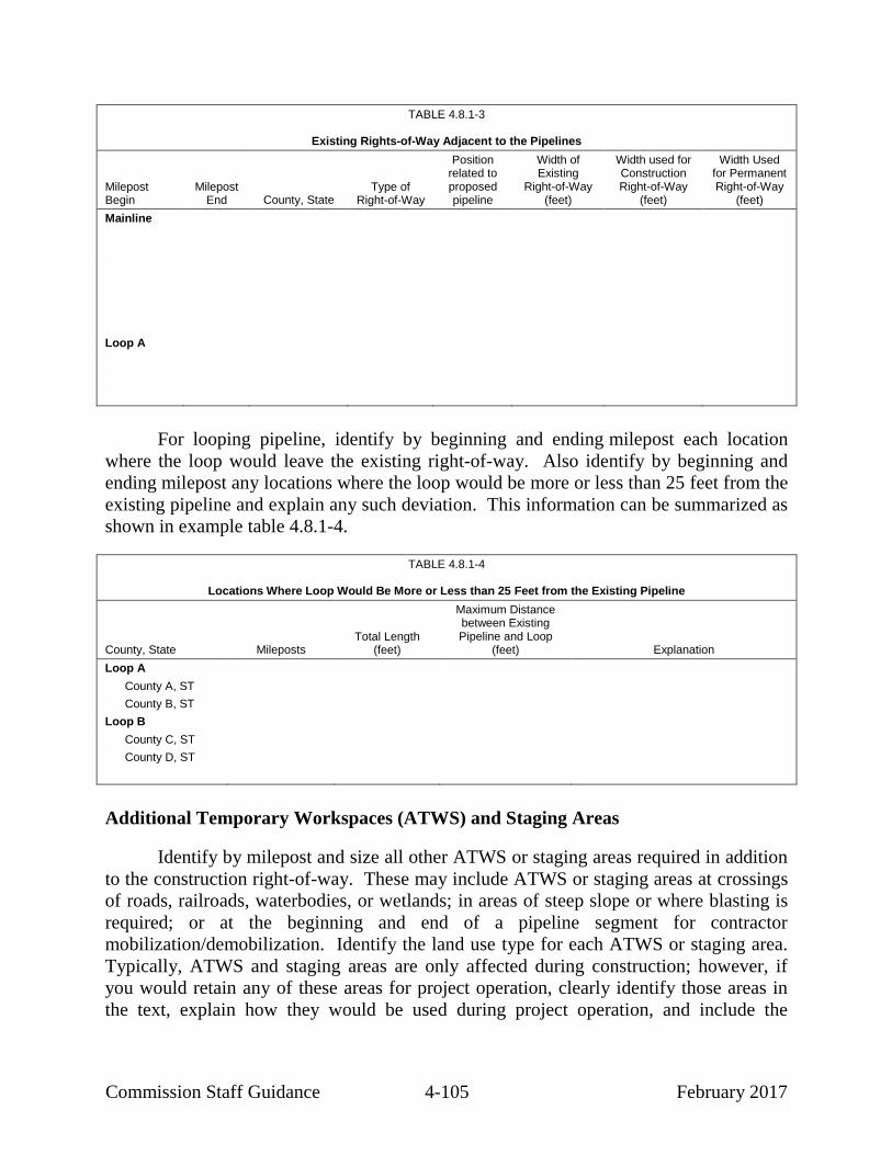
Commission Staff Guidance 4-105 February 2017
TABLE 4.8.1-3
Existing Rights-of-Way Adjacent to the Pipelines
Milepost Begin
Milepost End County, State
Type of Right-of-Way
Position related to proposed pipeline
Width of Existing
Right-of-Way (feet)
Width used for Construction Right-of-Way
(feet)
Width Used for Permanent Right-of-Way
(feet)
Mainline
Loop A
For looping pipeline, identify by beginning and ending milepost each location
where the loop would leave the existing right-of-way. Also identify by beginning and
ending milepost any locations where the loop would be more or less than 25 feet from the
existing pipeline and explain any such deviation. This information can be summarized as
shown in example table 4.8.1-4.
TABLE 4.8.1-4
Locations Where Loop Would Be More or Less than 25 Feet from the Existing Pipeline
County, State Mileposts Total Length
(feet)
Maximum Distance between Existing Pipeline and Loop
(feet) Explanation
Loop A
County A, ST
County B, ST
Loop B
County C, ST
County D, ST
Additional Temporary Workspaces (ATWS) and Staging Areas
Identify by milepost and size all other ATWS or staging areas required in addition
to the construction right-of-way. These may include ATWS or staging areas at crossings
of roads, railroads, waterbodies, or wetlands; in areas of steep slope or where blasting is
required; or at the beginning and end of a pipeline segment for contractor
mobilization/demobilization. Identify the land use type for each ATWS or staging area.
Typically, ATWS and staging areas are only affected during construction; however, if
you would retain any of these areas for project operation, clearly identify those areas in
the text, explain how they would be used during project operation, and include the

Commission Staff Guidance 4-106 February 2017
appropriate acreage in the operation impacts. Show all ATWS or staging areas on the
alignment sheets and aerial photographs submitted with the application.
Calculate the acreage affected in these areas in excess of the typical construction
right-of-way (i.e., do not double-count impacts). For example, a road crossing may
require a total work area of 200 feet by 200 feet on each side of the road. If the typical
construction right-of-way is 75 feet wide, the ATWS would be 125 feet by 200 feet
(0.6 acre on each side of the road or a total of 1.2 acres for the crossing). These data can
be summarized as shown in example table 4.8.1-5. The total acreage required for ATWS
or staging areas for each pipeline segment must be included in the total land requirements
section of Resource Report 1.
TABLE 4.8.1-5
Additional Temporary Workspaces or Staging Areas
Milepost County, State Reason Needed Number of ATWS and
Dimensions (feet) Area
(acres) Existing Land Use
Mainline
Subtotal
Loop A
Subtotal
TOTAL
Access Roads
Identify all temporary access roads that would be used to obtain access to the
right-of-way during construction and all permanent access roads that would be retained
for project operation. Include farm lanes, private drives, logging roads, jeep trails, or
other roads. Indicate their current condition (e.g., graveled, paved, dirt) and state whether
they would need to be modified or improved. Describe the types of modifications to be
made at existing roads (e.g., widening, grading). Do not include existing interstate, state,
county, or local roads unless they would need to be modified or improved for project use
or if the road fords a stream or wetland. In the latter case, you should discuss how you
would conduct the crossing and what measures you would implement to protect the
stream or wetland. Also include new roads that you would create to obtain access to the
right-of-way. Identify the location of each of these roads on USGS topographic maps,
alignment sheets, and aerial photographs. If not visible on alignment sheets due to the

Commission Staff Guidance 4-107 February 2017
scale and distance, we recommend that you provide separate topographic maps that show
the extent of the access roads from where they connect with the right-of-way to their
intersection with an interstate, state, county, or local road. Specify the land use affected
by the widening of existing roads or crossed by new access roads.
Identify the width of existing access roads after any proposed modifications as
well as the length and width of new access roads. State whether you would leave the
modifications or the new access roads after construction is complete and, if not, how you
would restore the area. If any new permanent access roads would cross wetlands or
waterbodies, describe how the roads would be constructed and maintained to avoid or
minimize impacts on the feature crossed. The access road information can be
summarized as shown in example table 4.8.1-6.
TABLE 4.8.1-6
Access Roads
Milepost or Facility
Access Road Name
County, State
Existing Land Use
Width x Length (feet)
Proposed Modification
Construction Requirements
(acres)
Operation
Requirements (acres)
Temporary Access Roads
25.0 TAR-001 County, ST Existing dirt field road
25 x 790 Add gravel, side
trimming
0.5 0.0
42.5 TAR-002 County, ST Agricultural land 25 x 1,200 Grade, add gravel
0.7 0.0
Permanent Access Roads
32.4 PAR-001 County, ST Open land 25 x 800 Grade, add gravel
0.5 0.5
51.7 PAR-002 County, ST Existing dirt field road
25 x 1,000 Widen by 10 feet, add
gravel
0.6 0.6
Pipe and Contractor Yards
Identify the location, size, and land use of all known pipe and contractor yards and
show each yard on USGS topographic maps, alignment sheets, or aerial photographs.
Include the distance and direction to the nearest pipeline milepost and the county and
state in which each yard is located. Describe the extent of ground disturbance that would
take place. Be sure to include total acreage requirements for all pipe and contractor yards
in the land requirements section of Resource Report 1.
Estimate the number and size of any pipe and contractor yards if you have not yet
determined them at the time you file the application. For example, a project consisting of
three loops in three locations could be estimated to require three pipe/contractor yards of

Commission Staff Guidance 4-108 February 2017
approximately 5 acres each. Provide this estimated information as part of the initial filing
and update it once you determine the location and size of each yard. Also complete the
appropriate biological and culture resource surveys on these areas once they are known,
and provide the results of those surveys.
4.8.1.2 Aboveground Facilities
Clearly show the location of each new or modified aboveground facility (e.g.,
LNG facility, compressor station, pig launcher/receiver, block valve, meter station,
storage well) on USGS topographic maps, alignment sheets, and aerial photographs.
Include mileposts for all facilities along the right-of-way.
Specify the amount of land required for all aboveground facilities, excluding those
that would be entirely within the permanent pipeline right-of-way such as block valves or
pig launchers/receivers, and state whether you presently own the land. If you plan to
acquire the land, state whether the landowner is agreeable to the sale or lease of the
property.
For each aboveground facility, identify the acreage of each land use type (e.g.,
agriculture, open land, forest, industrial) that would be affected by construction and
operation. For aboveground facilities that would be entirely within the permanent right-
of-way, identify those that would result in a permanent conversion in land use (for
example, a block valve within the permanent right-of-way might permanently convert the
land use from agricultural to developed land without increasing the total amount of land
affected). If a large parcel of land is associated with a facility (e.g., a compressor
station), identify the total size of the parcel. For land within this parcel that would not be
directly or indirectly affected by construction and operation of the facility, you should
identify the land use type (e.g., agriculture, open space) of that unaffected land during
operation. For a compressor station site, identify how much land surrounding the site
would be held as a buffer and what the land use would be for the buffer following
construction.
Land use affected by aboveground facilities can be summarized as shown in
example table 4.8.1-2 above. Additionally, be sure to include the total acreage of land
disturbed for each aboveground facility in the land requirements section of Resource
Report 1.
4.8.1.3 Facility Abandonment/Replacement
Describe the approximate age of pipeline that you propose to abandon, and
identify by milepost the segments that would be abandoned in place and the segments
that would be removed and why you chose the particular method. Also describe any
segments that would be abandoned by sale (i.e., being sold to another entity for use either
as a continued natural gas pipeline or for transport of other materials, or for salvage). If
applicable, it would be helpful to cross-reference to the section of Resource Report 1 that
Commission Staff Guidance 4-109 February 2017
describes any nonjurisdictional activities or facilities associated with abandonment by
sale.
Identify by milepost the locations that would be disturbed to remove, cut, or cap
the pipe. Also, discuss the feasibility of removing segments of the abandoned pipeline at
waterbodies, wetlands, and residential areas. In residential areas, consult with the
landowners to determine whether they prefer removal or abandonment in place. Explain
whether the right-of-way easement would revert to the landowner or continue to be
maintained by the applicant.
For pipelines that would be removed and replaced, specify whether the
replacement pipeline would be placed in the same trench as the abandoned pipeline. If
not, explain why and describe the sequence of removal and replacement activities.
For aboveground facilities (e.g., block valves, compressors, buildings, tanks),
describe how the facilities and other structures on the site would be abandoned or
removed and how the disturbed areas would be restored to previous land use. If there are
hazardous materials at the site, discuss how these would be handled and disposed of.
For all facilities that would be abandoned or replaced, quantify the amount and
type of land use affected. Indicate whether you anticipate that facilities to be abandoned
or replaced may contain asbestos. If so, describe the protocols for testing, treatment, and
disposal, and identify applicable regulations regarding removal and disposal of these
materials. Also see section 4.12 of this manual regarding Resource Report 12, which
addresses requirements related to potential PCB contamination.
4.8.2 Residential Areas
4.8.2.1 Planned Residential and Commercial Areas
Consult with county and local planning agencies to identify all planned residential
or commercial/business developments and subdivisions that would be crossed by or
within 0.25 mile of the construction right-of-way, ATWS, or staging area(s) (i.e., the
construction work area). Planned development means any development that is included
in a master plan or is on file with the local planning board or the county. For each
planned residential or commercial/business development, provide the distance and
direction from the project, status of permitting (i.e., whether approved or under review by
the local municipality), the timeframe for development and start of construction, and your
proposed coordination with the developer or other appropriate parties to avoid impact on
plotted land parcels. Mitigation measures may include avoiding a planned development
by a route deviation, placing the pipeline along property lines, or purchasing lot(s).
4.8.2.2 Existing Residences and Buildings
You must identify by milepost each residence or building within 50 feet of the
edge of the proposed construction work area. Provide the distance in feet between the

Commission Staff Guidance 4-110 February 2017
residence and the construction work area and the distance in feet between the residence
and the pipeline centerline. Describe proposed measures to minimize construction
impacts in residential areas. In addition to the measures identified in the filing
requirements, we recommend that you include:
how and when you would notify landowners of construction activities;
how you would maintain access and traffic flow during construction
activities, particularly for emergency vehicles;
how you would minimize the hazard of open trenches when construction
activities are not in progress;
how you would minimize noise impacts on the residents (e.g., limiting
speeds and hours of construction); and
how you would minimize fugitive dust from construction activities (this can
be a brief summary, with a cross reference to the appropriate section of
Resource Report 9).
In addition, you should adopt the mitigation measures below, or discuss why they
are not necessary, for all residences within 50 feet of the construction work area:
Do not remove mature trees and landscaping from within the edge of the
construction work area unless necessary to safely operate construction
equipment or as specified in landowner agreements.
Restore all lawn areas and landscaping within the construction work area
immediately after cleanup operations, or as specified in landowner
agreements, consistent with the requirements of the Plan.
Install safety fence along the edge of the construction work area adjacent to
the residence for a distance of 100 feet on either side of the residence to
ensure that construction equipment and materials, including the spoil pile,
remain within the construction work area.
Maintain fencing, at a minimum, throughout active construction in the area.
Maintain a minimum of 25 feet between the residence and the construction
work area for a distance of 100 feet on either side of the residence (i.e.,
reduce the construction work area as necessary to maintain the minimum
distance).
If you cannot maintain a minimum of 25 feet between a residence and the
construction work area, or if a residence is within the construction work area, you should
include a site-specific plan. In some cases, we may request additional site-specific
residential construction plans for residences farther from the construction area. Each site-
specific plan should describe the construction techniques to be used (e.g., reduced

Commission Staff Guidance 4-111 February 2017
pipeline separation, centerline adjustment, use of stove-pipe or drag-section techniques,
working over existing pipelines, pipeline crossover, bore) and include a dimensional site
plan showing, at a minimum, the location and distance of the residence in relation to:
the new pipeline and, where appropriate, the existing pipelines or other
utilities;
the boundaries of the construction work areas;
the edge of the new permanent right-of-way; and
other nearby residences, structures, roads, wetlands, waterbodies, or
residential features (e.g., specimen trees, gardens, decks, pools, swing sets,
fences, driveways).
We also recommend that you describe, either in text or in the site-specific plan,
whether you would remove any existing structures (e.g., fences, outbuildings, stone
walls) during construction, and if so, whether you would replace or relocate them.
If the pipeline centerline would be within 25 feet of a residence, explain how you
would ensure that the trench is not excavated until the pipe is ready for installation and
that the trench is backfilled immediately after pipe installation. If the construction work
area is within 10 feet of a residence, provide evidence of landowner concurrence unless
the construction work area is part of the existing maintained right-of-way.
Table 4.8.2-1 is an example of a listing of residences within 50 feet of the
construction work area and identified mitigation techniques. Figure 4.8.2-1 is an
example of a site-specific plan. If the proposed mitigation for residences within 50 feet
of the construction work area would not include the measures listed above, then identify
alternative mitigation that would provide an equal level of protection from construction
disturbance.
TABLE 4.8.2-1
Residences Within 50 Feet of Construction Work Area and Proposed Mitigation
Milepost County, State
Distance from Construction Work Area
(feet)
Distance from Pipeline Centerline
(feet) Proposed Mitigation
Mainline
Loop A

Com
missio
n S
taff Gu
idan
ce
4-1
12
F
ebru
ary 2
017
[Insert figure 4.8.2-1 Site-specific Residential Plan]

Commission Staff Guidance 4-113 February 2017
4.8.3 Public Land, Recreation, and Other Designated or Special Use Areas
4.8.3.1 Public or Conservation Land
Identify by beginning and ending mileposts and length of crossing all land
administered by federal, state, county, or local agencies, or private conservation
organizations. These may include national or state parks and forests, Indian reservations,
wilderness areas, wildlife management areas, nature preserves, national trails, registered
natural landmarks, flood control land, levee crossings, etc. For each area affected,
identify the primary uses, peak use periods, and any seasonal restrictions. If appropriate
for the project, it may be helpful to provide a table listing public lands crossed or
affected, including the location (by milepost or facility site), the owning or managing
public entity, and the temporary and permanent impacts.
For public lands, including national forests, state forests, and other lands owned or
managed by federal or state agencies, summarize the status of applicable special-use
permits or right-of-way grants and describe your proposed mitigation measures, or those
identified by the land management agency, to resolve specific agency concerns. If the
project would affect land administered by two or more federal agencies (with the
exception of lands held in trust for a Native American tribe, lands on the Outer
Continental Shelf, and lands owned by the National Park Service, for which a right-of-
way requires Congressional approval), you should discuss the status of coordination with
the U.S. Department of the Interior – Bureau of Land Management to obtain a right-of-
way grant under the Mineral Leasing Act.33
Address mitigation for public land that may
include avoiding especially sensitive areas by route deviations, reducing construction and
permanent right-of-way requirements, selectively removing trees, replanting trees or
shrubs within the temporary construction right-of-way, timing construction to occur
during low use or low impact periods, or using special restoration practices. In forested
areas or areas where off-road vehicle traffic is a concern, address whether you would
install and maintain off-road vehicle controls.
If you propose levee crossings, identify the locations of these crossings and
describe the proposed construction methods and mitigation measures. Identify the
agencies or entities from which permits or authorizations would be required for levee
crossings (e.g., levee districts, levee boards, COE, or others as applicable).
For any conservation lands crossed, such as FWS conservation easements or lands
enrolled in the Conservation Reserve Program, Wetland Reserve Program, Wetland
Reserve Easements, or other Agricultural Conservation Easement Program, describe
consultations with the appropriate federal and state agencies and the landowner to
determine whether construction would affect the program status of the land and whether
special construction or revegetation techniques should be used. Also use this
33
30 United States Code § 185 (2012).

Commission Staff Guidance 4-114 February 2017
consultation to identify applicable permits or agreements required to construct the project
facilities across these lands (e.g., compatible use permits, subordination agreements). If
any conservation easements exclude or restrict the installation of pipelines or other
facilities proposed as part of the project, describe these restrictions and the status of any
negotiations or procedures to obtain the necessary approvals to construct the project
facilities on this land. Provide copies of all relevant correspondence, and include in the
permit table provided in Resource Report 1 the permits and authorizations required for
crossing conservation easements.
4.8.3.2 Natural, Recreational, or Scenic Areas
Identify by beginning and ending mileposts and length of crossing all natural,
recreational, or scenic areas; all registered natural landmarks; and other special use areas
(e.g., wetland mitigation banks) crossed by the project. Identify any areas crossed by or
within 0.25 mile of the proposed pipeline or aboveground facility sites that are included
in or designated for study for inclusion in the National Wild and Scenic Rivers System,
the National Trails System, or wilderness areas designated under the Wilderness Act.
Consult with the National Park Service or other applicable federal agency and provide
copies of relevant correspondence. Also identify land of local historical or cultural
significance (e.g., religious sites, historic districts) and cross-reference as appropriate to
Resource Report 4.
4.8.3.3 Agency and Landowner Consultation
Identify public, recreation, or other designated special use areas during your map
and field review and through consultations with federal, state, county, and local agencies.
Consulting agencies early is essential to accurately identify use, concerns, and
potential impact on these lands from pipeline or aboveground facility construction. Also
contact landowners of campgrounds, golf courses, race tracks, and other recreational or
special use areas. Use agency and landowner contacts to determine or confirm the exact
location of land directly affected by construction of the facilities, as well as any special
concerns or constraints that may be associated with construction.
Table 4.8.3-1 is a checklist of typical agency/landowner contacts applicants may
consult to identify potential constraints associated with pipeline construction across
public or special use areas. This general list of jurisdictional entities does not represent
the varying land management structures from state to state.
Include a record of agency and landowner communications, by letter and/or
telephone/conference memoranda, with the application. Include a list of each agency and
department contacted, the name and title of the person contacted, the telephone number,
and the date on which the contact was made.
Summaries of meetings with agencies and open houses held with landowners are
also useful to assist Commission staff in conducting our review.

Commission Staff Guidance 4-115 February 2017
TABLE 4.8.3-1
Agency/Landowner Contacts
Jurisdiction Agency/Landowner Land Affected
Federal U.S. Army Corps of Engineers -Flood control and flood storage land
U.S. Environmental Protection Agency -Hazardous waste sites
U.S. Department of the Interior -National Wildlife Refuges
U.S. Fish and Wildlife Service -Designated critical habitat
-Conservation easements
Bureau of Land Management -Public land
-National monuments
-National conservation areas
-Wilderness and wilderness study areas
-Area of Critical Environmental Concern
-Research natural areas
-National recreation areas
-Other management units/areas identified in an applicable Resource Management Plan
Bureau of Indian Affairs -Indian Reservation lands
National Park Service -National parks
-National Wild and Scenic Rivers
(designated or proposed)
-National Trail system
(including Appalachian Trail)
-National Natural landmarks
-National monuments
-National preserves and reserves
-National lakeshores and seashores
-National historic sites
-National recreation areas
-Wilderness and wilderness study areas
Natural Resources Conservation Service, U.S. Department of Agriculture
-Conservation Reserve Program lands
-Agricultural Conservation Easement Program lands
-Wetland Reserve Program lands
-Wetland Reserve Easements
U.S. Forest Service -National forests
-National recreation areas
-National monuments
-Wilderness and wilderness study areas
-National scenic areas
-National scenic research areas
-National management emphasis areas
-Other management units/areas identified in an applicable Land and Resource Management Plan
National Marine Fisheries Service, National Oceanic and Atmospheric Administration, U.S. Department of Commerce
-Essential fish habitat
-Designated critical habitat
State Department of Environmental Management /Division of Natural Resources, or equivalent
-State forests and parks
-Coastal Zone Management compliance
-Designated recreation areas/trails
-Scenic roads
-State wild and scenic rivers
-Designated open land
Game and Fish Commissions -Game management areas

Commission Staff Guidance 4-116 February 2017
TABLE 4.8.3-1 (cont’d)
Agency/Landowner Contacts
Jurisdiction Agency/Landowner Land Affected
County/Town Planning Commissions -Proposed residential/commercial developments
-Open space/natural areas
-Locally significant roads, scenic areas, or rivers
-Schools, parks, ballfields, trails
Levee Commission -Flood control levees and structures
Other Landowners -Campgrounds
-Landfills
-Golf courses
-Race tracks
-Airfields
-Homeowner associations
4.8.3.4 Impact and Mitigation
List each identified public, recreation, or other designated special use area
by milepost, crossing length, and acreage affected (see example table 4.8.3-2). Also
provide maps depicting these areas in relation to the project. Describe each area and
exactly what portion of that area would be directly affected by construction. For
example, if the proposed facilities would cross a state forest, identify the agency that
administers the forest, the total acreage of land encompassed, and the predominant use of
the land (e.g., wildlife management, wilderness, timber, recreation). Then, identify the
specific resource area within the state forest that construction would affect (for example,
the area adjacent to existing right-of-way within a wildlife management area). In some
cases, we and/or the administering agencies may require site-specific construction plans
for construction within or near public, recreational, or designated special use areas.
TABLE 4.8.3-2
Public Land and Designated Recreation Areas, Scenic Areas, or Other Special Use Areas Crossed by Construction Right-of-Way
Facility/Mileposts County, State Name Crossing Length Acreage Affected by
Construction
Mainline
Loop A
Crossings of scenic rivers and national trails should be avoided if practicable.
Where crossings are proposed, you should consult early with the National Park Service or
other appropriate agency and provide associated documentation. Address avoidance,
minimization, and/or other mitigation measures developed in coordination with the

Commission Staff Guidance 4-117 February 2017
appropriate agency, which may include special construction techniques (e.g., boring,
HDD), visual screen plantings, installing off-road vehicle barriers, timing construction to
minimize impacts on users, and maintaining access throughout the construction period.
As appropriate, identify plans for notifying the public, posting signage, identifying
portage routes, etc.
Also address mitigation measures for other designated areas such as campgrounds,
golf courses, race tracks, etc. Such measures may include construction during the off
season or completing activities within the area as expeditiously as possible. Avoid
construction through landfills and hazardous waste sites. Where construction would
occur within or immediately adjacent to a landfill or hazardous waste site, provide
documentation that construction would not occur within contaminated areas or
contaminated groundwater plumes.
For offshore facilities, identify shipping channels, shellfish beds, or other specific
uses that may be affected by construction and operation of the facilities. Provide
documentation of your consultation with the Bureau of Ocean Energy Management,
Regulation and Enforcement; the Coast Guard, and NOAA Fisheries. Provide your
measures to avoid, minimize, or otherwise mitigate impacts in accord with these
agencies’ concerns.
4.8.4 Contaminated or Hazardous Waste Sites
Identify and describe lands crossed or within 0.25 mile of project facilities that are
known contaminated areas or are used for landfills, hazardous waste sites, quarries,
mines, or other special use areas. Describe any discussions with landowners and
agencies to identify special construction techniques and mitigation measures to be
implemented in these areas. To the extent that some of these areas are discussed in more
detail in Resource Reports 2, 6, 7, or 12, cross-reference to the appropriate sections of
those resource reports.
4.8.5 Coastal Zone Management Areas
You must identify all facilities that would be within designated coastal zone
management areas. You must provide a consistency determination or evidence that a
request for a consistency determination has been filed with the state’s coastal zone
management program. This evidence is required at the time of filing the application. If
the state wants you to defer the filing of the request until a later date, provide
correspondence between your company and the state to that effect and name a state
contact with whom we can consult. The coastal zone consistency determination process
requires adequate lead time and, in our experience, can be confusing for applicants.
Therefore, we advise early consultation with us and the applicable state agency.

Commission Staff Guidance 4-118 February 2017
4.8.6 Visual Resources
The extent of the discussion on visual resources depends on the proximity of the
project facilities to visually sensitive areas and residential areas. Visually sensitive areas,
which may include scenic roads, rivers, and trails, may be designated at the federal, state,
or local level and should be identified during agency consultations. Visual classification
systems have been developed by the federal Bureau of Land Management and U.S.
Forest Service and by some states to rank the scenic quality of various landscapes. Use
these systems where appropriate to quantify the potential visual impact of pipeline or
aboveground facility construction on a given scenic area. Visual impacts on areas such
as historic districts, traditional cultural properties, and places listed on, or eligible for
listing on, the NRHP should be addressed in Resource Report 4.
For all designated or sensitive scenic areas, describe mitigation proposed to reduce
visual impact. Mitigation for pipeline construction may include avoiding areas of high
visibility with route deviations, clearing the right-of-way in forested areas in a feathered
pattern (i.e., not in a straight line), and planting shrubs and small trees within the right-of-
way. Mitigation for aboveground facilities, such as compressor stations, may include
siting the facility to avoid proximity to visually sensitive areas, painting the facility with
colors that would harmonize with the landscape, building facades consistent with
agricultural buildings in the area, or effectively restoring the landscape, including
screening the facility with shrubs and trees. Part (e) of section 380.15 (siting and
maintenance requirements) provides additional information about avoiding and
minimizing impacts on visually sensitive resources.
In considering visual impacts for LNG facilities, we recommend that you also
identify impacts associated with LNG vessels transiting to and from the facility, as well
as flares and lighting. While it may be impossible to mitigate visual impacts from LNG
vessels, identify the impacts on surrounding recreational or residential areas to allow for a
complete environmental review. If necessary, additional details on visual impact (such as
visual simulations) and mitigation (such as screening plans) may be requested.
4.8.7 Applications for Rights-of-Way and Other Land Use
Document that applications for rights-of-way or other proposed land use have
been or will soon be filed with federal land-managing agencies with jurisdiction over
land that would be affected by the project. File these related applications by the time of
filing an application with the Commission. If the other applications have not been filed,
the Commission application must identify the timeframe in which you will file the related
applications with the appropriate agencies and a justification why they were not filed by
this date. Failure to file the related applications shortly after filing your primary
application with the Commission, or an adequate justification for delay, could result in
rejection of the application.

Commission Staff Guidance 4-119 February 2017
4.9 RESOURCE REPORT 9 – AIR AND NOISE QUALITY
INFORMATION OFTEN MISSING AND RESULTING IN DATA REQUESTS
INFORMATION
POTENTIAL DATA
SOURCES a
Air Quality Information (see further discussion below)
Include climate information as part of the air quality information provided for the project area. D, EE
Identify potentially applicable federal and state air quality regulations. J, EE
Provide construction emissions (criteria pollutants, hazardous air pollutants, greenhouse gases) for proposed pipelines and aboveground facilities.
D, R
Provide copies of state and federal applications for air permits. D
Provide operation and fugitive emissions (criteria pollutants, hazardous air pollutants,
greenhouse gases) for pipelines and aboveground facilities.
D, R
Provide air quality modeling for entire compressor stations. D
Identify temporary and permanent emissions sources that may have cumulative air quality effects
in addition to those resulting from the project.
D
Noise and Vibration (see further discussion below)
Describe the existing noise environment and ambient noise surveys for compressor stations, liquefied natural gas facilities, meter and regulation facilities, and drilling locations.
D, U
Identify any state or local noise regulations applicable to construction and operation of the
project.
D, EE
Indicate whether construction activities would occur over 24-hour periods. D
Discuss construction noise impacts and quantify construction noise impacts from drilling, pile
driving, dredging, etc.
D, R
Quantify operation noise from aboveground facilities, including blowdowns. D, R
Describe the potential for the operation of the proposed facilities to result in an increase in perceptible vibration and how this would be prevented.
D, R
Identify temporary and permanent noise sources that may have cumulative noise effects in
addition to those resulting from the project.
D, R
a D Applicant
J U.S. Environmental Protection Agency
R Manufacturer’s Data
U Noise Survey
EE State Air Quality Agency
This guidance manual does not change or substitute for any law, regulation, or
any other legally binding requirement. Where practical, we have distinguished between
legal obligations and Commission staff's interpretations or recommendations. We use
mandatory language such as “required,” “must,” and “must not” to describe controlling
requirements under statutes and regulations. We use non-mandatory language such as
“recommend,” “encourage,” and “may” to describe Commission staff’s
recommendations that will help the Commission meet its obligations under
NEPA. However, because clear distinctions are not always practical, a reader should
consult the regulations directly to determine the information legally required in order to
meet the filing requirements of 18 CFR 380.12.

Commission Staff Guidance 4-120 February 2017
Resource Report 9 is required for applications involving compressor facilities or
new LNG facilities. However, because of our responsibilities under the EPA’s General
Conformity regulations implementing the Clean Air Act, you should file this resource
report for all projects. This report should include an assessment of air, noise, and
vibration impacts both from construction activities (e.g., air emissions from construction
equipment exhaust, fugitive dust emissions, General Conformity applicability, noise from
construction equipment, HDD/drilling operations) and from operation activities (e.g.,
stationary source, marine vessel transit, and fugitive gas emissions; noise from operating
compressor or meter stations).
This report should quantify the impacts of the project on the existing air and noise
environment and describe any proposed measures to mitigate those impacts. The
resource report should present short-term (acute) and/or long-term (chronic) air quality
and noise impacts, as applicable, from constructing and operating any new facilities or
adding to or modifying existing facilities.
4.9.1 Air Quality
4.9.1.1 Existing Air Quality
To identify factors that may affect air quality, you should provide a general
description of climate conditions in the project area. Representative climate data should
include average low and high temperatures during various seasons, average precipitation
and type, and wind conditions and directions.
You should identify all applicable air quality control regions and describe the
existing air quality in the vicinity of the project, including attainment/nonattainment/
maintenance status for all criteria pollutants.34
For compressor stations or LNG facilities,
you must provide the background levels (e.g., ambient monitoring data) of nitrogen
dioxide (NO2) and other criteria pollutants. You should identify monitoring stations from
which you obtained information and identify each station’s monitored criteria
pollutant(s), the owner/controller, station number, location, and nearby land use (rural,
suburban, urban). You may provide any other relevant information to justify your use of
the monitoring station.
34
Criteria air pollutants as identified by the EPA are: carbon monoxide (CO), oxides of
nitrogen (NO2 and NOX), sulfur dioxide (SO2), respirable and fine particulate matter
(particulate matter with an aerodynamic diameter less than or equal 10 microns
[PM10] and less than or equal to 2.5 microns [PM2.5]), airborne lead (Pb), and ozone
(O3) (which results indirectly from emitted precursors nitrogen oxide [NOX] and
volatile organic compounds [VOCs]).

Commission Staff Guidance 4-121 February 2017
4.9.1.2 Regulatory Requirements
The Clean Air Act contains numerous provisions to protect air quality. For
compressor station and LNG facilities, you must explain how you would meet existing
regulatory standards.
You should identify and describe federal, state, and local air quality regulations
and air quality permits that may apply or be required for a project’s construction activities
or operation emission sources. It is useful if you explain why the proposed project
facilities would or would not be subject to each regulation and, if subject, how the project
facilities would comply with the regulation. Example regulations include, but are not
limited to: New Source Review permits; Title V permits; minor source air permits; New
Source Performance Standards; National Emission Standards for Hazardous Air
Pollutants; General Conformity; the Greenhouse Gas (GHG) Reporting Rule; open
burning restrictions; opacity limitations; idling limitations; and use of low-sulfur diesel
fuel.
You must file copies of air permit applications for major sources (New Source
Review or Title V) for compressor station or LNG facilities.35
To reduce the duplication
of efforts and to ensure consistency, you should also consider filing copies of minor
source permit applications and the final permit when it is available.
You should identify Class I areas within 100 kilometers of aboveground facility
stationary sources. If a project facility would be subject to Prevention of Significant
Deterioration (PSD) review or if you have received or anticipate comments (e.g., from
the public or land managing agencies) regarding impacts on Class I areas, we recommend
that you provide an analysis of the impacts of the project facility on the Class I area.36
Also, you should include any copies of correspondence with the federal land manager
regarding air quality impacts from the facilities.
General Conformity
As the lead federal agency, we must perform a General Conformity applicability
test and Determination (as required) for projects in nonattainment or maintenance areas.
In order to fulfill this obligation, we must receive the information needed to perform the
applicability test and Determination (as appropriate), and this information is considered
mandatory. Therefore, if any portion of the project would be within a designated
nonattainment or maintenance area, you must provide the project-related direct and
35
18 CFR § 380.12(k)(3)(ii) (2015). 36
To minimize duplicative efforts, you may file a copy of analyses performed under the
PSD Permitting Program.

Commission Staff Guidance 4-122 February 2017
indirect emissions for comparison with General Conformity applicability thresholds.37
Include all applicable construction and operation emissions.38
The considered emissions
must include construction equipment, marine vessels, vehicle emissions on paved and
unpaved roads, fugitive dust, commuter emissions, pipeline fugitives (VOCs), non-
permitted stationary sources, etc., as applicable. If the project would impact multiple
designated nonattainment or maintenance areas, each designated area for each pollutant
must be considered separately. However, you must combine emission estimates for all
counties identified within the same designated area. It is most useful if you provide a
separate table(s) identifying emissions for each nonattainment or maintenance area.
If the project would exceed the General Conformity applicability thresholds,
emission estimates for motor vehicle emissions must be based on the most current
version of the motor vehicle emissions model specified by the EPA and emission
estimates for non-motor vehicle emissions must be based on the most current emission
factors specified by the EPA in the “Compilation of Air Pollutant Emission Factors” (AP-
42),39
unless more accurate emission data are available. You must indicate how you
would demonstrate conformance with the applicable state implementation plans in
accordance with the General Conformity regulations.40
You must address each criterion
of the General Conformity regulations, explain in detail whether the project would meet
each requirement, and for each criterion being satisfied, provide supporting information
on how the project would comply. Also, you should include any correspondence with the
state or EPA Regional Office.
4.9.1.3 Air Quality Impacts
Air quality may be affected by construction and/or operation of project facilities.
Therefore, to develop a complete understanding of a project’s impacts on local and
regional air quality, you should provide emission estimates, mitigation measures, and
impact analyses.
37
40 CFR § 93.153(b)(1)-(b)(2) (2015) (emissions thresholds in tons per year). 38
Any emission sources that are subject to a major or minor New Source Review permit
are exempt from General Conformity. 39
The EPA’s regulations provide a full list of methodologies and exceptions. 40 CFR
§ 93.159 (2015). You should also consult with applicable state air pollution control
agencies about suggested methodologies or emission categories for estimated
construction emissions. 40
40 CFR § 93.158 (2015).

Commission Staff Guidance 4-123 February 2017
Construction Impacts and Mitigation
You should provide estimated direct emissions of criteria pollutants, VOCs, total
hazardous air pollutants (HAP), and GHGs41
in tons per year resulting from the
construction of the proposed project. This includes pipelines greater than 5 miles in
length42
(or any length in designated nonattainment/maintenance areas), compressor
stations, LNG facilities, and other aboveground facilities. You should include emissions
from activities such as site grading, excavation, trenching, pile-driving, HDD operations,
filling, demolition, pipe removal, drilling activities, delivery vehicles, delivery barge
emissions, dredging, fugitive dust, clean/pigging activities, open burning, and tailpipe
emissions from construction equipment and workers commuting. The information is
most useful if the emissions are broken down by calendar year based on the construction
schedule. You should support your emission estimates with detailed calculations,
emission factors, fuel consumption rates, vehicle power ratings, utilization rates, and
hours of operation. The detailed construction emissions calculations may be provided in
an appendix to Resource Report 9; however, you should include a summary table in the
text portion of the resource report, similar to example table 4.9.1-1, adapted as
appropriate to the project.
You should calculate construction emissions based on the current version of one of
the following EPA-developed methodologies:
Motor Vehicle Emission Simulator (MOVES), or other EPA-developed
motor vehicle emissions model;
NONROAD model; or
AP-42, Compilation of Air Pollutant Emission Factors.
Guidance for using each of these models is available on the EPA website. Other
publicly available methodologies or reference material may be appropriate, particularly
for calculating fugitive dust emissions. You should provide justification for the use of
other reference material or methods.
41
GHG emissions should include the emission categories and/or methodologies
described in the most current version of the CEQ’s guidance on GHG emissions and
climate change, as applicable. 42
This distance is based on FERC staff’s historical project experience, which has
demonstrated that pipeline construction under 5 miles in length does not result in
significant impacts.

Commission Staff Guidance 4-124 February 2017
TABLE 4.9.1-1
Construction Emissions (Year 1–Year 2) (tons per year)
Construction Activity NOX SO2 CO PM10 PM2.5 VOC CO2e Total HAPs
Pipeline Construction
Commuter transit
On-road vehicles
Off-road equipment
Open burning
Fugitive dust
Subtotal
Compressor Station Construction
Commuter transit
On-road vehicles
Off-road equipment
Open burning
Fugitive dust
Subtotal
Project Total
___________________
Notes:
CO = carbon monoxide
CO2e = carbon dioxide equivalent
HAPs = hazardous air pollutants
NOX = nitrogen oxides
PM2.5 = fine particulate matter with an aerodynamic diameter less than or equal 2.5 microns
PM10 = fine particulate matter with an aerodynamic diameter less than or equal 10 microns
SO2 = sulfur dioxide
VOCs = volatile organic compounds
You should describe proposed mitigation measures that you commit to
implementing to minimize construction emissions of criteria pollutants, HAPs, and/or
GHGs. Examples of measures to minimize emissions from construction equipment
include using low-sulfur diesel fuel, limiting equipment idling, using newer fleets,
maintaining equipment, and complying with EPA mobile source emissions performance
standards.
You should also identify your procedures to mitigate fugitive dust emissions,
including measures to reduce emissions of particulate matter with an aerodynamic
diameter less than or equal to 10 microns and less than or equal to 2.5 microns. For
larger projects, or projects in particulate matter nonattainment or maintenance areas, you
should provide a fugitive dust control plan. This plan should identify the mitigation
measures that you commit to implement, for example: spraying water on disturbed areas;
stabilizing unpaved access roads with non-toxic soil stabilizers or weighting agents;
limiting vehicle speeds on unpaved roads; covering, seeding, or treating spoil piles with
dust suppressant if they will remain inactive for extended periods of time or are subject to
windy conditions; using rock access pads to prevent vehicle tires from tracking soil onto
paved roads; and street cleaning to remove mud/trackout. Be specific when describing
these measures (for example, identify the speed limit, size/location of gravel pads, and
other details).

Commission Staff Guidance 4-125 February 2017
Operation Impacts and Mitigation
The goal of this section is to ensure that all direct operation emissions of criteria
pollutants (except lead), speciated HAPs, and GHGs are quantified, and concentrations of
criteria pollutants are identified and compared with the National Ambient Air Quality
Standards (NAAQS).
Aboveground Facilities
You should describe all emission-generating equipment to be installed at new or
modified compressor stations, LNG facilities, meter stations, or other facilities. Sources
may include heaters, boilers, turbines, generators, reciprocating engines, dehydrators,
relief valves, flares, oxidizers, submerged combustion vaporizers, firewater pumps, tank
emissions, other fugitive emissions, and unloading/loading emissions.
For each new equipment source at the facility you should indicate the make, model
number, fuel type, fuel consumption rate, load factor, hours of operation, and emission
factors (for criteria pollutants, HAPs, and GHGs). For existing facilities, you should
identify the number and type of each emission source, and the total existing emissions
from the facility (as permitted or based on the facility’s potential to emit). Emissions of
criteria pollutants (except lead), HAPs, and GHGs from each source should be provided
in tons per year and grams per second under maximum operating conditions. You should
also provide the above-referenced information for mobile marine operating emissions,
including marine vessel equipment and propulsion. Marine vessel emissions should
account for all transit, maneuvering, escorting, or hotelling within state-designated
waters. In addition, the fugitive gas emissions from each compressor station or LNG
facility should be quantified in tons per year for methane, VOCs, and HAPs. To facilitate
review of this information, you should provide detailed information in an appendix, and
summarize this information in the main text of Resource Report 9 similar to example
table 4.9.1-2, as appropriate for the project. Speciated HAPs should appear in a separate
table. Emission tables should clearly show the emission rates from any existing
equipment at the compressor station and the proposed new or modified equipment at the
compressor station.
You should indicate whether you would install any blowdown facilities. If so, you
should describe the expected types (e.g., individual unit, full station, capped), estimate
the average number of yearly blowdowns by type, and the amount of gas released per
event type, quantified as methane in tons and as GHG in tons of carbon dioxide
equivalent (CO2e).

Commission Staff Guidance 4-126 February 2017
TABLE 4.9.1-2
Operation Emissions Summary (tons per year)
Facility NOX SO2 CO PM10 PM2.5 VOCs Total HAPs CO2e
Compressor Station 1
Compressor Station 2
Meter Station 1 (with heaters)
Meter Station 2 (no heaters)
Pipeline (including valves)
_____________________
Notes:
CO = carbon monoxide
CO2e = carbon dioxide equivalent
HAPs = hazardous air pollutants
NOX = nitrogen oxides
PM2.5 = fine particulate matter with an aerodynamic diameter less than or equal 2.5 microns
PM10 = fine particulate matter with an aerodynamic diameter less than or equal 10 microns
SO2 = sulfur dioxide
VOCs = volatile organic compounds
All GHG emissions should be given as carbon dioxide (CO2), nitrous oxide (N2O),
methane (CH4), and combined as CO2e. The Global Warming Potential used should be
the most recent value used by the EPA for its GHG Reporting rule.
Emission Factors should be based on one of the following methodologies (with
citation):
EPA-certified emission standards;
manufacturer data;
EPA’s current AP-42 emission factors; or
peer reviewed studies for the equipment.
For compressor stations or LNG facilities, you must describe any manufacturer’s
specifications or equipment that you commit to implementing (through air permitting or
voluntarily) to mitigate air impacts from criteria pollutants, HAPs, and/or GHGs. You
should also indicate whether you are a partner in the EPA’s Natural Gas STAR Program
or Methane Challenge Program, and any recommended measures from those programs or
other state programs that you would implement on aboveground facilities to reduce
methane emissions. For any air pollution control equipment or mitigation measures, you
should identify the control efficiency.
For new or modified compressor stations or LNG facilities, you must estimate the
impact of the project on air quality. To do this we recommend that you provide an air
quality analysis (screening or refined dispersion model) identifying the impact of the
facility in comparison with the NAAQS or applicable state standards. The modeling
level (i.e., screening or refined dispersion modeling) should be consistent with the scope
of the project. Comparisons should be based on the statistical basis developed for each

Commission Staff Guidance 4-127 February 2017
NAAQS. You should include all source input parameters (emission rate, stack height,
stack temperature, exit velocity, etc.) and justify the bases for any assumptions. For any
analysis using refined modeling (AERMOD or another EPA-accepted model), you should
provide a description of how you performed the modeling (for example, identify the
specific model number, meteorological and terrain data and source, NO2/NOX conversion
rate, source parameters, building information, receptor grids, etc.). You should also file
the input and output files in a format compatible with eLibrary (e.g. as text files). You
should also consider providing electronic files to staff for verification.
If the project involves modification of an existing compressor station or LNG
facility (e.g., adding or replacing compressor units), the air quality analysis should
identify the incremental increase in air quality impact of criteria pollutants from the
entire facility in comparison with the NAAQS and/or applicable state standards. To
accomplish this, you should: (1) model the existing compressor station with
modifications, add background concentrations, and compare with the NAAQS; or (2)
collect 1 year of on-site ambient monitoring to add to modeling of the modifications for
comparison with the NAAQS. For any alternative monitoring timeframes, you should
provide justification, based on site- and/or project-specific reasons. For new or modified
LNG facilities, the air quality analysis should include mobile ship emissions (LNG
carrier, tugs, escort vessels) that would occur within the moored safety zone, including
these possible scenarios:
transiting through the moored safety zone;
hotelling within the moored safety zone; and
unloading/loading within the moored safety zone.
To the extent that air modeling performed for any facility as part of an air
permitting process includes the emission sources and pollutants identified above, you
may file that modeling effort to avoid duplicative efforts.
In addition to providing the results of the air quality analyses (typically provided
as appendices to Resource Report 9 due to their length), you should summarize the
results of the air quality analyses in tables within the text (see example table 4.9.1-3).
Pipeline Facilities Operation Emissions
You should provide estimates of operation emissions of methane, GHGs as CO2e,
VOCs, and HAPs associated with fugitive gas releases from the pipeline, valves, meter
stations, regulation facilities, and pig launcher/receivers along the pipeline, quantified in
tons per year. You should include supporting calculations and describe all assumptions.
You should also indicate whether you are a partner in the EPA’s Natural Gas STAR
Program or Methane Challenge Program, and any recommended measures from those
programs or other state programs that you would implement on pipeline facilities.

Commission Staff Guidance 4-128 February 2017
TABLE 4.9.1-3
Compressor Station ABC AERSCREEN Modeling Results
Pollutant Averaging
Period Combined Model
Concentration (μg/m3)
Ambient Background (μg/m
3)
Total Concentration (μg/m
3)
NAAQS (μg/m
3)
CO 1-Hour
8-Hour
NO2 1-Hour
Annual
PM2.5 24-Hour
Annual
PM10 24-Hour
SO2 1-Hour
____________________
Notes:
μg/m3 = microgram per cubic meter
CO = carbon monoxide
NO2 = nitrogen dioxide
PM2.5 = fine particulate matter with an aerodynamic diameter less than or equal 2.5 microns
PM10 = fine particulate matter with an aerodynamic diameter less than or equal 10 microns
SO2 = sulfur dioxide
4.9.2 Noise and Vibration
Impacts on the noise environment can result from both construction and operation
of natural gas pipeline facilities and LNG facilities. Two measures to relate the time-
varying quality of environmental noise to its known effect on people are the 24-hour-
equivalent sound level (Leq) and day-night sound level (Ldn). The Leq is the level of
steady sound with the same total (equivalent) energy as the time-varying sound of
interest, averaged over a 24-hour period. The Ldn is the Leq plus 10 decibels on the
A-weighted scale (dBA) added to nighttime levels to account for people’s greater
sensitivity to nighttime sound levels (between the hours of 10 p.m. and 7 a.m.). The A-
weighted scale is used because human hearing is less sensitive to low and high
frequencies than mid-range frequencies. The human ear’s threshold of perception for
noise change is considered to be 3 dBA; 6 dBA is clearly noticeable to the human ear;
and 10 dBA is perceived as a doubling of noise.
In 1974, the EPA published its Information on Levels of Environmental Noise
Requisite to Protect Public Health and Welfare with an Adequate Margin of Safety. This
document provides information for state and local governments to use in developing their
own ambient noise standards. The EPA determined that an Ldn of 55 dBA protects the
public from indoor and outdoor activity noise interference. An Ldn of 55 dBA is
equivalent to a continuous noise level of 48.6 dBA. New or modified compressor
equipment or LNG equipment should not exceed this level at receptors known as NSAs.
Examples of NSAs include residences, schools and day-care facilities, hospitals,
long-term care facilities, places of worship, and libraries. NSAs may also include
campgrounds, parks, and wilderness areas valued specifically for their solitude and
tranquility.

Commission Staff Guidance 4-129 February 2017
4.9.2.1 Existing Noise Levels
Mapping
For each new or modified compressor station, you must provide a plot plan (scale
1:3,600 or greater) in Resource Report 1 or in separate graphics provided with this
resource report (preferably USGS topographic maps or aerial photos at a scale that
clearly depicts the relevant features) that depicts any NSAs within 1 mile of the new or
modified compressor station. Aerial images must not be more than 1 year old (unless
older ones accurately depict current land use and development). Similarly, you should
provide a plot plan of any proposed new or modified LNG facility and NSAs within
1 mile. These plot plans should include compressor buildings, cooling fans, blowdown
stacks, LNG equipment, station/facility fencing, and property lines.
You should also provide map(s) of proposed or modified meter stations, HDD
entry and exit sites, Direct Pipe activities, or locations for well drilling or pile driving.
These maps should identify NSAs within 0.5 mile of the facility or activity. NSAs
should be provided in all directions and the maps should identify the distance between the
noise-generating facilities, the NSAs, and ambient noise measurement positions.
The text or tables in Resource Report 9 should describe the land use as well as
each type of NSA and the distance and direction from the compressor station, LNG
facility, meter station, or nighttime construction activity.
Ambient Noise Estimates
For new or modified compressor stations or LNG facilities, you must
quantitatively describe the existing noise levels at NSAs. In accordance with
section 380.12(k)(2), for existing compressor stations and LNG facilities you must
conduct an ambient sound survey for the NSAs and provide a copy of the report
describing the methodology and results. You must conduct the noise survey at the site
property line and nearby NSAs when the facility is operating at full load. Provide the
results of the noise survey of the existing facilities as Leq (day) from 7 a.m. to 10 p.m., Leq
(night) from 10 p.m. to 7 a.m., and the calculated Ldn.
For new compressor stations or LNG facilities, you must provide estimates of the
existing sound environment based on current land uses or measured sound surveys;
however, we recommend that you perform an ambient sound survey to quantitatively
describe the existing noise environment. You should provide the existing daytime (Ld)
and nighttime (Ln) ambient equivalent sound level and the calculated Ldn for each NSA.
We have also found that meter stations and certain construction activities (e.g.,
HDDs, Direct Pipe, well drilling, and pile driving) can contribute noise at NSAs within
0.5 mile. Further, many 24-hour-per-day construction activities (e.g., HDDs, Direct Pipe,

Commission Staff Guidance 4-130 February 2017
well drilling, and pile driving) often require several weeks or months to complete.
Therefore, you should also quantitatively describe ambient noise levels at NSAs within
0.5 mile of meter stations or these construction activities based on current land uses or
measured sound surveys. You should provide the existing day and night Leq ambient
noise levels and the calculated Ldn for each NSA.
Ldn is calculated using the formula:
Ldn = 10log10((15/24)10Leq (day)/10
+ (9/24)10(Leq (night)+10)/10
)
You should describe conditions during noise surveys, including:
date and time for each measurement;
the physical and ambient environment;
state of vegetation cover;
duration of measurements (periodic, 24-hour, etc.);
weather conditions;
wind speed and direction;
engine load; and
other sources of noise present during noise measurement at each location.
During periodic sound level measurement, you should avoid times when unusual
or extraneous noise that is not typical of station operation is occurring, such as noise from
traffic, pets, lawnmowers, insects, or nearby construction activity. If wind, rain, or other
intermittent conditions elevate the background noise levels by more than 10 decibels, you
should postpone the survey until conditions improve (American National Standards
Institute/Acoustical Society of America S.1.13-2005). The survey report should provide
information on the existing facility noise-generating equipment, including types, year of
installation, etc., as appropriate.
4.9.2.2 Regulatory Requirements
You should identify any potentially applicable state or local noise regulations or
ordinances. Describe how they would or would not apply to the project and identify
whether you commit to comply.
4.9.2.3 Noise Impacts
Construction Noise Impacts and Mitigation
You should provide a general description of noise sources for pipeline and/or
aboveground facility construction and indicate whether construction would occur during
nighttime hours (10 p.m. to 7 a.m.).

Commission Staff Guidance 4-131 February 2017
HDD, Direct Pipe Installation, Well Drilling, and Nighttime Construction
For each entry or exit location for HDD/Direct Pipe installation, each site for well
drilling, or each site of nighttime construction with NSAs within 0.5 mile, Resource
Report 9 should include an estimate of the number of days that drilling would be required
and state whether drilling would be conducted for 24 hours per day or for some period
during nighttime hours. If construction activity would or may occur during nighttime
hours, you should provide the Ldn of existing noise levels at all NSAs within 0.5 mile, the
estimated noise impacts at those NSAs from the construction activity, and the estimated
increase in background noise. Construction activity that would or may occur during
nighttime hours should be performed with the goal that the activity contribute noise
levels below 55 dBA Ldn and 48.6 Leq, or no more than 10 dBA over background if
ambient noise levels are above 55 dBA Ldn. You should describe all reasonable noise
mitigation that you commit to implementing during the construction activity to reduce
noise impacts at the NSAs to meet the goal. Also, for short-duration nighttime
construction (under 1 week), describe any alternative measures, such as temporary
relocation or compensation, proposed to minimize noise impacts on area residents.43
If
you retain a noise consultant for the acoustical analysis who recommends noise
mitigation measures, be sure to state clearly and affirmatively which of the recommended
measures you commit to implement.
Pile Driving and Dredging
Pile driving can result in an intense, high impact sound level. When applicable, in
Resource Report 9 you should evaluate and quantify noise impacts transmitted through
air from pile driving operations at NSAs within 1 mile and underwater on aquatic species.
For impacts on NSAs, report impacts in Lpeak (peak of sound pressure wave with no time
weighting) or Lmax (highest sound measured by the sound level meter over a given period
of time). You should identify whether these operations would occur over 24 hours, how
many pile-driving units would be operating at one time, the type and number of piles,
installation method, equipment, and the length of time that pile driving would occur.
You should provide supporting documents, calculations, and all assumptions used to
estimate the noise impacts.
Dredging may occur over a 24-hour-per-day schedule and may be close to coastal
communities and impact aquatic species. If a project involves dredging, you should
evaluate and quantify noise impacts transmitted through air at all NSAs within 0.5 mile
and underwater on aquatic species. Resource Report 9 should identify the dredge type,
43
We have routinely found that temporary relocation or compensation for relocation for
nighttime construction activities lasting over 1 week presents an unreasonable burden
on NSAs and is unacceptable.

Commission Staff Guidance 4-132 February 2017
whether these operations would occur over a 24–hour-per-day schedule, how long the
dredging would occur, and how many dredge units would be operating simultaneously.
You should provide supporting documents, calculations, and all assumptions used to
estimate the noise impacts.
If you provide the underwater noise analyses for pile driving and/or dredging in
Resource Report 2 or 3, give an appropriate cross–reference in Resource Report 9.
Blasting
If blasting would be required, you should provide a plan, or include methods in the
proposed blasting plan prepared in accordance with section III.F.4 of our Plan, to
mitigate noise and vibration impacts on NSAs during blasting operations. If blasting near
water, you should include the underwater noise impact on aquatic species.
Operation Noise Impacts and Mitigation
You must provide an acoustical analysis identifying noise impacts from each new
or modified compressor station or LNG facility on NSAs within 1 mile of the compressor
station or LNG facility. Similarly, you should provide an acoustical analysis identifying
noise impacts from each new or modified meter station on NSAs within 0.5 mile.
Noise sources should include all predominant noise producing equipment at the
facility including engines, turbines, electric motors, compressors, boilers, gas coolers, oil
coolers, vent fans, liquefaction equipment, vaporization equipment, flares, pumps, ship
noise, intake and exhaust noise, and all appurtenant equipment. The noise impact from
compressor station or LNG facility equipment must be based on far-field sound data
provided by the manufacturer, or on sound level measurements of similar equipment in
service elsewhere. You should identify and quantify mitigation measures, including
specific noise control equipment and propagate the resultant noise (Leq and Ldn in A-
weighted decibels) at the nearest NSAs. The data should represent the maximum
load/noise of the proposed equipment and identify the equipment manufacturer and
model for all major noise sources. You should provide octave band noise data for each
source.
For a new or modified compressor station or LNG facility you must provide a
description and specifications of proposed noise control measures to reduce the facility’s
noise contribution to below 55 dBA Ldn (such as intake and exhaust silencers, and/or
building and pipe insulation). You should also provide the same information for new or
modified meter stations. You should describe the construction of the proposed
compressor building and the acoustic insulation specifications/insertion loss for the
building’s walls and ceiling. Include a narrative discussing data sources and a basis for
any calculations or noise models used to generate the noise estimates. You should
provide octave band noise data for each noise control measure.
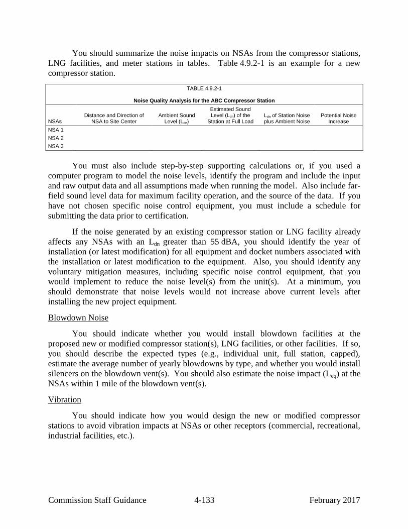
Commission Staff Guidance 4-133 February 2017
You should summarize the noise impacts on NSAs from the compressor stations,
LNG facilities, and meter stations in tables. Table 4.9.2-1 is an example for a new
compressor station.
TABLE 4.9.2-1
Noise Quality Analysis for the ABC Compressor Station
NSAs Distance and Direction of
NSA to Site Center Ambient Sound
Level (Ldn)
Estimated Sound Level (Ldn) of the
Station at Full Load Ldn of Station Noise plus Ambient Noise
Potential Noise Increase
NSA 1
NSA 2
NSA 3
You must also include step-by-step supporting calculations or, if you used a
computer program to model the noise levels, identify the program and include the input
and raw output data and all assumptions made when running the model. Also include far-
field sound level data for maximum facility operation, and the source of the data. If you
have not chosen specific noise control equipment, you must include a schedule for
submitting the data prior to certification.
If the noise generated by an existing compressor station or LNG facility already
affects any NSAs with an Ldn greater than 55 dBA, you should identify the year of
installation (or latest modification) for all equipment and docket numbers associated with
the installation or latest modification to the equipment. Also, you should identify any
voluntary mitigation measures, including specific noise control equipment, that you
would implement to reduce the noise level(s) from the unit(s). At a minimum, you
should demonstrate that noise levels would not increase above current levels after
installing the new project equipment.
Blowdown Noise
You should indicate whether you would install blowdown facilities at the
proposed new or modified compressor station(s), LNG facilities, or other facilities. If so,
you should describe the expected types (e.g., individual unit, full station, capped),
estimate the average number of yearly blowdowns by type, and whether you would install
silencers on the blowdown vent(s). You should also estimate the noise impact (Leq) at the
NSAs within 1 mile of the blowdown vent(s).
Vibration
You should indicate how you would design the new or modified compressor
stations to avoid vibration impacts at NSAs or other receptors (commercial, recreational,
industrial facilities, etc.).

Commission Staff Guidance 4-134 February 2017
4.10 RESOURCE REPORT 10 – ALTERNATIVES
INFORMATION OFTEN MISSING AND RESULTING IN DATA REQUESTS
INFORMATION
POTENTIAL DATA
SOURCES a
Ensure that project objectives that serve as the basis for evaluating alternatives are consistent
with the purpose and need discussion in Resource Report 1.
D
Identify and evaluate alternatives identified by stakeholders. D
Clearly identify and compare the corresponding segments of route alternatives and route
variations with the segments of the proposed route that they would replace if adopted.
D
a D Applicant
This guidance manual does not change or substitute for any law, regulation, or
any other legally binding requirement. Where practical, we have distinguished between
legal obligations and Commission staff's interpretations or recommendations. We use
mandatory language such as “required,” “must,” and “must not” to describe controlling
requirements under statutes and regulations. We use non-mandatory language such as
“recommend,” “encourage,” and “may” to describe Commission staff’s
recommendations that will help the Commission meet its obligations under
NEPA. However, because clear distinctions are not always practical, a reader should
consult the regulations directly to determine the information legally required in order to
meet the filing requirements of 18 CFR 380.12.
Resource Report 10 is required for all applications. It must describe alternatives
that were considered during the identification and design of the project and compare the
environmental impacts of such alternatives with those of the proposed project. Resource
Report 10 should describe the systematic procedure used to arrive at the proposed project,
starting with the broadest feasible range of alternatives and narrowing the alternatives to
a specific action on a specific site or right-of-way. The description of this procedure
should include the decision criteria used, the information weighed, and an explanation of
the conclusion at each decision point. The decision criteria must show how
environmental benefits and costs, even if not quantifiable, were weighed against
economic benefits and costs, and technological and procedural constraints. The
alternatives analysis should be based on, and consistent with, the purpose and need
statement provided in Resource Report 1. A clearly articulated purpose and need
statement facilitates the preparation of Resource Report 10 and the applicant’s ability to
demonstrate why an alternative may or may not function as a suitable replacement for the
proposed project.
At a minimum, Resource Report 10 must address the no-action alternative and the
potential for accomplishing the same objectives through the use of other natural gas
systems and/or energy conservation. The alternative analysis beyond the no-action
alternative should be driven by the extent and type of resource impacts and by public or

Commission Staff Guidance 4-135 February 2017
agency comments. Depending on the project, it may also be appropriate for the
alternatives analysis to address system alternatives, route alternatives, and aboveground
facility site alternatives. Further, in some cases, it may be appropriate to address
alternatives to other aspects of the project, such as alternative construction technologies,
dock locations or configurations for LNG facilities, power and water sources for LNG or
compressor facilities, or process alternatives to specialized technologies such as natural
gas liquefaction. We might identify such additional analysis, or it may be warranted
based on agency or public input.
4.10.1 General Guidance
Resource Report 10 should provide a brief summary of project
modifications that you adopted prior to filing the application to minimize
environmental impact or to respond to a stakeholder issue, especially those
modifications suggested during pre-filing. There is no need to itemize
modifications that you adopted for engineering reasons.
For each of the applicable alternative types discussed below, provide
environmental comparison tables that include all of the resource data that is
pertinent and useful for comparing the alternatives at the specific location.
For instance, the project area may include unique features, such as karst
features, prime farmland, sensitive species habitat, old growth forest,
special crops, conservation easements, waterbodies, wetlands, residential
developments, etc., that should be included in the comparison tables.
Data sources used to compare the impacts of an alternative with the impacts
of the corresponding portion(s) of the proposal should be consistent, based
on either field data for both or desktop data for both (e.g., aerial
interpretation, NWI maps, USGS topographic maps), in order to allow for
an objective comparison. In practice, this will usually mean that you
generate desktop data for the segments of the proposed alignment that are
subject to an alternatives review. However, alternatives selected for more
detailed study may also require field data. We may also request landowner
address lists for alternative routes that are under more detailed study.
4.10.2 No-Action Alternative
Address the consequences of not constructing the project. In addition to avoiding
the impacts directly associated with the construction of the project (e.g., disturbance of
wetlands, air quality impacts, clearing of vegetation) the no-action alternative discussion
should discuss what other options may be pursued by customers of the proposed project
to satisfy the need for the proposed project. For example, if the proposed project were
not constructed, describe the alternatives to meet the project objectives and, if known, the
likely environmental effects and costs of pursuing these options. These options should

Commission Staff Guidance 4-136 February 2017
include the use of other natural gas systems, non-gas energy alternatives, and/or energy
conservation or efficiency, as applicable.
4.10.3 System Alternatives
System alternatives are those that would meet the objectives of the project, but
would use a different (and often existing) natural gas facility/pipeline system or a
different configuration of facilities that would eliminate the need to construct all or part
of the project. If modifications or additions to the existing facilities/systems would be
required to meet the project objectives, you should quantify the environmental impact of
these modifications for comparison with those of the proposed project. The
modifications could include constructing additional compression facilities, either at new
or existing compressor stations, constructing additional pipeline loops, or constructing
new segments of pipeline to interconnect existing pipeline systems.
System alternatives should include alternative configurations both on your own
system and on one or more other companies’ facilities. Examples of the former could
include alternative placement of pipeline loop or compressor stations that may avoid
sensitive resource areas or alternative pipe diameters or compression scenarios to reduce
pipeline or compression requirements while still meeting the requirements of the
proposed project. The descriptions of these examples should clearly identify and
compare the alternative(s) considered with the corresponding segment of the project.
Examples of the latter, alternatives using other companies’ facilities, should
include an examination of the current capacities of existing systems, to the extent this
information is available, and an assessment of these systems’ ability to individually or in
combination meet the objectives of the proposed project. If the existing systems are
inadequate, you should examine whether any recently proposed facilities are able to
individually or in combination meet the objectives of the proposed project. If these
recently proposed facilities are also inadequate, you should examine what new facilities
one or more companies would likely need to construct to achieve the objectives of the
proposed project.
The description of each system alternative should include a map identifying the
location both of existing pipeline systems (pipelines and compressor stations) that could
be used and of any new pipeline and/or new or additional compression facilities that
would be required. The map should be of a scale that also provides coverage of the
corresponding segment of the project. Figure 4.10.3-1 shows a typical map of a proposed
project and a system alternative that could each meet the project need with additional
facilities.
The analysis of system alternatives should include a comparative table that
presents the characteristics and environmental factors of the system alternative(s) and of
the corresponding segment of the proposed project (see example table 4.10.3-1).
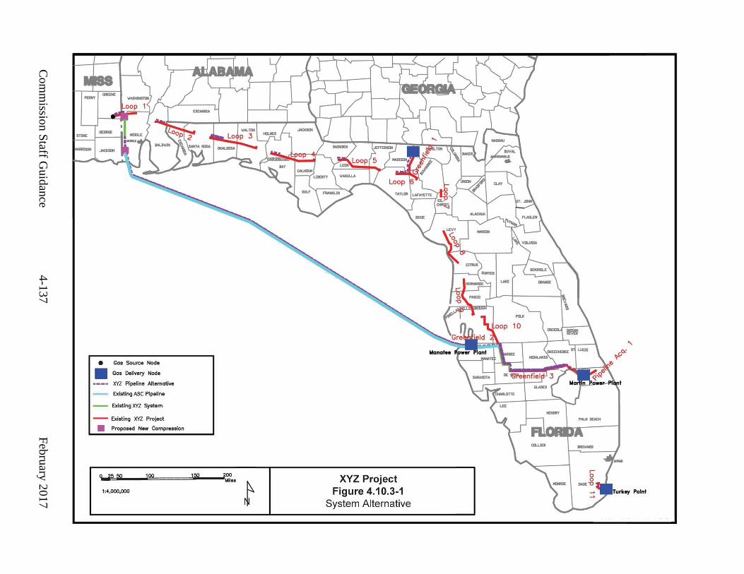
Com
missio
n S
taff Gu
idan
ce
4-1
37
F
ebru
ary 2
01
7

Commission Staff Guidance 4-138 February 2017
TABLE 4.10.3-1
Comparison of System Alternatives
Characteristics or Resources Unit Proposed Project
Lateral System Alternative
Mainline System Alternative
Pipeline and Compression Facilities
Total length (mi)
New pipeline (mi)
Loop pipeline
36-inch-diameter pipe (mi)
30-inch-diameter pipe (mi)
Total compressor stations
Upgraded (no.)
New (no.)
Total compression
Upgraded (hp)
New (hp)
Environmental Factors
Construction right-of-way a (acres)
Permanent right-of-way b (acres)
Length adjacent to existing right-of-way or corridor
(percent)
Total wetlands affected c (acres)
Forested wetlands (acres)
Scrub-Shrub wetlands (acres)
Total perennial waterbodies crossed (no.)
Major waterbody crossings (>100 feet) (no.)
Natural and scenic rivers (no.)
Endangered or threatened species habitat
(no.)
Known cultural resources (no. or miles)
Federal land crossed (mi)
State land crossed (mi)
Other recreation/designated land use areas
(no.)
Length of crossing (mi)
Existing residences within 50 feet of construction work area
(no.)
____________________ a Based on a xx-foot-wide construction right-of-way.
b Based on a xx-foot-wide right-of-way for the proposed project; a xx-foot-wide right-of-way for the Lateral System
Alternative; and a xx-foot-wide right-of-way for the Mainline System Alternative. c All wetland information is based on National Wetlands Inventory mapping.

Commission Staff Guidance 4-139 February 2017
The text should similarly present a comparative analysis describing the
characteristics and environmental factors of the system alternative(s) and of the
corresponding segment of the proposed project. It should also include a clear statement
of the advantages of the proposed project, including economic, environmental, technical,
and scheduling advantages that led to the rejection of each system alternative.
4.10.4 Route Alternatives
Route alternatives include pipeline alignments that differ from those of the
proposed project. You must discuss routes that were considered during the selection of
your proposed route but were rejected for environmental reasons. We recommend that
you also discuss economic or technical factors. The discussion should address alternative
routes that were determined to be viable means of accomplishing the same objectives as
the proposed route.
In general, the discussion of each route alternative should begin with a statement
explaining why you considered the alternative (e.g., landowner or resource agency
concerns, constructability, avoidance of an impact, shortening the route) and the criteria
you used to evaluate it. If you did not adopt the alternative, specifically state the reason
that you dismissed it from further consideration. If you, we, or another stakeholder
identifies a viable alternative prior to or during the environmental review process, we
may request a landowner mailing list for that alternative.
Route alternatives may include “major route alternatives” or “route variations or
deviations.” “Major route alternatives” deviate from the proposed route for an extended
distance (e.g., for several miles) or are several miles away from the proposed route.
Major route alternatives typically are geographically different routes and are primarily
considered for new pipeline projects. They may also be considered for expansion loops
where construction adjacent to an existing pipeline is precluded (e.g., substantial
development along the route). “Route variations or deviations” often include
realignments that are identified to avoid or resolve localized resource issues (e.g., cultural
resource sites, wetlands, residential areas, or to accommodate landowner requests).
While route variations or deviations may be a number of miles in length, they are more
typically short and relatively close to the proposed route. Route variations or deviations
are typically considered for both new and looping pipeline projects.
4.10.4.1 Major Route Alternatives
Major route alternatives should be addressed in sufficient detail to justify the
decision whether to eliminate them from further consideration. You must present the
location of each major route alternative on a map of a scale that covers both the
alternative route and the corresponding route segment of the proposed route.
Figure 4.10.4-1 is an example.

Com
missio
n S
taff Gu
idan
ce
4-1
40
F
ebru
ary 2
017

Commission Staff Guidance 4-141 February 2017
The text should generally describe the location of the major route alternative,
including the mileposts (of the proposed route) at which the major route alternative
deviates from and rejoins the proposed route, and the environmental characteristics of the
major route alternative compared with the corresponding segment of the proposed route.
The environmental characteristics should include as many of the relevant factors listed on
table 4.10.4-1 as you can reasonably calculate or obtain from published sources, such as
USGS or NWI maps, or from consultations with federal, state, or county agencies. If a
factor is not relevant to any of the major route alternatives and the proposed route (e.g., if
none of the routes cross federal land), you can reduce the level of detail in the table (e.g.,
omit specific types of federal land). You should also compare technical and economic
characteristics and include in the table any data that may have been pertinent in making
your routing decision (e.g., miles of karst, steep slopes, groundwater protection areas,
etc.). As noted above, the data sources used to determine the potential resources along
the alternative and the corresponding segment of the proposed route should be the same
to allow for objective comparisons.
If multiple major route alternatives are being considered for a particular segment
of the proposed route, the analysis should present all of the alternatives considered in the
area based on a common beginning and ending point, and should compare the alternatives
with the corresponding segment of the proposed route in one table. Generally, agency
contacts to collect data about major route alternatives can be limited to those necessary
to identify regional resources (e.g., endangered and threatened species habitat, location of
historic districts or documented cultural resource sites, public lands).
Finally, you should provide clear statements regarding the relative advantages and
disadvantages of the major route alternative(s) and the proposed route, including the
reasoning behind the route selection.
4.10.4.2 Route Variations or Deviations
Typically, route variations or deviations are the result of more detailed field
review. Route variations may also be identified during landowner discussions (usually
localized) or as a result of agency or public input. They should be identified prior to
filing the application, if at all possible, or as early as practicable. However, the need for
route variations might arise at any time during the review process, from the initial filing
up to construction, as localized resource issues are identified.

Commission Staff Guidance 4-142 February 2017
TABLE 4.10.4-1
Environmental Factors That May Be Considered for Analysis of Route Alternatives/Variations
Environmental Factor Unit a
Proposed Route
Route Alternative/Variatio
n
Total Length (mi)
Type of right-of-way:
New right-of-way (mi)
Adjacent to existing pipeline right-of-way (e.g., loop) (mi)
Adjacent to other existing rights-of-way/corridors (e.g., powerline, road)
(mi)
Right-of-way requirements:
Construction right-of-way (acres)
Permanent right-of-way (acres)
Wetlands:
Forested wetlands (acres)
Scrub-shrub wetlands (acres)
Total wetland impacts (acres)
Waterbodies:
Total perennial waterbodies crossed (no.)
Major waterbody crossings (>100 feet) (no.)
Designated natural and scenic rivers (no.)
Significant fisheries (no.)
Ponds/lakes (no.)
Federally listed endangered or threatened species:
Habitat (mi)
Species or critical habitat (no.)
Cultural resources:
National Historic Landmarks (no.)
National Register of Historic Places-listed properties (no.)
Unlisted/potentially eligible properties (no.)
Land use:
Forest (mi)
Agricultural (mi)
Open (e.g., recreation, historic districts) (mi)
Residential (mi)
Commercial/Industrial (mi)
Other (e.g., recreation, historic districts, conservation lands) (mi)
Residences and other structures:
Within 50 feet of construction work area b (no.)
Federal land:
National Forests (mi)
National Parks (mi)
Bureau of Land Management (mi)
Indian reservations (mi)
Other (e.g., wilderness areas, parks, flood storage control land) (mi)
State land:
State forest/parks (mi)
Wildlife management areas (mi)
Other (e.g., parks, open space) (mi)

Commission Staff Guidance 4-143 February 2017
TABLE 4.10.4-1 (cont’d)
Environmental Factors That May Be Considered for Analysis of Route Alternatives/Variations
Environmental Factor Unit a
Proposed Route
Route Alternative/Variatio
n
Trails:
National Trails (e.g., Appalachian Trail) (no.)
Other (e.g., snowmobile, hiking, biking) (no.)
Recreation or other designated land use areas:
Ballfields, campgrounds, landfills, quarries, etc. (mi)
Paleontological resource sites (no.)
____________________ a Unit of length may be miles or feet depending on the length of the alternative considered.
b In some cases, the distance considered should be expanded to accurately reflect the conditions. For example, an
alternative may contain no residences within 50 feet, but may have a dense residential development that is 65 feet from the construction right-of-way. Under this scenario, it is more informative to expand the area considered.
In one example, on a looping project, the application may show a proposed route
that deviates from the existing pipeline right-of-way to avoid a sensitive resource. In this
case, the application would include a comparison of the proposed route that avoids the
sensitive resource and a route variation that follows the existing pipeline right-of-way. In
another example, the application may show a proposed route that follows the existing
pipeline right-of-way, but then further field review identifies a sensitive resource within
the construction work area. To avoid the resource, a superior route variation is identified
that would not significantly affect other environmental resources. In this case, the
applicant should file the route variation as the revised proposed route and compare it with
the original route.
Because route variations are considered to resolve localized resource issues (e.g.,
wetlands, residence, cultural resource sites), they are normally much shorter than major
route alternatives and should receive a greater level of detailed analysis. This may
include more contact with governmental agencies and private entities, more field review,
more detailed map analysis, and a comparison of the pertinent environmental factors
listed in table 4.10.4-1.
Each route variation should be presented on at least 7.5-minute-series USGS
topographic maps or alignment sheets that include both the route variation and the
corresponding segment of the proposed route (see figure 4.10.4-2). The text should
describe the localized resource issue, compare the environmental characteristics of the
route variation with the proposed route, and clearly state the relative advantages and
disadvantages of the route variation and the proposed route.

Com
missio
n S
taff Gu
idan
ce
4-1
44
F
ebru
ary 2
017
[Insert figure 4.10.4-2, Route variation map.]

Commission Staff Guidance 4-145 February 2017
As with system and major route alternatives, the data sources used to determine
the potential resources along the route variation and corresponding segment of the
proposed route should be the same to allow for objective comparisons. If multiple route
variations are being considered for a particular segment of the route, the analysis should
present all of the variations considered in this area based on a common beginning and
ending point, and should compare the variations with the corresponding segment of the
proposed route in one table.
4.10.5 Alternative Sites for Aboveground Facilities
Alternative sites should generally be considered and discussed for all new major
aboveground facilities, particularly LNG facilities and compressor stations. This
consideration is especially necessary if specific problems or issues with a new site are
identified, such as environmental justice communities, the loss of over 5 acres of prime
farmland soils, land use incompatibility, location within designated flood storage land,
proximity to NSAs, contaminated soils, inability to reach an agreement with the
landowner to acquire the property, or presence of wetlands, critical habitat, endangered or
threatened species, or NRHP-eligible cultural resources.
The factors to consider for evaluating aboveground facility sites are different from
those to consider for pipeline routes because each site is a fixed location rather than a
linear corridor and because, unlike a pipeline, an aboveground facility is visible during
operation and, in most cases, generates visual impacts, air emissions, and noise. The
evaluation of alternative sites should consider:
Footprint – The site’s size needs to be adequate for constructing and
operating the facilities. Larger sites may let you set the facility back from
surrounding properties.
Site Use – Vacant land may present fewer obstacles to securing control.
Availability – Although section 7(h) of the NGA grants a Certificate holder
the right of eminent domain, we prefer that the site be available (such as by
purchase, lease, or restrictive easement).
Access Road and Lateral Pipeline Length – The location of the site relative
to existing roads and the associated mainline pipeline is important because
the location will determine the length of the permanent access road and
whether a pipeline lateral is required.
Engineering Constraints – The general location of a compressor station is
determined in large part by hydraulic modeling of the natural gas flow in
the pipeline. A compressor station must be sited within a specific milepost

Commission Staff Guidance 4-146 February 2017
range determined by the gas flow modeling to sustain the pressure needed
to deliver the gas.
Environmental – You should consider environmental impacts on resources
that may include, but are not limited to, noise receptors, prime farmland,
wetlands and water resources, vegetation, critical habitat, threatened and
endangered species, cultural resources, visual resources, geologic hazards,
and surrounding land use.
You should describe the procedures used to identify your proposed site. Identify
and discuss the decision criteria and weighting used at each decision point and clearly
state the basis for each decision. Summarize, as appropriate, the results of hydraulic
flow modeling and indicate the ideal milepost range for siting the facility.
Provide maps of the locations of the proposed and most viable alternative sites. The
analysis and comparison of environmental characteristics of the alternative sites should
include a discussion of the following factors:
new stations versus additional compression at existing station(s);
area (acres) required;
land use types (e.g., agriculture, pasture, forest, industrial);
land availability;
visual impact (including lighting);
designated land uses (e.g., flood storage);
area (acres) of prime farmland soils;
presence of wetlands;
presence of critical habitat or federally endangered or threatened species;
presence of NRHP-eligible sites;
zoning (e.g., industrial, residential, agriculture);
miles of pipeline required to reach the site;
length of access road required to reach the site and name and type of public
road from which access to the site would be obtained;
number of NSAs within 1 mile of the site;
location of nearby NSAs and distance from the site;
feasibility/existence of natural screening of the site;
air quality considerations;
noise considerations;
access to electric power and/or additional facilities required;
technical considerations; and
economic considerations.

Commission Staff Guidance 4-147 February 2017
As with alternative routes, we recommend that you discuss the technical and
economic characteristics of the alternative sites and compare them with the proposed site.
You should include a table of these factors based on common data sources that compares
each of the considered alternative sites with its related proposed site, and clearly state
why each alternative site was considered less preferable or rejected.
4.10.6 Alternative Layouts/Design
For major aboveground facilities (e.g. compressor stations or LNG facilities), you
should consider alternative layouts/design for the facility. Different layouts may offer
improved efficiency or may result in lower air and/or noise impacts by moving exhaust
stack locations. You should clearly describe the criteria used to select the proposed
layout and compare its environmental impacts with those of alternative layouts.
For projects involving the construction of new compressor stations or LNG
facilities that would include gas-fired compressors, particularly in designated
nonattainment or maintenance areas, you should discuss the feasibility of using electric-
motor-driven compressors. As part of this discussion, you should identify the power
required and the number of required electric motors. If known, you should identify
whether the electric power supplier can currently accommodate the facility’s power needs
or if the supplier would need to expand existing power generation infrastructure. Also,
compare the size of the electric transmission line required under the current proposal with
the size that the electric motors would require.
For LNG projects, we recommend that you discuss the feasibility of implementing
waste heat recovery on large turbine equipment (e.g., units greater than 15,000 hp).

Commission Staff Guidance 4-148 February 2017
4.11 RESOURCE REPORT 11 – RELIABILITY AND SAFETY
INFORMATION OFTEN MISSING AND RESULTING IN DATA REQUESTS
INFORMATION
POTENTIAL DATA
SOURCES a
Identify by milepost and in table form, all U.S. Department of Transportation class locations and
areas of concern (for example, high consequence areas) as defined in Title 49 of the Code of
Federal Regulations, Section 192.903 for the proposed route, alternative routes, and compressor stations and explain the basis for high consequence area identification.
D, LL
Discuss the outcome of the consultations with local fire departments and emergency response
agencies relative to whether additional equipment, training, and support are needed in the project area.
D
a D Applicant
LL U.S. Department of Transportation
This guidance manual does not change or substitute for any law, regulation, or
any other legally binding requirement. Where practical, we have distinguished between
legal obligations and Commission staff's interpretations or recommendations. We use
mandatory language such as “required,” “must,” and “must not” to describe controlling
requirements under statutes and regulations. We use non-mandatory language such as
“recommend,” “encourage,” and “may” to describe Commission staff’s
recommendations that will help the Commission meet its obligations under
NEPA. However, because clear distinctions are not always practical, a reader should
consult the regulations directly to determine the information legally required in order to
meet the filing requirements of 18 CFR 380.12.
4.11.1 LNG Facilities
Resource Report 11 is required for construction of new LNG facilities or the
recommissioning of existing LNG facilities. See Volume II of this guidance manual
for a detailed discussion of information required to be filed in Resource Report 11
for projects involving new or recommissioned LNG facilities.
4.11.2 Pipeline Facilities
Pipeline safety is a topic about which stakeholders routinely comment. Therefore,
we recommend that you: (1) characterize the existing environment and applicable safety
regulations that you would comply with to minimize potential hazards; and (2) provide a
table identifying all DOT class locations44
by milepost along the route.
44
Class locations are based on population density in the vicinity of the pipeline.
49 CFR § 192.5 (2015).

Commission Staff Guidance 4-149 February 2017
4.11.2.1 Pipeline Safety Regulations
You should identify how the project would comply with the DOT Minimum
Federal Safety Standards45
and any voluntary additional measures that are more stringent
than the DOT standards. Specifically, you should address the DOT standards that require
each pipeline operator to:
develop an emergency plan with local fire departments and other agencies
to identify personnel to be contacted, equipment to be mobilized, and
procedures to be followed to respond to a hazardous condition caused by
the pipeline;
establish and maintain liaison with the appropriate fire, police, and public
officials to coordinate mutual assistance during emergencies; and
establish a continuing education program to enable customers, the public,
government officials, and those engaged in excavation to recognize a
natural gas pipeline emergency and report it to appropriate public officials
and the company.
4.11.2.2 Class Locations
Identify by milepost each class location crossed by the pipeline, and explain the
approach for addressing potential future changes in class location (i.e., as a result of
future development). Additionally, you should identify high consequence areas46
or DOT
areas of concern. It is helpful if you identify the potential impact radius for all project
components.47
Discuss procedures for aerial surveillance flights, on-ground leak
detection surveys, internal pipeline inspection with pigging equipment, and cathodic
protection. Also discuss programs to monitor and certify reservoir pressure and storage
wells if appropriate.
45
49 CFR § 192 (2015). These regulations specify more rigorous safety requirements
for populated areas. 46
High consequence areas include: Class 3 and 4 locations; any area in a Class 1 or 2
location where the potential impact radius is greater than 660 feet and within this
circle there are 20 or more buildings intended for human occupancy; and any area in a
Class 1 or 2 location where the potential impact radius includes an identified site.
Alternatively, high consequence areas include 20 or more buildings intended for
human occupancy or an identified site within a potential impact circle. 49 CFR
§ 192.903 (2015) (defining both “high consequence area” and “identified site”); see
also id. § 192.905 and id. pt. 192, app. E (explaining how to identify high
consequence areas). 47
The potential impact radius is described in 49 CFR § 192.903 (2015).

Commission Staff Guidance 4-150 February 2017
4.12 RESOURCE REPORT 12 – PCB CONTAMINATION
This guidance manual does not change or substitute for any law, regulation, or
any other legally binding requirement. Where practical, we have distinguished between
legal obligations and Commission staff's interpretations or recommendations. We use
mandatory language such as “required,” “must,” and “must not” to describe controlling
requirements under statutes and regulations. We use non-mandatory language such as
“recommend,” “encourage,” and “may” to describe Commission staff’s
recommendations that will help the Commission meet its obligations under
NEPA. However, because clear distinctions are not always practical, a reader should
consult the regulations directly to determine the information legally required in order to
meet the filing requirements of 18 CFR 380.12.
Resource Report 12 is required for applications involving the replacement,
abandonment by removal, or abandonment in place of pipeline facilities determined to
have PCBs in excess of 50 parts per million in pipeline liquids. Resource Report 12 must
contain a statement that the proposed activities would comply with an “Approval to
Remove Natural Gas Pipeline Contaminated with PCBs and Dispose of PCBs” permit
from the EPA or with the PCB requirements of the Toxic Substances Control Act.48
If
you have received an EPA disposal permit, identify the date of the EPA approval and the
permit expiration date. We recommend that if you have confirmed the presence of PCBs
in the pipeline liquids, the pipeline, or other facilities being abandoned you should
describe how these liquids, pipeline, or other facilities containing PCBs above 50 parts
per million would be disposed.
For compressor station modifications on sites that have been determined to have
soils contaminated with PCBs, describe the status of remediation efforts completed to
date. You can see whether the site has been listed on the EPA’s Comprehensive
Environmental Response, Compensation, and Liability Information System because of
soils contaminated with PCBs. If no remediation has been completed, we recommend
that you provide the plans and schedule for future remediation work. If applicable,
we recommend that you provide copies of correspondence documenting investigations,
work plan approvals, submittal of closure reports, and the EPA determinations.
48
15 United States Code §§ 2602 to 2695d (2012). EPA’s regulations broadly address
the disposal of any PBC-contaminated component of a natural gas pipeline system,
40 CFR § 761.60(b)(5) (2015), and specify the methods to determine PCB
concentrations, id. subpt. M.

Commission Staff Guidance 4-151 February 2017
4.13 RESOURCE REPORT 13 – ADDITIONAL INFORMATION RELATED TO
LNG PLANTS
Resource Report 13 is required for construction of new LNG facilities, or the
recommissioning of existing LNG facilities. See Volume II of this guidance manual
for a detailed discussion of information required or recommended to be filed in
Resource Report 13.


Commission Staff Guidance 5-1 February 2017
5.0 APPLICANT-PREPARED DRAFT
ENVIRONMENTAL ASSESSMENTS FOR NATURAL
GAS ACT APPLICATIONS
Applicants may prepare their own (“applicant-prepared”) draft EA if approved to
do so by Commission staff. If you are interested in preparing an applicant-prepared draft
EA, we recommend that you use the pre-filing process, discuss this option with the
Director of OEP during the initial pre-filing meeting, and indicate the intent to prepare a
draft EA in your pre-filing request letter. When using this approach, you should submit
the applicant-prepared draft EA concurrently with the Environmental Report as part of
your application. For minor projects, where environmental issues are known and scoping
is not likely to identify new issues or concerns, we may allow for a submittal of an
applicant-prepared draft EA without utilizing the pre-filing process; however, this should
be coordinated with our office prior to filing an application and does not guarantee any
processing timeframes.
If well-prepared and supported by resource reports that are complete, accurate, and
fully in compliance with the regulatory requirements, an applicant-prepared draft EA can
accelerate our review and finalization of the EA, resulting in time and cost savings. We
will analyze and verify the data in the resource reports to ensure that they support the
draft EA, make appropriate adjustments and revisions, and develop recommendations as
necessary to prepare an EA for the Commission’s use. This option involves close
coordination with us to establish a realistic schedule and maximize the likelihood that the
draft EA will meet our needs. If using the pre-filing process, you should submit sections
of the applicant-prepared draft EA early enough during the pre-filing period to allow us
to review and provide comments, and for you to incorporate those edits and changes in
the formal filing.
The Commission has issued a document entitled Guidance for Applicant-prepared
Draft Environmental Assessments for Certain Proposed Natural Gas Projects, which is
available on the Commission’s website. This document provides additional detail about
the applicant-prepared draft EA process and content.


Commission Staff Guidance 6-1 February 2017
6.0 PROVIDING A THIRD-PARTY CONTRACTOR TO
ASSIST FERC IN DEVELOPING ENVIRONMENTAL
DOCUMENTS FOR NATURAL GAS ACT
APPLICATIONS
The Commission’s voluntary third-party contracting program enables applicants
seeking authority to construct and operate natural gas facilities to fund an independent
third-party contractor to assist us in reviewing and analyzing the environmental aspects of
an application and preparing the environmental documents required by NEPA.49
Under
this voluntary program, the independent contractor is:
selected by and works solely under our direct supervision and control;
responsible for conducting environmental analyses and preparing
documentation, including EAs and EISs; and
paid by the project applicant(s).
Third-party contracting provides you and us with additional flexibility in
satisfying the Commission’s NEPA responsibilities. As with the applicant-prepared draft
EA process, you should contact us early in the process to discuss the applicability of the
program to your specific project.
The Handbook for Using Third-party Contractors to Prepare Environmental
Documents is available on the Commission’s website. This document provides further
description of the third-party contracting program, as well as detailed information about
the third-party contractor selection process and solicitation of prospective contractor
proposals, including samples of the Request for Proposals.
49The Commission announced the beginning of a voluntary third-party contracting
program in February 1994. See News Release issued February 9, 1994. Subsequent
announcements were published in the Commerce Business Daily (March 25, 1994)
and the Federal Register (April 20, 1994).


Commission Staff Guidance 7-1 February 2017
7.0 PREPARING OTHER NATURAL GAS ACT AND
NATURAL GAS POLICY ACT FILINGS
This section describes the environmental requirements for filings submitted under
a part 157 blanket certificate;50
under part 284 authorizations, which implement
section 311 of the NGPA;51
or under the section 2.55 certificate exclusions for auxiliary
installations, replacements, and abandonments and for replacement of deteriorated or
obsolete facilities.52
The information provided in this section is current at the time of this
manual’s release. However, you should refer directly to the regulations to ensure that
you comply with the most current requirements.
Because the environmental requirements of section 157.206(b) of our regulations
are common to filings under the first two categories, section 7.1 summarizes these
requirements. The following sections identify the environmental reporting requirements
and recommendations for projects filed under each of the categories above.
7.1 STANDARD ENVIRONMENTAL CONDITIONS UNDER BLANKET
CERTIFICATES – SECTION 157.206(b)
The standard conditions of section 157.206(b) apply to any project under the part
157 blanket certificate program (subpart F) or under the part 284 authorizations under the
NGPA (subparts A, B, and C)53
that involves ground disturbance or changes to operation
air or noise emissions. Under section 157.206(b) the project sponsor must adopt the
siting and maintenance requirements set forth in section 380.15 “and shall issue the
relevant portions thereof to construction personnel, with instructions to use them.” In
addition, all activities must be consistent with all applicable law and the provisions of the
following statutes, as amended, and the regulations or compliance plans developed to
implement them:
Clean Water Act, including the National Pollutant Discharge Elimination
System;
Clean Air Act, and air quality regulations and state implementation plans;
5018 CFR pt. 157, subpt. F; see id. §§ 157.202(b)(2)-157.218 (possible activities under
the blanket certificate program). 51
18 CFR pt. 284, subpts. A, B, C (implementing section 311 of the NGPA, 15 USC
§ 3371); id. § 284.11 (environmental compliance for constructing an authorized
facility or abandoning one with removal).52
18 CFR § 2.55.53
18 CFR § 284.11(a) (cross-referencing section 157.206(b)).

Commission Staff Guidance 7-2 February 2017
National Historic Preservation Act of 1966 (NHPA);
Archeological and Historic Preservation Act of 1974;
Coastal Zone Management Act of 1972 (CZMA);
Endangered Species Act of 1973 (ESA);
Executive Order 11988 (May 24, 1977) requiring federal agencies to
evaluate the potential effects of any actions it may take on a floodplain;
Executive Order 11990 (May 24, 1977) requiring an evaluation of the
potential effects of construction on wetlands;
Wild and Scenic Rivers Act;
National Wilderness Act;
National Parks and Recreation Act of 1978; and
Magnuson-Stevens Fishery Conservation and Management Act.
In order to be deemed in compliance with these statutes, the project sponsor acting
under a blanket certificate or part 284 authorization must fulfill the following
requirements.
Comply with the ESA-implementing procedures in Appendix I of subpart
F, involving consultation with the FWS and/or NOAA Fisheries, as
appropriate. The project may go forward only if the FWS and/or NOAA
Fisheries determine, pursuant to informal consultation, that:
o there are no listed or proposed species or their critical habitat in the
project area; or
o there are listed or proposed species or their critical habitat in the
project area, but the project, with appropriate mitigation measures to
be implemented by the blanket certificate holder, is not likely to
adversely affect a listed or proposed species or its critical habitat; or
o there is no need for further consultation.54
54
Concurrence with no-effect findings is not required by section 7 of the ESA, so the
FWS and/or NOAA Fisheries may not respond to such requests. In these instances,
you should document any coordination with the agency (e.g., a telephone
conversation, meeting, or use of the IPaC system) to determine that no listed or

Commission Staff Guidance 7-3 February 2017
Comply with the NHPA-implementing procedures in Appendix II of
subpart F, involving review of the NRHP and consultation with the SHPO
and/or the THPO, as appropriate. 55
The project may go forward only if this
consultation results in the agency(ies) agreeing with the project sponsor
that:
o surveys are not required, and no listed properties56
occur in the area
of the project’s potential environmental impact; or
o surveys are required and survey results show that no listed
properties and no unlisted properties that satisfy the National
Register Criteria for Evaluation occur in the area of the project’s
potential environmental impact; or
o there are listed or unlisted Criteria-satisfying properties in the area of
the project’s potential environmental impact, but the project will
have no effect on these properties.57,58
If applicable, obtain a determination from the administering state agency
that the project will comply with the state’s coastal zone management plan
unless the state agency waives its right of review.
proposed species or critical habitat occur in the project area. If you use the IPaC
system to reach a conclusion of no effect, note the date of the IPaC system response
as the date of the no effect determination. Your effort to maintain these records is
critical to adequately support your no-effect determination acting as the Commission's
non-federal representative for consultation under section 7 of the ESA. 55
While THPOs must be consulted, as appropriate, there is no requirement for tribal
consultations for blanket certificate projects generally. 56
For purposes of this section, a “listed property” includes any district, site, building,
structure, or object that is listed on the NRHP or is identified in the Federal Register
as a property determined to be eligible for inclusion on the NRHP. 18 CFR pt. 157,
subpt. F, app. II(a). 57
A project that the project sponsor, the SHPO, or the THPO (as appropriate)
determines may affect a listed or Criteria-satisfying property, even if the effect is
minor (i.e., deemed to have “no adverse effect”), would not qualify to be constructed
under a blanket certificate or part 284 authorization unless the project can be relocated
to avoid all such properties, as agreed by the SHPO and/or THPO. We acknowledge
that the Advisory Council on Historic Preservation’s revised regulations use the
phrase “no historic properties affected.” 36 CFR pt. 800.

Commission Staff Guidance 7-4 February 2017
Adhere to our current Plan and Procedures, or obtain our written approval
to use project-specific alternative measures to the Plan and Procedures in
accordance with section 1.A. of the Plan and Procedures.59
Ensure that the project, including any project-specific alternative measures
to our Plan and Procedures, will not have a significant adverse impact on a
sensitive environmental resource or area. See table 7.1-1 for the list of
sensitive environmental resources and areas.
Ensure that the noise attributable to any new or modified compressor
station does not exceed an Ldn of 55 dBA at any pre-existing NSA (such as
schools, hospitals, or residences) when operating at full load.
Ensure that no increase in noise at NSAs results from additions or
modifications to existing compressor stations that already exceed an Ldn of
55 dBA at any pre-existing NSAs when operating at full load.60
Conduct any HDDs or drilling of wells that will occur between 10 p.m. and
7 a.m. with a goal of keeping the perceived noise at any pre-existing NSA
at or below an Ln of 55dBA.
TABLE 7.1-1
Sensitive Environmental Areas a
• The habitats of species which have been identified as endangered or threatened under the Endangered Species Act and
• Essential fish habitat as identified under the Magnuson-Stevens Fishery Conservation and Management Act
• National or State Forests or Parks
• Properties listed on, or eligible for inclusion in, the National Register of Historic Places, or the National Register of Historic Landmarks
• Floodplains and wetlands
• Designated or proposed wilderness areas, national or state wild and scenic rivers, wildlife refuges and management areas and sanctuaries
• Prime agricultural lands, designated by the Department of Agriculture
• Sites which are subject to use by American Indians and other Native Americans for religious purposes
____________________ a Section 157.202(b)(11).
59
To request a variance for projects constructed under the automatic authorization
provisions in the Commission’s regulations, you must file a request with us in
advance of construction and get our written approval. For prior notices, you should
indicate what alternative measures you are proposing in your environmental report,
and after construction commences on these projects, you must file a variance request
and get our written approval. 60
In accordance with 157.206(b)(5)(ii)(A), (B), and (C), you have 1 year to achieve
compliance if the noise attributable to your new compressor station at full load is
above an Ldn of 55 dBA or if the noise attributable to your addition to a grandfathered
existing compressor (already above an Ldn of 55 dBA) would increase the operating
noise. You must file a subsequent noise survey within 60 days of remediation.

Commission Staff Guidance 7-5 February 2017
If a project fails to meet all of the above conditions, then it cannot proceed under a
subpart F blanket certificate or a part 284 authorization. If it is to proceed, the project
sponsor must file an application for a certificate under the NGA.
Activity involving “eligible facilities” (section 157.208) or underground storage
testing and development (section 157.215) cannot proceed under a subpart F blanket
certificate if the activity is within 0.5 mile or 2.0 miles, respectively, of a nuclear power
plant that is operating, under construction, or for which a construction permit has been
filed with the Nuclear Regulatory Commission.61
7.2 BLANKET CERTIFICATE – PART 157, SUBPART F
This section covers possible activities under a Subpart F blanket certificate. You
may use the NGA blanket certificate program to acquire, construct, develop, install,
modify, replace, operate, or abandon natural gas facilities as described under the
following sections:
section 157.208: construction, acquisition, operation, and replacement of
“eligible facilities,” and miscellaneous rearrangement of any facilities;
section 157.209: temporary compression facilities;
section 157.210: mainline natural gas facilities;
section 157.211: delivery points;
section 157.212: synthetic gas and revaporized LNG facilities;
section 157.213: underground storage field facilities;
section 157.214: increase in storage capacity;
section 157.215: underground storage testing and development; or
section 157.216: abandonment.
The blanket certificate program requires that all projects must be completed in
compliance with the standard conditions of section 157.206(b), described above.
61
Section 157.206(b)(6)(ii).

Commission Staff Guidance 7-6 February 2017
You may automatically undertake activities related to the following facilities,
subject to the requirements (e.g., landowner requirements) and cost limits of the relevant
sections: minor eligible facilities (section 157.208(a)), all temporary compression
facilities (section 157.209(a)), some delivery points (section 157.211(a)(1)), minor
underground storage facilities (section 157.213(a)), all underground storage testing
and development (section 157.215), and some abandonments (section 157.216(a)).62
You must be authorized under the prior notice provisions of the relevant sections
to undertake activities related to the following facilities: major eligible facilities (section
157.208(b)), all mainline natural gas facilities (section 157.210), some delivery points
(section 157.211(a)(2)), all synthetic gas and revaporized LNG facilities (section
157.212); major underground storage facilities (section 157.213(b)), all increases in
storage capacity (section 157.214), and some abandonments (section 157.216(b)).
Table I under section 157.208(d) specifies project cost limits for automatic
authorization and prior notice provisions for applicable blanket projects. Table II under
section 157.215(a) specifies project cost limits for automatic authorization for
underground storage testing and development. Note that cost limits are subject to
change each year; therefore, project sponsors should check the regulations for
current cost limits.
The following sections describe only the environmental information required for
the annual reports or the prior notice filings. In most cases, those filings require
significant additional data. Increases in storage capacity, changes to rate schedules, and
changes to customer names do not involve any construction and are therefore not covered
by the environmental regulations. However, annual reporting may still be required;
consult sections 157.214, 157.217, and 157.218, respectively.
7.2.1 Annual Reporting
By May 1 of each year, you must file an annual report (as specified by
section 157.207) of all activities completed under the blanket certificate during the
previous calendar year. The only exceptions are increases in storage capacity, which
must be reported semi-annually (section 157.214(c)); the testing and development of an
aquifer-type storage reservoir, which must be reported quarterly (section 157.215(b)(2));
and some abandonments (section 157.216(b)), for which there are no annual reporting
requirements.
62
You may also use the blanket certificate program to make changes to an existing
customer’s rate schedule (section 157.217) or name (section 157.218).
Commission Staff Guidance 7-7 February 2017
Consult the applicable regulations for the full annual reporting requirements.63
Examples of the environmental reporting requirements include:
a description of the facilities including (as appropriate) the length and size
of pipelines, compression including horsepower, size, type, and number of
compressor units;
the specific purpose, location, and beginning and completion dates for the
construction or installation of the facilities, and the in-service date; and
a description of the contacts made, reports produced, and results of
consultations completed to comply with the ESA, NHPA, and CZMA
before construction. This should include the date and the name of the
relevant agency. Actual documentation is not required, although it is
helpful to include the “clearance” from the agency.
You should provide, in addition to the items listed above and in the regulations, a
map showing the location of the facility in sufficient detail to allow us to visit the site if
necessary.
For minor eligible facilities (section 157.208(a)) and minor underground storage
field facilities (section 157.213(a)), the annual report required by 157.208(e) must also
include documentation, including photographs, that the restoration of disturbed areas is
progressing appropriately, and discuss problems or unusual construction issues, including
those identified by affected landowners, and corrective actions taken or planned to
address these problems and issues.64
For major eligible facilities (section 157.208(b)), mainline natural gas facilities
(section 157.210), synthetic gas and revaporized LNG facilities (section 157.212), and
major underground storage field facilities (section 157.213(b)), for which you will have
provided environmental information in the prior notice before construction and in
environmental inspector reports during construction, the annual report required by section
157.208(e) must only include the actual installed cost of each facility item.
63
See section 157.207 for an overview with cross-references for each type of facility. 64
Section 157.208(e)(4)(ii).

Commission Staff Guidance 7-8 February 2017
For other types of facilities, the annual reports described in the separate
regulations require only limited environmental information, for example dates of
agreements with consulted resource agencies,65
or no environmental information at all.66
7.2.2 Prior Notice to the Federal Energy Regulatory Commission
For prior notice activities you must file a request that includes a form of notice and
other information described in section 157.205(b) with the Secretary of the Commission
before beginning any activities. The content of the filing will vary by activity, as
discussed below. Within 10 calendar days of receiving this information, the Secretary
will either notify you that she rejects the request as patently deficient or will publish a
notice of the request in the Federal Register. The notice in the Federal Register will
specify a 60-day deadline for filing protests or interventions. During this period any
person (and Commission staff) may file a protest. If no protest is filed, you may begin the
activity on the day after the 60-day period expires. If a protest is filed, the activity may
not go forward under the blanket regulations unless the Director of OEP dismisses the
protest within 10 days67
or the protestor withdraws it no later than 30 days after the
60-day period expires.68
If the 60-day period has run and all protests are withdrawn, the
activity may proceed on the day after the withdrawal of the last protest.
65
See, e.g., sections 157.209(b) (temporary compression facilities), 157.211(c) (delivery
points), 157.215(b)(1) (underground storage testing and development), and
157.216(d) (automatic abandonments). 66
See, e.g., sections 157.214(c) (increase in storage capacity), 157.217 (changes in rate
schedules), 157.218 (changes in customer name). 67
The Director of OEP may dismiss a protest if the Director determines that it does not
raise substantive issue and fails to provide any specific detailed reason or rationale for
the objection. A dismissal adds another 30 days to the 60-day deadline. 68
If a protest is not withdrawn or dismissed, the activity proposed by the blanket
certificate holder will be treated as an application for section 7 (NGA) authorization.

Commission Staff Guidance 7-9 February 2017
7.2.3 Prior Notice Filings for Major Eligible Facilities (Section 157.208(b)) and
Others
According to table I in section 157.208(d), you must fulfill prior notice
requirements under sections 157.208(b) and (c) for major eligible facilities, which cost
more than the cost limits in column 1 but less than the cost limits in column 2. Consult
section 157.208(c) for a full description of the information required in a prior notice
filing. This same information is required in prior notices for all mainline facilities,
including compression and looping projects (section 157.210); all synthetic gas and
revaporized LNG facilities (section 157.212); and major underground storage field
facilities (section 157.213(b)). Below is a summary of the environmental information
that you must include for each project:
a description of the facilities, including the length, diameter, wall thickness,
and maximum allowable operating pressure of pipelines; for compressors,
the size, type and number of compressor units, horsepower required,
horsepower existing and proposed, volume of fuel gas, suction and
discharge pressure and compression ratios; metering facilities, taps, valves,
etc.;
the specific purpose of the facilities and relationship to other existing and
planned facilities;
a general location map (showing the proposed facilities in relation to
existing facilities);
USGS 7.5-minute-series topographic maps or maps of equivalent detail
(showing the location of each proposed facility) and any sensitive
environmental area within 0.25 mile of construction;
a concise environmental report addressing relevant issues outlined in
section 380.12 that describes the existing environmental conditions and
resources, the anticipated impacts of facility construction on the quality of
the human environment, including impacts on sensitive environmental
areas, as offset by proposed mitigation measures;
a description of how proposed compression facilities (as applicable) will
comply with applicable state implementation plans developed under the
Clean Air Act;
a statement (as applicable) describing how drilling for wells or horizontal
directional drilling would be designed to meet the goal of limiting the noise

Commission Staff Guidance 7-10 February 2017
of these activities at NSAs to an Ldn of 55 dBA, or what mitigation would
be offered to landowners;
copies of correspondence or documentation of consultation, as appropriate,
with the FWS, NOAA Fisheries, SHPO, THPO, and state coastal zone
management agency as described in “Standard Environmental Conditions”
in section 7.1 above;
copies of all agreements received to comply with the ESA, the NHPA, and
the CZMA; and
a commitment to having the environmental inspector’s report filed every
week.
We also recommend that you provide the anticipated start and end dates of
construction and an analysis describing how the project will comply with the standard
conditions of section 157.206(b) including, for compression facilities, the Clean Air Act
and the Ldn of 55 dBA at any NSA.
7.2.4 Prior Notice Filings for Delivery Points (Section 157.211(a)(2)) and
Abandonments (Section 157.216(b))
Although the regulations do not specifically require that you file environmental
information to construct or abandon facilities under these sections (other than earth-
disturbing abandonments, which require USGS maps), the standard environmental
conditions of section 157.206(b) apply to these projects. We also recommend that you
provide the following environmental information to assist us in our review even if not
specifically required by regulation:
a description of the facilities/activity and its purpose;
the anticipated start and end dates of the activity;
the county and state where the activity will take place;
a general location map of where the activity will take place (copies of
pipeline system maps are acceptable if detailed enough to allow us to locate
the facilities in the field);
USGS 7.5-minute-series topographic maps, or maps of equivalent
detail, showing the location of each facility and any sensitive
environmental area within 0.25 mile of construction;

Commission Staff Guidance 7-11 February 2017
a statement that the project will comply with the requirements of
section 157.206(b) before construction;
a concise analysis discussing the relevant issues outlined in section 380.12;
and
copies of correspondence or documentation of consultation (e.g., telephone
conversations or meetings) with the:
o FWS and NOAA Fisheries (see Appendix I of Part 157, Subpart F,
referenced at section 157.206(b)(3)(i));
o SHPO and THPO (see Appendix II of Part 157, Subpart F,
referenced at section 157.206(b)(3)(ii)); and
o state coastal zone management agency, if applicable, including the
consistency determination.
7.2.5 Prior Notice Filings for Underground Storage Field Facilities (Section
157.213(b)) and Increases in Storage Capacity (Section 157.214)
You may acquire, construct, modify, replace, or operate underground storage
facilities under prior notice procedures only if your activities will not change the
facilities’ certificated physical parameters and compliance with environmental
provisions. You may increase storage capacity under prior notice procedures only if
you can accomplish the increase without constructing additional facilities. Such an
increase must be supportable by geological data and operating experience. In addition to
the requirements of 157.206(b), prior notice requests for underground storage field
facilities must include additional non-environmental information that is fully detailed in
section 157.213(c).
7.2.6 Landowner Notification
With four exceptions,69
you must notify landowners prior to any construction
under the subpart F blanket certificate program. “Landowners” who must be notified are
69
No landowner notification is required for: (1) replacements that would have been
done under section 2.55 of the Commission regulations but for the fact that the
replacement facilities do not have the same capacity and as long as they meet the
location requirements of section 2.55(b)(1)(ii) and do not cause any ground
disturbance, or any replacement done for safety, DOT compliance, or unplanned
environmental or maintenance reasons requiring immediate action by the certificate
holder; (2) abandonments that involve only the sale or transfer of facilities, and where

Commission Staff Guidance 7-12 February 2017
defined in section 157.6(d)(2). See section 157.203(d) for the specific requirements for
the contents of the landowner notice, which we describe in section 2.0 of this manual
above.
For automatically authorized projects, you must notify landowners at least 45 days
prior to commencing construction or at the time that you initiate easement negotiations,
whichever is earlier. A landowner may waive the 45-day waiting period in writing as
long as you have actually provided the notice.
For projects authorized under prior notice procedures, you must make a good faith
effort to notify landowners within at least 3 business days following the date that the
Commission assigns a docket number to the application or at the time that you initiate
easement negotiations, whichever is earlier.
7.3 NATURAL GAS POLICY ACT SECTION 311 PROJECTS – PART 284,
SUBPART A
This section covers possible activities under the authorization of Part 284, Subpart
A. Under this authorization you may construct facilities or abandon facilities by removal
if they will be used or have been used solely to provide transportation under section 311
of the NGPA. All activities must comply with the standard conditions of
section 157.206(b). You may proceed automatically with activities that do not exceed the
cost limit in column 1 of Table I of section 157.208(d). For activities of greater cost you
must notify the Commission at least 30 days before starting construction. You must
report all activities either in an annual report or a 30-day advance notification.
7.3.1 Annual Report
By May 1 of each year, you must file an annual report of all activities completed
during the previous calendar year that do not exceed the cost limit specified in column 1
of table I of section 157.208(d). You must include the following environmental
information, as specified in section 284.11(c):
a description of the facilities that were constructed or abandoned with
removal including pipeline size and length, compressor horsepower,
capacity, and cost of construction;
the easement will continue to be used for the transportation of natural gas; (3) if there
is only one landowner and that landowner has requested the service or facilities; and
(4) for activities that do not involve ground disturbance or changes to operation air
and/or noise emissions.

Commission Staff Guidance 7-13 February 2017
current USGS 7.5-minute-series topographic maps showing the location of
each facility;
evidence of compliance with each provision of section 157.206(b), (this
should include copies of agency concurrence documenting compliance with
the ESA, NHPA, and CZMA (see section 7.1 above)); and
a description of the procedures to be used for erosion control, revegetation
and maintenance, and stream and wetland crossings (these procedures
should be consistent with our Plan and Procedures).
7.3.2 Advance Notifications
For activities that exceed the cost limit in column 1 of table I in
section 157.208(d), you must notify the Commission at least 30 days before beginning
construction. In the advance notification, file the same environmental information
identified in section 7.3.1 above. These activities are not included in the annual report.
7.4 AUXILIARY INSTALLATIONS AND REPLACEMENT PROJECTS –
SECTION 2.55
This section covers the certificate exclusions for auxiliary installations,
replacements, and abandonments under section 2.55(a) and replacements of
deteriorated or obsolete facilities under section 2.55(b). In most cases you must
provide advance notification to affected landowners, the Commission, or both,
before you may proceed under section 2.55.
Activities associated with the construction, replacement, or abandonment of
section 2.55 facilities must conform to the conditions of the case-specific or part 157
blanket certificate authorization of the affected transmission facilities, including all
required mitigation measures, such as erosion control or revegetation protocols, that
applied when the facilities were constructed. All section 2.55 installations and
replacements, including all workspace associated with cathodic protection
installations, must be installed within the same permanent right-of-way or same
compressor station or other aboveground facility site as the affected transmission
facility. Similarly, all section 2.55(a) and 2.55(b) construction activities must be
confined to areas used to construct the existing certificated facilities. If you do not
know the location and width of the temporary and permanent rights-of-way and
associated workspaces used to construct the original facility, you should limit
construction to no more than a 75-foot-wide right-of-way for pipelines larger than
12 inches in diameter and no more than a 50-foot-wide right-of-way for pipelines
12 inches in diameter and smaller. Additional guidance for determining the
acceptable construction area, including ATWS, appears in Appendix A to part 2 of our
regulations.

Commission Staff Guidance 7-14 February 2017
Landowner Notification. You must make a good faith effort to notify affected
landowners at least 5 days in advance of commencing a section 2.55(a) or
section 2.55(b) activity. In this case, an “affected landowner” is defined as any
owner whose property will be directly affected (i.e., used) and subject to ground
disturbance. A landowner may waive the 5-day prior notice requirement so long as
you have actually provided the notice. The requirement for landowner notification
does not apply to activities with no ground disturbance or for which ground
disturbance will be confined within the aboveground site of your facilities, or to
activities for unforeseen safety, DOT compliance, or unplanned maintenance reasons
that require your immediate attention.
Annual Report. With the exception of aboveground replacements that do not
involve compression facilities or the use of earthmoving equipment, an annual report
must be filed by May 1 for all section 2.55(b) replacement projects completed during the
previous calendar year that cost less than the limit specified in column 1 of table I of
section 157.208(d) or that require immediate replacement to comply with DOT safety
regulations. If a project exceeds the cost limitation, an advance notification must be filed
at least 30 days before beginning construction.
For both the annual report and advance notification, the following information is
either required or recommended to assist us in our review of each project:
a description of the facilities, including the pipeline length and diameter,
capacity and cost, compressor horsepower, metering facilities, taps, valves,
etc.;
a current USGS 7.5-minute-series topographic map (showing the location
of each facility);
a description of the procedures to be used for erosion control, revegetation
and maintenance, and stream and wetland crossings (should be consistent
with the procedures approved when the original facility was certificated, or
in its absence, a plan that meets the baseline standards of our Plan and
Procedures);
the specific reason for replacing the facilities;
for 30-day advance notifications, a general location map (showing the
facilities in relation to existing facilities); and
the actual (or anticipated) start and end dates of construction.
Additionally, although not required, a brief description of impacts (including
acreage affected and impacts on any sensitive environmental resources) and photographic

Commission Staff Guidance 7-15 February 2017
documentation of the restored work area (annual report only) will help us decide whether
a project should have restoration inspections.
Advance Notification. To install auxiliary facilities on existing transmission
facilities, you are not required to notify the Commission beforehand. To install auxiliary
facilities on, or at the same time as, certificated facilities that are not yet in service, you
must notify the Commission at least 30 days before beginning construction. To install
auxiliary facilities on, or at the same time as, proposed facilities (not authorized) before
the Commission, you must describe auxiliary facilities in the section 380.12
environmental report or in a supplemental filing to the Commission.
To replace facilities, you must notify the Commission at least 30 days before
beginning construction, except when the cost does not exceed the cost limit in column 1
of table I of section 157.208(d) or when you must act immediately under DOT safety
regulations.


ATTACHMENT 1
MINIMUM AND FULL FILING REQUIREMENTS
FOR ENVIRONMENTAL REPORTS


ATTACHMENT 1
Commission Staff Guidance 1-1 February 2017
KEY TO DATA SOURCES
A Aerial Photographs
B Agency Consultation
C Agricultural Extension Agents
D Applicant
E State or county groundwater databases (e.g., Board of Health, Department of
Natural Resource water divisions)
F U.S. Army Corps of Engineers
G Community Noise, U.S. Environmental Protection Agency 1971
H Comprehensive Plans, County or Land Management Agencies
I County/Municipal Agencies
J U.S. Environmental Protection Agency
K Erosion Control and Drainage Plan Handbooks, State and County
L Field Surveys
M Fishery Biologist, State or Regional
N U.S. Fish and Wildlife Service
O National Wetlands Inventory Maps
P Geological Survey Personnel, Federal, State, and Local
Q Landowners
R Manufacturer’s Data
S Mineral Resource Maps, Federal and State
T National Oceanic and Atmospheric Administration, National Marine Fisheries Service
U Noise Surveys
V National Park Service
W Natural Resources Conservation Service
X Natural Resources Conservation Service Soil Surveys or Soil Survey
Geographic Database (SSURGO)
Y Upland Erosion Control, Revegetation, and Maintenance Plan
Z Wetland and Waterbody Construction and Mitigation Procedures
AA Resource Reports 2, 3, and 4
BB Resource Report 8
CC Soil Authorities, Other than Natural Resources Conservation Service
DD State Agencies
EE State Air Quality Agency
FF State Drinking Water Division
GG State Water Quality Division
HH State Wetland Maps
II Surficial Geologic and Bedrock Geologic Maps
JJ U.S. Department of Labor
KK U.S. Bureau of the Census
LL U.S. Department of Transportation
MM U.S. Geological Survey Topographic Maps


ATTACHMENT 1
Commission Staff Guidance 1-2 February 2017
ENVIRONMENTAL REPORTS FOR NATURAL GAS ACT APPLICATION
MINIMUM FILING REQUIREMENTS
(TITLE 18 CODE OF FEDERAL REGULATIONS SECTION 380 APPENDIX A)


ATTACHMENT 1
Environmental Reports for Natural Gas Act Application
Minimum Filing Requirements
(Title 18 Code of Federal Regulations Section 380 Appendix A)
Commission Staff Guidance 1-3 February 2017
Resource Report 1 – General Project Description
MINIMUM FILING REQUIREMENTS
INFORMATION
POTENTIAL
DATA SOURCES a
1. Provide a detailed description and location map of the project facilities – Title 18 Code of
Federal Regulations (CFR) part (§) 380.12 (c)(1)
D
2. Describe any non-jurisdictional facilities that would be built in association with the project – 18 CFR § 380.12 (c)(2)
D
3. Provide current original U.S. Geological Survey 7.5-minute-series topographic maps with
mileposts showing the project facilities – 18 CFR § 380.12 (c)(3)
D
4. Provide aerial images or photographs or alignment sheets based on these sources with
mileposts showing the project facilities – 18 CFR § 380.12 (c)(3)
D
5. Provide plot/site plans of compressor stations showing the locations of the nearest noise sensitive areas within 1 mile – 18 CFR § 380.12 (c)(3,4)
D
6. Describe construction and restoration methods – 18 CFR § 380.12 (c)(6) D
7. Identify the permits required for construction across surface waters – 18 CFR § 380.12 (c)(9)
D
8. Provide the names and address of all affected landowners and certify that all affected
landowners will be notified as required in § 157.6(d) – 18 CFR § 380.12 (c)(10)
D
a D Applicant

ATTACHMENT 1
Environmental Reports for Natural Gas Act Application
Minimum Filing Requirements
(Title 18 Code of Federal Regulations Section 380 Appendix A)
Commission Staff Guidance 1-4 February 2017
Resource Report 2 – Water Use and Quality
MINIMUM FILING REQUIREMENTS
INFORMATION
POTENTIAL
DATA SOURCES a
1. Identify all perennial surface waterbodies crossed by the proposed project and their water
quality classification – Title 18 Code of Federal Regulations (CFR) part (§) 380.12(d)(1)
L, GG, LL
2. Identify all waterbody crossings that may have contaminated waters or sediments –
18 CFR § 380.12(d)(1)
GG
3. Identify watershed areas, designated surface water protection areas, and sensitive
waterbodies crossed by the proposed project – 18 CFR § 380.12(d)(1)
GG, GG
4. Provide a table (based on National Wetlands Inventory [NWI] maps if delineations have
not been done) identifying all wetlands, by milepost and length, crossed by the proposed
project (including abandoned pipeline), and the total acreage and acreage of each wetland
type that would be affected by construction – 18 CFR § 380.12(d)(1,4)
A, D, L, O, HH
5. Discuss construction and restoration methods proposed for crossing wetlands, and
compare them to staff’s Wetland and Waterbody Construction and Mitigation Procedures –
18 CFR § 380.12(d)(2)
D, Z
6. Describe the proposed waterbody construction, impact mitigation, and restoration methods
to be used to cross surface waters and compare to the staff’s Wetland and Waterbody
Construction and Mitigation Procedures – 18 CFR § 380.12(d)(2)
D, Z
7. Provide original NWI maps or the appropriate state wetland maps, if NWI maps are not
available, that show all proposed facilities and include milepost locations for proposed
pipeline routes – 18 CFR § 380.12(d)(4)
D, O, HH
8. Identify all U.S. Environmental Protection Agency – or state-designated aquifers crossed – 18 CFR § 380.12(d)(9)
E, J, FF, GG
a A Aerial Photographs
D Applicant
E State or county groundwater databases
(e.g., Board of Health, Department of Natural
Resource water divisions)
J U.S. Environmental Protection Agency
L Field Surveys
O National Wetlands Inventory Maps
Z Wetland and Waterbody Construction and Mitigation Procedures
FF State Drinking Water Division
GG State Water Quality Division
HH State Wetland Maps
LL U.S. Department of Transportation
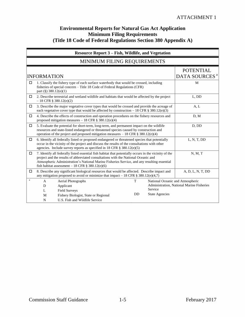
ATTACHMENT 1
Environmental Reports for Natural Gas Act Application
Minimum Filing Requirements
(Title 18 Code of Federal Regulations Section 380 Appendix A)
Commission Staff Guidance 1-5 February 2017
Resource Report 3 – Fish, Wildlife, and Vegetation
MINIMUM FILING REQUIREMENTS
INFORMATION
POTENTIAL
DATA SOURCES a
1. Classify the fishery type of each surface waterbody that would be crossed, including
fisheries of special concern – Title 18 Code of Federal Regulations (CFR) part (§) 380.12(e)(1)
M
2. Describe terrestrial and wetland wildlife and habitats that would be affected by the project
– 18 CFR § 380.12(e)(2)
L, DD
3. Describe the major vegetative cover types that would be crossed and provide the acreage of each vegetative cover type that would be affected by construction – 18 CFR § 380.12(e)(3)
A, L
4. Describe the effects of construction and operation procedures on the fishery resources and
proposed mitigation measures – 18 CFR § 380.12(e)(4)
D, M
5. Evaluate the potential for short-term, long-term, and permanent impact on the wildlife
resources and state-listed endangered or threatened species caused by construction and operation of the project and proposed mitigation measures – 18 CFR § 380.12(e)(4)
D, DD
6. Identify all federally listed or proposed endangered or threatened species that potentially
occur in the vicinity of the project and discuss the results of the consultations with other agencies. Include survey reports as specified in 18 CFR § 380.12(e)(5)
L, N, T, DD
7. Identify all federally listed essential fish habitat that potentially occurs in the vicinity of the
project and the results of abbreviated consultations with the National Oceanic and
Atmospheric Administration’s National Marine Fisheries Service, and any resulting essential fish habitat assessment – 18 CFR § 380.12(e)(6)
N, M, T
8. Describe any significant biological resources that would be affected. Describe impact and
any mitigation proposed to avoid or minimize that impact – 18 CFR § 380.12(e)(4,7)
A, D, L, N, T, DD
a A Aerial Photographs
D Applicant
L Field Surveys
M Fishery Biologist, State or Regional
N U.S. Fish and Wildlife Service
T National Oceanic and Atmospheric
Administration, National Marine Fisheries Service
DD State Agencies

ATTACHMENT 1
Environmental Reports for Natural Gas Act Application
Minimum Filing Requirements
(Title 18 Code of Federal Regulations Section 380 Appendix A)
Commission Staff Guidance 1-6 February 2017
Resource Report 4 – Cultural Resources
MINIMUM FILING REQUIREMENTS
INFORMATION
POTENTIAL
DATA SOURCES a
1. Initial cultural resources consultation and documentation, and documentation of
consultation with Native Americans – Title 18 Code of Federal Regulations (CFR)
part (§) 380.12(f)(1)(i) & (2)
D
2. Overview/Survey Report(s) – 18 CFR § 380.12(f)(1)(ii) & (2) D
a D Applicant

ATTACHMENT 1
Environmental Reports for Natural Gas Act Application
Minimum Filing Requirements
(Title 18 Code of Federal Regulations Section 380 Appendix A)
Commission Staff Guidance 1-7 February 2017
Resource Report 5 – Socioeconomics
MINIMUM FILING REQUIREMENTS
INFORMATION
POTENTIAL
DATA SOURCES a
1. For major aboveground facilities and major pipeline projects that require an environmental
impact statement, describe existing socioeconomic conditions within the project area – Title 18 Code of Federal Regulations (CFR) part (§) 380.12 (g)(1)
I, JJ, KK
2. For major aboveground facilities, quantify impact on employment, housing, local
government services, local tax revenues, transportation, and other relevant factors within the
project area – 18 CFR § 380.12 (g)(2-6)
D, I
a D Applicant
I County/Municipal Agencies
JJ U.S. Department of Labor
KK U.S. Bureau of the Census

ATTACHMENT 1
Environmental Reports for Natural Gas Act Application
Minimum Filing Requirements
(Title 18 Code of Federal Regulations Section 380 Appendix A)
Commission Staff Guidance 1-8 February 2017
Resource Report 6 – Geological Resources
MINIMUM FILING REQUIREMENTS
INFORMATION
POTENTIAL
DATA SOURCES a
1. Identify the location (by milepost) of mineral resources and any planned or active surface
mines crossed by the proposed facilities – Title 18 Code of Federal Regulations (CFR) part (§) 380.12 (h)(1 & 2)
A, L, S, LL
2. Identify any geologic hazards to the proposed facilities – 18 CFR § 380.12 (h)(2) H, L, P, X, II, LL
3. Discuss the need for and locations where blasting may be necessary in order to construct
the proposed facilities – 18 CFR § 380.12 (h)(3)
L, X, II
4. For liquefied natural gas (LNG) projects in seismic areas, the materials required by "Data
Requirements for the Seismic Review of LNG Facilities," National Bureau of Standards Information Report 84-2833 – 18 CFR § 380.12 (h)(5)
D
5. For underground storage facilities, how drilling activity by others within or adjacent to the
facilities would be monitored, and how old wells would be located and monitored within the facility boundaries – 18 CFR § 380.12 (h)(6)
D
a A Aerial Photographs
D Applicant
H Comprehensive Plans, County or Land
Management Agencies
L Field Surveys
P Geological Survey Personnel, Federal, State, and Local
S Mineral Resource Maps, Federal and State
X Natural Resources Conservation Service Soil
Surveys or Soil Survey Geographic Database (SSURGO)
II Surficial Geologic and Bedrock Geologic Maps
LL U.S. Department of Transportation

ATTACHMENT 1
Environmental Reports for Natural Gas Act Application
Minimum Filing Requirements
(Title 18 Code of Federal Regulations Section 380 Appendix A)
Commission Staff Guidance 1-9 February 2017
Resource Report 7 – Soils
MINIMUM FILING REQUIREMENTS
INFORMATION
POTENTIAL
DATA SOURCES a
1. Identify, describe, and group by milepost the soils affected by the proposed pipeline and
aboveground facilities – Title 18 Code of Federal Regulations (CFR) part (§) 380.12(I)(1)
L, W, X, CC
2. For aboveground facilities that would occupy sites over 5 acres, determine the acreage of
prime farmland soils that would be affected by construction and operation – 18 CFR § 380.12(I)(2)
C, H, L, W, X, CC
3. Describe by milepost potential impacts on soils – 18 CFR § 380.12(I)(3,4) C, K, W, Y, CC
4. Identify proposed mitigation to minimize impact on soils and compare with the staff’s
Upland Erosion Control, Revegetation, and Maintenance Plan – 18 CFR § 380.12(I)(5)
C, D, H, K, W, Y, CC
a C Agricultural Extension Agents
D Applicant
H Comprehensive Plans, County or Land Management Agencies
K Erosion Control and Drainage Plan Handbooks, State and County
L Field Surveys
W Natural Resources Conservation Service
X Natural Resources Conservation Service Soil
Surveys or Soil Survey Geographic Database (SSURGO)
Y Upland Erosion Control, Revegetation, and Maintenance Plan
CC Soil Authorities, Other than Natural Resources Conservation Service

ATTACHMENT 1
Environmental Reports for Natural Gas Act Application
Minimum Filing Requirements
(Title 18 Code of Federal Regulations Section 380 Appendix A)
Commission Staff Guidance 1-10 February 2017
Resource Report 8 – Land Use, Recreation, and Aesthetics
MINIMUM FILING REQUIREMENTS
INFORMATION
POTENTIAL
DATA SOURCES a
1. Classify and quantify land use affected by: Title 18 Code of Federal Regulations (CFR)
part (§) 380.12 (j) (1)
a. Pipeline construction and permanent rights-of-way;
b. Extra work/staging areas;
c. Access roads;
d. Pipe and contractor yards; and
e. Aboveground facilities.
A, L, X
2. Identify by milepost all locations where the pipeline right-of-way would at least partially
coincide with existing right-of-way, where it would be adjacent to existing rights-of-way, and
where it would be outside of existing right-of-way – 18 CFR § 380.12 (j) (1)
A, D, L, LL
3. Provide detailed typical construction right-of-way cross section diagrams showing
information such as widths and relative locations of existing rights-of-way, new permanent
right-of-way and temporary construction right-of-way – 18 CFR – § 380.12 (j) (1)
D
4. Summarize the total acreage of land affected by construction and operation of the project – 18 CFR § 380.12 (j) (1)
D
5. Identify by milepost all planned residential or commercial/business development and the
timeframe for construction – 19 CFR § 380.12 (j) (4)
I
6. Identify by milepost special land uses (e.g., maple sugar stands, specialty crops, natural
areas, national and state forests, conservation land, etc.) – 18 CFR § 380.12 (j) (4)
A, B, O, I, L, DD
7. Identify by beginning milepost and length of crossing all land administered by federal,
state, or local agencies, or private conservation organizations – 18 CFR § 380.12 (j) (4)
B, I, DD, LL
8. Identify by milepost all natural, recreational, or scenic areas, and all registered natural landmarks crossed by the project – 18 CFR § 380.12 (j) (4 & 6)
V, B, I, DD, LL
9. Identify all facilities that would be within designated coastal zone management areas – 18
CFR § 380.12 (j) (4))
DD
10. Identify by milepost all residences that would be within 50 feet of the construction right-
of-way or extra work area – 18 CFR § 380.12 (j) (5)
I, L
11. Identify all designated or proposed candidate National or State Wild and Scenic Rivers crossed by the project – 18 CFR – § 380.12 (j) (6)
B
12. Describe any measures to visually screen aboveground facilities, such as compressor
stations – 18 CFR § 380.12 (j) (11)
D
13. Demonstrate that applications for rights-of-way or other proposed land use have been or
soon will be filed with federal land-managing agencies with jurisdiction over land that would be affected by the project – 18 CFR § 380.12 (j) (12)
D
a A Aerial Photographs
B Agency Consultation
D Applicant
I County/Municipal Agencies
L Field Surveys
O National Wetlands Inventory Maps
V National Park Service
X Natural Resources Conservation Service Soil
Surveys or Soil Survey Geographic Database (SSURGO)
DD State Agencies
LL U.S. Department of Transportation

ATTACHMENT 1
Environmental Reports for Natural Gas Act Application
Minimum Filing Requirements
(Title 18 Code of Federal Regulations Section 380 Appendix A)
Commission Staff Guidance 1-11 February 2017
Resource Report 9 – Air and Noise Quality
MINIMUM FILING REQUIREMENTS
INFORMATION
POTENTIAL
DATA SOURCES a
1. Describe existing air quality in the vicinity of the project – Title 18 Code of Federal
Regulations (CFR) part (§) 380.12 (k) (1).
EE
2. Quantify the existing noise levels (day-night sound level (Ldn) and other applicable noise
parameters) at noise sensitive areas and at other areas covered by relevant state and local noise ordinances – 18 CFR § 380.12 (k) (2)
R
3. Quantify existing and proposed emissions of compressor equipment, plus construction
emissions, including nitrogen oxides (NOx) and carbon monoxide (CO), and the basis for
these calculations. Summarize anticipated air quality impacts for the project – 18 CFR § 380.12 (k) (3)
R
4. Describe the existing compressor units at each station where new, additional, or modified
compression units are proposed, including the manufacturer, model number, and horsepower
of the compressor units. For proposed, new, additional, or modified compressor units, include horsepower, type, and energy source – 18 CFR § 380.12 (k) (4)
D, R
5. Identify any nearby noise-sensitive area by distance and direction from the proposed
compressor unit building/enclosure – 18 CFR § 380.12 (k) (4)
G, U, EE
6. Identify any applicable state or local noise regulations – 18 CFR § 380.12 (k) (4). EE
7. Calculate the noise impact at noise-sensitive areas of the proposed compressor unit
modifications or additions, specifying how the impact was calculated, including
manufacturer's data and proposed noise control equipment – 18 CFR § 380.12 (k) (4)
R
a D Applicant
G Community Noise, U.S. Environmental Protection Agency 1971
R Manufacturer’s Data
U Noise Surveys
EE State Air Quality Agency

ATTACHMENT 1
Environmental Reports for Natural Gas Act Application
Minimum Filing Requirements
(Title 18 Code of Federal Regulations Section 380 Appendix A)
Commission Staff Guidance 1-12 February 2017
Resource Report 10 – Alternatives
MINIMUM FILING REQUIREMENTS
INFORMATION
POTENTIAL
DATA SOURCES a
1. Address the “no action” alternative – Title 18 Code of Federal Regulations (CFR)
part (§) 380.12(1)(1)
D
2. For large projects, address the effect of energy conservation or energy alternatives to the
project – 18 CFR § 380.12(1)(1)
D
3. Identify system alternatives considered during the identification of the project and provide
the rationale for rejecting each alternative – 18 CFR § 380.12(1)(1)
D
4. Identify major and minor route alternatives considered to avoid impact on sensitive
environmental areas (e.g., wetlands, parks, or residences) and provide sufficient comparative data to justify the selection of the proposed route – 18 CFR § 380.12(1)(2)(ii)
A, B, L, LL
5. Identify alternative sites considered for the location of major new aboveground facilities
and provide sufficient comparative data to justify the selection of the proposed site – 18 CFR § 380.12(1)(2)(ii)
A, I, L, W, X, LL
a A Aerial Photographs
B Agency Consultation
D Applicant
I County/Municipal Agencies
L Field Surveys
W Natural Resources Conservation Service
X Natural Resources Conservation Service Soil
Surveys or Soil Survey Geographic Database (SSURGO)
LL U.S. Department of Transportation

ATTACHMENT 1
Environmental Reports for Natural Gas Act Application
Minimum Filing Requirements
(Title 18 Code of Federal Regulations Section 380 Appendix A)
Commission Staff Guidance 1-13 February 2017
Resource Report 11 – Reliability and Safety
MINIMUM FILING REQUIREMENTS
INFORMATION
POTENTIAL
DATA SOURCES a
1. Describe how the project facilities would be designed, constructed, operated, and
maintained to minimize potential hazard to the public from the failure of project components
as a result of accidents or natural catastrophes – Title 18 Code of Federal Regulations part 380.12 (m).
D
a D Applicant
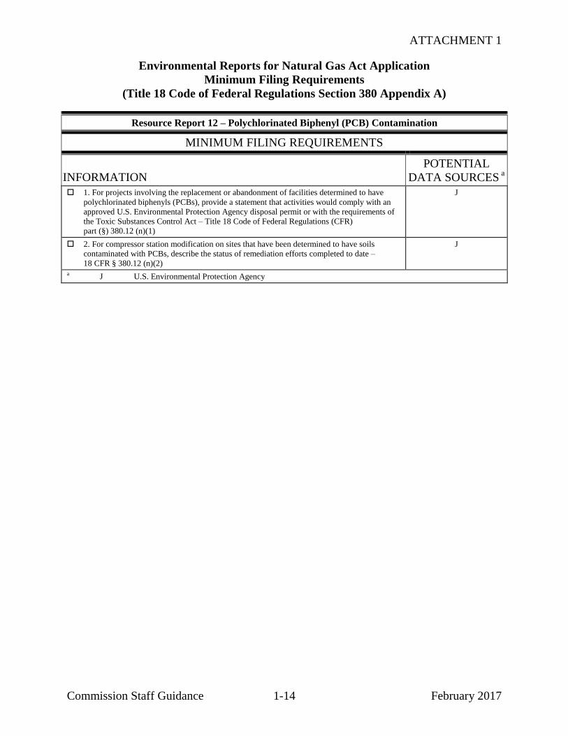
ATTACHMENT 1
Environmental Reports for Natural Gas Act Application
Minimum Filing Requirements
(Title 18 Code of Federal Regulations Section 380 Appendix A)
Commission Staff Guidance 1-14 February 2017
Resource Report 12 – Polychlorinated Biphenyl (PCB) Contamination
MINIMUM FILING REQUIREMENTS
INFORMATION
POTENTIAL
DATA SOURCES a
1. For projects involving the replacement or abandonment of facilities determined to have
polychlorinated biphenyls (PCBs), provide a statement that activities would comply with an
approved U.S. Environmental Protection Agency disposal permit or with the requirements of
the Toxic Substances Control Act – Title 18 Code of Federal Regulations (CFR)
part (§) 380.12 (n)(1)
J
2. For compressor station modification on sites that have been determined to have soils
contaminated with PCBs, describe the status of remediation efforts completed to date –
18 CFR § 380.12 (n)(2)
J
a J U.S. Environmental Protection Agency

ATTACHMENT 1
Environmental Reports for Natural Gas Act Application
Minimum Filing Requirements
(Title 18 Code of Federal Regulations Section 380 Appendix A)
Commission Staff Guidance 1-15 February 2017
Resource Report 13 – Additional Information Related to Liquefied Natural Gas (LNG) Plants
MINIMUM FILING REQUIREMENTS
INFORMATION
POTENTIAL
DATA SOURCES a
1. Provide all the listed detailed engineering materials – Title 18 Code of Federal Regulations
(CFR) Part 380.12(o))
D
a D Applicant

ATTACHMENT 1
Commission Staff Guidance 1-16 February 2017
ENVIRONMENTAL REPORTS FOR NATURAL GAS ACT APPLICATION
FULL FILING REQUIREMENTS
(TITLE 18 CODE OF FEDERAL REGULATIONS SECTION 380.12)


ATTACHMENT 1
Title 18 Code of Federal Regulations Section 380.12
Environmental Reports for Natural Gas Act Application
Full Filing Requirements
Commission Staff Guidance 1-17 February 2017
380.12 (c) Resource Report 1 – General Project Description
FULL FILING REQUIREMENTS
INFORMATION
POTENTIAL
DATA SOURCES a
This report is required for all applications. It will describe facilities associated with the project,
special construction and operation procedures, construction timetables, future plans for related
construction, compliance with regulations and codes, and permits that must be obtained. Resource Report 1 must:
(1) Describe and provide location maps of all jurisdictional facilities, including all
aboveground facilities associated with the project (such as: meter stations, pig
launchers/receivers, valves), to be constructed, modified, abandoned, replaced, or removed,
including related construction and operational support activities and areas such as maintenance
bases, staging areas, communications towers, power lines, and new access roads (roads to be
built or modified). As relevant, the report must describe the length and diameter of the
pipeline, the types of aboveground facilities that would be installed, and associated land
requirements. It must also identify other companies that must construct jurisdictional facilities
related to the project, where the facilities would be located, and where they are in the Commission's approval process.
D
(2) Identify and describe all nonjurisdictional facilities, including auxiliary facilities, that will
be built in association with the project, including facilities to be built by other companies. (i) Provide the following information:
- (A) A brief description of each facility, including as appropriate: Ownership, land
requirements, gas consumption, megawatt size, construction status, and an update of the latest status of federal, state, and local permits/approvals;
- (B) The length and diameter of any interconnecting pipeline;
- (C) Current 1:24,000/1:25,000 scale topographic maps showing the location of the facilities;
- (D) Correspondence with the appropriate State Historic Preservation Officer (SHPO) or
duly authorized Tribal Historic Preservation Officer (THPO) for tribal lands regarding
whether properties eligible for listing on the National Register of Historic Places (NRHP) would be affected;
- (E) Correspondence with the U.S. Fish and Wildlife Service (and National Marine
Fisheries Service, if appropriate) regarding potential impacts of the proposed facility on federally listed threatened and endangered species; and
- (F) For facilities within a designated coastal zone management area, a consistency
determination or evidence that the owner has requested a consistency determination from
the state's coastal zone management program.
(ii) Address each of the following factors and indicate which ones, if any, appear to indicate
the need for the Commission to do an environmental review of project-related nonjurisdictional facilities.
- (A) Whether or not the regulated activity comprises “merely a link” in a corridor type
project (e.g., a transportation or utility transmission project).
- (B) Whether there are aspects of the nonjurisdictional facility in the immediate vicinity
of the regulated activity which uniquely determine the location and configuration of the regulated activity.
- (C) The extent to which the entire project will be within the Commission's jurisdiction.
- (D) The extent of cumulative federal control and responsibility.
D
(3) Provide the following maps and photos:
- (i) Current, original United States Geological Survey (USGS) 7.5-minute series
topographic maps or maps of equivalent detail, covering at least a 0.5-mile-wide corridor
centered on the pipeline, with integer mileposts identified, showing the location of rights-
D
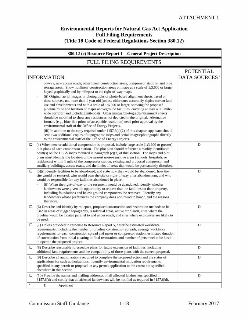
ATTACHMENT 1
Environmental Reports for Natural Gas Act Application
Full Filing Requirements
(Title 18 Code of Federal Regulations Section 380.12)
Commission Staff Guidance 1-18 February 2017
380.12 (c) Resource Report 1 – General Project Description
FULL FILING REQUIREMENTS
INFORMATION
POTENTIAL
DATA SOURCES a
of-way, new access roads, other linear construction areas, compressor stations, and pipe
storage areas. Show nonlinear construction areas on maps at a scale of 1:3,600 or larger
keyed graphically and by milepost to the right-of-way maps.
- (ii) Original aerial images or photographs or photo-based alignment sheets based on
these sources, not more than 1 year old (unless older ones accurately depict current land
use and development) and with a scale of 1:6,000 or larger, showing the proposed
pipeline route and location of major aboveground facilities, covering at least a 0.5 mile-
wide corridor, and including mileposts. Older images/photographs/alignment sheets
should be modified to show any residences not depicted in the original. Alternative
formats (e.g., blue-line prints of acceptable resolution) need prior approval by the environmental staff of the Office of Energy Projects.
- (iii) In addition to the copy required under §157.6(a)(2) of this chapter, applicant should
send two additional copies of topographic maps and aerial images/photographs directly to the environmental staff of the Office of Energy Projects.
(4) When new or additional compression is proposed, include large scale (1:3,600 or greater)
plot plans of each compressor station. The plot plan should reference a readily identifiable
point(s) on the USGS maps required in paragraph (c)(3) of this section. The maps and plot
plans must identify the location of the nearest noise-sensitive areas (schools, hospitals, or
residences) within 1 mile of the compressor station, existing and proposed compressor and auxiliary buildings, access roads, and the limits of areas that would be permanently disturbed.
D
(5)(i) Identify facilities to be abandoned, and state how they would be abandoned, how the
site would be restored, who would own the site or right-of-way after abandonment, and who would be responsible for any facilities abandoned in place.
- (ii) When the right-of-way or the easement would be abandoned, identify whether
landowners were given the opportunity to request that the facilities on their property,
including foundations and below ground components, be removed. Identify any
landowners whose preferences the company does not intend to honor, and the reasons therefore.
D
(6) Describe and identify by milepost, proposed construction and restoration methods to be
used in areas of rugged topography, residential areas, active croplands, sites where the
pipeline would be located parallel to and under roads, and sites where explosives are likely to
be used.
D
(7) Unless provided in response to Resource Report 5, describe estimated workforce
requirements, including the number of pipeline construction spreads, average workforce
requirements for each construction spread and meter or compressor station, estimated duration
of construction from initial clearing to final restoration, and number of personnel to be hired to operate the proposed project.
D
(8) Describe reasonably foreseeable plans for future expansion of facilities, including
additional land requirements and the compatibility of those plans with the current proposal.
D
(9) Describe all authorizations required to complete the proposed action and the status of
applications for such authorizations. Identify environmental mitigation requirements
specified in any permit or proposed in any permit application to the extent not specified elsewhere in this section.
D
(10) Provide the names and mailing addresses of all affected landowners specified in §157.6(d) and certify that all affected landowners will be notified as required in §157.6(d).
D
a D Applicant

ATTACHMENT 1
Environmental Reports for Natural Gas Act Application
Full Filing Requirements
(Title 18 Code of Federal Regulations Section 380.12)
Commission Staff Guidance 1-19 February 2017
380.12 (d) – Resource Report 2 – Water Use and Quality
FULL FILING REQUIREMENTS
INFORMATION
POTENTIAL DATA
SOURCES a
This report is required for all applications, except those which involve only facilities within the
areas of an existing compressor, meter, or regulator station that were disturbed by construction
of the existing facilities, no wetlands or waterbodies are on the site and there would not be a
significant increase in water use. The report must describe water quality and provide data
sufficient to determine the expected impact of the project and the effectiveness of mitigative,
enhancement, or protective measures. Resource Report 2 must:
(1) Identify and describe by milepost perennial waterbodies and municipal water supply or
watershed areas, specially designated surface water protection areas and sensitive
waterbodies, and wetlands that would be crossed. For each waterbody crossing, identify
the approximate width, state water quality classifications, any known potential pollutants
present in the water or sediments, and any potable water intake sources within 3 miles downstream.
L, GG, LL
(2) Compare proposed mitigation measures with the staff's current “Wetland and
Waterbody Construction and Mitigation Procedures,” which are available from the
Commission Internet home page or the Commission staff, describe what proposed
alternative mitigation would provide equivalent or greater protection to the environment,
and provide a description of site- specific construction techniques that would be used at each major waterbody crossing.
D, Z
(3) Describe typical staging area requirements at waterbody and wetland crossings. Also,
identify and describe waterbodies and wetlands where staging areas are likely to be more extensive.
D
(4) Include National Wetlands Inventory (NWI) maps. If NWI maps are not available,
provide the appropriate state wetland maps. Identify for each crossing, the milepost, the
wetland classification specified by the U.S. Fish and Wildlife Service, and the length of the
crossing. Include two copies of the NWI maps (or the substitutes, if NWI maps are not
available) clearly showing the proposed route and mileposts directed to the environmental
staff. Describe by milepost, wetland crossings as determined by field delineations using the current federal methodology.
D, O, HH
(5) Identify aquifers within excavation depth in the project area, including the depth of the
aquifer, current and projected use, water quality and average yield, and known or suspected
contamination problems.
E, J, FF, GG
(6) Describe specific locations, the quantity required, and the method and rate of
withdrawal and discharge of hydrostatic test water. Describe suspended or dissolved
material likely to be present in the water as a result of contact with the pipeline, particularly
if an existing pipeline is being retested. Describe chemical or physical treatment of the pipeline or hydrostatic test water. Discuss waste products generated and disposal methods.
D
(7) If underground storage of natural gas is proposed:
- (i) Identify how water produced from the storage field will be disposed of, and
- (ii) For salt caverns, identify the source locations, the quantity required, and the
method and rate of withdrawal of water for creating salt cavern(s), as well as the means of disposal of brine resulting from cavern leaching.
D
(8) Discuss proposed mitigation measures to reduce the potential for adverse impacts to
surface water, wetlands, or groundwater quality to the extent they are not described in
response to paragraph (d)(2) of this section. Discuss the potential for blasting to affect
water wells, springs, and wetlands, and measures to be taken to detect and remedy such effects.
D

ATTACHMENT 1
Environmental Reports for Natural Gas Act Application
Full Filing Requirements
(Title 18 Code of Federal Regulations Section 380.12)
Commission Staff Guidance 1-20 February 2017
380.12 (d) – Resource Report 2 – Water Use and Quality
FULL FILING REQUIREMENTS
(9) Identify the location of known public and private groundwater supply wells or springs
within 150 feet of proposed construction areas. Identify locations of U.S. Environmental
Protection Agency or state-designated sole-source aquifers and wellhead protection areas crossed by the proposed pipeline facilities.
E, J, FF, GG
a D Applicant
E State or county groundwater databases
(e.g., Board of Health, Department of Natural
Resource water divisions)
J U.S. Environmental Protection Agency
L Field Surveys
O National Wetlands Inventory Maps
Z Wetland and Waterbody Construction and
Mitigation Procedures
FF State Drinking Water Division
GG State Water Quality Division
HH State Wetland Maps
LL U.S. Department of Transportation
ATTACHMENT 1
Environmental Reports for Natural Gas Act Application
Full Filing Requirements
(Title 18 Code of Federal Regulations Section 380.12)
Commission Staff Guidance 1-21 February 2017
380.12 (e) – Resource Report 3 – Fish, Wildlife, and Vegetation
FULL FILING REQUIREMENTS
INFORMATION
POTENTIAL
DATA SOURCES a
This report is required for all applications, except those involving only facilities within the
improved area of an existing compressor, meter, or regulator station. It must describe aquatic life,
wildlife, and vegetation in the vicinity of the proposed project; expected impacts on these resources
including potential effects on biodiversity; and proposed mitigation, enhancement, or protection measures. Resource Report 3 must:
(1) Describe commercial and recreational warmwater, coldwater, and saltwater fisheries in the
affected area and associated significant habitats such as spawning or rearing areas and
estuaries.
M
(2) Describe terrestrial habitats, including wetlands, typical wildlife habitats, and rare, unique,
or otherwise significant habitats that might be affected by the proposed action. Describe
typical species that have commercial, recreational, or aesthetic value.
L, DD
(3) Describe and provide the acreage of vegetation cover types that would be affected,
including unique ecosystems or communities such as remnant prairie or old-growth forest, or significant individual plants, such as old-growth specimen trees.
A, L
(4) Describe the impact of construction and operation on aquatic and terrestrial species and
their habitats, including the possibility of a major alteration to ecosystems or biodiversity, and
any potential impact on state-listed endangered or threatened species. Describe the impact of
maintenance, clearing and treatment of the project area on fish, wildlife, and vegetation.
Surveys may be required to determine specific areas of significant habitats or communities of species of special concern to state or local agencies.
D, M
(5) Identify all federally listed or proposed endangered or threatened species and critical
habitat that potentially occur in the vicinity of the project. Discuss the results of the
consultation requirements listed in §380.13(b) at least through §380.13(b)(5)(i) and include
any written correspondence that resulted from the consultation. The initial application must
include the results of any required surveys unless seasonal considerations make this
impractical. If species surveys are impractical, there must be field surveys to determine the presence of suitable habitat unless the entire project area is suitable habitat.
L, N, T, DD
(6) Identify all federally listed essential fish habitat (EFH) that potentially occurs in the
vicinity of the project. Provide information on all EFH, as identified by the pertinent federal
fishery management plans, that may be adversely affected by the project and the results of
abbreviated consultations with the National Oceanic and Atmospheric Administration’s National Marine Fisheries Service, and any resulting EFH assessments.
N, M, T
(7) Describe site-specific mitigation measures to minimize impacts on fisheries, wildlife, and
vegetation.
D, DD
(8) Include copies of correspondence not provided pursuant to paragraph (e)(5) of this section,
containing recommendations from appropriate federal and state fish and wildlife agencies to
avoid or limit impact on wildlife, fisheries, and vegetation, and the applicant's response to the recommendations.
N, M, T, DD
a A Aerial Photographs
D Applicant
L Field Surveys
M Fishery Biologist, State or Regional
N U.S. Fish and Wildlife Service
T National Oceanic and Atmospheric
Administration, National Marine Fisheries Service
DD State Agencies
ATTACHMENT 1
Environmental Reports for Natural Gas Act Application
Full Filing Requirements
(Title 18 Code of Federal Regulations Section 380.12)
Commission Staff Guidance 1-22 February 2017
380.12 (f) – Resource Report 4 – Cultural Resources
FULL FILING REQUIREMENTS
INFORMATION
POTENTIAL
DATA SOURCES a
This report is required for all applications. In preparing this report, the applicant must follow the
principles in §380.14 of this part. Guidance on the content and the format for the documentation
listed below, as well as professional qualifications of preparers, is detailed in ‘‘ Office of Energy
Projects’ (OEP) Guidelines for Reporting on Cultural Resources Investigations,’’ which is
available from the Commission Internet home page or from the Commission staff.
(1) Resource Report 4 must contain:
- (i) Documentation of the applicant's initial cultural resources consultation, including consultations with Native Americans and other interested persons (if appropriate);
- (ii) Overview and Survey Reports, as appropriate;
- (iii) Evaluation Report, as appropriate;
- (iv) Treatment Plan, as appropriate; and
- (v) Written comments from State Historic Preservation Officer(s) (SHPO), Tribal
Historic Preservation Officers (THPO), as appropriate, and applicable land-managing agencies on the reports in paragraphs (f)(1)(i)-(iv) of this section.
D
(2) Initial filing requirements. The initial application must include the documentation of
initial cultural resource consultation, the Overview and Survey Reports, if required, and
written comments from SHPOs, THPOs and land-managing agencies, if available. The initial
cultural resources consultations should establish the need for surveys. If surveys are deemed
necessary by the consultation with the SHPO/THPO, the survey report must be filed with the application.
- (i) If the comments of the SHPOs, THPOs, or land-management agencies are not
available at the time the application is filed, they may be filed separately, but they must be filed before a final certificate is issued.
- (ii) If landowners deny access to private property and certain areas are not surveyed, the
unsurveyed area must be identified by mileposts, and supplemental surveys or
evaluations shall be conducted after access is granted. In such circumstances, reports,
and treatment plans, if necessary, for those inaccessible lands may be filed after a certificate is issued.
D
(3) The Evaluation Report and Treatment Plan, if required, for the entire project must be filed
before a final certificate is issued.
- (i) The Evaluation Report may be combined in a single synthetic report with the
Overview and Survey Reports if the SHPOs, THPOs, and land-management agencies allow and if it is available at the time the application is filed.
- (ii) In preparing the Treatment Plan, the applicant must consult with the Commission staff, the SHPO, and any applicable THPO and land-management agencies.
- (iii) Authorization to implement the Treatment Plan will occur only after the final
certificate is issued.
D
(4) Applicant must request privileged treatment for all material filed with the Commission
containing location, character, and ownership information about cultural resources in
accordance with §388.112 of this chapter. The cover and relevant pages or portions of the
report should be clearly labeled in bold lettering: “CONTAINS PRIVILEGED INFORMATION—DO NOT RELEASE.”
D
(5) Except as specified in a final Commission order, or by the Director of the Office of Energy
Projects, construction may not begin until all cultural resource reports and plans have been approved.
D
a D Applicant

ATTACHMENT 1
Environmental Reports for Natural Gas Act Application
Full Filing Requirements
(Title 18 Code of Federal Regulations Section 380.12)
Commission Staff Guidance 1-23 February 2017
380.12 (g) – Resource Report 5 – Socioeconomics
FULL FILING REQUIREMENTS
INFORMATION
POTENTIAL
DATA SOURCES a
This report is required only for applications involving significant aboveground facilities, including,
among others, conditioning or liquefied natural gas (LNG) plants. It must identify and quantify the
impacts of constructing and operating the proposed project on factors affecting towns and counties in the vicinity of the project. Resource Report 5 must:
(1) Describe the socioeconomic impact area. D, I, JJ, KK
(2) Evaluate the impact of any substantial immigration of people on governmental facilities and services and plans to reduce the impact on the local infrastructure.
D
(3) Describe on-site manpower requirements and payroll during construction and operation,
including the number of construction personnel who currently reside within the impact area,
would commute daily to the site from outside the impact area, or would relocate temporarily
within the impact area.
D
(4) Determine whether existing housing within the impact area is sufficient to meet the needs
of the additional population.
I
(5) Describe the number and types of residences and businesses that would be displaced by
the project, procedures to be used to acquire these properties, and types and amounts of relocation assistance payments.
D, I
(6) Conduct a fiscal impact analysis evaluating incremental local government expenditures in
relation to incremental local government revenues that would result from construction of the
project. Incremental expenditures include, but are not limited to, school operating costs, road maintenance and repair, public safety, and public utility costs.
D, I, JJ
a D Applicant
I County/Municipal Agencies
JJ U.S. Department of Labor
KK U.S. Bureau of the Census

ATTACHMENT 1
Environmental Reports for Natural Gas Act Application
Full Filing Requirements
(Title 18 Code of Federal Regulations Section 380.12)
Commission Staff Guidance 1-24 February 2017
380.12 (h) – Resource Report 6 – Geological resources
FULL FILING REQUIREMENTS
INFORMATION
POTENTIAL
DATA SOURCES a
This report is required for applications involving liquefied natural gas (LNG) facilities and all
other applications, except those involving only facilities within the boundaries of existing
aboveground facilities, such as a compressor, meter, or regulator station. It must describe
geological resources and hazards in the project area that might be directly or indirectly affected by
the proposed action or that could place the proposed facilities at risk, the potential effects of those
hazards on the facility, and methods proposed to reduce the effects or risks. Resource Report 6 must:
(1) Describe, by milepost, mineral resources that are currently or potentially exploitable; A, L, S, LL
(2) Describe, by milepost, existing and potential geological hazards and areas of nonroutine
geotechnical concern, such as high seismicity areas, active faults, and areas susceptible to
soil liquefaction; planned, active, and abandoned mines; karst terrain; and areas of potential
ground failure, such as subsidence, slumping, and landsliding. Discuss the hazards posed to the facility from each one.
H, L, P, X, II, LL
(3) Describe how the project would be located or designed to avoid or minimize adverse
effects to the resources or risk to itself, including geotechnical investigations and monitoring
that would be conducted before, during, and after construction. Discuss also the potential for blasting to affect structures, and the measures to be taken to remedy such effects.
D
(4) Specify methods to be used to prevent project-induced contamination from surface mines
or from mine tailings along the right-of-way and whether the project would hinder mine reclamation or expansion efforts.
D
(5) If the application involves an LNG facility located in zones 2, 3, or 4 of the Uniform
Building Code's Seismic Risk Map, or where there is potential for surface faulting or
liquefaction, prepare a report on earthquake hazards and engineering in conformance with
“Data Requirements for the Seismic Review of LNG Facilities,” National Bureau of
Standards Information Report 84-2833. This document may be obtained from the Commission staff.
D
(6) If the application is for underground storage facilities:
- (i) Describe how the applicant would control and monitor the drilling activity of others within the field and buffer zone;
- (ii) Describe how the applicant would monitor potential effects of the operation of adjacent storage or production facilities on the proposed facility, and vice versa;
- (iii) Describe measures taken to locate and determine the condition of old wells within
the field and buffer zone and how the applicant would reduce risk from failure of known and undiscovered wells; and
- (iv) Identify and discuss safety and environmental safeguards required by state and federal drilling regulations.
B, D
a A Aerial Photographs
B Agency Consultation
D Applicant
H Comprehensive Plans, County or Land Management Agencies
L Field Surveys
P Geological Survey Personnel, Federal, State, and Local
S Mineral Resource Maps, Federal and State
X Natural Resources Conservation Service Soil
Surveys or Soil Survey Geographic Database (SSURGO)
II Surficial Geologic and Bedrock Geologic Maps
LL U.S. Department of Transportation

ATTACHMENT 1
Environmental Reports for Natural Gas Act Application
Full Filing Requirements
(Title 18 Code of Federal Regulations Section 380.12)
Commission Staff Guidance 1-25 February 2017
380.12 (i) – Resource Report 7 – Soils
FULL FILING REQUIREMENTS
INFORMATION
POTENTIAL
DATA SOURCES a
This report is required for all applications except those not involving soil disturbance. It must
describe the soils that would be affected by the proposed project, the effect on those soils, and measures proposed to minimize or avoid impact. Resource Report 7 must:
(1) List, by milepost, the soil associations that would be crossed and describe the erosion
potential, fertility, and drainage characteristics of each association.
L, W, X, CC
(2) If an aboveground facility site is greater than 5 acres:
- (i) List the soil series within the property and the percentage of the property comprised of each series;
- (ii) List the percentage of each series which would be permanently disturbed;
- (iii) Describe the characteristics of each soil series; and
- (iv) Indicate which are classified as prime or unique farmland by the U.S. Department
of Agriculture, Natural Resources Conservation Service.
C, H, L, W, X, CC
(3) Identify, by milepost, potential impact from: Soil erosion due to water, wind, or loss of
vegetation; soil compaction and damage to soil structure resulting from movement of
construction vehicles; wet soils and soils with poor drainage that are especially prone to
structural damage; damage to drainage tile systems due to movement of construction
vehicles and trenching activities; and interference with the operation of agricultural
equipment due to the probability of large stones or blasted rock occurring on or near the surface as a result of construction.
C, K, W, Y, CC
(4) Identify, by milepost, cropland and residential areas where loss of soil fertility due to
trenching and backfilling could occur.
C, D, H, K, W, Y, CC
(5) Describe proposed mitigation measures to reduce the potential for adverse impact to soils
or agricultural productivity. Compare proposed mitigation measures with the staff's current
“Upland Erosion Control, Revegetation, and Maintenance Plan,” which is available from
the Commission Internet home page or from the Commission staff, and explain how proposed mitigation measures provide equivalent or greater protections to the environment.
C, D, H, K, W, Y, CC
a C Agricultural Extension Agents
D Applicant
H Comprehensive Plans, County or Land
Management Agencies
K Erosion Control and Drainage Plan Handbooks,
State and County
L Field Surveys
W Natural Resources Conservation Service
X Natural Resources Conservation Service Soil
Surveys or Soil Survey Geographic Database (SSURGO)
Y Upland Erosion Control, Revegetation, and Maintenance Plan
CC Soil Authorities, Other than Natural Resources Conservation Service

ATTACHMENT 1
Environmental Reports for Natural Gas Act Application
Full Filing Requirements
(Title 18 Code of Federal Regulations Section 380.12)
Commission Staff Guidance 1-26 February 2017
380.12 (j) – Resource Report 8 – Land Use, Recreation and Aesthetics
FULL FILING REQUIREMENTS
INFORMATION
POTENTIAL
DATA SOURCES a
This report is required for all applications except those involving only facilities which are of
comparable use at existing compressor, meter, and regulator stations. It must describe the existing
uses of land on, and (where specified) within 0.25 mile of, the proposed project and changes to
those land uses that would occur if the project is approved. The report shall discuss proposed
mitigation measures, including protection and enhancement of existing land use. Resource Report
8 must:
(1) Describe the width and acreage requirements of all construction and permanent rights-of-
way and the acreage required for each proposed plant and operational site, including injection
or withdrawal wells.
- (i) List, by milepost, locations where the proposed right-of-way would be adjacent to
existing rights-of-way of any kind.
- (ii) Identify, preferably by diagrams, existing rights-of-way that would be used for a
portion of the construction or operational right-of-way, the overlap and how much additional width would be required.
- (iii) Identify the total amount of land to be purchased or leased for each aboveground
facility, the amount of land that would be disturbed for construction and operation of the facility, and the use of the remaining land not required for project operation.
- (iv) Identify the size of typical staging areas and expanded work areas, such as those at
railroad, road, and waterbody crossings, and the size and location of all pipe storage yards and access roads.
A, D, L, X, LL
(2) Identify, by milepost, the existing use of lands crossed by the proposed pipeline, or on or
adjacent to each proposed plant and operational site.
A, D, L, X
(3) Describe planned development on land crossed or within 0.25 mile of proposed facilities,
the time frame (if available) for such development, and proposed coordination to minimize
impacts on land use. Planned development means development which is included in a master plan or is on file with the local planning board or the county.
I
(4) Identify, by milepost and length of crossing, the area of direct effect of each proposed
facility and operational site on sugar maple stands, orchards and nurseries, landfills, operating
mines, hazardous waste sites, state wild and scenic rivers, state or local designated trails,
nature preserves, game management areas, remnant prairie, old-growth forest, national or state
forests, parks, golf courses, designated natural, recreational or scenic areas, or registered
natural landmarks, Native American religious sites and traditional cultural properties to the
extent they are known to the public at large, and reservations, lands identified under the
Special Area Management Plan of the Office of Coastal Zone Management, National Oceanic
and Atmospheric Administration, and lands owned or controlled by federal or state agencies
or private preservation groups. Also identify if any of those areas are located within 0.25 mile of any proposed facility.
A, B, I, L, O, DD, LL
(5) Identify, by milepost, all residences and buildings within 50 feet of the proposed pipeline
construction right-of-way and the distance of the residence or building from the right-of-way.
Provide survey drawings or alignment sheets to illustrate the location of the facilities in relation to the buildings.
A, D, I, L
(6) Describe any areas crossed by or within 0.25 mile of the proposed pipeline or plant and
operational sites which are included in, or are designated for study for inclusion in: The
National Wild and Scenic Rivers System (Title 16 United States Code [U.S.C.] part 1271);
The National Trails System (16 U.S.C. 1241); or a wilderness area designated under the
Wilderness Act (16 U.S.C. 1132).
B

ATTACHMENT 1
Environmental Reports for Natural Gas Act Application
Full Filing Requirements
(Title 18 Code of Federal Regulations Section 380.12)
Commission Staff Guidance 1-27 February 2017
380.12 (j) – Resource Report 8 – Land Use, Recreation and Aesthetics
FULL FILING REQUIREMENTS
INFORMATION
POTENTIAL
DATA SOURCES a
(7) For facilities within a designated coastal zone management area, provide a consistency
determination or evidence that the applicant has requested a consistency determination from the state's coastal zone management program.
DD
(8) Describe the impact the project will have on present uses of the affected area as identified
above, including commercial uses, mineral resources, recreational areas, public health and
safety, and the aesthetic value of the land and its features. Describe any temporary or permanent restrictions on land use resulting from the project.
D
(9) Describe mitigation measures intended for all special use areas identified under paragraphs
(j)(2) through (6) of this section.
D
(10) Describe proposed typical mitigation measures for each residence that is within 50 feet of
the edge of the pipeline construction right-of-way, as well as any proposed residence-specific
mitigation. Describe how residential property, including for example, fences, driveways,
stone walls, sidewalks, water supply, and septic systems, would be restored. Describe
compensation plans for temporary and permanent rights-of-way and the eminent domain process for the affected areas.
D
(11) Describe measures proposed to mitigate the aesthetic impact of the facilities especially
for aboveground facilities such as compressor or meter stations.
D
(12) Demonstrate that applications for rights-of-way or other proposed land use have been or
soon will be filed with federal land-management agencies with jurisdiction over land that would be affected by the project.
D
a A Aerial Photographs
B Agency Consultation
D Applicant
I County/Municipal Agencies
L Field Surveys
O National Wetlands Inventory Maps
X Natural Resources Conservation Service Soil
Surveys or Soil Survey Geographic Database (SSURGO)
DD State Agencies
LL U.S. Department of Transportation

ATTACHMENT 1
Environmental Reports for Natural Gas Act Application
Full Filing Requirements
(Title 18 Code of Federal Regulations Section 380.12)
Commission Staff Guidance 1-28 February 2017
380.12 (k) – Resource Report 9 – Air and Noise Quality
FULL FILING REQUIREMENTS
INFORMATION
POTENTIAL
DATA SOURCES a
This report is required for applications involving compressor facilities at new or existing
stations, and for all new liquefied natural gas (LNG) facilities. It must identify the effects of the
project on the existing air quality and noise environment and describe proposed measures to mitigate the effects. Resource Report 9 must:
(1) Describe the existing air quality, including background levels of nitrogen dioxide and
other criteria pollutants which may be emitted above U.S. Environmental Protection Agency-identified significance levels.
EE
(2) Quantitatively describe existing noise levels at noise-sensitive areas, such as schools,
hospitals, or residences and include any areas covered by relevant state or local noise ordinances.
- (i) Report existing noise levels as the Leq (day), Leq (night), and Ldn and include the basis for the data or estimates.
- (ii) For existing compressor stations, include the results of a sound level survey at the
site property line and nearby noise-sensitive areas while the compressors are operated at full load.
- (iii) For proposed new compressor station sites, measure or estimate the existing ambient sound environment based on current land uses and activities.
- (iv) Include a plot plan that identifies the locations and duration of noise
measurements, the time of day, weather conditions, wind speed and direction, engine
load, and other noise sources present during each measurement.
R
(3) Estimate the impact of the project on air quality, including how existing regulatory
standards would be met.
- (i) Provide the emission rate of nitrogen oxides from existing and proposed facilities,
expressed in pounds per hour and tons per year for maximum operating conditions,
include supporting calculations, emission factors, fuel consumption rates, and annual
hours of operation.
- (ii) For major sources of air emissions (as defined by the Environmental Protection
Agency), provide copies of applications for permits to construct (and operate, if
applicable) or for applicability determinations under regulations for the prevention of significant air quality deterioration and subsequent determinations.
R
(4) Provide a quantitative estimate of the impact of the project on noise levels at noise-
sensitive areas, such as schools, hospitals, or residences.
- (i) Include step-by-step supporting calculations or identify the computer program used
to model the noise levels, the input and raw output data and all assumptions made
when running the model, far-field sound level data for maximum facility operation, and the source of the data.
- (ii) Include sound pressure levels for unmuffled engine inlets and exhausts, engine
casings, and cooling equipment; dynamic insertion loss for all mufflers; sound
transmission loss for all compressor building components, including walls, roof, doors,
windows and ventilation openings; sound attenuation from the station to nearby noise-
sensitive areas; the manufacturer's name, the model number, the performance rating;
and a description of each noise source and noise control component to be employed at
the proposed compressor station. For proposed compressors the initial filing must
include at least the proposed horsepower, type of compression, and energy source for the compressor.
- (iii) Far-field sound level data measured from similar units in service elsewhere, when available, may be substituted for manufacturer's far-field sound level data.
D, G, R, U, EE

ATTACHMENT 1
Environmental Reports for Natural Gas Act Application
Full Filing Requirements
(Title 18 Code of Federal Regulations Section 380.12)
Commission Staff Guidance 1-29 February 2017
380.12 (k) – Resource Report 9 – Air and Noise Quality
FULL FILING REQUIREMENTS
INFORMATION
POTENTIAL
DATA SOURCES a
- (iv) If specific noise control equipment has not been chosen, include a schedule for submitting the data prior to certification.
- (v) The estimate must demonstrate that the project will comply with applicable noise regulations and show how the facility will meet the following requirements:
a. (A) The noise attributable to any new compressor station, compression added to
an existing station, or any modification, upgrade or update of an existing station,
must not exceed a day-night sound level (Ldn) of 55 decibels on the A-weighted
scale at any pre-existing noise-sensitive area (such as schools, hospitals, or residences).
b. (B) New compressor stations or modifications of existing stations shall not result in a perceptible increase in vibration at any noise-sensitive area.
(5) Describe measures and manufacturer's specifications for equipment proposed to
mitigate impact to air and noise quality, including emission control systems, installation of
filters, mufflers, or insulation of piping and buildings, and orientation of equipment away from noise-sensitive areas.
D, R
a D Applicant
G Community Noise, U.S. Environmental
Protection Agency 1971
R Manufacturer’s Data
U Noise Surveys
EE State Air Quality Agency

ATTACHMENT 1
Environmental Reports for Natural Gas Act Application
Full Filing Requirements
(Title 18 Code of Federal Regulations Section 380.12)
Commission Staff Guidance 1-30 February 2017
380.12 (l) – Resource Report 10 – Alternatives
FULL FILING REQUIREMENTS
INFORMATION
POTENTIAL
DATA SOURCES a
This report is required for all applications. It must describe alternatives to the project and compare
the environmental impacts of such alternatives to those of the proposal. The discussion must
demonstrate how environmental benefits and costs were weighed against economic benefits and
costs, and technological and procedural constraints. The potential for each alternative to meet
project deadlines and the environmental consequences of each alternative shall be discussed.
Resource Report 10 must:
(1) Discuss the “no action” alternative and the potential for accomplishing the proposed
objectives through the use of other systems and/or energy conservation. Provide an analysis
of the relative environmental benefits and costs for each alternative.
D
(2) Describe alternative routes or locations considered for each facility during the initial screening for the project.
- (i) For alternative routes considered in the initial screening for the project but eliminated,
describe the environmental characteristics of each route or site, and the reasons for
rejecting it. Identify the location of such alternatives on maps of sufficient scale to
depict their location and relationship to the proposed action, and the relationship of the pipeline to existing rights-of-way.
- (ii) For alternative routes or locations considered for more in-depth consideration,
describe the environmental characteristics of each route or site and the reasons for
rejecting it. Provide comparative tables showing the differences in environmental
characteristics for the alternative and proposed action. The location of any alternatives in
this paragraph shall be provided on maps equivalent to those required in paragraph (c)(2) of this section.
A, B, D, I, L, W, X, LL
a A Aerial Photographs
B Agency Consultation
D Applicant
I County/Municipal Agencies
L Field Surveys
W Natural Resources Conservation Service
X Natural Resources Conservation Service Soil
Surveys or Soil Survey Geographic Database
(SSURGO)
LL U.S. Department of Transportation

ATTACHMENT 1
Environmental Reports for Natural Gas Act Application
Full Filing Requirements
(Title 18 Code of Federal Regulations Section 380.12)
Commission Staff Guidance 1-31 February 2017
380.12 (m) – Resource Report 11 – Reliability and Safety
FULL FILING REQUIREMENTS
INFORMATION
POTENTIAL
DATA SOURCES a
This report is required for applications involving new or recommissioned liquefied natural gas
(LNG) facilities. Information previously filed with the Commission need not be refiled if the
applicant verifies its continued validity. This report shall address the potential hazard to the
public from failure of facility components resulting from accidents or natural catastrophes, how
these events would affect reliability, and what procedures and design features have been used to
reduce potential hazards. Resource Report 11 must:
(1) Describe measures proposed to protect the public from failure of the proposed facilities (including coordination with local agencies).
D
(2) Discuss hazards, the environmental impact, and service interruptions which could
reasonably ensue from failure of the proposed facilities.
D
(3) Discuss design and operational measures to avoid or reduce risk. D
(4) Discuss contingency plans for maintaining service or reducing downtime. D
(5) Describe measures used to exclude the public from hazardous areas. Discuss measures
used to minimize problems arising from malfunctions and accidents (with estimates of
probability of occurrence) and identify standard procedures for protecting services and public safety during maintenance and breakdowns.
D
a D Applicant

ATTACHMENT 1
Environmental Reports for Natural Gas Act Application
Full Filing Requirements
(Title 18 Code of Federal Regulations Section 380.12)
Commission Staff Guidance 1-32 February 2017
380.12 (n) – Resource Report 12 – Polychlorinated Biphenyl (PCB) Contamination
FULL FILING REQUIREMENTS
INFORMATION
POTENTIAL
DATA SOURCES a
This report is required for applications involving the replacement, abandonment by removal, or
abandonment in place of pipeline facilities determined to have polychlorinated biphenyls (PCBs) in excess of 50 parts per million in pipeline liquids. Resource Report 12 must:
(1) Provide a statement that activities would comply with an approved EPA disposal permit,
with the dates of issuance and expiration specified, or with the requirements of the Toxic
Substances Control Act.
J
(2) For compressor station modifications on sites that have been determined to have soils
contaminated with PCBs, describe the status of remediation efforts completed to date.
J
a J U.S. Environmental Protection Agency

ATTACHMENT 1
Environmental Reports for Natural Gas Act Application
Full Filing Requirements
(Title 18 Code of Federal Regulations Section 380.12)
Commission Staff Guidance 1-33 February 2017
380.12 (o) – Resource Report 13 – Engineering and Design Material
FULL FILING REQUIREMENTS
INFORMATION
POTENTIAL
DATA SOURCES a
This report is required for construction of new liquefied natural gas (LNG) facilities, or the
recommissioning of existing LNG facilities. If the recommissioned facility is existing and is not
being replaced, relocated, or significantly altered, resubmittal of information already on file with the Commission is unnecessary. Resource Report 13 must:
(1) Provide a detailed plot plan showing the location of all major components to be
installed, including compression, pretreatment, liquefaction, storage, transfer piping,
vaporization, truck loading/unloading, vent stacks, pumps, and auxiliary or appurtenant service facilities.
D
(2) Provide a detailed layout of the fire protection system showing the location of fire water
pumps, piping, hydrants, hose reels, dry chemical systems, high expansion foam systems, and auxiliary or appurtenant service facilities.
D
(3) Provide a layout of the hazard detection system showing the location of combustible-gas
detectors, fire detectors, heat detectors, smoke or combustion product detectors, and low
temperature detectors. Identify those detectors that activate automatic shutdowns and the
equipment that would shut down. Include all safety provisions incorporated in the plant
design, including automatic and manually activated emergency shutdown systems.
D
(4) Provide a detailed layout of the spill containment system showing the location of impoundments, sumps, subdikes, channels, and water removal systems.
D
(5) Provide manufacturer's specifications, drawings, and literature on the fail-safe shut-off
valve for each loading area at a marine terminal (if applicable).
D
(6) Provide a detailed layout of the fuel gas system showing all taps with process
components.
D
(7) Provide copies of company, engineering firm, or consultant studies of a conceptual
nature that show the engineering planning or design approach to the construction of new
facilities or plants.
D
(8) Provide engineering information on major process components related to the first six
items above, which include (as applicable) function, capacity, type, manufacturer, drive system (horsepower, voltage), operating pressure, and temperature.
D
(9) Provide manuals and construction drawings for LNG storage tank(s). D
(10) Provide up-to-date piping and instrumentation diagrams. Include a description of the
instrumentation and control philosophy, type of instrumentation (pneumatic, electronic),
use of computer technology, and control room display and operation. Also, provide an
overall schematic diagram of the entire process flow system, including maps, materials, and energy balances.
D
(11) Provide engineering information on the plant's electrical power generation system,
distribution system, emergency power system, uninterruptible power system, and battery backup system.
D
(12) Identify all codes and standards under which the plant (and marine terminal, if
applicable) will be designed, and any special considerations or safety provisions that were applied to the design of plant components.
D

ATTACHMENT 1
Environmental Reports for Natural Gas Act Application
Full Filing Requirements
(Title 18 Code of Federal Regulations Section 380.12)
Commission Staff Guidance 1-34 February 2017
380.12 (o) – Resource Report 13 – Engineering and Design Material
FULL FILING REQUIREMENTS
INFORMATION
POTENTIAL
DATA SOURCES a
(13) Provide a list of all permits or approvals from local, state, federal, or Native American
groups or Indian agencies required prior to and during construction of the plant, and the
status of each, including the date filed, the date issued, and any known obstacles to
approval. Include a description of data records required for submission to such agencies
and transcripts of any public hearings by such agencies. Also provide copies of any
correspondence relating to the actions by all, or any, of these agencies regarding all required approvals.
D
(14) Identify how each applicable requirement will comply with Title 49 Code of Federal
Regulations (CFR) part 193 and the National Fire Protection Association 59A LNG
Standards. For new facilities, the siting requirements of 49 CFR part 193, subpart B, must
be given special attention. If applicable, vapor dispersion calculations from LNG spills
over water should also be presented to ensure compliance with the U.S. Coast Guard's LNG
regulations in 33 CFR part 127.
D
(15) Provide seismic information specified in “Data Requirements for the Seismic Review
of LNG Facilities” (National Bureau of Standards Information Report 84-2833, available
from Federal Energy Regulatory Commission staff) for facilities that would be located in zone 2, 3, or 4 of the Uniform Building Code Seismic Map of the United States.
D
a D Applicant

ATTACHMENT 2
CUMULATIVE IMPACT EXAMPLE TABLES


ATTACHMENT 2
Com
missio
n S
taff Gu
idan
ce
2-1
F
ebru
ary 2
01
7
TABLE 1
Past, Present, and Reasonably Foreseeable Projects and Associated Resource Impacts Considered in the Cumulative Impacts Analysis for the ABC Project a
Project/Project Proponent Project Description
Estimated Timeframe Geology Soils
Ground-water
Surface Water
Wet-lands Veg Wildlife
Listed Species Socio
Land use
Recrea-tion Visual Cultural Air Noise
INDUSTRIAL DEVELOPMENTS
XYZ Project
XYZ Company
[Insert brief project description, overall
project footprint, and location relative to proposed project]
Construction = [Year]
Operation = [Year]
– – + + – + + + + + + – + + –
[#] crossings
[#] ac forest
NLEB
COMMERCIAL DEVELOPMENTS
XYZ Project
XYZ Company
[Insert brief project description, overall
project footprint, and location relative to proposed project]
Construction = [Year]
Operation = [Year]
– – + – – – – – + + – – – + –
[#] tpy NOx
RESIDENTIAL DEVELOPMENTS
XYZ Project
XYZ Company
[Insert brief project description, overall
project footprint, and location relative to proposed project]
Construction = [Year]
Operation = [Year]
– – + – – – – – + + – – – + –
OTHER DEVELOPMENTS
XYZ Project
XYZ Company
[Insert brief project description, overall
project footprint, and location relative to proposed project]
Construction = [Year]
Operation = [Year]
+ + X + X X + + X X + X + + +
[#] ac [#] ac PEM
[#] ac PFO
____________________ a Only resources affected by the ABC Project are included in this analysis.
Key:
– Cumulative impacts precluded because outside defined geographic scope.
X The other past, present, or reasonably foreseeable project listed here would not affect this resource; therefore, cumulative impacts on the resource would not occur and were not considered further.
+ Project-related impacts are included in the cumulative impacts analysis provided herein. Quantitative impact information is provided in the table if available. Where quantitative information is not available, the discussion is based on a qualitative analysis.
Acronyms:
NLEB = Northern long-eared bat
PEM = Palustrine emergent
PFO = Palustrine forested
tpy = tons per year

ATTACHMENT 2
Commission Staff Guidance 2-2 February 2017
TABLE 2
Geographic Areas That Could Be Used in a Cumulative Effects Analysis
Resource Possible Geographic Areas for Analysis
Air quality Metropolitan area, airshed, or global atmosphere
Water quality Stream, watershed, river basin, estuary, aquifer, or parts thereof
Vegetative resources Watershed, forest, range, or ecosystem
Resident wildlife Species habitat or ecosystem
Migratory wildlife Breeding grounds, migration route, wintering areas, or total range of affected population units
Fishery resources Stream, river basin, estuary, or parts thereof; spawning area and migration route
Historic resources Neighborhood, rural community, city, state, tribal territory, known or possible historic district
Sociocultural resources Neighborhood, community, distribution of low-income or minority population, or culturally valued landscape
Land use Community, metropolitan area, county, state, or region
Coastal zone Coastal region or watershed
Recreation River, lake, geographic area, or land management unit
Socioeconomics Community, metropolitan area, county, state, or country
____________________
Source: Council on Environmental Quality. 1997. Considering Cumulative Effects Under the National Environmental Policy Act. January 1997.