Guidance for Reporting under the Floods Directive … for Reporting under the Floods Directive...
72
Technical Report - 2013 - 071 Environment Guidance for Reporting under the Floods Directive (2007/60/EC) Guidance Document No. 29 A compilation of reporting sheets adopted by Water Directors Common Implementation Strategy for the Water Framework Directive (2000/60/EC)
Transcript of Guidance for Reporting under the Floods Directive … for Reporting under the Floods Directive...
Technical Report - 2013 - 071
Environment
Guidance for Reporting under the Floods Directive (2007/60/EC)
Guidance Document No. 29A compilation of reporting sheets adopted by Water DirectorsCommon Implementation Strategy for the Water Framework Directive (2000/60/EC)

Guidance for Reporting under the Floods Directive (2007/60/EC)
Guidance Document No. 29A compilation of reporting sheets adopted by Water DirectorsCommon Implementation Strategy for the Water Framework Directive (2000/60/EC)
Europe Direct is a service to help you find answers to your questions about the European Union
New freephone number:00 800 6 7 8 9 10 11
A great deal of additional information on the European Union is available on the Internet.It can be accessed through the Europa server (http://ec.europa.eu).Luxembourg: Office for Official Publications of the European Communities, 2013
ISSN 1725-1087ISBN 978-92-79-33168-8doi: 10.2779/50095
© European Union, 2013Reproduction is authorised provided the source is acknowledged.
Disclaimer:
This technical document is a compilation of reporting sheets for the Floods Directive which have been developed through a collaborative programme involving the European Commission, all the Member States, the Accession Countries, Norway and other stakeholders and Non-Governmental Organisations. The document should be regarded as presenting an informal consensus position on best practice agreed by all partners. However, the document does not necessarily represent the official, formal position of any of the partners. Hence, the views expressed in the document do not necessarily represent the views of the European Commission.
Guidance for Reporting under the Floods Directive (2007/60/EC)
14/10/2013 Page 3 of 68
FOREWORD
The purpose of this Guidance Document is to provide one coherent guidance on the reporting requirements for Member States related to the implementation of Directive 2007/60/EC on the assessment and management of flood risks (a.k.a the Floods Directive). It was agreed to develop this consolidated reporting guidance document, in line with Guidance document N° 21 on reporting under the Water Framework Directive.
The aim of the document is to compile and streamline all approved reporting sheets, components from the Concept paper and the enumeration lists to easier locate the relevant information in one single document.
The Guidance document is a compilation of reporting sheets as adopted by Water Directors in the Common Implementation Strategy for the Water Framework Directive (2000/60/EC), for the reporting under the Floods Directive(2007/60/EC).
• Article 3 (Competent Authority and Units of Management), agreed on 30 November 2009;
• Article 4 and 5 (Preliminary Flood Risk Assessment), agreed on 30 November 2009;
• Article 6 (Flood Hazard Maps and Flood Risk Maps), agreed on 3 December 2010 and
• Article 7 and 8 (Flood Risk Management Plans), agreed on 9 December 2011.
This Guidance document also includes sections from the "Floods Directive 2007/60/EC : Concept paper on Reporting and compliance checking", which was endorsed by Water Directors in November 2009. In addition to the above documents endorsed by Water Directors, this guidance also includes a set of enumeration lists and reporting tools (schemas and GIS guidance) agreed at the level of the Floods Working Group (WGF).
A descriptive section on the function of the different reporting tools has also been included. Some updates relating to names and tasks of other Commission DGs and in relation to INSPIRE have been made.
In summary, there is no essential new information added to this document compared to documents upon which it is based agreed by Water Directors, which would alter Member States reporting requirements. Its added value is to compile this information into one document for easy of reference and overview.
Guidance for Reporting under the Floods Directive (2007/60/EC)
14/10/2013 Page 4 of 68
Table of Contents 1. Introduction and background ................................................................... 7
1.1. Purpose of this document................................................................... 7
1.2. Structure of this document................................................................. 7
2. Reporting requirements of the Floods Directive ........................................... 8
2.1. Reporting sheets .............................................................................. 9
2.2. Reporting schemas ......................................................................... 10
2.3. Supporting documents for electronic reporting under WISE................... 12
2.4. Inter-linkage with Reporting under the Water Framework Directive........ 14
2.5. Inter-linkage with Reporting according to the INSPIRE Directive ............ 15
3. Reporting and visualization of Floods Directive data through the Water Information System for Europe (WISE).......................................................... 17
4. How will the information/data reported be used BY the COMMISSION and other potential users? ......................................................................................... 19
4.1. Compliance checking with the requirements of the Floods Directive ....... 19
4.2. Potential users of information related to data and information provided .. 20
4.2.1. Joint Research Centre (JRC) ....................................................... 20
4.2.2. European Environment Agency (EEA)........................................... 20
4.2.3. DG Humanitarian Aid & Civil Protection (DG ECHO)........................ 21
4.2.4. DG for Regional Policy (DG REGIO).............................................. 21
5. Reporting Requirements for Competent Authorities (Article 3)..................... 22
5.1. Introduction to the reporting of competent authorities ......................... 22
5.2. How will the Commission use the information reported? ....................... 22
5.3. Information to be provided............................................................... 23
5.3.1. Geographic information.............................................................. 23
5.3.2. Optional geographic information.................................................. 23
5.3.3. Data ....................................................................................... 23
5.3.4. Summary text .......................................................................... 24
5.3.5. Other information ..................................................................... 26
6. Reporting Requirements for Unit/s of Management (Article 3) ..................... 27
6.1. Introduction................................................................................... 27
6.2. How will the Commission use the information reported? ....................... 27
6.3. Information to be provided............................................................... 28
6.3.1. Geographic information.............................................................. 28
6.3.2. Data ....................................................................................... 28
Guidance for Reporting under the Floods Directive (2007/60/EC)
14/10/2013 Page 5 of 68
6.3.3. Summary text .......................................................................... 28
7. Reporting Requirements for Preliminary Flood Risk Assessment (Article 4) .... 29
7.1. Introduction................................................................................... 29
7.2. Preliminary Flood Risk Assessment (Art 4).......................................... 32
7.2.1. How will the Commission use the information reported? ................. 32
7.2.2. Information to be provided......................................................... 33
7.3. Identification of areas with Potential Significant Flood Risk ................... 36
7.3.1. How will the Commission use the information reported? ................. 36
7.3.2. Information to be provided......................................................... 37
7.3.3. Geographic information.............................................................. 37
8. Reporting Requirements for Flood Hazard Maps and Flood Risk Maps (Article 6) 39
8.1. Introduction................................................................................... 39
8.2. How will the Commission use the information reported? ....................... 42
8.3. Information to be provided............................................................... 44
8.3.1. Geographic information.............................................................. 44
8.3.2. Optional geographic information.................................................. 45
8.3.3. Data ....................................................................................... 45
8.3.4. Summary text .......................................................................... 46
8.3.5. Other information ..................................................................... 47
9. Reporting Requirements for Flood Risk Management Plans (Article 7 and 8) .. 48
9.1. Introduction................................................................................... 48
9.2. How will the Commission use the information reported? ....................... 51
9.3. Information to be provided............................................................... 52
9.3.1. Geographic information.............................................................. 52
9.3.2. Summary text .......................................................................... 53
9.3.3. Other information ..................................................................... 56
9.3.4. Status categories of measures .................................................... 56
10. List of types of floods, types of consequences and types of measures .......... 58
10.1. List of types of floods ...................................................................... 59
10.2. List of types of consequences of flooding............................................ 61
10.3. List of types of measures ................................................................. 63
Guidance for Reporting under the Floods Directive (2007/60/EC)
14/10/2013 Page 6 of 68
List of tables and figures Table 1: Timetable for the implementation of the Floods Directive with particular focus on reporting, notification and information obligations 9 Figure 1: Reporting process from user-interface (front end) to back-end (data storage), XML conversion tool, QA/QC rules and release of data 11 Figure 2: Reporting Schema for CA and UoM (Article 3) 12 Figure 3: Reporting schema for PFRA (Articles 4 and 5) 15 Figure 4: Floods Directive Viewer – Displaying CA and UoM 20 List of terms and abbreviations APSFR Area of Potential Significant Flood Risk CA Competent Authorities CA/UoM Competent Authorities/Units of Management FD Floods Directive FDRDG Floods Directive Reporting Drafting Group (under WGF) FRMP Flood Risk Management Plans FHRM Flood Hazard and Risk Maps MS Member State POM Programme Of Measures PFRA Preliminary Flood Risk Assessment RBD River Basin District RBMP River Basin Management Plan UoM Unit of Management WFD Water Framework Directive WGF Common Implementation Strategy Working Group on Floods WISE Water Information System for Europe XML Extensible Mark-up Language
Guidance for Reporting under the Floods Directive (2007/60/EC)
14/10/2013 Page 7 of 68
1. INTRODUCTION AND BACKGROUND
1.1. Purpose of this document
The Guidance for Reporting under the “Directive 2007/60/EC of the European Parliament and of the Council of 23 October 2007 on the assessment and management of flood risks” (Floods Directive) aims at providing background information on reporting requirements according to the Floods Directive, supporting EU Member States in the structured preparation of information and data to be reported to the European Commission and giving explanations on how the European Commission intends to use the data for compliance assessment and drafting reports regarding the overall implementation of the Floods Directive in EU-27 Member States. 1.2. Structure of this document
Section 1 provides information on the background of this document, on the development of the reporting sheets forming the basis for this Guidance for Reporting as well as on the inter-linkage with accompanying support documents to the Floods Directive electronic reporting processes1”, reporting under the Water Framework Directive and provisions of the INSPIRE Directive2. Reporting of floods related data and information through the Water Information System for Europe which should ensure consistency and adequate information flows with other EU water legislation, notably the Water Framework Directive 2000/60/EC, the Drinking Water Directive 98/83/EC and the Bathing Water Directive 2006/7/EC and which should achieve compliance with the obligations under the INSPIRE Directive is addressed in section 2. The use of data and information reported by Member States to check compliance and to ensure a consistent implementation of the Floods Directive throughout the EU as well as the use of data through other potential users is explained in section 3. The different reporting requirements of the Floods Directive and a consolidated overview of information to be reported by Member States are summarised in section 4 to 7. This section contains the reporting sheets, which were already endorsed by Water Directors since 2009 and which are structured according to the following sub-sections: 1) Introduction, 2) How will the Commission use the information reported as well as 3) Information to be provided (geographic information, optional geographic information, data, summary text and other information).
1 A number of support documents to the Floods Directive reporting workflow processes focusing on electronic
reporting (tools, schemas, reporting of GIS information) were prepared and can be downloaded from the following EEA ReportNet webpage: http://icm.eionet.europa.eu/schemas/dir200760ec/resources.
2 Directive 2007/2/EC of the European Parliament and of the Council of 14 March 2007 establishing an Infrastructure for Spatial Information in the European Community (INSPIRE). OJ L 108, 25.4.2007, p.1. Web : http://inspire.jrc.ec.europa.eu/
Guidance for Reporting under the Floods Directive (2007/60/EC)
14/10/2013 Page 8 of 68
2. REPORTING REQUIREMENTS OF THE FLOODS DIRECTIVE
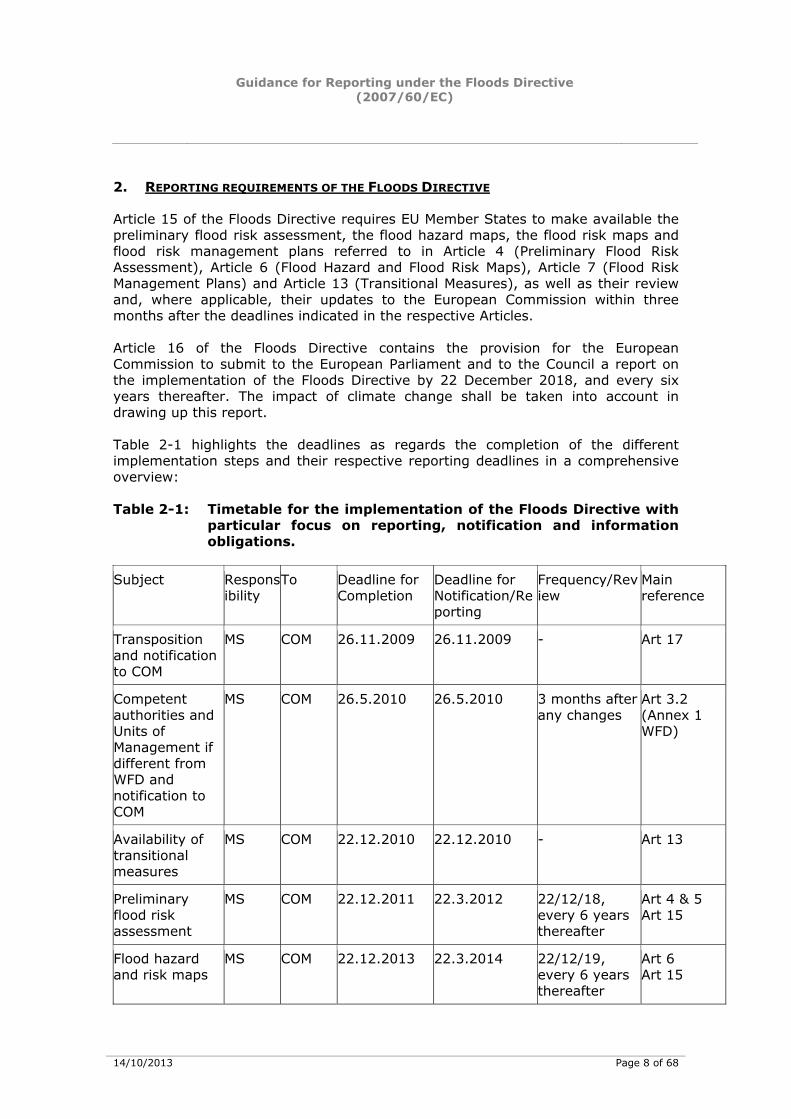
Article 15 of the Floods Directive requires EU Member States to make available the preliminary flood risk assessment, the flood hazard maps, the flood risk maps and flood risk management plans referred to in Article 4 (Preliminary Flood Risk Assessment), Article 6 (Flood Hazard and Flood Risk Maps), Article 7 (Flood Risk Management Plans) and Article 13 (Transitional Measures), as well as their review and, where applicable, their updates to the European Commission within three months after the deadlines indicated in the respective Articles. Article 16 of the Floods Directive contains the provision for the European Commission to submit to the European Parliament and to the Council a report on the implementation of the Floods Directive by 22 December 2018, and every six years thereafter. The impact of climate change shall be taken into account in drawing up this report. Table 2-1 highlights the deadlines as regards the completion of the different implementation steps and their respective reporting deadlines in a comprehensive overview: Table 2-1: Timetable for the implementation of the Floods Directive with
particular focus on reporting, notification and information obligations.
Subject Respons
ibility To Deadline for
Completion Deadline for Notification/Reporting
Frequency/Review
Main reference
Transposition and notification to COM
MS COM 26.11.2009 26.11.2009 - Art 17
Competent authorities and Units of Management if different from WFD and notification to COM
MS COM 26.5.2010 26.5.2010 3 months after any changes
Art 3.2 (Annex 1 WFD)
Availability of transitional measures
MS COM 22.12.2010 22.12.2010 - Art 13
Preliminary flood risk assessment
MS COM 22.12.2011 22.3.2012 22/12/18, every 6 years thereafter
Art 4 & 5 Art 15
Flood hazard and risk maps
MS COM 22.12.2013 22.3.2014 22/12/19, every 6 years thereafter
Art 6 Art 15
Guidance for Reporting under the Floods Directive (2007/60/EC)
14/10/2013 Page 9 of 68
Subject Responsibility
To Deadline for Completion
Deadline for Notification/Reporting
Frequency/Review
Main reference
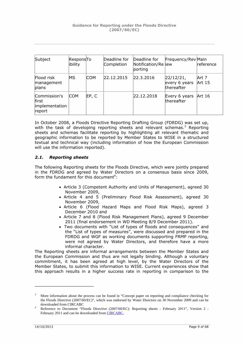
Flood risk management plans
MS COM 22.12.2015 22.3.2016 22/12/21, every 6 years thereafter
Art 7 Art 15
Commission's first implementation report
COM EP, C 22.12.2018 Every 6 years thereafter
Art 16
In October 2008, a Floods Directive Reporting Drafting Group (FDRDG) was set up, with the task of developing reporting sheets and relevant schemas.3 Reporting sheets and schemas facilitate reporting by highlighting all relevant thematic and geographic information to be reported by Member States to WISE in a structured textual and technical way (including information of how the European Commission will use the information reported). 2.1. Reporting sheets
The following Reporting sheets for the Floods Directive, which were jointly prepared in the FDRDG and agreed by Water Directors on a consensus basis since 2009, form the fundament for this document4:
• Article 3 (Competent Authority and Units of Management), agreed 30 November 2009,
• Article 4 and 5 (Preliminary Flood Risk Assessment), agreed 30 November 2009,
• Article 6 (Flood Hazard Maps and Flood Risk Maps), agreed 3 December 2010 and
• Article 7 and 8 (Flood Risk Management Plans), agreed 9 December 2011 (final endorsement in WD Meeting 8/9 December 2011).
• Two documents with “List of types of floods and consequences” and the “List of types of measures”, were discussed and prepared in the FDRDG and WGF as working documents supporting FRMP reporting, were not agreed by Water Directors, and therefore have a more informal character.
The Reporting sheets are informal arrangements between the Member States and the European Commission and thus are not legally binding. Although a voluntary commitment, it has been agreed at high level, by the Water Directors of the Member States, to submit this information to WISE. Current experiences show that this approach results in a higher success rate in reporting in comparison to the
3 More information about the process can be found in “Concept paper on reporting and compliance checking for
the Floods Directive (2007/60/EC)“, which was endorsed by Water Directors on 30 November 2009 and can be downloaded from CIRCABC
4 Reference to Document “Floods Directive (2007/60/EC): Reporting sheets - February 2011”, Version 2 - February 2011 and can be downloaded from CIRCABC.
Guidance for Reporting under the Floods Directive (2007/60/EC)
14/10/2013 Page 10 of 68
legally binding reporting requirements of the past.5 This informal process replaces the procedure set out in article 11 of the Floods Directive, setting out the procedure of formal adoption of reporting formats. This consolidated Guidance document contains all the information from the Reporting sheets presented in a clear, object-related way with the ultimate focus being on fully reported Floods Directive requirements, and places this process in the context of the reporting process developed for other water related legislation. 2.2. Reporting schemas
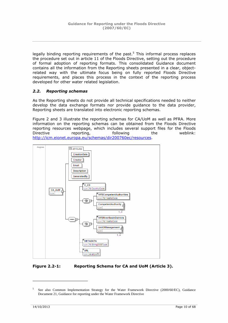
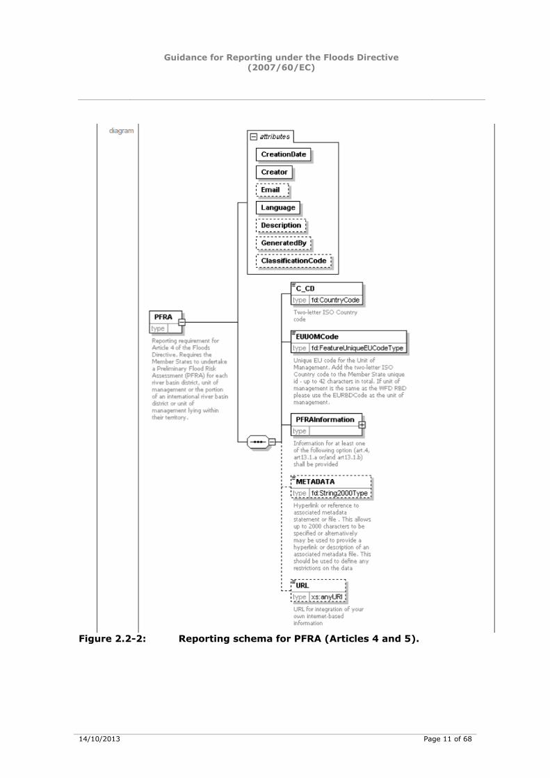
As the Reporting sheets do not provide all technical specifications needed to neither develop the data exchange formats nor provide guidance to the data provider, Reporting sheets are translated into electronic reporting schemas. Figure 2 and 3 illustrate the reporting schemas for CA/UoM as well as PFRA. More information on the reporting schemas can be obtained from the Floods Directive reporting resources webpage, which includes several support files for the Floods Directive reporting, following the weblink: http://icm.eionet.europa.eu/schemas/dir200760ec/resources.
Figure 2.2-1: Reporting Schema for CA and UoM (Article 3).
5 See also Common Implementation Strategy for the Water Framework Directive (2000/60/EC), Guidance
Document 21, Guidance for reporting under the Water Framework Directive
Guidance for Reporting under the Floods Directive (2007/60/EC)
14/10/2013 Page 11 of 68
Figure 2.2-2: Reporting schema for PFRA (Articles 4 and 5).
Guidance for Reporting under the Floods Directive (2007/60/EC)
14/10/2013 Page 12 of 68
2.3. Supporting documents for electronic reporting under WISE
Several supporting documents, tools and services facilitate the workflow for electronic Floods Directive reporting under WISE6: - Document No.1: Floods Directive reporting: User manual - Document No.2: Floods Directive reporting: User Guide to the reporting schema - Document No.3: Floods Directive reporting: User Guide to reporting spatial data - Document No.4: Guidance on reporting for FHRM of spatial information The document “Floods Directive reporting. A user guide for electronic reporting” (document 1)7 includes background information on reporting tools and QA/QC validation rules for reporting under Article 3 (Competent Authority and Unit of Management), Articles 4 and 5 (Preliminary Flood Risk Assessment) and Article 13 (Availability of transitional measures). To facilitate the submission of information according to the schemas to WISE, the following tools have been developed:
• Access database (back-end). This complements the schemas and organises the information into database tables. The database allows for manual entry, but also bulk data import can be used, depending upon the skill and the needs of the user.
• Access database (front-end). The front-end of the Access database is a user interface that also complements the schemas and organises the information into the back-end database tables. The front-end user interface only allows for manual entry and is only developed for the reporting of the CA and UoM.
• XML Conversion tool which generates the schemas from the Access database.
• QA/QC rules help ensure the information is filled out correctly. The QA/QC is run from the following:
• ReportNet
• Desktop validation tool
The document “User Guide to the Floods Reporting Schema” (Document No. 2)8 provides background information on the general issues in the schemas, the common schema and the key elements for reporting under Article 3 (CA and UoM) and Articles 4 and 5 (PFRA). Figure 2.3-1 illustrates the reporting process from user-interface (front end) to back-end (data storage), XML conversion tool, QA/QC rules and release of data. 6 http://icm.eionet.europa.eu/schemas/dir200760ec/resources. 7 More information can be found in “Floods Directive reporting. A user guide for electronic reporting”, to be
downloaded from http://icm.eionet.europa.eu/schemas/dir200760ec/resources. 8 All schemas are available online from EEA’s Reportnet following the link
http://icm.eionet.europa.eu/schemas/dir200760ec/resources.
Guidance for Reporting under the Floods Directive (2007/60/EC)
14/10/2013 Page 13 of 68
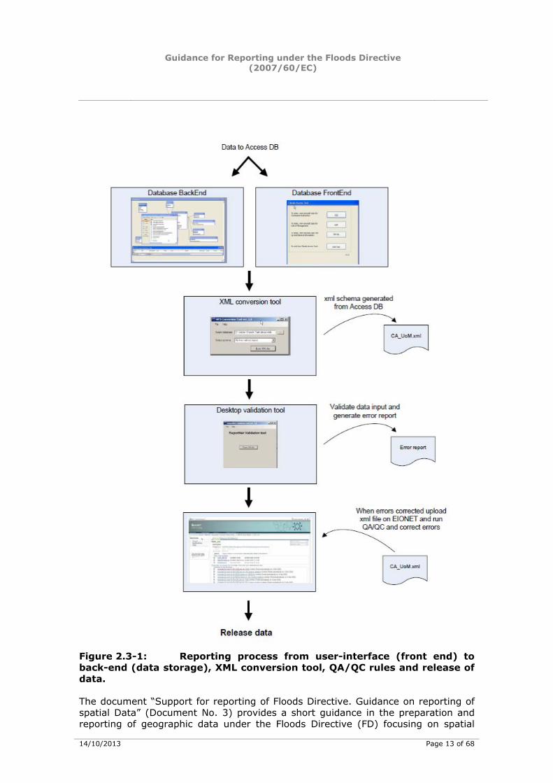
Figure 2.3-1: Reporting process from user-interface (front end) to back-end (data storage), XML conversion tool, QA/QC rules and release of data. The document “Support for reporting of Floods Directive. Guidance on reporting of spatial Data” (Document No. 3) provides a short guidance in the preparation and reporting of geographic data under the Floods Directive (FD) focusing on spatial

Guidance for Reporting under the Floods Directive (2007/60/EC)
14/10/2013 Page 14 of 68
information data to be provided for Article 3 (CA and UoM) and Articles 4 and 5 (PFRA). According to Article 6 of the Floods Directive, Member States shall produce flood mapping according to some minimum recommendations which are summarized in support Document No. 4 on “Reporting of spatial data for the Floods Directive (Part II). Guidance on reporting for flood risk and hazard maps of spatial information”. This document aims at providing guidance on the visualisation of the information to be shown on the flood maps, providing a technical framework for the setting up of Member State flood maps on national servers (INSPIRE) and describing how the information and maps will be used. Furthermore, the document “CIS Guidance Document No. 22: Updated Guidance on Implementing the Geographical Information System (GIS) Elements of the EU Water policy”9, shall be taken into account for reporting purposes. Templates for shape file(s) are available for the purpose of reporting of the Floods Directive.10 2.4. Inter-linkage with Reporting under the Water Framework Directive11
The Floods Directive shall be closely coordinated with the Water Framework Directive; the development of River Basin Management Plans under the WFD and of Flood Risk Management Plans under the FD are elements of integrated river basin management. The two processes should therefore use the mutual potential for common synergies and benefits, having regard to the environmental objectives of Directive 2000/60/EC.12 Article 9 of the Floods Directive includes the relevant provisions as regards the coordination with the WFD. Member States shall take appropriate steps to coordinate the application of the FD and WFD focusing on opportunities for improving efficiency, information exchange and for achieving common synergies and benefits. The coordination in particular requires the
development of first flood hazard maps and flood risk maps and their subsequent reviews to be carried out in such a way that the information they contain is consistent with relevant information presented according to the WFD, and
Development of the first Flood Risk Management plans and their subsequent reviews to be carried out in coordination with, and may be integrated into, the reviews of the River Basin Management Plans, as well as the
active involvement of all interested parties to be coordinated, as appropriate, with the active involvement of interested parties under the WFD.
9 Also available at http://icm.eionet.europa.eu/schemas/dir200760ec/resources under "Other supporting guidance" 10 http://icm.eionet.europa.eu/schemas/dir200760ec/resources 11 At the time of publishing this guidance a paper on the links between the WFD and the FD is being prepared by
the Floods WG (Links between the Floods Directive (FD 2007/60/EC) and Water Framework Directive (WFD 2000/60/EC). Resource Document)
12 Recital 17 of the Floods Directive.
Guidance for Reporting under the Floods Directive (2007/60/EC)
14/10/2013 Page 15 of 68
The inter-linkages with reporting processes under the WFD can be summarized as follows:
• Article 3.1 of the Floods Directive indicates that Member States may make use of the administrative arrangements made under Article 3 of the WFD. However, different competent authorities and units of management may be appointed by Member States for the Floods Directive. If the same Competent Authority is used for the Floods Directive as for the WFD, but the relevant information in relation to the responsibilities for the Floods Directive was not yet notified, such information should now be notified to the European Commission.13
• Article 6 of the Floods Directive states that the preparation of flood hazard maps and flood risk maps shall be coordinated with the review of the assessment carried out under article 5 of the Water Framework Directive 2000/60/EC. The coordination shall ensure that the information they contain is consistent, and the overall purpose of the coordination is to focus on opportunities for improving efficiency, information exchange and achieving common synergies and benefits having regard to the environmental objectives of that Directive.14
• There is a need to synchronise and coordinate, or to integrate, the FRMPs with the 2nd cycle River Basin Management Plans (RBMP) according to Article 9, and a need to avoid double reporting. From this it is clear that, the reporting formats need to enable integrated and/or coordinated reporting.
• Potential links concern the summary of the update of the Article 5(WFD) reports and the measures to address these pressures to be included in the programme of measures as part of the RBMP in 2015. As part of WFD RBMP Member States were requested to report information on relevant and significant pressures and the establishment of a programme of measures (PoM) for each RBD or part of an international RBD. Some of those pressure types and measure types are of particular interest, and may be of importance for FRMP, also in terms of coordination and synergies between both processes. A number of WFD relevant pressures and relevant WFD measures are of particular importance from the perspective of the co-ordinated implementation of the FD and the WFD with a view of improving information exchange, and of achieving common synergies and benefits. Taking into account the possibility to develop an integrated FRMP and RBMP the objective should be to develop a reporting structure to avoid double reporting. The reporting structure must give MS flexibility to report both plans in an integrated form or as two single but co-ordinated plans.15
2.5. Inter-linkage with Reporting according to the INSPIRE Directive
The “Directive 2007/2/EC of the European Parliament and of the Council of 14 March 2007 establishing an Infrastructure for Spatial Information in the European
13 Reporting sheet CA/UoM. 14 Reporting sheet maps. 15 Reporting Sheet FRMPs.
Guidance for Reporting under the Floods Directive (2007/60/EC)
14/10/2013 Page 16 of 68
Community (INSPIRE)” came into force on 15 May 2007 and will be implemented in various stages, with full implementation required by 2019.16 The Directive creates an EU wide spatial data infrastructure. This will enable the sharing of environmental spatial information among public sector organisations and better facilitate public access to spatial information across Europe. INSPIRE is based on a number of common principles:
Data should be collected only once and kept where it can be maintained most effectively.
It should be possible to combine seamless spatial information from different sources across Europe and share it with many users and applications.
It should be possible for information collected at one level/scale to be shared with all levels/scales; detailed for thorough investigations, general for strategic purposes.
Geographic information needed for good governance at all levels should be readily and transparently available.
Easy to find what geographic information is available, how it can be used to meet a particular need, and under which conditions it can be acquired and used.
Relevant Thematic Working Groups have been established aiming at drafting data specifications published as Guidelines for the spatial data themes referred to in Annex I of the INSPIRE Directive; the TWG on Annex III theme “Natural Risk Zones” is particularly relevant as regards the implementation of the FD, but many other themes are relevant for floods, notably for the flood hazard and risk maps. WG F actively participated in the development of INSPIRE requirements, notably through a FDRDG member taking part in the drafting of technical specifications for the Annex II theme of Natural Risk Zones. The Guidelines will supplement the Implementing Rule for interoperability of spatial data sets and services and allow for preparation for implementation. Together with the relevant materials (GML application schemas, UML models and registries), they will support the implementation and provide a better understanding of the requirements of the Implementing Rule.17 INSPIRE will not create any new reporting obligations, but requires Member States to provide spatial data and maps for the Floods Directive and other environmental Directives in an INSPIRE compliant way (interoperable and via web-services). This requires that further development of FD reporting formats and visualization for the PFRA, the Flood Risk Maps as well as Flood Hazard Maps and Flood Risk Management Plans shall furthermore be in line with relevant requirements of INSPIRE. The reporting sheets developed for the first FD implementation cycle will be assessed after the reporting, and if necessary be subject to a revision. This may be particularly relevant for the reporting of flood hazard and flood risk maps.18
16 http://inspire.jrc.ec.europa.eu/index.cfm/pageid/48. 17 http://inspire.jrc.ec.europa.eu/index.cfm/pageid/2. 18 Reporting sheets PFRA, Maps and FRMPs
Guidance for Reporting under the Floods Directive (2007/60/EC)
14/10/2013 Page 17 of 68
As the INSPIRE rules for metadata on relevant FD topics will not be operational until after 2014, this leads to a two pronged approach on reporting and visualisation of flood maps via WISE:
Under the staged approach, it is proposed that in the short term (until 2014) the reporting of flood maps reporting of geographical information as set out in section C, with web-links to detailed maps held in the Member States. This should be visualised in a way which allows the user to select an area from the EU-wide WISE background map, and then via hyperlink established in WISE, to switch and to zoom into the correct area at MS level. In either case the textual information on methodologies used, needs to be reported in textual form as set out in section C. Alternatively fully INSPIRE compliant maps can be prepared also for the 1st reporting cycle.
In the longer term as INSPIRE is being implemented, notably to be in place for all Member States for the second cycle of flood maps, the format for reporting/data and information exchange and visualisation/displayed of flood maps should be in a decentralised mode foreseen by the INSPIRE Directive, and in line with a Shared Environmental Information System (SEIS) initiative and made available via WISE. Member States have to implement the system to the map reporting of the second cycle (March 2020) at the latest, although reporting should as far as reasonably possible be INSPIRE compliant in the first cycle. 19
3. REPORTING AND VISUALIZATION OF FLOODS DIRECTIVE DATA THROUGH THE WATER INFORMATION SYSTEM FOR EUROPE (WISE)
Floods Directive data (submission of schemas as explained in section 1.3) are reported by Member States to WISE using the reporting infrastructure of EEA’s ReportNet (through the ReportNet Common Data Repository (CDR); guidance on uploading to ReportNet can be found in Chapter 6 of Document No. 1: A User Guide for electronic reporting). Reportnet is Eionet's20 infrastructure for supporting and improving data and information flows. Reportnet is based on a set of inter-related tools and processes which all build on the active use of the World Wide Web. Reportnet has been developed since 2000 and has been in operational use since 2002. The system integrates different web services and allows for distributed responsibilities. Reportnet was initially used for reporting environmental data to EEA, but is now also hosting some of DG Environment’s reporting tasks.21 The Water Information System for Europe (WISE) is comprised of data and information collected at EU level by various institutions or bodies. WISE was developed as a joint initiative and effort by DG Environment, EEA, JRC and
19 Reporting sheet Maps. 20 Eionet is the EEA's network which consists of administrative and scientific institutions at national level in more
than 32 countries. It consists of the EEA itself, currently 5 European Topic Centres and a network of more than 900 experts from 37 countries in over 300 national environment agencies and other bodies dealing with environmental information. See more information in EEA, Reportnet for beginners to be downloaded from the following weblink: http://www.eionet.europa.eu/reportnet/Reportnet%20for%20beginners.pdf
21 http://www.eionet.europa.eu/reportnet.
Guidance for Reporting under the Floods Directive (2007/60/EC)
14/10/2013 Page 18 of 68
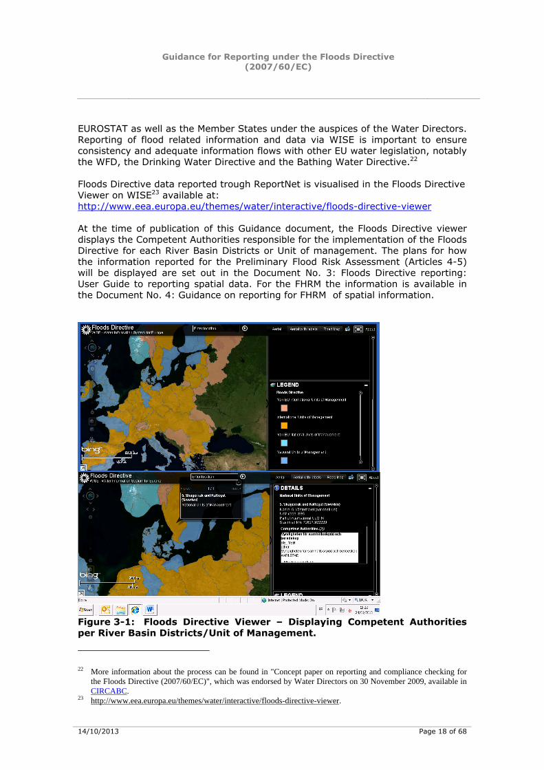
EUROSTAT as well as the Member States under the auspices of the Water Directors. Reporting of flood related information and data via WISE is important to ensure consistency and adequate information flows with other EU water legislation, notably the WFD, the Drinking Water Directive and the Bathing Water Directive.22 Floods Directive data reported trough ReportNet is visualised in the Floods Directive Viewer on WISE23 available at: http://www.eea.europa.eu/themes/water/interactive/floods-directive-viewer At the time of publication of this Guidance document, the Floods Directive viewer displays the Competent Authorities responsible for the implementation of the Floods Directive for each River Basin Districts or Unit of management. The plans for how the information reported for the Preliminary Flood Risk Assessment (Articles 4-5) will be displayed are set out in the Document No. 3: Floods Directive reporting: User Guide to reporting spatial data. For the FHRM the information is available in the Document No. 4: Guidance on reporting for FHRM of spatial information.
Figure 3-1: Floods Directive Viewer – Displaying Competent Authorities per River Basin Districts/Unit of Management.
22 More information about the process can be found in "Concept paper on reporting and compliance checking for
the Floods Directive (2007/60/EC)", which was endorsed by Water Directors on 30 November 2009, available in CIRCABC.
23 http://www.eea.europa.eu/themes/water/interactive/floods-directive-viewer.
Guidance for Reporting under the Floods Directive (2007/60/EC)
14/10/2013 Page 19 of 68
http://www.eea.europa.eu/themes/water/interactive/floods-directive-viewer
4. HOW WILL THE INFORMATION/DATA REPORTED BE USED BY THE COMMISSION AND OTHER POTENTIAL USERS?
4.1. Compliance checking with the requirements of the Floods Directive
A key role of the Commission is to check compliance with EU legislation. The Commission uses the information provided by Member States to carry out a compliance assessment and to ensure that the Floods Directive is being applied consistently throughout the EU. The Commission has developed a Concept paper on reporting and compliance checking for the Floods Directive (2007/60/EC), which was endorsed by Water Directors in November 2009.24 In order to be able to do a proper compliance checking, the European Commission requires information that enables to:
- Ensure data are plausible; - Ensure data are consistent; - Conduct cross-references and cross-checks on data (especially in
International River Basins); and, - Ensure Directives have been implemented in a comparable way.
The Commission also seeks information on the state of the environment and trends including on flooding (usually in cooperation with EEA), and on implementation of measures and objectives set to allow it to determine whether existing policies are adequately protecting the environment and European citizens and could play a role in relation to assessment on whether funds are adequately distributed. It also requires certain information at European level to create a European-wide picture to inform the public. Article 16 of the Floods Directive specifically requires the Commission to report to the European Parliament and Council on the implementation of the Directive by 2018 and every 6 years thereafter. To meet the Commission’s needs, data must be reported (or made available) in a clear and consistent way by all Member States. The information can be aggregated and supplied at a higher aggregation level than may be required at, for example Member State level. However, the Commission may need access to more detailed information (e.g. by providing hyperlinks to more detailed documents or by requesting more specific information or data) in cases where comprehension (e.g. of how a result has been achieved) or compliance (e.g. with specific issues) is not clear. Three main questions usually relate to the reported data and information:
• Are the reports complete (provision of mandatory fields) and clear (values in code lists correct and numeric/character values in correct minimum/maximum ranges)?
24 The contents of this chapter have been largely extracted from the 2009 Concept paper, see footnote 22.
Guidance for Reporting under the Floods Directive (2007/60/EC)
14/10/2013 Page 20 of 68
• Are the reports understandable (sense check)?
• Are the reports compliant
• with regard to key issues (compliance checking) involving for some issues the use of appropriate indicators?
• after in-depth assessment?
There are two parts to compliance checking: of methodologies and checking data or results. The reporting sheets for each implementation step sets out some specific compliance criteria. 4.2. Potential users of information related to data and information
provided
In addition, the following sub-section provides a non-exhaustive list of examples of other potential users of information related to the implementation of the Floods Directive. As outlined in the concept paper on reporting, information for other uses may be asked for, with the consent from the Member States, going beyond compliance checking purposes for the Floods Directive. With a view of streamlining reporting on, for instance, State of the Environment reports by the European Environment Agency with reporting for the Floods Directive, some additional optional information may be asked for.25 4.2.1. Joint Research Centre (JRC)
The DG Joint Research Centre provides research based policy support to other Commission DG’s. To carry out this support more accurately, the items provided for the Floods Directive will be very beneficial. For floods, JRC assists DG ENV and DG REGIO with the following activities:
• European Flood Alert System (EFAS): early warning on river floods for National Authorities and the Commission’s Civil Protection
• Other coastal flood warning systems.
• Assessment of climate change effects on floods in Europe.
• Assisting DG REGIO in evaluating Solidarity Funds (EUSF) applications of MS after major floods.
• Evaluating flood risk at European scale to assist DG REGIO in defining and monitoring regional planning strategies.
4.2.2. European Environment Agency (EEA)
The European Environment Agency (EEA) is an agency of the European Union. Its task is to provide sound, independent information on the environment. Regarding the data management, EEA cooperates with DG ENV in the development and maintenance of the Water Information System for Europe (WISE). WISE contains so far the compliance related information under the WFD and the UWWTD, as well 25 Reporting Sheet Flood Hazard and Risk Maps.
Guidance for Reporting under the Floods Directive (2007/60/EC)
14/10/2013 Page 21 of 68
as voluntary State of Environment (SoE) information related to these directives and the wider EEA work (stemming from the Eionet). Other directives including the FD are currently integrated. The EEA uses the SoE information in WISE in the context of its mandate to publish every 5 years reports on state, trends and outlooks of the Environment. To this purpose EEA collects regularly data via its network, develops indicator and wider assessments on environmental themes. This includes issues such as mapping the impacts of natural disasters and technological accidents (including the recurrence of flood events in Europe), climate change and water adaptation issues including flooding and climate change impact report which includes indicators on water quantity, river flows, floods and droughts. Aggregated information on past floods (frequency, duration, location per river basin) and an on-going record of current floods and its impacts would facilitate the state and trend analysis in this area. 4.2.3. DG Humanitarian Aid & Civil Protection (DG ECHO)
The Civil protection area was moved to DG ECHO in 2010 in order to promote better cooperation with the humanitarian field and to be better prepared for coordination of emergency response not only inside, but outside Europe as well. The coordinating tool of the EU Civil Protection Mechanism is the Emergency Response Coordination Centre (ERCC, previously MIC). On the basis of a community approach to the prevention of natural and man-made disasters, DG ECHO prepares an overview on EU risks, including floods. Activities also include reinforcing cooperation on the whole risk management cycle e.g. through the promotion of Early Warning Systems.
Detailed information on flood risk, such as the information to be included in the flood hazard maps, flood risk maps and flood risk management plans is crucial for effective civil protection operations before and during a flood situation. Information reported under the Floods Directive can contribute as well to the development of an EU overview on risks. 4.2.4. DG for Regional Policy (DG REGIO)
The Structural Funds, in particular the European Regional Development Fund and the Cohesion Fund can finance preventive (infrastructure) investments including for flood protection. The European Regional Development Fund can also contribute to financing infrastructure-related research and technological development. The European Union Solidarity Fund (EUSF) also can intervene to finance recovery operations, depending on the scale of damage which occurred. Transparent information at the European level on the assessment and management of floods according to the Directive can be beneficial for the management of such funds. The flood risk maps will allow DG REGIO to evaluate the MS applications more accurately and quickly.
Guidance for Reporting under the Floods Directive (2007/60/EC)
14/10/2013 Page 22 of 68
5. REPORTING REQUIREMENTS FOR COMPETENT AUTHORITIES (ARTICLE 3)
The Reporting sheet for Competent Authorities (CA) according to Article 3 of the Floods Directive was prepared in the Floods Directive Reporting Drafting group (FDRDG) and approved by WG F and by Water Directors on 30 November 2009. The relevant schema for electronic reporting of CA in WISE can be downloaded from the Eionet Floods Directive reporting resources webpage following the link http://icm.eionet.europa.eu/schemas/dir200760ec/resources. The information on the CA is displayed on the Floods Directive WISE Viewer following the link: http://www.eea.europa.eu/themes/water/interactive/floods-directive-viewer. 5.1. Introduction to the reporting of competent authorities
Article 3.1 of the Floods Directive indicates that Member States may make use of the administrative arrangements made under Article 3 of the Water Framework Directive. The Water Framework Directive requires Member States to ensure the appropriate administrative arrangements, including the identification of the appropriate competent authority, for the application of the rules of the Directive within each river basin district lying within their territory. However, different competent authorities may be appointed by Member States for the Floods Directive. The Floods Directive also allows Member States to identify different units of management from the river basin districts used for the Water Framework Directive. Competent authorities will be required for each national river basin district or unit of management and for the portion of any international river basin district or unit of management lying within a Member State’s territory. In cases where different competent authorities have been appointed, the Floods Directive required Member States to communicate to the Commission by 26 May 2010 the information referred to in Annex I of the Water Framework Directive. Any changes in administrative arrangements also need to be communicated within three months of the change coming into effect.
Look Out! According to the Floods Directive, this information should only beprovided if different competent authorities have been appointedand/or different units of management identified from those alreadyreported for the Water Framework Directive. However, if the same Competent Authority is used for the FloodsDirective as for the WFD, but the relevant information in relation tothe responsibilities for the Floods Directive was not yet notified to the Commission, such information should now be notified in accordance with this reporting sheet.
Guidance for Reporting under the Floods Directive (2007/60/EC)
14/10/2013 Page 23 of 68
5.2. How will the Commission use the information reported?
The provision of data and information will allow the Commission to ensure that all administrative roles required by the Floods Directive are being fulfilled within the river basin district or other unit of management. The data may be used for presentation to the European Commission and will be provided to the public through WISE. 5.3. Information to be provided
5.3.1. Geographic information
Please refer to section 6.3.1 for the reporting of each UoM, which will be required in order to be able to prepare a map of UoMs (and RBDs) at the European level. 5.3.2. Optional geographic information
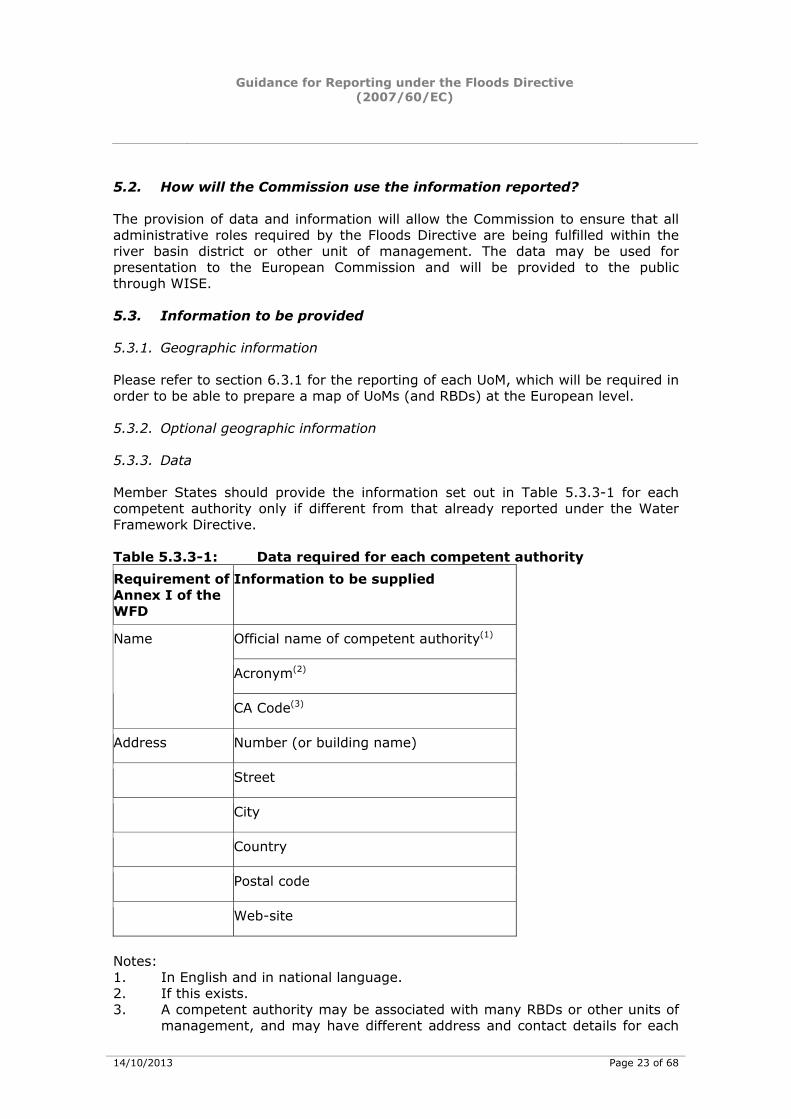
5.3.3. Data
Member States should provide the information set out in Table 5.3.3-1 for each competent authority only if different from that already reported under the Water Framework Directive. Table 5.3.3-1: Data required for each competent authority Requirement of Annex I of the WFD
Information to be supplied
Official name of competent authority(1)
Acronym(2)
Name
CA Code(3)
Address Number (or building name)
Street
City
Country
Postal code
Web-site
Notes: 1. In English and in national language. 2. If this exists. 3. A competent authority may be associated with many RBDs or other units of
management, and may have different address and contact details for each
Guidance for Reporting under the Floods Directive (2007/60/EC)
14/10/2013 Page 24 of 68
association. A general/main address and specific addresses for RBDs and other units of management should be provided if appropriate.
5.3.4. Summary text
• Summary text (< 5000 characters) of the legal status of each competent authority should be provided. This should include a summary of:
• The legislation establishing the competent authority;
• The legislation laying down the duties of the competent authority in relation to the Floods Directive; and
• The legislation laying down other duties of the competent authority relevant (but not directly related) to the Floods Directive.
• Summary text (< 5000 characters) will be required on the institutional relationships established in order to ensure co-ordination where the competent authority acts as a co-ordinating body for other competent authorities, or when more than one competent authority is established. This should include a list showing the co-ordinating body and the relationship between the co-ordinating body and the authorities whose activities it is co-ordinating, and relationships with other bodies carrying out tasks linked to implementation of the plans including for example civil protection agencies and early warning systems.
• Details of memberships and international relationships. Summary text (< 5000 characters) of the institutional relationships established to ensure co-ordination where a river basin district or other unit of management covers the territory of more than one Member State or includes the territory of non-Member States.
• The core responsibilities of the relevant competent authority must be specified for each river basin district or other unit of management. If other relevant roles (such as spatial planning, flood forecasting, flood warning and civil protection) are fulfilled by organisations not defined as competent authorities for the purposes of reporting, a summary (< 5000 characters) should be provided identifying these authorities and the roles that they perform.
Guidance for Reporting under the Floods Directive (2007/60/EC)
14/10/2013 Page 25 of 68
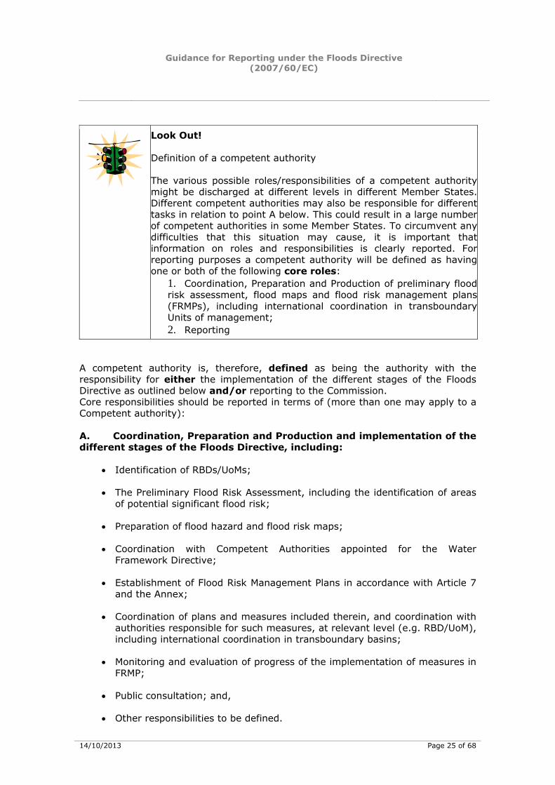
Look Out! Definition of a competent authority The various possible roles/responsibilities of a competent authoritymight be discharged at different levels in different Member States.Different competent authorities may also be responsible for differenttasks in relation to point A below. This could result in a large numberof competent authorities in some Member States. To circumvent anydifficulties that this situation may cause, it is important thatinformation on roles and responsibilities is clearly reported. For reporting purposes a competent authority will be defined as havingone or both of the following core roles:
1. Coordination, Preparation and Production of preliminary floodrisk assessment, flood maps and flood risk management plans(FRMPs), including international coordination in transboundary Units of management; 2. Reporting
A competent authority is, therefore, defined as being the authority with the responsibility for either the implementation of the different stages of the Floods Directive as outlined below and/or reporting to the Commission. Core responsibilities should be reported in terms of (more than one may apply to a Competent authority): A. Coordination, Preparation and Production and implementation of the different stages of the Floods Directive, including:
• Identification of RBDs/UoMs;
• The Preliminary Flood Risk Assessment, including the identification of areas of potential significant flood risk;
• Preparation of flood hazard and flood risk maps;
• Coordination with Competent Authorities appointed for the Water Framework Directive;
• Establishment of Flood Risk Management Plans in accordance with Article 7 and the Annex;
• Coordination of plans and measures included therein, and coordination with authorities responsible for such measures, at relevant level (e.g. RBD/UoM), including international coordination in transboundary basins;
• Monitoring and evaluation of progress of the implementation of measures in FRMP;
• Public consultation; and,
• Other responsibilities to be defined.

Guidance for Reporting under the Floods Directive (2007/60/EC)
14/10/2013 Page 26 of 68
B. Reporting
• Public information and consultation;
• Reporting to Commission; and,
• Other responsibilities to be defined.
C. Other
• Any other roles not covered above.
5.3.5. Other information
• Hyperlinks to more detailed supporting documents (e.g. the statute, founding treaty or equivalent legal document) should be provided.
Guidance for Reporting under the Floods Directive (2007/60/EC)
14/10/2013 Page 27 of 68
6. REPORTING REQUIREMENTS FOR UNIT/S OF MANAGEMENT (ARTICLE 3)
The Reporting sheet for Unit/s of Management (UoM) according to Article 3 of the Floods Directive was prepared in the FDRDG and was approved by WGF and Water Directors on 30 November 2009. The relevant schema for electronic reporting of UoM in WISE can be downloaded from the Eionet Floods Directive reporting resources webpage following the link http://icm.eionet.europa.eu/schemas/dir200760ec/resources. The information on the UoM is displayed on the Floods Directive WISE Viewer following the link: http://www.eea.europa.eu/themes/water/interactive/floods-directive-viewer. 6.1. Introduction
The Floods Directive (Article 3.2) allows Member States to identify units of management different from the river basin districts used for the Water Framework Directive. Units of management may be individual river basins and/or certain coastal areas, and may be entirely within national borders or may be part of an international unit of management or international river basin district. The Floods Directive required Member States to communicate to the Commission information on the identification of units of management by 26 May 2010.
Look Out! Data should only be provided if other units of management havebeen identified for the Floods Directive or if Water FrameworkDirective RBDs are being used but information was missing from aMember State’s submission to WISE or if any of the information haschanged.
6.2. How will the Commission use the information reported?
The Commission needs this information to ensure that the assessment and management of flood risk is at an appropriate scale for protecting public safety and meets the requirements of the Floods Directive. The Commission will require a European map of units of management in relation to national and international river basin districts with the aim of providing a reference data set of RBDs and units of management. The reference data set will be the basis for the presentation of indicators and information at the European level. The information will be provided to the public through WISE. 6.3. Information to be provided
6.3.1. Geographic information
• A digital map of each UoM will be required so that a map of UoMs (and RBDs) at the European level can be prepared by the Commission. The
Guidance for Reporting under the Floods Directive (2007/60/EC)
14/10/2013 Page 28 of 68
geographic information should be harmonised to national and coastal boundaries. 26
6.3.2. Data
• The geographical information must be provided either as GML files or as shape files. Templates will be available specifying how this information will be provided.
• According to the WFD “CIS Guidance Document No. 22: Updated Guidance on Implementing the Geographical Information System (GIS). Elements of the EU Water policy”27, the required spatial accuracy and resolution for reported data should be better than 125 metres and 0.5 km2, respectively at a map scale of 1:250,000. The positional and spatial accuracy should always be kept as high as possible and ideally be similar to the national operational datasets. Member States may report data at a more detailed scale if they wish.
6.3.3. Summary text
• No summary text is required.
26 The technical specifications of such harmonisation foreseen in the context of the development of the GIS
guidance for reporting under the WFD. 27 The “CIS Guidance Document No. 22: Updated Guidance on Implementing the Geographical Information
System (GIS). Elements of the EU Water policy” can be found following the weblink: http://icm.eionet.europa.eu/schemas/dir200760ec/resources
Guidance for Reporting under the Floods Directive (2007/60/EC)
14/10/2013 Page 29 of 68
7. REPORTING REQUIREMENTS FOR PRELIMINARY FLOOD RISK ASSESSMENT (ARTICLE 4)
The Reporting sheet for the Preliminary Flood Risk Assessment according to Article 4 of the Floods Directive was prepared in the FDRDG and was agreed by WGF and Water Directors on 30 November 2010. The relevant schema for electronic reporting of PFRA in WISE can be downloaded from the Eionet Floods Directive reporting resources webpage following the link http://icm.eionet.europa.eu/schemas/dir200760ec/resources. 7.1. Introduction
Article 4 of the Floods Directive requires Member States to undertake a Preliminary Flood Risk Assessment (PFRA) for each river basin district, unit of management or the portion of an international river basin district or unit of management lying within their territory. The identification of areas potential significant flood risk (Article 5) will be based on available or readily derivable information including the requirements specified in the Directive (Article 4). Exchange of relevant information is required between the competent authorities of Member States sharing international RBDs or units of management (Article 4.3) and identification of areas identified as being at potential significant flood risk shall be coordinated between the Member States concerned (Article 5.2). Available or readily derivable information should, where possible, include details of:
• Significant floods28 that have occurred in the past and their location, extent, conveyance routes and adverse consequences, and other floods that occurred in the past which would have significant adverse consequences if they occurred again;
• Potential adverse consequences of future floods;
• Impacts of climate change and long-term developments on the occurrence of floods; and,
• Other available or readily derivable information, as relevant to the Member State, on issues such as topography, the position of water courses and their general hydrological and geo-morphological characteristics, including flood plains as natural retention areas, the effectiveness of existing flood defense infrastructure, and the position of populated areas and areas of economic activity.
28 Significant floods here refer to floods that occurred in the past and which had significant adverse impacts on
human health, the environment, cultural heritage and economic activity and for which the likelihood of similar future events us still relevant (Art 4.2.(b) and significant floods which have occurred in the past, where significant adverse consequences of similar future events might be envisaged (Article 4.2(c)).
Guidance for Reporting under the Floods Directive (2007/60/EC)
14/10/2013 Page 30 of 68
The starting point of the assessment is to use maps of the river basin district, or Unit of Management, at the appropriate scale including the borders of the river basins, sub-basins and, where existing, coastal areas, showing topography and land use. In recognition that the PFRA is based on available or readily derivable information, and that Members States have discretion over particular factors that should be included in the PFRA, this reporting sheet includes some elements that are of an ”optional” nature. The Commission furthermore will need to know how the assessment has been carried out (e.g. methodology, criteria applied) and what aspects and factors have been excluded in the PFRA and the reasons for their exclusion, in order to check the compliance with Articles 4, 5 and 13.1(a). The Commission will also need to be notified, and be provided with the relevant information, when Member States apply Article 13.1(b), that is to not carry out a PFRA, but proceed directly to the preparation of maps and plans. In particular in case of areas that are not designated as areas of potential significant flood risk (and therefore will be excluded from the further implementation of the Directive), the Commission will need to know if the various aspects and factors mentioned in Article 4 were taken into account by the Member State, and if not, for what reason. The core of the requirements of Article 4 is to use information on past significant floods as the basis for identifying where floods may occur in the future. To avoid increasing the administrative costs in relation to reporting, but still gathering sufficient information to enable the Commission to check compliance with the preliminary flood risk assessment, basic information and geographic location, which either identifies a spatial position (x/y coordinates, name of locality) or identifies the river basins, sub-basins, stretch of coastal area and other areas where past floods have occurred, should be provided. More detailed information should however be provided for floods that occur in the future during subsequent implementation cycles, and which will be considered as past floods for the review of those cycles. Complementing this, a project to gather available and readily derivable information from Member States sources will be considered to be developed by JRC.
Look Out! It is recognised that not all of the data requested in this reportingsheet will be available for reporting for significant floods that haveoccurred prior to 22 December 2011. However, having recognisedthis, it is expected that the data set out will be collected, and hence reported, by Member States for significant flood events that occurafter 22 December 2011.
It is also recognised that other approaches may be used for identifying Areas of Potential Significant Flood Risk (APSFR), such as predictive modelling. The reporting sheet gives a possibility to explain the different approaches and methodologies applied. Article 4.2 (d) of the Floods Directive requires that the impacts of climate change and long-term developments on the occurrence of floods should be considered in
Guidance for Reporting under the Floods Directive (2007/60/EC)
14/10/2013 Page 31 of 68
the Preliminary Flood Risk Assessment, depending on the specific needs of the Member States. Early consideration of climate change and long-term developments will ensure that areas identified as being at significant flood risk, and hence where flood maps and flood management plans are focused, reflects future flood risk resulting from climate change or other long-term developments. The Floods Directive (Article 4.2) also identifies a range of specific other issues that should be taken into account in undertaking the Preliminary Flood Risk Assessment. This does not preclude the use of any further relevant available or readily derivable information by Member States. Article 5 requires that the PFRA shall be used as the basis for the identification of areas for which Member States conclude that potential significant flood risk (APSFR) exist or might be considered likely to occur in the future for each river basin district, unit of management or the portion of an international river basin district or unit of management lying within a Member State’s territory. Coordination is required between Member States sharing PSFR areas within international RBDs or other international units of management. The first PFRA had to be completed by 22 December 2011 and made available to the Commission by 22 March 2012. The PFRA will be used by Member States as the basis for identifying areas where potential significant flood risks might exist, or might be considered likely to occur. The Directive does not specify when the requirements of Article 5 must be completed; however, the identification must be completed after 22 December 2011, and in sufficient time to allow Member States to prepare flood maps by 2013. The Preliminary Flood Risk assessment (as set out in Chapter II of the Directive) shall be made available to the public. A summary of the process will be presented to the public through WISE, including:
• Maps showing if Articles 4, 5 or 13.1(a) or (b) have been applied and the conclusions of these Articles in terms of identification of APSFR or the decision made to proceed to mapping and the production of flood risk management plans,
• A map of river basin, sub-basins, coastal stretches or other areas where there has in the past been a significant flood event,
• Links to more detailed information and,
• Selected summary texts explaining overall approach and methodology (to be defined by WG F).
More detailed information, such as the extent of past floods or records of such floods or their consequences, may be held and made available to the public through national systems or through specifically defined expert views only. Member States may apply Article 13.1 (transitional arrangements) in the 1st implementation cycle, and either report on a PFRA carried out before 22 December 2010 (Article 13.1(a)) or proceed directly to mapping and establishment of flood risk management plans (Article 13.1(b)). If article 13.1(a) is applied, the result will include the identification of APSFR, but the information provided for the basis of
Guidance for Reporting under the Floods Directive (2007/60/EC)
14/10/2013 Page 32 of 68
such assessment may differ. This will be taken into account in each reporting stage, and when detailed reporting formats are developed. It is recognized that if Article 13.1(b) is applied, APSFR will not be identified; instead maps at the appropriate scale according to Article 6 will be prepared, showing where significant flood risk exists in these areas. To ensure transparency for the Commission, as well as the public and other actors, this reporting sheet asks Member States to report which provision has been used in different parts of their territory, the option used will be made transparent in map format to be visualised together with the map of APSFR
Look Out! Member States may designate relatively large areas of potentialsignificant flood risk (APSFR), compared to the areas that actuallymight be flooded. Flood risk management (the subject of Article 7)usually requires consideration of much larger areas than the areasthat may actually be flooded. The identification of floodable areas isnot due under Article 4, but under Article 6 of the Directive, throughthe production of the flood hazard and flood risk maps for all areasof PSFR. Thus, Member States may for instance choose to designate an areaof PSFR as "river basin X except for the sub-basins of the tributaries P, Q and R" (where P, Q and R are tributaries for which no significantadverse impacts are anticipated, as demonstrated throughapplication of the PFRA as set out in Articles 4 and 5).
A list of different flood types was developed and agreed in the FDRDG, which serves the purpose of facilitating systematic reporting of different aspects of the requirements.29 7.2. Preliminary Flood Risk Assessment (Art 4)
7.2.1. How will the Commission use the information reported?
The reporting requirement in this reporting sheet will allow the Commission to: • Check the compliance of Member States’ Preliminary Flood Risk Assessment
with the requirements of the Directive, including:
– that available and readily-derivable information on past floods of significant adverse consequences, and for which the likelihood of occurrence or significance of consequences are still relevant, has been identified and considered;
– that the impacts of climate change on the occurrence of floods have been identified and considered,
29 Please refer to section 10.1 for more information on the enumeration list of types of floods expressed as sources,
mechanisms and characteristics of floods.
Guidance for Reporting under the Floods Directive (2007/60/EC)
14/10/2013 Page 33 of 68
– that the adverse consequences of potential future significant floods, and the issues identified in Article 4.2(d), have been considered, according to the specific needs of Member States;
– that relevant information has been exchanged between Member States in the case of international RBDs or UoMs;
• Compare methodologies and the use of information across Member States, RBDs and UoMs and within UoM/RBD, particularly in terms of international RBDs and UoMs;
• Assess the compliance of the use of Article 13.1 (a), in comparison with the requirements of Articles 4 and 5, and assess the use of Article 13.1 (b) (although it is recognised that "equivalence" is not the legally defined criteria here).
• Prepare digital records at a European level on the locations of significant past flood events whose impacts are still relevant and the location of potential future floods, (depending on scale, in a public view or restricted expert view).
Some information after consultation of WG F, will also be provided to the public through WISE. The Commission will use the following criteria when checking the compliance of these aspects:
• Completeness of the assessment as regards geographical area that is covered, consideration of different types of past floods, and other relevant factors set out in Article 4,
• Transparency of procedures, methodologies, reports and information provided to the public and to neighbouring MS in accordance with relevant Articles,
• Adequacy of consideration of the relevant risk receptors (human health, economic activity, the environment and cultural heritage),
• Adequacy of the criteria defining significance of past floods.
7.2.2. Information to be provided
7.2.2.1. Geographic information
Data will be required from Member States to enable maps with the following content to be produced (taking into account that visualisation in expert view or public view is to be determined):
• Maps of the river basin district or unit of management at the appropriate scale including the borders of the river basins, sub-basins and, where
Guidance for Reporting under the Floods Directive (2007/60/EC)
14/10/2013 Page 34 of 68
existing, coastal areas, showing topography and land use (NB: Most of this information should already be available in WISE, and additional information shall be made available via WISE to complete the information.);
• Location of past significant floods30 or where potential future significant floods could occur (the format of how information can be provided is flexible, such as by simple x/y coordinates, or the geographic location of an urban area or other area affected by the flood (i.e. not precisely define a flood location, but provide a general location (e.g. centroid) of the town or other area that was flooded, or stretches of rivers /coastal areas, recognising that not all Member States may have available or readily derivable geo-referenced information on all past floods in electronic format).
7.2.2.2. Optional geographic information
7.2.2.3. Data
For each significant past flood31 and for potential future significant floods, where available or readily derivable:
• (Location (name of the locality, river basin, sub-basin and/or coastal area or other areas associated with past floods);
• Category of flood (past flood or potential future flood);
• Type of flood or floods (please refer to section 10.1 for more information)
• Extent (area of land inundated, or length of river stretches or coasts);
• Probability of flood event (frequency, recurrence);
• Type and degree of adverse consequences (please refer to section xx for more information) for:
• human health
• environment
• cultural heritage
• economic activity
• Other relevant information;
• For past floods, date of commencement and duration (days) of each flood.
30 See footnote 28. 31 See footnote 28.
Guidance for Reporting under the Floods Directive (2007/60/EC)
14/10/2013 Page 35 of 68
In case data is not available or readily derivable for past floods that occurred before 22.12.2011, summary text with description shall be provided for each event. 7.2.2.4. Summary text
Summary text [Note: In event of application of Art 13.1 it may not be possible to answer all questions] For each RBD/UoM:
• Summary (< 10,000 characters) of the overall approach and methodology applied to undertake the PFRA, or to meet the requirements of Article 13.1(a) as applicable;
– Notification of application of Article 13.1(b);
– Summary (< 5,000 characters) of the methodology and criteria used to identify and assess floods that occurred in the past and their past adverse consequences (including whether such consequences would be ‘significant’) and whether the likelihood of such floods remains relevant;
• Summary (< 5,000 characters) of the methodology and criteria used to identify and assess significant floods that occurred in the past that would have significant adverse consequences were they reoccur in the future;
• Summary (< 5,000 characters) of the methodology and criteria used to identify and assess potential future significant floods and their potential adverse consequences;
• Summary (< 5000 characters) of relevant long term developments that might affect the occurrence and significance of flooding and in particular the impacts of climate change, including the methods, records and studies used to assess such impacts;
• Summary (< 5000 characters) of how each of the issues identified under Article 4(2)(d) were considered to support the assessment of potential adverse consequences of future floods, including information on the methodologies applied to consider those issues and,
• Summary (< 5000 characters) of, if relevant, the reasons for not considering any issue identified under Article 4.2(d) when assessing the potential adverse consequences of future floods;
• Summary (< 5000 characters) of any other relevant available or readily-derivable information used in the PFRA;
• Summary (< 5000 characters) on the steps taken by Member States to ensure the exchange of relevant information between competent authorities for shared river basins or units of management.
• If Article 13.1(a) is applied, a summary (< 10000 characters) of relevant information in relation to application of that Article, to show how the
Guidance for Reporting under the Floods Directive (2007/60/EC)
14/10/2013 Page 36 of 68
assessment has been carried out, including information to determine the date of the availability of the assessment used.
For each significant flood event:
• If not possible to provide data as indicated above, a summary (<5,000 characters) description of each past flood and its adverse or potentially adverse consequences, including information equivalent of that of the data.
7.2.2.5. Other information
• Hyperlink to more detailed supporting documents (e.g. methodology documents, external sources of information) should be provided.
7.3. Identification of areas with Potential Significant Flood Risk
7.3.1. How will the Commission use the information reported?
The reporting requirements will allow the Commission to:
• Check the compliance of Member States’ Preliminary Flood Risk Assessment with the requirements of the Directive, including:
– that the definition of ”potential significant flood risk” has been clearly and transparently described;
– that the identification of areas of potential significant flood risk has been clearly and transparently applied and described;
– that relevant coordination has occurred between Member States in the case of international RBDs or UoMs;
• Compare methodologies and the use of information across Member States, RBDs and UoMs, including within RBD/UoM particularly in terms of international RBDs and UoMs;
• Assess the compliance of the use of Article 13.1 (a) in comparison with the requirements of Articles 4 and 5, and assess the use of Article 13.1(b) (although it is recognised that "equivalence" is not the legally defined criteria here).
• Prepare digital records at a European level on the locations of areas of potential significant flood risk.
Some information will be provided to the public through WISE. The Commission will use the following criteria when checking the compliance of these aspects:
• Completeness of the assessment as regards geographical are covered, consideration of different types of floods,
Guidance for Reporting under the Floods Directive (2007/60/EC)
14/10/2013 Page 37 of 68
• Transparency of procedures, methodologies, reports and information provided to the public and to neighbouring Member States in accordance with relevant Articles,
• Adequacy of consideration of the relevant risk receptors (human health, economic activity, the environment and cultural heritage),
• Adequacy of the criteria defining potential significant flood risk,
• Adequacy of justifications for potential exclusions.
7.3.2. Information to be provided
7.3.3. Geographic information
Data will be required from Member States to enable the following maps to be produced, taking into account that for visualisation, the option Member States used (Articles 4 and 5, Article 13.1(a) or 13.1(b)) shall be visualised together with the map of APSFR:
• Maps of the entire territory of each RBD or Unit of Management, indicating which of the following options that have been applied for areas that:
– Have been assessed for potential flood risk in accordance with Article 4 and 5, or,
– Have been subject to an assessment and identified as an APSFR in accordance with Article 13.1(a), or,
– Where, in accordance with Article 13.1(b), a decision has been taken to undertake flood mapping and to prepare a flood risk management plan, in accordance with Chapters III and IV, without undertaking any such assessment.
• Maps of RBD/UoM indicating areas with potential significant flood risk. (APSFR can be indicated as entire or stretches of river/coastal areas, areas, polygons, entire river basins. When presented to the public in WISE, it will be presented in a transparent manner together with the information reported above, on the possible use of Article 13.1(b)).
7.3.3.1. Optional geographic information
7.3.3.2. Data
For each Area of Potential Significant Flood Risk identified the following details are required to compile and assess indicator:
• Name of the river basin, sub-basin and/or coastal area or other areas associated with each area of potential significant flood risk (APSFR);
Guidance for Reporting under the Floods Directive (2007/60/EC)
14/10/2013 Page 38 of 68
• Type (s) of flood32
• Type (s) of potential consequences (human health, the environment, cultural heritage and / or economic activity)33 for which the risk is deemed significant
7.3.3.3. Summary text
• Description (< 20 000 characters) of the methodology (including criteria for the determination of significant flood risk, reasons and criteria for the exclusion or inclusion of areas and how the consequences to human health, environment, cultural heritage and economic activity have been considered) for the identification of potential significant flood risk areas;
• Description (< 5000 characters) of international coordination that has taken place between relevant Member States within international RBDs or international units of management.
7.3.3.4. Other information
• Hyperlink to more detailed supporting documents (e.g. methodology documents, external sources of information) should be provided.
32 More info in section 10.1.
33 More info in section 10.2.
Guidance for Reporting under the Floods Directive (2007/60/EC)
14/10/2013 Page 39 of 68
8. REPORTING REQUIREMENTS FOR FLOOD HAZARD MAPS AND FLOOD RISK MAPS (ARTICLE 6)
The Reporting sheet for the Flood Hazard Maps and Flood Risk Maps according to Article 6 of the Floods Directive was discussed and prepared in the FDRDG and was agreed by Water Directors on 3 December 2010. The relevant schema for electronic reporting of the maps in WISE will made available on Eionet Floods Directive reporting resources webpage following the link http://icm.eionet.europa.eu/schemas/dir200760ec/resources. 8.1. Introduction
Article 6 of the Floods Directive requires Member States to prepare flood hazard maps and flood risk maps. These maps must be prepared, at the river basin level and at the most appropriate scale, for the areas of potentially significant flood risk identified under Article 5 or according to Article 13.1 (a), or for the areas for which Member States decide to prepare flood maps according to Article 13(1)(b) (Article 6.1). Member States will determine the most appropriate scale of flood hazard maps and flood risk maps, and different scales can be chosen for instance depending on the location and type of map. The scale at which information is made available at European level via WISE is a different matter, and visualisation of flood related information in WISE (at scale 1:250,000) will be developed in separate GIS Guidance (CIS Guidance document n° 22, new Annex 13). Member States may chose to develop several flood maps for each type of relevant flood, provided that the requirements of the Directive are complied with. Flood hazard maps must show the geographical area which could be flooded under different scenarios (Article 6.3), whereas flood risk maps must show the potential adverse consequences of these flood scenarios (Article 6.5). The flood maps must be prepared for the following flooding scenarios:
• floods with low probability, or extreme event scenarios;
• floods with a medium probability (likely return period ≥ 100 years);
• floods with a high probability, where appropriate.
Members States have the flexibility to assign specific flood probabilities to these scenarios. For each scenario, Members State must prepare information of flood extents and water depth or levels (Article 6.4). Where appropriate, Members States could also prepare information on flow velocities or the relevant water flow. For each flooding scenario, the flood risk maps shall show:
• The indicative number of inhabitants potentially affected;
• Type of economic activity of the area potentially affected;
Guidance for Reporting under the Floods Directive (2007/60/EC)
14/10/2013 Page 40 of 68
• Installations as referred to in Annex I to Council Directive 2008/1/EC (codified version of Directive 96/61/EC of 24 September 1996) 34 concerning integrated pollution prevention and control which might cause accidental pollution in case of flooding and potentially affected WFD protected areas35 identified in Annex IV(1)(i), (iii) and (v) to Directive 2000/60/EC.
The maps may show other information which the Member State considers useful such as the indication of areas where floods with a high content of transported sediments and debris floods can occur and information on other significant sources of pollution. For coastal flooding where there is an adequate level of protection in place, and for groundwater flooding, Member States can decide to limit the preparation of flood hazard maps to low probability or extreme events (Article 6.6 and 6.7). The flood hazard maps and flood risk maps must be completed by the 22nd December 2013 and made available to the Commission by the 22nd March 2014. Member States may also use flood hazard maps and flood risk maps which were finalised before 22.12.2010, provided these maps “provide a level of information equivalent to the requirements of Article 6” (Article 13.2). Prior exchange of information between Member States in the preparation of Flood maps is required in shared units of managements (Article 6.2). The preparation of flood hazard maps and flood risk maps shall be coordinated with the review of the assessment carried out under Article 5 of the Water Framework Directive 2000/60/EC. The coordination shall ensure that the information they contain is consistent, and the overall purpose of the coordination is to focus on opportunities for improving efficiency, information exchange and achieving common synergies and benefits having regard to the environmental objectives of that Directive. To enable the Commission to assess the compliance of Member States flood hazard maps and flood risk maps with the requirement of Article 6 and 13.2, a number of summary questions are included focusing on the methodology for preparing flood hazard maps and flood risk maps. Flood hazard maps and flood risk maps shall also be made available to the public by the Member States. All reporting under the Directive should be done electronically via WISE (Water Information Systems for Europe). The reporting of Flood hazard maps and flood risk maps however presents two main challenges in this context.
34 Update: Directive 2008/1/EC replaced by Directive 2010/75/EC, OJ L334, 17.12.2010. 35 The term "protected areas", referring here to areas identified in WFD Annex IV(1)(i), (iii) and (v), such as
Natura 2000 areas, should not be confused with areas protected against floods, e.g. by dykes.
Guidance for Reporting under the Floods Directive (2007/60/EC)
14/10/2013 Page 41 of 68
Firstly, the current scale of visualisation of maps in the current WISE map viewer (scale 1:250,000) might not be the appropriate scale for such maps, as mentioned in the Directive. Secondly, the INSPIRE Directive rules for metadata on relevant topics will not be fully operational until after 2014, that is most likely after the reporting deadline for the flood hazard maps and flood risk maps. This leads to a two pronged approach on reporting and visualisation of flood maps via WISE. To address these challenges, a decentralised and staged approach to reporting flood maps will be implemented. The detailed and reference data for the flood hazard maps and flood risk maps shall rest in the national repositories for these maps (the decentralised approach), with web-links to these maps provided through geographical information as set out in section C (and through textual information on methodologies) provided to the public through WISE.
• Under the staged approach, it is proposed that in the short term (until 2014) the reporting of flood maps should be based on textual information on methodologies used, and reporting of geographical information as set out in section C, with web-links to detailed maps held in the Member States. This should be visualised in a way which allows the user to select an area from the EU-wide WISE background map, and then via hyperlink established in WISE, to switch and to zoom into the correct area at MS level. This will also take into consideration the reporting of existing maps according to Article 13.2. Data, as set out in section C, shall be reported which are required to enable certain maps and reference data sets to be produced at the European level (WISE scale) and to enable compliance checking by Commission, and, subject to prior consent of the Member State, for other uses by the Commission, including JRC and EEA.
• In the longer term as INSPIRE is being implemented, notably to be in place for the second cycle of flood maps (deadline for establishing maps : 22.12.2019), the format for reporting/data and information exchange and visualisation/displayed of flood maps should be in a decentralised mode foreseen by that Directive, and in line with a Shared Environmental Information System (SEIS) initiative and made available via WISE.
Guidance for Reporting under the Floods Directive (2007/60/EC)
14/10/2013 Page 42 of 68
Look Out! Fully INSPIRE compliant reporting formats may not be operationalfor the 1st cycle of reporting of flood hazard maps and flood riskmaps. Member States have to implement the system to thereporting of the second cycle (March 2020) at the latest, althoughreporting should as far as reasonably possible be INSPIRE compliant in the first cycle. Depending on the developments under the implementation ofINSPIRE, this reporting sheet or other related document may needto be revised. For the first cycle, Member States can report either in an INSPIREcompatible format (decentralised system), or if not fully implemented in that Member State, hyperlinks to maps available indigital format, with geo-referenced hyperlinks which enables access from a certain area identified within WISE. For the second cycle,reporting formats/schemas shall aim at being fully INSPIRE compliant.
Different existing data layers in WISE (e.g. RBD, sub-units, as well as currently under development 'WISE main rivers and Main lakes' reference dataset), and databases such as European Pollutant Release and Transfer Register (E-PRTR) can be used, along with background maps such as those provided for the PFRA (according to application of Article 4,5 and 13.1 as relevant), showing topography and land-use. As outlined in the Concept paper on reporting (chapter 3.2) information for other uses may be asked for, with the consent from the Member States; going beyond compliance checking purposes for the Floods Directive. With a view of streamlining reporting on, for instance, State of the Environment reports by the European Environment Agency with reporting for the Floods Directive, some additional optional information may be asked for. To facilitate and structure the technical reporting formats, enumeration lists of types of floods and of types of adverse consequences have been developed, to be implemented in the reporting schemas (see section 10.1 and 10.2). Appropriate structures such as NACE codes36, or national correlated equivalent codes, can for instance be used for this purpose.
36 NACE: The Statistical Classification of Economic Activities in the European Community (in French:
Nomenclature statistique des activités économiques dans la Communauté européenne), commonly referred to as NACE, is a European industry standard classification system consisting of a 6 digit code.
Guidance for Reporting under the Floods Directive (2007/60/EC)
14/10/2013 Page 43 of 68
Look Out! Coordination at the scale for the RBD (or smaller Unit of management, if relevant) is important, such as for the identification of common scenarios, for instance in the view of assessing the impacts of climate change on floods (Reference to CIS Guidance document no 24 "River Basin Management in a changing climate"), which may have an impact on flood maps. Thus, coordination between Member States and between regions in such shared RBD / UoM in the production of flood hazard maps and flood risk maps will therefore be important.
It is also noted that certain information in relation to the implementation of this Directive, such as mapping of effects of failures of critical infrastructure, may need to be reported to the Commission for compliance checking purposes only, if such information be deemed classified in the Member State concerned. 8.2. How will the Commission use the information reported?
The reporting requirements will allow the Commission to:
• Check the compliance of Member States Flood hazard maps, and flood risk maps with the requirements of the Directive, such as:
• How relevant information has been considered and the methodologies used to prepare maps, and that flood hazard maps and flood risk maps contain the relevant scenarios (Article 6.3) and data (Article 6.4 and 6.5);
• How the potential adverse consequences have been identified and presented in flood risk maps (Article 6.5);
• The justifications for applying Articles 6.6 (coastal areas) and 6.7 (groundwater floods) if applied;
• That flood hazard maps and flood risk maps are transparently made available to the public(Article 10.1);
• That maps were prepared at the level of the unit of management (Article 6.1);
• That the preparation of the maps was subject to prior information exchange between Member States in the case of international RBDs or UoMs (Article 6.2);
• Compare methodologies and the use of information across Member States, RBDs and UoMs and within UoM/RBD, particularly in terms of international RBDs and UoMs;
• Assess the compliance of the use of Article 13.2 in comparison with the requirements of Article 6;
Guidance for Reporting under the Floods Directive (2007/60/EC)
14/10/2013 Page 44 of 68
• Prepare digital maps to be displayed in WISE at a European level of selected aspects of flood maps, in formats to be agreed;
• Identify if, and if so how, climate change has been taken into account when scenarios are identified, considering that it is not a strict requirement of the Directive at the mapping stage.
Some specific information will also be provided to the public through WISE. The Commission will use the following criteria when checking the compliance of these aspects:
• Completeness of the coverage of the maps as regards Areas of potential significant flood risk and areas identified under Article 13(1)(b), and the coverage as regards flood scenarios and potential adverse consequences, and other relevant factors set out in Article 6;
• Transparency of procedures, methodologies, reports and information provided to the public and to neighbouring Member States in accordance with relevant Articles;
• Consideration of the relevant different types of floods, as relevant based on the preliminary flood risk assessment.
8.3. Information to be provided
8.3.1. Geographic information
The maps referred to in points 2 to 6 below in this section shall according to the Directive be prepared at the national level at the most appropriate scale, and shall be reported/made available to the Commission whilst remaining in a national repository37. In addition some data related to the content of flood hazard and flood risk maps as set out in Article 6, will be required from Member States to enable summary maps with the following content to be produced at the European level via the WISE viewer (or to enable compliance checking or assessments by the Commission and EEA). The exact format and content of reporting, as well as the visualisation at EU scale via the WISE viewer will furthermore be developed when GIS formats are developed and tested. For the first cycle, Member States can report either in an INSPIRE compatible format (decentralised system), or if not fully implemented in that Member State, hyperlinks to maps available in digital format, with geo-referenced hyperlinks which enables access from a certain area identified within WISE. For the second cycle, reporting formats/schemas shall aim at being fully INSPIRE compliant.
• Overview map of the river basin district or unit of management, clearly identifying areas where more detailed flood hazard maps and flood risk maps are available through national systems, with associated information
37 Testing on how to do this will be tested and developed further, starting spring 2010. For the long term INSPIRE
compatibility will be taken into account, see below.
Guidance for Reporting under the Floods Directive (2007/60/EC)
14/10/2013 Page 45 of 68
on these areas38. It is assumed that the reporting of areas of potential significant flood risk under Article 5 provides such an overview map, no additional reporting would be needed under this point. This includes reporting shape files of the geographic extent of the areas flooded under each scenario, along with associated data (see section data points 1-6) (Article 6.1).
• Flood hazard maps showing the extent of flooding associated with the flooding scenarios (high39, medium40, low probability floods 41) at the appropriate scale, including water depth or water level and where appropriate the flow velocity or relevant water flow42, for the areas identified under Article 5 or Article 13(1)(a) or (b) (Articles 6.3 and 6.4);
• Flood risk maps showing the potential adverse consequences expressed in terms of the indicative number of inhabitants potentially affected under the flood scenarios (Article 6.5(a));
• Flood risk maps showing the potential adverse consequences expressed in terms of the type of economic activity of the area potentially affected under the flood scenario (Article 6.5(b));
• Flood risk maps showing the potential adverse consequences expressed in terms of the location of installations43 which might cause accidental pollution in case of flooding and potentially affected areas identified in WFD Annex IV(1)(i) (iii) and (v) the flooding scenarios (Article 6.5(c));
• Maps showing coastal areas where adequate level of protection is in place, and where Article 6.6 will be applied.
8.3.2. Optional geographic information
• Areas vulnerable to floods with a high content of transported sediment and debris flows for each flood scenario (Article 6.5(d));
• The location of other significant sources of pollution, including the areas potentially affected where possible (Article 6.5(d));
• Maps with other information that Member States may consider useful (Article 6.5(d) (examples may be flood event maps, flood damage maps, maps or areas benefiting from protection against flooding, evacuation maps, maps relating to other potential natural or manmade hazards, etc.).
38 Format of this map and its visualisation in WISE to be defined, and depending on the technical developments at
the time of the 1st and 2nd and later cycles. This map at the WISE scale will also be used to ensure appropriate geo-referenced links to national flood hazard maps and flood risk maps can be made. The map of areas of potential significant flood risk may be used as the basis for this purpose.
39 In accordance with article 6.3(c), 6.6 and 6.7. 40 In accordance with article 6.3(b), 6.6 and 6.7. 41 In accordance with article 6.3(a). 42 Flow velocity and relevant flood flow where appropriate in accordance with article 6.4 (c). 43 With reference to Directive 2008/1/EC (codified version of Directive 96/61/EC) concerning integrated pollution
prevention and control, replaced by Directive 2010/75/EC, OJ L334, 17.12.2010.
Guidance for Reporting under the Floods Directive (2007/60/EC)
14/10/2013 Page 46 of 68
8.3.3. Data
The reporting of data shall complement the geographical data and may vary between Member States, depending on the availability of geographical information.
• Type of flood or floods, geo-referenced to the specific area identified in Article 5 or Article 13(1)(a) or (b) and optional for mechanisms and characteristics[Note : the reporting tool/format (e.g. XML schema for tabular/textual information) will provide an enumeration list of flood types, mechanisms and characteristics from which the relevant ones can be selected] 44;
• Probabilities assigned to each flood scenario: high; medium and low; [Note: the reporting tool (e.g. XML schema) will provide an enumeration list on how to express scenarios from which the relevant ones can be select, including the option of low probability or extreme event]
• Geo-referenced information on potential adverse consequences associated with the particular flood scenarios expressed as in terms of indicative number of inhabitants potentially affected, [Note: the reporting tool (e.g. XML schema) will provide an enumeration types of potential adverse consequences from which the relevant options can be selected]; 45
• Geo-referenced information on potential adverse consequences to the different types of economic activities in the areas potentially affected in association with the particular flood scenarios [Note: the reporting tool (e.g. XML schema) will provide an enumeration types of potential adverse consequences from which the relevant ones can be selected]; 46
• Geo-referenced information on potential adverse consequences in relation to IPPC installations and affected protected areas in association with the particular flood scenarios, [Note: the reporting tool (e.g. XML schema) will provide an enumeration types of potential adverse consequences from which the relevant ones can be selected]; 47
• (Optional) Geo-referenced information on potential adverse consequences to the other information the Member States considers useful in association with the particular flood scenarios [Note: the reporting tool (e.g. XML schema) will provide an enumeration types of potential adverse consequences from which the relevant ones can be selected].48
8.3.4. Summary text
• Summary (< 10.000 characters) on methods used to identify, assess or calculate: flooding extent (including resolution of digital terrain models); flooding probabilities (including information as to why particular probabilities
44 See section 10.1. 45 See also section 10.2. 46 See also section 10.2 47 See also section 10.2 48 See also section 10.2
Guidance for Reporting under the Floods Directive (2007/60/EC)
14/10/2013 Page 47 of 68
have been selected) or return periods; depths or water levels; velocities or flows (where appropriate); models used, datasets, uncertainties, if and if so how, climate change has been taking into account in the mapping(Article 6);
• Where particular flood scenarios have been omitted49, a summary (< 5000 characters) information on the exclusion of particular groundwater or coastal flooding scenarios, and a justification for these decisions, including information on the justification that adequate level of protection is in place in coastal areas and where Articles 6.6 and 6.7 have been applied.
• Summary (< 5000 characters) of methods (including criteria) used to determine, for each flood scenario,
– the indicative number of inhabitants affected (Article 6.5.a),
– the type of economic activity affected(Article 6.5.b),
– location of IPPC installations (Article 6.5.c),
– the impact on WFD protected areas (Article 6.5.c);
– other information considered relevant by Member States (Article 6.5.d).
• Summary text (<5000 characters) on how coordination at the level of the River Basin District / Unit of Management was carried out in preparing the flood maps (Article 6.1), including explaining how the prior exchange of information has been assured for RBD/UoM shared between different Member States (Article 6.2).
• Summary text (< 10.000 characters) with explanation (to be made available for the public through WISE 50) on how to understand the flood maps contents, scale, purpose/use, accuracy, legends, date of publication, responsible authorities, links to further information (Article 10.1).
• In addition to the information provided above, Member States making use of Article 13.2 shall provide summary text (< 5.000 characters) with notification of use of Article 13.2, which may include summary of additional relevant information to justify that the maps provided in accordance with Article 13.2 provide a level of information equivalent to the requirements of Article 6.
8.3.5. Other information
• Hyperlink to more detailed supporting documents (e.g. methodology documents, external sources of information) should be provided.
49 Given that the Directive here gives a possibility for an exemption from the main requirements, using these
options need to be justified. 50 Options for translation to be determined.
Guidance for Reporting under the Floods Directive (2007/60/EC)
14/10/2013 Page 48 of 68
• Geo-references hyperlinks to flood hazard and risk maps in accordance with above, available electronically in the Member States to the appropriate reference datasheet in WISE, giving the possibility to create direct links from specific water bodies or localities included in WISE to the detailed flood map.
Guidance for Reporting under the Floods Directive (2007/60/EC)
14/10/2013 Page 49 of 68
9. REPORTING REQUIREMENTS FOR FLOOD RISK MANAGEMENT PLANS (ARTICLE 7 AND 8)
The Reporting sheet for the Flood Risk Management Plans according to Article 7 and 8 of the Floods Directive was prepared in the FDRDG and was agreed WGF and by Water Directors on 9 December 2011. The relevant schema for electronic reporting of the FRMPs in WISE will be made available on the Eionet Floods Directive reporting resources webpage following the link: http://icm.eionet.europa.eu/schemas/dir200760ec/resources. The “List of types of measures” ( see section 10.3), which were discussed and prepared in the FDRDG as working documents supporting FRMP reporting, were not agreed by Water Directors and therefore have a different status. 9.1. Introduction
Article 7 of the Floods Directive requires Member States to prepare Flood Risk Management Plans (FRMPs) for all areas identified as being at potentially significant flood risk (APSFR) under Article 5 or Article 13.1(a), and areas covered by Article 13.1(b), on the basis of the maps prepared under Article 6. The plans must be coordinated at the level of the River Basin District (RBD) or other Unit of Management (UoM) as defined under Article 3.2(b) (Articles 7.1 and 4, Article 8). The Flood Risk Management Plans (FRMP) must set out appropriate objectives for the management of flood risk within the areas covered by the plan. The objectives must focus on reducing the adverse consequences of flooding for human health, the environment, cultural heritage and economic activity. Where appropriate, the FRMPs should focus on reducing the likelihood of flooding and/or on using non-structural measures, including flood forecasting and raising awareness of flooding (Article 7.2). The flood risk management plans shall include measures for achieving identified objectives (Article 7.3). Flood risk management plans shall include the components as detailed in the annex (Part 1) of the Directive:
• Conclusions of the preliminary flood risk assessment (PFRA)51, as required in Chapter II in the form of a summary map of the RBD/UoM delineating the areas of potential significant flood risk (APSFR) (Annex part A.I.1)52;
• Flood Hazard maps and Flood Risk maps (Annex part A.I.2)53;
51 Or decision on use of article 13.1 b as applied, for further information see reporting sheet on the preliminary
flood risk assessment. 52 This information needs to be included in the FRMP, but does not however need to be reported electronically
again to the Commission if the information has already been reported in accordance with Article 15. 53 This information needs to be included in the FRMP, but does not however need to be reported electronically
again to the Commission if the information has already been reported in accordance with Article 15.
Guidance for Reporting under the Floods Directive (2007/60/EC)
14/10/2013 Page 50 of 68
• Description of the objectives((Annex part A.I.3);
• Summary of measures and their prioritisation, including those taken under other Community acts (such as EIA, SEA, SEVESO, WFD54), aiming to achieve the objectives (Annex part A.I.4);
• Description of the cost-benefit methodology, when available, used in transnational context (Annex part A.I.5);
• Description of how implementation progress will be monitored (Annex part A.II.1);
• Summary of public information and consultation (Annex part A.II.2);
• List of competent authorities (Annex part A.II.3);
• Description of the co-ordination process in international RBD/other UoM (Annex part A.II.3);
• Description of the coordination process with the WFD (Directive 2000/60/EC) (Annex part A.II.3).
The review of the Flood Risk Management Plans (FRMP) shall include the following components (Annex Part B):
• Information on any changes or updates since the publication of the previous version of the FRMP, including a summary of the reviews carried out in compliance with Article 14 (Annex Part B.1);
• An assessment of the progress made towards achieving the objectives referred to in Article 7.2; a description of, and explanation for, any measures foreseen in the earlier version of the FRMP which were planned to be undertaken and have not been taken forward (Annex Part B.3);
• A description of any additional measures since the publication of the previous version of the FRMPs (Annex Part B.4).
For the reviews of the Flood Risk Management Plans, it is expected that Member States shall report on the same issues as for the initial plan, but focus on the progress and changes as outlined in the Directive. After the reporting for the first implementation cycle, the reporting sheet will be reviewed, based upon the experiences made.
54 For full references see the annex of Directive 2007/60/EC.
Guidance for Reporting under the Floods Directive (2007/60/EC)
14/10/2013 Page 51 of 68
Look Out! In part A of the Annex all components of the FRMP for the first cycle are listed and part B describes what is expected for the following cycles. It is important to highlight though, that where complete reports have already been submitted according to earlier stages (Competent Authorities (CA), Units of Management, Preliminary Flood Risk Assessment, Flood Hazard maps and Flood Risk maps), it is not expected that Member States report these again to WISE, unless the Member State in question wishes to submit updated information.
The FRMP shall address all aspects of flood risk management, focusing on prevention, protection and preparedness, and taking into account the characteristics of the particular river basin or sub-basin, including flood forecasting and early warning systems. The FRMP may include:
• Promotion of sustainable land-use practices;
• Improvements in water retention;
• Controlled flooding of certain areas;
• Structural and non-structural approaches to reducing the likelihood and consequences of flooding;
• Other actions in relation to preventing, protecting, or preparing against the adverse consequences of flooding.
FRMP plans shall take into account relevant aspects such as (Article 7):
• Costs and benefits;
• Flood extent and conveyance routes;
• Areas which have the potential to retain flood waters, such as natural flood plains;
• The environmental objectives of the WFD;
• Soil and water management, as well as nature conservation;
• Spatial planning and land use;
• Navigation and port infrastructure;
• The likely impact of climate change on the occurrence of floods, required at the latest from the first review of the FRMP (Article 14.4).
Guidance for Reporting under the Floods Directive (2007/60/EC)
14/10/2013 Page 52 of 68
The FRMP shall be subject to public consultation and the active encouragement of the involvement of interested parties in coordination with Article 14 of the WFD (Article 9.3 and 10.2). The complete FRMP shall also be made available to the public (Article 10.1). The FRMPs must be completed and published by 22nd December 2015 and made available to the Commission by 22nd March 2016 (Articles 7.5 and 15.1). As a transitional measure, FRMPs available by 22nd December 2010 may be used for the first cycle, provided that their content is ”equivalent to the requirements set out in Article 7” (Article 13.3). Due to the need to coordinate and synchronise the FRMPs with the 2nd cycle River Basin Management Plans (RBMP), and the need to avoid double reporting, the reporting formats will be coordinated. Cross references to and the structure of the information provided is linked to the relevant RBMP reporting sheet included in Guidance document N°21. This concerns in particular the summary of the update of the Article 5 (WFD) reports and the measures to address these pressures to be included in the programme of measures as part of the RBMP in 2015.
Look Out! As part of WFD RBMP Member States were requested to report information on relevant and significant pressures and the establishment of a programme of measures (PoM) for each RBD or part of an international RBD. Some of those pressure types and measure types are of particular interest, and may be of importance for FRMP, also in terms of coordination and synergies between both processes. A number of WFD relevant pressures and relevant WFD measures are of particular importance from the perspective of the co-ordinated implementation of Directives 2000/60/EC and 2007/60/EC with a view of improving information exchange, and of achieving common synergies and benefits. Taking into account the possibility to develop an integrated FRMP and RBMP (as expressed in Article 9.2 FD) the objective must be to develop a reporting structure to avoid double reporting. The reporting structure must give MS flexibility to report both plans in an integrated form or two single co-ordinated plans.
9.2. How will the Commission use the information reported?
The reporting requirements will allow the Commission to: • Check the compliance of Member States’ FRMP with the requirements of the
Directive, with emphasis on completeness, coherence with other legislation as set out in the Directive and coordination in the RBD/UoM and consideration of all aspect of flood risk management, applying appropriate compliance checking criteria, such as:
Guidance for Reporting under the Floods Directive (2007/60/EC)
14/10/2013 Page 53 of 68
– That flood risk management objectives have been established, and how they relate to the reduction of potential adverse consequences of flooding, to non-structural initiatives and/or to the reduction of the likelihood of flooding, and the completeness of consideration of the relevant potential adverse consequences to human health, economic activity, the environment and cultural heritage (Article 7.2);
– That measures related to the achievement of the objectives have been identified and prioritised, in order to achieve the objectives (Article 7.3 and Annex A.I.4);
– That all relevant aspects referred to in Article 7 have been taken into account;
– That coordination (as referred to in Article 7.4) in the RBD/UoM has been ensured paying due attention to the solidarity principle, and if potential significant increases of flood risks in other countries have been transparently presented and agreed upon by parties involved,
– That coordination with the WFD has been ensured (between 1st FRMP cycle and 2nd RBMP cycle and subsequent cycles), and that possible synergies and benefits having regard to the WFD objectives have been taken into account, that relevant coordination mechanisms are in place and have been followed between Member States in the case of international RBDs or UoMs; how public information and consultation and the encouragement of active involvement of interested parties has been carried out, as appropriate in coordination with that under Article 14 (WFD).
• Compare methodologies and the use of information across Member States, RBDs and UoMs and within UoM/RBD, particularly in terms of international RBDs.
• Assess the compliance of the use of Article 13.3 in comparison with the requirements of Articles 7, 8, 9.
• Prepare digital records at a European level on the flood risk management objectives, on planned measures and other relevant information by UoM/RBD level.
• Assess the consideration of climate change, as required in the review of the plans.
Guidance for Reporting under the Floods Directive (2007/60/EC)
14/10/2013 Page 54 of 68
9.3. Information to be provided
9.3.1. Geographic information
• A digital map of the UoMs / RBDs55, including a delineation of the areas (APSFR’s) identified under Article 5(1) or Article 13(1)(a), or areas for which plans are to be prepared as identified under Article 13(1)(b),which are the subject of the FRMP (Annex Part A.I.1)56.
• Flood Risk maps and Flood Hazard maps 57 (Annex Part A.I.2).
9.3.2. Summary text
The summary text is to be completed at the level of the RBD/UoM, but may also be completed by APSFR provided that coordination at the level of the RBD/UoM is also then indicated. To be completed for both the initial FRMP plan in 2015, as well as the subsequent reviews, but for updates addressing review process, updates or changes. If there are no changes, then that can easily be indicated. Specific references to more detailed information contained in the published plan, which provides the information requested can also be included.
• A summary (< 20.000 characters) of the objectives referred to under Article 7(2), including a description of how the objectives relate to impacts on human health, the environment, cultural heritage and economic activity, the process for developing objectives and selecting and prioritising measures to achieve the stated objectives (Article 7(2), Annex Part A.I.3);
• A summary (< 20.000 characters) of how all aspects of flood risk management (focusing on prevention, protection, preparedness, including flood forecasts and early warning systems) have been addressed in the flood risk management plan (Article 7.3);
• A summary (< 10.000 characters) on how flood extent and flood conveyance routes and areas which have the potential to retain flood water, such as natural flood plains, have been taken into account, and if relevant, the promotion of sustainable land use practices, improvement in water retention as well as the controlled flooding of certain areas in the case of a flood event has been included in the FRMP, as well as how soil and water management, spatial planning, land use, nature conservation, navigation and port infrastructure have been taken into account (Article 7.3);
55 Previously defined under UoM Reporting Sheet, if submitted, or as RBDs defined under WFD.
56 This information needs to be included in the FRMP, but does not however need to be reported electronically again to the Commission if the information has already been reported in accordance with Article 15. Reporting content and formats as developed for the PFRA.
57 This information needs to be included in the FRMP, but does not however need to be reported electronically again to the Commission if the information has already been reported in accordance with Article 15. Reporting content and formats as developed for the Flood hazard maps and risk map Reporting Sheet(s). Maps at the appropriate scale produced in accordance with article 6, shall be made available via WISE.
Guidance for Reporting under the Floods Directive (2007/60/EC)
14/10/2013 Page 55 of 68
• A summary (< 10.000 characters) of steps taken to coordinate the development and implementation of the FRMP and WFD RBMP, including on how the environmental objectives of Directive 2000/60/EC have been taken into account in the flood risk management plans (Articles 7.3 and 9);
• A summary (< 10.000 characters) of how coordination was achieved for the FRMP, or the set of coordinated FRMPs, at the level of the UoM/RBD, including in particular in international UoMs / RBDs. If no coordination was achieved, please explain why. If yes, please refer to international agreements or other documentation on the process, where relevant. A summary of how the solidarity (Article 7(4)) principle was considered, such as in the definition of a significant increase in flood risks and the relevant international coordination efforts, if applied (Articles 7(1), 7(4) and 8);
• A summary (< 5.000 characters) of whether and if so how the impact of climate change on the occurrence of floods has been taken into account (Article 14.4);
• A summary (< 5.000 characters) of the methodology of cost-benefit analysis used to assess measures with a transnational effect (when available) (Annex Part A.I.5);
• A summary (< 5.000 characters) of the public information and consultation, and the encouragement of active involvement of interested parties in the development of the FRMP in coordination with WFD (Articles 9 and 10, Annex Part A.II.2) (The schema for reporting will seek to avoid double reporting with respect to the equivalent requirement of the WFD RBMP reports);
• A description (< 5.000 characters) of the way in which progress towards implementing the identified measures will be monitored (Annex Part A.II.1).
For the review of the FRMP, the following summary texts shall also be provided:
• A summary (< 10.000 characters) of information on any changes or updates since the publication of the previous version of the FRMP, including a summary of the reviews carried out in compliance with Article 14, other than the updated information reported above in the relevant section (Annex, Part B.1);
• A summary (< 10.000 characters) of an assessment of progress made toward achievement of the objectives referred to in Article 7.2; a description of, and explanation for, any measures foreseen in the earlier version of the FRMP which were planned to be undertaken and have not been taken forward (Annex, Part B.2 and B.3);
• A summary (< 10.000 characters) description of any additional measures since publication of the previous version of the FRMP (Annex, Part B.4).
A summary reporting of measures need to be included: Measures can be reported as individual measures (recommended for major projects) or aggregated measures, this applies throughout section C.3, point 1-11.. For each measure or group of
Guidance for Reporting under the Floods Directive (2007/60/EC)
14/10/2013 Page 56 of 68
aggregated measures (Floods Directive Annex Part A.I.4)58, the following needs to be reported:
• Code: a unique code for the measures. (For measures reported for the WFD RBMP, use the same code. If all relevant information (as set out below) is reported for the WFD RBMP programme of measure, it will be possible to indicate this, and no further information needs to be provided here. If the measure is not reported in the WFD PoM, the following needs to be completed.);
• Name of the measure: short descriptive name of the measure (<100 characters);
• Description of the measure, including :
– Type of measures: expressed as "aspect of FRM" and "type" (and indication of whether individual or aggregated)59; (expressed in the enumeration list, to be included in schema. Different types can be selected for each measure.)
– Location: RBD/UoM(code), APSFR/s (code), name of location, river basin (code), sub-basin (code) or coastal area (code), or water body (code), or other (the most relevant location description shall be chosen from amongst these options);
– Geographic coverage of expected effect of the measures (whole national, RBD/UoM, specific river-basin, sub-basin or coastal area, specific APSFR, or other (location, water body, etc), if different from location of measure);
– Other description of the measure (optional).
• Responsibility: authority/authorities responsible - level of responsibility (e.g; national authority, RBD/UoM authority, regional authorities, municipality/ies, other) or name of authority;
• Explanation of how the measure contributes to the objectives (optional);
• Prioritisation:
– Either a timetable for implementation(Annex Part A.II.1 and A.I.4 60), or,
– As a category of priority such as for instance critical, high, very high, moderate etc.61, or,
58 To be coordinated with the collection of information of measures under 2nd WFD cycle River Basin Management
Plans. Provisional formats based on WFD cycle measures included here.
59 Enumeration list, see also section 10.3. 60 Formats for this to be agreed, given that there may be different methods and approaches used in different
Member States. Could for example be presented by year of foreseen start and completion of measure, or in which half of each implementation cycle a measure is foreseen to be started and completed.
Guidance for Reporting under the Floods Directive (2007/60/EC)
14/10/2013 Page 57 of 68
– Summary text.
• "Status"62 expressed as63 "not started", "ongoing", "completed". Short explanatory texts can be added.
• (optional) Cost and benefits of the measure(s) (expressed in monetary terms (in €/national currency), quantitative and/or qualitative terms). A text box will be provided for explaining what is included in the cost calculation and/or for providing further details;
• Other Community Act under which the measure has been implemented (where relevant) (Annex A.I.4);
• Comments: any additional useful information of clarification (optional, <2000 character);
• Hyperlink to further useful information (optional).
9.3.3. Other information
• Hyperlink to more detailed supporting documents (e.g. full FRMP, methodology documents and external sources of information).
• Hyperlink to other relevant information (optional).
9.3.4. Status categories of measures64
This sub-section lists the status categories for the 2012 Interim Progress Report in relation to the Water Framework Directive (2000/60/EC) on Programme of Measures as agreed by the Water Directors in May 2011. The following categories of the status (estimated towards the end of 2012) of the implementation of the measure were agreed:
• “Not started”: choose this option if the implementation of the measure is likely not to start before the end of 2012 (conditional text field: if this option is chosen, a short explanation must be provided on the reasons and/or obstacles for the measure not being implemented);
• “On-going”: choose this option if the implementation of the measure has started65 and is progressing. A tick box will be provided to indicate if
61 Enumeration list, see also section 10.3. 62 Not relevant for compliance checking first cycle. For examples of status categories for different types of
measures under WFD, see Reporting sheet for 2012 programme of measures progress report, adopted by Water Directors 27.5.2011. See section 9.3.4.
63 For examples of status categories for different types of measures under WFD, see Reporting sheet for 2012 programme of measures progress report, adopted by Water Directors 27.5.2011, copied into the annex. Please note that the deadlines referred to in that annex, do not relate to Floods Directive reporting, but the 2012 WFD reporting.
64 Section included as annex to the reporting sheet. 65 In case of measures involving construction or building works if the planning procedures have started it should be
already considered as "on-going".
Guidance for Reporting under the Floods Directive (2007/60/EC)
14/10/2013 Page 58 of 68
substantial delays in implementation are happening or are foreseen66: use the tick box if the implementation of the measure is on-going but there are substantial delays that may put at risk the completion of the measure on time (optional text field: explanatory textual information may be provided. If the tick box of significant delay is used, a short explanation must be provided on the reasons and/or obstacles for the measure being significantly delayed. An alternative way of reporting obstacles/delays is at RBD level using text boxes.
• “Completed”: optional text field: explanatory textual information may be provided.
Guidance on the interpretation of “not started”, “on-going” and “completed” for different types of measures: Reference date is a best estimate of the situation towards the end of 2012. Therefore any reference below to "has not started", "planning on-going", "construction on-going", "on-going", "has been completed", etc. is to be understood as referring to the estimated situation towards the end of 2012.
• Measures involving construction or building works (e.g. a waste water
treatment plant, a fish pass, a river restoration project, etc.):
- Not started means the technical and/or administrative procedures necessary for starting the construction or building works have not started.
- Planning on-going means that administrative procedures necessary for starting the construction or building works have started but are not finalised. The simple inclusion in the RBMPs is not considered planning in this context.
- Construction on-going means the construction or building works have started but are not finalized.
- Completed means the works have been finalised and the facilities are operational (maybe only in testing period in case e.g. a waste water treatment plant).
• Measures involving advisory services (e.g. training for farmers):
- Not started means the advisory services are not yet operational and have not provided any advisory session yet.
- On-going means the advisory services are operational and are being used. This is expected to be the situation for all multi-
66 A measure may consist of many individual projects and only some may be delayed. Member States are expected
to make a choice on the basis of an overall assessment of the situation.
Guidance for Reporting under the Floods Directive (2007/60/EC)
14/10/2013 Page 59 of 68
annual long/mid-term advisory services that are expected to be operational during the whole or most of RBMP cycle.
- Completed means an advisory service that has been implemented and has been finalised, i.e. is no longer operational. This is expected only for advisory services that are relatively short term or one-off, and which duration is time limited in relation to the whole RBMP cycle.
• Measures involving research, investigation or studies:
- Not started means the research, investigation or study has not started, i.e. contract has not been signed or there has not been any progress.
- On-going means the research, investigation or study has been contracted or started and is being developed at the moment.
- Completed means the research, investigation or study has been finalised and has been delivered, i.e. the results or deliverables are available (report, model, etc.).
• Measures involving administrative acts (e.g. licenses, permits, regulations, instructions, etc.):
- Not started means the administrative file has not been opened and there has not been any administrative action as regards the measure.
- On-going means an administrative file has been opened and at least a first administrative action has been taken (e.g. requirement to an operator to provide information to renew the licensing, request of a permit by an operator, internal consultation of draft regulations, etc.). If the measure involves more than one file, the opening of one would mean already “on-going”.
- Completed means the administrative act has been concluded (e.g. the license or permit has been issued; the regulation has been adopted, etc.). If the measure involves more than one administrative act, “completed” is achieved only when all of them have been concluded.
10. LIST OF TYPES OF FLOODS, TYPES OF CONSEQUENCES AND TYPES OF MEASURES
The list of types of floods, types of consequences and types of measures were discussed and prepared by the FDRDG and submitted to WGF for additional comment with the purpose to facilitate reporting under all stages of the Floods Directive, as well as to facilitate the analysis of the information. The descriptions are included to ensure a common understanding of the terms used for reporting purposes, and do not entail legal definitions. All three lists act as supporting
Guidance for Reporting under the Floods Directive (2007/60/EC)
14/10/2013 Page 60 of 68
working documents for reporting purposes, and were not formally agreed by Water Directors.
• The list of types of floods and types of consequences were agreed as final on 16 February 2011
• The list of types of measures was agreed as final on 20 October 2011.
The aim is to facilitate the reporting, by using predetermined agreed lists of types of floods, types of consequences, as well as types of measures with the understanding that on any occasion more than one option can be chosen, and that there is always an option to select “other”, and should the need arise, the lists can be modified. The lists were also be used to prepare the reporting schemas. For the PFRA/APSFR reporting only table 10.1-1 Source of Flooding is mandatory. 10.1. List of types of floods
The list of flood types comprises three parallel tables:
• Source of Flooding (Table 10.1-1)
• Mechanism of Flooding (Table 10.1-2)
• Characteristics of Flooding (Table 10.1-3)
One or more options can be selected from each of the tables to describe in turn the source, mechanism and characteristics of the flood. Reporting of Type for each significant flood under the PFRA Reporting Sheet should allow for multiple assignments from each of the tables. Where the relevant information is unavailable for a significant flood, or where the sources, mechanisms or characteristics of a flood do not correspond to the terms used in the tables, Member States may select the ‘Other’ option (which should be the default). The list of types of floods is prepared for the purposes of reporting types of floods giving rise to significant flood risk in an APSFR such that the flood mapping and Flood Risk Management Plans to be subsequently developed, where such types have been deemed to give rise to potential significant flood risk in accordance with Article 5 or 13(1), need only address the identified type of flood(s) for any given area identified under Article 5 or 13(1). The list may also be used for other aspects of the Directive. The list of flood types is prepared without prejudice to the interpretation of the Directive, in particular Article 2 and the required scope of Articles 4 and 5. The descriptions are included to ensure a common understanding of the terms used for reporting purposes, and do not entail legal definitions. Table 10.1-1: Source of Flooding
Source Description
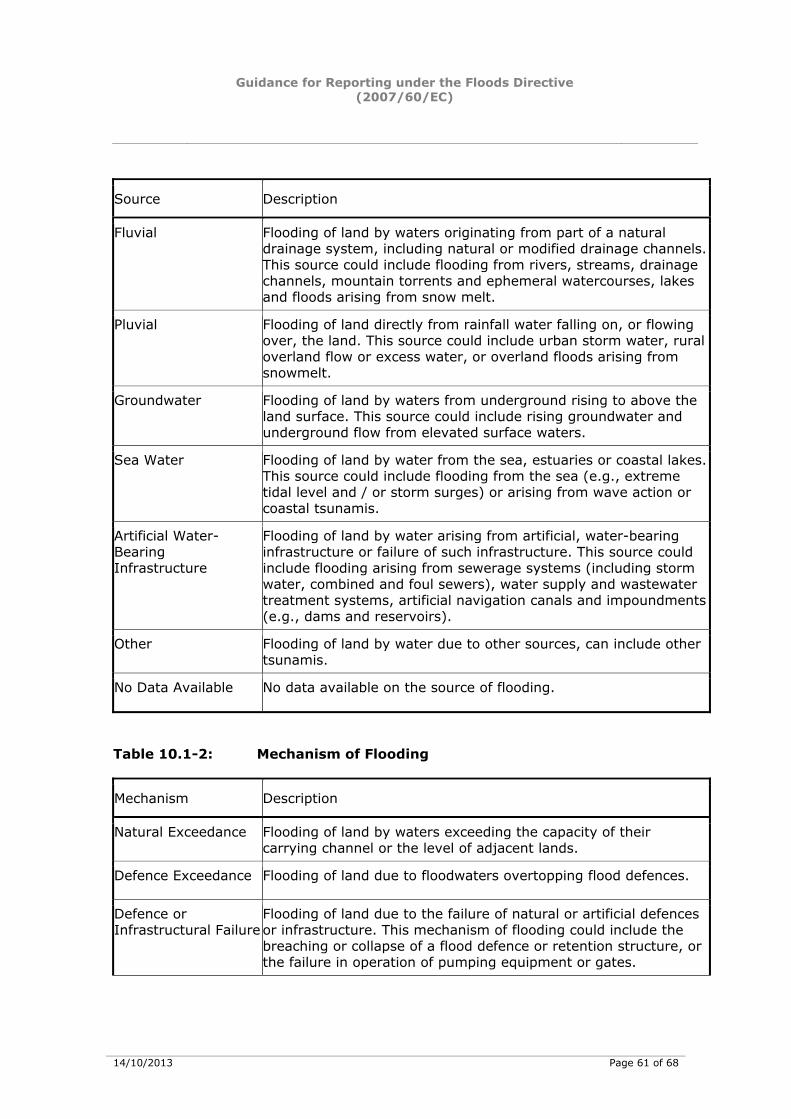
Guidance for Reporting under the Floods Directive (2007/60/EC)
14/10/2013 Page 61 of 68
Source Description
Fluvial Flooding of land by waters originating from part of a natural drainage system, including natural or modified drainage channels. This source could include flooding from rivers, streams, drainage channels, mountain torrents and ephemeral watercourses, lakes and floods arising from snow melt.
Pluvial Flooding of land directly from rainfall water falling on, or flowing over, the land. This source could include urban storm water, rural overland flow or excess water, or overland floods arising from snowmelt.
Groundwater Flooding of land by waters from underground rising to above the land surface. This source could include rising groundwater and underground flow from elevated surface waters.
Sea Water Flooding of land by water from the sea, estuaries or coastal lakes. This source could include flooding from the sea (e.g., extreme tidal level and / or storm surges) or arising from wave action or coastal tsunamis.
Artificial Water-Bearing Infrastructure
Flooding of land by water arising from artificial, water-bearing infrastructure or failure of such infrastructure. This source could include flooding arising from sewerage systems (including storm water, combined and foul sewers), water supply and wastewater treatment systems, artificial navigation canals and impoundments (e.g., dams and reservoirs).
Other Flooding of land by water due to other sources, can include other tsunamis.
No Data Available No data available on the source of flooding.
Table 10.1-2: Mechanism of Flooding
Mechanism Description
Natural Exceedance Flooding of land by waters exceeding the capacity of their carrying channel or the level of adjacent lands.
Defence Exceedance Flooding of land due to floodwaters overtopping flood defences.
Defence or Infrastructural Failure
Flooding of land due to the failure of natural or artificial defences or infrastructure. This mechanism of flooding could include the breaching or collapse of a flood defence or retention structure, or the failure in operation of pumping equipment or gates.
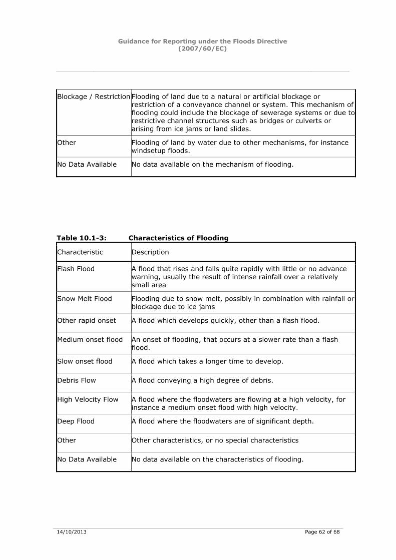
Guidance for Reporting under the Floods Directive (2007/60/EC)
14/10/2013 Page 62 of 68
Blockage / Restriction Flooding of land due to a natural or artificial blockage or restriction of a conveyance channel or system. This mechanism of flooding could include the blockage of sewerage systems or due to restrictive channel structures such as bridges or culverts or arising from ice jams or land slides.
Other Flooding of land by water due to other mechanisms, for instance windsetup floods.
No Data Available No data available on the mechanism of flooding.
Table 10.1-3: Characteristics of Flooding
Characteristic Description
Flash Flood A flood that rises and falls quite rapidly with little or no advance warning, usually the result of intense rainfall over a relatively small area
Snow Melt Flood Flooding due to snow melt, possibly in combination with rainfall or blockage due to ice jams
Other rapid onset A flood which develops quickly, other than a flash flood.
Medium onset flood An onset of flooding, that occurs at a slower rate than a flash flood.
Slow onset flood A flood which takes a longer time to develop.
Debris Flow A flood conveying a high degree of debris.
High Velocity Flow A flood where the floodwaters are flowing at a high velocity, for instance a medium onset flood with high velocity.
Deep Flood A flood where the floodwaters are of significant depth.
Other Other characteristics, or no special characteristics
No Data Available No data available on the characteristics of flooding.
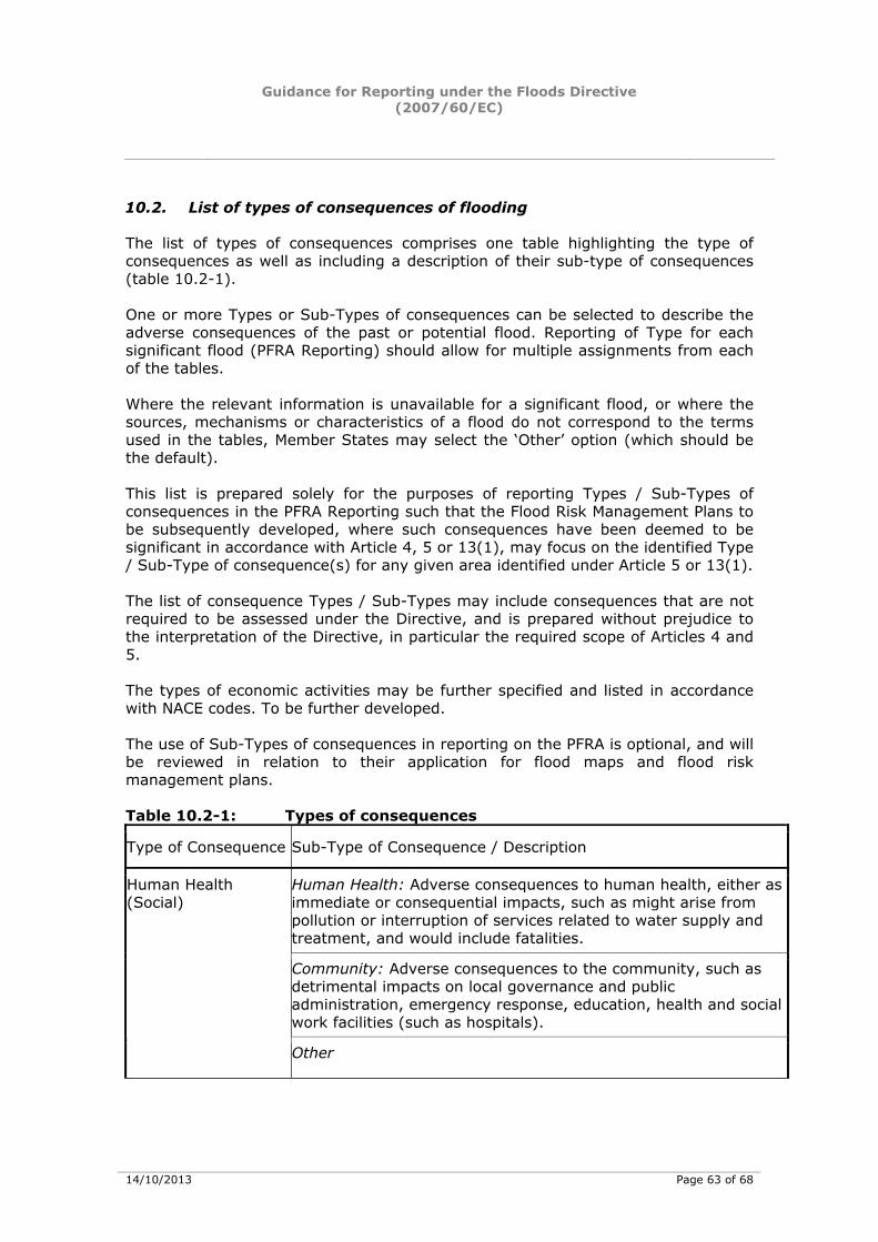
Guidance for Reporting under the Floods Directive (2007/60/EC)
14/10/2013 Page 63 of 68
10.2. List of types of consequences of flooding
The list of types of consequences comprises one table highlighting the type of consequences as well as including a description of their sub-type of consequences (table 10.2-1). One or more Types or Sub-Types of consequences can be selected to describe the adverse consequences of the past or potential flood. Reporting of Type for each significant flood (PFRA Reporting) should allow for multiple assignments from each of the tables. Where the relevant information is unavailable for a significant flood, or where the sources, mechanisms or characteristics of a flood do not correspond to the terms used in the tables, Member States may select the ‘Other’ option (which should be the default). This list is prepared solely for the purposes of reporting Types / Sub-Types of consequences in the PFRA Reporting such that the Flood Risk Management Plans to be subsequently developed, where such consequences have been deemed to be significant in accordance with Article 4, 5 or 13(1), may focus on the identified Type / Sub-Type of consequence(s) for any given area identified under Article 5 or 13(1). The list of consequence Types / Sub-Types may include consequences that are not required to be assessed under the Directive, and is prepared without prejudice to the interpretation of the Directive, in particular the required scope of Articles 4 and 5. The types of economic activities may be further specified and listed in accordance with NACE codes. To be further developed. The use of Sub-Types of consequences in reporting on the PFRA is optional, and will be reviewed in relation to their application for flood maps and flood risk management plans. Table 10.2-1: Types of consequences
Type of Consequence Sub-Type of Consequence / Description
Human Health: Adverse consequences to human health, either as immediate or consequential impacts, such as might arise from pollution or interruption of services related to water supply and treatment, and would include fatalities.
Community: Adverse consequences to the community, such as detrimental impacts on local governance and public administration, emergency response, education, health and social work facilities (such as hospitals).
Human Health (Social)
Other
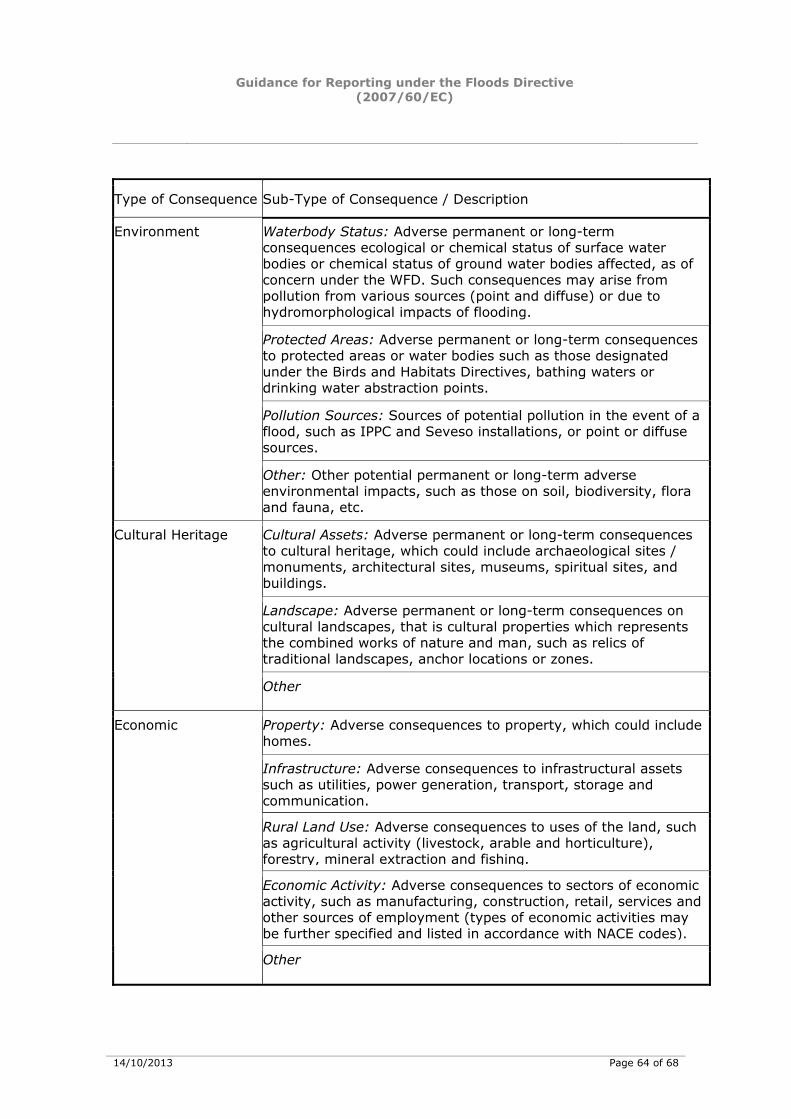
Guidance for Reporting under the Floods Directive (2007/60/EC)
14/10/2013 Page 64 of 68
Type of Consequence Sub-Type of Consequence / Description
Waterbody Status: Adverse permanent or long-term consequences ecological or chemical status of surface water bodies or chemical status of ground water bodies affected, as of concern under the WFD. Such consequences may arise from pollution from various sources (point and diffuse) or due to hydromorphological impacts of flooding.
Protected Areas: Adverse permanent or long-term consequences to protected areas or water bodies such as those designated under the Birds and Habitats Directives, bathing waters or drinking water abstraction points.
Pollution Sources: Sources of potential pollution in the event of a flood, such as IPPC and Seveso installations, or point or diffuse sources.
Environment
Other: Other potential permanent or long-term adverse environmental impacts, such as those on soil, biodiversity, flora and fauna, etc.
Cultural Assets: Adverse permanent or long-term consequences to cultural heritage, which could include archaeological sites / monuments, architectural sites, museums, spiritual sites, and buildings.
Landscape: Adverse permanent or long-term consequences on cultural landscapes, that is cultural properties which represents the combined works of nature and man, such as relics of traditional landscapes, anchor locations or zones.
Cultural Heritage
Other
Property: Adverse consequences to property, which could include homes.
Infrastructure: Adverse consequences to infrastructural assets such as utilities, power generation, transport, storage and communication.
Rural Land Use: Adverse consequences to uses of the land, such as agricultural activity (livestock, arable and horticulture), forestry, mineral extraction and fishing.
Economic Activity: Adverse consequences to sectors of economic activity, such as manufacturing, construction, retail, services and other sources of employment (types of economic activities may be further specified and listed in accordance with NACE codes).
Economic
Other
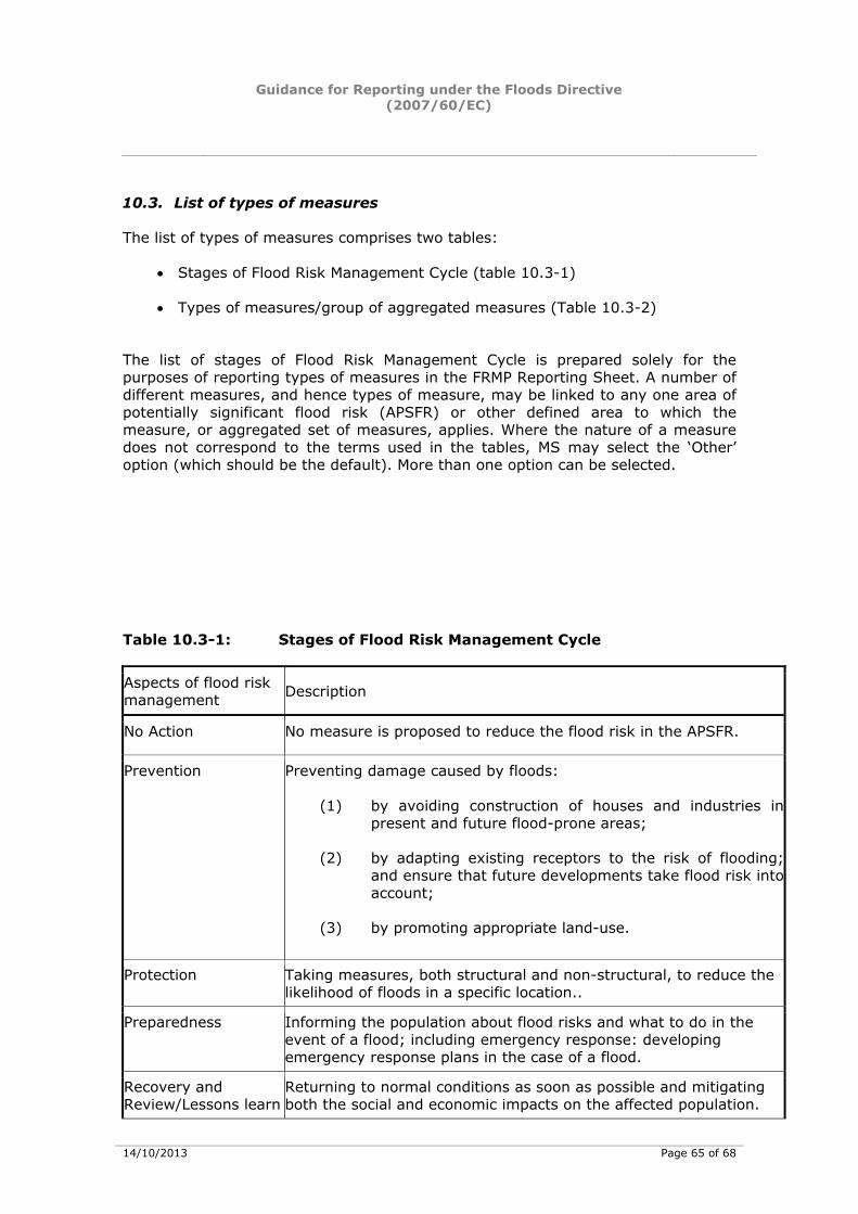
Guidance for Reporting under the Floods Directive (2007/60/EC)
14/10/2013 Page 65 of 68
10.3. List of types of measures
The list of types of measures comprises two tables:
• Stages of Flood Risk Management Cycle (table 10.3-1)
• Types of measures/group of aggregated measures (Table 10.3-2)
The list of stages of Flood Risk Management Cycle is prepared solely for the purposes of reporting types of measures in the FRMP Reporting Sheet. A number of different measures, and hence types of measure, may be linked to any one area of potentially significant flood risk (APSFR) or other defined area to which the measure, or aggregated set of measures, applies. Where the nature of a measure does not correspond to the terms used in the tables, MS may select the ‘Other’ option (which should be the default). More than one option can be selected. Table 10.3-1: Stages of Flood Risk Management Cycle
Aspects of flood risk management Description
No Action No measure is proposed to reduce the flood risk in the APSFR.
Prevention Preventing damage caused by floods:
(1) by avoiding construction of houses and industries in present and future flood-prone areas;
(2) by adapting existing receptors to the risk of flooding;and ensure that future developments take flood risk intoaccount;
(3) by promoting appropriate land-use.
Protection Taking measures, both structural and non-structural, to reduce the likelihood of floods in a specific location..
Preparedness Informing the population about flood risks and what to do in the event of a flood; including emergency response: developing emergency response plans in the case of a flood.
Recovery and Review/Lessons learn
Returning to normal conditions as soon as possible and mitigating both the social and economic impacts on the affected population.
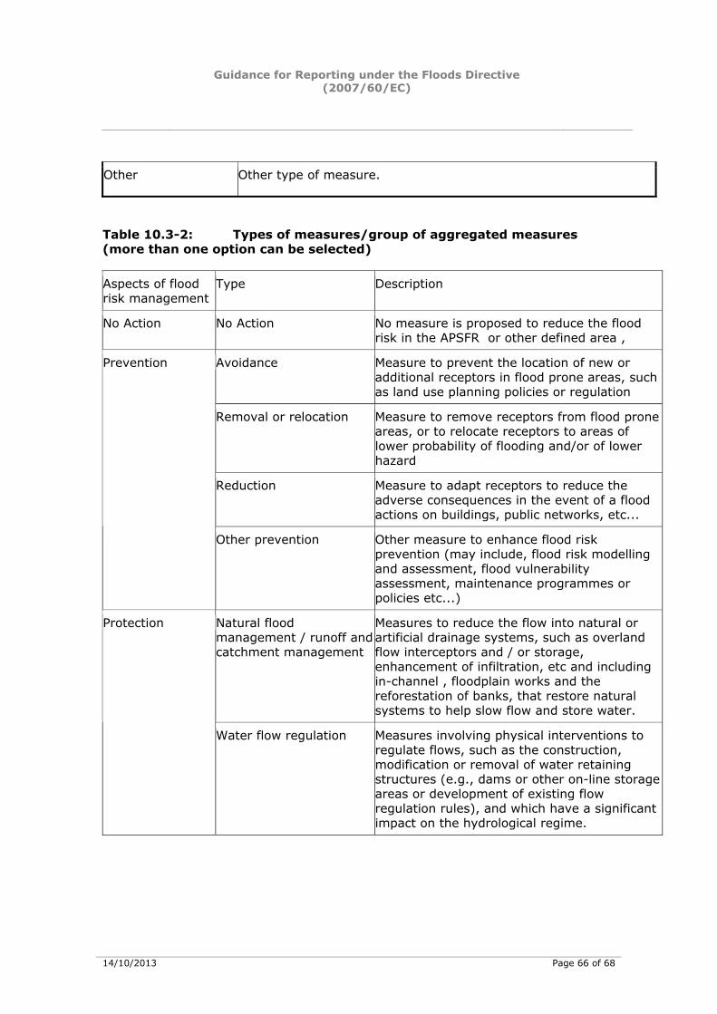
Guidance for Reporting under the Floods Directive (2007/60/EC)
14/10/2013 Page 66 of 68
Other Other type of measure.
Table 10.3-2: Types of measures/group of aggregated measures (more than one option can be selected) Aspects of flood risk management
Type Description
No Action No Action No measure is proposed to reduce the flood risk in the APSFR or other defined area ,
Avoidance Measure to prevent the location of new or additional receptors in flood prone areas, such as land use planning policies or regulation
Removal or relocation Measure to remove receptors from flood prone areas, or to relocate receptors to areas of lower probability of flooding and/or of lower hazard
Reduction Measure to adapt receptors to reduce the adverse consequences in the event of a flood actions on buildings, public networks, etc...
Prevention
Other prevention Other measure to enhance flood risk prevention (may include, flood risk modelling and assessment, flood vulnerability assessment, maintenance programmes or policies etc...)
Natural flood management / runoff and catchment management
Measures to reduce the flow into natural or artificial drainage systems, such as overland flow interceptors and / or storage, enhancement of infiltration, etc and including in-channel , floodplain works and the reforestation of banks, that restore natural systems to help slow flow and store water.
Protection
Water flow regulation Measures involving physical interventions to regulate flows, such as the construction, modification or removal of water retaining structures (e.g., dams or other on-line storage areas or development of existing flow regulation rules), and which have a significant impact on the hydrological regime.
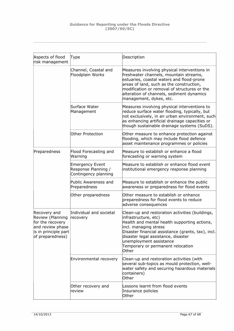
Guidance for Reporting under the Floods Directive (2007/60/EC)
14/10/2013 Page 67 of 68
Aspects of flood risk management
Type Description
Channel, Coastal and Floodplain Works
Measures involving physical interventions in freshwater channels, mountain streams, estuaries, coastal waters and flood-prone areas of land, such as the construction, modification or removal of structures or the alteration of channels, sediment dynamics management, dykes, etc.
Surface Water Management
Measures involving physical interventions to reduce surface water flooding, typically, but not exclusively, in an urban environment, such as enhancing artificial drainage capacities or though sustainable drainage systems (SuDS).
Other Protection Other measure to enhance protection against flooding, which may include flood defence asset maintenance programmes or policies
Flood Forecasting and Warning
Measure to establish or enhance a flood forecasting or warning system
Emergency Event Response Planning / Contingency planning
Measure to establish or enhance flood event institutional emergency response planning
Public Awareness and Preparedness
Measure to establish or enhance the public awareness or preparedness for flood events
Preparedness
Other preparedness Other measure to establish or enhance preparedness for flood events to reduce adverse consequences
Individual and societal recovery
Clean-up and restoration activities (buildings, infrastructure, etc) Health and mental health supporting actions, incl. managing stress Disaster financial assistance (grants, tax), incl. disaster legal assistance, disaster unemployment assistance Temporary or permanent relocation Other
Environmental recovery Clean-up and restoration activities (with several sub-topics as mould protection, well-water safety and securing hazardous materials containers) Other
Recovery and Review (Planning for the recovery and review phase is in principle part of preparedness)
Other recovery and review
Lessons learnt from flood events Insurance policies Other
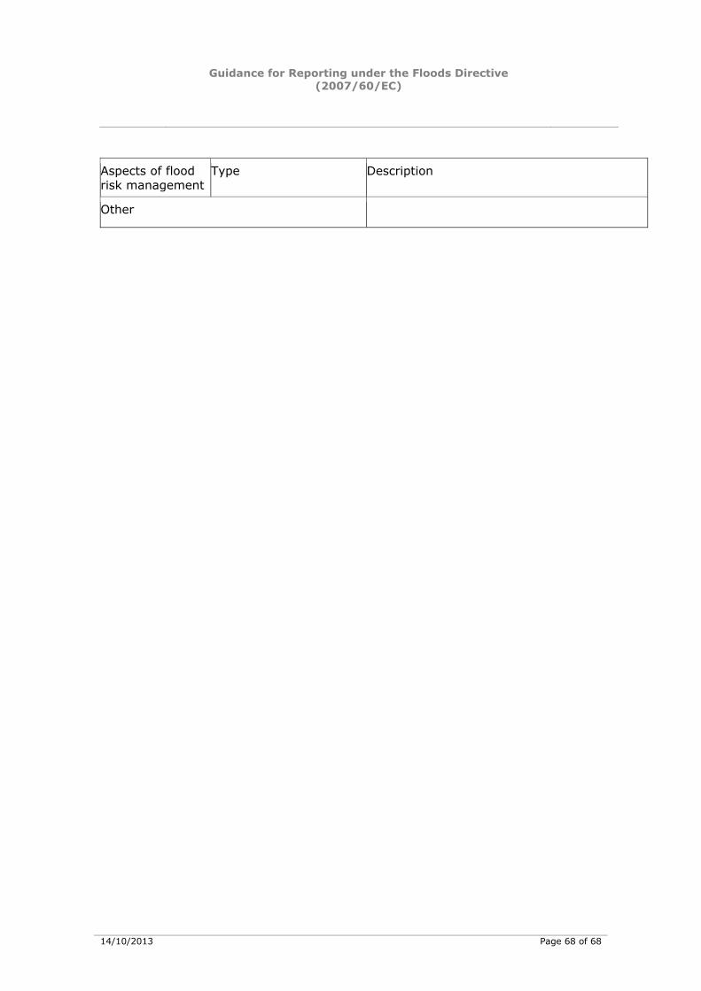
Guidance for Reporting under the Floods Directive (2007/60/EC)
14/10/2013 Page 68 of 68
Aspects of flood risk management
Type Description
Other


KH-AN-13-029-EN
-N
doi:10.2779/50095