GTA West Transportation Corridor Planning and ... Presentations - May 7 2015.pdf · 1 GTA West...
66
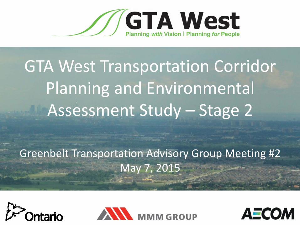
GTA West Transportation Corridor Planning and Environmental Assessment Study – Stage 2 Greenbelt Transportation Advisory Group Meeting #2 May 7, 2015
Transcript of GTA West Transportation Corridor Planning and ... Presentations - May 7 2015.pdf · 1 GTA West...
1
GTA West Transportation CorridorPlanning and Environmental Assessment Study – Stage 2
Greenbelt Transportation Advisory Group Meeting #2 May 7, 2015
2
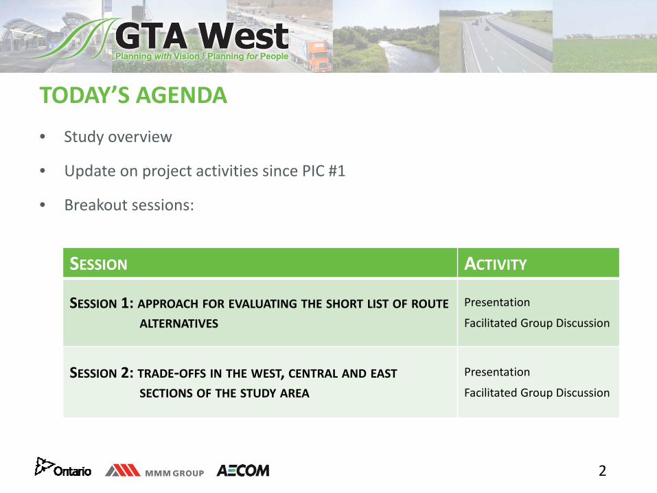
TODAY’S AGENDA• Study overview
• Update on project activities since PIC #1
• Breakout sessions:
SESSION ACTIVITY
SESSION 1: APPROACH FOR EVALUATING THE SHORT LIST OF ROUTEALTERNATIVES
Presentation
Facilitated Group Discussion
SESSION 2: TRADE‐OFFS IN THE WEST, CENTRAL AND EASTSECTIONS OF THE STUDY AREA
Presentation
Facilitated Group Discussion
3
THE GTA WEST PROJECT TEAM• Natalie Rouskov, MTO: Project Manager
• Chris Barber, MTO: Environmental Planner
• Sarah Merriam, MTO: Consultation Lead and Environmental Planner
• Neil Ahmed, MMM: Consultant Project Manager
• Tim Sorochinsky, AECOM: Manager – West Section
• Brenda Jamieson, AECOM: Manager – Central Section
• Jim Dowell, MMM: Manager – East Section
• Sandy Nairn, MMM: Environmental Planning Lead
• Patrick Puccini, AECOM: Consultation Lead
4
GETTING AND GIVING THE MOST• It’s OUR meeting…participate enthusiastically• Focus on the future• Terminology expertise is secondary• There is such a thing as a bad idea!• Build, don’t duplicate• Respect (for each other and the process)• Consensus on no consensus• Informal style, structured approach• No dissertations (rather, ‘rap and roll’)
5
GREENBELT TRANSPORTATION ADVISORY GROUP• The Greenbelt Transportation Advisory Group (GTAG) comprises members
from environmental agencies, interest groups and individuals with aspecific interest in the Greenbelt
• The GTAG is a volunteer group that provides advice to the GTA WestProject Team
• The GTAG will:– Share information regarding key environmental and agricultural features– Discuss potential impacts to sensitive features within the Greenbelt– Discuss and generate mitigation strategies to be used in the Greenbelt– Update the Greenbelt Guideline, if required
6
GTAG ROLES AND RESPONSIBILITIES
• Membership in the GTAG is for the duration of the Stage 2 Study• Members should try to attend all meetings to ensure consistency in
discussions• Members must be prepared to accept differences of opinions within the
GTAG• Help the GTAG operate effectively by offering suggestions and alternatives
to issues• Members should prepare for meetings in advance and consult with
members’ organizations if possible• Declare a conflict of interest in a matter under consideration
7
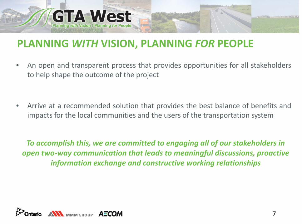
PLANNING WITH VISION, PLANNING FOR PEOPLE
• An open and transparent process that provides opportunities for all stakeholdersto help shape the outcome of the project
• Arrive at a recommended solution that provides the best balance of benefits andimpacts for the local communities and the users of the transportation system
To accomplish this, we are committed to engaging all of our stakeholders in open two‐way communication that leads to meaningful discussions, proactive
information exchange and constructive working relationships
8
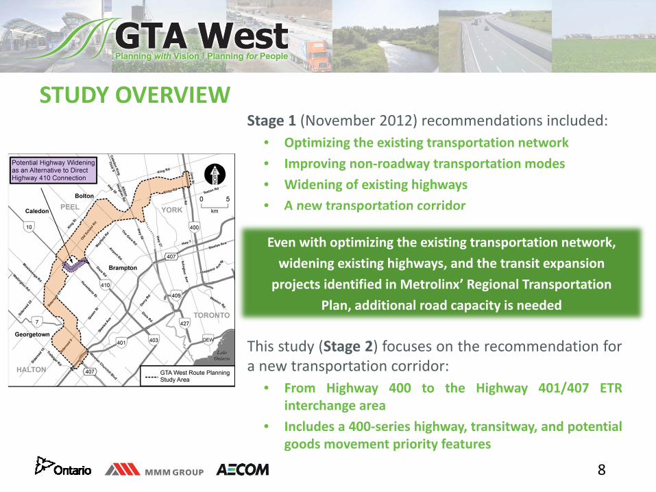
STUDY OVERVIEWStage 1 (November 2012) recommendations included:
• Optimizing the existing transportation network• Improving non‐roadway transportation modes• Widening of existing highways• A new transportation corridor
This study (Stage 2) focuses on the recommendation fora new transportation corridor:
• From Highway 400 to the Highway 401/407 ETRinterchange area
• Includes a 400‐series highway, transitway, and potentialgoods movement priority features
Even with optimizing the existing transportation network, widening existing highways, and the transit expansion projects identified in Metrolinx’ Regional Transportation
Plan, additional road capacity is needed
9
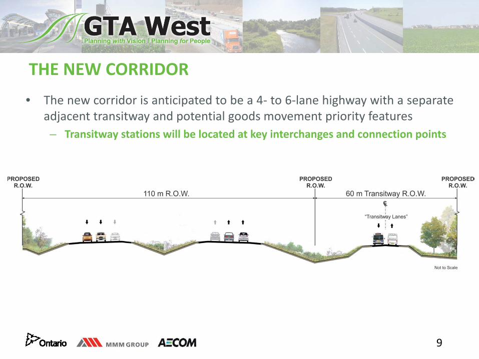
THE NEW CORRIDOR
• The new corridor is anticipated to be a 4‐ to 6‐lane highway with a separateadjacent transitway and potential goods movement priority features– Transitway stations will be located at key interchanges and connection points
10
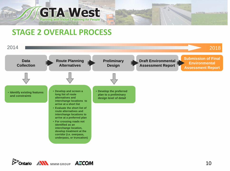
STAGE 2 OVERALL PROCESS
2014 2018
Data Collection
Route Planning Alternatives
Preliminary Design
Draft Environmental Assessment Report
Submission of Final Environmental
Assessment Report
• Develop and screen a long list of route alternatives and interchange locations to arrive at a short list
• Evaluate the short list of route alternatives and interchange locations to arrive at a preferred plan
• For crossing roads not identified as an interchange location, develop treatment at the corridor (i.e. overpass, underpass, or truncation)
• Identify existing features and constraints
• Develop the preferred plan to a preliminary design level of detail
11
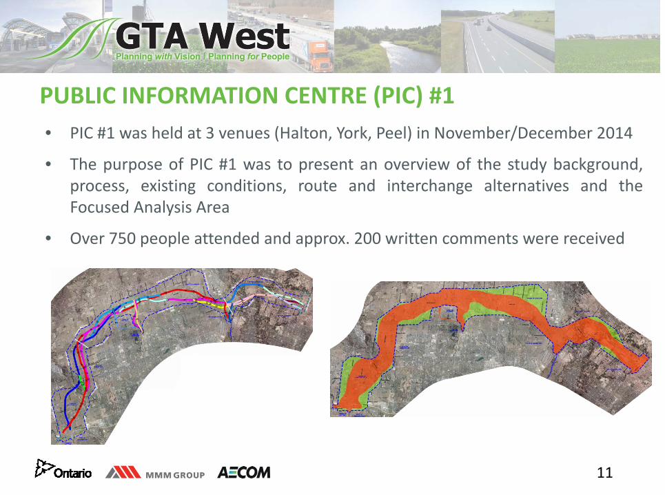
PUBLIC INFORMATION CENTRE (PIC) #1• PIC #1 was held at 3 venues (Halton, York, Peel) in November/December 2014
• The purpose of PIC #1 was to present an overview of the study background,process, existing conditions, route and interchange alternatives and theFocused Analysis Area
• Over 750 people attended and approx. 200 written comments were received
12
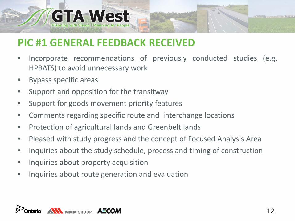
PIC #1 GENERAL FEEDBACK RECEIVED• Incorporate recommendations of previously conducted studies (e.g.
HPBATS) to avoid unnecessary work• Bypass specific areas• Support and opposition for the transitway• Support for goods movement priority features• Comments regarding specific route and interchange locations• Protection of agricultural lands and Greenbelt lands• Pleased with study progress and the concept of Focused Analysis Area• Inquiries about the study schedule, process and timing of construction• Inquiries about property acquisition• Inquiries about route generation and evaluation
13
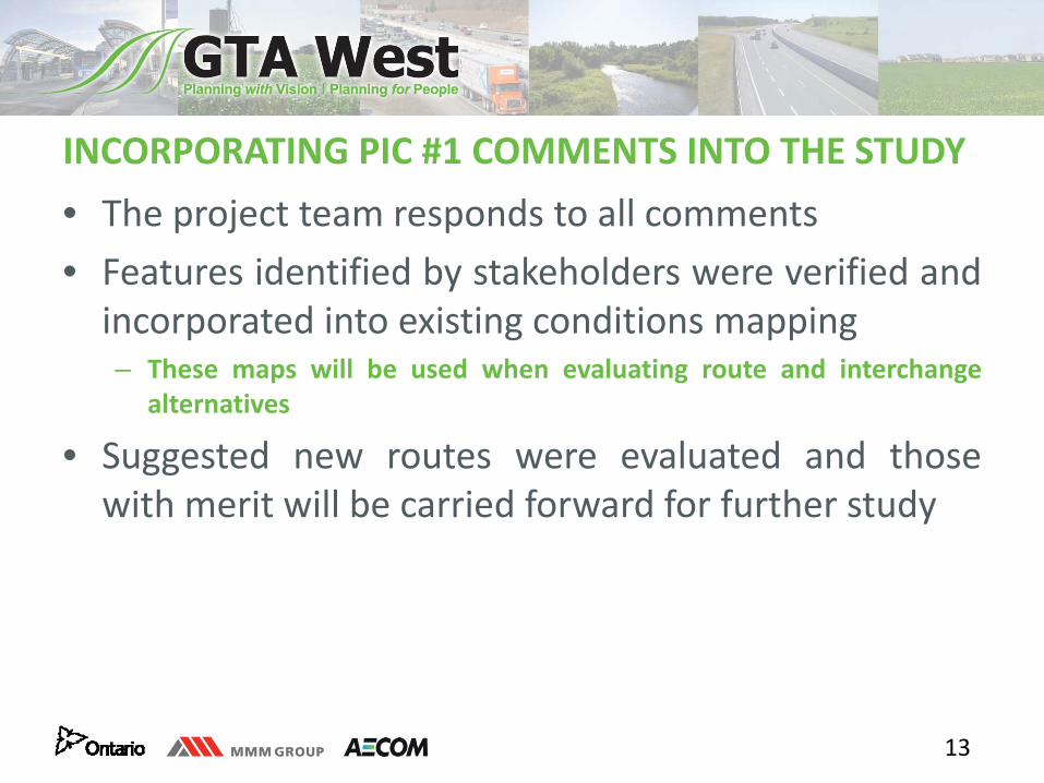
INCORPORATING PIC #1 COMMENTS INTO THE STUDY • The project team responds to all comments• Features identified by stakeholders were verified andincorporated into existing conditions mapping– These maps will be used when evaluating route and interchange
alternatives
• Suggested new routes were evaluated and thosewith merit will be carried forward for further study
14
REFINEMENTS TO ROUTE ALTERNATIVES
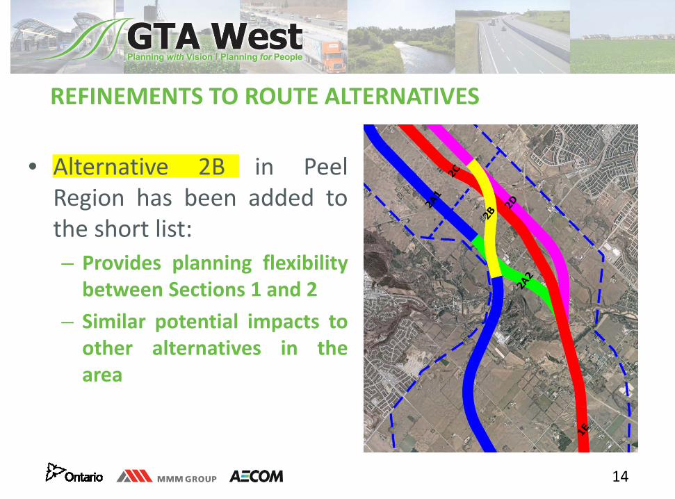
• Alternative 2B in PeelRegion has been added tothe short list:– Provides planning flexibilitybetween Sections 1 and 2
– Similar potential impacts toother alternatives in thearea
15
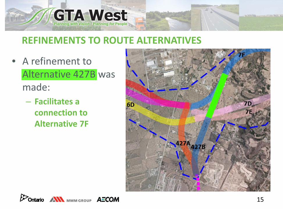
REFINEMENTS TO ROUTE ALTERNATIVES
• A refinement to Alternative 427B was made:– Facilitates a connection to Alternative 7F
16
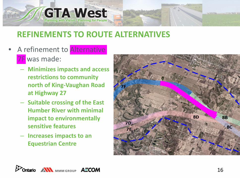
REFINEMENTS TO ROUTE ALTERNATIVES
• A refinement to Alternative 7F was made:– Minimizes impacts and access
restrictions to community north of King‐Vaughan Road at Highway 27
– Suitable crossing of the East Humber River with minimal impact to environmentally sensitive features
– Increases impacts to an Equestrian Centre
17
INTERCHANGE LOCATIONS• Prior to PIC #1, all existing and planned crossing roads were initially considered for
interchanges, then screened based on:– Minimizing impacts to significant natural features– Minimizing impacts to existing and planned (approved) population and employment areas– Ensuring efficient and direct connections and addressing future transportation needs
• Subsequent to PIC #1, the project team began an exercise to confirm the potentialinterchange locations by using criteria such as:
– Maximum spacing of 8 km between interchanges– Where more than one road meets the spacing criteria, identify the crossing road that best serves
transportation needs based on:• Road classification• Connectivity to existing and planned urban centres• Conflicts with other interchanges• Forecasted utilization of the interchanges
– Input from municipalities
18
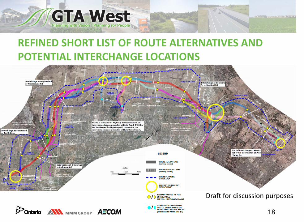
REFINED SHORT LIST OF ROUTE ALTERNATIVES AND POTENTIAL INTERCHANGE LOCATIONS
Draft for discussion purposes
19
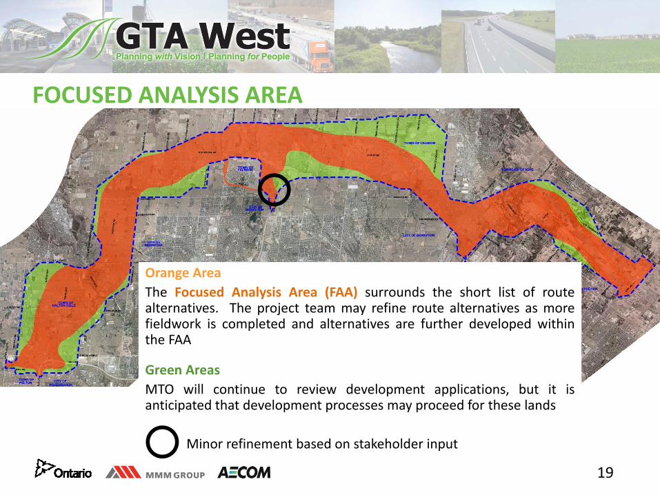
FOCUSED ANALYSIS AREA
Orange AreaThe Focused Analysis Area (FAA) surrounds the short list of routealternatives. The project team may refine route alternatives as morefieldwork is completed and alternatives are further developed withinthe FAA
Green AreasMTO will continue to review development applications, but it isanticipated that development processes may proceed for these lands
Minor refinement based on stakeholder input
20
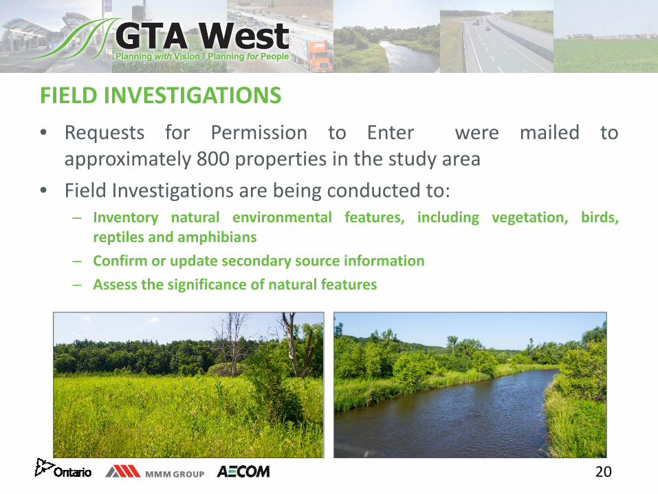
FIELD INVESTIGATIONS • Requests for Permission to Enter were mailed to
approximately 800 properties in the study area• Field Investigations are being conducted to:
– Inventory natural environmental features, including vegetation, birds,reptiles and amphibians
– Confirm or update secondary source information– Assess the significance of natural features
21
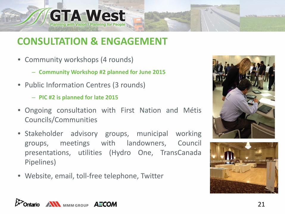
CONSULTATION & ENGAGEMENT• Community workshops (4 rounds)
– Community Workshop #2 planned for June 2015
• Public Information Centres (3 rounds)– PIC #2 is planned for late 2015
• Ongoing consultation with First Nation and MétisCouncils/Communities
• Stakeholder advisory groups, municipal workinggroups, meetings with landowners, Councilpresentations, utilities (Hydro One, TransCanadaPipelines)
• Website, email, toll‐free telephone, Twitter
22
NEXT STEPS
• Remain on schedule• Further develop, assess and evaluate the short list of route alternatives
and the potential interchange locations– Meetings with Advisory Groups
• Present the preferred route at PIC #2 (Fall/Winter 2015)• Present the preliminary design of the preferred route at PIC #3
(Winter/Spring 2017)
Website: www.gta‐west.comEmail: project_team@gta‐west.comToll‐Free: 1‐877‐522‐6916Twitter: @GTAWestStudy
Contact the GTA West Project Team
Opportunity for Input
1
Session 1: Approach for Evaluating the Short List
of Route Alternatives
2
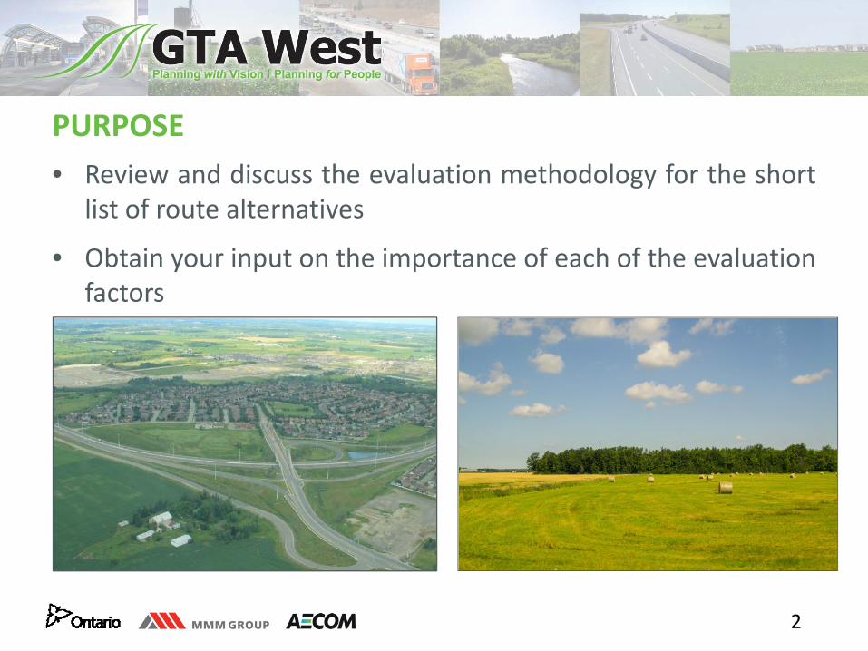
PURPOSE • Review and discuss the evaluation methodology for the short
list of route alternatives
• Obtain your input on the importance of each of the evaluationfactors
3
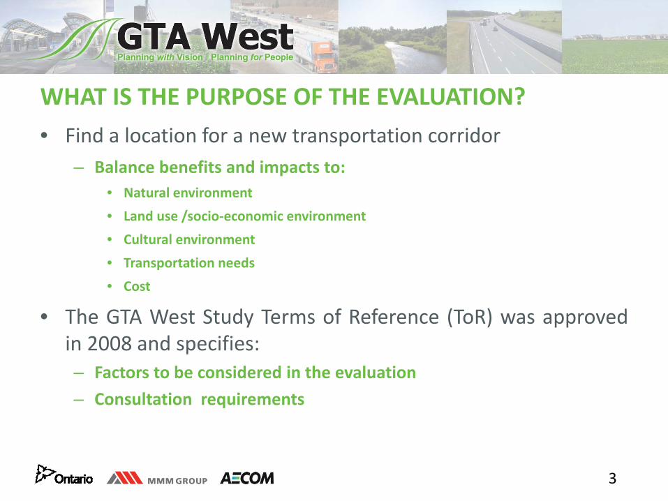
WHAT IS THE PURPOSE OF THE EVALUATION? • Find a location for a new transportation corridor
– Balance benefits and impacts to:• Natural environment
• Land use /socio‐economic environment
• Cultural environment
• Transportation needs
• Cost
• The GTA West Study Terms of Reference (ToR) was approvedin 2008 and specifies:– Factors to be considered in the evaluation– Consultation requirements
4
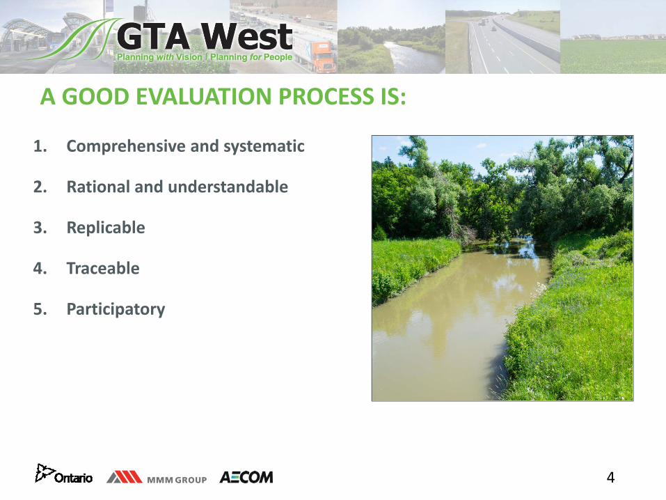
A GOOD EVALUATION PROCESS IS:
1. Comprehensive and systematic
2. Rational and understandable
3. Replicable
4. Traceable
5. Participatory
5
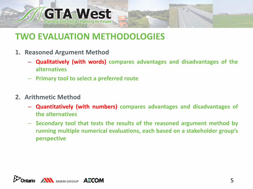
1. Reasoned Argument Method– Qualitatively (with words) compares advantages and disadvantages of the
alternatives– Primary tool to select a preferred route
2. Arithmetic Method– Quantitatively (with numbers) compares advantages and disadvantages of
the alternatives– Secondary tool that tests the results of the reasoned argument method by
running multiple numerical evaluations, each based on a stakeholder group’sperspective
TWO EVALUATION METHODOLOGIES
6
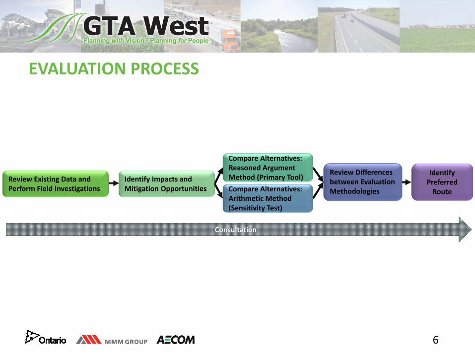
Review Existing Data and Perform Field Investigations
Compare Alternatives: Reasoned Argument Method (Primary Tool)
Review Differences between Evaluation Methodologies Compare Alternatives:
Arithmetic Method (Sensitivity Test)
Identify Preferred Route
Identify Impacts and Mitigation Opportunities
EVALUATION PROCESS
Consultation
7
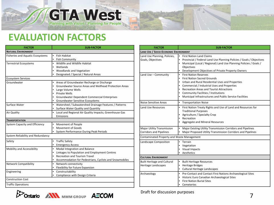
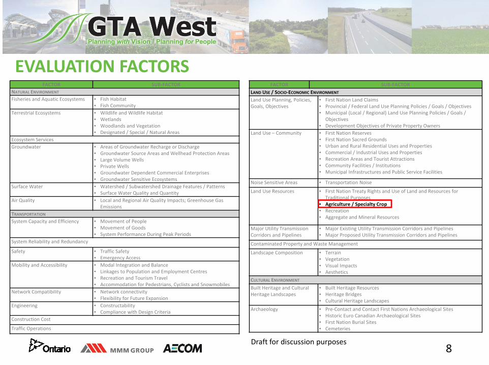
EVALUATION FACTORSFACTOR SUB‐FACTOR
NATURAL ENVIRONMENT
Fisheries and Aquatic Ecosystems • Fish Habitat• Fish Community
Terrestrial Ecosystems • Wildlife and Wildlife Habitat• Wetlands• Woodlands and Vegetation• Designated / Special / Natural Areas
Ecosystem ServicesGroundwater • Areas of Groundwater Recharge or Discharge
• Groundwater Source Areas and Wellhead Protection Areas• Large Volume Wells• Private Wells• Groundwater Dependent Commercial Enterprises• Groundwater Sensitive Ecosystems
Surface Water • Watershed / Subwatershed Drainage Features / Patterns• Surface Water Quality and Quantity
Air Quality • Local and Regional Air Quality Impacts; Greenhouse Gas Emissions
TRANSPORTATIONSystem Capacity and Efficiency • Movement of People
• Movement of Goods• System Performance During Peak Periods
System Reliability and Redundancy
Safety • Traffic Safety• Emergency Access
Mobility and Accessibility • Modal Integration and Balance• Linkages to Population and Employment Centres• Recreation and Tourism Travel• Accommodation for Pedestrians, Cyclists and Snowmobiles
Network Compatibility • Network connectivity• Flexibility for Future Expansion
Engineering • Constructability• Compliance with Design Criteria
Construction Cost
Traffic Operations
FACTOR SUB‐FACTORLAND USE / SOCIO‐ECONOMIC ENVIRONMENT
Land Use Planning, Policies, Goals, Objectives
• First Nation Land Claims• Provincial / Federal Land Use Planning Policies / Goals / Objectives• Municipal (Local / Regional) Land Use Planning Policies / Goals /
Objectives• Development Objectives of Private Property Owners
Land Use – Community • First Nation Reserves• First Nation Sacred Grounds• Urban and Rural Residential Uses and Properties• Commercial / Industrial Uses and Properties • Recreation Areas and Tourist Attractions• Community Facilities / Institutions• Municipal Infrastructures and Public Service Facilities
Noise Sensitive Areas • Transportation Noise
Land Use Resources • First Nation Treaty Rights and Use of Land and Resources for Traditional Purposes
• Agriculture / Specialty Crop• Recreation• Aggregate and Mineral Resources
Major Utility Transmission Corridors and Pipelines
• Major Existing Utility Transmission Corridors and Pipelines• Major Proposed Utility Transmission Corridors and Pipelines
Contaminated Property and Waste Management
Landscape Composition • Terrain• Vegetation• Visual Impacts• Aesthetics
CULTURAL ENVIRONMENT
Built Heritage and Cultural Heritage Landscapes
• Built Heritage Resources• Heritage Bridges• Cultural Heritage Landscapes
Archaeology • Pre‐Contact and Contact First Nations Archaeological Sites• Historic Euro Canadian Archaeological Sites• First Nation Burial Sites• Cemeteries
Draft for discussion purposes
8
EVALUATION FACTORSFACTOR SUB‐FACTOR
NATURAL ENVIRONMENT
Fisheries and Aquatic Ecosystems • Fish Habitat• Fish Community
Terrestrial Ecosystems • Wildlife and Wildlife Habitat• Wetlands• Woodlands and Vegetation• Designated / Special / Natural Areas
Ecosystem ServicesGroundwater • Areas of Groundwater Recharge or Discharge
• Groundwater Source Areas and Wellhead Protection Areas• Large Volume Wells• Private Wells• Groundwater Dependent Commercial Enterprises• Groundwater Sensitive Ecosystems
Surface Water • Watershed / Subwatershed Drainage Features / Patterns• Surface Water Quality and Quantity
Air Quality • Local and Regional Air Quality Impacts; Greenhouse Gas Emissions
TRANSPORTATIONSystem Capacity and Efficiency • Movement of People
• Movement of Goods• System Performance During Peak Periods
System Reliability and Redundancy
Safety • Traffic Safety• Emergency Access
Mobility and Accessibility • Modal Integration and Balance• Linkages to Population and Employment Centres• Recreation and Tourism Travel• Accommodation for Pedestrians, Cyclists and Snowmobiles
Network Compatibility • Network connectivity• Flexibility for Future Expansion
Engineering • Constructability• Compliance with Design Criteria
Construction Cost
Traffic Operations
FACTOR SUB‐FACTORLAND USE / SOCIO‐ECONOMIC ENVIRONMENT
Land Use Planning, Policies, Goals, Objectives
• First Nation Land Claims• Provincial / Federal Land Use Planning Policies / Goals / Objectives• Municipal (Local / Regional) Land Use Planning Policies / Goals /
Objectives• Development Objectives of Private Property Owners
Land Use – Community • First Nation Reserves• First Nation Sacred Grounds• Urban and Rural Residential Uses and Properties• Commercial / Industrial Uses and Properties • Recreation Areas and Tourist Attractions• Community Facilities / Institutions• Municipal Infrastructures and Public Service Facilities
Noise Sensitive Areas • Transportation Noise
Land Use Resources • First Nation Treaty Rights and Use of Land and Resources for Traditional Purposes
• Agriculture / Specialty Crop• Recreation• Aggregate and Mineral Resources
Major Utility Transmission Corridors and Pipelines
• Major Existing Utility Transmission Corridors and Pipelines• Major Proposed Utility Transmission Corridors and Pipelines
Contaminated Property and Waste Management
Landscape Composition • Terrain• Vegetation• Visual Impacts• Aesthetics
CULTURAL ENVIRONMENT
Built Heritage and Cultural Heritage Landscapes
• Built Heritage Resources• Heritage Bridges• Cultural Heritage Landscapes
Archaeology • Pre‐Contact and Contact First Nations Archaeological Sites• Historic Euro Canadian Archaeological Sites• First Nation Burial Sites• Cemeteries
Draft for discussion purposes
9
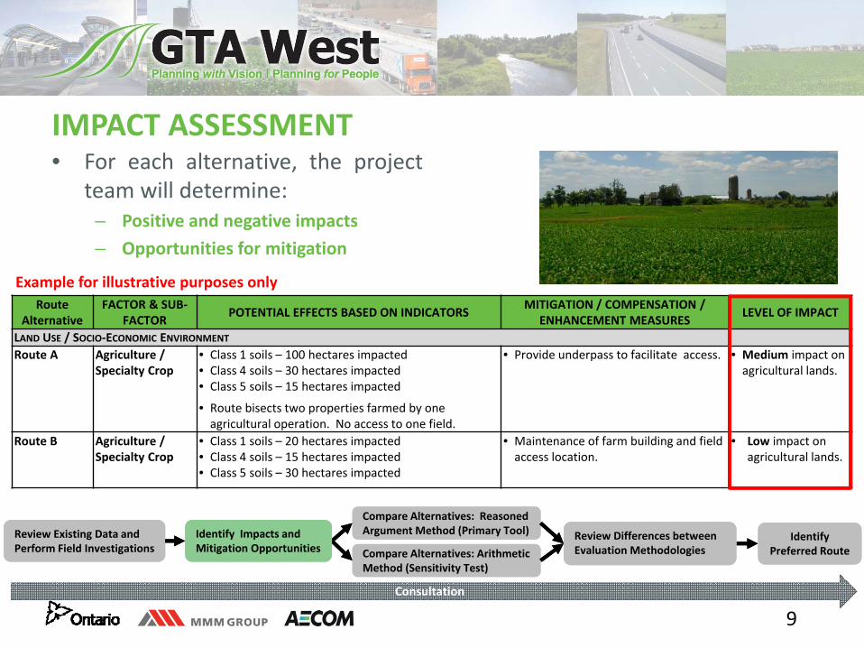
• For each alternative, the projectteam will determine:
– Positive and negative impacts– Opportunities for mitigation
IMPACT ASSESSMENT
Route Alternative
FACTOR & SUB‐FACTOR POTENTIAL EFFECTS BASED ON INDICATORS MITIGATION / COMPENSATION /
ENHANCEMENT MEASURES LEVEL OF IMPACT
LAND USE / SOCIO‐ECONOMIC ENVIRONMENT
Route A Agriculture / Specialty Crop
• Class 1 soils – 100 hectares impacted• Class 4 soils – 30 hectares impacted• Class 5 soils – 15 hectares impacted
• Route bisects two properties farmed by one agricultural operation. No access to one field.
• Provide underpass to facilitate access. • Medium impact on agricultural lands.
Route B Agriculture / Specialty Crop
• Class 1 soils – 20 hectares impacted• Class 4 soils – 15 hectares impacted• Class 5 soils – 30 hectares impacted
• Maintenance of farm building and field access location.
• Low impact on agricultural lands.
Example for illustrative purposes only
Review Existing Data and Perform Field InvestigationsReview Existing Data and Perform Field Investigations
Compare Alternatives: Reasoned Argument Method (Primary Tool)Compare Alternatives: Reasoned Argument Method (Primary Tool) Review Differences between
Evaluation Methodologies Review Differences between Evaluation Methodologies Compare Alternatives: Arithmetic
Method (Sensitivity Test)Compare Alternatives: Arithmetic Method (Sensitivity Test)
Identify Preferred Route
Identify Preferred Route
Identify Impacts and Mitigation OpportunitiesIdentify Impacts and Mitigation Opportunities
Consultation
10
REASONED ARGUMENT METHOD
Review Existing Data and Perform Field InvestigationsReview Existing Data and Perform Field Investigations
Compare Alternatives: Reasoned Argument Method (Primary Tool)Compare Alternatives: Reasoned Argument Method (Primary Tool) Review Differences between
Evaluation Methodologies Review Differences between Evaluation Methodologies Compare Alternatives: Arithmetic
Method (Sensitivity Test)Compare Alternatives: Arithmetic Method (Sensitivity Test)
Identify Preferred Route
Identify Preferred Route
Identify Impacts and Mitigation OpportunitiesIdentify Impacts and Mitigation Opportunities
Consultation
11
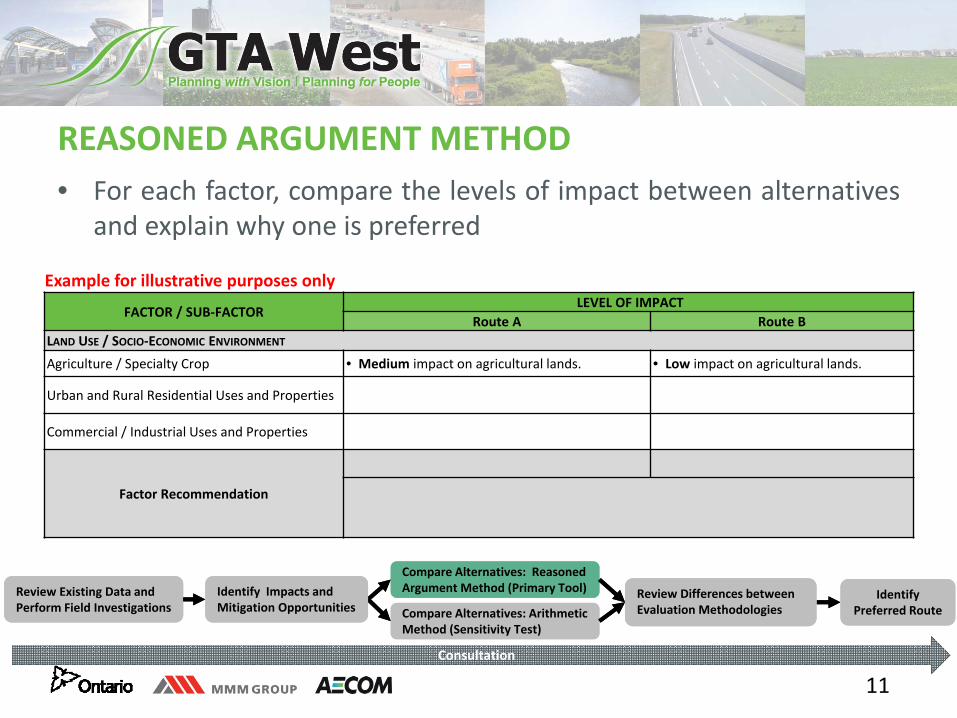
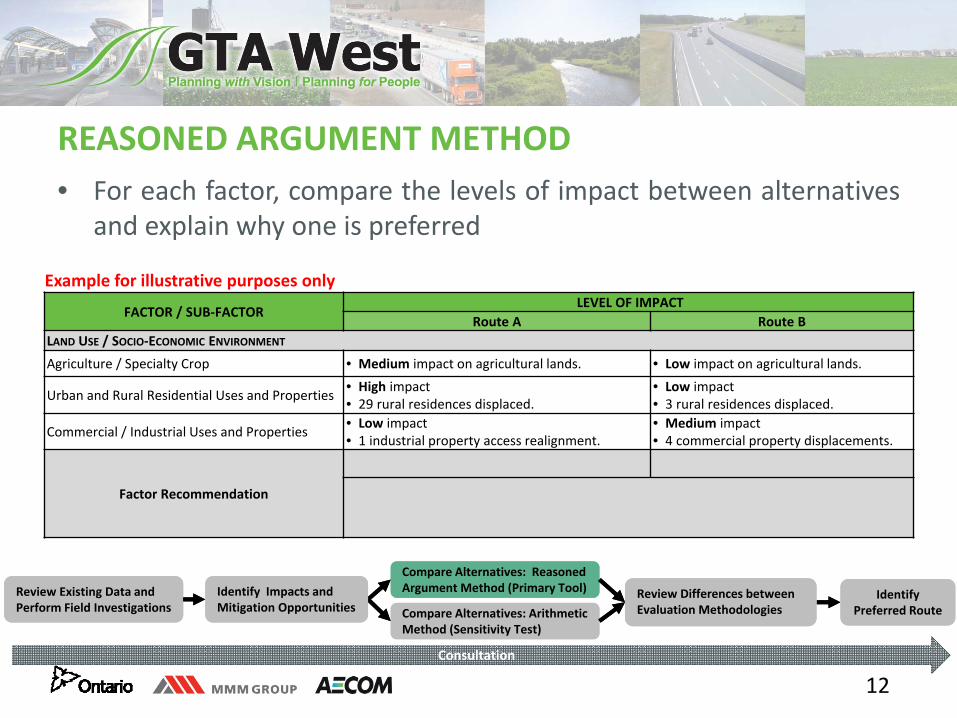
• For each factor, compare the levels of impact between alternativesand explain why one is preferred
FACTOR / SUB‐FACTOR LEVEL OF IMPACT
Route A Route B LAND USE / SOCIO‐ECONOMIC ENVIRONMENT
Agriculture / Specialty Crop • Medium impact on agricultural lands. • Low impact on agricultural lands.
Urban and Rural Residential Uses and Properties
Commercial / Industrial Uses and Properties
Factor Recommendation
REASONED ARGUMENT METHOD
Example for illustrative purposes only
Review Existing Data and Perform Field InvestigationsReview Existing Data and Perform Field Investigations
Compare Alternatives: Reasoned Argument Method (Primary Tool)Compare Alternatives: Reasoned Argument Method (Primary Tool) Review Differences between
Evaluation Methodologies Review Differences between Evaluation Methodologies Compare Alternatives: Arithmetic
Method (Sensitivity Test)Compare Alternatives: Arithmetic Method (Sensitivity Test)
Identify Preferred Route
Identify Preferred Route
Identify Impacts and Mitigation OpportunitiesIdentify Impacts and Mitigation Opportunities
Consultation
12
• For each factor, compare the levels of impact between alternativesand explain why one is preferred
FACTOR / SUB‐FACTOR LEVEL OF IMPACT
Route A Route B LAND USE / SOCIO‐ECONOMIC ENVIRONMENT
Agriculture / Specialty Crop • Medium impact on agricultural lands. • Low impact on agricultural lands.
Urban and Rural Residential Uses and Properties • High impact • 29 rural residences displaced.
• Low impact • 3 rural residences displaced.
Commercial / Industrial Uses and Properties • Low impact • 1 industrial property access realignment.
• Medium impact • 4 commercial property displacements.
Factor Recommendation
REASONED ARGUMENT METHOD
Example for illustrative purposes only
Review Existing Data and Perform Field InvestigationsReview Existing Data and Perform Field Investigations
Compare Alternatives: Reasoned Argument Method (Primary Tool)Compare Alternatives: Reasoned Argument Method (Primary Tool) Review Differences between
Evaluation Methodologies Review Differences between Evaluation Methodologies Compare Alternatives: Arithmetic
Method (Sensitivity Test)Compare Alternatives: Arithmetic Method (Sensitivity Test)
Identify Preferred Route
Identify Preferred Route
Identify Impacts and Mitigation OpportunitiesIdentify Impacts and Mitigation Opportunities
Consultation
13
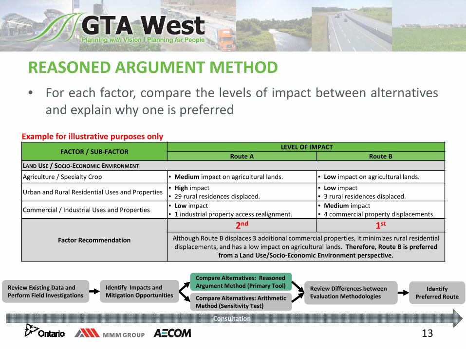
• For each factor, compare the levels of impact between alternativesand explain why one is preferred
FACTOR / SUB‐FACTOR LEVEL OF IMPACT
Route A Route B LAND USE / SOCIO‐ECONOMIC ENVIRONMENT
Agriculture / Specialty Crop • Medium impact on agricultural lands. • Low impact on agricultural lands.
Urban and Rural Residential Uses and Properties • High impact • 29 rural residences displaced.
• Low impact • 3 rural residences displaced.
Commercial / Industrial Uses and Properties • Low impact • 1 industrial property access realignment.
• Medium impact • 4 commercial property displacements.
Factor Recommendation
2nd 1stAlthough Route B displaces 3 additional commercial properties, it minimizes rural residential displacements, and has a low impact on agricultural lands. Therefore, Route B is preferred
from a Land Use/Socio‐Economic Environment perspective.
REASONED ARGUMENT METHOD
Example for illustrative purposes only
Review Existing Data and Perform Field InvestigationsReview Existing Data and Perform Field Investigations
Compare Alternatives: Reasoned Argument Method (Primary Tool)Compare Alternatives: Reasoned Argument Method (Primary Tool) Review Differences between
Evaluation Methodologies Review Differences between Evaluation Methodologies Compare Alternatives: Arithmetic
Method (Sensitivity Test)Compare Alternatives: Arithmetic Method (Sensitivity Test)
Identify Preferred Route
Identify Preferred Route
Identify Impacts and Mitigation OpportunitiesIdentify Impacts and Mitigation Opportunities
Consultation
14
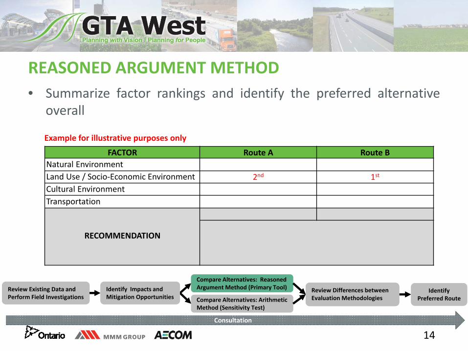
• Summarize factor rankings and identify the preferred alternativeoverall
FACTOR Route A Route BNatural EnvironmentLand Use / Socio‐Economic Environment 2nd 1st
Cultural EnvironmentTransportation
RECOMMENDATION
REASONED ARGUMENT METHOD
Example for illustrative purposes only
Review Existing Data and Perform Field InvestigationsReview Existing Data and Perform Field Investigations
Compare Alternatives: Reasoned Argument Method (Primary Tool)Compare Alternatives: Reasoned Argument Method (Primary Tool) Review Differences between
Evaluation Methodologies Review Differences between Evaluation Methodologies Compare Alternatives: Arithmetic
Method (Sensitivity Test)Compare Alternatives: Arithmetic Method (Sensitivity Test)
Identify Preferred Route
Identify Preferred Route
Identify Impacts and Mitigation OpportunitiesIdentify Impacts and Mitigation Opportunities
Consultation
15
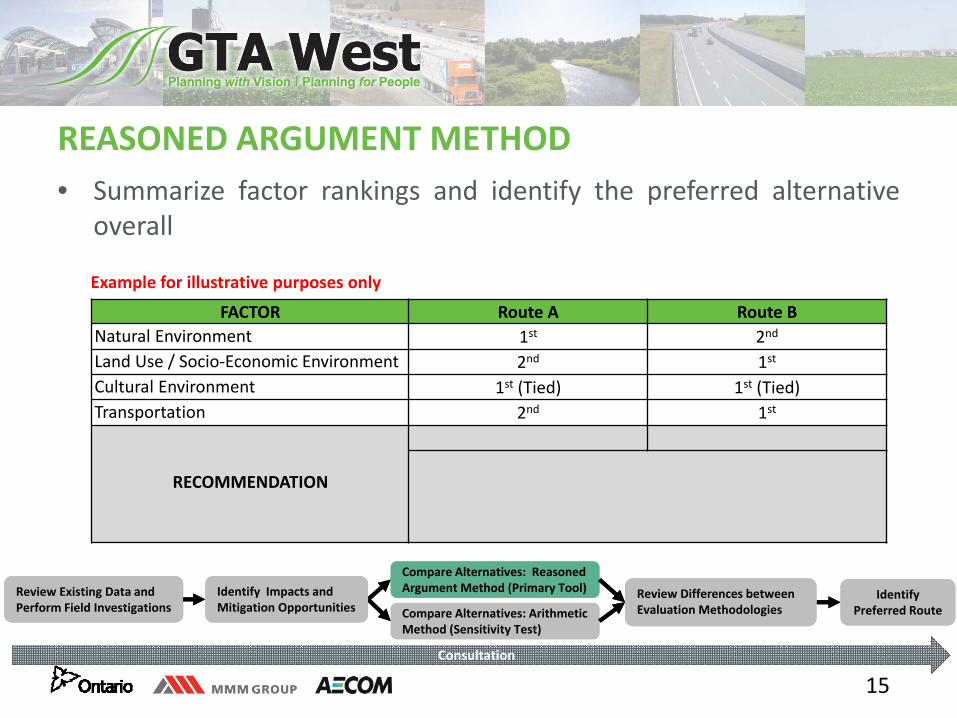
• Summarize factor rankings and identify the preferred alternativeoverall
FACTOR Route A Route BNatural Environment 1st 2nd
Land Use / Socio‐Economic Environment 2nd 1st
Cultural Environment 1st (Tied) 1st (Tied)Transportation 2nd 1st
RECOMMENDATION
REASONED ARGUMENT METHOD
Example for illustrative purposes only
Review Existing Data and Perform Field InvestigationsReview Existing Data and Perform Field Investigations
Compare Alternatives: Reasoned Argument Method (Primary Tool)Compare Alternatives: Reasoned Argument Method (Primary Tool) Review Differences between
Evaluation Methodologies Review Differences between Evaluation Methodologies Compare Alternatives: Arithmetic
Method (Sensitivity Test)Compare Alternatives: Arithmetic Method (Sensitivity Test)
Identify Preferred Route
Identify Preferred Route
Identify Impacts and Mitigation OpportunitiesIdentify Impacts and Mitigation Opportunities
Consultation
16
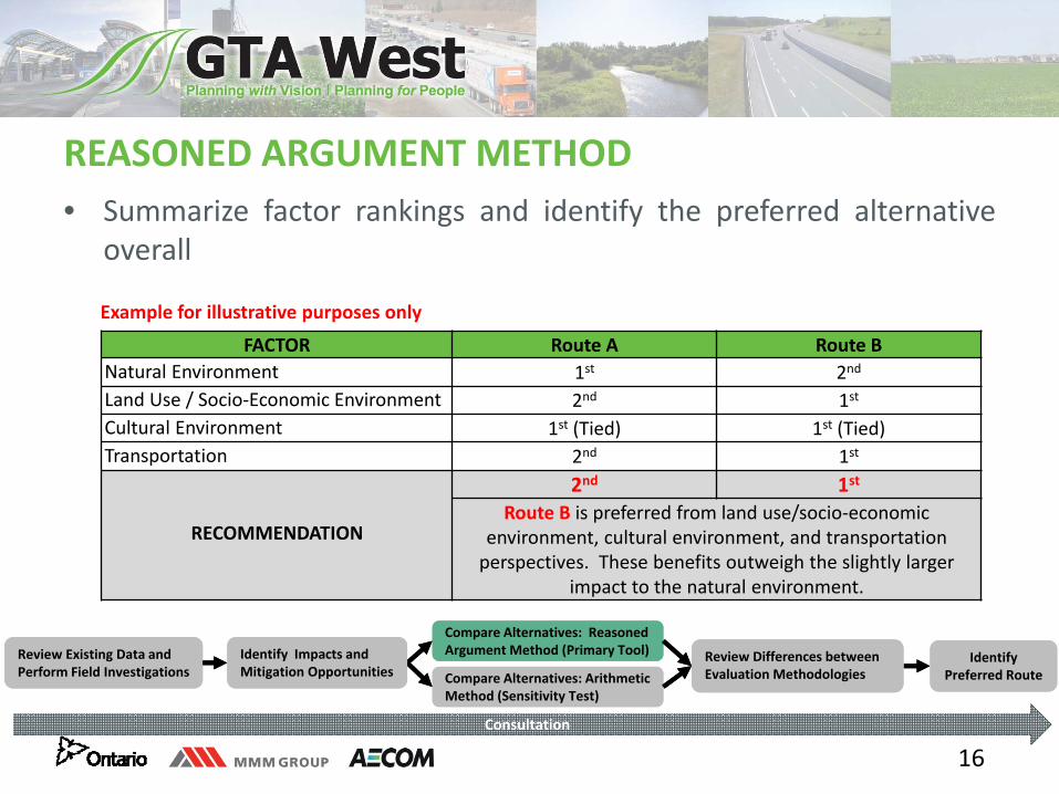
• Summarize factor rankings and identify the preferred alternativeoverall
FACTOR Route A Route BNatural Environment 1st 2nd
Land Use / Socio‐Economic Environment 2nd 1st
Cultural Environment 1st (Tied) 1st (Tied)Transportation 2nd 1st
RECOMMENDATION
2nd 1stRoute B is preferred from land use/socio‐economic
environment, cultural environment, and transportation perspectives. These benefits outweigh the slightly larger
impact to the natural environment.
REASONED ARGUMENT METHOD
Example for illustrative purposes only
Review Existing Data and Perform Field InvestigationsReview Existing Data and Perform Field Investigations
Compare Alternatives: Reasoned Argument Method (Primary Tool)Compare Alternatives: Reasoned Argument Method (Primary Tool) Review Differences between
Evaluation Methodologies Review Differences between Evaluation Methodologies Compare Alternatives: Arithmetic
Method (Sensitivity Test)Compare Alternatives: Arithmetic Method (Sensitivity Test)
Identify Preferred Route
Identify Preferred Route
Identify Impacts and Mitigation OpportunitiesIdentify Impacts and Mitigation Opportunities
Consultation
17
LET’S DISCUSS ANY QUESTIONS YOU HAVE REGARDING THE REASONED ARGUMENT METHOD
18
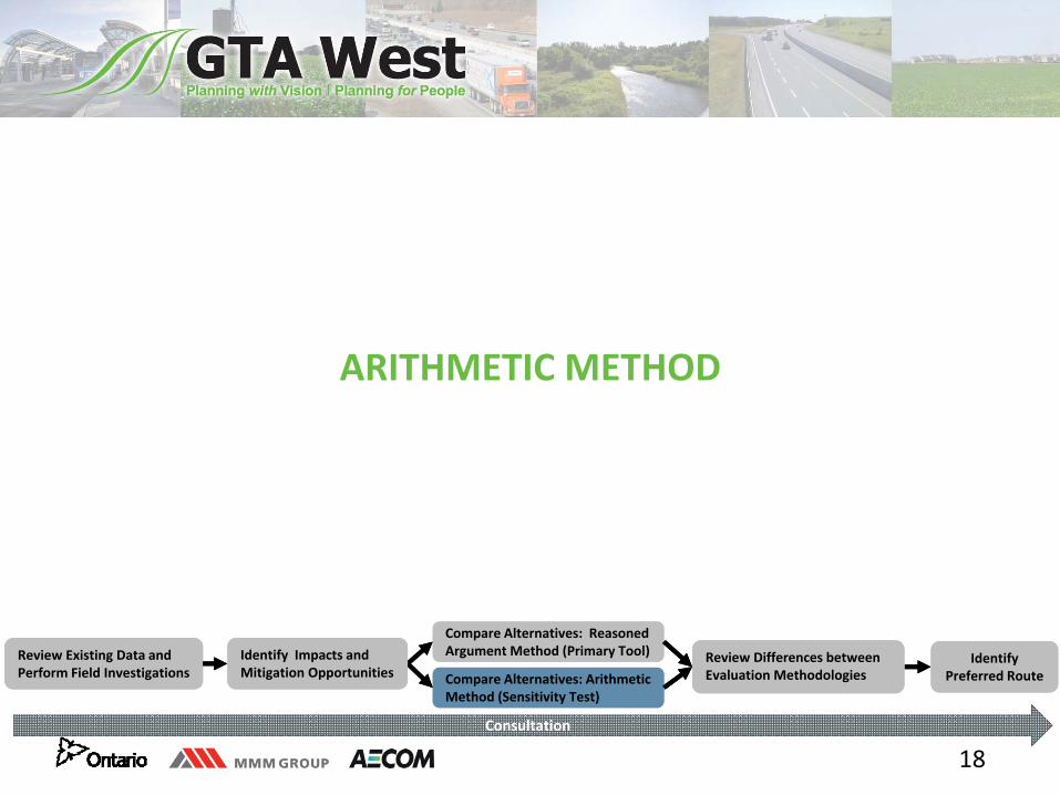
ARITHMETIC METHOD
Review Existing Data and Perform Field InvestigationsReview Existing Data and Perform Field Investigations
Compare Alternatives: Reasoned Argument Method (Primary Tool)Compare Alternatives: Reasoned Argument Method (Primary Tool) Review Differences between
Evaluation Methodologies Review Differences between Evaluation Methodologies Compare Alternatives: Arithmetic
Method (Sensitivity Test)Compare Alternatives: Arithmetic Method (Sensitivity Test)
Identify Preferred Route
Identify Preferred Route
Identify Impacts and Mitigation OpportunitiesIdentify Impacts and Mitigation Opportunities
Consultation
19
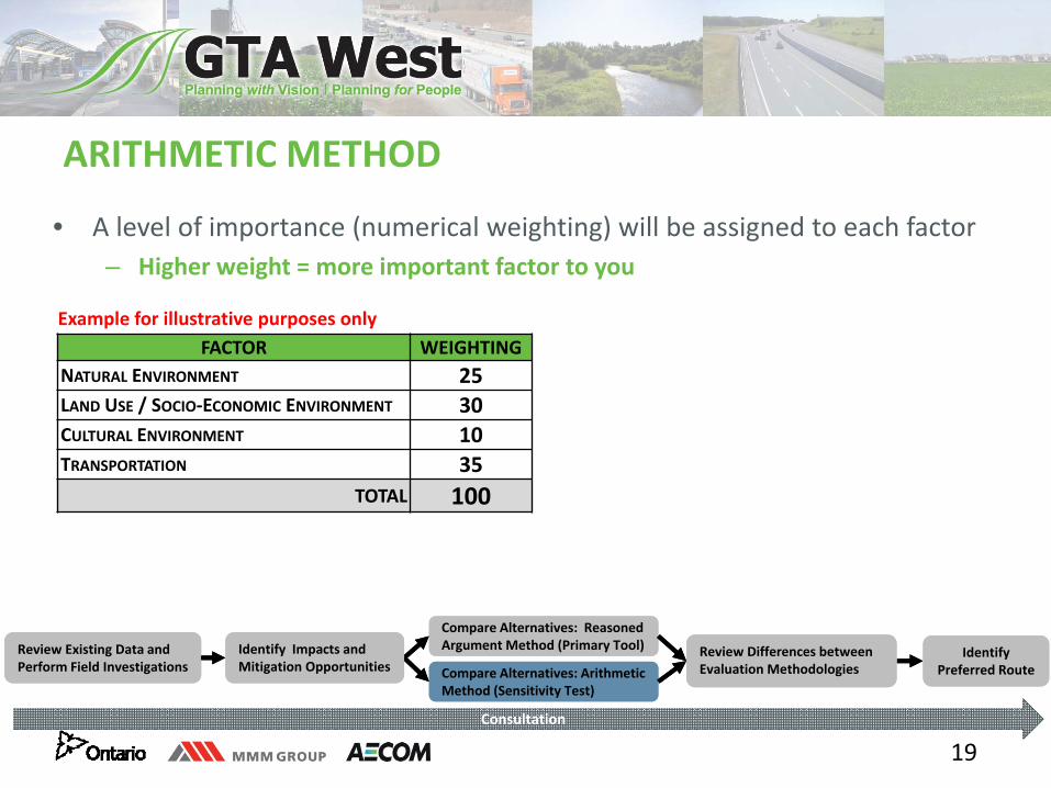
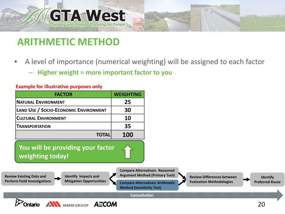
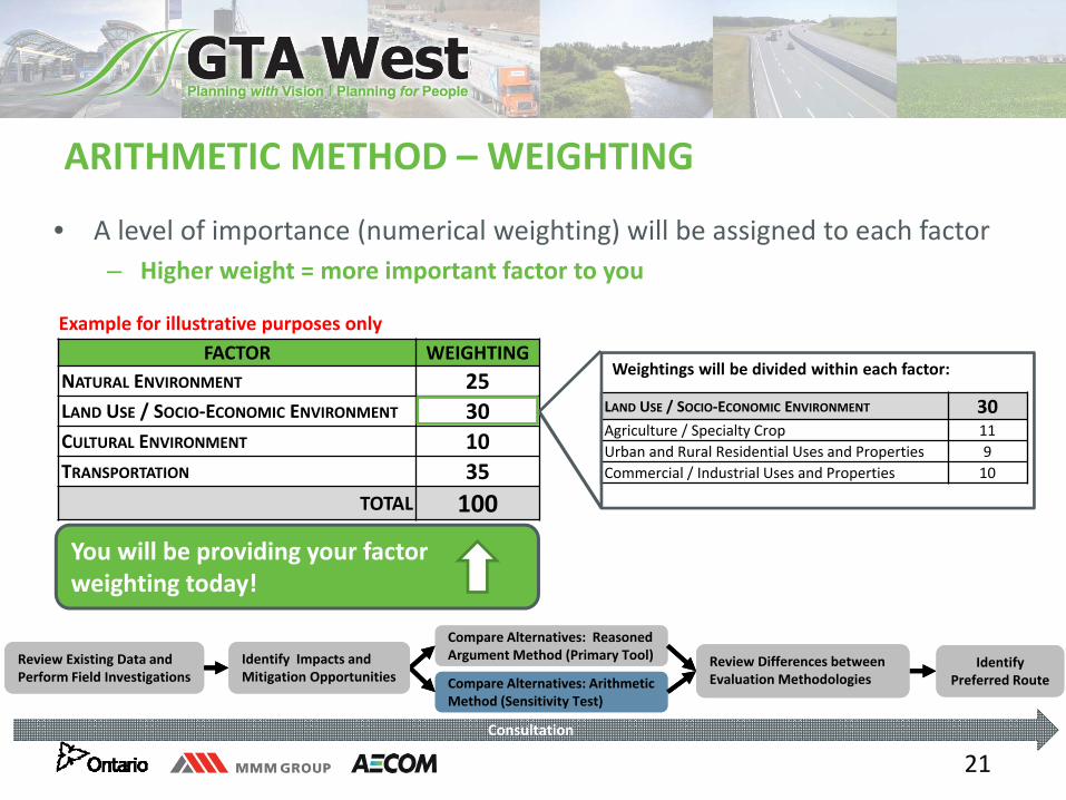
• A level of importance (numerical weighting) will be assigned to each factor– Higher weight = more important factor to you
ARITHMETIC METHOD
FACTOR WEIGHTING NATURAL ENVIRONMENT 25LAND USE / SOCIO‐ECONOMIC ENVIRONMENT 30CULTURAL ENVIRONMENT 10TRANSPORTATION 35
TOTAL 100
Example for illustrative purposes only
Review Existing Data and Perform Field InvestigationsReview Existing Data and Perform Field Investigations
Compare Alternatives: Reasoned Argument Method (Primary Tool)Compare Alternatives: Reasoned Argument Method (Primary Tool) Review Differences between
Evaluation Methodologies Review Differences between Evaluation Methodologies Compare Alternatives: Arithmetic
Method (Sensitivity Test)Compare Alternatives: Arithmetic Method (Sensitivity Test)
Identify Preferred Route
Identify Preferred Route
Identify Impacts and Mitigation OpportunitiesIdentify Impacts and Mitigation Opportunities
Consultation
20
• A level of importance (numerical weighting) will be assigned to each factor– Higher weight = more important factor to you
ARITHMETIC METHOD
FACTOR WEIGHTING NATURAL ENVIRONMENT 25LAND USE / SOCIO‐ECONOMIC ENVIRONMENT 30CULTURAL ENVIRONMENT 10TRANSPORTATION 35
TOTAL 100
Example for illustrative purposes only
You will be providing your factor weighting today!
Review Existing Data and Perform Field InvestigationsReview Existing Data and Perform Field Investigations
Compare Alternatives: Reasoned Argument Method (Primary Tool)Compare Alternatives: Reasoned Argument Method (Primary Tool) Review Differences between
Evaluation Methodologies Review Differences between Evaluation Methodologies Compare Alternatives: Arithmetic
Method (Sensitivity Test)Compare Alternatives: Arithmetic Method (Sensitivity Test)
Identify Preferred Route
Identify Preferred Route
Identify Impacts and Mitigation OpportunitiesIdentify Impacts and Mitigation Opportunities
Consultation
21
• A level of importance (numerical weighting) will be assigned to each factor– Higher weight = more important factor to you
ARITHMETIC METHOD – WEIGHTING
FACTOR WEIGHTING NATURAL ENVIRONMENT 25LAND USE / SOCIO‐ECONOMIC ENVIRONMENT 30CULTURAL ENVIRONMENT 10TRANSPORTATION 35
TOTAL 100
Example for illustrative purposes only
You will be providing your factor weighting today!
LAND USE / SOCIO‐ECONOMIC ENVIRONMENT 30Agriculture / Specialty Crop 11Urban and Rural Residential Uses and Properties 9Commercial / Industrial Uses and Properties 10
Weightings will be divided within each factor:
Review Existing Data and Perform Field InvestigationsReview Existing Data and Perform Field Investigations
Compare Alternatives: Reasoned Argument Method (Primary Tool)Compare Alternatives: Reasoned Argument Method (Primary Tool) Review Differences between
Evaluation Methodologies Review Differences between Evaluation Methodologies Compare Alternatives: Arithmetic
Method (Sensitivity Test)Compare Alternatives: Arithmetic Method (Sensitivity Test)
Identify Preferred Route
Identify Preferred Route
Identify Impacts and Mitigation OpportunitiesIdentify Impacts and Mitigation Opportunities
Consultation
22
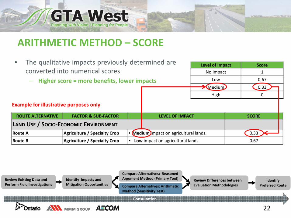
ARITHMETIC METHOD – SCORE
• The qualitative impacts previously determined areconverted into numerical scores
– Higher score = more benefits, lower impacts
ROUTE ALTERNATIVE FACTOR & SUB‐FACTOR LEVEL OF IMPACT SCORE
LAND USE / SOCIO‐ECONOMIC ENVIRONMENT
Route A Agriculture / Specialty Crop • Medium impact on agricultural lands. 0.33
Route B Agriculture / Specialty Crop • Low impact on agricultural lands. 0.67
Level of Impact ScoreNo Impact 1
Low 0.67
Medium 0.33
High 0
Example for illustrative purposes only
Review Existing Data and Perform Field InvestigationsReview Existing Data and Perform Field Investigations
Compare Alternatives: Reasoned Argument Method (Primary Tool)Compare Alternatives: Reasoned Argument Method (Primary Tool) Review Differences between
Evaluation Methodologies Review Differences between Evaluation Methodologies Compare Alternatives: Arithmetic
Method (Sensitivity Test)Compare Alternatives: Arithmetic Method (Sensitivity Test)
Identify Preferred Route
Identify Preferred Route
Identify Impacts and Mitigation OpportunitiesIdentify Impacts and Mitigation Opportunities
Consultation
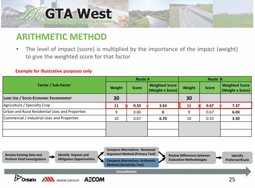
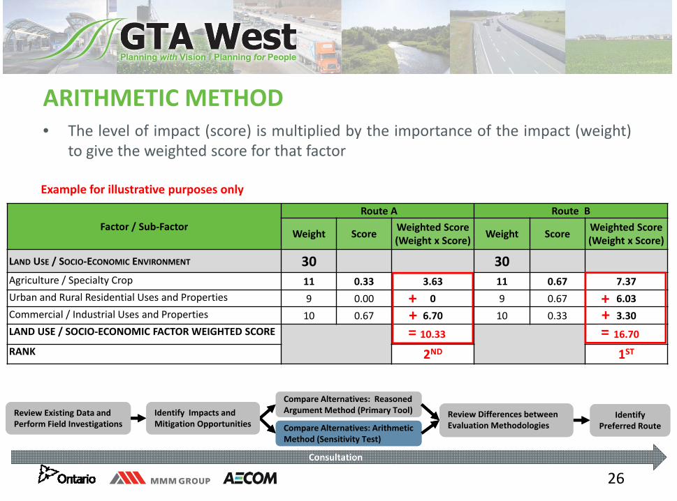
23
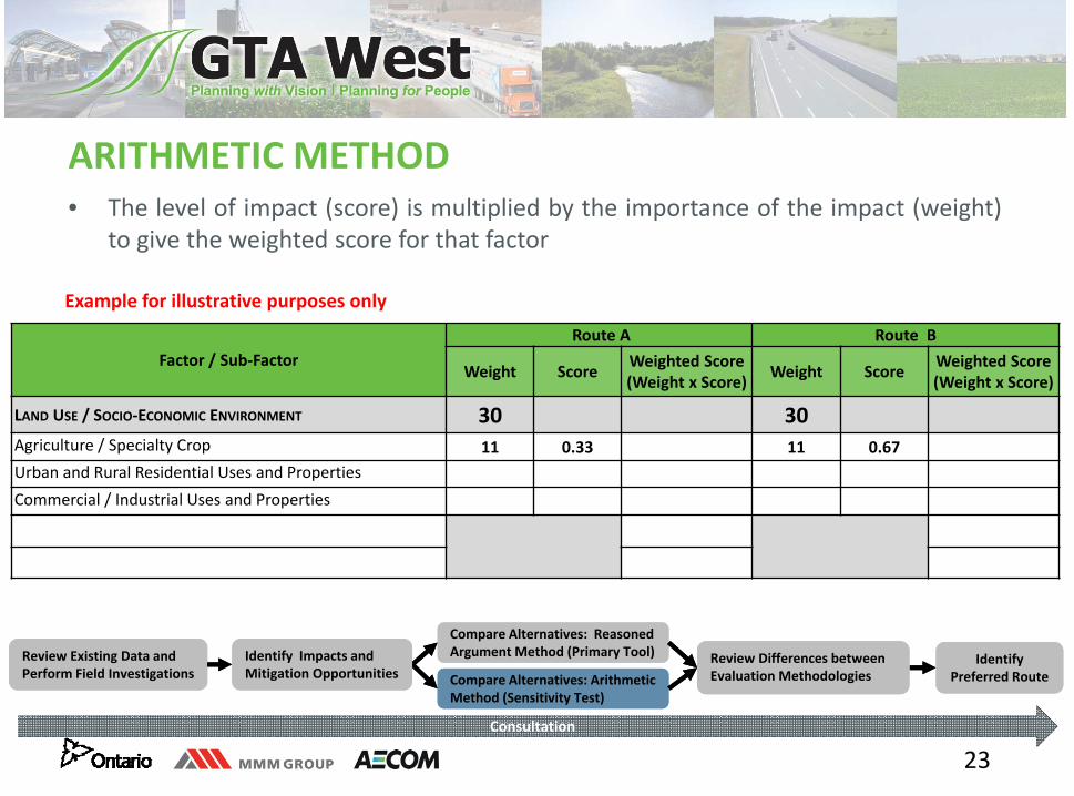
ARITHMETIC METHOD• The level of impact (score) is multiplied by the importance of the impact (weight)
to give the weighted score for that factor
Factor / Sub‐Factor Route A Route B
Weight Score Weighted Score(Weight x Score) Weight Score Weighted Score
(Weight x Score)
LAND USE / SOCIO‐ECONOMIC ENVIRONMENT 30 30Agriculture / Specialty Crop 11 0.33 11 0.67Urban and Rural Residential Uses and PropertiesCommercial / Industrial Uses and Properties
Example for illustrative purposes only
Review Existing Data and Perform Field InvestigationsReview Existing Data and Perform Field Investigations
Compare Alternatives: Reasoned Argument Method (Primary Tool)Compare Alternatives: Reasoned Argument Method (Primary Tool) Review Differences between
Evaluation Methodologies Review Differences between Evaluation Methodologies Compare Alternatives: Arithmetic
Method (Sensitivity Test)Compare Alternatives: Arithmetic Method (Sensitivity Test)
Identify Preferred Route
Identify Preferred Route
Identify Impacts and Mitigation OpportunitiesIdentify Impacts and Mitigation Opportunities
Consultation
24
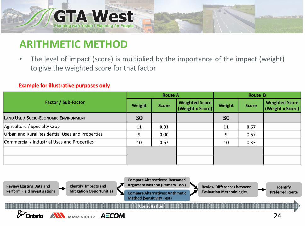
ARITHMETIC METHOD• The level of impact (score) is multiplied by the importance of the impact (weight)
to give the weighted score for that factor
Factor / Sub‐Factor Route A Route B
Weight Score Weighted Score(Weight x Score) Weight Score Weighted Score
(Weight x Score)
LAND USE / SOCIO‐ECONOMIC ENVIRONMENT 30 30Agriculture / Specialty Crop 11 0.33 11 0.67Urban and Rural Residential Uses and Properties 9 0.00 9 0.67Commercial / Industrial Uses and Properties 10 0.67 10 0.33
Example for illustrative purposes only
Review Existing Data and Perform Field InvestigationsReview Existing Data and Perform Field Investigations
Compare Alternatives: Reasoned Argument Method (Primary Tool)Compare Alternatives: Reasoned Argument Method (Primary Tool) Review Differences between
Evaluation Methodologies Review Differences between Evaluation Methodologies Compare Alternatives: Arithmetic
Method (Sensitivity Test)Compare Alternatives: Arithmetic Method (Sensitivity Test)
Identify Preferred Route
Identify Preferred Route
Identify Impacts and Mitigation OpportunitiesIdentify Impacts and Mitigation Opportunities
Consultation
25
ARITHMETIC METHOD• The level of impact (score) is multiplied by the importance of the impact (weight)
to give the weighted score for that factor
Factor / Sub‐Factor Route A Route B
Weight Score Weighted Score(Weight x Score) Weight Score Weighted Score
(Weight x Score)
LAND USE / SOCIO‐ECONOMIC ENVIRONMENT 30 30Agriculture / Specialty Crop 11 0.33 3.63 11 0.67 7.37Urban and Rural Residential Uses and Properties 9 0.00 0 9 0.67 6.03Commercial / Industrial Uses and Properties 10 0.67 6.70 10 0.33 3.30
Example for illustrative purposes only
Review Existing Data and Perform Field InvestigationsReview Existing Data and Perform Field Investigations
Compare Alternatives: Reasoned Argument Method (Primary Tool)Compare Alternatives: Reasoned Argument Method (Primary Tool) Review Differences between
Evaluation Methodologies Review Differences between Evaluation Methodologies Compare Alternatives: Arithmetic
Method (Sensitivity Test)Compare Alternatives: Arithmetic Method (Sensitivity Test)
Identify Preferred Route
Identify Preferred Route
Identify Impacts and Mitigation OpportunitiesIdentify Impacts and Mitigation Opportunities
Consultation
x = x =
26
ARITHMETIC METHOD• The level of impact (score) is multiplied by the importance of the impact (weight)
to give the weighted score for that factor
Factor / Sub‐Factor Route A Route B
Weight Score Weighted Score(Weight x Score) Weight Score Weighted Score
(Weight x Score)
LAND USE / SOCIO‐ECONOMIC ENVIRONMENT 30 30Agriculture / Specialty Crop 11 0.33 3.63 11 0.67 7.37Urban and Rural Residential Uses and Properties 9 0.00 0 9 0.67 6.03Commercial / Industrial Uses and Properties 10 0.67 6.70 10 0.33 3.30LAND USE / SOCIO‐ECONOMIC FACTOR WEIGHTED SCORE 10.33 16.70RANK 2ND 1ST
Example for illustrative purposes only
Review Existing Data and Perform Field InvestigationsReview Existing Data and Perform Field Investigations
Compare Alternatives: Reasoned Argument Method (Primary Tool)Compare Alternatives: Reasoned Argument Method (Primary Tool) Review Differences between
Evaluation Methodologies Review Differences between Evaluation Methodologies Compare Alternatives: Arithmetic
Method (Sensitivity Test)Compare Alternatives: Arithmetic Method (Sensitivity Test)
Identify Preferred Route
Identify Preferred Route
Identify Impacts and Mitigation OpportunitiesIdentify Impacts and Mitigation Opportunities
Consultation
=
++
=
++

27
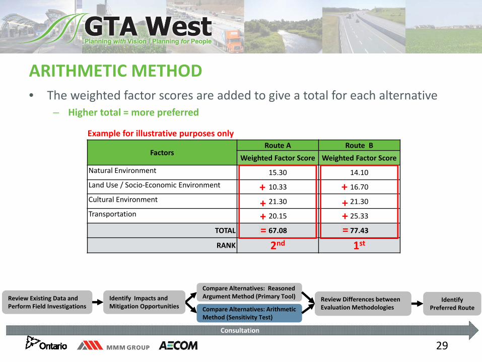
ARITHMETIC METHOD• The weighted factor scores are added to give a total for each alternative
– Higher total = more preferred
FactorsRoute A Route B
Weighted Factor Score Weighted Factor Score Natural Environment
Land Use / Socio‐Economic Environment 10.33 16.70Cultural Environment
Transportation
TOTAL
RANK
Example for illustrative purposes only
Review Existing Data and Perform Field InvestigationsReview Existing Data and Perform Field Investigations
Compare Alternatives: Reasoned Argument Method (Primary Tool)Compare Alternatives: Reasoned Argument Method (Primary Tool) Review Differences between
Evaluation Methodologies Review Differences between Evaluation Methodologies Compare Alternatives: Arithmetic
Method (Sensitivity Test)Compare Alternatives: Arithmetic Method (Sensitivity Test)
Identify Preferred Route
Identify Preferred Route
Identify Impacts and Mitigation OpportunitiesIdentify Impacts and Mitigation Opportunities
Consultation
28
ARITHMETIC METHOD• The weighted factor scores are added to give a total for each alternative
– Higher total = more preferred
FactorsRoute A Route B
Weighted Factor Score Weighted Factor Score Natural Environment 15.30 14.10Land Use / Socio‐Economic Environment 10.33 16.70Cultural Environment 21.30 21.30Transportation 20.15 25.33
TOTAL
RANK
Example for illustrative purposes only
Review Existing Data and Perform Field InvestigationsReview Existing Data and Perform Field Investigations
Compare Alternatives: Reasoned Argument Method (Primary Tool)Compare Alternatives: Reasoned Argument Method (Primary Tool) Review Differences between
Evaluation Methodologies Review Differences between Evaluation Methodologies Compare Alternatives: Arithmetic
Method (Sensitivity Test)Compare Alternatives: Arithmetic Method (Sensitivity Test)
Identify Preferred Route
Identify Preferred Route
Identify Impacts and Mitigation OpportunitiesIdentify Impacts and Mitigation Opportunities
Consultation
29
ARITHMETIC METHOD• The weighted factor scores are added to give a total for each alternative
– Higher total = more preferred
FactorsRoute A Route B
Weighted Factor Score Weighted Factor Score Natural Environment 15.30 14.10Land Use / Socio‐Economic Environment 10.33 16.70Cultural Environment 21.30 21.30Transportation 20.15 25.33
TOTAL 67.08 77.43
RANK 2nd 1st=
+++
Example for illustrative purposes only
Review Existing Data and Perform Field InvestigationsReview Existing Data and Perform Field Investigations
Compare Alternatives: Reasoned Argument Method (Primary Tool)Compare Alternatives: Reasoned Argument Method (Primary Tool) Review Differences between
Evaluation Methodologies Review Differences between Evaluation Methodologies Compare Alternatives: Arithmetic
Method (Sensitivity Test)Compare Alternatives: Arithmetic Method (Sensitivity Test)
Identify Preferred Route
Identify Preferred Route
Identify Impacts and Mitigation OpportunitiesIdentify Impacts and Mitigation Opportunities
Consultation
=
+++
30
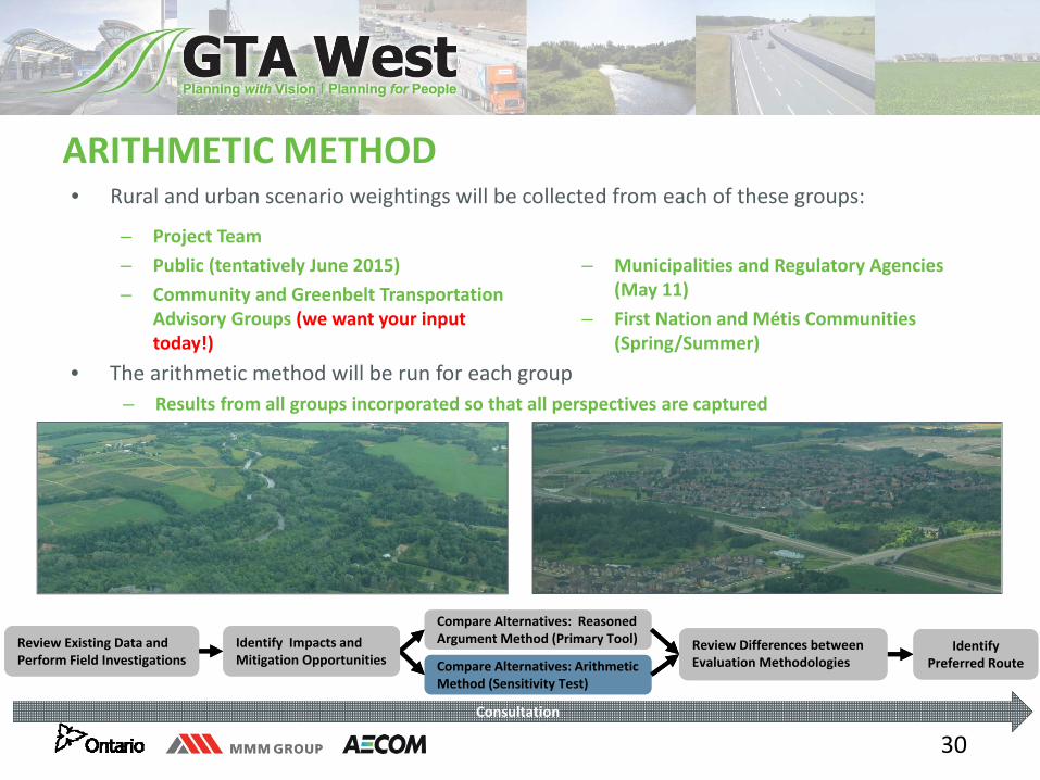
ARITHMETIC METHOD • Rural and urban scenario weightings will be collected from each of these groups:
– Project Team – Public (tentatively June 2015)– Community and Greenbelt Transportation
Advisory Groups (we want your input today!)
– Municipalities and Regulatory Agencies (May 11)
– First Nation and Métis Communities (Spring/Summer)
• The arithmetic method will be run for each group– Results from all groups incorporated so that all perspectives are captured
Review Existing Data and Perform Field InvestigationsReview Existing Data and Perform Field Investigations
Compare Alternatives: Reasoned Argument Method (Primary Tool)Compare Alternatives: Reasoned Argument Method (Primary Tool) Review Differences between
Evaluation Methodologies Review Differences between Evaluation Methodologies Compare Alternatives: Arithmetic
Method (Sensitivity Test)Compare Alternatives: Arithmetic Method (Sensitivity Test)
Identify Preferred Route
Identify Preferred Route
Identify Impacts and Mitigation OpportunitiesIdentify Impacts and Mitigation Opportunities
Consultation
31
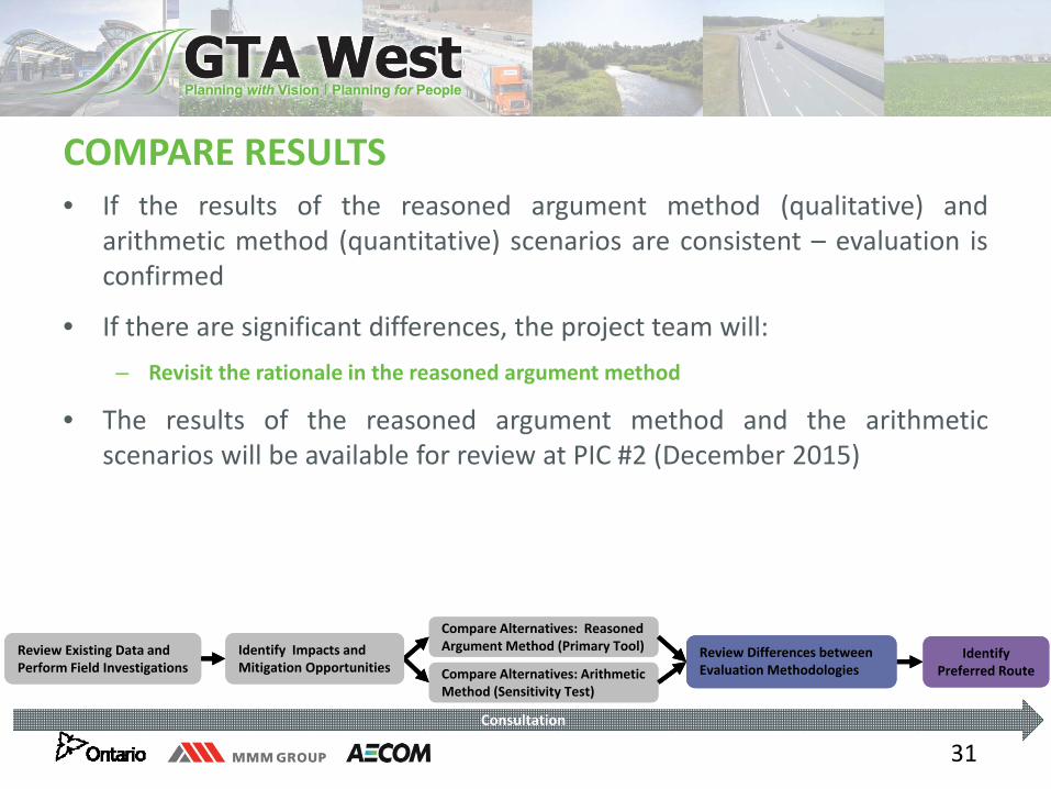
COMPARE RESULTS • If the results of the reasoned argument method (qualitative) and
arithmetic method (quantitative) scenarios are consistent – evaluation isconfirmed
• If there are significant differences, the project team will:– Revisit the rationale in the reasoned argument method
• The results of the reasoned argument method and the arithmeticscenarios will be available for review at PIC #2 (December 2015)
Review Existing Data and Perform Field InvestigationsReview Existing Data and Perform Field Investigations
Compare Alternatives: Reasoned Argument Method (Primary Tool)Compare Alternatives: Reasoned Argument Method (Primary Tool) Review Differences between
Evaluation Methodologies Review Differences between Evaluation Methodologies Compare Alternatives: Arithmetic
Method (Sensitivity Test)Compare Alternatives: Arithmetic Method (Sensitivity Test)
Identify Preferred Route
Identify Preferred Route
Identify Impacts and Mitigation OpportunitiesIdentify Impacts and Mitigation Opportunities
Consultation
32
LET’S TALK ABOUT WHAT FACTORS ARE IMPORTANT TO YOU AND OBTAIN YOUR FACTOR WEIGHTINGS
1
Session 2: Trade‐Offs in the West, Central and
East Sections of the Study Area
2
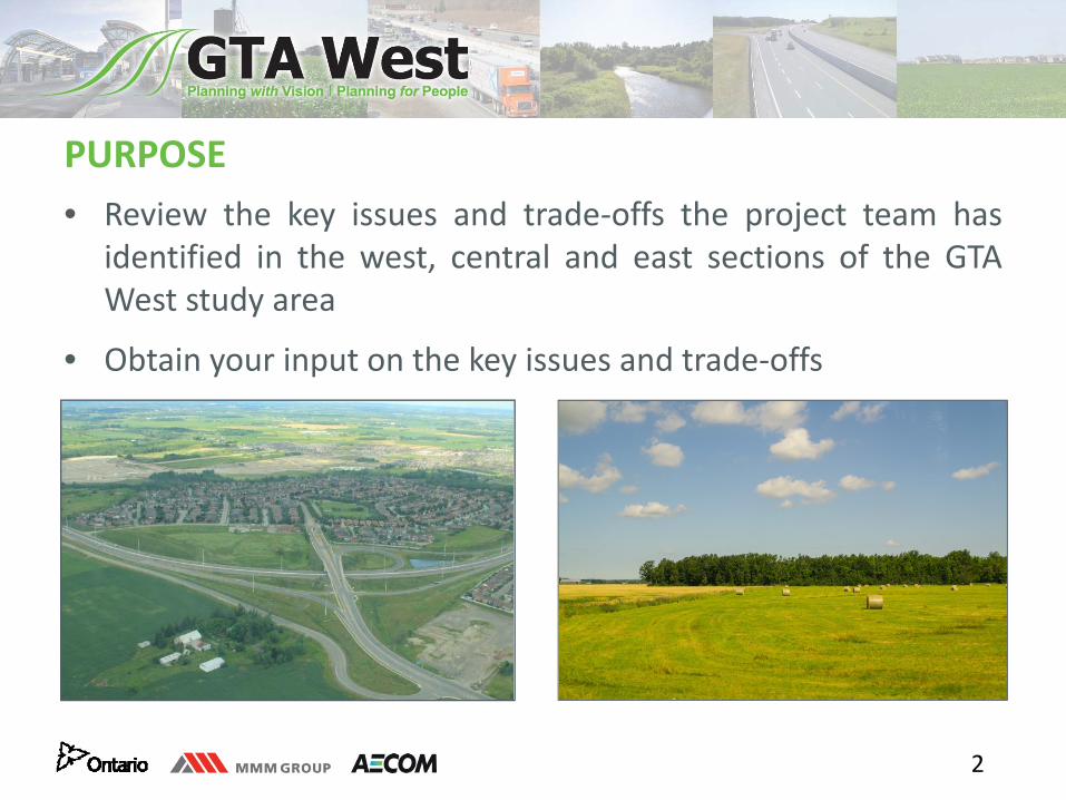
PURPOSE • Review the key issues and trade‐offs the project team has
identified in the west, central and east sections of the GTAWest study area
• Obtain your input on the key issues and trade‐offs
4
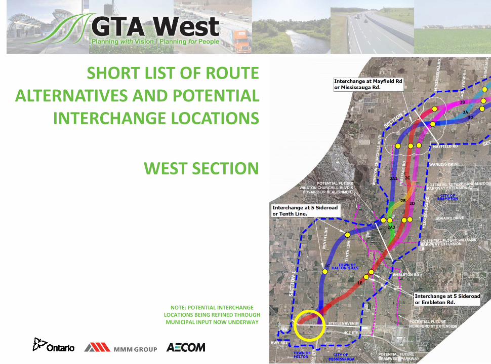
SHORT LIST OF ROUTE ALTERNATIVES AND POTENTIAL
INTERCHANGE LOCATIONS
WEST SECTION
NOTE: POTENTIAL INTERCHANGE LOCATIONS BEING REFINED THROUGH MUNICIPAL INPUT NOW UNDERWAY
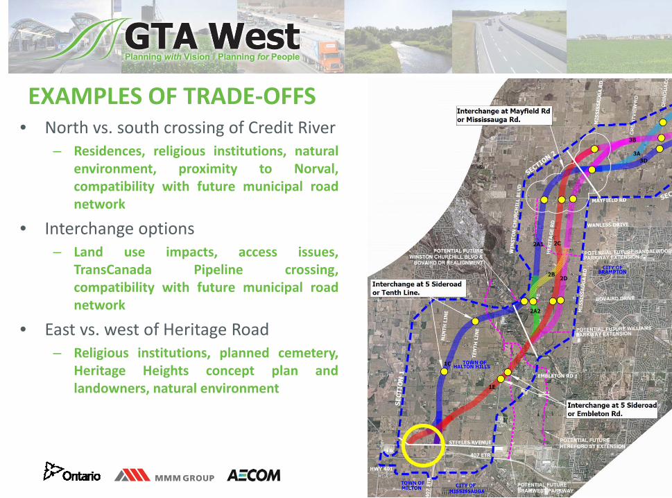
8
• North vs. south crossing of Credit River– Residences, religious institutions, natural
environment, proximity to Norval,compatibility with future municipal roadnetwork
• Interchange options– Land use impacts, access issues,
TransCanada Pipeline crossing,compatibility with future municipal roadnetwork
• East vs. west of Heritage Road– Religious institutions, planned cemetery,
Heritage Heights concept plan andlandowners, natural environment
EXAMPLES OF TRADE‐OFFS

9
GROUP DISCUSSION
10
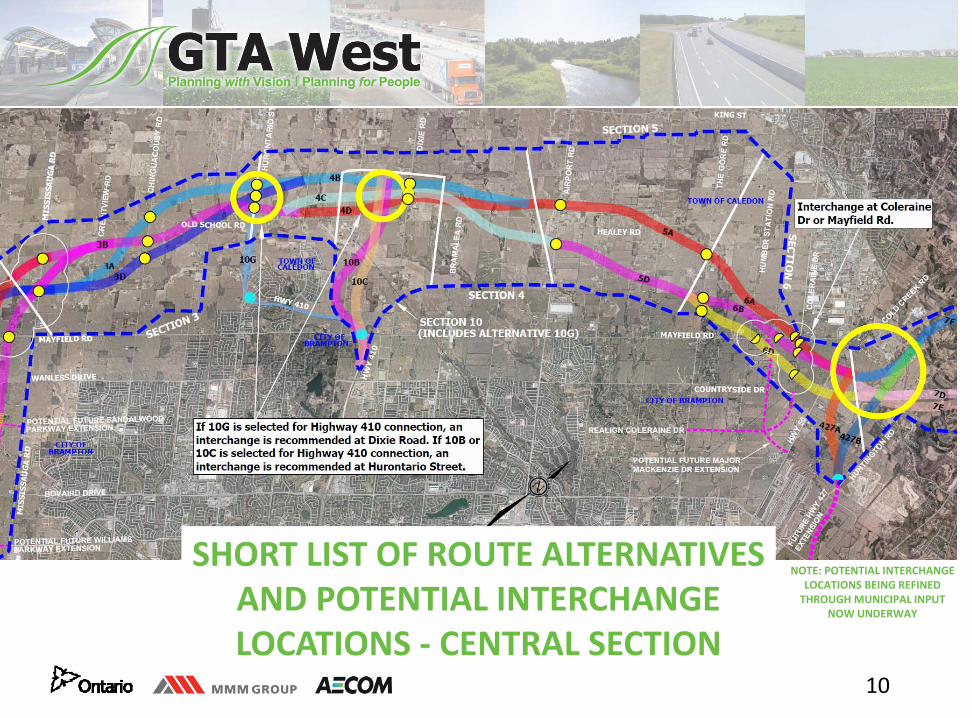
SHORT LIST OF ROUTE ALTERNATIVES AND POTENTIAL INTERCHANGE LOCATIONS ‐ CENTRAL SECTION
NOTE: POTENTIAL INTERCHANGE LOCATIONS BEING REFINED THROUGH MUNICIPAL INPUT
NOW UNDERWAY
14
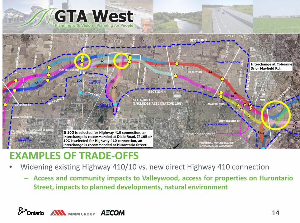
EXAMPLES OF TRADE‐OFFS• Widening existing Highway 410/10 vs. new direct Highway 410 connection
– Access and community impacts to Valleywood, access for properties on HurontarioStreet, impacts to planned developments, natural environment
15
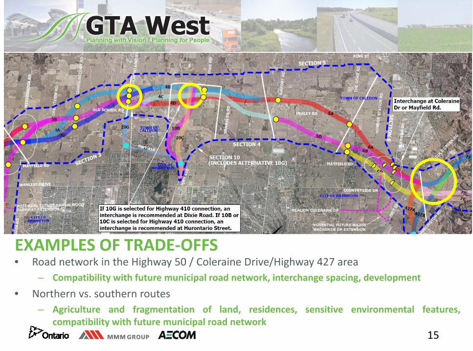
EXAMPLES OF TRADE‐OFFS• Road network in the Highway 50 / Coleraine Drive/Highway 427 area
– Compatibility with future municipal road network, interchange spacing, development
• Northern vs. southern routes– Agriculture and fragmentation of land, residences, sensitive environmental features,
compatibility with future municipal road network
16
GROUP DISCUSSION
17
SHORT LIST OF ROUTE ALTERNATIVES AND
POTENTIAL INTERCHANGE LOCATIONS
EAST SECTION
NOTE: POTENTIAL INTERCHANGE LOCATIONS BEING REFINED THROUGH MUNICIPAL INPUT NOW UNDERWAY
21
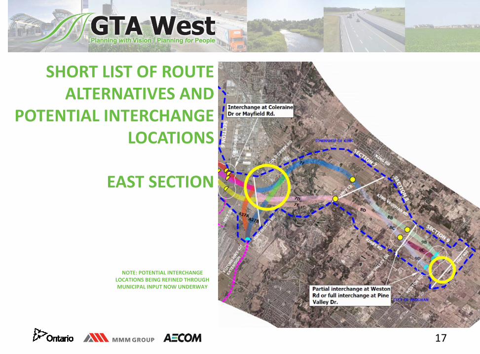
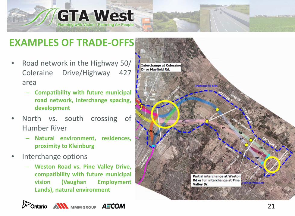
EXAMPLES OF TRADE‐OFFS
• Road network in the Highway 50/Coleraine Drive/Highway 427area
– Compatibility with future municipalroad network, interchange spacing,development
• North vs. south crossing ofHumber River
– Natural environment, residences,proximity to Kleinburg
• Interchange options– Weston Road vs. Pine Valley Drive,
compatibility with future municipalvision (Vaughan EmploymentLands), natural environment

22
GROUP DISCUSSION