GROUNDWELL RIDGE SWINDON WILTSHIRE RCHAEOLOGICAL … · groundwell ridge swindon wiltshire...
48
GROUNDWELL RIDGE SWINDON WILTSHIRE ARCHAEOLOGICAL EVALUATION CA PROJECT: 1566 CA REPORT: 03104 Author: Mark Brett Approved: Signed: Neil Holbrook ……………………………………………………………. Issue: 01 Date: 6th November 2003 This report is confidential to the client. Cotswold Archaeology accepts no responsibility or liability to any third party to whom this report, or any part of it, is made known. Any such party relies upon this report entirely at their own risk. No part of this report may be reproduced by any means without permission. © Cotswold Archaeology Headquarters Building, Kemble Business Park, Cirencester, Gloucestershire, GL7 6BQ Tel. 01285 771022 Fax. 01285 771033 E-mail: [email protected]
Transcript of GROUNDWELL RIDGE SWINDON WILTSHIRE RCHAEOLOGICAL … · groundwell ridge swindon wiltshire...

GROUNDWELL RIDGE SWINDON
WILTSHIRE
ARCHAEOLOGICAL EVALUATION
CA PROJECT: 1566 CA REPORT: 03104
Author: Mark Brett
Approved:
Signed:
Neil Holbrook
…………………………………………………………….
Issue: 01 Date: 6th November 2003
This report is confidential to the client. Cotswold Archaeology accepts no responsibility or liability to any third party to whom this report, or any part of it, is made known. Any such party relies upon this report entirely at their own risk. No part of this report may be reproduced by any means without permission.
© Cotswold Archaeology
Headquarters Building, Kemble Business Park, Cirencester, Gloucestershire, GL7 6BQ Tel. 01285 771022 Fax. 01285 771033 E-mail: [email protected]

Groundwell Ridge, Swindon, Wiltshire: Archaeological Evaluation ©Cotswold Archaeology
SUMMARY........................................................................................................................3
1. INTRODUCTION........................................................................................................ 4
The site ................................................................................................................ 4
Archaeological background.................................................................................. 5
Archaeological objectives .................................................................................... 6
Methodology ........................................................................................................ 8
2. RESULTS................................................................................................................... 9
Test-pit 12 (Fig. 3)................................................................................................ 9
Test-pit 16 ............................................................................................................ 9
Test-pit 21 (Fig. 4)................................................................................................ 10
Test-pit 29 ............................................................................................................ 10
Test-pit 38 ............................................................................................................ 10
Trench 39............................................................................................................. 10
Test-pit at 10 Pennine Way.................................................................................. 11
3. DISCUSSION ............................................................................................................. 11
4. PROJECT TEAM........................................................................................................ 13
5. REFERENCES........................................................................................................... 13
APPENDIX 1: CONTEXT DESCRIPTIONS...................................................................... 14
APPENDIX 2: THE FINDS BY SAM INDER ..................................................................... 22
APPENDIX 3: PROJECT DESIGN ................................................................................... 26
APPENDIX 4: REPORT ON TEST-PIT AT 4 PENNINE WAY.......................................... 38
1

Groundwell Ridge, Swindon, Wiltshire: Archaeological Evaluation ©Cotswold Archaeology
LIST OF ILLUSTRATIONS
Fig. 1 Site location plan
Fig. 2 Test-pit and trench location plan
Fig. 3 Test-pit 12; plan and section
Fig. 4 Test-pit 21; plan and section
2

Groundwell Ridge, Swindon, Wiltshire: Archaeological Evaluation ©Cotswold Archaeology
SUMMARY
Site Name: Groundwell Ridge
Location: Swindon, Wiltshire
NGR: SU 1412 8938
Type: Evaluation
Date: 28-29 June 2003
Location of Archive: Swindon Museum
Accession no. B/2003/02
Site Code: GRS 03
An archaeological evaluation was undertaken on land adjacent to the scheduled site of a
possible Roman religious sanctuary at Groundwell Ridge, Swindon, Wiltshire as part of the
Channel Four Time Team Big Dig television programme. The evaluation was carried out by
the Time Team archaeological team, with Cotswold Archaeology (CA) providing on-site
advice and supervision of recording. The project took place between the 28th and 29th June
2003. In compliance with a project design formulated in consultation with Pete Wilson of
English Heritage and Roy Canham, Wiltshire County Archaeological Officer, a total of 37
test-pits and 4 trenches were excavated across the study area.
The evaluation identified a number of Roman deposits and features including a posthole and
associated stone surface, a possible wall and a deposit of probable demolition rubble. In
addition a stone culvert and a buried soil horizon may also date to the Roman period,
although a later date for these is more likely.
The evaluation has characterised the archaeological potential of the study area, and has
indicated that Roman and undated deposits survive at a depth of between 0.3m and 0.9m
below the modern ground surface.
3

Groundwell Ridge, Swindon, Wiltshire: Archaeological Evaluation ©Cotswold Archaeology
1. INTRODUCTION
1.1 In June 2003 the Time Team carried out an archaeological evaluation at Groundwell
Ridge, Swindon, Wiltshire (centred on NGR: SU 1412 8938; Fig. 1). The evaluation
was undertaken as part of the Channel Four Time Team Big Dig television
programme, a nationwide initiative to involve the general public in excavating test-
pits in their own gardens and other public places within their localities. CA was
commissioned to provide on-site advice to the excavators, to supervise the
recording of the test-pits and trenches using context recording forms designed
specifically for the Big Dig, and to compile a report on the evaluation, as well as to
prepare the archive for deposition with the local museum.
1.2 The evaluation was undertaken in accordance with a project design compiled by
Tory Batten of Wildfire Television Ltd (2003)(see Appendix 3) and also procedural
guidelines advised by bodies including English Heritage, ALGAO, CBA and IFA.
Archiving has been undertaken in accordance with the Standards for Archaeological
Assessment and Field Evaluation in Wiltshire issued by Wiltshire County Council
Archaeological Service (1995).
The site
1.3 The main site, adjacent to the possible Roman rural sanctuary at Groundwell Ridge,
is situated between the housing estates of Ash Brake and Abbey Mead, which lie
approximately 4.8 km north of Swindon town centre, 1 km west of the A419 from
Swindon to Cricklade and immediately east of the B4534, otherwise known as Lady
Lane (Fig. 1). It comprises an open grassed area, hereafter referred to as ‘The
Combe’, and a wooded copse, together totalling an area of approximately 3ha. The
study area also encompasses areas of the surrounding housing estates, up to 140m
distant from the main evaluation site and the scheduled area. Topographically, the
site lies on the south-west facing slope of an escarpment, dropping considerably
from a height of 140m to 105m AOD.
1.4 Geologically, the site lies at the southern edge of the upper Thames valley on a
ridge of Corallian limestone, which runs north-west/south-east through North
Wiltshire. The south-west facing escarpment slopes steeply to a bed of Oxford clay
at the foot of the scarp. Numerous springs have been noted at the eastern end of
the scheduled site.
4

Groundwell Ridge, Swindon, Wiltshire: Archaeological Evaluation ©Cotswold Archaeology
1.5 The site lies in the centre of the modern housing estates and is crossed by footpaths
and a cycleway. It is currently used for recreation, such as dog-walking and cycling
by local residents, as well as for access to other parts of the housing estates.
Archaeological background
1.6 The archaeological and historical background of the study area is summarised in the
project design. It is not intended to repeat the findings of these investigations in full
here, rather this report should be read in conjunction with them.
The Scheduled Monument
1.7 The Scheduled Ancient Monument (SAM 29664), in the neighbouring field to the
evaluation site, comprises surviving earthworks and buried remains, including a
probable Roman agger with side-ditches leading to a series of platforms on artificial
terraces overlooking a number of structures. The overall interpretation of the site is
of an extensive complex incorporating water features and walkways. Marshy land at
the eastern end of the scheduled area indicates the likely presence of active springs.
(Batten n. d.)
1.8 One of the structures has been interpreted as a bath-house with a plunge bath.
Following excavation, one of the platforms was found to have had a cistern made of
limestone blocks, drained through a lead pipe. This feature has been interpreted as
part of a nymphaeum. Other excavated structures at the foot of the scarp were
found to be of mortared ragstone construction. Other building materials found above
the walls include sandstone roofing tile, fired clay tile fragments and painted wall
plaster. Finds from limited excavation of the SAM include numerous coins, pottery
and a silver bullion hoard. (ibid.)
1.9 Towards the western end of the SAM is what appears to be a stone quarry from the
Roman period, linked to Ermin Street by a Roman road. A hedgeline with an
associated bank and ditch marks the eastern boundary of the SAM. (ibid.)
1.10 There are no extant earthworks in the Combe, due either to their original absence or
to more recent ploughing. However, there may be some earthworks in the copse,
associated with the Roman site. An earthwork survey of the SAM (Corney 1998)
suggested that further earthwork features relating to the complex may survive to the
west and south-east of the monument and recommended additional earthwork and
geophysical survey in these areas.
5

Groundwell Ridge, Swindon, Wiltshire: Archaeological Evaluation ©Cotswold Archaeology
Previous archaeological work on the SAM site
1.11 Prior to development of the area, limited fieldwork recovered Roman pottery from a
pond, and further sherds were found during ploughing to the west of the SAM.
Initially, the earthworks of the SAM were assumed to be lynchets associated with the
medieval settlement of Blunsdon St. Andrew and the Roman site remained
undiscovered at the time of the development proposal, which predated the remit of
the PPG 16 regulations. An archaeological evaluation of features to the north of the
site produced negative results. (Batten n. d.)
1.12 The site itself was discovered in 1996 during the week preceding the start of a
housing development project. Subsequently, when developers cut into a Roman
structure whilst constructing a road, work was halted and archaeological work was
undertaken in the form of recording and rescue excavation. The results of this work
led to the interpretation of the site as a water cult sanctuary with formal gardens
incorporating at least one nymphaeum, and buildings below with bathing and other
facilities for visitors. Finds from this investigation included a large number of coins
from the lower end of the site, a high proportion of samian ware and glassware, as
well as hoards of coins and silver. High-quality buildings were suggested by painted
wall plaster, fine tesserae and architectural fragments. The site appears to date from
early 2nd to late 4th century (Phillips and Walters 1997). Development work for
housing in early 1997 revealed more of a southern enclosure wall, extending
towards the south-west corner of the site.
1.13 The Archaeometry Branch of the Ancient Monuments Laboratory of English Heritage
carried out a geophysical survey of the site with magnetometry, resistivity and radar,
with resistivity proving the most effective method of prospection (Linford 1996). In
2002 English Heritage undertook further magnetometer and resistivity surveys of the
full extent of the SAM, as well as the combe field to the east where the Big Dig
project was concentrated. (Linford and Martin 2002). The survey identified many
features including, buildings, walkways and ponds. In addition, Corney’s
archaeological earthwork survey, carried out for Swindon Borough Council, revealed
terracing, platforms, a road and other earthworks.
Archaeological objectives
1.14 The aims of the project, as determined by Time Team, fall within the wish of English
Heritage to clarify details of the site relevant to the preservation and conservation of
6

Groundwell Ridge, Swindon, Wiltshire: Archaeological Evaluation ©Cotswold Archaeology
the monument. The specific aims and objectives of the project can be divided into
three categories:
• to characterise the archaeological resource at the site
• to provide a condition survey of any remains
• to inform future discussion about the area outside the statutory boundary
of the scheduled site.
The data generated by the project will form an important resource for the future
management and interpretation of any potential archaeological remains.
1.15 The research aims of the project can be categorised as follows:
• to establish the exact nature of the Roman activity in the area surrounding
the SAM
• to establish the location and extent of features relating to the Roman
sanctuary to the east of the scheduled area
• to establish the presence, depth and condition of any surviving remains
related to the site in the gardens of the surrounding housing estate
• to provide an assessment of the landscape context of the site.
Management aims
1.16 The management aims of the project can be categorised as follows:
• to assess the location and extent of the archaeological remains relating
to the Roman site, and to inform future discussion about the extent of the
scheduled area
• to evaluate the quality of survival of the archaeological remains relating to
the Roman site, which will in turn inform the interpretation and long-term
management of the site
• to assess the survival of the Roman landscape.
7

Groundwell Ridge, Swindon, Wiltshire: Archaeological Evaluation ©Cotswold Archaeology
Methodology
1.17 Following consultation with Roy Canham and Pete Wilson, a total of 42 uniquely-
numbered test-pits were arranged in a grid formation, at intervals of 25m across the
main site (Fig.2). In addition, a further 8 test-pits were located in the gardens of
properties in a number of streets surrounding the main site and the scheduled area
Fig. 2). In the event, a total of 37 test-pits and 4 trenches were excavated.
1.18 Each test-pit was excavated by a team of volunteers, typically three or four to a test-
pit. Excavation was monitored for the most part by CA staff, together with two of the
Time Team supervisors. Each pit measured 1m square and was excavated
gradually, in measured spits of 0.1m depth, generally to a maximum depth of 0.6m,
or to the top of the natural substrate where encountered at a shallower depth than
this. Contexts were recorded for each pit on pre-printed Big Dig recording forms,
with the help of the supervisory staff.
1.19 Following the discovery of possible archaeological deposits in Test-pit 23, the
excavation area was extended by means of mechanical excavation to 4.2m x 2.2m.
This showed that there were in fact no archaeological remains in this area.
1.20 A single test-pit was excavated at 4 Pennine Way on Friday 27th June 2003, in
advance of the main evaluation. The results are presented as a separate report in
Appendix 1 below.
1.21 A geophysical survey of those parts of the site not covered by the 2002 English
Heritage geophysical surveys was carried out in tandem with the archaeological
fieldwork (GSB 2003). The English Heritage Survey was used to site Trench 26 over
an ill-defined area of high resistivity and Trench 25 over a possible ring-ditch. In the
event, excavation of these trenches revealed no archaeological features.
1.22 The 4 trenches were mechanically excavated using a toothless grading bucket. All
machine excavation was undertaken under constant archaeological supervision by
CA and Time Team staff. Excavation ceased at the top of the first significant
archaeological horizon or the natural substrate, whichever was encountered first.
Where archaeological deposits were encountered they were excavated by hand in
accordance with the project design. All artefacts recovered were also processed in
accordance with the project design.
8

Groundwell Ridge, Swindon, Wiltshire: Archaeological Evaluation ©Cotswold Archaeology
1.23 The archive and artefacts from the evaluation are currently held by CA at their
offices in Kemble. Subject to the agreement of the legal landowner the site archive
(including artefacts) will be deposited with Swindon Museum under accession
number B/2003/02.
2. RESULTS
2.1 The evaluation identified limited archaeological deposits. These were located in test-
pits 12, 16, 21, 29 and 38, in the Test-pit located at 10 Pennine Way, and in Trench
39. The remainder of the test-pits and trenches were devoid of any archaeological
features, however, many produced unstratified artefactual material, ranging from
Late Iron Age to post-medieval in date, from topsoil and subsoil or hillwash layers.
2.2 This section provides an overview of the evaluation results; detailed summaries of
the recorded contexts and finds are to be found in Appendices 2 and 3 respectively.
Test-pit 12 (Fig. 3)
2.3 A rough limestone rubble surface 8(a) was identified at a depth of 0.73m. From this
level, oval posthole 8(b) was cut. It was found to have vertical sides and extended
below the limit of excavation, a depth of almost 1m from the present ground level.
The posthole was filled with a stony clay deposit 8(c), which produced a small
quantity of pottery dated to the 2nd to 4th centuries AD, as well as a single sherd of
residual Late Iron Age material. Sealing the surface and the posthole was a
substantial deposit (<0.6m thick) of homogeneous light brown silty clay with frequent
ragstone inclusions. This was, in turn, overlaid by the topsoil layer of light brown clay
silt, up to 0.2m thick.
Test-pit 16
2.4 At a depth of 0.75m from the present ground level, a dark brown-grey buried soil
horizon 8 was revealed. This comprised clay silt with frequent limestone pieces. It
was overlain by a substantial deposit (<0.6m thick) of homogeneous light brown silty
clay with frequent ragstone inclusions, similar to that in Test-pit 12, containing 23
sherds of Roman pottery. This was, in turn, overlaid by the topsoil layer of dark
brown clay silt, up to 0.15m thick.
9

Groundwell Ridge, Swindon, Wiltshire: Archaeological Evaluation ©Cotswold Archaeology
Test-pit 21 (Fig. 4)
2.5 A dark grey/black silty clay deposit 9 was identified at a depth of 0.3m below present
ground level. It produced finds dated to the 2nd to 4th centuries AD. This was cut by
the construction cut (10) for an east/west aligned linear culvert which measured up
to 0.88m wide and 0.55m deep. The culvert itself (7) was constructed from local
limestone, roughly hewn and capped with larger flat stones. The basal stones of the
culvert were overlain by a thin layer of pea-grit which contained a number of small
mammal bones, possibly from a rat. This layer was covered by a concretion of
limescale and silt (11) which was in turn overlain by a deposit of sterile dark brown
clay (8).
2.6 The culvert itself was sealed by a dumped deposit of limestone rubble (6), up to
0.2m thick, which was overlain by a further backfill deposit (5) comprising dark grey-
brown silty clay, which produced finds of similar date to those recovered from
context 9. Sealing deposit 5, and overlying deposit 9 was a subsoil layer (2-4)
comprising dark grey-brown silty clay. This was covered by a topsoil deposit of dark
grey-brown silty clay (1) up to 0.16m thick.
Test-pit 29
2.7 A dark brown-grey buried soil horizon (7), similar to that in Test-pit 16, was revealed
at a depth of 0.5m from the present ground level. It was overlain by a substantial
deposit (<0.5m thick) of homogeneous light brown silty clay with frequent ragstone
inclusions, similar to that in Test-pit 12. This was, in turn, overlaid by the topsoil
layer of mid brown clay silt, up to 0.15m thick.
Test-pit 38
2.8 A layer of limestone rubble (5) was revealed at a depth of 0.5m below present
ground level. It was excavated to a final depth of 0.7m below present ground level,
and found to contain a small amount of Roman pottery. Layer 5 was overlain by a
light brown deposit (4), 0.1m thick, which was in turn, overlain by a homogeneous
mid brown topsoil layer.
Trench 39
2.9 Trench 39 was positioned in an effort to define the southern edge of the combe. This
was not found, however context 3, representing the buried soil horizon previously
identified in Test-pit 16, was identified at a depth of 0.9m below present ground
level. Here, it produced a large quantity of artefactual material of exclusively Roman
10

Groundwell Ridge, Swindon, Wiltshire: Archaeological Evaluation ©Cotswold Archaeology
date, including building material such as tegulae, box-tile and stone roofing tile, as
well as an assemblage of pottery sherds dated to the 2nd–4th centuries AD. It was
overlain by a substantial layer of mid grey-brown silty clay (2), up to 0.65m thick.
Layer 2 was covered by a dark brown-grey clay silt topsoil (1), which had a
maximum thickness of 0.25m.
Test-pit at 10 Pennine Way
2.10 A number of loose limestone blocks were identified immediately below the turf,
within a deposit of probable colluvium (1 and 2). A considerable assemblage of
animal bone and abraded Roman pottery was recovered from this material, together
with two iron hobnails and other artefacts.
3. DISCUSSION
3.1 Although completely unstratified, an assemblage of flint, including two blades was
recovered from across the site, indicating Mesolithic/Neolithic activity. This material
must have been imported into the locality as it does not occur naturally in the area.
The presence of pottery dated to the Late Iron Age may also indicate activity on the
site immediately preceding the construction of the Roman complex to the west.
3.2 Due to the limited nature of the excavation, precise interpretation of the posthole and
probable stone surface in Test-pit 12 is problematical, however this evidence is
indicative of a structure of some sort. Perhaps the most notable aspect of the
evaluation results is the paucity of structural evidence across the site. The deposits
in Test-pit 12, together with the culvert in Test-pit 21, the possible building material
in the test-pit at 10 Pennine Way and the possible demolition rubble in Test-pit 38
represent the only evidence of structural remains identified within the study area.
This strongly suggests that the core of the Roman sanctuary complex did not extend
eastwards beyond the limit of the present field boundary dividing the scheduled and
non-scheduled areas. One possibility is that that the rubble in Test-pit 38 derives
from a demolished boundary wall to the complex.
3.3 Again, due to the limited nature of the fieldwork, interpretation of the dark buried
Roman soil horizon identified in Test-pits 16, 21, 29, and in Trench 39 is difficult. It is
evident that it only exists in a small area towards the western extent of the site,
however, where its depth was tested (in Trench 39), it was found to be reasonably
11

Groundwell Ridge, Swindon, Wiltshire: Archaeological Evaluation ©Cotswold Archaeology
deep, perhaps indicative of it filling the natural hollow, rather than representing a
general layer overlying the natural clay. The dark, organic nature of the material is
suggestive of boggy, waterlogged ground, unsurprising if water from the spring-line
up slope was collecting in the hollow. Another explanation for the rich, organic
nature of the buried soil may be as a result of manuring if stock was kept close to
the Roman building complex. Whatever its origin, it is apparent that a large amount
of Roman demolition material was dumped into this deposit. The unabraded nature
of this material, and of the pottery recovered with it, surely suggests that it derives
from the complex immediatley to the west. This Roman soil deposit was
subsequently buried by an ongoing process of colluviation.
3.4 Elsewhere across the main Combe site, varying depths of topsoil and underlying hill
wash deposits were observed, overlying the natural Corallian limestone and, on the
lower slopes, clays. Test-pits 35 and 36, in the wooded area, encountered the
natural horizon at just 0.3m below the existing ground surface.
3.5 Plotting of the depths at which the natural horizon was encountered across the site
provides a modelled topography of the site, highlighting the presence of a deeper
east/west aligned combe in the past, as indicated on Figure 2. The presence of
deeply buried archaeological remains within this hollow cannot be discounted.
3.6 Unstratified artefactual material was recovered from layers overlying the natural
substrate, ranging from Late Iron Age to post-medieval in date. In addition, the
presence of a palaeochannel was indicated by the identification of a silty clay
deposit, 3, containing a large quantity of mollusc shells as well as occasional
charcoal, in Trench 25. This material is likely to be associated with the springs along
the slope, to the north-east.
3.7 The evaluation investigated two anomalies identified by geophysical survey and
found that in each case they did not in fact represent buried archaeological features.
3.8 In the final stages of compiling this report, CA received a copy of the English
Heritage report on the evaluation within the scheduled area that was in progress
when the Big Dig evaluation took place (Wilson et al 2003). A trench in the central
eastern part of that site identified a buried Roman ‘ploughsoil’, similar to that in
Trench 39. It was cut by a later large feature which contained exclusively Roman
material, demonstrating that the buried soil had accumulated earlier in the Roman
12

Groundwell Ridge, Swindon, Wiltshire: Archaeological Evaluation ©Cotswold Archaeology
period and that there was a phase of later Roman activity, which could conceivably
include the construction of the culvert in Test-pit 21. A post-medieval culvert was
found in another of the trenches within the scheduled area, and Wilson et al point
out that ‘unlike the Roman period culverts the one in Trench 5 was not sealed by a
substantial deposit of hill wash’. The culvert in Test-pit 21 was sealed by hillwash,
although a post-Roman date cannot be entirely ruled out, considering the relative
shallowness from which it was cut.
3.9 Bryn Walters (pers. comm.) suggests that the stone culvert identified in Test-pit 21
may be one of a series conveying water from the springs along the slope at the
northern end of the site towards a bathhouse suite in the south-eastern corner of the
scheduled site.
4. PROJECT TEAM
Fieldwork was undertaken by many willing volunteers, supervised by Kerry Ely and Brigid
Gallagher from Time Team, and by Laurent Coleman, Mark Brett and John Naylor of CA.
On-site finds processing was co-ordinated by Sam Inder, CA. Overall supervision of the site
was conducted by Neil Holbrook, Director, CA. This report has been prepared by Mark Brett,
assisted by Sam Inder. The illustrations were prepared by Pete Moore. The archive has
been compiled by Mark Brett, and prepared for deposition by Ed McSloy. The project was
managed for CA by Neil Holbrook.
5. REFERENCES
Batten, T. n. d. Proposed archaeological evaluation at Groundwell Ridge, Blunsdon St.
Andrew, Swindon (SU 1397 8946), Wiltshire: Project Design
Corney, M. 1998 Abbey Mead, Groundwell Ridge, Blunsdon St. Andrew, Wiltshire. An
Analytical Archaeological Earthwork Survey
Green, M. J. A. 1999 ‘Pilgrims in Stone. Stone images from the Gallo-Roman healing
sanctuary of Fontes Sequanae.’ British Archaeological Reports 754
GSB (GSB Prospection Ltd) 2003 Groundwell Ridge, Swindon: Geophysical Survey Report
2003/48
13

Groundwell Ridge, Swindon, Wiltshire: Archaeological Evaluation ©Cotswold Archaeology
14
Linford, P. 1999 Abbey Mead, Groundwell Ridge, Blunsdon St. Andrew, Wiltshire. Report
on Geophysical Survey, 1997. AML Report 15/1999
Linford, P. and Martin, L. 2002 Groundwell Ridge, Blunsdon St Andrew, Swindon: Report
on Geophysical Survey, March - April 2002. CfA Report 44/2002
Phillips, B. and Walters, B. 1997 Blunsdon Ridge, 1997 (BR97): An Archaeological
Evaluation. Unpublished typescript report, amended edition
APPENDIX 1: CONTEXT DESCRIPTIONS
Test-pit 11 Maximum depth of excavation = 0.8m
Spit Nos. Description Depth/thickness (m)
1 Turf and topsoil. Mid brown clay silt with very frequent limestone inclusions.
0.1
2, 3, 4, 5, 6 Colluvium. Light yellow-brown silty clay with very frequent limestone inclusions. Contains very occasional charcoal flecks.
0.5
7 ?Layer. Mid brown silty clay with frequent limestone inclusions 0.2 Test-pit 12 Maximum depth of excavation = 0.95m
Spit/Context Nos.
Description Depth/thickness (m)
1, 2, 3, 4, 5, 6, 7 Colluvium. Light yellow-brown silty clay with very frequent limestone inclusions. Contains very occasional charcoal flecks and grit.
<0.79
8(a) Rough layer of limestone rubble within a mid brown silty clay matrix. Possible surface.
N/K
8(b) Posthole cut. Oval. Vertical sides. 0.6m long x 0.45m wide. Depth not fully excavated.
>0.2
8(c) Fill of 8(b). Mid grey-brown silty clay with frequent limestone inclusions.
>0.2
Test-pit 13 Maximum depth of excavation = 0.7m
Spit Nos. Description Depth/thickness (m)
1 Turf and topsoil. Mid brown clay silt with very frequent limestone inclusions.
0.1
2, 3, 4. 5. 6 Colluvium. Light brown silty clay with very frequent limestone inclusions. Contains very occasional charcoal flecks.
0.5
7 Layer. Light orange-brown clay with frequent limestone inclusions. Contains very occasional charcoal flecks and shell.
>0.1
Test-pit 14 Maximum depth of excavation = 0.9m
Spit Nos. Description Depth/thickness (m)
1, 2 Turf and topsoil. Dark brown clay silt with occasional limestone 0.2

Groundwell Ridge, Swindon, Wiltshire: Archaeological Evaluation ©Cotswold Archaeology
inclusions. Contains very occasional shell. 3, 4, 5, 6, 7 Colluvium. Mid brown silty clay with very frequent limestone
inclusions. Contains very occasional charcoal flecks, grit and shell.
0.5
8, 9 ?Layer/colluvium. Mid brown silty clay. Contains very occasional charcoal flecks.
>0.2
Test-pit 16 Maximum depth of excavation = 0.8m
Spit Nos. Description Depth/thickness (m)
1, 2 Turf and topsoil. Dark brown clay silt with frequent limestone inclusions.
0.15
2, 3, 4, 5, 6, 7, 8 Colluvium. Mid brown silty clay with frequent limestone inclusions.
0.6
8 Buried Roman soil. Dark brown-grey clay silt with very frequent limestone inclusions.
>0.05
Test-pit 17 Maximum depth of excavation = 0.6m
Spit Nos. Description Depth/thickness (m)
1 Turf and topsoil. Dark brown clay silt with frequent limestone inclusions.
0.1
2 Subsoil. Mid brown silty clay with frequent limestone inclusions. 0.1 3, 4, 5, 6 Colluvium. Mid brown silty clay with frequent limestone
inclusions. Contains very occasional charcoal flecks, tile and ?mortar.
0.4
Test-pit 18 Maximum depth of excavation = 0.6m
Spit Nos. Description Depth/thickness (m)
1, 2 Turf and topsoil. Dark brown clay silt with occasional limestone inclusions.
0.2
3, 4, 5 ?Colluvium. Mid brown silty clay with very frequent limestone inclusions. Contains very occasional charcoal flecks.
0.25
5, 6 Natural substrate. Light grey calcareous deposit. Sterile. >0.15 Test-pit 19 Maximum depth of excavation = 0.4m
Spit Nos. Description Depth/thickness (m)
1, 2 Turf and topsoil. Dark brown clay silt with frequent limestone inclusions. Contains very occasional charcoal flecks and brick fragments.
0.2
3 Subsoil. Mid brown silty clay with very frequent limestone inclusions. Contains very occasional brick and tile fragments.
0.1
4 Natural Corallian limestone. >0.1 Test-pit 20 Maximum depth of excavation = 0.5m
Spit Nos. Description Depth/thickness (m)
1, 2, 3 Turf and topsoil. Dark brown clay silt with very frequent limestone inclusions.
0.3
4, 5 Subsoil. Mid brown silty clay with very frequent limestone inclusions
0.2
15

Groundwell Ridge, Swindon, Wiltshire: Archaeological Evaluation ©Cotswold Archaeology
Test-pit 21 Maximum depth of excavation = 0.85m
Context Nos. Description Depth/thickness (m)
1 Turf and topsoil. Dark grey-brown clay silt with frequent limestone inclusions. Contains very occasional charcoal flecks.
<0.15
2, 3, 4 Subsoil. Dark grey-brown silty clay with frequent limestone inclusions. Contains very occasional charcoal flecks, brick and tile fragments.
<0.18
5 Secondary backfill of 10. Dark grey-brown silty clay with frequent limestone inclusions. Contains very occasional charcoal flecks, brick and tile fragments and daub.
<0.2
6 Primary backfill of 10. Limestone rubble within a dark grey-brown silty clay matrix.
<0.15
7 Stone culvert. Constructed in local limestone. Large, flat stones forming base and capping, smaller pieces used in drystone form for sides. >1m long x 0.7m wide.
<0.42
8 Secondary fill of culvert 7. Dark orange-brown clay. Sterile. <0.05 9 Buried Roman soil. Dark grey/black silty clay with frequent
limestone inclusions. >0.55
10 Construction cut for culvert 7. Linear. N side vertical; S side slopes 60°. Irregular, concave base. >1m long x 0.7m wide
0.55
11 Primary fill of culvert 7. Comprises thin layer of pea-grit directly overlying basal stones of culvert with concreted limescale and silt above. Light yellow to white in colour.
<0.13
Test-pit 22 Maximum depth of excavation = 0.3m
Spit Nos. Description Depth/thickness (m)
1 Turf and topsoil. Dark brown clay silt with frequent limestone inclusions. Contains occasional charcoal flecks.
0.1
2 Subsoil. Mid brown silty clay with frequent limestone inclusions. 0.1 3 Natural yellow clay. >0.1
Trench 23 Maximum depth of excavation = 0.6m
Context Nos. Description Depth/thickness (m)
001 Turf and topsoil. Dark brown clay silt with occasional limestone inclusions.
0.12
002 Fill of modern service trench. Mottled yellow/grey redeposited clay with brown patches. Contains occasional limestone.
0.33
003 Colluvium. Mid brown silty clay with occasional limestone inclusions.
0.15
004 Natural substrate. Light grey calcareous deposit. Sterile. N/K Test-pit 24 Maximum depth of excavation = 0.8m
Spit Nos. Description Depth/thickness (m)
1, 2, 3, 4, 5, 6, 7, 8
Colluvium. Mid brown silty clay with occasional limestone inclusions.
0.8
Trench 25 Maximum depth of excavation = 1.25m
Context Nos. Description Depth/thickness (m)
1 Turf and topsoil. Dark grey-brown clay silt with frequent limestone inclusions.
0.75
2 Layer of redeposited natural clay. Mid yellow/grey. Contains very frequent limestone blocks.
0.2
3 Deposit. ?Fill of palaeochannel. Mid grey-brown silty clay. 0.3
16

Groundwell Ridge, Swindon, Wiltshire: Archaeological Evaluation ©Cotswold Archaeology
Contains occasional charcoal and very frequent mollusc shells. 4 Natural substrate. Degraded limestone and light yellow clay. N/K
Trench 26 Maximum depth of excavation = 0.3m
Context Nos. Description Depth/thickness (m)
1 Turf and topsoil. Dark grey-brown clay silt with frequent limestone inclusions.
0.2
2 Natural substrate. Light grey calcareous deposit. Sterile. N/K Test-pit 27 Maximum depth of excavation = 0.6m
Spit Nos. Description Depth/thickness (m)
1, 2, 3 Turf and topsoil. mid brown clay silt with frequent limestone inclusions.
0.3
4, 5, 6 Colluvium. Mid brown silty clay with very frequent limestone inclusions. Contains occasional charcoal flecks and tile fragments.
0.3
Test-pit 28 Maximum depth of excavation = 0.6m
Spit Nos. Description Depth/thickness (m)
1, 2, 3 Turf and topsoil. mid brown clay silt with frequent limestone inclusions.
0.27
3, 4, 5, 6 Colluvium. Mid brown silty clay with frequent limestone inclusions. Contains occasional charcoal flecks.
>0.33
Test-pit 29 Maximum depth of excavation = 0.6m
Spit Nos. Description Depth/thickness (m)
1, 2 Turf and topsoil. Mid brown clay silt with frequent limestone inclusions. Contains occasional charcoal flecks and brick fragments.
0.15
2, 3, 4, 5 Colluvium. Mid brown silty clay with frequent limestone inclusions. Contains occasional charcoal flecks, grit, and tile/brick and mollusc shell fragments.
0.35
6 Buried Roman soil. Dark grey-brown silty clay with occasional limestone inclusions. Contains very occasional charcoal flecks.
>0.1
Test-pit 30 Maximum depth of excavation = 0.7m
Spit Nos. Description Depth/thickness (m)
1, 2, 3 Turf and topsoil. Dark brown clay silt with frequent limestone inclusions. Contains occasional brick fragments.
0.27
3, 4 ?Colluvium. Mid brown silty clay with frequent limestone inclusions. Contains occasional charcoal flecks and grit, and frequent ?fired clay fragments.
0.13
5, 6, 7 ?Colluvium. Mid brown silty clay with frequent limestone inclusions. Contains occasional charcoal flecks and grit, and frequent ?fired clay fragments.
>0.3
17

Groundwell Ridge, Swindon, Wiltshire: Archaeological Evaluation ©Cotswold Archaeology
Test-pit 31 Maximum depth of excavation = 0.82m
Spit Nos. Description Depth/thickness (m)
1 Overburden. Comprising mainly leaf mould and vegetation. 0.1 2 Topsoil. Dark brown clay silt with occasional limestone
inclusions. 0.1
3, 4, 5, 6, 7, 8 Colluvium. Mid brown silty clay with frequent limestone inclusions. Contains occasional charcoal flecks and mollusc shell fragments.
0.62
Test-pit 32 Maximum depth of excavation = 0.45m
Spit Nos. Description Depth/thickness (m)
1, 2, 3 Turf and topsoil. Dark brown clay silt with frequent limestone inclusions.
0.25
3, 4, 5 Colluvium. Mid brown silty clay with frequent limestone inclusions.
0.2
Test-pit 33 Maximum depth of excavation = 0.4m
Spit Nos. Description Depth/thickness (m)
1,2 Turf and topsoil. Dark brown clay silt with frequent limestone inclusions. Contains occasional charcoal flecks.
0.2
3,4 Colluvium. Mid brown silty clay with frequent limestone inclusions. Contains occasional charcoal flecks and mollusc shell fragments.
0.2
Test-pit 34 Maximum depth of excavation = 0.6m
Spit Nos. Description Depth/thickness (m)
1 Turf and topsoil. Dark brown clay silt with frequent limestone inclusions. Contains occasional charcoal flecks, and very occasional brick/tile and mollusc shell fragments.
0.1
2, 3, 4, 5, 6 Colluvium. Mid brown silty clay with frequent limestone inclusions. Contains occasional charcoal flecks and brick/tile fragments.
>0.5
Test-pit 35 Maximum depth of excavation = 0.3 m
Spit Nos. Description Depth/thickness (m)
1, 2, 3 Turf and topsoil. Dark brown clay silt with frequent limestone inclusions. Excavated onto top of natural ragstone substrate.
0.3
Test-pit 36 Maximum depth of excavation = 0.3m
Spit Nos. Description Depth/thickness (m)
1, 2, 3 Turf and topsoil. Dark brown clay silt with frequent limestone inclusions. Excavated onto top of natural ragstone substrate.
0.3
Test-pit 37 Maximum depth of excavation = 0.6m
Spit Nos. Description Depth/thickness (m)
1 Turf and topsoil. Dark brown clay silt with frequent limestone inclusions.
0.1
2, 3, 4, 5, 6 Colluvium. Mid brown silty clay with frequent limestone >0.5
18

Groundwell Ridge, Swindon, Wiltshire: Archaeological Evaluation ©Cotswold Archaeology
inclusions. Contains occasional charcoal flecks, and very occasional brick/tile and mollusc shell fragments.
Test-pit 38 Maximum depth of excavation = 0.7m
Spit Nos. Description Depth/thickness (m)
1, 2, 3 Turf and topsoil. Dark brown clay silt with frequent limestone inclusions. Contains occasional charcoal flecks, and very occasional brick/tile fragments.
0.3
4 Layer. Light brown silty clay with frequent limestone inclusions. Contains occasional brick/tile and mollusc shell fragments.
0.1
5, 6, 7 Rubble layer. Light brown silty clay with very frequent limestone inclusions. Contains occasional tile fragments.
>0.3
Trench 39 Maximum depth of excavation = 1.4m
Context Nos. Description Depth/thickness (m)
1 Turf and topsoil. Dark brown-grey clay silt with very frequent limestone inclusions.
0.25
2 Colluvium. Mid grey-brown silty clay with very frequent limestone inclusions.
0.65
3 Buried Roman soil. Dark grey/black silty clay with frequent limestone inclusions. Contains frequent pottery and brick/tile.
0.4
4 Natural substrate. Mid-light brown-yellow silty clay with frequent limestone inclusions.
0.1
5 Natural substrate. Light grey-yellow silty clay with frequent limestone inclusions.
N/K
Test-pit 40 Maximum depth of excavation = 0.6m
Spit Nos. Description Depth/thickness (m)
1, 2, 3 Turf and topsoil. Mid brown clay silt with very frequent limestone inclusions. Contains occasional charcoal flecks, and very occasional brick/tile and mollusc shell fragments.
0.25
3, 4, 5 Layer. Light orange clay with very frequent limestone inclusions. 0.35 Test-pit 41 Maximum depth of excavation = 0.4m
Spit Nos. Description Depth/thickness (m)
1, 2 Turf and topsoil. Light brown clay silt with frequent limestone inclusions.
0.2
3, 4 ?Colluvium. Light yellow-brown silty clay with frequent limestone inclusions.
>0.2
Test-pit 42 Maximum depth of excavation = 0.45m
Spit Nos. Description Depth/thickness (m)
1 Turf and topsoil. Dark brown clay silt with very frequent limestone inclusions.
0.1
2, 3, 4 Colluvium. Mid brown silty clay with occasional limestone inclusions.
0.3
4, 5 Natural substrate. Light orange clay with occasional limestone inclusions.
>0.05
Test-pit @ 10 Pennine Way Maximum depth of excavation = 0.2m
Spit Nos. Description Depth/thickness
19
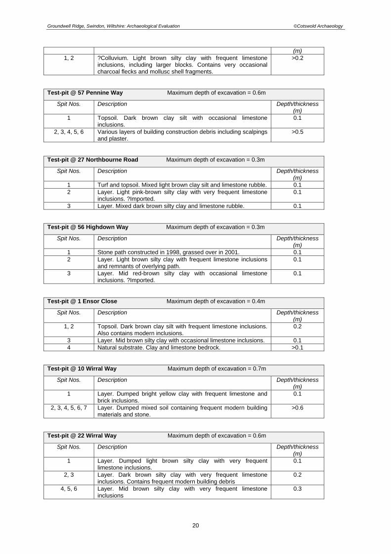
Groundwell Ridge, Swindon, Wiltshire: Archaeological Evaluation ©Cotswold Archaeology
(m) 1, 2 ?Colluvium. Light brown silty clay with frequent limestone
inclusions, including larger blocks. Contains very occasional charcoal flecks and mollusc shell fragments.
>0.2
Test-pit @ 57 Pennine Way Maximum depth of excavation = 0.6m
Spit Nos. Description Depth/thickness (m)
1 Topsoil. Dark brown clay silt with occasional limestone inclusions.
0.1
2, 3, 4, 5, 6 Various layers of building construction debris including scalpings and plaster.
>0.5
Test-pit @ 27 Northbourne Road Maximum depth of excavation = 0.3m
Spit Nos. Description Depth/thickness (m)
1 Turf and topsoil. Mixed light brown clay silt and limestone rubble. 0.1 2 Layer. Light pink-brown silty clay with very frequent limestone
inclusions. ?Imported. 0.1
3 Layer. Mixed dark brown silty clay and limestone rubble. 0.1 Test-pit @ 56 Highdown Way Maximum depth of excavation = 0.3m
Spit Nos. Description Depth/thickness (m)
1 Stone path constructed in 1998, grassed over in 2001. 0.1 2 Layer. Light brown silty clay with frequent limestone inclusions
and remnants of overlying path. 0.1
3 Layer. Mid red-brown silty clay with occasional limestone inclusions. ?Imported.
0.1
Test-pit @ 1 Ensor Close Maximum depth of excavation = 0.4m
Spit Nos. Description Depth/thickness (m)
1, 2 Topsoil. Dark brown clay silt with frequent limestone inclusions. Also contains modern inclusions.
0.2
3 Layer. Mid brown silty clay with occasional limestone inclusions. 0.1 4 Natural substrate. Clay and limestone bedrock. >0.1
Test-pit @ 10 Wirral Way Maximum depth of excavation = 0.7m
Spit Nos. Description Depth/thickness (m)
1 Layer. Dumped bright yellow clay with frequent limestone and brick inclusions.
0.1
2, 3, 4, 5, 6, 7 Layer. Dumped mixed soil containing frequent modern building materials and stone.
>0.6
Test-pit @ 22 Wirral Way Maximum depth of excavation = 0.6m
Spit Nos. Description Depth/thickness (m)
1 Layer. Dumped light brown silty clay with very frequent limestone inclusions.
0.1
2, 3 Layer. Dark brown silty clay with very frequent limestone inclusions. Contains frequent modern building debris
0.2
4, 5, 6 Layer. Mid brown silty clay with very frequent limestone inclusions
0.3
20

Groundwell Ridge, Swindon, Wiltshire: Archaeological Evaluation ©Cotswold Archaeology
Test-pit @ 5 Lukas Close Maximum depth of excavation = 0.5m
Spit Nos. Description Depth/thickness (m)
1, 2, 3 Layer. Dumped deposit of mid brown silty clay with very frequent inclusions of modern building materials.
0.3
4, 5 Layer. Dark brown silty clay with frequent charcoal and decayed organic matter.
0.2
21

Groundwell Ridge, Swindon, Wiltshire: Archaeological Evaluation ©Cotswold Archaeology
APPENDIX 2: THE FINDS BY SAM INDER
During excavations at Groundwell Ridge, Swindon, a quantity of pottery, animal bone, building material, glass, metal artefacts and flint were recovered. A database has been compiled, cataloguing the artefactual material recovered during the fieldwork. Excavations took the form of 37 x 1m square test pits, excavated by hand and 4 mechanically excavated trenches with the majority of the material recovered from topsoil and sub soil layers. A total of 569 sherds of pottery, weighing 1969g were recovered, dating from the Late Iron Age to the post-medieval period, with most of Romano-British date. The pottery is generally in very poor condition appearing highly abraded and has an average sherd weight of just 3.5g. A small quantity of Late Iron Age and Roman material from test pits 12, 21, 38 and 39 appears to be stratified. A sherd of handmade limestone tempered pottery of Late Iron Age date was recovered from posthole 8c in Test-pit 12. This appears to be residual, as several sherds of Roman pottery (broadly dated to the 2nd – 4th centuries AD) were also present. A stone lined culvert in Test-pit 21 produced a number of sherds of Roman pottery. In addition context 5, which seals the culvert, and context 9, into which the culvert is cut, both produced very abraded Roman sherds, broadly dateable to the 2nd – 4th centuries AD. A buried soil encountered in test pits 16, 21 and trench 39 produced pottery and building material exclusively of Roman date. Layer 3 in Trench 39 yielded a large quantity of building material, including tegulae, box tile and stone roofing tile (no material was recovered from the buried soil in Test-pit 16 and only a small quantity of pottery was present in Test-pit 21). The pottery from the buried soil primarily consists of locally produced sandy oxidised ware and greywares, together with grog-tempered ware (Savernake type). The forms, where discernible, appear to be of later Roman date, including a flared everted-rim jar imitating Dorset black burnished ware form. A possible rubble layer, 5, was identified in Test-pit 38 from which a small amount of Roman pottery was recovered. Typically, this is very abraded and is dated to the 2nd – 4th centuries AD. No other features were identified, the remainder of the material coming from topsoil and subsoil layers. The majority of the pottery is locally produced Roman wares with very few regional and continental imports. Single sherds of Oxfordshire white mortaria, Oxfordshire red colour-coated ware and several sherds of Dorset black burnished ware were recovered. Additionally, three scraps of Gaulish samian were also present. Most of the sherds probably date to the late Roman Period (after c250 AD) with forms including a disc-neck flagon. The earliest occurring Roman pottery consists of Samian and Savernake ware of 1st – 2nd century AD date. Very little Iron Age or medieval pottery was recovered, together accounting for approximately 2% of the recovered material. Of note is a sherd of a Belgic style bowl recovered from context 8 in test pit 24 which is dateable to the early to mid 1st century AD. Medieval pottery was found in small quantities across the site and consists mainly of Cotswold oolitic ware dating from the 11th – 13th centuries. A slashed strap handle from a glazed jug of likely late medieval date was retrieved from Test-pit 15. Other finds of note include a very worn Roman copper alloy coin recovered from test pit 23. This coin was illegible although its size and form suggests a 4th century AD date. A fragment of brown coloured vessel glass with white glass trailed decoration was retrieved from test pit 13 and probably dates to the early Roman period (1st – 2nd century AD). A small number of Roman hobnails were recovered from test-pits across the site and Test-pit 21 produced an iron shoe cleat. A small quantity of worked flint was also produced, including two blades/bladelets, both from topsoil layers, which are broadly dateable to the Mesolithic/ Early Neolithic periods. Finds Concordance: U/S 1 sherd late Iron Age pottery (14g); grog tempered ware 1 sherd of Roman pottery (4g); coarse Greyware 1 sherd of Medieval pottery (1g); Minety ware 1 flint blade (1g) 5 fragments of animal bone (1g) TP 11 9 sherds of Roman pottery (14g); Greyware 1 animal tooth (14g) TP 12 4 sherds of Iron Age pottery (15g); grog/calcareous tempered ware 21 sherds of Roman pottery (99g); Savernake ware, Greyware 1 fragment of Tegula (87g) 2 fragments of CBM (6g) 1 piece of fired clay (4g)
22

Groundwell Ridge, Swindon, Wiltshire: Archaeological Evaluation ©Cotswold Archaeology
2 Fe objects (12g) 1 Fe nail (3g) 1 flint fragment (24g) TP 13 1 sherd of Iron Age pottery (10g); grog/calcareous tempered ware 4 sherds of Roman pottery (5g); Grey ware 1 fragment of Roman vessel glass (1g) 19 pieces of fired clay (10g) 1 flint flake (3g) 1 fragment of CBM (1g) 2 Fe nails (2g) 1 Fe object (4g) 1 oyster shell (1g) 7 snail shells (4g) TP 14 1 sherd of Iron age pottery (5g); grog/calcareous tempered ware 24 sherds of Roman pottery ( 81g); Greyware, sandy oxidised ware, Savernake ware 1 piece of slag (20g) 1 Fe object (8g) 2 pieces of fired clay (3g) 1 Fe hob nail (2g) 2 fragments of tile (3g) TP 16 1 sherd of Iron Age pottery (8g); grog/calcareous tempered ware
28 sherds of Roman pottery (45g); Dorset Black Burnished ware, Greyware, sandy oxidised ware
1 fragment of brick (30g) 2 Fe nails (6g) 1 Fe object 1 fragment of CBM (4g) TP 17 52 sherds of Roman pottery (127g); Greyware, Savernake ware, sandy oxidised ware 1 fragment of stone tile (44g) 3 snail shells (1g) 1 Fe hobnail (1g) 2 Fe nails (2g) 3 fragments of tile (29g) 7 pieces of fired clay (5g) TP 18 4 sherds of Roman pottery (9g); Greyware 1 sherd of medieval pottery (25g); Brill Borstal ware 3 flint flakes (17g) 1 piece of slag (39g) TP 19 10 sherds of Roman pottery (24g); Greyware, sandy oxidised ware, Oxfordshire white
mortaria 3 fragments of stone tile (277g) 2 fragments of CBM (52g) TP 20 11 sherds of Roman pottery (29g); Greyware, sandy oxidised ware 1 Fe object (1g) 1 piece of fired clay/daub (18g) 1 piece of slag (8g) TP 21 24 sherds of Roman pottery (135g); Savernake ware, Greyware, sandy oxidised ware 6 fragments of CBM (72g) 16 pieces of fired clay (29g) 6 Fe nails (16g) 14 fragments of animal bone (7g) 1 fragment of burnt flint (1g) 1 Pb spill (6g) 1 Fe shoe cleat (2g) TP 22 3 sherds of Roman pottery (9g); Samian ware, Dorset Black Burnished ware, sandy oxidised
ware
23

Groundwell Ridge, Swindon, Wiltshire: Archaeological Evaluation ©Cotswold Archaeology
2 sherds of post-medieval pottery (3g); glazed and unglazed earthenware 9 pieces of fired clay (16g) 1 flint blade (1g) 1 Fe object (11g) Trench 23 24 sherds of Roman pottery (60g); Samian ware, Greyware, Savernake ware, sandy oxidised
ware 1 sherd of post-medieval pottery (5g); glazed stoneware 21 pieces of fired clay (62g) 15 fragments of CBM (35g) 3 Fe nails (10g) 1 flint flake(2g) 1 Cua Roman coin (1g) TP 24 1 sherd of late Iron Age pottery (30g); Belgic style
46 sherds of Roman pottery (153g); Greyware, Dorset Black Burnished ware, sandy oxidised ware
10 fragments of animal bone (18g) 2 fragments of CBM (13g) 9 pieces of fired clay (11g) 1 flint flake (1g) 2 Fe nails (9g) 2 Fe hobnails (2g) Trench 25 1 sherd of Roman pottery (5g); Greyware 2 fragments of tile (86g) TP 27 9 sherds of Roman pottery (26g); sandy oxidised ware, Greyware 1 fragment of animal bone (2g) 2 fragments of CBM (28g) TP 28 7 sherds of Roman pottery (33g); Greyware, sandy oxidised ware 2 lumps of coal (2g) TP 29 24 sherds of Roman pottery (74g); Greyware, sandy oxidised ware, Savernake ware 5 sherds of medieval pottery (56g); Cotswold oolitic ware, Minety ware 3 fragments of stone tile (519g) 1 fragment of CBM (22g) 2 flint fragments (2g) 3 Fe hob nails (2g) 2 Fe objects (19g) 1 animal tooth (8g) TP 30 14 sherds of Roman pottery (56g); Greyware, sandy oxidised ware 1 fragment of CBM (10g) 1 Fe nail (5g) 1 Fe object (12g) TP 31 12 sherds of Roman pottery (40g); Greyware, sandy oxidised ware 4 fragments of CBM (27g) 1 Fe nail (1g) TP 32 10 sherds of Roman pottery (10g); Samian ware, Greyware, sandy oxidised ware 1 fragment of tile (30g) 1 fragment of animal bone (3g) 2 Fe nails (11g) 6 fragments of burnt flint (4g) TP 33 4 sherds of Roman pottery (19g); Greyware, sandy oxidised ware 4 fragments of CBM (24g) 1 fragment of animal bone (6g) 1 flint flake (6g) TP 34 5 sherds of Roman pottery (17g); Greyware, sandy oxidised ware, Dorset Black Burnished
ware 1 fragment of post-medieval vessel glass (4g) 1 stone object (42g)
24

Groundwell Ridge, Swindon, Wiltshire: Archaeological Evaluation ©Cotswold Archaeology
TP 37 27 sherds of Roman pottery (75g); sandyoxidised ware, Dorset Black Burnished ware,
Greyware, grog tempered ware 1 fragment of tile (7g) 1 animal tooth (6g) 2 flint flakes (3g) 2 Fe nails (2g) 3 snail shells (2g) TP 38 1 sherd of Iron Age pottery (2g); Shell tempered
49 sherds of Roman pottery (145g); Savernake ware, Greyware, sandy oxidised ware, Samian
1 sherd of medieval pottery (2g); Minety ware 1 sherd of post-medieval pottery (1g); glazed stone ware 4 fragments of stone tile (934g) 1 fragment of box flue tile (53g) 16 fragments of CBM (252g) 2 Fe nails (10g) 4 pieces of mortar (23g) 9 fragments of animal bone (99g) 1 oyster shell (4g) 1 snail shell (1g) Trench 39 16 sherds of Roman pottery (114g); sandy oxidised ware, Savernake ware, Greyware 3 fragments of stone tile (162g) 1 fragment of Tegula (177g) 2 fragments of box flue tile (115g) 11 fragments of ceramic tile (625g) 1 flint flake (7g) TP 40 3 sherds of Iron Age pottery (6g); shell tempered ware 12 sherds of Roman pottery (24g); Greyware, sandy oxidised ware 1 clay pipe stem (3g) 1 fragment of snail shell (1g) 2 Fe nails (3g) 1 piece of coal (1g) TP 41 19 sherds of Roman pottery (60g); Savernake ware, Greyware 1 Fe hobnail (3g) 1 flint flake (1g) TP 42 3 sherds of Iron Age pottery (23g); grog tempered ware 22 sherds of Roman pottery (61g); Savernake ware, Greyware 3 fragments of CBM (14g) 2 flint fragments (6g) 27 Northbourne Road 4 flint fragments (16g) 1 Ensor Close 1 sherd of post-medieval pottery (3g); flowerpot 2 Fe nails (7g) 1 Fe object (2g) 4 Pennine Way 1 sherd of Roman pottery (2g); coarse greyware 1 sherd of medieval pottery (3g); Minety ware 1 fragment of modern white tile (16g) 10 Pennine Way 34 sherds of Roman pottery (165g); Greyware, Savernake ware 44 fragments of animal bone (846 2 fragments of CBM (43g) 1 piece of slag (20g) 1 piece of fired clay (7g) 2 flint flakes (4g) 1 snail shell (2g) 2 Fe hobnails (2g) Full finds database is available and included in the site archive
25

Groundwell Ridge, Swindon, Wiltshire: Archaeological Evaluation ©Cotswold Archaeology
26
APPENDIX 3: PROJECT DESIGN

Proposed archaeological evaluation at Groundwell Ridge, Blunsdon St. Andrew, Swindon (SU 1397 8946), Wiltshire:
Project Design Adjoining Scheduled Ancient Monument no. 29664
Prepared by Tory Batten, Associate Producer, Wildfire Television Ltd

1 Introduction This project design outlines a research evaluation to be carried out at Groundwell Ridge, Wiltshire, adjoining the site of a possible Roman rural sanctuary, a scheduled ancient monument (SAM). The evaluation is to be undertaken as part of a Channel Four Time Team Big Dig television programme and will be carried out within their established Time Team Live format over 2 days. It is planned to carry out the project on the 28-29 June 2003. The work will be carried out beyond the scheduled area: this project design recognizes the significance of the site as a whole and the potential of the archaeological resource outside the statutory boundary. Groundwell Ridge is an important site with a long and complex history. The research aims of the project are focused on the Roman ritual, but the project team is aware that the investigation may encounter archaeology from other periods as well, particularly relating to more recent activity at the site. Each archaeological phase is significant in its own right, and the project team will accord the highest quality of analysis, investigation and recording to each. 1.1 Archaeology and Time Team: statement The working relationship between archaeologists and film crews on Time Team excavations has been refined during the production of over sixty episodes of the programme. On site, all decisions regarding the work are formulated from an archaeological perspective by the archaeological team present, assisted by the relevant specialists and local archaeological officers, with reference to the project design. In case of disputes between crews and archaeologists over work in progress, the ultimate archaeological responsibility lies with Time Team’s archaeological consultant, Professor Mick Aston. All crews have extensive experience of filming on archaeological sites and are aware of both the archaeological and health and safety issues posed by such work.
2 The site 2.1 Location The site of the possible Roman rural sanctuary of Groundwell Ridge, Wiltshire (SU 1397 8946), is situated between the housing estates of Ash Brake and Abbey Mead, which lie 4.8 km north of the town of Swindon, 1 km west of the A419 from Swindon to Cricklade and immediately east of the B4534, otherwise known as Lady Lane. The location is, geologically, at the southern edge of the upper Thames valley in northern Wiltshire. The site itself lies on a ridge of Corralian limestone, which runs north-west – south-east through North Wiltshire. The south-facing escarpment slopes steeply to the bed of Oxford clay at the foot of the scarp. The remains of the site (in the form of earthworks and buried structures) on the slope (135m OD) and in the clay (110m OD). Numerous springs have been noted at the eastern end of the field of the SAM.

2.2 Ownership, management and status The field of the SAM (Scheduled Ancient Monument no. 29664), the part of the neighbouring (not-scheduled) field (known henceforth as the “Coombe”) and the adjoining wooded area are all the property of Swindon Borough Council. Crest and Bovis Homes also own part of the neighbouring field. The Coombe and wooded area cover an area of approximately 7.5 acres. They lie in the centre of modern housing with footpaths and a cycleway passing through this area. The site is used for recreation, such as dog-walking and cycling, by local residents as well as access to other parts of the housing estate. Remains of the roman site appear to run up to the old field boundary between the SAM field and the Coombe, and may well occupy a wider area and extend into the Coombe. There are two archaeological constraint areas within the Coombe and wooded area of Groundwell Ridge. These are due to the presence of active badger setts, one in the wooded area and potentially one in the hedgerow separating the Coombe from the field of the SAM. The Wiltshire Badger Group and English Nature have noted the entrance to the active sett. The licence from English Nature will permit hand digging within a 10m restriction zone from the sett entrances. 2.3 Historical and archaeological context 2.31 History of the site Study of the Sites and Monuments Record from the area show a variety of finds from all periods in the form of chance finds, pottery scatters, earthworks and structural evidence found through excavation. A possible Bronze Age settlement is known of to the west of Blunsdon St Andrew. Evidence for Iron Age occupation in the immediate vicinity is in the form of 2 sites, at Groundwell House and Groundwell West. 0.5 km east of Groundwell Ridge, was a Romano-British site represented by pottery dating from the 1st to 3rd century AD overlying a Iron Age double-ditched banjo-shaped enclosure around a circular hut. Excavation and earthworks survey suggests that, I km east of Groundwell Ridge, on the site of the former Groundwell House (now Motorola buildings), there appears to have been a huge Roman quarry of Corralian limestone and a probable Roman rutted road, leading towards the southern entrance of the Groundwell Ridge site. In addition, there is a univallate hillfort, Castle Hill, 2.5 km to the NE, lots of Iron Age artefacts and deposits around Highworth to the NE and 2 hillforts to the west at Bury Hill and Kingsbury Hill. Ermin Street, a Roman road running from Silchester to Cirencester and Gloucester, lies about 1 km SW of the site. Romano-British pottery of late 1st and early 2nd century was identified in a pit near Groundwell Farm (SU 1495 8918); contemporary pottery was found in a ploughed field just over 1km from the SAM (SU 1518 8942) and next to Ermin Street. A quantity of Roman pottery, including Samian Ware, was found through dredging a pond near the SAM. There is also evidence for a Roman station for soldiers at Cold Harbour and foundations of a Romano-British farmhouse excavated in 1934 in a field between Oxlease Farm and Lower Burytown.

In 2000 a number of graves were found at Groundwell West during an evaluation and were interpreted as part of a Saxon cemetery. The earliest documentary reference to Groundwell is attributed to AD 962 and refers to Grundewylle. The etymology of the place-name Groundwell may come from the old English words grynde (meaning abyss) and wielle (meaning spring) giving an interpretation of deep spring. There is a reference to the manor of Grendewelle in 1086 and the history of the manor is documented from sources throughout the Medieval period. There have been plenty of late Medieval finds, most notably evidence of settlements around Blundson St. Andrew, Haydon and Groundwell House and a quarry. 2.32 Monument Description The SAM in the neighbouring field, surviving as earthworks and buried remains, includes a possibly Roman agger with side-ditches in an east-west alignment and some platforms on a series of artificial terraces overlooking some structures, which date from the Roman period. The overall interpretation of the site is of an extensive site incorporating water features and walkways. Marshy land at the eastern end of the field shows the likely presence of active springs. One of the structures has been interpreted as a bath-house with a plunge bath. Following excavation, one of the platforms was found to have had a cistern made of limestone blocks and with a lead pipe and has been interpreted as part of a nymphaeum. Excavated structures from the foot of the scarp are of ragstone construction, mortared. Other building materials from above the walls include sandstone roofing tile, fired clay tile fragments and painted wall plaster. Finds from limited excavation of the SAM include numerous coins, pottery and a silver bullion hoard. Towards the western end of the SAM is what appears to be a stone quarry from the Roman period, which is linked to Ermin Street by a Roman road. The eastern boundary of the SAM is the bank and ditch (marked by a hedge) running north-south. This may not represent the original boundary to the site. There are no extant earthworks in the Coombe due either to their original absence or to more recent ploughing. There may be some earthworks in the copse, which relate to the Roman site. An earthwork survey of the SAM (Corney) suggests that further earthwork features relating to the complex may survive to the west and south-east of the monument and recommends additional earthwork and geophysical survey. 2.33 Previous Archaeological Work Prior to development of the area some field-work was carried out (Chandler) which revealed some Roman pottery from a pond and some sherds from ploughing west of the SAM. In this survey, the earthworks of the SAM were assumed to be lynchets from the medieval settlement of Blunsdon St. Andrews. The Roman site was therefore unknown at the time of the development proposal. There was some evaluation of features to the north, which resulted in nothing. Permission for development of the site for housing pre-dated PPG 16. The site was discovered in 1996 during the week preceding the start of a housing development project, when an amateur archaeologist brought some Romano-British pottery and coins in to Swindon Museum from the developer’s test-trenches. The County
Archaeologist promptly visited the site. When developers cut into a Roman structure while digging roads, work was halted and archaeological work was undertaken in the form of recording and rescue excavation (Phillips and Walters). 4 trenches were excavated by hand towards the lower end of the site and 1 trench was opened at the top of the site. The site has subsequently been interpreted as a water cult sanctuary with formal gardens incorporating at least one nymphaeum and buildings below with bathing and other facilities for visitors. Finds from this investigation included a large number of coins from the lower end of the site, also a high proportion of Samian ware and glassware and 2 hoards (one coin and one silver). High-quality buildings were suggested by the wall-paintings, fine tesserae and carved stones. The site appears to date from early 2nd to late 4th century. A series of inspection covers running east-west across the middle of the site suggest the presence of a water-pipe. Backfill from this trench, and spoil from the road-cutting, revealed pottery sherds, tile and building stone. Thames Water have sent plans of the immediate area which shows numerous sewage pipes running through the area, but it appears that no archaeological evidence was reported or recorded during their installation. Development work for housing in early 1997 revealed more of the southern enclosure wall, continuing to the south-west corner. The Archaeometry Branch of the Ancient Monuments Laboratory of English Heritage carried out a geophysical survey of the site with magnetometry, resistivity and radar. Resistivity proved the most effective at this site (Lindford 1996). The survey identified many features including, buildings, walkways and ponds. An archaeological earthwork survey was carried out for Swindon Borough Council (Corney) revealing terracing, platforms, a road and other earthworks. In summary, the material culture from the site suggests a level of richness beyond that expected of a villa site. The geophysical survey has revealed an aisled building that may or may not be a villa. The landscape survey defined formal features that are rare within villa complexes and are more in keeping with Romano-British temple and shrine sites in Western Britain. Finally the presence of the springs and the discovery of the cistern do give some weight to the suggestion that this may be the site of a nymphaeum. 2.34 National and Regional Significance The national significance of Groundwell Ridge is recognized in the scheduling of the SAM, although the current statutory boundary probably does not recognize the full location and extent of the Roman remains. The limited excavation and landscape survey shows that there is a good state of preservation of both the earthworks and the foundations of the buildings. If the site does extend into the Coombe and wood, then this may have some bearing on the significance of the SAM.
3 Research frameworks The aims of the project fall within the wish of English Heritage to clarify details of the site relevant to the preservation and conservation of the monument. Current evidence indicating the site is a Roman rural sanctuary is as yet inconclusive. More needs to be known about the extent and status of the site at Groundwell Ridge to ascertain its range of buildings and activities. If it is a Roman ritual site, the function of such sites was often misinterpreted in the past, something that is being addressed by current research

frameworks. Thus, the project at Groundwell Ridge contributes to wider research issues regarding the archaeology of Roman rural shrines. In recent research into Roman rural shrines, there has been a suggestion that a sequence of religious sites in an area of France may have been part of an established pilgrimage route and perhaps there was a similar circuit in the Romano-British West Country (Miranda Aldhouse Green 1999). If so, the site at Groundwell Ridge could form part of this.
4 Aims and objectives Although small in time-scale, a well-resourced two-day evaluation is sufficient to address a number of specific aims and objectives. These can be divided into three categories which represent the over-arching aims of the work (a) to characterize the archaeological resource at the site, (b) to provide a condition survey of any remains, and (c) to inform future discussion about the area outside the statutory boundary at the site. The data generated by the project will form an important resource for the future management and interpretation of any potential archaeology. 4.1 Research aims Although some archaeological fieldwork has been carried out on the SAM at Groundwell Ridge, it has been specifically to establish the nature of the site in preparation for emergency scheduling; thus fundamental issues remain unresolved. As a potential Roman rural sanctuary, Groundwell Ridge appears to have a tripartite arrangement of platforms at the top of the slope include a probable fountain or nymphaeum, whilst the buildings at the bottom of the slope may be accommodation, bathing and other facilities. However, the exact nature of the site and its extent are not established, and the research aims of this project are focused on establishing this and some of its key elements. A landscape survey carried out by Mark Corney (Corney 1997) identifies some possible features which merit further investigation. These include a feature that has been initially interpreted as an agger and earthwork features in the area of the wooded hill. Roman water cult sanctuaries are known in Gaul but rare in Britain. Sulis Minerva at Bath is the best known urban example whilst a good rural example can be found at Nettleton Scrub on the Fosse Way. The research aims of this project can be categorized as follows: 1. To establish the exact nature of the Roman activity in the area surrounding the SAM. 2. To establish the location and extent of the Roman sanctuary to the east of the scheduled
area. 3. To establish the presence, depth and condition of any surviving remains related to the
site in the gardens of the surrounding housing estate. 4. To provide an assessment of the landscape context of the site. 4.2 Management aims 1. To assess the location and extent of the archaeological remains relating to the Roman
site, to inform future discussion about the scheduled area. 2. To evaluate the quality of survival of the archaeological remains relating to the Roman
site, to inform the interpretation and long-term management of the site.

3. To assess the survival of the Roman landscape.
5 Methodology All fieldwork and recording will be carried out by volunteers under strict supervisory guidance, and following procedural guidelines that have been advised by bodies including English Heritage, ALGAO, CBA and IFA. Archiving will be carried out in accordance with/with reference to Wiltshire County Archaeology Service’s Procedures Manual for Archaeological Fieldwork Projects in Wiltshire or similar. (tbc with Robert Dickinson) 5.1 Field survey Any contour survey of the landscape will be carried out by Dr. Henry Chapman, using a Trimble Real Time Differential GPS survey system or similar. All Time Team surveys, earthwork and geophysics, are compatible with each other. Surveys will be related to the National Grid/ Ordnance Datum by local control using the 25” digital map. Digital copies of the survey data will be lodged with the county SMR. 5.2 Geophysical survey The area of the SAM and some of the area outside it have been undergone geophysical and radar survey by English Heritage Centre for Archaeology in 1996. Further radar work is intended to be carried out on the platforms at the top of the SAM in early June; this work will be carried out by the Centre for Archaeology at English Heritage. As part of this project this data will be made available to GSB Prospection and further geophysical survey will be undertaken across the potential extension of the sanctuary by them. The instruments used will be a Geoscan FM36 gradiometer, and an RM15 resistance meter. The survey area will be divided into 20x20m grids and sampled at 0.5m intervals/ 1m transects (magnetometer) and 1m interval/ 1m transects (resistance meter). 5.3 Evaluation 5.31 Trench array To address the aims outlined in sections 3.1 and 3.2, a system of evaluation excavation by test-pitting will be undertaken. This will be across a pre-arranged grid and will be located at intervals of 25m. The test-pits will measure 1m x 1m and it is intended will not extend far below 600mm in depth. This method is appropriate in order to establish the presence or absence of archaeological remains relating to the neighbouring Roman sanctuary or other period. Should a test-pit reveal the presence of a structure, it is envisaged that the test-pit may potentially be extended on the advice of Professor Mick Aston. The outline below indicates the potential array of evaluation trenches that has been developed in discussion with the Wiltshire County Archaeological Officer and English Heritage Inspector of Ancient Monuments. Approximate test-pit locations are outlined here and on the attached plan (Figure 3), but the exact locations and dimensions for each trench are considered to be a matter of professional judgment and will be decided on site, following survey work. Final decisions on-site will be the responsibility of the archaeological consultant Professor Mick Aston, as stated in section 1.1.
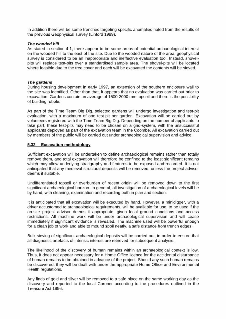
In addition there will be some trenches targeting specific anomalies noted from the results of the previous Geophysical survey (Linford 1999). The wooded hill As stated in section 4.1, there appear to be some areas of potential archaeological interest on the wooded hill to the east of the site. Due to the wooded nature of the area, geophysical survey is considered to be an inappropriate and ineffective evaluation tool. Instead, shovel-pits will replace test-pits over a standardised sample area. The shovel-pits will be located where feasible due to the tree cover and each will be excavated the contents will be sieved. The gardens During housing development in early 1997, an extension of the southern enclosure wall to the site was identified. Other than that, it appears that no evaluation was carried out prior to excavation. Gardens contain an average of 1500-2000 mm topsoil and there is the possibility of building rubble. As part of the Time Team Big Dig, selected gardens will undergo investigation and test-pit evaluation, with a maximum of one test-pit per garden. Excavation will be carried out by volunteers registered with the Time Team Big Dig. Depending on the number of applicants to take part, these test-pits may need to be chosen on a grid-system, with the unsuccessful applicants deployed as part of the excavation team in the Coombe. All excavation carried out by members of the public will be carried out under archaeological supervision and advice. 5.32 Excavation methodology Sufficient excavation will be undertaken to define archaeological remains rather than totally remove them, and total excavation will therefore be confined to the least significant remains which may allow underlying stratigraphy and features to be exposed and recorded. It is not anticipated that any medieval structural deposits will be removed, unless the project advisor deems it suitable. Undifferentiated topsoil or overburden of recent origin will be removed down to the first significant archaeological horizon. In general, all investigation of archaeological levels will be by hand, with cleaning, examination and recording both in plan and section. It is anticipated that all excavation will be executed by hand. However, a minidigger, with a driver accustomed to archaeological requirements, will be available for use, to be used if the on-site project advisor deems it appropriate, given local ground conditions and access restrictions. All machine work will be under archaeological supervision and will cease immediately if significant evidence is revealed. The machine used will be powerful enough for a clean job of work and able to mound spoil neatly, a safe distance from trench edges. Bulk sieving of significant archaeological deposits will be carried out, in order to ensure that all diagnostic artefacts of intrinsic interest are retrieved for subsequent analysis. The likelihood of the discovery of human remains within an archaeological context is low. Thus, it does not appear necessary for a Home Office licence for the accidental disturbance of human remains to be obtained in advance of the project. Should any such human remains be discovered, they will be dealt with under the appropriate Home Office and Environmental Health regulations. Any finds of gold and silver will be removed to a safe place on the same working day as the discovery and reported to the local Coroner according to the procedures outlined in the Treasure Act 1996.

It is proposed that all spoil is metal detected, either by Time Team’s regular detectorist or by an individual to be recommended by Wiltshire County Council. It is anticipated to use the same metal-detecting group as English Heritage, or Bill Giles who has worked with Time Team in Wiltshire before at Tockenham. It may be deemed appropriate to use a metal-detector in contexts further down the slope due to the high quantity of coins found on that part of the SAM. 5.4 On-site recording All contexts will be removed and recorded in stratigraphic order. Recording systems based on MAP 2 will be used: all contexts and features will be recorded using standard pro-forma context record sheets based on the MOLAS Handbook of Field Archaeology (1997); a record of the full extent in plan of all archaeological deposits encountered will be made; at least one long section will be drawn per trench or test-pit; the OD of all principal strata and features will be indicated on appropriate plans and sections; a photographic record of the investigations will be prepared. All trenches will be related to the National Grid/ Ordnance Datum by local control using the 25” digital map. Both a site location map and a trench location plan will be prepared and included in the report. A unique-number site code will be agreed with the Swindon Borough Council Museum. 5.5 Environmental and scientific sampling The project will be advised by English Heritage’s Regional Archaeology Science Advisor about sampling strategies for environmental work. 5.6 Backfilling and consolidation All excavated areas will be deturfed and excavated by hand, and topsoil and subsoil will be retained separately for backfilling. All excavated areas will be reinstated after the work to their pre-project condition, or to an appropriate condition agreed with the Swindon Borough Council in advance of the work. The project team are aware that fragile remains may require special treatment during backfilling. Wildfire Television Ltd will be responsible for all reinstatement and its costs. 5.7 Conservation statement A Conservator will be on site at all times. 5.8 Health and Safety 1. All relevant health and safety legislation, regulations and codes of practice will be
respected. A health and safety risk assessment will be carried out in advance of the work and all work on site monitored by elected health and safety officers.
2. All trenches at a depth of 1.2 m or greater will be either shored or stepped as appropriate.
3. All work will be carried out to minimize damage to nearby trees.

6 Post-excavation and publication 6.1 Reports and publication Post-excavation analysis, archive management and writing of the archaeological report will be undertaken by Cotswold Archaeology. Specialist and finds reports will be prepared by appropriate specialists, to be negotiated and paid for by Wildfire Television Ltd. Copies of the report will be sent to English Heritage and the county SMR, as well as the landowners, Swindon Borough Council, Crest and Bovis Homes. A geophysical survey report including diagrams, text and interpretation on a CAD system will be prepared by GSB Prospection. Copies of the field data and report will lodged with the county SMR, and the report sent to English Heritage and Swindon Borough Council. Given the potential significance of the site, an article may be submitted for publication to the local county journal. 6.2 Finds and archive deposition The integrity of the site archive will be maintained. The site archive will be deposited with Swindon Museum. Subject to the agreement of the landowners, the finds will be donated to Swindon Museum. A unique-number site code will be agreed with Swindon Museum. 6.3 Resources and timetable All excavation and post-excavation costs will be negotiated and paid for by Wildfire Television Ltd. All holding costs and conservation costs will be negotiated and paid for by Wildfire Television Ltd. The excavation report, publication and archive will be completed and presented within one year of the work, subject to the submission of specialist reports. English Heritage, the County Archaeologist and Swindon Borough Council will be kept informed of the projected timetable of works and promptly advised as to any proposed changes to this timetable. 7 Project team 7.1 Project advisors and on-site responsibility The project design has been developed in consultation with the English Heritage Inspector of Ancient Monuments (Pete Wilson) and the Wiltshire County Archaeological Officer (Roy Canham). Professor Mick Aston will act as the project advisor and be on-site to oversee the project: his on-site decisions are final. Responsibility for meeting the terms of the project design on-site for Time Team rests with him.

7.2 Experts As well as the usual Time Team personnel, the project team for the evaluation will include specialists selected to cover all relevant areas of expertise and knowledge which are likely to be required during and after the work. 7.3 Time Team Prof Mick Aston Professor of landscape archaeology, University of Bristol Stewart Ainsworth Senior investigator, English Heritage Archaeological Survey Dr Henry Chapman Head of Survey, Wetland Archaeology and Environment Research
Centre, University of Hull John Gater Partner, GSB Prospection 7.4 Excavation Team The archaeological team will consist of volunteers registered with Channel 4’s Time Team Big Dig and supervised by field archaeologists of recognised competence, suitably experienced in work of this character. They will be drawn from Time Team’s regular excavation team or be individuals recommended by the Wiltshire County Archaeological Officer or English Heritage. 7.5 Post-excavation and archive management Responsibility for meeting the post-excavation terms and conditions of this project design rests with Neil Holbrook, Director, Cotswold Archaeology.
8 Bibliography Linford, P 1999 Abbey Mead, Groundwell Ridge, Blunsdon St. Andrew, Wiltshire. Report on Geophysical Survey, 1997. AML Report 15/1999 M. Corney, Abbey Mead, Groundwell Ridge, Blunsdon St. Andrew, Wiltshire. An Analytical
Archaeological Earthwork Survey (1998) on behalf of Swindon Borough Council Green, Miranda J. Aldhouse 1999. Pilgrims in Stone. Stone images from the Gallo-Roman
healing sanctuary of Fontes Sequanae. Oxford: British Archaeological Reports (IS) 754.

Groundwell Ridge, Swindon, Wiltshire: Archaeological Evaluation ©Cotswold Archaeology
APPENDIX 4: REPORT ON TEST-PIT AT 4 PENNINE WAY
38

Time Team Big Dig 2003 Archaeological Evaluation at Groundwell Ridge, Swindon, Wilts Wiltshire
Archaeological Evaluation at Groundwell Ridge, Swindon, Wiltshire
NGR: SU 140 893
Wildfire TV/ Videotext Communications Ltd August 2003

Time Team Big Dig 2003 Archaeological Evaluation at Groundwell Ridge, Swindon, Wilts Wiltshire
Summary
In June 2003 an archaeological field evaluation was carried out by Time Team in
land adjacent to Groundwell Ridge, Swindon, Wiltshire (NGR: SU 140 893). The
project was part of the Big Dig television programme and as such the Time Team
was invited to investigate the potential of the site by the current landowners Mr & Mrs
Chris and Babs Walker. Discovery of Roman pottery in the Walkers garden
suggested that it may be part of, or associated with, the Roman Temple complex at
the Groundwell Ridge site. The evaluation revealed no evidence of structures
associated with the Roman complex or any other remains of archaeological
significance.
This report will be incorporated into the Groundwell Ridge site report written by
Cotswold Archaeology, as a result of public test pitting June 28th-29th June 2003.
This test pit will be known as Trench 1 in the Groundwell Ridge site report.
Background
Topography and Geology
The site was located on the northern lawn of 4 Pennine Way (SU 140 893). The
property of 4 Pennine Way is currently owned and occupied by the Walker family,
who positioned the evaluation at the base of terracing, and to the western side of
their landscaped back garden. The back garden has been terraced during housing
construction on the property. The result of this was the decision to excavate near the
house where terracing did not seem to have occurred, and therefore any archaeology
would be nearer the present ground surface.
The underlying geology of the site is clay.
Archaeological and Historical Background
Situated in the modern suburb of Ash Brake, the property on 4 Pennine Way was
established and built upon in 1998. The house is situated at the south end of the
property. Prior to land use as a housing sub division, the land along Pennine Way
was utilised as farmland.
Wildfire TV/ Videotext Communications Ltd August 2003

Time Team Big Dig 2003 Archaeological Evaluation at Groundwell Ridge, Swindon, Wilts Wiltshire
Adjacent to the site, on the north, is the Groundwell Ridge site, a complex of Roman
buildings that were discovered by contractors in 1996, and subsequently investigated
by local archaeologists, Bryn Walters and Bernard Philips. During excavation,
hypocaust, painted plaster walls, water piping system, and a possible shrine were
identified. Groundwell Ridge was classified as a scheduled ancient monument when
the land the site sits on was bought by Swindon Borough Council and English
Heritage. The site has been interpreted as either a villa or sanctuary complex. A
team from English Heritage are currently excavating at the site.
Aims of the Evaluation
The evaluation was carried out in order to assess the character, condition, extent,
state of preservation, date and complexity of any remains encountered on the site.
All deposits were sampled in order to characterise the remains. No deposits or
features were excavated in their entirety.
Special attention was given to remains that may have been associated with the
Groundwell Ridge Roman complex.
Methodology
The evaluation comprised the excavation of a single test pit. The test pit measured 1
m x 1 m at the base. The maximum depth of the test pit was 0.50 m. The test pit
was located in the northern lawn of 4 Pennine Way, Ash Brake at the base of the
stepped back garden.
The test pit was excavated entirely by hand under the constant supervision of a
professional archaeologist. All contexts were individually numbered and associated
finds were bagged and marked accordingly. Where archaeological deposits were
encountered a plan was drawn at a relevant scale (1:10) and at least one section
was recorded on completion of the excavation.
The test pit was allocated the label Trench 1, as this evaluation record will become
part of the Groundwell Ridge test pit archive, excavated by the public June 28th-29th
2003. This test pit, conducted June 27th 2003, was the precursor to this event, and
located within the possible limits of the roman complex.
Wildfire TV/ Videotext Communications Ltd August 2003

Time Team Big Dig 2003 Archaeological Evaluation at Groundwell Ridge, Swindon, Wilts Wiltshire
Results
Description of Deposits
The test pit measured a total depth of 0.5 m. Excavation ceased with identification of
modern building debris (2 & 3), dated to 1998, which extended across of the test pit.
Deposit (2) was composed of disturbed blue-grey clay, with silt. This was well
compacted and mid brown in colour. A modern iron nail and three small red brick
fragments were retained. Deposit (3) was a sterile, dark brown silt and clay mix. A
single find was retained from the context: a cheese and onion crisp packet with
expiry date 25 April 1998. Overlying contexts (2) and (3) was a dark brown garden
topsoil (1) to 0.15m. Iron nails, red brick fragments, white glazed tile, shell
predominated the finds, with a single probable Roman pot fragment and medieval
fragment also identified. Some stone and flecks of charcoal were also recorded.
Polystyrene pieces were found in both (1) and (2). No archaeological features were
identified.
Discussion of Results
The evaluation revealed three contexts; topsoil (1), and deposits (2 & 3) associated
with the construction of the house on the site in 1998. Figures 1 and 2 show
stratigraphy and extent of evaluation. No features or deposits of archaeological
significance were observed. This has been interpreted as a direct result of house
construction and subsequent garden landscaping in the Ash Brake area of Swindon.
The crisp packet (dated 25 April 1998) retained from context (3) at a depth of 0.45m
attests to this, plus polystyrene pieces down to a depth of 0.40m in context (2). The
lack of subsoil beneath the topsoil also supports deliberate and recent landscaping of
the garden evaluated. It can be inferred that if significant archaeology associated with
the roman Groundwell Ridge complex extended into this area of Pennine Way, it has
been disturbed and/or removed due to house building. It cannot be discounted that
archaeology survives at depths lower than 0.5m.
Bibliography and References
http://accessibility.english-heritage.org.uk
Drawings
Wildfire TV/ Videotext Communications Ltd August 2003
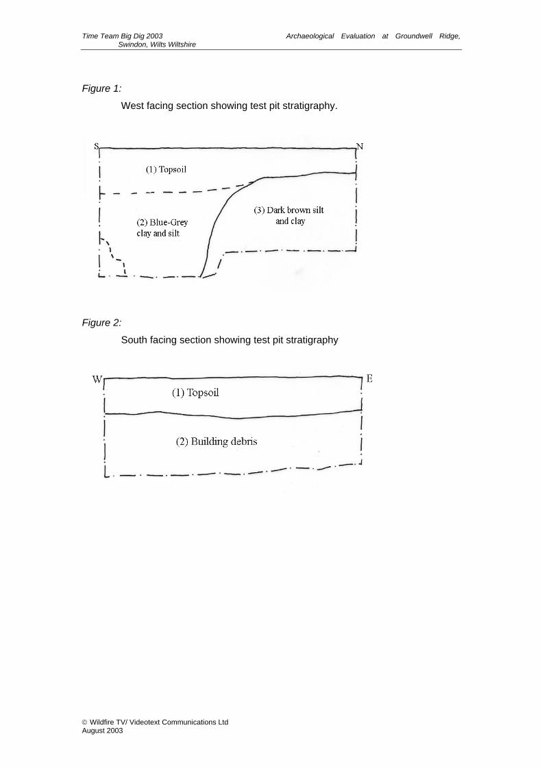
Time Team Big Dig 2003 Archaeological Evaluation at Groundwell Ridge, Swindon, Wilts Wiltshire
Figure 1:
West facing section showing test pit stratigraphy.
Figure 2:
South facing section showing test pit stratigraphy
Wildfire TV/ Videotext Communications Ltd August 2003

Site
Fig. 1 Site location plan

6763
1923
Pond
104.2m
118.6m
Sewage Tank
Post
128.0m
El Sub Sta
Playgroun
Playground
Playground
1
37
42
12
6
12
14
17
1 3 1115
19
65
2427
20
63
1
2
12
1
3
1
4
11
812
8
80
82
72
81
85
24
15
9
15
25
21
8
13
6
5
21
22
25
3
11
7
13
4
8
9
17
21
52
6477
69
59
63
18
22
17
11
1
3
69
7781
31
35
12
5
10
30
29
10
16
18
2
10
16
38
6
l2
19
26
35
22
12
25
18
6
1214
16
8
112
12
14
5
10
171
8
21
11
15
2
8
1
2
1
18
19
9
1
27
4
8
32
15
1214
31
45
6
23
1
10
1214
9
10
1
20
17
24
18
27
3O
18
17
60
10
59
48
16
7
28
StaEl Sub
51
42
40
34
57
51 43
8
2
30
11
20
2
1
41
14
7
5
7
12
27
10
2
1
17
4
2
17
El Sub Sta
20 3 6
1111
3
6
15
12
5
31
2
1
PH
21
37
27
24
26
4O
45
43
53
46
39
55
1
5
9
4
2
52
48
58
Nursery
27
42
32
30
1O
12
16
33
5254
35
36
67
11
El Sub Sta
24
46
42
14
12
42
10
12
62
31
7
74
15
11
20
24
8
21
25
22
23
5
18
Ward
Bdy
CR
LADY LANE
PENNINE WAY
SANDSTONE ROAD
EBOR CLOSE
VIKING CLOSE
MINSTER CLOSE
WEST HIGH
LAND
ROAD
GREENS
AND CL
OSE
TARKA
CLOSE
WIRRAL W
AY
PENNINE WAY
LANDO
R ROA
D
HINKSON CLOSE
MEYNELL
CLOSE
THORNHILL
DRIVE
HAMPSTEAD WAY
SCARLET CLOSE
GAMEKEEPERS CLOSE
CANTELO CLOSE
POACHERS WAY
LUKAS
CLOSE
WIRRAL WAY
SDOW
N DRIVE
PENNINE WAY
CLOSE
DALES
CLOSE
STENBURY
NORTHBOURNE ROAD
COBBETT CLOSE
ENSOR CLOSE
PENNINE WAY
BARLOW CLOSE
GILMAN CLOSE
REYNOLDS WAY
NASH CLOSE
THORNHILL DRIVE
HIGHD
OWN WA
Y
LEA CLOSE
20
19 40
38 21 29 34 14
16 24
28
41 42
27 12
11
33 17 18
37 32 13
31 22
30
3635
5Lukasclose
10Pennine
Way
57Pennine
Way
10WirralWay
22WirralWay
27Northbourne
Road
56Highdown
Way
1EnsorClose
26
39
25
23
892
894
140 142
SU 0 250m
N
Reproduced from the Ordnance Survey digital mappping with the permission ofOrdnance Survey on behalf of The Controller of Her Majesty's Stationery Office, Crown copyright Cotswold Archaeological Trust AL50196A c
Fig. 2 Test-pit and trench location plan (1:2000)
test-pit
garden test-pit
geophysical anomaly
limit of deeper 'combe'
site
SAM 29664
The combe
wooded area
trench

8c
N
surface8a
8b
0 1m
1
2
3
4
5
6
7
8c 8a8a 8b
S N
Fig. 3 Test-pit 12; plan and section (1:20)
section

N
9
9
calcite?base11
cappingstone
7
10
section
S N1
234
5
6
7
11
89 9
10
Fig. 4 Test-pit 21; plan and section (1:20)
0 1m