Groundwater use and salinization with grassland...
14
Groundwater use and salinization with grassland afforestation ESTEBAN G. JOBBA ´ GY *w and ROBERT B. JACKSON w z *CONICET, INTA San Luis, Ruta 7 y Ruta 8, Villa Mercedes, 5730, San Luis, Argentina, wDepartment of Biology, Duke University, Durham, NC 27708 USA, zNicholas School of the Environment and Earth Sciences, Duke University, Durham, NC 27708 USA Abstract Vegetation changes, particularly transitions between tree- and grass-dominated states, can alter ecosystem water balances and soluble salt fluxes. Here we outline a general predictive framework for understanding salinization of afforested grasslands based on biophysical, hydrologic, and edaphic factors. We tested this framework in 20 paired grassland and adjacent afforested plots across ten sites in the Argentine Pampas. Rapid salinization of groundwater and soils in afforested plots was associated with increased evapotranspiration and groundwater consumption by trees, with maximum salinization occurring on intermediately textured soils. Afforested plots (10–100 ha in size) showed 4– 19-fold increases in groundwater salinity on silty upland soils but otwofold increases on clay loess soils and sand dunes. Two years of salinity and groundwater measurements at a 40 ha Eucalyptus camaldulensis plantation revealed that the plantation reduced groundwater recharge, underwent groundwater discharge on 450% of the days, and depressed the water table 38 cm on average compared to the adjacent grassland. Soil cores and vertical electrical soundings indicated that 6 kg m 2 of salts accumulated close to the water table and suggested that salinization resulted from the exclusion of fresh groundwater solutes by tree roots. Groundwater use with afforestation in the Pampas and in other regions around the world can enhance primary production and provide a tool for flood control. However, our framework and experimental data also suggest that afforestation can compromise the quality of soils and water resources in predictable ways based on water use, climate, and soil texture. Keywords: ecohydrology, evapotranspiration, forest hydrology, pampas, phreatophytes, soil salinity, water table dynamics, woody encroachment Received 19 December 2003; revised version received and accepted 24 February 2004 Introduction Changes in vegetation, particularly transitions between grasslands and forests, alter ecosystem water balances and soluble salt fluxes. Compared with grasslands, forests often have greater leaf area and canopy rough- ness as well as root systems that access deeper water sources (Kelliher et al., 1993; Canadell et al., 1996; Calder, 1998; Jackson, 1999; Schenk & Jackson, 2002). These changes usually result in higher evaporative water losses (Kelliher et al., 1993; Zhang et al., 2001), lower moisture content in the soil and vadose zone (Calder et al., 1993, 1997; Chen et al., 2003), and reduced groundwater recharge (Le Maitre et al., 1999). At watershed scales, these ecological differences can also affect water yields from tree- and grass-dominated catchments. Paired watershed experiments typically show increased streamflow when forested watersheds are replaced by pastures and grassland (Sahin & Hall, 1996) and decreased streamflow when grassland water- sheds are afforested (Scott & Lesch, 1997). By affecting the amount of water that moves through the vadose zone (i.e. groundwater recharge), grassland– forest transitions can also alter patterns of salt accumulation and transport from stands to regional scales. The most well-known example is the salinization that accompanied the large-scale conversion of wood- lands and forests in Australia. In vast areas the replacement of native Australian trees by herbaceous Correspondence: Esteban G. Jobba ´gy, tel./fax 1 54 2652 490269, e-mail: [email protected] Global Change Biology (2004) 10, 1299–1312, doi: 10.1111/j.1365-2486.2004.00806.x r 2004 Blackwell Publishing Ltd 1299
Transcript of Groundwater use and salinization with grassland...

Groundwater use and salinization with grasslandafforestation
E S T E B A N G . J O B B A G Y *w and R O B E R T B . J A C K S O N w z*CONICET, INTA San Luis, Ruta 7 y Ruta 8, Villa Mercedes, 5730, San Luis, Argentina, wDepartment of Biology, Duke
University, Durham, NC 27708 USA, zNicholas School of the Environment and Earth Sciences, Duke University, Durham, NC
27708 USA
Abstract
Vegetation changes, particularly transitions between tree- and grass-dominated states,
can alter ecosystem water balances and soluble salt fluxes. Here we outline a general
predictive framework for understanding salinization of afforested grasslands based on
biophysical, hydrologic, and edaphic factors. We tested this framework in 20 paired
grassland and adjacent afforested plots across ten sites in the Argentine Pampas. Rapid
salinization of groundwater and soils in afforested plots was associated with increased
evapotranspiration and groundwater consumption by trees, with maximum salinization
occurring on intermediately textured soils. Afforested plots (10–100ha in size) showed 4–
19-fold increases in groundwater salinity on silty upland soils but otwofold increases
on clay loess soils and sand dunes. Two years of salinity and groundwater measurements
at a 40 ha Eucalyptus camaldulensis plantation revealed that the plantation reduced
groundwater recharge, underwent groundwater discharge on 450% of the days, and
depressed the water table 38 cm on average compared to the adjacent grassland. Soil
cores and vertical electrical soundings indicated that �6 kgm�2 of salts accumulated
close to the water table and suggested that salinization resulted from the exclusion of
fresh groundwater solutes by tree roots. Groundwater use with afforestation in the
Pampas and in other regions around the world can enhance primary production and
provide a tool for flood control. However, our framework and experimental data also
suggest that afforestation can compromise the quality of soils and water resources in
predictable ways based on water use, climate, and soil texture.
Keywords: ecohydrology, evapotranspiration, forest hydrology, pampas, phreatophytes, soil salinity,
water table dynamics, woody encroachment
Received 19 December 2003; revised version received and accepted 24 February 2004
Introduction
Changes in vegetation, particularly transitions between
grasslands and forests, alter ecosystem water balances
and soluble salt fluxes. Compared with grasslands,
forests often have greater leaf area and canopy rough-
ness as well as root systems that access deeper water
sources (Kelliher et al., 1993; Canadell et al., 1996;
Calder, 1998; Jackson, 1999; Schenk & Jackson, 2002).
These changes usually result in higher evaporative
water losses (Kelliher et al., 1993; Zhang et al., 2001),
lower moisture content in the soil and vadose zone
(Calder et al., 1993, 1997; Chen et al., 2003), and reduced
groundwater recharge (Le Maitre et al., 1999). At
watershed scales, these ecological differences can also
affect water yields from tree- and grass-dominated
catchments. Paired watershed experiments typically
show increased streamflow when forested watersheds
are replaced by pastures and grassland (Sahin & Hall,
1996) and decreased streamflow when grassland water-
sheds are afforested (Scott & Lesch, 1997).
By affecting the amount of water that moves through
the vadose zone (i.e. groundwater recharge), grassland–
forest transitions can also alter patterns of salt
accumulation and transport from stands to regional
scales. The most well-known example is the salinization
that accompanied the large-scale conversion of wood-
lands and forests in Australia. In vast areas the
replacement of native Australian trees by herbaceousCorrespondence: Esteban G. Jobbagy, tel./fax 1 54 2652 490269,
e-mail: [email protected]
Global Change Biology (2004) 10, 1299–1312, doi: 10.1111/j.1365-2486.2004.00806.x
r 2004 Blackwell Publishing Ltd 1299
species raised the water table and mobilized deeply
stored salts to the topsoil (Schofield, 1992; Pierce et al.,
1993). Current estimates suggest that the reversion of
this process would only be achieved by reforesting 70–
80% of the watershed (George et al., 1999). A similar
large-scale salinization mechanism has been proposed
for deforested areas of the Sahel (Culf et al., 1993).
The opposite transition, a vegetation shift from
grassland to forest, also has the potential to alter
groundwater and salt dynamics (Jackson et al., 2000).
Afforestation and tree invasion or encroachment affect
many grasslands globally (Jackson et al., 2002), espe-
cially in the Southern Hemisphere (Rudel & Ropel,
1996; Richardson, 1998; Geary, 2001), but the effects on
groundwater and salt fluxes remain poorly understood.
Soil and groundwater salinization have been linked to
tree establishment on grass-steppes in Russia and
pastures in Australia (Heuperman, 1999; Vertessy
et al., 2000; Sapanov, 2000), with recharge interruption
and groundwater use by trees proposed as potential
causes (Heuperman, 1999; Sapanov, 2000). In this paper,
we report rapid soil and groundwater salinization with
the afforestation of humid grasslands in the Pampas of
Argentina. We use this system to evaluate a general
ecohydrological framework that predicts the conditions
and mechanisms under which tree establishment in
grasslands leads to salinization. This general predictive
framework should also help researchers predict the
conditions under which both grassland afforestation
and deforestation can lead to salinization.
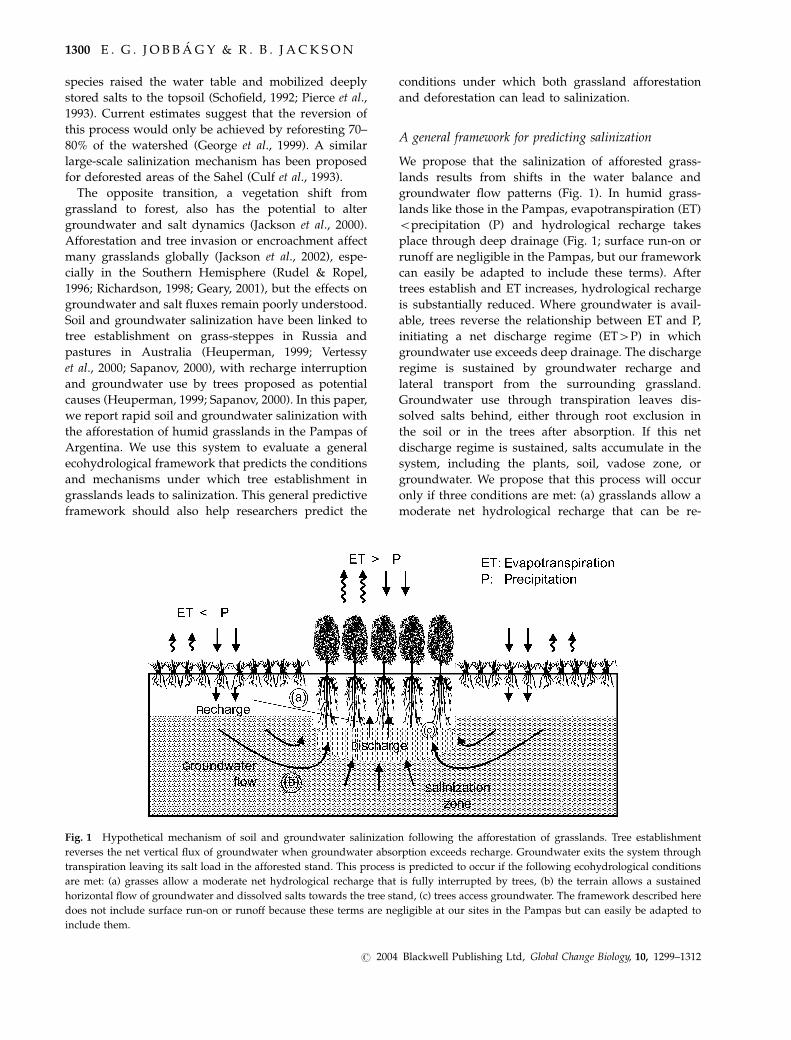
A general framework for predicting salinization
We propose that the salinization of afforested grass-
lands results from shifts in the water balance and
groundwater flow patterns (Fig. 1). In humid grass-
lands like those in the Pampas, evapotranspiration (ET)
oprecipitation (P) and hydrological recharge takes
place through deep drainage (Fig. 1; surface run-on or
runoff are negligible in the Pampas, but our framework
can easily be adapted to include these terms). After
trees establish and ET increases, hydrological recharge
is substantially reduced. Where groundwater is avail-
able, trees reverse the relationship between ET and P,
initiating a net discharge regime (ET4P) in which
groundwater use exceeds deep drainage. The discharge
regime is sustained by groundwater recharge and
lateral transport from the surrounding grassland.
Groundwater use through transpiration leaves dis-
solved salts behind, either through root exclusion in
the soil or in the trees after absorption. If this net
discharge regime is sustained, salts accumulate in the
system, including the plants, soil, vadose zone, or
groundwater. We propose that this process will occur
only if three conditions are met: (a) grasslands allow a
moderate net hydrological recharge that can be re-
Fig. 1 Hypothetical mechanism of soil and groundwater salinization following the afforestation of grasslands. Tree establishment
reverses the net vertical flux of groundwater when groundwater absorption exceeds recharge. Groundwater exits the system through
transpiration leaving its salt load in the afforested stand. This process is predicted to occur if the following ecohydrological conditions
are met: (a) grasses allow a moderate net hydrological recharge that is fully interrupted by trees, (b) the terrain allows a sustained
horizontal flow of groundwater and dissolved salts towards the tree stand, (c) trees access groundwater. The framework described here
does not include surface run-on or runoff because these terms are negligible at our sites in the Pampas but can easily be adapted to
include them.
1300 E . G . J O B B A G Y & R . B . J A C K S O N
r 2004 Blackwell Publishing Ltd, Global Change Biology, 10, 1299–1312

versed after tree establishment, (b) the terrain and soil
conductivity allow a sustained horizontal flow of
groundwater and dissolved salts towards the tree
stands, and (c) trees access groundwater (Fig. 1).
Using this framework we test predictions locally and
regionally in afforested grasslands of the Pampas. At
the regional scale, we predict that salinization will be
greatest in intermediately textured soils which are most
likely to fulfill conditions (a) and (b) simultaneously.
Under the humid climate of the Pampas (800–
1000 mm yr�1 mean annual precipitation), condition
(a) is unlikely to be met in coarse-textured soils where
groundwater recharge and salt-leaching rates can be
high. Condition (b) is unlikely on fine-textured soils
where poor saturated hydraulic conductivity constrains
the lateral transfer of groundwater and accompanying
salts from grasslands to plantations. Groundwater
access, condition (c), is common in the Pampas with
water tables typically o6 m below the surface. Species
effects may also be important, particularly those species
able to take up water directly from saturated soils (e.g.
Eucalyptus camaldulensis and Populus deltoides). How-
ever, salinization may be more general if capillary
transport moves sufficient groundwater to the unsatu-
rated soil above the water table.
To evaluate these predictions we assess salinization
across 10 afforested sites (20 grassland-plantation pairs)
with different soil/sediment types and tree species. At
three of these sites representing a sediment texture
gradient, we explore aspects of groundwater transport
and use by plants. At the local scale we then evaluate
the mechanisms of salinization and predict that tree
stands will have drier soil, reduced water table
recharge after rain, and deeper water table levels than
adjacent grasslands. We expect maximum salt accumu-
lation in the zone of groundwater absorption by trees at
depths close to the water table.
Methods
The study region
The Pampas occupy a vast sedimentary loess plain in
South America (Zarate, 2003). The native vegetation of
this temperate humid region is dominated by grasses
and was originally treeless (Soriano, 1991; Prieto, 1996).
The extremely flat topography and the imprint of wind
erosion during the Quaternary created a poor drainage
network which, combined with the current humid
climate (800–1000 mm mean annual precipitation),
results in shallow groundwater across most of the
region (Tricart, 1973). Saline/sodic soils are frequent in
low areas of groundwater discharge but are absent in
uplands (Tricart, 1973; INTA, 1989; Soriano, 1991). Most
of the region is still dominated by a combination of
native grasslands, pastures, and annual crops. Tree-
dominated stands, however, are present as a result of
European settlement. Starting in the 1800s, plantations
ranging from 0.1 to 100 ha were established across the
region primarily for shade, windbreak, and aesthetics.
Such plantations were rarely fertilized or irrigated.
Today, commercial afforestation with pines and eu-
calyptus is increasing rapidly, with counties in Argen-
tina and Uruguay near the Uruguay River having as
much as 30% of their area covered by trees (MAGP,
1998; SAGPyA, 2000). Afforestation rates are expected
to increase dramatically in the coming decades (Wright
et al., 2000).
Regional study
To evaluate the ecohydrological conditions favoring
salinization after tree establishment, we measured
groundwater salinity in 20 adjacent plantations and
grassland pairs at 10 sites with different soil/sediment
types including pure loess on plains, loess/granite
sequences on hills, and quartz-calcareous sand dunes
on the coast, as well as multiple tree species (Table 1).
Our sites covered a broad range of soil textures,
including loess with silty-clay to clay texture in the
Rolling Pampas (Chascomus and La Plata), loess with
silty to sandy loam texture in the Flooding and Inner
Pampas (Castelli, San Narciso, Guerrero, Dolores, and
America), and Atlantic coastal sand dunes (Pinamar
and Carilo). (INTA, 1989; Zarate 2003). Sites were �2
to �550 km away from the Atlantic Ocean. We
included one site on a hilltop at Tandil where a thin
layer (o0.5 m) of silty loess overlays Precambrian
granite, preventing access of roots to groundwater. We
sampled plantations of Eucalyptus camaldulensis and
Populus deltoides with the capacity to take up water from
saturated soil (Tewari, 1993; Bell & Williams, 1997). We
also included pine species such as Pinus halepensis,
P. taeda, and P. pinaster which are intolerant to anoxic soil
environments and unable to use water from saturated
soil (Richardson, 1998). All sites were located in
uplands and served as hydrologic recharge zones
before afforestation, except for two Populus deltoides
plantations in lowlands at San Narciso (Table 1).
Plantations were 410 ha in size and were never
fertilized or irrigated, as confirmed with land managers
and consistent with regional practices. Biomass was not
harvested from the stands except at Guerrero and
Pinamar, where 20–50% of the Eucalypts were cut
previously. Grassland stands were neither fertilized nor
irrigated but were typically grazed (see Jobbagy &
Jackson, 2003 for further details). We sampled ground-
water in grassland/forest pairs 50–100 m on each side
S A L I N I Z AT I O N I N A F F O R E S T E D G R A S S L A N D S 1301
r 2004 Blackwell Publishing Ltd, Global Change Biology, 10, 1299–1312

Table
1G
rou
nd
wat
ersa
lin
ity
un
der
tree
pla
nta
tio
nan
dco
ntr
ol
stan
ds
acro
ssa
ran
ge
of
geo
log
ical
sett
ing
sin
the
Pam
pas
Sed
imen
tty
pe
Sit
eP
osi
tio
nS
oil
typ
e/w
ater
dep
thD
ate
Tre
esp
ecie
sA
ge
(yea
rs)
EC
(dS
m�
1)
Co
ntr
ol
stan
dE
C(d
Sm
�1)
EC
rati
o
Sil
tycl
ays
Ch
asco
mu
sU
pla
nd
Arg
iaq
uo
l14
/11
/01
E.camaldu
lensis
461.
63O
P1.
391.
2
2–6
m14
/11
/01
Populusdeltoides
461.
71id
1.39
1.2
Buenos
Aires
Formation
14/
11/
01Pinustaeda
461.
51id
1.39
1.1
La
Pla
taU
pla
nd
Ver
tic
Arg
iud
ol
18/
7/03
E.camaldu
lensis
121.
19N
G0.
981.
2
1.5–
4m
Sil
tyan
dsa
nd
ylo
ams
Cas
tell
iU
pla
nd
Th
apto
Hap
lud
ol
21/
9/01
E.camaldu
lensis
5014
.51
OP
0.72
20.2
1–3
m21
/9/
01E.globulus
504.
55id
0.72
6.3
18/
7/03
E.globulus
-*
dea
d0.
99id
0.56
1.8
Junin
Formation
21/
9/01
Pinushalepensis
504.
42N
G0.
726.
2
18/
7/03
Celtistalaw
450
4.91
NG
0.56
8.8
8/3/
03P.
deltoides#1
Sz
234.
52N
G.
0.83
5.5
18/
7/03
W4.
44N
G0.
815.
5
San
Nar
ciso
Lo
wla
nd
Nat
racu
ol
8/3/
03P.
deltoides#3
S23
4.05
NG
2.10
1.9
0.2–
1.5
m18
/7/
03W
3.64
NG
1.75
2.1
8/3/
03P.
deltoides#4
S23
2.18
NG
1.79
1.2
18/
7/03
W1.
00
NG
1.51
0.7
Gu
erre
roU
pla
nd
thap
toH
aplu
do
l2/
2/02
E.camaldu
lensis
9614
.29
NG
1.01
14.1
1–3
m
Am
eric
aU
pla
nd
enti
cH
aplu
sto
l8/
6/03
E.camaldu
lensis
4218
.80
OP
0.63
29.8
2–6
m8/
6/03
Quercusrobu
r42
10.8
0id
0.63
17.1
Med
ium
san
ds
Pin
amar
Du
ne
slo
pe
Qu
artz
ipsa
mm
ent
3/3/
02E.camaldu
lensis
301.
03N
G0.
541.
9
2–5
m15
/7/
01Pinuspinaster
300.
99N
G0.
561.
8
AtlanticDunefields
Car
ilo
Du
ne
slo
pe
Qu
artz
ipsa
mm
ent
23/
12/
01E.globulus
550.
65B
D0.
361.
8
3–7
m23
/12
/01
Pinuspinaster
550.
58B
D0.
361.
6
PM
edan
os
Du
ne
slo
pe
Qu
artz
ipsa
mm
ent
23/
12/
01Pinuspinaster
160.
62B
D0.
431.
4
2–5
m
Ro
cky
sub
soil
Tan
dil
Hil
lto
pL
ith
icH
aplu
do
l8/
9/01
E.camaldu
lensis§
500.
08N
G0.
061.
4
Hills
No
tac
cesi
ble
Sit
esar
eg
rou
ped
acco
rdin
gto
sed
imen
tte
xtu
refr
om
fin
eto
coar
se.
Tan
dil
has
mas
siv
ero
cko
0.5
bel
ow
the
surf
ace.
Inso
me
site
sm
ore
than
on
etr
eep
lan
tati
on
was
sam
ple
d.
Ele
ctri
cco
nd
uct
ivit
yv
alu
es(E
C)
of
wat
erm
easu
red
inth
efi
eld
ind
icat
esa
lin
ity.
Th
eel
ectr
ical
con
du
ctiv
ity
rati
o(E
Cra
tio
)is
the
EC
of
the
tree
pla
nta
tio
nd
ivid
edb
yth
eE
Co
f
the
gra
ssla
nd
con
tro
l.In
all
case
sp
lan
tati
on
and
con
tro
lst
and
sw
ereo
200
maw
ay.
Th
ete
xtu
ral
clas
so
fse
dim
ents
,to
po
gra
ph
icp
osi
tio
n,
and
soil
typ
e(U
SD
A19
98)
are
ind
icat
edfo
rea
chsi
te.
Co
ntr
ol
stan
ds
are
old
pas
ture
s(O
P),
nat
ive
gra
ssla
nd
s(N
G),
and
bar
ed
un
es(B
D).
So
me
con
tro
lst
and
sar
esh
ared
by
two
or
mo
rep
lan
tati
on
s(i
d).
* E.globulus
and
con
tro
lst
and
sam
ple
dfo
rse
con
dti
me
2y
ears
afte
rtr
ees
wer
ew
ind
blo
wn
.w S
po
nta
neo
us
gro
ve
of
smal
ltr
eeCeltistala
.z Populusdeltoides
stan
ds
sam
ple
dat
the
end
of
sum
mer
(S)
and
inm
idw
inte
r(W
).§N
oac
cess
tog
rou
nd
wat
er.
EC
val
ues
corr
esp
on
dto
eph
emer
alst
ream
s.
1302 E . G . J O B B A G Y & R . B . J A C K S O N
r 2004 Blackwell Publishing Ltd, Global Change Biology, 10, 1299–1312

of the boundary, making boreholes with a hand auger
(10 cm outside diameter) that were 50–100 cm deeper
than the water table. Salinity was measured with an
electric conductivity meter automatically corrected for
temperature. To evaluate salinization at Tandil where
groundwater was inaccessible, we sampled soils for
salinity down to bedrock and also water in two
ephemeral streams that originated on the plantation
and in a nearby grassland 48 h after rainfall.
We evaluated the effect of afforestation on ground-
water fluxes and its interaction with soil texture in E.
camaldulensis and grassland stands at Chascomus (silty-
clay loess), Castelli (silty loam loess), and Pinamar
(sand dunes). There, we measured groundwater levels
during late spring and summer of 2001 in paired
boreholes located in the tree and grassland stands
100 m from the plantation boundary. Surface elevation
measured using a water level was used to calculate the
absolute gradient of groundwater depth between grass-
land and plantation boreholes. We examined diurnal
fluctuations in groundwater levels as an indicator of
groundwater absorption (White, 1932; Freeze & Cherry,
1979). For this purpose we monitored water levels with
high temporal (30 min) and altitudinal (o3 mm) resolu-
tion during 2–4-week periods without rainfall using
pressure transducers (model PS9800, Instrumentation
Northwest, Kirkland, WA, USA) connected to perma-
nent dataloggers (CR10, Campbell Scientific Instru-
ments, Logan, UT, USA). At all sites we measured
saturated hydraulic conductivity of the sediments in
situ using well tests (auger-hole method, Amoozegar &
Warrick, 1986). We bracketed the potential rates that
capillary rise could achieve under tree plantations at
each site with a simple simulation model (Upflow, Raes
& Deproost, 2003). The inputs for this model were
vegetation type, root distribution, soil textural class,
saturated hydraulic conductivity, atmospheric water
demand, water table depth, and topsoil moisture
content. To examine scenarios of capillary rise, we
selected forest vegetation and limited rooting depth to
1 m, assuming no direct access of tree roots to ground-
water. We ran parallel simulations using two different
root distributions, a depth-decreasing function reported
by Jackson et al. (1996) and a homogeneous distribution.
Soil texture was obtained from soil surveys and
saturated hydraulic conductivity from our field mea-
surements. We assumed a high water demand
(5 mm day�1) in order to find potential rates of capillary
transport with soil water at �1.5 MPa. Capillary rise
was simulated for a hypothetical water table located 1
or 3 m below tree roots.
Mechanistic local studies
To explore the mechanism of salinization after tree
establishment (Fig. 1), we studied changes in soil
moisture, groundwater levels, and salt accumulation
for 2 years in a 40 ha plantation and surround-
ing grasslands at Castelli, Buenos Aires province
(�36102.00, �57150.30). The site has a mean annual
temperature of 15.3 1C and mean annual precipitation
of 980 mm. This upland, loamy site was planted with E.
camaldulensis in 1951 at 3 � 2 m spacing (Table 1, Fig. 2),
with trees neither thinned nor managed after planting.
Fig. 2 Plantation and grassland groundwater sampling points at Castelli. Groundwater level and salinity were recorded in 45
boreholes along transects (dotted lines). Two permanent sampling wells were monitored during a 2-year period. Other sampling points
for water salinity involved additional boreholes and existing windmills pumping water from 6 to 15 m depth.
S A L I N I Z AT I O N I N A F F O R E S T E D G R A S S L A N D S 1303
r 2004 Blackwell Publishing Ltd, Global Change Biology, 10, 1299–1312

Current density is 783 stems ha�1 with a mean tree
height � 45 m. There is a very sparse understory of the
small tree Celtis tala. The surrounding area is covered
by native grasslands and improved pastures with the
typical composition and structure of upland commu-
nities in the Pampas, a mixture of C3 and C4 grasses
and no bare soil (Perelman et al., 2001). We recorded
rainfall throughout the study period with a tipping
bucket pluviometer connected to a datalogger in the
native grassland. Longer term precipitation records
beginning in 1950 were obtained from the town of
Castelli, 7 km from the study site.
We compared soil moisture dynamics in the grass-
land and Eucalpyt plantation using time domain
reflectometry (TDR). We randomly located three soil
pits (1 m wide � 1 m deep) 50 m from the grassland–
forest edge in each stand and measured soil volumetric
water content at 5, 15, 30, 50, and 100 cm depth using a
TDR sensor with four 6-cm-long probes (ML2x Theta-
Probe, Delta-T Devices, Burwell, UK). We took five mea-
surements horizontally at each depth along the wall of
the soil pit. One time measurements were repeated in
six opportunities (June 2001 – January 2002).
Changes in groundwater depth between the grassland
and plantation were characterized using a network of 45
boreholes located in three parallel 350 m transects in
September 2002 (winter) and along the central transect
in January 2003 (summer) (Fig. 2). These measurements
were complemented with a 2-year-long record of
groundwater levels in boreholes in the grassland and
plantation along the central transect 100 m from the
boundary (Fig. 2). At several intervals during this 418-
day period we monitored water levels with high
temporal (30 min) and altitudinal (o3 mm) resolution
using pressure transducers calibrated every two months.
Salt accumulation in groundwater, soil, and vadose
zone was evaluated in three ways. Groundwater
salinity was measured just below the water table in
the network of 45 boreholes described above and was
further quantified using 11 deeper boreholes and
windmills within the plantation and adjacent grassland
(Fig. 2). Groundwater salinity at greater depth along
grassland-plantation transects was characterized using
vertical electrical soundings (VES). In VES, a current is
introduced into the ground using electrodes and the
corresponding electric field is measured. Resistance
values are obtained from Ohm’s law, R5V/I, where V
is the measured Potential difference and I is the
introduced current. These soundings, which character-
ize the resistance of the terrain to the flow of electrical
current, have a variable depth of integration that is
controlled by shifting the horizontal spacing of two
emitting electrodes. In addition to substrate type, the
resistivity of the terrain is negatively associated with
groundwater salinity. We used a Schlumberger arrange-
ment of electrodes with 180 m of maximum aperture
( � 90 m of penetration). We performed 26 VES along
three grassland-forest transects in January 2003 with 50-
m VES spacing in distal zones of the transects and 10 m
spacing close to the plantation edge (Fig. 2), using an
inverse 1-D modeling routine to estimate the thickness
and resistivity of the terrain assuming a three-layer
structure (SchlumBG software, MicroFEM Develop-
ment and Support, Amsterdam, The Netherlands).
At a more detailed scale, we quantified the amount
and location of salts in the soil/vadose zone of adjacent
grassland and plantation stands. Mineral soil was
sampled between January and March 2003 in 0.5 m
intervals to 6 m depth with a 10 cm diameter auger at
four positions in each stand. Sampling points were
randomly located along transects parallel to the
plantation boundary, 50 m towards the grassland and
forest interior (Fig. 2). Bulk density, estimated every
50 cm, ranged from 1.31–1.45 Mg m�3 and did not differ
significantly between stands. We obtained clean sam-
ples of 6-m deep groundwater after casing and sealing
the soil sampling holes with PVC pipe and bentonite
plugs. Approximately 30 L of water were pumped
before each water collection. Root presence/absence
was recorded using soil cores and during borehole
drilling. Soil samples were analyzed for electrical
conductivity and Cl concentration using a 1 : 2 soil/
water ratio shaken for 5 min and equilibrated 24 h.
Chloride was measured in the laboratory using an ion-
selective electrode (Frankenberger et al., 1996).
Results
Regional study
As predicted by the ecohydrological framework in
Fig. 1, groundwater salinization in afforested stands
was greater in intermediately textured sediments and
lower in coarse and fine soils (Table 1). All upland sites
had fresh groundwater (o1.4 dS m�1) under grass-
lands, confirming the non-saline nature of the original
environment. These sites experienced different degrees
of salinization according to their soil texture (Table 1).
Along a textural gradient, the ratio of groundwater
salinity of E. camaldulensis plantations compared to
adjacent grasslands increased from 1.2 in clay soils
(Chascomus and La Plata) to 14–30 in sites with silty to
sandy loam sediment (Castelli, Guerrero, America), and
back to only 1.9 in the sand dunes (Pinamar) (Table 1).
At the hilly site (Tandil), where massive bedrock and
topography impeded groundwater use, E. camaldulensis
showed no salinization of stream water (Table 1) or
soils (data not shown – see Jobbagy, 2002).
1304 E . G . J O B B A G Y & R . B . J A C K S O N
r 2004 Blackwell Publishing Ltd, Global Change Biology, 10, 1299–1312
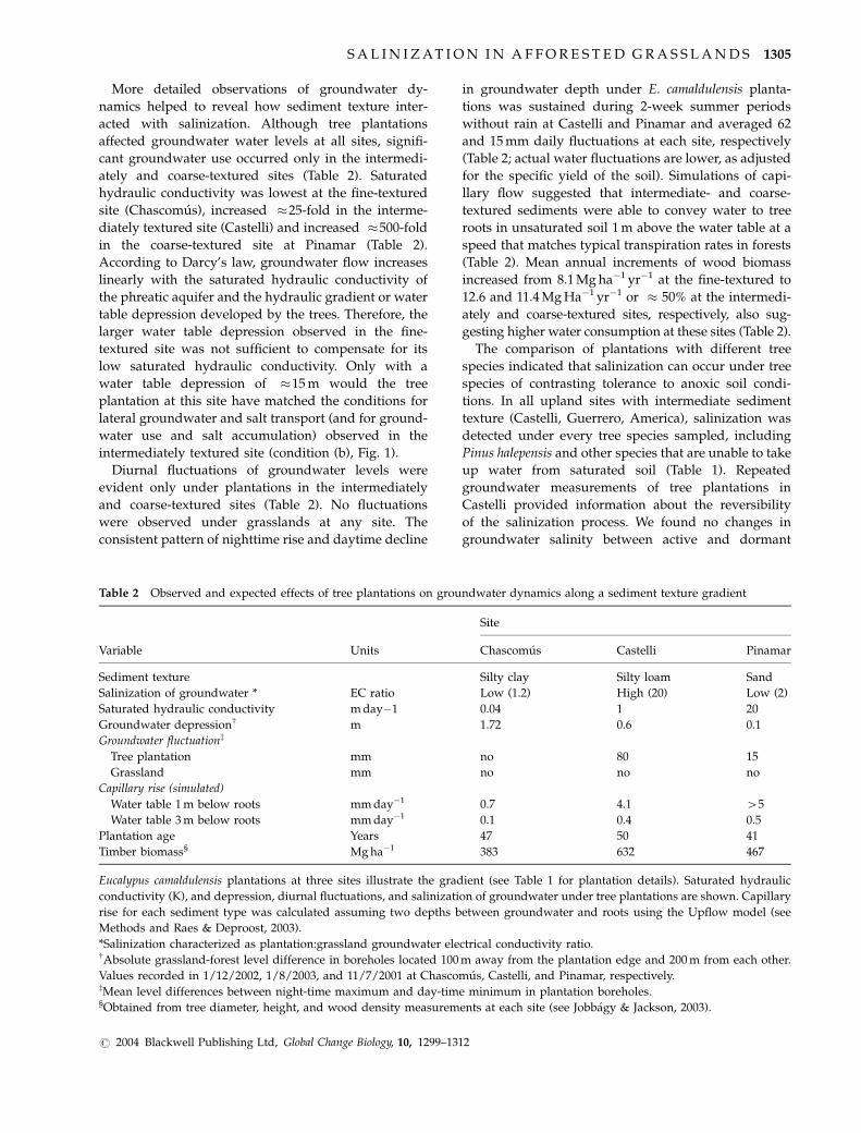
More detailed observations of groundwater dy-
namics helped to reveal how sediment texture inter-
acted with salinization. Although tree plantations
affected groundwater water levels at all sites, signifi-
cant groundwater use occurred only in the intermedi-
ately and coarse-textured sites (Table 2). Saturated
hydraulic conductivity was lowest at the fine-textured
site (Chascomus), increased �25-fold in the interme-
diately textured site (Castelli) and increased �500-fold
in the coarse-textured site at Pinamar (Table 2).
According to Darcy’s law, groundwater flow increases
linearly with the saturated hydraulic conductivity of
the phreatic aquifer and the hydraulic gradient or water
table depression developed by the trees. Therefore, the
larger water table depression observed in the fine-
textured site was not sufficient to compensate for its
low saturated hydraulic conductivity. Only with a
water table depression of �15 m would the tree
plantation at this site have matched the conditions for
lateral groundwater and salt transport (and for ground-
water use and salt accumulation) observed in the
intermediately textured site (condition (b), Fig. 1).
Diurnal fluctuations of groundwater levels were
evident only under plantations in the intermediately
and coarse-textured sites (Table 2). No fluctuations
were observed under grasslands at any site. The
consistent pattern of nighttime rise and daytime decline
in groundwater depth under E. camaldulensis planta-
tions was sustained during 2-week summer periods
without rain at Castelli and Pinamar and averaged 62
and 15 mm daily fluctuations at each site, respectively
(Table 2; actual water fluctuations are lower, as adjusted
for the specific yield of the soil). Simulations of capi-
llary flow suggested that intermediate- and coarse-
textured sediments were able to convey water to tree
roots in unsaturated soil 1 m above the water table at a
speed that matches typical transpiration rates in forests
(Table 2). Mean annual increments of wood biomass
increased from 8.1 Mg ha�1 yr�1 at the fine-textured to
12.6 and 11.4 Mg Ha�1 yr�1 or � 50% at the intermedi-
ately and coarse-textured sites, respectively, also sug-
gesting higher water consumption at these sites (Table 2).
The comparison of plantations with different tree
species indicated that salinization can occur under tree
species of contrasting tolerance to anoxic soil condi-
tions. In all upland sites with intermediate sediment
texture (Castelli, Guerrero, America), salinization was
detected under every tree species sampled, including
Pinus halepensis and other species that are unable to take
up water from saturated soil (Table 1). Repeated
groundwater measurements of tree plantations in
Castelli provided information about the reversibility
of the salinization process. We found no changes in
groundwater salinity between active and dormant
Table 2 Observed and expected effects of tree plantations on groundwater dynamics along a sediment texture gradient
Variable Units
Site
Chascomus Castelli Pinamar
Sediment texture Silty clay Silty loam Sand
Salinization of groundwater * EC ratio Low (1.2) High (20) Low (2)
Saturated hydraulic conductivity m day�1 0.04 1 20
Groundwater depressionw m 1.72 0.6 0.1
Groundwater fluctuationz
Tree plantation mm no 80 15
Grassland mm no no no
Capillary rise (simulated)
Water table 1 m below roots mm day�1 0.7 4.1 45
Water table 3 m below roots mm day�1 0.1 0.4 0.5
Plantation age Years 47 50 41
Timber biomass§ Mg ha�1 383 632 467
Eucalypus camaldulensis plantations at three sites illustrate the gradient (see Table 1 for plantation details). Saturated hydraulic
conductivity (K), and depression, diurnal fluctuations, and salinization of groundwater under tree plantations are shown. Capillary
rise for each sediment type was calculated assuming two depths between groundwater and roots using the Upflow model (see
Methods and Raes & Deproost, 2003).
*Salinization characterized as plantation:grassland groundwater electrical conductivity ratio.wAbsolute grassland-forest level difference in boreholes located 100 m away from the plantation edge and 200 m from each other.
Values recorded in 1/12/2002, 1/8/2003, and 11/7/2001 at Chascomus, Castelli, and Pinamar, respectively.zMean level differences between night-time maximum and day-time minimum in plantation boreholes.§Obtained from tree diameter, height, and wood density measurements at each site (see Jobbagy & Jackson, 2003).
S A L I N I Z AT I O N I N A F F O R E S T E D G R A S S L A N D S 1305
r 2004 Blackwell Publishing Ltd, Global Change Biology, 10, 1299–1312
periods in two plantations of the deciduous Populus
deltoides (Table 1), suggesting that the interruption of
groundwater use during the winter was not sufficient
to leach or dilute salts. In contrast, a decline of
groundwater salinity was noticed 2 years after a E.
globulus stand was felled by wind, indicating a partial
reversion of salinization in longer time frames (Table 1).
Mechanistic local studies
We evaluated the mechanisms of salinization in a E.
camaldulensis plantation and its surrounding grassland
at Castelli (Table 1). In agreement with the hypothesis
that tree plantations increase evapotranspiration, we
found significantly drier soils in the plantation com-
pared to the grassland during most of the sampling
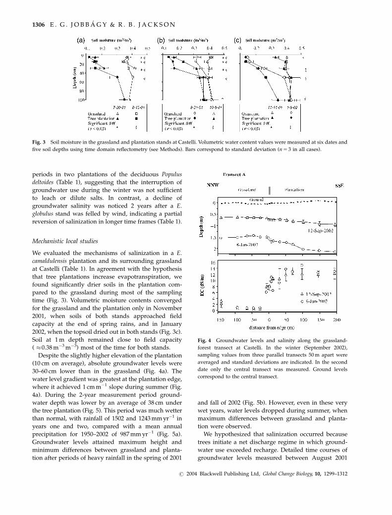
time (Fig. 3). Volumetric moisture contents converged
for the grassland and the plantation only in November
2001, when soils of both stands approached field
capacity at the end of spring rains, and in January
2002, when the topsoil dried out in both stands (Fig. 3c).
Soil at 1 m depth remained close to field capacity
( �0.38 m�3 m�3) most of the time for both stands.
Despite the slightly higher elevation of the plantation
(10 cm on average), absolute groundwater levels were
30–60 cm lower than in the grassland (Fig. 4a). The
water level gradient was greatest at the plantation edge,
where it achieved 1 cm m�1 slope during summer (Fig.
4a). During the 2-year measurement period ground-
water depth was lower by an average of 38 cm under
the tree plantation (Fig. 5). This period was much wetter
than normal, with rainfall of 1502 and 1243 mm yr�1 in
years one and two, compared with a mean annual
precipitation for 1950–2002 of 987 mm yr�1 (Fig. 5a).
Groundwater levels attained maximum height and
minimum differences between grassland and planta-
tion after periods of heavy rainfall in the spring of 2001
and fall of 2002 (Fig. 5b). However, even in these very
wet years, water levels dropped during summer, when
maximum differences between grassland and planta-
tion were observed.
We hypothesized that salinization occurred because
trees initiate a net discharge regime in which ground-
water use exceeded recharge. Detailed time courses of
groundwater levels measured between August 2001
Fig. 3 Soil moisture in the grassland and plantation stands at Castelli. Volumetric water content values were measured at six dates and
five soil depths using time domain reflectometry (see Methods). Bars correspond to standard deviation (n5 3 in all cases).
Fig. 4 Groundwater levels and salinity along the grassland-
forest transect at Castelli. In the winter (September 2002),
sampling values from three parallel transects 50 m apart were
averaged and standard deviations are indicated. In the second
date only the central transect was measured. Ground levels
correspond to the central transect.
1306 E . G . J O B B A G Y & R . B . J A C K S O N
r 2004 Blackwell Publishing Ltd, Global Change Biology, 10, 1299–1312
and April 2003 showed that trees reduced groundwater
recharge and initiated a sustained discharge regime
that was absent under grasses (Fig. 5c–e). Recharge
interruption was shown by the patterns of groundwater
rise following large rainfall events (420 mm day�1).
After these events, groundwater depth increased
immediately in the grassland but not in the forest, as
shown for October 2001 (Fig. 5c). During 306 days of
paired high-frequency measurements of water table
depth, 16 recharge events were detected in the grass-
land but only one in the tree plantation. In this recharge
event, groundwater rose simultaneously in both stands
after the rain of November 10, 2001, at the end of the
wettest spring on record (Fig. 5d).
Discharge of groundwater by trees was shown by
sustained diurnal fluctuations of the water table only
under the plantation (Fig. 3e). Consistent patterns of
nighttime increase and daytime decrease of at least
10 mm were observed on 65% of the 418 days of
measurements. These fluctuations averaged 49 mm
over the whole period (33 and 62 mm during winter
and summer days, respectively). Small rain events, as
on December 31, 2001, interrupted fluctuations and
caused daytime groundwater levels to rise in the tree
Fig. 5 Precipitation and water table dynamics at Castelli. (a) Weekly precipitation (bars) and 4-week moving average (grey line). (b)
Water table levels were measured at permanent monitoring wells (see Fig. 1). Levels correspond to the absolute elevation of the water
table with respect to the ground level at the plantation edge. (c–e) Water table levels from permanent monitoring wells measured with
high temporal resolution (30 min). (c) Depicts the typical responses after large rain events. (d) Shows the only event after which both
grassland and plantation wells showed immediate rise of the groundwater. E. Shows the diurnal fluctuation pattern observed in the
plantation during �50% of the recording period.
S A L I N I Z AT I O N I N A F F O R E S T E D G R A S S L A N D S 1307
r 2004 Blackwell Publishing Ltd, Global Change Biology, 10, 1299–1312

plantation without recharging the grassland (Fig. 3e),
most likely due to a cessation of groundwater use by
trees.
Groundwater was 10–20 times saltier beneath the
plantation than in surrounding grasslands (Po0.00001;
paired t-test). Electrical conductivity measured at the
water table averaged only � 0.7 dS m�1 in the grass-
land but was 6–15 dS m�1 under the plantation (Fig. 4b).
Additional samples from two boreholes and five
windmills in the surrounding grassland ranged from
0.6–0.8 and 1.1–1.2 dS m�1, respectively. In contrast,
samples from four boreholes inside the plantation were
7–19 dS m�1. VES revealed that the terrain under the
grassland had uniformly high resistivity and fresh
groundwater down to 20–35 m depth (Fig. 6). In
contrast, the plantation had a � 4 m thick layer of
low-resistivity saline groundwater under it (Fig. 6).
Below 20–35 m and down to the maximum sounding
depth of �90 m, resistivity was uniformly low,
indicating deep brackish water under both vegetation
types (Fig. 6). The salty layer found at the surface of the
aquifer in the plantation overlaid a freshwater layer
and was not connected with deep salty water. It is
important to note, however, that VES obtained at the
core of the plantation on transects A and C indicated
higher salinity in the intermediate layer and a shal-
lower upper boundary for the salty aquifer in the
innermost sampling point.
In agreement with VES, soil cores showed large salt
accumulation in the rooting zone of E. camaldulensis
(Fig. 7). The deepest tree roots in the plantation were
found at 5–6 m depth, coincident with the upper
boundary of a fully reduced (gley) sediment layer of
blue-greenish color present in all grassland and forest
cores, suggesting the long-term maximum watertable
depth at the site (Fig. 7b). Cl concentrations were low
(o15 mg kg�1) throughout the whole profile in the
grassland, but were an order of magnitude higher
between 2.5 and 3 m depth under the plantation (1300–
2200 mg kg�1). The plantation stored 3.8 � 0.8 kg m�2 Cl
in the soil column down to 6 m of depth ( �6 kg m�2 of
salts), 85% of which was between 0.5 and 3 m (Fig. 7a).
Groundwater Cl concentrations had inverse vertical
gradients in the grassland and the plantation, as
expected from recharge and discharge regimes, respec-
tively. In the grassland, groundwater had concentra-
tions of 6.5 � 1.3 g m�3 Cl at the water table and
42 � 27 g m�3 at 6 m depth. In the plantation, chloride
concentrations in groundwater were 2472 � 880 g m�3
at the water table and 264 � 50 g m�3 at 6 m depth.
Discussion
The conversion of grasslands to plantations in the
Pampas triggered intense soil and groundwater salini-
zation in areas with intermediate texture sediments, the
Fig. 6 Resistance to the flow of electrical current in the ground (resistivity) along three grassland–forest transects at Castelli. The
location of 26 vertical electrical soundings (VES) performed in January 2003 is indicated with crosses. Each VES was used to infer a 1-D
ground resistivity profiles using an inverse modeling technique. Lines represent the modeled boundaries of layers with contrasting
resistivity and values show the range of modeled resistivities for each layer in Ohms per meter (Om�1). Dotted lines depict three
individual VES that were not properly explained by a three-layer model (error 410%) and had lower resistivity in the intermediate
zone. Lower resistivity is associated with higher water salinity.
1308 E . G . J O B B A G Y & R . B . J A C K S O N
r 2004 Blackwell Publishing Ltd, Global Change Biology, 10, 1299–1312

most common soil type in the region. We hypothesized
that salinization occurred as a result of deep drainage
reduction and groundwater absorption by trees, some-
thing that was expected to occur where (a) initial
vegetation allowed a moderate net hydrological re-
charge that was fully interrupted by trees, (b) the
terrain allowed a sustained horizontal flow of ground-
water and dissolved salts towards tree stands, and (c)
trees could access groundwater (Fig. 1). We found
groundwater salinization in tree plantations where
these conditions were met. All tree species triggered
salinization on intermediately textured soils, including
some that do not tolerate anoxic soil conditions (Table
1). Simulations suggested that capillarity could have
conveyed sufficient groundwater (and salts) to roots in
the unsaturated soil (Table 2). Salinization was smaller
or absent where conditions (a), (b), or (c) failed,
including in sand dunes (a failed), in fine loess where
saturated water transport was probably limited by low
conductivity (b failed), or in hilltop soils overlaying
massive bedrock where groundwater was not accessi-
ble (c failed) (Tables 1 and 2).
Our mechanistic local study confirmed that tree
plantations in the Pampas have a high evaporative
potential realized through groundwater use. Despite
the extremely rainy conditions that prevailed during
the study (the wettest 2-year period in 50 years of
records), the Castelli plantation was able to reverse
vertical groundwater fluxes, maintain low levels of soil
moisture, and interrupt recharge almost completely,
discharging groundwater during more than half of the
study period (Fig. 5). The diurnal fluctuations of
groundwater level presented here showed a strong
correlation with independent estimates of groundwater
discharge based on sapflow measurements on trees and
both approaches suggested that during the study
period the groundwater consumption in the Castelli
plantation was 350 mm yr�1 (Engel et al., 2004). A Cl
balance at Castelli also suggested a similar ground-
water use of 290 mm yr�1 by the plantation (Engel et al.,
2004). According to our capillary rise simulations and
water table depth records, grass roots could have
absorbed groundwater from the capillary fringe during
most of the study period but did not. This suggests that
water demand rather than access/supply determined
higher evaporative water losses in tree plantations
(Calder, 1998). The high coupling of tree canopies
with the atmosphere could have interacted with
advective energy imports from surrounding areas,
increasing the evaporative potential of afforested
stands in the Pampas; such a relationship has been
suggested for forests compared to herbaceous canopies
in Britain (Calder, 1998). Nonetheless, the deeper
root systems of trees in the Pampas could enhance
access to water during dry periods as it does in regions
with lower or more seasonal precipitation inputs
(Nepstad et al., 1994; Calder et al., 1997; Kleidon
& Heimann, 1998).
Fig. 7 Soil chloride storage and maximum rooting depth in grassland and forest stands at Castelli. (a) Mean total Cl storage per square
meter in each 0.5 m depth interval is indicated, with bars representing standard deviation (n5 4). (b) Mean maximum rooting depth and
standard deviation were obtained from presence/absence observations during soil sampling cores and borehole augering (n5 6). The
position of the clay pan (b horizon) and the top of a reduced (gley) sediment layer is shown, as well as the range of water level
fluctuations throughout the study period.
S A L I N I Z AT I O N I N A F F O R E S T E D G R A S S L A N D S 1309
r 2004 Blackwell Publishing Ltd, Global Change Biology, 10, 1299–1312
Vertical patterns of salt accumulation at Castelli
suggest that salinization was predominantly caused
by the exclusion of fresh groundwater solutes by tree
roots, whereas alternative mechanisms of salt transport,
such as salt cycling by trees or salty groundwater
intrusion from greater depth, played a lesser role. Salts
at the Castelli plantation accumulated in the vicinity of
the water table, where groundwater absorption and salt
exclusion are expected to occur (Fig. 7). Salt cycling by
trees would have developed a zone of high salinity in
surface soil, which was not observed (see Jobbagy &
Jackson, 2001). The detection of low Cl and Na
concentrations in the biomass, throughfall, and litterfall
of trees at this site in a previous study provides
additional evidence against salt cycling (Jobbagy &
Jackson, 2003). This mechanism, however, may be
important where salt-concentrating species such as
Tamarix spp. are established (Di Tomaso, 1998). Deep
salty aquifers are common in sedimentary plains and
may intrude overlaying fresh aquifers after afforesta-
tion (see Sapanov, 2000). Although vertical electrical
soundings confirmed the presence of a salty aquifer at
25–30 m, they showed no connection between this
water and the salty zone close to tree roots (Fig. 6).
Direct measurements of groundwater at the base of the
rooting zone in the plantation showed that it had �10
times less salt than at the water table (see Fig. 7 and
results section). These observations suggest that the
salinization triggered by trees was independent of salty
groundwater intrusion from greater depths throughout
most of the plantation. The core of the tree stand,
however, apparently had experienced an intrusion of
deep salty water, as suggested by the higher elevation
of the upper boundary of the salty aquifer and the
higher salinity of the intermediate zone.
How far can salinization proceed in the Pampas and
other regions of the world? We suggest that the
salinization process will ultimately face a biological
limitation based on the tolerance of tree species to
salinity. The combination of groundwater uptake, salt
exclusion, and lack of leaching, would eventually raise
groundwater salinity to a point beyond which no
further uptake is possible. This limit will depend on
the ability of individual plants to sustain water
absorption as salinity increases (e.g. through osmotic
adjustment) and may imply different maximum levels
of groundwater salinity depending on the species
involved. Remarkably, the highest groundwater salinity
levels that we found were achieved by E. camaldulensis
plantations, the most salt-tolerant tree species covered
by our study. These values were slightly lower than
20 dS m�1, the salinity tolerance threshold reported for
the species (Morris et al., 1998). This negative and self-
limiting feedback of salt exclusion on water consump-
tion has been identified in mangroves, and the ability of
such trees to absorb and excrete salts is an effective
strategy to cope with the problem (Passioura et al.,
1992). A more drastic limit to salinization may be
imposed by tree death, something that can occur when
episodic stresses such as drought or waterlogging affect
heavily salinized plantations. This may have occurred
at the Castelli plantation during the spring of 2001,
when E. camaldulensis trees died extensively within a
0.5 ha depression, a week after groundwater attained its
highest level on records, reaching the surface of that
small area of the plantation interior.
The results on groundwater use and salinization
presented here are for 10–100 ha tree plantations
embedded in a matrix of grassland vegetation that
subsidizes lateral groundwater replenishment. What
would the effects of more massive afforestation or tree
encroachment in the Pampas be? Extensive tree estab-
lishment could compromise groundwater replenish-
ment at the landscape scale, making its use transient
and producing a widespread depression of ground-
water. A landscape with deep and salty groundwater
would be a likely outcome of a massive tree establish-
ment in the Pampas and is what occurs naturally under
forests with similar precipitation levels in flat land-
scapes of SW Australia (Schofield, 1992; Pierce et al.,
1993). In deforested areas of SW Australia, where
groundwater has risen near the surface, widespread
watertable depressions are achieved only after 470–
80% of a watershed is reforested (George et al., 1999);
smaller scale reforestation can lead to localized ground-
water use and salinization as we found in the Pampas
(Vertessy et al., 2000; see also Heuperman, 1999 for W
Australia). Other grassland or cropland regions with
shallow groundwater, particularly those in flat sedi-
mentary landscapes like the eastern Chaco in South
America (Sayago, 1995), the steppes of western Siberia
in Russia (Bazilievich, 1970), or the Hortovagy grass-
lands in Hungary (Toth & Rajkai, 1994), are likely to
meet these conditions and could be vulnerable to tree-
induced salinization.
Our study demonstrates that vegetation change can
have a profound effect on groundwater hydrology and
salinization. In the case of grassland to forest conver-
sions in the Pampas, this ecohydrological interaction
has both positive and negative aspects. On the one
hand, groundwater use by plantations enhances pri-
mary production and could provide a tool for flood
control; on the other, plantation establishment may
compromise the fertility of soils, the sustainability of
forestry and other land uses, and the quality of water
resources. Identifying the mechanisms and environ-
mental conditions that allow sustained groundwater
use by trees is critical for achieving sustainable forestry
1310 E . G . J O B B A G Y & R . B . J A C K S O N
r 2004 Blackwell Publishing Ltd, Global Change Biology, 10, 1299–1312

in grasslands and for predicting the consequences that
this land use change will have on hydrology and climate.
Acknowledgements
We thank Ram Oren, Gaby Katul, Jose Paruelo, Zbignew Kabala,Claudio Ghersa, Roberto Fernandez, Will Pockman, and VicEngel for the discussion of the data and ideas presented hereand suggestions for improvement. Pedro Gundel, CarlosVillardi, Pablo Roset, Marcelo Nosetto, Edgardo Meleguer, andRuben Lewin provided valuable help in the field. This work wassupported by grants from the InterAmerican Institute for GlobalChange (SGP 004 and CRN 012), the Fundacion Antorchas, NSF,and the Mellon foundation. EGJ has a career fellowship fromCONICET – Argentina.
References
Amoozegar A, Warrick AW (1986) Hydraulic conductivity of
saturated soils: field methods. In: Methods of soil analysis – Part
1: Physical and Mineralogical Methods (ed. Klute A), pp. 735–
770. Soil Science Society of America, Madison.
Bazilievich NI (1970) The Geochemistry of Soda Soils. Israel
Program for Scientific Translation, Jerusalem.
Bell DT, Williams JE (1997) Eucalyptus ecophysiology. In:
Eucalypt Ecology: Individuals to Ecosystems (eds Williams JE,
Woinarski JCZ), pp. 168–196. Cambridge University Press,
Cambridge.
Calder IA (1998) Water use by forests, limits and controls. Tree
Physiology, 18, 625–631.
Calder IR, Hall RL, Prasanna KT (1993) Hydrological impact of
Eucalyptus plantation in India. Journal of Hydrology, 150, 635–
648.
Calder IR, Rosier PTW, Prasanna KT et al. (1997) Eucalyptus water
use greater than rainfall input – possible explanation from
southern India. Hydrology and Earth System Sciences, 1, 249–256.
Canadell J, Jackson RB, Ehleringer JR et al. (1996) Maximum
rooting depth of vegetation types at the global scale. Oecologia,
108, 583–595.
Chen CR, Condron LM, Davis MR et al. (2003) Seasonal changes
in soil phosphorus and associated microbial properties under
adjacent grassland and forest in New Zealand. Forest Ecology
and Management, 177, 539–557.
Culf AD, Allen SJ, Gash JHC et al. (1993) Energy and water
budgets of an area of patterned woodland in the Sahel.
Agricultural and Forest Meteorology, 66, 65–80.
Di Tomaso JM (1998) Impact, biology, and ecology of saltcedar
(Tamarix spp.) in the southwestern United States. Weed
Technology, 12, 326–336.
Engel V, Jobbagy EG, Jackson RB (2004) Water use characteristics
of expanding Eucalyptus plantations in central Argentina (in
preparation).
Frankenberger WT, Tabaitabai MA, Adriano DC et al. (1996)
Bromine, chlorine and fluorine. In: Methods of Soil Analysis –
Part 3 Chemical Methods (eds Sparks SL, Page AL, Helmke PA,
Loeppertke RH, Soltanpour PN, Tabaitabai MA, Johnson CT,
Sumner ME), pp. 833–868. Soil Science Society of America,
Madison.
Freeze RA, Cherry JA (1979) Groundwater. Prentice-Hall, Engle-
wood Cliffs, NJ.
Geary TF (2001) Afforestation in Uruguay – study of a changing
landscape. Journal of Forestry, 99, 35–39.
George RJ, Nulsen RA, Ferdowsian R et al. (1999) Interactions
between trees and groundwaters in recharge and discharge
areas – a survey of Western Australian sites. Agricultural Water
Management, 39, 91–113.
Heuperman A (1999) Hydraulic gradient reversal by trees in
shallow water table areas and repercussions for the sustain-
ability of tree-growing systems. Agricultural Water Manage-
ment, 39, 153–167.
INTA (1989) Mapa de suelos de la provincia de Buenos Aires –Escala
1 : 500.000. Instituto Nacional de Tecnologıa Agropecuaria,
Buenos Aires.
Jackson RB (1999) The importance of root distributions for
hydrology, biogeochemistry, and ecosystem functioning. In:
Integrating Hydrology, Ecosystem Dynamics and Biogeochemistry
in Complex Landscapes (eds Tenhunen JD, Kabat P), pp. 219–
240. John Wiley & Sons Ltd, Chichister.
Jackson RB, Banner JL, Jobbagy EG et al. (2002) Ecosystem
carbon loss with woody plant invasion of grasslands. Nature,
418, 623–626.
Jackson RB, Canadell J, Ehleringer JR et al. (1996) A global
analysis of root distributions for terrestrial biomes. Oecologia,
108, 389–411.
Jackson RB, Schenk HJ, Jobbagy EG et al. (2000) Belowground
consequences of vegetation change and their treatment in
models. Ecological Applications, 10, 470–483.
Jobbagy EG, Jackson RB (2001) The distribution of soil nutrients
with depth: Global patterns and the imprint of plants.
Biogeochemistry, 53, 51–77.
Jobbagy EG (2002) The imprint of plants on the vertical distribution
of soil resources. PhD dissertation, Duke University, Durham.
Jobbagy EG, Jackson RB (2003) Patterns and mechanisms of soil
acidification in the conversion of grasslands to forests.
Biogeochemistry, 54, 205–229.
Kelliher FM, Leuning R, Schulze ED (1993) Evaporation and
canopy characteristics of coniferous forests and grasslands.
Oecologia, 95, 153–163.
Kleidon A, Heimann M (1998) A method of determining rooting
depth from a terrestrial biosphere model and its impacts on
the global water and carbon cycle. Global Change Biology, 4,
275–286.
Le Maitre DC, Scott DF, Colvin C (1999) A review of information
on interactions between vegetation and groundwater. Water
SA, 25, 137–152.
MAGP (1998) Anuario estadıstico agropecuario. Ministerio de
Agricultura y Produccion, Montevideo.
Morris J, Mann L, Callopy J (1998) Transpiration and canopy
conductance in a eucalypt plantation using shallow saline
groundwater. Tree Physiology, 18, 547–555.
Nepstad DC, De Carvalho CR, Davidson EA et al. (1994) The role
of deep roots in the hydrological and carbon cycles of
amazonian forests and pastures. Nature, 372, 666–669.
Passioura JB, Ball MC, Knight JH (1992) Mangroves may salinize
the soil and in so doing limit their transpiration rate.
Functional Ecology, 6, 476–481.
S A L I N I Z AT I O N I N A F F O R E S T E D G R A S S L A N D S 1311
r 2004 Blackwell Publishing Ltd, Global Change Biology, 10, 1299–1312

Perelman SB, Leon RJC, Oesterheld M (2001) Cross-scale
vegetation patterns of Flooding Pampa grasslands. Journal of
Ecology, 89, 562–577.
Pierce LL, Walker J, Dowling TI et al. (1993) Ecohydrological
changes in the Murray-Darling basin. III. A simulation of
regional hydrological changes. Journal of Applied Ecology, 30,
283–294.
Prieto AR (1996) Late Quaternary vegetational and climatic
changes in the Pampa grassland of Argentina. Quaternary
Research, 45, 73–88.
Raes D, Deproost P (2003) Model to assess water movement
from a shallow water table to the root zone. Agricultural Water
Management, 62, 79–91.
Richardson DM (1998) Ecology and Biogeography of Pinus. Cam-
bridge University Press, New York.
Rudel T, Ropel J (1996) Regional patterns and historical trends in
tropical deforestation, (1976–1990): A qualitative comparative
analysis. Ambio, 25, 160–166.
SAGPyA (2000) Primer inventario nacional de plantaciones
forestales en macizo. Secretarıa de Agricultura, Ganaderıa y
Pesca Argentina. Buenos Aires – Argentina. Revista Forestal,
20, 1–9.
Sahin V, Hall J (1996) The effects of afforestation and deforesta-
tion on water yields. Journal of Hydrology, 178, 293–309.
Sapanov MK (2000) Water uptake by trees on different soils in
the northern caspian region. Eurasian Soil Science, 33, 1157–
1165.
Sayago JM (1995) The Argentinian neotropical loess: an over-
view. Quaternary Science Reviews, 14, 755–766.
Schenk HJ, Jackson RB (2002) The global biogeography of roots.
Ecological Monographs, 72, 311–328.
Schofield NJ (1992) Tree-planting for dryland salinity control in
Australia. Agroforestry Systems, 20, 1–23.
Scott DF, Lesch W (1997) Streamflow responses to afforestation
with Eucalyptus grandis and Pinus patula and to felling in the
Mokobulaan experimental catchments, South Africa. Journal
Hydrology, 199, 360–377.
Soriano A (1991) Rıo de la Plata grasslands. In: Natural
Grasslands: Introduction and western Hemisphere (ed. Coupland
RT), pp. 367–405. Elsevier, Amsterdam.
Tewari DN (1993) Poplar. Surya Publications, New Delhi.
Toth TS, Rajkai K (1994) Soil and plant correlations in a
solonetzic grassland. Soil Science, 157, 253–262.
Tricart JL (1973) Geomorfologia de la Pampa Deprimida. Base para los
estudios edafologicos y agronomicos, Vol. XII. Coleccion Cientica,
INTA, Buenos Aires.
Vertessy R, Connell L, Morris J et al. (2000) Sustainable hardwood
production in shallow watertable areas. RIRDC publication 00-
163, Rural Industries Research and Develpment Corporation,
Barton.
White WN (1932) A method of estimating groundwater supplies
based on discharge by plants and evaporation from soil. USGS
Water-Supply Paper 659-A. USGS, Washington.
Wright JA, Di Nicola A, Gaitan E (2000) Latin American forest
plantations – opportunities for carbon sequestration, economic
development and financial returns. Journal of Forestry, 98, 20–
23.
Zarate MA (2003) Loess of southern South America. Quaternary
Science Reviews, 22, 1987–2006.
Zhang L., Dawes WR., Walker GR. (2001) Response of mean
annual evapotranspiration to vegetation changes at catchment
scale. Water Resources Research, 37, 701–708.
1312 E . G . J O B B A G Y & R . B . J A C K S O N
r 2004 Blackwell Publishing Ltd, Global Change Biology, 10, 1299–1312