Groundwater Animation Groundhogs sing us a song about Groundwater. Concepts cover the historical...
18
Groundwater Animation Groundhogs sing us a song about Groundwater. Concepts cover the historical path of water, uses of water and dangers groundwater faces. https://www.youtube.com/watch?v=uQRvN6MUajE
Transcript of Groundwater Animation Groundhogs sing us a song about Groundwater. Concepts cover the historical...

Groundwater AnimationGroundhogs sing us a song about Groundwater. Concepts cover the historical path of water, uses of water and dangers groundwater faces. https://www.youtube.com/watch?v=uQRvN6MUajE

Section 6:
Depletion of Freshwater Resources
http://www.survivopedia.com/vital-foods-stock/
49. In many parts of the world people are extracting water from aquifers more quickly than the aquifers are replenished by recharge. In addition to draining aquifers, excessive groundwater pumping changes groundwater flow patterns around wells and can drain nearby rivers and streams. http://www.ablemuse.com/v7/poetry/catherine-chandler/drought
50. When pumping starts, groundwater stores are depleted in the vicinity of the well, creating a cone of depression in the hydraulic head. If a new water source such as a river or stream is available close by, the well may capture (draw water from) that source and increase its recharge rate until this inflow matches the pumping rate. If no such source is available and pumping draws the water table down far enough, it will dry up the aquifer or deplete it so far that is it not physically possible or affordable to pump out the last stores of water.

The area affected by the pumping is called the cone of depression
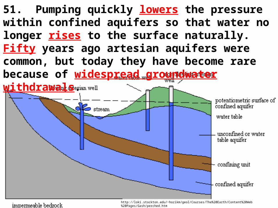
51. Pumping quickly lowers the pressure within confined aquifers so that water no longer rises to the surface naturally. Fifty years ago artesian aquifers were common, but today they have become rare because of widespread groundwater withdrawals.
http://loki.stockton.edu/~hozikm/geol/Courses/The%20Earth/Content%20Web%20Pages/Gash/perched.htm
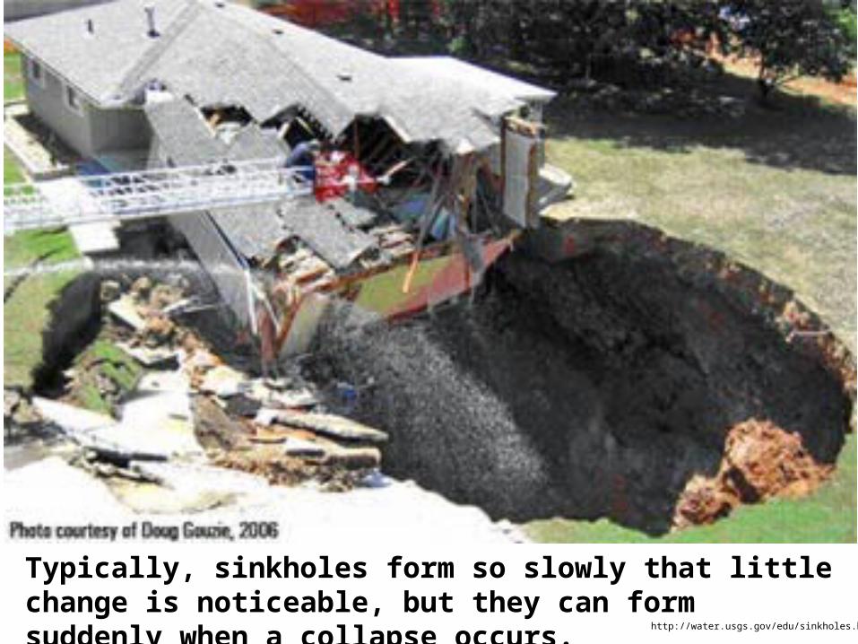
Typically, sinkholes form so slowly that little change is noticeable, but they can form suddenly when a collapse occurs.
http://water.usgs.gov/edu/sinkholes.html

http://oko-planet.su/pogoda/listpogoda/223011-pechalnaya-reputaciya-karstovyh-voronok-podtverzhdaetsya-s-kazhdym-mesyacem.html

A Massive Sinkhole Threatens To Swallow A Home In FloridaRead more: http://www.businessinsider.com/sinkhole-windermere-florida-2012-5#ixzz2x1FNM9Oe

Photo:Luis Echeverria, Guatemala's Presidency/AP
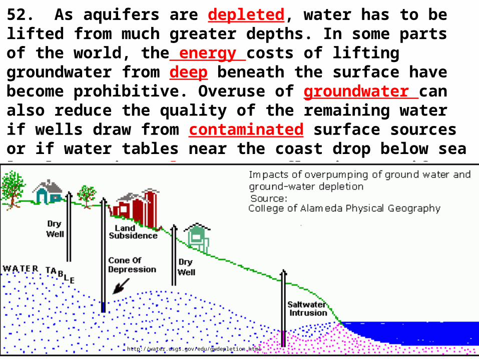
52. As aquifers are depleted, water has to be lifted from much greater depths. In some parts of the world, the energy costs of lifting groundwater from deep beneath the surface have become prohibitive. Overuse of groundwater can also reduce the quality of the remaining water if wells draw from contaminated surface sources or if water tables near the coast drop below sea level, causing salt water to flow into aquifers.
http://water.usgs.gov/edu/gwdepletion.html
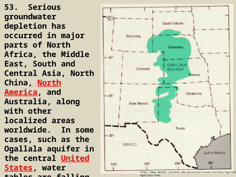
53. Serious groundwater depletion has occurred in major parts of North Africa, the Middle East, South and Central Asia, North China, North America, and Australia, along with other localized areas worldwide. In some cases, such as the Ogallala aquifer in the central United States, water tables are falling so low that wells can no longer produce water.
http://www.meteor.iastate.edu/gccourse/issues/society/ogallala/ogallala.html
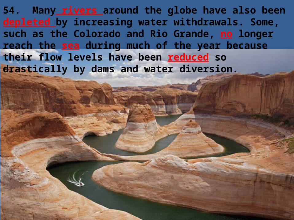
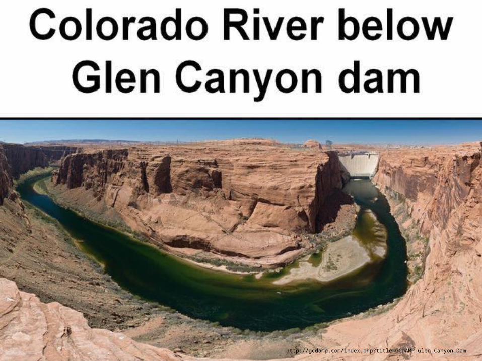
54. Many rivers around the globe have also been depleted by increasing water withdrawals. Some, such as the Colorado and Rio Grande, no longer reach the sea during much of the year because their flow levels have been reduced so drastically by dams and water diversion.

The Colorado River Delta in Baja California at the Sea of Cortez, once a vast riparian and tidal wetland, one of the largest desert estuaries on earth brimming with life, has been reduced by the Glen Canyon Dam and drought to a barren mudflat of white sand. Marine productivity has fallen 95 percent in the gulf, the fishery severely depleted. Photo By Peter McBride.
http://www.wilderutopia.com/politics/advocates/colorado-river-dams-and-drought-the-folly-of-taming-nature/

Glen Canyon Dam
http://gcdamp.com/index.php?title=GCDAMP_Glen_Canyon_Dam
http://gcdamp.com/index.php?title=GCDAMP_Glen_Canyon_Dam
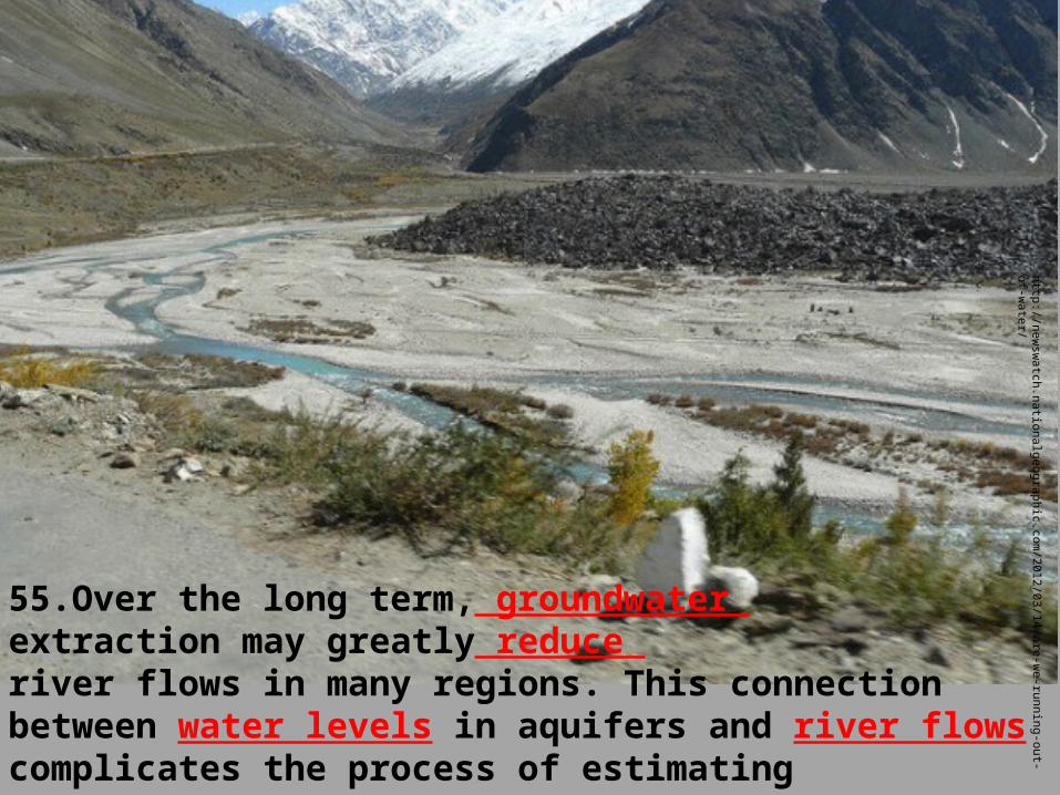
55.Over the long term, groundwater extraction may greatly reduce river flows in many regions. This connection between water levels in aquifers and river flows complicates the process of estimating sustainable yield from aquifers.
http://new
swatch.nationalgeographic.com
/2012/03/14/are-we-running-out-of-w
ater/

56. By regulating river flows to reduce floods and increase flows during dry periods, dams have major impacts on river ecosystems. Among other services, floods scour out channels, deposit nutrient-rich sediments on flood plains, and help to replenish groundwater.
This aerial photograph taken April 16, 2008, near Vicksburg, Miss., shows the extensive nature of the flooding from the Mississippi River, background, and its tributaries.
http://www.standeyo.com/NEWS/08_Food_Water/080429.MS.river.flood.html