Ground Water and the Rural Homeowner - USGS · Ground Water and the Rural Homeowner U.S. Department...
38
Ground Water and the Rural Homeowner U.S. Department of the Interior / U.S. Geological Survey
Transcript of Ground Water and the Rural Homeowner - USGS · Ground Water and the Rural Homeowner U.S. Department...
Ground Waterand the Rural Homeowner
U.S. Department of the Interior / U.S. Geological Survey
njestes
Click here to return to USGS publications

Cover photograph :
Rural dug well.

Ground Waterand the Rural Homeowner
by Roger M. Waller
Preface
As the salesmen sang in the musical TheMusic Man, "You gotta know the territory." Thissaying is also true when planning to buy or builda house. Learn as much as possible about theland, the water supply, and the septic system ofthe house before buying or building . Do not justlook at the construction aspects or the beauty ofthe home and surroundings . Be sure to considerthe environmental conditions around andbeneath the site as well . Try to visit the siteunder adverse conditions, such as during heavyrain or meltwater runoff, to observe the drainagecharacteristics, particularly the condition of thebasement .Many of the conditions discussed in this book,
such as lowered well-water levels, floodedbasements, and contamination from septicsystems, are so common that rural families oftenhave to deal with one or more of them. The pur-pose of this book is to awaken an interest inground water and an awareness of where it isavailable, how it moves, how people can adjustto its patterns to avoid problems, and how it canbe protected and used wisely .
This booklet provides both present and pro-spective rural homeowners, particularly those inthe glaciated northern parts of the United States,with a basic but comprehensive description ofground water . It also presents problems one mayexpect to encounter with ground water and somesolutions or suggestions for help with theseproblems .
Introduction
When buying a home in the country, peopleneed to consider certain factors that usually donot confront the urban homebuyer, such aswhether or not the water supply is adequate andif the means of disposing of wastewater is safe .Disappointed rural homeowners have sometimesfound out too late that the well drilled on theirnew land does not yield enough water or that thewater is of poor chemical quality. Also, founda-tions can become unstable from excess surfacerunoff or from high ground-water levels . Septicsystems, if not located properly or if soil condi-tions are not properly considered, can fail . Wellscan be contaminated by septic systems orbarnyard wastes . Shallow or dug wells on farmsor near older homes that served adequately inearlier years are often inadequate for modernuses .
Preventing water problems or coping withthem when buying or building a rural home canbe either complex or relatively simple . Prospec-tive homeowners need to know about the terrain,the proximity of the house to other structures,and the condition of the existing well and septicsystem . If building in an unpopulated area, drill awell first-or if buying an old house, find out ifthe water supply is adequate . This bookletdescribes the most common well problemsencountered by rural homeowners, how torecognize them, solve them, or get help . Butfirst, the characteristics and behavior of groundwater and the relationship between ground waterand the surrounding land are discussed briefly.
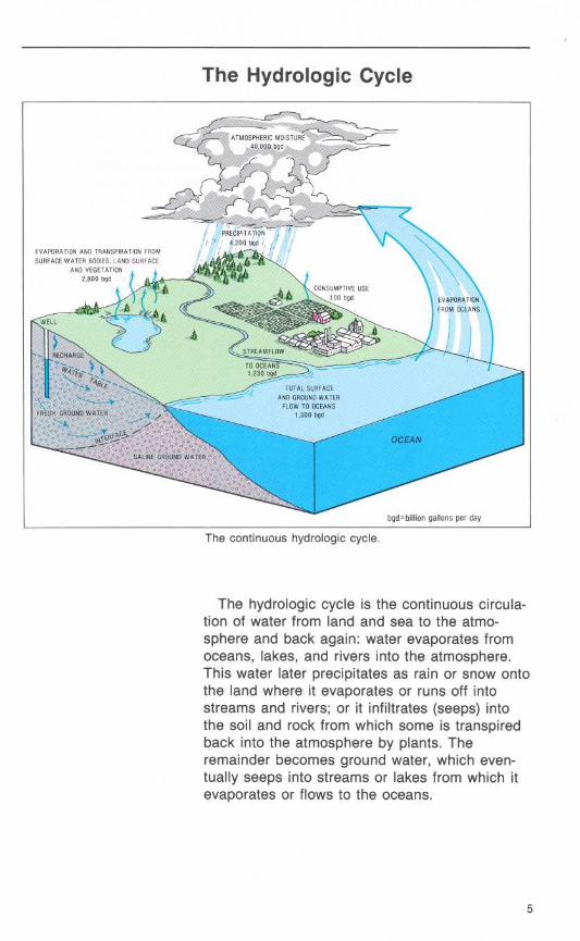
The Hydrologic Cycle
The continuous hydrologic cycle .
The hydrologic cycle is the continuous circula-tion of water from land and sea to the atmo-sphere and back again : water evaporates fromoceans, lakes, and rivers into the atmosphere .This water later precipitates as rain or snow ontothe land where it evaporates or runs off intostreams and rivers ; or it infiltrates (seeps) intothe soil and rock from which some is transpiredback into the atmosphere by plants . Theremainder becomes ground water, which even-tually seeps into streams or lakes from which itevaporates or flows to the oceans .
Ground Water
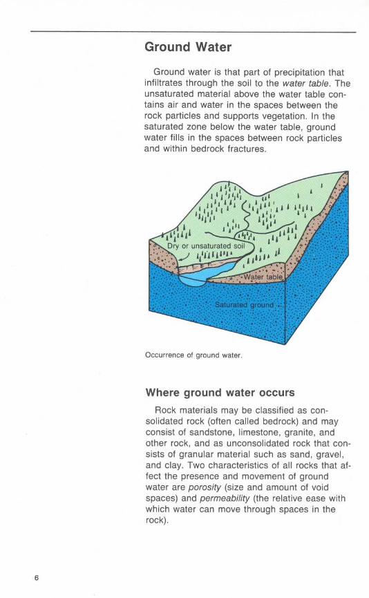
Ground water is that part of precipitation thatinfiltrates through the soil to the water table. Theunsaturated material above the water table con-tains air and water in the spaces between therock particles and supports vegetation . In thesaturated zone below the water table, groundwater fills in the spaces between rock particlesand within bedrock fractures.
Occurrence of ground water.
Where ground water occursRock materials may be classified as con-
solidated rock (often called bedrock) and mayconsist of sandstone, limestone, granite, andother rock, and as unconsolidated rock that con-sists of granular material such as sand, gravel,and clay . Two characteristics of all rocks that af-fect the presence and movement of groundwater are porosity (size and amount of voidspaces) and permeability (the relative ease withwhich water can move through spaces in therock).
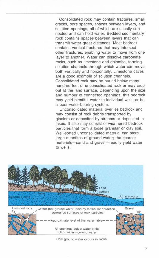
Consolidated rock may contain fractures, smallcracks, pore spaces, spaces between layers, andsolution openings, all of which are usually con-nected and can hold water. Bedded sedimentaryrock contains spaces between layers that cantransmit water great distances . Most bedrockcontains vertical fractures that may intersectother fractures, enabling water to move from onelayer to another. Water can dissolve carbonaterocks, such as limestone and dolomite, formingsolution channels through which water can moveboth vertically and horizontally . Limestone cavesare a good example of solution channels .Consolidated rock may be buried below manyhundred feet of unconsolidated rock or may cropout at the land surface. Depending upon the sizeand number of connected openings, this bedrockmay yield plentiful water to individual wells or bea poor water-bearing system .
Unconsolidated material overlies bedrock andmay consist of rock debris transported byglaciers or deposited by streams or deposited inlakes. It also may consist of weathered bedrockparticles that form a loose granular or clay soil .Well-sorted unconsolidated material can storelarge quantites of ground water; the coarsermaterials-sand and gravel-readily yield waterto wells .
How ground water occurs in rocks.
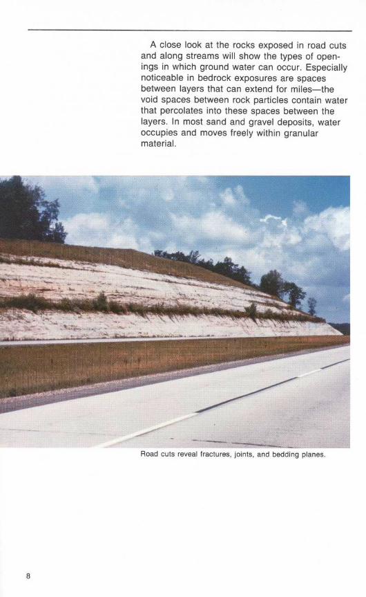
A close look at the rocks exposed in road cutsand along streams will show the types of open-ings in which ground water can occur. Especiallynoticeable in bedrock exposures are spacesbetween layers that can extend for miles-thevoid spaces between rock particles contain waterthat percolates into these spaces between thelayers . In most sand and gravel deposits, wateroccupies and moves freely within granularmaterial .
Road cuts reveal fractures, joints, and bedding planes .
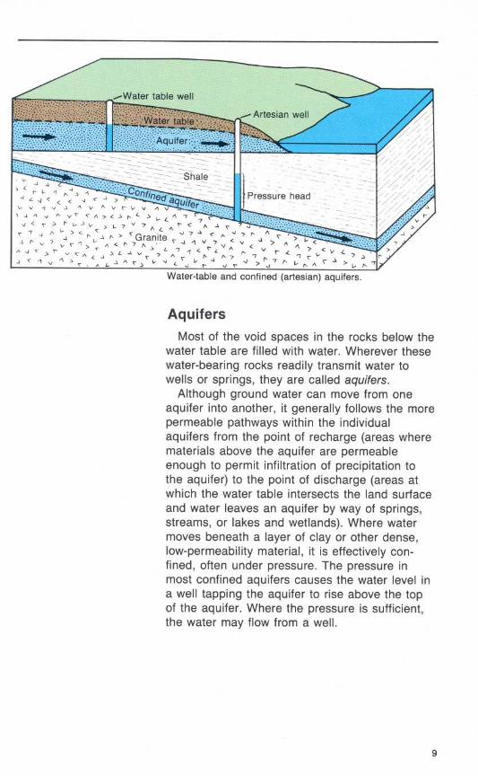
Water-table and confined (artesian) aquifers .
AquifersMost of the void spaces in the rocks below the
water table are filled with water. Wherever thesewater-bearing rocks readily transmit water towells or springs, they are called aquifers .
Although ground water can move from oneaquifer into another, it generally follows the morepermeable pathways within the individualaquifers from the point of recharge (areas wherematerials above the aquifer are permeableenough to permit infiltration of precipitation tothe aquifer) to the point of discharge (areas atwhich the water table intersects the land surfaceand water leaves an aquifer by way of springs,streams, or lakes and wetlands). Where watermoves beneath a layer of clay or other dense,low-permeability material, it is effectively con-fined, often under pressure . The pressure inmost confined aquifers causes the water level ina well tapping the aquifer to rise above the topof the aquifer. Where the pressure is sufficient,the water may flow from a well .
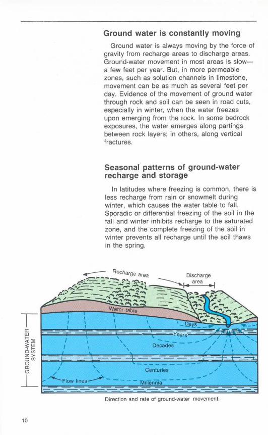
Ground water is constantly movingGround water is always moving by the force of
gravity from recharge areas to discharge areas.Ground-water movement in most areas is slow-a few feet per year . But, in more permeablezones, such as solution channels in limestone,movement can be as much as several feet perday. Evidence of the movement of ground waterthrough rock and soil can be seen in road cuts,especially in winter, when the water freezesupon emerging from the rock . In some bedrockexposures, the water emerges along partingsbetween rock layers ; in others, along verticalfractures.
Seasonal patterns of ground-waterrecharge and storage
In latitudes where freezing is common, there isless recharge from rain or snowmelt duringwinter, which causes the water table to fall .Sporadic or differential freezing of the soil in thefall and winter inhibits recharge to the saturatedzone, and the complete freezing of the soil inwinter prevents all recharge until the soil thawsin the spring .
Direction and rate of ground-water movement .
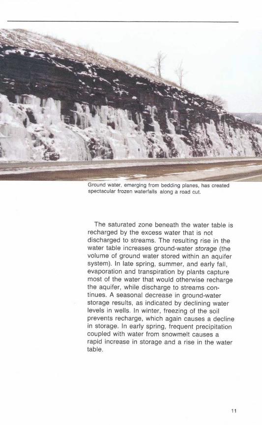
Fund water, emerging from bedding planes, has createdspectacular frozen waterfalls along a road cut.
The saturated zone beneath the water table isrecharged by the excess water that is notdischarged to streams . The resulting rise in thewater table increases ground-water storage (thevolume of ground water stored within an aquifersystem). In late spring, summer, and early fall,evaporation and transpiration by plants capturemost of the water that would otherwise rechargethe aquifer, while discharge to streams con-tinues . A seasonal decrease in ground-waterstorage results, as indicated by declining waterlevels in wells. In winter, freezing of the soilprevents recharge, which again causes a declinein storage. In early spring, frequent precipitationcoupled with water from snowmelt causes arapid increase in storage and a rise in the watertable.
Effects of long-term climatic trends onground-water storage
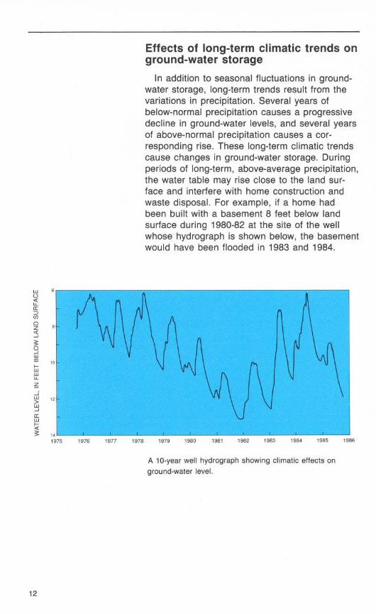
In addition to seasonal fluctuations in ground-water storage, long-term trends result from thevariations in precipitation . Several years ofbelow-normal precipitation causes a progressivedecline in ground-water levels, and several yearsof above-normal precipitation causes a cor-responding rise . These long-term climatic trendscause changes in ground-water storage. Duringperiods of long-term, above-average precipitation,the water table may rise close to the land sur-face and interfere with home construction andwaste disposal . For example, if a home hadbeen built with a basement 8 feet below landsurface during 1980-82 at the site of the wellwhose hydrograph is shown below, the basementwould have been flooded in 1983 and 1984 .
A 10-year well hydrograph showing climatic effects onground-water level.
Types of Wells
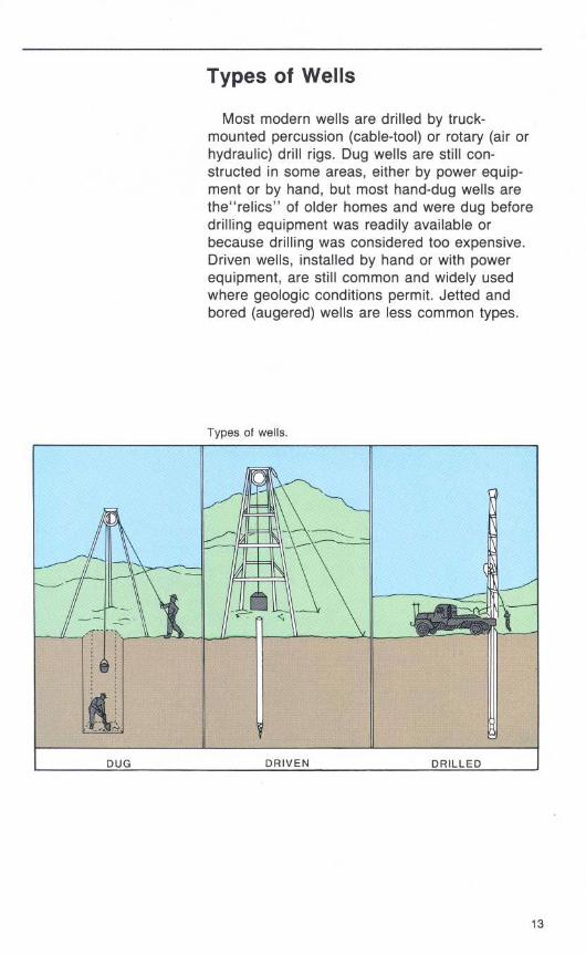
Most modern wells are drilled by truck-mounted percussion (cable-tool) or rotary (air orhydraulic) drill rigs . Dug wells are still con-structed in some areas, either by power equip-ment or by hand, but most hand-dug wells arethe"relics" of older homes and were dug beforedrilling equipment was readily available orbecause drilling was considered too expensive .Driven wells, installed by hand or with powerequipment, are still common and widely usedwhere geologic conditions permit . Jetted andbored (augered) wells are less common types.
Types of wells.
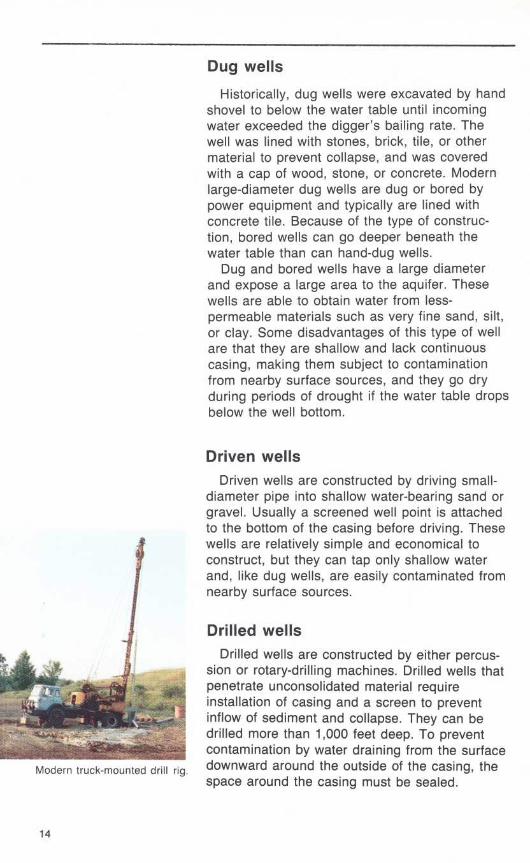
Modern truck-mounted drill rig .
Dug wells
Historically, dug wells were excavated by handshovel to below the water table until incomingwater exceeded the digger's bailing rate . Thewell was lined with stones, brick, tile, or othermaterial to prevent collapse, and was coveredwith a cap of wood, stone, or concrete . Modernlarge-diameter dug wells are dug or bored bypower equipment and typically are lined withconcrete tile . Because of the type of construc-tion, bored wells can go deeper beneath thewater table than can hand-dug wells .Dug and bored wells have a large diameter
and expose a large area to the aquifer . Thesewells are able to obtain water from less-permeable materials such as very fine sand, silt,or clay . Some disadvantages of this type of wellare that they are shallow and lack continuouscasing, making them subject to contaminationfrom nearby surface sources, and they go dryduring periods of drought if the water table dropsbelow the well bottom .
Driven wellsDriven wells are constructed by driving small-
diameter pipe into shallow water-bearing sand orgravel. Usually a screened well point is attachedto the bottom of the casing before driving . Thesewells are relatively simple and economical toconstruct, but they can tap only shallow waterand, like dug wells, are easily contaminated fromnearby surface sources.
Drilled wellsDrilled wells are constructed by either percus-
sion or rotary-drilling machines . Drilled wells thatpenetrate unconsolidated material requireinstallation of casing and a screen to preventinflow of sediment and collapse . They can bedrilled more than 1,000 feet deep . To preventcontamination by water draining from the surfacedownward around the outside of the casing, thespace around the casing must be sealed .

Wells and Pumpage
Even though water is present at some depth atalmost any location, the success of obtaining anadequate domestic supply (usually 5 gallons perminute) of water from a well depends upon thepermeability of the rock . Where permeablematerials are near land surface, a shallow wellmay be adequate . Elsewhere, such as whereclayey material directly overlies bedrock, a deepwell extending into bedrock may be needed .Pumping a well lowers the water level around
the well to form a cone of depression in thewater table. If the cone of depression extends toother nearby wells, the water level in those wellswill be lowered. The cone develops in bothshallow water-table and deeper confined-aquifersystems . In the deeper confined-aquifer system,the cone of depression is indicated by a declinein the pressure and the cone spreads over amuch larger area than in a water-table system .For a given rate of withdrawal, the cone ofdepression extends deeper in low-yieldingaquifers than in high-yielding ones .
Cone of depression caused by pumping .
Water-Level Declines
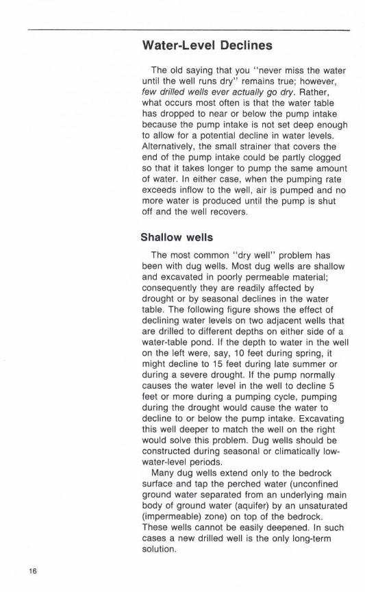
The old saying that you "never miss the wateruntil the well runs dry" remains true ; however,few drilled wells ever actually go dry. Rather,what occurs most often is that the water tablehas dropped to near or below the pump intakebecause the pump intake is not set deep enoughto allow for a potential decline in water levels .Alternatively, the small strainer that covers theend of the pump intake could be partly cloggedso that it takes longer to pump the same amountof water. In either case, when the pumping rateexceeds inflow to the well, air is pumped and nomore water is produced until the pump is shutoff and the well recovers .
Shallow wells
The most common "dry well" problem hasbeen with dug wells. Most dug wells are shallowand excavated in poorly permeable material ;consequently they are readily affected bydrought or by seasonal declines in the watertable . The following figure shows the effect ofdeclining water levels on two adjacent wells thatare drilled to different depths on either side of awater-table pond . If the depth to water in the wellon the left were, say, 10 feet during spring, itmight decline to 15 feet during late summer orduring a severe drought. If the pump normallycauses the water level in the well to decline 5feet or more during a pumping cycle, pumpingduring the drought would cause the water todecline to or below the pump intake . Excavatingthis well deeper to match the well on the rightwould solve this problem. Dug wells should beconstructed during seasonal or climatically low-water-level periods.Many dug wells extend only to the bedrock
surface and tap the perched water (unconfinedground water separated from an underlying mainbody of ground water (aquifer) by an unsaturated(impermeable) zone) on top of the bedrock .These wells cannot be easily deepened . In suchcases a new drilled well is the only long-termsolution .
EXPLANATION-------- High water table------- Low water table
Pumping levelPond level
Solving a drought-relatedwater shortage by deepeningthe well .
How does a well go dry?
Some drilled wells that tap shallow bedrockwill yield only 1 or 2 gallons of water per minute .These wells are not deep enough to provide ade-quate storage of water for short-term pumpingcycles . Such a well may contain only 50 feet ofwater above the pump intake . As an example,when the water table declines 10 feet because ofdrought conditions, only 40 feet of water isavailable in the well for one pumping cycle, andthe well seems to "go dry." In that situation,deepening the well may solve the problem aslong as the deeper water is of good quality. Ifusable water is not available at a greater depth,the pumping rate must be reduced so that lesswater is pumped during each cycle.
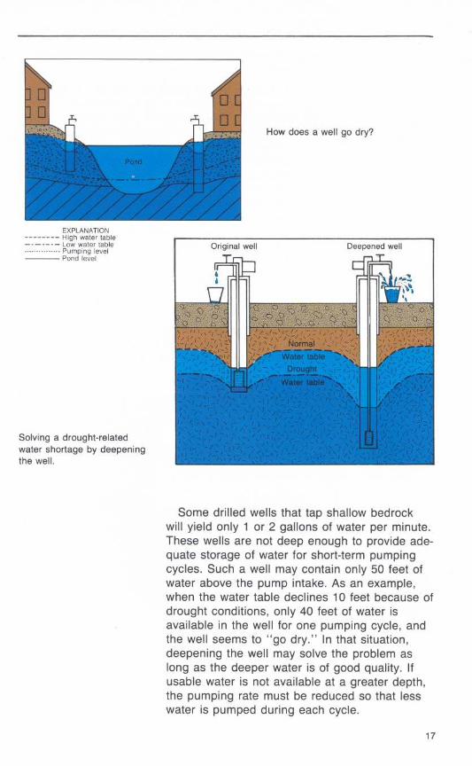
Increased pumping in the immediateareaAnother reason that wells "go dry" is the
lowering of the water table by increasedpumpage in the immediate area . Housingdevelopments with small lots and individual wellshave been built in many rural areas. If theaquifer is low yielding so that pumping causes alarge drawdown, a cone of depression willdevelop around each well . Thus, severaldomestic wells close together can create asteady lowering of the water table if pumpageexceeds the natural recharge to the system(unless the withdrawn water is returned to theaquifer through septic systems) . A third majorreason that rural wells "go dry" is the installa-tion of larger capacity wells for municipal,industrial, or agricultural purposes adjacent toresidental areas. The increased withdrawals maycause large widespread cones of depression thatintersect one another and cause general water-level declines that affect nearby domestic wells.
Effect of concentrated housing on ground-water level.
Water-Level Rises
The opposite problem, namely a rising watertable, has developed in some parts of the coun-try. Rising water tables occur in areas wherepumpage has been curtailed after years of largeground-water withdrawals, such as for minedewatering or municipal water supply, which keptthe water table below its natural levels . The cur-tailment of pumping allows the water table to riseto the previous natural level, which may floodunderground structures that were built when thewater table was lowered .
In many parts of the country, water levels inshallow aquifers have been lowered artificiallyover large areas. If houses are constructed indewatered areas and if the water table thenrecovers to its natural (higher) level, basementflooding or foundation failures may occur,especially where the natural water level is within10 feet of the land surface . Many basements thatwere built in a dry unconsolidated material andthat had remained dry for decades have nowbecome permanently wet. The public's first reac-tion may be that unusually heavy precipitation inthe past few months has raised the water tableor created a temporary perched-water system,when in fact the situation is much more seriousand will remain a problem unless pumping isresumed to maintain a lower water table.
Where water levels are closely monitored,water-level records can indicate whether suchhigh water levels are related solely to climaticevents or whether water levels are recoveringafter nearby pumping has ceased . An increasingnumber of local areas are being dewatered formining or industrial uses, which could causeserious problems in the future when suchpumpage is decreased or ended.
Similar situations have occurred where hous-ing developments were built during a period ofextended drought when the water table was low .Even if basements were the "daylight" or raisedtype because the natural water table wasshallow, the eventual return of a wet periodcaused the water table to rise a few feet andflood basements.
19
Quality of Water
Some common ground-water quality concernsare excessive hardness (high dissolvedmagnesium and calcium content), a high concen-tration of salt or iron, or the presence ofhydrogen sulfide (sulfur), methane gas,petroleum or organic compounds, or bacteria .Some are naturally occurring; others are in-troduced by human activities . In many areas, thehomeowner has little recourse other than to usechemical treatment to remove or reduce the levelof these constituents or to abandon the watersupply . Hardness, iron, and sulfur are commonconstituents that can be treated.
Salt contamination
Salt contamination is difficult and expensive toremedy unless the well drawing saline waterfrom a deep aquifer also penetrates one or morefreshwater aquifers at lesser depth. In suchcases, the deep saline aquifer can be sealed offand the well can be drilled in the freshwateraquifer instead . In many parts of the country,however, when a well is drilled deeper intobedrock to obtain larger supplies, saline water ismore likely encountered than additionalfreshwater is .
Road-salt contamination of ground water hasincreased in the last 30 years and is of majorconcern in northern areas . Highway departmentsmix salt with sand to spread on roads fordeicing . Salt is readily soluble in water and runsoff highways into lakes and streams and per-colates to the water table.
Probably more serious than the spreading isthe stockpiling of uncovered salt and sand mix-tures. This practice produces concentratedsaltwater runoff that percolates to underlyingaquifers and nearby wells. Many stockpiles arewithin small villages or near housing areaswhere nearby domestic wells can becomecontaminated .

Leachate from sand and saltstockpiles is a potentialsource of contamination toshallow ground water .
Oil spills
Another chronic problem in many rural homesis leaking or spilled fuel oil which eventually con-taminates the owner's own well . Many homeshave a fuel tank, either buried or above ground,adjacent to the house and within a few feet ofthe well . Spills or accumulated leakage eventual-ly can migrate to the aquifer and can be drawninto the well, making it unusable for years.Usually the only solution is to obtain a new watersource . In some instances, however, reducingthe pumping rate to reduce drawdown allows theoil to float on the water surface safely above thewell's intake area .
Methane gas
Perhaps the problem that poses the greatesthazard to a well owner is flammable gas in thewell . Small volumes of natural gas, usuallymethane, can be carried along with the waterinto wells tapping carbonate or shale rock . Insome areas, the gas dissipates soon afterinstallation of the well, but, in other areas, alarge continual source of natural gas remains.Because methane is flammable and cannot bedetected by smell, precautions are needed toprevent explosions and fire . Venting of the well
2 1
head to the open air is the simplest precautionbut, because gas can also accumulate in pumpenclosures, pressure tanks, and basements,other venting may be needed . For this reason, ahome should never be built over a well .
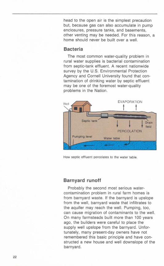
BacteriaThe most common water-quality problem in
rural water supplies is bacterial contaminationfrom septic-tank effluent . A recent nationwidesurvey by the U.S . Environmental ProtectionAgency and Cornell University found that con-tamination of drinking water by septic effluentmay be one of the foremost water-qualityproblems in the Nation .
How septic effluent percolates to the water table.
Barnyard runoff
Probably the second most serious water-contamination problem in rural farm homes isfrom barnyard waste . If the barnyard is upslopefrom the well, barnyard waste that infiltrates tothe aquifer may reach the well . Pumping, too,can cause migration of contaminants to the well .On many farmsteads built more than 100 yearsago, the builders were careful to place thesupply well upslope from the barnyard . Unfor-tunately, many present-day owners have notremembered this basic principle and have con-structed a new house and well downslope of thebarnyard .
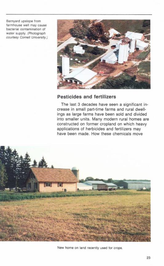
Barnyard upslope fromfarmhouse well may causebacterial contamination ofwater supply . (Photographcourtesy Cornell University .)
Pesticides and fertilizersThe last 3 decades have seen a significant in-
crease in small part-time farms and rural dwell-ings as large farms have been sold and dividedinto smaller units . Many modern rural homes areconstructed on former cropland on which heavyapplications of herbicides and fertilizers mayhave been made . How these chemicals move
New home on land recently used for crops.
23
through the soil and ground water and howquickly they decompose or how their harmfuleffects are neutralized is not well understood .
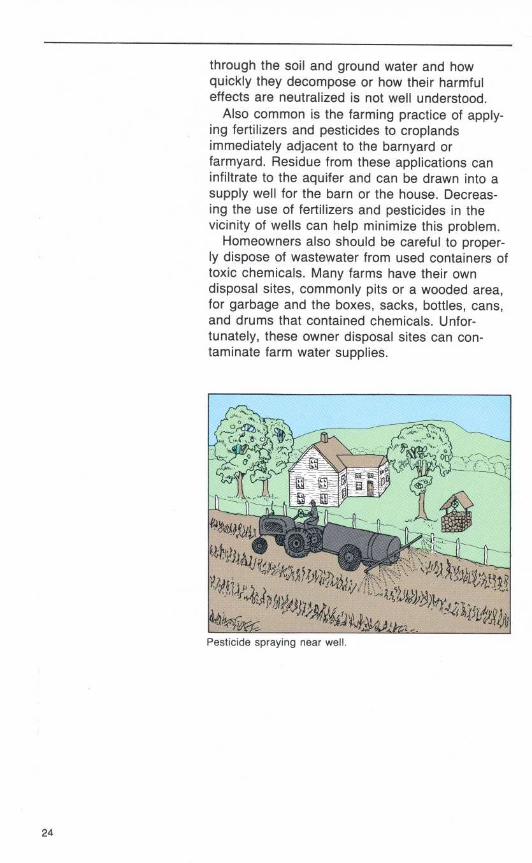
Also common is the farming practice of apply-ing fertilizers and pesticides to croplandsimmediately adjacent to the barnyard orfarmyard . Residue from these applications caninfiltrate to the aquifer and can be drawn into asupply well for the barn or the house. Decreas-ing the use of fertilizers and pesticides in thevicinity of wells can help minimize this problem.Homeowners also should be careful to proper-
ly dispose of wastewater from used containers oftoxic chemicals. Many farms have their owndisposal sites, commonly pits or a wooded area,for garbage and the boxes, sacks, bottles, cans,and drums that contained chemicals. Unfor-tunately, these owner disposal sites can con-taminate farm water supplies .
Pesticide spraying near well .
Septic Systemsand Ground Water
The liquid effluent from a septic system followsthe same path as the rain or snowmelt that per-colates into the unsaturated zone . Like the rain,once the effluent reaches the water table, itflows down the hydraulic gradient, which may beroughly parallel to the slope of the land, to lowerpoints . Thus, again, the location of one's housein relation to neighboring houses, both upslopeand downslope, is important.
Septic-tank effluent that enters the aquifer sup-plying the homeowner's well introduces not onlybacteria but also other contaminants . Many ruralhomeowners also discharge other wasteproducts, including toxic material, into theirseptic systems, and these products gradually ac-cumulate in the aquifer. What happens to thesecontaminants in the ground is not well known .Some adhere to rock material, others travel withthe water. In some types of rock material, theleach field or dry-well part of the septic systemcan gradually become clogged by contaminants .
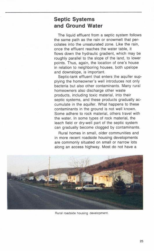
Rural homes in small, older communities andin more recent roadside housing developmentsare commonly situated on small or narrow lotsalong an access highway. Most do not have a
Rural roadside housing development .
community water supply, and almost all havetheir own individual septic systems. In clusterssuch as this, effluent recycling can occur if thewells are shallow or the septic systems are im-properly placed . Deep wells are less likely todraw in septic waste.
This type of effluent problem becomes acute inan area underlain by a shallow water-tableaquifer where the septic effluent discharges intowater that is used by many homeowners . Thisdilemma has been posed in many rural housingdevelopments throughout the Nation . One either"fouls his own nest" with effluent or connects toa central sewer system . Although a sewersystem protects the aquifer from further con-tamination, it reduces recharge of water to theaquifer. This engineering, economic, and socialdilemma must be resolved soon in many areas.An increasing number of counties and townshipsare planning and zoning rural areas to limit thedensity of houses according to soil conditions .Other approaches being considered are a com-munity water supply with individual septicsystems or individual water supplies with acommunity sewer system .Some banks and lenders require that the pro-
spective buyer or the seller furnish proof of abacteria-free water supply before they will issuea mortgage . When a seller faces such a require-ment, a common procedure is to chlorinate thewater to destroy the bacteria in the well . Thistreatment affects only the well and perhaps avolume of the aquifer immediately adjacent tothe well, but for only a brief time . If the con-tamination is in the aquifer, the source will notbe attacked nor the problem solved ; thus a wateranalysis showing bacteria-free water immediatelyafter the well has been disinfected is notnecessarily an assurance of a safe water supply .The homeowner should periodically have thewater analyzed for bacteria . If a high bacteriacount occurs repeatedly, the problem is probablyin the water source, and chemical treatment ofthe well alone cannot solve it .
In a bacteria-contaminated water system,chlorination of the water pumped from the well iscommonly recommended as a solution . Other-
wise, one must obtain a water supply from a newwell that either is upgradient from the con-taminating source or that taps a deeper aquifer.Moving the septic system to a more distant spotis a long-term solution, but the underlying con-taminated zone may take years to stop releasingcontaminants to the aquifer.
Cluster-housing contaminationIn a row-housing setting, the house at the
highest location will generally have the saferwater supply . Because the effluent migratesdown beneath the development, it could bepumped, used, and again discharged by eachhouse along its course . The house furthestdownslope would receive the combined effluentfrom the other houses .Another contamination problem from closely
spaced septic systems can occur where a row ofhouses on the uphill side of a road faces a rowof houses on the downhill side of the road . Here,the safer water supply would be on the uphillside . The downhill side would receive effluentfrom the uphill side plus any contaminationgenerated along the road, such as road salt ormetal compounds . In flat areas underlain by ashallow water table, especially where clusterdevelopments are two or more decades old,almost perpetual recycling of septic waste mayoccur.Another source of contamination that is com-
mon in villages or hamlets lacking a centralwater or sewage system is small waste-generating businesses such as laundries, auto-repair shops, and industries that dischargewastes to their own septic systems . Many of thebacterial problems, cited in a recent U.S . En-vironmental Protection Agency rural water study,were in hamlets, villages, or crossroads com-munities . Once indoor plumbing became com-mon and outdoor privies were removed, all wastewent into septic systems from which increasedamounts of liquid effluent eventually entered theaquifer and became subject to pumping by wells.
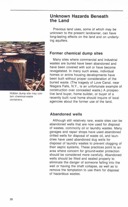
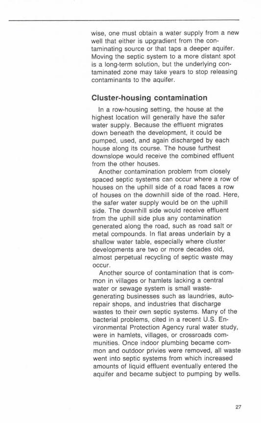
Hidden dump site may con-tain chemical-wastecontainers .
Unknown Hazards Beneaththe Land
Previous land uses, some of which may beunknown to the present landowner, can havelong-lasting effects on the land and on underly-ing aquifers .
Former chemical dump sitesMany sites where commercial and industrial
wastes are buried have been abandoned andhave been covered with soil or have becomerevegetated . In many such areas, individualhomes or entire housing developments havebeen built without proper consideration of theburied waste. (The tragedy of Love Canal, nearNiagara Falls, N.Y., is an unfortunate example ofconstruction over concealed waste .) A prospec-tive land buyer, home builder, or buyer of arecently built rural home should inquire of localagencies about the former use of the land .
Abandoned wellsAlthough still relatively rare, waste sites can be
abandoned wells that are now used for disposalof wastes, commonly oil or laundry wastes . Manygarages and repair shops have used abandoneddrilled wells for disposal of waste oil, and laun-dries have used abandoned dug wells fordisposal of laundry wastes to prevent clogging oftheir septic systems. These practices point to anarea where concern for ground-water protectionshould be considered more carefully. Abandonedwells should be filled and sealed properly toeliminate the danger of someone falling into thewell or having the shaft collapse, as well as toremove the temptation to use them for disposalof hazardous wastes .

Crop dusting and orchardspraying . (Photographscourtesy Cornell University.)
Former orchards or vegetable landsIndividual homes and developments alike have
been built on former orchards or vegetablefarms. Although these lands can be picturesquewhere fruit trees remain, one must rememberthat pesticides and chemical fertilizers probablywere applied heavily in the past . The fate ofmany of these chemicals in the soil is unknown,and long-term contamination may remain,especially in the shallow ground water. The soilthrough which recharge from precipitation movesis the repository for much of the chemicals thatare deposited on the land . Decades may passbefore these chemicals are dissipated or flushedaway . Therefore, anyone planning to buy or builda house on a former orchard or truck farmshould consult farm or zoning agencies to obtaininformation on the potential for pesticide andfertilizer residue .
29
Oil and gas fields
Oil and gas development has occurred and isoccurring in many parts of the country. Oil andgas development almost always includes the pro-duction of brine or saline water, which then mustbe disposed of . Most states regulate the disposalof brine to prevent contamination of surface andground water, but, in old oil and gas fields thatwere abandoned before extensive regulation,saline water is still escaping from improperlysealed or cased wells into freshwater aquifers .One method of producing more oil or gas from
old fields is to inject water or brine into the pro-ducing formation to increase the pressure andmove the oil or gas to wells. Some oil or gasfields are "leaking," however, and once thepressure is increased, the injected fluid or oilfinds avenues of escape to other formations,such as through abandoned boreholes or corrod-ed well casings. Some shallow producing areasthat contain many abandoned wells spaced afew hundred feet apart have created anunmanageable leakage problem. Every oldabandoned oil or gas well that is not cemented-in may provide an avenue for saline water, oil, orgas to escape into the nearest aquifer and con-taminate the system . It would be wise to verifythat the home being purchased is not near anold oil or gas field .
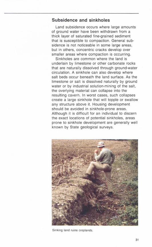
Subsidence and sinkholesLand subsidence occurs where large amounts
of ground water have been withdrawn from athick layer of saturated fine-grained sedimentthat is susceptible to compaction . General sub-sidence is not noticeable in some large areas,but in others, concentric cracks develop oversmaller areas where compaction is occurring .
Sinkholes are common where the land isunderlain by limestone or other carbonate rocksthat are naturally dissolved through ground-watercirculation . A sinkhole can also develop wheresalt beds occur beneath the land surface . As thelimestone or salt is dissolved naturally by groundwater or by industrial solution-mining of the salt,the overlying material can collapse into theresulting cavern . In worst cases, such collapsescreate a large sinkhole that will topple or swallowany structure above it . Housing developmentshould be avoided in sinkhole-prone areas.Although it is difficult for an individual to discernthe exact locations of potential sinkholes, areasprone to sinkhole development are generally wellknown by State geological surveys.
Sinking land ruins croplands .
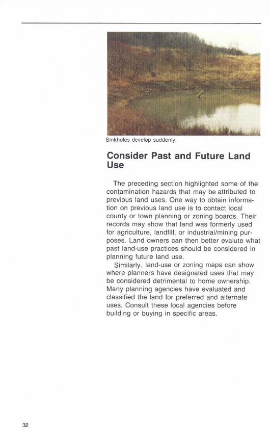
Sinkholes develop suddenlv .
Consider Past and Future LandUse
The preceding section highlighted some of thecontamination hazards that may be attributed toprevious land uses . One way to obtain informa-tion on previous land use is to contact localcounty or town planning or zoning boards . Theirrecords may show that land was formerly usedfor agriculture, landfill, or industrial/mining pur-poses . Land owners can then better evalute whatpast land-use practices should be considered inplanning future land use.
Similarly, land-use or zoning maps can showwhere planners have designated uses that maybe considered detrimental to home ownership.Many planning agencies have evaluated andclassified the land for preferred and alternateuses . Consult these local agencies beforebuilding or buying in specific areas.
Country Living Calls forKnowledge
Before purchasing a home in a rural area, thebuyer should determine the amount and qualityof water and should locate the waste-disposalsystem .
A well log and a water analysis maybe as important as a deedAs ground water receives increasing attention
nationwide, particularly because of toxic-chemicalcontamination, a written legal document verifyingan adequate water supply from new or old wellsis becoming important. Some mortgage lendersrequire a negative bacterial analysis of the waterand a yield test of the well to verify an adequatesupply . As mentioned earlier, a single analysisfor bacteria may not reflect true conditions, but itis worthwhile to have it done nevertheless .A well record (driller's log) describes the well
characteristics, including yield and the type ofmaterial that the driller encountered . The well logis not always available from the owner, andsometimes the driller who installed the well can-not be located. If the well log is available,however, it can be helpful. If water quantitybecomes insufficient, a record of a yield test ishelpful in determining what happened . Most dugwells, of course, have no description other thandepth . In any case, it is wise to obtain informa-tion on well depth, water level, type of pump,pump-intake setting, and yield before buying ahouse.
Determine the location of the septicsystem and water source
The buyer of rural property must know thelocation of the water source and the waste-disposal system to evaluate the potential for cer-tain problems . Even a cursory glance at theirlocation, distance from each other, and the landslope often provides an initial estimate as to theiradequacy . For example, evidence of two or morewells or septic systems warrants a detailed in-quiry. An odor of sewage, a wet area, or lushgrass over a leach field, especially during dryperiods, indicates a potential problem.
Some Practical Considerations
As stated earlier, learn as much as you canabout the land, the water supply, and the septicsystem of the house before you buy. Be sure toconsider the environmental conditions, and tryalso to visit the site during bad weather. Don'tbe rushed-take time to be informed .
Most rural water problems are related to olddug wells, septic systems, and too-dense hous-ing developments . Drilled or deep wells aregenerally less susceptible to sewage or surface-contamination sources than shallow wells are,but water from bedrock wells is more likely tocontain gas or minerals than is water fromshallow deposits . Most well drillers are aware ofcommon local problems and generally locatewells properly .
Although potential water problems for the ruralhomeowner can sometimes be expensive, pose ahealth hazard, or possibly affect real estatevalues, these problems can be avoided by theobservant, informed buyer or owner.
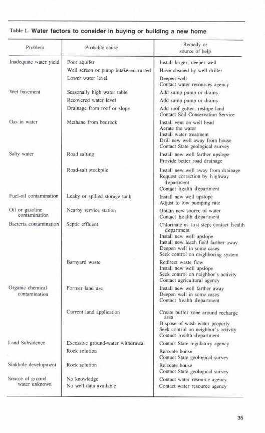
Table 1. Water factors to consider in buying or building a new home
Salty water Road salting Install new well farther upslopeProvide better road drainage
Road-salt stockpile Install new well away from drainageRequest correction by highwaydepartment
Contact health departmentFuel-oil contamination Leaky or spilled storage tank Install new well upslope
Adjust to low pumping rateOil or gasoline Nearby service station Obtain new source of water
contamination Contact health departmentBacteria contamination Septic effluent Chlorinate as first step ; contact health
departmentInstall new well upslopeInstall new leach field farther awayDeepen well in some casesSeek control on neighboring system
Barnyard waste Redirect waste flowInstall new well upslopeSeek control on neighbor's activityContact agricultural agency
Organic chemical Former land use Install new well farther awaycontamination Deepen well in some cases
Contact health department
Current land application Create buffer zone around rechargearea
Dispose of wash water properlySeek control on neighbor's activityContact health department
Land Subsidence Excessive ground-water withdrawal Contact State regulatory agencyRock solution Relocate house
Contact State geological surveySinkhole development Rock solution Relocate house
Contact State geological surveySource of ground No knowledge Contact water resource agency
water unknown No well data available Contact water resource agency
Problem Probable cause Remedy orsource of help
Inadequate water yield Poor aquifer Install larger, deeper wellWell screen or pump intake encrusted Have cleaned by well drillerLower water level Deepen well
Contact water resources agencyWet basement Seasonally high water table Add sump pump or drains
Recovered water level Add sump pump or drainsDrainage from roof or slope Add roof gutter, reslope land
Contact Soil Conservation ServiceGas in water Methane from bedrock Install vent on well head
Aerate the waterInstall water treatmentDrill new well away from houseContact State geological survey
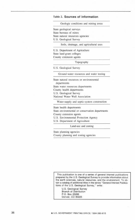
Table 2. Sources of information
Geologic conditions and mining areas
State geological surveysState bureaus of minesState natural resources agenciesU.S . Geological Survey
Soils, drainage, and agricultural uses
U.S . Department of AgricultureState land-grant collegesCounty extension agents
U.S . Geological Survey
Topography
Ground-water resources and water testing
State natural resources or environmentaldepartments
State water resources departmentsCounty health departmentsU.S . Geological SurveyNational Water Well Association
Water-supply and septic-system construction
State health departmentsState environmental or conservation departmentsCounty extension agentsU .S . Environmental Protection AgencyU .S . Department of Agriculture
Land-use and zoning
State planning agenciesCounty planning and zoning agencies
This publication is one of a series of general interest publicationsprepared by the U.S . Geological Survey to provide information aboutthe earth sciences, natural resources, and the environment. To ob-tain a catalog of additional titles in the series "General Interest Publica-tions of the U.S . Geological Survey," write :
U.S . Geological SurveyBranch of DistributionP.O . Box 25286Denver, CO 80225
* U.S . GOVERNMENT PRINTING OFFICE : 1994-380-615
Suggested Reading
Baldwin, H.L., and McGuinness, C.L ., 1963, A primer onground water : U.S . Geological Survey, 26 p .
Cobb, E.L., and Morgan, M .E., 1978, Drinking water suppliesin rural America : U .S . Environmental Protection Agency,National Demonstration Water Project, 164 p .
Craun, G.F ., 1981, Outbreaks of water-borne disease in theUnited States, 1971-1978 : Journal of American WaterWorks Association, vol . 73, no . 7, pp . 360-369 .
Edward E . Johnson, Inc ., 1966, Ground water and wells [1sted] : Saint Paul, Minn ., 440 p .
Francis, J.D . (principal investigator), [1980], Nationalstatistical assessment of rural water conditions, Executivesummary : Ithaca, N.Y ., Cornell University, Department ofRural Sociology, U.S . Environmental Protection Agency,The Office of Drinking Water, 5 v .
Geyer, A.R ., and McGlade, W.G ., 1972, Environmentalgeology for land-use planning : Commonwealth of Penn-sylvania Department of Environmental Resources, En-vironmental Geology Report 2, 37 p .
Gibb, J .P ., 1973, Planning a domestic groundwater supplysystem : Illinois State Water Survey, Circular 116, 13 p .
Heath, R.C ., 1983, Basic ground-water hydrology : U.S .Geological Survey Water-Supply Paper 2220, 84 p .
Keough, Carol, 1980, Water fit to drink : Emmaus, Pa .,Rodale Press, 265 p .
Leopold, L.B ., and Langbein, W.B ., 1960, A primer on water :U .S . Geological Survey, 50 p .
Massachusetts Audubon Society, 1983, An introduction togroundwater and aquifers : Lincoln, Mass., CommunityGroundwater Protection Project, Groundwater InformationFlyer no . 1, 12 p .
New York State Department of Health, 1966, Rural watersupply : Albany, N.Y ., 66 p .
Paulsen, Q.F ., 1983, Guide to North Dakota's ground-waterresources : U.S . Geological Survey Water-Supply Paper2236, 25 p .
Peck, M.K ., 1981, Troubleshooting water well failure : WestVirginia Geological and Economic Survey Circular C-25,18 p .
U.S . Bureau of Reclamation, 1977, Ground-water manual :Washington, D.C ., U.S . Government Printing Office,480 p .
U.S . Department of Agriculture, 1971, Water supply sourcesfor the farmstead and rural home : Science and EducationAdministration Farmers Bulletin No . 2237, 18 p .
U.S . Environmental Protection Agency, 1974a, Manual of in-dividual water-supply systems : EPA-430/9-74-007, 155 p .
1974b, Polluted groundwater-estimating the ef-fects of man's activities : EPA-680/4-74-002, 99 p .
1980, Groundwater protection : Water PlanningDivision, Water Quality Management Report, 36 p .
U.S . National Science Foundation, 1983, Groundwaterresources and contamination in the United States : U .S .Department of Commerce PB 84-126 358, WorkshopPapers and Summary, 231 p .