GROUND TRUTHING OF ENVIRONMENTAL … GROUND TRUTHING OF ENVIRONMENTAL VALUES FOR 4 FLYNN DRIVE,...
17
GROUND TRUTHING OF ENVIRONMENTAL VALUES FOR LOT 4 FLYNN DRIVE, NEERABUP Prepared for City of Wanneroo August 2012
Transcript of GROUND TRUTHING OF ENVIRONMENTAL … GROUND TRUTHING OF ENVIRONMENTAL VALUES FOR 4 FLYNN DRIVE,...

GROUND TRUTHING OF ENVIRONMENTAL VALUES FOR LOT 4 FLYNN DRIVE, NEERABUP
Prepared for
City of Wanneroo
August 2012

Ci t y o f W a nn er o o – L o t 4 F l yn n Dr i ve , Ne er a b u p
© E C O L O G I C AL AU S T R AL I A P T Y L T D i
DOCUMENT TRACKING
ITEM DETAIL
Project Name Ground truthing of Environmental Values for Lot 4 Flynn Drive, Neerabup
Project Number 11PERPLA-0041
File location P:\SYNERGY\Projects\11PERPLA-0041 Landcorp Wanneroo - Flynn Drive, Neerabup Industrial Area
Project Manager Michelle Doak
Prepared by Joel Collins and Robert Browne-Cooper
Approved by Michelle Doak and Teresa Gepp
Status Draft
Version Number 1
Last saved on 31 August 2012
Cover photo
(Clockwise from top left) Winter Bell (Blancoa canescens), Banksia menzeisii, TEC Banksia attenuata
woodland over species rich shrubland (SCP20a), Carnaby’s Black Cockatoo © Eco Logical Australia,
2009 – 2012.
This report should be cited as ‘Eco Logical Australia (2012). Ground truthing of Environmental Values
Lot 4 Flynn Drive, Neerabup. Prepared for City of Wanneroo, Perth, Western Australia.’
ACKNOWLEDGEMENTS
This document has been prepared by Eco Logical Australia Pty Ltd with support from Michael Penson of
the City of Wanneroo.
Disclaimer
This document may only be used for the purpose for which it was commissioned and in accordance with the contract between
Eco Logical Australia Pty Ltd and City of Wanneroo. The scope of services was defined in consultation with City of Wanneroo,
by time and budgetary constraints imposed by the client, and the availability of reports and other data on the subject area.
Changes to available information, legislation and schedules are made on an ongoing basis and readers should obtain up to date
information.
Eco Logical Australia Pty Ltd accepts no liability or responsibility whatsoever for or in respect of any use of or reliance upon this
report and its supporting material by any third party. Information provided is not intended to be a substitute for site specific
assessment or legal advice in relation to any matter. Unauthorised use of this report in any form is prohibited.

Ci t y o f W a nn er o o – L o t 4 F l yn n Dr i ve , Ne er a b u p
© E C O L O G I C AL AU S T R AL I A P T Y L T D ii
Contents
1 Introduction ................................................................................................................................. 4
1.1 Background................................................................................................................................... 4
1.2 Purpose of Report ........................................................................................................................ 4
2 Methods ....................................................................................................................................... 7
2.1 Flora .............................................................................................................................................. 7
2.2 Fauna ............................................................................................................................................ 7
3 Results ......................................................................................................................................... 8
3.1 Flora .............................................................................................................................................. 8
3.1.1 Vegetation communities ............................................................................................................... 8
3.1.2 Vegetation condition ..................................................................................................................... 9
3.1.3 Dieback and Declared plants........................................................................................................ 9
3.2 Fauna .......................................................................................................................................... 13
3.2.1 Black Cockatoo foraging habitat ................................................................................................. 13
3.2.2 Potential Black Cockatoo breeding habitat ................................................................................. 13
3.2.3 Graceful Sun Moth habitat .......................................................................................................... 13
References ............................................................................................................................................. 15
Ci t y o f W a nn er o o – L o t 4 F l yn n Dr i ve , Ne er a b u p
© E C O L O G I C AL AU S T R AL I A P T Y L T D iii
List of Figures
Figure 1: Regional location of Project Area ................................................................................................ 5
Figure 2: General location of Project Area ................................................................................................. 6
Figure 3: Vegetation Type Code and Description .................................................................................... 10
Figure 4: Vegetation Communities and TEC location .............................................................................. 11
Figure 5: Vegetation Condition ................................................................................................................. 12
Figure 6: Potential foraging and breeding habitat for Black Cockatoos ................................................... 14
Abbreviations
ABBREVIATION DESCRIPTION
ARRP Agriculture and Related Resources Protection Act 1976
ELA Eco Logical Australia
FCT Floristic Community Type
NIA Neerabup Industrial Area
TEC Threatened Ecological Community

Ci t y o f W a nn er o o – L o t 4 F l yn n Dr i ve , Ne er a b u p
© E C O L O G I C AL AU S T R AL I A P T Y L T D 4
1 Introduction
This report outlines the results of ground truthing undertaken with regards to vegetation description,
vegetation condition and fauna habitat, based on previous fauna surveys conducted by RPS (2006) and
ATA Environmental (2007).
1.1 BACKGROUND
The City of Wanneroo is pursuing resource extraction and industrial land development on approximately
210 ha of land at Lots 4, 41 and 1002 Flynn Drive as well as Part Lots 53 and 2692 (hereafter referred
to as Lot 4 Flynn Drive) in Neerabup (the Project Area; Figure 1) and is seeking to progress towards
having the required subdivision planning and environmental approvals in place to proceed. The site
forms part of the Neerabup Industrial Area (NIA), and Meridian Business Park within that (Figure 2).
The site includes open woodland over degraded pasture, Jarrah and Banksia woodland over mixed low
shrubland and a small amount of Tuart woodland. The site contains potential habitat for several
threatened species including the federally listed Endangered Carnaby’s Black-cockatoo and Graceful
Sun Moth (Synemon gratiosa).
The following flora and fauna surveys have been undertaken on land considered part of Lot 4 Flynn
Drive and form the basis of this ground truthing work:
RPS Bowman Bishaw Gorham (2006) – Neerabup Industrial Area: Vegetation and Flora
Surveys
ATA Environmental (2007) – Flora, vegetation and vertebrate fauna assessment Neerabup
Industrial Area (NIA), Neerabup.
1.2 PURPOSE OF REPORT
The following presents the results of ground truthing of specific environmental values previously
identified by RPS (2006) and ATA Environmental (2007). As these surveys were completed between
five and six years ago, the surveys were to ensure currency of data.
The environmental values assessed were:
vegetation communities and their extent
vegetation condition
occurrence of Dieback (Phytophthora cinnamomi)
Declared plants listed under the Agriculture and Related Resources Protection Act 1976
(ARRP Act)
fauna habitat types
Carnaby’s Black-cockatoo (Calyptorhynchus latirostris) significant trees, foraging and
roosting habitat consistent with Department of Sustainability, Environment, Water,
Populations and Communities guidance statement (DSEWPaC 2011).

Ci t y o f W a nn er o o – L o t 4 F l yn n Dr i ve , Ne er a b u p
© E C O L O G I C AL AU S T R AL I A P T Y L T D 5
Figure 1: Regional location of Project Area

Ci t y o f W a nn er o o – L o t 4 F l yn n Dr i ve , Ne er a b u p
© E C O L O G I C AL AU S T R AL I A P T Y L T D 6
Figure 2: General location of Project Area

Ci t y o f W a nn er o o – L o t 4 F l yn n Dr i ve , Ne er a b u p
© E C O L O G I C AL AU S T R AL I A P T Y L T D 7
2 Methods
The following environmental values of Lot 4 Flynn Drive were assessed by Robert Browne-Cooper
(Senior Zoologist) and Joel Collins (Senior Botanist) on the 1st August 2012.
2.1 FLORA
Vegetation communities previously mapped by RPS (2006) and ATA Environmental (2007) were
ground truthed to validate extent, composition and accuracy of mapping by walking through vegetation
communities and assessing their mapped boundaries. These vegetation structural classes were based
on Keighery (1994). Each vegetation community was then ground truthed to validate the vegetation
condition score assigned during the previous assessments by RPS (2006) and ATA Environmental
(2007), using the Bush Forever vegetation condition scale (Government of Western Australia 2000).
Vegetation condition can change over time and therefore the condition score required re-assessment to
determine if the condition score was still current and to observe any changes in condition through any
threatening processes.
A visual assessment for the presence of Dieback was completed across the Project Area. Opportunistic
observations for Declared Plants, listed under the ARRP Act, were also completed.
2.2 FAUNA
Potential foraging habitat for Black Cockatoos was ground truthed based on habitat mapping previously
undertaken by RPS (2006) and ATA Environmental (2007). Ground truthing was undertaken to validate
extent, composition and accuracy of habitat mapping by walking through vegetation communities and
assessing their mapped boundaries. Foraging and breeding habitat was identified based on the
Environment Protection and Biodiversity Conservation Act 1999 draft referral guidelines for Black
Cockatoo species (DSEWPaC 2011). Potential foraging habitat was identified based on presence of
known foraging plant species.
Potential breeding habitat was validated based on the presence of known breeding tree species with
DBH (diameter at breast height) of greater than 50 centimetres. Trees of this size are considered to be
of sufficient size to potentially have suitable sized nesting hollows for Black Cockatoos. Previously
identified and mapped potential breeding trees (ATA Environmental 2007) were visited and additional
habitat trees recorded where identified.
Ci t y o f W a nn er o o – L o t 4 F l yn n Dr i ve , Ne er a b u p
© E C O L O G I C AL AU S T R AL I A P T Y L T D 8
3 Results
The following results were recorded after completing the ground truthing of environmental values of
Lot 4 Flynn Drive.
3.1 FLORA
3.1.1 Vegetation communities
The vegetation communities previously mapped by RPS (2006) were ground truthed with the following
results:
The Threatened Ecological Community (TEC) ‘Banksia attenuata woodland over species
rich dense shrublands’ Floristic Community Type (FCT) 20a (Gibson et al. 1994) mapped
by RPS (2006) as EmBaBmAf north of Flynn Drive is considered to be an accurate
description of the vegetation extent and composition
The vegetation community EmBAf is considered to be an accurate description of the
vegetation extent and composition across the majority of Lot 4 except for an area of
cleared vegetation that was not represented in the RPS (2006) mapping. This area is east
of the north-south track that continues from Mather Drive. This cleared area is shown in
Figure 3 and Figure 4.
The vegetation community CcBgBa located in the northern section of Lot 4 was not
completely consistent with the extent and composition described by RPS (2006). The
vegetation description did not include Eucalyptus marginata, Allocasuarina fraseriana and
Jacksonia sternbergiana, which were present and form part of the structural vegetation
layers. This vegetation community also extends west over the north-south track that
continues from Mather Drive (Figure 3 and Figure 4) into vegetation community ScEmAf
previously mapped by ATA Environmental (2007).
The vegetation communities previously mapped by ATA Environmental (2007) were ground truthed with
the following results:
The vegetation community EmLW west of Mather Drive was considered to be an accurate
description of the vegetation extent and composition, however, the description did not
include the weed species *Ehrharta calycina (Perennial Veldt Grass) that was present as
an open grassland and should be included in the vegetation description as it forms a
dominate species in the understorey. Additional areas of EmLW have been included in the
area as they were previously mapped as cleared (Figure 3 and Figure 4)
The vegetation community ScEmAf west of the north-south track that continues from
Mather Drive was not completely consistent with the extent and composition described by
ATA Environmental (2007). The vegetation description did not include Corymbia
calophylla and Banksia attenuata, which were present and form part of the overstorey.
The vegetation description did not include the understorey species Hakea prostrata,
Grevillea vestita subsp. vestita and Hibbertia hypericoides, which were present throughout
the community. The dominate overstorey species Eucalyptus marginata was also
previously listed as being scattered, however, this cover should be recorded as Scattered
to Open Woodland. It was also noted that ATA Environmental (2007) listed Hakea
Ci t y o f W a nn er o o – L o t 4 F l yn n Dr i ve , Ne er a b u p
© E C O L O G I C AL AU S T R AL I A P T Y L T D 9
amplexicaulis as part of the vegetation community, however, only Hakea prostrata was
observed in the community. It was noted that no quadrats were established in this
vegetation community
The additional vegetation community Eucalyptus gomphocephala open woodland was also
recorded along the western boundary of ScEmAf. This community was not previously
mapped by ATA Environmental (2007). This additional community forms part of the
vegetation community EgOW previously mapped in the north-west corner of Lot 4 (Figure
3 and Figure 4)
The vegetation community EgOW in the north-west corner of Lot 4 was considered to be
an accurate description of the vegetation extent and composition
The vegetation community EtNfOW west of Orchid Road was considered to be an accurate
description of the vegetation extent and composition
The vegetation community ErAfMpOW west of Orchid Road was considered to be an
accurate description of the vegetation extent and composition.
3.1.2 Vegetation condition
The vegetation condition previously mapped by RPS (2006) and ATA Environmental (2007) was ground
truthed with the results shown in Figure 5. In general, most of the vegetation condition was consistent
with the previous mapping. Differences include EmBaBmAf being scored as Excellent, compared with
the previous score of Very Good (RPS 2006); CcBgBa being scored as Good, compared with the
previous score of Completely Degraded (ATA Environmental 2007); and a section of Good vegetation
condition in ScEmAf, previously all mapped as Degraded by ATA Environmental (2007).
3.1.3 Dieback and Declared plants
A visual assessment for the presence of Dieback (Phytophthora cinnamomi) was completed across the
Project Area. In the northern half of Lot 4, within the vegetation community EmBAf, recently dead
Banksia species were observed scattered across the community. While the presence of Dieback
cannot be eliminated until further sampling and testing is conducted, it appears that the deaths may be
as a result of changes in hydrology and/or declining rainfall. Other susceptible species, such as
Xanthorrhoea preissii, were not affected.
Opportunistic observations for Declared Plants, listed under the ARRP Act, did not record any Declared
plants, such as Bridal Creeper (*Asparagus asparagoides) and Arum Lily (*Zantedeschia aethiopica).

Ci t y o f W a nn er o o – L o t 4 F l yn n Dr i ve , Ne er a b u p
© E C O L O G I C AL AU S T R AL I A P T Y L T D 10
Figure 3: Vegetation Type Code and Description

Ci t y o f W a nn er o o – L o t 4 F l yn n Dr i ve , Ne er a b u p
© E C O L O G I C AL AU S T R AL I A P T Y L T D 11
Figure 4: Vegetation Communities and TEC location

Ci t y o f W a nn er o o – L o t 4 F l yn n Dr i ve , Ne er a b u p
© E C O L O G I C AL AU S T R AL I A P T Y L T D 12
Figure 5: Vegetation Condition
Ci t y o f W a nn er o o – L o t 4 F l yn n Dr i ve , Ne er a b u p
© E C O L O G I C AL AU S T R AL I A P T Y L T D 13
3.2 FAUNA
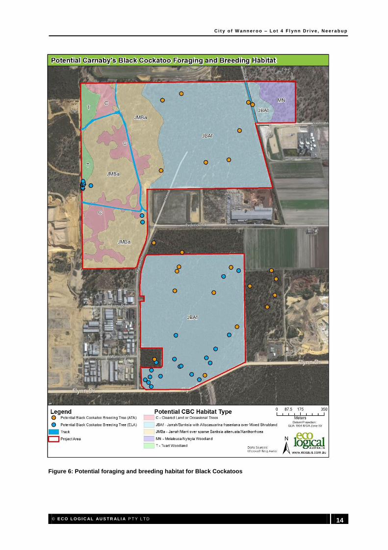
3.2.1 Black Cockatoo foraging habitat
The site inspection showed that on the whole, the vegetation communities previously mapped by ATA
Environmental (2007) were accurate in terms of foraging habitat for Black Cockatoos. Some minor
amendments included slight vegetation boundary adjustments and the addition of foraging plant
species. Vegetation communities in both the northern and southern portions of Lot 4 contain extensive
foraging habitat including Marri, Jarrah and a range of Banksia species. Carnaby’s Black Cockatoos
are known to feed frequently in remnant bushland within the vicinity of Lot 4 (ELA 2009), and this
species was observed feeding within Lot 4 during the site inspection. Foraging habitat for Black
Cockatoos is presented in Figure 6.
3.2.2 Potential Black Cockatoo breeding habitat
The site inspection identified an additional 28 potential Black Cockatoo breeding trees, in comparison to
the 15 trees originally mapped by ATA Environmental (2007) (Figure 6). However, there were a
number of other trees observed on-site that could also be potential breeding trees. In order to map the
locations of all potential breeding trees, a systematic and thorough search of Lot 4 is required.
3.2.3 Graceful Sun Moth habitat
During the site inspection, Banksia woodland vegetation communities within Lot 4 were identified as
potential breeding habitat for the Graceful Sun Moth, based on the presence of Lomandra
hermaphrodita in the northern portion of the site. It is understood that a Graceful Sun Moth survey has
previously been undertaken by City of Wanneroo personnel and no individuals were recorded during
that survey (conducted between March and April).
Ci t y o f W a nn er o o – L o t 4 F l yn n Dr i ve , Ne er a b u p
© E C O L O G I C AL AU S T R AL I A P T Y L T D 14
Figure 6: Potential foraging and breeding habitat for Black Cockatoos

Ci t y o f W a nn er o o – L o t 4 F l yn n Dr i ve , Ne er a b u p
© E C O L O G I C AL AU S T R AL I A P T Y L T D 15
References
ATA Environmental. 2007. Flora, vegetation and vertebrate fauna assessment Neerabup Industrial
Area (NIA), Neerabup. Unpublished report prepared for City of Wanneroo, LandCorp and various
landowners.
Department of Environment and Conservation. 2010. Survey guidelines for the Graceful sun-moth
(Synemon gratiosa) and site habitat assessments. November 2010, version 1.2.
Department of Sustainability, Environment, Water, Population and Communities (DSEWPaC). 2011.
Environment Protection and Biodiversity Conservation Act 1999 draft referral guidelines for three
threatened black cockatoo species: Carnaby’s cockatoo (endangered) Calyptorhynchus latirostris,
Baudin’s cockatoo (vulnerable) Calyptorhynchus baudinii, Forest red-tailed black cockatoo (vulnerable)
Calyptorhynchus banksii naso. Commonwealth of Australia.
Eco Logical Australia. 2009. EPBC Act Approval Risk Analysis, Lot 21 Flynn Drive Neerabup. Report
prepared for LandCorp WA, October 2009.
Government of Western Australia. 2000. Bush Forever Volume 2: Directory of Bush Forever Sites.
Department of Environmental Protection, Perth, Western Australia.
Keighery, B.J. 1994. Bushland Plant Survey. A Guide to Plant Community Survey for the Community.
Wildflower Society of WA (Inc.), Nedlands, Western Australia.
RPS Bowman Bishaw Gorham (RPS). 2006. Neerabup Industrial Area: Vegetation and Flora Surveys.
Unpublished report prepared for LandCorp.

Ci t y o f W a nn er o o – L o t 4 F l yn n Dr i ve , Ne er a b u p
© E C O L O G I C AL AU S T R AL I A P T Y L T D 16
HEAD OFFICE
Suite 4, Level 1
2-4 Merton Street
Sutherland NSW 2232
T 02 8536 8600
F 02 9542 5622
SYDNEY
Level 6
299 Sussex Street
Sydney NSW 2000
T 02 8536 8650
F 02 9264 0717
ST GEORGES BASIN
8/128 Island Point Road
St Georges Basin NSW 2540
T 02 4443 5555
F 02 4443 6655
CANBERRA
Level 2
11 London Circuit
Canberra ACT 2601
T 02 6103 0145
F 02 6103 0148
NEWCASTLE
Suites 28 & 29, Level 7
19 Bolton Street
Newcastle NSW 2300
T 02 4910 0125
F 02 4910 0126
NAROOMA
5/20 Canty Street
Narooma NSW 2546
T 02 4476 1151
F 02 4476 1161
COFFS HARBOUR
35 Orlando Street
Coffs Harbour Jetty NSW 2450
T 02 6651 5484
F 02 6651 6890
ARMIDALE
92 Taylor Street
Armidale NSW 2350
T 02 8081 2681
F 02 6772 1279
MUDGEE
Unit 1, Level 1
79 Market Street
Mudgee NSW 2850
T 02 4302 1230
F 02 6372 9230
PERTH
Suite 1 & 2
49 Ord Street
West Perth WA 6005
T 08 9227 1070
F 08 9322 1358
WOLLONGONG
Suite 204, Level 2
62 Moore Street
Austinmer NSW 2515
T 02 4201 2200
F 02 4268 4361
GOSFORD
Suite 5, Baker One
1-5 Baker Street
Gosford NSW 2250
T 02 4302 1220
F 02 4322 2897
DARWIN
16/56 Marina Boulevard
Cullen Bay NT 0820
T 08 8989 5601
BRISBANE
PO Box 1422
Fortitude Valley QLD 4006 T 0400 494 366