
Ground motion simulations and site effect estimation for Istanbul, Turkey Mathilde Bøttger...
42
Ground motion simulations and site effect estimation for Istanbul, Turkey Mathilde Bøttger Sørensen 1 , Nelson Pulido 2 , Sylvette Bonnefoy-Claudet 3 , Kuvvet Atakan 1 1 Department of Earth Science, University of Bergen, Norway, 2 Earthquake Disaster Mitigation Research Center EDM, NIED,
-
Upload
geraldine-berry -
Category
Documents
-
view
217 -
download
0
Transcript of Ground motion simulations and site effect estimation for Istanbul, Turkey Mathilde Bøttger...
Ground motion simulations and site effect estimation for
Istanbul, Turkey
Mathilde Bøttger Sørensen1, Nelson Pulido2, Sylvette Bonnefoy-Claudet3, Kuvvet Atakan1
1Department of Earth Science, University of Bergen, Norway, 2Earthquake Disaster Mitigation Research Center
EDM, NIED, Kobe, Japan, 3LGIT, Université Joseph Fourier, Grenoble, France.

Outline
Introduction
Ground motion simulations
- technique
- results
Site effect studies
- 4 methods
- results
Summary and further studies
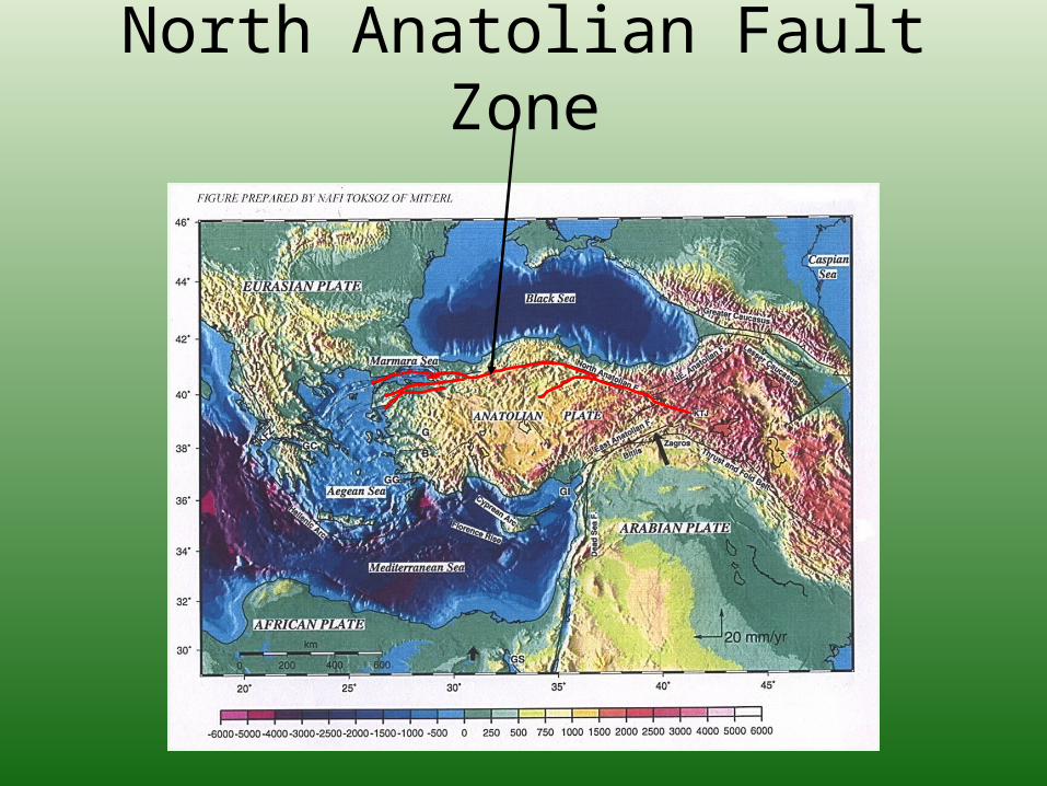
North Anatolian Fault Zone

Westward migration of earthquakes on the NAF
after Barka et. al. (2002)

Coulomb Failure Stress Change after the 1999 Izmit earthquake

Ground motion simulations
• Hybrid method for simulating ground motions due to finite-extent earthquake source in Marmara Sea
• Pulido and Kubo (2004): Deterministic at low frequencies, semi-stochastic at high frequencies
• Simulation on regular grid and on irregular grid of Istanbul Earthquake Rapid Response and Early Warning System stations
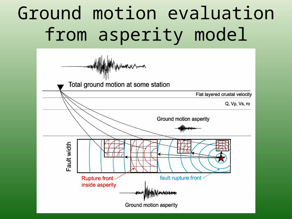
Ground motion evaluation from asperity model

Ground motion simulation technique
• Low frequency: Deterministic wave propagation from an asperity model in a flat layered velocity structure (Discrete Wave Number Method, Bouchon 1981)
• High Frequency: Semi-Stochastic Simulation based on an asperity model. The model combines the stochastic methodology of Boore (1986) with the empirical Green’s function method of Irikura (1986), and a high frequency radiation pattern model (Pulido et. al 2002).

Tectonic Setting Marmara Sea Region
Okay et. al 2000
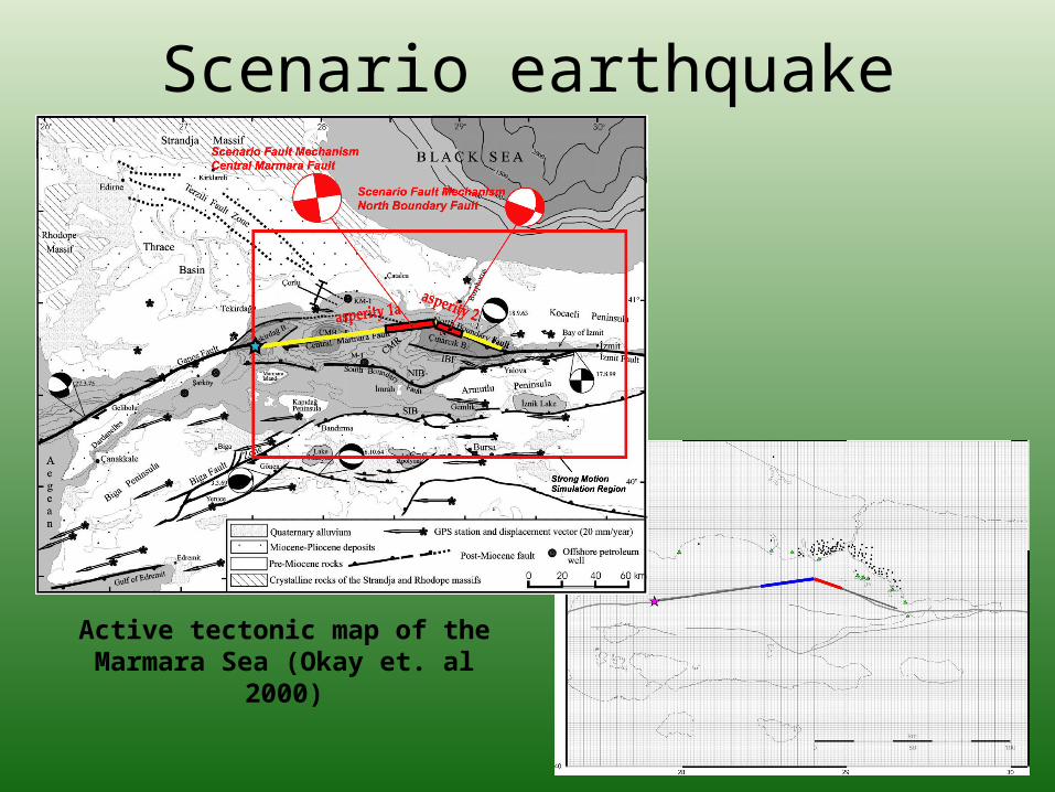
Scenario earthquake
Active tectonic map of the Marmara Sea (Okay et. al 2000)

Source parametersTotal seismic moment M0 = 2.0·1020 Nm
Asperity area Sa/S = 0.22
Average stress drop 5 MPa
Asperity stress drop 10 MPa
Rise time Random, average 3.0 s
Rupture velocity Random between 2.8 – 3.2 km/s
fmax 10 Hz
Q 100 · f1.5

Velocity model

PGV results

PGA results

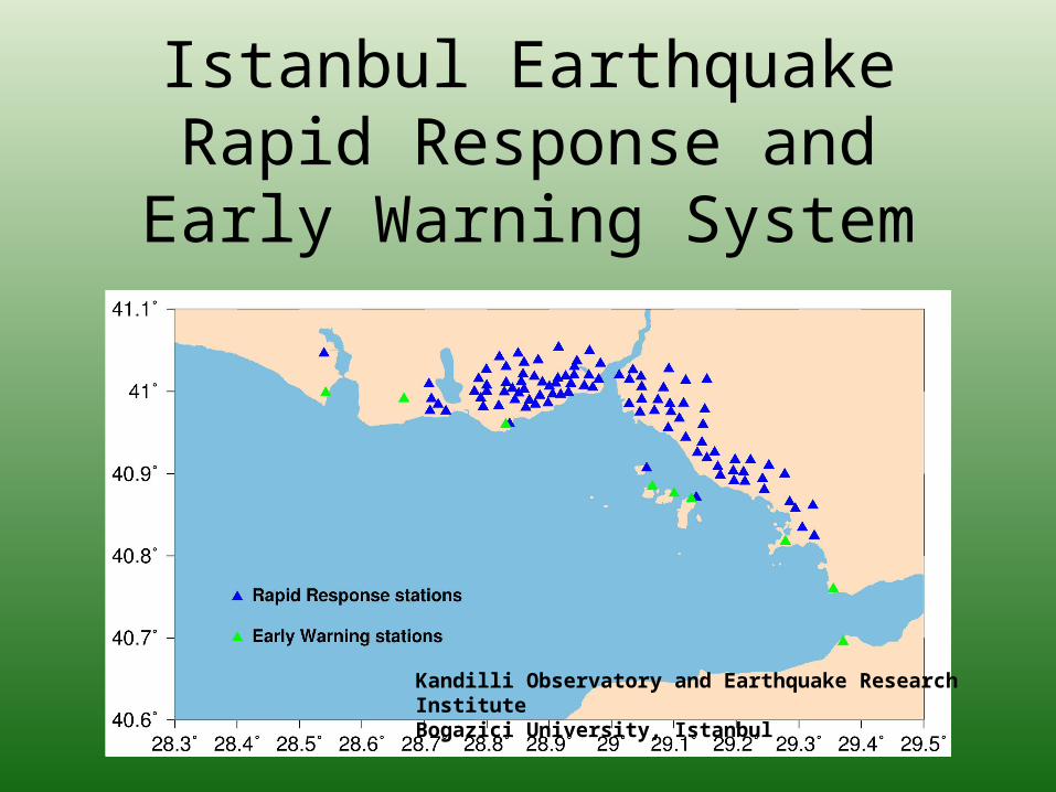
Istanbul Earthquake Rapid Response and Early Warning
System
Kandilli Observatory and Earthquake Research InstituteBogazici University, Istanbul

Rapid Response system
• 100 accelerometer stations• When triggered, station produces spectral
acceleration at a number of frequencies, 12 Hz filtered PGA and PGV
• Data sent pr SMS every 20 s• Main data center produces shake, damage
and casualty maps, which are available to the end-users within 5 min
Istanbul Earthquake Rapid Response and Early Warning
System
Kandilli Observatory and Earthquake Research InstituteBogazici University, Istanbul
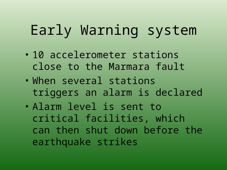
Early Warning system
• 10 accelerometer stations close to the Marmara fault
• When several stations triggers an alarm is declared
• Alarm level is sent to critical facilities, which can then shut down before the earthquake strikes

Use of RR/EW simulation results
• Calibration of Rapid Response system parameters• Calibration of Early Warning system parameters • Realistic scenario input for producing shake,
damage and casualty maps• Comparison to recorded earthquakes
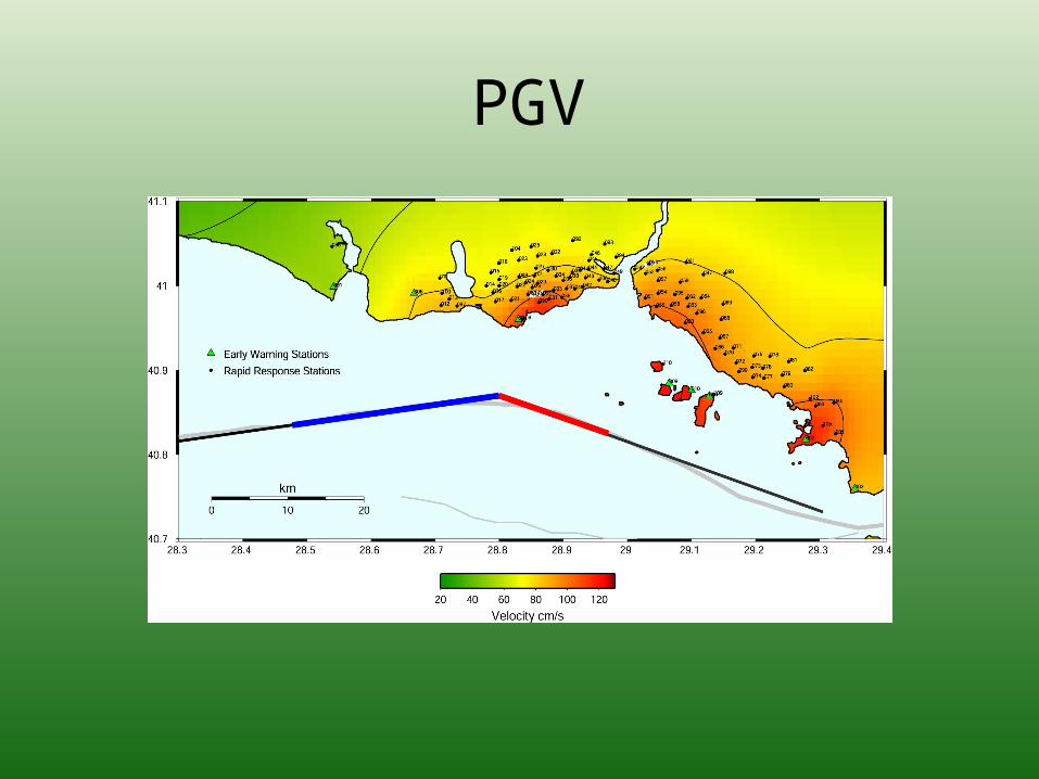
PGV

PGA
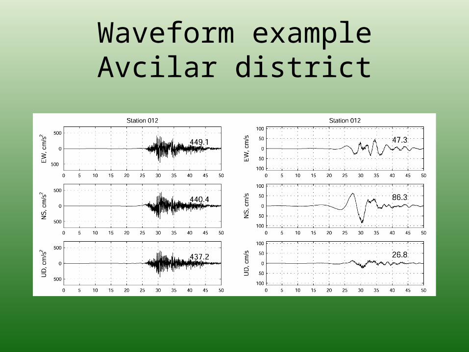
Waveform exampleAvcilar district
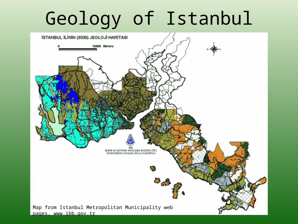
Geology of Istanbul
Map from Istanbul Metropolitan Municipality web pages, www.ibb.gov.tr

Geology of Istanbul
Map from Istanbul Metropolitan Municipality web pages, www.ibb.gov.tr

Ataköy area, geology
Ataköy
From I.T.Ü. Gelistirme vakfi iktisadi isletmesi

Ataköy area, accessibility

3 approaches
• H/V spectral ratio
• Standard spectral ratio
• 1D modelling

H/V spectral ratio
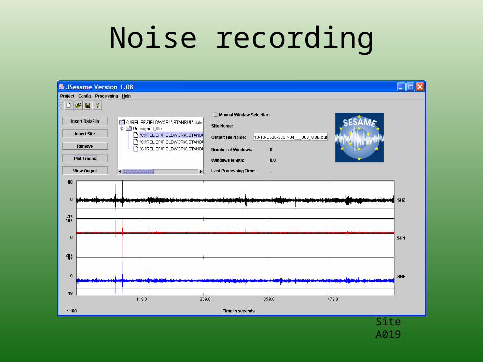
Noise recording
Site A019

H/V results, Alluvium

H/V results, Bakirköy formation

Standard spectral ratio

Event locations

Results, SSRall events

Event locations

Results, SSRevents 2 + 4

SSR resultscomparison

1D modeling site
Representative of alluvial site:
5 m Alluvium
8 m Bakirköy formation
80 m Güngören formation
Bedrock
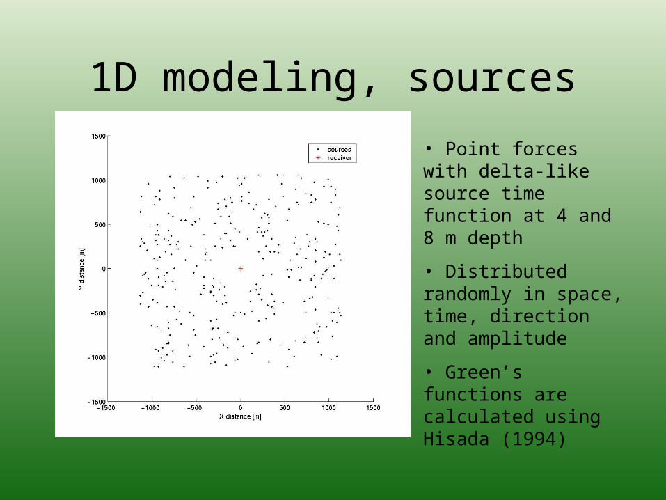
1D modeling, sources
• Point forces with delta-like source time function at 4 and 8 m depth
• Distributed randomly in space, time, direction and amplitude
• Green’s functions are calculated using Hisada (1994)
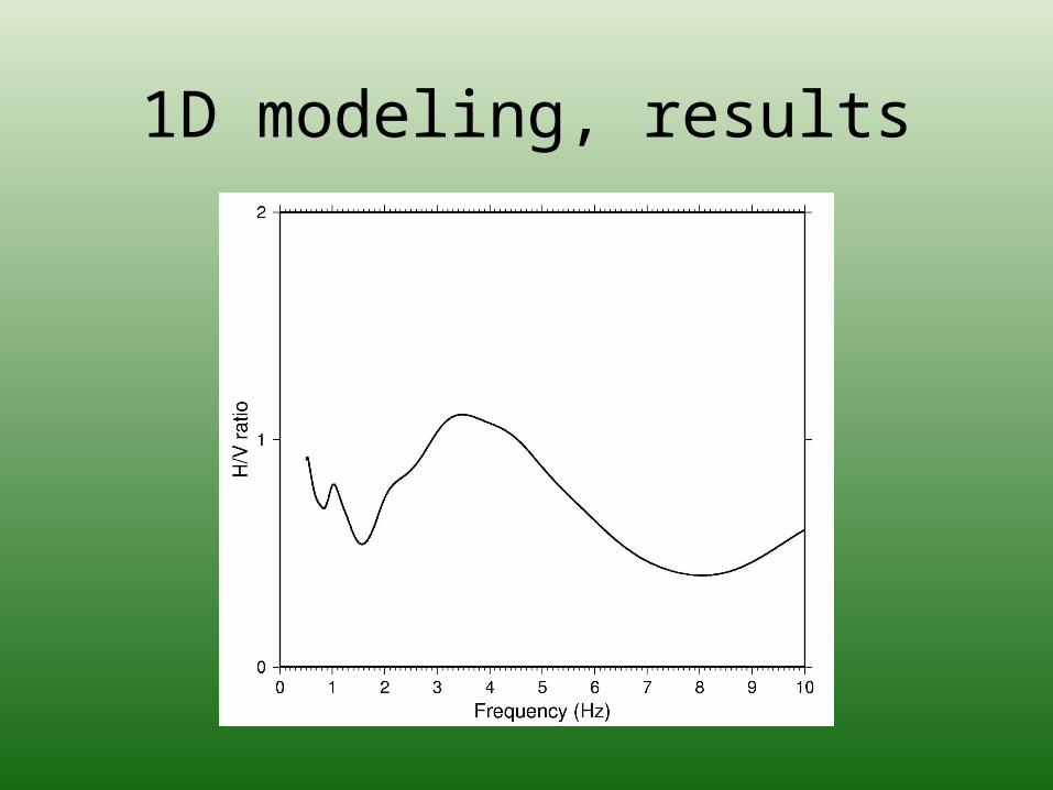
1D modeling, results

Summary
• Agreement between recorded and modelled microtremor H/V results
• Peaks at 1Hz and 3-6 Hz for alluvial site
• Peak at 1 Hz for Bakirköy formation
• SSR indicates high amplification levels, up to a factor of 10

Future plans
• Ground motion simulations for different source parameters
• Use simulation results as input in RR and EW system
• Assign site amplification factor to RR and EW sites


![WORKSHOP ON CABLE-BASED OCEAN OBSERVATORIES,11-12 JUNE 2007, RADISSON SAS HOTEL NORGE, BERGEN Research topics within [Seafloor] Participants: Kuvvet AtakanJon.](https://static.fdocuments.in/doc/165x107/56649de55503460f94addf32/workshop-on-cable-based-ocean-observatories11-12-june-2007-radisson-sas-hotel.jpg)